
The beaver meadow complex revisited the role of beavers in ... · The beaver meadow complex...
15
The beaver meadow complex revisited – the role of beavers in post-glacial floodplain development Lina E. Polvi* and Ellen Wohl Colorado State University, Geosciences Campus Delivery 1482, Fort Collins, CO, USA Received 15 April 2011; Revised 31 October 2011; Accepted 1 November 2011 *Correspondence to: Lina E. Polvi-Pilgrim, Landscape Ecology Group, Department of Ecology and Environmental Science, Umeå University, 901 87 Umeå, Sweden. E-mail: [email protected] ABSTRACT: We evaluate the validity of the beaver-meadow complex hypothesis, used to explain the deposition of extensive fine sediment in broad, low-gradient valleys. Previous work establishes that beaver damming forms wet meadows with multi-thread channels and enhanced sediment storage, but the long-term geomorphic effects of beaver are unclear. We focus on two low-gradient broad valleys, Beaver Meadows and Moraine Park, in Rocky Mountain National Park (Colorado, USA). Both valleys experienced a dramatic decrease in beaver population in the past century and provide an ideal setting for determining whether contemporary geomorphic conditions and sedimentation are within the historical range of variability of valley bottom processes. We examine the geomorphic significance of beaver-pond sediment by determining the rates and types of sedimentation since the middle Holocene and the role of beaver in driving floodplain evolution through increased channel complexity and fine sediment deposition. Sediment analyses from cores and cutbanks indicate that 33–50% of the alluvial sediment in Beaver Meadows is ponded and 28–40% was deposited in-channel; in Moraine Park 32–41% is ponded sediment and 40–52% was deposited in-channel. Radiocar- bon ages spanning 4300 years indicate long-term aggradation rates of ~0.05 cm yr -1 . The observed highly variable short-term rates indicate temporal heterogeneity in aggradation, which in turn reflects spatial heterogeneity in processes at any point in time. Channel complexity increases directly downstream of beaver dams. The increased complexity forms a positive feedback for beaver-induced sedimentation; the multi-thread channel increases potential channel length for further damming, which increases the potential area occupied by beaver ponds and the volume of fine sediment trapped. Channel complexity decreased significantly as surveyed beaver population decreased. Beaver Meadows and Moraine Park represent settings where beaver substantially influence post-glacial floodplain aggradation. These findings underscore the importance of understanding the historical range of variability of valley bottom processes, and implications for environmental restoration. Copyright © 2011 John Wiley & Sons, Ltd. KEYWORDS: floodplain; sedimentation; beaver; Holocene Introduction The beaver-meadow complex Beaver (Castor fiber in Europe, Castor canadensis in North America) are large rodents that build low dams of sediment and wood across stream channels. Although beaver can occupy most portions of a forested stream network, the animals prefer unconfined, low-gradient (<6%) alluvial channels, without coarse or bedrock substrates, and below a stream power threshold (McComb et al., 1990; Gurnell, 1998; Pollock et al., 2003; Persico and Meyer, 2009). Woody vegetation is a neces- sary food source, including willow, alder, and maple, but with a strong preference for aspen (Gurnell, 1998), which tend to thrive in the wet floodplains created by beaver (Rosell et al., 2005). Beaver are considered ecosystem engineers and their ecological importance is well documented in numerous studies across a range of forested, temperate environments (Naiman et al., 1986, 1988; Wright et al., 2002; Rosell et al., 2005). Their long-term geomorphic significance is less well established. Studies of contemporary beaver dams indicate that beaver activity can alter channel longitudinal profiles, create localized sediment storage in backwater ponds, cause high magnitudes of sediment transport during potentially catastrophic dam failures (Butler and Malanson, 1995; Gurnell, 1998; Pollock et al., 2003, 2007), and increase extent and duration of overbank flooding and associated alluvial groundwater recharge (Westbrook et al., 2006). Beaver dams can increase the potential for channel avulsions (John and Klein, 2004); this has been suggested to cause a multi-thread channel network downstream of the dam (Woo and Waddington, 1990; Burchsted et al., 2010). While a beaver dam is active, rates of sediment aggradation behind dams exceed those in adjacent undammed segments of the stream and floodplain (Butler and Malanson, 1995). The relative importance of beaver-induced geomorphic changes over hundreds to thousands of years, however, remains uncertain. The term ‘beaver-meadow complex’ grew out of work during the first half of the 20th century and refers to wet meadows with multi-thread channels that occur in broad, low-gradient valleys as a result of beaver dams; it has been proposed as a mechanism for accumulating significant magnitudes of sediment in broad, low-gradient valleys in headwater segments (Ruedemann EARTH SURFACE PROCESSES AND LANDFORMS Earth Surf. Process. Landforms 37, 332–346 (2012) Copyright © 2011 John Wiley & Sons, Ltd. Published online 1 December 2011 in Wiley Online Library (wileyonlinelibrary.com) DOI: 10.1002/esp.2261
Transcript of The beaver meadow complex revisited the role of beavers in ... · The beaver meadow complex...

EARTH SURFACE PROCESSES AND LANDFORMSEarth Surf. Process. Landforms 37, 332–346 (2012)Copyright © 2011 John Wiley & Sons, Ltd.Published online 1 December 2011 in Wiley Online Library(wileyonlinelibrary.com) DOI: 10.1002/esp.2261
The beaver meadow complex revisited – the roleof beavers in post-glacial floodplain developmentLina E. Polvi* and Ellen WohlColorado State University, Geosciences Campus Delivery 1482, Fort Collins, CO, USA
Received 15 April 2011; Revised 31 October 2011; Accepted 1 November 2011
*Correspondence to: Lina E. Polvi-Pilgrim, Landscape Ecology Group, Department of Ecology and Environmental Science, Umeå University, 901 87 Umeå, Sweden.E-mail: [email protected]
ABSTRACT: We evaluate the validity of the beaver-meadow complex hypothesis, used to explain the deposition of extensive finesediment in broad, low-gradient valleys. Previous work establishes that beaver damming forms wet meadows with multi-threadchannels and enhanced sediment storage, but the long-term geomorphic effects of beaver are unclear. We focus on two low-gradientbroad valleys, Beaver Meadows and Moraine Park, in Rocky Mountain National Park (Colorado, USA). Both valleys experienced adramatic decrease in beaver population in the past century and provide an ideal setting for determining whether contemporarygeomorphic conditions and sedimentation are within the historical range of variability of valley bottom processes. We examinethe geomorphic significance of beaver-pond sediment by determining the rates and types of sedimentation since the middleHolocene and the role of beaver in driving floodplain evolution through increased channel complexity and fine sediment deposition.Sediment analyses from cores and cutbanks indicate that 33–50% of the alluvial sediment in Beaver Meadows is ponded and28–40% was deposited in-channel; in Moraine Park 32–41% is ponded sediment and 40–52% was deposited in-channel. Radiocar-bon ages spanning 4300 years indicate long-term aggradation rates of ~0.05 cmyr-1. The observed highly variable short-term ratesindicate temporal heterogeneity in aggradation, which in turn reflects spatial heterogeneity in processes at any point in time. Channelcomplexity increases directly downstream of beaver dams. The increased complexity forms a positive feedback for beaver-inducedsedimentation; the multi-thread channel increases potential channel length for further damming, which increases the potential areaoccupied by beaver ponds and the volume of fine sediment trapped. Channel complexity decreased significantly as surveyed beaverpopulation decreased. Beaver Meadows and Moraine Park represent settings where beaver substantially influence post-glacialfloodplain aggradation. These findings underscore the importance of understanding the historical range of variability of valley bottomprocesses, and implications for environmental restoration. Copyright © 2011 John Wiley & Sons, Ltd.
KEYWORDS: floodplain; sedimentation; beaver; Holocene
Introduction
The beaver-meadow complex
Beaver (Castor fiber in Europe, Castor canadensis in NorthAmerica) are large rodents that build low dams of sediment andwood across stream channels. Although beaver can occupymostportions of a forested stream network, the animals preferunconfined, low-gradient (<6%) alluvial channels, withoutcoarse or bedrock substrates, and below a stream powerthreshold (McComb et al., 1990; Gurnell, 1998; Pollock et al.,2003; Persico and Meyer, 2009). Woody vegetation is a neces-sary food source, including willow, alder, and maple, but with astrong preference for aspen (Gurnell, 1998), which tend to thrivein the wet floodplains created by beaver (Rosell et al., 2005).Beaver are considered ecosystem engineers and their
ecological importance is well documented in numerous studiesacross a range of forested, temperate environments (Naimanet al., 1986, 1988; Wright et al., 2002; Rosell et al., 2005). Theirlong-term geomorphic significance is less well established.Studies of contemporary beaver dams indicate that beaver
activity can alter channel longitudinal profiles, create localizedsediment storage in backwater ponds, cause high magnitudes ofsediment transport during potentially catastrophic dam failures(Butler and Malanson, 1995; Gurnell, 1998; Pollock et al.,2003, 2007), and increase extent and duration of overbankflooding and associated alluvial groundwater recharge (Westbrooket al., 2006). Beaver dams can increase the potential for channelavulsions (John and Klein, 2004); this has been suggested tocause a multi-thread channel network downstream of the dam(Woo and Waddington, 1990; Burchsted et al., 2010). While abeaver dam is active, rates of sediment aggradation behind damsexceed those in adjacent undammed segments of the stream andfloodplain (Butler and Malanson, 1995). The relative importanceof beaver-induced geomorphic changes over hundreds tothousands of years, however, remains uncertain.
The term ‘beaver-meadow complex’ grew out of work duringthe first half of the 20th century and refers to wet meadows withmulti-thread channels that occur in broad, low-gradient valleysas a result of beaver dams; it has been proposed as a mechanismfor accumulating significant magnitudes of sediment in broad,low-gradient valleys in headwater segments (Ruedemann

333THE ROLE OF THE BEAVER-MEADOW COMPLEX IN POST-GLACIAL ALLUVIATION
and Schoonmaker, 1938; Ives, 1942; Rutten, 1967). In broad,low-gradient valleys with a glacial legacy, these workers sug-gested beaver as the cause for accumulation of fine sedimentrather than the previous explanations of channel meandering(Ruedemann and Schoonmaker, 1938), silted up glacial lakes(Ives, 1942), or deposition from braided channels (Rutten,1967). Ives (1942), who worked in northern Colorado, observedthat beaver pond deposits are not spatially extensive, suggestingspatially and temporally variable deposition, which is in contrastto a filled glacial lake. These studies of the beaver-meadow com-plex are largely inferential and lack systematic data collection ofgeomorphic forms or volumes of sediment resulting fromdifferentdepositional processes.There has been little quantitative evaluation of the hypothe-
sized beaver-meadow complex until recently. In addition, theimportance of beaver aggradation relative to other alluviationprocesses has not been quantified for glacial troughs, the wide,low-gradient valley segments that store the largest volume ofsediment in glaciated, mountainous river networks (Wohl,2010). Several studies demonstrating the efficiency of currentbeaver ponds in trapping sediment (Butler and Malanson,1995; Meentemeyer and Butler, 1999; Bigler et al., 2001)support the central role accorded to beaver dams in thebeaver-meadow complex hypothesis. Persico and Meyer(2009), however, noted only minor effects of beaver aggrada-tion in a study in Yellowstone National Park through multiplevalleys segments. In most reaches, beaver-induced aggradationwas <2m; however, in low-gradient reaches, vertical stackingof ponded sediment was observed (Persico and Meyer, 2009).To evaluate the overall long-term significance of beaver-ponded sediment in broad, low-gradient valleys, which are thesediment storage centers within headwater reaches, knowledgeof the subsurface sediment geometry is necessary. If relativelyshallow post-glacial alluvium overlies thicker glacial deposits,then even a few meters of patchy, beaver-induced sedimentationcan constitute a significant percentage of this alluvium.In this study, we examine whether beaver-pond sediment can
have a major influence on fluvial sedimentary and geomorphiccharacter even without accumulating to large thicknesses. Wefocus on low-gradient glacially-carved valleys that might beexpected to store sediment and organic matter even in the ab-sence of beavers, and quantify the proportion of total post-glacialalluvium associated with beaver ponds. Beaver dams facilitateformation of spatially heterogeneous sediment patches overtime from cycles of beaver colonization and abandonment(Westbrook et al., 2011), and can potentially result in substantialsediment contributions in some geomorphic settings.We focus onvalley bottom processes that trap sediment in broad, low-gradientvalleys in the southern Rocky Mountains of Colorado, USA.
Importance of historic range of variability
Low-gradient, unconfined headwater valleys present an ideallocation to study alluvial processes and the historical range ofvariability of geomorphic processes in valley bottom sedimen-tation. Mountainous headwaters tend to act as sediment sources(Schumm, 1977; Milliman and Syvitski, 1992), with relativelyminor sediment storage relative to lowland portions of a drainagebasin. Mountainous headwaters also display substantial longitu-dinal variability in valley geometry, however, with limited wider,lower gradient portions of the river network that are capable ofsubstantial sediment storage (Wohl, 2000, 2010). Glacial pro-cesses have played a large role in creating the geomorphic formsable to store sediment, including glacial troughs, moraine-bounded valleys, overdeepened valleys, and stepped valleys.In the context of this study, we define historical as encom-
passing the period between ~4000 years ago and the initial
Copyright © 2011 John Wiley & Sons, Ltd.
exploration of the region by people of European descent duringthe first decade of the 19th century. We choose this time periodbecause we have sediment and aggradation data up until~4000 years BP and the climate has been relatively stable sincethe end of the Altithermal that ended ~3500 years BP (Short,1985; Elias et al., 1986; Elias, 1996). Although conditionsmay have been similar during the early-mid Holocene andtherefore valley bottom processes could be extrapolated, ourdata only extend for the past 4000 years. Many of the valleybottoms in the Colorado Rockies have been extensively alteredby diverse land uses during the past two centuries. Characteriz-ing historical range of variability of valley bottom processes, asrelated to sedimentation type, rate, and magnitude for theselandscapes becomes particularly important as resource man-agers seek to restore riparian ecosystems.
The magnitude, type, and rate of post-glacial sedimentationresulting from beaver activity likely reflect Holocene hydrologyand sediment yield, which in turn are a function of climate,vegetation and hillslope processes. All of these parametersvaried during the Holocene (Woodhouse, 2001; Shumanet al., 2009). Beaver populations and dam-induced sedimenta-tion and multi-thread channels also presumably varied duringthe Holocene, creating some range of historical variability priorto when fur trappers began removing beaver from the studyarea during the first decade of the 19th century. With the reduc-tion of beaver populations, the beaver-meadow complexchanges and may lose significance in valley or channel devel-opment. Without beaver, geomorphic and ecologic systemscan change to an alternative stable state that is fundamentallyoutside of the range of historic variability (Sutherland, 1974).For river and ecosystem restoration, the trajectory of the currentand past valley formation determines the available habitattemplate and possibilities for geomorphic process. Naturalrange of variability ecosystem management is based on theconcept that past processes provide context for managementof ecological systems and that disturbance-driven heterogene-ity is an important ecosystem attribute (Landres et al., 1999).Therefore, an understanding of historical, natural patterns ofsedimentation and channel complexity can be used as a modelof how ecological and geomorphic systems have evolvedtogether (Veblen and Donnegan, 2005).
Objectives
Sediments deposited in valley bottoms record watershed-scalelandscape processes through sediment storage and removalover varying timescales. By examining valley bottom sediment,we can examine: (1) the range of variability in sedimentationrates and types since deglaciation, (2) the relative importanceof fluvial processes, e.g. flooding and lateral channel move-ment, compared to hillslope processes, e.g. mass movementsor wildfires, in floodplain sedimentation, (3) the role of beaversin driving floodplain evolution, and spatial and temporaldiscontinuities in sedimentation, and (4) whether beaver damsalter channel complexity and promote greater magnitudes ofsedimentation throughout a valley. Examining these issuesallows us to determine the chronology and processes ofpost-glacial alluviation. By inferring the relative importance ofthese processes, we can understand post-glacial landscapeprocesses and the historical range of variability in the RockyMountains and make management recommendations regard-ing the relative importance of beavers in creating particulargeomorphic conditions. Additionally, we can revisit thebeaver-meadow complex hypothesis and determine whetherbeaver have fundamentally changed processes in post-glacialalluviation by altering sedimentation or channel form.
Earth Surf. Process. Landforms, Vol. 37, 332–346 (2012)

334 L. E. POLVI AND E. WOHL
Study Area
We focused on two glacially formed valleys on the eastern sideof the Continental Divide in Rocky Mountain National Park(RMNP): Moraine Park and Beaver Meadows (Figure 1), locatedalong the Colorado Front Range at approximately 2440melevation. Several cycles of alpine glaciation are recorded inthe southern Rocky Mountains. Pre-Bull Lake glaciation, extend-ing from 1800 to 300 ka, incorporates several glacial maximawithout clear signatures on today’s landscape (Richmond,1960; Chadwick et al., 1997). Bull Lake glaciation occurredfrom 300–130ka; Pinedale glaciation extended down to~2300–2400m elevation, lasted ~20000years, and ended10–15 000 years ago, depending on elevation (Madole, 1980;Madole et al., 1998). Because Moraine Park and Beaver Mea-dows are located within 1 km of the terminal moraine (Braddockand Cole, 1990; Madole et al., 1998), we assume the studysites were deglaciated ~15ka (Madole, 1976; Madole, 1980).Although there were significant gaps between glacial episodes,during which alluvial processes dominated in the study valleys,we focus on the sedimentation history after the end of the latestPleistocene, Pinedale glaciation.Moraine Park is bounded by two lateral moraines and was
glaciated in the Pinedale as well as earlier. Moraine Park is ap-proximately 3 km long and 1km wide. The Big Thompson River,which flows throughMoraine Park, is a pool–riffle streamwith anactive channel 8–15mwide, and a bed gradient of ~1.5%. At thedownstream end ofMoraine Park, the Big Thompson River drainsan area of 103km2, originating at the Continental Divide at
Figure 1. Location map of the two study valleys, Beaver Meadows and Moraiado. In the map of Colorado, the north–south line represents the Continental Dithe locations of the study valleys. The study valleys are shown on the 2001 aeriaextent of glaciation (Madole et al., 1998). BeaverMeadows is divided into the th(EBM), bounded by glacial till to the north and south, West Beaver Meadows (WNorth Beaver Meadows (NBM), outside the range of glacial extent. This figure
Copyright © 2011 John Wiley & Sons, Ltd.
3600–4300m. Beaver Meadows is bounded by one of MorainePark’s lateral moraines to the south and by granite, gneiss, andschist bedrock to the north (Braddock and Cole, 1990). BeaverMeadows is 2.5 km long and 75–300m wide. Beaver Brookdrains an area of 15km2, with a mean elevation of 2810m.Beaver Brook is 0.2–1.5m wide with a bed gradient of0.2–0.8%. BeaverMeadowswas glaciated during earlier episodes,but not during the Pinedale. The hydrographs of these streamslocated at ~2450m elevation are dominated by snowmelt andhigh-magnitude floods are rare (Jarrett and Costa, 1988).The basinsreceive an average of ~680mmyr-1 precipitation.
These valleys are located within the montane ecozone, withhillslope forests dominated by ponderosa pine (Pinus ponderosa)and to a lesser extent lodgepole pine (P. contorta). Vegetation inthe valleys consists of xeric and mesic species. Because thechannel in BeaverMeadows is incised (0.5–2m) and the channelin Moraine Park is restricted to limited parts of the valley, thecontemporary channel, overbank flooding, and the associatedshallow alluvial aquifer likely do not have a large influence overvegetation in most of each valley. Xeric vegetation that hasrecently encroached on the valley bottoms includes smallponderosa pines, native and non-native thistles, graminoids andherbaceous species. The main mesic vegetation is water birch(Betula occidentalis) and gray alder (Alnus incana). Few to nowillows (Salix spp.) are present in either valley, althoughhistorical ground photographs and descriptions suggest thatthey were present during the 20th century.
Forest fires in themontane zonewere frequent but weremostlysurface fires prior to 20th century fire suppression (Veblen et al.,
ne Park, in Rocky Mountain National Park (RMNP) in north-central Color-vide, and the boundary of RMNP is shown; the two white circles representl photograph with a hillshade DEM below; the shaded area represents theree segments as detailed by Kramer et al. (in review): East BeaverMeadowsBM), bounded by glacial till to the south and bedrock to the north, and
is available in colour online at wileyonlinelibrary.com/journal/espl
Earth Surf. Process. Landforms, Vol. 37, 332–346 (2012)
335THE ROLE OF THE BEAVER-MEADOW COMPLEX IN POST-GLACIAL ALLUVIATION
2000). At the elevation of Beaver Meadows and Moraine Park,the fire regime transitions into the subalpine forest zone becauseponderosa pine is intermixed with lodgepole pine and Douglasfir. The subalpine forests in RMNP are affected by infrequentbut extensive stand-replacing fires (Brown et al., 1999; Siboldet al., 2006). This low fire frequency means that fire-inducedsedimentation would also be infrequent; however, stand-replacing fires could be geomorphically effective with sedimentpulses transported into low-gradient valley segments.Regular surveys of beaver populations, or the proxies of beaver
lodges, were conducted in RMNP throughout the 20th century.The beaver population in Moraine Park decreased drasticallythroughout the 20th century: 315 beaver were present in 1940,then the population dropped by 96% to only 12 in 1980(Packard, 1947; Stevens and Christianson, 1980; Mitchell et al.,1999). In 1999, only 6 beaver were present, and no beaveractivity was observed during this study in the summers of 2009and 2010. In Beaver Meadows, 36 beavers were surveyed in1940 and by 1980 none were present. The dramatic decline inbeaver has been attributed to competition with elk for willow,an important winter food source for beavers (Peinetti et al.,2002; Baker et al., 2005). Elk numbers increased following theremoval of their main predator, thewolf, from the park by the startof the 20th century (Ripple and Beschta, 2003). Park managershave experimented with various elk-reduction strategies sincethe 1930s (Buchholtz, 1983). Packard (1947) noticed that BeaverMeadows and Moraine Park were already being overgrazed byelk and deer. Where beaver have been removed from valleys,an altered hydrologic state exists, which may not allow beaverto return the valleys to their original state by simply excludingelk and reintroducing willow (Westbrook et al., 2006; Wolfet al., 2007).Although no paleontologic data on the Holocene history of
beaver exist for RMNP, beavers are known to have been presentthroughout most of the contiguous United States until the arrivalof European fur trappers (Naiman et al., 1988). Wood-cutting,semi-aquatic mammals in the Castoridae family, of whichC. canadensis andC. fiber are a part, evolved as early as 25millionyears ago (Rybczynski, 2007). This suggests that beavers have cuttrees and built dams, potentially altering riparian corridors and geo-morphic process, at least through the Pleistocene. Therefore,beavers were likely present in RMNP whenever climatic andecologic conditions allowed.
Supporting geophysical data
The overall subsurface sediment geometry in Beaver Meadowswas described in detail using the shallow geophysical techniquesof near-surface seismic refraction (SSR) and ground penetratingradar (Kramer, 2011; Kramer et al., In press). In this study, BeaverMeadows was divided into three regions: East Beaver Meadows(EBM), which is bounded by glacial till to the north and south,West Beaver Meadows (WBM), which is bounded by bedrockto the north and till to the south, and North Beaver Meadows(NBM), which is the tributary valley that joins Beaver Meadowsat the eastern end of WBM (Figure 1). Geophysical techniqueswere used to differentiate crystalline bedrock, glacial deposits,post-glacial alluvium, and beaver pond sediments. Mean totalvalley fill depth, which includes glacial deposits, post-glacialalluvium, and beaver pond sediments, was 16m in EBM, 10min WBM, and 1.3m in NBM. The maximum and mean alluvialthicknesses, which include all the post-glacial alluvium andbeaver pond deposits, in EBM, WBM, and NBM are 2.5 and0.7m, 6.0 and 1.8m, and 3.5 and 1.3m, respectively (Krameret al., In press). From isopach maps, the percentage of alluviumin the valley fill was determined to be only 5% in EBM, 19% inWBM, and 100% in NBM. Using type facies from sediment
Copyright © 2011 John Wiley & Sons, Ltd.
beneath surface features interpreted as buried beaver dams,Kramer et al. (In press) estimated the percentage volume of allu-vium attributed to beaver dams and ponds as 64% in EBM,28% in WBM, and 38% in NBM.
In Moraine Park, SSR was used to determine the depth tobedrock, which ranges from 5–30m (N. Kramer, unpublisheddata). The total volume of valley fill (glacial and alluvial fill) isapproximately 24 million m3, compared with 5.3 million m3 inBeaver Meadows (including EBM, WBM, and NBM). Whenstandardized for the valley area, however, the total valley fill isquite similar: 10.7m3/m2 in Beaver Meadows and 12.6m3/m2
in Moraine Park.These data give us the template fromwhichwe can deduce the
Holocene stratigraphy, aggradation chronology, and importanceof beavers in aggradation. In evaluating the beaver-meadowcomplex hypothesis, we need to determine whether beaversplayed a significant role in sediment aggradation. Because thedepth of alluvium is only ~2m, then even a small magnitude ofbeaver-related sediment aggradation can be significant.
Methods
We used three primary lines of evidence in addition to near-surface geophysical data to evaluate the influence of beaverson post-glacial sediment accumulation at the study sites. Wequantified sediment texture and age within 2m of the surface atnumerous locations in both study areas, we mapped contempo-rary landforms across each valley bottom, and we measuredthe extent of beaver ponds and channel planform on aerialphotographs spanning several decades.
Sediment characterization and radiocarbonchronology
Because we worked in a public area of a national park, we usednon-invasive methods to analyze near-surface sediment, definedas the sediment within 2m of the surface. This sediment wasaccessible along cutbanks and in ~2m-deep hand-augeredcores. We recorded sediment texture, sorting and angularity,presence of organic material, such as wood, leaves or roots, colorof sediment as an indicator of past anoxic or aerobic conditions,and depth of layers and type of boundary between each layer.The depth of the water table was also recorded. The augerreached a depth of ~1.9m; cores ended at this depth, whenimpenetrable substrate was encountered or when too muchinfilling occurred, usually with a rounded, well-sorted sandbelow the water table. At the bottom of each core, we recordedthe substrate encountered as similar to previous layer; coarsegravel to cobbles; or large cobbles, boulders, or bedrock. Usingthe auger, it is possible to feel whether the sediment moves butcannot be picked up (coarse gravel to cobbles) or is completelyimpenetrable (cobbles to bedrock). Descriptions of cutbanksincluded more detailed stratigraphy. In Beaver Meadows, thechannel throughout most of the valley is incised up to 1–2m,which allowed for detailed observations of stratigraphy includingboundaries between layers not preserved within cores. Sampleswere taken of characteristic sediment types. We sieved sedimentsamples and used a hydrometer to determine the clay andsilt fraction of the remaining sediment smaller than 4 j(0.0625mm). To interpret the depositional environment, wecollected samples of modern sediment in known depositionalenvironments, including the hillslope and the pools and rifflesof the channel. Because there were no active beaver ponds ordams in either Beaver Meadows or Moraine Park, beaver pondsediment was collected from two proxy locations: (1) in MorainePark, upstream of a minor berm, in what is interpreted to be an
Earth Surf. Process. Landforms, Vol. 37, 332–346 (2012)

336 L. E. POLVI AND E. WOHL
abandoned beaver pond that is currently a dried, marshy pond,5–10m from an active channel, and (2) in active beaver pondsalong Corral Creek valley, located north of RMNP in theheadwaters of the Cache la Poudre River, with channel andvalley dimensions roughly between that of Beaver Meadowsand Moraine Park. Samples of silt- and clay-rich sediment wereanalyzed for organic content by measuring mass before and afterburning off all organic material.We used radiocarbon dating to obtain dates of wood and
charcoal samples, of which 16 were from Beaver Meadows and3 from Moraine Park. Three cores had two samples dated fromdifferent depths (BM01 and BM02; BM09 and BM10; andBM11 and BM14) and a fourth core had two samples fromapproximately the same depth (BM03 and BM04). We used theweighted mean of the calibrated probability distribution of ageswith 2s ranges to obtain a single age for each dated sample thatcould be used to calculate aggradation rates (Telford et al., 2004).Net, average aggradation rates were calculated by simplydividing the depth at which the sample was found by the age.Six organic samples of wood and charcoal were dated using theUniversity of Arizona Radiocarbon Lab via standard analyses;13 samples were dated by Beta Analytic Inc. using acceleratormass spectrometry.
Geomorphic mapping
Using a 2001 aerial photograph as a template, we mapped con-temporary landforms in the field, including the active floodplain,hummocky landforms, glacial deposits, and ramps or berms inthe valley profile perpendicular to the valley axis (Persico andMeyer, 2009), which we interpreted as abandoned beaver dams.Hummocks are raised surfaces, usually in fine-grained sediment,with abundant sedges, and ~0.2–0.5m in height and 0.4–0.1min diameter. We surveyed the valley geometry with a total stationto determine valley length and widths, channel sinuosity, andvalley and channel gradient. Twelve valley cross-sections weresurveyed in Beaver Meadows and the entire valley and channellongitudinal profiles were surveyed. Because of the large sizeof Moraine Park, it was divided into three study reaches,approximately 300m long. For each reach, we surveyed a valleycross-section, and valley and channel longitudinal profiles.In Moraine Park, evidence of beaver influence is still prevalent
in the formof abandoned beaver dams and beaver-chewedwooddeposited in the channel. We walked the entirety of the mainchannel and all of the side channels in Moraine Park and notedany occurrences of abandoned beaver dams, beaver-chewedwood, or instream wood without evidence of beaver influence.Structures with clearly beaver-chewed wood that were tightlypacked with other debris and sediment and attached to at leastone streambank were identified as abandoned beaver dams.For each wood observation, the local in-channel geomorphicstructure was recorded: channel splits and junctions; islands,which were smaller in width than the combined channel widthsof the two side channels; a cutbank or point bar; or a sharp bendwhere the bend around a point bar was 90� or less.
Aerial photo analysis
We used historical aerial photographs to assess the historicalpresence of beaver dams or ponds and to quantify channelplanform change. We obtained a series of aerial photographs ofBeaver Meadows and Moraine Park from the late 1930s to2001. In Beaver Meadows no historical beaver ponds or multi-thread channel systems were visible, except one other channelthat was present for a brief time period. We were, however, ableto identify linear features (perpendicular to the valley axis) withpond-like shapes, delineated by changes in vegetation, up-valley.
Copyright © 2011 John Wiley & Sons, Ltd.
In Moraine Park, multiple channels and ponds were historicallyabundant and apparently dynamic during the time of the aerialphoto series. For the Moraine Park photos, we digitized pondsand calculated total area and number of ponds for each year ofphotographic coverage. We determined channel complexity intwo ways: we digitized all the channels and calculated totalchannel length, and we calculated a braiding index (Bridge,1993). The braiding index was determined by counting thenumber of stream channels that crossed 18 valley-wide transects,which were spaced ~250m apart; the mean and standarddeviations for each year were compared. The braiding indexand total channel length were compared with trends in thenumber or area of ponds.
Results
Sediment textures at both sites were comparable, although largergrain sizes were found in Moraine Park. Grain sizes ranged fromclay to coarse gravel in Beaver Meadow, and clay to smallcobbles in Moraine Park. Most sand- to cobble-sized sedimentwas sub-rounded to well-rounded. Alternating layers of fluvialsands, gravels, and cobbles with layers of clay to fine sand werecommonly seen in cutbanks and cores. Ten sediment texturecategories were identified and used to classify sediment in coresand cutbanks; these include organic soil, fluvial sands and gravel,very fine grained sediment, and oxygenated and anoxic claysthrough gravel (Table I).
Interpretation of sediment depositional settings
Using modern analogs, we interpreted a range of possibledepositional settings for each sediment category. Table II showsdescriptions and results from textural analyses of in-channelsediment in Beaver Meadows and Moraine Park, hillslopesediment fromBeaverMeadows, and beaver pond sediment fromMoraine Park and Corral Creek. Channel sediment in BeaverMeadows is slightly smaller (very fine gravel) than that inMorainePark (medium- very coarse gravel). Sediments in Beaver Mea-dows were sub-rounded to sub-angular; fluvial sediments withinthis valley do not necessarily show significant rounding becauseof the small drainage area. The in-channel sediment in MorainePark was much more rounded than that of Beaver Meadows.
We interpret any very fine-grained sediment as beingdeposited in a pond behind a beaver dam. Other possiblecauses for fine-grained sediment were eliminated in these studyareas. Log jams and debris flows could cause damming ofwater and sediment and thus deposition of fine-grainedsediment. However, these broad valleys are relatively discon-nected from the hillslopes, thus reducing wood recruitment intothe channels. If any long-lasting instream wood is recruited, thelow channel gradients (<1 %) limit transport and formation of ajam. Additionally, we have observed elsewhere in the rivernetwork that wood from deciduous riparian species that enterthe channel (birch, alder, willows) disintegrates quickly andwill not form jams. No contemporary of stratigraphic evidenceof debris flows was observed, and hillslopes bordering thestudy reaches have low gradients and are fairly short, limitingmobilization of hillslope sediment by intense rain or snowmelt.Cutoffs or avulsions that could trap sediment are not evident,and interpretation of fine sediment as beaver pond sedimentis supported by geophysical evidence of onlapping structures(Kramer et al., In press).
Cores in Beaver Meadows showed characteristic sequencesof alternating fluvial and ponded sediment, especially close tothe channel and up-valley of any linear berms, which alsousually coincided with hummocky surface features (Figure 2,
Earth Surf. Process. Landforms, Vol. 37, 332–346 (2012)

TableII.
Sedimen
tdescriptio
nsan
dtexturesofmodernsedim
entdep
ositio
nal
environmen
tsusedto
interpretsedim
entin
coresan
dcu
tban
ks.
Modernsedim
entdep
ositio
nan
alogs
Locatio
nDep
ositio
nal
setting
Observationtype
Med
iangrainsize
(mm)
Descriptio
n
BeaverMeadows
Chan
nel
Pointco
unt(100partic
les)
3Semi-an
gularto
semi-rounded
sandan
dgravel:49%
sand,51%
gravel;
max
grainsize:11
20mm
BeaverMeadows
Chan
nel
thalweg
Grabsample
6Semi-an
gularto
semi-rounded
sandan
dgravel:11
%sand,89%
gravel
BeaverMeadows
Hillslope
Grabsample
0.5
Angu
larsandan
dgravel:<2%
clay
andsilt;
68%
sand;30%
gravel
(upto
8%
coarse
gravel)
MorainePark
Chan
nel
Sixpointco
unts(100partic
les)
32
Sub-roun
ded
toround
edgravel
andtracesand;med
ians
rang
efrom
27to
49mm;mostrangesarefrom
2085mm
andupto
900mm
MorainePark
Aban
don
edbeaverpond
Grabsample
0.125
Darkbrownto
black,co
hesive,fin
esedim
ent;med
iangrainsize
of
findsand;~5%
clay
ndsilt;
95%
sand;<1%
gravel
Corral
Creek
Activebeaverpond
Threegrab
samples
0.09
Darkbrownto
black,co
hesive,fin
esedim
ent;med
iangrainsize
of
very
fineto
finesand;~3-9%
clay
andsilt;
91-98%
sand;<1%
gravel
TableI.
Sedim
entcatego
ries
iden
tifiedin
BeaverMeadowsan
dMorainePark.
Abbr.
Layernam
eColor
Texture
Macroscopicorgan
ics
Dep
ositional
environmen
t
OS
Organ
icsoil
Darkbrown
Clayto
finesand
Abundan
troots
Modernsoilform
ation
CS
Veryfin
egrained
Darkbrown-black
Veryfin
egrained
;mostly
clay
andsilt;
possibly
minorsand
Minim
alto
extensive
Pondbeh
indbeaverdam
CSS
Finegrained
Darkbrown-black
Finegrained
;Clay,
silt,
andfin
esands
Minim
alto
extensive
Pondbeh
indbeaverdam
CSG
Clayto
finegravel
Ligh
t-darkbrown
Clays,silt,
sand&
gravel;sandsan
dgravelsaresubround
ed-suba
ngu
lar
Minim
alto
none
Pondoroverban
k
CSG
+O
Oxygena
tedclay
through
gravel
Ligh
t-darkbrown&
red/
orange
pods
Clays,silt,
sand&
gravel;sandsan
dgravelsaresubround
ed-suba
ngu
lar
Minim
alto
extensive;
oxygenated
Pondoroverban
k
CSG
+A
Anoxicclay
through
gravel
Ligh
t-darkbrown&
grey/
blue/greenpods
Clays,silt,
sand&
gravel;sandsan
dgravelsaresubround
ed-suba
ngu
lar
Minim
al;an
oxic
Pondoroverban
k
SSSiltan
dfin
esand
Ligh
t-med
ium
brown
Silts
&fin
esands
Minim
alto
none
Overban
korch
annel
FSG
Fluvial
sands&
gravel
Ligh
t-med
ium
brown
Wellsorted
,subrounded
sandsan
dfin
egravels
Minim
alto
none
Fluvial
chan
nel
FGFluvial
gravels
Tan-lig
htbrown
Wellsorted
,subrounded
fineto
med
ium
gravels
Minim
alto
none
Fluvial
chan
nel
FGC
Fluvial
gravels&
cobb
les
Tan-grey
Wellsorted
,subrounded
med
ium
gravelsto
smallco
bbles
Minim
alto
none
Fluvial
chan
nel
337THE ROLE OF THE BEAVER-MEADOW COMPLEX IN POST-GLACIAL ALLUVIATION
Copyright © 2011 John Wiley & Sons, Ltd. Earth Surf. Process. Landforms, Vol. 37, 332–346 (2012)

Figure 2. Sediment stratigraphy of core in northern valley of BM,representative of cores in areas of abandoned beaver ponds.Horizontal lines represent clay; horizontal lines with dots representsilt; randomly spaced dots represent sand; randomly spaced dotswith circles represent gravel. The lateral extent (width of bar) ofstratigraphic layers represents median grain size in that layer.
338 L. E. POLVI AND E. WOHL
Figure 3(a)). In cores closer to the valley edge and at theupstream end of the valley, little to no silt and clay werepresent, contemporary soils were better developed, and mostlyfine to coarse sand and fine gravel occurred in the remainder ofthe core. Cores and cutbanks throughout the valley in MorainePark showed alternating sequences of fine, cohesive sedimentwith mostly silt and clay and minor sand, and clearly fluvialsediment ranging from well-sorted sand to gravels and cobbles(Figure 3(b)). The percentage organic material in the finegrained sediment, interpreted as beaver pond sediment, rangedfrom 4.9–23.2% with an average of 14.5%.Fluvial sediment in Beaver Meadows was abundant and
commonly formed most of a core or cutbank, showing upwardor downward coarsening that records channel migration.When ponded sediment was present, thickness ranged from0.05–1.2m (Table III). Core sections with distinctly differenttextures were measured separately even if they were collec-tively interpreted as fluvial sediment. These sections rangedfrom a few centimeters, when bounded by clay layers as a sandlens, to over 0.5m. Fluvial sediment packages in Moraine Parkthat we could core through had smaller thicknesses (Table III).
Figure 3. Photographs of cutbanks in Beaver Meadows (a) and Moraine Parphotograph (a) a 13 x 18 cm notebook is shown for scale, and in photograph (at wileyonlinelibrary.com/journal/espl
Copyright © 2011 John Wiley & Sons, Ltd.
All of the cores in Moraine Park ended at a coarse fluvialsediment layer of unknown thickness, comprised of coarsegravels and cobbles, at an average depth of 0.66m�0.36.Ranges of the percentage of total alluvium for sediment fromfour different depositional settings (beaver ponds, a fluvialchannel, floodplain, and abandoned channel) in BeaverMeadows and Moraine Park are reported in Table IV. In BeaverMeadows, sediment from beaver ponds comprised more of thetotal sediment than from fluvial channels (~42% versus 34%).In Moraine Park, there was slightly less beaver pond thanfluvial sediment (37% versus 46%).
Organic material dating
Radiocarbon ages ranged from 180 to 4340cal. years BP, with amedian of 360cal. years BP (Table V). Assuming constantaggradation over depth, aggradation rates vary over an order ofmagnitude from ~0.02 to ~0.47 cmyr-1, with a median of~0.22 cmyr-1. Because of the large uncertainty in ages<200 cal.years BP, short-term aggradation rates should be taken as approx-imate rates. Aggradation rates tend to decrease with larger timeinterval and follow a log-linear relationship (Sadler, 1981;McShea and Raup, 1986), and we can plot these variables forrelatively short timespans, over only two orders of magnitude,using a power relationship (Figure 4(a)). A large amount ofvariability in residuals of the aggradation rate, especially for ages<500 years BP (Figure 4(b)), indicates large temporal variabilityin sedimentation rates even at small timescales, which mayreflect spatial variability in processes across the valley at anygiven time. Long-term aggradation rates are in agreement at~0.05 cmyr-1, which can be used to estimate sedimentationdepths over long time periods.
A surface feature interpreted as an abandoned, partially buriedbeaver dam revealed, through a series of cores along a longitudi-nal transect, a sequence of interlayered fluvial sands and gravelsand fine-grained ponded sediment (Figure 5). Several disinte-grated wood fragments were found in each core, usually at thetop of a fluvial coarse-grained layer. Because the buried beaverdam is still expressed as a surface feature, this must be a relativelyrecently abandoned dam. This is confirmed through the dating offour wood fragments (BM11, BM13, BM14, and BM15), whichhave ages ≤ 200cal. years BP. We interpret this sequence as
k (b) showing typical sequence of fluvial (F) and ponded (P) sediment. Inb) a clipboard is shown for scale. This figure is available in colour online
Earth Surf. Process. Landforms, Vol. 37, 332–346 (2012)

Table III. Thickness of different sediment types in cores and cutbanks, showing range of thicknesses, mean thickness, and standard deviation (SD).
Pond sediment Fluvial sediment
Range (m) Mean (m) SD (m) Range (m) Mean (m) SD (m)
Beaver Meadows 0.05-1.20 0.25 0.17 0.05-0.60 0.21 0.12Moraine Park 0.05-1.10 0.25 0.21 0.05-0.45 0.17 0.11
Table IV. Percentage of examined alluvium from various depositionalenvironments in Beaver Meadows and Moraine Park.
Beaverpond
Fluvialchannel Floodplain
Abandonedchannel
BeaverMeadows
33-50% 28-40% 2-23% 0-3%
Moraine Park 32-41% 40-52% 0-6% 0%
339THE ROLE OF THE BEAVER-MEADOW COMPLEX IN POST-GLACIAL ALLUVIATION
showing intermittent fluvial and beaver dam influence, eitherdownstream or at the main break in slope (at ~5m down valleyin Figure 5) for at least 200 years and more likely up to 500 years,given that there were at least two sequences of ponded andfluvial sediment, and that the top pond-sequence dates to~200cal. years BP. Fluvial sediment was deposited either whenan original dam was breached or simply through spatial hetero-geneity of the main flow through the beaver pond. Because abeaver dam allows some flow by creating a patchy, discontinu-ous environment (Burchsted et al., 2010), coarser-grained fluvialsediment may deposit within the pond, depending on the flowdynamics upstream of the pond.
Beaver dams and channel complexity
Aerial photographs in Moraine Park and Beaver Meadowsshow significant changes in channel planform, ponding, andvegetation type and extent from the late 1930s to the present(2010). Currently there are no tall willows and very few shortwillows and only scattered birch and alder in Beaver Meadows.In 1938 large patches (up to 300 � 50m) of shrubs, which aremost likely willows, are present, and somewhat more fragmentedpatches are seen in 1947. Through the 1960s these willowpatches became more linear, found in discontinuous areas alongthe channel. The 1987 and 2001 aerial photographs show similarconditions to those during field visits in 2009; woody vegetationis sparse and only found along the channel.From the 2001 aerial photograph, lighter-colored vegetation
areas correspond to hummocky, wet areas in the field with thetop layer of sediment commonly composed of cohesive clayand silt with grasses and sedges growing on top of the hummocks.Typically a linear feature bounds these vegetation areas along thedown-valley boundary, and the area tapers in the up-valley side;in that case, we interpreted these as former beaver ponds. Theberms or down-valley boundaries, interpreted as locations ofbeaver dams, could be more clearly delineated than the entirepond boundary and were identified on a series of five aerialphotographs (1938–1987). On the most recent aerial photograph(2001), we mapped linear features for which there was geomor-phic field evidence of buried dams (Figure 6). We see a generaldecreasing trend in the presence of features representing buriedbeaver dams, which corresponds with beaver surveys of BeaverMeadows that show a population of 36 in 1940 and none presentin 1980. Relict beaver dams identified in the aerial photographsnumbered 6 in the main valley (MV) and 4 in the north valley(NV) in 1938, which only had partial photographic coverage;these numbers become 8 and 4, respectively, in 1947, 5 and 3in 1964, and 1 and 3 in 1969 and 1987. The total topographic fea-tures identified in the field in 2009 that were interpreted as buriedbeaver dams were 10 in the main valley and 7 in the north valley.A qualitative review of the aerial photograph series from
Moraine Park clearly shows a dramatic decrease in the complex-ity of the channel network (Figure 7). Currently, the channel splitsat the upstream end of the valley into two main channels andrejoins at the downstream end of the valley; there are a few other
Copyright © 2011 John Wiley & Sons, Ltd.
side channels on each main fork. Aerial photographs from the1940s and 1960s show an extremely complex network of chan-nels, where braidplains, meander belt widths, and significantriparian vegetation occupy ~50% of the valley area. In the1987 and 2001 photographs, these areas make up <25% of thevalley area.
The number of ponds and the total channel length generallydecrease with time through the twentieth century, but bothmetrics increase in 1969, which could reflect a mild drought atthe beginning of the 1960s and higher than normal discharge atthe end of the 1960s (Woodhouse, 2001). Even with a decreasingbeaver population in the 1960s, the newly abandoned channelswould accommodate the increase in flow and appear as an in-crease in the number of active channels in the aerialphotograph. The discharges at the time of the photographs areunknown but they were all taken during the same time of yearin the early autumn. The number of ponds range from 64 in1947, up to 96 in 1969, decreasing to only 4 in 2001 (Figure 8).The total channel length ranges from approximately 30km in the1940s and 1960s and drops off to less than 15km in 1987 and2001. Several channels that were active in the 2001 photographwere found to be abandoned during field work in 2009–2010.The braiding index for the channels, as measured from thenumber of channels per valley width in 18 valley-wide transects,also increases slightly for the 1960s, but the maximum is in1964 rather than 1969. According to an ANOVA comparison ofbraiding indices, there are two significantly different groups ofmeans, 1947–1969 and 1987–2001, where the means are0.0110 (1947), 0.0125 (1964), and 0.0123 (1969), versus0.0051 (1987) and 0.0038 (2001).
Field reconnaissance of evidence of beaver dams or beaver-chewed wood indicates that in over half of the observations ofabandoned beaver dams, there is an island that has formeddirectly downstream (Figure 9, Figure 10). If there was no islanddownstream, the channel split (~25% of observations) or therewas a sharp bend in the channel. After the dam is abandoned,the channel migrates and incorporates the relict dam into thestreambank, where the bank is highly reinforced and acts in ananalogous manner to a geotechnical bank reinforcement(Figure 9). Where only beaver-chewed wood was present, thismay be a disintegrated dam or simply transported beaver-chewed wood. Where abandoned beaver dams or beaver-chewed wood is present, we see strong field evidence of thepresence of channel splits or islands, which increase channelcomplexity and increase the braiding index (Figure 8(b)).
Earth Surf. Process. Landforms, Vol. 37, 332–346 (2012)
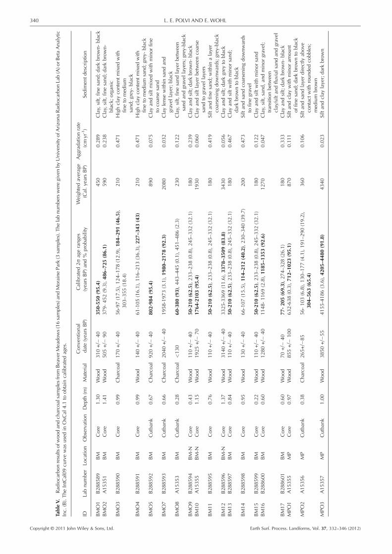
TableV.
Rad
iocarbonresults
ofw
oodan
dch
arco
alsamplesfrom
BeaverM
eadows(16samples)an
dMorainePark(3
samples).T
helabnumbersweregivenbyUniversityofA
rizo
naRad
iocarbonLab(A)o
rBetaAnalytic
Inc.
(B).TheIntCal09cu
rvewas
usedin
OxC
al4.1
toobtain
calib
ratedages.
IDLabnumber
Locatio
nObservation
Dep
th(m
)Material
Conventio
nal
date(years
BP)
Calibrated2s
agerang
es(years
BP)
and%
probab
ility
Weigh
tedaverage
(Cal.yearsBP)
Aggrada
tionrate
(cmyr
-1)
Sedim
entdescriptio
n
BMO1
B288589
BM
Core
1.30
Wood
310+/�
40
350-55
0(95.4)
450
0.289
Clay,
silt,
finesand;darkbrown-black
BMO2
A15351
BM
Core
1.41
Wood
505+/�
90
379-452(9.3),48
6–72
5(86.1)
590
0.238
Clay,
silt,
finesand;darkbrown-
black;organ
icBMO3
B288590
BM
Core
0.99
Charco
al170+/�
40
56-97(17.5),124–
178(12.9),18
4–29
1(46.5),
303–
355(18.4)
210
0.471
Highclay
contentmixed
with
fineto
med
ium
sand;grey-black
BMO4
B288591
BM
Core
0.99
Wood
140+/�
40
61-105(16.1),11
6–213(36.3),22
7–34
3(43)
210
0.471
Highclay
contentmixed
with
fineto
med
ium
sand;grey-black
BMO5
B288592
BM
Cutban
k0.67
Charco
al920+/�
40
802-98
4(95.4)
890
0.075
Clayan
dsiltmixed
with
minorfin
eto
coarse
sand
BMO7
B288593
BM
Cutban
k0.66
Charco
al2040+/�
40
1958-1973(3.1),19
80–2
178(92.3)
2080
0.032
Claylense
with
insandan
dgravel
layer;black
BMO8
A15353
BM
Cutban
k0.28
Charco
al<130
60-380
(93),443–
445(0.1),451–
486(2.3)
230
0.122
Clay,
silt,
finesandlayerbetween
sandan
dgravel
layers;grey-black
BMO9
B288594
BM-N
Core
0.43
Wood
110+/�
40
50-210
(62.5),233–
238(0.8),245–
332(32.1)
180
0.239
Clayan
dsilt;
darkbrown-black
BM10
A15355
BM-N
Core
1.15
Wood
1925+/�
70
1764
-210
3(95.4)
1930
0.060
Clayan
dsiltlayerbetweenco
arse
sandto
gravel
layers
BM11
B288595
BM
Core
0.76
Wood
110+/�
40
50-210
(62.5),233–
238(0.8),245–
332(32.1)
180
0.419
Siltan
dfin
esand;
with
inalayer
coarseningdownw
ards;grey-black
BM12
B288596
BM-N
Core
1.37
Wood
3140+/�
40
3325-3369(11.6),33
78–3
509(83.8)
3430
0.056
Clayan
dsilt;
darkgrey
toblack
BM13
B288597
BM
Core
0.84
Wood
110+/�
40
50-210
(62.5),233–
238(0.8),245–
332(32.1)
180
0.467
Clayan
dsiltwith
minorsand;
darkbrownto
black
BM14
B288598
BM
Core
0.95
Wood
130+/�
40
66-107(15.5),11
4–21
2(40.2),230–
340(39.7)
200
0.473
Siltan
dsandco
arseningdownwards
tofin
egravel
BM15
B288599
BM
Core
0.22
Wood
110+/�
40
50-210
(62.5),233–
238(0.8),245–
332(32.1)
180
0.122
Clayan
dsiltwith
minorsand
BM16
B288600
BM
Core
0.60
Wood
1280+/�
40
1148-11
69(2.8),11
85–1
353(92.6)
1270
0.047
Clay,
silt,
sand,an
dminorgravel;
tran
sitio
nbetween
clay/silt
andflu
vial
sandan
dgravel
BM17
B288601
BM
Core
0.60
Wood
70+/�
40
77-20
5(69.3),274–
328(26.1)
180
0.333
Clayan
dsilt;
darkbrown-black
MPO1
A15355
MP
Core
0.97
Wood
855+/�
100
632-638(0.3),71
2–10
23(95.1)
870
0.111
Siltan
dclay
with
minor
amoun
toffin
esand;darkbrownto
black
MPO2
A15356
MP
Cutban
k0.38
Charco
al265+/�
85
56-103(6.8),130–
177(4.1),191–
290(19.2),
304–
563(65.4)
360
0.106
Siltan
dsandlayerdirectly
abov
eco
ntactwith
round
edco
bbles;
med
ium
brown
MPO3
A15357
MP
Cutban
k1.00
Wood
3850+/�
55
4155-4186(3.6),42
05–4
480(91.8)
4340
0.023
Siltan
dclay
layer;darkbrown
340 L. E. POLVI AND E. WOHL
Copyright © 2011 John Wiley & Sons, Ltd. Earth Surf. Process. Landforms, Vol. 37, 332–346 (2012)

Figure 4. (a) Plot of ages versus calculated aggradation rates ofsampled wood and charcoal (Table V) in BM and MP, and the powerregression line fit to the data. (b) The residuals of the sampled datesfrom the power regression show general agreement in long-termaggradation rates and high variability in short-term rates.
igure 5. Schematic down-valley cross-section of topographic bermmain valley of BM, interpreted as buried beaver dam. Schematic
ompiled from five cores (shown as dashed vertical lines) taken alonge same longitudinal transect. Four wood samples from these coresere taken and radiocarbon dated. The step in the longitudinal profilet ~5m down valley is interpreted to be a buried beaver dam.
341THE ROLE OF THE BEAVER-MEADOW COMPLEX IN POST-GLACIAL ALLUVIATION
Discussion
Sedimentation types
Near-surface alluvial sediment in Beaver Meadows and MorainePark creates a relatively thin veneer above glacial outwash ortill (Kramer et al., In press). The post-glacial alluviumdisplays spa-tial heterogeneity of sediment types laterally and within a verticalsection. The various sediment types reflect deposition in fluvialchannels, beaver ponds, and floodplains. Common sedimentpackages have alternating coarse fluvial sediment (sands and finegravel in Beaver Meadows and gravels and small cobbles inMoraine Park) and fine-grained ponded sediment (clay, silt, andfine sands). Sediment from beaver ponds consists of mainly0.1-m-thick sequences, up to ~1m thick in some places, buttogether these sequences compose a significant proportion ofthe entire sampled sediment. Beaver pond sediment constitutes33–50% of post-glacial alluvium in Beaver Meadows, and in-channel sediment constitutes only 28–40% of the alluvium.These values are supported by the geophysical analyses ofBeaver Meadows, where 32–38% of alluvium was interpretedas beaver pond sediment (Kramer et al., In press). InMoraine Parkthere is 40–50% fluvial sediment and slightly less pondedsediment (32–41%). We interpreted minor amounts of sediment(2–23% in BeaverMeadows, 0–6% inMoraine Park) as overbankdeposition. We observed no other major sources of sediment,including debris flows or peat accumulation. Therefore, weinterpret the primary processes for retaining post-glacial alluviumand building floodplains in Beaver Meadows and Moraine Parkas reflecting the long-term dynamic interplay between channelprocesses and beaver pond development.
Copyright © 2011 John Wiley & Sons, Ltd.
Fincthwa
Rates of sedimentation
Sedimentation rates in BeaverMeadows andMorainePark vary overan order of magnitude. Long-term rates agree at ~0.05cmyr-1.Short-term rates vary considerably, indicating high temporalvariability in aggradation and spatial variability in sedimentationprocesses and rates throughout the valley at any given point intime. Recent rates of sedimentation (within 500cal. years BP)range from ~0.1–0.5 cmyr-1, which is still considerably lowerthan those measured in contemporary beaver ponds. Butler andMalanson (1995) measured rates of 2–28cmyr-1 (mean: 9.6,sd: 8.14) in several successive beaver ponds in Montana. Otherstudies have obtained rates within a similar order of magnitude.John and Klein (2004) measured a mean rate of 8.02cmyr-1
(sd: 3.71) and Meentemeyer and Butler (1999) measured a meanrate of 15.25 cmyr-1 (sd: 12.6) in beaver ponds in Germany andMontana, respectively. Aggradation rates in an entrenchedchannel after the introduction of beaver in eastern Oregon wereat first very high (47 cmyr-1) and leveled off to 7.5 cmyr-1 aftersix years (Pollock et al., 2007). Ives (1942), who worked innorthern Colorado, suggested a rate of <1cmyr-1. This isconsistent with the highest rates measured in Beaver Meadowsand Moraine Park, but is an estimate from observations of risingwater levels over 20years. Assuming that seasonal aggradationrates in beaver ponds in Beaver Meadows and Moraine Parkare similar to those reported elsewhere, the lower averaged ratesobserved in Beaver Meadows and Moraine Park confirm tempo-ral variability in sedimentation. If beaver pond sedimentationoccurred within a similar order of magnitude as that measuredin contemporary ponds, averaged sedimentation rates observedin Beaver Meadows and Moraine Park represent periods ofrelatively fast pond sedimentation and periods of slow or episodicfluvial sedimentation.
Because these low-gradient, broad valleys on the eastern sideof the Continental Divide in RMNP are not affected by manyoutside sediment sources (e.g. debris flows, frequent fire- inducedsedimentation), they are an ideal location for examining thepotential of beaver-induced sedimentation in this geographicsetting. Compared with sites on the western slope of the dividein RMNP that are subject to extensive debris-flow deposition(Rubin, 2010), Beaver Meadows and Moraine Park have limitedsources of hillslope sediment. Aggradation rates at the westernsite are nonetheless consistent with those in Beaver Meadows
Earth Surf. Process. Landforms, Vol. 37, 332–346 (2012)

Figure 6. Aerial photograph series of Beaver Meadows from 1938–2001. Photos from 1938–1987 show black or white lines (depending onphotograph darkness) that represent interpreted active or abandoned beaver dams. White lines on the 2001 photograph are located where therewas photographic or field evidence (in 2009–2010) of buried beaver dams. Where there is incomplete coverage of the valley (1938 and 1964),the 2001 aerial photograph is in the background. This figure is available in colour online at wileyonlinelibrary.com/journal/espl
Figure 7. Aerial photographs of Moraine Park in 1964 and 1987 that show the dramatic decrease in channel complexity and total channel length.This figure is available in colour online at wileyonlinelibrary.com/journal/espl
342 L. E. POLVI AND E. WOHL
and Moraine Park, ranging from 0.04–0.15cmyr-1, with morerecent rates up to 0.4 cmyr-1 (Rubin, 2010). In a site more similarto Moraine Park, Horseshoe Park on the eastern slope of RMNPshows varying Holocene sedimentation rates of 0.025 cmyr-1
directly after deglaciation to 8200years BP, 0.089cmyr-1 from8200–6075years BP, and 0.035 cmyr-1 from 6075years BP topresent (Rainey, 1987). The average of these values (0.05cmyr-1)coincides with the long-term average aggradation rates in BeaverMeadows and Moraine Park. The long-term rates of aggradation,which agree in sediment sinks throughout RMNP, may reflect theoverall landscape changeand the average amount of sediment avail-able from the hillslopes and headwaters per year. However, in eachdepositional setting, the unique amalgam of sediment types, rates,
Copyright © 2011 John Wiley & Sons, Ltd.
and incision or transport processes reflects the nearby hillslope andfloodplain processes throughout the Holocene.
Beaver, channel complexity, and sedimentationpositive feedback loop
The presence of beaver dams increases the complexity of thechannel network through promoting avulsions, multiple flowpaths, and discontinuous flows (Woo and Waddington, 1990;John and Klein, 2004; Burchsted et al., 2010). The dramaticdecrease in the braiding index and total channel length fromthe 1930s to the present in Moraine Park was concurrent with a
Earth Surf. Process. Landforms, Vol. 37, 332–346 (2012)

Figure 8. Relationship between channel complexity and number ofbeaver ponds (circles) in Moraine Park. Actual beaver populations areshown on graph, as determined from surveys conducted by RMNP(squares). Channel complexity is represented by total channel length(a) and braiding indices (b). Letters above braiding indices in graph(b) signify significantly different groups. Note that there is a generalcorrespondence in trend of changes in channel complexity (totalchannel length and braiding indices) and number of ponds.
343THE ROLE OF THE BEAVER-MEADOW COMPLEX IN POST-GLACIAL ALLUVIATION
surveyed decrease in beaver population and a decrease in thenumber of ponds present. These data, in conjunction with fieldevidence of islands or channel splits downstream of relict beaverdams, support the hypothesis that beaver promote the formationof a multi-thread channel network. Past studies have noticedsimilar changes over shorter time spans (Woo and Waddington,
Figure 9. Examples of beaver-influencd channel form. Photos a, c, and epresent. Photos b and d show island formation at the site of an abandoned bpossibly an abandoned dam, which caused a sharp meander bend. White arroat wileyonlinelibrary.com/journal/espl
Copyright © 2011 John Wiley & Sons, Ltd.
1990; John and Klein, 2004). The multi-thread networkinfluences complexity in several spheres, such as the vegetatedriparian area, groundwater flow, and sedimentation (Westbrooket al., 2006; Burchsted et al., 2010; Westbrook et al., 2011).Moraine Park illustrates the extended result of the removal ofbeaver on channel planform and reduction of multiple flow pathsduring overbank flooding, and the resultant transformation ofriparian vegetation zones to xeric environments. The reductionof beavers removes current floodplain processes from the rangeof historical variability of valley bottom processes in terms ofchannel complexity, sedimentation, and how these geomorphicfactors influence ecologic process and form.
In terms of hypothesized beaver pond sedimentation in abeaver-meadow complex, the increase in channel complexityforms a positive feedback. A multi-thread channel network, aproduct of beaver dams, increases the potential channel lengthfor further damming, thus increasing the area that can beoccupied by beaver ponds and increasing the volume of beaverpond sediment trapped in a valley (Figure 11). With relativelyfew beaver dams, complexity is reduced and the potential ofbeaver ponds to trap sediment is minimal. There is probably athreshold population of beavers that will alter channel planformand exponentially increase possible dam sites and thus beaverpopulation. Even though sedimentation is spatially heteroge-neous because of the different processes acting on a broad valleyat any point in time, beaver ponds can exist at multiple locationslaterally and longitudinally throughout an extensive valley likeMoraine Park.
The beaver-meadow complex hypothesis was introducedas a mechanism to explain the presence of fairly large magni-tudes of fine sediment in glacially-carved valleys as opposedto the previous explanations of silted-up glacial lakes, mean-dering streams, and braided channels (Ruedemann andSchoonmaker, 1938; Ives, 1942; Rutten, 1967). Until now,this had not been tested quantitatively by determining thepercentage of the entire alluvium influenced by beaver damsin low-gradient valleys where sediment storage is likely. Al-though the hypothesis may not be applicable in all settings,we believe that Beaver Meadows and Moraine Park representsettings where beavers do have a large impact in post-glacialsediment aggradation. Given the high percentage of beaversediment (~50%) in the thin veneer (~1–6m) of alluvial sedi-ment and the role of beavers in enhancing their habitat poten-tial not only through creation of ponds but also a multi-thread
show channel avulsions or splits where an abandoned beaver dam iseaver dam. Photo f shows a bank reinforced by beaver-chewed wood,ws indicate main flow direction. This figure is available in colour online
Earth Surf. Process. Landforms, Vol. 37, 332–346 (2012)

Figure 10. Geomorphic channel form associated with different typesof wood in channel throughout Moraine Park. For each type of woodobservation made (abandoned beaver dam, beaver-chewed wood, orinstream wood (wood without any evidence of beaver influence), themain proximal channel form was characterized. Splits and junctionsare where a side channel splits or rejoins; an island is smaller in widththan the combination of the two side channels; a sharp bend is ameander curve with an angle of 90� or less.
344 L. E. POLVI AND E. WOHL
channel network, valley-bottom aggradation and deposition offuture streambank material has been facilitated by beavers.
Historical range of variability of beaverpond deposits
Given the scenarios of future climate change, the relevance ofhistorical range of variability to management may be limited,
Figure 11. Schematic diagram showing change in valley planform and chanmeadow complex (BMC), and varying characteristics of sediment storagedominated system. Black rounded triangles represent beaver dams and upstr
Copyright © 2011 John Wiley & Sons, Ltd.
because the governing processes are moving into non-stationarytrends from what human society has been used to in the pastcenturies (Milly et al., 2008). Novel scenarios, in terms of whathas been seen in the historical past, may need to be consideredfor environmental restoration, rather than restoring to historicalcondition. However, given the interaction of multiplegeomorphic and biotic processes in producing the current valleyform, understanding the historical range of variability illuminatesthe template on which current conditions formed. Understandingthe historical range of variability of valley bottom processescan provide insight to the possible trajectories with alteredhydrologic, sediment, or disturbance regimes. Reference condi-tions for restoration often use a historical condition as a goal,and although this may be misleading, understanding process inconjunction with a range of historical valley bottom conditionscan be thought of as a compromise between scientists whoadvocate a completely process-based understanding andmanagers who sometimes choose overly-simplistic restorationtechniques. The role of biotic processes, especially animals, inshaping long-term channel form and valley evolution has largelybeen ignored in the past. This study has illustrated how beaverscan compound their own effects on the valley through creatinga more complex channel network and thus allowing morepotential stream length to be dammed where sediment can betrapped. Without the added complexity of a beaver- influencedchannel network, less fine sediment will be trapped and moresediment will be evacuated from the system because of thehigher stream gradient (Gurnell, 1998).
In this type of headwater stream there are few segments wherefine sediment will deposit. At the watershed scale, headwatersare erosional centers (Schumm, 1977), but the broad, low-gradient valleys of glacial troughs act as temporary storage depots
nel complexity with an increase in beaver population forming a beaver-, channel complexity, and heterogeneity for a headwater, snowmelt-eam ponds. Flow direction is from top to bottom.
Earth Surf. Process. Landforms, Vol. 37, 332–346 (2012)

345THE ROLE OF THE BEAVER-MEADOW COMPLEX IN POST-GLACIAL ALLUVIATION
for sediment. Without mechanisms such as those present inbeaver meadows that slow the movement of sediment, hillslopeand upstream disturbances translate downstream more quicklyand with greater magnitude. Just as beaver dams dampen theeffect of floods (Gurnell, 1998; Westbrook et al., 2006), thebeaver-meadow complex in broad, low-gradient headwatervalleys may dampen sediment movement. As channels migratelaterally, the fine sediment trapped in beaver ponds will formcohesive streambanks, which are rare in headwater streamsbecause of high gradients and coarse substrates. This furthersthe legacy of beavers on channel form by increasing thefrequency of cohesive streambanks and thus increasing overallbank stability.Given that estimates of beaver populations in North America
prior to European settlement range from 60 to 400 million andcurrent populations are only 6 to 12 million (Naiman et al.,1988), beaver-meadow complexes would have beenmuchmorecommon. Butler andMalanson (2005) estimated that the numberof ponds ranged from 15 to 250 million versus only 1.5 to 7.7million before and after European settlement, respectively.Because beaver-meadow complexes are composed of severalponds, the number of complexes will be less but would stillhave decreased by at least 50%. Beaver-meadow complexescontribute significantly to the development of the floodplain inunconfined, low-gradient valleys, which are often disproportion-ately impacted by human development, thereby further alteringfloodplain processes from a historical range of variabilitythroughout North America.
Conclusions
Unconfined, low-gradient headwater valleys are importantcenters for temporary sediment storage within the larger spaceand timescales of sediment transport from headwaters to themouth of a catchment. In Beaver Meadows and Moraine Parkin RMNP, we have shown the importance of beavers in trappingand storing a significant amount of fine sediment throughout theHolocene. Because the alluvium that covers the glacial sedimentis relatively thin, a relatively small magnitude of sedimentdeposition induced by beavers is significant and supports thebeaver-meadow complex hypothesis in explaining the evolutionof relatively flat, broad headwater valleys with abundant finesediment. Temporal heterogeneity in aggradation rates reflectsspatial heterogeneity in fluvial and beaver pond processesthroughout the floodplain. These study valleys were ideallocations for examining the potential role of beavers in floodplainprocesses, but relatively low sedimentation volumes in beaverponds may be overshadowed in landscapes with strong signalsfrom debris flows (Rubin, 2010) or sediment pulses fromgeomorphically-effective forest fires (Meyer et al., 1995; Persicoand Meyer, 2009).Beaver were abundant in the RMNP area prior to European
settlement, which caused a positive feedback in the volume ofsediment aggradation through the formation of a complexchannel network. The current ecologic and geomorphic condi-tion without beaver exhibits a single-thread channel with ahigher gradient, which not only traps less sediment but, with ahigher stream power, incises and transports additional sediment.This condition falls outside of the historical range of variabilityin channel form and sedimentation rates. Historically, a multi-thread channel network maintained by successive beaver damstrapped a nearly equal amount of beaver pond and in-channelsediment. Fine sediment, which ordinarily would be flushed outof headwater reaches, is trapped and incorporated into thefloodplain and streambanks after channel migration. The fasterand larger magnitude of sediment evacuation translates into
Copyright © 2011 John Wiley & Sons, Ltd.
higher connectivity between disturbances in the headwatersand downstream reaches.
The ecological management of these headwater valleysrequires an understanding of the historical channel conditionsin addition to changes in vegetation and elk–beaver interactionsand the impacts of past and present climate conditions. With thereduction in beaver population, the change in channel form to asimpler, single-thread system has affected riparian vegetation,sediment trapping and the potential for supporting a largerbeaver population.
Acknowledgements—We would like to thank the USDA Forest Servicefor funding and Rocky Mountain National Park for supporting researchin the park. We would like to thank Natalie Kramer, who we workedclosely with during field work and formulating ideas. Additionally, wethank Grant Meyer and an anonymous reviewer for their comments thathave substantially improved this paper.
ReferencesBaker BW, Ducharme HC, Mitchell DCS, Stanley TR, Peinetti HR.2005. Interaction of beaver and elk herbivory reduces standing cropof willow. Ecological Applications 15: 110–118.
Bigler W, Butler DR, Dixon RW. 2001. Beaver-pond sequence morphol-ogy and sedimentation in northwestern Montana. Physical Geography22: 531–540.
BraddockWA, Cole JC. 1990. Geologic map of RockyMountain NationalPark and vicinity, Colorado. U.S. Geological Survey, miscellaneousinvestigations series I-1973, 1:50,000.
Bridge JS. 1993. The interaction between channel geometry, waterflow, sediment transport and deposition in braided rivers. In BraidedRivers, Best JL, Bristow, CS (eds). Special Publication 75 of theGeological Society of London; 13–71.
Brown PM, Kaufmann MR, Shepperd WD. 1999. Long-term, landscapepatterns of past fire events in a montane ponderosa pine forest ofcentral Colorado. Landscape Ecology 14: 513–532.
Buchholtz CW. 1983. Rocky Mountain National Park: A History.Colorado Associated University Press: Boulder, CO.
Burchsted D, Daniels M, Thorson R, Vokoun J. 2010. The riverdiscontinuum: applying beaver modifications to baseline conditionsfor restoration of forested headwaters. Bioscience 60: 908–922.DOI: 10.1525/bio.2010.60.11.7.
Butler DR, Malanson GP. 1995. Sedimentation rates and patterns inbeaver ponds in a mountain environment. Geomorphology 13:255–269.
Butler DR, Malanson GP. 2005. The geomorphic influences of beaverdams and failures of beaver dams. Geomorphology 71: 48–60.DOI: 10.1016/j.geomorph.2004.08.016.
Chadwick OA, Hall RD, Phillips FM. 1997. Chronology of Pleistoceneglacial advances in the central Rocky Mountains. Geological Societyof America Bulletin 109: 1443–1452.
Elias SA. 1996. Late Pleistocene and Holocene seasonal temperaturesreconstructed from fossil beetle assemblages in the Rocky Moun-tains. Quaternary Research 46: 311–318.
Elias SA, Short SK, Clark PU. 1986. Paleoenvironmental interpretationsof the late Holocene, Rocky Mountain National Park, Colorado,USA. Revue de Paleobiologie 5: 127–142.
Gurnell AM. 1998. The hydrogeomorphological effects of beaverdam-building activity. Progress In Physical Geography 22: 167–189.
Ives RL. 1942. The beaver-meadow complex. Geomorphology 5:191–203.
Jarrett RD, Costa JE. 1988. Evaluation of the flood hydrology in theColorado Front Range using precipitation, streamflow, and paleo-flood data for the Big Thompson River basin. US Geological Survey,Water Resources Investigations Report 87-4117.
John S, Klein A. 2004. Hydrogeomorphic effects of beaver dams onfloodplain morphology: avulsion processes and sediment fluxes inupland valley floors (Spessart, Germany). Quaternaire 15: 219–231.
Kramer N. 2011. An investigation into beaver- induced Holocenesedimentation using ground genetrating radar and seismic refraction:
Earth Surf. Process. Landforms, Vol. 37, 332–346 (2012)

346 L. E. POLVI AND E. WOHL
Beaver Meadows, Rocky Mountain National Park, Colorado. Mastersthesis, Colorado State University.
Kramer N, Wohl EE, Harry D. In press. Using ground penetrating radarto ‘unearth’ buried beaver dams. Geology.
Landres PB, Morgan P, Swanson FJ. 1999. Overview of the use ofnatural variability concepts in managing ecological systems. Ecolog-ical Applications 9: 1179–1188.
Madole RF. 1976. Bog stratigraphy, radiocarbon-dates, and Pinedale toHolocene glacial history in Front Range, Colorado. Journal ofResearch of the US Geological Survey 4: 163–169.
Madole RF. 1980. Time of Pinedale deglaciation in north-centralColorado - further considerations. Geology 8: 118–122.
Madole RF, Honke JS, Langdon P. 1998. Pleistocene glaciation in theUpper Platte River drainage basin, Colorado. US Geological Survey,99-0017-S, 1:50,000.
McComb WC, Sedell JR, Buchholz TD. 1990. Dam-site selection bybeavers in an eastern Oregon basin. Great Basin Naturalist 50:273–281.
McShea DW, Raup DM. 1986. Completeness of the geological record.Journal of Geology 94: 569–574.
Meentemeyer RK, Butler, DR. 1999. Hydrogeomorphic effects ofbeaver dams in Glacier National Park, Montana. Physical Geography20: 436–446.
Meyer GA, Wells SG, Jull AJT. 1995. Fire and alluvial chronology inYellowstone National Park: climatic and intrinsic controls onHolocene geomorphic processes. GSA Bulletin 107: 1211–1230.
Milliman JD, Syvitski JPM. 1992. Geomorphic tectonic control of sedi-ment discharge to the ocean- the importance of small mountainousrivers. Journal of Geology 100: 525–544.
Milly PCD, Betancourt J, Falkenmark M, Hirsch RM, KundzewiczZW, Lettenmaier DP, Steuffer RJ. 2008. Stationarity is dead:whither water management? Science 319: 573–574. DOI:10.1126/science.1151915.
Mitchell D, Tjornehoj J, Baker B. 1999. Beaver populations andpossible limiting factors in Rocky Mountain National Park.Technical Report, US Geological Survey, Midcontinent EcologicalScience Center.
Naiman RJ, Melillo JM, Hobbie JE. 1986. Ecosystem alteration ofboreal forest streams by beaver (Castor canadensis). Ecology 67:1254–1269.
Naiman RJ, Johnston CA, Kelley JC. 1988. Alteration of North Americanstreams by beaver. Bioscience 38: 753–762.
Packard FM. 1947. A survey of the beaver population of RockyMountain National Park Colorado. Journal of Mammalogy 28:219–227.
Peinetti HR, Kalkhan MA, Coughenour MB. 2002. Long-term changesin willow spatial distribution On the elk winter range of RockyMountain National Park (USA). Landscape Ecology 17: 341–354.
Persico L, Meyer G. 2009. Holocene beaver damming, fluvial geomor-phology, and climate in Yellowstone National Park, Wyoming. Qua-ternary Research 71: 340–353. DOI: 10.1016/j.yqres.2008.09.007.
Pollock MM, Heim M, Werner D. 2003. Hydrologic and geomorphiceffects of beaver dams and their influence on fishes. In EcologyAnd Management Of Wood In World Rivers. American FisheriesSociety: Bethesda; 213–233.
Pollock MM, Beechie TJ, Jordan CE. 2007. Geomorphic changesupstream of beaver dams in Bridge Creek, an incised streamchannel in the interior Columbia River basin, eastern Oregon. EarthSurface Processes and Landforms 32: 1174–1185. DOI: 10.1002/esp.1553.
Rainey E. 1987. Sedimentary record of Pinedale ice recession inHorseshoe Park, Rocky Mountain National Park, Colorado. PhDdissertation, University of Northern Colorado.
Richmond GM. 1960. Glaciation of the east slope of Rocky MountainNational Park, Colorado. Geological Society of America Bulletin71: 1371–1382.
Ripple WJ, Beschta RL. 2003. Wolf reintroduction, predation risk, andcottonwood recovery in Yellowstone National Park. Forest Ecology
Copyright © 2011 John Wiley & Sons, Ltd.
and Management 184: 299–313. DOI: 10.1016/S0378-1127(03)00154-3.
Rosell F, Bozser O, Collen P, Parker H. 2005. Ecological impact ofbeavers Castor fiber and Castor canadensis and their ability to modifyecosystems. Mammal Review 35: 248–276.
Rubin ZK. 2010. Post-glacial valley evolution and post-disturbancechannel response as a context for restoration, Upper Colorado River,RockyMountainNational Park.Masters thesis, Colorado StateUniversity.
Ruedemann R, Schoonmaker W. 1938. Beavers as geologic agents.Science 88: 523–525.
Rutten MG. 1967. Flat-bottomed glacial valleys, braided rivers andbeavers. Geologie en Mijnbouw 46: 356–360.
Rybczynski N. 2007. Castorid phylogentics: implications for theevolution of swimming and tree exploitation in beavers. Journal ofMammal Evolution 14: 1–35.
Sadler PM. 1981. Accumulation rates and the completeness ofstratigraphic sections. Journal of Geology 89: 569–584.
Schumm SA. 1977. The Fluvial System. Wiley: New York.Short SK. 1985. Palynology of Holocene sediments, Colorado FrontRange: vegetation and treeline changes in the subalpine forest. Aaspcontribution series, Institute of Arctic and Alpine Research, Boulder,Colorado, no. 16.
Shuman B, Henderson AK, Colman SM, Stone JR, Fritz SC, Stevens LR,Power MJ, Whitlock C. 2009. Holocene lake-level trends in theRocky Mountains, USA. Quaternary Science Reviews 28: 1861–1879.DOI: 10.1016/j.quascirev.2009.03.003.
Sibold JS, Veblen TT, Gonzalez ME. 2006. Spatial and temporalvariation in historic fire regimes in subalpine forests across theColorado Front Range in Rocky Mountain National Park, Colorado,USA. Journal of Biogeography 33: 631–647. DOI: 10.1111/j.1365-2699.2005.01404.x.
Stevens D, Christianson S. 1980. Beaver populations on the east slopeof Rocky Mountain National Park. Special report, National ParkService: Estes Park, call no. VF599.3232 STE.
Sutherland JP. 1974. Multiple stable points in natural communities. TheAmerican Naturalist 108: 859–873.
Telford RJ, Heegaard E, Birks HJB. 2004. The intercept is a poor esti-mate of a calibrated radiocarbon age. The Holocene 14: 296–298.DOI: 10.1191/0959683604hl707fa.
Veblen TT, Donnegan JA. 2005. Historical range of variability for forestvegetation of the national forests of the Colorado Front Range. Finalreport, USDA Forest Service, agreement no. 1102-0001-99-033.
Veblen TT, Kitzberger T, Donnegan J. 2000. Climatic and humaninfluences on fire regimes in ponderosa pine forests in the ColoradoFront Range. Ecological Applications 10: 1178–1195.
Westbrook CJ, Cooper DJ, Baker BW. 2006. Beaver dams and overbankfloods influence groundwater-surface water interactions of a RockyMountain riparian area. Water Resources Research 42: W06404.DOI: 10.1029/2005WR004560.
Westbrook CJ, Cooper DJ, Baker BW. 2011. Beaver assisted river valleyformation. River Research and Applications 27: 247–256. DOI:10.1002/rra.1359.
Wohl E. 2000. Mountain Rivers. American Geophysical Union:Washington, DC.
Wohl E. 2010. A brief review of the process domain concept and itsapplication to quantifying sediment dynamics in bedrock canyons.Terra Nova 22: 411–416. DOI: 10.1111/j.1365-3121.2010.00950.x.
Wolf EC, Cooper DJ, Hobbs NT. 2007. Hydrologic regime andherbivory stabilize an alternative state in Yellowstone National Park.Ecological Applications 17: 1572–1587.
Woo MK, Waddington JM. 1990. Effects of beaver dams on sub-arcticwetland hydrology. Arctic 43: 223–230.
Woodhouse CA. 2001. A tree-ring reconstruction of streamflow for theColorado Front Range. Journal of the American Water ResourcesAssociation 37: 561–569.
Wright JP, Jones CG, Flecker AS. 2002. An ecosystem engineer, thebeaver, increases species richness at the landscape scale. Oecologia132: 96–101.
Earth Surf. Process. Landforms, Vol. 37, 332–346 (2012)