The Battle of Philiphaugh Community Project 1.0 Executive Summary In 2009 the Philiphaugh Estate...
65
The Battle of Philiphaugh Community Project Natasha Ferguson Centre for Battlefield Archaeology University of Glasgow
Transcript of The Battle of Philiphaugh Community Project 1.0 Executive Summary In 2009 the Philiphaugh Estate...

The Battle of Philiphaugh Community Project
Natasha Ferguson
Centre for Battlefield Archaeology University of Glasgow

2
Contents
1.0 Executive Summary
7
2.0 Introduction
7
3.0 Site Location, Topography and Geology
7
4.0 Archaeological Background
8
5.0 Summary of Works
11
6.0 Garden Haugh Ditch Investigation
6.1 Historical Background
6.2 Aims and Objectives
6.3 Methodology
6.4 Results
14
14
15
15
15
7.0 Metal Detector Surveys
7.1 Metal Detector Survey
22
22
8.0 Metal Detecting Results
8.1 ‘Core Area’ of the Battlefield
8.2 ‘Peripheral Areas’
25
25
25
35
9.0 Working Within the Community
36
10.0 Conclusions and Recommendations
38
11.0 Acknowledgements
38
12.0 Bibliography
39
13.0 Appendices
41

3
List of Figures
Figure 1: Site Location & areas of investigation
Figure 2: Roy's Map of 1755 depicting field boundaries on Philiphaugh Figure 3: Plan and Section drawings for Trench 1 & 2
Figure 4: Artefact distribution map of the battlefield
List of Plates
Plate 1: Volunteers recording artefacts recovered from the metal detecting survey 12
Plate 2: Removing turf from Trench 1 15
Plate 3: NE section of Trench 1 16
Plate 4: Central section of Trench 1 showing base of ditch 16
Plate 5: SW section of Trench 1 17
Plate 6: View of Trench 2 from the SW 18
Plate 7: West facing section of Trench 2 18
Plate 8: Pistol ball and musket ball recovered during excavation 1
Plate 9: Possible lead ingot and lead casting waste recovered during excavation 2
Plate 10: Charles II and Victorian coin recovered during excavation 2
Plate 11: Systematic metal detector survey in Area A 4
Plate 13: View of Area G and location of pistol ball scatter 5
Plate 14: Rolled strips of lead possibly intended for use in casting 8
Plate 15: Unrecorded musket balls recovered by hobbyist metal detectorists from the
battlefield 10

4
1.0 Executive Summary
In 2009 the Philiphaugh Estate initiated the Battle of Philiphaugh Community Project with funding awarded by the
Scotland Rural Development Programme through LEADER (Links Between Activities Developing the Rural
Community). The aim of the project was to promote the battlefield as an important heritage site by generating local
interest through community involvement and developing the Philiphaugh Estate as a visitor attraction in the Scottish
Borders, with the battlefield landscape and its associated archaeology forming the central focus. The Centre for
Battlefield Archaeology was commissioned by the Philiphaugh Estate to carry out the archaeological elements of this
project which as a community based project involved a programme of excavation and survey, together with open days,
lectures and workshops beginning in May and ending in December 2011.
2.0 Introduction
This community project assessed for the first time the archaeological character and extent of the battlefield. The
programme of investigation focused on two main sites, the first being fields situated to the southwest of Selkirk which
is believed to be the area where the main engagement took place (Historic Scotland Battlefields Inventory 2010). As
this was a community project, all activities associated with the archaeological investigation of the battlefield included
local volunteers led by professional experts from the Centre. As well as engaging the community with their local
heritage, the overall aim of the archaeological activities was to provide an interpretation of the battlefield landscape to
inform and enhance future presentation of the site to the general public.
This report provides a summary of the sites investigated, the methodology engaged, and the results of the project.
This report also offers an overall interpretation of the site drawn from the evidence gathered in the field, as well as
providing recommendations for future investigation of the site, and for the management of this important
archaeological heritage.
3.0 Site Location, Topography, and Geology
The Battle of Philiphaugh, 1645, lies within the steep sided river valley of the Ettrick Water, close to the town of
Selkirk some 1.5 km to the north-east (NT 45600 28370). The battlefield itself, or the area identified as the most likely
location of the main engagement, is located in fields on the flat valley floor which follows a northwest orientation. The
battlefield is bounded in the northwest by the A708 and in the southeast by a rerouted channel of water (leat) and weir
from the Ettrick which formerly fed the fish farm and the Philiphaugh sawmill. The valley sides are steep with the
northern side reaching a height of 198 m and summit of Harehead Hill, north of the Battle of Philiphaugh monument,
measuring 324 m in height.
The underlying geology of this area is alluvium, composed of gravel, silt and sand formed by continual flooding of the
river Ettrick as defined by the flat valley floor. The alluvial soils of the Ettrick flood plain are fertile and provide
excellent land for agriculture. Arable is the current land use, with the flatter ground on the valley floor regularly
ploughed for the planting of cereal crops such as winter barely. Fields situated on the valley sides north of the A708,
also potentially part of the battlefield landscape, have a glacial geology also composed of gravel, silt and sand. The
valley sides have also been partially covered by conifer plantations, a proportion of which has been removed in recent
decades.

5
Figure 1: Site Location & areas of investigation

6
4.0 Historical & Archaeological Background
The Battle of Philiphaugh, which took place on the 13th September 1645, was to be the final battle of Montrose’s
campaign to secure Scotland for the Royalist cause. From 1644, James Graham, Marquis of Montrose with his army of
Highland Scots and a contingent of Irish soldiers swept through Scotland gaining victory after victory over the
Covenanter army which had recently formed an alliance with the Parliamentarian forces in England. Despite the
resounding success of his campaign over the Covenanter forces, culminating in the Battle of Kilsyth on 15 August
1645, Montrose continually struggled to retain the strength of his army with the bulk of his force melting away at
various stages in the campaign as loyalties to clan leaders and concerns over local conflicts took precedence.
After the success of Kilsyth, Montrose intended to build up his army before making his military control in Scotland
complete. However, his Highland troops resented his refusal to allow them to plunder Glasgow and a promised
payment in lieu of the plunder did not appear, and within a few days, many had deserted. The problem was
compounded by the loss of Aboyne with most of the cavalry when Montrose appointed the Earl of Crawford as
commander of the horse. Montrose appears to have been trying to make his army more of a clearly Royalist
organisation and less of a Gaelic Highland one, but the result was that Aboyne felt undervalued and returned home
with the Gordon cavalry. They were the most experienced cavalry that Montrose had, and had been key to his
victories at Alford and Kilsyth; it had also been a difficult process in getting support from the Gordon clan in view of
the personal dislike between the Earl of Huntly (chief of Clan Gordon) and Montrose, dating back to the First
Bishops’ War in 1638. Montrose had also lost Alasdair Mac Colla, his Lieutenant General who had been the
centrepoint of his successes over the past year. Mac Colla went back to the west to continue his conquest of Argyll
(Stevenson , taking around 800 of the most experienced infantry with him; the two men were never to meet again.
His departure reduced Montrose’s army to little more than the surviving Irish troops and a few hundred cavalry.
Montrose appears to have believed that he would be able to get significant new support in the south, but marching
east through the Lowlands, he was unable to raise significant numbers of new recruits. Much of the area was strongly
Covenanter, while Montrose’s army was seen as being Highland and Irish troops: they were feared as ‘foreign’ and
because of the excesses committed at Aberdeen and in the Campbell lands in Argyll.
Nonetheless, Montrose now marched into the Borders with his small army with the intention of moving his forces
into England and gather recruits along the way. He was relatively successful in this and had a cavalry force of around
1,000 new recruits, but they were all inexperienced and yet to face battle. to disrupt the mustering of the Covenanter
levies and then, turning south from Kelso to Jedburgh and then west to Selkirk, he camped on 12 September at
Philiphaugh. However, he suffered from poor intelligence from his scouts, for he was unaware that on 6 September
Sir David Leslie had marched north from England with a large army of Covenanter troops, all veterans of the fighting
in the English Civil War. On 11 September, Leslie had rendezvoused with Lothian forces at Gladsmuir to the west of
Haddington. Then, on hearing the small size of Montrose’s army, he marched south to engage the Royalists while
they were at their weakest, approaching Selkirk on the night of 12 September with an army four times the size of
Montrose’s force (Gentles 2007, 235).
On reaching Selkirk on 12 September, the Royalist army camped at Philiphaugh, with old Philiphaugh House used as
the headquarters and a place to position the artillery in order to ‘command the valley and flank the road up the river’
(Craig-Brown 1886, 185). According to a contemporary account of the battle, Montrose’s army prepared the ground
to secure their position on the Haugh,
‘…. [the Royalists] made choice of a most advantageous ground wherin they had intrenched [sic] themselves, having on
the one hand an unpassable [sic] Ditch, and on the other Dikes and Hedges, and where there were not strong enough,
they further fortified them by casting up Ditches, and lined their Hedges with Musketeers’ (Bostock 1645, 2).
According to local tradition, Montrose spent the night in a house close to the West Port of Selkirk (Robson 1897).
Montrose quartered many of his officers and some of his cavalry in Selkirk that night, while his infantry camped in a

7
‘neighbouring wood’, apparently beyond Philiphaugh (Wishart 1720). However, this meant that the officers were
more than two km away from the infantry and were on the other side of the river. As a result, the next morning many
officers failed to get to their units before the action began (Gordon & Dunn, 1844).
During the night, Leslie sent out forward units to attack Royalist quarters; though several Royalists escaped from the
skirmishing to Selkirk, their report of the arrival of Leslie’s army was ignored. Leslie’s forces spent the night in a deep
wooded valley, which the Philiphaugh Ballad suggests was in the area of Linglie Burn, or possibly further NE around
Minglie Hill (Brander & Macgregor, 1975; Gordon & Dunn, 1844). In the morning, Royalist scouts were sent out but
they still failed to locate Leslie’s army. This may be partially explained by the early morning mist, but it is a strong
illustration of the weakness of Royalist scouting. Montrose’s intelligence on the whereabouts of Leslie’s army had
failed and on the morning of 13 September, the alarm was finally raised that the Covenanter army was barely a mile
away in the mist. Montrose rushed to the rendezvous point at Philiphaugh but found that many of his officers and his
cavalry had not arrived, and he struggled to get the troops organised. Many of his cavalry never arrived, realising that
the day was lost and not wishing to fall in a lost cause. However, Montrose did manage to get a formation established,
with the Irish on the left wing and what little cavalry Montrose had on the right. Estimates vary, but Montrose may
have had as few as 200 cavalry at his disposal. His troops all appear to have been behind the ditch previously
mentioned.
Leslie’s Covenanter forces advanced directly across the haugh, the low lying alluvial area of beside the river. Leslie’s
cavalry were the first to engage, with some 400 or more cavalry charging Montrose’s right wing, but they were twice
driven back with heavy losses. The accounts then describe Royalist musketeers as advancing from the enclosures,
which is likely to have been Colonel O’Cahan leading his Irishmen in a charge. However, they were driven back after
a series of attacks and counter attacks. The majority of the Royalist cavalry now counter-attacked but, having crossed
the ditch, they were prevented by the ditch and enclosures from turning left where the greatest strength of the
Covenanter horse were deployed. As a result, they continued forward and broke through the Covenanter rear
divisions, then riding away from the field, effectively leaving the infantry to their fate. However, Montrose still had
some cavalry on the field impeding the Covenanter advance. At this point, Leslie himself, whose cavalry charge at
Marston Moor had been so critical in the result of that battle, led forward an attack on the left wing where there were
no cavalry, and here he broke through. In the meantime, roughly 2,000 Covenanter cavalrymen came across the river
Ettrick, having outflanked Montrose and now attacked the remaining 50 or so Royalist cavalry from the flank and
rear. Assaulted on all sides, the last of the Royalist cavalry now retreated and fled. Montrose was amongst them,
fighting his way clear of the battle with a small group and then escaping to Peebles.
The infantry had nowhere to go; the enclosures and ditch provided some safety, whereas if they tried to escape across
the open ground, they would be cut down by the Covenanter cavalry. They fought on for a while, making a last stand
at Philiphaugh Farm, but eventually it was clear that they could not continue. They finally surrendered on a promise
of quarter, but once they had laid down their weapons, it was announced that quarter only applied to the officers and
the rest of the men were shot out of hand.
The aftermath of the battle was to be as bloody and without mercy. Those who had fled the battlefield were pursued
by Covenanter cavalry and were relentlessly brought down. The Royalist baggage train was looted and the camp
followers, including women and children, were executed (Reid 1990, 159). This is perhaps unsurprising if one
considers the context in which the massacre took place. Montrose and his Irish soldiers had developed a brutal
reputation as they swept through Scotland, committing many atrocities along the way, including the sacking of
Aberdeen which saw widespread looting, murder and rapine over several days (Brown 2002). The behaviour of Mac
Colla and the Irish in the attacks on Campbell lands had been savage in the extreme and there had been no mercy
given to their enemies. The camp followers suffered the revenge of the Covenanters now, as they were killed and
thrown into the Ettrick. Craig-Brown notes in his history of Selkirkshire that in December 1645 a letter was sent to
the Estates of Parliament to ask what to do with ‘4 Irishmen and 6 Irish women’ who had clearly somehow evaded
capture long enough to be retained in the town goal. The town of Selkirk was duly told to execute them as soon as
possible (1886, 193).

8
There appears to be no surviving maps or sketches associated with contemporary accounts of the battle; therefore it is
necessary to rely on later maps to further understand the contemporary landscape of the 17th century battlefield. The
field enclosure, which was the focus of an excavation within this project, appears on the 1st Edition Ordnance Survey
6-inch map of 1843. From the 1840s until 1900s, when the cricket ground was built, the enclosure runs its length
uninterrupted by development towards the Ettrick Water. Roy’s Map of 1757 provides the most detailed depiction of
the early landscape of the battlefield before later 18th – 19th century agricultural and industrial development. Field
enclosures, similar in layout and orientation to the enclosures present in the modern landscape, are depicted in the
map. However, it is not possible to ascertain whether this indicates a continuity of landscape enclosure on
Philiphaugh.
Figure 2: Roy's Map of 1755 depicting field boundaries on Philiphaugh
4.1 Personalities
Marquess of Montrose: Commanding the Royalist army was James Graham, Marquess of Montrose. Montrose was an experienced soldier and inspirational leader, who won a striking series of battles across Scotland that made him master of the country. However, despite his success in Scotland, Montrose was regarded with suspicion by Charles I having been one of the original signatories of the Covenant and a leader of the Covenanter armies in the Bishops’ Wars. As a Protestant and non-Highlander, he was also an outsider to the MacDonalds and other clansmen that formed the backbone of his army and he was never able to keep his army together. After his defeat at Philiphaugh in September 1645, Montrose spent a year or so fighting small skirmishes against Covenanter troops but was never able to raise significant forces. With the Engagement between Charles I and the moderate Covenanters in 1646, Charles ordered all Royalist forces to stand down. Montrose now went into exile in Europe along with Sir John Hurry, who he had defeated at Auldearn. After the execution of Charles 1 in 1649, he returned to Scotland with a small army in

9
1650, this time in support of Charles II. However, he was unable to raise the same level of support from the Highland clans and was defeated at the battle of Carbisdale on 27 April 1650. Although he evaded capture in the battle, after a few days wandering the Highlands, he was betrayed and sent to Edinburgh. Here he was hanged on 21 May, having been previously sentenced to death in absentia for his betrayal of the Covenant. He went to the gallows protesting that he had never abandoned the Covenant, but the king in whose name he fought abandoned him to his fate. Charles II signed the Covenant a few weeks later.
Manus O Cahan: Manus O Cahan was the colonel of the Irish regiment that fought in all of Montrose’s battles and which was the backbone of all his victories. He was a cousin of Mac Colla, Montrose’s right hand man, but stayed with Montrose after Mac Colla left. He has been credited with the invention of the Highland charge, along with Mac Colla, who is generally given sole credit. He fought in the wars in Ireland from 1641 onwards, until coming to Scotland in 1644. He was the constant element of the Irish regiment, taking command during Mac Colla’s frequent journeys to the west to gather troops and supplies. He had played a key role in the fighting at Fyvie in September 1644 and was acknowledged as a fine soldier. He survived the fighting at Philiphaugh and was amongst the group of Irish soldiers that surrendered at Philiphaugh Farm. As the colonel of the regiment, he and his cousin Colonel Laghtnan were given quarter but forced to watch as their men were shot down. The two officers were then taken to Edinburgh and hanged on the walls of Edinburgh Castle without trial.
David Leslie: Major-General David Leslie was a very capable and experienced commander who began his military career fighting for Gustavus Adolphus in the Thirty Years War, where he rose the rank of Colonel. After his return to Scotland in 1640, he was second in command as Major-General of the Scottish armies that were sent to help the English Parliamentarians; it was the despatch of Leslie and his troops that acted as the spark for Montrose’s raising of the Royal Standard in Scotland. At Marston Moor in 1644, Leslie led the Scottish cavalry charge that finally broke the Royalist lines and ensured a Parliamentarian victory for Cromwell. In 1645, following the battle of Kilsyth, where Montrose destroyed the last Covenanter army in Scotland, Leslie was recalled to restore the situation. Later in his career, Leslie was to take Charles I’s personal surrender at Newark, before fighting on behalf of the new king Charles II at Dunbar and Worcester as the vagaries of politics in the War of the Three Kingdoms put the Scottish Parliament in alliance with Charles II against Cromwell and the English Parliamentarians.
5.0 Summary of Works
5.1 Garden Haugh Excavation
Between 9 and 14 August 2011, an excavation was carried out to investigate a linear ditch feature which forms part of
a northwest to southeast orientated field enclosure, dividing the field named Garden Haugh with the football and
cricket pitches to the north. Contemporary sources documenting the battle suggest that in preparation for the battle
the Irish soldiers of Montrose’s Royalist army ‘cast up ditches’ and potentially modified already existing features in the
landscape to strengthen their position. The aim of the excavation was firstly to establish whether this linear ditch
feature could have existed in the 17th century landscape, and secondly if it could have been used or modified as a
defensive structure which may have played an important role during the battle of 1645. Significant concentrations of
lead projectiles, a proportion of which have been catalogued, have reportedly been found either side of this feature by
local metal detectorists. This evidence, together with the distinctive character of the ditch, identified this feature as an
interesting candidate for further investigation in relation to understanding the landscape of the battlefield.
As the profile of the ditch gradually altered along its length, from a steep and deep ditch at the north-western end, to a
shallow and wide ditch closer to the Cricket Club, two trenches were cut to investigate the nature of this
differentiation. Excavation of the shallow area (T1) established that the cut of the ditch matched its surface shallow
and wide surface profile. The south-eastern facing side of the ditch was better defined than the north-eastern facing
side which appeared more mixed, possibly due to later re-cutting at some stage. A Charles II coin was found at the
base of a fill at this end, demonstrating the cut is at least potentially earlier than 1660. Trench 2 revealed that this end
of the ditch was not only morphologically different, but also stone lined. The base of the ditch had been re-cut and
10
squared, then lined with a thin layer of clay and large stones. The south-eastern facing side, which was somewhat
steeper, was lined with tightly packed stones which continued on beyond the break of slope to form what appeared to
be a cobbled surface. The fabric of north-eastern facing stone lined side included a late 19th – early 20th century brick,
possibly dating this feature. However, there are slight differences in the structure of the lining which may indicate they
have been constructed at different times. Therefore the brick may simply represent a later repair on one side.
Unfortunately, two days were lost due to extremely wet weather conditions which hampered further work on this
trench. Small finds included two musket balls, one from each trench and two 17th century coins from T1.
As this was a community project local volunteers from Selkirk assisted with the excavation and included those who
had taken part in the metal detector survey. The excavation culminated with an open weekend, the date of which had
been arranged to co-ordinate with the Battle of Philiphaugh re-enactment, which took place in fields adjacent to the
Waterwheel Café. A significant number of people from the area visited the excavation, including tourists visiting the
Scottish Borders on holiday.
5.2 Metal Detector Survey
Due to the nature of battlefield archaeology, it is necessary to adopt an alternative methodology to investigate the site
as the more traditional techniques used to excavate the ditch at Garden Haugh are not appropriate in this context. As
opposed to more sedentary archaeological finds and features which exist as stratified deposits, battlefields, as
ephemeral events, leave behind a unique archaeological signature, primarily characterised by scatters of artefact
material suspended in the ploughsoil representing debris deposited during the battle. These are usually metal artefacts
and may include items such as lead projectiles – musket balls, artillery projectiles, i.e. cannon balls, canister shot, etc,
together with pieces of broken weaponry buttons, buckles, coins and small personal possessions. In order to
effectively recover this material and interpret the patterns of distributions it is necessary to engage a systematic
programme of metal detector survey. When operated correctly a metal detector may be used to pinpoint accurately
metal objects, with an option to cancel out ferrous items, to an approximate depth of 0.20 m – 0.30 m.
The primary aim of the survey was to assess the character, extent and survival of the battlefield. It was therefore
necessary to sample as much of the area as possible in order to identify the area of main engagement, as well as the
possible boundaries. As a generally undeveloped area composed primarily of agricultural land it was a relatively simple
process to identify areas to survey. Two major factors to consider during the survey were the presence of crops across
much of the survey area, together with the existence of a potentially extensive Early Medieval settlement identified by
crop marks. As part of this site was protected by scheduling and was likely to be extremely sensitive to metal detecting
activity it was decided to avoid this area as much as possible.
The Centre recognises the skills and experience that may be offered by members of the metal detecting community
and their ability to cover large tracts of ground and recover objects quickly and efficiently. For this reason local metal
detectorists were recruited to assist in the metal detector survey which played an important role in the project. Those
who took part lived in the local area and had metal detected on the battlefield before their involvement in the project.
Their involvement therefore served to build an awareness of the archaeological sensitivity of the battlefield and the
impact of removing unrecorded artefacts, with the aim of promoting a degree of stewardship in terms of any future
metal detecting.
The areas surveyed were:
5.2.1 Fields composing the ‘battlefield core’ - Areas A, B, C, D, T and LS
Four large fields (A, B, C, T), an orchard (D) and one small enclosed paddock (LS) situated on the flat valley floor of
the Ettrick Water. As this area had previously been proposed as the core of the battlefield, it was necessary to test this
hypothesis by recovering artefact distributions which may indicate the location of the main area of engagement and its

11
extent in the landscape. A small assemblage of lead projectiles were recovered from this area, together with a small
number of 17th century artefacts potentially related to the battle.
5.2.2 ‘Periphery’ – Areas E, F, G
These fields were initially identified as peripheral areas as they were not located on the valley floor and may be
regarded as topographically distinct as they are separated by a steep escarpment. It was, however, necessary to sample
these areas archaeologically in order to establish the extent of the battlefield and the potential presence of battle-
related activity, such as encampments, skirmishing or evidence of a rout. The survey of this area proved to be
unexpectedly productive, with Area G producing a small but significant assemblage of pistol balls. This scatter of
pistol balls is indicative of a cavalry action, possibly to dislodge Royalist skirmishers positioned on the high ground.
5.3 Geophysical Survey
A small scale geophysical survey was carried out within the gardens of Laurieston House, Ettrickhaugh Road. The
house is situated on the fringes of the current cricket ground and sits on the line of the same field enclosure which
features the ditch bounding Garden Haugh. On an earlier visit to Selkirk, local historian Walter Elliot suggested that
the current house had been built on top of an earlier structure known as the old Philiphaugh House. The house was
built in 1535, and described as ‘an ancient building with a dovecot’ by 1722. The house had disappeared completely by
the early 19th century, with the current house appearing on OS survey maps by the 1870s. The owners of the current
Laurieston House have reported seeing linear parch marks on their lawn which they had interpreted as foundation
walls. Their garden also contains an old well, which has now been covered by decking. There has been some
suggestion that Montrose placed his cannons beside the old Philiphaugh House, which according to Craig-Brown
(1886, 185) became the Royalist HQ.
The geophysical survey, carried out by Dr Iain Banks, included both magnetometry and resistivity and covered an area
of lawn measuring approximately 35 m². Despite interesting linear like lumps and bumps across the area, both
methods produced results that were inconclusive, with only faint traces of potential features.
5.4 Community Workshops
Community involvement was of key importance to this project and therefore it was necessary to ensure a positive
volunteer experience at each stage of the investigation. Prior to the metal detector survey, volunteers were requested
to attend a volunteer training workshop which aimed to provide an introduction to the project and the techniques
engaged within battlefield archaeology. Each volunteer was given a handbook which clearly outlined the methodology
to be used during the metal detector survey, together with sections covering the types of artefacts to expect and the
importance of accurate recording. This workshop was very successful and allowed volunteers time to ask questions
and get a handle on what was expected of them in the field. In turn, volunteers also had the opportunity to offer their
own advice on ground conditions and what had been found previously, etc.
As well as field work, volunteers were encouraged to get involved with other activities associated with the
archaeological process, including artefact processing, and cataloguing. This artefact workshop took place on the 6th
and 7th July and involved those who had taken part in the metal detector surveys, including several metal detectorists.
This gave volunteers the opportunity to handle and identify the artefacts they had recovered during the survey, as well
as demonstrating the processes of post-excavation.
12
A programme of school workshops was also initiated and involved Selkirk High School and Tweedbank Primary
School. These workshops were carried out in conjunction with Olivier Hefer, project historian, who led pupils on a
tour of the battlefield and talked about the life of a 17th century soldier, including a musket firing demonstration.
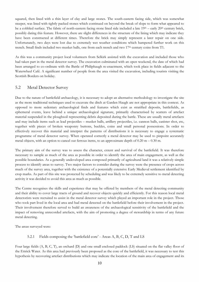
Plate 1: Volunteers recording artefacts recovered from the metal detecting survey

13
6.0 Garden Haugh Ditch Excavation
6.1 Historical background and source material
Two primary sources make reference to a ‘ditch’ within their account of the battle. Master Balsame, Minister at
Berwick in 1645 wrote a narrative of the battle in a letter to a friend, which was duly published, and do doubt added
to, in London for Robert Bostock only a week after the conflict took place. Here the writer describes the Royalist
preparing the ground before the battle took place:
‘according to their usual manner they had made choice of most advantageous ground wherein they had intrenched
themselves, having upon the one hand an unpassable Ditch, and on the other Dikes and Hedges, and where these were
not strong enough, they further fortified them by casting up Ditches, and lined their Hedges with Musketeers (1645, 2).
From what the Minister states, the Royalists selected an area of ground with as much defensive capability as possible,
with the potential of strengthening it further where necessary. The ‘unpassable Ditch’ has been interpreted by
historians and other interested parties as a narrow valley or wide chasm, with the Linglie Burn put forward as a main
contender. In terms of defence against Cavalry, however, which the Royalists may have been expecting, a shallow
ditch, perhaps filled with brush or stakes, would create enough of an obstacle to deter a charge. Similarly against
infantry, a ditch and hedges would provide relatively good cover from enemy fire. With regards to the historic
landscape, Roy’s map, drawn just over 100 years after the battle, depicts an enclosed landscape in a similar pattern to
enclosure in the present landscape.
A second source is written by Patrick Gordon of Ruthven who wrote an historical account of Montrose’s campaigns
several years after the conflict, drawing his evidence from Montrose and soldiers who fought with him. Gordon
describes the ditch in relation to the arrangement of Montrose’s army on the field:
‘....did rainge themselfes vpon the generalles right hand, the foot on the leift, and a ditch befor them...’
He goes on to describe the role of the ditch within the battle, with the Royalist Cavalry, as small as they were, so keen
to chase the enemy that they passed over the ditch:
‘In this second charge, so willing ware they to prewaill or die, as a hunder of them following there enemies, leape the
ditch; and haueing gone so fare as they could not returne without the disgracefull name of flight, and finding there
enemies aboue tua thousand horse, in three diuisiones, and there greatest strength to the leift hand...’
The fact that they could not come back may have been due to temporary defences on that side, such as outward
facing stakes, rather than fear of being disgraced. However, we must be cautious of contemporary references to
features such as ditches, hedges and dikes, as their meaning may have changed over the centuries. For example, a ditch
may refer to what we would consider to be a field bank or enclosure, rather than a trench or waterway. The use of the
phrase, ‘casting up ditches’, within the text may indicate they were in fact reinforcing the field banks. On the other
hand, the use of the term ‘Hedge’ along with ‘Ditch’, may provide sufficient descriptive detail to counter act potential
double meaning.
As discussed within the metal detecting survey section (7.6), concentrations of lead projectiles had reportedly been
found either side of this feature, with a particular concentration situated within the Garden Haugh field (Area C). A
small diagnostic assemblage (including two pistol balls, a musket ball and a piece of canister shot), which could
potentially represent the area of main engagement, was also recorded during the systematic metal detector survey in
Area C. This evidence, together with the historical accounts, adds weight to the theory that the linear feature at
Garden Haugh played an important role in the battle.

14
No excavation has been carried out on this linear feature. However, a large fragment of medieval green glaze pottery,
now situated in the Philiphaugh Estate office, was said to have been recovered from the ditch. A geophysical survey of
the Early Historic settlement was carried out by CFA in 1995 but no further investigation of the site has taken place
(Alexander and Neighbour 1995, 9).
6.2 Aims and Objectives
The general aim of the excavation was to expose, investigate and fully record any archaeological deposits or features in
the area to be opened by the trenches, and to establish the spatial and temporal relationships between them.
The specific objectives were:
To investigate archaeologically the linear ditch situated on the north-eastern boundary of Garden Haugh, a
feature traditionally associated with the battlefield.
To determine the character, extent and significance of any archaeological deposits encountered within the
field enclosure at Garden Haugh. This includes determining the nature of a significant profile change within
the ditch from broad and shallow to narrow with a sharp incline.
To establish whether the present linear ditch and field enclosure was present within the 17th century landscape
of the battlefield.
To determine whether there evidence to suggest this feature has been modified, and if this modification
occurred as a result of preparations for the battle as suggested by historical accounts.
6.3 Methodology
Two trenches, measuring 2 m x 8 m and 1 x 6 m respectively, were cut across the breadth of the ditch. The location of
the trenches was determined by two factors: vegetation and the changing nature of the ditch profile. A preliminary
investigation of the area prior to excavation noted that the profile of the ditch altered mid-way along its length,
changing from a sharp and narrow incline to broad and shallow as it reached the bounds of the cricket club grounds
where it terminated.. A total of two trenches were excavated to investigate the nature of the profile change. Trench 1
was approximately 2 m x 8 m and Trench 2 was 1 m x 6 m. The topsoil was removed to the surface of the subsoil, or
to the first archaeological horizon, and exposed surfaces were then cleaned first by hoe and then by trowel. All topsoil
removal and excavation were carried out by hand. Prior to topsoil removal a metal detector evaluation of the trenches
and immediate area was carried out as there was high potential for the presence of lead projectile scatters related to
the battle. Signals indicating the presence of metallic objects were flagged in the first instance and if situated on the
surface were recovered during the removal of the topsoil. The position of objects located deeper in archaeological
deposits were marked and recovered throughout the excavation process. Trench 1 was half sectioned and excavated in
spits where appropriate. Due to poor weather conditions it was only possible to excavate Trench 2 partially, which
included removal of the topsoil and half sectioning of the ditch base. All sections were recorded by photograph, by
measured drawing at a scale of 1:10 and by written description using context sheets.
The potential presence of human remains or archaeological features relating to an Early Medieval settlement situated
in close proximity to the excavation site and protected by scheduling was considered within the project design. No
human remains, or evidence relating to Early Medieval activity were recovered.

15
6.4 Results
6.4.1 Summary of the field work results
Trench 1 was located across an area of the ditch characterised by a broad and shallow profile; it was also the only
viable area with enough space to place a trench due to tree coverage. The ditch cut was relatively shallow with the
upper fill containing mainly Victorian ceramics, glass and metallic objects. The south-western end of the trench was
mixed and it was difficult to identify any distinct contexts or determine a stratigraphic sequence. A coin of Charles II
was recovered from what was identified as the lower fill (006) of the ditch cut [004], therefore potentially dating the
cutting of the ditch to before 1663 when this series of coin began to be minted.
Trench 2, situated 12 m from the A708, was positioned across an area of the ditch characterised by having a narrower
profile and sharp incline compared with Trench 1. This included removal of the topsoil down to a compact layer of
stone lining (013) & (011), which not only extended across the trench but continued beyond the ditch on the north-
eastern side to form a rough cobble-like surface. The ditch had been modified at some point from the mid-19th
century, with the ditch base re-cut and squared off. The stone lining on the south-western side contained a Victorian
red brick and appears to be contemporary with the re-cut. However, there are slight differences in the character of the
stone lining on this south-western side (011) compared with the opposite side of the ditch (013). As poor weather
significantly restricted time on site, it was not possible investigate the construction of the stone lining further and
whether or not both sides are contemporary, or have been subject to modification at different times.
Plate 2: Removing turf from Trench 1
6.4.2 Trench 1
The cut of the ditch retained its wide and shallow surface profile as it was excavated. It appeared to contain only three
fills, with (005), which was filled with modern debris, the most substantial and most recent. The profile of the cut was
clearly defined on the NE end of the trench; however, as it reached the base and the SW end the cut became less clear
and the stratigraphy was harder to define. During the excavation the cut on the SW side appeared to sit under context

16
(006) and so it was identified as a fill of cut [004]. This fill contained the Charles II coin and is key evidence to the
dating of the ditch and whether or not this feature could be contemporary with the battle. Very slight differences in
the soil matrix between (005), (006) and (007) are the only evidence to suggest separate phases. It is proposed that
they represent separate contexts which have formed after the ditch was cut indicating that the ditch is at least post-
medieval in date rather than a modern feature.
Plate 3: NE section of Trench 1
Plate 4: Central section of Trench 1 showing base of ditch

17
Plate 5: SW section of Trench 1
6.4.3 Trench 2
This section of the ditch was very different in profile as it was narrow with steep sides. Excavation revealed a stone
lining which on the NE facing side contained a brick dating to the late 19th century. This lining continued beyond the
break of slope on the NE side to form a kind of rough cobbled surface. The base of the ditch had been re-cut to form
a square profile, possibly to enable drainage. It is possible this would have been done when the stone lining was put in
place. Due to time constraints it was not possible to excavate beyond the stone lining to further investigate underlying
stratigraphy to further understand the nature of the ditch and how it was formed. Questions relating to the
composition of the stone lining remain, as the NE facing side differs to the SW facing side. The latter is more loosely
compact and uses larger stones, while the NE facing side is more compact and composed of smaller tightly packed
stones.
The purpose of lining the ditch with stone and then continuing it beyond the ditch onto a flatter surface is at this
point unknown. It does appear to be a re-use of the ditch, possibly to improve drainage, it acting as a channel to draw
water from the fields on either side. Another possibility is that it was created to drain water away from the recently
built A708 Selkirk road which was laid out in the mid-19th century.

18
Plate 6: View of Trench 2 from the SW
Plate 7: West facing section of Trench 2

Figure 3: Plan and Section drawings for Trench 1 & 2

6.4.4 Artefacts
The majority of artefacts recovered from the upper deposits in both trenches could be dated to the 19th – 20th century
and consisted primarily of glass and ceramic sherds, together with fragments of animal bone and charcoal, all of which
are consistent with the continual dumping of domestic waste, or ‘night soil’ to fertilise surrounding fields. Small
fragments of slate and mortar were also recovered from Trench 1 but not to significant levels. Trench 2 produced the
smallest number of finds, including later 19th – 20th century material, but did contain a high volume of modern rubbish
such as plastics throughout fill (010) which are likely to have been dumped or washed in. Finds from this trench
included a Victorian silver threepence c. 1859 and a brick with the stamp “Patent Loudons & Russell Newmains”
which formed part of the stone lining structure of (011). Recovered from the spoil heap of this trench was a musket
ball with interesting casting features.
6.4.4.1 Lead projectiles and lead casting
Two lead projectiles were recovered from the spoil of T1 and T2. The example from T1 (SF 002) is either a large
pistol ball or small musket ball weighing 15 g (0.5 oz). It has an unusual oval shape and flattened on one side with a
sunken depression in the centre which is the result of a collapsed air bubble due to a failed cast. If the lead is too hot
or has been poured too quickly, air bubbles may form causing this unusual morphology. Usually such casting failures
are re-melted, but this one appears to have either been dropped or thrown away. The deep groove on the opposite
side looks to be more of a cut than impact damage. The projectile from T2, also found in the spoil, weighs 21 g (0.7
oz) and measures 15.5 mm in diameter. The preservation of the surface is interesting as an oxidised patina has not
formed leaving it a dark silver colour. Also interesting are the casting marks which have not been filled down as would
be expected. The sprue is round and rough and the casting seam is clearly visible around the circumference of the ball.
A quarter of the way round on the ‘equator’ of the ball is a small circular scar. This is another casting feature which
indicates the ball was cast together with other balls in a two part ‘gang mould’. The shape of the ball is also slightly
oval in profile possibly suggesting the hemispheres were not quite spherical in shape. There is no indication that this
ball has been fired and so may have been cast in the vicinity of the ditch and either dropped or thrown away. The lack
of patina development on the surface may also suggest this object hasn’t been rolled around the ploughsoil but has
remained in the same place.
Plate 8: Pistol ball and musket ball recovered during excavation
Two other lead objects found in T1 appear to be result of casting. The first (004) is a flat square object that appears to
be an ingot. This ingot is melted on one side as if the melting process was stopped half way, or the ingot was added
unsuccessfully to refill a crucible which had just been used. The second object (005) is a lead disc with one flat side
and one curved side as if it has been removed from the base of a bowl or shallow ladle. The flat side is crinkled which
occurs when lead is left to cool. Both provide evidence of casting at some level, however, it is unclear whether this
activity could have been carried out in proximity to the ditch or if it is contemporary with the battle.

Plate 9: Possible lead ingot and lead casting waste recovered during excavation
6.4.4.2 Coin
A coin of Charles II (c. 1663 – 1668) was recovered from a lower fill located just above the cut on the north-east
facing side (Holmes 1998, 67), indicating the ditch is likely to be at least post-medieval in date rather than a modern
feature.
Plate 10: Charles II and Victorian coin recovered during excavation
In T2 a silver threepence of Queen Victoria which was minted in 1859 was recovered from the upper fill on the SW
side of the trench. The coin is in excellent condition.
6.4.4.3 Victorian Brick
In Trench 2 the ditch was stone lined and had been modified in the 19th century. It appears this would have occurred ,
at least on the north-east facing side, after 1873 as indicated by the presence of a red fired brick stamped Loudon &
Russell Newmains who produced bricks from c.1873 – 1970s (Douglas 1986).

7.0 Metal Detector Surveys
7.1 Introduction
Compared with other archaeological features and landscapes such as settlements or monuments that may form over
decades or centuries, battles are ephemeral events lasting only a matter of hours or even minutes and have the
potential to encompass an extensive area of the landscape. As a highly mobile event, battlefields leave behind a
unique archaeological signature in the form of artefact scatters suspended in the ploughsoil which represent spreads of
debris dropped, torn off or fired during the fray. Seventeenth century battlefield, such as Philiphaugh, will produce a
significant volume of debris characterised by artefacts recognised as key signatures of conflict, including musket, pistol
and cannon balls, together with more personal items such as buttons, buckles and coinage. Standard archaeological
techniques such as excavation are not suitable to record or recover artefact scatters. Therefore battlefields require a
distinct and specialised multi-disciplinary approach to their investigation. As the vast majority of the assemblage is
composed of metals such as lead, iron and copper alloys, a systematic metal detector survey is the most effective and
efficient method to locate this material.
The systematic metal detector survey of the battlefield took place over a period of two weeks from 15 May – 24 May
2011, with two additional days in July as an area became available due to grass cutting. The survey covered in total an
area of approximately 200, 000m², although it should be noted that at least three of these areas were sampled. The
survey focused on areas identified as the potential ‘core’ of the battlefield which was defined geographically as the flat
valley floor (Areas A, B, C & LS) bounded by the Ettrick Water to the south-west and the steep escarpment beside the
A708 road to the north-east crowned by Calton cottage. To the south-west the survey halted at the Waterwheel café
where the valley floor became a bottle neck as the river headed in a westerly direction. To the north-east, however, the
survey was restricted by the cricket ground and the development of new playing fields and a stadium. In this area only
the small orchards (Area D) and the large triangular field (Area T) were appropriate for survey. Areas considered likely
to be the ‘periphery’ of the battlefield were also investigated as they were important not only for understanding the
archaeological extent of the battlefield, but for understanding events other than the main engagement, such as
skirmishing on the fringes of the battle, or routing in the final stages of the conflict. The ‘periphery’ included two
fields adjacent to Ravensheugh House and the former Philiphaugh Farm buildings (Areas E & F), together with a field
defined on its south-east facing boundary by a steep escarpment that divides it from the valley floor (Area G).
The survey was assisted by volunteers from the local community who were involved in recording and metal detecting.
The majority of those who engaged in the metal detecting were experienced hobbyists who had detected in the local
area for a number of years. Their involvement and contribution to the project will be discussed in more detail in a
separate section. The core team consisted of a supervising archaeologist, a surveyor and an experienced archaeology
student from the Centre for Battlefield Archaeology.

Plate 11: Systematic metal detector survey in Area A
7.2 Aims and objectives
The aims and objectives of the systematic metal detector survey are detailed below:
1. To assess the archaeological potential of the battlefield and to identify any distributions of battle related
material such as musket balls, etc.
i. If concentrations were identified then this area would be returned to as a later date and
investigated with a more intensive metal detector survey.
2. To understand further the character of the battlefield through the material recovered
i. Achieved through a process of detailed analysis of the recovered artefact material and its
patterns of distribution within the landscape.
3. Identify through metal detector survey the extent of the battlefield and its associated archaeology in order to
advise future planning policy developments.
i. Achieved by systematically surveying the battlefield and accurately recording find spot data
in order to identify patterns of artefact distribution.
4. Identify any threats that may affect the future archaeological survival of the battlefield.
i. Address current activity on the battlefield, including hobbyist metal detecting.
ii. Build an awareness of the archaeological sensitivity of the battlefield.

7.3 Methodology
As the primary aims of the systematic metal detector survey was to establish the extent and character of the battlefield
it was important to ensure maximum coverage of the area, and as accurately as possible. When analysing patterns of
artefact distribution it is important to identify both concentrations of material and negative areas where little or no
material is found as this will ultimately define the character of the engagement. For example, the area of main
engagement may be represented by dense concentrations of material, including fragments of weaponry, etc. where the
fighting is most intense. However, events such as routing may be characterised by extensive spreads of material,
possibly moving in one direction away from the core.
To ensure maximum coverage of the ground surface it was necessary to engage two phases of survey. In the first
phase transects are spaced out every 3 m across the survey area. Each metal detectorist would therefore have a 3m
wide corridor to survey as fully as possibly by walking up and down its length. Light guide ropes were used in the first
instance to mark the position of the transects for the metal detectorists to ensure they kept within the corridor.
However as the survey progressed, and the metal detectorists became more experienced, it was more efficient to use
ranging rods, flags and canes, together with the watchful eye of the supervising archaeologists. The transect length
varied across the survey area, but would be no more than 50 m long to avoid losing sight of the target area. Where
concentrations of battle related material, or particular patterns of distribution were identified, these areas were
subjected to a second phase of more intensive metal detecting survey using a system of grids divided into 20 m x 20 m
squares. To ensure that 100% of the ground was covered, each metal detectorist was assigned a grid square.
Within each phase, the location of each signal picked up by the metal detector was marked by a flag which would be
returned to once the transect had been completed. The signal would then be investigated by the metal detectorist (this
involves the removal of only a small plug of earth which is then replaced), with any recovered artefact bagged and left
in place to be recorded and assigned a finds number by an archaeologist or assisting volunteer. During this process the
position of the find spot was recorded to sub-centimetre accuracy using either a Leica total station or a SmartRover
GPS unit and the artefact collected by the finds officer.
Throughout the first phase of the survey, the volunteer metal detectorists were instructed to set their machines to
discriminate, meaning that signals from iron, and more modern metals such as zinc and aluminium, could be screened
to avoid picking up large fragments of agricultural machinery and rubbish such as coke cans; a common and often
time consuming occurrence. Experienced metal detectorists are often able to recognise varying tones in the signal to
identify certain objects. The author was therefore assured that important iron artefacts such as horseshoes and
cannonballs, owing to their density and shape, would produce a viable signal and could be identified. If a second
phase of more intensive survey was initiated then the metal detectorists would be instructed to set their machines to
‘all metal’ so nothing was missed.
The system of recovery and recording was a continual process throughout the day and would be dependent on the
progress of the metal detecting team. Factors such as ground conditions and vegetation were crucial to the efficiency
and effectiveness of the metal detecting. For example, although the grass in Area T had recently been cut, a thick
coverage of clover quickly appeared in at least 1/3 of the field. This greatly hampered the efforts of the metal
detectorists who could not get their machine heads close enough to the ground surface to pick up signals. Therefore
in some portions of the field where vegetation was thickest, few artefacts of any period were recovered.
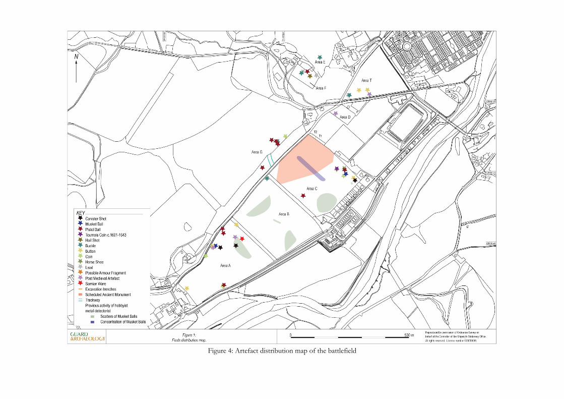
Figure 4: Artefact distribution map of the battlefield

7.4 Results
7.4.1 Core of the Battlefield
The area identified as the potential core of the battlefield .i.e. where the main engagement and associated activity takes
place, covers an area of approximately 217950 m² and was selected after a process of documentary research and
historic terrain analysis. This ‘core’ area includes four fields, an orchard and a paddock situated along the flat valley
floor known as Philiphaugh. The fields are divided by substantial enclosures composed of trees, hedges and in some
cases the outline of field banks, particularly towards the north-easterly end at Ettrickhaugh House, and Garden
Haugh, the location of the excavation. Overall, 608 objects were recovered from this area; however, only 31 artefacts
(5%) could be identified as either significant or battle-related. Of the battle-related material, or signature artefacts, only
11 lead projectiles, including musket balls, pistol balls and canister shot, and two rolled strips of lead interpreted as
personal rations for making ammunition, were identified. The rest of the material within this grouping was primarily
composed of coinage, buttons, buckles and other more domestic items dating to the post-medieval period. One small
fragment of Roman samian ware was also recovered. The remaining 95% of the assemblage consisted of undiagnostic
fragments of metal, agricultural related items and modern objects such as toy parts, cans. A modern, but interesting,
set of objects relating to a particular event included several arrowheads from recent archery practice and competitions
in Field A.
Access to the fields was a particular issue throughout the survey as some areas had been sown with a crop prior to the
survey and Area C was partially restricted by scheduling. This meant limited availability to the ground surface as large
parts of the field had to be avoided so as not to damage the crop or underlying archaeology. The restrictions on access
and how they were overcome will be discussed in turn.
7.4.1.1 Area A - Beechwood
Area A, referred to as Beechwood on estate maps, was the largest of the fields at 67700m² and was the first field to be
surveyed. The field was also in pasture and so was the only area to receive full coverage as there were no restrictions
due to the presence of crops. This is also reflected in the large volume of objects recovered from this field, which at
318 finds was the most recovered from any area during the survey, although the vast majority of these were modern
or non-diagnostic.
The ground surface was relatively flat, except for the remnants of a palaeochannel which crossed through the centre
of the field in a north-westerly direction. This created a raised terrace on the south-west area of the field close to the
Waterwheel café and marked by a shallow bend in the A708. It was in this area that the majority, if not all, of the
significant artefacts were recovered, including two pistol balls, two pieces of canister shot, a musket ball and a neatly
folded strip of lead. A concentration of late medieval and post medieval artefacts, not observed anywhere else in the
field, was also recorded at this location. A possible interpretation for this concentration of material may be seen on
Roy’s Military Map of 1747-57 which shows the original route of the Selkirk road. The current A708 road heading
west from Selkirk to Moffat runs along the north-western side of Philiphaugh. However, prior to the mid-19th century
this road terminated on the banks of the River Ettrick, possibly cutting across the Beechwood field, only to reappear
again on the other side following the route of the present B7009 into Selkirk. This old route presumably made use of a
ford to cross the river, and may explain the increase of dropped or deposited material as a steady traffic of people
moved through the area on their way to the town. The ford crossing as a feature in the historic landscape of the
battlefield may also be an important thread in interpreting the course of the battle, as will be discussed in the
concluding section.
7.4.1.2 Area B – Cannon Haugh
This field is referred to on the Philiphaugh Estate map as Cannon Haugh, an enticing placename for a battlefield.
However, due to the presence of a crop this field could not be as intensively surveyed as Area A. Rather than cancel
survey in this area it was decided to metal detect along the tramlines, i.e. pathways created by the tractor in order to
achieve a representative sample of the field. The each pair of tramlines and crossed the breadth of the field in a north-
east to south-west orientation and were spaced at 10 m intervals. It was therefore possible to metal detect along 20 of
these tramline pairs covering both directions. The assemblage recovered consisted of non-diagnostic material and
agricultural fragments. No significant artefacts were recovered in this field, although a representative sample had been
achieved.
7.4.1.3 Area C – Garden Haugh
Area C, known as Garden Haugh, was the most problematic of the areas to survey as not only did it contain a crop,
but also a large proportion of the area was scheduled under the Archaeological Monuments and Areas Act, 1979. The
scheduled area, as outlined in Fig. 4, protected an expansive settlement complex, believed to be Early Historic in date,
represented by a system of cropmarks. The settlement and other associated features including a possible cemetery
were identified by aerial photography in 1970s and a programme of geophysics was carried out by CFA in 1980s
(Alexander & Neighbour 1995). Concerned that the process of metal detecting could potentially damage the
underlying archaeology, Historic Scotland decided not to grant the project Scheduled Monument Consent to cover the
area with a systematic metal detecting survey. Although the decision is understandable, it was disappointing as a
concentration of musket balls had reportedly been found by a local metal detectorist in this area (see Fig. 4),
potentially indicating the location of the heaviest fighting. Furthermore, it was situated close to the feature selected for
trial excavation later in the project. Considering the location of the site, it is remarkable that so many phases of intense
activity, including the battle, should be concentrated in such a small area.
As previously mentioned the field also contained a turnip and winter barley crop. It was possible to cover the area
seeded for winter barley as this had not yet germinated. The turnips, however, had been drilled creating large ridges of
soil that transected the field. It was possible to metal detect in between the drills, but this was hard going under foot
and certainly slowed the progress of the survey. Much of the assemblage recovered from this field comprised of
agricultural material and domestic objects probably thrown over the fence from the row of houses which sit adjacent
to the area. However, a small concentration of artefacts was recovered from the north-eastern corner of the field,
including lead projectiles, 17th century coins and a fragment of an early horseshoe. There are three lead projectiles in
total from this small area, a musket ball, pistol ball and piece of canister shot, as well as a second pistol ball further to
the south-west. The canister shot and musket ball are of particular interest due to their morphology and context. This
will be discussed in greater detail in a separate section dedicated to an analysis of the lead projectiles from the project.

Plate 12: View of Area C
7.4.1.4 Area D - Orchard
The orchard was the most disappointing of all the areas surveyed within the project. Initially, the orchard appeared to
represent a pocket of preserved ground surrounded by the recent development of the football field. This was further
compounded by the presence of a low lying field bank running in north-west to south-west and parallel with the other
field enclosures that crossed the valley floor. The plantation of apple trees conveniently divided up the orchard into
transects measuring 3 m wide. The metal detecting team were asked to metal detect between the rows, whilst avoiding
the wire mesh wrapped around the tree trunks to protect them from cattle. A considerable amount of litter, a result of
its proximity to the football field, was removed from the fringes of the orchard and disposed of safely before the
survey could be conducted.
This encounter with modern litter continued during the survey as signal after signal pulled up drinks cans, etc. It was
decided to excavate a small test pit measuring 0.30 m x 0.30 m to establish the depth and depositional character of the
ground. At approximately 0.35 m down, close to the capacity of a metal detectors range, an Irn-Bru can was
recovered, indicating either a substantial disturbance of the upper horizons, or more likely, a deposit of dumped soil.
One possible explanation for this thick disturbed deposit was a major flood event which occurred in the summer of
2005. The housing estate, football field and area of the orchard were flooded with at least 1 m of standing water. It
also washed down with it a significant volume of hillwash and other debris. Taking this into consideration and the
results of the test pit it was decided not to continue with the survey in this area of the orchard, but to concentrate on
the area close to the field bank where the original ground surface appeared to be intact. Only one medieval or post
medieval artefact was found in this area, the foot of a bronze of a cooking pot or skillet. The rest of the assemblage
was composed of 19th -20th century material such as coins, buckles and buttons.
7.4.1.5 Area T – Triangular Field
As this area had previously been unavailable during the main survey due to the height of the grass it was surveyed
separately over two days in July. Unfortunately, the grass was cut at very short notice and a survey team could not be
organised in time to avoid a secondary growth of clover which occurred over the space of two weeks. The clover,
which covered at least a third of the total area, did hamper the progress of the survey as the metal detectors could not
get close enough to the ground surface. Furthermore, the author was informed that approximately 2-3 years ago a
metal detectorist had spent nearly two weeks in this field and had covered it intensively. According to those within the

metal detecting team, he had recovered a dagger and hundreds of other finds, none of which have been declared to
the Treasure Trove Unit.
A concentration of artefacts was recovered from the south-eastern corner of the field which more accurately
represents the area where the clover was at its shortest. One pistol ball was recovered on the eastern side of the field,
but no other potentially battle-related material was found. Two post-medieval artefacts were also found, a small
decorated buckle and a lead seal or stamp, although the latter will require firmer identification.
7.4.1.6 Area LS - Lauriston Stables
As with Area D (Orchard) this small area, used as a paddock for exercising horses, represented a potentially
undeveloped area adjacent to the cricket ground. Furthermore, the paddock was bounded to the north by a section of
well-preserved field bank. This field bank is truncated by Laurieston House and the cricket ground, before appearing
again on the other side as the bank and ditch feature where the excavation took place at Garden Haugh. The close
proximity to the potential location of the old Philiphaugh House also added an extra layer of interest as according to
historical accounts this had been an area of great activity during the battle. A review of the historical maps indicated
that little to no development had taken place on this small patch of ground, which was confirmed by the landowner.
This small field had, however, been subject to metal detecting forays in the past, as disclosed by two members of the
metal detecting team who reportedly found a spur fragment.
Surveying this area was delayed until late July, during the same period as Area T, as the paddock had recently been
seeded with grass and was therefore sensitive to trampling. Unfortunately the only day available for the survey was
extremely wet, with flood warnings in place, which reduced time for survey considerably. However, despite these
setbacks approximately two thirds of the field was covered with an intensive metal detecting survey. Forty-nine
objects were recovered and all were relatively modern in date i.e. 19th – 20th century.
7.4.2 Peripheral Areas
Three areas were surveyed as ‘peripheral’ areas i.e. areas believed to be out with the main engagement but possibly
containing evidence of other battle related activity such as skirmishing, routing or encampments. Surveying such areas
is also important in order to establish how far the battlefield extends across the landscapes by identifying the limit of
any artefact scatters. Later historical writings of the battle, drawn mostly from local legend, ballads and conjecture
rather than primary accounts, tell of Leslie splitting his forces and sending several squadrons of cavalry over Harehead
Hill to the north and then down on to Philiphaugh to attack the Royalists from the rear. There is no mention of this
in the primary accounts of the battle, which focus on Leslie’s forces crossing the Ettrick to the south to attack the
Royalist rear. As this story sat firmly in local folklore it was important to investigate this theory to ensure all avenues
of enquiry had been explored.
This investigation of the north-west side of the valley became more limited than expected as a significant area of
ground had been developed, or more accurately destroyed, as tonnes of gravel and soil several meters thick had been
dumped on the site of the former Philiphaugh Farm. Furthermore, an area between Calton Cottage and Ravensheugh
House, where one of the metal detecting team had reportedly found a cluster of musket and pistol balls, had been
transformed into a pond and wetland which had involved the removal of the topsoil to create garden features. As the
rest of the area was covered in forestry and private gardens, only three areas were available to survey. This included
two fields or paddocks at Ravensheugh (E & F) and the large field adjacent to Calton Cottage bounded by a steep
south-east facing escarpment.
7.4.2.1 Area E & F – Ravensheugh

These fields were kindly made available for survey at short notice by the landowner residing at Ravensheugh House.
This was a small area used as a paddock and for horse jumping and so could be covered with an intensive survey quite
rapidly. The soil depth was relatively thin measuring on average only 0.15 m-0.20 m with a high gravel content close to
the surface. The author was informed by the landowner that the area had been affected by the 2005 flood with
significant volume of hillwash passing through the valley as the Long Philip Burn burst its banks. Although our
location was relatively high on the valley side, it was clear that the flood had had some impact. 150 artefacts were
recorded across both areas ranging in date from post-medieval to modern. The assemblage contained a usual selection
of artefacts reflecting decades of farm and estate management, including buttons, buckles, horseshoes and other non-
diagnostic fragments of copper alloy and iron. One interesting artefact, the last to be found on the day, was the
remains of a cut-throat razor dating to the late 19th - 20th century. Two artefacts of potential significance to the
investigation found in the area were a pistol ball and a rolled strip of lead, similar to the piece found in Area A. A
piece of buckshot or hail shot was also found in this area, however, as it was in close proximity to a farm and country
house it is more likely to be related to hunting unlike examples found on the battlefield at Sedgemoor (1685), which
had a more certain relationship with pistol balls (Ferguson forthcoming). Leslie’s cavalry may have passed through this
area, but it is unlikely they would have left much trace unless intercepted before they reached Philiphaugh.
7.4.2.2 Area G – Calton Cottage
Area G is a large field with rolling topography which flanks the north-western side of the flat valley floor of
Philiphaugh. Calton Cottage sits on the northern corner of the field close to the tributary valley of the Long Philip
Burn. The field is geographically divided from the valley floor by a steep south-west facing escarpment, possibly a
truncated spur, which stretches along its entire length. As the escarpment reaches Calton Cottage it begins to reduce
in height and gradient, but is still a dominant presence when standing on the flat valley floor. Further enforcing a
feeling of separation is a dense plantation of conifer and deciduous trees which considerably reduce the inter-visibility
between the field and the valley floor. The trees would not have been part of the 17th century landscape of battlefield;
however, the topography of Area G, a steep slope which eventually dips to create a shallow rounded base before rising
again to create a flattened ridge as it reaches the escarpment, appears to create a natural blind spot. Therefore anyone
moving along this ‘blind spot’ produced by the flattened ridge and dip may have been concealed from those
positioned on the valley floor. A viewshed analysis of this landscape produced in a GIS package would be
recommended.
The method of survey engaged to survey this field had to take three factors into consideration. Firstly, the field
contained a crop; secondly, the field covered a considerable area; and thirdly, the topography of at least two thirds of
the field was very steep and therefore unlikely to contain any meaningful information in terms of artefact scatters. It
was therefore decided, in a similar method to the survey in Area B, to collect a representative sample by metal
detecting along the tramlines which were spaced in pairs every 10 m. This also reduced pressure on the metal
detecting team who would have been quickly tired out from walking up and down the hill. A different crop had been
planted on south-eastern fringe of the field i.e. the flattened ridge on the edge of the treeline and escarpment, and as it
was yet to germinate it was possible to get full coverage of this strip in an intensive survey. It was also decided to
attempt some degree of coverage on the slope of the escarpment, focusing on an overgrown trackway which had been
cut in the 1960s. According to the landowner and Craig-Brown, several small iron cannon balls had been found whilst
cutting the track, potentially fired across the valley from the Royalist artillery position at the Old Philiphaugh House
(Laurieston House). One of these cannon balls formed part of Craig-Brown’s collection and was shown to the author
during a talk to the Selkirk Antiquarian Society in December 2011. Only the fittest of the metal detecting team
volunteered to venture into the forested area as conditions were difficult. Their efforts were rewarded with the
discovery of a pistol ball.
80 artefacts in total were recovered from Area G. This may seem a relatively small amount for the area covered, but
when considering the steep topography of the field and that only a representative area was surveyed, this was
considered a satisfactory amount. The majority of artefacts were found at the base of the slope in the dip and on the

flattened ridge as expected. Diagnostic objects recovered included three buttons and two buckles, one made of iron,
and a William III silver shilling. The most interesting discovery, and perhaps the least expected, was a cluster of three
pistol balls situated on the ridge near to the edge of the escarpment (Fig. 4). All four of the pistol balls recovered,
including the pistol ball found close by in the trees, were all of matching bore i.e. diameter and weight and featured a
similar casting pattern. Clusters of pistol balls such as this are indicative of cavalry action at close quarters,
demonstrating that activity in the form of skirmishes, possibly to break up small bands of skirmishers or retreating
soldiers, were taking place outside the main area of engagement on the valley floor. This will be discussed in more
detail within the interpretation section.
Plate 13: View of Area G and location of pistol ball scatter
7.5 Artefact Assemblages
Overall, 880 artefacts were recovered from the metal detector survey and as previously mentioned only 5% could be
classed as either signature artefacts, or relative to the understanding of the archaeological landscape of Philiphaugh.
This section has been divided into three separate sections in order to provide an overview of the assemblage. This
section will first focus on the battle-related material such as the lead projectiles and any other signature artefacts that
were recovered. It will then summarise the other categories of material including coinage, buckles, buttons and other
items of interest. A list of all artefacts recorded, both diagnostic and non-diagnostic, is included as an appendix at the
end of this report.
7.5.1 Lead projectiles
In total, 14 lead projectiles were recorded across the survey area. This includes eight pistol balls, two musket balls,
three pieces of canister shot and one piece of buck/hail shot. Although this is a small assemblage of projectiles in
comparison to other battlefield projects, it does contain several interesting elements which will enhance our
understanding of the battle and its archaeological composition, for example, the proportionally high number of pistol
balls and the presence of canister shot. See Appendix A for images.
7.5.1.1 Musket balls

Only two musket balls were recorded from Area A and Area C, which is a small amount considering the area of
ground covered with intensive metal detecting survey. It is also disappointing if one compares this count to the
volume of musket balls, approximately 50 – 60, physically handed in to the author by hobbyist metal detectorists over
the course of the project. This figure rises dramatically if one considers the approximate figures provided by a number
of metal detectorists when recalling their finds to the author. The activities of hobbyist metal detectorists will be the
focus of discussion in a separate section of this report (7.6).
The first musket ball (211) from Area A measures 17 mm (0.669 in) and weighs 23 g (0.8 oz), giving it an approximate
bore of 20 i.e. number of balls to the pound. The bore has been given an approximate value as the ball appears to
have been poorly cast, therefore reducing its weight. The casting seam and sprue indicates the ball was cast in a two
part mould, possibly an individual one rather than a gang mould. The oval shape depression is a collapsed air hole
suggesting that the lead was either too hot or poured too quickly into the mould during the casting process resulting in
this feature. This may happen if the manufacturer was inexperienced, or short in time. The ball does not appear to
have been fired and therefore may have been dropped.
The second musket ball (491) from Area C measures 18.9 mm (0.744 in) and weighs 28 g (1 oz) giving it a bore of 16.
Morphologically this is a very interesting projectile as it appears to have two very distinct diagnostic features. The first
is a square dark orange patch on the surface indicating the presence of a ferrous material. It is possible that this
represents an iron inclusion added during casting to make up the composition of the ball. Iron additions to musket
balls have been found in other 17th century contexts, including one example from a site in Cornwall were a nail had
been driven through the ball (Ferguson forthcoming). The purpose may be twofold; to create a projectile with an
unstable trajectory to increase damage on impact, or to bulk up the size of the projectile if lead supplies are short. To
establish the nature of the inclusion, and to be sure the orange patch as not simply a stain on the surface, it would be
necessary to X-ray the object; a process that may be carried out in the near future.
The second feature is a hole that runs through the centre of the musket ball with a distinctive entry and exit point. The
entry point is wider with raised edges around the rim, whilst the exit point is smaller and neater in form. Inside the
hole neat spiralled ridges, or threads, may be seen indicating the use of a small screw device. It is clear from this
evidence that whilst firing the ball it had become jammed within the barrel and therefore had to be pulled out using an
implement called a tireball. The tireball was not a tool commonly owned by the average soldier and so may have been
quite rare, possibly borrowed or shared out amongst a small group of men whenever they found themselves in a
similar position on the battlefield (Courtney 1988, 3). The jamming of the ball is further supported by banding around
the equator a series of parallel grooves in the same area. This occurs when the ball expands in the heat during firing
causing it to compress along the sides of the barrel. If the ball is too large for the barrel then it may become stuck, as
we can see has happened on this occasion. This artefact encapsulates a single event which took place on the battlefield
and provides a rare glimpse of an individual’s experience of the battle.
7.5.1.2 Pistol balls
Nine pistol balls were recovered across the survey area with two found in Area A, two in Area C, one in Area F and a
concentration of four recorded in Area G. The size and weight of the balls were consistent across the site measuring
12 mm (0.472 in) in diameter and 11 g (0.4 oz) in weight giving it a bore of 38. The only exception to this was one
larger pistol ball from Area T which measured 13.6 mm (0.535 in) and 17 g (0.6 oz) in weight. All the pistol balls
present traces of a thin casting seam and small lipped sprue, which suggests they have been cast in an individual mould
rather than together in a gang mould. This is a feature that would have been filled away after the casting process.
Although most of the pistol balls are very similar, no two are the same. For example, (776) from Area G has what may
be described as a ‘hood’ surrounding the sprue of extra lead which has spilled in during the final stages of its
production. In terms of impact damage, the majority of the pistol balls appeared to have been fired showing distortion

in their shape. One pistol balls from Area C (495) was unusually distorted as the two halves on either side of the
casting seam appear to have slipped on impact giving it an elongated shape. .
The consistency in size and casting of the pistol balls suggests a degree of standardisation, not only in the manufacture
of ammunition, but also the type of pistol used by Cavalry units which is likely to have been an English flintlock pistol
(Blackmore 1962, 24). Standardisation of ammunition and firearms issued allows an army to be efficiently equipped
with supplies. Leslie’s army was a large and well organised unit, very likely influenced by Cromwell’s recently formed
New Model Army. Montrose’s Royalist Cavalry on the other hand was composed primarily of Lords and their
retainers who would have been equipped with privately owned pistols ranging in bore and design. They would have
had to produce their own supplies of ammunition, or else used bullets potentially unsuitable for their weapon.
The range and accuracy of a pistol on horseback is poor and so Cavalrymen were trained to wait until the last minute,
practically until the barrel was touching the target, before discharging the weapon. Pistol balls, particularly in clusters,
are therefore key indicators of close engagement meaning their recovery is important to our understanding of where
the battle took place.
7.5.1.3 Artillery projectiles
Primary historical sources of the battle make no reference to artillery, although some secondary sources do,
particularly Craig-Brown who places the Royalist cannon beside the Old Philiphaugh House. Leslie’s army, as a fast
moving body primarily composed of cavalry, would not have required artillery as it would have hindered their
approach. Cannonballs have reportedly been discovered as chance finds across Philiphaugh, including several small
iron cannonballs found during the cutting of a road leading up the steep escarpment to Area G. Another handed in to
the author during the project was found in a garden next to Laurieston House; however, it was large in size and was
more likely to have been a later Navy issue perhaps retained or bought as a souvenir. As previously mentioned, the
author was shown a small cannon ball which was reportedly found on the steep escarpment at Area G during
construction of a trackway to the field and became part of Craig-Brown’s collection. The ball was of a relatively small
calibre, perhaps 1.5 – 2 lbs, which is consistent with highly mobile 17th century field artillery.
The survey did, however, uncover two, possibly three, pieces of canister shot, which together with reports of
discovered cannonballs provides good evidence for the presence of artillery on the battlefield. Canister shot is a very
simple, but effective form of artillery projectile, simply consisting of a canvas bag, or later a tin, containing a
proportion of loose musket balls which is then fired from the cannon. Canister shot is most effective at close range to
repel an attack, particularly by cavalry as may have been the case at Philiphaugh (Hughes 1997, 35). Canister shot may
be identified by its characteristic morphology of multiple facets and flattened sides covering the surface of the ball.
This is caused when the musket balls collide with each other, and in some rare cases fuse together, as they are
discharged from the cannon.
The most diagnostic piece (499) immediately identifiable as canister shot was recovered from Area C in the north-
eastern corner of the field close to Laurieston House. A second piece (117) possibly representing a form of canister
shot was recorded in Area A. It is cylindrical in shape and is flat on one end, but depressed on the other. The
depressed end appears to have been cut or gouged out to create the shape. There are flattened edges similar to canister
shot, but these may have been cut rather than formed by colliding with other projectiles. Examples of cylindrical
shaped canister shot have been found at Edgehill (1642; Pollard & Oliver 2002); however, it is possible that this
projectile represents a slug; a projectile deliberately misshapen to cause maximum damage when impacted, similar to a
dum-dum bullet. The third piece (222) also recorded in Area A was initially identified as canister shot, but on analysis
this is unlikely. Rather, the morphology of the projectile, which is flattened almost to a disc with a central depression,
is more suggestive of a double loaded pistol ball. The depression is caused when the lower ball makes contact with the
upper ball when fired. Similar examples have been recorded in an assemblage from the battle of Sedgemoor (1685:
Ferguson forthcoming).

7.5.1.4 Signature Artefacts
Artefacts considered to be signatures of conflict, other than lead projectiles, may include accoutrements which form
part of the soldier’s kit that may easily fall off or brake during battle, such as lead powder box caps; powder flask
nozzles; fragments of musketry, etc. No artefacts of this type were recorded during the metal detector survey, nor
have any been handed in the author by hobbyist metal detectorists. Two artefacts that may potentially be identified as
‘signature’ artefacts, however, include two rolled strips of lead found in Area A and Area F. Rolled lead strips are often
found within battlefield assemblages and have been interpreted as rations of lead with which to cast a small personal
supply of ammunition. By 1645, lead would have been in short supply and many opted to strip lead from church roofs
and windows. As a heavy object it may have been the first thing to be thrown out of the knapsack if being pursued by
the enemy, possibly a reason why it was found in Area A. Further evidence of casting, in the form of a lead ingot and
lead waste, was also found during the excavation of the ditch.
Plate 14: Rolled strips of lead possibly intended for use in casting
7.5.1.5 Other artefacts of interest
The following section provides a brief summary of recorded artefacts which, although unrelated to the battle, should
be included within the report gives a sense of the archaeological character of the landscape other than the battlefield.
7.5.1.5.1 Coinage
A significant volume of 17th coinage, approximately 25, in the form of copper Charles I ‘turners’ or ‘bodles’ were
found across the survey area and during the excavation. These coins are a relatively common find across Scotland and
reflect the high level of activity and movement which took place around Selkirk at this time. A less common find is
the French Tournois which was in circulation from 1601 – 1642. An example of a ‘double Tournois’ was found in
Area C in close proximity to the lead projectiles in the north-eastern corner. Although technically illegal tender in
Scotland in the 17th century their use was almost encouraged by the Crown due to the poor quality of the Scottish
coinage (Holmes 1995). Although much of this coinage is contemporary with the battle it is not possible establish any
relationship between them. It is, however, very useful in terms of interpretation to recover 17th century material of this
kind as it demonstrates that material of this date is present in the ploughsoil and has not been affected by soil removal
or dumping.
7.5.1.5.2 Buttons & Buckles
The majority of buttons and buckles recorded dated to the 18th - 20th century, with a large number related to
agricultural equipment for horses. A square buckle with shaped sides (396) found in Area B was at first thought to be

17th century in date; however, it is more likely to be part of a decorated harness. Another decorative buckle (781)
found in Area T, also thought to be contemporary with the battle, dated more closely to examples from the late 17th
(Cuddleford 1992, 13)
A decorated silver button (173) recorded in Area A has been identified as possibly dating to 17th century and as an
adornment more likely to have been worn by a person of high status, it could have fallen off during the battle.
Doubts, however, have been cast on its authenticity as there is a possibility that this is a copy made for a re-enactor’s
costume, which may have been deposited during a re-enactment event.
7.5.1.5.3 Domestic and agricultural material
Two fragments of bronze skillet or pot, including a body sherd (217 A) and a leg (549 D), provide an interesting
example of medieval domestic vessels used and disposed of in this area. In area C, a fragment of an old horseshoe
(349), possibly dating to the late 17th – 18th century was recorded. Earlier examples of horseshoes may be identified by
the flat and wide plate, together with rounded shape.
7.5.1.5.4 Roman
A small sherd of decorated Roman Samian ware of Gaulish type (094) dating to the 3rd – 4th century (Webster 1996,
2), was discovered whilst excavating the plough soil to recover a metal detecting find in Area A. The sherd itself is
very thin, representing the outer layer of the vessel which has been chipped off. The condition of the sherd is good,
with the design still clear and sharp. This suggests the sherd has only recently entered the ploughsoil and therefore
may have come from a vessel disturbed within archaeological context. Other Roman material has been found on
Philiphaugh, including a coin and a finger ring, found by a metal detectorist in the 1990s.
7.5.1.5.5 Miscellaneous
Of other interest within the assemblage was a small lead alloy Fleur d’Lis (080) found in Area A. This object has not
been given a definite identification, but one suggestion is the tip of a small spoon handle possibly dating to the 16th
century. Another unidentified object, a lead disc, was found in Area T. The disc appears to have reverse lettering on
the outer edge and some kind of figure in the centre. A possible identification is a late 18th – 19th lead stamp, although
the object does appear to have a medieval character.
7.6 Extent of hobbyist metal detecting activity on the battlefield
Within initial desk based assessments prior to the archaeological investigation of the battlefield, it was suggested that
metal detecting activity was low with only one individual, the Philiphaugh Estate gamekeeper, recovering any battle
related material in the form of lead projectiles. The Estate gamekeeper had concentrated on the area between Garden
Haugh (Area C) and the Orchard (Area D) now re-developed as football pitches. Although he no longer has the
assemblage he reported to have found approximately 50 musket balls in this area over a 20 year period, although this
may underrepresent the true level of recovery.
Only once the project had begun did it become clear that in reality metal detecting activity was high across the
battlefield and had been since the early 1980s. At least five individuals, many of whom took part in the metal detector
survey, reported to have metal detected on the site on a number of occasions and had found significant quantities of
lead projectiles and other potentially battle related objects. Those who had metal detected on the site, particularly in
Area C, said they could remember approximately where they had found concentrations of material, but had not
recorded individual find spots for each artefact. Only one individual, Mr M. Brown, had kept his finds from the

battlefield, mostly musket and pistol balls, separated from other artefacts he had found across the Scottish Borders.
His collection consisted of approximately 50 musket balls and 25 pistol balls. To accompany this assemblage Mr
Brown produced a sketch map showing roughly where he had come across concentrations of projectiles, much of
which was concentrated in a band within Area C and inside the recently Scheduled Area. To assist the project Mr
Brown donated the assemblage for analysis, a process which he also took part in as part of an artefact recording
workshop. It is interesting to note that Brown’s assemblage was mostly composed of musket balls, rather than pistol
balls as with the archaeological survey. If correct this would match historical accounts of the battle which indicate that
the Irish musketeers were located on the left flank of the Royalist army. Furthermore, this sketch map produced by
Brown, together with the gamekeeper’s report, may provide the only artefactual evidence to support the theory that
the ditch at Garden Haugh, subject to excavation during the project, may have played an important role as a defensive
structure during the battle.
Despite the presence of crops in the survey area there is no doubt the volume of battle-related objects recovered
during systematic metal detector survey was very low, particularly in comparison to the large volume of material
recovered by hobbyist metal detectorists over a 30 year period. With this in consideration it must be concluded that
hobbyist metal detecting has had a negative impact on the archaeological survival of the battlefield with a significant
volume of unrecorded artefacts consistently removed over a period of many years. An important factor is the presence
of Early Medieval and potentially Roman material which will mark these fields out as attractive places to metal detect.
As the focus is on recovering earlier artefacts, the value of the battlefield material is not considered and in some cases
may even be regarded as a hindrance if a large proportion of ‘good’ signals turn out to be lead musket balls, resulting
in them being thrown away or collected as a curiosity.
It is important to note that local metal detectorists who made up the survey team made a significant contribution to
the project. Their involvement was important as it provided an opportunity to promote the importance and sensitivity
of the battlefield, as well as encouraging good practice in recording and a sense of stewardship within the local
community. It is hoped that this awareness, along with the support of the Philiphaugh Estate, will reduce further
metal detecting activity on the battlefield.
Plate 15: Unrecorded musket balls recovered by hobbyist metal detectorists from the battlefield
8.0 Overall interpretation
The evidence recovered from the battlefield, in the form of an artefact assemblage of battle related artefacts, is a small
sample. It is therefore only possible to provide a limited interpretation of the battlefield beyond comments on the

archaeological survival of the site which have been discussed throughout this report. This interpretation will therefore
focus on two areas identified as significant. The first is the small scatter of projectiles, including a piece of canister
shot, in the NE corner of Area C (Garden Haugh) and the concentration of pistol balls in Area G. Results of the
excavation and information gathered from unrecorded assemblages recovered by hobbyist metal detectorists will also
contribute to this interpretation.
Drawing on the archaeological evidence recovered during the project, together with historical research and historic
terrain analysis may suggest the following:
1. Area C (Garden Haugh) may be identified as an area of significant activity during the battle due presence of a
representative assemblage of lead projectiles, including pistol balls, a musket ball, with evidence of having
jammed in the musket, and a piece of canister shot. Also taken into consideration are the scatters of material
recovered by hobbyist metal detectorists in this vicinity.
2. The canister shot is evidence of the use of artillery and supports the theory that it was located at the Old
Philiphaugh House (Laurieston House). Primary historical accounts of the battle suggest a unit of Covenanter
cavalry broke away from the main army to intercept the Royalists from the rear, crossing the River Ettrick in
the process. Roy’s 18th century map indicates the use of a fording point across the Ettrick at Beechwood
where the main road terminates on the banks of the River. It is therefore possible that that the Covenanter
cavalry used this fording point to gain access to Philiphaugh. This may be supported by the location of the
canister shot in Area A and Area C, which suggests artillery was used to break a Covenanter cavalry charge
from the rear heading northwards up the valley.
3. The pistol balls in Area G are indicative of a cavalry action taking place at close quarters. There are two
possible interpretations for this scatter. The first is that this action took place in the opening stages of the
battle with a squadron sent up the slopes of the escarpment by Calton Cottage and Leslie Cottage to dislodge
small bands of skirmishers taking advantage of the higher ground. The second interpretation is that this
action may have occurred in the closing stages of the battle when bands of routed Irish soldiers attempting to
escape were pursued by Cavalry. It is also possible to consider that a unit of Covenanter cavalry moved along
this ridge parallel to a unit on the other side of the Ettrick in an attempt to close the Royalists off at the rear.
This movement may have been the origin of suggestions that the Covenanters attempted to surprise the
Royalists by moving around Harehead Hill. Using this ridge, which is somewhat concealed from the valley
floor, seems a much more plausible theory.
9.0 Working within the community
This project aimed to work closely with the local community through a programme of workshops, talks and
opportunities for volunteers to participate in field work and other activities. Engagement with local schools was also
an important part of the project, which involved an artefact handling workshop, a tour of the battlefield and a
demonstration of how a 17th century soldier would have lived and fought.
9.1 Volunteers
Volunteers were a vital part of the project and were involved at each stage, including the metal detector survey and the
excavation. Overall the core volunteer team was made of 15 members of the community who took part in the project
on a regular basis. At least 10 other volunteers and metal detectorists from the surrounding area arrived to take part
for one or two days only. The average age of the volunteers was between 45 – 65, with younger members only taking
part sporadically throughout the project.

The volunteers can be categorised into two groups; field recording assistants and local metal detectorist. Prior to the
metal detector survey beginning, a volunteer workshop was organised to introduce volunteers to the aims of the
survey and the methodology involved. This was to ensure that each member of the team was aware of the
archaeological process; why this methodology was being used; the tasks they would be engaged in and what was
expected of them in terms of fulfilling tasks. The aim was to give volunteers the opportunity to learn a new set of
skills and in turn create a confident team of volunteers therefore enhancing their experience of the project. The
workshop was particularly important for the volunteer metal detectorists who are asked to follow a set methodology
for recovering artefacts, a process that many of the team would not have been familiar with. Each volunteer was given
a ‘Volunteers Handbook’ which provided information on the project, the methodology and some helpful resources to
learn about archaeology e.g. RCAHMS website and Treasure Trove. In previous experiences of metal detector survey,
metal detectorists have expressed a frustration at the process of recovering artefacts within an archaeological
framework, and not being ‘allowed’ to use their own preferred system instead. This is mainly due to the lack of time
available in the field to explain the process and answer questions relating to it. Once the logic behind this process is
understood and any myths dispelled, the majority feel much more confident to engage with it. The workshop proved
to be very successful as each volunteer was familiar with the process and could therefore develop their skills and
understanding further. The workshop was also an opportunity for the volunteers to meet each other and gel as a team,
something which happened very quickly.
Plate 16: Volunteers during excavation
9.2 Artefact Recording Workshops
As well as the initial volunteer workshop there was also an opportunity for volunteers to get involved with the post-
excavation process. It was felt important that volunteers should be aware of all aspects of the archaeological process
and it also gave many of those involved in the metal detector survey to see and handle the artefacts they had either
found or recorded in the field. The workshop involved sorting, identification and cataloguing of the artefacts over a
period of two days. Along with the author, this workshop was assisted by Jen Novotny, a doctoral researcher within
the Centre for Battlefield Archaeology and artefact specialist.
9.3 Open Evening and Open Excavation Day

To ensure as many people within the local community could be engaged with the project, without the need to actively
participate in volunteering, a series of events were organised including two talks and an Open Day. The first talk took
place in April 2011 in the Victoria Hall and focused on introducing the aims of the project as well as inviting
suggestions and ideas from members of the local community. It was also an opportunity to raise awareness of the
project and to recruit volunteers, as well as displaying battlefield artefacts from other projects organised by the Centre.
The second talk, which took place in December 2011, provided a round up of the project, presented the results and
showcased the artefacts found during the course of survey and excavation. This talk was hosted by the Selkirk
Antiquarian Society.
The Open Excavation Day took place over a weekend during the excavation of the ditch at Garden Haugh. Members
of the public were invited to see the work in progress with a guided tour of the trenches and to view some of the
uncovered artefacts. This event was organised to co-ordinate with a re-enactment event organised by the Philiphaugh
Estate next to the Waterwheel Café, which resulted in a steady stream of people walking to and from Selkirk. As well
as local people, there was a significant number of tourists visiting the area on holiday who also visited the excavation.
The Open Day, or weekend, was a great success and certainly achieved its aim of raising awareness of the battlefield
and its underlying archaeology.
9.4 School workshops
A series of artefact handling workshops and battlefield tours were organised for local primary and secondary school,
of which Selkirk High School and Tweedbank Primary took part. Schools are the core of the community and it is
vitally important to get young people involved and aware of the historical environment around them, especially as the
battlefield is situated so close to the town of Selkirk. The workshop and tour for Selkirk High School took place over
two days and involved two classes of S1 – S2 pupils who took part in activities across a morning and afternoon. In the
morning the class were given a tour of the battlefield and learning about the life a 17th century solider. This activity
was led by project historian Ols Helfer who as a 17th century re-enactor was able to give a realistic demonstration of
how a soldier would have lived and fought, including his kit and the firing of his match-lock musket. In the afternoon,
pupils took part in an artefact based workshop, led by the author, which involved handling and analysing 17th – 18th
century battlefield artefacts. Pupils described and drew their artefacts and recorded them by measuring, weighing and
photographing them. Rather than being told outright what the artefacts were, the pupils were encouraged to
investigate them using information on the fact sheets provided. The primary school workshops were focused much
more on group-led learning as an artefact handling exercise would not have been appropriate due to the size of the
number of classes participating. Pupils were still able to view the objects and a live firing demonstration of the musket
was also provided by Ols in the playground.
10.0 Conclusions and recommendations
10.1 Potential of further work There are a number of potential opportunities to investigate the archaeological landscape of the battlefield further. It
is also recommended that any systematic metal detecting survey should take place in the autumn and early winter to
avoid disturbance to crops.

Further investigation of the battlefield may include:
1. Further excavation of the ditch to resolve the date of construction and the purpose of stone lining.
2. Intensive metal detecting survey in Areas C and G with a particular focus on the areas defined by artefact
scatters. This may be of importance in Area G to assess the extent of possible cavalry activity on the ridge i.e.
is this an isolated pocket or not? In Area C, a representative sample has been taken which has identified a
range of lead projectiles associated with the main engagement.
3. Return to Area T to carry out another phase of intensive metal detecting survey as this appears to be the only
surviving pocket of ground NE of Garden Haugh.
4. Carry out a systematic metal detector survey in fields situated between the leat and the River Ettrick to
establish whether any scatters of battle related material are present there.
5. Conservation of the Battle of Philiphaugh monument. This is a unique monument which could be further
promoted as part of the battlefield landscape. An investigation is also required to establish the origin of the
building material as it appears to have prehistoric and medieval elements.
6. Geophysical survey at Slain Men’s Lea to establish the presence of pits or graves that may be associated with
the battle and the subsequent execution of Irish soldiers within the Royalist army.
10.2 Activity on the battlefield
The Battle of Philiphaugh is recognised within the Historic Scotland Inventory of Battlefields as a battlefield of
national significance. As guardians of the battlefield, the Philiphaugh Estate is responsible for protecting and
maintaining this unique and sensitive archaeological landscape. In consideration of the evidence gathered during this
project, this report recommends that the activity of hobbyist metal detecting should be discouraged on all areas of the
battlefield. If permission is given to metal detect, then the Estate are advised to refer to the following guidelines:
1. Ensure that the individual is aware of the archaeological significance of the battlefield.
2. Ensure that the individual intends to record the position of each artefact with a GPS, as well as individually
bag them and assigning a unique find number to each one for future reference.
3. All artefacts found are reported to the Philiphaugh Estate. Treasure Trove laws in Scotland require these
artefacts to then be reported to the Treasure Trove Unit based in the National Museum of Edinburgh.
Declaration forms may be found on their website.
4. If the individual cannot agree to any of these stipulations then they should not be granted access to the
battlefield. For further advice they may be referred to the Treasure Trove Unit for information on recording
methods.
Modern contamination from events other than agriculture was an issue taken into consideration during the survey as
in Area C (now a scheduled area) has in the past been the site of agricultural fairs, and Area A the location for re-
enactments celebrating the battle. Re-enactors pride themselves on being historically accurate, including their
weaponry, clothing and equipment. Re-enacting on the actual site of a battlefield is frowned upon in most circles as
inappropriate, not only because it raises moral questions relating to whether battlefields should be considered as war
graves (e.g. Culloden), but also because of the potential contamination of the archaeology with ‘historically accurate’
material being dropped or torn off as in real conflict events. The author understands why the re-enactment event took
place here as it is within the grounds of the Philiphaugh Estate and next to the Waterwheel Café, all important
elements to boost the local economy in the summer season. However, if such events are to continue in the future
questions must be raised about finding a more appropriate location, not only to protect the underlying archaeology,
but also in consideration of any ethical concerns.
The Battle of Philiphaugh project has successfully involved the local community in a programme of fieldwork,
workshops and Open days which has contributed to our understanding of the battle and its place in the landscape.
Whilst our understanding of the battlefield has increased with new information on the archaeological character of the
landscape coming to light, it is clear that more field work is required to further enhance this understanding. Work is
also required in the heritage management of this landscape as certain activities which have taken place in this area have
had a significant impact on its survival. At present there is a real risk that all archaeological traces of the battlefield will
disappear entirely if action is not taken. It should be noted, however, that the project has succeeded in raising
community awareness of the battlefield, together with a sense of stewardship for the battlefield. Therefore it is
possible, in conjunction with the local community, to put in place a successful and long lasting management and
conservation strategy which will serve to enhance and promote this nationally significant archaeological heritage.
11.0 Acknowledgements
The Philiphaugh project was part of a community initiative and thanks are offered to the people of Selkirk for their
warm hospitality and for giving up their time to take part. Thanks should go to all the volunteers whose assistance
throughout the project was very much appreciated, particularly Sue Cook, Mick Brown, Jock Graham, Ian Brown, Phil
Clayton, Nettie & Fraser Simm, Colin & Ewan Cairny, Gina Tubbutt. A very special thanks must go to Al Pattullo,
Judith Thompson and Ragz who participated in the ‘Adopt-an-Archaeologist’ scheme. With great kindness they
offered their hospitality on a number of occasions which was very much appreciated all round.
Thanks to the project manager and Executive Director of the Centre for Battlefield Archaeology Dr Iain Banks.
Thanks also to Dr Tony Pollard, Centre Director. Many thanks to our project assistants who are currently doctoral
researchers and MLitt students within the Centre for Battlefield Archaeology. They are Jen Novotny, Ryan McNutt,
Justin Smith, Martin Crawford. Professional and moral support was provided by GUARD Archaeology Ltd Surveyor,
Fiona Jackson and illustrator Gillian Swan. Thanks are also due to Scottish Borders Local Authority Archaeologist, Dr
Chris Bowles who was good enough to give up a Saturday to come and dig with us.
This project of course could not have been possible without the support of the Philiphaugh Community Project
Manager Julie Nock and Sir Michael Strang-Steel of the Philiphaugh Estate. Every resource possible was put to our
disposal of which we are very grateful.
12.0 Bibliography
Bostock, R. 1645 A more and perfect relation of the late great victorie in Scotland obtained over Montrose. London.
Brown, C. 2002 The battle for Aberdeen, 1664. Tempus
Craig-Brown, T (1886) The history of Selkirkshire or chronicles of Ettrick Forest, 2v Edinburgh Page(s): Vol.1
Douglas, G. 1986 A Survey of Scottish Brickmarks. Glasgow: Scottish Industrial Archaeology Survey

Ferguson, N. (forthcoming) A tale of two battles: The contribution of two hobbyist metal detectorists to battlefield archaeology. Furgol, E. M. 1990 A Regimental History of the Covenanting Armies 1639 – 1651. Edinburgh: John Donald Gentles, I. J. 2007 The English Revolution and the Wars of the Three Kingdomes 1638 – 1652’. Harlow: Pearson/Longman
Gordon, P (Ruthven). 1649 A short abridgement of Britane's distemper, from the yeare of God M.DC.XXXIX to M.DC.XLIX.
Aberdeen : Printed for the Spalding Club, 1844
Holmes, N. 1998 Scottish Coins: A history of small change in Scotland. NMS Publishing: Edinburgh
Kenyon, J and Ohlemeyer, J. 1998 The Civil Wars: Military History of England, Scotland and Ireland 1638 – 1660. Oxford University Press. Reid, S. 1990 The Campaigns of Montrose: a military history of the Civil War in Scotland, 1639-1646. Edinburgh: Mercat Press Webster, P. 1996 Roman Samian Ware in Britain. Council for British Archaeology
Online Sources:
Historic Scotland Inventory of Battlefields: Battle of Philiphaugh, 1645
http://data.historic-scotland.gov.uk/pls/htmldb/f?p=2500:15:0::NO::BATTLEFIELD:philiphaugh:

13.0 Appendices
13.1 Artefact Images
13.1.1 Lead projectiles
Musket balls
Find no. 491/C: Musket ball with a central hole created by a tireball
Find no. 211/A: Musket ball which has been miscast.

Pistol Balls – Area A
Area C

Area F
Area G
Area T
Artillery projectiles

Find no. 499/C: Canister shot – note the multiple facets across the surface of the ball
Find no. 222/A: Possible canister shot or compressed pistol ball
13.2 List of Contexts

Context No
Area Context type Description Interpretation
001 T1 Deposit Turf layer overlying compact dark brown clay/sand. Depth 0.05 m
Turf layer/topsoil
002 T1 Deposit Light coloured brown-grey sandy clay. High concentration of gravel and river pebbles. It is a loose compaction with a depth of 0.25 m. Extents 1.9 0m to beginning of ditch and underneath bank, terminating at larger stones. Truncated by ditch cut [004]
Forms the base of the bank
003 T1 Deposit Compact orange-brown deposit
with a clay-sand composition. Approximately 0.35 m thickness and extends across the length of the trench, but is less visible within the ditch.
Natural
004 T1 Cut Wide shallow linear cut with rising on either side to form bank. Rounded corners and shallow at base. Break of slope gentle and rounded. Sides gentle to base on west side, but rises steeply on east side. Orientation is E-W. Cut becomes less visible on west side and becomes difficult to resolve nature.
Shallow ditch with steeper east side, possibly recut on west side.
005 T1 Fill Medium compaction dark brown
and clay-sand. Small stone inclusions, as well as fragments of charcoal and numerous Victorian artefacts at base. Fragments of glass and ceramics throughout fill. Shallow in section - approximately 0.51 m at base of ditch, rising to 0.30 m. Extends in section - approximately 5.30 m where cut becomes less clear after deposit of mortar at 5.10 m
Later fill of ditch. Mixed with stone that appears to be river deposits. Also dry at base.
006 T1 Fill/Deposit Medium compaction light brown sandy clay. Infrequent stone inclusions. Extends from 5.30 m - 7.0 m with an approximate thickness of 0.25. Possibly truncated by [004] cut. Very mixed and only difference between (006) and (005) is slight colour change. (006) is slightly lighter in colour.
17th century coin found in situ. Context looks to be a fill rather than a deposit, however cut is not clearly visible at this end.

Coin of Charles II c. 1660 - 1684 found within fill.
007 T1 Deposit Compact orange-brown deposit
with a clay-sand composition. Approximately 0.35 m thickness and extends across the length of the trench, but is less visible within the ditch.
Context same as (003)
008 T2 Deposit Compact dark brown clay-sand topsoil at NE end of trench. Significant root action from surrounding trees. Extends to ditch base with an approximate thickness of 0.10 m, thinning to 0.02 m at ditch base.
Topsoil deposit. Context same as (009)
009 T2 Deposit Compact dark brown clay-sand
topsoil at SW. Significant root action from surrounding trees. Approximate thickness of 0.02 m
Topsoil deposit. Context same as (008)
010 T2 Fill Dark brown clay-sand. Mixed fill containing modern plastics, together with ceramic sherds and cu alloy/fe fragments. Thickness approximately 0.30 m and extending across base of ditch
Fill of cut (012). Mix of modern debris washed into ditch. Very thin layer of topsoil on top, therefore appears to be subject to regular flood wash.
011 T2 Structure Compact regularly placed stone lining on NE facing side of ditch. Composed of relatively small and flat stones carefully selected. Gradient of the NE facing ditch slope is steep. Structure contains c.late 19th century brick.
Stone lining of NE facing side of ditch. Structure contains c. Late 19th century red brick
012 T2 Cut Square shape cut at base of ditch with sharp corners. Approximately 0.65 m wide and 0.40 m deep. Break of slope is sharp at NE facing side and more gently on SW facing slope. Base is flat and square in shape. Orientation is NE/SW. Fill numbers (010) and (009) and lined with stones from (011) and (013)
Modern re-cut of ditch possibly contemporary with stone lining event.

013 T2 Structure Compact stone lining and paving of SW facing side of ditch. Composed of large angular stones measuring approximately 0.30 m x 0.15 m dimensions. Reveting extending beyond break of slope and continues 2 m in a NE direction. Stones larger and less compact than on NE facing side.
Stone lining and paving on SW facing side of ditch. Appears to be slight difference in stone structure compared with NE facing side (011). No evidence of modern material such as bricks. May not be contemporary with structure (011)
014 T2 Cut Cut of linear ditch on NE facing side. Gentle and rounded break of slope with steep sides to base. Truncated by modern square cutting [012] at base. Fills (009), (010) and (011).
Original cut of linear ditch on NE facing side.
015 T2 Cut Cut of linear ditch on SW facing side. Rounded break of slope with gently sloping sides to base. Truncated by modern square cutting of [012] at base. Fills include (013), (008) and (010).
Original cut of linear ditch on SW facing side.
016 T2 Deposit Compact orange-brown deposit with a clay-sand composition. Approximately 0.35 m thickness and extends across the length of the trench, but is less visible within the ditch.
Natural and similar to (003) in Trench 1

13.3 List of Finds
Find No. Area Context No. of Pieces
Material Description
001 T1 006 1 Cu alloy Charles II Scottish two pence (bodle) c.1663. Small triangular shaped hole off centre
002 T1 Spoil 1 Lead Pistol ball (see lead projectile sheet)
003 T1 Spoil 1 Cu alloy Small 17th century coin. Facings worn and very thin.
004 T1 Spoil 1 Lead Rectangular flat piece of lead with rounded edges and squared sides. Evidence of melting on one side. Lead ingot half melted
005 T1 005 1 Glass Thick sherd of green glass, post medieval.
006 T1 005 1 Lead Lead disc with one flat side and one curved side. Possible lead waste from crucible.
007 T2 Spoil 1 Lead Musket ball (see lead projectile sheet for detail)
008 T2 009 1 Silver Victorian threepenny piece c.1859. Slightly worn but in excellent condition.
009 T2 011 1 Brick Red brick with 'Patent Loudons & Russell Newmains' c. 19th century
T1 005 5 Ceramic Modern blue and white glazed body sherds
T1 005 3 Ceramic Modern glazed rim sherds
T1 005 2 Ceramic Modern brown glaze body sherd
T1 15 Glass Post-medieval, unknown metallic shining
T2 3 Glass Modern base of bottle, clear.
T1 1 Mortar Small lump of mortar
T1 4 Slate Small fragment of slate with traces of mortar
T1 1 Rubber 20th century bottle top
T1 1 Bone Large fragment of animal bone (possibly cow)
T1 1 Metal Fragment of a pocket watch
T2 3 Glass Modern bottle neck, clear.
T2 5 Plastic Fragments of plastic sheeting

13.4 Lead Projectile Analysis
Area& Find No.
Dimensions Weight (oz)
Weight (g)
Condition Casting feature Diagnostic Feature Description Interpretation
A/117 15.1 x 12.2 0.8 22 Flaky with smooth surface
None Possible banding Cylindrical in shape. One end flat and smooth, other end has rough depression
Slug or canister shot
A/211 17 0.8 23 Smooth surface and pitted
Trace of seam and sprue. Casting error at sprue. Sunken during casting
D shape depression near sprue which appears to be casting error.
Minimal impact damage. Main feature is depression next to sprue
Musket ball with casting error
A/222 16.3 x 0.89 0.5 12 Pitted and flaky
None Compression creasing around sides
Flat rounded disc with slight depression in centre and rounded at other end
Possible canister shot or result of double loaded pistol ball
A/302 11.9 0.3 8 Pitted and flaky
Possible air hole
Distortion of shape 1/2 flat with rounded edges and 1/4 flat
Pistol ball. Impact damage, possible air hole present in ¼ flat
C/491 18.9 1 28 Pitted and flaky with traces of original surface colour
None Banding with prominent vertical lines. Distortion of shape. Hole running through centre, wider at one end. At narrow end it is possible to see threading. Dark orange square on one side. Possible composite piece with iron cube inclusion.
Distortion of shape with one side appears to be compressed
Musket ball removed from musket or rifle with a worm. Possible iron cube inclusion. Prominent banding suggestive of becoming stuck within the barrel.
C/495 22 x 0.69 0.4 12 Smooth surface and pitted
Possible trace of seam and sprue
Heavy distortion of shape along orientation of seam
Flat oval shape, appears as if two halves have slipped away
Pistol ball. Impact damage causing rupture from seam.

C/499 16.1 0.8 23 Smooth surface and pitted
None Facets across surface Multi-faceted surface Piece of canister shot
F/592 0.9 0.1 4 Flaky and pitted
Trace of seam Distortion of shape 1/2 flat with rounded edges Hail shot, possibly from hunting as close to farm house
F/636 12.2 0.4 11 Flaky and pitted
Trace of sprue Slight distortion of shape Slight impact damage Pistol ball with slight impact damage
G/697 12.3 0.4 11 Flaky and pitted with brown deposit on one side
None Slight distortion of shape Distortion of shape and small nick.
Pistol ball with slight impact damage
G/636 12.2 0.4 11 Flaky and pitted
Sprue and seam Slight distortion of shape Small gouge Pistol ball with slight impact damage
G/738 12 0.3 10 Flaky and pitted
Sprue and seam Slight distortion of shape Slight compression of shape Pistol ball with minimal to no impact damage
G/776 12 0.4 10 Flaky and pitted
Sprue with slight overlap
Slight distortion of shape Slight compression of shape and small gouge
Pistol ball with slight impact damage
T/793 13.6 0.6 17 Flaky and pitted
None Distortion of shape, both sides compressed
Compressed but rounded sides
Impact damage, possible carbine ball or large pistol ball.
TR1/ 002
17 x 11.5 0.5 15 Smooth surface with brown staining
Bar sprue Severe distortion of shape
Oval in shape with 1/2 flat and large hole.
Large pistol ball. Large air hole due to casting error causing main distortion.
TR2/ 007
15.5 0.7 21 Smooth shiny surface, little oxidisation
Prominent sprue and seam and 1/4 flat where it has attached to other ball within mould. Circular bands across surface
Casting most prominent feature. No distortion of shape
No distortion of shape and prominent casting features
Freshly cast musket ball with casting features still present.

13.5 List of Drawings
13.6 List of Photographs Area Frame Context No. Subject Taken From
T1 1826 001 Plan of Trench 1 with removal of turf and cleaned NE
T2 1827 008 Plan of T1 – removal of turf and cleaned NE
T2 1828 008/015 Plan of T2 – removal of turn and cleaned SW
T2 1833 008/015 Plan of T2 – cleaning of 015 and half section SW
T2 1853 008/015/009/012 Plan of T2 – half section showing stone lining NE
T1 1869 005/006/007/004 Section of ditch fill W
T1 1886 002/003/005 Section of NE end of ditch showing cut and fills W
T1 1885 005/006/007 Section of SW end of ditch showing cut and fills W
T2 1889 009/010/011/012 Section of ditch showing later cutting of base W
T2 1890 008/013/016 Section of ditch showing stone lining W
T2 1895 009/011 NE facing side of ditch showing stone lining NE
T2 1896 010/015 SW facing side of ditch showing cut and stone lining
SW
T1 1897 N/A Backfill of Trench 1 NE
Area Drawing No Sheet No Subject Scale
T1 1 1 NE facing section of Trench 1 1:10
T2 2 1 NE facing section of Trench 2 1:10
T2 3 2 Plan of Trench 2 1:20
MD Survey Area
N/A N/A Distribution map of artefacts recovered during systematic metal detecting survey
MD Survey area
N/A N/A Distribution of lead projectiles recovered during systematic metal detecting survey

13.7 List of finds from the battlefield handed in by hobbyist metal detectorists Please note that these objects do not have individual find spots. The individually bagged and assigned find numbers during post-excavation to enable analysis. Number Width Weight oz Weigth g Condition Diagnostic
Feature Description Interpretation Casting
feature Location
1 14.00 1.30 36.00 good circular feature
Garden Haugh
2 12.00 1.00 26.00 good poorly cast Garden Haugh
3 12.00 0.90 25.00 good slight knick sprue Garden Haugh
4 12.00 0.80 24.80 good teeth marks, flattened impact
rounded sprue
Garden Haugh
5 12.00 0.80 22.00 Good Banding at equator
Slight impact CB/MB trace of seam
Garden Haugh
6 12.00 0.80 22.00 Pitted and flaky
MB trace of seam ridge
Garden Haugh
7 12.00 1.00 26.00 Pitted and flaky, grey patina
Multiple facets, possibly hailshot
Elongated shepe with possible sprue, very irregular shape
MB/CS Possible sprue
Garden Haugh
8 13.00 1.00 27.00 Pitted and flaky
banding at equator; 1/4 flat
Distortion of shape
MB Trace of sprue
Garden Haugh
9 14.00 1.00 23.00 Pitted and flaky
1/2 flat with rim; large gouge; possible blast mark
Severe impact
MB None Garden Haugh
10 18.50 0.80 23.00 Pitted and flaky
1/2 flat with with curving lips at rim; radial lines on flat; trace of banding
Severe impact
MB Sprue Garden Haugh
11 12.00 0.80 23.00 Flaky with Banding at Medium CB/MB Sprue Garden

smooth patina
equator; 2 1/4 flat with lip
impact with evidence of ricochet
Haugh
12 11.00 0.60 19.00 Dark patina with crystalisation on patina. Trace of orange deposit
Trace of banding; rounded distortion on one half
Distortion of shape and potentially too light for size
PB/CB None Garden Haugh
13 12.00 0.90 25.00 Flaky with smooth patina
Slight nick Slight distortion of shape
MB/CB Sprue Garden Haugh
14 12.00 0.90 25.00 Flaky with smooth patina
Little/no damage Possibly unfired
MB Seam and sprue
Garden Haugh
15 13.00 1.00 26.00 Flaky with smooth patina
Prominent banding with vertical grooves surrounding equator; 1/2 flat with slight depression; rounded half with small air hole
Severe impact damage; possible double loading
MB None Garden Haugh
16 11.00 0.70 19.00 Dark patina with crystalisation on patina. Trace of orange deposit
1/2 distortion and facets and grooves
Impact damage; light ball for size and colour unusual
PB/CB None Garden Haugh
17 15.00 1.20 34.00 Pitted and flaky
Trace of banding; slight distortion
Fired; poor quality lead; large ball
MB None Garden Haugh
18 0.90 0.50 13.00 Pitted and flaky
Slight distortion of shape
Impact damage
PB None Garden Haugh
19 10.00 0.50 15.00 Pitted and flaky
Distortion of shape; nicks and
Impact damage;
PB None Garden Haugh

grooves; small dimple
small dimple possible hail shot
20 11.00 0.70 21.00 Smooth with dark grey patina
two heavy nicks with folding lips
Impact damage; impact close to sprue
PB/CB Sprue Garden Haugh
21 12.00 0.70 19.00 Severe pitting and flaky
Slight distortion of shape
Possible impact; corrosion of patina
PB/CB Prominent seam ridge; slightly offset casting
Garden Haugh
22 15.00 1.30 36.00 Smooth patina
Slight nicks; little distortion of shape; trace of scarring on surface
Fired MB Seam Garden Haugh
23 12.00 0.90 25.00 Pitted and flaky
Slight distortion of shape; nicks and grooves
Impact damage
MB Seam at pole and rounded sprue
Garden Haugh
24 12.00 1.00 25.00 Pitted and flaky
Slight distortion of shape; small groove; incised lines creating a cross, one line covers equator
Slight impact damage
MB Sprue Garden Haugh
25 10.00 0.60 18.00 Patina not formed; smooth and dark in colour
Deep pitting at pole; nicks and grooves across surface
Impact damage
PB Sharp prominent sprue and seam
Garden Haugh
26 13.00 1.00 28.00 Dark patina; rough
Banding at equator with vertical grooves; 1/4 flat with striations on surface; lip; mulitple grooves and nicks; small dimple
Impact damage with possible ricochet; dimple possible double loading
MB Possible seam
Garden Haugh

27 12.00 1.00 28.00 Flaky and pitted; patches of severe pitting
Slight distortion of shape; 1/4
Slight impact damage
MB/CB sprue Garden Haugh
28 12.00 0.90 26.00 Pitted and flaky; patches of deep pitting
Distortion of shape; roundedmultiple flats; deep nick with lip; scuff
MB/CB None MB
29 12.00 1.00 27.00 Pitted and flaky
Slight distortion of shape
Possible impact
MB Possible sprue
Garden Haugh
30 12.00 1.00 28.00 Pitted and flaky
Slight distortion of shape; deep nick; incised line covering equator
Impact marks and possible modification
MB Sprue and seam
Garden Haugh
31 12.00 1.00 27.00 Pitted and flaky
Slight distortion of shape; slight casting offset
Impact damage and casting distortion
MB Sprue and seam; slight offset
Garden Haugh
32 14.00 1.20 33.00 Pitted and flaky
Minimal distortion; large gouge with rough sides
Gouge possible impact; casting?
MB None Garden Haugh
33 14.00 1.20 33.00 Pitted and flaky
1/2 depression with deep hole; deep gouge; deep groove
Depression and hole possible casting error; double loading?
MB seam Garden Haugh
34 14.00 1.20 33.00 Pitted and flaky
Multiple facets; distortion of shape
Impact damage
CS None Garden Haugh
35 14.00 1.30 36.00 Pitted and flaky
Minimal distortion; slight groove
Minimal impact; dropped?
MB None Garden Haugh
36 12.00 1.00 28.00 Pitted and flaky
1/4 flat; multiple pits
Pits possible teeth marks
MB None Garden Haugh
37 12.00 1.10 29.00 Smooth Minimal/no distortion
Dropped? CB/MB Prominent sprue and
Garden Haugh

seam
38 12.00 1.10 30.00 Pitted and flaky
1/4 flat; flat rough and pitted;
Minimal impact
CB/MB Sprue and trace of seam
Garden Haugh
39 9.00 0.70 19.00 Severe pitting and flaky
Distortion of shape; possible offset of seam
Impact with possible casting offset
PB Spue and trace of seam
Garden Haugh
40 8.00 0.60 16.00 Pitted and flaky
Distortion of shape; regular facets surrounding equator.
Impact damage; possible rifle marks? Small fowling piece?
Possible fowling piece
None Garden Haugh
41 8.00 0.60 16.00 Smooth Minimal/no distortion
Dropped? PB Sprue and seam
Garden Haugh
42 12.00 1.10 30.00 Pitted and flaky
Small flat at sprue; deep pitting
Minimal impact
MB Sprue and seam
Garden Haugh
43 12.00 1.00 27.00 Pitted and flaky
Multiple facets; small deep grooves and pitting
Distortion of shape
CS? None Garden Haugh
44 12.00 1.10 30.00 Pitted and smooth
Minimal/no distortion; deep depression with sprue in centre
Poor casting; sprue collapsed as cast
MB Sprue and seam; casting error
Garden Haugh
45 12.00 1.10 30.00 Pitted and smooth
Minimal/no distortion; small hole at sprue
Poor casting; sprue collapsed as cast
MB Sprue and seam; casting error
Garden Haugh
46 9.00 0.70 20.00 Pitted and smooth
Slight distortion of shape; flattening corresponds with seam
Shape possibly due to casting
PB Sprue and seam; mould shape poor
Garden Haugh
47 8.00 0.70 19.00 Pitted and smooth
Minimal/no distortion
Two sprues due to casting type
PB 2 sprues and seam
Garden Haugh
48 7.00 0.60 16.00 Pitted and Trace of banding Slight impact PB None Garden

flaky and vertical grooves at equator; slight distortion of shape
and firing diagnostic
Haugh
49 12.00 0.70 20.00 Pitted and flaky
Banding at equator; 1/4 flat at pole, rough edges.
Possible imapact damage
MB None Garden Haugh
50 10.00 0.50 14.00 Pitted and flaky
Trace of banding above equator; small 1/4 flat
Firing and possible ramrod mark
PB None Garden Haugh
51 12.00 0.70 20.00 Pitted and flaky
Minimal/no distortion; crescent shaped depression surrounding sprue
Depression due to casting error
MB Sprue, sunken
Garden Haugh
52 9.00 0.40 11.00 Pitted and flaky
Slight distortion to shape; oval in profile; shape correlating with seam ridge
Shape due to casting
PB Seam ridge Garden Haugh
53 7.00 0.20 6.00 Pitted and flaky
Minimal/slight distortion to shape; small airhole
Airhole due to casting
PB none Garden Haugh
54 25 x 18 1.10 30.00 Pitted and flaky
Flat folded piece of lead
Raw material None Garden Haugh
55 17 x 10 0.80 23.00 Pitted and flaky
Oblong shaped with two smooth depressions, one circular
Possible slug with two facets
Slug None Garden Haugh
56 15.00 0.60 17.00 Pitted and flaky
Flat disc with rounded edges
Possible slug or canister shot
unknown None Garden Haugh
57 22 x 16 0.80 22.00 Pitted and flaky
Wedged shape object, possibly folded. Sharp side with shallow
Fragment of lead possibly chopped
unknown None Garden Haugh

groove
58 24 x 18 0.60 17.00 Pitted and flaky
Flattened oval shape with rounded edges
Possible impacted projectile
PB/CB None Garden Haugh
59 VOID
60 15 0.80 22.00 Pitted and flaky
Flattened with spread curving lips around 3/4; trace of spherical form; radial lines on flat side
Severe impact
MB None Garden Haugh
61 22 x 17 0.60 18.00 Pitted and flaky; dark patina
Flattened with radial grooves; small circular ridge
Possible modern bullet
Modern bullet None Garden Haugh
62 24 x 12 0.40 10.00 Pitted and flaky
Rough and irregular surface
lead waste Lead waste None Garden Haugh
63 12 0.70 20.00 Pitted and flaky
Distortion of shape; large irregular depression with dimple in centre
Sprue collapsed due to poor casting
MB Sprue collapsed
Sawmill Haugh
64 12 0.80 24.00 Pitted and flaky
Deep gouge with thin radial striations
Severe impact
MB None Sawmill Haugh
65 14 0.80 22.00 Pitted and flaky
1/2 flat with rim; small gouge
Impact MB None Sawmill Haugh
66 12 0.80 24.00 Pitted and flaky
Small gouge; shallow dimple; line or ridge surrounding sprue
Dimple possible double loading; circular feature from casting
MB Sprue Sawmill Haugh
67 12 0.80 23.00 Pitted and flaky
1/2 flat and squashed; triangular hole in centre; small gouge
Impact and possible castng error
MB None Sawmill Haugh

68 6 0.30 9.00 Pitted and flaky
Distortion of shape with radial lines; regular shaped facets at equator
Impact and possible rifling marks
PB/Fowling None Sawmill Haugh
69 14 0.80 23.00 Pitted and flaky
Distortion of shape; angular edges
Impact; possible canister shot
CS/MB None Sawmill Haugh
70 22 9.00 Good CU alloy Round with edge; shank integral and intact; no decoration
18 - 19th century button
71 44 x 18 3.20 90.00 Good Bronze Angular foot shape; square in profile
Skillet leg Junction Haugh
72 45 x 35 5.30 151.00 Flaky pitted Folded strip of lead; small hole visible
Possibly from roof with hole for nail fixing
Lead material Junction Haugh
73 70 x 30 3.10 86.00 Flaky and pitted
Roughly folded strip of lead; small hole visible at one end
Possibly from roof with hole for nail fixing
Lead material Junction Haugh
74 17 x 25 2.40 66.00 Flaky and pitted
Cylindrical object with pointed end; other end flat with trace of wire
6 Plumb bob Junction Haugh
75 21 1.00 44.00 Flaky and pitted
Semi-cone shaped object with central hole
Possible spindle whorl; rough in manufacture
Spindle whorl Junction Haugh
76 50 x 45 15.00 Slight corrosion; traces of gilt
Rectangular shape; slightly curved; ornate floral decoration
18th century shoe buckle
Shoe buckle c. 18th c
77 47 x 42 0.40 11.00 Slight corrosion;
Rectangular shape; rounded
Slightly squashed
Possible shoe buckle c. 18th

traces of gilt edges; plain design; tongue detatched but with teeth
78 70 x 50 1.80 52.00 Slight corrosion; traces of gilt
Square plate with two holes and buckle shaped loop
Possible strap end for belt or equipment
Possible strap end c. 20th
79 30 x 7 0.80 24.00 Flaky and pitted
Rolled cylindrical shaped lead
Rolled up lead
Possible lead material
80 20 0.80 22.00 Flaky and pitted
Lead disc with rounded edges; two small holes either side and a 3 stamped in centre
Hem weight c. 19th cen Victorian hem weight
81 16 3.00 slight corrosion; edges frayed
Flat and thin with worn sides
Size suggests William III Bodle or turner
c.17 - 18th century coin
82 13 Corrosion; frayed edges; facings worn
Flat; thin with worn facings
Charles I or II Turner
c. 17th century
Junction Haugh
83 90 x 85 5.50 155.00 Good; slightly corroded; corner cracked
Large square cu alloy buckle with rounded corners and pointed sides; central bar but tongue missing
Large square buckle for a decorative horse harness
c. 19th century
Garden Haugh
84 80 x 80 4.30 122.00 Good; slight corrosion; traces of silver gilt
Large square cu alloy buckle with rounded corners and rounded points at sides; central bar, tongue missing
Large square buckle for decorative horse harness
c.19th century Garden Haugh
85 14 1.20 36.00 Pitted and flaky
Minimal/no distortion of shape
Minimal damage
MB Sprue Howden Haugh

86 14 1.10 30.00 Pitted and flaky
Slight distortion of shape; gouge; small nicks
Impact damage
MB None Howden Haugh
87 12 0.90 24.00 Pitted and flaky
Small facets; grooves and nicks
Slight impact damage
MB None Howden Haugh
88 12 0.80 23.00 Pitted and flaky
Slight distortion of shape; small nicks
Slight impact damage
MB None Howden Haugh
89 27 1.30 36.00 Pitted and flaky
Saucer shape with flat bottom and central hole; both sides decorated by incised lines
Spindle whorl
MB
90 18 0.70 18.00 Pitted and flaky
Saucer shape with central hole
Spindle whorl Cannon Haugh
91 130 8.50 239.00 Iron; slight corrosion
Stirrup with narrow straps; foot rest hole in centre
Stirrup c.18 - 19th Cannon Haugh
92 13 0.80 24.00 Pitted and flaky
slight distortion of shape; 1/4 flat
sligt impact damage
MB Sprue Calton
93 12 0.70 21.00 Pitted and flaky
Slight distortion of shape; 2 1/4 flats with rounded edges
Slight impact damage
MB None Calton
94 13 0.70 21.00 Pitted and flaky
1/2 flat with rounded edges
Impact damage, with soft surface?
MB None Calton
95 7 0.30 8.00 Pitted and flaky
Distortion of shape
Impact damage
PB None Calton
96 12 0.70 19.00 Pitted and flaky
Minimal; small gouges
Slight impact PB Sprue and seam
Calton
97 6 0.20 5.00 Flaky and smooth
Small dimple; slight distortion of shape
Impact; possible double loading
PB/HS None Calton
98 6 0.10 4.00 Flaky and Small gouge Slight impact PB/HS Sprue and Calton

smooth damage seam
99 6 0.20 4.00 Flaky and smooth
Two small dimples
Possible double loading
PB/HS Calton
100 15 2.00 Corrosion; frayed edges; facings worn
Thistle and crown slightly visible
Turner Charles I or II
c.17th century Calton
101 15 2.00 Corrosion; frayed edges; facings worn
Thistle; crown and CR visible
Turner Charles I or II
c.17th century Calton
102 13 Frayed edges; facing slightly worn; traces of copper
Trace of thistle visible
Turner Charles I or II
c. 17th century
103 14 Corrosion; frayed edges; facings worn
Facing not visible
Turner Charles I or II
c. 17th century
104 11 Corrosion; frayed edges; facings worn
Thin and worn; trace of thistle
Turner Charles I or II
c. 17th century
105 12 Corrosion; frayed edges; facings worn
Facing not visible
Turner Charles I or II
c.17th century