
THE AXE CREEK - VRO | Agriculture...
48
THE AXE CREEK SALINITY STUDY PART A CATCHMENT CHARACTERISATION FOR SALINITY CONTROL, AXE CREEK, VICTORIA By JS Duff, JJ Jenkin and GA David 1982 Revised 1984 by JJ Jenkin
Transcript of THE AXE CREEK - VRO | Agriculture...

THE AXE CREEK SALINITY STUDY
PART A
CATCHMENT CHARACTERISATION FOR SALINITY CONTROL,
AXE CREEK, VICTORIA
By
JS Duff, JJ Jenkin and GA David 1982
Revised 1984 by JJ Jenkin

CONTENTS
Axe Creek Salinity Study – Part A INTRODUCTION........................................................................................................3 CATCHMENT CHARACTERISATION .................................................................4
The catchment approach ............................................................................................4 Essential characteristics .............................................................................................5 Methods......................................................................................................................5
CATCHMENT CHARACTERISTICS .....................................................................8 Geology......................................................................................................................8 Physiography and soils ..............................................................................................8 Granodiorite ...............................................................................................................8 Metamorphic aureole ...............................................................................................13 Moderate to steep Ordovician..................................................................................13 Gentle Ordovician....................................................................................................14
VEGETATION, LAND USE AND SOIL SALINITY............................................16 Vegetation ................................................................................................................16 Land use ...................................................................................................................16 Soil salinity ..............................................................................................................17
HYDROLOGY...........................................................................................................18 Surface waters..........................................................................................................18 Saline flow ...............................................................................................................18 Water quality............................................................................................................18
GROUNDWATER.....................................................................................................21 Groundwater changes...............................................................................................21
Salt content...........................................................................................................21 Watertable levels......................................................................................................21 Saltland and groundwater ........................................................................................24 Pressure water ..........................................................................................................24
HYDROLOGICAL PROPERTIES OF ROCK AND SOILS ...............................28 Granitic, metamorphic and alluvial soils .................................................................29
Rock hydrology....................................................................................................29 CONCLUSIONS AND RECOMMENDATIONS...................................................31 ACKNOWLEDGEMENTS AND CREDITS..........................................................32 REFERENCES...........................................................................................................33 APPENDIX 1 – TABLE PIEZOMETER AVERAGES – 7/1/82...........................34 APPENDIX 2 – AREAS OF VARIOUS MAP UNITS...........................................35 Axe Creek Salinity Study - Part B INTRODUCTION......................................................................................................37 PHYSICAL CHARACTERISTICS OF THE AXE CREEK CATCHMENT.....38 RELATIVE IMPORTANCE OF VARIOUS PARTS OF THE LANDSCAPE ..39 MANAGEMENT REQUIREMENTS BASED ON CATCHMENT CHARACTERISTICS...............................................................................................44 CONCLUSIONS AND RECOMMENDATIONS...................................................45 ACKNOWLEDGEMENTS AND CREDITS..........................................................47 REFERENCES...........................................................................................................48

INTRODUCTION The purpose of this study was to determine the most suitable way of defining catchment characteristics necessary to form the basis for lad use planning in order to control dryland salinity. It has been shown that secondary salinisation in Victoria is directly related to groundwater recharge followed by discharge in lower parts of the landscape (Jenkin 1981, a, b; Jenkin and Dyson, 1983; Jenkin and Irwin, 1975). It follows that hydrological control of the recharge end of the system, that is reduction in the amount of water percolating to the groundwater, is an essential part of any remedial strategy. Furthermore, it is considered that such control, on a catchment basis, is the only way in which effective and permanent containment of salinisation is likely to be obtained. The first step is to determine the characteristics of the catchments involved. Secondary salinisation takes two main forms: soil salting and increase in salinity of water supplies, both surface and sub-surface. These invariably go together, and are often associated with other forms of land deterioration such as soil erosion and reduction of soil fertility. The north-central hill country of Victoria is severely affected by soil salting and has been the subject of a series of detailed studies. These were directed towards determining the causes and mechanisms of salinisation, as well as the hydrological properties of the soils and underlying materials. By 1979, a stage had been reached when the data and the principles evolved from it could be applied regionally. This report describes the initial stage, a pilot project in the Axe Creek area aimed at devising the procedures necessary to adequately characterise such catchments.

CATCHMENT CHARACTERISATION
The catchment approach It has always been the philosophy of the Soil Conservation Authority, in connection with erosion control, to look at the catchment, or drainage basin, as a whole. As far as salinity control is concerned, the whole-catchment approach has also been regarded as the most appropriate yet, because of inadequate basic data, it could not be applied with confidence. Now that the mechanisms of dryland salinisation are understood in principle, it is possible to isolate the critical features and to determine their relative significance by calculating magnitudes in particular situations. If the distribution of these critical features is known it is possible to quantify the contribution of each one and then to determine the best means of achieving the desired control. Two points are emphasised:
1. The details of the mechanisms operating in a particular catchment must be known.
2. The performance of particular measures under specified conditions must also be known.
Concerning mechanisms, there is reasonable certainty in the hill country situations investigated so far, and a similar degree of certainty can be achieved quite rapidly and comparatively cheaply in most other Victorian Upland areas where dryland salting occurs. The dearth of information on the hydrological effects of various measures, both agronomic∗ and engineering, is the main weakness in this approach. The effect of vegetation, viewed as an ecological system, on the control of soil hydrology has not been emphasised sufficiently. Certain assumptions have been made, and acted upon, even though their effects were not definitely known and which have not been shown to be effective, while in some conditions they may even be deleterious. The whole geohydrological system therefore should be examined in a catchment context, not just an isolated part of it. Modification of one part of the system can, and more probably is likely to throw the remainder of the system out of balance. Thus, it is necessary to regard natural systems as integrated groups of phenomena and to be fully aware that changes designed to modify one aspect can result in deleterious changes in other components. To evaluate these problems adequately it is essential to know the characteristics of the catchments concerned, not only the superficial features, but those at depth. It is the purpose of this pilot project to demonstrate how this can best be done.
∗ This is now being rectified with the establishment of the Plant – WaterUse Section in the SCA Research Division

Essential characteristics Those features of a catchment which control its hydrology and salt storage are the essential characteristics to be determined. These are: Geology Geomorphology Climate Soils Vegetation Land use Geological features which influence salting include the nature of the rocks themselves and their weathering products, as well as their disposition and mutual relationships. Geology controls the movement of groundwater and is also important in landform and soil development. Geomorphic features important to salinisation include slope, and break of slope, as well as the overall shape of landforms, especially the configuration of valleys and ridges. They form an integral part of the basin hydrological system in that they influence terrestrial water movement, and sometimes climate. The climatic factors directly concerned are rainfall and evaporation, and these control the total amount of water available for runoff and groundwater recharge. Climate, both past and present, also influences the initial accession, movement and subsequent concentration of salts. The metre of depth of soil at Axe Creek, which includes both the A and B horizons, is not an important salt storage site. However, the soil controls the amount of water which can infiltrate and become available for deeper percolation to groundwater tables. This varies markedly with the nature of the profile. Vegetation distribution under natural conditions is often closely related to the above factors. At the same time, it is of prime importance in its influence on the fate of precipitation, through interception, transpiration and runoff control. Land use, in most cases, introduced fundamental changes in vegetation and in the soils resulting in hydrological and geomorphic disequilibrium. This in turn leads to changes in salt storage in the soil and in soil/water relations. The aim was finally to bring all this information together by comparing map patterns and spot data variations in order to designate a series of zones in the order of their recharge potential.
Methods Maps of the principal parameters were produced to form the basis for future planning. The primary geomorphological grouping was based directly on geology, each group then being subdivide on a slope and form basis.

The soils were mapped on the basis of profile form, with the nature and boundaries of the B horizons receiving particular attention because of their fundamental hydrological significance as shown by Dyson and Jenkin (1981). In addition, the current land use and areas of salting were mapped, and the history of land use and the development of salting were elucidated as far as possible, principally by means of interviews with landholders. Surface water was sampled at 27 sites and subsurface waters at 12 piezometer nests (30 bores) installed at selected localities. Sampling was at fortnightly intervals for the first four months and later on a monthly basis. Water levels in the bores were also measured at the same time. This data has since been supplemented by information from 10 bores drilled in to bedrock. The results of studies on the hydrological properties of soils (Dyson and Jenkin, 1981), combined with qualitative information on water in soils and rock formations, were extrapolated to the remainder of the Axe Creek catchment in order to determine the pattern of recharge over the whole area.

Figure 1 – Bedrock Geology

CATCHMENT CHARACTERISTICS
Geology Geologically the catchment is complex (Figure 1), with late Devonian granodiorite forming the bedrock in the southern quarter, while the northern three quarters is underlain by Mid and Early Ordovician clastic, siliceous sediments. A contact metamorphic aureole separates the Ordovician sediments from the granite. Two outstanding geological features within Ordovician bedrock are:
1. The Whitelaw fault with a conspicuous upthrown block to the west that is now evidenced by an eroded fault scarp now approximately 70 m in vertical elevation above the downthrown block.
2. The north-south strike of the steeply dipping Ordovician bedrock, leading to any sharp ridges in the steeper country southwest of the fault, and less steep, but significant ones to the northeast.
Physiography and soils The geomorphic map (Figure 2) shows the pattern of drainage channels, ridges and peaks. Superimposed on these is a slop categorisation, viz: steep, moderate, gentle and flat. The physiography and soils (Figure 3) are discussed together under the following four headings related to terrain groups:
1) Granodiorite 2) Metamorphic aureole 3) Moderate to steep Ordovician (mainly south-west of the Whitelaw fault) 4) Gentle Ordovician (north-east of the fault)
Table 1 summarises these groups, their soils and hydrologic properties. The Northcote (1974) key was used to classify the soils.
Granodiorite Erosion-resistant granodiorite has persisted as a rocky, steep (30% =/-; 16o) ridge on the western rim of the catchment. The steepest (40%; 22o) part of this rim is the Mount Alexander range. Bare rock is common, while the soils that have formed on these steep slopes range from uniform coarse sands on flatter ridge tops to gradational sandy loam soils in drainage depressions. The soils are shallow (100 – 200 mm) and absorb water readily. Moderately steep country is uncommon (Figure 2). It occurs as three isolated boulder-topped hills and also around the central and eastern rim as a narrow, transitional foot slope to the dominantly steep western rim slopes. This suggests relative instability of the weathered rock or a fault relationship. The moderate slopes have less exposed rock and duplex soils are more common.

The gentle slopes and colluvial apron carry duplex soils of a kind often found on granitic areas. A notable feature is a thick (approx. 250 mm) A2 horizon which becomes saturated and incoherent during winter. This waterlogging is mostly related to the impermeability of the often thin 200 – 300 mm to heavy clay B horizon although it is sometimes due to the soliceous hardpan which often underlies the granite soils at about 2 metres. A notable octagonal weathering pattern has developed on the colluvial material. The formation of the colluvial apron may be due to a possible N-S fault scarp or it could be related to earlier impeded drainage resulting from the resistant aureole ridge downstream.

Figure 2 – Geomorphology

Figure 3 – Soils of the Axe Creek catchment
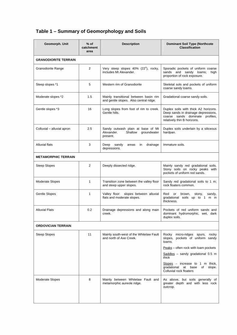
Table 1 – Summary of Geomorphology and Soils
Geomorph. Unit % of catchment
area
Description Dominant Soil Type (Northcote Classification
GRANODIORITE TERRAIN
Granodiorite Range 2 Very steep slopes 40% (22o), rocky, includes Mt Alexander.
Sporadic pockets of uniform coarse sands and sandy loams; high proportion of rock exposure.
Steep slopes *1 5 Western rim of Granodiorite Skeletal sols and pockets of uniform coarse sandy loams.
Moderate slopes *2 1.5 Mainly transitional between basin rim and gentle slopes. Also central ridge.
Gradational coarse sandy soils.
Gentle slopes *3 16 Long slopes from foot of rim to creek. Gentle hills.
Duplex soils with thick A2 horizons. Deep sands in drainage depressions, coarse sands dominate profiles, relatively thin B horizons.
Colluvial – alluvial apron 2.5 Sandy outwash plain at base of Mt Alexander. Shallow groundwater present.
Duplex soils underlain by a siliceous hardpan.
Alluvial flats 3 Deep sandy areas in drainage depressions.
Immature soils.
METAMORPHIC TERRAIN
Steep Slopes 2 Deeply dissected ridge. Mainly sandy red gradational soils. Stony soils on rocky peaks with pockets of uniform red sands.
Moderate Slopes 1 Transition zone between the valley floor and steep upper slopes.
Sandy red gradational soils to 1 m; rock floaters common.
Gentle Slopes 1 Valley floor: slopes between alluvial flats and moderate slopes.
Red or brown, stony, sandy, gradational soils up to 1 m in thickness.
Alluvial Flats 0.2 Drainage depressions and along main creek.
Pockets of red uniform sands and dominant hydromorphic, wet, dark duplex soils.
ORDOVICIAN TERRAIN
Steep Slopes 11 Mainly south-west of the Whitelaw Fault and north of Axe Creek.
Rocky micro-ridges spurs, rocky slopes, pockets of uniform sandy loams.
Peaks – often rock with loam pockets
Saddles – sandy gradational 0.5 m thick
Slopes – increase to 1 m thick, gradational at base of slope. Colluvial rock floaters
Moderate Slopes 8 Mainly between Whitelaw Fault and metamorphic aureole ridge.
As above, but soils generally of greater depth and with less rock outcrop.

Geomorph. Unit % of catchment
area
Description Dominant Soil Type (Northcote Classification
Gentle Slopes 10 Generally northeast of the Whitelaw Fault.
Peaks and ridges – sandy, gravely gradational and duplex.
Slopes – red brown duplex.
Drainage depressions – yellow duplex soils.
Alluvial Flats 11 Mainly in northern end of catchment. Sand and/or clay uniform and duplex soils.
Terraces 4 Mainly in northern end of catchment Sand and/or clay uniform and duplex soils.
Slopes Classes *1 Steep – 30%+ (16o) or greater *2 Moderate – 10% (5o) to 30% (16o) *3 Gentle – less than 10% (5o)
Metamorphic aureole The relatively erosion-resistant metamorphic rocks that surround the Harcourt Granodiorite have resulted in an aureole ridge that is higher than the adjoining granodiorite and much higher than the unmetamorphosed Ordovician rocks. Most of the slopes are steep, up to 60% (30o), with gentler fringing colluvial lower slopes. The soils on the steep slopes, distinguished by an abundance of rock fragments, are shallow (100 – 300 mm) uniform to gradational red sands. The soils increase in thickness towards the base of the slopes. Gradational red sandy soils to about a metre in thickness occur on the moderate and gentle slopes, again with rock fragment inclusions. The soils in the drainage depressions range from deep (2 m) uniform red sands at the top, to dark duplex (Dd) soils in the mid drainage depressions and fans.
Moderate to steep Ordovician Rejuvenation of streams on the upthrown side of the Whitelaw Fault has led to deep dissection by watercourses of the higher Ordovician country. The dissection is advanced as no plateau remnants or old soils were found, although the longitudinal main ridge crests are essentially accordant. The slopes are generally moderate (10-30%, 5-16o), although a significant area of steep (40%+) country exists on the western side of the Whitelaw fault in a central location. The main NNW-trending ridge to the west of the Whitelaw Fault coincides with the regional strike but the main spur and drainage directions are NE, that is, oblique to the fault scarp. This suggests some form of structural control, possibly through major joints or subsidiary faults. The microtopography is controlled by resistant sandstone beds that outcrop in 2-5 m wide by 10-50 m long rock bars. These bars cut obliquely across the spurs and produce a

layered appearance on aerial photos. The dip of the beds is very steep and nearly vertical in many cases (Figure 4).
Figure 4 – Steeply dipping beds exposed in Axe Creek, in the steep Ordovician unit near surface water sample site 16. The variability of the soils on these slopes is attributed to the variability of the bedrock. Bare rock is common, particularly in the steep unit (Figure 4), occurring on peaks and many ridges. Soils on the peaks consist of pockets of uniform sandy loam. Deeper, brown gradational soils, up to 50 cm thick, occur on saddles and slopes. Profiles on the slopes contain large quantities of rock, stone and gravel while, on the lower and foot slopes the rock can misleadingly be interpreted as representing a shallow soil. In fact, this stone layer is floating and often covers soil up to 1 metre thick. Generally speaking, gradational soils predominate on the moderate and steep slopes. Red or yellow duplex soils may be found on the gentle slopes while yellow duplex soils predominate in the drainage depressions.
Gentle Ordovician A gently rolling topography is usual east of the Whitelaw Fault (Figure 5). Few peaks exceed 10% in slopes, while the long slopes are generally between 2 - 6% (1o – 3o). Surface rock bars are relatively uncommon. Despite the gentle nature of the country, soil depth does not appear to exceed 1 metre except on the alluvium where various sandy or clayey soils to 2 metres in thickness are common. The soil types predominating in particular parts of the landscape can be related to topographic situation. The peaks generally carrying shallow (0.5 m) stony, brownish, gradational soils with light clay B horizons and rock fragments throughout, while the ridges and saddles may have similar soils, although gravely, yellow or red duplex soils, again 0.5 m deep, but with less rock, also occur. Generally the more subdued the topography the more likely are duplex soils to occur and the long slopes typically carry red or yellow duplex soils. The shallow sandy loam A horizons are approximately 10 cm

thick, and an A2 horizon is often present, underlain by a medium clay B horizon. These soils again do not exceed one metre in thickness (Figure 6).
Figure 5 – Gentle Ordovician landscape
Figure 6 – Thin soils of the gentle Ordovician ridge country. Soils here vary between duplex and gradational.

VEGETATION, LAND USE AND SOIL SALINITY
Vegetation The Axe Creek Catchment was originally timbered. Vegetation on the Ordovician sedimentary material is described in the Northern Slopes Project Report (SCA unpublished) and in Dyson and Jenkin, 1981. The relevant Land Systems Sheets also provide basic information on the main vegetation associations. On the Ordovician bedrock country, open forest of red stringybark, red box, red ironbark, grey box and long leaf box predominates on the shallow stony soils of the crests and upper slopes, while grey box, yellow box, yellow gum and some redgum grown on lower slopes in and drainage depressions. On the steep granodiorite in the Mount Alexander area, at the catchment head, manna gum forest is dominant, changing to yellow box, long leaf box, grey box and broadleaf peppermint on lower crests, with red gum-yellow box-grey box-long leaf box woodland on long slopes, and red gum along the streams. The catchment is now extensively cleared with approximately 20% of the total area, confined to the poorer stony soils around the perimeter, remaining as reserved forest. This land was originally considered too poor for selection and most of it has been cut over for firewood at least three time since settlement. Existing forest consists largely of coppice regrowth of little commercial value, and selective thinning is being carried out as routine forest management. On the freehold portion of the Ordovician land, scattered trees remain in most paddocks, either singly, or in clumps confined to poorer gradational soils on ridge lines or peaks. A greater density of cover remains on the steeper Ordovician land through the middle and upper portions of the catchment, while few trees remain on the terraces and lower slopes in the lower reaches. The metamorphic aureole ridge is noticeably devoid of all but a few scattered trees. The steep granodiorite country, including Mt Alexander, is reserved open forest, while on the gentler slopes and crests the forest has been largely removed. Large redgums remain on the road reserve which crosses the alluvial apron an at the foot of Mt Alexander. Most road reserves throughout the catchment are well vegetated, and trees line the Axe Creek and most of the main lateral valleys. Few trees within the catchment show signs of ill health due to salting.
Land use Pastures of varying quality have voluntarily replaced the forests. Few land managers have sown deep-rooted perennial pastures except in a few placed on the lower slopes and terraces. Rye grasses and subterranean clover have also been sown on some of these areas.

Dairying and mixed cropping are the dominant form of land use on the terraces and lower slopes in the lower parts of the catchment. The small area of alluvial flats that are irrigated receive the water from the Eppalock pipeline. Axe Creek itself is not used due to its ephermal nature and its high summer salinity. Cropping, using conventional techniques, is confined to a small acreage where the normal practice is to cultivate right to the edge of visibly salt-affected and spiny rush infested areas along the valley floor. There is only one operational bore, located on a terrace adjacent to Axe Creek in the middle part of the catchment, approximately 1 km downstream from the point where the creek crosses the Whitelaw Fault. Water is extracted from about 25 metres and its salinity remains constant at around 500 mg/L TDS. Local information indicates that other bores have been drilled but none has produced water of acceptable quality. Historically, an extensive viticulture industry developed through the latter half of last century on the terraces and lower slopes, but was wiped out by disease at around the turn of the century. Older landholders recall the vineyards, and the considerable concern as the industry declined. It is reported that hundreds of tons of salt were poured onto some areas in an unsuccessful attempt to kill the disease, presumably Phyloxera. Some of the main vineyards were on land which is now visibly salt affected, but this is not a result of deliberate salt application in the past as the amounts applied were insignificant compared with amount stored naturally in the landscape.
Soil salinity Surface soil salinity was first noticed by landholders in the mid to late 1940’s. This was in the main valley floor in the lower central catchment, on land now owned by Edwards family. Prior to 1946, this area had been considered prime grazing land, but it deteriorated rapidly with stock concentrating on it. At least one waterhole in the immediate area was known to have become saline at about the same time. Spiny rush (Juncus acutus) appeared soon after near the head of that valley, and rapidly spread downstream. It appears that, in some instances, dam construction has contributed to surface salinity by inducing groundwater mounds immediately downstream. This appears to be the case in the valley above surface water sampling site 6 (Figure 9). Erosion is almost exclusively confined to gullying of the valley floors. Through the Ordovician country, these are cut out to base material, generally at around one metre depth and further significant deterioration is unlikely. Deep gully erosion also occurs in the granite outwash material.

HYDROLOGY
Surface waters Axe Creek is an ephemeral stream. In 1980 and 1981 it flowed for 8 months at the SR&WSC Sedgwick stream gauging station (Figures 7 & 8). Records at Longlea, 6 km downstream from the project area, suggest that there is normally about 9 months flow under the bridge over Axe Creek on the Lake Eppalock Road (Point A, Figure 9). Daily rainfall, measured by Mrs Miles (a catchment landholder), indicates that 1980 was an average year while 1981 was extremely wet (Figures 7 & 8). The Bureau of Meteorology recordings for Bendigo support this. The winter of 1981 was Bendigo’s wettest on records and its effects on flows at Sedgwick gauging station (Point 16, Figure 9) is in marked contrast to those in 1980 (Figures 7 & 8).
Saline flow Surface water salinity measurements were taken at 30 locations at monthly intervals for 1980 and 1981 (Figure 9). Flow volumes were not measured, except by SR&WSC at locality 16, so that salt load for individual tributaries and the lower reaches of Axe Creek could not be calculated.
Water quality According to the Victorian Irrigation Research Advisory Committee standards, at no time during the 17 months of the project was Axe Creek water at the Lake Eppalock road bridge (Point A, Figure 9) suitable for off-stream storage for irrigation of salt sensitive crops (Table 2). The minimum electrical conductivity (EC) recorded was 303 µScm-1 during August 1981, the wettest winter on record. Taking 1980 as a more representative year, the usual minimum EC would probably be around 1000 µScm-1 making this water only suitable for salt-tolerant crops. However, in practice, many plants would suffer no short term ill-affects if irrigated by water of similar quality to that of the Axe Creek main flow. As little flow occurs in summer, off-stream winter storage would be required for summer irrigation. Axe Creek was suitable for stock at all times of recording and also permissible for human consumption for 11 months of the 15. However, it did exceed the desirable salinity limit of 500 Mg/l, set by the World Health Organisation, for most of the sampling period.

Table 2 – Water quality of Axe Creek at Lake Eppalock road bridge (Point A, Figure 9) – Total period of sampling 15 months: (Aug 30, 1980 – Oct 21, 1981).
Water Use *Maximum tolerable salinityµScm-1 at 25oC
Number of months Axe Creek
suitable for specified use
Irrigation
Sensitive plants 280 None Moderately tolerant plant 780 2 High tolerance plants 2,350 9 High tolerance plants and particular soil conditions
5,500 14
High tolerance plants plus specific management (e.g. drainage)
5,500+ 15
Human Consumption
Desirable level 780 2 Permissible level 3,125 11
Stock
Dairy cattle 8,400 All year Beef cattle, ewes in milk Approx. the same All year Dry sheep 22,000 All year
* VIRASC – ‘Quality aspects of Farm Water Supplies”
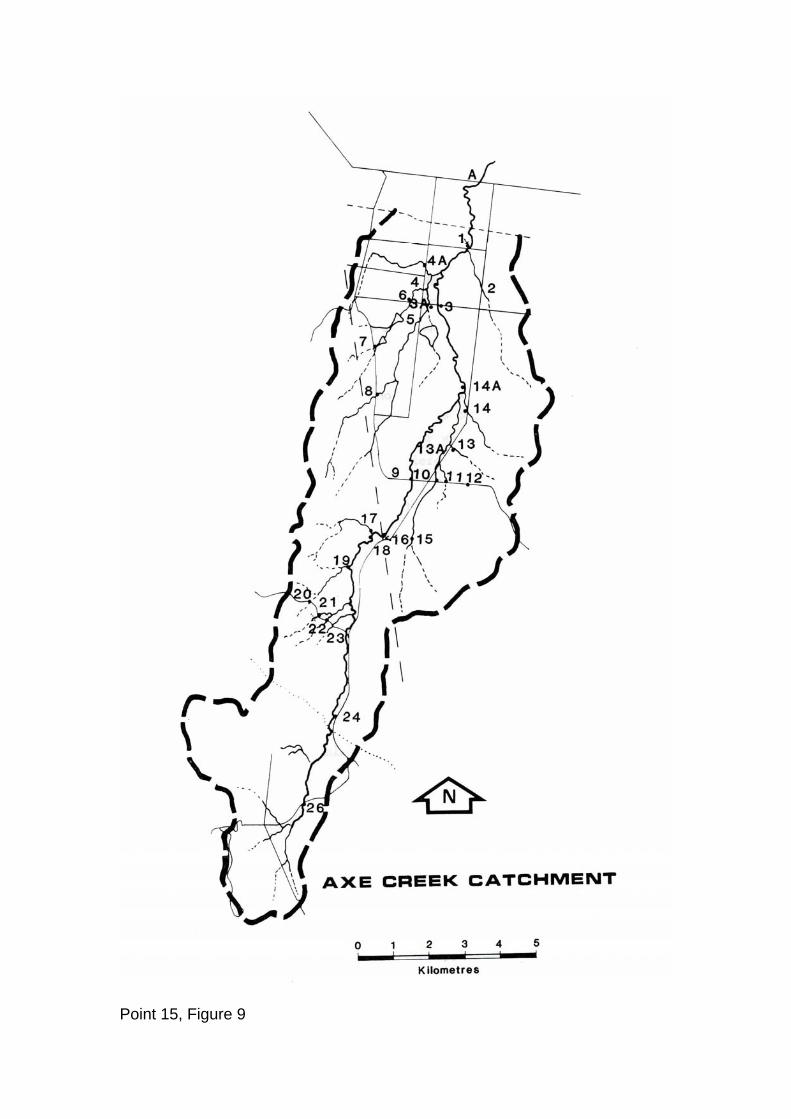
Point 15, Figure 9

GROUNDWATER Thirty piezometers in twelve nests were installed in the catchment in August 1980 (Figure 11). These nests consisted of two or three bores of which was comparatively deep (10 m – 20 m, depending on depth to “hard” bedrock), one shallow (3 m) and sometimes a third tube of intermediate depth (approx. 6 m). The groundwater level in each bore was measured and a sample tests for salt content at monthly intervals since installation (Appendix 2). Very saline groundwater was encountered in the northern or lower end of the catchment. For example water in bore No. 3M had a salinity of 30,992 µScm-1 which contrasted with water from 12M and 12D, at the southern or higher end of catchment, with a salt content of only 762 µScm-1 maximum. Table 4 shows ranges and averages for nests 12 and 3, and a centrally located next No. 7. The salt content of groundwater found in the Ordovician bedrock country, with the exception of Site 1, was never less than five times that found in the granodiorite (Table 3). This is one of the main indications of a higher storage of salt being associated with the sedimentary country than with the granodiorite. The effect of intersection of the watertable on stream salinity is shown in Figure 10, where groundwater is discharging into an erosion gully through fractures in the exposed sedimentary bedrock.
Groundwater changes Salt content
The annual variation in salt content of the groundwater was around 30 - 60% of the geometric mean value. This variation is much less than encountered is much less than encountered with surface water, where a 50 – 100%+ variation is common. The groundwater is in most cases much slower to respond to rainfall events or dry periods than the surface waters. As an illustration, the salt content of groundwater was still generally falling at the end of October, although the heavy rains finished in August and the period September to October was relatively dry (Figure 12). The largest salt concentrations measured were in February (1981) and the lowest in August (1981).
Watertable levels Watertables came nearest to the ground surface in August 1981 generally within one metre in the valleys, and were deepest between February and June 1981 (Figure 12 and Table A4). The deepest annual average (geometric) obtained was 2.11 m in bore 6D and the shallowest 0.53 m in 9D.

Figure 11 – Piezometer nest location and depth

Table 3 – Representative Piezometer Nests Piezometer nest Bore Average depth of
watertable Geometric
(Arithmetic) 12 months (10/11/80 – 26/10/81)
Average Salinity (µScm-1)
Geometric (Arithmetic) 12 months (10/11/80 – 26/10/81)
Depth to watertable:
Range (metres)
Salinity: Range (µScm-1)
Average depth to watertable,
Spring (2/9/80 – 24/12/80)
(Metres) Arithmetic
Average salinity, Spring
(2/9/80 – 24/11/80) (µScm-1)
Arithmetic (Median Value)
Lower Catchment - Ordovician
3 3D 0.78 (0.89) 11,882 (12,210) 2.38 – 0.15 14487 – 6574 1.07 12,361 (14,307) 3M 0.94 (1.03) 16,291 (16,824) 1.69 – 0.25 20992 – 9183 1.04 20,142 (19,968) 3S 1.01 (1.1) 12,213 (12,653) 1.49 – 0.35 16432 – 6928 1.06 14,324 (14,607)
Mid Catchment - Ordovician
7 7D 0.69 (0.71) 8,517 (8,716() 2.35 - + 10 cm above surface
10768 – 5052 0.64 10,331 (10,221)
7S 0.75 (0.86) 10,351 (10,597) 2.44 – 0.28 12595 – 6026 0.75 12,121 (12,168)
Upper Catchment – Granodiorite
12 12D 0.64 (0.68) 475 (483) 2.25 – 0.25 762 – 379 0.49 515 (504) 12S 0.68 (0.7) 483 (491) 1.12 – 0.45 762 – 412 0.53 471 (442)

Saltland and groundwater No bores were sunk directly into saltland, although 3, 4 and 7 are close (Figure 11 and P1.1). These all have high salinity water in the shallow bores and watertables were close to natural surface in spring, thereby permitting salting by capillary action. At least 9, groundwater conditions are similar to those at the above three sites, but no salting is evident. The reason for this is unknown but could be due to shallow confining layers preventing or retarding water movement to the surface.
Pressure water All piezometer nests, except Nos. 5 and 6, exhibited higher watertable levels in the deeper bores, e.g. Next 9, where 9D was considerably deeper than the other bores with water actually flowing from it for at least a month during 1982. This again indicates higher aquifer permeability at depth, with less permeable, semi-confining layers close to the surface. The pressure of the deeper groundwater results in a net upwards movement of water in the lower parts of the landscape through preferred pathways in the fractured bedrock, thus maintaining the salinisation in the catchment.
Figure 12 – Water Level and Salinity. Fluctuations Piezometer Nests 9 & 11
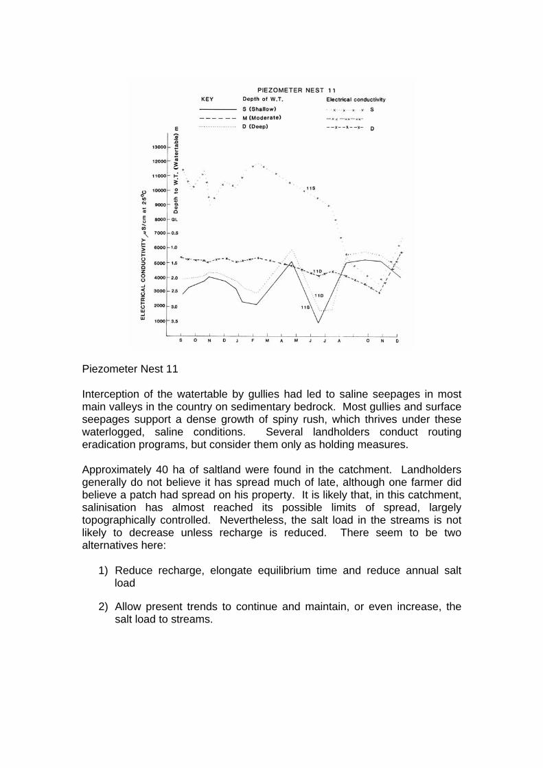
Piezometer Nest 11 Interception of the watertable by gullies had led to saline seepages in most main valleys in the country on sedimentary bedrock. Most gullies and surface seepages support a dense growth of spiny rush, which thrives under these waterlogged, saline conditions. Several landholders conduct routing eradication programs, but consider them only as holding measures. Approximately 40 ha of saltland were found in the catchment. Landholders generally do not believe it has spread much of late, although one farmer did believe a patch had spread on his property. It is likely that, in this catchment, salinisation has almost reached its possible limits of spread, largely topographically controlled. Nevertheless, the salt load in the streams is not likely to decrease unless recharge is reduced. There seem to be two alternatives here:
1) Reduce recharge, elongate equilibrium time and reduce annual salt load
2) Allow present trends to continue and maintain, or even increase, the salt load to streams.

Figure 7 – Axe Creek Hydrograph, Rainfall & salinity at Sedgwick Gauging Station 1980

Figure 8 – Axe Creek Hydrograph, Rainfall & Salinity at Sedgwick Gauging Station 1981

HYDROLOGICAL PROPERTIES OF ROCK AND SOILS The following discussion on infiltration through the soil profile is based on two sources, Dyson and Jenkin (1981) and on existing and new soil survey data from the catchment. Table 4 – Saturated Infiltration of Axe Creek soils (adapted from Dyson & Jenkin 1981)
Saturated infiltration mm/day
Soils developed on Ordovician sediments
Range Average
Duplex: red (Dr) or yellow (Dy) – top of B1 horizon
3 - 7 5
Gradational: stony red (Gn)
5 – 200+ 200+ ?
Table 4 highlights the large infiltration differences between the two most common soils in the catchment (Figure 3). Note the particularly low infiltration rate in the duplex soils and the mainly high rate, with large variation, in the gradational soils. The infiltration rates of the less common soil types can be inferred by comparison with those developed on Ordovician bedrock soils, since Dyson and Jenkin (1981) showed that there is no significant difference in infiltration rate and hydraulic conductivity in the same profile form whether it is developed on bedrock or alluvium/colluvium. In the duplex soils the limiting factor is the top of the B1 horizon. Infiltration into the B1 was consistently 5 mm/day or less, while the hydraulic conductivity of the B1 horizon below the top was found to be greater than 5 mm/day. Thus, the top of the B horizon acts as a “throttle” and the thickness of the B horizon, which varies considerably, is of much less importance. The wide variation in infiltration rate in gradational soils is governed by soil thickness and texture, including the amount of rock in the profile and, in the absence of a “throttle” like that in the duplex soils, by the varying permeability of the underlying bedrock. Most of the groundwater is transmitted through the bedrock along preferred pathways consisting of joints and fractures. Deep boring at Axe Creek (Dyson pers. Comm.) has shown that the potential for flow of groundwater appears to increase with depth. In general, the areas with gradational soils appear to be where groundwater recharge is greatest, but further deep drilling would be needed to confirm this and to determine the actual quantities of water involved. This aspect has been quantified by Dyson (1983) whose model gives the lead to determining management requirements in such situations.

Granitic, metamorphic and alluvial soils The sandy gradational soils of the moderate and steep granodiorite country appear to have high infiltration rates. The underlying bedrock on the other hand is relatively impermeable, has relatively few fractures or joints and is therefore a barrier to deep infiltration. This has been proved by private drilling into the granodiorite and the lack of water entering tunnels following rain. Therefore, water entering these soils can move by lateral flow and this explains the many winter seeps at the base and on the sides of the moderate and steep slopes of the granodiorite country. In the duplex soils of the gentle granitic country the B horizons are not thick (usu 20 – 50 cm) and are overlain by deep A2 horizons which saturate in winter, forming an incoherent layer. Another barrier to deep percolation on the granitic country is the extensive siliceous hard pan that forms in the B horizon. The sandy gradational soils on the metamorphic terrain appear to have high infiltration rates, possibly similar to those measured on the gradational soils of the moderate and steep Ordovician country. The bedrock also has preferred pathways similar to those occurring in the Ordovician bedrock and similar groundwater conditions are expected. The variation in soil type found on the alluvial flats and terraces indicates possible differences in infiltration rate. However, due to slow runoff on these relatively flat areas and the sandy nature of many of these soils, the recharge to groundwater must be considered, generally, as high. Rock hydrology
The saline groundwater movement and pressure transmission at Axe Creek is through the fractures and joints of the bedrock. These fracture flow paths are much more common and are apparently open to much greater depths in the sedimentary and metamorphic rock in granodiorite. The granitic area in Axe Creek is not considered important as far as groundwater and salinity are concerned. The main concern is the sedimentary and metamorphic rock groundwater system which occupies 80% of the catchment. The volume of fracture space involved is probably not great, but exists to considerable depth. Groundwater has been recorded down to 50 metres at Axe Creek (Dyson per. Comm.) and probably exists to much deeper levels. Legrand (1979) suggests 200 m as a possible depth. However, experience in the deep Bendigo mines suggests that this may be a considerable underestimate for the Ordovician bedrock. The irregularity of the fracture flow in the bedrock means that many test bores would be required to completely characterize an area. However, a semi-quantitative assessment of the bedrock hydrology can be made by integrating information derived from a limited number of bores, from the nature of the rock

as seen in exposures and cuttings and from the catchment salinity and flow patterns. The existence of pressure at water depth, and free interconnection over considerable distances, has been demonstrated at Axe Creek. This indicates that greater flow capacity exists in the fracture system beneath the semi-confining weathered rock and clay soil. This is consistent with studies of groundwater flow at Kamarooka, where it was demonstrated that recharge on the ridge and slopes was accompanied by an equivalent discharge (net upward flow) on the flats at the base of the slopes (Jenkin & Dyson 1983). About half of Victoria, an area of approximately 110,000 km2, is underlain by a similar fractured rock groundwater system. The part of the Central Uplands that has substantial salinity problems represents 70% of this area and therefore the features of this groundwater system are important over a considerable area.

CONCLUSIONS AND RECOMMENDATIONS 1. The characteristics which provide the physical basis for catchment
management strategy development are:
(a) Geology, including both surficial deposit and bedrock properties. (b) Landform, especially slop and including micro-forms such as
rock outcrop, ridges and peaks. Mapping of landform, to be useful, must be at land component level at least.
(c) Groundwater conditions including levels and salinity. (d) Climate, especially rainfall, its seasonality and event variability. (e) Soils, especially the Northcote profile form and the textures and
hydrological properties of the profile components (f) Vegetation, natural and introduced. (g) Current and past landuse, including the standard of
management. (h) Deterioration, including soil salting, salinisation of was supplies
and erosion. 2. Using the above information, supplemented by research data on the
hydrological properties of soils and substrate, a semi-quantitative estimate can be made of the relative significance of the various landscape components with respect to groundwater recharge.
3. The principal deficiencies with regard to catchment characterisation at present are:
(a) Lack of detailed information on the hydrological properties of soils other than duplex soil types on Palaeozoic sedimentary bedrock.
(b) The sparsity of other hydrological and salinity data – stream flow and salt flow – required to calculate reliable water/salt balances.
4 (a) Despite these problems, estimates can be made from the readily observable catchment characteristics on which management decisions can be made with reasonable confidence.
(b) Confidence levels need to be improved by overcoming the deficiencies listed under item 3 above, and by monitoring hydrological and salinity trends produced by large scale field trials. This recommendation is being vigorously acted upon.

ACKNOWLEDGEMENTS AND CREDITS The authors are grateful to the Soil Conservation Authority and to Harold Allen and Frank Gibbons for their continuing support and encouragement. Specific and enthusiastic help from Lynette Brooks, John Cooke, Phil Dyson, Mal Lorimer, David Williamson and Jill Wood was also greatly appreciated. Graeme David started the project which after twelve months was taken over and completed by John Duff. Jeff Jenkin devised the program and supervised the technical aspects, while David Elvery superintended the extension side of the project. The provision by the State Rivers and Water Supply Commission of Axe Creek flow and salinity data is gratefully acknowledged. We were also most appreciative of the help from and interest shown by Axe Creek landholders.

REFERENCES Dyson, PR and Jenkin JJ, 1981. The hydrological properties of soils relevant to dryland salinity. Soil Conservation Authority. Jenkin, JJ 1981 (a). Terrain, groundwater and secondary salinity in Victoria, Australia. Agric. Water Manage. 4: 143-171. Jenkin, JJ 1981 (b). Dryland salting in Victoria. 2nd edition. Soil Conservation Authority. Jenkin, JJ and Dyson, P 1983. Groundwater and soil salinisation near Bendigo, Victoria. Geol. Soc. Aust. Spec. Publ. 11:229-257. Jenkin JJ and Irwin, 1975. The Northern Slopes land deterioration project – some preliminary conclusions. Soil Conservation Authority. Legrand, H 1979. Evaluation techniques of fractured – rock hydrology. In: Black and Stephenson (Eds), Contemporary Hydrogeology, J. Hyrol. 43: 333-346. Northcote, KH 1974. A factual key for the recognition of Australian soils. CSIRO/Rellim.

APPENDIX 1 – TABLE PIEZOMETER AVERAGES – 7/1/82
12 Month (10/11/80 – 26/10/81) Watertable Depths
12 Month (10/11/80 – 26/10/81)
uScm-1 ECS of water
Average Springtime(2-9/80 – 24/12/80) Watertable Depth
Average Springtime (2-9/80 – 24/12/80)
µScm-1 ECs of water
Piezometer No.
−x G
−x
−x G
−x
Watertable Range
(m)
EC Range
µScm-1 −x
−x
M
1D 2.05 (1.99) 5294 (5182) 3.39-0.85 7472-3127 2.06 6582 (6461) 1M 1.88 (1.73) 292 (276) 2.75-0.60 408-134 1.81 248 (313) 1S 1.88 (1.80) 304 (295) 2.75-0.05 588-197 1.83 334 (305) 2D 2.44 (2.41) 6823 (6665) 3.05-1.79 8436-3949 2.39 8087 (7994) 2S 3D 0.89 (0.78) 12210 (11882) 2.38-0.15 15587-6574 1.07 12361 (14307) 3M 1.03 (0.94) 16824 (16291) 1.69-0.25 20992-9183 1.04 20142 (19968) 3S 1.1 (1.01) 12653 (12213) 1.49-0.35 16432-6928 1.06 14324 (14670) 4D 0.93 (0.94) 10487 (10193) 2.85-ground level 13196-5510 0.83 12421 (12285) 4S 1.44 (1.35) 12768 (12423) 3.14-0.62 16645-6806 1.16 15256 (14916) 5D 1.16 (1.01) 9108 (8872) 6.42-0.63 11233-5212 1.46 10597 (10690) 5M 1.11 (1.06) 9096 (8849) 1.55-0.52 11053-4987 1.18 10456 (10417) 5S 1.16 (1.08) 7586 (6798) 1.60-0.35 11470-2526 1.24 9421 (9921) 6D 2.20 (2.11) 7107 (6770) 2.95-1.11 8871-2472 2.24 8501 (8456) 6S 2.12 (2.05) 5588 (4815) 3.18-1.13 9017-1582 2.15 6126 (5668) 7D 0.71 (0.69) 8716 (8517) 2.35-+10 cm above
surface 10768-5050 0.64 10231 (10221)
7S 0.86 (0.75) 10597 (10351) 2.44-0.28 12595-6026 0.75 12121 (12168) 8D 1.41 (1.23) 9736 (9523) 2.15-0.25 11817-5510 1.41 11164 (11052) 8S 1.45 (1.28) 9071 (8728) 2.15-0.30 11791-5307 1.42 11013 (10952) 9D 0.39 (0.53) 6413 (6052) 2.95-+10cm above
surface 7210-3844 0.25 6925 (6886)
9M 0.81 (0.76) 6590 (6490) 2.35-ground level 7655-4129 0.54 7490 (7558) 9S 0.94 (0.84) 11215 (10929) 2.35-ground level 13729-6392 0.6 12724 (12500) 10 1.21 (1.08) 2526 (2324) 1.75-0.31 3356-665 1.01 2859 (2948) 11D 1.98 (1.83) 4563 (4496) 3.15-1.10 5392-2929 1.97 5204 (5204) 11S 2.18 (2.07) 8788 (8219) 3.55-1.35 11977-3527 2.25 10364 (10177) 12D 0.68 (0.64) 483 (472) 2.25-0.25 762-379 0.49 515 (504 12S 0.7 (0.68) 491 (483) 1.12-0.45 762-412 0.53 471 (442)

APPENDIX 2 – AREAS OF VARIOUS MAP UNITS
Area (ha) Slope Types Granite area Metamorphic
area Ordovician
area Total
1. Colluvial apron 253.7 - 157.4 411.1 2. Alluvial flat 329.0 30.3 697.4 1056.9 3. Terrace - - 401.9 401.9 4. Gentle slope 584.5 91.5 4690.0 5365.0 5. Moderate slope 136.2 77.3 1363.3 1506.8 6. Steep slope 484.0 178.5 189.0 851.5 7. Granite range 232.7 - - 232.7 Total 2020 378 7500 9898
LAND USE AREAS Area (ha) % of Total
Catchment Area
Saltland 42.08 0.4 LAND USE % Forest Grazed 200.92 2.0 Grazing 69.5 Other 2101.45 21.0 Other LU 7.0 Pasture (improved) 257.43 2.6 Forest 23.0 Orchards 10.52 0.01 Improved pasture 2.6 Areas cropped 180.96 1.8 Small allotments 117.4 1.2 Strong regrowth 40.47 0.4 Native pasture 6947.00

THE AXE CREEK SALINITY STUDY
PART B
SALINITY CONTROL POSSIBILITIES IN THE AXE CREEK CATCHMENT
By J S Duff and J J Jenkin
1982
Revised 1984 by J J Jenkin
Introduction Physical Characteristics of the Axe Creek Catchment Relative Importance of various parts of the Landscape Management requirements based on Catchment Characteristics Conclusions and recommendations Acknowledgements References LIST OF FIGURES Figure 1 – Main areas of saltland and salt discharge in the Axe Creek catchment. Figure 2 – Salinity priority rating in the Axe Creek catchment.

INTRODUCTION This report is complementary to the study of catchment characterization at Axe Creek (Duff, Jenkin and David, 1982, 1984). It sets out the management requirements for salinity control in the catchment and suggest the applicability of the method over the uplands in general. Briefly, the procedure is to determine the relative magnitude of recharge in the various parts of the landscape and to evaluate their significance, weighted according to the area involved. Estimates of recharge are made using infiltration, hydraulic conductivity and groundwater data, interpreted with regard to the particular geological, geomorphic, soil and landuse features in each unit. Although salinity control requirements can be determined with some confidence, the design of management options at present relies on a limited knowledge of the hydrological performance of various farming systems. Nevertheless, an attempt should be made to produce management prescriptions for salt-affected catchments. This needs to be accompanied by monitored trials on a field scale as well as vigorously pursuing fundamental hydrological research on currently used crops and pastures, along with possible alternatives. The hydrological effects of various cultivation techniques, drainage and erosion control should also be carefully studied.

PHYSICAL CHARACTERISTICS OF THE AXE CREEK CATCHMENT Axe Creek rises on Mount Alexander, the highest part of the Harcourt Granodiorite massif. The creek then emerges from the granitic area, which occupies about 20% of the catchment, through a gap in the surrounding metamorphic aureole ridge. The remainder of the catchment consists of folded, faulted and fractured Ordovician sandstone, mudstone and slate. Some slopes carry a thin veneer of colluvial material and alluvium of variable texture and thickness occupies the valley floors. These geological divisions have been further subdivided on a slope bases. Furthermore, each slope unit was found to carry a characteristic association of soils (Duff, Jenkin and David, 1982). The main hydrological features of all units are indicated in Table 1. Groundwater discharge is the immediate cause of soil, dam and stream salinisation. In the Axe Creek catchment, saline water occurs in two main situations – in shallow alluvium and immediately underlying weathered bedrock where the water is largely confined, and in the deeper, less-weathered bedrock. The deeper water is under pressure and it is common in bores on the valley floors for its peizometric level to be above that of the shallow, unconfined watertable. A further important consideration is landuse, especially the differences in groundwater recharge under forest, pastoral and cropping systems (Jenkin, 1981; Dyson and Jenkin, 1981; Duff, Jenkin and David, 1982).

RELATIVE IMPORTANCE OF VARIOUS PARTS OF THE LANDSCAPE The importance of a landscape component to non-irrigation salinity depends on salt storage within it and water movement through it. In the Axe Creek valley salt storage is mostly high, although it varies with rock type and position in the catchment. The two known principal salt stores are the existing groundwater and the weathered bedrock in the Ordovician country. Salt concentrations in the groundwater are greatest at the lower end of the catchment. In the granitic headwater country, salt storage is low and need not concern us further∗. The salt stored in the metamorphic aureole regolith is probably of a similar order to that found in the steep Ordovician country. Salt concentrations in the Ordovician bedrock have been shown to be differently distributed in cleared and timbered catchments (Jenkin and Irwin, 1975; Jenkin, 1981 a, b). Salt concentrations appeared to be greater lower down in cleared catchments, while a more even distribution was found in timbered areas. Recent deep boring to 50 m (Dyson, pers. Comm.). has shown that the store is of the order of 9 to 15 x 105 kg/hg (900 – 1500 tonne/ha) in weathered Ordovician bedrock at Axe Creek. Water movement is regulated by the properties of the regolith and underlying bedrock. Different parts of the regolith have different regulatory effects on water movement and these vary in different parts of the landscape. Factors in water movement are the nature of the soil and the properties of the vadose (aeration) and groundwater zones, as well as the effects of present land use, principally exerted through the influence of plants. The soil is the uppermost layer of the regolith and controls infiltration. In the Axe Creek catchment, there is a marked hydrological contrast between the duplex soils (low infiltration rate) of the gentle Ordovician country and the gradational soils (high infiltration rate) of the moderate and steep Ordovician and the metamorphic aureole country. In the vadose zone the overall vertical flow or deep percolation is most important, while both vertical and horizontal flow and pressure transmission are important in the groundwater zone. Deep bores into the bedrock are helping to quantify the local difference present as are the measurements of hydraulic conductivity and infiltration. The correlation is excellent. As previously mentioned, because of the greater number of preferred pathways it contains, the Ordovician bedrock is more important than the granodiorite as a transmitter of groundwater. A critical factor in future management proposals is the degree of interconnection of local groundwater sub-catchment systems. Whether a regional or a smaller catchment groundwater system is dominant, or a combination of both exists, is vital when considering watertable lowering strategies. In the Axe Creek catchment, recent evidence from deep bores (Dyson, pers. Comm.) suggests that there is no permanent groundwater divide between Axe Creek and the neighbouring Sweeney’s Creek. The suggestion in the 1982 report that the divides may be more pronounced has been confirmed in relation to the steep metamorphic aureole ridges and almost certainly applies in the case of prominent northerly trending strike ridges. There is now no doubt that a hydrologically integrated regional groundwater body, with an overall gentle north easterly gradient, exists on the Northern Slopes, although the detailed form of its surface will vary temporarily with local hydraulic conditions, the topography of the land ∗ It is important t note, however, that in other granitic area which are deeply weathered, salt storage is very high.

and climate. This implies that areas mostly larger than subcatchments will need to be treated in an integrated way for worthwhile results to be obtained. The groundwater discharge areas occur mainly in five sub-catchments marked as (i) – (v) in Figure 1. The significance of these areas appears to be related to the occurrence of gentle slopes and alluvial flats adjoining the marked break of slope at the Whitelaw Fault scarp. The saltland in Edward’s property ((v) in Figure 1) is some 30 m higher in the landscape than the groundwater level found in deep bores in Eppalock catchment No. 2 (Figure 1). This is evidence for a northward sloping hydraulic gradient. The other main salt discharge areas occur at about 210 m as 1, a similar level to the water table in Eppalock No. 2 and Sweeney’s Creek deep bores. Land use is crucial with regard to salinisation. As Jenkin and Irwin (1975), Jenkin (1981 a, b) and P R Dyson (pers. Comm.) have shown, recharge to groundwater under forest is low or non-existent. Therefore the areas of permanent forest must be relatively unimportant as far as recharge is concerned. However, the potential for salting to start or spread is greatly increased should these areas be cleared. The relative importance of each part of the landscape with regard to salinity is summarized in Table 1. A rating system of 1 to 5 has been established independently of current landuse and each part of the Axe Creek landscape allotted to one of these categories. Category 1 is the most significant with regard to salinity, and 5 the least (Figure 2). When measured infiltration rates (Dyson and Jenkin, 1981) are considered in relation to the area cleared, although they are limited in number for the stony gradational soils, it seem on a conservative estimate that Category 1 terrain is at least 10 times more significant with regard to recharge in the Axe Creek catchment than Category 3 terrain (cf. Table 1). The role in recharge of the alluvial flats and terraces is difficult to estimate owing to their considerable textural and subtle physiographic variability. However, their low position in the landscape, coupled with the presence of highly permeable components, justifies the high recharge status allotted here.

Table 1 – Relative importance of Landscape Units Rating Landscape component Reasons
1. Cleared land in
- Ordovician Steep GMU* - Ordovician Moderate GMU - Peaks, selected ridges in Gentle Ordovician GMU - Aureole GMU’s
- high salt storage - high infiltration through gradational soils - relatively high volume of groundwater with high salt content - low water use
2. - Alluvial flats - Terraces
- low water use - moderate to high infiltration in parts due to sandy soils and flat topography - high salt content ground water
3. - Ordovician gentle GMU (except parts in 1)
- low infiltration through duplex soils - high salt storage relatively high volume of groundwater with high salt content - low water use
4. Forested Ordovician Sediments - high salt storage - high infiltration but low to nil deep percolation through vadose zone due to high water use
5. Granodiorite cleared or forest - low salt storage - low to high infiltration - low deep-percolation - low volumes of ground water
* GMU – abbreviation for Geomorph. Unit

Figure 1 – Main areas of saltland and salt discharge in the Axe Creek catchment

Figure 2 – Salinity priority rating in the Axe Creek catchment

MANAGEMENT REQUIREMENTS BASED ON CATCHMENT CHARACTERISTICS The most critical information for the management of salinity in the Axe Creek catchment is the presence of a regional groundwater table and its apparent north-easterly slope. Because of this, it is unlikely that a subcatchment (Figure 1) could be effectively treated in isolation. At present it appears that much larger areas must be treated, for example, all the Ordovician sedimentary country between the Mt Sugarloaf Ridge, west of the Campaspe River and the Daybreak Ridge, west of Bendigo, the distance between the two being approximately 15 km north-south, this area is about 20 km, the total area involved being 30,000 km2. Of this about 15,000 km2 would require some form of direct treatment or management modification. At Kamarooka, where the Ordovician sediments are highly weathered, in contrast to the less intense weathering at Axe Creek, there is strong evidence for the presence of a subcatchment watertable effect (Dyson, pers. Comm..) and treatment of a subcatchment there has a good possibility of being successful. The suggested management for priority areas 1-5 is as follows: 1) the steeper Ordovician and metamorphic country which has been cleared,
characterized by high recharge rates, requires revegetation with plants of very high water-using capacity and ability to survive in dry conditions.
2) the broad alluvial flats and terraces at the northern end of the catchment, in particular those areas which tend to become waterlogged, as they undoubtedly contribute to groundwater, initially as local mounds and eventually to the regional body. Being fresh, this water could be drained without risk, or used up by various pastures or crops, e.g. Lucerne or oil seeds. The saltland discharge areas should be treated by fencing out followed by tolerant vegetation to improve water use and reduce evaporation.
3) A mix of high-water using pasture and/or crops should be used on the medium clay
soils of the gentle Ordovician country with higher water-using plants on the rocky ridges and peaks.
4) This area should be left under native forest. 5) The granodiorite country management is not important at this stage as far as salinity
is concerned. However, the removal of trees could indirectly adversely affect hydrological conditions in the metamorphic and sedimentary country downstream and should be discouraged.

CONCLUSIONS AND RECOMMENDATIONS The pilot study in Axe Creek and related hydrogeological investigations (Dyson and Jenkin, 1981), encourage the view that practicable salinity control systems can be devised for Northern Slopes catchments. This work has pointed out the significant factors involved, which mans that work in other catchments can be simplified and therefore speeded up. Similar studies have now been extended to other Northern Slopes catchments, for example, that incorporating the Timor West area. The two principal limiting factors in salinity control system design are: 1) the lack of information on the water using capacity of crops and pastures under
particular soil condition and management procedures. In order to obtain the maximum benefit from the program, it is essential that work on this aspect be vigorously pursued.
2) the lack of deep bores showing the extent of inter-connection of groundwater systems and permitting a comprehensive quantitative groundwater model to be formulated for the Northern Slopes of Victoria, although this has been developed to a large extent recently as a major result of bedrock drilling programs by SCA.
It is also vital that salting knowledge, practices and ideas are transmitted to field officers and landholders throughout the State. In addition to directions obtained from this research, useful leads might be obtained in this way and harmful practices identified. The approach adopted and the techniques worked out for the Axe Creek catchment are now being extended to other areas of the Northern Slopes, as recommended in the first edition of this report, e.g. at Bourke’s Flat, Timor West, Sheep Pen Creek and Warrenbayne as well as the Dundas Tablelands. Field officers should be specially trained to do this work with advice from the Geology/Geomorphology and Land Studies Sections as the principals and techniques involved are outside any formal course being offered at present. Three aspects should dominate future salting investigations. These are: (a) The nature and distribution of hydrogeological provinces insofar as they relate to
salinity of soil and water.
(b) The water-using capacity of various crops and pastures, and the role of land management techniques and systems in modifying water usage.
(c) Water/salt balance studies which incorporate the entire catchment hydrological-hydrogeological system. Monitoring water levels in bores drilled into bedrock is an integral part of all three.
Despite the present paucity of information on these topics in most areas, an attempt should be made to design control measures based on present knowledge and should-based inference.

Trial treatments of subcatchments should be established. (a) to test the methods being applied
(b) to use as models for extension demonstration These trials should be integrated with the proposed water usage studies. Salinity control designs should take account of other forms of land deterioration in catchments so as to produce a fully integrated plan of action. That is, salinity control and erosion control should not be separated as they are both integral parts of the same earth system, whose key control is the hydrological cycle. The basis, then, is the rational management of this cycle.

ACKNOWLEDGEMENTS AND CREDITS The authors are grateful to the Soil Conservation Authority and to Harold Allen and Frank Gibbons for their continuing support and encouragement. Specific and enthusiastic help from Lynetter Brooks, John Cooke, Phil Dyson, Mal Lorimer, David Williamson and Jill Wood was also greatly appreciated. Graeme David started the project, which after twelve months was taken over and completed by John Duff. Jeff Jenkin devised the program and supervised the technical aspects, while David Elvery superintended the extension side of the project.

REFERENCES Duff JS, Jenkin, JJ and David GA 1982. Catchment characterization for salinity control, Axe Creek, Victoria. Soil Conservation Authority. Dyson, PR and Jenkin JJ 1981. The hydrological properties of soils relevant to dryland salinity. Soil Conservation Authority. Jenkin, JJ 1981 (a). Terrain, groundwater and secondary salinity in Victoria, Australia. Agric. Water Manage. 4: 143-171. Jenkin, JJ 1981 (b). Dryland salting in Victoria. 2nd edition. Soil Conservation Authority. Jenkin, JJ and Dyson, 1981. Groundwater and soil salinisation near Bendigo, Victoria. Geol. Soc. Aust. Spec. Pub. 11: 229-257. Jenkin, JJ and Irwin, 1975. The Northern Slopes land deterioration project – some preliminary conclusions. Soil Conservation Authority. Legrand, H 1979. Evaluation techniques of fractured-rock hydrology. In: Black and Stephenson (Eds.), Contemporary Hydrogeology. J. Hydrol. 43: 333-346.