THE APPLICATION OF MAPINFO IN MANAGING MATERIAL...
22
THE APPLICATION OF MAPINFO IN MANAGING MATERIAL AND WASTE AT CONSTRUCTION SITES DESMOND YIP TECK WING A project report submitted in partial fulfilment of the requirements for the award of the degree of Master of Science (Construction Management) Faculty of Civil Engineering Univeriti Teknologi Malaysia MAY 2006
Transcript of THE APPLICATION OF MAPINFO IN MANAGING MATERIAL...

THE APPLICATION OF MAPINFO IN MANAGING MATERIAL
AND WASTE AT CONSTRUCTION SITES
DESMOND YIP TECK WING
A project report submitted in partial fulfilment
of the requirements for the award of the degree of
Master of Science (Construction Management)
Faculty of Civil Engineering
Univeriti Teknologi Malaysia
MAY 2006

iii
Dedicated to Jesus Christ,
My personal Lord and Savior,
And
To my beloved parents and family.

iv
ACKNOWLEDGEMENT
This study would not have been possible without the assistance and support
of those who have been actively involved in this research. First, the author would
like to thank God for His grace and mercy throughout this research. It is by His
hands and wisdom in guiding the author to finish the work in this study.
Second, the author would like to thank the honorable supervisor, Assoc. Prof.
Dr. Mushairry Mustaffar, for his support, encouragement, and academic guidance
during the study. The author would like to thank specially for his patience and
tolerance. His diligence, dedication and working attitudes are good examples to
follow.
Third, the author would like to thank the co-supervisor, Assoc. Prof. Dr.
Muhd Zaimi b. Abdul Majid for his ideas and valuable suggestions which allowed
the author to gain a broader understanding and improvement for the research.
Fourth, the author would also like to thank the project manager of the MPJBT
construction site, Mr. Omar b. Md. Yasin and project manager of KIPark
construction site, Mr. Lim Tiang Faat for their willingness to share their experience
and help in collecting the data required.
Last but not least, the author is also grateful to his family members for their
love, support and encouragement.

v
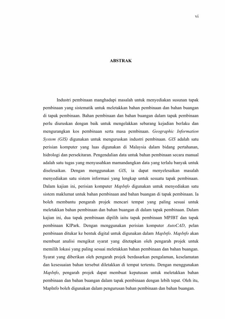
ABSTRACT
Many countries nowadays have serious problems concerning site layout for
locating the construction materials and waste. Construction materials and waste
should be managed properly especially for high rise buildings. As such, Geographic
Information System (GIS) has been applied in the construction management. GIS is
a software-based technology that is now thriving in Malaysia. It has been
implemented in many agencies and department for various applications such as
military, hydrological modeling and environmental monitoring. Managing the
materials data that is needed at construction site by using conventional method is a
laborious task. The implementation of GIS in construction management may
improve the traditional method in the preparation of the geographic information.
MapInfo was chosen as a software to develop a database system for construction
materials and waste. Tools available within MapInfo were utilized to produce a
system which can help the project manager to make decison to locate the materials
and waste in the construction site. However, the software is limited to simple
analysis but nonetheless is able to provide a data storage system that is needed in
construction management. In this study, two construction sites have been choosen,
which are, MPJBT and KIPark. Construction site plan were taken from the project
manager and digitalize using AutoCAD. The digitized site plan were then input into
MapInfo. The software is able to produce analysis according to the requirements and
conditions given by the project manager. The requirements given by the project
manager usually is based on their experience, safety purposes and suitability of the
construction site. Project managers can use the functions within MapInfo to allocate
the suitable location to place the materials and waste on their construction site. So
MapInfo is a suitable tool in managing materials and waste at construction sites.
vi
ABSTRAK
Industri pembinaan manghadapi masalah untuk menyediakan susunan tapak
pembinaan yang sistematik untuk meletakkan bahan pembinaan dan bahan buangan
di tapak pembinaan. Bahan pembinaan dan bahan buangan dalam tapak pembinaan
perlu diuruskan dengan baik untuk mengelakkan sebarang kejadian berlaku dan
mengurangkan kos pembinaan serta masa pembinaan. Geographic Information
System (GIS) digunakan untuk menguruskan industri pembinaan. GIS adalah satu
perisian komputer yang luas digunakan di Malaysia dalam bidang pertahanan,
hidrologi dan persekitaran. Pengendalian data untuk bahan pembinaan secara manual
adalah satu tugas yang menyusahkan mamandangkan data yang terlalu banyak untuk
diselesaikan. Dengan menggunakan GIS, ia dapat menyelesaikan masalah
menyediakan satu sistem informasi yang lengkap untuk sesuatu tapak pembinaan.
Dalam kajian ini, perisian komputer MapInfo digunakan untuk menyediakan satu
sistem maklumat untuk bahan pembinaan and bahan buangan di tapak pembinaan. Ia
boleh membantu pengarah projek mencari tempat yang paling sesuai untuk
meletakkan bahan pembinaan dan bahan buangan di dalam tapak pembinaan. Dalam
kajian ini, dua tapak pembinaan dipilih iaitu tapak pembinaan MPJBT dan tapak
pembinaan KIPark. Dengan menggunakan perisian komputer AutoCAD, pelan
pembinaan ditukar ke bentuk digital untuk digunakan dalam MapInfo. MapInfo akan
membuat analisi mengikut syarat yang ditetapkan oleh pengarah projek untuk
memilih lokasi yang paling sesuai meletakkan bahan pembinaan dan bahan buangan.
Syarat yang diberikan oleh pengarah projek berdasarkan pengalaman, keselamatan
dan kesesuaian bahan tersebut diletakkan di tempat tertentu. Dengan menggunakan
MapInfo, pengarah projek dapat membuat keputusan untuk meletakkan bahan
pembinaan dan bahan buangan dalam tapak pembinaan dengan lebih tepat. Oleh itu,
MapInfo boleh digunakan dalam pengurusan bahan pembinaan dan bahan buangan.

vii
TABLE OF CONTENTS
CHAPTER TITLE PAGE
TITLE PAGE i
DECLARATION PAGE ii
DEDICATION PAGE iii
ACKNOWLEDGEMENT iv
ABSTRACT v
ABSTRAK vi
TABLE OF CONTENTS vii
LIST OF TABLES xii
LIST OF FIGURES xiii
LIST OF SYMBOLS xv
LIST OF APPENDICES xvi
1 INTRODUCTION 1
1.1 Introduction 1
1.2 Problem Statement 2
1.3 Research Objectives 3
1.4 Scope of Study 3
1.5 Expectation 4
1.6 Hypothesis 4
1.7 Limitation 4

viii
2 LITERATURE REVIEW 5
2.1 Site Layout 5
2.1.1 Site Layout Problem 6
2.1.2 Site Layout Field Practice 9
2.2 Definition of Construction Material 11
2.2.1 Fine Aggregate 12
2.2.2 Formwork 13
2.2.3 Wood in Construction 14
2.2.3.1 Production and consumption of
wood-based construction materials 15
2.2.3.2 Developments in wood-building
components 16
2.2.3.3 Type of Wood in Construction 17
2.2.3.4 Conclusion 20
2.2.4 Cardboard in Construction 21
2.2.5 Drywall in Construction 21
2.2.6 Masonry in Construction 22
2.2.7 Metal in Construction 23
2.3 Construction Waste Definition 23
2.3.1 Construction Waste 25
2.3.2 Types and Quantities of Construction Waste 26
2.3.3 Waste Arising From New Construction Work 27
2.3.4 Construction Waste Management 28
2.3.4.1 Why Construction Waste Management 30
2.3.5 Alternatives to Construction Waste Disposal 31
2.3.5.1 Reuse and Recycle 31
2.4 Geographical Information Systems (GIS) Definition 36
2.4.1 GIS History 38
2.4.2 GIS History: Malaysia 43
2.4.3 Geographical Concepts in GIS 45
2.4.4 Topology Matters 47
2.4.5 Components of GIS 49
2.4.6 Hardware 49

ix
2.4.7 Software 51
2.4.8 Data 51
2.4.9 People 52
2.4.10 GIS Functional Element 53
2.4.10.1 Data Acquisition 53
2.4.10.2 Data Management 53
2.4.10.3 Data Analysis 54
2.4.10.4 Output and Data Visualization 57
2.4.11 Applications of GIS 57
2.4.11.1 GIS in Hydrography 58
2.4.11.2 GIS in Emergency Response Planning 58
2.4.11.3 GIS in Urban Planning 58
2.4.11.4 GIS for Fire Department 59
2.4.11.5 GIS in Marketing 59
2.4.11.6 GIS in Agricultural Watershed
Management 59
2.4.12 Benefit of Using GIS 60
2.4.13 Problems in Implementing GIS 60
3 METHODOLOGY 61
3.1 Introduction 61
3.2 Preliminary Survey 61
3.3 Data Collection 63
3.4 Map Digitization 63
3.5 Data Entry/Input 64
3.6 Database Development 66
3.6.1 Geocoding 66
3.6.2 Creating Table 66
3.6.3 Mapping in Layers 67
3.6.4 Buffering 68
3.7 Data Display / Result 68

x
3.8 Analysis Result 69
4 RESULTS AND ANALYSIS 70
4.1 AutoCAD Digitization Analysis 70
4.2 Analysis Inside MapInfo Software 72
4.2.1 Bringing Data into MapInfo 72
4.2.2 Producing the Site Information 73
4.2.2.1 Editing Inside MapInfo 75
4.2.3 Analysis Using Function Inside MapInfo 76
4.2.4 Displaying the Result 78
4.3 Analysis on MPJBT Construction Site in the Perception
of Construction Management 83
4.3.1 Rain Water Outlet 83
4.3.2 Decision on Locating the Construction Materials 84
4.3.2.1 Fine Aggregate 84
4.3.2.2 Steel Bar and Formwork 86
4.3.3 Decision on Locating The Construction Waste 88
4.4 Analysis on KIPark Construction Site in the Perception
of Construction Management 91
4.4.1 Rain Water Outlet 91
4.4.2 Decision on Locating the Construction Materials 92
4.4.2.1 Fine Aggregate 92
4.4.2.2 Steel Bar and Steel Formwork 95
4.4.3 Decision on Locating Construction Waste 98
5 Conclusion 100
5.1 Introduction 100
5.2 Conclusion 100

xi
5.3 Suggestions 101
REFERENCES 103
APPENDICES A - C 106-108
xii
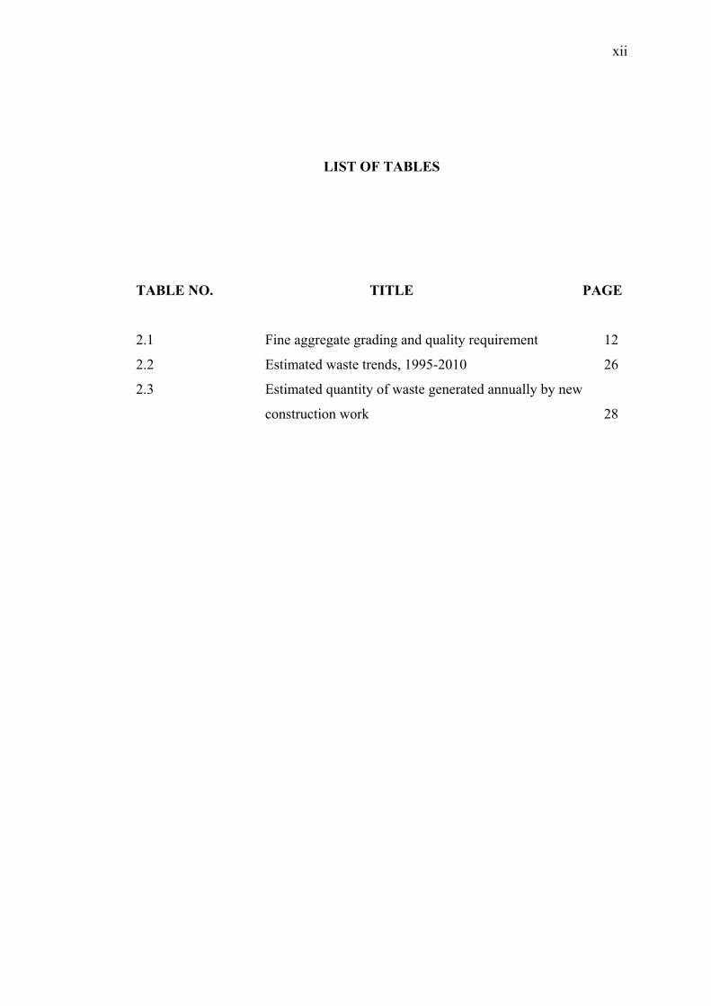
LIST OF TABLES
TABLE NO. TITLE PAGE
2.1 Fine aggregate grading and quality requirement 12
2.2 Estimated waste trends, 1995-2010 26
2.3 Estimated quantity of waste generated annually by new
construction work 28

xiii
LIST OF FIGURES
FIGURE NO. TITLE PAGE
2.1 The project context of site layout 8
2.2 Principles, considerations and criteria that affect site
layout 9
2.3 Schematic drawing of layout design procedure 11
2.4 Drywall as the ubiquitous interior building material 22
2.5 Type and quantities of construction waste 26
2.6 Network topology 48
2.7 Regional topology 48
2.8 Component of GIS 49
2.9 Relevant GIS equipment to meet requirement for data
collection, strorage, manipulation and representation 50
2.10 An example of overlaying various layers in GIS 55
3.1 Operational Framework 62
3.2 Digitized construction site of MPJBT 65
3.3 Digitized construction site of KIPark 65
3.4 Combination of various layers 68
4.1 Digitized construction site of MPJBT 71
4.2 Digitized construction site of KIPark 71
4.3 Saving digitized plan into .dxf file format 72
4.4 Importing data into MapInfo 73
4.5 Entering building data using table structure 74
4.6 Accessing layer control in MapInfo 75
4.7 Accessing Info Window in MapInfo 75
4.8 Adding legend to the plan 76
xiv
4.9 Thematic map of MPJBT construction site 77
4.10 Thematic map of KIPark construction site 77
4.11 Building of KIPark construction site 78
4.12 Materials found in KIPark construction site 79
4.13 Equipments found in KIPark construction site 79
4.14 Waste found in KIPark construction site 80
4.15 Combine plan of KIPark construction site 80
4.16 Table showing the equipments found in KIPark
construction site 81
4.17 Table showing the ground level of the KIPark
construction site 81
4.18 Developed KIPark construction site using MapInfo 82
4.19 Thematic map of MPJBT construction site 83
4.20 3D map of MPJBT construction site 83
4.21 Suitable place for fine aggregate in MPJBT
construction site 85
4.22 The place where fine aggregate located 86
4.23 Suitable place for steel bar and formwork in MPJBT
construction site 87
4.24 Woods and used formwork 88
4.25 Suitable place for waste dumping at MPJBT
construction site 89
4.26 Thematic map of KIPark construction site 91
4.27 3D map of KIPark construction site 91
4.28 Suitable place for fine aggregate in KIPark
construction site 93
4.29 Vehicle exit 94
4.30 Fine aggregate near to the temporary drain 95
4.31 Suitable place for steel bar and formwork at KIPark
construction site 96
4.32 Water are left in the site after raining 97
4.33 Steel bending workplace 97
4.34 Suitable place for waste dumping at KIPark
construction site 98

xv
LIST OF SYMBOLS
ASEAN - Association of Southeast Asian Nation
CTFT - Centre Technique Forestier Tropical
DBMS - Database Management System
DCDB - Digital Cadastral Database
EPA - Environmental Protection Agency
ESRI - Environmental Systems Research Institute
FEMA - Federal Emergency Management Agency
FGDC - Federal Geographic Data Committee
GBF-DIME - Geographic Base File, Dual Independent Map Encoding
GIS - Geographic Information System
GPS - Global Positioning System
LVL - Laminated veneer lumber
MoEPP - Ministry of Environment and Physical Planning
MPJBT - Majlis Perbandaran Johor Bahru Tengah
NaLIS - National Infrastructure for Land Information System
OECD - Organisation for Economic Co-operation and Development
UNDP - United Nations Development Program
3D - Three Dimensional
% - Percent
xvi
LIST OF APPENDICES
APPENDIX TITLE PAGE
A Construction Site Plan of MPJBT (Ground Floor Plan) 106
B Construction Site Plan of KIPark (Location Plan) 107
C Construction Site Plan of KIPark (Fencing Detail) 108

CHAPTER I
INTRODUCTION
1.1 Introduction
Construction is one of the important sectors which influence the economy of
our country. This sector creates many work opportunities to the citizen and involves
several parties such as contractors, consultants and architects. It brings benefit to the
parties who are involved in the process of construction. Nevertheless, this target can
only be realized if the construction process is managed effectively. Construction
management is an important element which can affect the profit and the project’s
completion time.
The management of construction waste is a problem suffered worldwide
(Adam, 2004). In developing countries, waste management is becoming an acute
problem as urbanization and economic development increase which have led to
larger quantities of waste materials requiring management in these countries. In Asia,
the management of construction waste requires immediate attention especially in
countries such as China, South Korea and Malaysia, which have been categorized, as
emerging industrialized countries.
Malaysia, like most of the developing countries, is facing an increase in the
generation and disposal of waste. According to Grant (2001) five states (Kuala

2
Lumpur, Selangor, Pahang, Terengganu and Kelantan) represent 70 % of the total
amount of waste in the country. One can observe that 64 % of the waste is domestic
waste. The share of industrial waste stands at 15 %, followed by commercial waste
and construction and institution waste.
One of the approaches that can be applied in managing construction site is
Geographical Information Systems (GIS). Geographical Information Systems (GIS)
is an industry that is popular in the western countries and now is thriving in
Malaysia. GIS has been implemented in many departments in Malaysia for
application such as military, hydrological modeling and environmental monitoring.
GIS is actually a combination of element designed to store, retrieve, manipulate,
process and display geographical data. The geographical data are computerized
information about people, place and environment.
The term GIS is always associated with both computer hardware and
software. These will provide the means for data input, storage, manipulation, analysis
and finally output. The use of GIS in construction management studies can be very
useful in planning the suitable place to locate materials and waste at the site.
Therefore, GIS is the best tool to solve problem in construction fields.
1.2 Problem Statement
Construction sector, the world over, is considered to be a basic industry on
which the development of the country depends to a great extent, the growth of a
country and its development status, is generally determined by the quality of its
construction companies and their capabilities. It is treated as an important sector, not
only in the developing countries but also the developed ones where separate
ministries have been created to look after the housing problems of the people.
But unfortunately, most of the construction companies concentrate in gaining
maximum profit thus failing to adopt effective site layout on materials and ideally

3
managed the construction waste. Thus, a significant strategy for minimizing
construction waste on site does not exist.
The proper management of the construction materials and waste is neglected
by the contractor which can be presumed as a way to reduce an expense. Managing
data by conventional method is a laborious task for the project. Therefore, applying
GIS in monitoring construction site may improve the conventional method in the
preparation of geographical information.
In the conventional method, technicians are confronted with restrictions and
limitations when there is too much material to be used in a big project. There is no
systematic system that helps to properly decide where the material and waste ideally
located. Thus the application of GIS in managing construction site is seen as an
alternative approach.
1.3 Research Objectives
The objectives of this study are as follow:
i. To implement the Geographical Information System (GIS) in developing
a database system for construction materials and waste.
ii. To investigate its capability as a management decision making tool for
depositing the construction materials and waste on construction site.
1.4 Scope of the Study
The scopes of study can be outlined as follow:
i. To collect data and create a user-friendly spatial database system that
reflects the construction waste and materials on construction sites.
ii. To develop a construction materials and waste management system
using GIS application system.

4
iii. To use the management system as a tool to analyse construction
materials and waste so as to do prediction and recommendation on
construction site.
1.5 Expectation
i. It is expected that the implementation of GIS can help to improve the
management of the construction materials and waste on site because the
conventional method is take much time in the process of restore, retrieve
and analyze the data.
1.6 Hypothesis
Geographical Information Systems (GIS) is able to manage the construction
materials and waste.
1.7 Limitation
The limitations of the study are:
i. The software used in this research is MapInfo as it is the software
available in the faculty.
ii. The materials analyse in the study are fine aggregate, steel bar and steel
formwork.
iii. The study is conducted at selected certain areas.

103
REFERENCES
Abler, R. F., 1988. “Awards, Rewards, and Excellence: Keeping Geography Alive
and Well,” The Professional Geographer 40: 135-40.
Adam, T.V., 2004. “Israel Union for Environmental Defense (IUED),” Imply
Multimedia Ltd.
Anon, 1983. “Building for man: the National Shelter Programme in the Philippines,”
Reader's Digest (Jun)
Building Research Establishment Digest, 1981. “Waste of building materials,” Her
Majesty Stationery Office; UK London.
Clarke, K.C, 1997. “Geographic Information Systems,” University of California,
Santa Barbara.
CTFT., 1983. “Regional study for the commercialization of the timber resources in
ASEAN countries,” France. Centre technique forestier tropical.
FAO/UNDP., 1983. “Proc. Technical Consultation on Wood-based Panels,” 13- 17
Jan 1983. New Delhi.
Goodchild, M. F., 1992. “Geographical Information Science,” International Journal
of Geographical Information Science, 6, 31-45.
Greene, R.W., 2000. “GIS in Public Policy,” Environmental Systems Research
Institute, Redlands California.

104
Greene, R.W., 2001. “Open Access GIS in e-Government,” Environmental Systems
Research Institute, Redlands California.
Harreld, H., 2000. “Opening up GIS Borders,” Freelance writer based in Cry, N.C.
Harris, T., and Weiner, D., 1996. “GIS and Society: The Social Implications of How
People, Space, and Environment are represented in GIS,” Santa Barbara,
California: NCGIA Technical Report 96-7.
Hidayat, B.Y., 1984. “The prospect of agro-residues for building materials in
Indonesia,” Paper presented to the Seminar and Workshop of Agro-Residues
for Low-Cost Building Materials, July 1984, Manila
Jordan, B., 2000. “A Grand Central Station for Maps,” News Article located at
www.fcw.com, June 20, 2000.
Lang, L., 1998. “Managing Natural Resources with GIS,” Environmental Systems
Research Institute, Redlands California.
Lauritzen, E., 2001. “The Challenge Of Recycling Construction And Demolition
Waste,” DEMEX Consulting Engineers A/S, Denmark.
Mark, D., Chrisman, N, Frank, A, McHaffie, U.P., Pickles, J., 1997. “GIS History
Project,” Summary Paper Presented at the UCGIS Seminar, Bar Harbor,
Maine, June 1997.
Ministry of Environment and Physical Planning (MOEPP), 1996. “Strategic
Guidelines on Waste Management” in “Management of Pollution and of
Natural” Chapter 6 Waste Management.
Mitchell, A., 1998. “Zeroing In Geographic Information Systems at Work in the
Communit,” Environmental Systems Research Institute, Redlands
California.

105
Mosteiro, A., 1985. “The need for industrial utilization of coconut wood,” Los
Baños. Laguna, Philippines.
Neil, J.M. (1980). “Teaching Site Layout for Construction,” ASCE Meeting, Portland
NEPC., 1977. “National Environmental Protection Council,” Philippine
Environmental Quality Report, p. 153. Manille, the Philippines.
Sasaki. H., 1981. “Recent Developments in Laminated Wood Products in Japan,”
Proc. XVII IUFRO World Congress. Div. 3 Forest Products p. 146- 156.
Sax, S.K., Salleh, R. & Soon, C.K., 1984. “State of the art in housing in
Malaysia,” Paper presented to the Seminar and Workshop of Agro-Residues
for Low-Cost Building Materials, July 1984, Manila.
Sinsuwong, C., 1984. “State of the art in housing in Thailand,” Paper presented to
the Seminar and Workshop of Agro-Residues for Low-Cost Building
Materials, July 1984, Manila
Thailand, 1983. “Forestry statistics of Thailand,” Royal Forest Department.