THE APPLICATION FOR RECTIFICATION IN TERMS OF SECTION 24G AND 7 OF
33
1 THE APPLICATION FOR RECTIFICATION IN TERMS OF SECTION 24G AND 7 OF THE NATIONAL ENVIRONMENTAL MANAGEMENT AMENMENT ACT NO 8 OF 2004 FOR THE PROPOSED CONSTRUCTION OF A 42 M HIGH TOWER FOR A ZIP-LINE, KOPJESKRAAL 517-IQ, TLOKWE LOCAL MUNICIPALITY, NORTH WEST PROVINCE CONDUC APPLICANT: Crater Slide (Pty) Ltd Tel: +27 (56) 818 1585 Fax: +27 (56) 818 1585 Cell: 083 406 0841 PREPARED BY: Holistic Environmental Services Suite No.: C26 Private Bag X9687 Polokwane 0700 DOCUMENT VERSION 1.0 – Draft REHABILITATION PLAN: 12/12/20/1946
Transcript of THE APPLICATION FOR RECTIFICATION IN TERMS OF SECTION 24G AND 7 OF
1
THE APPLICATION FOR RECTIFICATION IN TERMS OF SECTION 24G AND 7 OF THE
NATIONAL ENVIRONMENTAL MANAGEMENT AMENMENT ACT NO 8 OF 2004 FOR THE
PROPOSED CONSTRUCTION OF A 42 M HIGH TOWER FOR A ZIP-LINE, KOPJESKRAAL
517-IQ, TLOKWE LOCAL MUNICIPALITY, NORTH WEST PROVINCE
CONDUC
APPLICANT:
Crater Slide (Pty) Ltd
Tel: +27 (56) 818 1585
Fax: +27 (56) 818 1585
Cell: 083 406 0841
PREPARED BY:
Holistic Environmental Services
Suite No.: C26
Private Bag X9687
Polokwane
0700
DOCUMENT VERSION 1.0 – Draft
REHABILITATION PLAN: 12/12/20/1946

Rehabilitation Plan - The proposed construction of a 42 m high tower for a Zip-line in the Vredefort Dome Area
i
Holistic Environmental Services - “We are committed to the sustainable development,
management and restoration of the environment.”
THE APPLICATION FOR RECTIFICATION IN TERMS OF SECTION 24G AND 7
OF THE NATIONAL ENVIRONMENTAL MANAGEMENT AMENMENT ACT NO 8
OF 2004 FOR THE PROPOSED CONSTRUCTION OF A 42 M HIGH TOWER FOR
A ZIP-LINE, KOPJESKRAAL 517-IQ, TLOKWE LOCAL MUNICIPALITY, NORTH
WEST PROVINCE
DOCUMENT VERSION 1.0 – Draft
CONDUCTED ON BEHALF OF:
Crater Slide (Pty) Ltd
Tel: +27 (56) 818 1585
Fax: +27 (56) 818 1585
Cell: 083 406 0841
E-mail: [email protected]
AUTHOR:
PREPARED BY:
Holistic Environmental Services Mr B.P. Pretorius
Suite No.: C26 Environmental Consultant
Private Bag X9687 082 885 3546
Polokwane [email protected]
0700 www.holistic-servies.co.za
REHABILITATION PLAN: 12/12/20/1946 5

Rehabilitation Plan - The proposed construction of a 42 m high tower for a Zip-line in the Vredefort Dome Area
ii
Holistic Environmental Services - “We are committed to the sustainable development,
management and restoration of the environment.”
Document History and Distribution
TITLE:
Rectification application for the proposed construction of a 42 m high
tower for a Zip-line, Kopjeskraal 517-KQ, Tlokwe Local Municipality,
North West Province
OUR REFERENCE
NO.: HES/001/RA/P2
DEA REFERENCE: 12/12/20/1946
Name Institution Date Version Status
Registered Interested
and Affected Parties
15 April 2011 1.0 Draft
Mr C. Meyer Crater Slide (Pty) Ltd 15 April 2011 1.0 Draft
Rehabilitation Plan - The proposed construction of a 42 m high tower for a Zip-line in the Vredefort Dome Area
iii
Holistic Environmental Services - “We are committed to the sustainable development,
management and restoration of the environment.”
Copyright Information
This document contains intellectual property and propriety information that is
protected by copyright in favour of Holistic Environmental Services Cc and
the specialist consultants. The document may therefore not be reproduced,
used or distributed to any third party without the prior written consent of
Holistic Environmental Services Cc.
This document is prepared exclusively for Crater Slide (Pty) Ltd and is subject
to all confidentiality, copyright and trade secrets, rules, intellectual property
law and practices of South Africa.

Rehabilitation Plan - The proposed construction of a 42 m high tower for a Zip-line in the Vredefort Dome Area
iv
Holistic Environmental Services - “We are committed to the sustainable development,
management and restoration of the environment.”
1 Introduction .........................................................................................................................1
2 Background ........................................................................................................................1
2.1 Project objective and scope ......................................................................................................... 2
3 Proposed Activity ...............................................................................................................2
3.1 Locality ............................................................................................................................................ 2
3.2 Description of Activity .................................................................................................................... 2
3.3 Location alternatives ..................................................................................................................... 4
3.3.1 Alternative 1 ........................................................................................................................................... 5
3.3.1 Alternative 2 (Preferred Option) .......................................................................................................... 5
4 Description of Affected Environment ..............................................................................6
4.1 Land Uses ....................................................................................................................................... 6
4.2 Climate ............................................................................................................................................ 6
4.3 Vegetation ....................................................................................................................................... 6
4.4 Topography .................................................................................................................................... 7
4.5 Surface Water ................................................................................................................................ 7
4.6 Geology and soils .......................................................................................................................... 7
4.7 Aesthetic Environment .................................................................................................................. 7
5 Rehabilitation process ....................................................................................................10
5.1 Pre-Rehabilitation ........................................................................................................................ 11
5.2 Measure of Success.................................................................................................................... 13
5.3 Rehabilitation Implementation Tasks ....................................................................................... 13
5.3.1 Infrastructure ........................................................................................................................................ 13
5.3.2 Landscaping ......................................................................................................................................... 14
Table of Contents

Rehabilitation Plan - The proposed construction of a 42 m high tower for a Zip-line in the Vredefort Dome Area
v
Holistic Environmental Services - “We are committed to the sustainable development,
management and restoration of the environment.”
5.3.3 Soil ........................................................................................................................................................ 14
5.3.4 Vegetation ............................................................................................................................................ 17
5.3.5 Post-Rehabilitation (Monitoring) ....................................................................................................... 20
5.3.6 Record .................................................................................................................................................. 21
6 Conclusion ........................................................................................................................21
7 References .......................................................................................................................22
Rehabilitation Plan - The proposed construction of a 42 m high tower for a Zip-line in the Vredefort Dome Area
vi
Holistic Environmental Services - “We are committed to the sustainable development,
management and restoration of the environment.”
List of Figures
Figure 1: Location of Alternative 1 & 2 ............................................................... 4
Figure 2: View of original location in a northern direction .................................. 5
Figure 3: General view of site along the southern boundary (tower area) of the property
............................................................................................................................. 9
Figure 4: General view of site along the northern boundary (platform 1) of the property
............................................................................................................................. 10
Figure 5: EMP and Rehabilitation applicability during the different pahses of the
development ....................................................................................................... 11

Rehabilitation Plan - The proposed construction of a 42 m high tower for a Zip-line in the Vredefort Dome Area
vii
Holistic Environmental Services - “We are committed to the sustainable development,
management and restoration of the environment.”
List of Tables
Table 1: Activity Description ................................................................................ 2

Rehabilitation Plan - The proposed construction of a 42 m high tower for a Zip-line in the Vredefort Dome Area
viii
Holistic Environmental Services - “We are committed to the sustainable development,
management and restoration of the environment.”
DEA Department of Environmental Affairs
EIA Environmental Impact Assessment
EMP Environmental Management Plan/Programme
Abbreviations

Rehabilitation Plan - The proposed construction of a 42 m high tower for a Zip-line in the Vredefort Dome Area
ix
Holistic Environmental Services - “We are committed to the sustainable development,
management and restoration of the environment.”
Biodiversity : The variety of life and its processes; including the variety of living
organisms the genetic differences among them, the communities and ecosystems in which they occur, and the ecological and evolutionary processes that keep them functioning, yet ever changing and adapting.
Clearing : The clearing and removal of vegetation, whether partially or in whole,
including trees and shrubs, as specified. Environment : The surroundings within which humans exist and that is made up of:
a) The land, water and atmosphere of the earth;
b) Micro-organisms, plant and animal life;
c) Any part or combination of a) and b) and the interrelationships among and between them; and
d) The physical, chemical, aesthetic and cultural properties and
conditions of the foregoing that influence human health and well-being (i.e. the social environment).
Erosion control : The act of reducing or eliminating on–going erosion caused by natural
or man-made processes. Herbicide : A chemical substance or cultured biological organism used to control,
suppress or kill plants, or severely interrupt their normal growth processes.
Indigenous species : Any species of flora or fauna that naturally occurs in an specific area. Natural vegetation : The existing vegetation species, indigenous or otherwise, of trees,
shrubs, groundcover, grasses and all other plants found growing on the site.
Pollution : Any change in the environment caused by –
Glossary

Rehabilitation Plan - The proposed construction of a 42 m high tower for a Zip-line in the Vredefort Dome Area
x
Holistic Environmental Services - “We are committed to the sustainable development,
management and restoration of the environment.”
(a) substances; or (b) noise, odours, dust or heat, emitted from any activity associated with the clearance or rehabilitation phases, where that change has an adverse effect on human health or well-being or on the composition, resilience and productivity of natural or managed eco-systems, or on materials useful to people, or will have such an effect in the future.
Rehabilitation : The return of a disturbed area to a state which approximates the state
(where possible) which it was before disruption. Rehabilitation for the purposes of this specification is aimed at re-vegetation of a disturbed area and the insurance of a stable land surface. Re-vegetation should aim to accelerate the natural succession processes so that the plant community develops in the desired way, i.e. promote rapid vegetation establishment.
Solid waste : All solid waste, chemical waste, wrapping materials, tins and cans,
drums, wire, nails, food and domestic waste (e.g. plastic packets and wrappers).
Weeds and invader plants : Weeds and invader plants, as defined under Section 1 of the
Conservation of Agricultural Resources Act, 1983 (Act 43 of 1983) and Government Notice R1048 of 25 May 1984 Part 2, or any list of invaders identified by the Agricultural Research Council and the Plant Protection Research Institute (Handbook No.5 – Plant Invaders of Southern Africa).

Rehabilitation Plan - The proposed construction of a 42 m high tower for a Zip-line in the Vredefort Dome Area
1
1 Introduction
The demand for reclamation or rehabilitation has increased during the last few decades as resource firms
become increasingly conscious about the environment and the relevant environmental laws. However,
rehabilitation can be a very costly process, especially if there is a toxic cleanup involved.
2 Background
Holistic Environmental Services (HES) Cc was appointed by Crater Slide (Pty) Ltd to submit the application for
rectification in terms of sections 24G and 7 of the National Environmental Management Amended Act, (Act 8 of
2004), for a 42 m high tower for a Zip-line on portion 71 on the farm Kopjeskraal 517-IQ, in the Vredefort
Dome Management Area. The activity was listed in GNR 386 of 21 April 2006 under activity no 14 “The
construction of masts of any material or type of any height, including those used for telecommunication,
broadcasting and radio transmission, but excluding – (a) masts of 15 metres and lower exclusively used (i) by
radio amateurs; or (ii) for lighting purposes (b) flag poles; and (c) lighting conductor poles.”
The section 24G application for the above mentioned activity was submitted to the DEA on 20 May 2010. The
acknowledgement of receipt was received on 17 June 2010. A site visit was conducted by Ms Linda Poll-Jonker
from the DEA on 16 August 2010. During the site visit it was confirmed that some of the earthworks have
already commenced. A letter was received from the DEA on 6 September 2010 requesting that the applicant
provide additional information in order for them to make an informed decision regarding the application. The
following clarification and additional information were required in a consolidated EIA report in order for DEA to
make an informed decision regarding the way forward for the proposed zip-line:
A public participation process in accordance with Government Notice R385 and national public
participation guideline;
Structural Diagrams of the proposed activity;
A layout/ diagrammatic representation of the disturbance of the transformed areas;
Visual Impact Assessment;
Description of the noise associated with the construction and operational phases;
A description of the impacts associated with the development and an assessment of the significance of
these impacts with and without mitigation measures;
A clear description of the mitigation measures to be put in place to manage the impacts of the activity
during the construction, operation, and decommissioning phases;
Rehabilitation Plan;
Photographs of site;
A motivation of why the application in terms of Section 24G of the NEMA, should be considered
favourable, with specific reference to the site`s environmental sensitivity and environmental
management plans.
Clear readable minutes of the public meeting and colour pictures of the site notices;
Clear description of the alternative site location.
Rehabilitation Plan - The proposed construction of a 42 m high tower for a Zip-line in the Vredefort Dome Area
2
2.1 Project objective and scope
The assignment was interpreted as follows: Compile a Rehabilitation Plan for the existing and proposed
activities that will be conducted on site with clear objectives and possible methods for restoring the
environment. Specific objectives include:
To ensure that the site is safe and secure;
To remove any sources of pollution from the site and rehabilitate and restore the soils;
To control erosion by establishing a vegetative cover;
To re-establish a plant community with specified indigenous species;
Where feasible maintain or increase the biological diversity of species in the vicinity;
To rehabilitate the site to a state that is suitable for other land uses; and
To rehabilitate the site that it facilitates compliance with current environmental quality objectives.
3 Proposed Activity
3.1 Locality
The study area falls within the jurisdiction of the Tlokwe Local Municipality, North West Province. The proposed
development site is located approximately 12km north-west of Parys on Portion 71 (±168 ha) of the farm
Kopjeskraal 517-IQ, at the following coordinates in the centre of the property:
Latitude: 26. 878726 S Longitude: 27. 387544 E
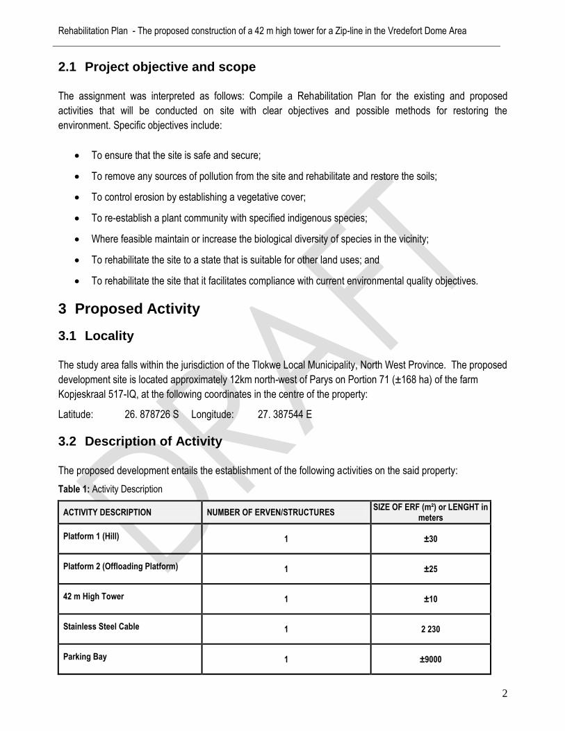
3.2 Description of Activity
The proposed development entails the establishment of the following activities on the said property:
Table 1: Activity Description
ACTIVITY DESCRIPTION NUMBER OF ERVEN/STRUCTURES SIZE OF ERF (m²) or LENGHT in
meters
Platform 1 (Hill) 1 ±30
Platform 2 (Offloading Platform) 1 ±25
42 m High Tower 1 ±10
Stainless Steel Cable 1 2 230
Parking Bay 1 ±9000
Rehabilitation Plan - The proposed construction of a 42 m high tower for a Zip-line in the Vredefort Dome Area
3
ACTIVITY DESCRIPTION NUMBER OF ERVEN/STRUCTURES SIZE OF ERF (m²) or LENGHT in
meters
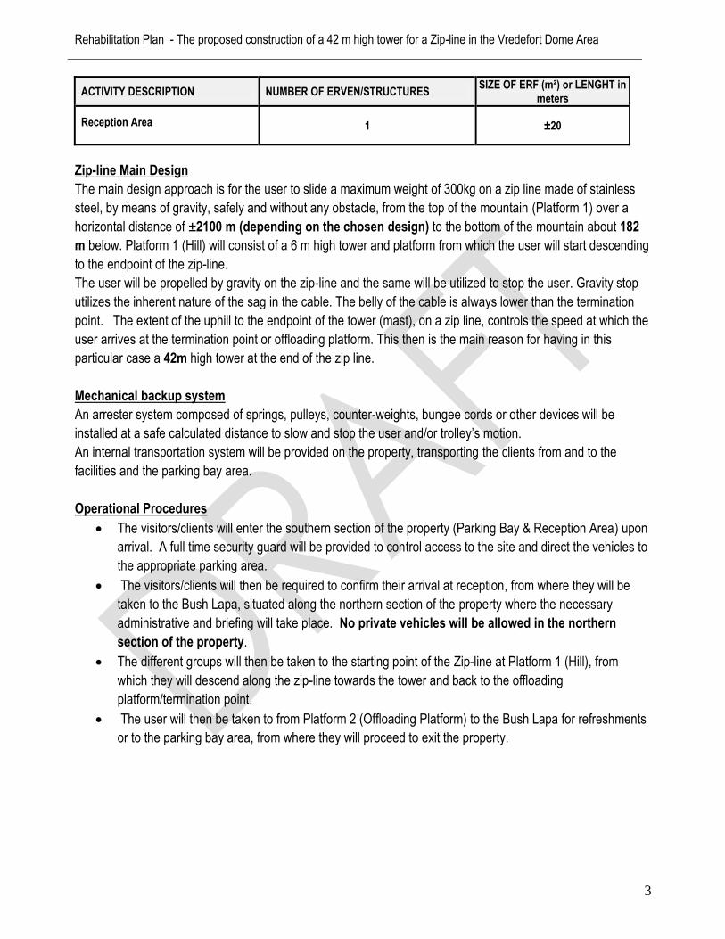
Reception Area 1 ±20
Zip-line Main Design
The main design approach is for the user to slide a maximum weight of 300kg on a zip line made of stainless
steel, by means of gravity, safely and without any obstacle, from the top of the mountain (Platform 1) over a
horizontal distance of ±2100 m (depending on the chosen design) to the bottom of the mountain about 182
m below. Platform 1 (Hill) will consist of a 6 m high tower and platform from which the user will start descending
to the endpoint of the zip-line.
The user will be propelled by gravity on the zip-line and the same will be utilized to stop the user. Gravity stop
utilizes the inherent nature of the sag in the cable. The belly of the cable is always lower than the termination
point. The extent of the uphill to the endpoint of the tower (mast), on a zip line, controls the speed at which the
user arrives at the termination point or offloading platform. This then is the main reason for having in this
particular case a 42m high tower at the end of the zip line.
Mechanical backup system
An arrester system composed of springs, pulleys, counter-weights, bungee cords or other devices will be
installed at a safe calculated distance to slow and stop the user and/or trolley’s motion.
An internal transportation system will be provided on the property, transporting the clients from and to the
facilities and the parking bay area.
Operational Procedures
The visitors/clients will enter the southern section of the property (Parking Bay & Reception Area) upon
arrival. A full time security guard will be provided to control access to the site and direct the vehicles to
the appropriate parking area.
The visitors/clients will then be required to confirm their arrival at reception, from where they will be
taken to the Bush Lapa, situated along the northern section of the property where the necessary
administrative and briefing will take place. No private vehicles will be allowed in the northern
section of the property.
The different groups will then be taken to the starting point of the Zip-line at Platform 1 (Hill), from
which they will descend along the zip-line towards the tower and back to the offloading
platform/termination point.
The user will then be taken to from Platform 2 (Offloading Platform) to the Bush Lapa for refreshments
or to the parking bay area, from where they will proceed to exit the property.

Rehabilitation Plan - The proposed construction of a 42 m high tower for a Zip-line in the Vredefort Dome Area
4
Operation Details
The following is a brief description of the parameters in which the Zip-line will operate:
Operation hours will be from 8h00 to 17h00 from Monday to Saturday, on Sundays operating hours will
be limited from 9h00 to 16h00.
The duration of each slide will be approximately 10 minutes.
The expected maximum number of slides that will be conducted per day is 50 during peak season.
Depending on the combined weight of the users, they will also be allowed to slide together (two at a
time).
This will not impact on the maximum number of slides that will be undertaken, but could result in a
maximum of 100 visitors/clients per day that will be make use of the facility.
3.3 Location alternatives
The following alternative locations were identified during the initial survey. Option 1 as indicated below is the
original alternative for which construction activities has commenced, which includes the excavation of the
foundation and the purchasing of the 14 segments required for the 42 m high tower. The length of the zip-line
for this alternative will be approximately 2052 m. Option 2 is approximately 70 m west of the original option.
The hill platform will be the same for both location alternatives. No earthwork has currently been undertaken for
this option. The length of the zip-line for this alternative will be approximately 2100 m.
Figure 1: Location of Alternative 1 & 2

Rehabilitation Plan - The proposed construction of a 42 m high tower for a Zip-line in the Vredefort Dome Area
5
3.3.1 Alternative 1
The initial development site where the 42 m high tower was to be erected was situated on Portion 71 (±168 ha)
of the farm Kopjeskraal 517-IQ, at the following coordinated:
Latitude: 26. 878726 S Longitude: 27. 387544 E
Figure 2: View of location 1 in a northern direction
3.3.1 Alternative 2 (Preferred Option)
The alternative position of the 42 m high tower is situated on the same property as Alternative 1, at the
following coordinated:
Latitude: 26. 88818 S Longitude: 27. 38674 E

Rehabilitation Plan - The proposed construction of a 42 m high tower for a Zip-line in the Vredefort Dome Area
6
4 Description of Affected Environment
4.1 Land Uses
The study area is situated within a sparsely populated section of the Vredefort Dome Management Area, which
is currently in the process of being proclaimed as a World Heritage Site by the South African Government.
The property is currently used for tourism activities (i.e. quad biking & accommodation), livestock farming and
environmental education programmes. The surrounding farms are currently used for agriculture, mining (sand
and stone), governmental, tourism, recreational/adventure and residential purposes.
4.2 Climate
The site falls within the summer rainfall region. The mean annual precipitation is ± 550mm, while the mean
monthly maximum and minimum temperatures for the area are 35˚C (October) and -3˚C (July), respectively.
4.3 Vegetation
The study area forms part of the Grassland Biome. The vegetation according to Acocks, 1975, and
Bredenkamp and Van Rooyen, 1996, is Rocky Highveld Grassland. The most recent classification of the area
by Mucina & Rutherford (2006) is a combination of Gold Reef Mountain Bushveld and the Vredefort Dome
Granite Grassland vegetation types.
The northern and central section of the property is characterised by dense woody vegetation, which is still
relatively undisturbed. The main disturbances that took place in this area are the internal gravel roads and a
few building structures mostly used for residential and tourism (accommodation and environmental education)
purposes.
The natural vegetation along the southern section of the property has been altered by agricultural activities (old
croplands), this is also the section of the property were the 42 m high tower will be located for both location
alternatives. When these old croplands are left fallow, it results in a landscape mosaic of patches of secondary
vegetation varying in age and dominated by various grass species.
The section of the property located to the south of the Kopjeskraal Road is dominated by a grassy layer with a
few scattered woody species.

Rehabilitation Plan - The proposed construction of a 42 m high tower for a Zip-line in the Vredefort Dome Area
7
4.4 Topography
The regional topographical setting of the study area is classified as Parallel Hills. The project area itself drapes
from the relatively sharp crest of a prominent hill in the north onto the relatively flat plains along the southern
sections of the site. The lowest point is located in the south-eastern corner of the property at an elevation of
approximately 1 375 m above mean sea level (mamsl), with the highest point occurring in the north at an
elevation of approximately 1 650 mamsl.
4.5 Surface Water
The study area is located within the quaternary drainage region C23C, situated within the Upper Vaal
Catchment Management area. The property drains mainly by means of surface run-off (i.e.: sheetwash) with
surface water flowing along the internal road infrastructure towards the non-perennial streams traversing the
northern, central and southern sections of the property.
These streams form tributaries of the regionally important, perennial Vaal River that occurs approximately 1.5
km to the south of the property. It must be noted that stream flow along these stream generally occurs only
during and directly after heavy precipitation events, and may continue for a short period directly after a
particularly good rainy season. An old dam is located along the central section of the property.
4.6 Geology and soils
According to the available geological information the study area is predominantly covered by land type (Ib46),
which typically lies in the mountainous areas varying in depth from bare rock to very deep. The associated
geology is quartzite (crests, scarps and middle slopes) and shale, slate and diabase on the foot slopes and
valley bottoms.
The soils that are present on site varies from shallow soils with scattered bedrock outcrops and/or loose
boulders along the northern and western sections to relatively deep soils ranging between 0.4 to 0.7 m along
the southern sections of the site.
4.7 Aesthetic Environment
Coastal & Environmental Services 32
The property is currently used for tourism (accommodation), adventure activities (i.e. quad biking) and grazing
by livestock. The southern section of the site can be characterised as a relatively flat grassland area, with
scattered woody species.

Rehabilitation Plan - The proposed construction of a 42 m high tower for a Zip-line in the Vredefort Dome Area
8
The photographs of the southern section of the property were taken during a site survey on 21 March 2011
(S23. 88818; E27. 38674).
North-East East
South-East South
South-West West

Rehabilitation Plan - The proposed construction of a 42 m high tower for a Zip-line in the Vredefort Dome Area
9
Figure 3: General view of site along the southern boundary (tower area) of the property
The northern section of the site is located on a localised hill with dense woody vegetation characterized by
large indigenous tree species (>3m) in size. The photographs of the northern section of the property were
taken a site survey in 21 March 2011 (S26. 86893; E27.38980).
North-West North
East South-East
South South-West

Rehabilitation Plan - The proposed construction of a 42 m high tower for a Zip-line in the Vredefort Dome Area
10
Figure 4: General view of site along the southern boundary (tower area) of the property
5 Rehabilitation process
Rehabilitation can be defined as the return of disturbed areas to a safe, stable, productive and self-sustaining
condition, consistent with the agreed end land uses. Although land rehabilitation is most often used to rectify
problems caused by man-made processes, it is also used to "clean up" natural processes (e.g. natural
disasters such as earthquakes and flooding) that can also cause damage to the natural environment. Land
rehabilitation techniques can be used to speed up the time required to restore the location back to its original,
or better, state.
To maintain a sustainable environment it is important to plan how the different sites associated with the zip-line
construction will be rehabilitated.
West North-West
North North-East
Rehabilitation Plan - The proposed construction of a 42 m high tower for a Zip-line in the Vredefort Dome Area
11
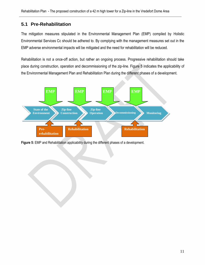
5.1 Pre-Rehabilitation
The mitigation measures stipulated in the Environmental Management Plan (EMP) compiled by Holistic
Environmental Services Cc should be adhered to. By complying with the management measures set out in the
EMP adverse environmental impacts will be mitigated and the need for rehabilitation will be reduced.
Rehabilitation is not a once-off action, but rather an ongoing process. Progressive rehabilitation should take
place during construction, operation and decommissioning of the zip-line. Figure 5 indicates the applicability of
the Environmental Management Plan and Rehabilitation Plan during the different phases of a development.
Figure 5: EMP and Rehabilitation applicability during the different phases of a development.
Zip-line
Operation
Zip-line
Construction
State of the
Environment
Decommissioning
Monitoring
Pre-
rehabilitation
Rehabilitation Rehabilitation
EMP EMP EMP EMP
Rehabilitation Plan - The proposed construction of a 42 m high tower for a Zip-line in the Vredefort Dome Area
12
Pre-Rehabilitation Recommendations include:
All indigenous woody species taller than 2.5 meters must be preserved.
Indigenous woody species must be neatly pruned to allow for access by vehicles to erect the towers
and cable. During pruning, bird nests must not be disturbed or destroyed.
Weeds and exotic species should be eradicated.
Removal of litter on the site.
Provision of sufficient solid waste bins and waste removal services during operation.
No construction or operational activities should be allowed near the drainage line as this may cause
adverse environmental impacts (e.g. erosion, sedimentation). A 30 m buffer must be maintained
from the edge of the stream.
Excessive vegetation growth in the drainage line must be removed to allow stormwater run-off.
Open/cleared/levelled areas must be re-vegetated as soon as possible.
Sufficient stormwater management measures must be taken.
Strict security control must be maintained during and after the development to prevent illegal
dumping, vandalism and uncontrolled fires.
The necessary topsoil management measures must be used as prescribed.
The excavated areas must be demarcated and managed in accordance with the topsoil measures
stipulated below. If DEA require these areas to be rehabilitated the following measures will apply:
The stockpiled soils derived from the excavated areas can be used for infill material. The infill
material should be allowed time to settle, the moistening of soils will assist in this matter. The
topsoil for the excavated areas has already been mixed with the other soil layers. A mixture of
topsoil and compost together with indigenous grass species at the existing excavated areas along
the southern section of the site will stimulate vegetation growth. The hill platform can be
rehabilitated in a similar technique by planting indigenous tree species that occur along the steeper
slopes of the site (e.g. Rhus leptodictya & Ziziphus mucronata).

Rehabilitation Plan - The proposed construction of a 42 m high tower for a Zip-line in the Vredefort Dome Area
13
5.2 Measure of Success
Rehabilitation can take the form of restoring the site to its original environmental state, or to an alternative land
use (i.e. adventure tourism). To determine if rehabilitation is successful certain outcomes are set for alternative
land uses or a “reference site” is selected which represents the original state of the environment.
If the application is successful it is the intention to maintain the site as an adventure tourism destination i.e. zip-
line with the associated infrastructure, while giving due cognisance of the surrounding environment. If the
application is rejected, then the site should be restored to it`s previous state.
5.3 Rehabilitation Implementation Tasks
5.3.1 Infrastructure
REHABILITATION OBJECTIVE
ASPECT POSSIBLE ISSUE REHABILITATION METHOD/MEASURE
Creation of an aesthetically beautiful, safe and secure site
when it is not in use a adventure tourism
destination
Effective implementation of
maintenance measures, like cutting of grass,
pruning of trees, provision of solid waste bins, and strict access
control.
Infrastructure Vandalism
Safety & Security
Visual Disturbance
All temporary structures (e.g. solid waste bins)
must be removed.
Protect and maintain permanent infrastructure
(e.g. gates, fences, towers and platforms,
roads etc.).
Access control must be maintained to prevent
illegal dumping, vandalism
Ensure that the site is safe for recreational
activities.
The maintenance of road infrastructure and
storm water systems, especially along the
lower lying area and steep slopes

Rehabilitation Plan - The proposed construction of a 42 m high tower for a Zip-line in the Vredefort Dome Area
14
5.3.2 Landscaping
Management Measures for Steep Slopes
The road infrastructure along the steep slopes is critical areas for accepting and directing stormwater runoff.
Developments that interfere with natural drainage patterns may result in negative environmental impacts (e.g.
erosion and ponding of water). Properly planned and constructed drainage systems require very little
maintenance afterwards. Specific management measures for the drainage systems include:
Inspections of the drainage system should be made after heavy rainfall events;
Side slopes should be maintained to prevent erosion;
Grass buffer strips approximately 5m wide should be maintained on both sides of a ditch to minimize
siltation of storm water pipelines at the lower lying areas. Soil with a high content of fine sand and silt
can pose a blockage problem to subsurface drainage systems. Drainage blockage caused by
sedimentation can be detected by initially checking the outlet;
Any debris or silt that is visible at an in- or outlet must be removed to ensure free flow; and.
5.3.3 Soil
Topsoil Management Measures
The topsoil layer (0-25 cm) is important as it contains nutrients, organic material, seed, and communities of
microorganisms, fungi and soil fauna. The biologically active upper layer of soil is fundamental in the
development of soils and the sustainability of the entire ecosystem. Soil management practices must be adhered
to in order to reduce soil loss and to encourage rehabilitation post-construction. The two most important aspects
to consider when removing topsoil are the depth of soil to be removed and the conditions of storage. The correct
handling of topsoil is vital in conserving the seed bank and nutrients which occur within this layer thereby
ensuring successful rehabilitation. The correct measures of handling topsoil are listed in the table below.
REHABILITATION OBJECTIVE
ASPECT POSSIBLE ISSUE REHABILITATION METHOD/MEASURE
Creation of an
aesthetically beautiful area when it is not in use as a adventure tourism destination
Landscaping
Rough landscape
Eroded ground or unwanted trenches should be backfilled.
Cover the backfill areas and slopes with 20-30 cm topsoil and establish a seed bank with indigenous vegetation including a component of creeper species.

Rehabilitation Plan - The proposed construction of a 42 m high tower for a Zip-line in the Vredefort Dome Area
15
Compaction Rehabilitation Measures
Soil compaction is often an effect of high traffic areas or construction areas. It can become a major problem and
can be recognized by:
Excess surface moisture and slow drying soils due to deeper compaction preventing the
percolation of water through the soil profile; and
REHABILITATION OBJECTIVE
ASPECT POSSIBLE ISSUE REHABILITATION METHOD/MEASURE
Constructing a physically and
geologically stable site, with
appropriate surface water
drainage that is resistant to compaction,
sedimentation, and erosion.
Soil Loss of Topsoil Topsoil must only be used for rehabilitation purposes and not for any other use example i.e. construction of roads.
Topsoil must be stored on site for it to be used for rehabilitation purposes (e.g. preparation of seed bank on levelled or cleared areas).
If necessary, the correct depth (30 cm) of topsoil must be removed.
Topsoil must be stored separately from other soil heaps.
All stockpiles should be kept <1.5 m with slopes not exceeding 18 degrees.
The duration of storage of the topsoil should be minimized as much as possible. Storing topsoil for long periods leads to seed bank depletion following germination during storage and anoxic conditions.
The topsoil must be uniformly redistributed in a manner that assures placement and compaction compatible with the needs of the species that will be used to restore the disturbed area.
After redistribution of the topsoil layer during rehabilitation, it is important to ensure that the area is protected against wind erosion such that the topsoil is not blown away.
Wind nets can effectively minimize the loss of topsoil through wind erosion.
Wind nets should be erected as soon as the topsoil is replaced. This will reduce wind speed aiding new plant growth.
Stockpiles/redistributed topsoil can also be kept wet to prevent fine particles being removed by wind. This should be done to prevent erosion and to prevent the wash-away of valuable topsoil resulting in the sedimentation of streams.
Fertilizers could also be applied to the soils on the stockpiles. Initial applications of fertilizer have shown to increase the species numbers, plant co-density, and growth rates in a number of areas where the objective has been to restore the native vegetation. The type of fertilizer and application rate will vary according to the site, soil type, and post-rehabilitation land use. Care needs to be taken when preparing fertilizer prescriptions and applying fertilizers on the rehabilitated areas. The roots of seedlings can be damaged if the fertilizer is placed too close to the plant. Fertilizers, particularly nitrogen fertilizers, may stimulate the growth of weed species. These weeds can jeopardize the success of rehabilitation by out-competing the more desirable species or by becoming a fire hazard.

Rehabilitation Plan - The proposed construction of a 42 m high tower for a Zip-line in the Vredefort Dome Area
16
Water runoff due to surface compaction preventing penetration and absorption (ponding of
water), especially on banks and sloping surfaces.
By decompacting soils, ponding of water will be prevented and an improvement will be made in terms of water
infiltration, water holding capacity, aeration and sustainable vegetation coverage.
Erosion Rehabilitation Measures
Water has the gift to sustain life, but also the potential to maim, damage and destroy if not managed correctly.
Remedial actions must be established to ensure that potential erosion is addressed with an erosion control
strategy towards long-term rehabilitation.
It is important to take note of the following generic points regarding erosion risks in the study area:
Soil loss will be greater during wetter periods. However, the provision of erosion control measures for
the through the drier months of the year is equally as important;
Soil loss from the site is proportionally related to the time the soils are exposed, prior to rehabilitation.
The time from commencement of construction to rehabilitation should be reduced. Rehabilitation efforts
should commence as soon as practical;
Construction staging and progressive rehabilitation is important; and
The extent of the disturbance that will take place will influence the risk and consequences of erosion on
the site.
REHABILITATION OBJECTIVE
ASPECT POSSIBLE ISSUE REHABILITATION METHOD/MEASURE
Constructing a physically and
geologically stable site, with
appropriate surface water
drainage that is resistant to compaction,
sedimentation, and erosion.
Soil Compaction
Rip and/or scarify all disturbed areas, including roads that are no longer in use (preferably before the rainy season).
Do not rip and/or scarify areas under wet conditions, as the soil will not loosen.
Compacted soil can also be decompacted by “Rotary Decompactors” to effectively aerate soils for vegetation establishment.

Rehabilitation Plan - The proposed construction of a 42 m high tower for a Zip-line in the Vredefort Dome Area
17
Sedimentation Rehabilitation Measures
General control measures are recommended for the site. The recommendations relate to the planning and
implementation stages of the proposed development and should be incorporated progressively.
5.3.4 Vegetation
REHABILITATION OBJECTIVE
ASPECT POSSIBLE ISSUE REHABILITATION METHOD/MEASURE
Constructing a physically and
geologically stable site, with
appropriate surface water
drainage that are resistant to compaction,
sedimentation, and erosion.
Soil Erosion
Avoid over-wetting, saturation and unnecessary run-off during dust control activities and irrigation.
Do not allow surface water or stormwater to be concentrated.
Protect all areas susceptible to erosion and ensure that there is no undue soil erosion.
Retain natural trees and shrubs.
REHABILITATION OBJECTIVE
ASPECT POSSIBLE ISSUE REHABILITATION METHOD/MEASURE
Constructing a physically and
geologically stable site, with
appropriate surface water
drainage that are resistant to compaction,
sedimentation, and erosion.
Soil Sedimentation
Diversion drains must be provided to divert run-off from upslope areas around the site to natural drainage areas.
The site must be stabilized using Geo-textile, if deemed necessary.
REHABILITATION OBJECTIVE
ASPECT POSSIBLE ISSUE REHABILITATION METHOD/MEASURE
Establishing a self-sustainable and
resilient vegetation unit comprised of indigenous plant
species.
Vegetation Destruction of vegetation
Loss of indigenous
plant species
Actively protect all natural features (e.g. aesthetically significant areas, hill area).
Do not disturb, deface, destroy or remove natural features (e.g. large trees).
Re-establishment of plant cover must commence once the site has been established.
The tower areas should be rehabilitated by establishing indigenous grass species during the rainy season. This will support effective surface water handling, as well as limit erosion and loss of topsoil.
Re-vegetation should be undertaken using a mixture of commercially available seeds that will germinate reliably, followed by the establishment of indigenous plants endemic to the area.

Rehabilitation Plan - The proposed construction of a 42 m high tower for a Zip-line in the Vredefort Dome Area
18
Indigenous Plant Species
Although the use of indigenous grass species is preferable in any situation, indigenous seed is not always
commercially available. In this respect, the establishment of suitable indigenous grasses would entail
harvesting seed from the veldt or in the absence of such an opportunity, mixtures of indigenous and alien grass
species and application rates as recommended by the Department of Water Affairs (DWA). These seed
mixtures may be obtained from any registered seed merchant.
Some of the grass species that are indigenous to the Vredefort Dome Granite Grassland area:
Elionurus muticus (d), Setaria sphacelata var torta (d), Themeda triandra (d), Brachiaria serrata,
Cymbopogon plurinodis, Eragrostis chloromelas, E. racemosa, Heteropogon contortus,
Trichoneura.
It is proposed that he seed mixture consist of the above mentioned grass species. As an
alternative, some of the surrounding grass species can be replanted at the disturbed areas.
Any bare patches appearing within the vegetation's growth after seeding can be repaired by a second treatment. Once the new grass has germinated it must be carefully monitored and maintained in order to achieve a satisfactory, self-sustaining cover.
Some seed germination rates are dramatically improved if the seeds are treated prior to planting. A range of treatments are available and would be investigated as necessary to maximise re-vegetation success and cost effectiveness.
Grass should be mown to a height of 50 mm above ground level and edges trimmed regularly to maintain a neat appearance.
Mowing of veldt grass is to take place once a year after the grass has shed its seed.
Grass can be cut by hand (e.g. scythe) if mechanical mowing is not possible.
Trees and shrubs must be pruned at the end of winter so as to stimulate growth.
Avoid pruning during the growing season as this stunts growth.
Planted areas that have deteriorated through excessive traffic volumes can be repaired using more suitable landscaping materials and/or plants.
Dispose of the eradicated plant material at an approved garden waste disposal site.
Rehabilitation Plan - The proposed construction of a 42 m high tower for a Zip-line in the Vredefort Dome Area
19
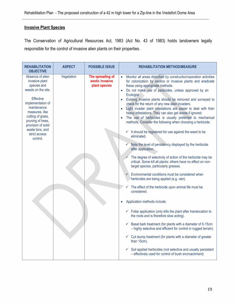
Invasive Plant Species
The Conservation of Agricultural Resources Act, 1983 (Act No. 43 of 1983) holds landowners legally
responsible for the control of invasive alien plants on their properties.
REHABILITATION OBJECTIVE
ASPECT POSSIBLE ISSUE REHABILITATION METHOD/MEASURE
Absence of alien invasive plant species and
weeds on the site.
Effective implementation of
maintenance measures, like
cutting of grass, pruning of trees, provision of solid waste bins, and
strict access control.
Vegetation The spreading of exotic invasive plant species
Monitor all areas disturbed by construction/operation activities for colonization by exotics or invasive plants and eradicate these using appropriate methods.
Do not make use of pesticides, unless approved by an Ecologist.
Existing invasive plants should be removed and surveyed to check for the return of any new alien invaders.
Light invader plant infestations are easier to deal with than heavy infestations. They can also get worse if ignored.
The use of herbicides is usually preferred to mechanical methods. Consider the following when choosing a herbicide:
It should be registered for use against the weed to be eliminated.
Note the level of persistency displayed by the herbicide after application.
The degree of selectivity of action of the herbicide may be critical. Some kill all plants; others have no effect on non-target species, particularly grasses.
Environmental conditions must be considered when herbicides are being applied (e.g. rain).
The effect of the herbicide upon animal life must be considered.
Application methods include:
Foliar application (only kills the plant after translocation to the roots and is therefore slow acting).
Basal bark treatment (for plants with a diameter of 5-15cm – highly selective and efficient for control in rugged terrain).
Cut stump treatment (for plants with a diameter of greater than 15cm).
Soil applied herbicides (not selective and usually persistent – effectively used for control of bush encroachment)

Rehabilitation Plan - The proposed construction of a 42 m high tower for a Zip-line in the Vredefort Dome Area
20
Fire Hazard
Wildfires can be started both by people and by acts of nature. They are often associated with slash and burn
activities, which in times of drought, can pose greater hazards. Negligence of people often plays a major role in
such a hazard.
Factors affecting the impact of vegetation fire hazards are:
Vegetation dryness (moisture content and amount of living vegetation);
Changes in weather variables that influence the spread and intensity of fires (el niño);
Availability of combustibles; and
Long term drought in the dry season.
5.3.5 Post-Rehabilitation (Monitoring)
The site must be inspected for harmful environmental impacts and the appropriate rehabilitation measures must
be applied accordingly. The following occurrences must be attended to:
Any signs of compaction and/or erosion;
Any signs of excessive sediment settlement;
The inadequate gravel cover of roads;
Destruction of vegetation on the site;
The presence of undesirable plants on the site;
Possible fire hazards on the site;
REHABILITATION OBJECTIVE
ASPECT POSSIBLE ISSUE REHABILITATION METHOD/MEASURE
Effective implementation of
maintenance measures, like
cutting of grass, pruning of trees, provision of solid waste bins, and
strict access control.
Vegetation Fire Hazard The grass cover at the structures and infrastructure should be kept short (30 cm) in order to minimise the fire hazards.
Grass cuttings must be removed to a licensed garden refuse site or used for compost on site
Adequate precautions have to be taken to ensure that fires are not started on site.
Do not permit any fires or open flames anywhere on the site, except at designated areas.
Cleared vegetation must not be burned on the site.

Rehabilitation Plan - The proposed construction of a 42 m high tower for a Zip-line in the Vredefort Dome Area
21
Illegal trespassing or dumping that occurs;
Vandalism of natural attributes and/or infrastructure on the site;
The excessive ponding of water; and
Disturbance of bird life nesting on site
5.3.6 Record
A record of all the impacts occurred and the rehabilitation methods applied must be kept by the applicant or zip-
line managing body. The Rehabilitation Plan forms part of the EIA Report submitted to the DEA. Compliance to
the rehabilitation measures will be evaluated during the environmental audits that will be performed according
to the conditions stipulated in the environmental authorisation.
6 Conclusion
Following the investigation, the conclusion can be made that the excavated areas and the proposed
construction, operation and decommissioning activities that will be taking place on site will be successfully
rehabilitated to a sustainable ecosystem, provided that the rehabilitation measures are strictly adhered to.
Note: Not all the rehabilitation measures may be applicable to the site at a specific time. Thus,
remediation/management measures were included to the extent of any environmental issue that might occur at
a given time on the site.

Rehabilitation Plan - The proposed construction of a 42 m high tower for a Zip-line in the Vredefort Dome Area
22
7 References
MIDGLEY, D.C. PITMAN, W.V. AND MIDDLETON, B.J.1994. First Edition Surface water resources of South Africa 1990, Volume VI, Drainage regions U,V,W,X, Eastern Escarpment. WRC Report No 298/6.2/94, Pretoria.
MUCINA L., RUTHERFORD M.C. & POWRIE L.W. (eds) (2005). Vegetation Map of South Africa, Lesotho and Swaziland, 1:1000000 scale sheet maps.