

The African Plate: A history of oceanic crust accretion and subduction since the Jurassic
22
The African Plate: A history of oceanic crust accretion and subduction since the Jurassic Carmen Gaina a, ⁎, Trond H. Torsvik a,b,c , Douwe J.J. van Hinsbergen d , Sergei Medvedev a , Stephanie C. Werner a , Cinthia Labails e a CEED—Centre for Earth Evolution and Dynamics, University of Oslo, Norway b Geodynamics, Geological Survey of Norway, Norway c School of Geosciences, University of Witwatersrand, WITS, 2050, South Africa d Department of Earth Sciences, Utrecht University, Budapestlaan 4, 3584 CD Utrecht, The Netherlands e BEICIP, France abstract article info Article history: Received 13 August 2012 Received in revised form 24 May 2013 Accepted 29 May 2013 Available online 7 June 2013 Keywords: Africa Oceanic crust Relative and absolute motion Palaeostress We present a model for the Jurassic to Present evolution of plate boundaries and oceanic crust of the African plate based on updated interpretation of magnetic, gravity and other geological and geophysical data sets. Location of continent ocean boundaries and age and geometry of old oceanic crust (Jurassic and Cretaceous) are updated in the light of new data and models of passive margin formation. A new set of oceanic palaeo-age grid models constitutes the basis for estimating the dynamics of oceanic crust through time and can be used as input for quantifying the plate boundary forces that contributed to the African plate palaeo-stresses and may have influenced the evolution of intracontinental sedimentary basins. As a case study, we compute a simple model of palaeo-stress for the Late Cretaceous time in order to assess how ridge push, slab pull and horizontal mantle drag might have influenced the continental African plate. We note that the changes in length of various plate boundaries (especially trenches) do not correlate well with absolute plate motion, but variations in the mean oceanic crust age seem to be reflected in acceleration or deceleration of the mean absolute plate velocity. © 2013 Elsevier B.V. All rights reserved. 1. Introduction The African plate is at the present the third largest tectonic plate (~60 million km 2 ) with approximately half of it covered by land. This plate comprises several old cratonic units and accreted younger crust, representing a period of more than 2.5 billion years of continental and oceanic crust growth (e.g. Burke, 1996). Initially part of Gondwana since 550 million years (Ma) and Pangea since 320 Ma, and now surrounded almost entirely by spreading centers, the African plate moved relatively slowly for the last 150 Ma (Lithgow-Bertelloni and Richards, 1998; Torsvik et al., 2010). However, its continental interior experienced many changes throughout this time including rifting and variations in sedimentary basin subsidence, most of them in regions sit- uated thousands of kilometers away from plate boundaries. The African plate was also partly underlain by mantle with above the average temperature—either induced by a series of hotspots or a superswell, or both—that contributed to episodic volcanism (including several Large Igneous Provinces—LIPS), basin-swell topography, and conse- quent sediment deposition, erosion, and structural deformation (e.g., Bumby and Guiraud, 2005). Long-term intra-continental crustal deformation may be the related to local and regional tectonic events (e.g., Cloetingh and Burov, 2011; Zoback et al., 1993) and mantle–lithosphere interaction (e.g. Heine et al., 2008). Far-field stresses related to changes in plate boundaries are able to propagate within the lithospheric plates over thousands of kilometers and therefore may trigger rifting, folding and changes in sed- imentary basin subsidence rate in remote regions (e.g. Xie and Heller, 2009). The relationship between plate boundary forces and observed deformation within plate interiors has been studied for several large tectonic plates and numerous authors attempted modelling and quanti- fication of ensuing present day and palaeo-stresses resulted from this connection: North America (e.g., Faure et al., 1996), South America (e.g., Meijer and Wortel, 1992), Africa (Meijer and Wortel, 1999), Eurasia (e.g., Nielsen et al., 2007; Warners-Ruckstuhl et al., 2012), Australia (e.g., Coblentz et al., 1995; Dyksterhuis and Muller, 2004), and Pacific (e.g., Faccenna et al., 2012; Wortel et al., 1991). A systematic study of plate boundaries for the African plate since the opening of surrounding oceanic basins is lacking. This is mainly because geophysical data were insufficient and various models proposed for dif- ferent oceanic basin formation were not properly linked. The publication of regional and global geophysical datasets in the last couple of years, in- cluding magnetic and gravity data acquired by satellites (e.g., Maus et al., 2007; Sandwell and Smith, 2009), prompted us to systematically Tectonophysics 604 (2013) 4–25 ⁎ Corresponding author. Tel.: +47 2285 6042. E-mail address: [email protected] (C. Gaina). 0040-1951/$ – see front matter © 2013 Elsevier B.V. All rights reserved. http://dx.doi.org/10.1016/j.tecto.2013.05.037 Contents lists available at ScienceDirect Tectonophysics journal homepage: www.elsevier.com/locate/tecto
Transcript of The African Plate: A history of oceanic crust accretion and subduction since the Jurassic

Tectonophysics 604 (2013) 4–25
Contents lists available at ScienceDirect
Tectonophysics
j ourna l homepage: www.e lsev ie r .com/ locate / tecto
The African Plate: A history of oceanic crust accretion and subductionsince the Jurassic
Carmen Gaina a,⁎, Trond H. Torsvik a,b,c, Douwe J.J. van Hinsbergen d, Sergei Medvedev a,Stephanie C. Werner a, Cinthia Labails e
a CEED—Centre for Earth Evolution and Dynamics, University of Oslo, Norwayb Geodynamics, Geological Survey of Norway, Norwayc School of Geosciences, University of Witwatersrand, WITS, 2050, South Africad Department of Earth Sciences, Utrecht University, Budapestlaan 4, 3584 CD Utrecht, The Netherlandse BEICIP, France
⁎ Corresponding author. Tel.: +47 2285 6042.E-mail address: [email protected] (C. Gaina)
0040-1951/$ – see front matter © 2013 Elsevier B.V. Allhttp://dx.doi.org/10.1016/j.tecto.2013.05.037
a b s t r a c t
a r t i c l e i n f oArticle history:Received 13 August 2012Received in revised form 24 May 2013Accepted 29 May 2013Available online 7 June 2013
Keywords:AfricaOceanic crustRelative and absolute motionPalaeostress
We present a model for the Jurassic to Present evolution of plate boundaries and oceanic crust of the Africanplate based on updated interpretation of magnetic, gravity and other geological and geophysical data sets.Location of continent ocean boundaries and age and geometry of old oceanic crust (Jurassic and Cretaceous)are updated in the light of new data and models of passive margin formation. A new set of oceanic palaeo-agegrid models constitutes the basis for estimating the dynamics of oceanic crust through time and can be usedas input for quantifying the plate boundary forces that contributed to the African plate palaeo-stresses andmay have influenced the evolution of intracontinental sedimentary basins. As a case study, we compute asimple model of palaeo-stress for the Late Cretaceous time in order to assess how ridge push, slab pull andhorizontal mantle drag might have influenced the continental African plate. We note that the changes inlength of various plate boundaries (especially trenches) do not correlate well with absolute plate motion, butvariations in themean oceanic crust age seem to be reflected in acceleration or deceleration of themean absoluteplate velocity.
© 2013 Elsevier B.V. All rights reserved.
1. Introduction
The African plate is at the present the third largest tectonic plate(~60 million km2) with approximately half of it covered by land.This plate comprises several old cratonic units and accreted youngercrust, representing a period ofmore than 2.5 billion years of continentaland oceanic crust growth (e.g. Burke, 1996). Initially part of Gondwanasince 550 million years (Ma) and Pangea since 320 Ma, and nowsurrounded almost entirely by spreading centers, the African platemoved relatively slowly for the last 150 Ma (Lithgow-Bertelloni andRichards, 1998; Torsvik et al., 2010). However, its continental interiorexperienced many changes throughout this time including rifting andvariations in sedimentary basin subsidence, most of them in regions sit-uated thousands of kilometers away from plate boundaries. The Africanplate was also partly underlain by mantle with above the averagetemperature—either induced by a series of hotspots or a superswell,or both—that contributed to episodic volcanism (including severalLarge Igneous Provinces—LIPS), basin-swell topography, and conse-quent sediment deposition, erosion, and structural deformation(e.g., Bumby and Guiraud, 2005).
.
rights reserved.
Long-term intra-continental crustal deformationmay be the relatedto local and regional tectonic events (e.g., Cloetingh and Burov, 2011;Zoback et al., 1993) and mantle–lithosphere interaction (e.g. Heineet al., 2008). Far-field stresses related to changes in plate boundariesare able to propagate within the lithospheric plates over thousands ofkilometers and thereforemay trigger rifting, folding and changes in sed-imentary basin subsidence rate in remote regions (e.g. Xie and Heller,2009). The relationship between plate boundary forces and observeddeformation within plate interiors has been studied for several largetectonic plates and numerous authors attemptedmodelling and quanti-fication of ensuing present day and palaeo-stresses resulted from thisconnection: North America (e.g., Faure et al., 1996), South America(e.g., Meijer and Wortel, 1992), Africa (Meijer and Wortel, 1999),Eurasia (e.g., Nielsen et al., 2007; Warners-Ruckstuhl et al., 2012),Australia (e.g., Coblentz et al., 1995; Dyksterhuis and Muller, 2004),and Pacific (e.g., Faccenna et al., 2012; Wortel et al., 1991).
A systematic study of plate boundaries for the African plate since theopening of surrounding oceanic basins is lacking. This is mainly becausegeophysical data were insufficient and various models proposed for dif-ferent oceanic basin formationwere not properly linked. Thepublicationof regional and global geophysical datasets in the last couple of years, in-cludingmagnetic andgravity data acquired by satellites (e.g., Maus et al.,2007; Sandwell and Smith, 2009), prompted us to systematically

5C. Gaina et al. / Tectonophysics 604 (2013) 4–25
reconstruct the ages and extent of oceanic crust around Africa for thepast 200 Ma. Location of continent ocean boundary (COB) and old oce-anic crust (Jurassic and Cretaceous) are updated in the light of newdata and models of passive margin formation. Data, methods and ashort review of available recent studies used to construct a model forthe oceanic crust of the African plate are presented in Section 2. Themodel is presented in detail for selected times in Section 3.
This study aims to take a step further in understanding the causallink between the evolution of one of the largest tectonic plates, the Afri-can plate (Fig. 1), and its continental interior at times when importanttectonic changes have been recorded. In Section 4, a new model forthe evolution of the African plate boundaries from the Jurassic toPresent is used to assess whether changes in plate geometry and plateboundaries correlatewith deformation in the continental interior. Final-ly, as a case study, we show how ridge push, slab pull and horizontalmantle drag might have influenced the interior of the African plate inthe Late Cretaceous by computing a simple model of palaeo-stresses.
As more detailed observations and measurements point to far-fieldstresses playing an important role in sedimentary basin evolution(e.g. Abadi et al., 2008; Bosworth et al., 2008) this study can contributenot only to a better understanding of the long-term tectonic history ofAfrica, but also can be used as an exploration tool for the hydrocarbonindustry.
2. Plate boundaries within and around the African continent
2.1. Continent–ocean boundaries
Mapping the transition between the continental and oceanic crust(Continent–Ocean Boundary (COB) or Continent–Ocean TransitionZone (COTZ/OCTZ) proves to be a difficult task taking into accountthe structural complexities of some of the continental margins as
Fig. 1. Present day extent of the African plate. Age of oceanic crust (this study) and ages of crelief of free air gravity anomaly (Sandwell and Smith, 2009). The white region surroundinglimit is considered the continent–ocean boundary (COB). Neighboring tectonic plates are: Eu(SAM) and North America (NAM). Other abbreviations: GA—Gulf of Aden, NSB—North Som
highlighted in numerous recent studies (see Table 1 for an overviewof the African continental margin studies). Particularly for the so-called non-volcanic margins, where the presence of exhumed (andserpentinized) continental mantle and isolated blocks of extended con-tinental crust exist for at least tens of kilometers (e.g., Manatschal,2004), a clear boundary between extended continental crust and ocean-ic crust is almost impossible to identify. In those cases, the COB is ratherdefined as the (oceanward) boundary that marks the onset of trueoceanic crust. An integrated set of geophysical data is usually necessaryfor defining these boundaries, because unequivocal evidences resultedfrom drilling are rarely available. Seismic reflection and refractiondata, heatflow and potential field data (for a review see e.g., Geoffroy,2005; Minshull, 2009), as well as plate reconstructions are usuallyemployed to define and test COBs and COTZs.
The passive margin community is currently in the process ofreviewing the strict terminology of volcanic and non-volcanic margintypes, as the criteria so far applied are insufficient and possibly obso-lete. For example, a considerable amount of volcanic material is nowobserved in detailed seismic studies of presumed non-volcanicmargins,(e.g. Peron-Pinvidic et al., 2010), whereas hyperextension and sub-continental mantle exhumation can also occur in volcanic margins(e.g. Lundin and Doré, 2011). In the case of the so-called volcanic mar-gins, the presence of seaward dipping reflectors (SDRs)—volcanicmate-rial deposited on rifted and newly formed margins—hinders imagingtechniques to fully resolve the exact position of the transition betweenthe broken extended continental crust and newly formed oceanic crust.Similar problems are encountered on highly extended passive marginswhere subsequent salt deposition may also obstruct imaging deeperstructures. While being aware of these complexities, we will use theterminology that defines the two extreme end-members of passivemargins when discussing various COB segments in this paper: themagma-dominated (or magma-rich) and magma-poor margins by
ontinental basement and sedimentary cover (Persits et al., 2002) are draped on shadedpresent day coastlines is interpreted as extended continental crust and its oceanwardrasia (EUR), Arabia (AR), India (IND), Australia (AUS), Antarctica (ANT), South Americaali Basin, RS—Red Sea, OB—Oman Basin.
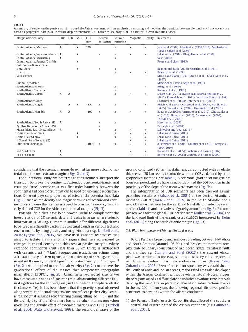
Table 1A summary of studies on the passive margins around the African continent with an emphasis on mapping and modeling the transition between the continental and oceanic areabased on geophysical data (SDR – Seaward dipping reflectors; LCB – Lower crustal body; COT – Continent – Ocean Transition Zone).
Margin name/country SDR LCB SALT COT(km)
Seismicrefraction
Seismicreflection
Magnetic Gravity References
Central Atlantic/Morocco X X 120 x x x Jaffal et al. (2009); Labails et al. (2009, 2010); Maillard et al.(2006); Sahabi et al. (2004))
Central Atlantic/Western Sahara X X x x x x Labails et al. (2009); Klingelhoefer et al. (2009)Central Atlantic/Mauritania X x Vear (2005)Central Atlantic/Senegal/Gambia X Roussel and Liger (1983)Gulf Guinea/Guinea-BissauSiera Leone X x x Bennett and Rusk (2002); Sheridan et al. (1969)Liberia x x x Behrendt et al. (1974)Cote D'Ivoire Mascle and Blarez (1987) Mascle et al. (1995); Sage et al.
(1997)Ghana/Togo/Benin Mascle et al. (1995); Sage et al. (1997)South Atlantic/Nigeria x x Briggs et al. (2009)South Atlantic/Cameroon x Rosendahl et al. (1991)South Atlantic/Gabon X X x x x Dupre et al. (2011); Mascle et al. (1995); Nemcok et al.
(2012); Rosendahl et al. (1991); Watts and Stewart (1998)South Atlantic/Congo Contrucci et al. (2004); Unternehr et al. (2010)South Atlantic/Angola X X ~150 x x x Blaich et al. (2011); Contrucci et al. (2004); Moulin et al.
(2005); Torsvik et al. (2009); Unternehr et al. (2010)South Atlantic/Namibia X X ~100 x x x x Bauer et al. (2000); Fernandez et al. (2010); Gladczenko et
al. (1998); Heine et al. (2013); Stewart et al. (2000);Torsvik et al. (2009)
South Atlantic/South Africa (SE) X x x x Hirsch et al. (2009)Agulhas Bank/South Africa (SW) x Parsiegla et al. (2009)Mozambique Basin/Mozambique X x x x x Leinweber and Jokat (2011)Somali Basin/Tanzania X x x x Labails and Gaina (2011)Somali Basin/Kenya X x x x Labails and Gaina (2011)N Somali Basin/Somalia (E) x x Labails and Gaina (2011)Gulf Aden/Somalia (N) ~10–40 x x x x d'Acremont et al. (2005); Fournier et al. (2010); Leroy et al.
(2004, 2010)Red Sea/Eritrea X x x Bosworth et al. (2005); Cochran and Karner (2007)Red Sea/Sudan X x x Bosworth et al. (2005); Cochran and Karner (2007)
6 C. Gaina et al. / Tectonophysics 604 (2013) 4–25
considering that the volcanic margins do exhibit far more volcanic ma-terial than the non-volcanicmargins (Figs. 2 and 3).
For our regional study, we preferred to consistently re-interpret thetransition between the continental/extended continental/transitionalcrust and “true” oceanic crust as a first-order boundary between thecontinental and oceanic crust that can be used for kinematic reconstruc-tions. Different physical properties reflected in the potential field data(Fig. 2), such as the density and magnetic values of oceanic and conti-nental crust, were the first criteria used to construct a new, systemati-cally defined COB for the African continental margins (Fig. 3).
Potential field data have been proven useful to complement theinterpretation of 2D seismic data and assist in areas where seismicinformation is lacking. Numerous studies offer different algorithmsto be used in efficiently capturing structural trends in various tectonicenvironments by using gravity and magnetic data (e.g., Kimbell et al.,2004; Lyngsie et al., 2006). We have used standard techniques thataimed to isolate gravity anomaly signals that may correspond tochanges in crustal density and thickness at passive margins, whereextended continental crust (less than 30 km thick) is juxtaposedwith oceanic crust (~7 km). Bouguer and isostatic corrections usinga crustal density of 2670 kg/m3, a mantle density of 3330 kg/m3, sed-iment infill density of 2300 kg/m3 and water density of 1030 kg/m3
(Fig. 2c) were applied to the free air gravity (Fig. 2a) to remove thegravitational effects of the masses that compensate topographymass effect (ETOPO1, Fig. 2b). Using terrain-corrected gravity wehave computed a series of isostatic residuals assuming different flex-ural rigidities for the entire region (and equivalent lithospheric elasticthicknesses, Te). It has been shown that the gravity signal observedalong several continentalmargins does not reflect a perfect Airy isostat-ic regime (that assumes zero thinning during rifting, Te = 0), and theflexural rigidity of the lithosphere has to be taken into account whenmodelling the gravity effect of extended margins and COBs (Kimbellet al., 2004; Watts and Stewart, 1998). The second derivative of the
upward continued (20 km) isostatic residual computed with an elasticthickness of 20 km seems to coincide with the COB as defined by othergeophysicalmethods (see Table 1). A horizontal gradient of this grid hasbeen computed, and we have visually identified the COB location in theproximity of the slope of the oceanward maxima (Fig. 3b).
The interpretation of COB segments has been checked againstpublished results of (Sahabi et al., 2004) in the Central Atlantic, amodified COB of (Torsvik et al., 2009) in the South Atlantic, and anew COB interpretation for the SE, E and NE of Africa guided by recentstudies (Table 1) and derivatives of gravity anomalies (Fig. 3). For com-parisonwe show the global COB location fromMüller et al. (2008a) andthe landward limit of the oceanic crust (LaLOC) interpreted by Heineet al. (2013) along the South Atlantic margin (Fig. 3b).
2.2. Plate boundaries within continental areas
Before Pangaea breakup and seafloor spreading between NW Africaand North America (around 195 Ma), and besides the northern com-plex plate boundary (consisting of mid ocean ridges, transform faultsand trenches e.g., Stampfli and Borel (2002)), the nascent Africanplate was bordered to the east, south and west by rifted regions, ofwhich some evolved later into mid-ocean ridges (Burke, 1996;Guiraud et al., 2005). Even after seafloor spreading was established inthe South Atlantic and Indian oceans, major rifted areas also developedwithin the African continent without evolving into mid-ocean ridges;these regions acted as diffuse plate boundaries at various time intervalsdividing the main African plate into several individual tectonic blocks.In the last 200 million years the following regional rifts developed (orcontinued to develop) within the African continent:
1) the Permian–Early Jurassic Karoo rifts that affected the southern,central and eastern part of the African continent (e.g. Catuneanuet al., 2005),

Fig. 2. a) Free air gravity (Sandwell and Smith, 2009) complemented onshore with the EGM2008 model (Pavlis et al., 2012); b) topography and bathymetry (ETOPO1, Amante andEakins (2009); c) Gravity anomaly Bouguer corrected using ETOPO1 present day topography and bathymetry and a Bouguer correction of 2670 kg/m3 and d) World DigitalMagnetic Anomaly (Maus et al., 2007). White outlines show the present day COB around the African continent and intra continental plate boundaries that were active in Mesozoicand/or Cenozoic. Inset 3c: Main intra-continental plate boundaries and tectonic blocks that moved independent from each other at certain stages from the Jurassic to presentday: I—Moroccan Meseta, II—Oran Meseta, III—NW Africa, IV—NE Africa, V—S Africa/Nubia, VI—Victoria, VII—Somalia. Thick black lines show outlines of cratonic areas: 1—West African,2—Congo, 3–4. Tanzanian, 5—Kalahari (modified after Gubanov and Mooney, 2009).
7C. Gaina et al. / Tectonophysics 604 (2013) 4–25
2) the Late Jurassic–Early Cretaceous Central African Rift System(CARS) (Guiraud et al., 1992) and part of the East African Rift Sys-tem (EARS) (Guiraud et al., 2005) followed by a pervasive earlySenonian–late Santonian compressional event that inverted rift
structures in northern and central Africa (Guiraud and Bosworth,1997), and
3) the Tertiary East African Rift system (Bosworth, 1992; Chorowicz,2005) that also extended offshore (Mougenot et al., 1986) and

Fig. 3. Derivatives of isostatic gravity residuals (a–c) and satellite gravity anomaly (GOCE) used to map the COB and internal plate boundaries and major faults within the conti-nental area. a) Residual gravity anomaly computed for anAiry Isostasy case (Te = 0); b)Horizontal gradient of second vertical derivative of upward continued (20 km) residual anomaly(Te = 20 km), present study identified COBs and published COBs by Müller et al. (2008a) and Heine et al. (2013); c) Horizontal gradient of second vertical derivative of upward con-tinued (30 km) residual anomaly (Te = 50 km); and d) Satellite gravity anomaly (GOCE) downward continued at 4000 m. Abbreviations are BT—Benue Trough, CASZ—Central AfricanShear Zone, MR—Muglad Rift, TB—Tenere Basin, NEAFR—Northeast Africa, WAFR–West Africa, SAFR—South Africa.
8 C. Gaina et al. / Tectonophysics 604 (2013) 4–25

9C. Gaina et al. / Tectonophysics 604 (2013) 4–25
subsequently led to the formation of the independent Somali plate(Horner-Johnson et al., 2007) and several microplates: Victoria,Rovuma and Lwandle, (Stamps et al., 2008) (Fig. 2).
Before presenting the evolution of the oceanic area around theAfrican continent and defining the kinematics of oceanic crust accretionand destruction, wewill describe the zones of lithospheric deformationthat evolved into regional plate boundaries within the continental area.These plate boundaries were used in defining the outlines of maintectonic blocks thatmoved during the opening of various oceanic basinsaround the continental area. In these regions compression or extensionaccommodated the offshore tectonic development.
Locations of intra-continental diffuse plate boundaries were pub-lished in several studies (e.g., Gregory et al., 2009; Guiraud et al.,1992; Moulin et al., 2010; Torsvik et al., 2010)—some of theminterpreted as linear trends in the potential field data, other utilizedevidences from geological mapping, or both. The more recent studies(e.g., Moulin et al., 2010; Torsvik et al., 2009) focused on the South At-lantic opening, and for our study we therefore revisit the interpretationof these intra-continental boundaries with an “African plate” emphasis.We start with Torsvik et al.'s (2010) global model that shows thepresent day simplified plate boundaries of tectonic blocks that movedrelative to each other for specific time intervals. The EGM2008 globalgravity model is used for onshore areas (Fig. 2a). This is a sphericalharmonic model of Earth's gravitational potential based on satellite-derived data (GRACE) merged with terrestrial and airborne gravitydata (Pavlis et al., 2012). For checking/defining the location of themain intra-continental boundaries, we have used a residual gravityanomaly grid computed for an elastic thickness of 50 km, which wasupward continued 30 km. The horizontal gradient of its derivativewas used to establish the final outlines of the tectonic blocks (Fig. 3c).The Te value of 50 km has been selected based on the regional studyof Perez-Gussinye et al. (2009) as the median Te value of continentalAfrica that characterizes regions bordering the cratons and/or crustalheterogeneities inherited from Palaeozoic and older tectonic eventssubsequently modified by Mesozoic and Cenozoic rifting.
The EGM08 model can resolve features as small as 10 km, as longas terrestrial data are available (Pavlis et al., 2012). As significantparts of the African continent are poorly covered by public-domainairborne or terrestrial data, satellite derived gravity anomaly datawere also used to check our interpretation of regional tectonic featureoutlines. We show a model based on the gravity anomaly recorded at250 km by the latest satellite mission, GOCE (Gravity and Steady-State Ocean Circulation Explorer). The model presented here wascomputed using the time-wise (TIM) modelling approach for the alti-tude of 4 km (where most of the African topography is removed)(Braitenberg et al., 2011) (Fig. 3d).
Two intra-continental plate boundaries of Torsvik et al. (2009)were modified according to trends in the potential field data asfollowing: one between the NW and NE Africa (in short WAFR-NEAFR),running from North Africa through the Tenere Basin (TB, Fig. 3c) to-wards the Benue Trough (BT, Fig. 3c), and a second one between NEAfrica and South Africa (in short NEAFR-SAFR) that runs along theCentral African Shear Zone (CASZ) continuing along the southern partof the Sudan Rifted area (SR, Fig. 3c) (Guiraud et al., 2005). Potentialfield data show numerous almost N–S trending lineations in the TBarea, which may suggest that the Mesozoic WAFR-NEAFR boundarywas either a diffuse area or a “jumping” boundary that relocated intime within short distances and created new rifts. We have selectedthe easternmost part of this rifted region as a plate boundary. In thecase of NEAFR-SAFR, the gravity anomaly and derivatives show a veryclear, almost E–W lineation along the CASZ, with two distinct NW–SEtrends, one along the Muglad Rift (MR, Fig. 3c), the southern branch ofthe Sudan Rift system, and another one south of it, along the NE partof the exposed Archean crust of the Congo craton, trends that were de-scribed by earlier studies of Bermingham et al. (1983) and Browne and
Fairhead (1983). As most of the Mesozoic plate boundaries seem to fol-low some inherited discontinuities in the crustal structure (Guiraudet al., 1987), we have chosen the northern trend observed in the gravityanomaly that runs south of MR. The selected boundary location coin-cides with an inferred Archean–Paleoproterozoic shield boundary andhas been also chosen as the active Mesozoic plate boundary betweenNE Africa and S Africa in the Tectonic Map of Africa (Milesi et al., 2010).
2.3. Plate boundaries in the oceanic domain
Mid-ocean ridges acted as plate boundaries between two tectonicplates while upwelling magmatic material created divergent forcesand led to plate growth. Mapping past plate boundaries within anoceanic domain is usually based on trends and ages of (positivelyand negatively) magnetized basaltic bodies that form the oceaniccrust, in combination with oceanic fracture zones that offset thesebodies parallel to the direction of movement between the tectonicplates. We interpret the magnetic anomalies derived from data ac-quired by ships or airplanes in the oceanic domain to infer the agesof oceanic crust and, together with fracture zone trend interpretation(using free air gravity anomaly or its vertical derivative Sandwell andSmith (2009)), construct an isochron model. Magnetic anomalies de-rived from satellite measurements usually cannot resolve the oceanicspreading anomalies, although some of the latest models seem to bemore sensitive to larger bodies of magnetized basaltic layers in theoceanic area (e.g., Maus et al., 2008). A comprehensive model forthe oceanic crust ages around the African continent is part of theglobal age grid published by Müller et al. (2008a). This model is most-ly based on the previous global compilation of oceanic crust ages frommarine geophysical data (Müller et al., 1997) and has not beenupdated since. Both in the Atlantic as well as in the Indian oceans, awealth of studies has been published in the last decade; thereforewe review these studies togetherwith our own interpretation, and con-struct a new circum-African age grid (Fig. 1) and palaeo-age grids. Inparticular we have included an additional set of nine isochrons for theEocene interval (C25y, C24y, C23y, C22o, C21y, C21o, C21y, C19o,C18y, C18o, C16y, C15o, C13y) based on a newPaleocene–Eocene globalanomaly picks dataset (Gaina et al., 2011) that include Cande et al.'s(2010) identifications in the Indian Ocean, Müller et al.'s (1999) mag-netic anomaly picks in the Central and South Atlantic, and new fracturezone segment interpretation based on Sandwell and Smith (2009) grav-ity anomaly grids. The timescale used in this study is Gee and Kent(2007) for times younger than M26, and Sager et al. (1998) for oldertimes. Our model is illustrated by the new set of isochrons (shown inpresent day coordinates in Fig. 4) and the rotation model fromTable 2. In the following we will briefly describe the regional kinematicmodels that were incorporated in this model.
2.3.1. Central AtlanticThe classical interpretation of Klitgord and Schouten (1986) for the
opening of the Central Atlantic around 175 Ma has been challengedby recent studies. Instead of an earlier ridge jump towards the NorthAmerican margin, these studies postulate that an earlier break-up wasfollowed by slow seafloor spreading between northwest Africa andnortheast America (Labails et al., 2010; Sahabi et al., 2004). Here wehave constructed the Central Atlantic isochrons based on this new inter-pretation for times older than M0 (for which we adopt a 120.6 Ma ageaccording to the Gee and Kent (2007) timescale), whereas for youngertimes we takeMüller et al.'s (2008a) isochrons and interpret additionalisochrons as described above.
2.3.2. South AtlanticThe older isochrons in the South Atlantic have been revised based
on recent data and new interpretations summarized by Moulin et al.(2010). This study used an improved magnetic anomaly identificationsfrom the new marine magnetic data from the NGDC (www.ngdc.noaa.

Fig. 4. Circum-Africa isochrons used in this study (grey lines) and volcanic provinces in the continental and oceanic areas (magenta) (Burke and Torsvik, 2004). The activemid-ocean ridges (MOR) are shown in red, trenches and compressional boundaries in black and transform fault boundaries in green. The inset figure shows Müller et al.'s(2008a) isochron model for the same area. Timing of major episodes of intra-plate volcanism is numbered as following: i) Karoo LIP, ii) Parana-Etendeka LIP SE Atlantic,iii) Indian Ocean (Madagascar, Agulhas LIP), iv) SW Indian Ocean and SE Atlantic Ocean (Conrad Rise and Del Cano Rise, Meteor Rise and Discovery seamounts), and v) Afar relatedvolcanism. Roman numbers I–VII are like in Fig. 3c inset map. Abbreviations: AFFZ—Agulhas—Falkland Fracture Zone, AG—ESB, CIR—Central Indian Ridge, CSZ—AF—Cyprus Subduc-tion Zone—Anatolian Fault, DSF—Dead Sea Fault, ESB, NSB and WSB—East, North and West Somali basins; MB—Mozambique Basin; MasB—Mascarene basin, MCP—MozambiqueCentral Plains; MozR—Mozambique Ridge, OFZ—Owen Fracture Zone, Sey—Seychelles.
10 C. Gaina et al. / Tectonophysics 604 (2013) 4–25
gov/mgg/mggd.html) and BGR (B. Schreckenberger, pers. comm.) data-bases complemented with confidential data. Compared to the model ofMüller et al. (2008a) that has only two Early Cretaceous isochrons(M0ry and M4y, with “y” and “o” referring to youngest and oldest sideof normal magnetized chron), Moulin et al. (2010) identified a seriesof denser spaced isochrons south of the Walvis Ridge that span fromM7o (127.5 Ma) to M4y (125.7 Ma), M2y (123.5 Ma) and M0o(121 Ma) (ages changed following the timescale of Gee and Kent,2007). The oldest isochron is situated oceanward of a wide,double-sided anomaly called “Large Marginal Anomaly” (LMA) that issupposed to represent the transitional crust and the oldest oceaniccrust covered with SDRs. The oceanward side of this magnetic anomalyis dated to 129 Ma (using the converted LMA age of Moulin et al., 2010)and we have used it as the oldest isochron in the southernmost part ofthe South Atlantic Ocean. North of theWalvis Ridge there are no identi-fiedM anomalies as the oldest generation of oceanic crust started prob-ably at the beginning of the Cretaceous Normal Superchron (CNS, 83.5–120.6 Ma). Isochrons for Mid-Cretaceous to Present were constructedin the same way as for the Central Atlantic.
2.3.3. West Indian Ocean
2.3.3.1. Mozambique and West Somali Basins, South and North NatalValley. The oldest part of the West Indian Ocean, the Mozambiqueand the West and North Somali basins (MB, WSB and NSB, Fig. 4)recorded the early history of Gondwana break-up and are floored byJurassic and Cretaceous crust (e.g., Norton and Sclater, 1979). TheWest Somali Basin is an old Jurassic–Cretaceous inactive basin that
formed as a result of Somali/Madagascar plate separation (Figs. 1and 4). Detailed studies have been published in the 1980s when acomplete set of geophysical data and drilling cores were collected inthis area (e.g., Coffin and Rabinowitz, 1987; Coffin et al., 1986;Segoufin and Patriat, 1980). Based on these data, most authors con-curred that breakup occurred in the Mid-Late Jurassic followed by sea-floor spreading until the Aptian (~M0) (Segoufin and Patriat, 1980) orBarremian (~M10) (Coffin and Rabinowitz, 1987). A study that aimedto link the evolution of the Mozambique Basin with the opening inthe WSB (Eagles and Konig, 2008), reinterpreted fracture zone andvintage magnetic anomaly data between Africa and Madagascar andsuggested that the WSB seafloor spreading became extinct at ~M10, asolution similar to the Coffin and Rabinowitz (1987) interpretation,but the breakup in both basins occurred probably earlier, at ~170 Maor slightly older.
New gravity data, vintage and new industry seismic data and vin-tagemagnetic data togetherwith published studies on the rifted Africanand Madagascan margins have been used to re-evaluate the locationand timing of the COB and early seafloor spreading in the WSB (Gainaet al., 2010a; Labails and Gaina, 2011). These studies suggest a lateToarcian–Aalenian age for the break-up and seafloor spreading com-mencing around 170 Ma, with M41 (167.5 Ma—Sager et al., 1998 time-scale) as the oldest Jurassic magnetic anomaly and M2 the youngest,followed by the mid ocean ridge extinction around 123 Ma. Our iso-chrons are constructed based on the above mentioned interpretation(Fig. 4).
Several recent scientific cruises collected geophysical data in theMozambique basin that was used to construct a more detailed model
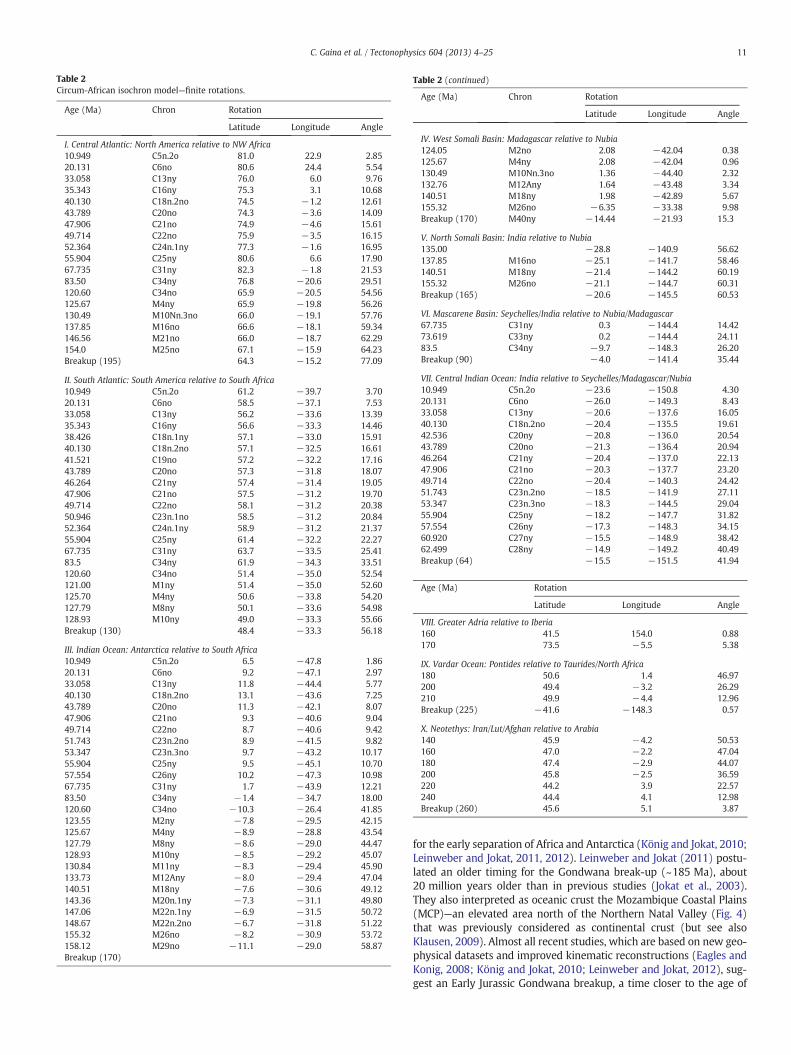
Table 2Circum-African isochron model—finite rotations.
Age (Ma) Chron Rotation
Latitude Longitude Angle
I. Central Atlantic: North America relative to NW Africa10.949 C5n.2o 81.0 22.9 2.8520.131 C6no 80.6 24.4 5.5433.058 C13ny 76.0 6.0 9.7635.343 C16ny 75.3 3.1 10.6840.130 C18n.2no 74.5 −1.2 12.6143.789 C20no 74.3 −3.6 14.0947.906 C21no 74.9 −4.6 15.6149.714 C22no 75.9 −3.5 16.1552.364 C24n.1ny 77.3 −1.6 16.9555.904 C25ny 80.6 6.6 17.9067.735 C31ny 82.3 −1.8 21.5383.50 C34ny 76.8 −20.6 29.51120.60 C34no 65.9 −20.5 54.56125.67 M4ny 65.9 −19.8 56.26130.49 M10Nn.3no 66.0 −19.1 57.76137.85 M16no 66.6 −18.1 59.34146.56 M21no 66.0 −18.7 62.29154.0 M25no 67.1 −15.9 64.23Breakup (195) 64.3 −15.2 77.09
II. South Atlantic: South America relative to South Africa10.949 C5n.2o 61.2 −39.7 3.7020.131 C6no 58.5 −37.1 7.5333.058 C13ny 56.2 −33.6 13.3935.343 C16ny 56.6 −33.3 14.4638.426 C18n.1ny 57.1 −33.0 15.9140.130 C18n.2no 57.1 −32.5 16.6141.521 C19no 57.2 −32.2 17.1643.789 C20no 57.3 −31.8 18.0746.264 C21ny 57.4 −31.4 19.0547.906 C21no 57.5 −31.2 19.7049.714 C22no 58.1 −31.2 20.3850.946 C23n.1no 58.5 −31.2 20.8452.364 C24n.1ny 58.9 −31.2 21.3755.904 C25ny 61.4 −32.2 22.2767.735 C31ny 63.7 −33.5 25.4183.5 C34ny 61.9 −34.3 33.51120.60 C34no 51.4 −35.0 52.54121.00 M1ny 51.4 −35.0 52.60125.70 M4ny 50.6 −33.8 54.20127.79 M8ny 50.1 −33.6 54.98128.93 M10ny 49.0 −33.3 55.66Breakup (130) 48.4 −33.3 56.18
III. Indian Ocean: Antarctica relative to South Africa10.949 C5n.2o 6.5 −47.8 1.8620.131 C6no 9.2 −47.1 2.9733.058 C13ny 11.8 −44.4 5.7740.130 C18n.2no 13.1 −43.6 7.2543.789 C20no 11.3 −42.1 8.0747.906 C21no 9.3 −40.6 9.0449.714 C22no 8.7 −40.6 9.4251.743 C23n.2no 8.9 −41.5 9.8253.347 C23n.3no 9.7 −43.2 10.1755.904 C25ny 9.5 −45.1 10.7057.554 C26ny 10.2 −47.3 10.9867.735 C31ny 1.7 −43.9 12.2183.50 C34ny −1.4 −34.7 18.00120.60 C34no −10.3 −26.4 41.85123.55 M2ny −7.8 −29.5 42.15125.67 M4ny −8.9 −28.8 43.54127.79 M8ny −8.6 −29.0 44.47128.93 M10ny −8.5 −29.2 45.07130.84 M11ny −8.3 −29.4 45.90133.73 M12Any −8.0 −29.4 47.04140.51 M18ny −7.6 −30.6 49.12143.36 M20n.1ny −7.3 −31.1 49.80147.06 M22n.1ny −6.9 −31.5 50.72148.67 M22n.2no −6.7 −31.8 51.22155.32 M26no −8.2 −30.9 53.72158.12 M29no −11.1 −29.0 58.87Breakup (170)
Table 2 (continued)
Age (Ma) Chron Rotation
Latitude Longitude Angle
IV. West Somali Basin: Madagascar relative to Nubia124.05 M2no 2.08 −42.04 0.38125.67 M4ny 2.08 −42.04 0.96130.49 M10Nn.3no 1.36 −44.40 2.32132.76 M12Any 1.64 −43.48 3.34140.51 M18ny 1.98 −42.89 5.67155.32 M26no −6.35 −33.38 9.98Breakup (170) M40ny −14.44 −21.93 15.3
V. North Somali Basin: India relative to Nubia135.00 −28.8 −140.9 56.62137.85 M16no −25.1 −141.7 58.46140.51 M18ny −21.4 −144.2 60.19155.32 M26no −21.1 −144.7 60.31Breakup (165) −20.6 −145.5 60.53
VI. Mascarene Basin: Seychelles/India relative to Nubia/Madagascar67.735 C31ny 0.3 −144.4 14.4273.619 C33ny 0.2 −144.4 24.1183.5 C34ny −9.7 −148.3 26.20Breakup (90) −4.0 −141.4 35.44
VII. Central Indian Ocean: India relative to Seychelles/Madagascar/Nubia10.949 C5n.2o −23.6 −150.8 4.3020.131 C6no −26.0 −149.3 8.4333.058 C13ny −20.6 −137.6 16.0540.130 C18n.2no −20.4 −135.5 19.6142.536 C20ny −20.8 −136.0 20.5443.789 C20no −21.3 −136.4 20.9446.264 C21ny −20.4 −137.0 22.1347.906 C21no −20.3 −137.7 23.2049.714 C22no −20.4 −140.3 24.4251.743 C23n.2no −18.5 −141.9 27.1153.347 C23n.3no −18.3 −144.5 29.0455.904 C25ny −18.2 −147.7 31.8257.554 C26ny −17.3 −148.3 34.1560.920 C27ny −15.5 −148.9 38.4262.499 C28ny −14.9 −149.2 40.49Breakup (64) −15.5 −151.5 41.94
Age (Ma) Rotation
Latitude Longitude Angle
VIII. Greater Adria relative to Iberia160 41.5 154.0 0.88170 73.5 −5.5 5.38
IX. Vardar Ocean: Pontides relative to Taurides/North Africa180 50.6 1.4 46.97200 49.4 −3.2 26.29210 49.9 −4.4 12.96Breakup (225) −41.6 −148.3 0.57
X. Neotethys: Iran/Lut/Afghan relative to Arabia140 45.9 −4.2 50.53160 47.0 −2.2 47.04180 47.4 −2.9 44.07200 45.8 −2.5 36.59220 44.2 3.9 22.57240 44.4 4.1 12.98Breakup (260) 45.6 5.1 3.87
11C. Gaina et al. / Tectonophysics 604 (2013) 4–25
for the early separation of Africa and Antarctica (König and Jokat, 2010;Leinweber and Jokat, 2011, 2012). Leinweber and Jokat (2011) postu-lated an older timing for the Gondwana break-up (~185 Ma), about20 million years older than in previous studies (Jokat et al., 2003).They also interpreted as oceanic crust the Mozambique Coastal Plains(MCP)—an elevated area north of the Northern Natal Valley (Fig. 4)that was previously considered as continental crust (but see alsoKlausen, 2009). Almost all recent studies, which are based on new geo-physical datasets and improved kinematic reconstructions (Eagles andKonig, 2008; König and Jokat, 2010; Leinweber and Jokat, 2012), sug-gest an Early Jurassic Gondwana breakup, a time closer to the age of

12 C. Gaina et al. / Tectonophysics 604 (2013) 4–25
the Karoo LIP formed by a magmatic event that affected the South andEast African continent (Jourdan et al., 2007). The Mozambique Basinand the West Somali Basin opened almost simultaneously (Eagles andKonig, 2008; Segoufin and Patriat, 1980), while the African/Somaliplates moved northward, leaving the Antarctic and Madagascar blocksbehind. As themodel of Leinweber and Jokat (2011) of early Gondwanabreakup between Africa and Antarctica assigned an Early Jurassicbreak-up time for the opening of Mozambique basin, and we inferreda COB age of ca. 170–175 Ma for the West Somali Basin, we hereassign a conservative breakup age for these basins of 170 Ma. TheMozambique Basin isochrons are constructed following the magneticanomaly interpretation of König and Jokat (2010) up to M25(154 Ma). For the time interval from M25 to M41 (167.5 Ma) weconstructed isochrons taking into account the basin geometry and as-suming symmetric seafloor spreading.
In our model we have adopted an oceanic origin for the MCP andMozambique Ridge (MozR) (Fig. 4) and regarded this corridor as partof the Mozambique Basin opening until M0 when the ridge betweenthe MCP/NNV and MR became extinct. We have considered the ArielGraben (AG, Fig. 4), which has a pronounced negative gravity anomaly,as the only extinct ridge in this area, although Leinweber and Jokat(2011) postulated additional southward ridge jumps. Early to MidCretaceous isochrons (132–121 Ma) have been constructed for theSouthern Natal Valley (SNV), as postulated by previous authors(Goodlad et al., 1982).
2.3.3.2. North Somali Basin (NSB). The NSB is a deep oceanic basin situ-ated north of the WSB and south of the Cenozoic Gulf of Aden oceanicbasin (Figs. 1 and 4). The age of oceanic crust in this basin has beenonly inferred based on depth of basement, sediment ages and theregional tectonic framework (e.g., Mountain and Prell, 1990). In thesame fashion, we have inferred a Jurassic age for the NSB, probablysimilar to that in the WSB, taking into account that India, which wasjuxtaposed to the Somali plate margin, was fixed to Madagascar whileboth were separated from the East African margin during the WSBopening (e.g., Coffin and Rabinowitz, 1987). Following this inference,oceanic crust north of the NSB (offshore SE Arabia, in the position oftoday's Oman Basin, Fig. 1), would have been the continuation of theNSB (and consequently of the same age). However, the age of the mod-ern Oman Basin oceanic crust might be younger than NSB as suggestedby basement depth, sediment ages and geophysical data (Mountain andPrell, 1990). In addition, the eastern Oman margin contains ophiolites(e.g. the Masirah ophiolite) that obducted onto East Arabian margin inthe latest Cretaceous to Eocene time during transpressional motionbetween India and Arabia (~65–55 Ma according to Gnos et al., 1997;Immenhauser et al., 2000). The Masirah ophiolite section has a LateJurassic (~150 Ma) MORB-type oceanic crust and contains a classicalophiolite sequence, albeit with a very thin gabbroic crustal section(~200–500 m) suggesting that it formed in a magma-poor environ-ment (Peters, 2000). Hence, although the ophiolite record demon-strates that Jurassic seafloor spreading occurred also along the Omanmargin, the inception of that spreading, as well as the pre-Cretaceousarchitecture of this basin, have been obliterated by subsequent com-pression and transpression. Our isochrons in the NSB are constructedusing the kinematic parameters for the Nubia–India relative motion(Table 2) and the interpreted trends of NNW–SSE fracture zones fromgravity anomaly models.
2.3.3.3. Late-Cretaceous–Cenozic Indian Ocean. Isochrons in theMascarene Basin are based on a simplified model of Bernard andMunschy (2000), and isochrons for Cenozoic oceanic crust are fol-lowing Cande et al. (2010) kinematic model.
2.3.3.4. Gulf of Aden and Red Sea. For the youngest oceanic basins thatare part of the African plate: the Gulf of Aden and the Red Sea (Fig. 1),our isochron model followed Cochran (2005) and Fournier et al.
(2010) with an extrapolated age of the COB of 15 and 21 Ma in theGulf of Aden and ca. 11 Ma in the Red Sea respectively.
2.3.4. Mediterranean/Neotethys regionMapping past plate boundaries east, south and west of the African
plate is facilitated by the presence of oceanic crust whose age andstructure can be identified relatively straightforward. In contrast,the northern part of the African plate underwent a very complex historyinvolving numerous tectonic blocks and jumping plate boundaries.Apart from limited amount of oceanic crust left in situ, the evidencethat documents the past motion of these blocks resides in ages andstructure of obducted ophiolites and upper crustal nappes thatwere offscraped from the subducted African lithosphere and accretedto overriding oceanic (ophiolitic) and continental margins (e.g., vanHinsbergen et al., 2005) together with inferred ages of tectonic eventsincluding collision and subduction. Here we present a simplified inter-pretation of the northern African plate boundary through time thatcomplies with regional kinematic framework and first order interpreta-tion of geological data.
2.3.4.1. Preserved oceanic crust of the northern African plate. The Ionianabyssal plain (actively subducting at the Calabrian trench to the westand at the Hellenic trench to the east, Fig. 5) and part of the East Med-iterranean basin (subducting northward below Cyprus, Fig. 1) are nowthe only “in situ” remnants of the southern branch of the NeotethysOcean that developed as part of the African plate. Accretionary prisms(the submerged Calabrian and Mediterranean bathymetric highs,normally called “ridges”) confine these oceanic domains from the NW,NE and N respectively (Finetti, 1976; Huguen et al., 2001; Mascleet al., 1986; ten Veen et al., 2004) (Fig. 5). The oceanic nature of theIonian crust was inferred from seismic studies (e.g. Di Luccio andPasyanos, 2007) and gravity modelling constrained by seismic data(Makris and Yegorova, 2006). A recent study documented in detail thestructure of the old oceanic crust in the Ionian Abyssal plain (Gallaiset al., 2011). The oceanic nature of some of the crust in the EastMediter-ranean basin has been proposed based on geophysical data, mainly forthe western part of the basin (Gesret et al., 2010; Koulakov andSobolev, 2006). Recent studies show that the easternmost part of theEast Mediterranean basin, the Levantine basin, offshore Israel, has thestructure of extended continental crust (Gardosh andDruckman, 2006).
2.3.4.2. Subducted oceanic crust that belonged to the African plate. Aconceptual simplification of the Mediterranean region subdividesthe Jurassic paleogeography between Africa and Eurasia into amicrocontinental domain underlain by Precambrian (“Pan-African”)and late Paleozoic (“Hercynian”) basement—here termed “GreaterAdria”. Remnants of Greater Adria include all continental platformsand basins whose rocks are now found in the Apennines, the Southernand Austro-Alpine Alps, Dinarides, Hellenides and Anatolide–Taurides(Fig. 5b). Greater Adria was separated from Africa by the aforemen-tioned still existing oceanic crust of the southeast Mediterraneanbasin. To the west and north, Greater Adria was separated from Eurasiaby the Jurassic Alpine Tethys (Frisch, 1979) and to the northeast bya northern branch of the Neotethys represented by the Sava–Izmir–Ankara suture zone (Schmid et al., 2008; Sengor and Yilmaz, 1981,also see below).
The Jurassic opening of an Alpine Tethys (or Piemonte–LigurianOcean) domain between Africa, Greater Adria and Eurasia followsdirectly from differences in opening rates in the Central and NorthAtlantic ocean (Dercourt et al., 1986; Stampfli and Borel, 2002), andfrom Mid-Jurassic fragments of oceanic crust and mantle lithospherewith mostly Mid Ocean Ridge-MOR type geochemistry and 169–148 Ma ages (e.g., Smith, 2006) that are widespread in accretionaryprisms preserved in the Apennines, Alps and Carpathians. Fig. 5 showsJurassic to Early Cretaceous motion paths and estimated extension be-tween Africa–Iberia (AFR-IB) and Africa–Eurasia (AFR-EUR) according

Fig. 5. a. Estimated extension between the Iberian plate and neighboring margins in the North Africa (motion path in the white box) and Iberia and (Greater) Adria (motion pathsin the red box) that led to formation of oceanic crust between North Africa, Iberia and fragments of Adria in the Mesozoic. Transtension followed by strike-slip motion betweenIberia and NW Africa from 180 to 154 Ma and extension between Iberia and (Greater) Adria from 170 to 154 Ma (~350 km) suggest that a transform plate boundary linked CentralAtlantic to the Alpine Tethys (Ligurian-Piemont ocean)—a region that consisted of oceanic crust only between Iberia and (Greater) Adria. b. Present day location of main tectonicblocks that were displaced and deformed during the opening and closure of the Neotethys ocean.
13C. Gaina et al. / Tectonophysics 604 (2013) 4–25
to our composite rotational model. In this model, using the recentIberia–Eurasia kinematic restorations of Vissers and Meijer (2012a,b)less than 400 km of extension between major tectonic plates isexpected (Fig. 5), that is substantially less than in othermodels. For sim-plicity, we have treated Greater Adria as an African promontory (i.e. wekeep it fixed to northern Africa), except for the last 4 million yearswhen it experienced a small counter-clockwise rotation relative toAfrica (van Hinsbergen and Schmid, 2012).
Transtension followed by strike-slip motion between Iberia andNW Africa from 180 to 154 Ma and extension between Iberia and(Greater) Adria from 170 to 154 Ma (~350 km) suggest that a trans-form plate boundary linked the Central Atlantic to the Alpine Tethys—a region that may have consisted of oceanic crust only between Iberiaand (Greater) Adria, with extended continental margins dominatingfarther to the northeast in the Alpine region (Mohn et al., 2012).
A review of the controversy regarding the timing and geometry ofthe Eastern Mediterranean Basin is presented by de Lamotte et al.(2011) who, after analyzing the contrasting arguments brought for-ward for a Permian (Stampfli and Borel, 2002) and Late Triassic–EarlyJurassic break-up age (Garfunkel, 1998; Robertson, 2006, 2012) con-cluded that the East Mediterranean basin should be rather a Late
Triassic–Early Jurassic branch of the Neotethys opened in a north–south direction as the Taurides block (i.e., the eastern part of GreaterAdria, Fig. 5) rifted away from the northern Africanmargin. This conclu-sion was recently also put forward by Speranza et al. (2012) based onmarine magnetic data. More or less simultaneously, the Pontides riftedaway from Greater Adria opening the northern branch of the Neotethysas suggested by the oldest ages of oceanic crust found in the Izmir-Ankara suture zone in Turkey (e.g., Tekin et al., 2002). For the south-eastern Mediterranean basin, we adopt the interpretation of deLamotte et al. (2011) and assign an age of ~220 to ~170 Ma to its oce-anic crust whose remnants are now preserved in the Ionian Abyssalplain and in some regions of the EastMediterranean basin. The assumedtransition to the continental crust follows the interpretation from thestudies by Longacre et al. (2007) and Makris and Yegorova (2006).
Rifting along northern and north-eastern Arabia (which remainedpart of Africa until the onset of rifting in the Red Sea, ~35 Ma,(Bosworth et al., 2005)) occurred well before the separation of GreaterAdria fromAfrica, in the Late Permian time. This age is inferred from thestratigraphic analysis of the northeastern Arabian passive margin rocksand paleomagnetic data (e.g., Muttoni et al., 2009; Robertson, 2007;Ziegler et al., 2001). Rifting led to the separation of a continental sliver

14 C. Gaina et al. / Tectonophysics 604 (2013) 4–25
(or slivers) now found in Iran and Afghanistan (Sanand, Alborz, Lut andHelmand blocks, see Fig. 5). Seafloor spreading probably continueduntil the Late Triassic collision of these blocks with Eurasia (e.g.,Muttoni et al., 2009). It has been suggested that pulses of rifting affectedthe northern part of the Arabian block, along the Oman margin, sincethe Carboniferous, but we model the inception of seafloor spreadingstarting in the Late Permian (~260 Ma) following Robertson (2007)and Ziegler et al. (2001). The Jurassic to Late Cretaceous intra-oceanictectonic history of the Neotethys between Arabia and Eurasia is poorlyconstrained. More or less continuous arc volcanism along the southernIranianmargin (Sanandaj–Sirjan arc) occurred since ~150 Ma, attestingto northward subduction below the Eurasian margin since this time(Agard et al., 2011). Around ~95 Ma, a second, intra-oceanic subductionzone formed northeast of Arabia and ended with the obduction ofophiolites over the Arabian margin in the Late Cretaceous (~70 Ma)from Oman through Iran and Iraq to Syria (Agard et al., 2011;Al-Riyami et al., 2002; Dilek and Furnes, 2011; Searle and Cox, 2009).These ophiolites typically have supra-subduction zone geochemical sig-nature and attest a phase of ocean spreading during the Late Cretaceoussubduction, either in a back-arc fashion (e.g. Dilek and Furnes, 2011;Stampfli and Borel, 2002), or close to the trench in the forearc (Deweyand Casey, 2011; Stern et al., 2012). Given their similar age and setting(e.g., Celik et al., 2006), it seems most likely that the Cretaceousophiolite belts of the Anatolide–Tauride–Cyprus region (Fig. 5) andnorth-eastern Arabia were derived from a laterally semi-continuousintra-oceanic subduction zone (e.g. Pedersen et al., 2010). Followingophiolite obduction, Arabia converged with Eurasia, and started tocollide in Oligocene time (~27–28 Ma or thereafter (McQuarrie andvan Hinsbergen, 2013)).
3. Absolute and relative motion of the African Plate
The African plate grew from the Jurassic time onwards by oceaniccrust accretion eastward, southward and westward and partiallynorthward. Following the Jurassic inception of subduction in theeastern Mediterranean region, subduction started to consume oceanic(and continental) crust of the northern African plate margin leavingonly the small remnants in the East Mediterranean basin today. Ournew circum-African isochron and kinematic model is used here toconstruct oceanic crust palaeo-age grids and furthermore analyze theage and geometrical parameters of the plate at key geological times inthe African plate history. In addition, we re-evaluate the direction ofmotion of this plate relative to themantle and aim to discuss the resultswithin a regional geological perspective.
3.1. Relative plate motion: Circum-African palaeo-age grids
The isochron and rotation model based on existing and updatedkinematic models for the evolution of oceanic crust around the Africancontinent described above forms the basis for constructing palaeo-agegrids. This technique has been used to make the present day globaloceanic age grid (Müller et al., 2008a) and regional (e.g., Gaina andMüller, 2007) and global oceanic palaeo-age grids (Müller et al.,2008b). We select a series of six reconstructions and associatedpalaeo-age grids to discuss the position and areal extent of the Africanplate and its boundaries at times that coincided or preceded majorplate boundary reorganizations.
3.2. The African plate absolute motion
Global absolute plate motion models aim to express the connectionbetween the lithospheric plates and a reference frame usuallyconnected to the Deep Earth. The most common references used sofar are the Earth's spin axis and hotspots. We present and discuss theposition of the African and surrounding plates and microplates relativeto the underlyingmantle (the “absolute”motion) based on a newglobal
reference frame model (Doubrovine et al., 2012). This model uses rela-tive platemotions based on paleomagnetic data andmarine geophysicaldata plus estimation of both Pacific and Indo-Atlantic hotspot motionrelative to themantle to construct a self-consistent globalmodel for rel-ative and absolute motions for the past 124 Ma. This model has beenmerged with a true-polar wander (TPW) corrected paleomagnetism-based global reference frame for times older than 124 Ma, and we willcall this model GMHRFh2012.
Besides the recent global reference frame model, the absolute platemotion for selected geological times is also presented in some of thepreviously published (and still widely used) global models: 1) Mülleret al. (1993)—FHRF1993 and 2) Torsvik et al. (2008)—HYBRF2008. TheFHRF1993 model is based on hotspot tracks in the Indian and Atlanticoceans and considers that these hotspots were fixed relative to themantle for the last 130 million years. The “moving hotspots” modelssuperseded this model, as many evidences have shown that hotspotsare deflected from vertical ascent through the mantle by the mantlecirculation (or “mantle wind”, see Steinberger and O'Connell, 1998).Despite these findings, the FHRF1993 is still used inmany recent studiesand therefore we will use it in our analysis for demonstrating differ-ences between the models. Model HYBRF2008, like our preferredmodel, the GMHRFh2012, is based on the “moving hotspot” hypothesis,and it takes the global hotspot tracks and a global mantle convectionand hotspotmotionmodel to compute the African platemotion relativeto the moving hotspots for the last 100 million years. For older time alongitude adjusted (5°) paleomagnetism-based reference frame wasconsidered.
Finally, we also compute the African plate absolute motion in theslab-fitted reference frame—SFRF2010 (van der Meer et al., 2010)that used the true-polar wander corrected paleomagnetism-basedreference frame of Torsvik et al. (2008) and Steinberger and Torsvik(2008)—which in absence of palaeo-longitudinal control assumes astable longitude for Africa—and adjusted the plate circuit in longitudeto match subduction zones in the plate circuit to corresponding lowermantle slabs assuming vertical slab sinking. SFRF2010 applies a west-ward correction of up to 18° in the Late Jurassic compared to Africa'slongitude today, decreasing in magnitude with older and youngertimes. This is the first absolute reference frame obtained with thismethod, and we will use it for illustrating similarities and differenceswith other models.
The mean absolute motion of the African plate in 10 million yearsinterval as described by these four reference frame models is shownin Fig. 6. A peak in the absolute plate velocity from 110 to 100 Mashown by HYBRF2008 and SFRF2010 is partly an artefact due tomerging hotspot and paleomagnetic based reference frames at a timeof significant true polar wander (i.e. when the whole solid Earth andmantle were tilted relative to the spin axis).
3.3. Snapshots of the African Plate from Jurassic to the Present
In the following wewill present the evolution of the African plate asoceanic crust was accreted and subducted at its margins and discuss itsinteraction with the underlying mantle through time as illustrated bythe absolute plate motion. We have chosen the time of reconstructionsthat were meaningful for important first-order changes within thecontinental area in an attempt to identify any connections betweenthe evolution of distant plate boundaries and interior deformations.
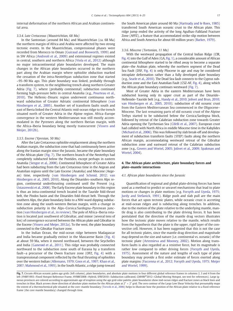
3.3.1. Mid Jurassic (Bajocian, 170 Ma)Around 170 Ma, the spreading rate doubled between NW Africa
and North America, and the development of normal oceanic crustwas established in the Central Atlantic (Labails et al., 2010). Fromthe Central Atlantic, the plate boundary continued in the AlpineTethys/Mediterranean domain along a transtensional/transcurrentfault south of Iberia along the northwestern tip of the African plate.The intra-Tethyan trench that was in the northeast and the transform
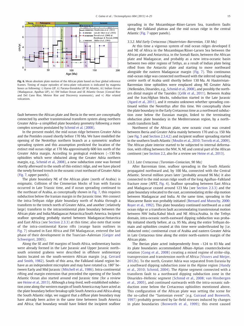
Fig. 6. Mean absolute plate motion of the African plate based on four global referenceframes. Timing of major episodes of intra-plate volcanism is indicated by magentaboxes as following: i) Karoo LIP, ii) Parana-Etendeka LIP SE Atlantic, iii) Indian Ocean(Madagascar, Agulhas LIP), iv) SW Indian Ocean and SE Atlantic Ocean (Conrad Riseand Del Cano Rise, Meteor Rise and Discovery seamounts), and v) Afar relatedvolcanism.
15C. Gaina et al. / Tectonophysics 604 (2013) 4–25
fault between the African plate and Iberia in the west are conceptuallyconnected by another transtensional transform system along northernGreater Adria—a simplified plate boundary geometry following a morecomplex scenario postulated by Schmid et al. (2008).
In the present model, the mid ocean ridge between Greater Adriaand the Pontides ceased shortly before 170 Ma. We have modelled theopening of the Neotethys northern branch as a symmetric seafloorspreading system and this assumption predicted the location of theextinct mid ocean ridge at 170 Ma approximately 600 km north of theGreater Adria margin. According to geological evidences (~130 Maophiolites which were obducted along the Greater Adria northernmargin, e.g., Schmid et al., 2008), a new subduction zone was formedshortly afterward to the south of this extinct ridge, and we have placedthe newly formed trench in the oceanic crust northeast of Greater Adria(Fig. 7, upper panels).
The plate boundary NE of the African plate (north of Arabia) isenigmatic. Collision of the Cimmerian blocks of Iran with Eurasiaoccurred in Late Triassic time, and if ocean spreading continued tothe northeast of Arabia, as conceptually shown in Fig. 7, this requiressubduction below the Iranian margin in the Jurassic time. We connectthe intra-Tethyan ridge plate boundary north of Arabia through atransform to the trench north of Greater Adria, and another (relativelylarge) transform to the intracontinental plate boundary between theAfrican plate and India/Madagascar/Antarctica/South America. Incipientseafloor spreading probably started between Madagascar/Antarcticaand East Africa (see Section 2.3.3) at this time; also note that someof the intra-continental Karoo rifts (orange basin outlines inFig. 7) situated in East Africa and SW Madagascar, entered the lastphase of their development in the Toarcian–Aalenian (Geiger andSchweigert, 2005).
Along the SE and SW margins of South Africa, sedimentary basinswere already formed in the Late Jurassic and Upper Jurassic north–south oriented grabens were described in offshore sedimentarybasins located on the south-western African margin (e.g. Gerrardand Smith, 1982). South of this area, the Falkland island region be-have as an independent microplate and may have rotated ca. 180° be-tween Early and Mid Jurassic (Mitchell et al., 1986). Intra-continentalrifting and margin extension that preceded the opening of the SouthAtlantic Ocean also started around end Jurassic time (for a reviewsee Heine et al., 2013). Although a long-lived, well-established subduc-tion zone along thewesternmargin of SouthAmericamay have acted asthe plate boundary before breakup split South America and Africa alongthe South Atlantic ridge, we suggest that a diffuse plate boundary mayhave already been active in the same time between South Americaand Africa; that boundary would have linked the incipient seafloor
spreading in the Mozambique–Riiser-Larsen Sea, transform faultsalong the Falkland plateau and the mid ocean ridge in the centralAtlantic (Fig. 7 upper panels).
3.3.2. Mid Early Cretaceous (Hauterivian–Barremian, 130 Ma)At this time a vigorous system of mid ocean ridges developed E
and NE of Africa in the Mozambique/Riiser-Larsen Sea between theAfrican plate and Antarctica, in the Somali Basin, between the Africanplate and Madagascar, and probably as a new intra-oceanic basinbetween two older regions of Tethys, as a result of Indian plate beingrifted from the Antarctic plate and starting to move northwardalongside the eastern Madagascar margin (Fig. 7). This continuousmid-ocean ridgewas connected northward with the inferred spreadingcentre north of Arabia until shortly before 130 Ma. At Hauterivian–Barremian time ophiolites were emplaced along NE Greater Adria(Hellenides, Dinarides, e.g., Schmid et al., 2008), and possibly the north-ern distal margin of the Taurides (Çelik et al., 2011). Between Arabiaand the Iran/Afghan blocks, subduction started in the Late Jurassic(Agard et al., 2011), and it remains unknown whether spreading con-tinued within the Neotethys after this time. We conceptually showthe plate boundary in the Early Cretaceous time as a northward subduc-tion zone below the Eurasian margin, linked to the terminatingobduction plate boundary in the Mediterranean region, by a north–south transform fault.
Northwest of the African plate, new oceanic crust was createdbetween Iberia and Greater Adria mainly between 170 and ca. 150 Ma(see Fig. 5 and Section 2.3.4.2) and incipient seafloor spreading startedin the southern South Atlantic (Moulin et al., 2010; Torsvik et al., 2009).The African plate interior started to be subjected to internal deforma-tion, with rifting between the NW, N, NE and central part of the Africancontinent (see Section 2.2, also for a review see Heine et al., 2013).
3.3.3. Late Cretaceous (Turonian–Coniacian, 90 Ma)After Barremian time, seafloor spreading in the South Atlantic
propagated northward and, by 100 Ma, connected with the CentralAtlantic. Several million years later (probably around 96 Ma) it alsoconnected to the mid ocean ridge south of the long Agulhas–Falklandfracture zone (AFFZ, Fig. 4). Seafloor spreading between East Africaand Madagascar ceased around 123 Ma (see Section 2.3.3) and theplate boundary relocated to the east, accommodating strike-slipmotionbetween Madagascar and India. At the same time, spreading in theMascarene Basin was probably initiated (Bernard and Munschy, 2000;Royer et al., 1992). This plate boundary continued northward as a midocean ridge or a transform fault accommodating transtensional motionbetween NW India/Kabul block and NE Africa/Arabia. In the Tethysdomain, intra-oceanic north-eastward dipping subduction was proba-bly initiated shortly before, at ca. 95 Ma, along the entire Tethyan do-main and ophiolites created at this time were underthrusted by (i.e.obducted onto) continental crust of Arabia and eastern Greater Adriain Late Cretaceous time along the entire north-eastern margin of theAfrican plate.
The Iberian plate acted independently from ~124 to 83 Ma andits plate boundaries accommodated Albian–Aptian counterclockwiserotation (Gong et al., 2008) creating a mixed regime of strike-slip,transpression and transtension north of Africa (Vissers and Meijer,2012b). To the north, Greater Adria was separated from Eurasia bya southward dipping subduction zone in the Alpine region (Handyet al., 2010; Schmid, 2004). The Alpine segment connected with atransform fault to a northward dipping subduction zone in theDinarides–Hellenic segment (Schmid et al., 2008; van Hinsbergenet al., 2005), and continued eastwards with the intra-oceanic sub-duction zone below the Cretaceous ophiolites mentioned above.This configuration of the African plate was setting the scene forthe so-called the “Santonian event” (e.g. Guiraud and Bosworth,1997) probably generated by far-field stresses induced by changesin plate boundaries (Bosworth et al., 1999); this event caused
17C. Gaina et al. / Tectonophysics 604 (2013) 4–25
internal deformation of the northern African and Arabian continen-tal area.
3.3.4. Late Cretaceous (Maastrichtian, 68 Ma)In the Santonian (around 84 Ma) and Maastrichtian (ca. 68 Ma)
the northern margin of Africa and Arabia were affected by two strongtectonic events. In the Maastrichtian, compressional phases wererecorded from Morocco to Oman (Guiraud and Bosworth, 1999) andin SW Africa (Andreoli et al., 2009) and extensional regimes existedin central, southern and northern Africa (Viola et al., 2012) althoughno major intracontinental plate boundaries developed. The mainchanges in the African plate boundaries occurred in the northernpart along the Arabian margin where ophiolite obduction markedthe cessation of the intra-Neotethyan subduction zone that started~95–90 Ma ago. This plate boundary was linked, probably througha transform system, to the neighboring trench along northern GreaterAdria (Fig. 7), where (probably continental) subduction continuedforming high-pressure belts in central Anatolia (e.g., Pourteau et al.,2010). The Hellenic–Dinaric region underwent continuous north-ward subduction of Greater Adriatic continental lithosphere (vanHinsbergen et al., 2005). Another set of transform faults south andeast of Iberia linked the Central Atlantic mid-ocean ridge to the trenchsituated north of Greater Adria in the Alpine region. Africa–Europeconvergence in the western Mediterranean was still mostly accom-modated in the Pyrenees along the northern Iberian margin, withthe Africa–Iberia boundary being mostly transcurrent (Vissers andMeijer, 2012b).
3.3.5. Eocene (Ypresian, 50 Ma)After the Late Cretaceous ophiolite emplacement along the northern
Arabianmargin, the subduction zone that had continuously been activealong the Iranian margin since the Jurassic, became the plate boundaryof the African plate (Fig. 7). The northern branch of the Neotethys hadcompletely subducted below the Pontides, except perhaps in easternAnatolia (Sengor et al., 2008). Continental lithosphere of Greater Adriahad been subducting from the Late Cretaceous time in the Aegean andAnatolian regions until the Late Eocene (Anatolia) and Miocene (Aege-an) time, respectively (van Hinsbergen and Schmid, 2012; vanHinsbergen et al., 2005, 2010). Along the Dinarides–southern Alps re-gion, continental underthrusting continued until the Present (e.g.Ustaszewski et al., 2008). The Early Eocene plate boundary in this regionis thus an intra-continental trench located in the Tauride fold-thrustbelt, the Pindos basin and the Dinarides fold-thrust belt. Through thesouthern Alps, the plate boundary links to a NW-ward dipping subduc-tion zone along the south-western Iberian margin, with a change insubduction polarity in the Alps–Corsica/Sardegna–Pyrenean junc-tion (van Hinsbergen et al., in review). The pole of Africa–Iberia rota-tion is located just southwest of Gibraltar, and minor (several tens ofkm) of convergence occurred between the African plate and Gibraltar inthe Eocene (Vissers and Meijer, 2012a). To the west, the plate boundaryconnected to the Gibraltar Fracture zone.
In the Indian Ocean, the mid-ocean ridge between Madagascarand India became gradually extinct in the Mascarene Basin (Fig. 4)at about 59 Ma, when it moved northward, between the Seychellesand India (Ganerød et al., 2011). This ridge was probably connectednorthward to the subduction zone south of Eurasia by a transformfault—a precursor of the Owen fracture zone (OFZ, Fig. 4) with atranspressional component reflected by the final thrusting of ophiolitesover the western Indian (Allemann, 1979; Gnos et al., 1997; Khan et al.,2007;Mahmood et al., 1995). In the South Atlantic, a ridge jump toward
Fig. 7. Circum-African oceanic paleo-age grids (left column), plate boundaries, and absoluteleft (FHRF1993—Fixed Hotspot Reference Frame, HYBRF2008—Hybrid, SFRF2010—Subductioneous provinces are colored according to approximate age of eruption using the age grid colotrenches in blue. Black arrows show direction of absolute plate motion for the African platethe extent of a thermochemical pile situated at the core–mantle boundary (Torsvik et al., 20frame (the core mantle boundary) changed through time.
the South American plate around 60 Ma (Hartnady and le Roex, 1985)transferred South American oceanic crust to the African plate. Thisridge jump ended the activity of the long Agulhas–Falkland FractureZone (AFFZ), a feature that accommodated strike-slip motion betweenAfrica and South America for about 60 million years (Barker, 1979).
3.3.6. Miocene (Tortonian, 11 Ma)With the westward propagation of the Central Indian Ridge (CIR,
Fig. 4) into the Gulf of Aden (GA, Fig. 1), a considerable amount of Africancontinental lithosphere started to be rifted away to become a separateplate—the Arabian plate, whereby the northern segment of the DeadSea Fault (DSF, Fig. 4) is only Pliocene in age and may be consideredintraplate deformation rather than a fully developed plate boundary(e.g., Searle et al., 2010). The Dead Sea fault connects to the Cyprus sub-duction zone and the East Anatolian Fault (CSZ-AF, Fig. 4), along whichthe African plate boundary continues westward (Fig. 7).
Most of Greater Adria in the eastern Mediterranean have beensubducted leaving only its upper crust as part of the Dinaride–Hellenide–Tauride belt (e.g., Handy et al., 2010; Jolivet and Brun, 2010;van Hinsbergen et al., 2005, 2010); subduction of old oceanic crustfrom the Eastern Mediterranean Sea commenced in the Oligocene–Miocene. The last remaining parts of old oceanic crust of the AlpineTethys started to be subducted below the Corsica/Sardegna block,followed by retreat of the Calabrian subduction zone towards GreaterAdria opening the Tyrrhenian Sea (Cifelli et al., 2007). European crusthad collided with North Africa in middle Miocene time in the Kabylides(Michard et al., 2006). This was followed by slab break-off and develop-ment of subduction transform faults (STEP) faults along the northernAfrican margin, accommodating westward retreat of the Gibraltarsubduction zone and eastward retreat of the Calabrian subductionzone (e.g., Govers and Wortel, 2005; Jolivet et al., 2009; Spakman andWortel, 2004).
4. The African plate architecture, plate boundary forces andplate–mantle interactions
4.1. African plate boundaries since the Jurassic
Quantification of regional and global plate-driving forces has beenused as a method to predict or unravel mechanisms that lead to platemotions or changes in plate motions (e.g. Forsyth and Uyeda, 1975;Jurdy and Stefanick, 1991). Ridge push and slab pull are the mainforces that act upon tectonic plates, while oceanic crust is accretingat mid-ocean ridges and is subducting along trenches. In addition,due to the motion of the plate relative to the underlying mantle, man-tle drag is also contributing to the plate driving forces. It has beenpostulated that the direction of the mantle drag vectors illustrateshow the tectonic plate moves relative to the mantle, which resultsfrom the hypothesis that the plate is the upper, rigid layer of the con-vective cell. However, it has been suggested that this is not the casefor all tectonic plates, since the mantle drag direction and magnitudemay depend on the size and nature (i.e. continental vs. oceanic) of thetectonic plate (Artemieva and Mooney, 2002). Motion along trans-form faults is also regarded as a resistive force, but its magnitude israther low compared to other driving forces (Forsyth and Uyeda,1975). Assessment of the nature and lengths of each type of plateboundary may provide a first order estimate of forces exerted alongplate margins (Faccenna et al., 2012; Forsyth and Uyeda, 1975; Meijerand Wortel, 1999).
plate motions in four different global reference frames in columns 2, 3 and 4 from then calibrated, GMHRFh2012—Global Moving Hotspot, see text for references). Large ig-r palette, plate boundaries showmid-ocean ridges and fracture zones as black lines andat 2° × 2° grid. The zero contour of the Large Low Shear Velocity that presumably maps06) helps to illustrate how the position of the African plate relative to a fixed reference

Fig. 8. The African plate geometry at selected times: total length of active ridge segments,fracture zones, trenches, total length of plate boundaries, total area of oceanic crust, meanage of oceanic crust and man absolute plate velocity.
18 C. Gaina et al. / Tectonophysics 604 (2013) 4–25
We have used the new isochron and rotation model and resultingpalaeo-age grids to estimate the length of different plate boundariesaround the African plate, the amount of oceanic area, and the meanoceanic crust age. Fig. 8 and Table 3 present the African plate geometryfor the six time intervals presented in Section 3.3. showing the comput-ed length of three types of plate boundaries (mid ocean ridges—MOR,transform faults and fracture zones—TF and trenches-TR), plate area,amount of oceanic crust, mean age of oceanic crust and mean absolutevelocity in the GMHRFh12 reference frame. The lengths of MOR and TFhave been calculated based on this study's isochrons using the methodof Seton et al. (2009) and are mostly based on preserved oceanic crustand therefore plate boundaries. The length of trenches is an estimatebased on plate boundary geometry from this study. Consequently, theaccuracy of calculation is poorer than in the case of MOR and TF plateboundaries. We have not computed these values for our oldest timeframe (170 Ma) because besides the older oceanic crust in theNeotethys, only a small amount of oceanic crust was formed withinthe African plate (in the Central Atlantic) and the errors related tothese (mostly inferred) plate boundaries are too large. Instead, wechose the 140 Ma reconstruction to illustrate the geometry of theAfrican plate at the time when several Jurassic oceanic basins werealready well established, but still before 130 Ma, when major changesin plate boundaries commenced. Analyzing plate boundaries of presentday tectonic plate configuration Forsyth and Uyeda (1975) found noclear correlations between global tectonic plate average velocities andtotal plate area, continental area, or length ofmid-ocean ridges or trans-form faults. They suggested that the only factor that seemed to havecontributed to the average absolute velocity was the length of trenches.In our study we observe that a considerable change in the type of plateboundaries around the African plate from extensional (mid oceanridges) to compressional (possible intra-oceanic subduction in thenortheastern part) did not resulted in a change in absolute platemotion.On the other hand, the highest mean absolute velocity computed here(at around 70 Ma) coincides with a sharp decrease in themean oceaniccrust age which is probably due to the removal of large part of olderoceanic crust in the Tethys domain between 90 and 68 Ma by subduc-tion within the Neotethys margins. An increase in the mean oceanicage also corresponds to a rapid decrease in the mean absolute velocityat around 50 Ma (Table 3). We therefore suggest that, in the case ofthe African plate, the oceanic crust mean age variations play a role inthe plate–mantle interaction.
4.2. The African plate absolute motion and intra-plate volcanism
The absolute motion of the African plate was computed for ourselected time frames using the four global reference frames describedin Section 3.2. (Figs. 6 and 7). Here we will briefly present the mainmagmatic events that were observed on the African plate for timesyounger than 200 million years and attempt to establish whetherthere are any correlations in time with changes in the absolute platemotion of this plate.
After the Central Atlantic Magmatic province (CAMP)—a ca.200 Ma LIP that was formed shortly before breakup and incipient sea-floor spreading in the Central Atlantic (Marzoli et al., 1999)—the Africanplate was disturbed and modified by extensive volcanic activity in thefollowing time-intervals: i) in the Early Jurassic mostly in the southernAfrica by the so-called Karoo event dated from ca.177 to 183 Ma(Jourdan et al., 2005); ii) in the Early Cretaceous, before breakup andearly seafloor spreading in the South Atlantic—when Parana-EtendekaLarge Igneous Province was formed in Namibia and northern SouthAfrica, iii) in the Late Cretaceous, when the Agulhas LIP formed in theSW Indian ocean and in the SE Atlantic ocean (Gohl et al., 2011), butalso manifested in the Central Atlantic by the Sierra Leone Rise volca-nism (Kumar, 1979); iv) in the Early Cenozoic in the SE Atlantic ocean(south of Agulhas fracture zone, and v) from the Eocene/Miocene torecent as the Afar volcanism in the NE African continent (Figs. 4 and
6). Most of these large magmatic events are linked to mantle plumes(Coffin and Eldholm, 1994), most likely sourced from the core–mantleboundary (Burke and Torsvik, 2004). As the ascent of mantle plumesthrough the mantle and their impingement at the base of the litho-sphere may induce a change in the motion between the tectonic plateand underlyingmantle, large scale volcanism and absolute platemotionmay be linked, at least at the inception of the plume–lithosphere inter-action or emplacement of large igneous provinces.
According to the GMHRFh2012model, large volcanic events coincidewith an increase in the absolute plate velocity at ca. 130 Ma and100 Ma. The less-well constrained magmatic events in the Early Ceno-zoic may have occurred at the time of the African plate slowing down,and the same seems to be the case for the Eocene/Miocene Afarplume activity. The absolute plate motion may be also influenced bychanges in the subduction regime, particularly in the event of a largeslab break-off. Interestingly, the most noticeable deviation from aslow motion (1–4 cm/yr) relative to the mantle is shown by theGMHRFh2012 model for the Late Cretaceous time (80 to 60 Ma)(Fig. 6). For that time severe continental internal deformation weredescribed by (Guiraud and Bosworth (1997) and Guiraud et al. (2005)as the “Santonian event” (also see Section 2.2).
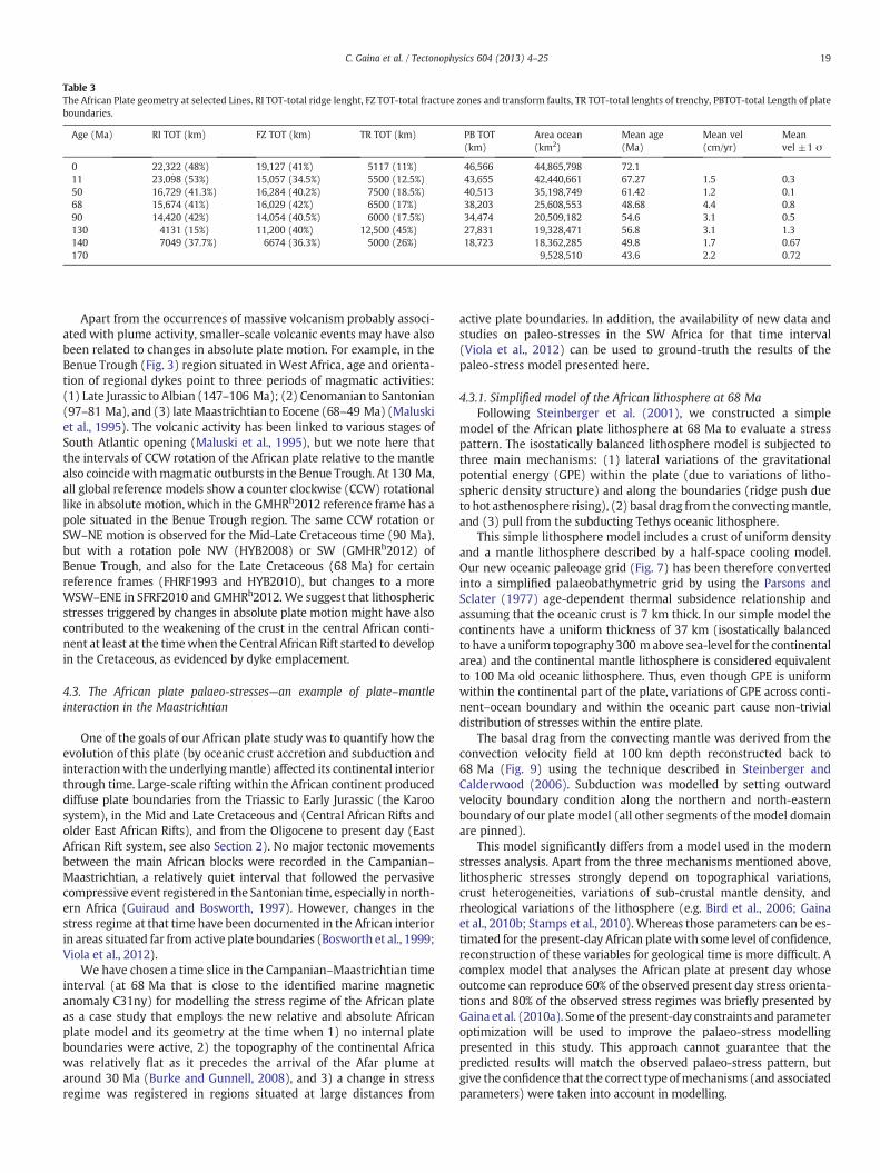
Table 3The African Plate geometry at selected Lines. RI TOT-total ridge lenght, FZ TOT-total fracture zones and transform faults, TR TOT-total lenghts of trenchy, PBTOT-total Length of plateboundaries.
Age (Ma) RI TOT (km) FZ TOT (km) TR TOT (km) PB TOT(km)
Area ocean(km2)
Mean age(Ma)
Mean vel(cm/yr)
Meanvel ±1 σ
0 22,322 (48%) 19,127 (41%) 5117 (11%) 46,566 44,865,798 72.111 23,098 (53%) 15,057 (34.5%) 5500 (12.5%) 43,655 42,440,661 67.27 1.5 0.350 16,729 (41.3%) 16,284 (40.2%) 7500 (18.5%) 40,513 35,198,749 61.42 1.2 0.168 15,674 (41%) 16,029 (42%) 6500 (17%) 38,203 25,608,553 48.68 4.4 0.890 14,420 (42%) 14,054 (40.5%) 6000 (17.5%) 34,474 20,509,182 54.6 3.1 0.5130 4131 (15%) 11,200 (40%) 12,500 (45%) 27,831 19,328,471 56.8 3.1 1.3140 7049 (37.7%) 6674 (36.3%) 5000 (26%) 18,723 18,362,285 49.8 1.7 0.67170 9,528,510 43.6 2.2 0.72
19C. Gaina et al. / Tectonophysics 604 (2013) 4–25
Apart from the occurrences of massive volcanism probably associ-ated with plume activity, smaller-scale volcanic events may have alsobeen related to changes in absolute plate motion. For example, in theBenue Trough (Fig. 3) region situated in West Africa, age and orienta-tion of regional dykes point to three periods of magmatic activities:(1) Late Jurassic to Albian (147–106 Ma); (2) Cenomanian to Santonian(97–81 Ma), and (3) lateMaastrichtian to Eocene (68–49 Ma) (Maluskiet al., 1995). The volcanic activity has been linked to various stages ofSouth Atlantic opening (Maluski et al., 1995), but we note here thatthe intervals of CCW rotation of the African plate relative to the mantlealso coincide withmagmatic outbursts in the Benue Trough. At 130 Ma,all global reference models show a counter clockwise (CCW) rotationallike in absolutemotion, which in the GMHRh2012 reference frame has apole situated in the Benue Trough region. The same CCW rotation orSW–NE motion is observed for the Mid-Late Cretaceous time (90 Ma),but with a rotation pole NW (HYB2008) or SW (GMHRh2012) ofBenue Trough, and also for the Late Cretaceous (68 Ma) for certainreference frames (FHRF1993 and HYB2010), but changes to a moreWSW–ENE in SFRF2010 and GMHRh2012. We suggest that lithosphericstresses triggered by changes in absolute plate motion might have alsocontributed to the weakening of the crust in the central African conti-nent at least at the timewhen the Central African Rift started to developin the Cretaceous, as evidenced by dyke emplacement.
4.3. The African plate palaeo-stresses—an example of plate–mantleinteraction in the Maastrichtian
One of the goals of our African plate study was to quantify how theevolution of this plate (by oceanic crust accretion and subduction andinteractionwith the underlyingmantle) affected its continental interiorthrough time. Large-scale rifting within the African continent produceddiffuse plate boundaries from the Triassic to Early Jurassic (the Karoosystem), in the Mid and Late Cretaceous and (Central African Rifts andolder East African Rifts), and from the Oligocene to present day (EastAfrican Rift system, see also Section 2). No major tectonic movementsbetween the main African blocks were recorded in the Campanian–Maastrichtian, a relatively quiet interval that followed the pervasivecompressive event registered in the Santonian time, especially in north-ern Africa (Guiraud and Bosworth, 1997). However, changes in thestress regime at that time have been documented in the African interiorin areas situated far from active plate boundaries (Bosworth et al., 1999;Viola et al., 2012).
We have chosen a time slice in the Campanian–Maastrichtian timeinterval (at 68 Ma that is close to the identified marine magneticanomaly C31ny) for modelling the stress regime of the African plateas a case study that employs the new relative and absolute Africanplate model and its geometry at the time when 1) no internal plateboundaries were active, 2) the topography of the continental Africawas relatively flat as it precedes the arrival of the Afar plume ataround 30 Ma (Burke and Gunnell, 2008), and 3) a change in stressregime was registered in regions situated at large distances from
active plate boundaries. In addition, the availability of new data andstudies on paleo-stresses in the SW Africa for that time interval(Viola et al., 2012) can be used to ground-truth the results of thepaleo-stress model presented here.
4.3.1. Simplified model of the African lithosphere at 68 MaFollowing Steinberger et al. (2001), we constructed a simple
model of the African plate lithosphere at 68 Ma to evaluate a stresspattern. The isostatically balanced lithosphere model is subjected tothree main mechanisms: (1) lateral variations of the gravitationalpotential energy (GPE) within the plate (due to variations of litho-spheric density structure) and along the boundaries (ridge push dueto hot asthenosphere rising), (2) basal drag from the convectingmantle,and (3) pull from the subducting Tethys oceanic lithosphere.
This simple lithosphere model includes a crust of uniform densityand a mantle lithosphere described by a half-space cooling model.Our new oceanic paleoage grid (Fig. 7) has been therefore convertedinto a simplified palaeobathymetric grid by using the Parsons andSclater (1977) age-dependent thermal subsidence relationship andassuming that the oceanic crust is 7 km thick. In our simple model thecontinents have a uniform thickness of 37 km (isostatically balancedto have a uniform topography 300 mabove sea-level for the continentalarea) and the continental mantle lithosphere is considered equivalentto 100 Ma old oceanic lithosphere. Thus, even though GPE is uniformwithin the continental part of the plate, variations of GPE across conti-nent–ocean boundary and within the oceanic part cause non-trivialdistribution of stresses within the entire plate.
The basal drag from the convecting mantle was derived from theconvection velocity field at 100 km depth reconstructed back to68 Ma (Fig. 9) using the technique described in Steinberger andCalderwood (2006). Subduction was modelled by setting outwardvelocity boundary condition along the northern and north-easternboundary of our plate model (all other segments of the model domainare pinned).
This model significantly differs from a model used in the modernstresses analysis. Apart from the three mechanisms mentioned above,lithospheric stresses strongly depend on topographical variations,crust heterogeneities, variations of sub-crustal mantle density, andrheological variations of the lithosphere (e.g. Bird et al., 2006; Gainaet al., 2010b; Stamps et al., 2010). Whereas those parameters can be es-timated for the present-day African platewith some level of confidence,reconstruction of these variables for geological time is more difficult. Acomplex model that analyses the African plate at present day whoseoutcome can reproduce 60% of the observed present day stress orienta-tions and 80% of the observed stress regimes was briefly presented byGaina et al. (2010a). Some of the present-day constraints and parameteroptimization will be used to improve the palaeo-stress modellingpresented in this study. This approach cannot guarantee that thepredicted results will match the observed palaeo-stress pattern, butgive the confidence that the correct type ofmechanisms (and associatedparameters) were taken into account in modelling.

Fig. 9. Velocities of mantle flow at 100 km depth for the African plate at 68 Ma (model byB. Steinberger using Steinberger and Calderwood's (2006) technique). These velocities areused to calculate the basal drag in the palaeo-stress modelling for Maastrichtian time(see Section 4).
20 C. Gaina et al. / Tectonophysics 604 (2013) 4–25
4.3.2. Modelling technique: the ProShell approachThe calculationswere performed using the in-house numerical suite
ProShell. Analysis of stresses within such a large plate requires takinginto account the lithosphere non-flatness and the potential interactionbetween in-plane and bending deformation. ProShell is designed toanalyze stresses and deformation in the lithosphere which can bedescribed as a thin shell of arbitrary shape and treats a shell as a set offinite elements where each element is being considered as a flat(shear-deformable) plate with specific orientation in space (Kwon andBang, 2000). The different orientation of individual elements may causetransformation of bending in one element into in-plane deformation ofthe neighboring element. Thus, the shell element accounts for balanceof both, moments (bending) and in-plane force. The calculation of stress-es in the lithospheric plate follows the Earth's global curvature and thelocal curvature associated with large perturbations of topography/bathymetry. The numerical approach was also optimized using the tech-niques described in Dabrowski et al. (2008).
For a given structure of the continental and oceanic crust, this pro-gram computes the isostatic position of the lithosphere and calculatesthe gravitational potential energy (GPE). The traction at the base ofthe lithosphere is modelled using the approach of Ellis et al. (1995).The maximum density variations within the lithospheric mantle(96 kg/m3), the thermal correction of the mantle lithosphere due tocrustal thickness variations (9 °C/km), and parameters of intensity ofthe basal drag such as viscosity of asthenosphere (2 × 10²¹ Pa · s)were taken from our modern stress analysis study (Gaina et al.,2010b) which was tested against the observed patterns of lithosphericstress (Bird et al., 2006; Bosworth et al., 2008; Delvaux and Barth,2010; Heidbach et al., 2008).
4.3.3. Modelling resultsTo understand the influence of each mechanism contributing
to palaeo-African stresses, we apply them individually and analyzethe resulting stress patterns. The calculations were performed on aregular finite-element grid of approximately 450 × 500 linear ele-ments, resulting in the system with approximately 1 million degreesof freedom.
Firstly, we analyzed the stresses resulting from the lateral variationsof GPE. The assumption of low topographical variations at 68 Ma for
continental Africa precludes analysis of the intra-continental variationsof GPE, and thus this set of calculations presents the influence of pushfrom mid-oceanic ridges only (Fig. 10). The stress regime map showsthat the entire African continent is in a compressional regime due tothe surrounding ridge push forces.
In Model 2 (Fig. 10) we simulated the influence of mantle flow dragby adding a basal traction term. Following Ellis et al. (1995) we assumethat the lithosphere is affected by traction from Quette-like flow.This flow is controlled by the difference between the lithosphere andconvecting mantle velocities (calculated at 100 km depth using theapproach of Steinberger and Calderwood, 2006) and by the viscosityof the asthenosphere (taken as ~2 × 10²¹ Pa · s). The effect of thismechanism seems to be a severe change in the orientation ofmost com-pressive stresses in the northern and south-eastern parts of the Africancontinent and the creation of an extensional stress regime in north-eastAfrica.
The two previous models used no-slip boundary conditions forvelocities. Model 3, in contrast, sets outward directed boundaryvelocities in the middle part of the northern domain boundary. Thatsimulates slab pull, associated with subduction of the old Tethysoceanic lithosphere (Fig. 10). We applied a simplified kinematicboundary condition and vary the magnitude of the subductionvelocity from low (velocity of 1–3 cm/yr, Model 3a) tomoderate values(4–7 cm/yr, Model 3b). Those variations, however, do not produce sig-nificant changes in the stress pattern (Fig. 10), illustrating the robust-ness of the model to rate of subduction uncertainties. Adding thismechanismdoes not lead to large changes in the stress field orientation,but significantly alters the stress regimes of Northern Africa (Fig. 10).The extensional regime seems to affect the entire NE Africa and its off-shore part, being bordered by regions of strike-slip.
Our first order results correspond relativelywell to the palaeo-stressregimes inferred from geological studies. A recent dataset of palaeo-stress indicators including measured striated fault planes was collectedin the SW Africa (Namaqualand) and modelled into palaeo-stress ten-sors that suggest a compressional regime in the Maastrichtian (Violaet al., 2012). This timing is constrained by the dated markers situatedclose to the measured faulting directions and matches our results. Inthe northern and north-eastern part of Africa, after the compressionalSantonian/Senonian event, NW–SE rifting recommenced in parts ofthe northern African–Arabian margin in the early Campanian andcontinued to the late Maastrichtian (Guiraud and Bosworth, 1997).Large NW–SE trending rift basins (Fig. 3c) were rejuvenated duringLate Senonian–Paleocene times and magmatic activity occurred alongthe E–W trending Nubian fault swarm of southern Egypt–northernSudan (Wilson and Guiraud, 1992). The palaeo-stress regime predictedby our model is consistent with these geological evidences that sug-gested an extensional/strike-slip regime in the NE and N of the Africanplate. Furthermodelling of the African plate palaeo-stresses for relevantgeological time frameswill be presented elsewhere (Medvedev et al., inprep).
5. Summary and conclusions
In this contribution we present a systematic study of the Africanplate boundaries since the opening of surrounding oceanic basins,starting at 195 Ma in the Central Atlantic, that aids further understand-ing of the geodynamics of the African plate. The accretion and subduc-tion of oceanic crust around the African continent is described in thelight of available geophysical and geological data and publishedmodels.
The geometry and location of the African plate in time and spaceare analyzed for several time frames that correspond to episodes ofintra-continental deformation. The evolution of plate boundaries andlithosphere–mantle connections revealed by the absolute motion ofthe African plate are discussed in the attempt to explore a correlationamong these and far-field stresses that may have influenced the Africancontinental interior.
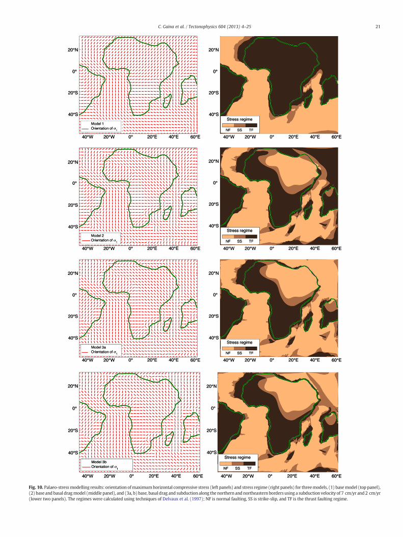
Fig. 10. Palaeo-stressmodelling results: orientation ofmaximumhorizontal compressive stress (left panels) and stress regime (right panels) for threemodels, (1) basemodel (top panel),(2) base and basal dragmodel (middle panel), and (3a, b) base, basal drag and subduction along the northern and northeastern borders using a subduction velocity of 7 cm/yr and 2 cm/yr(lower two panels). The regimes were calculated using techniques of Delvaux et al. (1997); NF is normal faulting, SS is strike-slip, and TF is the thrust faulting regime.
21C. Gaina et al. / Tectonophysics 604 (2013) 4–25

22 C. Gaina et al. / Tectonophysics 604 (2013) 4–25
Weobserve that changes in the lengths and type of plate boundariesdo not correlate with variations in the absolute plate velocities as sug-gested in studies based on today's plate configuration (Forsyth andUyeda, 1975), but variations in the mean age of oceanic crust seemto be linked to changes in the mean absolute velocities. A counter-clockwise rotation of the African plate relative to the mantle around apole situated in the Benue Trough or its vicinity seems to coincide toepisodes of volcanic activities described in that region and rifting inthe Central and Northern Africa.
A simple model of the African plate lithosphere at 68 Ma was usedto calculate palaeo-stress regimes taking into account the influence ofridge push, slab pull and mantle drag forces. This model predicts acompressional regime in South Africa and an extension and strike-slipin NE and N Africa. These predictions are in accordance with the com-puted palaeo-stress tensors based on geological evidences in south-western Africa (Viola et al., 2012) and agree with published modelson the geological evolution of theNorthern part of the African continent(e.g. Guiraud and Bosworth, 1999).
Acknowledgments
We thank Statoil and the Geological Survey of Norway (NGU) forfinancing the African Plate project (2008–2011). We are grateful toBernhard Steinberger for sharing his global mantle convection modelto the African Plate project. We thank M. Moulin for kindly allowingus to use the South Atlantic isochrons (Moulin et al., 2010) in our newmodel. Detailed comments provided by S. Mazur and an anonymousreviewer greatly improved the manuscript.
References
Abadi, A.M., van Wees, J.D., van Dijk, P.M., Cloetingh, S.A.P.L., 2008. Tectonics andsubsidence evolution of the Sirt Basin, Libya. AAPG Bulletin 92, 993–1027.
Agard, P., Omrani, J., Jolivet, L., Whitechurch, H., Vrielynck, B., Spakman, W., Monié, P.,Meyer, B., Wortel, M.J.R., 2011. Zagros orogeny: a subduction-dominated process.Geological Magazine 148, 692–725.
Allemann, F., 1979. Time of emplacement of the Zhob Valley Ophiolites and BelaOphiolites, Baluchistan (Preliminary report). In: Farah, A., de Jong, K.A. (Eds.),Geodynamics of Pakistan. Geological Survey of Pakistan, Quetta, pp. 215–242.
Al-Riyami, K., Robertson, A.H.F., Dixon, J.E., Xenophontos, C., 2002. Origin and emplace-ment of the Late Cretaceous Baer–Bassit ophiolite and its metamorphic sole in NWSyria. Lithos 65, 225–260.
Amante, C., Eakins, B.W., 2009. ETOPO1 1 Arc-Minute Global Relief Model: Procedures, DataSources and Analysis. NOAA Technical Memorandum NESDIS NGDC. NGDC, p. 19.
Andreoli, M., Viola, G., Kounov, A., Scheepers, J., Heidbach, O., Stengel, I., 2009. Historyof stress at Vaalputs, Namaqualand, South Africa: evidence for a Mid-Cretaceous“Wegener-type orogeny” in western southern Africa. 515–520. http://dx.doi.org/10.1130/0091-7613.
Artemieva, I.M., Mooney, W.D., 2002. On the relations between cratonic lithospherethickness, plate motions, and basal drag. Tectonophysics 358, 211–231.
Barker, P.F., 1979. The history of ridge-crest offset at the Falkland–Agulhas fracturezone from a small-circle geophysical profile. Geophysical Journal of the RoyalAstronomical Society 59, 131–145.
Bauer, K., Neben, S., Schreckenberger, B., Emmermann, R., Hinz, K., Fechner, N., Gohl, K.,Schulze, A., Trumbull, R.B., Weber, K., 2000. Deep structure of the Namibia conti-nental margin as derived from integrated geophysical studies. Journal of Geophys-ical Research—Solid Earth 105, 25829–25853.
Behrendt, J.C., Schlee, J., Robb, J.M., Mk, Silverst, 1974. Structure of continental-marginof Liberia, West-Africa. Geological Society of America Bulletin 85, 1143–1158.
Bennett, K., Rusk, D., 2002. Regional 2D sesimic interpretation and exploration poten-tial of offshore deepwater Sierra Leone and Liberia, West Africa. The LeadingEdge 21, 1118–1124.
Bermingham, P.M., Fairhead, J.D., Stuart, G.W., 1983. Gravity study of the Central AfricanRift System—amodel of continental disruption. 2. The Darfur Domal uplift and associ-ated Cainozoic volcanism. Tectonophysics 94, 205–222.
Bernard, A., Munschy, M., 2000. Were the Mascarene and Laxmi Basins (western IndianOcean) formed at the same spreading centre? Comptes Rendus de l'Academie desSciences Serie IIA 330, 777–783.
Bird, P., Ben-Avraham, Z., Schubert, G., Andreoli, M., Viola, G., 2006. Patterns of stress andstrain rate in southern Africa. Journal of Geophysical Research—Solid Earth 111.
Blaich, O.A., Faleide, J.I., Tsikalas, F., 2011. Crustal breakup and continent–ocean transi-tion at South Atlantic conjugate margins. Journal of Geophysical Research—SolidEarth 116.
Bosworth,W., 1992.Mesozoic and Early Tertiary rift tectonics in East-Africa. Tectonophysics209, 115–137.
Bosworth, W., Guiraud, M., Kessler, L.G., 1999. Late Cretaceous (ca. 84 Ma) compressivedeformation of the stable platform of northeast Africa (Egypt): far-field stresseffects of the “Santonian event” and the origin of the Syrian arc deformation belt.Geology 27, 633–636.
Bosworth,W., Huchon, P., McClay, K., 2005. The Red Sea andGulf of Aden basins. Journal ofAfrican Earth Sciences 43, 334–378.
Bosworth, W., El-Hawat, A.S., Helgeson, D.E., Burke, K., 2008. Cyrenaican “shock absorber”and associated inversion strain shadow in the collision zone of northeast Africa. Geology36, 695–698.
Braitenberg, C., Mariani, P., Ebbing, J., Sprlak, M., 2011. The enigmatic Chad lineamentrevisited with global gravity and gravity-gradient fields. In: van Hinsbergen,D.J.J., Buiter, S., Torsvik, T.H., Gaina, C., Webb, S. (Eds.), The Formation and Evolutionof Africa: A Synopsis of 3.8 Ga of Earth History. The Geological Society of London,London, pp. 329–343.
Briggs, S.E., Cartwright, J., Davies, R.J., 2009. Crustal structure of the deepwater westNiger Delta passive margin from the interpretation of seismic reflection data.Marine and Petroleum Geology 26, 936–950.
Browne, S.E., Fairhead, J.D., 1983. Gravity study of the Central African rift system—amodel ofcontinental disruption. 1. The Ngaoundere and Abu Gabra Rifts. Tectonophysics 94,187–203.
Bumby, A.J., Guiraud, R., 2005. The geodynamic setting of the Phanerozoic basins ofAfrica. Journal of African Earth Sciences 43, 1–12.
Burke, K., 1996. The African Plate, The 24th du Toit Memorial lecture African. Journal ofGeology 99, 339–409.
Burke, K., Gunnell, Y., 2008. The African Erosion Surface.Burke, K., Torsvik, T.H., 2004. Derivation of Large Igneous Provinces of the past 200 million
years from long-termheterogeneities in the deepmantle. Earth and Planetary ScienceLetters 227, 531–538.
Cande, S.C., Patriat, P., Dyment, J., 2010. Motion between the Indian, Antarctic andAfrican plates in the early Cenozoic. Geophysical Journal International 183, 127–149.
Catuneanu, O., Wopfner, H., Eriksson, P.G., Cairncross, B., Rubidge, B.S., Smith, R.M.H.,Hancox, P.J., 2005. The Karoo basins of south-central Africa. Journal of AfricanEarth Sciences 43, 211–253.
Celik, O.F., Delaloye,M., Feraud, G., 2006. Precise Ar-40―Ar-39 ages from themetamorphicsole rocks of the Tauride Belt Ophiolites, southern Turkey: implications for the rapidcooling history. Geological Magazine 143, 213–227.
Çelik, Ö.F., Marzoli, A., Marschik, R., Chiaradia, M., Neubauer, F., Öz, I., 2011. Early–Middle Jurassic intra-oceanic subduction in the İzmir-Ankara-Erzincan Ocean,Northern Turkey. Tectonophysics 509, 120–134.
Chorowicz, J., 2005. The East African rift system. Journal of African Earth Sciences 43,379–410.
Cifelli, F., Mattei, M., Rossetti, F., 2007. Tectonic evolution of arcuate mountain beltson top of retreating subduction slab: the example of the Calabrian arc. Journal ofGeophysical Research 112.
Cloetingh, S., Burov, E., 2011. Lithospheric folding and sedimentary basin evolution: areview and analysis of formation mechanisms. Basin Research 23, 257–290.
Coblentz, D.D., Sandiford, M., Richardson, R.M., 1995. The origins of the intraplate stressfield in continental Australia. Earth and Planetary Science Letters 133, 299–309.
Cochran, J.R., 2005. Northern Red Sea: nucleation of an oceanic spreading center withina continental rift. Geochemistry, Geophysics, Geosystems 6.
Cochran, J.E.M., Karner, G.D., 2007. Constraints on the deformation and rupturing ofcontinental lithosphere of the Red Sea: the transition from rifting to drifting. In:Karner, G.D., Manatschal, G., Pinheiro, L.M. (Eds.), Imaging, Mapping and ModellingContinental Lithosphere Extension and Breakup. The Geological Society of London,London, pp. 265–289.
Coffin, M.F., Eldholm, O., 1994. Large igneous provinces—crustal structure, dimensions,and external consequences. Reviews of Geophysics 32, 1–36.
Coffin, M.F., Rabinowitz, P.D., 1987. Reconstruction of Madagascar and Africa—evidencefrom the Davie Fracture-Zone and Western Somali Basin. Journal of GeophysicalResearch: Solid Earth 92, 9385–9406.
Coffin, M.F., Rabinowitz, P.D., Houtz, R.E., 1986. Crustal structure in the Western SomaliBasin. Geophysical Journal of the Royal Astronomical Society 86, 331–369.
Contrucci, I., Matias, L., Moulin, M., Geli, L., Klingelhofer, F., Nouze, H., Aslanian, D., Olivet,J.L., Rehault, J.P., Sibuet, J.C., 2004. Deep structure of the West African continentalmargin (Congo, Zaire, Angola), between 5 degrees S and 8 degrees S, from reflection/refraction seismics and gravity data. Geophysical Journal International 158, 529–553.
Dabrowski, M., Krotkiewski, M., Schmid, D.W., 2008. MILAMIN: MATLAB-based finiteelement method solver for large problems. Geochemistry, Geophysics, Geosystems 9.
d'Acremont, E., Leroy, S., Beslier, M.O., Bellahsen, N., Fournier, M., Robin, C., Maia, M.,Gente, P., 2005. Structure and evolution of the eastern Gulf of Aden conjugate mar-gins from seismic reflection data. Geophysical Journal International 160, 869–890.
de Lamotte, D.F., Raulin, C., Mouchot, N., Wrobel-Daveau, J.C., Blanpied, C., Ringenbach,J.C., 2011. The southernmost margin of the Tethys realm during the Mesozoic andCenozoic: initial geometry and timing of the inversion processes. Tectonics 30.
Delvaux, D., Barth, A., 2010. African stress pattern from formal inversion of focal mech-anism data. Tectonophysics 482, 105–128.
Delvaux, D., Moeys, R., Stapel, G., Petit, C., Levi, K., Miroshnichenko, A., Ruzhich, V.,San'kov, V., 1997. Paleostress reconstructions and geodynamics of the Baikal region,Central Asia, part 2. Cenozoic rifting. Tectonophysics 282, 1–38.
Dercourt, J., Zonenshain, L.P., Ricou, L.E., Kazmin, V.G., Lepichon, X., Knipper, A.L.,Grandjacquet, C., Sbortshikov, I.M., Geyssant, J., Lepvrier, C., Pechersky, D.H., Boulin,J., Sibuet, J.C., Savostin, L.A., Sorokhtin, O., Westphal, M., Bazhenov, M.L., Lauer, J.P.,Bijuduval, B., 1986. Geological evolution of the Tethys Belt from the Atlantic to thePamirs since the Lias. Tectonophysics 123, 241–315.
Dewey, J.F., Casey, J.F., 2011. The origin of obducted large-slab ophiolite complexes arc-continent collision. Frontiers in Earth Sciences 2011, 431–444.
23C. Gaina et al. / Tectonophysics 604 (2013) 4–25
Di Luccio, F., Pasyanos, M.E., 2007. Crustal and upper-mantle structure in the EasternMediterranean from the analysis of surface wave dispersion curves. GeophysicalJournal International 169, 1139–1152.
Dilek, Y., Furnes, H., 2011. Ophiolite genesis and global tectonics: geochemical and tec-tonic fingerprinting of ancient oceanic lithosphere. Geological Society of AmericaBulletin 123, 387–411.
Doubrovine, P., Steinberger, B., Torsvik, T.H., 2012. Absolute plate motions in a referenceframe defined by moving hotspots in the Pacific, Atlantic and Indian oceans. Journalof Geophysical Research 117, B09101. http://dx.doi.org/10.1029/2011JB009072.
Dupre, S., Cloetingh, S., Bertotti, G., 2011. Structure of the Gabon Margin from integrat-ed seismic reflection and gravity data. Tectonophysics 506, 31–45.
Dyksterhuis, S., Muller, R.D., 2004. Modelling the contemporary and palaeo stress fieldof Australia using finite-element modelling with automatic optimisation. Explora-tion Geophysics 35, 236–241.
Eagles, G., Konig, M., 2008. A model of plate kinematics in Gondwana breakup. Geo-physical Journal International 173, 703–717.
Ellis, S., Fullsack, P., Beaumont, C., 1995. Oblique convergence of the crust driven bybasal forcing—implications for length-scales of deformation and strain partitioningin orogens. Geophysical Journal International 120, 24–44.
Faccenna, C., Becker, T.W., Lallemand, S., Steinberger, B., 2012. On the role of slab pull inthe Cenozoic motion of the Pacific plate. Geophysical Research Letters 39.
Faure, S., Tremblay, A., Angelier, J., 1996. State of stress and tectonism of northeasternAmerica since Cretaceous times, with particular emphasis on the New England–Quebec igneous province. Tectonophysics 255, 111–134.
Fernandez, M., Afonso, J.C., Ranalli, G., 2010. The deep lithospheric structure of theNamibian volcanic margin. Tectonophysics 481, 68–81.
Finetti, I., 1976. Mediterranean Ridge: a young submerged chain associated with theHellenic Arc. Bollettino di Geofisica Teorica ed Applicata 13, 31–65.
Forsyth, D., Uyeda, S., 1975. Relative importance of driving forces of plate motion. Geo-physical Journal of the Royal Astronomical Society 43, 163–200.
Fournier, M., Chamot-Rooke, N., Petit, C., Huchon, P., Al-Kathiri, A., Audin, L., Beslier,M.O., d'Acremont, E., Fabbri, O., Fleury, J.M., Khanbari, K., Lepvrier, C., Leroy, S.,Maillot, B., Merkouriev, S., 2010. Arabia–Somalia plate kinematics, evolution ofthe Aden-Owen-Carlsberg triple junction, and opening of the Gulf of Aden. Journalof Geophysical Research—Solid Earth 115.
Frisch, W., 1979. Tectonic progradation and plate tectonic evolution of the Alps.Tectonophysics 60, 121–139.
Gaina, C., Müller, D., 2007. Cenozoic tectonic and depth/age evolution of the Indonesiangateway and associated back-arc basins. Earth-Science Reviews 83, 177–203.
Gaina, C., Labails, C., Reeves, C., 2010a. The Early Opening of the Indian Ocean: An AfricanPerspective. American Geophysical Union Fall Meeting. AGU, San Francisco.
Gaina, C., Medvedev, S., Guilio, V., 2010b. The African Plate (TAP): lithosphere andmantle interactions and implications for basin evolution, preliminary insightsinto regional present day and paleo-stresses. AAPG‐ER Newsletter 5, 2–3.
Gaina, C., Torsvik, T.H., Cande, S., Croon, M., Doubrovine, P., 2011. Global plate circuitsat Paleocene–Eocene time. In: EGU (Ed.), European Geophysical Union General As-sembly. EGU, Vienna, pp. EGU2011–EGU4492.
Gallais, F., Gutscher, M.A., Graindorge, D., Chamot-Rooke, N., Klaeschen, D., 2011. AMiocene tectonic inversion in the Ionian Sea (central Mediterranean): evidencefrom multichannel seismic data. Journal of Geophysical Research—Solid Earth116.
Ganerød, M., Torsvik, T.H., van Hinsbergen, D.J.J., Gaina, C., Corfu, F., Werner, S., Owen-Smith, T., Ashwal, L.D., Webb, S.J., Hendriks, B.W.H., 2011. Paleoposition of theSeychelles microcontinent in relation to the Decan Traps and the PlumeGeneration Zone in late Cretaceous-early Palaeogene time. In: van Hinsbergen,D.J.J., Buiter, S.J.H., Torsvik, T.H., Gaina, C., Webb, S. (Eds.), The Formation andEvolution of Africa: A Synopsis of 3.8 Ga of Earth History. Geological Society,London, Special Publications, pp. 229–252.
Gardosh, M., Druckman, Y., 2006. Seismic stratigraphy, structure and tectonic evolutionof the Levantine Basin, offshore Israel, Tectonic development of the Eastern Medi-terranean region. In: Robertson, H.F., Mountrakis, D. (Eds.), Tectonic Developmentof the Eastern Mediterranean Region: Geological Society, 260. London, SpecialPublication, pp. 201–227. http://dx.doi.org/10.1144/GSL.SP.2006.260.01.09.
Garfunkel, Z., 1998. Constrains on the origin and history of the Eastern Mediterraneanbasin. Tectonophysics 298, 5–35.
Gee, J., Kent, D.V., 2007. Source of oceanic magnetic anomalies and the geomagnetic polaritytime scale. In: Kono,M. (Ed.), Treatise onGeophysics. Elsevier, Amsterdam, pp. 455–507.
Geiger, M., Schweigert, G., 2005. Toarcian-Kimmeridgian depositional cycles of the south-western Morondava Basin along the rifted continental margin of Madagascar. Facies52, 85–112.
Geoffroy, L., 2005. Volcanic passive margins. Comptes Rendus Geosciences 337,1395–1408.
Gerrard, I., Smith, G.C., 1982. Post-Paleozoic succesion and structure of the southwesternAfrican continental margin. In: Watkins, J.S., Drake, C.L. (Eds.), Studies in ContinentalMargin Geology. American Association of Petroleum Geologists, pp. 49–74.
Gesret, A., Laigle, M., Diaz, J., Sachpazi, M., Hirn, A., 2010. The oceanic nature of theAfrican slab subducted under Peloponnesus: thin-layer resolution from multiscaleanalysis of teleseismic P-to-S converted waves. Geophysical Journal International183, 833–849.
Gladczenko, T.P., Skogseid, J., Eldhom, O., 1998. Namibia volcanic margin. MarineGeophysical Research 20, 313–341.
Gnos, E., Immenhauser, A., Peters, T., 1997. Late Cretaceous early Tertiary convergencebetween the Indian and Arabian plates recorded in ophiolites and related sediments.Tectonophysics 271, 1–19.
Gohl, K., Uenzelmann-Neben, G., Grobys, N., 2011. Growth and dispersal of a SoutheastAfrican large igneous province. South African Journal of Geology 114, 379–386.
Gong, Z., Langereis, C.G., Mullender, T.A.T., 2008. The rotation of Iberia during theAptian and the opening of the Bay of Biscay. Earth and Planetary Science Letters273, 80–93.
Goodlad, S.W., Martin, A.K., Hartnady, C.J.H., 1982. Mesozoic magnetic-anomalies in theSouthern Natal Valley. Nature 295, 686–688.
Govers, R., Wortel, M., 2005. Lithosphere tearing at STEP faults: response to edges ofsubduction zones. Earth and Planetary Science Letters 236, 505–523.
Gregory, L.C., Meert, J.G., Bingen, B., Pandit, M.K., Torsvik, T.H., 2009. Paleomagnetismand geochronology of the Malani Igneous Suite, Northwest India: implicationsfor the configuration of Rodinia and the assembly of Gondwana. PrecambrianResearch 170, 13–26.
Gubanov, A.P., Mooney, W.D., 2009. New global geological maps of crustal basementage. Eos, Transactions, American Geophysical Union 90 (52) Suppl. pp. T53B–T1583B. Fall Meeting, San Francisco, USA.
Guiraud, R., Bosworth, W., 1997. Senonian basin inversion and rejuvenation of rifting inAfrica and Arabia: synthesis and implications to plate-scale tectonics. Tectonophysics282, 39–82.
Guiraud, R., Bosworth, W., 1999. Phanerozoic geodynamic evolution of northeasternAfrica and the northwestern Arabian platform. Tectonophysics 315, 73–108.
Guiraud, R., Bellion, Y., Benkhelil, J., Moreau, C., 1987. Post-Hercynian tectonics inNorthern and Western Africa. Geological Journal 22, 433–466.
Guiraud, R., Binks, R.M., Fairhead, J.D., Wilson, M., 1992. Chronology and geodynamicsetting of Cretaceous Cenozoic rifting in West and Central Africa. Tectonophysics213, 227–234.
Guiraud, R., Bosworth, W., Thierry, J., Delplanque, A., 2005. Phanerozoic geologicalevolution of Northern and Central Africa: an overview. Journal of African EarthSciences 43, 83–143.
Handy, M., Schmid, S.M., Bousquet, R., Kissling, E., Bernoulli, D., 2010. Reconcilingplate-tectonic reconstructions of Alpine Tethys with the geological–geophysicalrecord of spreading and subduction in the Alps. Earth-Science Reviews 102, 121–158.
Hartnady, C.J.H., le Roex, A.P., 1985. Ocean hot spot tracks and the Cenozoic absolutemotion of the African, Antarctic and South American plates. Earth and PlanetaryScience Letters 75, 245–257.
Heidbach, O., Tingay, M., Barth, A., Reinecker, J., Kurfess, D., Müller, B., 2008. The WorldStress Map database release.
Heine, C., Muller, R.D., Steinberger, B., 2008. Subsidence in intracontinental basins dueto dynamic topography. Physics of the Earth and Planetary Interiors 171, 252–264.
Heine, C., Zoethout, J., Müller, R.D., 2013. Kinematics of the South Atlantic rift. SolidEarth Discussions 5, 41–116.
Hirsch, K.K., Bauer, K., Scheck-Wenderoth, M., 2009. Deep structure of the westernSouth African passive margin—results of a combined approach of seismic, gravityand isostatic investigations. Tectonophysics 470, 57–70.
Horner-Johnson, B.C., Gordon, R.G., Argus, D.F., 2007. Plate kinematic evidence for theexistence of a distinct plate between the Nubian and Somalian plates along theSouthwest Indian Ridge. Journal of Geophysical Research—Solid Earth 112.
Huguen, C., Mascle, J., Chaumillon, E., Woodside, J.M., Benkhelil, A., Volkonskaïa, A.,2001. Deformational styles of the eastern Mediterranean Ridge and surroundingsfrom combined swath mapping and seismic reflection profiling. Tectonophysics343, 21–47.
Immenhauser, A., Schreurs, G., Gnos, E., Oterdoom, H.W., Hartmann, B., 2000. LatePalaeozoic to Neogene geodynamic evolution of the northeastern Oman margin.Geological Magazine 137, 1–18.
Jaffal, M., Klingelhoefer, F., Matias, L., Teixeira, F., Amrhar, M., 2009. Crustal structure ofthe NW Moroccan margin from deep seismic data (SISMAR Cruise). ComptesRendus Geosciences 341, 495–503.
Jokat, W., Boebel, T., Konig, M., Meyer, U., 2003. Timing and geometry of early Gondwanabreakup. Journal of Geophysical Research—Solid Earth 108.
Jolivet, L., Brun, J.P., 2010. Cenozoic geodynamic evolution of the Aegean. InternationalJournal of Earth Sciences 99, 109–138.
Jolivet, L., Faccenna, C., Piromallo, C., 2009. From mantle to crust: stretching the Medi-terranean. Earth and Planetary Science Letters 285, 198–209.
Jourdan, F., Feraud, G., Bertrand, H., Kampunzu, A.B., Tshoso, G., Watkeys, M.K., Le Gall,B., 2005. Karoo large igneous province: brevity, origin, and relation to mass extinc-tion questioned by new Ar-40/Ar-39 age data. Geology 33, 745–748.
Jourdan, F., Feraud, G., Bertrand, H., Watkeys, M.K., 2007. From flood basalts to the incep-tion of oceanization: example from the Ar-40/Ar-39 high-resolution picture of theKaroo large igneous province. Geochemistry, Geophysics, Geosystems 8.
Jurdy, D.M., Stefanick, M., 1991. The forces driving the plates—constraints from kine-matics and stress observations. Philosophical Transactions of the Royal Society A337, 127–139.
Khan, M., Kerr, A.C., Mahmood, K., 2007. Formation and tectonic evolution of theCretaceous–Jurassic Muslim Bagh ophiolitic complex, Pakistan: implications forthe composite tectonic setting of ophiolites. Journal of Asian Earth Sciences 31,112–127.
Kimbell, G.S., Gatliff, R.W., Ritchie, J.D., Walker, A.S.D., Williamson, J.P., 2004. Regionalthree-dimensional gravity modelling of the NE Atlantic margin. Basin Research16, 259–278.
Klausen,M.B., 2009. The Lebombomonocline and associated feeder dyke swarm: diagnos-tic of a successful and highly volcanic rifted margin? Tectonophysics 468, 42–62.
Klingelhoefer, F., Labails, C., Cosquer, E., Rouzo, S., Geli, L., Aslanian, D., Olivet, J.L.,Sahabi, M., Nouze, H., Unternehr, P., 2009. Crustal structure of the SW-Moroccanmargin from wide-angle and reflection seismic data (the DAKHLA experiment)Part A: wide-angle seismic models. Tectonophysics 468, 63–82.
Klitgord, K.D., Schouten, H., 1986. Plate kinematics of the central Atlantic. In: Vogt, P.R.,Tucholke, B.E. (Eds.), The Western North Atlantic Region: The Geology of NorthAmerica (DNAG). GSA, pp. 351–378.

24 C. Gaina et al. / Tectonophysics 604 (2013) 4–25
König, M., Jokat, W., 2010. Advanced insights into magmatism and volcanism of theMozambique Ridge and Mozambique Basin in the view of new potential fielddata. Geophysical Journal International 180, 158–180.
Koulakov, I., Sobolev, S.V., 2006. Moho depth and three-dimensional P and S structureof the crust and uppermost mantle in the Eastern Mediterranean and Middle Eastderived from tomographic inversion of local ISC data. Geophysical Journal Interna-tional 164, 218–235.
Kumar, N., 1979. Origin of paired aseismic rises—Ceara and Sierra-Leone rises in theequatorial, and the Rio-Grande Rise andWalvis Ridge in the South-Atlantic. MarineGeology 30, 175–191.
Kwon, Y.W., Bang, H., 2000. The Finite Element Method Using MATLAB, 2nd ed. CRCPress, Boca Raton, FL.
Labails, C., Gaina, C., 2011. Insights on the Deep Structure of the Conjugate East Africanand Madagascan Margins. Geological Survey of Norway (NGU), Trondheim.
Labails, C., Olivet, J.L., Grp, D.S., 2009. Crustal structure of the SW Moroccan marginfrom wide-angle and reflection seismic data (the Dakhla experiment). Part B—The tectonic heritage. Tectonophysics 468, 83–97.
Labails, C., Olivet, J.L., Aslanian, D., Roest, W.R., 2010. An alternative early opening scenariofor the Central Atlantic Ocean. Earth and Planetary Science Letters 297, 355–368.
Leinweber, V.T., Jokat, W., 2011. Is there continental crust underneath the northern NatalValley and the Mozambique Coastal Plains? Geophysical Research Letters 38.
Leinweber, V.T., Jokat, W., 2012. The Jurassic history of the Africa–Antarctica corridor—new constraints from magnetic data on the conjugate continental margins.Tectonophysics 530, 87–101.
Leroy, S., Gente, P., Fournier, M., d'Acremont, E., Patriat, P., Beslier, M.O., Bellahsen, N.,Maia, M., Blais, A., Perrot, J., Al-Kathiri, A., Merkouriev, S., Fleury, J.M., Ruellan,P.Y., Lepvrier, C., Huchon, P., 2004. From rifting to spreading in the eastern Gulfof Aden: a geophysical survey of a young oceanic basin from margin to margin.Terra Nova 16, 185–192.
Leroy, S., Lucazeau, F., d'Acremont, E., Watremez, L., Autin, J., Rouzo, S., Bellahsen, N.,Tiberi, C., Ebinger, C., Beslier, M.O., Perrot, J., Razin, P., Rolandone, F., Sloan, H.,Stuart, G., Al Lazki, A., Al-Toubi, K., Bache, F., Bonneville, A., Goutorbe, B., Huchon,P., Unternehr, P., Khanbari, K., 2010. Contrasted styles of rifting in the easternGulf of Aden: a combined wide-angle, multichannel seismic, and heat flow survey.Geochemistry, Geophysics, Geosystems 11.
Lithgow-Bertelloni, C., Richards, M.A., 1998. The dynamics of Cenozoic and Mesozoicplate motions. Reviews of Geophysics 36, 27–78.
Longacre, M., Bentham, P., Hanbal, I., Cotton, J., Edwards, R., 2007. New crustal structureof the Eastern Mediterranean basin: details integration and modelling of gravity,magnetic, seismic refraction, and seismic reflection data. Innovation in EM, Gravand Mag methods: A new perspective for exploration, Capri, Italy, pp. 1–5.
Lundin, E.R., Doré, A.G., 2011. Hyperextension, serpentinization, and weakening: anew paradigm for rifted margin compressional deformation. Geology 39,347–350.
Lyngsie, S.B., Thybo, H., Rasmussen, T.M., 2006. Regional geological and tectonic struc-tures of the North Sea area from potential field modelling. Tectonophysics 413,147–170.
Mahmood, K., Boudier, F., Gnos, E., Monie, P., Nicolas, A., 1995. 40Ar/39Ar dating of theemplacement of the Muslim Bagh ophiolite, Pakistan. Tectonophysics 250,169–181.
Maillard, A., Malod, J., Thiebot, E., Klingelhoefer, F., Rehault, J.P., 2006. Imaging a litho-spheric detachment at the continent–ocean crustal transition off Morocco. Earthand Planetary Science Letters 241, 686–698.
Makris, J., Yegorova, T., 2006. A 3-D density-velocity model between the Cretan Sea andLibya. Tectonophysics 417, 201–220.
Maluski, H., Coulon, C., Popoff, M., Baudin, P., 1995. Ar-40/Ar-39 Chronology, petrologyand geodynamic setting of Mesozoic to Early Cenozoic magmatism from the BenueTrough, Nigeria. Journal of the Geological Society of London 152, 311–326.
Manatschal, G., 2004. New models for evolution of magma-poor rifted margins basedon a review of data and concepts from West Iberia and the Alps. InternationalJournal of Earth Sciences 93, 432–466.
Marzoli, A., Renne, P.R., Piccirillo, E.M., Ernesto, M., Bellieni, G., DeMin, A., 1999. Extensive200-million-year-old continental flood basalts of the Central Atlantic MagmaticProvince. Science 284, 616–618.
Mascle, J., Blarez, E., 1987. Evidence for transform margin evolution from the Ivory-Coast Ghana continental-margin. Nature 326, 378–381.
Mascle, J., Le Cleac'h, A., Jongsma, D., 1986. The eastern Hellenic margin from Crete toRhodes: example of progressive-collision. Marine Geology 73, 145–168.
Mascle, J., Basile, C., Pontoise, B., Sage, F., 1995. The Cote d'Ivoire Ghana transformmargin: an example of an ocean–continent transform boundary. NATO AdvancedScience Institute Series 463, 327–339.
Maus, S., Sazonova, T., Hemant, K., Fairhead, J.D., Ravat, D., 2007. National GeophysicalData Center candidate for the World Digital Magnetic Anomaly Map. Geochemistry,Geophysics, Geosystems 8.
Maus, S., Yin, F., Luhr, H., Manoj, C., Rother, M., Rauberg, J., Michaelis, I., Stolle, C.,Muller, R.D., 2008. Resolution of direction of oceanic magnetic lineations by thesixth-generation lithospheric magnetic field model from CHAMP satellite magneticmeasurements. Geochemistry, Geophysics, Geosystems 9.
McQuarrie, N., van Hinsbergen, D.J.J., 2013. Retro-deforming the Arabia–Eurasia collisionzone: age of collision versus magnitude of continental subduction. Geology 41,315–318.
Meijer, P.T., Wortel, M., 1992. The dynamics of motion of the South American Plate.Journal of Geophysical Research 97, 11915–11931.
Meijer, P.T., Wortel, M.J.R., 1999. Cenozoic dynamics of the African plate with emphasison the Africa–Eurasia collision. Journal of Geophysical Research—Solid Earth 104,7405–7418.
Michard, A., Negro, F., Saddiqi, O., Bouybaouene, M.L., Chalouan, A., Montigny, R., Goffe,B., 2006. Pressure–temperature–time constraints on the Maghrebide mountainbuilding: evidence from the Rif-Betic transect (Morocco, Spain), Algerian correla-tions, and geodynamic implications. Comptes Rendus Geosciences 338, 92–114.
Milesi, J.P., Frizon de Lamotte, D., de Kock, G., Toteu, F., 2010. Tectonic map of Africa,Comission for the Geological Map of the World, 2nd ed. (scale 1:10 M). (ISBN9782917310069 2917310065).
Minshull, T.A., 2009. Geophysical characterisation of the ocean–continent transition atmagma-poor rifted margins. Comptes Rendus Geosciences 341, 382–393.
Mitchell, C., Taylor, G.K., Cox, K.G., Shaw, J., 1986. Are the Falkland-Islands a rotatedmicroplate. Nature 319, 131–134.
Mohn, G., Manatschal, G., Beltrando, M., Masini, E., Kusznir, N.J., 2012. Necking of conti-nental crust in magma-poor rifted margins: evidence from the fossil Alpine Tethysmargins. Tectonics 31, TC1012.
Mougenot, D., Recq, M., Virlogeux, P., Lepvrier, C., 1986. Seaward extension of the East-African Rift. Nature 321, 599–603.
Moulin, M., Aslanian, D., Olivet, J.L., Contrucci, I., Matias, L., Geli, L., Klingelhoefer, F.,Nouze, H., Rehault, J.P., Unternehr, P., 2005. Geological constraints on the evolutionof the Angolan margin based on reflection and refraction seismic data (ZaiAngoproject). Geophysical Journal International 162, 793–810.
Moulin, M., Aslanian, D., Unternehr, P., 2010. A new starting point for the South andEquatorial Atlantic Ocean. Earth-Science Reviews 98, 1–37.
Mountain, G.S., Prell, W.L., 1990. A multiphase plate tectonic history of the SoutheastContinental-Margin of Oman. Geology and Tectonics of the Oman Region 49,725–743.
Müller, R.D., Royer, J.Y., Lawver, L.A., 1993. Revised plate motions relative to thehotspots from combined Atlantic and Indian-Ocean hotspot tracks. Geology 21,275–278.
Müller, R.D., Roest, W.R., Royer, J.Y., Gahagan, L.M., Sclater, J.G., 1997. Digital isochrons oftheworld's ocean floor. Journal of Geophysical Research—Solid Earth 102, 3211–3214.
Müller, R.D., Cande, S.C., Royer, J.-Y., Roest, W.R., Maschenkov, S., 1999. New constraintson the Late Cretaceous/Tertiary plate tectonic evolution of the Caribbean. In: Mann, P.(Ed.), Caribbean Basins. Elsevier, Amsterdam, pp. 39–55.
Müller, R.D., Sdrolias, M., Gaina, C., Roest, W.R., 2008a. Age, spreading rates, andspreading asymmetry of the world's ocean crust. Geochemistry, Geophysics,Geosystems 9.
Müller, R.D., Sdrolias, M., Gaina, C., Steinberger, B., Heine, C., 2008b. Long-term sea-level fluctuations driven by ocean basin dynamics. Science 319, 1357–1362.
Muttoni, G., Mattei, M., Balini, M., Zanchi, A., Gaetani, M., Berra, F., 2009. The drift his-tory of Iran from the Ordovician to the Triassic. In: Brunet, M.-F., Wilmsen, M.,Granath, J.W. (Eds.), South Caspian to Central Iran Basins: The Geological Society,London, Special Publications, pp. 7–29.
Nemcok, M., Stuart, C., Rosendahl, B.R., Welker, C., Smith, S.E., Sheya, C., Sinha, S.T.,Choudhuri, M., Allen, R., Reeves, C., Sharma, S.P., Venkatraman, S., Sinha, N., 2012.Continental break-up mechanism; lessons from intermediate and fast-extension set-tings. In: Mohriak, W.U., Danforth, A., Post, P.J., Brown, D.E., Tari, G.C., Nemcok, M.,Sinha, S.T. (Eds.), Conjugate Divergent Margins. Geological Society, London, London.
Nielsen, S.B., Stephenson, R., Thomsen, E., 2007. Dynamics of Mid-Palaeocene NorthAtlantic rifting linked with European intra-plate deformations. Nature 450,1071–1074.
Norton, I.O., Sclater, J.G., 1979. Model for the evolution of the Indian-Ocean and thebreakup of Gondwanaland. Journal of Geophysical Research 84, 6803–6830.
Parsiegla, N., Stankiewicz, J., Gohl, K., Ryberg, T., Uenzelmann-Neben, G., 2009. SouthernAfrican continental margin: dynamic processes of a transform margin. Geochemistry,Geophysics, Geosystems 10.
Parsons, B., Sclater, J.G., 1977. Analysis of variation of ocean-floor bathymetry and heat-flow with age. Journal of Geophysical Research 82, 803–827.
Pavlis, N.K., Holmes, S.A., Kenyon, S.C., Factor, J.K., 2012. The development and evalua-tion of the Earth Gravitational Model 2008 (EGM2008). Journal of GeophysicalResearch—Solid Earth 117.
Pedersen, R.B., Searle, M.P., Carter, A., Bandopadhyay, 2010. U―Pb zircon age of theAndaman ophiolite: implications for the beginning of subduction beneath theAndaman–Sumatra arc. Journal of the Geological Society of London 167,1105–1112.
Perez-Gussinye, M., Metois, M., Fernandez, M., Verges, J., Fullea, J., Lowry, A.R., 2009.Effective elastic thickness of Africa and its relationship to other proxies for litho-spheric structure and surface tectonics. Earth and Planetary Science Letters 287,152–167.
Peron-Pinvidic, G., Shillington, D.J., Tucholke, B.E., 2010. Characterization of sills associ-ated with the U reflection on the Newfoundland margin: evidence for widespreadearly post-rift magmatism on a magma-poor rifted margin. Geophysical JournalInternational 182, 113–136.
Persits, F., Ahlbrandt, T., Tuttle, T., Charpentier, R., Brownfield, M., Takahashi, K., 2002.Geology, oil and gas fields and geologic provinces of Africa, Ver. 2.0. In: USGS (Ed.),USGS Open File Report 97-470A, version 2.0.
Peters, T., 2000. Formation and evolution of the western Indian Ocean as evidenced bythe Masirah ophiolite. In: Dilek, Y., Moores, E.M., Elthon, D., Nicolas, A. (Eds.),Ophiolites and Oceanic Crust: New Insights from Field Studies and the Ocean DrillingProgram: Geological Society of America Special Paper, Boulder, CO, pp. 525–536.
Pourteau, A., Candan, O., Oberhansli, R., 2010. High-pressure metasediments in centralTurkey: constraints on the Neotethyan closure history. Tectonics 29.
Robertson, A.H.F., 2006. Sedimentary evidence from the South Mediterranean region(Sicily, Crete, Peloponnese, Evia) used to test alteranative models for the regionaltectonic setting of Tethys during Late Paleozoic–Early Mesozoic time. In:Robertson, A.H.F., Moutrakis, D. (Eds.), Tectonic Development of the EasternMediterannean Region. Geological Society, London, London, pp. 91–154.

25C. Gaina et al. / Tectonophysics 604 (2013) 4–25
Robertson, A.H.F., 2007. Overview of tectonic settings related to the rifting and opening ofMesozoic ocean basins in the Eastern Tethys: Oman, Himalayas and Eastern Mediter-ranean regions. Geological Society, London, Special Publications 282, 325–388.
Robertson, A.H.F., 2012. Late Palaeozoic–Cenozoic tectonic development of Greece andAlbania in the context of alternative reconstructions of Tethys in the Eastern Med-iterranean region. International Geology Review 54, 373–454.
Rosendahl, B.R., Groschelbecker, H., Meyers, J., Kaczmarick, K., 1991. Deep seismic-reflection study of a passive margin, Southeastern Gulf of Guinea. Geology 19,291–295.
Roussel, J., Liger, J.L., 1983. A review of deep-structure and ocean continent transition inthe Senegal Basin (West-Africa). Tectonophysics 91, 183–211.
Royer, J.Y., Sclater, J.G., Sandwell, D.T., Cande, S.C., Schlich, R., Munschy, M., Dyment, J.,Fisher, R.L., Müller, R.D., Coffin, M.F., Patriat, P., Bergh, H.W., 1992. Indian Oceanplate reconstructions since the Late Jurassic. In: Duncan, R.A., Rea, D.K., Kidd, R.B.,Rad, U.v., Weissel, J.K. (Eds.), Synthesis of Results from Scientific Drillig in theIndian Ocean. American Geophysical Union, Washington, D.C., pp. 471–475.
Sage, F., Pontoise, B., Mascle, J., Basile, C., Arnould, L., 1997. Crustal structure and ocean–continent transition at marginal ridge: the Cote d'Ivoire Ghana marginal ridge.Geo-Marine Letters 17, 40–48.
Sager, W.W., Weiss, C.J., Tivey, M.A., Johnson, H.P., 1998. Geomagnetic polarity reversalmodel of deep-tow profiles from the Pacific Jurassic Quiet Zone. Journal of Geo-physical Research—Solid Earth 103, 5269–5286.
Sahabi, M., Aslanian, D., Olivet, J.L., 2004. A new starting point for the history of the cen-tral Atlantic. Comptes Rendus Geosciences 336, 1041–1052.
Sandwell, D.T., Smith, W.H.F., 2009. Global marine gravity from retracked Geosat andERS-1 altimetry: ridge segmentation versus spreading rate. Journal of GeophysicalResearch—Solid Earth 114.
Schmid, S.M., 2004. Tectonic map and overall architecture of the Alpine orogen. EclogaeGeologicae Helvetiae 97, 93–117.
Schmid, S.M., Bernoulli, D., Fugenschuh, B., Matenco, L., Schefer, S., Schuster, R., Tischler,M., Ustaszewski, K., 2008. The Alpine–Carpathian–Dinaridic orogenic system: corre-lation and evolution of tectonic units. Swiss Journal of Geosciences 101, 139–183.
Searle, M.P., Cox, J.C., 2009. Tectonic setting, origin and obduction of the OmanOphiolite. Geological Society of America Bulletin 111.
Searle, M.P., Chung, S.L., Lo, C.H., 2010. Geological offsets and age constraints along thenorthern Dead Sea fault, Syria. Journal of the Geological Society of London 167,1001–1008.
Segoufin, J., Patriat, P., 1980. Mesozoic anomalies in the Somali Basin—inferencesconcerning the relationships between Africa–Antarctica–Madagascar. CompteRendus de Academic Science B Physics 291, 85–88.
Sengor, A.M.C., Yilmaz, Y., 1981. Tethyan evolution of Turkey—a plate tectonic ap-proach. Tectonophysics 75, 181–241.
Sengor, A.M.C., Ozeren, M.S., Keskin, M., Sakinc, M., Ozbakir, A.D., Kayan, I., 2008. EasternTurkish high plateau as a small Turkic-type orogen: Implications for post-collisionalcrust-forming processes in Turkic-type orogens. Earth-Science Reviews 90, 1–48.
Seton, M., Gaina, C., Müller, R.D., Heine, C., 2009. Mid-Cretaceous seafloor spreadingpulse: fact or fiction? Geology 37, 687–690.
Sheridan, R.E., Houtz, R.E., Drake, C.L., Ewing, M., 1969. Structure of continental marginoff Sierra Leone West Africa. Journal of Geophysical Research 74, 2512–2530.
Smith, A.G., 2006. Tethyan ophiolite emplacement, Africa to Europe motions, andAtlantic spreading. In: Robertson, A.H.F., Mountrakis, D. (Eds.), Tectonic Developmentof the Eastern Mediterranean Region. Geological Society of London, London, London,p. 260 (pp. 211–234).
Spakman, W., Wortel, M., 2004. A tomographic view on western Mediterraneangeodynamics. In: Cavazza, W., Roure, F., Spakman, W., Stampfli, G.M., Ziegler, P.(Eds.), The Mediterranean Region From Crust to Mantle, pp. 31–52.
Speranza, F., Minelli, L., Pignatelli, A., Chiappini, M., 2012. The Ionian Sea: the oldest in situocean fragment of the world? Journal of Geophysical Research—Solid Earth 117.
Stampfli, G.M., Borel, G.D., 2002. A plate tectonic model for the Paleozoic and Mesozoicconstrained by dynamic plate boundaries and restored synthetic oceanic iso-chrons. Earth and Planetary Science Letters 196, 17–33.
Stamps, D.S., Calais, E., Saria, E., Hartnady, C., Nocquet, J.M., Ebinger, C.J., Fernandes,R.M., 2008. A kinematic model for the east African rift. Geophysical Research Let-ters 35.
Stamps, D.S., Flesch, L.M., Calais, E., 2010. Lithospheric buoyancy forces in Africa from athin sheet approach. International Journal of Earth Sciences 99, 1525–1533.
Steinberger, B., Calderwood, A.R., 2006. Models of large-scale viscous flow in theEarth's mantle with constraints from mineral physics and surface observations.Geophysical Journal International 167, 1461–1481.
Steinberger, B., OConnell, R.J., 1998. Advection of plumes in mantle flow: implicationsfor hotspot motion, mantle viscosity and plume distribution. Geophysical JournalInternational 132, 412–434.
Steinberger, B., Torsvik, T.H., 2008. Absolute plate motions and true polar wander in theabsence of hotspot tracks. Nature 452, 620–623.
Steinberger, B., Schmeling, H., Marquart, G., 2001. Large-scale lithospheric stress fieldand topography induced by global mantle circulation. Earth and Planetary ScienceLetters 186, 75–91.
Stern, R.J., Reagan, M., Ishizuka, O., Ohara, Y., Whattam, S., 2012. To understand subduc-tion initiation, study forearc crust: to understand forearc crust, study ophiolites.Lithosphere-Us 4, 469–483.
Stewart, J., Watts, A.B., Bagguley, J.G., 2000. Three-dimensional subsidence analysis andgravity modelling of the continental margin offshore Namibia. Geophysical JournalInternational 141, 724–746.
Tekin, U.K., Goncuoglu, M.C., Turhan, N., 2002. First evidence of Late Carnian radiolar-ians from the Izmir–Ankara suture complex, central Sakarya, Turkey: implicationsfor the opening age of the Izmir–Ankara branch of Neo-Tethys. Geobios-Lyon 35,127–135.
ten Veen, J.H., Woodside, J.M., Zitter, T.A.C., Dumont, J.F., Mascle, J., Volonskaia, A., 2004.Neotectonic evolution of the Anaximander Mountains at the junction of the Hellenicand Cyprus arcs. Tectonophysics 391, 35–65.
Torsvik, T.H., Smethurst, M.A., Burke, K., Steinberger, B., 2006. Large igneous provincesgenerated from the margins of the large low-velocity provinces in the deep mantle.Geophysical Journal International 167 (3), 1447–1460.
Torsvik, T.H., Muller, R.D., Van der Voo, R., Steinberger, B., Gaina, C., 2008. Global platemotion frames: toward a unified model. Reviews of Geophysics 46.
Torsvik, T.H., Rousse, S., Labails, C., Smethurst, M.A., 2009. A new scheme for the openingof the South Atlantic Ocean and the dissection of an Aptian salt basin. GeophysicalJournal International 177, 1315–1333.
Torsvik, T.H., Steinberger, B., Gurnis, M., Gaina, C., 2010. Plate tectonics and net litho-sphere rotation over the past 150 My. Earth and Planetary Science Letters 291,106–112.
Unternehr, P., Peron-Pinvidic, G., Manatschal, G., Sutra, E., 2010. Hyper-extendedcrust in the South Atlantic: in search of a model. Petroleum Geoscience 16,207–215.
Ustaszewski, K., Schmid, S.M., Fügenschuh, B., Tischler, M., Kissling, E., Spakman, W.,2008. A map-view restoration of the Alpine–Carpathian–Dinaridic system for theEarly Miocene. Swiss Journal of Geosciences 101 (Supplement 1), S273–S294.
van der Meer, D.G., Spakman, W., van Hinsbergen, D.J.J., Amaru, M.L., Torsvik, T.H.,2010. Towards absolute plate motions constrained by lower-mantle slab remnants.Nature Geoscience 3, 36–40.
van Hinsbergen, D.J.J., Schmid, S.M., 2012. Map-view restoration of Aegean–westAnatolian accretion and extension since the Eocene. Tectonics 31, TC5005. http://dx.doi.org/10.1029/2012TC003132.
van Hinsbergen, D.J.J., Hafkenscheid, E., Spakman, W., Meulenkamp, J.E., Wortel, M.J.R.,2005. Nappe stacking resulting from subduction of oceanic and continental litho-sphere below Greece. Geology 33, 325–328.
van Hinsbergen, D.J.J., Kaymakci, N., Spakman, W., Torsvik, T.H., 2010. Reconciling thegeological history of western Turkey with plate circuits and mantle tomography.Earth and Planetary Science Letters 297, 674–686.
van Hinsbergen, D.J.J., Vissers, R.L.M., Spakman, W., 2013. Origin and consequences ofwestern Mediterranean subduction, rollback, and slab segmentation. Tectonics(in review).
Vear, A., 2005. Deep-water plays of the Mauritanian continental margin. In: Dore, A.G.,Vining, B.A. (Eds.), PetroleumGeology: North-West Europe and Global Perspectives—Proceeding of the 6th Petroleum geology Conference. Geological Society, London,pp. 1217–1232.
Viola, G., Kounov, A., Andreoli, M., Mattila, J., 2012. Brittle tectonic evolution along thewestern margin of South Africa: More than 500 Myr of continued reactivation.Tectonophysics 514–517 (5), 93–114.
Vissers, R.L.M., Meijer, P.T., 2012a. Iberia plate kinematics and Alpine collision in thePyrenees. Earth-Science Reviews 114, 61–83.
Vissers, R.L.M.,Meijer, P.T., 2012b.Mesozoic rotation of Iberia: subduction in the Pyrenees?Earth-Science Reviews 110, 93–110.
Warners-Ruckstuhl, K.N., Govers, R., Wortel, R., 2012. Lithosphere-mantle coupling andthe dynamics of the Eurasian Plate. Geophysical Journal International 189,1253–1276.
Watts, A.B., Stewart, J., 1998. Gravity anomalies and segmentation of the continen-tal margin offshore West Africa. Earth and Planetary Science Letters 156,239–252.
Wilson, M., Guiraud, R., 1992. Magmatism and rifting in Western and Central Africa,from Late Jurassic to Recent Times. Tectonophysics 213, 203–225.
Wortel,M.J.R., Remkes,M.J.N., Govers, R., Cloetingh, S.A.P.L.,Meijer, P.T., 1991. Dynamics ofthe lithosphere and the intraplate stress-field. In: Whitmarsh, R.B., Bott, M.H.P.,Fairhaid, J.D., Kusznir, N.J. (Eds.), Tectonic Stress in the Lithosphere. Royal Society ofLondon, London, pp. 111–126.
Xie, X., Heller, P.L., 2009. Plate tectonics and basin subsidence history. Geological Society ofAmerica Bulletin 121, 55–64.
Ziegler, P.A., Cloetingh, S., Guiraud, R., Stampfli, G.M., 2001. Peri-Tethyan platforms:constraints on dynamics of rifting and basin inversion. Memoires du MuseumNational d'Histoire Naturelle 186, 9–49.
Zoback, M.D., Stephenson, R.A., Cloetingh, S., Larsen, B.T., Vanhoorn, B., Robinson, A.,Horvath, F., Puigdefabregas, C., Benavraham, Z., 1993. Stresses in the lithosphereand sedimentary basin formation. Tectonophysics 226, 1–13.


![Index [mem.lyellcollection.org]€¦ · Index Index 335 Aalenian, Jurassic 119, 134, 263 Acanthocerataceae superfamily 136 Acanthoscaphites, late Cretaceous boundaries 194 Accretion](https://static.fdocuments.us/doc/165x107/5f0803dc7e708231d41fe74c/index-mem-index-index-335-aalenian-jurassic-119-134-263-acanthocerataceae.jpg)