The 9th International Symposium on Physical Measurements and
69
The 9th International Symposium on Physical Measurements and Signatures in Remote Sensing (ISPMSRS 2005) IGSNRR, Beijing, China 17 – 19 October 2005 Organisers ISPRS WG VII/1 “Fundamental Physics and Modeling” Sponsors Institute of Geographical Sciences and Natural Resources Research, CAS Institute of Remote Sensing Applications, CAS National Aeronautics and Space Administration (NASA) Chinese 973 Project No.G20000779 by Beijing Normal University International Society for Photogrammetry and Remote Sensing IEEE Geoscience and Remote Sensing Society
Transcript of The 9th International Symposium on Physical Measurements and
The 9th International Symposium on Physical
Measurements and Signatures in Remote Sensing
(ISPMSRS 2005)
IGSNRR, Beijing, China 17 – 19 October 2005
Organisers ISPRS WG VII/1 “Fundamental Physics and Modeling”
Sponsors Institute of Geographical Sciences and Natural Resources Research, CAS
Institute of Remote Sensing Applications, CAS National Aeronautics and Space Administration (NASA)
Chinese 973 Project No.G20000779 by Beijing Normal University International Society for Photogrammetry and Remote Sensing
IEEE Geoscience and Remote Sensing Society
INTERNATIONAL SCIENTIFIC COMMITTEE HONORARY CHAIRMAN
Prof. Guanhua Xu, Ministry of Science and Technology of China Chairman
Prof. Shunlin Liang, University of Maryland, USA Members
Dr. Frédéric Baret, INRA, Avignon, France
Prof. Mike Barnsley, University of Wales Swansea, UK
Prof. Marvin Bauer, University of Minnesota, USA
Prof. Jon Benediktsson, University of Iceland, Iceland
Prof. Jing Chen, University of Toronto, Canada
Prof. Peng Gong, University of California at Berkeley, USA
Dr. David Goodenough, Pacific Forestry Centre, Natural Resources Canada
Dr. Tom Jackson, USDA/ARS at Beltsville, Maryland, USA
Dr. David Jupp, CSIRO Earth Observation Centre, Australia
Dr. Yann Kerr, CNES/CESBIO, Frence
Dr. Marc Leroy, MEDIAS, France
Dr. Philip Lewis, University College London, UK
Prof. Deren Li, Wuhan University
Prof. Xiaowen Li, Institute of Remote Sensing Applications, CAS, China
Prof. Jiyuan Liu, Institute of Geographical Sciences and Natural Resources Research, Chinese Academy of Sciences, China
Dr. John V. Martonchik, Jet Propulsion Laboratory, USA
Prof. Ranga Myneni, Boston University, USA
Prof. Ziyuan Ouyang, Institute of Geochemistry, CAS

Dr. Jeff Privette, NASA/GSFC, USA
Dr. Jon Ranson, NASA/GSFC, USA
Prof. Michael Schaepman, Wageningen University, The Netherlands
Prof. Jose Sobrino, University of Valencia, Spain
Dr. Karl Staenz, Canadian Centre for Remote Sensing, Canada
Prof. Alan Strahler, Boston University, USA
Prof. Qingxi Tong, Institute of Remote Sensing Applications, CAS, China
Dr. Michel Verstraete, JRC, Ispra, Italy
Dr. Charlie Walthall, USDA/ARS at Beltsville, Maryland, USA
Dr. Zhengming Wan, University of California at Santa Barbara, USA

LOCAL ORGANISING COMMITTEE
Chairman
Prof. Jiyuan Liu, Director of Institute of Geographical Sciences and Natural Resources Research, Chinese Academy of Sciences
Prof. Xiaowen Li, Director of the Remote Sensing Center of Beijing Normal University and Director of Institute of Remote Sensing Applications, Chinese Academy of Sciences
Vice-chairman
Prof. Dafang Zhuang, Data Center for Resources and Environmental Sciences, Chinese Academy of Sciences
Secretary-general
Dr. Ronggao Liu, Institute of Geographical Sciences and Natural Resources Research, Chinese Academy of Sciences
Members Prof. Boqin Zhu, Institute of Remote Sensing Applications, CAS Prof. Renhua Zhang, Institute of Geographical Sciences and Natural Resources
Research, CAS Prof. Lixin Zhang, Beijing Normal University Dr. Keping Du, Beijing Normal University
Secretary
Xiaolinag Lv, Xuebo Ni, Fengting Yang, Qinghui Lin, Wenyan Hu

ISPMSRS 2005 Program 1
Program for ISPMSRS2005 Oct. 17th Morning 09:20 Opening ceremony (Room 2-602), chaired by Prof. S. Liang 09:50 Short Break Plenary session (Room 2-602), chaired by Prof. J. Liu 10:00 Dr. Einar-Arne Herland, Mission Experts Division, ESA/ESTEC, Norway 10:30 Dr. Laiyan Sun, Director of Chinese National Space Agency, China 11:00 Dr. Diane Wickland, Program Manager, NASA Headquarters, USA 11:30 Prof. Ziyuan Ouyang, Principal Scientists for Chinese Moon Exploitation
Program, China 12:00 Lunch (Exhibit Hall, 1st floor and 6th floor hall) Oct. 17th Afternoon Session 1: Microwave Remote Sensing Systems (Room 2-602) Session 2: Lidar Remote Sensing Systems (Room 2-521) Session 3: Hyperspectral Remote Sensing Systems (Room 2-421) Session 4: Thermal Remote Sensing Systems (Room 2-321) 13:00 Oral sessions 14:40 Poster session and coffee break (Exhibit Hall, 1st floor) 15:20 Panel session “Remote Sensing Systems” (Room 2-602) Social Event: 17:30 Take bus to the Chinese Ethnic Culture Park 18:50 Dinner and shows 21:10 Take bus to hotels

ISPMSRS 2005 Program 2
Oct. 18th Morning Session 1: Physical Modeling in Remote Sensing (Room 2-602) Session 2: Inversion of Biogeophysical Variables (Room 2-521) Session 3: Image Classification Methods (Room 2-421) Session 4: Data Processing Techniques (Room 2-321) 08:20 Oral sessions 10:40 Coffee break and poster session (Exhibit Hall, 1st floor)
12:00 Lunch (Exhibit Hall, 1st floor and 6th floor hall) Oct. 18th Afternoon Session 1: Modeling and Inversion (Room 2-602) Session 2: Data Assimilation Methods (Room 2-521) Session 3: Land Use and Land Cover Mapping (Room 2-421) Session 4: Calibration and Validation (Room 2-321) 13:00 Oral sessions 14:40 Poster session and coffee break (Exhibit Hall, 1st floor) 15:20 Panel session “Modeling and Inversion Methods” (Room 2-602) Social Event: 17:20 Take bus to Shengli Hotel for dinner 18:20 Take bus from Shengli Hotel to Laoshe Tea House 21:10 Take bus to hotels Oct. 19th Morning Session 1: Estimation of ET and surface BRDF (Room 2-602) Session 2: Forestry Applications (Room 2-521) Session 3: Environmental Change Detection (Room 2-421) Session 4: Ecosystem and Carbon Cycle (Room 2-321) 08:20 Oral sessions

ISPMSRS 2005 Program 3
10:40 Poster session and coffee break (Exhibit Hall, 1st floor) 12:00 Lunch (Exhibit Hall, 1st floor and 6th floor hall) Oct. 19th Afternoon Session 1: Integration with Dynamic Process models (Room 2-602) Session 2: Agricultural Applications (Room 2-521) Session 3: Hazards/Disasters (Room 2-421) Session 4: Soil Moisture and Hydrological Cycle (Room 2-321) 13:00 Oral sessions 14:40 Coffee break and poster session (Exhibit Hall, 1st floor) 15:20 Panel session “Remote Sensing Applications” (Room 2-602) 17:30 Closing session (Room 2-602), chaired by Prof. M. Schaepman Social Event: 18:00 Cocktail Lounge at IGSNRR (1st floor), sponsored by IGSNRR 19:00 Take bus to hotels
ISPMSRS 2005 Program 4
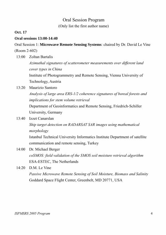
Oral Session Program (Only list the first author name)
Oct. 17 Oral sessions 13:00-14:40 Oral Session 1: Microwave Remote Sensing Systems: chaired by Dr. David Le Vine (Room 2-602) 13:00 Zoltan Bartalis
Azimuthal signatures of scatterometer measurements over different land cover types in China Institute of Photogrammetry and Remote Sensing, Vienna University of Technology, Austria
13:20 Maurizio Santoro Analysis of large area ERS-1/2 coherence signatures of boreal forests and implications for stem volume retrieval Department of Geoinformatics and Remote Sensing, Friedrich-Schiller University, Germany
13:40 Izzet Canarslan Ship target detection on RADARSAT SAR images using mathematical morphology Istanbul Technical University Informatics Institute Department of satellite communication and remote sensing, Turkey
14:00 Dr. Michael Berger coSMOS: field validation of the SMOS soil moisture retrieval algorithm ESA-ESTEC, The Netherlands
14:20 D.M. Le Vine Passive Microwave Remote Sensing of Soil Moisture, Biomass and Salinity Goddard Space Flight Center, Greenbelt, MD 20771, USA
ISPMSRS 2005 Program 5
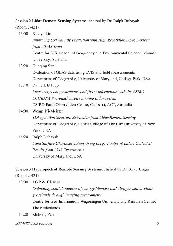
Session 2 Lidar Remote Sensing Systems: chaired by Dr. Ralph Dubayah (Room 2-421)
13:00 Xiaoye Liu Improving Soil Salinity Prediction with High Resolution DEM Derived from LiDAR Data Centre for GIS, School of Geography and Environmental Science, Monash University, Australia
13:20 Guoqing Sun Evaluation of GLAS data using LVIS and field measurements Department of Geography, University of Maryland, College Park, USA
13:40 David L B Jupp Measuring canopy structure and forest information with the CSIRO ECHIDNA™ ground based scanning Lidar system CSIRO Earth Observation Centre, Canberra, ACT, Australia
14:00 Wenge Ni-Meister 3DVegetation Structure Extraction from Lidar Remote Sensing Department of Geography, Hunter College of The City University of New York, USA
14:20 Ralph Dubayah Land Surface Characterization Using Large-Footprint Lidar: Collected Results from LVIS Experiments University of Maryland, USA
Session 3 Hyperspectral Remote Sensing Systems: chaired by Dr. Steve Ungar (Room 2-421)
13:00 J.G.P.W. Clevers Estimating spatial patterns of canopy biomass and nitrogen status within grasslands through imaging spectrometry Centre for Geo-Information, Wageningen University and Research Centre, The Netherlands
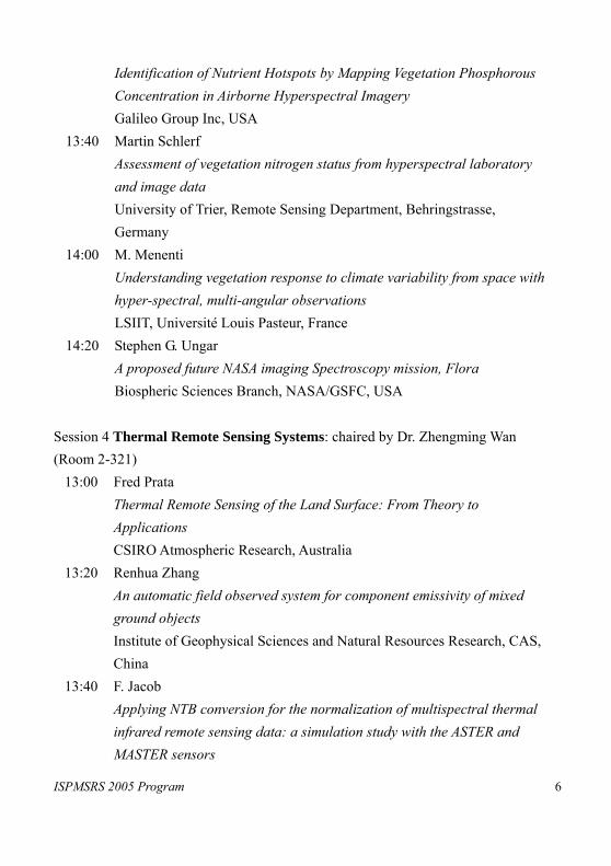
13:20 Zhihong Pan
ISPMSRS 2005 Program 6
Identification of Nutrient Hotspots by Mapping Vegetation Phosphorous Concentration in Airborne Hyperspectral Imagery Galileo Group Inc, USA
13:40 Martin Schlerf Assessment of vegetation nitrogen status from hyperspectral laboratory and image data University of Trier, Remote Sensing Department, Behringstrasse, Germany
14:00 M. Menenti Understanding vegetation response to climate variability from space with hyper-spectral, multi-angular observations LSIIT, Université Louis Pasteur, France
14:20 Stephen G. Ungar A proposed future NASA imaging Spectroscopy mission, Flora Biospheric Sciences Branch, NASA/GSFC, USA
Session 4 Thermal Remote Sensing Systems: chaired by Dr. Zhengming Wan (Room 2-321)
13:00 Fred Prata Thermal Remote Sensing of the Land Surface: From Theory to Applications CSIRO Atmospheric Research, Australia
13:20 Renhua Zhang An automatic field observed system for component emissivity of mixed ground objects Institute of Geophysical Sciences and Natural Resources Research, CAS, China
13:40 F. Jacob Applying NTB conversion for the normalization of multispectral thermal infrared remote sensing data: a simulation study with the ASTER and MASTER sensors
ISPMSRS 2005 Program 7
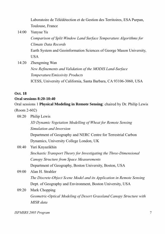
Laboratoire de Télédétection et de Gestion des Territoires, ESA Purpan, Toulouse, France
14:00 Yunyue Yu Comparison of Split Window Land Surface Temperature Algorithms for Climate Data Records Earth System and Geoinformation Sciences of George Mason University, USA
14:20 Zhengming Wan New Refinements and Validation of the MODIS Land-Surface Temperature/Emissivity Products ICESS, University of California, Santa Barbara, CA 93106-3060, USA
Oct. 18 Oral sessions 8:20-10:40 Oral sessions 1 Physical Modeling in Remote Sensing: chaired by Dr. Philip Lewis (Room 2-602)
08:20 Philip Lewis 3D Dynamic Vegetation Modelling of Wheat for Remote Sensing Simulation and Inversion Department of Geography and NERC Centre for Terrestrial Carbon Dynamics, University College London, UK
08:40 Yuri Knyazikhin Stochastic Transport Theory for Investigating the Three-Dimensional Canopy Structure from Space Measurements Department of Geography, Boston University, Boston, USA
09:00 Alan H. Strahler The Discrete-Object Scene Model and its Application in Remote Sensing Dept. of Geography and Environment, Boston University, USA
09:20 Mark Chopping Geometric-Optical Modeling of Desert Grassland Canopy Structure with MISR data

ISPMSRS 2005 Program 8
Department of Earth & Environmental Studies at Montclair State University, NJ, USA
09:40 Jean-Luc Widlowski Results from the third phase of RAMI Joint Research Centre, IES/GVM TP 440 Via E. Fermi, 1, 21020 Ispra (VA), Italy
10:00 Wout Verhoef Earth observation model sensitivity analysis to assess mission performances in terms of geo-biophysical variable retrieval accuracies National Aerospace Lab NLR, Netherlands
10:20 Wenhan Qin Retrieving Woody Vegetation Structural Parameters from LUTs Generated with a 3-D Scene Model SSAI and NASA Goddard Space Flight Center, USA
Oral sessions 2 Inversion of Biogeophysical Variables: chaired by Dr. Fred Baret (Room 2-521)
08:20 Ranga B. Myneni Global Products of Vegetation Leaf Area and Fraction Absorbed PAR from MODIS Sensors onboard NASA Terra and Aqua Satellites Department of Geography, Boston University, USA
08:40 C. Schaaf The Reprocessed Aqua/Terra MODIS BRDF/Albedo Product for use in Modeling Studies Department of Geography/Center for Remote Sensing, Boston University, USA
09:00 Xiaowen Li The Spectrum Knowledge Base of Typical Objects and Remote Sensing Inversion of Land Surfaces Parameters Beijing Normal University, China
09:20 Gladimir Baranoski

ISPMSRS 2005 Program 9
Computer Simulation of Biophysical Phenomena: Challenges, Pitfalls and Applications University of Waterloo, Canada
09:40 Zbynek Malenovsky Influence of forest canopy structure simulated using the Discrete Anisotropic Radiative Transfer (DART) model on the retrieval of spruce stand LAI Centre for Geo-Information, Wageningen University, The Netherlands
10:00 Linda Hunt Land Surface Remote Sensing Results from MISR NASA Langley Research Center, USA
10:20 Frédéric Baret The CYCLOPES LAI, fAPAR, fCover and albedo products derived from the VEGETATION, AVHRR and MERIS sensors: principles and evaluation using ground measurements and intercomparison with MODIS INRA, CSE, Avignon, France
Oral sessions 3 Image Classification Methods: chaired by Dr. Hosni Ghedira (Room 2-421)
08:20 Anthony, Gidudu Land Cover Mapping: Optimising SVM Classification University of Cape Town, School of Architecture, Planning and Geomatics, 7701, Rondebosch, Cape Town, South Africa
08:40 Peijun Li Multitemporal image classification by multichannel texture and Support Vector Machines (SVM) Institute of Remote Sensing and GIS, Peking University, China
09:00 Chih-Cheng Hung A Study on the Comparison of Unsupervised Training Algorithms Using Genetic Algorithms for Multispectral Image Classification Systems School of Computing and Software Engineering Southern Polytechnic
ISPMSRS 2005 Program 10
State University, Marietta, GA 30060, USA 09:20 Hosni Ghedira
Capabilities and Limitations of Neural Networks in Snow Cover Mapping from Passive Microwave Data NOAA-CREST, City University of New York, USA
09:40 Wanxiao Sun Improving plant functional types product from MODIS data using evidential reasoning methods Depart of Geography, Southern Illinois University, Carbondale, IL 62901-4514, USA
10:00 Svetlana Solodyankina Recognition of Vegetation Types in Space of Brightness Characteristics of Multi-band Remote Sensing Information Geography Institute Siberian Branch of Russian Academy of Science
10:20 Erxue CHEN Study on ENVISAT ASAR APS Data Processing and Classification for Rice Mapping Institute of Forest Resources Information Techniques, Chinese Academy of Forestry
Oral sessions 4 Data Processing Techniques: Dr. Vern Vanderbilt (Room 2-321)
08:20 V.C. Vanderbilt The Impact of Mismatched Pixel Sizes NASA Ames Space Flight Center, USA
08:40 Jianhong Guo Study of Multispectral Detecting Shadow Areas and A Theoretical Model of Removing Shadows from Remote Sensing Images International Institute for Earth System Science, Nanjing University, China
09:00 Ronggao Liu Mapping China Using MODIS Data: Method, Software and Data Products
ISPMSRS 2005 Program 11
IGSNRR, CAS, China 09:20 Yoshio Awaya
An analysis of inter-annual changes of PAL data after an empirical radiometric correction Forestry and Forest Products Research Institute, Japan
09:40 Sathit Intajag Speckle reduction using fuzzy morphological anisotropic diffusion King Mongkut’s Institute of Technology Ladkrabang Bangkok 10520, Thailand
10:00 Jiang Gengming Land surface temperature and emissivity retrieval from combined mid-infrared and thermal infrared data of MSG-SEVIRI TRIO/LSIIT/ENSPS, Université Louis Pasteur, France
10:20 Xiaoliang Lv Removal of noise by Wavelets method to generate the high-quality time series of terrestrial MODIS products IGSNRR, CAS, China
18th Afternoon Oral session 13:00-14:40 Oral sessions 1 Modeling and Inversion: chaired by Dr. John Martonchik (Room 2-602)
13:00 Feng Gao On the Blending of the Landsat and MODIS Surface Reflectance Earth Resources Technology, Inc., 8106 Stayton Drive, Jessup, MD 20794, USA
13:20 R. Fernandes Evaluation of stochastic radiative transfer and reflectance models of northern forest landscapes Canada Centre for Remote Sensing, Natural Resources, Canada

ISPMSRS 2005 Program 12
13:40 M. Disney A lumped parameter representation of spectral reflectance from leaf to canopy Department of Geography, University College London, UK
14:00 Li Jia Simulation of directional Thermal Infrared radiance images using Soil-Vegetation-Atmosphere Transfer mode and radiative transfer models Centre for Geo-Information, Alterra, Wageningen University and Research Centre, Wageningen, The Netherlands
14:20 John Martonchik Use of Multiangle Satellite Observations To Retrieve Aerosol Properties and Ocean Color Jet Propulsion Laboratory, USA
Oral sessions 2 Data Assimilation Methods: chaired by Dr. John van Genderen (Room 2-521)
13:00 Chunlin Huang Experiments of soil moisture data assimilation system based on ensemble Kalman filter Cold and Arid Regions Environmental and Engineering Research Institute, CAS, China
13:20 T. Quaife Assimilating Earth Observation Data into a Vegetation Model using an Ensemble Kalman Filter. Centre for Terrestrial Carbon Dynamics, and University College London, UK
13:40 B. Coudert Dynamic SVAT model calibration process based on thermal infrared brightness temperature data Centre d’étude des Environnements Terrestres et Planétaires (CETP/IPSL), Vélizy, France

ISPMSRS 2005 Program 13
14:00 Claire Lauvernet Improved estimates of vegetation biophysical variables from MERIS TOA images by using spatial and temporal constraints INRA-CSE, Site Agroparc, Avignon, France
14:20 Shunlin Liang An advanced method for improving estimation of land surface variables from satellite observations: data assimilation Department of Geography, University of Maryland, USA
Oral sessions 3 Land Cover and Land Use Mapping: chaired by Dr. Nina Lam (Room 2-421)
13:00 Nina S. Lam A Spatial Metric for Land Cover Identification and Change Detection Department of Geography & Anthropology, Louisiana State University, USA
13:20 Raul Zurita Milla Enhanced sub-pixel land cover mapping through an effective integration of the spatial, spectral and temporal dimensions of MERIS imagery Wageningen UR. Centre for Geo-Information, The Netherlands
13:40 Charles N. Mundia Urban Growth in Africa’s Major Cities: Land Use/Cover Changes and Modelling Urban Growth in Nairobi, Kenya Graduate school of Life and Environmental Sciences, University of Tsukuba, Japan
14:00 P. Rowhani Land-cover change and vegetation dynamics across Africa and Europe University of Louvain, Department of Geography, Belgium
14:20 Ryotaro Komura Detection and Delineation of Killed Tree Crowns of Japanese Oak Wilt (JOW) using IKONOS Imagery Ishikawa National College of Technology, JAPAN
ISPMSRS 2005 Program 14
Oral sessions 4 Calibration and Validation: chaired by Dr. Andres Kuusk (Room 2-321)
13:00 Y. Govaerts Operational vicarious calibration of MFG/MVIRI and MSG/SEVIRI solar channels Eumetsat, Darmstadt, Germany
13:20 Hiroshi Watanabe Geometric and radiometric calibration and validation of ASTER data Earth Remote Sensing Data Analysis Center, JAPAN
13:40 A. Lyapustin, Y. Wang and B. Holben The EOS validation dataset of surface reflectance NASA Goddard Space Flight Center, USA
14:00 A. Kuusk Validation of the forest radiative transfer model Tartu Observatory, Estonia
14:20 J. R. Dim Validation and Parametization of Cloud Radiation Fields from satellite retrievals Center for Environmental Remote Sensing, Chiba University, JAPAN
19th Morning Oral sessions 8:20-10:40 Oral sessions 1. Estimation of Evapotranspiration and surface BRDF: chaired by Ruenhua Zhang (Room 2-602)
08:20 Hongjing Yu A Simple Method for Estimation of Evapotranspiration Using Remotely Sensed Data College of Resources Science & Technology, Beijing Normal University, China
08:40 Z.G. Sun
ISPMSRS 2005 Program 15
A Simple Remote Sensing Evapotranspiration Model based on Energy Balance and Aerodynamics (Sim-RESET) Graduate School of Life and Environmental Science, University of Tsukuba, Tsukuba, 305-8571, Japan
09:00 Joshua B. Fisher New Global Estimates of the Land-Atmosphere Water Flux: A Fully Remote Sensing Driven, Flux Site-Validated Ecophysiological Model of Evapotranspiration University of California at Berkeley, USA
09:20 B. Koetz, M. Kneubühler, J.-L. Widlowski, F. Morsdorf, M. Schaepman and K. Itten Assessment of Canopy Structure and Heterogeneity from Multi-angular CHRIS-PROBA Data Remote Sensing Laboratories (RSL), Dept. of Geography, University of Zurich, Switzerland
09:40 Charles Gatebe Airborne Spectral Measurements of Surface-Atmosphere Anisotropy for Several Surfaces and Ecosystems NASA Goddard Space Flight Center, USA
10:00 Karen Anderson The dynamic nature of the calibration surfaces: Quantitative models for describing varibility of field-measured reflectance factors Department of Geography, University of Exeter, UK
10:20 Cédric Bacour Determination of Standard Biome Directional Signatures for Reflectance Normalization Issues Laboratoire des Sciences du Climat et de l'Environnement, Commissariat à l'Energie Atomique, France
ISPMSRS 2005 Program 16
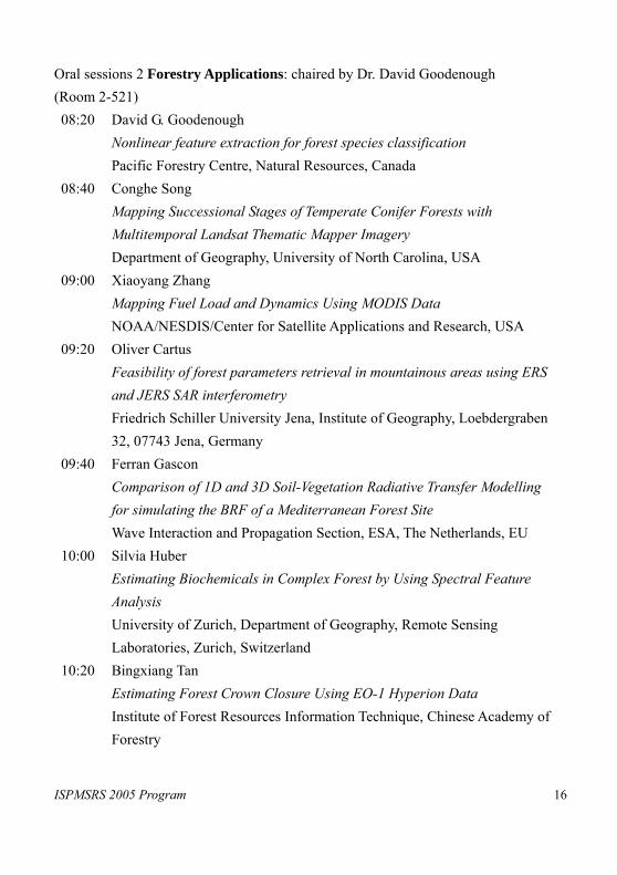
Oral sessions 2 Forestry Applications: chaired by Dr. David Goodenough (Room 2-521) 08:20 David G. Goodenough
Nonlinear feature extraction for forest species classification Pacific Forestry Centre, Natural Resources, Canada
08:40 Conghe Song Mapping Successional Stages of Temperate Conifer Forests with Multitemporal Landsat Thematic Mapper Imagery Department of Geography, University of North Carolina, USA
09:00 Xiaoyang Zhang Mapping Fuel Load and Dynamics Using MODIS Data NOAA/NESDIS/Center for Satellite Applications and Research, USA
09:20 Oliver Cartus Feasibility of forest parameters retrieval in mountainous areas using ERS and JERS SAR interferometry Friedrich Schiller University Jena, Institute of Geography, Loebdergraben 32, 07743 Jena, Germany
09:40 Ferran Gascon Comparison of 1D and 3D Soil-Vegetation Radiative Transfer Modelling for simulating the BRF of a Mediterranean Forest Site Wave Interaction and Propagation Section, ESA, The Netherlands, EU
10:00 Silvia Huber Estimating Biochemicals in Complex Forest by Using Spectral Feature Analysis University of Zurich, Department of Geography, Remote Sensing Laboratories, Zurich, Switzerland
10:20 Bingxiang Tan Estimating Forest Crown Closure Using EO-1 Hyperion Data Institute of Forest Resources Information Technique, Chinese Academy of Forestry

ISPMSRS 2005 Program 17
Oral sessions 3 Environmental Change Detection: chaired by Dr. Yifang Ban (Room 2-421) 08:20 Yifang Ban
ENVISAT ASAR for Land Cover Mapping and Change Detection in the Rural-Urban Fringe of the Greater Toronto Area Department of Infrastructure, Royal Institute of Technology, Sweden
08:40 Masayuki Matsuoka Detection of the land cover change in large irrigated districts in the Yellow River basin, China using Landsat and AVHRR data Research Institute for Humanity and Nature, Japan
09:00 T. Bailloeul Urban building land use change mapping from high resolution satellite imagery, active contours and Hough voting LIAMA, Institute of Automation, Chinese Academy of Sciences, China
09:20 Yunpeng Wang Land use change detection in Pearl River Delta Area from 1998 to 2003 using Landsat TM/ETM+ data: Change magnitude, spatial pattern and socio-economic implications Guangzhou Institute of Geochemistry, Chinese Academy of Sciences, China
09:40 Maria Cecilia D. Rubio, Enrico C. Paringit, Kazuo Nadaoka, Ariel C. Blanco Connectivity and impact assessment of land use/cover and benthic cover change by advance remote sensing analysis
10:00 Takashi Kusaka A method for estimating optical properties of the Asian dust in the air and ground reflectance from satellite data Kanazawa Institute of Technology, Japan
10:20 I.N. Vladimirov Mapping of the recovery-age dynamics of taiga forests using remotely sensed data, geographic knowledge, and mathematical models
ISPMSRS 2005 Program 18
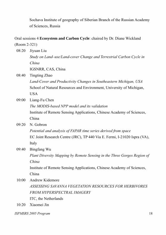
Sochava Institute of geography of Siberian Branch of the Russian Academy of Sciences, Russia
Oral sessions 4 Ecosystem and Carbon Cycle: chaired by Dr. Diane Wickland (Room 2-321) 08:20 Jiyuan Liu
Study on Land–use/Land-cover Change and Terrestrial Carbon Cycle in China IGSNRR, CAS, China
08:40 Tingting Zhao Land-Cover and Productivity Changes in Southeastern Michigan, USA School of Natural Resources and Environment, University of Michigan, USA
09:00 Liang-Fu Chen The MODIS-based NPP model and its validation Institute of Remote Sensing Applications, Chinese Academy of Sciences, China
09:20 N. Gobron Potential and analysis of FAPAR time series derived from space EC Joint Research Centre (JRC), TP 440 Via E. Fermi, I-21020 Ispra (VA), Italy
09:40 Bingfang Wu Plant Diversity Mapping by Remote Sensing in the Three Gorges Region of China Institute of Remote Sensing Applications, Chinese Academy of Sciences, China
10:00 Andrew Kidemore ASSESSING SAVANNA VEGETATION RESOURCES FOR HERBIVORES FROM HYPERSPECTRAL IMAGERY ITC, the Netherlands
10:20 Xiaomei Jin
ISPMSRS 2005 Program 19
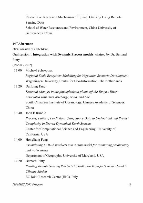
Research on Recession Mechanism of Ejinaqi Oasis by Using Remote Sensing Data School of Water Resources and Environment, China University of Geosciences, China
19th Afternoon Oral session 13:00-14:40 Oral session 1 Integration with Dynamic Process models: chaired by Dr. Bernard Pinty (Room 2-602) 13:00 Michael Schaepman
Regional Scale Ecosystem Modelling for Vegetation Scenario Development Wageningen University, Centre for Geo-Information, The Netherlands
13:20 DanLing Tang Seasonal changes in the phytoplankton plume off the Yangtze River associated with river discharge, wind, and tide South China Sea Institute of Oceanology, Chinese Academy of Sciences, China
13:40 John B Rundle Process, Pattern, Prediction: Using Space Data to Understand and Predict Complexity in Driven Dynamical Earth Systems Center for Computational Science and Engineering, University of California, USA
14:00 Hongliang Fang Assimilating MODIS products into a crop model for estimating productivity and water usage Department of Geography, University of Maryland, USA
14:20 Bernard Pinty Relating Remote Sensing Products to Radiation Transfer Schemes Used in Climate Models EC Joint Research Centre (JRC), Italy
ISPMSRS 2005 Program 20
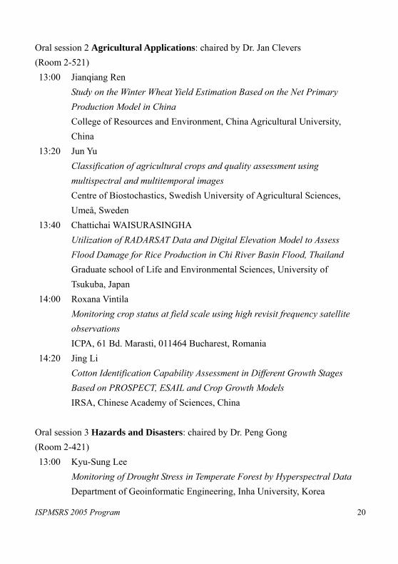
Oral session 2 Agricultural Applications: chaired by Dr. Jan Clevers (Room 2-521) 13:00 Jianqiang Ren
Study on the Winter Wheat Yield Estimation Based on the Net Primary Production Model in China College of Resources and Environment, China Agricultural University, China
13:20 Jun Yu Classification of agricultural crops and quality assessment using multispectral and multitemporal images Centre of Biostochastics, Swedish University of Agricultural Sciences, Umeå, Sweden
13:40 Chattichai WAISURASINGHA Utilization of RADARSAT Data and Digital Elevation Model to Assess Flood Damage for Rice Production in Chi River Basin Flood, Thailand Graduate school of Life and Environmental Sciences, University of Tsukuba, Japan
14:00 Roxana Vintila Monitoring crop status at field scale using high revisit frequency satellite observations ICPA, 61 Bd. Marasti, 011464 Bucharest, Romania
14:20 Jing Li Cotton Identification Capability Assessment in Different Growth Stages Based on PROSPECT, ESAIL and Crop Growth Models IRSA, Chinese Academy of Sciences, China
Oral session 3 Hazards and Disasters: chaired by Dr. Peng Gong (Room 2-421) 13:00 Kyu-Sung Lee
Monitoring of Drought Stress in Temperate Forest by Hyperspectral Data Department of Geoinformatic Engineering, Inha University, Korea
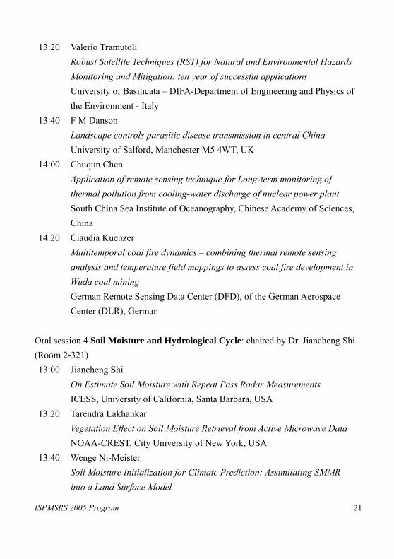
ISPMSRS 2005 Program 21
13:20 Valerio Tramutoli Robust Satellite Techniques (RST) for Natural and Environmental Hazards Monitoring and Mitigation: ten year of successful applications University of Basilicata – DIFA-Department of Engineering and Physics of the Environment - Italy
13:40 F M Danson Landscape controls parasitic disease transmission in central China University of Salford, Manchester M5 4WT, UK
14:00 Chuqun Chen Application of remote sensing technique for Long-term monitoring of thermal pollution from cooling-water discharge of nuclear power plant South China Sea Institute of Oceanography, Chinese Academy of Sciences, China
14:20 Claudia Kuenzer Multitemporal coal fire dynamics – combining thermal remote sensing analysis and temperature field mappings to assess coal fire development in Wuda coal mining German Remote Sensing Data Center (DFD), of the German Aerospace Center (DLR), German
Oral session 4 Soil Moisture and Hydrological Cycle: chaired by Dr. Jiancheng Shi (Room 2-321) 13:00 Jiancheng Shi
On Estimate Soil Moisture with Repeat Pass Radar Measurements ICESS, University of California, Santa Barbara, USA
13:20 Tarendra Lakhankar Vegetation Effect on Soil Moisture Retrieval from Active Microwave Data NOAA-CREST, City University of New York, USA
13:40 Wenge Ni-Meister Soil Moisture Initialization for Climate Prediction: Assimilating SMMR into a Land Surface Model

ISPMSRS 2005 Program 22
Department of Geography, Hunter College of The City University of New York, USA
14:00 C. Notarnicola Laboratory measurements of soil moisture affected by hydrocarbons contamination in the microwave domain Politecnico di Bari Via Amendola, Italy
14:20 Thomas J. Jackson Validation of Satellite Based Soil Moisture Algorithms USDA ARS Hydrology and Remote Sensing Lab, USA
ISPMSRS 2005 Program 23
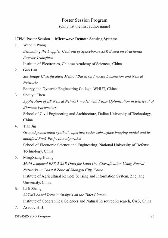
Poster Session Program (Only list the first author name)
17PM: Poster Session 1. Microwave Remote Sensing Systems 1. Wenqin Wang
Estimating the Doppler Centroid of Spaceborne SAR Based on Fractional Fourier Transform Institute of Electronics, Chinese Academy of Sciences, China
2. Gao Lan Sar Image Classification Method Based on Fractal Dimension and Neural Networks Energy and Dynamic Engineering College, WHUT, China
3. Shouyu Chen Application of BP Neural Network model with Fuzzy Optimization in Retrieval of Biomass Parameters School of Civil Engineering and Architecture, Dalian University of Technology, China
4. Tian Jin Ground penetration synthetic aperture radar subsurface imaging model and its modified Back-Projection algorithm School of Electronic Science and Engineering, National University of Defense Technology, China
5. MingXiang Huang Multi-temporal ERS-2 SAR Data for Land Use Classification Using Neural Networks in Coastal Zone of Shangyu City, China Institute of Agricultural Remote Sensing and Information System, Zhejiang University, China
6. Li-li Zhang SRTM3 based Terrain Analysis on the Tibet Plateau Institute of Geographical Sciences and Natural Resource Research, CAS, China
7. Asadov H.H.
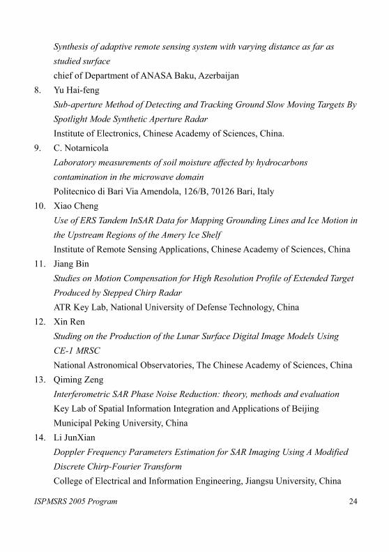
ISPMSRS 2005 Program 24
Synthesis of adaptive remote sensing system with varying distance as far as studied surface chief of Department of ANASA Baku, Azerbaijan
8. Yu Hai-feng Sub-aperture Method of Detecting and Tracking Ground Slow Moving Targets By Spotlight Mode Synthetic Aperture Radar Institute of Electronics, Chinese Academy of Sciences, China.
9. C. Notarnicola Laboratory measurements of soil moisture affected by hydrocarbons contamination in the microwave domain Politecnico di Bari Via Amendola, 126/B, 70126 Bari, Italy
10. Xiao Cheng Use of ERS Tandem InSAR Data for Mapping Grounding Lines and Ice Motion in the Upstream Regions of the Amery Ice Shelf Institute of Remote Sensing Applications, Chinese Academy of Sciences, China
11. Jiang Bin Studies on Motion Compensation for High Resolution Profile of Extended Target Produced by Stepped Chirp Radar ATR Key Lab, National University of Defense Technology, China
12. Xin Ren Studing on the Production of the Lunar Surface Digital Image Models Using CE-1 MRSC National Astronomical Observatories, The Chinese Academy of Sciences, China
13. Qiming Zeng Interferometric SAR Phase Noise Reduction: theory, methods and evaluation Key Lab of Spatial Information Integration and Applications of Beijing Municipal Peking University, China
14. Li JunXian Doppler Frequency Parameters Estimation for SAR Imaging Using A Modified Discrete Chirp-Fourier Transform College of Electrical and Information Engineering, Jiangsu University, China
ISPMSRS 2005 Program 25
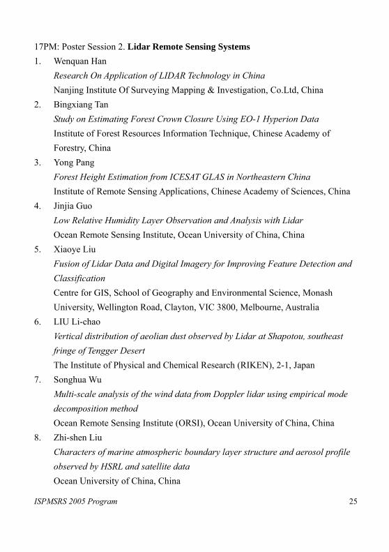
17PM: Poster Session 2. Lidar Remote Sensing Systems 1. Wenquan Han
Research On Application of LIDAR Technology in China Nanjing Institute Of Surveying Mapping & Investigation, Co.Ltd, China
2. Bingxiang Tan Study on Estimating Forest Crown Closure Using EO-1 Hyperion Data Institute of Forest Resources Information Technique, Chinese Academy of Forestry, China
3. Yong Pang Forest Height Estimation from ICESAT GLAS in Northeastern China Institute of Remote Sensing Applications, Chinese Academy of Sciences, China
4. Jinjia Guo Low Relative Humidity Layer Observation and Analysis with Lidar Ocean Remote Sensing Institute, Ocean University of China, China
5. Xiaoye Liu Fusion of Lidar Data and Digital Imagery for Improving Feature Detection and Classification Centre for GIS, School of Geography and Environmental Science, Monash University, Wellington Road, Clayton, VIC 3800, Melbourne, Australia
6. LIU Li-chao Vertical distribution of aeolian dust observed by Lidar at Shapotou, southeast fringe of Tengger Desert The Institute of Physical and Chemical Research (RIKEN), 2-1, Japan
7. Songhua Wu Multi-scale analysis of the wind data from Doppler lidar using empirical mode decomposition method Ocean Remote Sensing Institute (ORSI), Ocean University of China, China
8. Zhi-shen Liu Characters of marine atmospheric boundary layer structure and aerosol profile observed by HSRL and satellite data Ocean University of China, China

ISPMSRS 2005 Program 26
9. XianFeng Huang Curve Footprint Building Extraction from Airborne Laser Scanning Data State Key Laboratory of Information Engineering in Surveying, Mapping and Remote Sensing, Wuhan University, China
10. XianFeng Huang Experimental Comparison of Extraction Algorithms for Lines and Planar Patch from Airborne Laser Scanning Data State Key Laboratory of Information Engineering in Surveying, Mapping and Remote Sensing, Wuhan University, China
17PM: Poster Session 3. Hyperspectral Remote Sensing Systems 1. Ning Lu
Hyperspectral data recognition and mapping of soil salinization in arid environments China University of Geosciences, China
2. Barat. Mojaradia Hyperspectral Data analysis and supervised feature extraction based on angular criterion Faculty of Geodesy and Geomatics Eng., KN Toosi University of Technology, Iran
3. Duan Hongtao The Application of Hyperspectral Data in Monitoring the Water Trophic State of Nanhu lake, China Northeast Institute of Geography and Agricultural Ecology, CAS, China
4. Yuchun Wei The hyperspectral data monitoring model of Chla in summer, Taihu Lake, China Pivot Lab of Geographic Information Science in Jiangsu Province, Nanjing Normal University, China
5. DU Peijun Multi-scale analysis of spectral vector in hyperspectral RS data Department of RS and GISCi, China University of Mining and Technology,
ISPMSRS 2005 Program 27
China 6. Peijun Du
Hyperspectral RS image classification based on Support Vector Machine (SVM) Department of RS and GISCi, China University of Mining and Technology, China
7. A.K. Skidmore ASSESSING SAVANNA VEGETATION RESOURCES FOR HERBIVORES FROM HYPERSPECTRAL IMAGERY ITC, PO Box 6, 7500 AA Enschede, The Netherlands
8. Zongming Wang Study on Hyperstectral Remote Sensing Estimation Model for the Corn LAI with Canopy Reflectance Northeast Institute of Geography and Agricultural Ecology, China
9. Heike Bach Analyses of hyperspectral and directional CHRIS data for monitoring of agricultural crops using the canopy reflectance model SLC VISTA GmbH, Germany
10. CHEN Gui-hong Texture Analysis of Hyperspectral Image --Based on HyMap Data of Barrax in Spanish Beijing Information Resources Management Center, China
11. Yan SHEN Analysis of dry-leaf biochemistry based on the hyperspectral position variables normalized by the corresponding area College of Meteorology, Nanjing University of Information Science & Technology, China
12. B. Koetz Assessment of canopy structure and heterogeneity from mulit-angular CHRIS-PROBA data Remote Sensing Laboratories (RSL), Dept. of Geography, University of Zurich, Winterthurerstrasse 190, CH-8057 Zurich, Switzerland
ISPMSRS 2005 Program 28
13. B. Koetz Inversion of combined Radiative Transfer Models for Imaging Spectrometer and LIDAR Data Remote Sensing Laboratories (RSL), Dept. of Geography, University of Zurich, Winterthurerstrasse 190, CH-8057 Zurich, Switzerland
14. Yongchao ZHAO Rocks/Minerals Information Extraction of Mount ISA in Northern Australia by Using the Hyperspectral Data of HYMAP Institute of Remote Sensing Applications, Chinese Academy of Sciences, China
15. Y.Maghsoudi Using a Weighted Random Subspace Method to Improve the Classification Accuracy of Hyperspectral Images Faculty of Geodesy and Geomatics Eng., KN Toosi University of Technology, Iran
16. Chen Zhongxin Farm Weeds Identification with Hyperspectral Spectroscopy Key Laboratory of Resources Remote Sensing & Digital Agriculture, Ministry of Agriculture, China
17. Shudong Wang A simple method for spectral unmixingof three mixed objects with Hyperspectral technique Center for Remote Sensing and GIS, Beijing Normal University, China
18. Shudong Wang Changes of “red edge” and its related parameters of the various leaves with losing of water Center for Remote Sensing and GIS, Beijing Normal University, China
19. Jin Chen Biological soil crust detection in desert based on EO-1 Hyperion data College of Resource Science and Technology, Beijing Normal University, China
17PM: Poster Session 4. Thermal Remote Sensing Systems
ISPMSRS 2005 Program 29
1. Alavi panah S. K. Study of temperature range and and daily cycles in desert using field measurements and interpretation of TM and ETM+ thermal data College of Geography, Dept. of Cartography, University of Tehran, Iran.
2. Bokun Yan Correlation between SiO2 content of Si-containing minerals and thermal infrared emissivity spectral features China University of Geosciences, China
3. Renzong Ruan Identification of Inland Fresh Water Wetland Using SAR and ETM+ Data Department of Urban and Resources Sciences, Nanjing University, China
4. Kebiao Mao An Advanced and Optimized Split-Window Algorithm for Retrieving Land-Surface Temperature from ASTER Data Institute of Remote Sensing Applications, CAS, China
5. Junichi Susaki Comparison of Estimators of BRDF Model Parameters using Limited Number of Observations Institute of Industrial Science, University of Tokyo, Japan
6. Junichi Susaki Comparison between broadband albedos converted by Liang model and MODIS albedo products Institute of Industrial Science, University of Tokyo, Japan
7. Gengming JIANG Land surface temperature and emissivity retrieval from combined mid-infrared and thermal infrared data of MSG-SEVIRI TRIO/LSIIT/ENSPS, Bld Sebastein Brant, BP10413, 67412 Illkirch, France
8. Kaicun Wang Global land surface broadband emissivity from Terra/Aqua MODIS LAGEO, Institute of Atmospheric Science, Chinese Academy of Sciences, China
9. Ji Liang
ISPMSRS 2005 Program 30
The Comparison of Methods for Retrieving the Land Surface Temperature from LANDSAT 7 Third Institute of Oceanography, State Oceanic Administration, China
10. Maofang Gao Validation of the Chinese land surface temperature products retrieved from Moderate Resolution Imaging Spectroradiometer data International Institute for Earth System Science, Nanjing University, China
11. Xinjian Shan Satellite thermal infrared observation and analysis on alternate activity of different segments of seismogenic fault State Key Laboratory of Earthquake Dynamics, Institute of Geology, China Earthquake Administration, China
12. Wanchang Zhang Mono-window Algorithm-Based for Derivation of Land Surface Net Long-wave Radiation in Mountainous Area START Regional Center for Temperate East Asia, Institute of Atmospheric Physics, Chinese Academy of Sciences, China
13. M. Romaguera Surface temperature estimation from Meteosat-8/SEVIRI data: Algorithms and validation University of València, Spain
14. Yongming Du A study on directional surface brightness temperature over a wheat canopy in row structure : seasonal variations and model validation Institute of Remote Sensing Applications, Chinese Academy of Sciences, China
15. Jian Li Land Surface Temperature Retrieval for the Region of Changbai Mountain Based on Landsat 7 ETM+ Thermal Infrared Data and Meteorological Data Department of Remote Sensing and GIS, Jilin University, China
16. Gong A-du Temporal and Spatial Distribution Characteristics of the Summertime Urban
ISPMSRS 2005 Program 31
Heat Island in Beijing, China Institute of Resources Engineering and Technology, College of Resources Science & Technology, Beijing Normal University, China
18AM: Poster sessions 1 Physical Modeling in Remote Sensing 1. Zhenhua Liu
The Research on Thermal Inertial Model South China Agricultural University, China
2. Yan SHEN Simulation Research in A Two-layer Canopy Reflectance Model Institute of Remote Sensing Applications, Chinese Academy of Sciences, China
3. Wenjie Zhao CA to Simulate the Agro_landscape at DEHUI County Supported by RS and GIS The Aeronautical Aviation University, China
4. Zhifeng Guo The Effect of Birch Stand Structure on Radar Backscattering Using Model Analysis Institute of Remote Sensing Applications, Chinese Academy of Sciences, China
5. Lisa-Maria Rebelo A comparison of two temporal BRDF models with application to the identification of fire affected areas Department of Geography, University College London, 26 Bedford Way, WC1H 0AP, UK
6. Donghui Xie Studying Bidirectional Reflectance and NDVI of Heterogeneous Scenes Based on Radiosity-combined Graphic Model Research Center for Remote Sensing and GIS, School of Geography, Beijing Normal University, Beijing, China
7. Jean-Luc Widlowski The impact of horizontal fluxes on the radiative properties of forest canopies observed at different spatial resolutions

ISPMSRS 2005 Program 32
Joint Research Centre, IES/GVM TP 440 Via E. Fermi, 1, 21020 Ispra (VA), Italy 8. N. Rochdia
How does shoot structure influence canopy BRDF? Canada Centre for Remote Sensing, Natural Resources, Canada
9. Yong TANG A Study on the Transition of Reflectance Models about Homogeneous Crop Canopy and Row-Plant Crop Canopy Institute of Remote Sensing Applications, CAS, China
10. Wen Yang Vector Radiative Transfer Model based on Adding-Doubling Method with Application to Passive Microwave Remote Sensing of Snow Cold and Arid Environment and Engineering Research Institute, CAS, Lanzhou, China
11. Tian Xiang Yue HPSM Based Imagery Geometric Model Institute of Geographical Sciences and Natural Resources Research, Chinese Academy of Sciences, China
12. Yuli Shi Surface Component Temperatures Inversion Using Dual-angle Observations of Directional Radiometric Temperature Institute of Remote Sensing Applications, CAS, China
13. Dong Yanfang A C-band microwave radar backscattering model and monitoring for corn Institute of Remote Sensing Applications, Chinese Academy of Sciences, China
14. Jinyang Du Evaluating Shape Effects on Backscattering by A Second-order Snow Model The Institute of Remote Sensing Applications, Chinese Academy of Sciences, China
15. Jinling Song Computer Simulation of Radiation Regime for Vegetation Canopies Research Center for Remote Sensing and GIS, School of Geography, Beijing

ISPMSRS 2005 Program 33
Normal University, China 16. Hua Xu
Remote Sensing Image Processing System on CBERS Institute of Remote Sensing Applications Chinese Academy of Sciences, China
18AM: Poster sessions 2 Inversion of Biogeophysical Variables 1. Chunlin Huang
Retrieving Leaf Area Index with a canopy reflectance model by using simulated annealing algorithm Cold and Arid Regions Environmental and Engineering Research Institute, CAS, China
2. Y. Govaerts Deriving surface albedo maps from archived Geostationary observations Eumetsat, Darmstadt, Germany
3. Kaishan Song Corn Chlorophyll Content Estimation from Reflectance Spectra Data with Wavelet Transformation and ANN-BP Algorithm Northeast Institute of Geography and Agricultural Ecology, Changchun, 130012, China
4. E. J. Fillol Extraction of the phenological signal per plant functional type from medium resolution observations INRA-CSE, Site Agroparc, 84914 Avignon, Cedex 9, France
5. Cédric Bacour Determination of Standard Biome Directional Signatures for Reflectance Normalization Issues Laboratoire des Sciences du Climat et de l'Environnement, Commissariat à l'Energie Atomique, Gif-sur-Yvette, France
6. Argentina NERTAN Estimation of vegetation parameters using SAIL+PROSPECT model National Romanian Meteorological Administration, Romanian
ISPMSRS 2005 Program 34
7. Bernard Pinty MODIS/Meteosat/MISR Surface Albedo Comparison Results EC Joint Research Centre (JRC), TP 440 Via E. Fermi, I-21020 Ispra (VA), Italy
8. Yinhong LI A prior knowledge accumulation using T method Department of Mathematics, Beijing Normal University, China
9. Hongxia Cui The Inversion of Albedo using EM algorithm based on the assumption of student-t observations error distribution Research Center for Remote Sensing and GIS, School of Geography, Beijing Normal University, China
10. Jiannan Hu Global Leaf Area Index and Fraction Vegetation Absorbed PAR Products from the MISR Sensor Yuri Knyazikhin, Department of Geography, Boston University, USA
11. Tang Yi Estimating LAI using EVI based on canopy radiative transfer model National Engineering Research Center for Information Technology in Agriculture, China
12. Guangjian Yan Leaf Area Index Retrieval from Airborne Multianglular Images Using a Priori Knowledge Given by Vegetation Index Research Center for Remote Sensing and GIS School of Geography, Beijing Normal Univ., China
13. Lei Yang Evaluation of cloudless Land PAR using MODIS in Jiangxi Province, China State Key Laboratory of Remote Sensing Science, CAS, China
14. Xuehong zhang The Anisotropic Characteristics Analysis of Bidirectional Reflectance and Red Edge Parameters for Winter Wheat and Summer Maize Canopy State key Laboratory of Remote Sensing Science School of Geography, Beijing
ISPMSRS 2005 Program 35
Normal University, China 15. Abduwasit Ghulam
Albedo variation and its effects on surface biophysical and climate factors Institute of RS & GIS, Peking University, China
16. Runhe Shi Estimation of Optimal Mesophyll Structure Parameter of Rice Leaves Institute of Geographical Sciences and Natural Resources Research, Chinese Academy of Sciences
17. Liu Sanchao Determination of Surface Reflectance and Albedo by Integration of ETM+ data and DEM in Heihe Rvier Basin Institute of Remote Sensing Applications, Chinese Academy Sciences, China
18. Lihong Su Recognition of Semi-Arid Vegetation Types Based on MISR Multi-Angular Observations and Surface Anisotropy Patterns Inversed by Bidirectional Reflectance Models Department of Earth & Environmental Studies at Montclair State University, NJ, USA
19. Ronggao Liu Mapping PAR using MODIS data in China IGSNRR, CAS, China
20. Zbyněk Malenovský Influence of forest canopy structure simulated using the Discrete Anisotropic Radiative Transfer (DART) model on the retrieval of spruce stand LAI Centre for Geo-Information, Wageningen University, The Netherlands
18AM: Poster sessions 3 Image Classification Methods 1. Zhang Xiao-mei
The discussion of Knowledge-Based Classification of Remote Sensing Data Using Spatial Data Mining Approach China Remote Sensing Satellite Ground Station, Chinese Academy of Sciences,

ISPMSRS 2005 Program 36
China 2. Hong Tang
Spectral Similarity Analysis Based on Algorithms for Manifold Learning Institute of Image Processing and Pattern Recognition, Shanghai Jiao Tong University, Shanghai 200030, P.R. China
3. Bertels Luc Optimized Spectral Angle Mapper classification of spatially heterogeneous dynamic dune vegetation, a case study along the Belgian coastline Flemish Institute for Technological Research, Remote Sensing and Earth Observation Processes, Boeretang 200, B-2400 Mol, Belgium
4. Kai Liu A knowledge-based system for classifying wetland types using ENVISAT SAR and Landsat TM data Guangzhou Institute of Geochemistry, CAS, Guangzhou 510640, China
5. Xiaotao Li Application Research on Remote Sensing Image Classification Based on Variogram and ANN Remote Sensing Application Technology Center, China Institute of Water Resources and Hydropower Research, China
6. Binbin He Uncertainty Measurement and Representation of Classification at Pixel Scale of Multi-spectrum Remote Sense Images College of Automatic Engineering, University of Electronic Science and Technology of China, China
7. Chaoyang Li Tree Crown Segmentation in Aerial Images by Multiscale Weight Aggregation Based on the DSM Laboratory of Pattern Recognition and Intelligent System, School of Information Engineering Beijing University of Posts and Telecommunications, China
8. Jian YANG Polarimetric SAR Image Classification by Using Generalized Optimization of
ISPMSRS 2005 Program 37
Polarimetric Contrast Enhancement References Department of Electronic Engineering, Tsinghua University, China
9. S. M. Shahrokhy SHADOWED FEATURE CLASSIFICATION IN HYPERSPECTRAL IMAGES Remote sensing division, Surveying engineering department, University of Tehran, Tehran, Iran
10. Gao Lan Approach of SAR Image classification Based on Wavelet Transform and FCM Energy and Dynamic Engineering College, WHUT, China
11. She xiangyang The remote image classification research based on mines classification rules on the spatial database College of Automation, Northwest Polytechnic University, Xi’an, 710072, China
12. Jia Tianxia Remote Sensing Image Classification Based on Fuzzy Clustering --- Qinghai Lake as an Example Department of Urban and Resource Science, Nanjing University, China
13. Zhigang Liu Remote Sensing Spectral Reflectance for Coral Reef Habitats Discrimination Beijing Normal University, China
18AM: Poster sessions 4 Data Processing Techniques 1. Kang Jia-yin
QuickBird Pixel Level Image Fusion between Panchromatic Image and Multispectral Image Based on Wavelet Packet Transform School of Information Engineering, University of Science and Technology Beijing
2. Yong-gang Shi Cauchy-Schwarz divergence based registration of multisensor remote sensing images School of Information Science and Technology, Beijing Institute of Technology,

ISPMSRS 2005 Program 38
China 3. Weizhou Zhao
Study on the Method of Threshold Segmentation Based on the Ambiguity Institute of Information Engineering of the Second Artillery Engineering Institute,Xi'an, China, 710025
4. Wei Hu Study on Imaging and Combining of ScanSAR with Modified SPECAN Algorithm Department of Information Engineering, Beijing University of Chemical Technology, China
5. Chen Gang Cloud and Ice-snow Area Detection Based on SVM in Antarctica Chinese Antarctic Center of Surveying and Mapping, Wuhan University, China
6. Rongbing Gan Contrast optimization-based deconvolution in SAR image restoration 701-4, College of Electronic Engineering, UESTC, Chengdu, 610054, China
7. Weizhou Zhao Study on the Filtering Algorithm Based on Fuzzy Theory in SAR Image Institute of Information Engineering of the Second Artillery Engineering Institute,Xi'an, China, 710025
8. Nan Sun An Extension of Structure Detection and Adapative Speckle Filtering in Multilook Polarimetric SAR Images Institute of Electronics, Chinese Academy of Sciences, China
9. Geng xiurui A new spectral endmember extraction method in hyperspectral imagery Institute of Remote Sensing Application, China
10. QI Li Digital region and regional sustainable development Cyber GIS studio, RS&GIS institute, Peking University, China
11. Jian LI Establishment of wetland vegetation Biomass model by in-situ and Remote
ISPMSRS 2005 Program 39
Sensing observation in Poyang Lake area The Key Lab of Poyang Lake Ecological Environment and Resource Development and Geography and Environment College, Jiangxi Normal University, China
12. Jian Liu The photometric correction for the fourier transform imaging spectrometer images Institute of Geochemistry, Chinese Academy of Sciences, Guiyang, 550002, China
13. Zhao Dengzhong Removal of Topographic Effects on the Supervised Classification in the Rugged Terrain Using the Landsat ETM+ and DEM Data International Institute for Earth System Science (ESSI), Nanjing University, 210093, China
14. Chen Zhongxin The EOS-MODIS Land Products’ Processing and Validation System in China Key Laboratory of Resources Remote Sensing & Digital Agriculture, Ministry of Agriculture, China
15. LIU Mingjun Ortho-rectification of spaceborne SAR Image in High Mountain Areas School of Remote Sensing and Information Engineering, Wuhan University, China
16. Rafael Molina A new super resolution Bayesian method for pansharpening Landsat ETM+ imagery Dpto. de Ciencias de la Computación e I.A. Universidad de Granada.18071 Granada, Spain.
17. Zhiqiang Xiao Automatic Spacer Extraction Based on the Adaptive Model Match from Aerial Imagery State Key Laboratory of Remote Sensing Science, CAS, China
ISPMSRS 2005 Program 40
18. Hai-kun Yu The Study of Ground Information Extraction and Analysis based on SIR-C Quad-polarization Data China University of Mining and Technology, Xuzho, China
19. Wei Hu A Combination of BAQ and VQ for SAR Raw Data Compression Department of Information Engineering Beijing University of Chemical Technology, China
20. A.K.Cherkashin A Sequence of Landscape-interpretative Mapping Procedures – from Space Imagery Processing to the Creation of Special-purpose Maps Sochava Institute of Geography, Siberian Branch of the Russian Academy of Science
18PM: Poster sessions 1 Modeling and Inversion 1. Asadov Hikmat Hamid
High accuracy remote measurements of ozone total content of atmosphere with preprocessing to remove the aerosol effect to accuracy of remote sensing department of Azerbaijan National Aerospace Agency, Azerbaijan
2. Jianming Wei Image data fusion based on fuzzy neural network Box01, 149 Yanchang Rd, Shanghai, 200072, P.R.China
3. Yonggang Wang Improved algorithm of image fusion based on Brovey transform Bejing Normal University, China
4. Peijun Du Study on the adaptive fusion of multi-source RS images Department of RS and GISCi, China University of Mining and Technology, Xuzhou City, Jiangsu Province 221008, China
5. DU Peijun On the Integration of RS Information Fusion and Data Mining
ISPMSRS 2005 Program 41
Department of RS and GISCi, China University of Mining and Technology, Xuzhou City, Jiangsu Province 221008, China
6. Wout Verhoef Earth observation model sensitivity analysis to assess mission performances in terms of geo-biophysical variable retrieval accuracies National Aerospace Laboratory NLR P.O. Box 153, 8300 AD Emmeloord, The Netherlands
7. Bo Zhong A new algorithm for estimating the aerosol optical depth from multi-temporal MODIS data Department of Geography, University of Maryland, USA
8. BUHE Aosier Evaluate the accuracy of the atmosphere correction (ATCOR3 Software) of the ASTER data using ground radiometric measurement data Hokkaido Institute of Environmental Sciences. Kita-19, Nishi-12, Kita-Ku, Sapporo, 060-0819, Japan
9. Yanfei Wang BRDF Model Inversion of Multiangular Remote Sensing: Ill-posedness and the Interior Point Solution Method Institute of Remote Sensing Applications, Chinese Academy of Sciences, China
10. Yincui Hu A Case Study of Multi-spatial Scale Aerosol Distribution Using Remote Sensing Technique Institute of Remote Sensing Applications, Chinese Academy of Sciences, China
11. Takashi KUSAKA A method for estimating optical properties of the Asian dust in the air and ground reflectance from satellite data Kanazawa Institute of Technology, JAPAN
12. Wang Yi MODIS Aerosol Retrieval In South China Department of Atmospheric Sciences, Nanjing University, Nanjing, China
ISPMSRS 2005 Program 42
13. Xiang Zhao Studying on the multi-phase robust estimation of BRDF model parameters Center for Remote Sensing & GIS, Beijing Normal University, China
14. N.A.S. Hamm Global sensitivity analysis for the 6S atmospheric correction model School of Geography, University of Southampton, United Kingdom
15. Hua Jia Data Fusion of ASTER and ETM+ for Enhanced Mapping of Land Cover Features Mitsubishi Materials Natural Resources Development Corp., Tokyo, Japan
16. Fan Wenjie Study on atmospheric correction for accurate SSST retrieval by ATSRII data Institute of Remote Sensing and GIS, Peking University, China
17. Li Qiu Remote Sensing Image Based Spatial Data Mining of Real Estate GIS 3S and Subsidence Engineering Institute, China University of Mining and Technology (Beijing), China
18. Lin Sun Remote sensing of Aerosols over urban area Institute of Remote Sensing Applications, Chinese Academy of Sciences, China
19. Quanyi Mo Information Extraction of Remote Sensing Image Based On Independent Component Analysis Department of Automation, University of Electronic Science and Technology, China
20. Fei Gao An Improved Fusion Method Based on ETM and Aerial Image Department of Automation, University of Electronic Science and Technology, China
21. Gerhard Meister The MODIS Aqua Point-Spread Function for Ocean Color Bands

ISPMSRS 2005 Program 43
Goddard Space Flight Center, Greenbelt, Maryland, USA 22. Haijun Yuan
An Effective Method for Fusing Remote Sensing Image with Aerial Image Department of Automation, University of Electronic Science and Technology, China
23. P. TANG A Generalized Regression based Method for Fusion of Multi-Resolution IKONOS Imagery Institute of Remote Sensing of Applications, Chinese Academy of Science, China
24. Hequn Yang Simulation of net radiation flux over complex terrain based on MODIS and DEM --- A case study in Qilian Mountains Key Laboratory of Western China’s Environmental Systems, MOE, Lanzhou University, China
25. Yongmei Zeng An improved adaptive filter for speckle suppression in SAR imagery Department of signal process, Shanghai Jiao Tong University, China
26. Qiaoning Yang IHS based image fusion of SAR image and TM image using lifting wavelet transform Department of Information Engineering, Beijing University of Chemical Technology, China
27. Zhe Yan A Study on Upscaling-Method Based on the Mathematical Transformation Research Center for Remote Sensing and GIS, School of Geography, Beijing Normal University, China
18PM: Poster sessions 2 Data Assimilation Methods 1. Zhan TIAN
Assessing the applicability of Assimilating MODIS data products into crop growth models for yield estimation ---a case study in ShanDong Yucheng in
ISPMSRS 2005 Program 44
China Institute of Geographical Sciences and Natural Resources Research. CAS, China
2. WEN Jun LOess Plateau Mesa Region Land Surface Process Field EXperiment 2005 (LOPEX05) Cold and Arid Environmental and Engineering Research Institute, Chinese Academy of Sciences, China
3. Jun Qin Estimation of land surface energy balance components through EnKF data assimilation of MODIS temperature into CLM School of Geography and Remote Sensing, Research center for RS&GIS, Beijing Normal University, China
4. Ali Rahimi Khoob Estimation of air temperature using NOAA satellite images Irrigation Eng’g Dept., University of Tehran, Iran
18PM: Poster sessions 3 Land Cover and Land Use Mapping 1. Xinming Wang
Application of R/S Method in Analyzing NDVI Time Series Laboratory of Remote Sensing Information Science, the Institute of Remote Sensing Applications, CAS, China
2. Xiufeng Wang The study on desertification in the Yellow River Basin: Investigation of actual status using satellite and climate data, and their relationship Graduate School of Agriculture, Hokkaido University, Japan
3. Chengyuan Hao Study on relationship between land-use pattern and desertification in Mu Us region of China Institute of Geographical Sciences and Natural Resources,Chinese Academy of Sciences, China
4. Gong Pan
ISPMSRS 2005 Program 45
Land cover mapping with MODIS NDVI time series in Northeast China Department of land resources management, China Agricultural University, China
5. Hua Yang Application of Remote Sensing and GIS Technology for Land Desertification in Chongqing Karst Region college of Geography, Chongqing Normal University, Chongqing, China
6. Claudia Kuenzer Analysis of spaceborne hyperspectral HYPERION data for landcover mapping in a Chinese mining environment German Remote Sensing Data Center (DFD), of the German Aerospace Center (DLR), Germany
7. Rendong Li Remote Sensed Land Use Change and Its Impact on the Floodwater Storage -- A Case Study on the Dongting Lake area, Central China Institute of Geodesy and Geophysics, CAS, Wuhan 430077, China
8. Haobo Lin Study on the criteria and regulations for remote sensing based land use classification State key Laboratory of Remote Sensing Science, Beijing Normal University, China
9. Wan-chang Zhang Accuracy improvement on Land use/cover classification by means of data fusion of MODIS and +ETM images with wavelet transform techniques Institute of Atmospheric Physics, Chinese Academy of Sciences, China
10. Maria Cecilia D. Rubio Multi-temporal LANDSAT TM/ETM land cover classification by assimilating the measured ground spectra into linear spectral unmixing Department of Mechanical and Environmental Informatics, Graduate School of Science and Engineering, Tokyo Institute of Technology, Japan
11. Yanchen Bo A Method of Mapping Land Cover by Integrating Multi-resolution Remotely
ISPMSRS 2005 Program 46
Sensed Data Research Center for Remote Sensing and GIS, School of Geography, Beijing Normal University, China
12. Y. Julien Global monitoring of land cover through PAL and Reanalysis data Global Change Unit, University of Valencia, Spain
18PM: Poster sessions 4 Calibration and Validation 1. Albert K. Chong
A technique for terrain feature mapping using 3d producer and camcorder School of Surveying, University of Otago, Dunedin, New Zealand.
2. Karen Anderson The dynamic nature of calibration surfaces: quantitative models for describing variability in field-measured reflectance factors Department of Geography, University of Exeter, Tremough Campus, Penryn, Cornwall, TR10 9EZ, UK
3. Kaishan Song Study on Relationship between Polarized Reflectance and Bi-directional Reflectance Northeast Institute of Geography and Agricultural Ecology, Changchun, 130012, China
4. Nando R Foppa Validation of fractional snow cover maps derived from AVHRR with ASTER data sets University of Bern, Department of Geography, Hallerstr. 12, CH-3012 Bern, Switzerland
5. Adrian Hauser Disclosing aerosol information from NOAA AVHRR over land Remote Sensing Research Group, Department of Geography, Hallerstrasse 12, CH-3012 Bern, Switzerland
6. A. Abuelgasim
ISPMSRS 2005 Program 47
Impact of radiometric calibration errors on geoscience information products derived from hyperspectral imagery Canada Centre for Remote Sensing, Natural Resources, Canada
7. Laurent Bousquet Validation of a leaf spectral and directional optical properties model Adress: Institut de Physique du Globe de Paris, Université Paris, France
8. Guangjun DONG A New Method for Fusing Hyperspectral Data of PHI and High-resolution Image Information Engineering University Institute of Surveying and Mapping, China
9. Yu Yang Study on the Impact of Dust Storm on the Urban Environment by Remote Sensing Method--Taking Beijing as an Example Faculty of Earth Sciences and Mineral Resources, China University of Geosciences, China
10. Xiang Zhao Evaluation the Influence of land surface spatial distribution Pattern on the MODIS LAI product Center for Remote Sensing & GIS, Beijing Normal University, China, 100875
11. Wedad A. Abdou Evaluation of MISR land surface BRF measurements: Intercomparison with coincident airborne and ground field measurements Jet Propulsion Laboratory, California Institute of Technology, Pasadena, CA 91109, USA
12. Zhang Hao Study on scale effect of LAI inversion Research Center for Remote Sensing and GIS, School of Geography, Beijing Normal University, China
13. Jian-Li Ding Multi-Source Remote Sensing Data Fusion Based On Wavelet Transformation Algorithm College of Geography and Remote Sensing Science, Beijing Normal University,
ISPMSRS 2005 Program 48
China 14. Xingfa Gu
Modeling 3D Canopy’s Four Components at the Leaf Scale Using Ray-Tracing method Institute of Remote Sensing Applications, CAS, China
15. Haitao Li The statistics-based wavelet method of multi-resolution image fusion Chinese Academy of Surveying and Mapping, China
16. Xiaoying Li In flight MTF monitoring for the CCD and WFI on CBERS-02 Institute of Remote Sensing Applications Chinese Academy of Sciences, China
17. M. Rukieh Spectral Properties and Reflected Curves of The Sedimentary rocks in Syria using Radiometer Measurements General Organization of Remote Sensing (GORS) /Syria
18. J. R. Dim Validation and Parametization of Cloud Radiation Fields from satellite retrievals Center for Environmental Remote Sensing, Chiba University, JAPAN
19. Jürg Schopfer Intercomparison of field and laboratory goniometer measurements Department of Geography, University of Zurich, Switzerland
20. Guanhua Zhou Measurement of the reflection-polarization pattern above water surface Institute of Remote Sensing Application, CAS, China
21. Wenhui Wang Validating MODIS Land Surface Temperature Product Department of Geography, University of Maryland, USA
19AM: Poster sessions 1 Estimation of Evapotranspiration: chaired by Dr. Fred Prata 1. Mahmoudreza Behbahani
Determination of reference evapotranspiration through NOAA-AVHRR satellite
ISPMSRS 2005 Program 49
images Irrigation Eng’g Dept., University of Tehran, Iran
2. Song Xiaoning An Improved Semi-arid Regional Dual-layer Evapotranspiration Model Using MODIS Data College of Resources and Environment, Graduate School of Chinese Academy of Sciences, China
3. Shiqi Yang Estimation of daily evapotranspiration by using MODIS data School of Geography, Beijing Normal University, China
4. Shaomin Liu Estimation of Regional Evapotranspiration based on high resolution remote sensing data TM/ETM+ State key Laboratory of Remote Sensing Science, Beijing Normal University, China
5. Hongbo Su Remote Sensing of Terrestrial Evapotranspiration (ET) based on MODIS and LDAS Forcing Data Dept. of Civil and Environmental Engineering, Princeton University, USA
19AM: Poster sessions 2 Forestry Applications: chaired by Dr. David Goodenough 1. Miina Rautiainen
Estimating Spectral Invariants from Canopy Radiation Measurements University of Helsinki, Finland
2. Bunkei Matsushita Detecting forest degradation in western Japan using airborne hyperspectral data Graduate School of Life and Environmental Sciences, University of Tsukuba, Japan
3. ZHANG Bao-lei The auto-extraction of current situation of forest land resources in Three Gorges Reservoir Area and the changes of forest land resources during the past 50 years
ISPMSRS 2005 Program 50
Institute of Mountain Hazards and Environment, Chinese Academy of Sciences & Ministry of Water Conservancy, China
4. Liu Xusheng Remote Sensing Classification Approach of Forest Vegetation Using Artificial Neural Network Assisted By GIS Academy of Forest Inventory and Planning, SFA, China
5. Wenze Yue Improvement of LSMA and experimentation in Estimation of Urban Vegetation Fraction College of Southeast Land Management, Zhejiang University, Hangshou, China
6. Yuan Zeng Deriving the forest biophysical variables using processed EO-1 Hyperion hyperspectral data Institute of Remote Sensing Applications, Chinese Academy of Sciences, P. R. China
7. F M Danson Canopy reflectance models to simulate the spectral response to forest fire severity levels University of Salford, Manchester M5 4WT, UK
8. Yichen TIAN Estimating the Forest Canopy Structure Using High-resolution Image and Fieldwork Data Institute of Remote Sensing Applications, CAS, China
9. Ryotaro KOMURA Semi-automatic Tree Crown Detection based on Segmentation using High Spatial Resolution Imagery Electronics and Information Engineering Course, Ishikawa National College of Technology, Kitacyujo, Tsubata, Kahoku-gun, Ishikawa, 929-0392, JAPAN
10. Mamoru KUBO Individual Tree Crown Recognition in High Spatial Resolution Remote Sensing Imagery
ISPMSRS 2005 Program 51
Graduate School of Natural Science and Technology, Kanazawa University, Japan
11. Ali A. Darvishsefat Evaluation of potential of SPOT5-HRG for forest density mapping in north of Iran University of Tehran, Faculty of Natural Resources, RS & GIS Laboratory, Karaj, IRAN
12. Chaoyang Li Automatic Extraction of Power Line Spacers from Aerial Images Laboratory of Pattern Recognition and Intelligent System, School of Information Engineering, Beijing University of Posts and Telecommunications, China
13. Li-gang FANG Combining spectral library into intelligent expert classifier for Lychee orchard mapping----A case study on in Shenzhen, South China Guangzhou Institute of Geochemistry, Chinese Academy of Sciences, China
14. Xinfang Yu MODIS NDVI and LSWI seasonal characteristics of dominant tree species in deciduous forest Institute of Geographical Sciences and Natural Resources Research, CAS, China
15. Wenhan Qin Retrieving Woody Vegetation Structural Parameters from LUTs Generated with a 3-D Scene Model SSAI, GSFC/NASA, Lanham, MD 20706, USA
16. Jianxi Huang Inversion of overstory and understory leaf area index in forest stands using forest canopy reflectance model Institute of Remote Sensing Applications, Chinese Academy of Sciences, China
17. Ryotaro KOMURA Detection and Delineation of Killed Tree Crowns of Japanese Oak Wilt (JOW) using IKONOS Imagery Electronics and Information Engineering Course, Ishikawa National College of
ISPMSRS 2005 Program 52
Technology, JAPAN 19AM: Poster sessions 3 Environmental Change Detection: chaired by Dr. Yifang Ban 1. Reza Amiri
The Study of Spatial and Temporal Variability of Water Quality Parameters in theLake Urmia in Connection with the Construction of a Causeway over it Using Multitemporal Landsat data and GIS High Expert of Remote Sensing, Department of GIS and Remote Sensing, Tarbiat Modarres University, Tehran, Iran
2. Hui Sheng The Expansion Research of Dongying City Using Remote Sensing Image College of Geo-resources and Information, University of Petroleum (East China), China
3. Yuechen Li Study on Landscape Pattern and Its Dynamical Change in the North China During 1989-1999 Based on RS and GIS Key Laboratory of Environmental Change and Natural Disaster, Ministry of Education of China, College of Resources Science & Technology, Beijing Normal University, China
4. Youjing Zhang Research on Urban Building Information Extraction and Space Expansion Analysis Based Remote Sensing College of water resource & environment, HoHai University, Nanjing, China
5. Qian Wang Research Progress of Monitoring the Urban Expansion Based on RS and GIS Institute of Remote Sensing Applications, Chinese Academy of Sciences, China
6. YU xiao-fei Monitoring of land cover change in Mu Us Desert by using remote sensing data School of Geography, Beijing Normal University, China
7. Yongjun Sun Middle scale land use change detection with the assistant of MODIS Data
ISPMSRS 2005 Program 53
Peaking University, China 8. Rong Liu
URBAN LAND USE CLASSIFICATION AND DYNAMIC MONITORING BASED ON KNOWLEDGE School of Remote Sensing Information Engineering, Wuhan University, China
9. Maria Cecilia D. Rubio Interconnection between land use/cover change and its impact on the benthic cover by advance remote sensing analysis Department of Mechanical and Environmental Informatics, Graduate School of Science and Engineering, Tokyo Institute of Technology, Japan
10. Xiaohonggao Analysis of Land Use Change in the Manasi oasis of arid region, northwestern China using remote sensing and GIS Cold and Arid Regions Environmental and Engineering Research Institute, Chinese Academy of Sciences, China
11. Courage KAMUSOKO Land use/cover dynamics and landscape change pattern analysis in the Bindura district, Zimbabwe using remote sensing and GIS Graduate school of Life and Environmental Sciences, University of Tsukuba, Japan
12. Jing Li Knowledge-based land use and land cover classification with higher precision in the Yellow River Delta Institute of Geographical Sciences and Natural Resource Research, CAS, China
13. Feilong Ling Land use, land cover and crop classification using ENVISAT ASAR in Zhangzhou Key Laboratory of Data Mining & Information Sharing of Ministry of Education, Fuzhou University, China
14. Chuan-Sheng Liu The Study on the Landscape Changes in the Typical Region of the Arid Land Based on RS & GIS
ISPMSRS 2005 Program 54
International Institute for Earth System Science, Nanjing University, China 15. Jin Chen
Urban Spectral Mixture Analysis based on Subtraction Method and Information Diffusion Theory College of Resource Science and Technology, Beijing Normal University, China
16. Wiwin Ambarwulan GIS AND RS TECHNOLOGY FOR SUPPORTING INVENTORY AND ANALYSIS OF SMALL ISLANDS IN INDONESIA: A MODEL OF SMALL ISLANDS DIRECTORY Center for Marine Surveys, National Coordinating Agency for Surveys and Mapping (BAKOSURTANAL) Jl. Raya Jakarta Bogor Km 46 Cibinong, Indonesia
17. Kuan Song Improved methods for automating the mapping of deforestation Department of Geography, University of Maryland, USA
19AM: Poster sessions 4 Ecosystem and Carbon Cycle: chaired by Dr. Diane Wickland 1. Xiaoming Feng
Research on MISR-based canopy attribute inversion of semi-arid grassland College of Resources and Environment, Graduate School of the Chinese Academy of Sciences, China
2. Cong Pifu Temporal and spatial variability analysis of chlorophyll a in Chinese shelf sea from 2000 to 2004 using remote sensing Institute of Remote Sensing Applications, CAS, China
3. Hongyi Li Integration of remote sensing and multilinear regression for assessing ecological environment in Fujian province Insitutue of Agricultural Remote Sensing and Information Technology, Zhejiang University, China
ISPMSRS 2005 Program 55
4. Xianfeng Zhang Alteration Mineral Information Extraction and Visualization from EOS ASTER Data Institute of Remote Sensing Applications, Chinese Academy of Sciences, China.
5. Meiling Liu Study on Ecosystem Types with Remote Sensing ―a Case Study of Transboundary Area in Yunnan Province Institute of Geographical Science and Natural Resource Research, CAS, China
6. Juan Gu Interannual Variability of NDVI in West China and Its Responses to Climate Change Cold and Arid Regions Environmental and Engineering Research Institute, China
7. Lijun Xu Analyzing the influence of Water Regulation on the wetland ecological system at Yellow River Delta LRIES, Institute of Geographical Sciences & Nature Resources Research CAS, China
8. Jian-Li Ding Study on Ecological Environmental Change of Ecotone Using Remote Sensing Technique College of Geography and Remote Sensing Science, Beijing Normal University, China
9. B. Satyanarayana Analysis on ecological significance of Coringa mangroves in the Godavari delta, East coast of India, using biological and remote sensing data LED, South China Sea Institute of Oceanology, Chinese Academy of Sciences, Guangzhou-510301, P.R. China
10. X.M. Jin Research on Recession Mechanism of Ejinaqi Oasis by Using Remote Sensing Data School of Water Resources and Environment, China University of Geosciences,
ISPMSRS 2005 Program 56
China 11. DanLing Tang
Spatial distribution of Chlorophyll-a in the northeast Arabian Sea associated with monsoon, eddies and river discharge LED, South China Sea Institute of Oceanology, Chinese Academy of Sciences, China
12. Guangmeng Guo Estimate Grassland Biomass with TM data around Qinghai Lake Institute of Geography Science and Natural Resource, CAS, China
13. Huading Shi Impact assessment on forest net primary productivity under climate change: China as a case study Institute of Geographic Sciences of Natural Resources Research, Chinese Academy of Sciences, China
19PM: Poster Session 2 Agricultural Applications 1. Wenbo Xu
A Method of Extracting Endmembers for Unmixing MODIS Data in Agricultural Monitoring System Institute of Geo-Spatial Information Science and Technology, University of Electronic Science and Technology of China, Chengdu, China
2. Yuping Ma Study on winter wheat regional simulation model based on remote sensing data and it’s simulations in North China Chinese Academy of Meteorological Sciences, China
3. Erxue Chen Study on ENVISAT ASAR APS Data Processing and Classification for Rice Mapping Institute of Forest Resources Information Techniques, Chinese Academy of Forestry, China
4. Mengquan WU
ISPMSRS 2005 Program 57
Analyses and Practice on Monitoring the Growth of Large-area Tobacco with MODIS Data ARSIS, Institute of Remote Sensing Application, CAS, China
5. Lin Wenpeng Method of crop identification based spectral analysis on Terra/MODIS Institute of Remote Sensing Applications, Chinese Academy of Sciences, China
6. Xiaoyu Song Primary Application of ASTER Imagery to Winter Wheat Growth and Quality Investigation National Engineering Research Center for Information Technology in Agriculture, Beijing Academy of Agriculture and Forestry Sciences, China
7. Luo Jing The Study of crop growing monitoring of Spatio-temporal Reasoning Model Using object’s spectrum Institute of Remote Sensing Applications, Chinese Academy of Sciences, China
8. Ren Jianqiang Yield Estimation for Winter Wheat Using Long-time Series NOAA-NDVI Data in China College of Resources and Environment, China Agricultural University, China
9. Wenjiang Huang Identification of crop canopy geometry based on multi-temporal and bidirectional canopy reflected spectrum National Engineering Research Center for Information Technology in Agriculture, China
10. Ping Zhang Potential Monitoring of Crop Yield Using a Satellite-Based Climate-Variability Impact Index Department of Geography, Boston University, USA
11. Hui Li An Approach to compute the C factor for Universal Soil Loss Equation using Vegetation Index (VI) derived from EOS-MODIS imagery
ISPMSRS 2005 Program 58
Sate Key Laboratory for Information Engineering in Surveying, Mapping and Remote Sensing (LIESMAES), Wuhan University, Wuhan 430072, China
12. Yonghua QU A Hybrid Inversion Scheme to Estimate Biophysical parameters of Winter Wheat: Simulation and Validation State Key Laboratory of Remote Sersing Science, Beijing Normal University, China
13. Chattichai WAISURASINGHA Utilization of RADARSAT Data and Digital Elevation Model to Assess Flood Damage for Rice Production in Chi River Basin Flood, Thailand Graduate school of Life and Environmental Sciences, University of Tsukuba, Japan
14. Yanjuan Yao LAI inversion model assessment and uncertainty analysis for typical crops at different growth stages Institute of Remote Sensing Applications, Chinese Academy of Sciences, China
15. Guo-ping ZHANG A new estimation method for winter wheat planting area with MODIS and agri-meteorological data National Meteorological Center, China
16. Shui-sen Chen Detection of Pure Maize Pixels Based on Spectral Angle Mapping and Spectral Library : A Case Study in Luancheng, North China Plain Institute of Remote Sensing Applications, Chinese Academy of Sciences 100101, China
17. Ainong Li Estimating crop yield from multitemporal satellite data using machine learning techniques Chengdu Institute of Mountain Hazards and Environment, CAS, Chengdu, 610041, China
18. Guo Jun
ISPMSRS 2005 Program 59
Agriculture Crop Monitoring In Yangzhou City Based on Remote Sensing Inst. of Remote Sensing Applications, CAS, China
19. Takeo Shima Estimation of irrigation starting time and in paddy field using MODIIS and GIS data National Institute for Rural Engineering Lab of Rural Land Resources, JAPAN
20. Jindong Wu Responses of broadband vegetation indices to LAI over potato and corn canopies and retrieving LAI with QuickBird data Department of Soil, Water, and Climate, University of Minnesota, USA
21. Shigeo OGAWA Making a cultivating pattern map using seasonal satellite images in Lower Mekong River Basin National Institute for Rural Engineering, JAPAN
22. Lei Wang Correlation between Corn Leaves Spectral Reflectance and Agronomic Parameters under different Nitrogen Level Soil and Fertilizer Institute, Chinese Academy of Agricultural Sciences, China
23. Weihua FANG Detecting the Adaptation of Crop Systems with NOAA AVHRR NDVI (1982-2000) under Climate Changes in the Fenhe River Basin of China College of Resources Science & Technology, Beijing Normal University, China
24. Jihua Wang Red Edge Variables application in Winter Wheat Nutrition Diagnosis and grain quality forecasting by in situ reflected spectrum National Engineering Research Center for Information Technology in Agriculture, China
25. Yichen TIAN Linear Mixture Modeling Built by ETM+ and Time-Series Modis Data Applied to Crop Area Estimation Institute of Remote Sensing Applications, CAS, China
ISPMSRS 2005 Program 60
26. Weifeng Zhou Spatial and Temporary Change Analysis of Soil Erosion Intensity on Regional Scale: A Case Study on Upstream Guanting Reservoir Institute of Remote Sensing Applications, Chinese Academy of Sciences, China
27. Xiaohua Yang The Estimation Models of Rape Biomass Yield Using Hyperspectral Data Inst. of Agricultural Remote Sensing & Inform. Application, Zhejiang University, China
28. Han Hui Case Study on Saline Soil Changes Using Remote Sensing in Minqin Basin, Northwestern China National Laboratory of Western China’s Environmental Systems, MOE, Lanzhou University, China
29. C.L. Walthall Characterizing Landscape Composition and Structure with Image Texture Parameters Hydrology and Remote Sensing Laboratory, USDA-Agricultural Research Service, Beltsville, MD 20705, USA
30. Qingjiu TIAN Analysis of spectral differences of some selected cotton varieties International Institute for Earth System Science, Nanjing University, China
19PM: Poster Session 3 Hazards and Disasters 1. LIAO Chujiang
Using Geostatistical MSAVI Image Texture Analysis for Desertification Assessment Institute of Remote Sensing Applications, Chinese Academy of Sciences, China
2. MA Ronghua Comparison of remote sensing reflectance of water-body between the measured in situ and calculated by bio-optical model in Taihu Lake, China Nanjing Institute of Geography & Limnology of Chinese Academy of Sciences,
ISPMSRS 2005 Program 61
Nanjing, China 3. Yunmei Li
Inversing chlorophyll content in Taihu Lake by analytic model Jiangsu Provincial Key Laboratory of Geographic Information Science, Nanjing Normal University, China
4. Long Ma Interpretation of Wetlands in North-east China Using MODIS Data Institute of Geography and Resources Research, Chinese Academy of Sciences, China
5. Wan-cun Zhou Assessment of the Interaction between Land-use and Social Economy and the sustainable development by remote sensing in Sichuan Basin during the Past Decade Institute of Mountain Hazards and Environment, Chinese Academy of Sciences & Ministry of Water Conservancy, China
6. Zakaria Smahi The use of data fusion image of Remote Sensing to characterise the risk of a steppic environment degradation (Djelfa, Algeria) Laboratory of Remote Sensing, National Center of Spatial Techniques, BP 13, 31200 Arzew, Algeria
7. Sylvain Ouillon Optical Properties and Bio-optical Algorithms in Coastal Waters of South West Pacific Lagoons UR CAMELIA IRD, BP A5, 98848 Noumea cedex, New Caledonia
8. Dong Xieqiong An Operational System for Forest Fire Danger Early-warning in West-Yunnan with Remote Sensing and GIS Center for Agrometeorology and Remote Sensing Application of Yunnan, Kunming, China
9. Hou Yan Spatial-temporal pattern of fire activity in China from MODIS data
ISPMSRS 2005 Program 62
Forest fire monitoring Center, Chinese Agency of Forest, China 10. Yoichi Kageyama
Estimation of the groundwater discharge points in coastal regions by using remote sensing data Department of Computer Science and Engineering, Faculty of Engineering and Resource Science, Akita University, Japan
11. Youichi Oyama Assessing the robustness of spectral decomposition algorithm for estimating chlorophyll-a concentrations from multi-spectral remote sensing data in CaseⅡwaters Graduate School of Life and Environmental Sciences, University of Tsukuba, Japan
12. Wang Fang a Dualistic Parameter Suspended Sediment Concentration Retrieval Model of the Yellow River Estuary from MODIS Institute of Geographical Sciences and Natural Resources Research Chinese Academy of Science, China
13. Xiangzheng Deng Space Technology in the Mapping of Rocky Desertification in the Hilly Karst Guangxi of China Center for Chinese Agricultural Policy, Chinese Academy of Sciences, China
14. Hongyang Cao Study on Hazard Assessment and Prediction of Regional Landslide China University of Mining & Technology (Beijing). China
15. Qinghua YE Glacier variations in the Geladaindong area on the Tibetan Plateau between 1969~2002 Using Remote Sensing techniques Institute of Tibetan Plateau Research (ITPR), Chinese Academy of Sciences, China
16. Guifang Zhang Preliminary application of the high-resolution satellite in the earthquake-disaster
ISPMSRS 2005 Program 63
estimate in advance quickly State Key Laboratory of Earthquake Dynamics, Institute of Geology, China Seismological Bureau, China
17. Chunyan Qu Counterevidence for an Earthquake Precursor of Satellite Thermal Infrared Anomalies State Key Laboratory of Earthquake Dynamics, Institute of Geology, China Seismological Bureau, China
18. Liu Yan Monitoring of steppe degradation by using MODIS FPAR in Xilingol, Inner Mogolia Institute of Remote Sensing Application, Chinese Academy of Science, China
19. D. Courault Assessing the potential of ASTER data for the mapping of surface energy fluxes and air temperature, in the context of crop monitoring over an agricultural region of South Western France Unité Climat Sol Environnement, INRA domaine St Paul, site Agroparc, 84914 AVIGNON, France
20. Wei Yaxing Grassland degradation monitoring by remote sensing Institute of Geographical Sciences and Natural Resources Research, CAS, China
21. Chujiang Liao Using Geostatistical MSAVI Image Texture Analysis for Desertification Assessment Institute of Remote Sensing Applications, Chinese Academy of Sciences, China
22. WU Wen-bo NOAAAVHRR And TM Monitor Target System Union in Degree Desertification Judgement Application and Research Department of Surveying Engineering, Liaoning Technical University, China
23. Peter J. Mouginis-Mark Morphology of Pacific Rim Volcanoes from Shuttle Radar Topographic Mission
ISPMSRS 2005 Program 64
(SRTM) Data University of Hawaii, USA
24. Li Cui Research on Monitoring the Changes of Desertification Based on Remote Sensing Department of Surveying Engineering, Liaoning Technical University, China
25. An Zhao Study on the Submersion Extents of Various Flood-level Frequencies on the Basis of Historic Hydrological Data and RS Images for Poyang Lake Region Institute of Geographical Sciences and Resources Research, Chinese Academy of Sciences, China
26. Ali Akbar Shamsipour Monitoring of Drought on Thermal Remote Sensing in the Kashan Department of Geography, University of Tehran, Iran
19PM: Poster Session 4 Soil Moisture and Hydrological Cycle 1. Kebiao Mao
A Physics Based on Statistics Algorithm for Retrieving Land Surface Temperature and Soil Moisture From AMSR-E Passive Microwave Data State key LAB of Remote sensing science, Institute of Remote Sensing Applications, CAS, China
2. Guoyin Cai Drought Monitoring in Northern China Plain from MODIS data Using Thermal Inertia Model (SoA-TI) Laboratory of Remote Sensing Information Sciences, Institute of Remote Sensing Applications, Chinese Academy of Sciences, China
3. Yu Qin Retrieval Snow Wetness Using Multi-polarized SAR Data in C Band State Key Laboratory of Remote Sensing Sciences, Institute of Remote Sensing Applications, Chinese Academy of Sciences, China
4. Ying Guo
ISPMSRS 2005 Program 65
Soil Moisture Retrieval from TRMM Microwave Imager Center for Remote Sensing and GIS, Beijing Normal University, China
5. Wanchang Zhang Rainfall-Runoff Simulations Based on Improved TOPMODEL to a Meso-scale Mountainous Catchment over Heihe River Basin, Northwestern China International Institute for Earth System Science, Nanjing University
6. Wan-chang Zhang Modification & Application of the AVSWAT2000 for Streamflow Prediction for Mountainous Catchments in China START Regional Center for Temperate East Asia, Institute of Atmospheric Physics, Chinese Academy of Sciences, China
7. Jinyang Du Vegetation Effects Study for Soil Moisture Retrieval The Institute of Remote Sensing Applications, Chinese Academy of Sciences, China
8. Lingmei Jiang On Improvement of Snow Water Equivalence Estimation for Passive Microwave Instrument – AMSR/E Center for Remote Sensing and GIS, Beijing Normal University, China
9. Zhiming Zhan A New Method for Drought Monitoring Based on NIR-Red Spectral Space Institute of RS & GIS, Peking University, China