THE 1974–75 EXCAVATIONS AT MOUND BOTTOM, A...
17
THE 1974–75 EXCAVATIONS AT MOUND BOTTOM, A PALISADED MISSISSIPPIAN CENTER IN CHEATHAM COUNTY, TENNESSEE Michael J. O’Brien 1 and Carl Kuttruff 2 Mound Bottom (40CH8) is a large complex of 14 prehistoric mounds located in a horseshoe-shaped bend of the Harpeth River, a tributary of the Cumberland, in Cheatham County, Tennessee. It, together with another mound group 3 km to the south known as the Pack site (40CH1), received sporadic archaeological attention during the first half of the twentieth century, but it was not until 1974 that systematic work was carried out at either mound center. Over portions of that and the following year, Mound Bottom was mapped in detail and excavations were carried out to document the range in variability of mound construction and community structure. Six mounds were tested and 19 houses were partially or totally excavated. House types included both single-set-post structures and wall-trench structures. Calibrated radiocar- bon dates from Mound Bottom span about a 600-year period from the eighth through the fourteenth centuries. Mound Bottom (40CH8) is a complex of Mississip- pian mounds and village located on the Harpeth River, a tributary of the Cumberland, in Cheatham County, Tennessee (Figure 1). The setting is a horseshoe bend of the river in which the 14 mounds and associated plaza and residential areas are located. The river encircles the 40-plus ha of the bottom on the north, east, and south, and to the west the neck of the horseshoe is constricted to only a narrow strip of land that connects the bottomland to the uplands. Roughly 3 km to the south, and on the same side of the Harpeth, is another Mississippian mound group, the Pack site (40CH1), consisting of 15 mounds, some arranged around a large plaza. The site is encircled in part by the river, and the remainder by a palisade with bastions (see Figure 1). 1 How the two mound groups were related socially, politically, and chronologically is unknown. On a broader scale, we also cannot accurately state how the Mound Bottom site was related to the larger context of Mississippian archaeology in the Middle Cumberland drainage. Probably of immediate concern would be an analysis of the information about the Pack site in an effort to determine the possible chronological and other relationship of the two sites. There are some 26 Mississippian mound sites in the Middle Cumber- land drainage (see Smith 1992), along with many village sites and numerous stone-box-grave cemeteries. Since the 1970s’ work at Mound Bottom, various excavations, many salvage in nature, have been carried out at several Mississippian mound sites as well as at other types of sites, not all of which have been adequately reported. Additional analysis and reporting on several of these, as well as a restudy of older information on various sites, would be important to an initial development of an overall settlement pattern. William E. Myer of the Smithsonian Institution conducted extensive excavations at Pack in the early 1920s and also surveyed and photographed Mound Bottom (Kuttruff 1979). Over the next decade and a half, at least three excavations were carried out at Mound Bottom—one by state of Tennessee archaeolo- gist P. E. Cox in 1924 (Cox 1926) and two by archaeologists connected with the University of Ten- nessee, first George Neumann and Stuart Neitzel in 1936–37, then Charles Nash in 1940 (Kuttruff 1979). A common thread throughout the early fieldwork was an emphasis on locating and excavating stone-box graves (Autry 1983). The state of Tennessee purchased Mound Bottom in 1973 as part of a program to preserve important archaeological properties and to promote tourism. Kuttruff began working with the Tennessee Division of Archaeology (TDOA) in 1973 and developed plans to conduct excavations at the site the following summer using Vanderbilt University archaeological field school students and archaeologists employed by the TDOA. He returned with the field school in June 1975 and was joined by O’Brien’s TDOA crew, which worked through mid-November. The results of those two field seasons of work formed the basis of a dissertation (O’Brien 1977), but they were never published in accessible form. This applies to almost all of the work carried out at Mound Bottom and Pack. Although the two sites figure prominently in overviews of the Middle Cumberland region (e.g., Ferguson 1972; Smith 1992), very little of the actual fieldwork has ever been published—a point highlighted by Kevin Smith in the title of his presentation at the 2008 Southeastern Southeastern Archaeology sarc-31-01-05.3d 29/6/12 14:47:20 70 1 317 Lowry Hall, Department of Anthropology, University of Missouri, Columbia, MO 65211. e-mail: [email protected] 2 621 Albert Hart Drive, Baton Rouge, LA 70808. e-mail: [email protected] Southeastern Archaeology 31:70–86
Transcript of THE 1974–75 EXCAVATIONS AT MOUND BOTTOM, A...

THE 1974–75 EXCAVATIONS AT MOUND BOTTOM, A PALISADED
MISSISSIPPIAN CENTER IN CHEATHAM COUNTY, TENNESSEE
Michael J. O’Brien1 and Carl Kuttruff2
Mound Bottom (40CH8) is a large complex of 14 prehistoricmounds located in a horseshoe-shaped bend of the HarpethRiver, a tributary of the Cumberland, in Cheatham County,Tennessee. It, together with another mound group 3 km tothe south known as the Pack site (40CH1), received sporadicarchaeological attention during the first half of the twentiethcentury, but it was not until 1974 that systematic work wascarried out at either mound center. Over portions of that andthe following year, Mound Bottom was mapped in detail andexcavations were carried out to document the range invariability of mound construction and community structure.Six mounds were tested and 19 houses were partially ortotally excavated. House types included both single-set-poststructures and wall-trench structures. Calibrated radiocar-bon dates from Mound Bottom span about a 600-year periodfrom the eighth through the fourteenth centuries.
Mound Bottom (40CH8) is a complex of Mississip-pian mounds and village located on the Harpeth River,a tributary of the Cumberland, in Cheatham County,Tennessee (Figure 1). The setting is a horseshoe bend ofthe river in which the 14 mounds and associated plazaand residential areas are located. The river encircles the40-plus ha of the bottom on the north, east, and south,and to the west the neck of the horseshoe is constrictedto only a narrow strip of land that connects thebottomland to the uplands. Roughly 3 km to the south,and on the same side of the Harpeth, is anotherMississippian mound group, the Pack site (40CH1),consisting of 15 mounds, some arranged around a largeplaza. The site is encircled in part by the river, and theremainder by a palisade with bastions (see Figure 1).1
How the two mound groups were related socially,politically, and chronologically is unknown.
On a broader scale, we also cannot accurately statehow the Mound Bottom site was related to the largercontext of Mississippian archaeology in the MiddleCumberland drainage. Probably of immediate concernwould be an analysis of the information about the Packsite in an effort to determine the possible chronological
and other relationship of the two sites. There are some26 Mississippian mound sites in the Middle Cumber-land drainage (see Smith 1992), along with manyvillage sites and numerous stone-box-grave cemeteries.Since the 1970s’ work at Mound Bottom, variousexcavations, many salvage in nature, have been carriedout at several Mississippian mound sites as well as atother types of sites, not all of which have beenadequately reported. Additional analysis and reportingon several of these, as well as a restudy of olderinformation on various sites, would be important to aninitial development of an overall settlement pattern.
William E. Myer of the Smithsonian Institutionconducted extensive excavations at Pack in the early1920s and also surveyed and photographed MoundBottom (Kuttruff 1979). Over the next decade and ahalf, at least three excavations were carried out atMound Bottom—one by state of Tennessee archaeolo-gist P. E. Cox in 1924 (Cox 1926) and two byarchaeologists connected with the University of Ten-nessee, first George Neumann and Stuart Neitzel in1936–37, then Charles Nash in 1940 (Kuttruff 1979). Acommon thread throughout the early fieldwork was anemphasis on locating and excavating stone-box graves(Autry 1983).
The state of Tennessee purchased Mound Bottomin 1973 as part of a program to preserve importantarchaeological properties and to promote tourism.Kuttruff began working with the Tennessee Divisionof Archaeology (TDOA) in 1973 and developed plans toconduct excavations at the site the following summerusing Vanderbilt University archaeological field schoolstudents and archaeologists employed by the TDOA.He returned with the field school in June 1975 and wasjoined by O’Brien’s TDOA crew, which workedthrough mid-November. The results of those two fieldseasons of work formed the basis of a dissertation(O’Brien 1977), but they were never published inaccessible form. This applies to almost all of the workcarried out at Mound Bottom and Pack. Although thetwo sites figure prominently in overviews of theMiddle Cumberland region (e.g., Ferguson 1972; Smith1992), very little of the actual fieldwork has ever beenpublished—a point highlighted by Kevin Smith in thetitle of his presentation at the 2008 Southeastern
Southeastern Archaeology sarc-31-01-05.3d 29/6/12 14:47:20 70
1317 Lowry Hall, Department of Anthropology, University of Missouri, Columbia, MO 65211. e-mail:[email protected]
2621 Albert Hart Drive, Baton Rouge, LA 70808. e-mail: [email protected]
Southeastern Archaeology 31:70–86

Archaeological Conference, ‘‘Shrouded in Myth andMystery: Two Centuries of Interest in the MoundBottom–Pack Locality’’ (Smith 2008).
Here we hope to rekindle archaeological interest inMound Bottom by highlighting what is currentlyknown about its community layout, architecture, andmound construction. Our intent is not to list every testunit that was excavated in 1974 and 1975, nor to detailthe thousands of artifacts recovered, although asummary of the faunal remains recovered is included.Details on all that information can be found in O’Brien(1977). Rather, our decision on what to include wasbased on a question we asked ourselves: If we had littleor no prior knowledge of Mound Bottom, and had nointent of becoming experts on the site, what would wemost like to know about it?
Site Description
Eleven of the 14 mounds in the Mound Bottom groupare arranged around a central plaza. One (Mound L) islocated in the eastern end of the plaza and two are nearthe edge of the terrace east of the plaza (Figures 2 and3). The plaza is slightly trapezoidal and is approxi-mately 200 m east-west between Mound A and F and
130 m north-south between Mounds C and J. Thewestern end of the plaza is largely enclosed by MoundA, which, at roughly 75 m along each side of the baseand 11 m high at the southwestern corner, is the largestmound in the complex. The mound is orientedapproximately 11 degrees east of north, similar to thelargest mound at Pack. The lower contours at thenortheastern corner of Mound A grade imperceptiblyinto Mound J, one of two long mounds that formthe north and south edges of the plaza. Mound J isapproximately 100 m long, 40 m wide, and 1.75 m high.Rising from the northwestern corner of that platform isMound K, a small structure that is too eroded tomeasure reliably.
Mound B is 60 m south of Mound A and measures40 m north-south, 35 m east-west, and 4 m high. Aswith the other mounds, erosion has broadened the baseof Mound B considerably. There may have existed araised platform extending from the western side of thestructure. This feature, which seems to have beenhalf as high as the mound itself, is suggested by thecontours but is readily visible only when the sun is inthe correct position.
East and just to the north of Mound B is Mound C,the southern twin of Mound J. The structure wasprobably originally flat-topped, but erosion in thecenter has created two low summits. The moundmeasures 80–90 m long and approximately 40 m wide.It is almost 3 m high at the southeast corner. Mound Dis located southeast of Mound C and together withMound E seals off the southeast corner of the plaza.This mound is almost completely eroded and may haveoriginally been two separate mounds. The structure
Southeastern Archaeology sarc-31-01-05.3d 29/6/12 14:47:39 71
Figure 2. Aerial view to the southwest of the horseshoe bendof the Harpeth River containing the Mound Bottom site.Mound A is at the right. Note the elevation differencebetween the bottomland to the north of Mound A, near theriver, and the terrace containing Mound A. It is unclear howmuch of the terrace is artificial and how much is natural. Alsonote the locations of excavation units; see Figure 3 for preciselocations relative to contour map. The embankment for thenorthern and eastern sides of the palisade line (arrows) isvisible. Photograph taken February 1976.
Figure 1. Aerial view to the north of the Harpeth River valley,approximately 5 km north of Kingston Springs, Tennessee.Mound A at the Mound Bottom site is located just to the leftof the A, and Mound A at the Pack site is located just to theright of and above the B. The distance between the mounds isapproximately 3 km.
MOUND BOTTOM
71

now measures 30 m 3 15 m and is slightly more than1 m high. Mound E has escaped severe erosion and isthe best preserved of all the surface structuresexcepting Mound A. It is nearly circular, with adiameter of about 25 m and a height of 3.5 m.
Mounds F and G form part of the eastern enclosureof the plaza. Mound F is circular, with a diameter of15 m and a height of 1.75 m. Mound G is too eroded toobtain accurate measurements but at one time wasperhaps equal in size to Mound F. Mound H is located40 m north of Mound G and forms the northeasterncorner of the plaza. Circular in shape, it has a diameterof 30 m and is 2 m high.
Mounds M and N are located outside and east of thering of mounds outlining the plaza. Each is approxi-mately 8 m in diameter and 50 cm high. Mound I islocated just east of Mound J and is so eroded as to bealmost unnoticeable as a structure. Mound L isanomalous in that it is located in the plaza, just westof Mound G. It is circular and has a diameter of 30 mand a height of 1 m.
Surrounding the eastern end of the plaza and itsmounds is a low earthen embankment (see Figure 3). Acentury of plowing largely leveled the feature. It wasfirst noticed after the grass was cut in July 1975, wheresegments of the northern, eastern, and southern lines ofthe embankment were traceable for short distancesbefore becoming too eroded to follow. The chancediscovery of a photograph taken during the 1940s fromthe high bluff across the river near sunset showed thesame embankment but in much less eroded condition.It is barely discernible in Figure 2 and is plotted onFigure 3.
One curious feature of Mound Bottom is theapparent terrace at the northwestern corner of theplaza that contains Mounds A, J, K, and I—a featurereadily apparent in Figure 2. In retrospect, a few dayswith a core truck could have helped determine howmuch of the terrace, if any, was artificial and howmuch was natural.2 The terrain drops sharply to thefloodplain north of the three mounds, ending at theriver. Although access to the plaza would have beeneasiest from the west, through the 60-m gap betweenMounds A and B, another entry point could have beenthrough the gap between Mounds H and I. The terracecontaining Mounds A, J, K, and I stops at that gap, andalthough this may be the result of erosion, it couldconceivably represent the presence of a gateway,perhaps between the eastern end of the terrace andthe western end of the earthen embankment. We basethis possibility on an account written in the earlynineteenth century by John Haywood (1823), whostated that a gateway existed on the northern side ofthe plaza and a large palisade with two gatewayssurrounded the upper portion of the area. There is alsoa ford of the Harpeth River to the northeast of thisopening, which is also shown on one of the early mapsof Mound Bottom. It is possible that it may have beenthere prehistorically.
Fieldwork Objectives
Several research objectives drove the two seasons offieldwork at Mound Bottom. Some of them, in light ofmodern archaeological thought, seem rather dated,
Southeastern Archaeology sarc-31-01-05.3d 29/6/12 14:47:50 72
Figure 3. Contour map of Mound Bottom showing locations of mounds (lettered), excavation units (dark rectangles), andearthen embankment (dashed line). See the map key for hectare designations.
SOUTHEASTERN ARCHAEOLOGY 31(1) SUMMER 2012
72

whereas others transcend time and would be part ofany modern field project. For example, one mightcontrast attempts to understand the inner workings of achiefdom, a very 1970s topic, with defining the limits ofoccupation around a mound-ringed plaza, a topic thatwould appeal to archaeologists of any period. Definingoccupation limits depends on measuring variables suchas artifact density—a fairly straightforward task—whereas identifying chiefdoms archaeologically, if onewere so inclined, depends on finding evidence of craftspecialization, ascribed status, ranked lineages, redis-tribution, and a host of other sociopolitical character-istics that decades ago were identified ethnologically(e.g., Moore 1974; Sahlins 1958; Service 1962), not tomention providing an adequate definition of the term‘‘chiefdom.’’
Ignoring for the moment that it may even be illusoryto search for ‘‘chiefdoms’’ archaeologically in theMidwest and Southeast (Pauketat 2007; Sullivan2009), the job is certainly made more difficult whensomething considerably less than one percent of a siteis excavated. Those of us raised on the promise of theNew Archaeology, however, were not too concerned atthe time because we knew deep down that we couldalways escape problems of sample size with betterethnological theory (O’Brien et al. 2005). We werewrong, of course; the only way of escaping problems ofsample size is to generate a larger sample—ideally, onedesigned to maximally reflect the population beingsampled.
From a practical standpoint, the TDOA wanted todetermine where an interpretive center might be builton the site with minimum disturbance to the archae-ological record, and thus both seasons of fieldworkwere geared in part to addressing differential prehis-toric use of the large bottom contained in the horseshoeof the Harpeth River. Whereas the 1974 field seasonwas dedicated to examining both on-mound and off-mound areas through excavation, we decided in 1975to use a mix of intensive surface collection andexcavation to determine where residential structuresand associated features were the most and least dense.This strategy was driven in part by an increasing bodyof work in archaeology that not only suggested surfacearchaeology was a worthwhile endeavor in its ownright (e.g., Redman and Watson 1970) but alsodemonstrated that in many cases a positive correlationexisted between surface-artifact density and subsurfacefeatures such as pits and houses (e.g., Binford et al.1970; Tolstoy and Fish 1975).
Prior to the 1974 field season, a Tennessee Depart-ment of Conservation survey crew established a gridoriented magnetic north-south over the mound com-plex and adjacent areas. Bronze survey pins and plateswere set at the corners of each hectare (100 3 100 m) aspermanent markers. Each hectare or part thereof was
numbered as shown in Figure 3, and subsequent fieldunits were designated by the north and east coordi-nates measured from the southwestern corner pins ofeach hectare. A detailed topographic map was pre-pared in late summer 1975 (see Figure 3).
For the controlled surface collection, selected por-tions of the plaza and adjacent areas were plowed anddisked. After several heavy rainfalls, the preparedareas were gridded in 5-3-5-m units, and all visibleartifacts were collected. Few real surprises wereencountered upon analyzing the surface-collectedmaterials from the 658 units (see O’Brien [1977] forunit locations). As expected, the plaza—presumably anonresidential zone—contained relatively few artifactscompared to areas outside of it, where artifactfrequencies (primarily sherds and chipping debris)ranged as high as 100-plus pieces per unit. The heaviestartifact densities were in Hectare 34, south of Mound C,which after excavation proved to be one of the mostheavily occupied areas of the site.
Mound Excavations
Six mounds—A, B, C, I, J, and L—were tested, four ofwhich (Mounds A, B, J, and L) are discussed in detailhere. Excavations into Mounds C and I are brieflydescribed. Several research problems drove moundexcavation, the primary one being to determine therange of functions the mounds served. Our initial guesswas that the more circular structures (Mounds B, I, andL) may have served as burial mounds, whereas thenearly square Mound A and the two long rectangularmounds (Mounds C and J) that defined the northernand southern edges of the plaza served other purposes.We also wanted to obtain at least a preliminary idea ofthe growth and development of the plaza area as itrelated to mound building.
Mound A
A 1-3-2.8-m unit was excavated into the west base ofMound A in 1974 to see if we could locate the contactbetween the base of the mound and the originalsurface. That contact was located, and there was nodiscernible evidence of previous occupation of thepre-mound surface. Four distinct mound-constructionstages, together with fill episodes within each stage,were defined (Figure 4), as was an underlying zone ofpre-mound fill or slope wash from an even earlier stageof construction that was not present in the excavatedarea. A thin layer of charcoal on the surface of Stage IIyielded a date of cal. A.D. 976 6 48 (DIC-617), andcharcoal from the surface of Stage III dated cal. A.D.1144 6 97 (DIC-624) (all dates calibrated using CalPal
Southeastern Archaeology sarc-31-01-05.3d 29/6/12 14:48:16 73
MOUND BOTTOM
73

20073; see the later discussion of potential problemswith Dicarb assays).
Mound B
Mound B, a conical mound, was tested to determinewhether it was a burial structure. Numerous stone-boxgraves had been excavated at Mound Bottom (Autry1983; O’Brien 1977), but, where known, they occurredin small cemeteries, possibly covered by low mounds,either well to the west and southwest of the plaza or onthe northern slope of Mound I and potentially beneaththat low mound. A 2-3-2-m unit was opened just southof the summit of Mound B and reached a depth of 4.2 mbefore it encountered yellow clay subsoil. A 5-cm-thickmidden zone rested directly on the submound claysurface, evidence that at least some occupationalmaterial had accumulated prior to the first stage ofmound construction.
Five construction stages were visible in the profiles(Figure 5). The first stage consisted of a l.7-m-thickdeposit of gray sandy clay containing bands of darkergray clay. The upper surface of Stage I was erodedacross the profile. Stage II had layers of tan sand andbattleship-gray clay interspersed throughout the mainmatrix. Stage III was added to the south and west ofStage II, possibly after a portion of the earlier stage hadbeen removed. This 40-cm-thick layer consisted of amixture of clay and marl. It did not extend up to thesurface of Stage II, stopping 35 cm short of it. Thiswould have given the mound, at least on the south andwest sides, a stepped appearance. Prior to the additionof Stage IV, a 55-cm-deep pit was excavated into thesurface of Stage II. Later, the pit was filled with the
Southeastern Archaeology sarc-31-01-05.3d 29/6/12 14:48:16 74
Figure 4. South profile of a cut into the western slope of Mound A showing four recognized stages of mound construction.
Figure 5. West profile of the 2-3-2-m test unit into Mound Bshowing five recognized stages of mound construction.
SOUTHEASTERN ARCHAEOLOGY 31(1) SUMMER 2012
74

previously removed soil. Stage IV was next added intwo parts—a layer of gray, sandy clay 80–110 cm thickto the north and a layer of tan, sandy clay 1.15 m thickto the south. Stage V consisted of an 80-cm-thick cap oflight tan, very sandy soil. The layer was most certainlythicker before erosion removed some of it. No postmolds or other features were found in any of the levels.Based on the information from this single unit, we wereunable to determine the function(s) the mound mighthave served.
Mound C
Work on Mound C consisted of a 1-m-wide trenchexcavated from the cluster of structures south of themound into its southern slope (see Figure 3). Thetrench revealed the homogeneous first stage of MoundC resting on an old humus zone. The maximum heightof the first mound stage was 1.3 m. The excavation wasnot carried far enough into the mound to determine ifthe top of that platform had a similar configuration asMound J (see below), nor was it determined whetherthe mound had a second stage.
Mound I
An 11-m2 unit northeast of the summit of Mound Iexcavated to record some eroding stones revealed sixempty stone boxes. No bone or other material waspresent, the graves having apparently been previouslyexcavated (O’Brien 1977).
Mound J
Excavations on Mound J began in 1974 near thecenter of the mound and were expanded later that year
and in 1975 to locate and define additional constructiondetails (Figure 6). In all, 253 m2 were excavated on andaround the mound. Initial work revealed an even anddeliberately fired-clay surface about 4 cm thick on whatwas later determined to be the upper surface of the firststage of mound construction. A large, heavily fired-claybasin nearly a meter in diameter and 6 cm deep wasbuilt into the surface at the approximate center of themound. Charcoal obtained from the basin fill dated tocal. A.D. 934 6 58 (DIC-615).
Unit profiles showed that Mound J had been built inat least two stages, with the first stage capped by theburned surface (labeled Structure 2 in O’Brien 1977).Stage 1 was about 1 m high. Its fired-clay upper surfaceextended about 25 m north-south and at least 60 meast-west. If we assume that the fire basin was more orless centrally located, then the upper surface of Stage Iwould have been approximately 25 by 75 m, or about1,875 m2.
A wall of vertically placed logs, 30–37 cm indiameter, encircled at least a portion of the Stage Isurface, with the logs set in trenches that were roughly70 cm wide (see Figure 6). Excavation revealed the twoparallel trenches and sets of post molds seen inFigures 6 and 7—one on the north side of Mound Jand one on the south side—that were cut through theburned platform surface. The trench and post molds onthe east edge of the mound were outside the extent ofthe burned surface.
The fired first-stage surface of the platform was wellpreserved, but there was no indication that thestructure was roofed. Although there clearly was aperimeter wall on the northern, southern, and easternsides of this platform, no interior post molds werelocated on the surface of the first stage. Although theexcavations may not have been extensive enough toreveal interior support posts, with the information
Southeastern Archaeology sarc-31-01-05.3d 29/6/12 14:48:28 75
Figure 6. Plan of Mound J showing locations of excavation units. The fired-clay surface of Stage I extended across the entiretyof the largest excavation unit but was not found in either of the smaller units. The large wall trenches on the north and southcut through the burned surface, but the one on the eastern end is beyond the limit of the burned floor.
MOUND BOTTOM
75

currently available a clear-span roof of some 25 m by75 m seems unlikely.
The addition of the second stage expanded the lengthand width of the mound and raised its height, butplowing and erosion precluded determination of itsoriginal height. Portions of presumably later walls,possibly associated with Stage II, were defined in thenorth-south profiles of a 5-3-5-m unit on the southernslope of Mound J (Figure 8). There, large posts hadbeen repeatedly sunk into and pulled from the originalmound and the overlying erosional zone. Evident inthe western profile (see Figure 8, top) were the remainsof what appear to be three logs, perhaps once havingserved as steps on the southern slope of Stage I. Largepost molds such as the ones seen in the profiles werenot found in the floor of the unit, leading us to suspectthat the unit just happened to be placed in a gap in thewall.
Mound L
A 1-m-wide Z-shaped trench was excavated throughMound L (see Figure 3). A small section of the north-south profile is shown in Figure 9. A small platform isevident in the northern (right) half of the profile, and
others were evident in other sections of the profiles.Several post molds, such as the one near the southernedge of the platform and originating from its surface,suggest there might have been a small structure on topof the platform. The platforms were then covered withadditional material to consolidate them into a muchlarger and slightly higher mound. No evidence wasfound to suggest what might have been on the surfaceof the final mound stage. Charcoal from mound filldated to cal. A.D. 768 6 105 (DIC-621), the earliest datefrom the site.
House Excavations
Excavations aimed at locating the remains of houseswere placed south and southeast of Mound C inHectares 26, 34, and 35; west of Mound A in Hectare 14;and under a nineteenth-century barn southwest ofMound A in Hectare 24 (see Figure 3).
Hectare 14
We speculated that houses near Mound A would belarger than those elsewhere on the site and perhapswould contain goods not found elsewhere. Work beganin 1974 with the excavation of two 5-3-5-m units about10 m west of the base of Mound A. No features orstructures were present, and little cultural material waspresent in either unit. Two additional 5-3-5-m unitswere begun about 30 m west of Mound A and thenexpanded. In one unit we defined the remains of fourrectangular wall-trench structures (Figure 10), each 4–5 m on a side. House 1 contained four prepared-clayfire basins and one shallow pit. Fired-clay areas suggestthe structure may have had a prepared floor. Charcoalfrom the floor yielded a date of cal. A.D. 976 6 48 (DIC-616). House 2 was represented by only the west walland a small segment of an east wall. It most likelypredated House 1. Only the northwestern corner ofHouse 3 was exposed, and portions of three walls ofHouse 4 were defined. A centrally located prepared-clay fire basin was present in House 4. Whereas thehouses are similar in size to those in other areas ofMound Bottom, some mica, copper, shell, numerousfine-paste sherds, and one negative-painted bottle wererecovered from this area, suggesting a possible differ-entiation from the other excavated structures at the site.
A unit that eventually measured 111 m2 wasexcavated 12 m south of the area containing Houses1–4 (Figure 11). The remains of two adjacent structures,Houses 22 and 23, and a number of other features weredefined within a large rectangular basin that had beenexcavated to a depth of 40–50 cm below the 1974ground surface (Figure 12). Two wall-trench houses
Southeastern Archaeology sarc-31-01-05.3d 29/6/12 14:48:36 76
Figure 7. View west of the large wall trench along thesouthern edge of Stage I of Mound J. Note that the trench wascut through the fired-clay surface. The tops of the post moldsare just becoming visible in the wall trench.
SOUTHEASTERN ARCHAEOLOGY 31(1) SUMMER 2012
76

had then been built within the basin. House 22, about4 m square, was recognized by portions of three walltrenches. A line of post molds and other scattered oneswere in the floor, perhaps representing an earliersingle-set-post house. A prepared-clay fire basin wasnear the western wall of the house. House 23 was aslightly trapezoidal 3.5-3-3.75-m wall-trench structurethat contained a prepared-clay fire basin near thecenter. The two visible corners were open, with a smallpost mold in one opening, and there was a gap in thewest wall trench.
Evidence suggested that after the two houses wereerected, excavated soil from the basin was placed
against the walls and possibly over some of the roofarea. After abandonment, the houses collapsed, and theearthen fill from around the walls partially collapsedinto the pit. Although plowing had obliterated anysurface evidence, this feature would originally havehad the doughnut-shaped arrangement common tomany ‘‘house circles’’ that were often reported at sitesin Tennessee, including Mound Bottom, during the latenineteenth and early twentieth centuries and which arestill visible at a number of sites, including Pack.After abandonment and collapse of the structures, thedepression was filled with debris, including largenumbers of sherds, stone tools, pieces of debitage,
Southeastern Archaeology sarc-31-01-05.3d 29/6/12 14:48:37 77
Figure 9. West profile of the north-south section of the Z-shaped trench through Mound L. Evidence of a smaller platformmound is evident in the right half of the profile. One post mold is present near the south edge of the platform. The dark line atthe extreme right is an animal burrow.
Figure 8. Profiles of the 5-3-5-m unit on the southern flank of Mound J: (top) west profile showing both stages of moundconstruction, intervening midden and slope wash, and two large post molds; (bottom) east profile showing the samestratigraphic units and three post molds. Note the remains of three logs (shown in black) in the west profile possiblyrepresenting steps.
MOUND BOTTOM
77
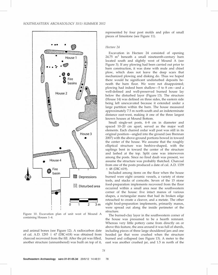
and animal bones (see Figure 12). A radiocarbon dateof cal. A.D. 1293 6 67 (DIC-618) was obtained fromcharcoal recovered from the fill. After the pit was filled,another structure (unnumbered) was built on top of it,
represented by four post molds and piles of smallpieces of limestone (see Figure 11).
Hectare 24
Excavation in Hectare 24 consisted of opening24.75 m2 beneath a small nineteenth-century barnlocated south and slightly west of Mound A (seeFigure 3). If any plowing had been carried out prior tobarn construction, it was done with mule and chiselplow, which does not leave the deep scars thatmechanized plowing and disking do. Thus we hopedthere would be significant undisturbed deposits be-neath the barn floor. We were not disappointed;plowing had indeed been shallow—5 to 8 cm—and awell-defined and well-preserved burned house laybelow the disturbed layer (Figure 13). The structure(House 14) was defined on three sides, the eastern sidebeing left unexcavated because it extended under alarge partition within the barn. The house measuredapproximately 7.5 m north-south and an indeterminatedistance east-west, making it one of the three largestknown houses at Mound Bottom.
Small single-set posts, 4–8 cm in diameter andspaced 10–20 cm apart, served as the major wallelements. Each charred cedar wall post was still in itsoriginal position—angled into the ground (see Brennan2007) with the above-ground portions bowed in towardthe center of the house. We assume that the roughlyelliptical structure was beehive-shaped, with thesaplings bent in toward the center of the structureand lashed at the top. Split cane was interwovenamong the posts. Since no fired daub was present, weassume the structure was probably thatched. Charcoalfrom one of the posts produced a date of cal. A.D. 13396 48 (DIC-619).
Included among items on the floor when the houseburned were eight ceramic vessels, a variety of stonetools, and stacks of corncobs. Seven of the 15 stonefood-preparation implements recovered from the flooroccurred within a small area near the southwesterncorner of the house: five intact manos of variousshapes, a rectangular mano that had its broken edgeretouched to create a cleaver, and a metate. The othereight food-preparation implements, primarily manos,were spread out along the inside perimeter of thestructure.
The burned-clay layer in the southwestern corner ofthe house was presumed to be a hearth remnant.Whereas very little pottery came from directly on orabove this feature, the area around it was full of sherds,including pieces of three large shouldered jars and onehooded jar that were crushed when the structureburned and collapsed (see Figure 13). A meter to theeast was another crushed jar, and 1.5 m north of the
Southeastern Archaeology sarc-31-01-05.3d 29/6/12 14:48:51 78
Figure 10. Excavation plan of unit west of Mound Acontaining Houses 1–4.
SOUTHEASTERN ARCHAEOLOGY 31(1) SUMMER 2012
78

four vessels was an intact small, hooded bottle. Twomore large jars were found broken in place along thenorthwest wall, next to a pile of charred corn cobs. Thehearth area also produced by far the highest frequencyof lithic debris, with unit totals dropping off to thenorth. Included in the 1,163 pieces of stone were smallcores, core-reduction pieces of various sizes, andretouched flakes, some with steep retouch along anedge. When standardized by volume, the number ofpieces recovered from the 4-cm-thick floor deposit washigher than that from any other house floor or middendeposit at Mound Bottom, presumably because thefloor was never cleaned after the structure burned.
Hectares 26 and 34–35
The majority of the excavations conducted in 1975occurred south of Mound C in Hectare 34 and twoadjacent hectares (see Figure 3). A total of 101 m2
was excavated in the extreme northeastern corner ofHectare 34 and the northwestern corner of Hectare 35.Two distinct wall-trench house patterns were found—House 10, measuring 7.1 by 6.3 m, and House 9,measuring 5.1 by 4.8 m (Figure 14). Stratigraphicevidence showed that House 10 was constructed first.A wall trench 20–30 cm deep was excavated, open atleast at two corners, around the area to be enclosed.Posts measuring 20 cm in diameter were then placed atthe two open corners of the trench. No post molds wereevident in the fill or bottoms of the trenches. Thesouthern wall trench was broken just east of the
southwestern corner of the structure. This 60-cm-widegap could have served as a doorway.
House 9 was constructed inside the area bounded byHouse 10. It was also constructed using the wall-trenchtechnique, with trenches averaging 10–15 cm wide. Itwas open at all four corners, with small corner posts intwo of the openings. The northern wall trench extendedalmost a meter past the northeast corner and possiblyfunctioned as a windscreen that protected the entranceat that corner of the house from northern exposure.Five small post molds were found in the northeasterncorner of the room, running diagonally from the north
Southeastern Archaeology sarc-31-01-05.3d 29/6/12 14:48:59 79
Figure 11. Excavation plan of unit containing Houses 22 and 23. Both houses were constructed in a large basin (see Figure 12).After the houses were torn down or naturally deteriorated, the basin was largely filled with trash, and at least one structure orwall was built on top of the filled area.
Figure 12. Photograph (looking southwest) of House 23 in aportion of the basin containing Houses 22 and 23. Note in theprofiles the zone of refuse on the floor of the basin and thefill above.
MOUND BOTTOM
79

to the east wall. The average spacing between the postmolds was 40–50 cm, except for one opening thatmeasured 80 cm. It is possible that this row of postmolds represented an interior partition to shield theinterior from the doorway.
Two scatterings of pottery were found on whatappeared to be the floor of House 9. This was not aprepared surface but only a common level containingthe pottery and a fire basin. Two broken jars werefound near the northeastern corner, and five broken
jars and two bowls were found in the southwesterncorner. Most of the vessel bases were still in place onthe ground, with the most serious damage, probablyfrom plowing, occurring on the upper portions of thecontainers. The combined vessels presumably repre-sent an assemblage used in everyday cooking andstorage by one household, similar to those found inHouse 14. The assemblage consists of three shoulderedjars with tall, vertical to slightly excurvate necks (onewith a thickened rim); one shouldered jar with a short,excurvate neck; one shouldered jar with a short,excurvate rim; one shouldered jar with an evertedneck/rim; one hooded jar; one incurving-wall bowlwith a direct rim (meaning there is no change in anglefrom wall to lip); and one semihemispherical bowl witha direct rim.
The pattern of single-set-post molds seen in the west-central portion of Figure 14 was at first thought to be aseparate house structure, constructed prior to or afterthe construction and/or abandonment of Houses 9 and10, but various lines of evidence demonstrated that thepost molds postdated the abandonment and disman-tling of House 10. The enclosure (Structure 1) measuredroughly 4.5 m on a side. Several post molds of varioussizes were found in the west side of the enclosure, butno function could be assigned to them. A 50-cm-wideopening was present in the south side of the wall orfence and may have functioned as an entrance.
Excavation along the border of Hectares 34 and 26(see Figure 3) was designed to determine if intact house
Southeastern Archaeology sarc-31-01-05.3d 29/6/12 14:49:13 80
Figure 14. Plan of excavations in Hectares 34 and 35 containing Houses 9 and 10 and Structure 1.
Figure 13. Photograph looking down on House 14 (east to thetop). The charred wall posts of the house are visible to the left,and a concentration of crushed pottery vessels is at the lowerright. Other broken vessels are at the top right. Several stonetools and a small intact jar are on the floor.
SOUTHEASTERN ARCHAEOLOGY 31(1) SUMMER 2012
80

floors could be located beneath slope wash fromMound C, where the overburden might have protectedthem from agricultural activities. As noted earlier,surface collections from Hectare 34 contained some ofthe highest frequencies of artifacts seen at MoundBottom, indicating substantial residential activity inthe area. Excavations near the center of the hectareboundary revealed numerous wall trenches and pits,many of which intruded into other features. Portions ofat least five presumed houses were excavated, includ-ing one with a circular wall trench. Circular wall-trenchhouses are not unheard of on Mississippian sites (e.g.,Chapman et al. 1977; O’Brien 1972), but they areuncommon.
The northernmost 4-3-2-m section (Figure 15) con-tained the remains of House 13, a wall-trench structurewhose eastern end was protected by a semicirculararrangement of posts that curved inside the house fromthe west side of the doorway. The wall trenches weredeep, extending into the subsoil an average of 35 cm.Post molds 10–25 cm in diameter were found in the
trenches at odd intervals. Numerous broken ceramicvessels were found on a burned-clay floor, alongsideseveral stone tools, including a large metate with anelongate trough on one side, two manos, and severalitems of Dover chert. The latter included a well-crafted,thin biface found just outside the south wall of thestructure and a well-made hoe recovered just inside theentryway. Alongside the hoe were 21 flakes, mostexhibiting the sheen characteristic of the working endof a hoe, and one core fragment; all 21 flakes could befitted back on the hoe.
Scattered charred timbers were recovered fromalmost every unit; one sample of charcoal taken fromthe floor of House 13 dated cal. A.D. 889 6 74 (DIC-620). The wood was all cedar, which grows inabundance on the hillsides above Mound Bottom. Thelarger pieces ranged in diameter from 3 cm to 5 cm andwould have served as wall posts or roof framing, orboth. Smaller pieces, ranging 1–2 cm in diameter,would have served as wattle for the walls and asroofing material. Small concentrations of cane, split andunsplit, were found throughout the midden layer.
The excavation unit was expanded to the north andwest to determine if more house patterns could befound. Expansion of a narrow trench to the west (seeFigure 3) uncovered a dark black stain that ran acrossthe units and into the north wall. As additional unitswere excavated, it became obvious that a heavilyburned surface lay well above the dark stain. Oncethe 5-cm-thick burned surface was mapped andphotographed, it was removed and the entire areaexcavated to the surface of the dark stain, whichproved to be the surface of a filled-in house basin. Arectangular house basin had been cut into the subsoil15 to 20 cm deep, and House 12 was erected inside(Figure 16). The wall posts were individually sunk intothe subsoil an average of 35 cm. The diameter of thepost molds ranged from 10 to 17 cm. The double line ofpost molds apparently was the result of rebuilding.
A large cedar post from House 12 dated to cal. A.D.1092 6 75 (DIC-622). A fire basin was found near themiddle of the house, and traces of a burned-clay floorwere discovered near the fire basin. To the west of theburned-clay layer, a fine sandy layer was founddirectly overlying the basal yellow clay. The sand,abundant in the bed of the Harpeth River, had beendeliberately spread over the clay and then ground in toform a floor.
House 12 was abandoned, the pit was filled, andHouse 11 was constructed on a new surface. We wereunable to see the House 11 post molds in the darkmidden that accumulated in the House 12 basin; theywere recognized in the floor of House 12 only after thefill was removed from the basin (see Figure 16).Diameters of the post molds ranged from 10 cm to17 cm, and their spacing varied from 10 cm to 30 cm.
Southeastern Archaeology sarc-31-01-05.3d 29/6/12 14:49:18 81
Figure 15. View east of House 13. The house extends into theunexcavated north wall of the unit. The post molds in theforeground wrap around a hearth area. Various brokenceramic vessels and stone tools are present on the floor ofthe house.
MOUND BOTTOM
81

Pieces of large charred cedar posts were found inseveral post molds, one of which was radiocarbondated to cal. A.D. 1353 6 47 (DIC-623). We estimatedthat House 11 could well have contained close to 80 m2
of floor, several times that of most houses at MoundBottom.
Excavations along the southern half of the borderbetween Hectares 34 and 35 were based on thepresence of an inordinate amount of daub in thesurface collections, including over a kilogram from one5-3-5-m unit alone. Fifty-four square meters wereopened, exposing a single structure, House 15, andseveral pits and natural depressions. The house was acombination of the wall-trench type and the single-set-post type. The southwestern wall had been set in atrench, but the northwestern wall had not. Plowing anddisking had destroyed the other walls. A small, 10-cm-thick midden that overlay the northwest wall of thehouse contained considerable amounts of bone, pot-tery, and lithic material, as well as 37 kg of daub. Themidden undoubtedly postdated abandonment ofHouse 15.
Other midden-filled depressions in the area wererich sources of pottery, bone, and lithic material, andwhen the artifact assemblage is taken in the aggregate,it tells us quite a bit about the activities undertaken byone or a few residential groups living in that part of thecommunity. As was true in other residential areas, themost common vessel form was a shouldered jar with atall, vertical to slightly excurvate neck, with or withoutrim lugs. A single rim sherd from a bowl and three
bottle fragments were found. The lithic assemblagefrom the depressions is what would be expected fromhousehold deposits, with the most numerous toolsbeing flakes with steep lateral retouch or light edgeretouch. With respect to faunal remains from thedepressions, not surprisingly, the remains of white-tailed deer dominated the assemblage, followed bysquirrel, turkey, and Eastern box turtle. Several aviantaxa other than turkey were represented, includingwhooping crane and common loon.
Discussion
Six mounds, 19 houses, and two other structureswere excavated at Mound Bottom during the three-month 1974 season and the seven-month 1975 season.Based on that fieldwork, we can draw several conclu-sions, one admittedly tentative, about Mississippianperiod life in a large river bottom in central Tennessee.The tentative conclusion has to do with the length ofoccupation of Mound Bottom. The 10 radiocarbon datessuggest quite a lengthy occupation—something on theorder of 600 years if the mean calibrated assays areconsidered (Figure 17). The earliest date, cal. A.D. 7686 105 (DIC-621), came from the interior of Mound L,the lone mound in the plaza, followed by four closelyspaced dates: cal. A.D. 889 6 74 (DIC-620) from a firebasin in House 13, cal. A.D. 934 6 58 (DIC-615) fromthe prepared-clay hearth on Mound J, and two dates ofcal. A.D. 976 6 48 (DIC-616 and DIC-617), one fromHouse 1 and the other from Stage II of Mound A. Thethree latest dates fall into a 60-year period that spansthe end of the thirteenth and first half of the fourteenthcenturies: cal. A.D. 1293 6 67 (DIC-618) from themidden overlying Houses 22 and 23, cal. A.D. 1339 6
48 (DIC-619) from the floor of House 14, and cal. A.D.1353 6 47 (DIC-623) from a post inside House 11.
On the face of it, the suite of radiocarbon datessuggests that perhaps Mound L, which is an oddity interms of its location, was a very early structure, builtbefore the plaza was planned and constructed, which,based on dates from Stage I of Mound J (cal. A.D. 934 6
58; DIC-615) and Stage II of Mound A (cal. A.D. 976 6
48; DIC-617), occurred sometime over the next centuryor so. Based on the date from Stage III of Mound A, cal.A.D. 1144 6 97 (DIC-624), mound construction lasted atleast another century or more. Dates from the housesrange from cal. A.D. 889 6 74 (DIC-620), for House 13,to cal. A.D. 1353 6 47 (DIC-623), for House 11. Wherehouses were superimposed and samples were collectedfrom multiple levels, the dates are in correct strati-graphic order.
As helpful as the dates appear to be, we urge cautionwhen using or citing them because the now-defunctDicarb Radioisotope Company produced them. Statis-
Southeastern Archaeology sarc-31-01-05.3d 29/6/12 14:49:20 82
Figure 16. View east of Houses 11 (at the top of thephotograph) and 12 (the double lines of post molds in theforeground) and associated features. House 12 was construct-ed first; the edge of the pit in which it was built is visible justoutside the western and southern lines of post molds.Associated pits and a charred post are present west andsouth of the house. The fire basin in the center of photographbelonged to House 12. After abandonment, the pit andsurrounding area were filled in, and a new structure, House11, was erected.
SOUTHEASTERN ARCHAEOLOGY 31(1) SUMMER 2012
82

tical testing by Reuther and Gerlach (2005), in whichthey compared radiocarbon assays produced by Dicarbto those produced by Beta Analytic, Geochron Labora-tories, and the NSF–Arizona AMS Facility on materialsexcavated in northern Alaska, showed that assaysproduced by Dicarb are consistently younger thanassays produced by other laboratories, with differencesranging between 350 and 1,440 years. Whether thissame phenomenon applies to the Mound Bottomassays is unknown, but again, caution should be usedfor anything more than using the dates for more than ageneral picture of the time of community occupationand abandonment. However, also supporting the earlyoccupation at Mound Bottom is the notable absence ofwide strap handles considered characteristic of ceramicvessels of the later Mississippian sites in MiddleTennessee (Smith 1969).
With respect to houses at Mound Bottom, there weretwo types: single-set-post structures and wall-trenchstructures. One single-set-post structure, House 14, had
burned, and the remains were sufficiently well pre-served to suggest that the vertical wall members weresupple enough to have been bent over and lashedtogether at the top. This would have given thatstructure an elongated rectangular, beehive shape.One, House 15, appears to be a hybrid, having bothtypes of wall construction. The average house size,regardless of type, was roughly 4 m2, although Houses10, 11, and 14 were considerably larger. In a fewinstances, wall trenches were connected at the cor-ners—the northwestern corner of House 10, forexample (see Figure 14)—but in most cases the trench-es were unconnected. Also, in a few instances smallposts were set in the gaps between wall trenches, as inHouses 9 and 10 (see Figure 14). Sometimes post moldswere found in the wall trenches, as in House 15, but inmany cases they were not. Wall trenches often containone or more post molds, but not in any abundance. Atypical arrangement is seen in Houses 1 and 2 (seeFigure 10). Single-set-post houses, such as Houses 11and 12 (see Figure 16), appear to have been morepermanent, and certainly more substantial, than thewall-trench houses, but we are guessing that theywould have required much more effort to maintain.House 15 appears to be a hybrid of the two types ofconstruction, as one of the two excavated walls was setin a trench and the other single-set. Perhaps it dates tothe early period of wall-trench construction, circa A.D.1150, when builders were possibly experimenting withthe construction of curtain walls (Alt and Pauketat2011).
At least two houses had what appeared to be smallwindscreens to protect the entryways. Most houses hada single prepared-clay fire basin in the center of thedwelling, although it was not unusual for more thanone to be present. House 1 had four basins placed closeto one another. Open hearths, characterized by areas offired clay, were present in some of the structures, notalways in the center of floors.
Almost every residential structure that had anaccompanying artifact deposit, such as an intact housefloor or refuse pits, contained items related to threebasic activities: food procurement, preparation, andstorage. Every house, or deposit within one, that wasextensively sampled yielded fragments or completeexamples of manos and pitted slabs. Some housedeposits yielded metates, either complete or broken.Also present in all deposits were retouched flakes andother small tools used for cutting and scraping. Almostall house deposits contained small triangular arrowpoints and hoes and hoe fragments, especially flakesremoved during hoe sharpening. Over 95 percent of thelithic material from Mound Bottom was Fort Paynechert, undoubtedly obtained from extensive stone andgravel deposits in and along the Harpeth River.Imported material, primarily Dover chert, was found
Southeastern Archaeology sarc-31-01-05.3d 29/6/12 14:49:23 83
Figure 17. Calibrated radiocarbon dates from Mound Bottom.Assays were calibrated using CalPal 2007. We urge caution inusing these dates for anything more than approximations (seetext for explanation).
MOUND BOTTOM
83
well distributed across the site, evidence that allhouseholds apparently had equal access to local aswell as nonlocal stone.
The most represented ceramic vessel at MoundBottom—the ‘‘universal cooking container’’— is thetall, straight to slightly everted-neck jar. O’Brien (1977)originally subdivided these vessels into classes usingseveral sorting criteria, some of which undoubtedlyhave functional implications, but the overall theme issimilar: a jar that stands approximately 20–30 cm highand has a maximum width of roughly 25 cm. Theremains of some 300 individual jars of this type wereidentified in the assemblages, dwarfing the frequenciesof all other types of ceramic vessels. Some specimenshave rim lugs—either two lugs, one across from theother, or two pairs of lugs across from each other—andothers loop handles. Some of the loops are slightlyflattened, but no strap handles were found, a featurethat has chronological implications if the receivedwisdom is correct that strap handles are late in theMississippian sequence of the region (Smith 1969).Other vessel forms include a few plates and bowls ofvarious dimensions.
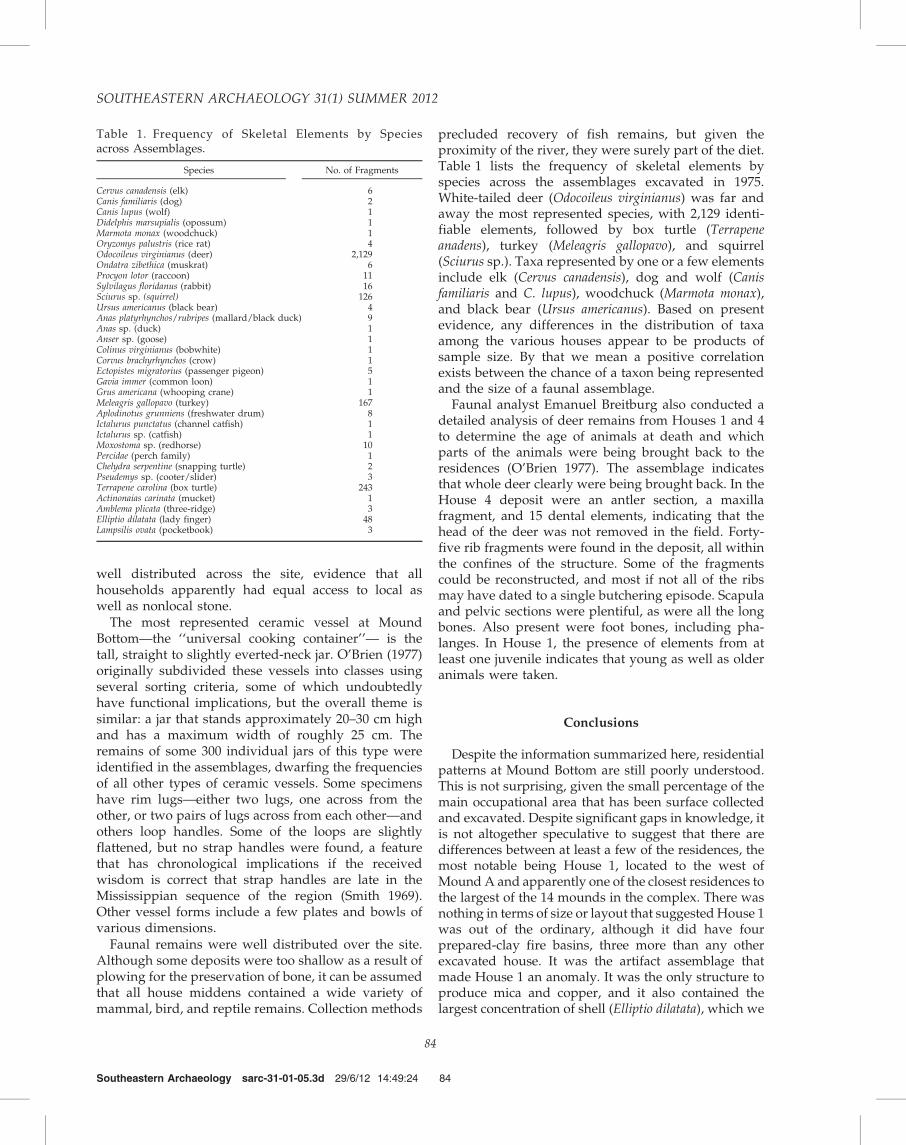
Faunal remains were well distributed over the site.Although some deposits were too shallow as a result ofplowing for the preservation of bone, it can be assumedthat all house middens contained a wide variety ofmammal, bird, and reptile remains. Collection methods
precluded recovery of fish remains, but given theproximity of the river, they were surely part of the diet.Table 1 lists the frequency of skeletal elements byspecies across the assemblages excavated in 1975.White-tailed deer (Odocoileus virginianus) was far andaway the most represented species, with 2,129 identi-fiable elements, followed by box turtle (Terrapeneanadens), turkey (Meleagris gallopavo), and squirrel(Sciurus sp.). Taxa represented by one or a few elementsinclude elk (Cervus canadensis), dog and wolf (Canisfamiliaris and C. lupus), woodchuck (Marmota monax),and black bear (Ursus americanus). Based on presentevidence, any differences in the distribution of taxaamong the various houses appear to be products ofsample size. By that we mean a positive correlationexists between the chance of a taxon being representedand the size of a faunal assemblage.
Faunal analyst Emanuel Breitburg also conducted adetailed analysis of deer remains from Houses 1 and 4to determine the age of animals at death and whichparts of the animals were being brought back to theresidences (O’Brien 1977). The assemblage indicatesthat whole deer clearly were being brought back. In theHouse 4 deposit were an antler section, a maxillafragment, and 15 dental elements, indicating that thehead of the deer was not removed in the field. Forty-five rib fragments were found in the deposit, all withinthe confines of the structure. Some of the fragmentscould be reconstructed, and most if not all of the ribsmay have dated to a single butchering episode. Scapulaand pelvic sections were plentiful, as were all the longbones. Also present were foot bones, including pha-langes. In House 1, the presence of elements from atleast one juvenile indicates that young as well as olderanimals were taken.
Conclusions
Despite the information summarized here, residentialpatterns at Mound Bottom are still poorly understood.This is not surprising, given the small percentage of themain occupational area that has been surface collectedand excavated. Despite significant gaps in knowledge, itis not altogether speculative to suggest that there aredifferences between at least a few of the residences, themost notable being House 1, located to the west ofMound A and apparently one of the closest residences tothe largest of the 14 mounds in the complex. There wasnothing in terms of size or layout that suggested House 1was out of the ordinary, although it did have fourprepared-clay fire basins, three more than any otherexcavated house. It was the artifact assemblage thatmade House 1 an anomaly. It was the only structure toproduce mica and copper, and it also contained thelargest concentration of shell (Elliptio dilatata), which we
Southeastern Archaeology sarc-31-01-05.3d 29/6/12 14:49:24 84
Table 1. Frequency of Skeletal Elements by Speciesacross Assemblages.
Species No. of Fragments
Cervus canadensis (elk) 6Canis familiaris (dog) 2Canis lupus (wolf) 1Didelphis marsupialis (opossum) 1Marmota monax (woodchuck) 1Oryzomys palustris (rice rat) 4Odocoileus virginianus (deer) 2,129Ondatra zibethica (muskrat) 6Procyon lotor (raccoon) 11Sylvilagus floridanus (rabbit) 16Sciurus sp. (squirrel) 126Ursus americanus (black bear) 4Anas platyrhynchos/rubripes (mallard/black duck) 9Anas sp. (duck) 1Anser sp. (goose) 1Colinus virginianus (bobwhite) 1Corvus brachyrhynchos (crow) 1Ectopistes migratorius (passenger pigeon) 5Gavia immer (common loon) 1Grus americana (whooping crane) 1Meleagris gallopavo (turkey) 167Aplodinotus grunniens (freshwater drum) 8Ictalurus punctatus (channel catfish) 1Ictalurus sp. (catfish) 1Moxostoma sp. (redhorse) 10Percidae (perch family) 1Chelydra serpentine (snapping turtle) 2Pseudemys sp. (cooter/slider) 3Terrapene carolina (box turtle) 243Actinonaias carinata (mucket) 1Amblema plicata (three-ridge) 3Elliptio dilatata (lady finger) 48Lampsilis ovata (pocketbook) 3
SOUTHEASTERN ARCHAEOLOGY 31(1) SUMMER 2012
84

suggest may represent a workshop for bead production(O’Brien 1977). House 1 and the area immediatelyadjacent also contained an inordinately high density offigurine fragments and fine-paste pottery, especiallybowls and portions of one negative-painted bottle.Whether the structure was the residence of a craftsman,which O’Brien (1977) speculated could have been thecase, is unknown. Or were it and other structures inHectare 14 residences of an elite segment of MoundBottom society? That remains to be determined as well.
Certainly the 99 burials from Mound Bottom do nothint at much in the way of social differences (Autry1983; O’Brien 1977). A possible exception might beNeitzel’s 1936 work at a small cemetery located on aslight rise west of Houses 1–4 that produced severalburials that rank at the top of the sample in terms ofitems interred with the dead. One burial contained twosmall ceramic vessels, a mussel-shell spoon, and astone pipe. A second contained two well-made slate earspools, and a third contained four intricately carvedbear claws of cedar that had been covered with sheetsof hammered copper. Two were found under eachmastoid of the skull and apparently functioned asearrings or pendants. Neitzel’s field notes state that thebody had been interred on a mat (Neitzel 1936). Again,these burial inclusions, as interesting as they are, do notprovide much in the way of support for striking socialdifferentiation within the Mound Bottom population.
A small sample of burials and houses, however, doesnot negate the possibility that Mound Bottom con-tained a socially differentiated population, and werather think it did, based on considerably more in-depth work at contemporary Mississippian centersacross the Southeast (e.g., Blitz and Lorenz 2006; Knight1990; Knight and Steponaitis 2007). But, over time, wehave become a little more conservative in how weapproach the archaeological record than we once were,and we tend to shy away from weaving too manystories about social and political organization, espe-cially when basing them on something like a 0.01percent excavation sample. This is a much safer tack,but to tell the truth, we still get a little wistful when weremember those halcyon days of the 1970s when weknew less but enjoyed it more.
Notes
Acknowledgments. We thank Charles Cobb, Tom Pluckhahn,and several anonymous reviewers for excellent advice onhow to strengthen the manuscript and Melody Galen forproducing the figures.
1Approximately 600 m of the embankment and the regularlyspaced bastions of this palisade line are in an excellent stateof preservation. We are unaware of any other palisade inthe Southeast with this degree of preservation. Other large
sections of the palisade are readily discernible. One bastionwas tested during 1936–37.2At Pack, there is a clearly defined terrace below the westernside of the plaza.3Because radiocarbon-date calibration often produces irregu-lar probability distributions, calibrated dates usually arereported as ranges, but CalPal computes a calibratedcalendric age in addition to the date range. For ease ofpresentation, we use the calendric age and one-sigmastandard error.
References Cited
Alt, Susan M., and Timothy R. Pauketat2011 Why Wall Trenches? Southeastern Archaeology 30:
108–122.
Autry, William O., Jr.1983 Sociopolitical Dimensions of the Mississippian System
in the Cumberland River Valley of Middle Tennessee andWestern Kentucky: An Analysis of Mortuary Patterns andSkeletal Remains from Mound Bottom, Tennessee. Reporton file, Frank H. McClung Museum, University ofTennessee, Knoxville.
Binford, Lewis R., Sally R. Binford, Robert Whallon, andMargaret Ann Hardin
1970 Archaeology at Hatchery West, Carlyle, Illinois.Society for American Archaeology, Memoirs, No. 24.Washington, DC.
Blitz, John H., and Karl G. Lorenz2006 The Chattahoochee Chiefdoms. University of Alabama
Press, Tuscaloosa.
Brennan, Tamira K.2007 In-Ground Evidence of Above-Ground Architecture at
Kincaid Mounds. In Architectural Variability in the Southeast,edited by Cameron H. Lacquement, pp. 73–100. Universityof Alabama Press, Tuscaloosa.
Chapman, Carl H., John W. Cottier, David Denman, David R.Evans, Dennis E. Harvey, Michael J. Reagan, Bradford L.Rope, Michael D. Southard, and Gregory A. Waselkov
1977 Investigation and Comparison of Two Fortified Mis-sissippi Tradition Archaeological Sites in Southeast Mis-souri: A Preliminary Comparison. Missouri Archaeologist 38.
Cox, Paul E.1926 Prehistoric Man in Tennessee. Journal of the Tennessee
Academy of Sciences 1(3):125–130.
Ferguson, Robert B. (editor)1972 The Middle Cumberland Culture. Vanderbilt Publications
in Anthropology No. 3. Nashville, TN.
Haywood, John1823 The Natural and Aboriginal History of Tennessee up to the
First Settlements Therein by the White People in the Year 1768.Wilson, Nashville, TN.
Knight, Vernon James, Jr.1990 Social Organization and the Evolution of Hierarchy
in Southeastern Chiefdoms. Journal of Anthropological Re-search 46:1–23.
Knight, Vernon James, Jr., and Vincas P. Steponaitis(editors)
2007 Archaeology of the Moundville Chiefdom. Rev. ed.University of Alabama, Tuscaloosa.
Southeastern Archaeology sarc-31-01-05.3d 29/6/12 14:49:24 85
MOUND BOTTOM
85

Kuttruff, Carl1979 Mound Bottom and Pack Sites, Tennessee. Report on
file, Tennessee Division of Archaeology, Nashville.Moore, Charlotte B. (editor)1974 Reconstructing Complex Societies. Bulletin of the American
Schools of Oriental Research (Supplement), No. 20. Boston.O’Brien, Michael J.1977 Intrasite Variability in a Middle Mississippian Com-
munity. Unpublished Ph.D. dissertation, Department ofAnthropology, University of Texas, Austin.
O’Brien, Michael J., R. Lee Lyman, and Michael B. Schiffer2005 Archaeology as a Process: Processualism and Its Progeny.
University of Utah Press, Salt Lake City.O’Brien, Patricia J.1972 A Formal Analysis of Cahokia Ceramics from the Powell Tract.
Illinois Archaeological Survey Monograph No. 3. Urbana.Pauketat, Timothy R.2007 Chiefdoms and Other Archaeological Delusions. AltaMira,
Lanham, MD.Redman, Charles L., and Patty Jo Watson1970 Systematic, Intensive Surface Collection. American
Antiquity 35:279–291.Reuther, Joshua D., and Craig S. Gerlach2005 Testing the ‘‘Dicarb Problem’’: A Case Study from
North Alaska. Radiocarbon 47:359–366.
Sahlins, Marshall D.1958 Social Stratification in Polynesia. University of Washing-
ton Press, Seattle.Service, Elman R.1962 Primitive Social Organization. Random House, New York.Smith, Gerald P.1969 Ceramic Handle Styles and Cultural Variation in the
Northern Sector of the Mississippi Alluvial Valley. MemphisState University, Anthropological Research Center Occa-sional Papers, No. 3. Memphis, TN.
Smith, Kevin E.1992 The Middle Cumberland Region, Mississippian Ar-
chaeology in North Central Tennessee. UnpublishedPh.D. dissertation, Department of Anthropology, Van-derbilt University, Nashville.
2008 Shrouded in Myth and Mystery: Two Centuries ofInterest in the Mound Bottom–Pack Locality. Paperpresented at the 65th annual meeting of the SoutheasternArchaeological Conference, Charlotte, NC.
Sullivan, Lynne P.2009 Deposing the Chiefdom Model ‘‘Monster-God.’’ Native
South 2:88–97.Tolstoy, Paul, and Suzanne K. Fish1975 Surface and Subsurface Evidence for Community Size
at Coapexco, Mexico. Journal of Field Archaeology 2:97–104.
Southeastern Archaeology sarc-31-01-05.3d 29/6/12 14:49:24 86
SOUTHEASTERN ARCHAEOLOGY 31(1) SUMMER 2012
86