TH3.L09 - RADARSAT-2 DATA UTILIZATIONS AND APPLICATIONS
23
Government of Canada RADARSAT-2 Data Utilizations and Applications IGARSS 2010 July 25 - 30, 2010 Honolulu, Hawaii, USA Stéphane Chalifoux et al. Canadian Space Agency Manager, RADARSAT-2 Data Allocation
Transcript of TH3.L09 - RADARSAT-2 DATA UTILIZATIONS AND APPLICATIONS
Government of Canada RADARSAT-2 Data
Utilizations and Applications
IGARSS 2010
July 25 - 30, 2010
Honolulu, Hawaii, USA
Stéphane Chalifoux et al.Canadian Space AgencyManager, RADARSAT-2 Data Allocation
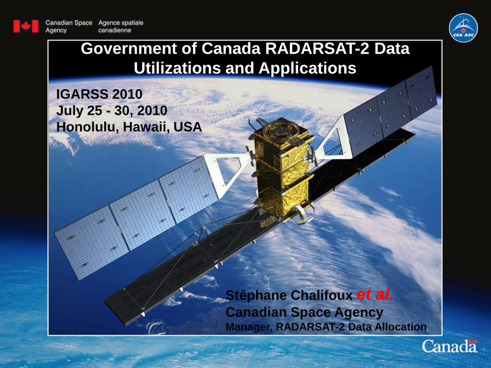
Committed to Providing RADARSAT Data
Continuity
1995: RADARSAT-1
2007: RADARSAT-2
2014:2015: 2015:
RCM
RADARSAT-2 Data and Product © MacDonald, Dettwiler and Associates Ltd. (2008) – All
Rights Reserved.

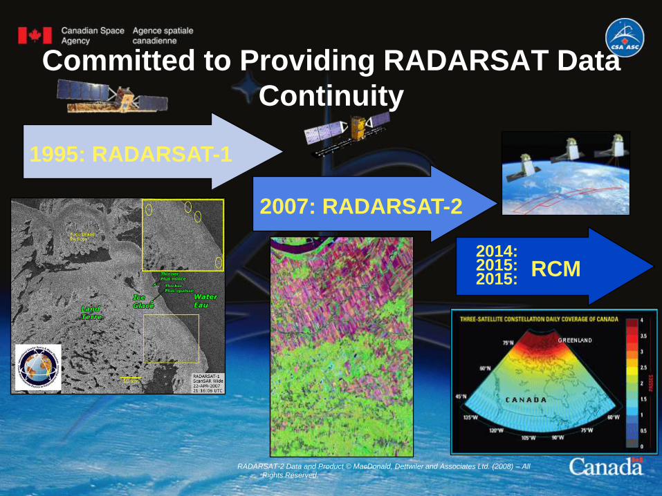
RADARSAT-2 Data UtilizationsData Volume:
– FY08-09 (year #1): 12 836 scenes
– FY09-10 (year #2): 20 869 scenes
– FY10-11 (year #3): 4 465 scenes (up to 25 000 scenes + 25%)
Total up to May 2010 : 38 170 scenes
RADARSAT-2 data management
– Consumption estimation planned for
10 years (April 2008 until March 2018)
– Will provide an overlap with RCM
Government of Canada Authorized Users : 240
-12 Departments
R&D Principal Investigators : >200
- 237 total projects accepted
Excluding Operational Departments
(52% of total scenes)
ICEC ScanSAR Wide
ISTOP ScanSAR Narrow
ISTOP ScanSAR Narrow Dual
DND - Operations ScanSAR Narrow Dual
DND - Projects ScanSAR Narrow Dual
ICEC : Ice Center, Environment Canada
ISTOP : Integrated Satellite Tracking of
Pollution
DND : The Department of National Defence
and the Canadian Forces
RADARSAT-2 Data Utilizations
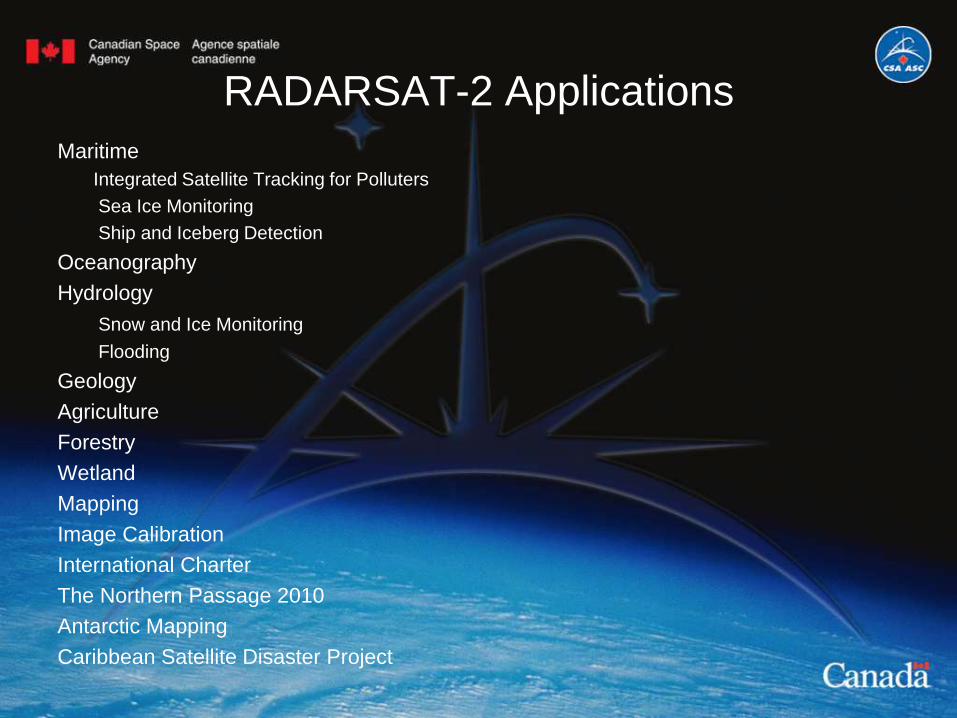
RADARSAT-2 Applications
Maritime
Integrated Satellite Tracking for Polluters
Sea Ice Monitoring
Ship and Iceberg Detection
Oceanography
Hydrology
Snow and Ice Monitoring
Flooding
Geology
Agriculture
Forestry
Wetland
Mapping
Image Calibration
International Charter
The Northern Passage 2010
Antarctic Mapping
Caribbean Satellite Disaster Project
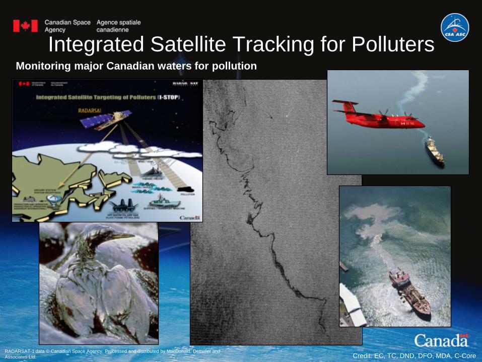
Integrated Satellite Tracking for Polluters
RADARSAT-1 data © Canadian Space Agency. Processed and distributed by MacDonald, Dettwiler and
Associates Ltd. Credit: EC, TC, DND, DFO, MDA, C-Core
Monitoring major Canadian waters for pollution
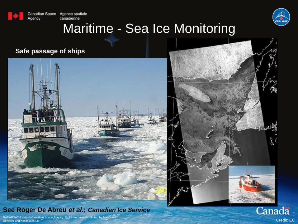
Maritime - Sea Ice Monitoring
RADARSAT-1 data © Canadian Space Agency. Processed and distributed by MacDonald,
Dettwiler and Associates Ltd. Credit: EC
Safe passage of ships
See Roger De Abreu et al.; Canadian Ice Service
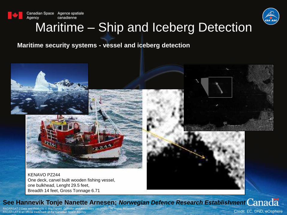
Maritime – Ship and Iceberg Detection
Maritime security systems - vessel and iceberg detection
KENAVO PZ244
One deck, carvel built wooden fishing vessel,
one bulkhead, Lenght 29.5 feet,
Breadth 14 feet, Gross Tonnage 6.71
RADARSAT-2 Data and Products © MacDonald, Dettwiler and Associates Ltd.(2010) - All Rights Reserved.
RADARSAT is an official trademark of the Canadian Space Agency. Credit: EC, DND, eOsphere
See Hannevik Tonje Nanette Arnesen; Norwegian Defence Research Establishment

Oceanography
Ocean Waves
Emili (19 jul. 2005)
Golf du Mexique
Hurricane monitoring
RADARSAT-1 data © Canadian Space Agency. Processed and distributed by MacDonald, Dettwiler and
Associates Ltd. Credit: DFO, DND, EC
Studying winds to
improve marine forecast

Hydrology - Snow and Ice Monitoring
Landsat RADARDAT-2
RADARSAT-2 Data and Products © MacDonald, Dettwiler and Associates Ltd.(2009-10) - All Rights
Reserved. RADARSAT is an official trademark of the Canadian Space Agency.
Ice freeze-up phenomena manages the wildlife and the human activities as hunting and fishing
on ice, ice road routing and winter sports. During the spring time, this river ice is melting,
causing floods and ice jam floods.
Credit: NRCan, EC, NRC
Weather forecast & Climate change
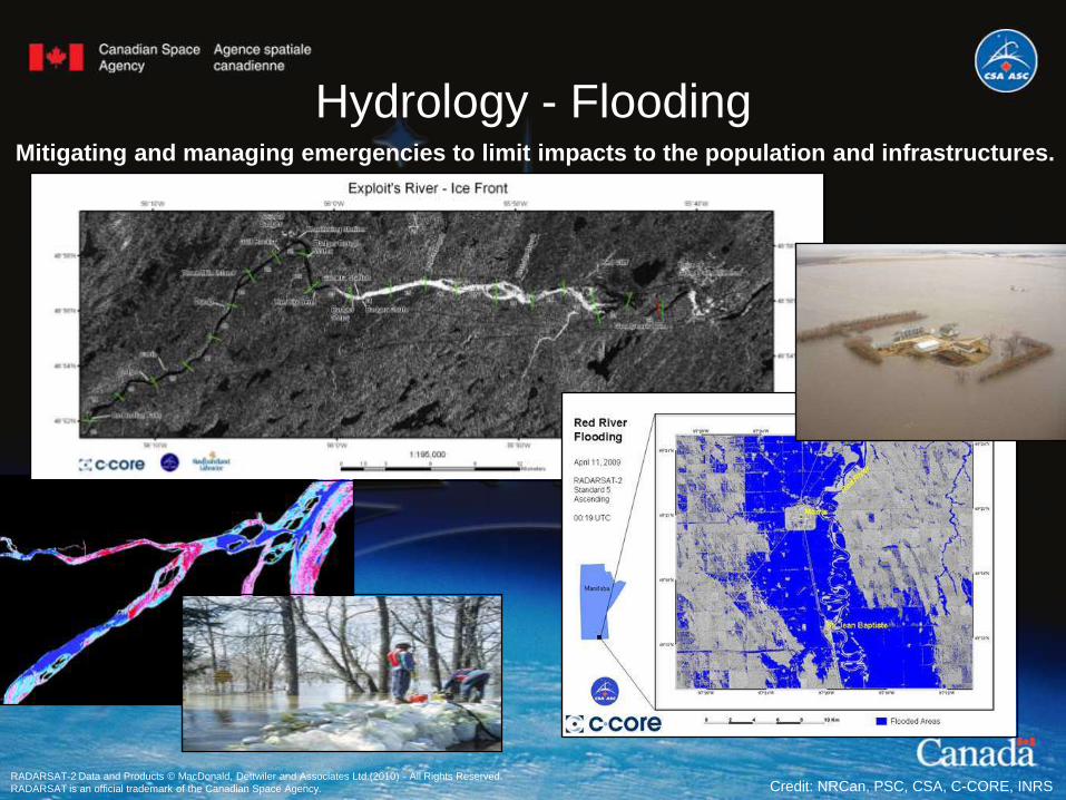
Hydrology - FloodingMitigating and managing emergencies to limit impacts to the population and infrastructures.
RADARSAT-2 Data and Products © MacDonald, Dettwiler and Associates Ltd.(2010) - All Rights Reserved.
RADARSAT is an official trademark of the Canadian Space Agency. Credit: NRCan, PSC, CSA, C-CORE, INRS

Geology
Monitoring Landslide and Soil Instability
RADARSAT-2 Data and Products © MacDonald, Dettwiler and Associates Ltd.(2008-10) - All Rights Reserved.
RADARSAT is an official trademark of the Canadian Space Agency.
Surficial Geology & Structure, Oil & Gas Exploration, Mineral Exploration, Geological
Hazards, Subsidence
Geology Mapping
Credit: NRCan,, CCRS, CSA
Landslide – Dam Failure
Water or smooth
surface
Mud
~ 250
m
Photograph by:
THE CANADIAN
PRESS/
Daniel Hayduk &
Darryl Dyck
See Vern Singhroy et al.; Canada Centre for Remote Sensing
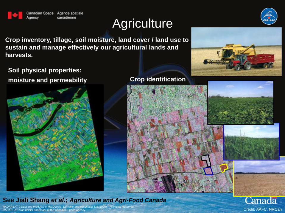
Agriculture
Soil physical properties:
moisture and permeability
RADARSAT-2 Data and Products © MacDonald, Dettwiler and Associates Ltd.(2008) - All Rights Reserved.
RADARSAT is an official trademark of the Canadian Space Agency.
Crop identification
Crop inventory, tillage, soil moisture, land cover / land use to
sustain and manage effectively our agricultural lands and
harvests.
Credit: AAFC, NRCan
See Jiali Shang et al.; Agriculture and Agri-Food Canada

Forestry
Forest cover, and change detection e.g., clear-cutting, forest fires and insect defoliation,
biomass, environmental effects mapping in support of Canada's sustainable forest
management.
Credit: NRCan, EC, Wildlife Enforcement, Carleton University
Improved forest structure mapping and
monitoring of forest disturbance
Environmental change impacts

Wetlands
Wetland Mapping
Wetland (InSAR)
RADARSAT-2 Data and Products © MacDonald, Dettwiler and Associates Ltd.(2008-09) - All Rights Reserved.
RADARSAT is an official trademark of the Canadian Space Agency.
With the population constantly growing, the GoC had to elaborate politics to preserve one of
the most productive ecosystems of the planet : wetlands.
Credit: EC, NRCan,, NRC, University of Miami, Sejong University
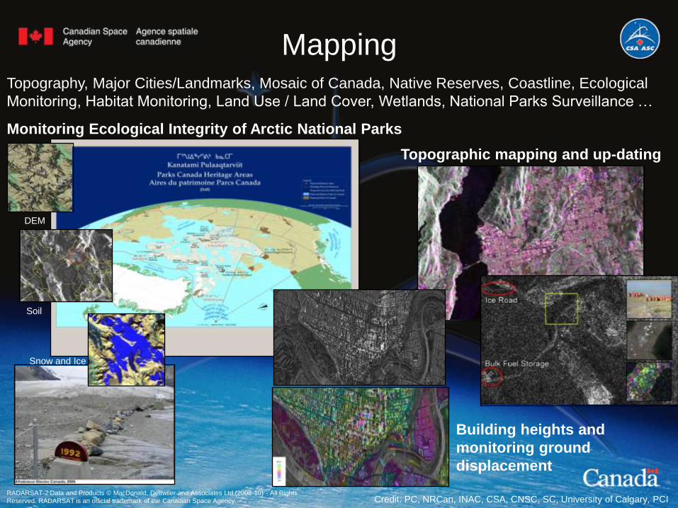
Mapping
RADARSAT-2 Data and Products © MacDonald, Dettwiler and Associates Ltd.(2008-10) - All Rights
Reserved. RADARSAT is an official trademark of the Canadian Space Agency.
Topographic mapping and up-dating
Building heights and
monitoring ground
displacement
Monitoring Ecological Integrity of Arctic National Parks
DEM
Soil
Snow and Ice
Topography, Major Cities/Landmarks, Mosaic of Canada, Native Reserves, Coastline, Ecological
Monitoring, Habitat Monitoring, Land Use / Land Cover, Wetlands, National Parks Surveillance …
Credit: PC, NRCan, INAC, CSA, CNSC, SC, University of Calgary, PCI
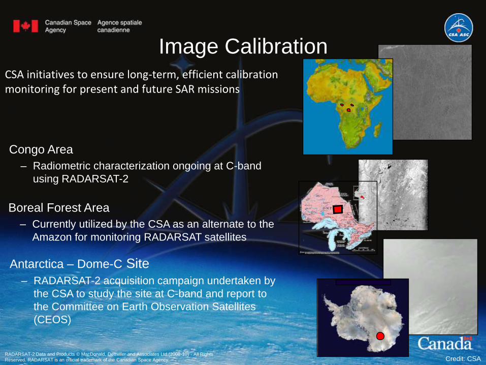
Image CalibrationCSA initiatives to ensure long-term, efficient calibration monitoring for present and future SAR missions
Antarctica – Dome-C Site
– RADARSAT-2 acquisition campaign undertaken by
the CSA to study the site at C-band and report to
the Committee on Earth Observation Satellites
(CEOS)
Congo Area
– Radiometric characterization ongoing at C-band
using RADARSAT-2
Boreal Forest Area
– Currently utilized by the CSA as an alternate to the
Amazon for monitoring RADARSAT satellites
RADARSAT-2 Data and Products © MacDonald, Dettwiler and Associates Ltd.(2008-10) - All Rights
Reserved. RADARSAT is an official trademark of the Canadian Space Agency. Credit: CSA

International CharterUSGS Activation: Oil spill in the Gulf of Mexico
RADARSAT-2 Data and Products © MacDonald, Dettwiler and Associates Ltd.(2010) - All Rights Reserved.
RADARSAT is an official trademark of the Canadian Space Agency.
RADARSAT-1 data © Canadian Space Agency. Processed and distributed by MacDonald, Dettwiler
and Associates Ltd. Credit: CSA

The Northern Passage 2010On Midsummer’s Eve, Børge and Thorleif will sail from Oslo, in a daring attempt to sail
through both the Northwest and Northeast passages during the same season. Can
their speedy trimaran survive the challenge of ice-filled Arctic waters, clearing both
passages before they freeze?
Ousland (Web News): '…the use of
satellite images to know where the ice
are. We will use RADARSAT, and this
will be quite important. '
The CSA will provide RADARSAT data to
the Norwegian Meteorological Institute
that will derive ice charts for a secure
travelling route!
Journey timeline: June 23 to October 2010
RADARSAT-2 Data and Products © MacDonald, Dettwiler and Associates Ltd.(2010) - All Rights Reserved.
RADARSAT is an official trademark of the Canadian Space Agency. Credit: CSA

Antarctic Mapping
RADARSAT-2, an exceptional contribution to IPY!
Following on the successful 1997 RADARSAT-1 campaign, RADARSAT-2 was
used to capture the 2nd completed Antarctic Mosaic.
An Antarctica Interferometric Coverage campaign was also successfully
completed.
Courtesy: NSF
Amundsen-Scott South Pole Station
RADARSAT-2 Data and Products © MacDonald, Dettwiler and Associates Ltd.(2008) - All Rights Reserved.
RADARSAT is an official trademark of the Canadian Space Agency. Credit: CSA, MDA, GIIPSY
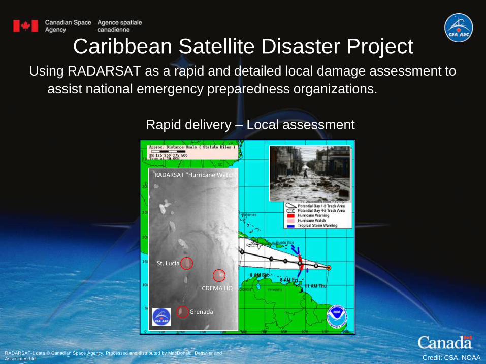
Caribbean Satellite Disaster ProjectUsing RADARSAT as a rapid and detailed local damage assessment to
assist national emergency preparedness organizations.
RADARSAT “Hurricane Watch”
CDEMA HQ
Grenada
St. Lucia
Rapid delivery – Local assessment
RADARSAT-1 data © Canadian Space Agency. Processed and distributed by MacDonald, Dettwiler and
Associates Ltd. Credit: CSA, NOAA

Mahalo!
Visit: http://www.asc-csa.gc.ca/eng/events/2010/radarsat2.asp
3rd RADARSAT-2 WorkshopSeptember 27 to October 1, 2010 at the Canadian Space Agency

Contact information
For more information on RADARSAT-2 utilizations
and applications, please contact:
Stéphane Chalifoux, M. Sc.
Manager RADARSAT-2 Allocation
Canadian Space Agency
E-mail : [[email protected]]
Government of Canada
RADARSAT-2 Data and Products © MacDonald, Dettwiler and Associates Ltd.(2010) - All Rights Reserved.
RADARSAT is an official trademark of the Canadian Space Agency.
Visit: http://www.asc-csa.gc.ca/eng/observation/applications.asp
Visit: http://www.asc-csa.gc.ca/eng/newsletters/eo_express/editions.asp
Suscribe: [email protected]