Tetley Avenue Residential - files.ceqanet.opr.ca.gov
80
County of Los Angeles Department of Regional Planning Initial Study Mitigated Negative Declaration Tetley Avenue Residential Contact: Marie Pavlovic Los Angeles County Department of Regional Planning Land Divisions Section 320 W. Temple Street Los Angeles, CA 90012 (213) 974-6433 Email: [email protected] July 30, 2021
Transcript of Tetley Avenue Residential - files.ceqanet.opr.ca.gov

County of Los Angeles Department of Regional Planning
Initial Study Mitigated Negative Declaration
Tetley Avenue Residential
Contact:
Marie Pavlovic Los Angeles County Department of Regional Planning Land Divisions Section 320 W. Temple Street Los Angeles, CA 90012 (213) 974-6433 Email: [email protected]
July 30, 2021

This page is intentionally blank.

TABLE OF CONTENTS
Page No.
EXECUTIVE SUMMARY............................................................................................................................................................ 1
INTRODUCTION .......................................................................................................................................................................... 2
INCORPORATION BY REFERENCE .................................................................................................................................. 2
ENVIRONMENTAL CHECKLIST FORM (Initial Study) ............................................................................................... 4
DESCRIPTION OF PROJECT .................................................................................................................................................. 4
EXISTING PROJECT SITE CONDITIONS...................................................................................................................... 10
SURROUNDING LAND USES............................................................................................................................................... 12
ENVIRONMENTAL FACTORS POTENTIALLY .......................................................................................................... 16
DETERMINATION (To be completed by the Lead Department.) ............................................................................... 16
EVALUATION OF ENVIRONMENTAL IMPACTS..................................................................................................... 17
1. AESTHETICS ............................................................................................................................................................................ 18
2. AGRICULTURE / FOREST ................................................................................................................................................ 21
3. AIR QUALITY........................................................................................................................................................................... 23
4. BIOLOGICAL RESOURCES............................................................................................................................................... 28
5. CULTURAL RESOURCES.................................................................................................................................................... 33
6. ENERGY ..................................................................................................................................................................................... 36
7. GEOLOGY AND SOILS....................................................................................................................................................... 37
8. GREENHOUSE GAS EMISSIONS................................................................................................................................... 40
9. HAZARDS AND HAZARDOUS MATERIALS ........................................................................................................... 44
10. HYDROLOGY AND WATER QUALITY ................................................................................................................... 49
11. LAND USE AND PLANNING ........................................................................................................................................ 53
12. MINERAL RESOURCES .................................................................................................................................................... 56
13. NOISE ........................................................................................................................................................................................ 57
14. POPULATION AND HOUSING .................................................................................................................................... 60
15. PUBLIC SERVICES............................................................................................................................................................... 61
16. RECREATION ........................................................................................................................................................................ 63
17. TRANSPORTATION ........................................................................................................................................................... 64
18. TRIBAL CULTURAL RESOURCES ............................................................................................................................... 66
19. UTILITIES AND SERVICE SYSTEMS ......................................................................................................................... 69

Page ii
20. WILDFIRE................................................................................................................................................................................ 72
21. MANDATORY FINDINGS OF SIGNIFICANCE.................................................................................................... 74
LIST OF FIGURES
FIGURE NO. Page No.
1. Regional Location Map. .............................................................................................................................................. 5 2. Project Aerial Location Map ...................................................................................................................................... 6 3. Project Concept Site Plan on Aerial Map ............................................................................................................. 7 4. Architectural Style, North Elevation Fronting Tetley Street ............................................................................ 8 5. Existing Site Conditions Aerial View ...................................................................................................................... 9 6. Existing Main Sanctuary Building Street View from Tetley Street................................................................11 7. Site Photos Key Map .................................................................................................................................................11 8. Site Photos – Front and East Side Looking to South.......................................................................................12 9. Site Photos – Rear Looking to South....................................................................................................................12 10. Site Photos –Rear looking South, West and North ..........................................................................................13 11. Site Photos – West Side looking North and East ..............................................................................................13 LIST OF TABLES
TABLE NO. Page No.
1. Tetley Street Residential Unit Summary ................................................................................................................. 7 2. Comparison of Project Construction Emissions and Daily Criteria Values...............................................25 3. Comparison of Project Operational Emissions and Daily Criteria Values ................................................26 4. Project Construction Related Greenhouse Gas Emissions by Year .............................................................39 5. Project Operational Greenhouse Gas Emissions ..............................................................................................39

Page iii
APPENDICES
A. Phase I and II Environmental Site Assessment for 15716 Tetley Street, Hacienda Heights, California, prepared by Stantec Consulting Services Inc., July 17, 2018
B. Native American Heritage Commission Sacred Lands File Check and Consultation List, January 27, 2020.
C. South Central Coastal Information Center Records Search, March 26, 2020 D. Tetley Street Residential Development Focused Air Quality and Greenhouse Gas Analysis,
prepared by Synectecology, February 9, 2021 E. Historic-Period Building Evaluation - Hacienda Heights Christian Church and Morning Star
Christian School, prepared by CRM Tech, May 5, 2021 F. Geotechnical Grading Plan Review Report, Proposed Residential Development, 50 Tetley St,
Hacienda, Heights, California, prepared by Albus & Associates, March 4, 2021.. G. Hydrology Study for 15716 Tetley Street, prepared by B&E Engineers, July 2019 H. Tribal Consultation Notification Letters I. County Sanitation Districts of Los Angeles County Will Serve Letter, February 23, 2021 J. San Gabriel Valley Water Company Will Serve Letter, March 3, 2021.

Initial Study – Tetley Residential Project Page 1
EXECUTIVE SUMMARY This Initial Study assesses the potential environmental impacts of a proposal by The Olson Company to construct and operate the Tetley Residential Project (Project), which consists of 33 new residential townhome condominium units on a lot that is approximately 2.16-acres. The project is located at 15716 Tetley Street in the Hacienda Heights area of unincorporated Los Angeles County.
This Initial Study finds that the Project could have a potentially significant adverse impact relative to the following: biological resources related to nesting birds and roosting bats; cultural resources related to archaeological resources and unanticipated human remains; hazards and hazardous materials from contaminants associated with past site activities; tribal cultural resources related to Native American monitoring; and utilities related to hazardous waste disposal. However, mitigation measures are added to the Project which these reduces each these potential impacts to less than significant levels. Consequently, a Mitigated Negative Declaration will be prepared for the Project.
Initial Study – Tetley Residential Page 2
INTRODUCTION
This Initial Study has been prepared in accordance with relevant provisions of the California Environmental Quality Act (CEQA) of 1970, as amended, and the CEQA Guidelines. Section 21063(c) of the CEQA Guidelines indicates that the purposes of an Initial Study are to:
1. Provide the Lead Agency (i.e. the County of Los Angeles) with information to use as the basis for deciding whether to prepare an Environmental Impact Report (EIR) or Negative Declaration;
2. Enable an applicant or Lead Agency to modify a project, mitigating adverse impacts before an EIR is prepared, thereby enabling the Project to quality for a Negative Declaration or Mitigated Negative Declaration;
3. Assist the preparation of an EIR, if one is required, by:
• Focusing the EIR on the effects determined to be significant;
• Identifying the effects determined not to be significant;
• Explaining the reasons why potentially significant effects would not be significant; and
• Identifying whether a program EIR, tiering, or another appropriate process can be used for analysis of the project's environmental effects;
4. Facilitate environmental assessment early in the design of a project;
5. Provide documentation of the factual basis for the findings in a Negative Declaration or Mitigated Negative Declaration that a project will not have a significant effect on the environment;
6. Eliminate unnecessary EIRs; and
7. Determine whether a previously prepared EIR could be used with the project.
INCORPORATION BY REFERENCE
The information contained in this document is based, in part, on the following documents that include the Project site or provide information addressing the general project area or use:
• Los Angeles County General Plan (General Plan). The General Plan, adopted by the Los Angeles County Board of Supervisors on October 2015, provides the policy framework for how and where the unincorporated County will grow through the year 2035, while recognizing and celebrating the County’s wide diversity of cultures, abundant natural resources, and status as an international economic center. Comprising approximately 4,083 square miles, Los Angeles County is home to 9.5 million people. The Los Angeles County General Plan accommodates new housing and jobs within the unincorporated areas in anticipation of population growth in the County and the region.
• Final Environmental Impact Report Los Angeles County General Plan Update, County of Los Angeles, State Clearinghouse # 2011081042 (General Plan EIR). The General Plan EIR, adopted by the Los Angeles County Board of Supervisors on March 2015, was prepared in support of the General Plan and in accordance with the California Environmental Quality Act (CEQA) as amended (Public Resources Code Section 21000 et seq.) and CEQA Guidelines (California Administrative Code Section 15000 et seq.).
Initial Study – Tetley Residential Page 3
• Hacienda Community Plan (Community Plan). The Community Plan, adopted May 24, 2011 by the Los Angeles County Department of Regional Planning, is a policy document designed to provide long-range guidance for decision-making affecting the future character of Hacienda Heights. It represents the official statement of the community’s physical development, as well as its economic, social, and environmental goals. The Plan was used throughout this Initial Study as the fundamental planning document governing development on the Project site.
• Hacienda Heights Community Plan Mitigated Negative Declaration, Project Number R2008-01137 (Community Plan MND). The MND, dated March 16, 2011 was prepared by the Los Angeles County Department of Regional Planning in support of the Community Plan and in accordance with the California Environmental Quality Act (CEQA) as amended (Public Resources Code Section 21000 et seq.) and CEQA Guidelines (California Administrative Code Section 21000 et seq.). The Community Plan MND identifies baseline conditions for the County, potential impacts associated with implementing the Community Plan and mitigation measures necessary to reduce potential impacts to less than significant levels.
• Los Angeles County Code (County Code). Chapter 21 of the County Code establishes procedures for subdividing properties within the County as required by the state of California Subdivision Map Act. Chapter 22 of the County Code the basic zoning regulations under which land is developed and utilized and by which the General Plan is systematically implemented. This includes allowable uses, building setback and height requirements, and other development standards. The basic intent of the Planning and Zoning Code is to promote and protect the public health, safety, convenience, and welfare of present and future citizens of the County.
Initial Study – Tetley Residential Page 4
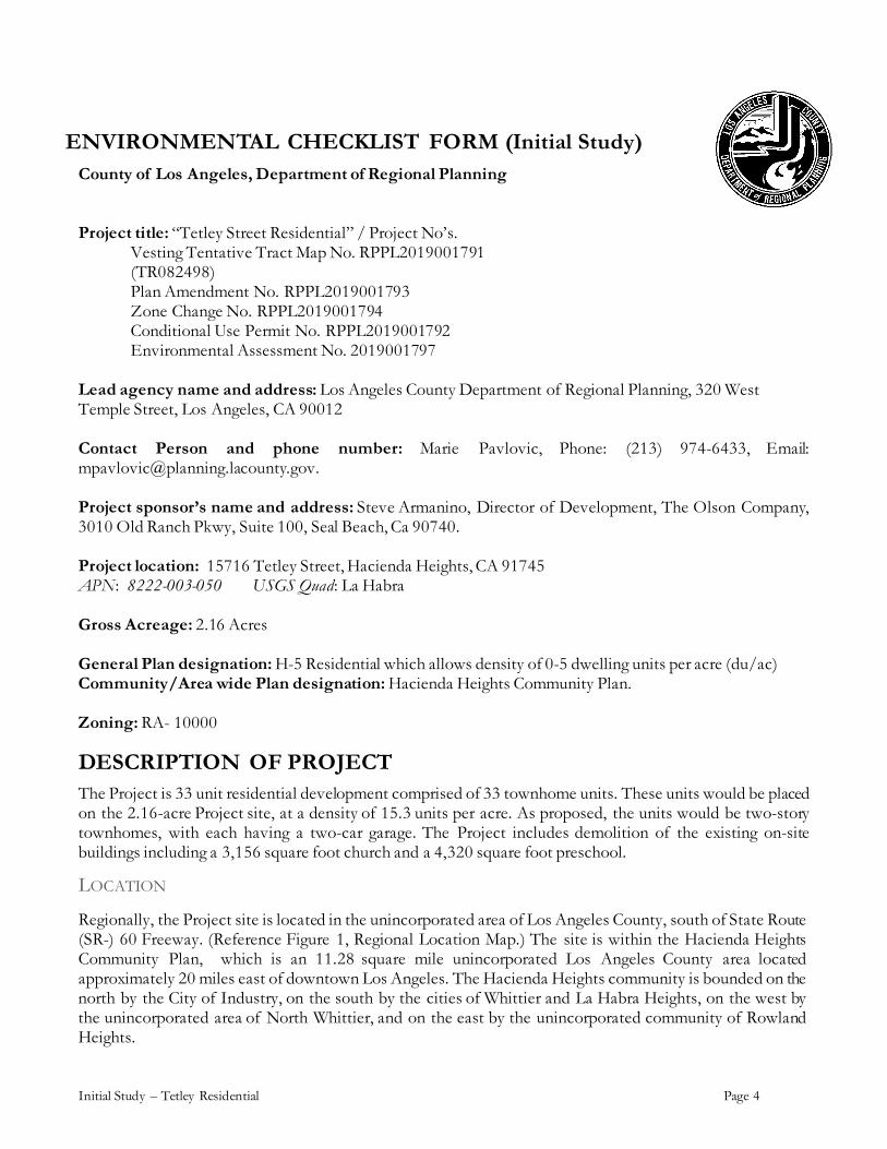
ENVIRONMENTAL CHECKLIST FORM (Initial Study) County of Los Angeles, Department of Regional Planning Project title: “Tetley Street Residential” / Project No’s.
Vesting Tentative Tract Map No. RPPL2019001791 (TR082498) Plan Amendment No. RPPL2019001793 Zone Change No. RPPL2019001794 Conditional Use Permit No. RPPL2019001792 Environmental Assessment No. 2019001797
Lead agency name and address: Los Angeles County Department of Regional Planning, 320 West Temple Street, Los Angeles, CA 90012 Contact Person and phone number: Marie Pavlovic, Phone: (213) 974-6433, Email: [email protected]. Project sponsor’s name and address: Steve Armanino, Director of Development, The Olson Company, 3010 Old Ranch Pkwy, Suite 100, Seal Beach, Ca 90740. Project location: 15716 Tetley Street, Hacienda Heights, CA 91745 APN: 8222-003-050 USGS Quad: La Habra Gross Acreage: 2.16 Acres General Plan designation: H-5 Residential which allows density of 0-5 dwelling units per acre (du/ac) Community/Area wide Plan designation: Hacienda Heights Community Plan. Zoning: RA- 10000
DESCRIPTION OF PROJECT The Project is 33 unit residential development comprised of 33 townhome units. These units would be placed on the 2.16-acre Project site, at a density of 15.3 units per acre. As proposed, the units would be two-story townhomes, with each having a two-car garage. The Project includes demolition of the existing on-site buildings including a 3,156 square foot church and a 4,320 square foot preschool.
LOCATION
Regionally, the Project site is located in the unincorporated area of Los Angeles County, south of State Route (SR-) 60 Freeway. (Reference Figure 1, Regional Location Map.) The site is within the Hacienda Heights Community Plan, which is an 11.28 square mile unincorporated Los Angeles County area located approximately 20 miles east of downtown Los Angeles. The Hacienda Heights community is bounded on the north by the City of Industry, on the south by the cities of Whittier and La Habra Heights, on the west by the unincorporated area of North Whittier, and on the east by the unincorporated community of Rowland Heights.

Initial Study – Tetley Residential Page 5
Locally, the Project site is addressed at 15716 Tetley Street, situated on the south side of Tetley Street, east of Richdale Avenue and west of South Hacienda Boulevard. (Reference Figure 2, Project Aerial Location Map.)
FIGURE 1. REGIONAL LOCATION MAP (SOURCE: GOOGLE MAPS)
Initial Study – Tetley Residential Page 6
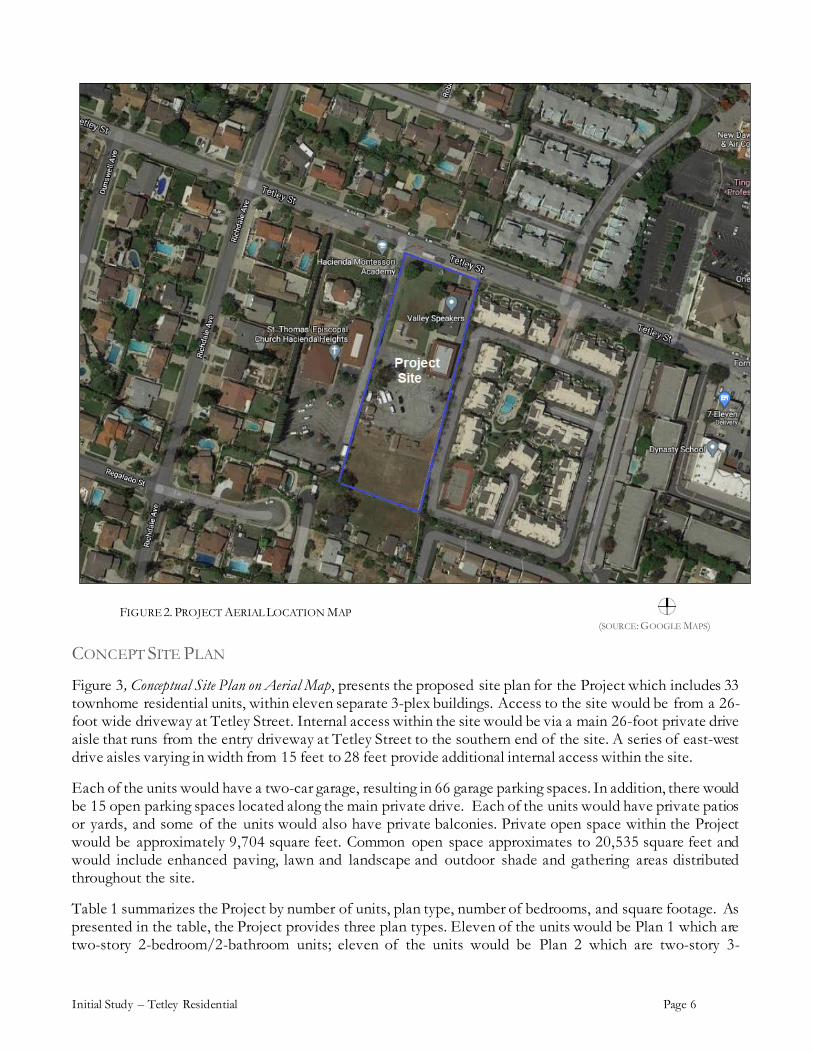
FIGURE 2. PROJECT AERIAL LOCATION MAP (SOURCE: GOOGLE MAPS)
CONCEPT SITE PLAN
Figure 3, Conceptual Site Plan on Aerial Map, presents the proposed site plan for the Project which includes 33 townhome residential units, within eleven separate 3-plex buildings. Access to the site would be from a 26-foot wide driveway at Tetley Street. Internal access within the site would be via a main 26-foot private drive aisle that runs from the entry driveway at Tetley Street to the southern end of the site. A series of east-west drive aisles varying in width from 15 feet to 28 feet provide additional internal access within the site.
Each of the units would have a two-car garage, resulting in 66 garage parking spaces. In addition, there would be 15 open parking spaces located along the main private drive. Each of the units would have private patios or yards, and some of the units would also have private balconies. Private open space within the Project would be approximately 9,704 square feet. Common open space approximates to 20,535 square feet and would include enhanced paving, lawn and landscape and outdoor shade and gathering areas distributed throughout the site.
Table 1 summarizes the Project by number of units, plan type, number of bedrooms, and square footage. As presented in the table, the Project provides three plan types. Eleven of the units would be Plan 1 which are two-story 2-bedroom/2-bathroom units; eleven of the units would be Plan 2 which are two-story 3-

Initial Study – Tetley Residential Page 7
bedroom/2.5 bathroom units; and eleven of the units would be ground floor single level 4-bedroom/2.5 bathroom units.
Table 1: Tetley Street Project Residential Unit Summary
Plan Type Number of Units Bedrooms Average Per
Unit Gross S.F. Total Gross
S.F. 1 11 2 1,595 17,545
2 11 3 1,777 19,547
3 11 4 1,756 19,316
Totals 33 56,408
Notes: S.F. = square footage
FIGURE 3. CONCEPT SITE PLAN ON AERIAL MAP (SOURCE: THE OLSON COMPANY)

Initial Study – Tetley Residential Page 8
Table 1: Tetley Street Project Residential Unit Summary
No. of Units Plan Type Bedrooms Average Per
Unit Gross S.F. Total Gross
S.F.
19 P1 2 1,263 23,997
15 P1X 2 1,338 20,070 8 P2 2 1,429 11,432
2 P2X 2 1,475 2,950
4 P3* 3 1,386 5,544 6 P4 3 1,671 10,026
2 P5 3 1,494 2,988
Totals 33 77,007 Notes: S.F. = square footage X = additional flex space * = units allocated for qualified moderate income households
PROJECT ARCHITECTURAL CONCEPT
Figure 4, Architectural Style North Elevation Fronting Tetley Street, shows the architectural elevations for the Project 3-plex buildings. Each of the buildings would be two-story and maximum height of the buildings would be 32 feet.
FIGURE 4. ARCHITECTURAL STYLE, NORTH ELEVATION FRONTING TETLEY STREET (SOURCE: THE OLSON COMPANY)

Initial Study – Tetley Residential Page 9
REQUIRED ENTITLEMENTS
Required entitlements for the Project are amendments to the General Plan Land Use Element and zoning maps to change the designation of the site to allow for medium high density residential development, and a vesting tentative tract map to subdivide the property for condominium purposes. The Project also requires preparation, processing and approval of this environmental compliance document to ensure consistency with CEQA.
Vesting Tentative Tract Map No. RPPL2019001791 (TR082498) Plan Amendment No. RPPL2019001793 Zone Change No. RPPL2019001794 Conditional Use Permit No. RPPL2019001792 Environmental Assessment No. 2019001797
According to the community of Hacienda Heights Community Plan, the Project site is within Hacienda Heights’ H-5 Residential land use category that permits a density of 0-5 dwelling units per acre. To accommodate development of the proposed townhomes, the Project is requesting a land use designation change from H-5 to H-18.
The current zone for the site is RA-10000, which is a Residential Agriculture use. This zone is based on the historically agricultural character of the area, as this out parcel was once an orchard. Currently, the site and surrounding areas are no longer agricultural. The Project proposes to rezone the property to RPD-Residential Planned Development.
A Conditional Use Permit is required to regulate uses and development proposed by the RPD to allow for a planned unit development and to ensure its proper integration with the surrounding community. In addition, the Project proposes a Vesting Tentative Tract Map for condominium purposes.
These entitlements and development of the Project requires preparation, processing and approval of this environmental compliance document to ensure consistency with CEQA.
PHASING
Development of the Project is proposed to occur in two phases. Phase I would start in Spring 2023 with completion in Fall 2023, and Phase II would start in Summer 2023 with completion in Winter 2023.
GRADING
The project grading quantities are as follows: total volume is 37,460 cubic yards (c.y.); cut is 1,560 c.y.; over excavation is 17,750 c.y.; import is 770 c.y.; and fill is 18,140 c.y. after shrinkage (1,930 c.y.). Haul routes during construction, including movement of soils, are likely to utilize Tetley Street via South Hacienda Boulevard and the nearby SR-60 Freeway.

Initial Study – Tetley Residential Page 10
EXISTING PROJECT SITE CONDITIONS Topography of the Project site is generally flat at an elevation of approximately 446 feet mean sea level (msl), sloping slightly to the north. Soil conditions consist primarily of fine-grained material with the expectation of sandy material observed between approximately 25 and 30 feet below ground surface (bgs). 1 A review of historical uses on the site show that from 1928 through about 1952, the Project site was developed with orchards and no structures. By 1952, the site is vacant with no orchards, although orchards still occupy the surrounding properties. By 1964, residential structures occur on the site; surrounding property to the north and south are cleared and vacant, and orchards continue to occur on properties to the east. Between 1970 and 1972, the two existing structures on the site (the church and preschool) have been developed. By 1983, the properties surrounding the site developed to the current configuration, with residential and institutional uses. As shown in Figure 5, Existing Site Conditions Aerial View, the Project site currently contains the two buildings, scattered vegetation and paving. Figure 6, Existing Church Building Street View from Tetley Street, shows the current street view appearance of the site. Figures 7 through Figures 12 contain additional photos of the current Project site appearance; Figure 7 is a Key Map, and Figures 8 through 12 contain photos of the front, sides and rear of the site.
FIGURE 5. EXISTING PROJECT SITE CONDITIONS AERIAL VIEW) (SOURCE: THE OLSON COMPANY / STANTEC)
1 Existing site condition information from Phase I and II Environmental Site Assessment for 15716 Tetley Street, Hacienda Heights, California, prepared by Stantec Consulting Services Inc., on behalf of the Project Applicant. (reference Appendix A.)

Initial Study – Tetley Residential Page 11
FIGURE 6. EXISTING CHURCH BUILDING STREET VIEW FROM TETLEY STREET (SOURCE: GOOGLE MAPS)
FIGURE 7. SITE PHOTOS KEY MAP (SOURCE: THE OLSON COMPANY)

Initial Study – Tetley Residential Page 12
FIGURE 8. SITE PHOTOS – FRONT AND EAST SIDE LOOKING TO SOUTH (SOURCE: THE OLSON COMPANY)
FIGURE 9. SITE PHOTOS – REAR LOOKING TO SOUTH (SOURCE: THE OLSON COMPANY)

Initial Study – Tetley Residential Page 13
FIGURE 10. SITE PHOTOS –REAR LOOKING SOUTH, WEST AND NORTH (SOURCE: THE OLSON COMPANY)
FIGURE 11. SITE PHOTOS – WEST SIDE LOOKING NORTH AND EAST (SOURCE: THE OLSON COMPANY)
Initial Study – Tetley Residential Page 14
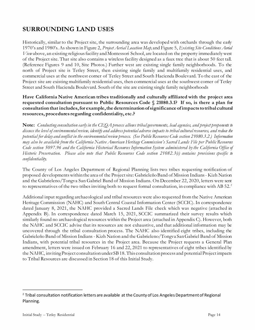
SURROUNDING LAND USES
Historically, similar to the Project site, the surrounding area was developed with orchards through the early 1970’s and 1980’s. As shown in Figure 2, Project Aerial Location Map, and Figure 5, Existing Site Conditions Aerial View above, an existing religious facility and Montessori School, are located on the property immediately west of the Project site. That site also contains a wireless facility designed as a faux tree that is about 50 feet tall. (Reference Figures 9 and 10, Site Photos.) Further west are existing single family neighborhoods. To the north of Project site is Tetley Street, then existing single family and multifamily residential uses, and commercial uses at the northwest corner of Tetley Street and South Hacienda Boulevard. To the east of the Project site are existing multifamily residential uses, then commercial uses at the southwest corner of Tetley Street and South Hacienda Boulevard. South of the site are existing single family neighborhoods
Have California Native American tribes traditionally and culturally affiliated with the project area requested consultation pursuant to Public Resources Code § 21080.3.1? If so, is there a plan for consultation that includes, for example, the determination of significance of impacts to tribal cultural resources, procedures regarding confidentiality, etc.? Note: Conducting consultation early in the CEQA process allows tribal governments, lead agencies, and project proponents to discuss the level of environmental review, identify and address potential adverse impacts to tribal cultural resources, and reduce the potential for delay and conflict in the environmental review process. (See Public Resources Code section 21080.3.2.) Information may also be available from the California Native American Heritage Commission’s Sacred Lands File per Public Resources Code section 5097.96 and the California Historical Resources Information System administered by the California Office of Historic Preservation. Please also note that Public Resources Code section 21082.3(c) contains provisions specific to confidentiality.
The County of Los Angeles Department of Regional Planning lists two tribes requesting notification of proposed developments within the area of the Project site: Gabrieleño Band of Mission Indians - Kizh Nation and the Gabrieleno/Tongva San Gabriel Band of Mission Indians. On December 22, 2020, letters were sent to representatives of the two tribes inviting both to request formal consultation, in compliance with AB 52.2
Additional input regarding archaeological and tribal resources were also requested from the Native American Heritage Commission (NAHC) and South Central Coastal Information Center (SCCIC). In correspondence dated January 8, 2021, the NAHC provided a Sacred Lands File check which was negative (attached in Appendix B). In correspondence dated March 15, 2021, SCCIC summarized their survey results which similarly found no archaeological resources within the Project area (attached in Appendix C). However, both the NAHC and SCCIC advise that its resources are not exhaustive, and that additional information may be uncovered through the tribal consultation process. The NAHC also identified eight tribes, including the Gabrieleño Band of Mission Indians - Kizh Nation and the Gabrieleno/Tongva San Gabriel Band of Mission Indians, with potential tribal resources in the Project area. Because the Project requests a General Plan amendment, letters were issued on February 16 and 22, 2021 to representatives of eight tribes identified by the NAHC, inviting Project consultation under SB 18. This consultation process and potential Project impacts to Tribal Resources are discussed in Section 18 of this Initial Study.
2 Tribal consultation notification letters are available at the County of Los Angeles Department of Regional Planning.
Initial Study – Tetley Residential Page 15
Other public agencies whose approval may be required (e.g., permits, financing approval, or participation agreement): Public Agency Approval Required Department of Public Works Demolition and Building Permits
Major projects in the area: Project/Case No. Description and Status N/A
Reviewing Agencies: [See CEQA Appendix B to help determine which agencies should review your project] Responsible Agencies Special Reviewing Agencies Regional Significance
None Regional Water Quality Control Board: Los Angeles Region Lahontan Region
Coastal Commission Army Corps of Engineers LAFCO
None Santa Monica Mountains Conservancy
National Parks National Forest Edwards Air Force Base Resource Conservation District of Santa Monica Mountains Area
None SCAG Criteria Air Quality Water Resources Santa Monica Mtns. Area
Trustee Agencies County Reviewing Agencies
None State Dept. of Fish and
Wildlife State Dept. of Parks and Recreation
State Lands Commission University of California (Natural Land and Water Reserves System)
DPW Fire Department (delete those that don’t apply) - Forestry, Environmental Division
-Planning Division - Land Development Unit - Health Hazmat Sanitation District Public Health/Environmental Health Division: Land Use Program (OWTS), Drinking Water Program (Private Wells), Toxics Epidemiology Program (Noise)
Sheriff Department Parks and Recreation Subdivision Committee

Initial Study – Tetley Residential Page 16
ENVIRONMENTAL FACTORS POTENTIALLY The environmental factors checked below would be potentially significant impacts affected by this project.
Aesthetics Greenhouse Gas Emissions Public Services
Agriculture/Forestry Hazards/Hazardous Materials Recreation
Air Quality Hydrology/Water Quality Transportation
Biological Resources Land Use/Planning Tribal Cultural Resources
Cultural Resources Mineral Resources Utilities/Services
Energy Noise Wildfire
Geology/Soils Population/Housing Mandatory Findings of Significance
DETERMINATION (To be completed by the Lead Department.)
On the basis of this initial evaluation:
I find that the proposed project COULD NOT have a significant effect on the environment, and a NEGATIVE DECLARATION will be prepared.
I find that although the proposed project could have a significant effect on the environment, there will not be a significant effect in this case because revisions in the project have been made by or agreed to by the project proponent. A MITIGATED NEGATIVE DECLARATION will be prepared.
I find that the proposed project MAY have a significant effect on the environment, and an ENVIRONMENTAL IMPACT REPORT is required.
I find that the proposed project MAY have a "potentially significant impact" or "potentially significant unless mitigated" impact on the environment, but at least one effect 1) has been adequately analyzed in an earlier document pursuant to applicable legal standards, and 2) has been addressed by mitigation measures based on the earlier analysis as described on attached sheets. An ENVIRONMENTAL IMPACT REPORT is required, but it must analyze only the effects that remain to be addressed.
I find that although the proposed project could have a significant effect on the environment, because all potentially significant effects (a) have been analyzed adequately in an earlier EIR or NEGATIVE DECLARATION pursuant to applicable standards, and (b) have been avoided or mitigated pursuant to that earlier EIR or NEGATIVE DECLARATION, including revisions or mitigation measures that are imposed upon the proposed project, nothing further is required.
____________________________________________ ___________________________ Signature (Prepared by) Date
____________________________________________ ___________________________ Signature (Approved by) Date
08/27/21
08/27/21
Initial Study – Tetley Residential Page 17
EVALUATION OF ENVIRONMENTAL IMPACTS 1) A brief explanation is required for all answers except "No Impact" answers that are adequately supported
by the information sources the Lead Department cites in the parentheses following each question. A "No Impact" answer is adequately supported if the referenced information sources show that the impact simply does not apply to projects like the one involved (e.g., the project falls outside a fault rupture zone). A "No Impact" answer should be explained where it is based on project-specific factors as well as general standards (e.g., the project will not expose sensitive receptors to pollutants, based on a project-specific screening analysis).
2) All answers must take account of the whole action involved, including off-site as well as on-site, cumulative as well as project-level, indirect as well as direct, and construction as well as operational impacts.
3) Once the Lead Department has determined that a particular physical impact may occur, then the checklist answers must indicate whether the impact is potentially significant, less than significant with mitigation, or less than significant. "Potentially Significant Impact" is appropriate if there is substantial evidence that an effect may be significant. If there are one or more "Potentially Significant Impact" entries when the determination is made, an EIR is required.
4) "Negative Declaration: Less Than Significant With Mitigation Incorporated" applies where the incorporation of mitigation measures has reduced an effect from "Potentially Significant Impact" to a "Less Than Significant Impact." The lead agency must describe the mitigation measures, and briefly explain how they reduce the effect to a less than significant level. (Mitigation measures from Section XVII, "Earlier Analyses," may be cross-referenced.)
5) Earlier analyses may be used where, pursuant to the tiering, program EIR, or other CEQA processes, an effect has been adequately analyzed in an earlier EIR or negative declaration. (State CEQA Guidelines § 15063(c)(3)(D).) In this case, a brief discussion should identify the following:
a) Earlier Analysis Used. Identify and state where they are available for review.
b) Impacts Adequately Addressed. Identify which effects from the above checklist were within the scope of, and adequately analyzed in, an earlier document pursuant to applicable legal standards, and state whether such effects were addressed by mitigation measures based on the earlier analysis.
c) Mitigation Measures. For effects that are "Less than Significant with Mitigation Measures Incorporated," describe the mitigation measures which were incorporated or refined from the earlier document and the extent to which they address site-specific conditions for the project.
6) Supporting Information Sources: A source list should be attached, and other sources used or individuals contacted should be cited in the discussion.
7) The explanation of each issue should identify: the significance threshold, if any, used to evaluate each question, and; mitigation measures identified, if any, to reduce the impact to less than significant. Sources of thresholds include the County General Plan, other County planning documents, and County ordinances. Some thresholds are unique to geographical locations.

Initial Study – Tetley Residential Page 18
1. AESTHETICS
Potentially Significant
Impact
Less Than Significant
Impact with Mitigation
Incorporated
Less Than Significant
Impact No
Impact Except as provided in Public Resources Code Section 21099, would the project:
a) Have a substantial adverse effect on a scenic vista?
According the Hacienda Heights Community Plan, the scenic resource applicable to the Hacienda Heights area is the Hillside Management Overlay, which is identified as a County scenic resources in the Scenic Resources section of the Conservation and Open Space Element of the Los Angeles County General Plan. In Hacienda Heights, the Hillside Management Overlay includes areas above 25 percent slope in the southern portions of the community and in the western slopes around the Puente Hills Landfill. Both these designated hillside areas are several miles from the Project site, which as dicussed above, is generally flat. Within the County, there are three adopted state scenic highways: Angeles Crest Highway Route-2, from 2.7 miles north of I-210 to the San Bernardino County line; Mulholland Highway (two sections), from SR-1 to Kanan Dume Road, and from west of Cornell Road to east of Las Virgenes Road; and Malibu Canyon–Las Virgenes Highway, from SR-1 to Lost Hills Road. There are also eight highways identified with an “Eligible for State Scenic Highway” designation: SR-1 from the Orange County line to SR-19 (Lakewood Boulevard) in the city of Long Beach; SR-1 from SR-187 (Venice Boulevard) in the city of Los Angeles to the Ventura County line; SR-27 (Topanga Canyon Boulevard) from SR-1 to the city of Los Angeles city limit; SR-67 from the Orange County line to SR-60 in the city of Diamond Bar; SR-118 from the western city of Los Angeles boundary to the Ventura County line; SR-210/I-5 from SR-134 in the city of Pasadena, through the city of Santa Clarita to the Ventura County line; U.S. Route 101 from Topanga Canyon Boulevard to the Ventura County line. As shown in Figures 1 and 2, the Project site is not located within the vicinity of these designated or eligible scenic highways. Consequently, the development of the proposed townhome residential Project would not have a substantial adverse effect on a scenic vista. b) Be visible from or obstruct views from a regional riding, hiking, or multi-use trail?
As discussed above, the County defines a scenic vista as a scenic view from a given location, such as a highway, corridors (or routes), hillsides, ridgelines, a park, a hiking trail, river/waterway, or even from a particular neighborhood. Designated County scenic resources in the Hacienda Heights area is the Hillside Management Overlay, which as noted above is several miles from the Project site. Figure 10.1 of the General Plan identifies the County’s Regional Trail System. The Schabarum Recreation Trail, also known as the Skyline Trail, is a multipurpose trail that traverses portions of Hacienda Heights in the southwest and southern edges of the community. There is also the Hacienda Hills Trail, which can be accessed at Orange Grove and 7th Avenue in Hacienda Heights. Both trails are maintained by the Puente Hills Landfill Native Habitat Preservation Authority. The Project site is located in the central area of the community, in a generally flat and urbanized area. Development of the Project would not be visible from or obstruct views from a designated trail. Consequently, the development of the proposed townhome residential Project would not be visible and would not signficantly block views from an existing or proposed regional trail.

Initial Study – Tetley Residential Page 19
c) Substantially damage scenic resources, including, but not limited to, trees, rock outcroppings, and historic buildings within a state scenic highway?
As discussed above, the Project site is not within the vicinity of a designated scenic highway or scenic resource. The Project site is relatively flat and is currently contains a church and preschool buildings which were constructed in the early 1970s. A records search by the South Central Coastal Information Center (SCCIC) was conducted for the Project site and the results are summarized in a March 15, 2021 letter from SCCIC, contained in Appendix C of this Initial Study document. The SCCIC search covered the Project site and a ½ mile radius, and included a review of recorded archaeological and built-environment resources as well as a review of cultural resource reports on file. In addition, the California Points of Historical Interest (SPHI), the California Historical Landmarks (SHL), the California Register of Historical Resources (CAL REG), the National Register of Historic Places (NRHP), and the California State Historic Properties Directory (HPD) listings were reviewed for the Project site. The records search did not identify the existing church or school building located on the Project site or any resources on within a ½ mile of the site. (Reference Section 5.a) of this Initial Study regarding potential historic significance of existing onsite buildings.) The site vegetation on the site consists of a few scattered shrubs and trees. Three of the trees are Podocarpus, each about 30 to 35 feet hight. Los Angeles County Oak Tree Ordinance No. 22.56.2050 protects oak trees, recognizing oak trees as significant historical, aesthetic and ecological resources. No oak tree occurs on the Project site. The site does not contain a protected tree or rock croppings or historic building. Consequently, the Project would not substantially damage scenic resources, including, but not limited to, trees, rock outcroppings, and historic buildings within a state scenic highway have a substantial adverse effect on a scenic vista. d) Substantially degrade the existing visual character or quality of public views of the site and its surroundings because of height, bulk, pattern, scale, character, or other features and/or conflict with applicable zoning and other regulations governing scenic quality? (Public views are those that are experienced from publicly accessible vantage point)
The Project proposes to replace an existing religious facility and preschool with 33 townhome residential units. This change of would change the visual character of the site, with more structures. The existing church, which fronts Tetley Street is one-story at an approximate height of 20 feet, has a tower on its west side that is about 28 feet high. On top of the tower is a cross that reaches about 35 feet high. Behind the church is the existing preschool, which is two-stories and reaches about 30 feet high. Both of the existing buildings are located on the northeast quadrant of the site, with the rest of the site containing a parking lot, play area, lawn and trees. Chainlink fencing is located at the front and west side of the Project site, and a block wall at the rear and east side. Single-family residences are located across the street. The Project includes a plan amendment to increase the density of the site which would intensify the scale and bulk of the development. The Project would develop eleven 3-plex buildings on the site. Each of the buildings would be two-story and maximum height of the would be 32 feet. The height of the buildings would be similar to the existing preschool and tower, and the existing two-story townhome developments immediate east and

Initial Study – Tetley Residential Page 20
across the street from the site. The Project proposed to underground the electrical lines, remove the chainlink fencing and install stucco wall fencing at the west and east sides. Setbacks for the Project would be consistent with the proposed RPD development standards: 20-feet front, 5-feet side and 15-feet rear. The proposed front and east-side setback are similar to the existing on-site buildings. Although the Project would change the phyiscal appearance of the site particularly on the west-side and rear, the change would be consistent with existing on-site and surrounding two-story developments and with the RPD development standards. The Project area is generally flat and is not governed by scenic regulations and is not within a designaged public viewsheld. Consequently, the Project would have a less than significant impacts on the visual character of the site or its surroundings. e) Create a new source of substantial shadows, light, or glare which would adversely affect day or nighttime views in the area?
Exterior lighting associated with the Project would include low voltage 12 volt (V) fixtures, including decorative downlights at the Project entry and common areas, and spot uplighting at trees, and down lighting at shade structures. As indicated in the Project Schematic Lighting Coordination Plan, all exterior lighting would would be directed to the interior of the site, and would be similar to that of the existing townhome residential directly east of the site. 3 Consequently, Project impacts relative to a new source of substantial shadow, light or glare would be less than significant.
3 Schematic Lighting Coordination Plan, Tetley Avenue Architectural, Civil and Landscape Plan (08-05-2019), available at the County of Los Angeles, Department of Regional Planning.

Initial Study – Tetley Residential Page 21
2. AGRICULTURE / FOREST
Potentially Significant
Impact
Less Than Significant
Impact with Mitigation
Incorporated
Less Than Significant
Impact No
Impact Would the project:
a) Convert Prime Farmland, Unique Farmland, or Farmland of Statewide Importance (Farmland), as shown on the maps prepared pursuant to the Farmland Mapping and Monitoring Program of the California Resources Agency, to non-agricultural use?
According to the State of California Important Farmland Map 2018, the Project site and it’s surrounding areas are not designated as farmlands. 4 The General Plan Figuire 9.5 identifies potential agricultural resources within the County as occuring from the Angeles National Forest north. The Project site is south of the Angeles National Forest and not within any mapping of agricultural resources. Consequently, the Project would not convert Farmland to a non-agricultural use. b) Conflict with existing zoning for agricultural use, with a designated Agricultural Resource Area, or with a Williamson Act contract?
The current zoning for the site is RA-1000 (Residential Agriculture). According to Section 22.20.410 of the Couty Zoning Code, the RA zones are intended for single family residences with crops or orchards. This zoning is consistent with the area’s historical use as orchards. However, there are no existing orchards or agriculture uses in the vicinity of the Project site. The current General Plan Land Use Map designation for the Project site is H-5 which permits residential uses including single-family residence, residential agriculture and RPD development. To develop the proposed 33 residential units at a density of 15.3 units per acre, the Project would rezone the site to RPD and change the General Plan Land Use Map designation to H18 which permits residential development up to a density of 18 units per acre. This change of zoning and General Plan Land Use Map designation is consistent with the non-agricultural nature of existing uses on and nearby the site as well as the proposed Project use. Consequently, Project impacts relative to conflicts with existing zoning for agricultural use would be less than significant. c) Conflict with existing zoning for, or cause rezoning of, forest land (as defined in Public Resources Code § 12220 (g)), timberland (as defined in Public Resources Code § 4526), or timberland zoned Timberland Production (as defined in Government Code § 51104(g))?
The Project site is within an urbanized area. The General Plan identifies the Los Padres National Forest, Angeles National Forest and Santa Monica Mountains as natural forest areas within the County. Of these areas, the Santa Monica Mountains are the closest to the Project site at a distance of approximately 22 miles.
4 DLRP Important Farmland Finder (ca.gov); accessed April 16, 2021.

Initial Study – Tetley Residential Page 22
There are no lands zoned for timberland production within the County. Consequently, the Project would not conflict with existing zoning for, or cause rezoning of forest land. d) Result in the loss of forest land or conversion of forest land to non-forest use?
As discussed in above, no forest lands occur in the vicinity of the Project site. Consequently, the Project would not result in a loss of forest land or conversion of forest land. e) Involve other changes in the existing environment which, due to their location or nature, could result in conversion of Farmland, to non-agricultural use or conversion of forest land to non-forest use?
No Farmland or forest land occurs in the vicinity of the Project site. Consequently, the Project would not result in the conversion from Farmland to a non-agricultural use or from forest to a non-forest use

Initial Study – Tetley Residential Page 23
3. AIR QUALITY Potentially
Significant Impact
Less Than Significant Impact with Mitigation Incorporated
Less Than Significant Impact
No Impact
Would the project:
a) Conflict with or obstruct implementation of applicable air quality plans of either the South Coast AQMD (SCAQMD) or the Antelope Valley AQMD (AVAQMD)?
Applicable Air Quality Policies: The Project area is within Los Angeles County which is part of the the South Coast Air Basin (SCAB), which is bounded by the Pacific Ocean to the south and west and mountains to the north and east. Air quality in the South Coast Air Basin is managed by the South Coast Air Quality Management District (SCAQMD). The SCAQMD and the Southern California Association of Governments (SCAG) are the agencies responsible for preparing the Air Quality Management Plan (AQMP) for the SCAB. Since 1979, a number of AQMPs have been prepared. Every three (3) years the SCAQMD prepares a new AQMP, updating the previous plan and having a 20-year horizon. The latest version is the 2019 AQMP. The 2016 AQMP is a regional blueprint for achieving the federal air quality standards and healthful air. While air quality has dramatically improved over the years, the SCAB still exceeds federal public health standards for both ozone and particulate matter (PM) and experiences some of the worst air pollution in the nation. Project Compliance with Air Quality Plan: CEQA requires that projects be consistent with the AQMP. A consistency determination plays an essential role in local agency project review by linking local planning and unique individual projects to the AQMP in the following ways: (1) it fulfills the CEQA goal of fully informing local agency decision-makers of the environmental costs of the project under consideration at a stage early enough to ensure that air quality concerns are fully addressed; and (2) it provides the local agency with ongoing information assuring local decision-makers that they are making real contributions to clean air goals contained in the AQMP. Only new or amended General Plan elements, specific plans, and regionally significant projects need to undergo a consistency review. This is because the AQMP strategy is based on projections from local General Plans. Projects that are consistent with the local General Plan are, therefore, considered consistent with the air quality management plan. To develop the Project site at a residential project at a density of 15.3 units per acre, the Project requires amendments to both the General Plan Land Use Map and zoning map. As proposed, the Project would amend the General Plan Land Use Map designation for the site from to H-5 to H-18, which permits single family residences, two family residences and multifamily residences. This transition would be consistent with the with surrounding residential and townhome uses surrounding the Project site. As described in the Tables 2 and 3, this transition would not result in significant construction emissions nor significant operation emissions. Additionally, the Project would not result in significant localized air quality impacts. As such, the Project is consistent with the goals of the AQMP.
b) Result in a cumulatively considerable net increase of any criteria pollutant for which the project region is non-attainment under an applicable federal or state ambient air quality standard?
Initial Study – Tetley Residential Page 24
A violation of an air quality standard could occur over the short-term during construction, or over the long-term during its subsequent operation. Each is addressed below. Short-Term Impacts: Project construction raises localized ambient pollutant concentrations. Construction air quality impacts are considered significant if they exceed any of the following thresholds that have been established by SCAQMD to measure construction emissions. Each of the thresholds represents a daily maximum of acceptable pollutant emissions during the construction period5:
• 75 pounds per day for ROG (reactive organic gases)
• 100 pounds per day for NOx (oxides of nitrogen)
• 550 pounds per day for CO (carbon monoxide)
• 210 pounds per day for PM10 (respirable 10-micron diameter particulate matter)
• 55 pounds per day for PM2.5 (respirable 2.5-micron diameter particulate matter)
• 210 pounds per day of SOx (oxides of sulfur) Air quality impacts may occur during demolition, site preparation and grading, and construction activities associated with the Project. Major sources of emissions during construction include exhaust emissions, fugitive dust generated as a result of soil and material disturbance during site preparation, and grading activities, and the emission of ROGs during the painting of the structures. SCAQMD’s Rule 403 governs fugitive dust emissions from construction projects. This rule sets forth a list of control measures that must be undertaken for all construction projects to ensure that no dust emissions from the Project are visible beyond the property boundaries. These measures include: (1) soil stabilizers shall be applied to unpaved roads; (2) ground cover shall be quickly applied in all disturbed areas; and (3) the active construction site shall be watered twice daily. Adherence to Rule 403 is mandatory. Consistent with SCAQMD established methodologies, this rule is a requirement and not a mitigation of the Project. The Project is a relatively small, under three acres, infill development. Construction of the Project would involve standard grading, trenching, paving, building and coatings, typical of construction activities that occur in Los Angeles County. To evaluate Project air quality impacts, a Tetley Street Residential Development Focused Air Quality and Greenhouse Gas Analysis was prepared by Synectecology (Air Quality Impact Study); and contained in Appendix D. To estimate Project air pollutant emissions, the Air Quality Impact Study uses the California Emissions Estimator Model Version 2016.3.2 (CalEEMod) to calculate criteria air pollutants from the construction and operation of the Project. CalEEMod is a statewide land use emissions computer model designed to provide a uniform platform for government agencies, land use planners, and environmental professionals to quantify criteria air pollutant and GHG emissions. The Air Quality Impact Study calculated demolition of the existing church and preschool, totaling about 7,500 square feet, and removal of approximately 0.75 acres of paving. would be removed during demolition. Construction activities are assumed in the Air Quality Impact Study to begin in January 2022 and end on January 2023, allowing for full occupancy in 2023.
5 ROG (reactive organic gases); NOx (oxides of nitrogen); CO (carbon monoxide); PM-10 (respirable 10-micron diameter particulate matter); PM-2.5 (respirable 2.5-micron diameter particulate matter; SOx (oxides of sulfur).
Initial Study – Tetley Residential Page 25
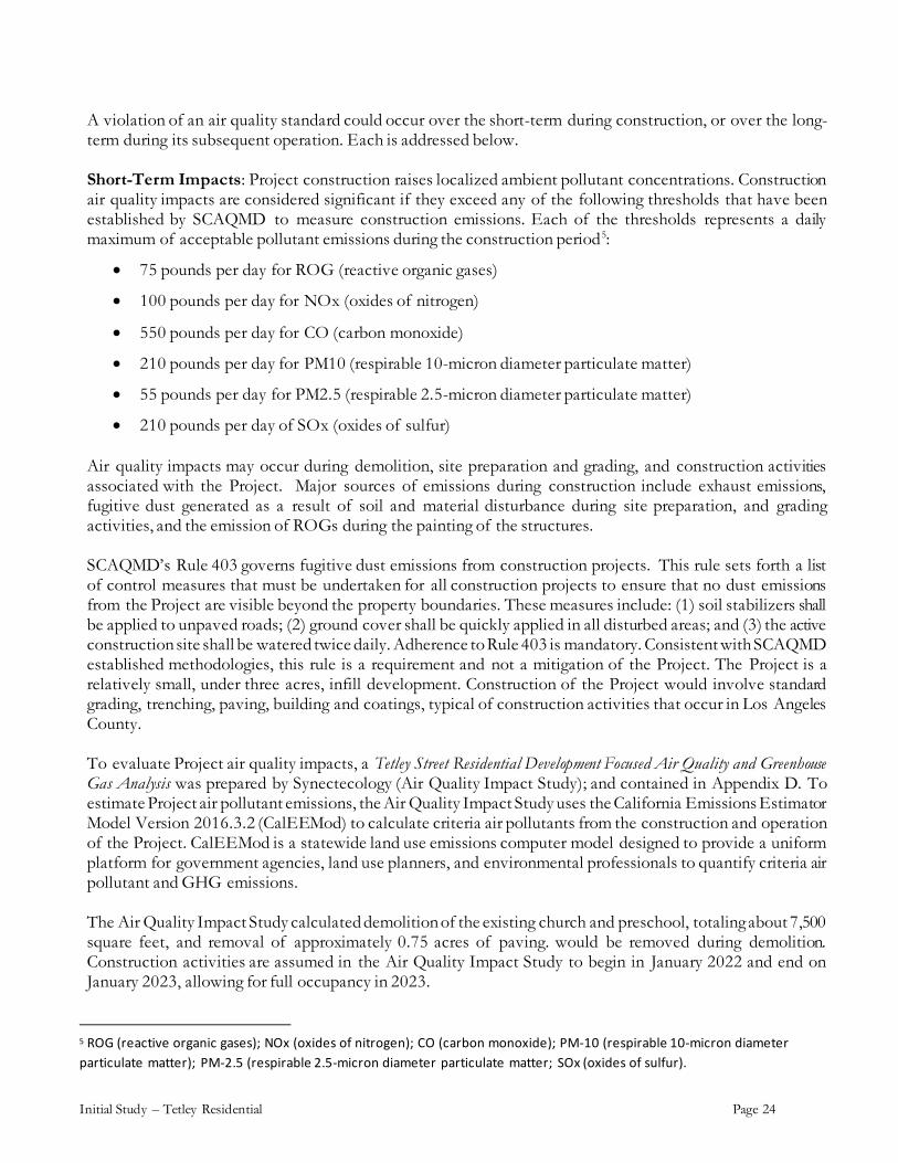
Based on these estimates, Table 2 presents the daily emissions projected for Project site construction and demonstrates that all Project construction emissions would be below their respective thresholds. With required SCAQMD’s Rule 403 fugitive dust emission controls, as discussed above, Project construction related air quality impacts would be less than significant. Table 2: Comparison of Project Construction Emissions and Daily Criteria Values (pounds/day) (lbs/day)1
Activity ROG NOx CO SO2 PM10 PM2.5
Demolition 1.81 18.51 14.92 0.03 1.44 0.91
Site Preparation 1.43 15.69 10.33 0.02 1.01 0.60
Grading 1.58 17.01 9.59 0.02 2.18 1.39
Building Construction 1.98 15.04 15.35 0.02 1.00 0.75
Paving 1.21 9.37 12.26 0.02 0.66 0.50
Architectural Coating 35.32 1.42 2.00 0.00 0.14 0.10
SCAQMD Threshold 75 100 550 150 150 55
Exceeds Threshold (?) No No No No No No 1 Maximum daily emissions during summer or winter; includes both on-site and off-site project emissions.
Long-Term Impacts: Long-term or operational Project emissions are caused by mobile emissions from truck and passenger vehicle traffic, and stationary source emissions from Project building heating and electrical systems. These air quality impacts are considered significant if they exceed any of the following thresholds that have been established by SCAQMD to measure long-term or operational emissions. Each of the thresholds represents a daily maximum of acceptable pollutant emissions:
• 55 pounds per day of ROG
• 55 pounds per day of NOx
• 550 pounds per day of CO
• 210 pounds per day of PM10
• 55 pounds per day of PM2.5
• 210 pounds per day of SOx The major source of long-term air quality impacts for criteria pollutants is that associated with the emissions produced from project-generated vehicle trips, though stationary sources add to the total. Project traffic is estimated by the ITE Trip Generation Manual, 10th Edition. Based on these sources, the Project would generate 242 Average Daily Trips (ADT) on a weekday, 269 ADT on a Saturday, and 207 ADT on a Sunday. With respect to summer and winter daily emissions, the CalEEMod model reports the day with the highest emissions production, which in this case actually works out to be Saturday. The estimations of weekday and Sunday values are used in the calculation of the annual and greenhouse gas emissions.

Initial Study – Tetley Residential Page 26
Project traffic emissions would be offset by emissions generated by the existing church and preschool traffic. For the church, the ITE Manual (10th Edition) puts the weekday ADT at about 22 trips, the Saturday ADT at 19 trips, and Sunday ADT at 87 trips. Existing emissions would peak on a Sunday and this value would be used in the CalEEMod peak day analysis. The existing preschool generates about 206 ADT on a weekday and about 25 ADT on a Saturday or Sunday. Major sources of stationary source emissions for the Project include combustion of natural gas for space and water heating. Additionally, the structures would be maintained and this requires repainting over time, thus resulting in the release of additional ROG emissions. The Air Quality Impact Study also considered existing stationary source emissions from the site’s existing church and preschool and deducted these from the Project stationary source emission calculations. Long-term or operational Project mobile and stationary source emissions are presented in Table 3. All Project long-term emissions are below their respective threshold values and the impact is less than significant.
TABLE 3: COMPARISON OF PROJECT DAILY OPERATIONAL EMISSIONS AND DAILY CRITERIA VALUES (POUNDS/DAY)
Source ROG NOx CO SO2 PM10 PM2.5
Total Daily Operational Emissions 0.10 0.19 0.47 0.00 0.17 0.04 SCAQMD Threshold 55 55 550 150 150 55 Exceeds Threshold? No No No No No No Notes: The CalEEMod model projects summer and winter emissions. These can differ for mobile sources and the higher of the two values were included in the table.
c) Expose sensitive receptors to substantial pollutant concentrations?
Project construction and operation has the potential to raise localized ambient pollutant concentrations that could be regionally insignificant but could impact nearby sensitive receptors or uses. Nearby sensitive receptors include adjacent and nearby residential uses, and the adjacent church and Montessori school. The SCAQMD has developed screening tables for the construction and operation of projects up to five acres in size. These tables are included in the SCAQMD’s Final Localized Significance Threshold Methodology (June 2003) and are periodically updated on the SCAQMD Internet website. The most current update was in 2008 and these data are used in the Air Quality Impact Study. The screening tables calculate allowable emissions based on the source receptor area in which they are produced. In this case, the Project lies within SRA 10 (Pomona/Walnut Valley) and the distance of the sensitive uses from the site. Because of the proximity of the sensitive uses to the Project site, the Air Quality Impact Study applied a 25-meter threshold. For construction, the SCAQMD screening tables set a CO threshold of 612 pounds per day, a NOx threshold of 103 pounds per day, a PM10 threshold of 4 pounds per day and a PM25 threshold of 2.25 pounds per day, PM10. For Project construction, the Air Quality Impact Study calculates peak values of 9.22 and 16.98 pounds per day for CO and NOx, respectively during grading. These construction emissions would not create localized impacts to the adjacent and nearby sensitive uses. Because the Basin is a non-attainment area for particulate matter, the thresholds for both PM10 and PM2.5 are much more stringent than those for CO and NOx. In this case, the screening level for a 1-acre site for PM10 with receptors at 25 meters is 4 pounds per day. For Project construction, the Air Quality Impact Study calculates peak values at 2.07 pounds per day for PM10, at 1.36 pounds per day for PM2.5. Similar to

Initial Study – Tetley Residential Page 27
CO and NOx, these construction emissions would not create localized impacts to the adjacent and nearby sensitive uses, and no significant localized impacts would occur. Long-term effects of the Project could also be significant if they exceed the California Ambient Air Quality Standards (CAAQS). As noted for construction, these criteria only apply to CO, NO2, PM10, and PM2.5. CO and NO2 would be significant if a project were to raise existing levels above those values included in the CAAQS. Unlike construction equipment that generates exhaust and dust in a set area, the primary source of emissions from project operations is due to the addition of vehicles on the roadway system. These emissions are then spread over a vast area and do not result in localized concentrations in proximity to the project site. As such, localized modeling for the project operations is not prepared for residential, limited commercial, or light industrial development that does not include a truck terminal. Because CO is the criteria pollutant that is produced in greatest quantities from vehicle combustion and does not readily disperse into the atmosphere, long-term impacts are typically demonstrated through an analysis of localized CO concentrations. In the past, areas of vehicle congestion had the potential to create “pockets” of CO called “hot spots.” However, the SCAB has now been designated as an “attainment” area of both the State and federal CO standards, and no hot spots have been reported in project area in more than the last 5 years. CO is no longer a localized pollutant of concern near roadways and as such this analysis is no longer necessary. Consequently, no significant long-term operational emissions are associated with the Project and there would not be long-term exposure of sensitive receptors to substantial pollutant concentrations. d) Result in other emissions (such as those leading to odors) adversely affecting a substantial number of people?
Project construction would involve the use of heavy equipment creating exhaust pollutants from on-site earth movement and from equipment bringing concrete and other building materials to the site. With regards to nuisance odors, any air quality impacts would be confined to the immediate vicinity of the equipment itself. By the time such emissions reach neighboring residential properties, they would be diluted to well below any level of air quality concern. Any exposure of the general public to common construction odors would be of short duration and not significant. Operational odors associated with residential uses typically include cooking and vehicle use. These odors would be nominal, and consistent with the surrounding residential uses. Consequently, potential impacts associated with objectionable odors would not be significant.

Initial Study – Tetley Residential Page 28
4. BIOLOGICAL RESOURCES
Potentially Significant Impact
Less Than Significant Impact with Mitigation Incorporated
Less Than Significant Impact
No Impact
Would the project:
a) Have a substantial adverse effect, either directly or through habitat modifications, on any species identified as a candidate, sensitive, or special status species in local or regional plans, policies, or regulations, or by the California Department of Fish and Wildlife (CDFW) or U.S. Fish and Wildlife Service (USFWS)?
Chapter 9, Conservation and Natural Resources Element of the General Plan identifies the biological resources and important habitat areas in the unincorporated areas of Los Angeles County. The Element identifies Significant Ecological Area (SEAs) within the County, a designation is given to land that contains the most sensitive biological resources and established local policies to protect sensitive habitat. Additional discussion regarding SEAs is provided in the Hacienda Heights Community Plan, which identifies two SEAs in Hacienda Heights: the Sycamore and Turnbull Canyons SEA and the Powder Canyon SEA. Both SEAs are located at the southern edges of the Hacienda Heights community, both more than 2 miles from the Project Site. The Project site is graded and fully developed with a church, preschool, paved parking lot, playground and scattered lawn and vegetation. It is surrounded by urbanized uses, including religions facilities, residential and commercial. No sensitive species as identified by the U.S. Fish and Wildlife Service (USFWS) or the California Department of Fish and Wildlife (CDFW) are found on the Project site or surrounding properties. Consequently, the Project would not cause a substantial adverse effect, either directly or through habitat modifications, on a sensitive species. However, the existing Podocarpus, Olive, and Eucalyptus trees and other trees and shrubs on the Project site could provide nesting habitat for birds or roosting habitat for bats, some of which may be sensitive. Near the southwest corner, but offsite are two large Ash trees that extend canopies onto the project site. Migratory birds are protected under the federal Migratory Bird Treaty Act (MBTA) and under Section 3513 et. seq. of the CDFW Code. The Project site is otherwise fully covered by buildings and paving, with no evidence of dirt for burrows or rodent populations to support burrowing owls. The nesting season for birds in the Los Angeles County region occurs between January 1st to September 15th (which accommodates the nesting period for passerine birds and raptors). Because there is a possibility that a bird could nest in the existing tree or shrubs on the Project site, Mitigation Measures 4.1, 4.2 and 4.3 are added to the Project. With inclusion of these measures, potential impacts relative to a substantial adverse effect, either directly or through habitat modifications, on a sensitive species would be reduced to less than significant levels.
Mitigation Measure 4.1: Proposed project activities (including disturbances to native and nonnative vegetation, and substrates) shall occur outside of the avian breeding season which generally runs from February 1-August 31 (as early as January 1 for some raptors) to avoid take of birds or their eggs. Take means to hunt, pursue, catch, capture, or kill, or

Initial Study – Tetley Residential Page 29
attempt to hunt, pursue, catch, capture or kill (Fish and Game Code Section 86), and includes take of eggs and/or young resulting from disturbances which cause abandonment of active nests. Depending on the avian species present, a qualified biologist may determine that a change in the breeding season dates is warranted. Any proposed changes shall be reviewed and authorized by the Department of Regional Planning. Measure 4.2. If avoidance of the avian breeding season is not feasible, a qualified biologist (as determined by Los Angeles County) with experience in conducting breeding bird surveys shall conduct a bird survey to detect protected native bird nests within 300 feet of construction activity (within 500 feet for raptors). If an active nest is located, project activities within 300 feet of the nest (within 500 feet for raptor nests) or as determined by a qualified biological monitor, must be postponed until the nest is vacated and juveniles have fledged. Flagging, stakes, and/or construction fencing shall be used to demarcate the inside boundary of the buffer of 300 feet (or 500 feet) between the project activities and the nest. Project personnel, including all contractors working on site, shall be instructed on the sensitivity of the area. If requested, the project proponent shall provide Los Angeles County the results of the recommended protective measures described above to document compliance with applicable State and Federal laws pertaining to the protection of native birds. Mitigation Measure 4.3. If an active nest is observed, the biological monitor shall be present on site during all grubbing and clearing of vegetation to ensure that these activities remain within the project footprint (i.e., outside the demarcated buffer) and that the flagging/stakes/fencing is being maintained, and to minimize the likelihood that active nests are abandoned or fail due to project activities. The biological monitor shall send weekly monitoring reports to Los Angeles County’s Department of Regional Planning (DRP) during the grubbing and clearing of vegetation, and shall notify DRP immediately if project activities damage active avian nests.
b) Have a substantial adverse effect on any sensitive natural communities (e.g., riparian habitat, coastal sage scrub, oak woodlands, non-jurisdictional wetlands) identified in local or regional plans, policies, regulations or by CDFW or USFWS?
As discussed above, the Project site is urbanized and surrounded by urban land uses. The Project would be an infill development and consequently, would not cause a substantial adverse effect on a County, USFWS or CDFW designated natural community. c) Have a substantial adverse effect on state or federally protected wetlands (including, but not limited to, marshes, vernal pools, coastal wetlands, etc.) through direct removal, filling, hydrological interruption, or other means?
Wetlands are defined under the federal Clean Water Act as land that is flooded or saturated by surface water or groundwater at a frequency and duration sufficient to support, and that normally does support, a prevalence of vegetation adapted to life in saturated soils. Wetlands include areas such as swamps, marshes, streams, lakes, and bogs. No bodies of water are located within the vicinity of the site. According to the USFWS

Initial Study – Tetley Residential Page 30
National Wetlands Mapper, 6 no natural wetlands are located within the vicinity of the Project site. Consequently, the Project would not cause a substantial adverse effect on federally protected wetlands. d) Interfere substantially with the movement of any native resident or migratory fish or wildlife species or with established native resident or migratory wildlife corridors, or impede the use of native wildlife nursery sites?
As discussed in Section 4.a, above, the Project site is covered with buildings and asphalt, and surrounded by urban land uses. Vegetation on the site consists of a few scattered shrubs, with the most notable vegetation being a Podocarpus tree on the northwest and 2 very large Olive trees west of the church. These trees are about 30 to 35 feet in height. These trees and other shrubs on the Project site could provide nesting habitat for birds. Mitigation Measures 4.1, 4.2 and 4.3 are added to the Project to ensure possible nesting birds are protected. With inclusion of these measures, potential impacts relative to substantial interference with the movement of any resident migratory fish or wildlife species or migratory wildlife corridor or native wildlife nursery would be reduced to less than significant levels.
e) Convert oak woodlands (as defined by the state, oak woodlands are oak stands with greater than 10% canopy cover with oaks at least 5 inch in diameter measured at 4.5 feet above mean natural grade) or other unique native woodlands (juniper, Joshua, southern California black walnut, etc.)?
The Project site is developed and surrounded by urban land. Vegetation on the site consists of a three Podocarpus trees and scattered ornamental shrubs. No oak trees, junipers, joshuas, or southern California black walnut occur within or adjacent to the Project site. Consequently, the Project would not impact oak woodlands.
Conflict with any local policies or ordinances protecting biological resources, including Wildflower Reserve Areas (L.A. County Code, Title 12, Ch. 12.36), the Los Angeles County Oak Tree Ordinance (L.A. County Code, Title 22, Ch. 22.174), the Significant Ecological Areas (SEAs) (L.A. County Code, Title 22, Ch. 102), Specific Plans (L.A. County Code, Title 22, Ch. 22.46), Community Standards Districts (L.A. County Code, Title 22, Ch. 22.300 et seq.), and/or Coastal Resource Areas (L.A. County General Plan, Figure 9.3)?
The Project site is not within a designated Significant Ecological Area. The site is urbanized and surrounded by urban land uses. There are no oak trees on the Project site or wildflower reserve areas. There are no County policies protecting biological resources applicable to the Project site. Consequently, the Project would not conflict with local policies protecting biological resources.
6 http://www.fws.gov/wetlands/data/mapper.HTML; accessed January 10, 2021.

Initial Study – Tetley Residential Page 31
g) Conflict with the provisions of an adopted Habitat Conservation Plan, Natural Community Conservation Plan, or other approved state, regional, or local habitat conservation plan?
The Project site is not within a designated Significant Ecological Area. The site is urbanized and surrounded by urban land uses. There are no state, regional or County habitat conservation plans applicable to the Project site. Consequently, the Project would not conflict with a habitat conservation plan.
Initial Study – Tetley Residential Page 32
5. CULTURAL RESOURCES
Potentially Significant Impact
Less Than Significant Impact with Mitigation Incorporated
Less Than Significant Impact
No Impact
Would the project:
a) Cause a substantial adverse change in the significance of a historical resource pursuant to CEQA Guidelines § 15064.5?
The CEQA Guidelines, Section 15064.5, define “historic resources” as resources listed in the California Register of Historical Resources, or determined to be eligible by the California Historical Resources Commission for listing in the California Register of Historic Resources. 7 The criteria for eligibility are generally set by the Historic Sites Act of 1935, which established the National Register which recognizes properties that are significant at the national, state and local levels. To be eligible for listing in the National Register, a district, site, building, structure, or object that must possess integrity of location, design, setting, materials, workmanship, feeling and association relative to American history, architecture, archaeology, engineering, or culture. 8 In addition, unless the property possesses exceptional significance, it must be at least 45 years old to be eligible.
There are currently two existing buildings on the site, dating back to about 1964, making them about 57 years old. Although the buildings are old enough to potentially qualify as a historic resource, none of the buildings possess the integrity of location, design, setting, materials, workmanship, feeling and association relative to American history or culture. The existing church building has arches and a tower with Spanish architectural style elements. (Reference Figure 6, Existing Church Building Street View from Tetley Street.)
To evaluate the potential significance the existing site buildings, CRM Tech, on behalf of the Applicant, prepared a Historic Building Evaluation for the structures; contained in Appendix E. The Historic Building Evaluation did not find any records that identified the designer or builder of the buildings. The only building permit records found pertain only to repairs and minor remodeling in the 1980s-1990s (County of Los Angeles 1983-1996). The Historic Building Evaluation found that the Hacienda Heights Christian Church and Morning Star Christian School have been used for religious practice and school instruction since they were built in 1964, a period of transition in the history of Hacienda Heights—and the San Gabriel Valley in general—from agricultural to suburban. The construction of these buildings are certainly related to that important episode that helped shape the subsequent history of the region, but the buildings do not demonstrate a unique, important, or particularly close association with this pattern of events or with any other established themes in local and regional history. No evidence was uncovered to indicate that these buildings are closely associated with any persons or specific events of recognized significance in national, state, or local history, nor have any prominent architects, designers, or builders been identified in their construction. Based on these findings, the Historic Building Evaluation concludes that the demolition of the existing Hacienda Heights Christian Church and Morning Star Christian School buildings would not constitute a substantial adverse change in the significance of a historical resource.”
7 California Public Resources Code Section 5020.1(k), Section 5024.1(g).
8 Guidelines for Completing National Register Forms, National Register Bulletin 16, U.S. Department of the Interior, National Park Service, September 30, 1986 (“National Register Bulletin 16”).

Initial Study – Tetley Residential Page 33
As discussed in Section 1.c, above, a records search by the South Central Coastal Information Center (SCCIC) was conducted for the Project site, contained in Appendix D of this Initial Study document. The SCCIC search covered the Project site and a ½ mile radius, and included a review of recorded archaeological and built-environment resources as well as a review of cultural resource reports on file and state and national historical records. The SCCIC search did not identify the existing historic buildings located on the Project site or any resources on within a ½ mile of the site.
Figure 9.9 of the General Plan Chapter 9 Conservation and Natural Resources Element lists the identified historic resource sites within unincorporated County areas. The closest identified historic site is Bassett Elementary School, located about 40 miles northwest of the Project site. Consequently, the Project would not result in a substantial adverse change in the significance of a historical resource.
b) Cause a substantial adverse change in the significance of an archaeological resource pursuant to CEQA Guidelines § 15064.5?
“Unique archaeological resources” are defined by §15064.5 of the CEQA Guidelines as an archaeological artifact, object, or site about which it can be clearly demonstrated that, without merely adding to the current body of knowledge, there is a high probability that it meets any of the following criteria:
(1) Contains information needed to answer important scientific research questions and that there is a demonstrable public interest in that information. (2) Has a special and particular quality such as being the oldest of its type or the best available example of its type. (3) Is directly associated with a scientifically recognized important prehistoric or historic event or person.
To identify potential archaeological resources on the Project site and its vicinity, a records search by the SCCIC. (Reference Appendix D.) As summarized in the SCCIC letter, no records of archaeological resources in the vicinity of the site have been identified. However, the SCCIC letter concludes that the Project location has not been surveyed for the presence of cultural resources. While archaeological surface finds would not be visible; buried prehistoric or historic cultural resources could be present. To assess the archaeological sensitivity of the site, SCCIC recommends that an archaeological monitor be retained to monitor ground-disturbing activities. In the event that cultural resources are observed, all work within the vicinity of the find should be diverted until the archaeologist can assess and record the find and make recommendations for the documentation and/or preservation of the resources.
Mitigation Measures, below, are added to the Project incorporating the SCCIC recommendation. Cost of these measures shall be the responsibility of the Applicant, and the Department of Regional Planning shall be responsible for their implementation. With inclusion of these measures, potential impacts relative to archaeological resources would be reduced to less than significant levels.
Mitigation Measure 5.1: If an archaeological resource is encountered during ground-disturbing activities, work within 50 feet of the find must halt, a qualified archaeologist meeting the Secretary of the Interior’s Professional Qualifications Standards for archaeology must be contracted immediately to evaluate the find. Additionally, the applicant shall notify the Department of Regional Planning of the find. If the qualified archaeologist determines the discovery is significant under CEQA, additional work such as data recovery excavation

Initial Study – Tetley Residential Page 34
may be warranted. The on-site monitoring shall end when the Project site excavation cut activities are completed, or sooner if the archaeologist indicates that the site has a low potential for archeological resources. Mitigation Measure 5.2: During monitoring, if required per Mitigation Measure 5.1, the archaeologist shall complete monitoring logs on a daily basis. The logs shall include descriptions of the daily activities, consistent with Secretary of Interior guidelines and professional standards, including construction activities, locations, soil, and any cultural materials identified. Following completion of monitoring, the archaeologist shall prepare a summary memorandum of finds, their significance under CEQA and their disposition. Logs shall be provided to the County of Los Angeles upon request.

Initial Study – Tetley Residential Page 35
c) Directly or indirectly destroy a unique paleontological resource or site or unique geologic feature?
Chapter 9: Conservation and Natural Resources Element of the General Plan states that over 1,000 fossil localities have been recorded and in excess of a million specimens have been collected in Los Angeles County. These finds have occurred in the La Brea Tar Pits, Santa Monica Mountains, Mint Canyon, Palos Verdes Peninsula and Puente Hills which is the area closest to the Project site, located approximately 15 miles to the east. The Project site has been previously graded and developed. Consequently, the potential Project impacts regarding paleontological resources would be less than significant.
d) Disturb any human remains, including those interred outside of dedicated cemeteries?
As discussed above, the Project site is not within the vicinity of identified archaeological resources, has already been graded, and does not include subsurface excavation such as that necessary to accommodate a subterranean garage or basement. Pursuant to state of California Health and Safety Code provisions (notably § 7050.5-7055), should any human remains be uncovered, all construction activities must cease and the Los Angeles County Coroner, County Department of Regional Planning and Sheriff Department be immediately contacted. With this legal requirement in place and the already disturbed nature of the Project site, the Project’s potential to encounter or disturb any human remains would be less than significant.

Initial Study – Tetley Residential Page 36
6. ENERGY
Potentially Significant Impact
Less Than Significant Impact with Mitigation Incorporated
Less Than Significant Impact
No Impact
Would the project:
a) Result in potentially significant environmental impact due to wasteful, inefficient, or unnecessary consumption of energy resources, during project construction or operation?
As a new development, the Project would be required to comply with the Los Angeles County Green Building Code. The proposed Project will incorporate energy efficient measures such as the following:
• Drip irrigation • Low flow plumbing fixtures • Energy efficient appliances and light fixtures • Net Zero 2020 (enhanced Title 24 standards) • Solar.
Consequently, the Project would not result in the potentially significant wasteful consumption of energy resources. b) Conflict with or obstruct a state or local plan for renewable energy or energy efficiency?
As a new development, the Project would be required to comply with the Los Angeles County Green Building Code. It is an infill project that would connect to existing on- and off-site utilities. As required by the 2019 Building Code, the Project buildings would be equipped with solar. Infill development constructed in compliance with the most current Green Building Code would not involve the inefficient use of energy resources.

Initial Study – Tetley Residential Page 37
7. GEOLOGY AND SOILS
Potentially Significant Impact
Less Than Significant Impact with Mitigation Incorporated
Less Than Significant Impact
No Impact
Would the project:
a) Directly or indirectly cause potential substantial adverse effects, including the risk of loss, injury, or death involving:
i) Rupture of a known earthquake fault, as delineated on the most recent Alquist-Priolo Earthquake Fault Zoning Map issued by the State Geologist for the area or based on other substantial evidence of a known active fault trace? Refer to Division of Mines and Geology Special Publication 42.
The Alquist-Priolo Earthquake Fault Zoning Act was passed in 1972 to mitigate the hazard of surface faulting to structures used for human occupancy. 9 The main purpose of the Act is to prevent the construction of buildings used for human occupancy on top of the traces of active faults. General Plan Figure 12.1, Seismic and Geotechnical Hazard Zones Policy Map, identifies Alquist-Priolo zones and active seismic faults within Los Angeles County. The closest mapped recently active faults are the Walnut Creek Fault located approximately 2 miles to the north of the Project site and the Whittier Fault which is located approximately 2 miles to the south. Neither of these faults underlie the property, and of the two, only the Whittier Fault is as an identified Alquist-Priolo (AP) Earthquake Fault. Development of any projects within any active or potentially active fault zone, including Alquist-Priolo fault zones is not permitted by the Community Plan. The Project site is located in the generally flat central portion of the community. As required by the California Building Code (CBC), the Project would be required to provide a geotechnical study for review and approval by the County prior to issuance of a building permit. Project construction must then comply with the requirements of the approved geotechnical report and CBC. Compliance with these measures would mitigate potential adverse impacts from regional seismic activity. Because no identified Alquist-Priolo fault underlies the property, Project impacts related to rupture of a known Alquist-Priolo Earthquake Fault Zone would not be significant. ii) Strong seismic ground shaking?
As discussed above, the Project site is approximately 4 miles from the Whittier Fault. All of Los Angeles County could be affected by seismic hazards including ground shaking. During the life of the proposed Project residential, the site could experience ground shaking from a seismic event. Design and construction in accordance with the current CBC requirements is anticipated to address the issues related to potential ground shaking at the site. Consequently, Project impacts related to strong seismic ground shaking would be less than significant.
9 Originally titled the Alquist-Priolo Special Studies Zones Act until renamed in 1993, Public Resources Code Division 2, Chapter 7.5, Section 2621.
Initial Study – Tetley Residential Page 38
iii) Seismic-related ground failure, including liquefaction and lateral spreading?
Liquefaction occurs during moderate to great earthquakes, when ground shaking causes water-saturated soils to become fluid and loose strength, much like quicksand. If the liquefied layer is in the subsurface, the material above it may slide laterally depending on the confinement of the unstable mass. According to County GIS mapping, the Project site is in a liquefaction zone. A Geotechnical Grading Plan Review Report (Geotechnical Report) prepared for the Project, and included in this document as Appendix F, conducted a liquefaction analysis to estimate the potential settlement on the site as a result of liquefaction. As stated in the Geotechnical Report (page 9), generally three basic factors must exist concurrently in order for liquefaction to occur. These factors include:
(1) A source of ground shaking, such as an earthquake, capable of generating soil mass distortions. (2) A relatively loose silty and/or sandy soil. (3) A relative shallow groundwater table (within approximately 50 feet below ground surface) or
completely saturated soil conditions that will allow positive pore pressure generation.
The Geotechnical Report evaluated the liquefaction susceptibility of the onsite subsurface soils by analyzing the potential concurrent occurrence of the above-mentioned three basic factors. The Geotechnical Report included soil borings to 51.5 feet in depth, and a tabulated summary of the liquefaction analyses is provided within Table C-1 in Appendix C of the Geotechnical Report (reference Appendix F of this document). The liquefaction analysis applied the historic high groundwater depth of 25 feet below the existing ground surface, and found the soils at this depth were clayey in nature (not silty or sandy as noted above as one of the three concurrent factors that must exist for liquefaction to occur.). Based on the liquefaction analysis, the Geotechnical Report determined that the site is not susceptible to liquefaction. Prior to development, the Project would be required to provide a geotechnical study for review and approval by the County, and to comply with the requirements of the approved geotechnical report. Compliance with these measures would mitigate potential adverse impacts associated with seismic-related ground failure including liquefaction if it were to exist. Consequently, Project impacts related to liquefaction would be less than significant. iv) Landslides?
According to General Plan Figure 12.1, Seismic and Geotechnical Hazard Zones Policy Map, areas of landslides occur generally within the hills and mountainous areas of the County. The area surrounding the Project site is relatively flat and the site is not identified as being within a potential landslide area. As discussed in Section VI.7.a(i), above, the Project would be required to provide a geotechnical study for review and approval by the County, and to comply with the requirements of the approved geotechnical report. Compliance with these measures would mitigate potential adverse impacts associated with potential landslides. Consequently, Project impacts related to landslides would not be significant. b) Result in substantial soil erosion or the loss of topsoil?
The Project site is relatively flat and already developed with buildings and paving. During Project construction when soils are exposed, temporary soil erosion may occur, which could be exacerbated by rainfall. Project grading would be managed through the preparation of a Stormwater Pollution Prevention Plan (SWPPP) as required by State Water Resources Control Board. In addition, Los Angeles Regional Water Quality Control

Initial Study – Tetley Residential Page 39
Board (LARWQCB) requires that all post development stormwater runoff shall not exceed the pre-development peak flow. A Hydrology Study, prepared by B&E Engineers (contained in Appendix G of this Initial Study document), presents a LID plan that will generally maintain the existing drainage pattern with the site discharging to existing 6’ wide x 6’ high underground RCB (reinforced concrete basin) on Tetley Street. Stormwater runoff from the proposed development will be collected by an onsite catch basin. Consequently, by controlling off-site run-off, substantial soil erosion and potential loss of topsoil would be reduced to less than significant levels. c) Be located on a geologic unit or soil that is unstable, or that would become unstable as a result of the project, and potentially result in on- or off-site landslide, lateral spreading, subsidence, liquefaction or collapse?
Soil conditions on the Project site consist primarily of fine-grained material with the expectation of sandy material observed between approximately 25 and 30 feet bgs. As discussed above, the site is not within a potential liquefaction or land slide area that could cause lateral spread. Project construction must comply with the requirements of the approved geotechnical report and CBC. Although there is low probability for unstable soils on the site, compliance with these measures would further reduce potential adverse impacts from geologic hazards. Consequently, Project impacts related to unstable soils, including liquefaction or collapse liquefaction would be less than significant.
d) Be located on expansive soil, as defined in Table 18-1-B of the Uniform Building Code (1994), creating substantial direct or indirect risks to life or property?
Soil conditions on the Project site consist primarily of fine-grained material with the expectation of sandy material observed between approximately 25 and 30 feet bgs. Expansive soils have not been identified on the site. Prior to development, the Project would be required to provide a geotechnical study for review and approval by the County, and to comply with the requirements of the approved geotechnical report. Consequently, Project impacts related to expansive soils would be less than significant.
e) Have soils incapable of adequately supporting the use of onsite wastewater treatment systems where sewers are not available for the disposal of wastewater?
Wastewater flow from the Project would discharge to the existing 8-inch County sewer line in Tetley Street. The Project proposes a connection to the public sewer system, and will not use septic tanks or alternative wastewater disposal systems.
f) Conflict with the Hillside Management Area Ordinance (L.A. County Code, Title 22, Ch. 22.104)?
As discussed in Section 1.a, the Project site is not within a designated Hillside Management Area or hillside area protected by the General Plan Conservation and Natural Resources Element.
Initial Study – Tetley Residential Page 40
8. GREENHOUSE GAS EMISSIONS
Potentially Significant Impact
Less Than Significant Impact with Mitigation Incorporated
Less Than Significant Impact
No Impact
Would the project:
a) Generate greenhouse gas (GHGs) emissions, either directly or indirectly, that may have a significant impact on the environment?
Greenhouse gases (GHGs) comprise less than 0.1 percent of the total atmospheric composition, yet they play an essential role in influencing climate. Greenhouse gases include naturally occurring compounds such as carbon dioxide (CO2), methane (CH4), water vapor (H2O), and nitrous oxide (N2O), while others are synthetic. Man-made GHGs include the chlorofluorocarbons (CFCs), hydrofluorocarbons (HFCs) and Perfluorocarbons (PFCs), as well as sulfur hexafluoride (SF6). Different GHGs have different effects on the Earth's warming. GHGs differ from each other in their ability to absorb energy (their "radiative efficiency") and how long they stay in the atmosphere, also known as the "lifetime". To provide guidance to local lead agencies on determining significance for greenhouse gas (GHG) emissions in their CEQA documents, the SCAQMD has recommended a threshold of 3,000 metric tons (Mtons) of CO2e per year for residential and commercial projects. For construction, the SCAQMD recommends that construction GHG emissions be totaled and amortized over a period of 30 years, then added to the emissions generated by the project’s operation. The Air Quality Impact Study calculated GHG emissions for Project construction assuming construction would begin in January 2022 and last approximately 12 months. Table 4 shows the construction greenhouse gas emissions, including equipment and worker vehicle emissions for all phases of construction. Construction emissions are averaged over 30 years and added to the long term operational emissions pursuant to SCAQMD recommendations. As shown in the Table, emissions are well within the 3,000 Mtons threshold, and below a level of significance.

Initial Study – Tetley Residential Page 41
TABLE 4: PROJECT CONSTRUCTION-RELATED GREENHOUSE GAS EMISSIONS (MTONS/YEAR)
Year Emissions (MTC02e)1
2022 311.34
2023 1.36
Total 312.70
Total per Year2 10.42
Threshold 3,000
Exceeds Threshold? No 1 MTCO2e = metric tons of carbon dioxide equivalents (includes carbon dioxide, methane, nitrous oxide, and/or hydrofluorocarbons) .
2 The emissions are averaged over 30 years and added to the operational emissions, pursuant to SCAQMD recommendations.
Site Operations: In the case of site operations, the majority of greenhouse gas emissions, and specifically CO2, is due to vehicle travel and energy consumption. As shown in Table 5, combined, mobile, area source, energy, waste, and water conveyance, plus construction emissions amortized over 30 years, would generate 890.72 Mtons of CO2e on an annual basis. These emissions are below the threshold of 3,000 Mtons per year and the impact is less than significant.
TABLE 5: PROJECT OPERATIONAL GREENHOUSE GAS EMISSIONS (MTONS/YEAR)
Year Emissions (MTC02e)1
Total per Year 122.96
Threshold 3,000
Exceeds Threshold? No 1 MTCO2e = metric tons of carbon dioxide equivalents (includes carbon dioxide, methane, nitrous oxide, and/or hydrofluorocarbons) .
b) Conflict with any applicable plan, policy, or regulation adopted for the purpose of reducing the emissions of greenhouse gases?
In 2006, California passed the California Global Warming Solutions Act of 2006 (AB 32; California Health and Safety Code Division 25.5, Sections 38500, et seq.), which requires the California Air Resources Board (CARB) to design and implement emission limits, regulations, and other measures, such that feasible and cost-effective statewide GHG emissions are reduced to 1990 levels by 2020 (representing an approximate 25 percent reduction in emissions). Statewide strategies to reduce GHG emissions include reduced building emission requirements specified in the Building and Energy Efficiency Standards and California Green Building Standards Code, which was most recently updated in 2019.

Initial Study – Tetley Residential Page 42
Additionally, the California legislature passed Senate Bill (SB) 375 to connect regional transportation planning to land use decisions made at a local level. SB 375 requires the metropolitan planning organizations to prepare a Sustainable Communities Strategy (SCS) in their regional transportation plans to achieve the per capita GHG reduction targets. For the SCAG region, Connect SoCal – The 2020-2045 Regional Transportation Plan/Sustainable Communities Strategy (Connect SoCal Plan) is a long-range visioning plan that balances future mobility and housing needs with economic, environmental and public health goals. The Connect SoCal Plan identifies land use siting and design measures that reduce GHG emissions, including infill development.
The Hacienda Heights Community Plan includes policies that support the countywide objective of reducing greenhouse gases. These policies include:
• Policy C51: Support the county’s efforts to create an adopted Climate Action Plan by 2015 that meets state requirements and includes emission inventories, enforceable reduction measures, regular progress reviews, procedures for reporting on and revising the plan, and provides for resources to implement the Plan.
• Policy C 5.3: Provide information and education to the public about energy conservation and local strategies to address climate change.
For Los Angeles County, the Project is also required to comply with the following goals and policies established in the County General Plan 2035 for the purposes of reducing GHG emissions.
Goal AQ 3: Implementation of plans and programs to address the impacts of climate change.
Policy AQ 3.1: Facilitate the implementation and maintenance of the Community Climate Action Plan to ensure that the County reaches its climate change and greenhouse gas emission reduction goals.
Policy AQ 3.2: Reduce energy consumption in County operations by 20 percent by 2015.
Policy AQ 3.3: Reduce water consumption in County operations.
Policy AQ 3.4: Participate in local, regional and state programs to reduce greenhouse gas emissions.
Policy AQ 3.5: Reduce water consumption in County operations.
Policy AQ 3.6: Encourage energy conservation in new development and municipal operations.
Policy AQ 3.7: Support rooftop solar facilities on new and existing buildings.
Policy AQ 3.8: Support and expand urban forest programs within the unincorporated areas.
Policy AQ 3.9: Develop, implement, and maintain countywide climate change adaptation strategies to ensure that the community and public services are resilient to climate change impacts.
In addition to the General Plan requirements, the County has established the Unincorporated Los Angeles County Community Climate Action Plan 2020 that includes:
BE-1 Green Building Development.
BE-2 Energy Efficiency Programs.
BE-2 Solar Installations.
BE-4 Alternative Renewable Energy Programs.
Initial Study – Tetley Residential Page 43
BE-5 Wastewater Treatment Plant Biogas10:
BE-6 Energy Efficiency Retrofits of Wastewater Equipment.
BE-7 Landfill Biogas.
The following aspects of the Project would comply with these various regional, County and Community Plan measures to reduce GHG: The Project is an infill development. It would replace an existing religious facility and preschool with a new residential built in compliance with the current CBC including the Green Building Code. The Project would be developed with energy efficient heating and ventilation, windows, roofs and building materials. The Project would install solar and energy efficient plumbing and electric fixtures, and appliances. As discussed in Sections 10 and 19 below, the Project also includes water quality improvements and would comply with waste recycling requirements. Consequently, the Project would not conflict with policies or regulations aimed at reducing GHG.
10 “Biogas” refers to a mixture of different gases produced by the breakdown of organic matter in the absence of oxygen.

Initial Study – Tetley Residential Page 44
9. HAZARDS AND HAZARDOUS MATERIALS
Potentially Significant Impact
Less Than Significant Impact with Mitigation Incorporated
Less Than Significant Impact
No Impact
Would the project:
a) Create a significant hazard to the public or the environment through the routine transport, storage, production, use, or disposal of hazardous materials?
As a residential townhome development, the Project is not associated with the transport or use of hazardous materials. However past uses on the Project site could create existing on-site hazards that could require removal and disposal prior to Project development. Phase I and II Environmental Site Assessments (ESAs) were prepared by Stantec Consulting Services, Inc. for the Project and are contained in Appendix A. The Assessments identified potential hazards material associated with environmental or health hazards that could occur onsite, and reached the following conclusions:
• Review of a regulatory agency database search for the Project site and surrounding area indicates no current or past underground storage tanks (USTs) or aboveground storage tanks (ASTs) were reported to have existed on or near the site. Additionally, field observations and soil samples conducted as part of the ESAs uncovered no USTs or ASTs at the site.
• Past agricultural use of the land as orchards could have involved use of pesticides and herbicides
containing potentially hazardous chemicals. Soil samples conducted as part of the ESAs found the presence of 4,4-dichlorodiphenyldichloroethylene (4,4-DDE), which is a synthetic organochlorine pesticide associated with reproductive toxicity in bird and animal species. However the ESAs found that the concentrations of 4,4-dichlorodiphenyldichloroethylene (4,4-DDE) were below the United States Regional Screening Levels (US EPA RSLs) for residential sites. Cumulative concentrations of organochlorine pesticides compounds are also below the California hazardous waste level.
• Soil samples conducted as part of the ESAs also found arsenic at levels above residential RSLs. However, arsenic occurs naturally throughout California at levels significantly exceeding the RSL. The reported arsenic concentrations are within the range of naturally-occurring expected background levels for arsenic in California. Lead concentrations were also detected but at levels significantly below the residential RSL. Based on these results, the ESAs conclude that the historical agricultural use of the Property does not represent a REC or a human health risk, in light of the contemplated residential use of the Property and recommends no further investigation regarding this issue.
• Given the age of the existing buildings on the Project site (about 1964), the presence of lead-based paint (LBP) and asbestos containing materials (ACMs) is considered likely. The lead in LBP is hazardous, known to cause damage to the nervous system and kidneys. Historically, paints included LBP. In 1978, federal regulations were passed largely banning the use of LBP. ACMs can be found in many building applications, including sprayed-on or blanket-type insulation, pipe wraps, mastics, floor and ceiling tiles, wallboard, mortar, roofing materials, and a variety of other materials commonly used in construction. The greatest asbestos-related human health risks are lung damage associated with friable asbestos, which is asbestos material reduced to powder by hand pressure. Federal regulations curtailed the manufacture and use of asbestos as a building material in the late 1970s.

Initial Study – Tetley Residential Page 45
• The ESAs recommend conducting a comprehensive, pre-demolition LBP and ACM survey in
accordance with the sampling protocol of the Asbestos Hazard Emergency Response Act (AHERA) prior to any activities with the potential to disturb building materials to determine whether ACM are present. Further, in the event LBP or ACM is detected, the ESAs recommend proper removal and disposal of the materials identified prior to any activities with the potential to disturb them.
• Petromat is the registered name of an asphalt product that is frequently composed of ACMs. The
existing site currently has asphalt material on its parking lot. Samples of the asphalt were taken and tested for asphalt materials. No Petromat was observed from the samples, and the ESAs recommend no further investigation regarding this issue.
To ensure that potential LBP and ACMs in existing onsite buildings are identified and abated, Mitigation Measure 9.1 is added to the Project. Cost of Mitigation Measure 9.1 shall be the responsibility of the Applicant, and the Departments of Regional Planning and Building and Safety shall be responsible for their implementation. With inclusion of this Mitigation Measure, potential impacts relative to transport or use of hazardous materials would be reduced to less than significant levels.
Mitigation Measure 9.1: Prior to demolition of any existing building on the Project site, a lead-based paint (LBP) survey and an asbestos-containing materials (ACM) survey shall be completed to ensure proper removal and disposal. Removal of LBP and ACM material must be conducted by certified abatement specialists in compliance with applicable regulations. A copy of the completed survey and removal certification shall be provided to Building and Safety prior to demolition activities.
b) Create a significant hazard to the public or the environment through reasonably foreseeable upset and accident conditions involving the release of hazardous materials or waste into the environment?
As discussed above, the proposed residential Project is not associated with the transport or use of hazardous materials. However past building materials used on the existing onsite buildings could create existing on-site hazards that require removal and disposal of LBP or ACM material prior to Project development. Mitigation Measure 9-1 is added to the Project to require that the existing buildings be surveyed for ACMs and LBPs and, and if found, properly abated. With inclusion of this measure, potential impacts relative to transport or use of hazardous materials would be reduced to less than significant levels.
c) Emit hazardous emissions or handle hazardous or acutely hazardous materials, substances, or waste within one-quarter mile of sensitive land uses?
Residential uses and the elementary school located in the vicinity of the Project site are considered sensitive land uses. Residential uses are adjacent to the Project site on its north, east and west sides. A Montessori School is located immediately to the west of the site, and Newton Middle School is located within one quarter of mile northwest of the site. Other nearby schools include the Kwis Elementary School, located about one half mile to the northwest and the Mesa Robles school, located about one half mile to the east. Although as previously discussed the proposed residential Project is not associated with the transport or use of hazardous materials, past building materials used on the existing onsite buildings could create existing on-site hazards that require removal and disposal prior to Project development. Mitigation Measure 9-1 is added to the Project

Initial Study – Tetley Residential Page 46
to require that the existing buildings be surveyed for ACMs and LBPs and, and if found, properly abated. With inclusion of this measure, potential impacts relative to hazardous emissions or materials within one-quarter mile of a sensitive land use would be reduced to less than significant levels. d) Be located on a site which is included on a list of hazardous materials sites compiled pursuant to Government Code § 65962.5 and, as a result, would it create a significant hazard to the public or the environment?
Section 65962.5 requires that state of California Department of Toxic Substances Control (DTSC) compile and update as appropriate a list of all hazardous waste facilities subject to corrective action pursuant to Section 25187.5 of the Health and Safety Code (HSC). As part of the ESAs prepared for the Project (reference Appendix A, a regulatory records search was conducted, including DTSC records, of properties within the vicinity of the Project site. The Project site is not included on a list of hazardous materials sites maintained by DTSC, nor any other identified lists of hazardous materials sites including those maintained by the LARWQCB. Consequently, potential Project impacts associated with a Section 65962.5 are less than significant.
e) For a project located within an airport land use plan, or where such a plan has not been adopted, within two miles of a public airport or public use airport, would the project result in a safety hazard or excessive noise for people residing or working in the project area?
The closest airport to the Project site is the San Gabriel Valley Airport, located approximately 9 miles to the north. There is no airport in or within two miles of the Hacienda Heights Community. Consequently, the Project would not result in an airport related safety hazard for future Project residents. f) Impair implementation of, or physically interfere with, an adopted emergency response plan or emergency evacuation plan?
The emergency response plan for the unincorporated areas of the County is the Operational Area Emergency Response Plan (OAERP), which is prepared by the County Office of Emergency Management (OEM). The OAERP strengthens short and long-term emergency response and recovery capability, and identifies emergency procedures and emergency management routes in Los Angeles County. Vehicle access to the Project site is via Tetley Street. Fire turnarounds and fire lanes are provided within the private drives of the Project in compliance with County Regional Planning and Fire Department requirements. Consequently, the Project would not impair or physically interfere with the County OAERP. However Project construction activities could temporarily impact street traffic adjacent to the site due to roadway improvements and potential extension of construction activities into the right-of-way. This could reduce the number of lanes or temporarily close certain street segments. Any such impacts would be limited to the construction period and would affect only adjacent streets or intersections. With implementation of construction traffic plan, temporary street closures would not affect emergency access in the vicinity of future developments, and potential impacts would be less than significant. Mitigation Measure 9.2 is added to require
Initial Study – Tetley Residential Page 47
a construction traffic plan. Consequently, with implementation of Mitigation Measure 9.2, the Project would not impair implementation or interfere with the County emergency response evacuation plans.
Mitigation Measure 9.1: Prior to any grading or construction activities, the Applicant shall provide for review and approval from the Department of Public Works, a construction traffic management plan to address construction-related traffic congestion and emergency access issues. If temporary lane closures are necessary for the installation of utilities, emergency access should be maintained at all times. Flag persons and/or detours should be provided as needed to ensure safe traffic operations, and construction signs should be posted to notify motorists of reduced construction zone speed limits.
g) Expose people or structures, either directly or indirectly, to a significant risk of loss, injury or death involving fires, because the project is located:
i) within a high fire hazard area with inadequate access?
Los Angeles County faces major wildland fire threats due to its hilly terrain, dry weather conditions, and the nature of its plant coverage. The at-risk areas are designated as Fire Hazard Severity Zones (FHSZs) and are classified as Very High, High, and Moderate in State Responsibility Areas and Very High in Local and Federal Responsibility Areas. Areas in the Very High FHSZ areas are generally located in the mountainous and hilly areas of the County, including the Santa Monica Mountains, Angeles National Forest and Puente Hills. The Project site is an infill property located in a flat and urbanized area of the County. According to the County Fire Zone Map, the Project site is not within a Very High FHSZ. 11 Vehicle access to the Project site is via Tetley Street. Fire turnarounds and fire lanes are provided within the private drives of the Project in compliance with County Regional Planning and Fire Department requirements. Regional access is available on surrounding arterials and freeways, including the nearby I-60 freeway north of the Project site. The Project site is not within a high fire hazard area and would provide adequate access.
ii) within an area with inadequate water and pressure to meet fire flow standards?
The Project site is currently developed and located within a fully urbanized area of the County. An existing County water line is located along Tetley Street and the Project proposes to connect to this line. San Gabriel Valley Water Company is the water purveyor for the Project site and has provided a letter to the Applicant indicating that adequate water distribution is available to serve the Project (contained in Appendix J of this Initial Study document). Consequently, the Project would locate within an area with adequate water and pressure to meet fire flow standards and in compliance with County Fire requirements. iii) within proximity to land uses that have the
potential for dangerous fire hazard?
As discussed above, the Project site is an infill property located in a flat and urbanized area of the County. According to the County Fire Zone Map, the Project site is not within a Very High FHSZ. The Project site is not proximate to land uses that have the potential for dangerous fire hazard.
11 https://www.lafd.org/fire-prevention/brush/fire-zone/fire-zone-map; accessed February 2, 2021.

Initial Study – Tetley Residential Page 48
h) Does the proposed use constitute a potentially
dangerous fire hazard?
As discussed above, the Project site is an infill property located in a flat and urbanized area of the County. According to the County Fire Zone Map, the Project site is not within a Very High FHSZ. The Project would remove two deteriorated buildings and construct a new residential according to current building and fire codes. The Project does not constitute a potentially dangerous fire hazard.

Initial Study – Tetley Residential Page 49
10. HYDROLOGY AND WATER QUALITY
Potentially Significant Impact
Less Than Significant Impact with Mitigation Incorporated
Less Than Significant Impact
No Impact
Would the project:
a) Violate any water quality standards or waste discharge requirements or otherwise substantially degrade surface or groundwater quality?
According to Section 7.1 of the Los Angeles County Low Impact Development (LID) Standards (February 2014), “Stormwater quality control measures are required to augment site design principles and source control measures to reduce the volume of stormwater runoff and potential pollution loads in stormwater runoff to the maximum extent practicable.” 12 As discussed in Section 7.b., a Hydrology Study (contained in Appendix G of this Initial Study document), presents a LID plan that will generally maintain the existing drainage pattern with the site discharging to existing 6’ wide x 6’ high underground RCB (reinforced concrete basin) on Tetley Street. The LID plan includes an on-site catch basin with splitter will intercept and split the total flow. This volume will be stored in a underground storage tank, and then pumped from the storage tank to a proposed bio-filtration system (WetlandMOD) and ultimately be discharged into the existing RCB in Tetley Street. The proposed LID will be subject to review and approval by the Los Angeles County Public Works Department. This process will ensure that the Project will meet goals of reducing post development runoff and treating remaining runoff to comply with LARWQCB and County requirements. Consequently, the Project impacts relative to violation of water quality and waste discharge standards would be less than significant. b) Substantially decrease groundwater supplies or interfere substantially with groundwater recharge such that the project may impede sustainable groundwater management of the basin?
The Project site is currently developed with buildings and paving. According to the ESAs prepared by Stantec Consulting Services, Inc. for the Project (Appendix A of this Initial Study), groundwater is estimated to have a depth of 31.12 to 31.81 feet bgs and the groundwater flow direction is north-northeast. The Project would be drawing water from the local water distribution system managed by San Gabriel Water Company. No local groundwater would be drawn to supply water to the Project, and proposed water quality improvements would comply with County LID requirements and protect the quality of the site and surrounding area groundwater supply. Consequently, the Project impact on groundwater supplies or recharge would be less than significant. c) Substantially alter the existing drainage pattern of the site or area, including through the alteration of a
12 https://dpw.lacounty.gov/ldd/lib/fp/Hydrology/Low%20Impac t%20Development%20Standards%20Manual.pdf; accessed January 17, 2021.

Initial Study – Tetley Residential Page 50
Federal 100-year flood hazard area or County Capital Flood floodplain; the alteration of the course of a stream or river; or through the addition of impervious surfaces, in a manner which would:
(i) Result in substantial erosion or siltation on- or off-site?
As depicted in Figure 12.2, Flood Hazard Policy Map, of the General Plan, the Project site is not located within a 500-year or 100-year flood plain. The site is relatively flat and already developed with buildings and paving. During Project construction when soils are exposed, temporary soil erosion may occur, which could be exacerbated by rainfall. Project grading would be managed through the preparation of a SWPPP as required by State Water Resources Control Board. In addition, LARWQCB requires that all post development stormwater runoff shall not exceed the pre-development peak flow. A Preliminary LID for the Project presents a plan to collect and filter the drainage from the proposed Project’s development. As presented in the LID plan, site drainage would generally maintain the existing drainage pattern with the site discharging to existing 6’ wide x 6’ high underground RCB (reinforced concrete basin) on Tetley Street. By controlling off-site run-off, substantial soil erosion and siltation would be reduced to less than significant levels.
(ii) Substantially increase the rate, amount or depth of surface runoff in a manner which would result in flooding on- or offsite?
As discussed above, the Project would collect both construction and post development run-off on-site consistent with State and County LID requirements. Consequently, the Project would not increase the rate or amount of surface runoff in a manner which would result in flooding on- or offsite, and this impact is less than significant.
(iii) Create or contribute runoff water which would exceed the capacity of existing or planned stormwater drainage systems or provide substantial additional sources of polluted runoff?
As discussed above, the Project would collect both construction and post development run-off on-site consistent with State and County LID requirements. Consequently, the Project would not create or contribute runoff that would exceed existing or planned drainage systems,, and this impact is less than significant.
(iv) Impede or redirect flood flows which would expose existing housing or other insurable structures in a Federal 100-year flood hazard area or County Capital Flood floodplain to a significant risk of loss or damage involving flooding?
Figure 12.2, Flood Hazard Policy Map, of the General Plan illustrates locations of flood hazard areas and shows the area surrounding the Project site as outside of any 100-year or 500-year flood hazard. Further, as discussed above, the Project would collect both construction and post development run-off on-site consistent with State and County LID requirements. Consequently, the Project would not impede or redirect flood flows.

Initial Study – Tetley Residential Page 51
d) Otherwise place structures in Federal 100-year flood hazard or County Capital Flood floodplain areas which would require additional flood proofing and flood insurance requirements?
As discussed above, the Project LID identifies a series of drainage and water quality improvements required to comply with the County LID requirements. Compliance with the approved LID would ensure that County water quality and waste discharge standards are met. Consequently, the Project would not conflict with the County LID.
e) Conflict with the Los Angeles County Low Impact Development Ordinance (L.A. County Code, Title 12, Ch. 12.84)?
As discussed above, the Project LID identifies a series of drainage and water quality improvements required to comply with the County LID requirements. Compliance with the approved LID would ensure that County water quality and waste discharge standards are met. Consequently, the Project would not conflict with the County LID.
f) Use onsite wastewater treatment systems in areas with known geological limitations (e.g. high groundwater) or in close proximity to surface water (including, but not limited to, streams, lakes, and drainage course)?
The Project is an infill site within a fully urbanized area. As discussed in Sections 4 and 7 of this Initial Study, the site is not within an area of known geological limitations and is not in close proximity to surface water. Consequently, the Project would not result in adverse impacts relative to onsite wastewater treatment systems. g) In flood hazard, tsunami, or seiche zones, risk release of pollutants due to project inundation?
As discussed above, the Project site as outside of any 100-year or 500-year flood hazard. A seiche is a surface wave created when an inland body of water is shaken. A tsunami is a series of ocean waves caused by a sudden displacement of the ocean floor, most often due to earthquakes. The Project site is located inland approximately 34 miles east of the Pacific Ocean. Consequently, the Project would not place development in areas of flooding, tsunamis or seiches. h) Conflict with or obstruct implementation of a water quality control plan or sustainable groundwater management plan?
As discussed above, the Project LID identifies a series of drainage and water quality improvements required to comply with the County LID requirements. Development of the Project would be subject to County review and approval of the LID. Compliance with the approved LID would ensure that County water quality and

Initial Study – Tetley Residential Page 52
waste discharge standards are met. Consequently, Project impacts relative to degradation of water quality would be less than significant.

Initial Study – Tetley Residential Page 53
11. LAND USE AND PLANNING
Potentially Significant Impact
Less Than Significant Impact with Mitigation Incorporated
Less Than Significant Impact
No Impact
Would the project:
a) Physically divide an established community?
The Project would replace a religious facility and preschool with 33 townhome residential units. Surrounding uses north, east and south of the Project site are residential. The Project would expand the residential character of the community. The Project would not divide an established community.
b) Cause a significant environmental impact due to a conflict with any County land use plan, policy, or regulation adopted for the purpose of avoiding or mitigating an environmental effect?
The Project site has a current General Plan Land Use Map designation of H-5 Residential which permits density of 0-5 du/ac. Current zoning for the site is RA-1000 Residential Agriculture, which allows single family residences with crops or orchards. This zone is based on the historically agricultural character of the area, as this out parcel was once an orchard. Currently, the site and surrounding areas are no longer agricultural.
To accommodate development of the proposed townhomes at density of approximately 15 units per acre, the Project is requesting a General Plan land use designation change to H-18, which permits density up to 18 du/ac. The Project also is requesting a zoning map change to RPD-Residential Planned Development and a Conditional Use Permit. Pursuant to Section 22.18.060 of the County Code, a planned unit development is permitted in the RPD with a Conditional Use Permit. In addition, the Project proposes a Vesting Tentative Tract Map for condominium purposes.
Amendments to the General Plan Land Use Map and zoning map require Planning Commission and Board of Supervisors review and approval. To review the proposed General Plan Land Use Map Amendment, the following findings must be made:
A. The proposed amendment employs Smart Growth. B. The proposed amendment ensures that community services and infrastructure are sufficient to
accommodate growth. C. The proposed amendment provides the foundation for a strong and diverse economy. D. The proposed amendment promotes excellence in environmental resource management. E. The proposed amendment provides healthy, livable and equitable communities.
To review the proposed zoning change, the following findings must be made pursuant to Section 22.198.050 of the Planning and Zoning Code:
A. Modified conditions warrant a revision in the Zoning Map as it pertains to the area or district under consideration.
B. A need for the proposed zone classification exists within such area or district.

Initial Study – Tetley Residential Page 54
C. The particular property under consideration is a proper location for said zone classification within such area or district.
D. The zone classification at such location will be in the interest of public health, safety and general welfare, and in conformity with good zoning practice.
E. The Zone Change is consistent with the General Plan. F. If the Zone Change will permit any uses prohibited by the existing zoning, that such Zone Change
will not result in a need for a greater water supply for adequate fire protection or that the existing and proposed sources of water will provide an adequate water supply.
To review the proposed Conditional Use Permit, the following findings must be made in accordance with Section 22.158.050 of the Planning and Zoning Code:
A. The proposed use will be consistent with the adopted General Plan for the area. B. The requested use at the location proposed will not: a. Adversely affect the health, peace, comfort, or
welfare of persons residing or working in the surrounding area; b. Be materially detrimental to the use, enjoyment, or valuation of property of other persons located in the vicinity of the site; and c. Jeopardize, endanger, or otherwise constitute a menace to the public health, safety, or general welfare.
C. The proposed site is adequate in size and shape to accommodate the yards, walls, fences, parking and loading facilities, landscaping, and other development features prescribed in this Title 22, or as is otherwise required in order to integrate said use with the uses in the surrounding area.
D. The proposed site is adequately served: a. By highways or streets of sufficient width and improved as necessary to carry the kind and quantity of traffic such use would generate; and b. By other public or private service facilities as are required.
In regard to the above listed General Plan amendment findings, the Project is consistent with the residential character of the surrounding uses north, west and south of the site. As an infill development, the Project is consistent with General Plan Goal LU-3 that discourages sprawl and Housing Element Goal 1 that encourages a wide range of housing. The Project would also be consistent Hacienda Heights Community Plan Goal LU-1 that aims for well designed, walkable residential neighborhoods that provide various housing types and densities. In regard to the above listed zone change findings, increasing the residential density of the site as proposed by the Project responds to state and regional demands to increase housing supply and affordability. The site is suitability located adjacent to existing residential uses. The Project would meet the development standards of the RPD zone for height and setbacks. As discussed in Sections 9.f. and 15.a. of this Initial Study, the Project provides for adequate fire protection and San Gabriel Valley Water Company has indicated that there is adequate water capacity for the Project. In regard to the above listed Conditional Use Permit findings, the Project includes a General Plan Land Use Map amendment and Zoning Map amendment to allow for its proposed density of approximately 15.3 du/ac. The change of use and density would be consistent with surrounding residential and townhome uses, and would not adversely affect the surrounding community. The site is of adequate size to fit the proposed development consistent with the setbacks and height requirements of the RPD zone, and there is adequate access to the site from Tetley Street. Consequently, the Project proposed amendments to the General Plan Land Use Map and zoning map and the Conditional Use Permit are consistent with the three sets of findings listed above. The Project also requires a tentative tract map for condominium purposes and preparation, processing and approval of this environmental compliance document to ensure consistency with CEQA. Following the completion of the
Initial Study – Tetley Residential Page 55
review and approval process for the proposed amendment, the Project would not conflict with County land use plans and policies. c) Conflict with the goals and policies of the General Plan related to Hillside Management Areas or Significant Ecological Areas?
As discussed in Section 4 of this Initial Study, the Project site is not within a County designated Hillside Management Area or Significant Ecological Area (SEA). Consequently, the Project would not conflict with these plans.
Initial Study – Tetley Residential Page 56
12. MINERAL RESOURCES
Potentially Significant Impact
Less Than Significant Impact with Mitigation Incorporated
Less Than Significant Impact
No Impact
Would the project:
a) Result in the loss of availability of a known mineral resource that would be of value to the region and the residents of the state?
The General Plan Chapter 9: Conservation and Natural Resources Element identifies mineral resources in the County. Regionally-significant mineral resources in the County are designated as Mineral Resource Zones (MRZ-2s). Four major MRZ-2s are identified in, or partially within the unincorporated areas: Little Rock Creek Fan, Soledad Production Area, Sun Valley Production Area, and Irwindale Production Area. The Project site and surrounding areas are fully developed and not within the designated MRZ-2 zones. Consequently, the Project would not impact a known mineral resource. b) Result in the loss of availability of a locally-important mineral resource recovery site delineated on a local general plan, specific plan or other land use plan?
As noted above, there are no identified mineral resources on the Project site or in the vicinity. Consequently, the Project would not result in a loss of availability of a locally important mineral resource.

Initial Study – Tetley Residential Page 57
13. NOISE
Potentially Significant Impact
Less Than Significant Impact with Mitigation Incorporated
Less Than Significant Impact
No Impact
Would the project result in:
a) Generation of a substantial temporary or permanent increase in ambient noise levels in the vicinity of the project in excess of standards established in the County General Plan or noise ordinance (Los Angeles County Code, Title 12, Chapter 12.08), or applicable standards of other agencies?
Noise Measurements: Since the human ear is not equally sensitive to all sound frequencies within the entire auditory spectrum, human response is factored into sound descriptions by weighting sounds within the range of maximum human sensitivity more heavily in a process called “A-weighting,” written as dB(A). Any further reference in this discussion to decibels written as "dB" should be understood to be A-weighted. Time variations in noise exposure are typically expressed in terms of a steady-state energy level equal to the energy content of the time varying period (called LEQ), or alternately, as a statistical description of the sound pressure level that is exceeded over some fraction of a given observation period. Typical human hearing can detect changes in sound levels of approximately 3 dBA under normal conditions. Changes of 1 to 3 dBA are detectable under quiet, controlled conditions, and changes of less than 1 dBA are usually indiscernible. A change of 5 dBA is discernable to most people in an exterior environment while a change of 10 dBA is perceived as a doubling (or halving) of the noise. Because people are generally more sensitive to unwanted noise intrusion during the evening and at night, state law requires that, for planning purposes, an artificial dB increment be added to quiet time noise levels in a 24-hour noise descriptor called the Ldn (day-night) or the Community Noise Equivalent Level (CNEL). The CNEL metric has gradually replaced the Ldn factor, but the two descriptors are essentially identical. Noise Standards: Noise is defined as unwanted sound, and is known to have several adverse effects on people, including hearing loss, speech and sleep interference, physiological responses, and annoyance. Based on these known adverse effects of noise, the federal government, the State of California, and many local governments have established criteria to protect public health and safety and to prevent disruption of certain human activities. The State of California has established guidelines for acceptable community noise levels that are based upon the CNEL rating scale to ensure noise exposure is considered in any development. For exterior noise levels at sensitive land uses, the State guidelines set 50-65 dB CNEL as normally acceptable, and 60-70 dB CNEL as conditionally acceptable.13 Sensitive land uses include residences, hospitals, schools and lodging. An interior
13 State Guidelines provide the following definitions: • Normally Acceptable: Specified land use is satisfactory based upon the assumption that any buildings involved are of
normal conventional construction, without any special noise insulation requirements.
Initial Study – Tetley Residential Page 58
CNEL of 45 dBA for sensitive land uses is mandated in Title 24 of the California Code of Regulations for sensitive uses, including all habitable rooms in a residential. For stationary noise sources located proximate to sensitive land uses, Los Angeles County has adopted a detailed Noise Ordinance that establishes the maximum allowable noise exposure. In areas of sensitive land uses, daytime noise exposure is not to exceed 70 dB for any period of time, and nighttime noise exposure is not to exceed 65 dB for any period of time. Section 12.08.440 of the County Code regulates construction noise, prohibiting construction activities between the hours of 7:00 p.m. and 7:00 a.m. of any day, any time on Sundays, and legal holidays. Required compliance with these time restrictions would limit construction noise to times when people are generally less sensitive to noise and reduce construction equipment noise. Project Area Noise: Major noise sources in the vicinity of the Project site are from vehicles on adjacent streets, primarily from Tetley Street. The Project includes residential townhomes which are considered sensitive to noise. Other sensitive uses include adjacent and nearby residential uses, and the adjacent church and Montessori school. Typical noises from these surrounding land uses include car doors, outside play voices and loudspeakers. Noise generated by the Project would be similar to the adjacent residential uses and would not create a significant new noise source. Project Construction Noise: Noise levels associated with construction activities would be higher than the ambient noise levels in the Project area today, but would subside once construction of the project is completed. Two types of noise impacts could occur during the construction phase. First, the transport of workers and equipment to the construction site would incrementally increase noise levels along site access roadways. Even though there could be a relatively high single event noise exposure potential with passing trucks (a maximum noise level of 86 dBA at 50 feet), the increase in noise would be less than 1 dBA when averaged over a 24-hour period, and would therefore have a less than significant impact on noise receptors along the truck routes. In addition, the Project would be required to comply with the County Code regulations that prohibit construction activities between the hours of 7:00 p.m. and 7:00 a.m. of any day, any time on Sundays, and legal holidays. Consequently, both Project operational and construction noise are expected to comply with County noise regulations and Project noise impacts would be less than significant. b) Generation of excessive groundborne vibration or groundborne noise levels?
Vibration is a trembling, quivering, or oscillating motion of the earth. Unlike noise, vibration is typically of a frequency that is felt rather than heard. Construction of the Project would generate vibration from bulldozers used for excavation and demolition. However, the duration of bulldozers on the site would be short-term and all construction activities would be limited to the days and times established by County ordinance. Consequently, potential impacts from exposure to vibration from the Project would be less than significant.
• Conditionally Acceptable: New construction or development should be undertaken only after a detailed analysis of the
noise reduction requirements is made and needed noise insulation features included in the design. Conventional construction, but with closed windows and fresh air supply systems or air conditioning will normally suffice.
Initial Study – Tetley Residential Page 59
c) For a project located within the vicinity of a private airstrip or an airport land use plan or, where such a plan has not been adopted, within two miles of a public airport or public use airport, would the project expose people residing or working in the project area to excessive noise levels?
As discussed in Section 9.e., above, the closest airport to the Project site is the San Gabriel Valley Airport, located approximately 9 miles to the north. There is no airport in or within two miles of the Hacienda Heights Community. Consequently, the Project would not expose future residents to excessive airport noise.
Initial Study – Tetley Residential Page 60
14. POPULATION AND HOUSING
Potentially Significant Impact
Less Than Significant Impact with Mitigation Incorporated
Less Than Significant Impact
No Impact
Would the project:
a) Induce substantial unplanned population growth in an area, either directly (for example, by proposing new homes and businesses) or indirectly (for example, through extension of roads or other infrastructure)?
The Project would convert a low density residentially zoned site to a high residential zoning, and replace a religious facility and preschool with 33 new units. According to the state of California Department of Finance Table 2: E-5 City/County Population and Housing Estimates (1/1/2020), average household size in the unincorporated areas of Los Angeles County is 2.96 persons per household. Assuming this household size, the Project would bring 98 new persons to the area, which would represent less than 0.02% of the County’s 2020 population. The Project would be developed on an infill site and as noted in Section 11.b, above, would be consistent with General Plan policies to provide for a variety of housing, including affordable housing. The Project does not add new roads or infrastructure, and consequently, the Project would not induce unplanned growth. b) Displace substantial numbers of existing people or housing, especially affordable housing, necessitating the construction of replacement housing elsewhere?
The site is currently occupied by a religious facility and preschool. No housing occurs on the site. Consequently, the Project would not displace substantial numbers of people or housing.
Initial Study – Tetley Residential Page 61
15. PUBLIC SERVICES
Potentially Significant Impact
Less Than Significant Impact with Mitigation Incorporated
Less Than Significant Impact
No Impact
a) Would the project create capacity or service level problems, or result in substantial adverse physical impacts associated with the provision of new or physically altered governmental facilities, the construction of which could cause significant environmental impacts, in order to maintain acceptable service ratios, response times or other performance objectives for any of the public services:
Fire protection? According to the General Plan EIR, the Los Angeles County Fire Department (LACoFD) serves the unincorporated areas of Los Angeles County as well as 60 cities. In addition to fire suppression, the LACoFD also provides fire prevention services, emergency medical services (EMS), hazardous materials services, and urban search and rescue (USAR) services. The Community Plan MND states that Hacienda Heights is primarily served by the City of Industry Fire Station 91 located at 2691 S. Turnbull Canyon Road in Hacienda Heights. The Project would replace a religious facility and preschool constructed approximately in 1964, about 57 years ago, with a new residential development constructed to meet current building and fire codes. The Project would be conditioned to comply with LACoFD requirements, including provision of adequate water service that would be provided by the San Gabriel Valley Water Company. LACoFD is a Special District and receives most of its revenue from a portion of the ad valorem property tax paid by the owners of all taxable properties within the District. In 1997, voters approved a special tax to pay for essential fire suppression and emergency medical services within the LACoFD. Future Project property owners would contribute to the LACoFD through the payment of these taxes. Consequently, Project impacts relative to new or physically altered fire protection facilities would be less than significant. Sheriff protection? Law enforcement services in the unincorporated County are provided by the Los Angeles County Sheriff's Department (LASD). According to the General Plan EIR, LASD staff has indicated that an officer-to-population ratio of one officer to every 1,000 residents provides the desired level of service for its service area. The Project would replace a religious facility and preschool with a new residential development constructed that would meet current County codes. The Project would result in a negligible population increase and is consistent with General Plan Land Use and Housing Element Goals that support infill development and an adequate supply of housing of varying types. The Project would generate revenue for the County in the form of property tax, sales tax and user fees. These fees are available to the County to support sheriff services. Consequently, Project impacts relative to new or physically altered police facilities would be less than significant. Schools?
Initial Study – Tetley Residential Page 62
The Project’s proposed 33 townhome units would result in a negligible population increase and the development itself is consistent with General Plan Land Use and Housing Element Goals that support infill development and an adequate supply of housing of varying types. Per California Government Code (CGC), the Project would be subject to the payment of school impact fees (Section 53080, CGC). As authorized under Section 17620(a) of the California Education Code (CEC) and Section 65995(b) of the CGC, local school districts are authorized to impose and collect school impact fees for all residential and non-residential development activities that occur within their jurisdiction to off-set the additional costs associated with the new students that result directly from the construction of new homes. Payment of school impact fees constitutes full mitigation for the impacts associated with new residential and non-residential development. Consequently, Project impacts relative to new or physically altered school police facilities would be less than significant. Parks? The Project’s proposed 33 townhome units would result in a negligible population increase and the development itself is consistent with General Plan Land Use and Housing Element Goals that support infill development and an adequate supply of housing of varying types. The Project would be required to pay County Quimby fees, which are established to provide for residential development’s fair share of park facilities. Consequently, Project impacts relative to new or physically altered park facilities would be less than significant. Libraries? The County Library System has 20 libraries throughout the County with the closest to the Project site located at 16010 La Monde Street in Hacienda Heights, about 0.6 mile east. The Project would generate revenue for the County in the form of property tax, sales tax and user fees. These fees are available to the County to support library services. The Project would develop 33 townhome units, resulting in a negligible population increase and is consistent with General Plan Land Use and Housing Element Goals that support infill development and an adequate supply of housing of varying types. Consequently, Project impacts relative to new or physically altered library facilities would be less than significant. Other public facilities? The Project would generate revenue for the County in the form of property tax, sales tax and user fees. These fees are available to the County to support general public services. Consequently, Project impacts relative to new or physically altered public facilities would not be significant.

Initial Study – Tetley Residential Page 63
16. RECREATION
Potentially Significant Impact
Less Than Significant Impact with Mitigation Incorporated
Less Than Significant Impact
No Impact
a) Would the project increase the use of existing neighborhood and regional parks or other recreational facilities such that substantial physical deterioration of the facility would occur or be accelerated?
As discussed above, the Project’s proposed 33 residential units would result in a negligible population increase and is consistent with General Plan Land Use and Housing Element Goals that support infill development and an adequate supply of housing of varying types. The Project would be required to pay County Quimby fees, which are established to provide for residential development’s fair share of park facilities. Consequently, Project impacts relative to increased use of existing parks and recreational facilities would be less than significant. b) Does the project include neighborhood and regional parks or other recreational facilities or require the construction or expansion of such facilities which might have an adverse physical effect on the environment?
The proposed residential does not include any neighborhood or regional park or recreational facilities. Consequently, Project impacts relative to physical impacts from construction or expansion of recreational facilities would not be significant. c) Would the project interfere with regional trail connectivity?
As discussed in Section 1.b, above, there are several regional trails that serve the Hacienda Heights Community, with the nearest trail being the Hacienda Hills Trail, which can be accessed at Orange Grove and 7th Avenue approximately 2.5 miles northwest of the Project site. The Project is a proposed infill development that would replace an existing religious facility and preschool with a new residential development. Consequently, the development of the proposed residential on the Project site would not interfere with regional open space connectivity.

Initial Study – Tetley Residential Page 64
17. TRANSPORTATION
Potentially Significant Impact
Less Than Significant Impact with Mitigation Incorporated
Less Than Significant Impact
No Impact
Would the project:
a) Conflict with an applicable program, plan, ordinance, or policy addressing the circulation system, including transit, roadway, bicycle and pedestrian facilities?
Effective July 1, 2020, the longstanding metric of roadway level of service (LOS), which is typically measured in terms of auto delay or volume-to-capacity, will no longer be considered a significant impact under the California Environmental Quality Act (CEQA). Pursuant to the 2020 CEQA Guidelines, Section 15064.3, “Generally, vehicle miles traveled (VMT) is the most appropriate measure of transportation impacts. Other relevant considerations may include the effects of the project on transit and non-motorized travel.” For land use projects, the CEQA guidelines provides the following criteria for analyzing Transportation Impacts and VMT:
• Vehicle miles traveled exceeding an applicable threshold of significance may indicate a significant impact.
• Generally, projects within one-half mile of either an existing major transit stop or a stop along an existing high quality transit corridor should be presumed to cause a less than significant transportation impact.
• Projects that decrease vehicle miles traveled in the project area compared to existing conditions should be presumed to have a less than significant transportation impact.
In July 2020, Los Angeles County adopted Transportation Impact Analysis Guidelines (TIA Guidelines). Projects are exempt from a trip generation study and VMT analysis for the following conditions:
(1) Non-retail projects that generate less than 110 net daily vehicle trips.
(2) Retail projects that are less than 50,000 square feet of gross floor area.
(3) Residential land uses that set aside 100 percent of the units for low-income households.
(4) Projects that are located within a one-half mile radius of a major transit stop or an existing stop along a high-quality transit corridor but do not meet the following criteria:
• Have a Floor Area Ratio of less than 0.75.
• Provides more parking than required by the County Code.
• Inconsistent with the Southern California Association of Governments (SCAG), Regional Transportation Plan (RTP)/Sustainable Communities Strategy (SCS).
• Replaces residential units set aside for low-income households with a smaller number of market-rate residential units.

Initial Study – Tetley Residential Page 65
Existing structures on the Project site include an existing private school with 43 enrolled students and a 3,156 square-foot church. Based on the trip generation data provided in the latest edition of the ITE Trip Generation Manual, 10th Edition, 2017, these existing uses generate a total of 199 average daily trips (ADT). The proposed Project with 33 multifamily residential units would generate a total of 242 ADT. Net ADT for the Project is 43, which is calculated by subtracting the proposed Project ADT from the existing uses ADT:
• Proposed Project ADT = 242 • Existing Uses ADT = 199 • Net Project ADT = 43.
Consistent with the list of exemptions discussed above, Section 3.1.2.1. of the TIA Guidelines, a non-retail projects that generate less than 110 net ADT a day is exempt from further VMT analysis. The Project meets this exemption. Consequently, the Project is not expected to have a significant traffic impact to County intersections in the area. b) Conflict or be inconsistent with CEQA Guidelines section 15064.3, subdivision (b)?
As discussed above, the Project is a non-retail project that generate less than 110 net ADT. Consequently, the Project would be consistent with CEQA Guidelines Section 15064.3. c) Substantially increase hazards due to a road design feature (e.g., sharp curves) or incompatible uses (e.g., farm equipment)?
The Project is an infill development that would take access from a 26-foot wide driveway at Tetley Street. Internal access within the site would be via a main 26-foot private drive aisle that runs from the entry driveway at Tetley Street to the southern end of the site. A series of east-west drive aisles varying in width from 15 feet to 28 feet provide additional internal access within the site. The Project does not create design hazards. Consequently, the Project would not substantially increase hazards related to traffic or incompatible land uses such as farm equipment. d) Result in inadequate emergency access? As discussed in Section 9.f, above, the emergency response plan for the unincorporated areas of the County is the Operational Area Emergency Response Plan (OAERP), which is prepared by the County Office of Emergency Management (OEM). The OAERP strengthens short and long-term emergency response and recovery capability, and identifies emergency procedures and emergency management routes in Los Angeles County. Vehicle access to the Project site is via Tetley Street. Emergency access for the entire Project would be from Tetley Street with fire turnarounds and fire lanes provided within the Project’s private drives, in compliance with County Regional Planning and Fire Department requirements. Consequently, the Project would not result in inadequate emergency access.
Initial Study – Tetley Residential Page 66
18. TRIBAL CULTURAL RESOURCES
Potentially Significant Impact
Less Than Significant Impact with Mitigation Incorporated
Less Than Significant Impact
No Impact
a) Would the project cause a substantial adverse change in the significance of a tribal cultural resource, defined in Public Resources Code §21074 as either a site, feature, place, cultural landscape that is geographically defined in terms of the size and scope of the landscape, sacred place, or object with cultural value to a California Native American tribe, and that is:
i) Listed or eligible for listing in the California Register of Historical Resources, or in a local register of historical resources as defined in Public Resources Code § 5020.1(k), or
As discussed in Section 5 of this document, the Project site does not contain historical resources of any sort. Consequently, the Project would not have impacts relative to California Register of Historical Resources or local register.
ii) A resource determined by the lead agency, in its discretion and supported by substantial evidence, to be significant pursuant to criteria set forth in subdivision (c) of Public Resources Code § 5024.1. In applying the criteria set forth in subdivision (c) of Public Resources Code § 5024.1, the lead agency shall consider the significance of the resource to a California Native American tribe.
Significant archaeological resources found in the County include those associated with Native American cultures. AB52 which became effective July 1, 2015, requires public agencies to respond to Native American tribal representative requests by providing formal notification of proposed projects within the geographic area that is traditionally and culturally affiliated with the tribe. As discussed previously, the County of Los Angeles Department of Regional Planning lists two tribes requesting notification of proposed developments within the area of the Project site: Gabrieleño Band of Mission Indians - Kizh Nation, and the Gabrieleno/Tongva San Gabriel Band of Mission Indians. On December 22, 2020, letters were sent to representatives of the two tribes inviting both to request formal consultation through AB 52. Both tribes have contacted the County of Los Angeles Department of Regional Planning to request consultation. Because the Project requests a General Plan amendment, letters were issued on February 16 and 22, 2021 to representatives of eight tribes inviting Project consultation under SB 18. These eight tribes were identified by NAHC as having potential tribal resources in the project area, and included the Gabrieleño Band of Mission Indians - Kizh Nation and the San Gabriel Band of Mission Indians. All of the tribal consultation notification letters are included in Appendix H of this Initial Study.
Initial Study – Tetley Residential Page 67
Representatives from both the Gabrieleño Band of Mission Indians - Kizh Nation and the San Gabriel Band of Mission Indians contacted County staff to request to a consultation regarding potential tribal resources on the Project site. Tribal consultation with the Andrew Salas of Gabrieleño Band of Mission Indians - Kizh Nation and Marie Pavlovic and Josh Huntington of the County’s Regional Planning Department occurred on March 31, 2021, April 2, 2021, April 7, 2021, April 13, 2021, July 21, 2021, July 22, 2021, July 23, 2021, and August 25, 2021. Consultation concluded with the Gabrieleño Band of Mission Indians - Kizh Nation on August 26, 2021 without full agreement. Tribal consultation with Adrian Morales of the Gabrieleno/Tongva San Gabriel Band of Mission Indians and Marie Pavlovic of the County’s Regional Planning Department occurred on June 3, 2021, July 21, 2021, August 17, 2021, and August 20, 2021. Consultation with Gabrieleno/Tongva San Gabriel Band of Mission Indians concluded on August 26, 2021. During these consultations, both tribal representatives discussed their cultural heritage and the potential for tribal cultural resources to be found on the site. Both tribal representatives requested to be present to monitor Project grading activities. To address these requests, Mitigation Measures 18.1, 18.2, and 18.2 are added to the Project. Cost of these mitigation measures shall be the responsibility of the Subdivider or successor. With inclusion of these measures, potential impacts relative to tribal cultural resources would be reduced to less than significant levels.
Mitigation Measure 18.1: Two qualified Native American Monitors, one from the Gabrieleno Band of Mission Indians-Kizh Nation and another from the Gabrieleno Tongva San Gabriel Band of Mission Indians shall monitor all grading activities within the project site. Prior to ground disturbing activities, the subdivider shall provide evidence of separate executed monitoring agreements with the Gabrieleno Band of Mission Indians-Kizh Nation and Gabrieleno Tongva San Gabriel Band of Mission Indians for the monitoring of all grading activities, to the satisfaction of the monitoring agency. In the event archaeological resources are encountered during Project grading, all ground-disturbing activities within the vicinity of the find shall cease. The Native American Monitor shall evaluate and record all tribal cultural resources. The Native American Monitor shall also maintain a daily monitoring log that contains descriptions of the daily construction activities, locations with diagrams, soils, and documentation of tribal cultural resources identified. The Monitoring log and photo documentation, accompanied by a photo key, shall be submitted to the Los Angeles County Department of Regional Planning upon completion of the grading activity. Mitigation Measure 18.2: If both Native American Monitor determine the resources are not tribal cultural resources, a qualified archaeologist shall be notified of the find. The archaeologist shall record all recovered archaeological resources on the appropriate California Department of Parks and Recreation Site Forms to be filed with the California Historical Resources Information System-South Central Information Center, evaluate the significance of the find, and if significant, determine and implement the appropriate mitigation in accordance with the U.S. Secretary of the Interior and California Office of Historic Preservation guidelines, including but not limited to a Phase III data recovery and associated documentation. The archaeologist shall prepare a final report about the find to be filed with the County of Los Angeles Department of Regional Planning, and the California Historical Resources Information System-South Central Coastal Information Center. The archaeologist’s report shall include documentation of the resources recovered, a full evaluation of eligibility with respect to the California Register of Historical Resources, and the treatment of the resources recovered. Each monitor(s) shall photo-document the grading. The Monitoring log and photo documentation, accompanied by a photo key, shall be

Initial Study – Tetley Residential Page 68
submitted to the Los Angeles County Department of Regional Planning upon completion of the grading activity. The on-site monitoring shall end when the grading activities are completed.
Mitigation Measure 18.3: In the event of an archaeological find, the qualified archaeologist shall monitor all remaining grading activities, along with the Native American Monitor, within the boundaries of the archaeological site and document and report findings as described in Mitigation Measure 18.1.

Initial Study – Tetley Residential Page 69
19. UTILITIES AND SERVICE SYSTEMS
Potentially Significant Impact
Less Than Significant Impact with Mitigation Incorporated
Less Than Significant Impact
No Impact
Would the project:
a) Require or result in the relocation or construction of new or expanded water, wastewater treatment, storm water drainage, electric power, natural gas, or telecommunication facilities, the construction or relocation of which could cause significant environmental effects?
The Los Angeles County Sanitation Districts (Districts), the Consolidated Sewer Maintenance District (CSMD), and municipal septic or wastewater systems all contribute to ensuring that the sanitary sewage system operates properly to protect public health. The Districts, which are a confederation of 24 independent districts, serve the wastewater and solid waste management needs of approximately 5.6 million people, cover over 850 square miles and service 78 cities and the unincorporated areas. The Districts provides wastewater treatment to many areas of unincorporated Los Angeles County. The Project site is located within the jurisdictional boundaries of District No. 21. Wastewater flow from the Project would discharge to a local 8-inch sewer main on Tetley Street, and then to the Districts' Joint Outfall H Unit 7B Trunk Sewer, located in a private right of way along the east side of Hacienda Boulevard at Parriot Place. The Districts' 36-inch diameter trunk sewer has a capacity of 26 million gallons per day (mgd) and conveyed a peak flow of 12.5 mgd when last measured in 2015. (Reference Correspondence from County Sanitation Districts of Los Angeles County, from Adriana Raza, Facilities Planning Department to Ramy F. Awad, B&E Engineers, Appendix G of this Initial Study.) Wastewater generated by the Project will be treated at the San Jose Creek Water Reclamation Plant (WRP) located adjacent to the City of Industry, and has a capacity of 100 million gallons per day (mgd) and currently processes an average flow of 63.9 mgd. All biosolids and wastewater flows that exceed the capacity of the San Jose Creek WRP are diverted to and treated at the Joint Water Pollution Control Plant in the City of Carson. The expected increase in average wastewater flow from the Project is about 6,066 gallons per day. A February 2021 letter from the County Sanitation Districts, contained in Appendix I of this Initial Study, states that the Districts have adequate collection and treatment capacity to accommodate the Project, but that the final determination of availability of sewer capacity depends upon project size and timing of connection to the sewerage system. The Districts are empowered by the California Health and Safety Code to charge a fee for the privilege of connecting (directly or indirectly) to the Districts' sewerage system for increasing the strength or quantity of wastewater discharged from connected facilities. This connection fee is a capital facilities fee that is imposed in an amount sufficient to construct an incremental expansion of the Sewerage System to accommodate the proposed project. Payment of a connection fee will be required before a permit to connect to the sewer is issued. Consequently, the Project would not exceed County wastewater treatment requirements. b) Have sufficient water supplies available to serve the project and reasonably foreseeable future development during normal, dry and multiple dry years?
Initial Study – Tetley Residential Page 70
San Gabriel Valley Water Company is the water purveyor for the Project site and has provided a letter to the Applicant indicating that adequate water distribution is available to serve the Project. (Reference Appendix J.) As required, the Project would pay its fair share to the water company for provision of water. Consequently, the Project would not create water capacity problems. c) Result in a determination by the wastewater treatment provider which serves or may serve the project that it has adequate capacity to serve the project’s projected demand in addition to the provider’s existing commitments?
As discussed above, the Project would connect to the District’s wastewater conveyance and treatment systems. The Project would pay its fair share to the Districts to provide for this connection. As required, the Project would pay a fee consistent with its fair share for connection and use of the Districts wastewater systems. Consequently, the Project would not create wastewater system capacity problems. d) Generate solid waste in excess of State or local standards, or in excess of the capacity of local infrastructure, or otherwise impair the attainment of solid waste reduction goals?
The Los Angeles County Solid Waste Program is responsible for solid waste collection and disposal within the County. Available solid waste services and landfills are listed on the County Solid Waste Information Management Systems website, and shows numerous active landfills available to the Project site. 14 According to the County Integrated Waste Management Report 2019 (issued September 2020), ongoing Districts’ planning is continuing to ensure adequate landfill capacity for the County. 15 Solid waste from the Project site and surrounding area is disposed of at various landfills. The 2019 report finds that the County has sufficient landfill capacity to cover 15 years of expected growth. The Project is an infill residential development and its future solid waste demands would be consistent with the 2019 report. Future Project residents could generate household hazardous waste, such as paint and cleaning solvents, which could adversely impact existing hazardous waste management infrastructure in Los Angeles County. To ensure that future Project residents are properly informed about hazardous waste disposal, Mitigation Measure 19.1 is added to the Project. With inclusion of this measure, potential impacts associated with solid waste standards, capacity and goals would be less than significant.
Mitigation Measure 19.1: Prior to final map recordation, incorporate into the Project Covenants, Conditions & Restrictions (CC&Rs), a provision requiring the homeowner's association provide all new homeowners with educational materials on the proper management and disposal of household hazardous waste. The educational materials shall incorporate current information available from the County of Los Angeles regarding household hazardous and electronic waste collection and disposal.
14https://dpw.lacounty.gov/epd/swims/OnlineServices/search-solid-waste-sites-esri.aspx; accessed April 19, 2021
15 Microsoft Word - Draft 2019 Annual Report_Marked Up Copy (lacounty.gov); accessed April 19, 2021.

Initial Study – Tetley Residential Page 71
e) Comply with federal, state, and local management and reduction statutes and regulations related to solid waste?
As discussed above, the County Integrated Waste Management Report 2019 reports on countywide plans to ensure adequate landfill capacity which includes recycling. The Project would be required to comply with applicable solid waste and disposal programs. Consequently, Project impacts relative to compliance with solid waste regulations would be less than significant.

Initial Study – Tetley Residential Page 72
20. WILDFIRE
Potentially Significant Impact
Less Than Significant Impact with Mitigation Incorporated
Less Than Significant Impact
No Impact
If located in or near state responsibility areas or lands classified as very high fire hazard severity zones, would the project: a) Substantially impair an adopted emergency response plan or emergency evaluation plan?
As discussed in Section 9.g, above, Los Angeles County faces major wildland fire threats due to its hilly terrain, dry weather conditions, and the nature of its plant coverage. The at-risk areas are designated as Fire Hazard Severity Zones (FHSZs) and are classified as Very High, High, and Moderate in State Responsibility Areas and Very High in Local and Federal Responsibility Areas. Areas in the Very High FHSZ areas are generally located in the mountainous and hilly areas of the County, including the Santa Monica Mountains, Angeles National Forest and Puente Hills. The Project site is an infill property located in a flat and urbanized area of the County. According to the County Fire Zone Map, the Project site is not within a Very High FHSZ. 16 The Project would not expose people or structures to significant loss involving wildland fires. b) Due to slope, prevailing winds, and other factors, exacerbate wildfire risks, and thereby expose project occupants to pollutant concentrations from a wildfire or the uncontrolled spread of a wildfire?
The Project is an infill development that will replace religious facility buildings constructed about 48 years ago with a new residential project constructed to current building and fire codes. The Project site is flat and not within a Very High FHSZ. The Project would not exacerbate wildfire risks or expose residential occupants to pollutant concentrations from wildfire. c) Require the installation or maintenance of associated infrastructure (such as roads, fuel breaks, emergency water sources, power lines or other utilities) that may exacerbate fire risk or that may result in temporary or ongoing impacts to the environment?
The Project site is an infill property located in a flat and urbanized area of the County. According to the County Fire Zone Map, the Project site is not within a Very High FHSZ. The Project would not require installation or maintenance of associated infrastructure that may exacerbate fire risk.
16 https://www.lafd.org/fire-prevention/brush/fire-zone/fire-zone-map; accessed September 18, 2019.
Initial Study – Tetley Residential Page 73
d) Expose people or structures to significant risks, including downslope or downstream flooding or landslides, as a result of runoff, post-fire slope instability, or drainage changes?
Figure 5.9-3 of the General Plan EIR illustrates locations of flood hazard areas and shows the area surrounding the Project site as outside of any 100-year or 500-year flood hazard. Figure 5.6-2, Map of Seismic Hazards Los Angeles County, illustrates areas of landslides and shows that area surrounding the Project site is not susceptible to landslides. The Project site is flat and does not contain slopes, and the Project does not propose drainage changes. Consequently, the Project would not expose people or structures to significant risks from flooding, landslides, slope instability or drainage changes. e) Expose people or structures, either directly or indirectly, to a significant risk of loss, injury or death involving wildland fires?
Figure 5.9-3 of the General Plan EIR illustrates locations of flood hazard areas and shows the area surrounding the Project site as outside of any 100-year or 500-year flood hazard. Figure 5.6-2, Map of Seismic Hazards Los Angeles County, illustrates areas of landslides and shows that area surrounding the Project site is not susceptible to landslides. The Project site is flat and does not contain slopes, and the Project does not propose drainage changes. Consequently, the Project would not expose people or structures to significant risks from flooding, landslides, slope instability or drainage changes.
Initial Study – Tetley Residential Page 74
21. MANDATORY FINDINGS OF SIGNIFICANCE
Potentially Significant Impact
Less Than Significant Impact with Mitigation Incorporated
Less Than Significant Impact
No Impact
a) Does the project have the potential to substantially degrade the quality of the environment, substantially reduce the habitat of a fish or wildlife species, cause a fish or wildlife population to drop below self-sustaining levels, threaten to eliminate a plant or animal community, substantially reduce the number or restrict the range of a rare or endangered plant or animal or eliminate important examples of the major periods of California history or prehistory?
The Project is an infill development replacing religious facility and preschool buildings constructed about 57 years ago with a new residential project constructed to current codes. It would not degrade the quality of the environment, substantially reduce species or eliminate important examples of history or pre-history. However, certain site-specific impacts could occur during Project development. These potential impacts include disturbance of biological resources (nesting birds, roosting bats and maternity colonies), cultural resources (archaeological resources), and Native American resources. Mitigation Measures 4.1, 4.2, 4.3, 5.1, 5.2 and 18.1 are added to the Project to mitigate potential impacts to biological, archaeological or Native American resources to less than significant levels. b) Does the project have impacts that are individually limited, but cumulatively considerable? ("Cumulatively considerable" means that the incremental effects of a project are considerable when viewed in connection with the effects of past projects, the effects of other current projects, and the effects of probable future projects)?
The Project is an infill development that will replace religious facility and preschool buildings constructed about 57 years ago with a new residential project constructed to current codes. Pursuant to Green Building Code contemporary requirements, the Project would include energy efficient heating and air conditioning and lighting, and water conserving plumbing and irrigation fixtures. Project improvements are expected to result in improved energy efficiency and reduced site stormwater runoff. The Project is consistent with General Plan goals and policies that support infill development. Consequently, the Project would not achieve short-term environmental goals to the disadvantage of long term environmental goals c) Does the project have impacts that are individually limited, but cumulatively considerable? ("Cumulatively considerable" means that the incremental effects of a project are considerable when viewed in connection with the effects of past projects, the effects of other current projects, and the effects of probable future projects)?
Initial Study – Tetley Residential Page 75
The Project is an infill development replacing religious facility and preschool buildings constructed about 57 years ago with a new residential project constructed to current codes. It would not have substantial impacts on the quality of the environment. Potential impacts regarding potential lead or asbestos materials onsite are site specific and would be mitigated through Mitigation Measure 9.1. No regional or cumulative impacts would occur. Consequently, the Project with inclusion of Mitigation Measure 9.1, the project would have a less than significant effect on potential cumulatively considerable adverse impacts. d) Does the project have environmental effects which will cause substantial adverse effects on human beings, either directly or indirectly?
Potential impacts regarding potential lead or asbestos materials onsite are site specific and would be mitigated through Mitigation Measure 9.1. With inclusion of this measure, the Project potential to cause substantial adverse environmental effects on human beings would be less than significant.