Tendring Core Strategy and Development Policies Document ...
160
Transcript of Tendring Core Strategy and Development Policies Document ...


2

3
Important Notice This is the Tendring Local Development Framework (LDF): Core Strategy and Development Policies Proposed Submission Document (Regulation 27). It sets out the Council’s vision for change and new growth in the Tendring district for the 20-year period 2011 to 2031 and contains the Council’s proposed policies that will be used in the future to determine planning applications. This document is the subject of six weeks public consultation ending on Monday 6th December 2010 and we are very interested in your views on whether what the Council is proposing is sound before it is submitted to the Secretary of State for examination. You can send us your comments in a number of ways:
If you have access to the internet, the Council’s website www.tendringdc.gov.uk allows you to submit your comments on-line;
You can send in your comments on the standard comment form that is available on
request and at the various ‘deposit points’ where this document is available for public view; and
We are happy to accept your comments in the form of an e-mail or a letter but it is
important that you make it clear which part of the document you are commenting on. The closing date for submitting your comments is Monday 6th December 2010 at 4.00pm. Any submissions received after that time will not be considered. If you intend to make your submission by post, please send it to the following address:
The Development Plan Manager
Planning Services Tendring District Council
Council Offices Thorpe Road
Weeley Clacton-on-Sea
Essex CO16 9AJ Further Information and Contacts Information on the general Local Development Framework process, updates on the Council’s progress in preparing individual planning documents and information on current consultation exercises is available on the planning pages of the Council’s website www.tendringdc.gov.uk. If you have any questions regarding the Local Development Framework, including this document, please feel free to contact a member of the Council’s Development Plans Team by telephone on 01255 686177 or by e-mail on [email protected]. For more detailed information and guidance on the national planning system, please visit the Communities and Local Government website www.communities.gov.uk.

4
Making Your Comments When making any comments in response to this document, we urge you to be clear about what section you are referring to and to consider why you might feel the document fails to pass the ‘Tests of Soundness’. When considering your comments, the Independent Inspector will do so with the following tests in mind: To be considered ‘sound’ the content of the LDF Core Strategy must be shown to be “justified”, “effective” and “consistent with national policy”.
“Justified” means the document must be based on a robust and credible evidence base (which includes technical research and public participation) and must be the most appropriate strategy for the area when considered against reasonable alternatives.
“Effective” means the document must be deliverable, flexible and able to be monitored i.e.
the policies and proposals contained within it must be realistic and able to happen in reality, cope with changing local and global circumstances and able to be monitored to identify things that are working well and things that need to be changed for the future.
“Consistent with National Policy” means that the document must not conflict with any
planning policies set out at the national level.
5
CONTENTS Chapter 1 Introduction 7
Chapter 2 Structure of this Document 11
Chapter 3 Strategic Context 15
Chapter 4 Spatial Portrait 19
Chapter 5 Key Issues 25
Chapter 6 Spatial Vision and Objectives 29
Chapter 7 Spatial Strategy
New Jobs New Homes Improving the Strategic Transport Network Settlement Hierarchy The Tendring Key Diagram & Key Projects Essential Infrastructure Improvements
39 40 41 44 45 46 57
Chapter 8 Core Policies Managing Growth CP1 – Containing Urban Growth CP2 – Development in the Countryside CP3 – Securing Facilities and Infrastructure CP4 – Transport and Accessibility Our Place CP5 – Achieving a Sense of Place CP6 – Tackling Climate Change CP7 – Flood Risk, Coastal Change and Water Conservation CP8 – Nature Conservation CP9 – The Historic Environment CP10 – The Countryside Landscape CP11 – Green Infrastructure Our Prosperity CP12 – Regeneration Areas CP13 – Employment sites CP14 – Freight Transport CP15 – Tourism CP16 – Town, District, Village and Neighbourhood Centres Our People CP17 – Improving Health CP18 – Delivering a Mix of New Housing CP19 – Gypsies and Travellers CP20 – Community Facilities CP21 – Play Pitches and Outdoor Sports Facilities CP22 – Children’s Play Areas CP23 – Residential Densities
59 61 61 63 64 65 66 67 68 69 71 72 75 76 77 78 79 82 82 86 87 88 90 91

6
Chapter 9 Development Policies Managing Growth DP1 – Design of New Development DP2 – Backland Residential Development DP3 – Garden Extensions into the Countryside DP4 – Private Amenity Space for Residential Development Our Place DP5 – Landscape Impacts DP6 – Development Affecting Protected Trees and Hedges DP7 – Development in Conservation Areas DP8– Development Affecting Listed Buildings Our Prosperity DP9 – Development in Defined Centres DP10 – Conversion and Re-Use of Redundant Buildings in the Countryside DP11 – Occupancy Timescales for Tourist Accommodation DP12 – Agricultural/Forestry Buildings and Structures DP13 – Equestrian Development Our People DP14 – Health Impact Assessments DP15 – Protecting Existing Community Facilities DP16 – Provision of Green Infrastructure in New Residential Development DP17 – Affordable Housing in New Developments DP18 – Rural Exception Sites DP19 – Aspirational Housing DP20 – Residential Institutions and Care
93 95 96 98 98 100 101 101 103 101 105 106 107 108 110 110 111 112 116 118 118
Chapter 10 Implementation and Monitoring
121

7
CHAPTER 1
IINNTTRROODDUUCCTTIIOONN

8
1. Introduction 1.1 Tendring district has a diverse and unique range of assets including its attractive
landscapes, a special coastline, areas of nature conservation, a rich maritime heritage, local and internationally important ports, populous seaside resorts and picturesque rural villages. It also has a diverse range of issues that the Council, with its various partners, community groups and organisations, will tackle in the coming years, along with challenges arising from population growth, economic trends and the need for more sustainable forms of transportation and energy generation.
1.2 The preparation of a Local Development Framework (hereafter the ‘LDF’) is a statutory
requirement for local planning authorities under the 2004 Planning and Compulsory Purchase Act (as subsequently amended). The LDF is a portfolio of planning documents containing the local authority’s planning policies and proposals to guide future development in their area. For Tendring, the LDF period is the 20-year period 2011 to 2031.
1.3 The Core Strategy and Development Policies Document lies at the heart of the LDF and is
the most important element because it sets out the community’s vision for change in our district, and highlights the key issues and growth requirements that must be addressed. The Core Strategy also explains how the Council will use its planning powers, working in close partnership with other organisations, to deliver a positive future for our area.
1.4 It is very important to understand that this document is about the “big picture”. It will not
contain detailed information on very local or site-specific issues. However, in the Core Strategy and Development Policies Document, the Council has brought forward the big decisions that will influence the way in which more site-specific and detailed issues will be dealt with in future planning documents, such as the ‘Site Allocations Document’ and ‘Area Action Plans’ (which will contain detailed proposals maps), and when dealing with planning applications for specific development proposals.
Figure 1 – Elements of the LDF

9
Preparing the Core Strategy 1.5 The preparation of the Core Strategy involves the following stages. These correspond with
the Town and Country Planning (Local Development) (England) Regulations 2008:
Evidence Gathering for the Tendring LDF
Core Strategy Discussion Document - Issues and Possible Options Consultation (Regulation 25)
Undertaken 23rd March to 30th May 2009 This was the first stage of the process where the Council produced a discussion document and held a series of exhibitions and workshops throughout the district to gauge the views of local residents and other stakeholders on a series of issues and different suggestions for distributing growth around the district. The comments received and the views expressed during that period have heavily influenced the content of this document.
Core Strategy and Development Policies – Proposed Submission Document (Regulation 27)
21st October 2010 – 6th December 2010 WE ARE HERE Taking the comments received in response to this Issues and Options Consultation Document into account, the Council has prepared the Core Strategy and Development Policies Document for formal public consultation. This document contains the Council’s spatial strategy for development up to 2031 along with a set of planning policies. Stakeholders will be expected to comment on whether, in their view, the document is ‘sound’. Where stakeholders do not consider the document to be sound they should outline what changes are required to make it sound prior to its submission to the Secretary of State. This is the last opportunity for people to comment prior to formal examination.
Submission Early 2011
Taking into account the Regulation 27 consultation responses the Council will finalise the Core Strategy and Development Policies Document incorporating any changes as deemed necessary to make it sound. If any major changes are required, the Council may hold a further round of public consultation to allow people to comment on those changes. The Council will then formally submit the document to the Secretary of State. At this point, the process of ‘examination’ begins.
Independent Examination Spring/Summer 2011
The Secretary of State will appoint an independent planning inspector to oversee a series of debates involving different stakeholders and covering issues of particular relevance or contention. The Inspector will decide who to invite to the examination and what issues to discuss. The Inspector will want to be satisfied (or convinced otherwise) that the Council’s Core Strategy and Development Policies Document is ‘sound’ i.e. justified by robust evidence, effective in delivering the desired outcomes and in accordance with national planning policy.
Adoption of the document Autumn 2011
Following the Independent Examination, the Inspector will produce a binding report containing decisions as to whether the Core Strategy and Development Policies Document is judged to be ‘sound’. After taking on any changes required by the Inspector, the Council adopt the Core Strategy and Development Policies Document which will then become a statutory document.

10
Working in Partnership 1.6 Whilst the Council as local planning authority has the main responsibility for overseeing the
preparation of the Core Strategy, it has been prepared in partnership and consultation with a number of other key organisations including neighbouring authorities, statutory consultees, utility companies and emergency services.
1.7 These include the following organisations who have been involved by sharing knowledge,
compiling technical data, providing advice, and assisting us in commissioning technical studies:
Anglian Water; Babergh District Council; Colchester Borough Council; East of England Development Agency (EEDA); Environment Agency; Essex County Council; Essex Fire Authority; Essex Police; Essex Wildlife Trust; Federation of Small Businesses; Haven Gateway Partnership; Home Builders Federation; Natural England; NHS North-East Essex; Rural Community Council for Essex (RCCE); Tendring Local Strategic Partnership (LSP); and Veolia Water (formerly Tendring Hundred Water).
1.8 The Tendring Local Strategic Partnership (LSP), comprising a number of key partners
working together, produced the Tendring Sustainable Community Strategy in December 2009 which sets out a number of key aspirations to bring about positive changes in our district through to 2016. The Core Strategy is designed to give effect to the spatial aspects of the document. Accordingly, the LSP has been actively involved in the preparation of the Core Strategy, and will increasingly play an important role in delivering its objectives.

11
CHAPTER 2
SSTTRRUUCCTTUURREE OOFF TTHHIISS DDOOCCUUMMEENNTT

12
2. Structure of this document 2.1 Each Chapter of this document represents one stage of ‘events’ that show how the Council
has considered the wider policy framework and characteristics of the district to identify key issues before setting out a vision for the future and strategy to deliver that vision.
2.2 This structure of this document is explained below:
Chapter 3 – Strategic Context: This Chapter explains how the content of the Core Strategy and Development Policies Document has been influenced by other policies, plans and strategies including planning legislation, national planning policy, local strategies and technical documents produced by the Council and other partners.
Chapter 4 – Spatial Portrait: This Chapter provides a profile of the Tendring district that draws upon our knowledge of its key geographical features, socio-economic make-up and other characteristics and how these vary across the district.
Chapter 5 - Key Issues: Drawing upon the strategic context and the profile of the district contained in the Spatial Portrait, this Chapter presents the key development issues facing our district; issues that the development strategy and planning policies address.
Chapter 6 – Spatial Vision and Objectives: Taking into account the vision and objectives that the Local Strategic Partnership sets out in the Sustainable Community Strategy, this Chapter establishes the Council’s vision for change in the district and the key planning objectives for turning that vision into reality.
Chapter 7 – Spatial Strategy: This Chapter explains how the growth targets for new jobs, and housing, and infrastructure to support that growth will be achieved and identifies the key projects that the Council, working in partnership with other organisations, will deliver.
Chapter 8 – Core Policies: This Chapter contains a series of policies that set out how the Council, working in partnership with other organisations, will deliver its objectives and what kinds of development the Council will support.
Chapter 9 – Development Policies: This Chapter contains a series of policies that set out the more detailed criteria against which planning applications for new development will be judged when submitted to the Council as the planning authority.
Chapter 10 – Implementation and Monitoring: A strategy must provide a clear understanding of how projects are to be delivered, who will be involved, how funding will be secured and what the timescales will be. The final Chapter contains schedules that explain how the strategy will be delivered and sets out the arrangements for monitoring progress over the LDF plan period. The ‘Plan, Monitor and Manage’ approach ensures that, if circumstances change, the Council can take appropriate action by reviewing policies and proposals quickly and efficiently.

13
Background Technical Documents Accompanying this Strategy 2.3 The Council is required to keep the Core Strategy and Development Policies document as
short and succinct as possible to make it easy to use. However, many of the topics covered in this document are highly complex and have required a great deal of technical assessment and professional judgement. This is particularly relevant for our district as it has such a diverse range of issues, characteristics and geographical areas.
2.4 The Council has attempted to keep this document as short and succinct as possible to
ensure it easy to use but, at the same time, sufficiently detailed and robust to reflect the complex issues that need to be dealt with.
2.5 This document is accompanied by ten ‘technical documents’ that correspond with each of
the ten chapters that provide the detailed justification for the various statements, policies and proposals included within each chapter and explain how they have been influenced by national and regional planning policy, technical studies, the results of public consultation, professional judgement, Council decisions and other factors.
2.6 Accordingly, if readers want to look at the detailed reasoning behind different elements of
this document, the ten technical documents (which are referred to through the text of this document) are available to view at the Council’s offices and on the Council’s website www.tendringdc.gov.uk.

14

15
CHAPTER 3
SSTTRRAATTEEGGIICCCCOONNTTEEXXTT

16
3 Strategic Context 3.1 To ensure that the Core Strategy and Development Policies Document is sound, the
Council has ensured consistency with a wide range of other policies, guidance, strategies and plans that have been produced not only by the Council but also by central government and other public bodies.
3.2 The ‘strategic context’ therefore provides the framework in guiding the Core Strategy which,
in turn, can help deliver objectives and projects identified in those other plans and strategies. This chapter identifies these other policies, guidance, strategies and plans and explains how they are relevant to our district. The strategic context is presented under the following categories:
National Context Sub-Regional Context County Context Local Context Technical Evidence Other Necessary Assessments
National Context The Tendring district is subject to the legal requirements of the Planning and Compulsory Purchase Act (2004) (as amended) along with a range of national planning policies and guidance produced by the government intended to ensure a consistent approach to strategic planning issues of national significance. It is important that the policies and proposals in Local Development Frameworks do not conflict with national planning policy and guidance which include Planning Policy Guidance (PPG), Planning Policy Statements (PPS), Government Circulars and Good Practice Guides. At the same time however, Local Development Frameworks should not merely repeat national policy so it is important that the policies and proposals in this document are read alongside national planning policy, particular for those looking to submit planning applications for development. For our district, national planning policy on Development and Flood Risk (PPS25) (or any subsequent replacement or amendments) is of particular importance given the large areas of Tendring affected by the risk of coastal flooding.

17
Sub-Regional Context The Core Strategy also needs to be used positively as a tool to help deliver the objectives contained in other plans and strategies prepared at a sub-regional and local level. Our district forms part of the ‘Haven Gateway’ sub-region which is recognised as an area of strategic importance as a gateway to Europe and the rest of the world via the ports of Harwich and Felixstowe with the major towns of Colchester and Ipswich identified as key centres for development and change.
The Haven Gateway is designated as a growth area where a significant proportion of the region’s growth in new jobs and housing is expected to take place and where funding is allocated for new infrastructure to support regeneration and facilitate these high levels of growth. The Local Development Framework must reflect the district’s important role within the Haven Gateway and helps deliver the sub-regional objectives of the Haven Gateway Partnership.
Map taken from the Haven Gateway Integrated Delivery Plan
County Context Our district is also part of the county of Essex for which there is an ‘Essex Partnership’. This is a partnership of organisations who deliver services to the public across Essex including all local authorities (county, district, town and parish councils); police; fire service; health trusts; academic institutions; private, community and voluntary bodies. The Essex Partnership will play an important role in delivering improvements in Essex and it is important that the Core Strategy reflects and, where possible, assists in delivering the county-wide objectives.
Map taken from the Essex County Council web site.

18
Local Context There are a number of organisations working at the district level, including the Local Strategic Partnership (LSP) that have an important role to play in delivering improvements in our area and who have produced plans and strategies that the Core Strategy should reflect and seek to assist in their delivery. This includes the delivery of the Sustainable Community Strategy (see paragraph 1.8 above). The Council also needs to recognise the strategies of neighbouring authorities, particularly Colchester Borough Council and how these may affect Tendring. Colchester is the fastest growing town in the country and its Core Strategy proposes major growth in housing and commercial activity in the Hythe area of the town, close to the border with Tendring. 2,600 homes, the expansion of Essex University, 36,000sqm of office/business floor space and a new health centre are proposed. Whilst no development is proposed on the Tendring side of the border, this growth will nevertheless have an impact on the western parts of our district; mainly positive with the delivery of new jobs.
Technical Evidence Any Local Development Document needs to have been based on a sound and robust evidence base. Some of the documents that were prepared to inform the previous Local Plan are still relevant, some have had to be updated but others have been prepared from scratch.
Other Necessary Assessments The Council has a statutory requirement to carry out a number of assessments to ensure that the implications of policies and proposals in the Local Development Framework have been fully understood. Necessary assessments include Sustainability Appraisal (SA), Strategic Environmental Assessment (SEA), Appropriate Assessment and Equality Impact Assessment.
3.3 The Council’s Technical Paper 3: ‘Strategic Context’ provides more information on the
various policies, guidance, strategies, plans and evidence and explains how these have influenced the content of this document.

19
CHAPTER 4
SSPPAATTIIAALL PPOORRTTRRAAIITT

20
4 Spatial Portrait 4.1 To plan for the future, it is important that we understand what our district is like now by
taking account of a range of social, economic and environmental factors. The ‘spatial portrait’ is effectively a profile of the district that highlights its main characteristics.
Spatial Portrait – The Tendring District
The district is located on the north-eastern tip of the east coast within the county of Essex, forms part of the Haven Gateway. Tendring is a coastal district and a peninsula bordered by the Stour Estuary to the north, the North Sea to the south and east and the Colne estuary to the south-west. The western inland boundary of our district abuts the large town of Colchester. The settlement pattern is dispersed rather than centred on one principal town. The largest settlements are located on the extensive coastline and estuaries with the inland area comprising of a rural heartland containing more than 27 individual villages as well as a variety of hamlets of varying size. The district’s largest settlement is Clacton-on-Sea with a population nearly three times the size of any other settlement.
People The population of Tendring is expected to grow significantly between now and 2031 by around 13%. (need to check) As the district is a popular area for retirement, particularly in the coastal towns of Clacton and Frinton, it has a higher proportion of over 65s than any other part of the country and the average age of a Tendring resident is higher than the regional average. Related to this, there is a much higher than average proportion of residents that suffer with a long-term illnesses – mainly concentrated in parts of Clacton and Walton. Whilst there are issues with lower than average educational achievement and concentrated areas of deprivation, crime levels in Tendring are relatively low. Total population (mid-2009): 148,000 Projected population (2031): 191,000 Average Age: 45 years (Regional average = 38) Percentage of residents who are 65 years or older: 27% (Higher than anywhere else in the UK; Regional average = 17%) Percentage of residents who are 15 years or younger: 17% (Regional Average = 19%) Percentage of residents suffering with long-term illness: 24% (Regional Average = 16%) Average Life Expectancy: 79 years Recorded Crime (2006-2008): 67 offences per 1,000 people per year (Regional Average = 75) Percentage of residents living in the most deprived areas in England: 14% (Regional Average = 5%)

21
Housing The majority of housing in the district is owner occupied and, partly as a result, there is an undersupply of social housing for those on lower incomes. Average house prices are lower than elsewhere in Essex but so are average household incomes. House prices in the rural west of the district are significantly higher than those in the coastal towns with the exception of Frinton-on-Sea where there are a high number of larger properties. The Council’s Strategic Housing Market Assessment identifies that, in a strong housing market, demand for new housing can be as high as 1,000 new homes per annum of which around half is for affordable housing for those on lower incomes that cannot afford to buy or rent on the open market. The area of the district with by far the highest demand for new housing is Clacton followed by the Frinton and Walton area. Housing demand in Harwich, in contrast, is relatively low. Approximately half of all housing demand is from people seeking to move into the district from other parts of the country including Colchester and East London, many of whom are seeking to retire. In recent years, housing completions have averaged around 427 dwellings (net) per annum and the majority of this development has been in Clacton and Harwich. Total households (2008): 68,000 Percentage of homes that owner-occupied: 78% (Regional Average = 71%) Percentage of social housing: 10% (Regional Average = 17%) Percentage of private rented housing: 12% Average house price (2010): £176,000 (Essex average = £222,000) Estimated Demand for Housing (in strong market conditions): 1,000 dwellings per annum Rate of House Building 2001-2010: 427 dwellings per annum
Economy The main sectors of employment in the district are in service sector industries of which jobs in Health and Education form an important element. It is estimated that around 10% jobs are related to tourism either directly or indirectly which reflects the district’s historic role as a popular holiday destination, particularly in the main coastal resorts. Most of the working age people that live in Tendring also work in the district but a large number of people do commute out of the district each day for work, mainly to Colchester and London. Unemployment is higher than the regional average and is mainly concentrated in parts of Clacton, Harwich and Walton. Total Jobs: 41,000 Largest employment sectors: Health and education (28%); Retail (18%); Hotel and restaurant (9%); and Manufacturing (9%) Tourism related jobs (2007): 10% (Regional Average = 7.6%) Percentage of working-age residents unemployed (2007): 6.3% (Regional average = 4.5%) Percentage of working-age residents claiming unemployment benefits (2007): 2.8% (Regional average = 1.9%) People that live and work in the district each day: 36,000 People commuting out of the district for work each day: 17,500 People travelling into the district for work each day: 5,000 Main destinations of Tendring’s workers: Tendring (67%); Colchester (16%); and London (9%) Percentage of households with one or more car(s): 74% Average household income (2007): £24,273 (Regional average = £26,000)

22
Environment Mainly due to its coastal location, Tendring has a wealth of wildlife areas and attractive landscapes however large areas of the coast are affected by flood risk including some built up areas. There is also a wealth of built heritage reflecting the historic role of some of the district’s older towns and villages. Habitats of International Importance: Hamford Water; Stour and Orwell Estuary; and Colne Estuary Special Protections Areas (SPA), Sites of Special Scientific Interest (SSSI), National Nature Reserves (NNR) and ‘Ramsar’ Sites. Colne Estuary is also designated a ‘Special Area of Conservation’ (SAC). Local Wildlife Sites: More than 100 smaller sites throughout the district are designated as Local Wildlife Sites in recognition of their biodiversity value that include over 50 individual areas of ancient woodland. Landscape Sensitivity: Approximately 25% of district is classed as high landscape sensitivity. Notable examples include part of the Dedham Vale Area of Outstanding Natural Beauty (AONB), the southern shores of the Stour Estuary (recognised locally as an area with the potential for inclusion in the Suffolk Coast and Heaths AONB) and the undeveloped portions of our coastline which offer long-distance views to and from the coast. Built Heritage: 1,100 individual listed buildings, 27 Scheduled Ancient Monuments and 3 registered Historic Parks and Gardens. Also 20 individual Conservation Areas designated in recognition of their special architectural and historic character. Flooding: Being a coastal district, significant parts of our area are at risk of tidal and, to a lesser extent, river flooding. Notably, many of our built-up areas are at risk of flooding and, over the years, there has been significant investment in coastal defences in these areas.
Infrastructure The infrastructure of the district, including its transport links, is generally sufficient to serve the existing population however, with a growing population, it will be important that there is more investment in infrastructure in the coming years. Generally, the main towns in the district have greater capacity to accommodate growth than the more rural areas. Railway stations: There are 14 stations in total served by three main train service patterns- Clacton to London Liverpool Street, Harwich to London Liverpool Street and Walton-on-the-Naze to Colchester. Bus Routes: There are numerous routes which serve the Tendring district including frequent inter-urban routes such as 3/4 Village Link Clacton to Harwich; 74/76 Clacton to Colchester; 7/8/8a Clacton to Walton; 103/104 Harwich to Colchester; and 78/78a/78x Brightlingsea to Colchester. Main roads: A120 Harwich to Colchester; A133 Clacton to Colchester; and A137 Colchester to Ipswich (via Ardleigh and Lawford). B-roads of importance include B1027 Clacton to Colchester; B1029 Brightlingsea to Stratford St Mary; and B1035 Manningtree to Thorpe-le-Soken. Several areas are prone to congestion during peak travel times and the highway network connecting Clacton and Harwich is weak. District Hospitals: 2 (Clacton and Harwich) Nearest General Hospital: Colchester Number of Doctors Surgeries: 29 People per GP: 1,554 Schools: 40 Main stream Infant, Junior and Primary Schools and 7 Secondary Schools Open Space: 276 hectares (57 hectares short of the National Playing Field Association standard of 2.4 hectares per 1,000 head of population).

23
4.2 Because our district is so diverse, we feel that one spatial portrait for Tendring as a whole
does not fully reflect the differences between one part of the district and another. For this reason, the Council’s Technical Paper 4: ‘Spatial Portrait’ contains individual profiles for different parts of the district demonstrating some of the important variations. It also explains the various sources of the above data which can be monitored periodically to identify changes to the profile of the district over time.

24

25
CHAPTER 5
KKEEYY IISSSSUUEESS

26
5 Key Issues 5.1 In planning for the future of the district, it is important to set out what the Council considers
to be the main current issues that need to be addressed. These issues have been highlighted following consideration of national and regional planning policy and other relevant plans and strategies contained in the ‘Strategic Context’ in Chapter 3, the unique characteristics of the district highlighted in the ‘Spatial Portrait’ in Chapter 4 and the results of public consultation.
Key Issues:
Addressing the Economy: Historically Tendring has a weaker economy than its neighbouring districts largely due to a lack of a strong manufacturing base, its peripheral location and poor transport links. The district particularly suffers from a lack of high-paid, high-skilled jobs, higher than average levels of unemployment, low educational achievement and a general lack of skills. These problems are more acute in the district’s coastal towns. Higher paid jobs are generally found outside the district there is a high level of daily commuting out of the district (mainly to Colchester and London) and young people tend to migrate out of the district to areas with better employment prospects.
Improving Transport Links: Although the district is relatively well served by rail, sections of the A133 are frequently congested with high levels of commuting, seasonal traffic and freight movements which impacts significantly on marketing of the district. The rural road links between the north and south of the district are also poor and because the district has a dispersed geography, public transport services are stretched with a consequential reliance on private car use.
Tackling the Decline of Traditional Maritime and Tourism Industries:
Historically, the district’s urban areas’ economies evolved out of their coastal locations and maritime and tourism industries which provided jobs for local people and gave each town a unique identity and purpose. Over the years, these traditional activities have declined leaving behind areas of extreme deprivation and unemployment.
Dealing with Areas of Deprivation: Clacton and Harwich are identified as priority
areas for regeneration as they contain neighbourhoods with severe levels of physical and social deprivation. Parts of Jaywick, Clacton Town Centre and Dovercourt are some of the most deprived in the country. Walton-on-the-Naze is also recognised as a deprived area, mainly as a result of its seasonal economy. High levels of unemployment and benefits, poor housing and ill health are typical problems in these areas.
Remedying a Shortage of Affordable Housing: There is a significant shortage of
affordable housing throughout the district, mainly social rented accommodation. This problem is particularly acute in Clacton and Harwich where low-incomes and unemployment are major contributing issues to the number of people who cannot afford normal market housing. For Clacton, this problem is compounded by a high demand for market housing with many people moving into the area to retire.

27
Dealing with the Needs of an Ageing Population: Tendring is a popular
retirement destination due to its coastal location, particularly Clacton and Frinton. This popularity, combined with people generally living longer and poor employment prospects for younger people, has led to an imbalance in the population structure of the district putting pressure on local health services and threatening the district’s long-term economic future.
Addressing Health Inequalities: Tendring has higher than average levels of long-
term ill health and disability which is, in part, related to its ageing population. There is also significant health inequality with life expectancy in some of the district’s deprived coastal areas being almost 10 years lower than some of its affluent rural areas. This puts significant strain on local health care provision with many of the required specialist services are only available in Colchester, some 20 miles from Tendring’s largest built up areas.
Protecting and Enhancing our Attractive Environment: The district has large
areas of unspoilt open countryside and a wealth of attractive natural and historic landscapes including areas of importance to nature conservation, particularly around its coast and estuaries. It also contains many buildings of historic and architectural importance, many of which are found in Conservation Areas. These assets are key to the district’s attractiveness and its tourist economy but, at the same time, are sensitive to the development pressures stemming from new jobs and homes needed to meet local demands and address the social and economic issues facing the district. The protection and enhancement of these assets in the face of major growth is a significant challenge for the district.
Minimising the Impact of New ‘Greenfield’ Development: The supply of
previously-developed ‘brownfield’ sites within the district is limited and therefore the majority of the new growth that is required will need to be on ‘greenfield’ land. This growth notionally involves some negative environmental impacts as a result of the permanent loss of some areas of agricultural land.
Planning for Port Expansion: A new Container Port is due to be built on Bathside
Bay which will create a significant number of new jobs in the Harwich area including associated jobs in industry, warehousing and logistics but will bring about an increase in freight activity. Much of Harwich’s economic future is dependent on this development. However, due to the global recession, the timing of the development is difficult to predict with any certainty.
Responding to Climate Change: Whilst climate change is a global issue, coastal
areas like Tendring are most likely to be directly affected. Therefore, the district must play its part in reducing carbon emissions to secure a long-term sustainable future.
Anticipating Flood Risk and Coastal Change: Surrounded by water, the district
is particularly vulnerable to the threats of flooding and coastal change which are likely to become more serious in the future as a consequence of climate change. The district’s main built-up areas are all located around the coast, so many properties lie within areas potentially at risk. These include parts of Harwich, Clacton (particularly Jaywick), Walton-on-the-Naze, Brightlingsea, Lawford and St. Osyth with coastal erosion being a particular issue for parts of Walton and Clacton and their respective tourism-based economies.

28
5.2 An understanding of the challenges that face Tendring is the key to forming appropriate policies and initiatives for the future, identifying development opportunities and projects and taking advantage of the many attributes and attractions the district offers. The district has a superb coastline and rural backcloth. It contains the unique coastal resorts of Clacton, Frinton and Walton each with their own character and attractiveness and Harwich with its rich maritime history, all offering up potential opportunities to promote tourism, leisure and recreation. Harwich also offers significant on and off-site economic and job growth associated with the Bathside Bay container port expansion. But there are also other ways in which economic growth can be captured across the district – in the service, education and health sectors, and capitalising on the rich built and natural environment to support the rural economy, including leisure and tourism.
5.3 Accordingly, taking its lead from the Council’s Regeneration and Tourism Strategies, this
document is “promotional”, in terms of exploring all the opportunities and potential available in Tendring, as expressed in the tailored future “visions” for the varying communities large and small. It fully recognises that promoting sustainable economic growth and regeneration in the district, to benefit the wellbeing of its population, is both compatible with and reliant on protecting and enhancing the environment.
5.4 The Council’s Technical Paper 5: ‘Key Issues’ explains how the above issues were
identified.

29
CHAPTER 6
SSPPAATTIIAALL VVIISSIIOONN AANNDD OOBBJJEECCTTIIVVEESS

30
6 Spatial Vision and Objectives 6.1 Having considered the unique characteristics of the district and the issues that it faces, this
chapter sets out the future ‘vision’ for the district and the main objectives that will deliver that vision. These objectives underpin the projects and policies that the Council will work with partners to implement between now and 2031.
District-Wide Spatial Vision and Objectives 6.2 The vision for the district reflects the aspirations of the Local Strategic Partnership as well
as with the Council’s own priorities expressed through its ‘Corporate Plan’. All the projects and policies contained in this document will, in some way, contribute towards delivering this vision.
“In 2031, Tendring will be a vibrant, healthy and attractive place to live, work and visit. It will have a thriving, resilient and prosperous economy making best use of its natural assets, maritime connections and popularity as a visitor destination.
Tendring’s residents will have the opportunity to enjoy a safe and healthy quality of life in communities that offer a range of new housing, job opportunities and other important services and facilities. They will be able to enjoy unspoilt coast and open countryside and a diverse range of attractive historic settlements. The district will be the home to people of all ages and abilities, providing for the needs of older people and ensuring that children and young people have the opportunity for a good start in life. Clacton-on-Sea will have seen the largest proportion of the district’s growth in new housing and commercial development and there will be visible signs of regeneration in the town centre and along the seafront. Harwich will be enjoying an economic resurgence thanks to the new development at the port and associated commercial growth and new housing developments. The Old Town of Harwich will offer various visitor attractions associated with its wealth of maritime history with new leisure activities. Frinton-on-Sea and Walton-on-the-Naze will have received an injection of new housing and holiday accommodation which has helped to sustain local shops and services and bring more year-round prosperity, particularly in Walton which will also have a range of new shops and visitor attractions. The smaller towns of Manningtree/Lawford and Brightlingsea and some of the larger villages within the rural parts of the district will have seen some modest levels of new housing to support local shops and services and provide for local needs.”
31
6.3 To realise the vision, the Council has set out twenty-two ‘Overarching Objectives’ which reflect the key elements of the vision and government planning policy aimed at delivering sustainable communities. They also tackle the key issues identified in Chapter 5 that are specific to Tendring.
6.4 The overarching objectives listed under the following four spatial themes show how the
Council will use the planning policies and proposals described in later chapters of this document to give effect to the spatial implications of its corporate aspirations:- ‘Managing Growth’, ‘Our Place, ‘Our Prosperity’ and ‘Our People’.
6.5 The overarching aims and objectives are as follows:
Managing Growth
Overall aim: achieve sustainable patterns of growth and secure the infrastructure needed for growth. MG1: MG2: MG3: MG4:
Direct new development towards locations that are either already well served by existing infrastructure, services and facilities or can accommodate their provision or improvement, as necessary, as part of a comprehensive delivery package. Promote a shift in travel behaviour away from reliance on private car use by maximising the opportunities for walking, cycling and the use of public transport. Manage urban growth to minimise environmental impacts, maximise the re-use of previously developed land, prevent uncontrolled sprawl into the open countryside or along the coast and maintain and secure important countryside gaps between different settlements.
Link housing and job growth to tackle unemployment and minimise the need to commute outside the district.
Our Place
Overall aim: protect and enhance the district’s built, natural and historic environmental assets, contribute towards the global fight against climate change and ensure high quality design. PL1: PL2: PL3:
Minimise the risk to human life and property from flooding and coastal erosion taking into account the likely impacts of climate change. Protect and enhance the district’s biodiversity, attractive countryside, its coastal assets and the character of its historic and architecturally important assets. Expand the district’s network of green infrastructure as a means of creating new wildlife habitats, achieving sustainable drainage and delivering green
32
Our People
Overall aim: improve quality of life for all residents. PE1: PE2: PE3:
Delivering new housing, jobs, services and facilities in the district’s most deprived areas. Bring balance to the district’s ageing population by improving the opportunities for younger people to live and work in the area whilst still providing for the needs of its older residents.
Improve the health of the district’s residents by improving access to recreational activities and healthcare services.
PL4: PL5:
corridors and open spaces that improve the health and quality of the environment for residents and visitors. Conserve natural resources through the promotion of energy and water-efficient design in new development, renewable energy and the effective management and re-cycling of waste. Promote high quality, energy efficient design that respects local character and contributes positively to achieving a ‘sense of place’.
Our Prosperity
Overall aim: create the conditions for economic growth and new job opportunities in the district. PR1: PR2: PR3: PR4: PR5: PR6: PR7:
Improve the strategic transport and communications network. Support and promote growth and diversification in tourism, making best use of the district’s natural and man made features.
Attract inward investment by identifying sustainable and commercially attractive development opportunities, creating regeneration opportunities in its deprived areas and improving skills.
Improve the image, vitality and viability of the district’s town, village and neighbourhood centres through public realm improvements, creating jobs and achieving sustainable housing growth. Deliver growth in public sector services to support the growing population.
Support growth, diversification and stability in the rural economy. Resist the loss of existing job opportunities.
33
PE4: PE5: PE6:
Create a more balanced housing stock by delivering a mix of new homes and other accommodation to meet local demands and needs. Ensure, through design, that new development promotes social inclusion and minimises the opportunities for crime and antisocial behaviour. Resist the loss of existing community, leisure and sports facilities and deliver new facilities to support a growing population of all ages and abilities.
Local Spatial Vision and Objectives 6.6 The local visions and objectives supplement the district-wide picture with specific priorities
for individual parts of the district, reflecting the diversity of issues that exist. They explain how those ‘places’ will change between now 2031 and how the objectives will be delivered through the projects and proposals set out in the following chapters of this document.
6.7 A separate vision and a set of local objectives are therefore set out below for each of the
district’s ‘urban settlements’ along with the ‘rural heartland’ which contains a number of attractive villages and hamlets.
Clacton (including Great Clacton, Jaywick and Holland-on-Sea) 6.8 The vision for Clacton in 2031 is:
“In 2031, Clacton will be well known as a re-invented ‘21st Century year-round resort’ offering a mix of contemporary and traditional family leisure activities in its core seafront visitor area with a vibrant evening economy and conference opportunities. The town will be a popular place on the coast to live and work for people of all ages having been the focus for well planned major growth in new quality housing, jobs and other community services and attractive surrounding countryside. As a shopping centre, it will have undergone a renaissance, boasting quality new development and retailers giving the area a fresh, vibrant image attractive to increasing numbers of new visitors as well as residents. Jaywick will address quality new housing for local people and a range of holiday accommodation taking advantage of its new beach and other leisure facilities.”
34
6.9 To deliver this vision, the specific objectives for Clacton are to:
CL1: CL2: CL3: CL4: CL5: CL6: CL7:
Promote the town as a ‘21st Century year-round resort. Protect and enhance the town’s core visitor area on the seafront. Deliver major economic growth in the town centre. Deliver significant levels of new market and affordable housing. Deliver a comprehensive package of new green infrastructure. Deliver a new relief road to ease the town’s traffic. Deliver regeneration and tourism activity in Jaywick.
Harwich (including Dovercourt, Parkeston, Little Oakley and part of Ramsey)
6.10 The vision for Harwich in 2031 is:
“In 2031, Harwich will be established as a major gateway to Europe having exploited and made the most of wind farm market opportunities followed by its recently completed modern container port benefitting from major improvements to the A120 and improved rail freight infrastructure. The port and associated off-site logistics and distribution facilities and services will provide many jobs for local people. The town will benefit from its rich maritime heritage focussed on the historic character of Old Harwich and its superb waterfront setting with excellent visitor facilities. New shops and visitor attractions will have made Harwich a popular destination and the home for new exciting sailing and water sports events. The town will attract increasing numbers of day trippers and Cruise Liner visitors whose needs are met by new leisure experiences linked to the Mayflower theme and the rich heritage of the town. Following a recent economic resurgence, the town will be a popular place to live and work by the sea, with award winning beaches, a number of new quality residential developments and a new linear country park to safeguard its attractive countryside setting.”
6.11 To deliver this vision, the specific objectives for Harwich are to:
HA1:
Promote the town as a ‘Gateway to Europe’ by supporting and facilitating the expansion of the container port and promoting the cruise passenger market.

35
HA2: HA3: HA4: HA5: HA6:
Deliver a range of logistics, distribution and other support services related to the port. Protect and enhance the town’s unique maritime heritage and take advantage of the opportunities to attract more visitors to the harbour waterside in Old Harwich. Deliver regeneration and sensitively designed commercial development opportunities in Harwich Old Town and Dovercourt Town Centre. Deliver appropriate levels of new market and affordable housing. Safeguard the town’s attractive countryside setting.
Frinton and Walton (including Kirby Cross) 6.12 The vision for Frinton and Walton in 2031 is:
“In 2031, Frinton and Walton will be reaping the fruits of an economic revival that began following a series of developments in Walton-on-the-Naze designed to promote commercial activity and job opportunities throughout the winter months as well as the busy summer period. Its historic Victorian character will have been preserved and enhanced thanks to various public realm improvements, repairs to its historic buildings and the introduction of well designed infill developments offering new commercial and leisure facilities. The town will offer a range of new housing and tourist accommodation and upgraded attractions including water sports facilities and a boating lake. Its beaches, diverse coastline and attractive environmental setting, with new education field centres at the Naze and Hamford Water will continue to make it a significant weekend and day visitor attraction in the summer months. In Frinton, Connaught Avenue will offer a unique shopping experience for residents and visitors alike, supported by public realm improvements, strict control over the appearance of new shop fronts and new services and facilities to meet the day to day needs of the local population. The seafront and beach will continue to attract large numbers of day visitors with its wide open greenswards. Attractive new infill developments on the seafront and its much sought after residential together with a modest amount of planned quality new residential development will have taken place in the area to relieve both local pressures and to accommodate some of the demand generated by the area’s popularity. However, the essential character of the area will have been preserved and enhanced.”

36
6.13 To deliver this vision, the specific objectives for Frinton and Walton are to:
FW1: FW2: FW3: FW4:
Deliver regeneration and year-round economic and leisure activity in Walton-on-the-Naze. Deliver a range of new housing and tourist accommodation. Promote the conservation of the Naze and Hamford Water. Maintain the unique charm and historic character of Frinton.
Manningtree and Lawford (including western part of Mistley) 6.14 The vision for Manningtree and Lawford is:
“In 2031, Manningtree and Lawford will be popular and attractive places for commuters and second home owners due to their good communications, rich historic character, attractive riverside setting and high quality landscapes. Manningtree town centre will have benefitted from a greater range of sensitively planned shops and services to meet the needs of a growing population and a number of environmental enhancements to improve pedestrian measures and exploit its riverside setting. The rich historic heritage of the urban fabric will have been safeguarded and enhanced through a conservation management approach. A modest amount of quality new residential development will have taken place in the area to relieve both local pressures and to accommodate some of the demand generated by the area’s popularity. However, the essential character of the area will have been preserved and enhanced.”
6.15 To deliver this vision, the specific objectives for Lawford and Manningtree are to:
ML1: ML2: ML3:
Safeguard the area’s important historic heritage and its countryside and riverside setting. Expand the range of shops and services in the town centre and improve its accessibility. Deliver a modest amount of new housing.

37
Brightlingsea 6.16 The Spatial Vision for Brightlingsea is:
“In 2031, Brightlingsea will be associated with its sailing activities, its attractive riverside setting and easy access to the surrounding countryside. The attractive town centre will offer a healthy range of shops and services and the waterside will be the focus of varied commercial activities, water sports and other leisure pursuits. Some commercial activities will continue in the harbour, some related to maintaining off-shore wind farms. The western promenade will provide a range of new leisure facilities and continue to host local events and will have undergone environmental enhancements to improve the area’s attractiveness. A modest amount of quality new residential development will have taken place to meet local demands and needs, including waterside houses but any expansion of the town will be limited by environmental constraints and its single road access.”
6.17 To deliver this vision, the specific objectives for Brightlingsea are to:
BR1: BR2: BR3: BR4:
Promote the town’s leisure assets. Support a diverse range of shops and services in the town centre. Deliver a modest amount of new housing to meet local needs. Deliver improvements to local services and public transport.

38
Rural Heartland 6.18 The Spatial Vision for the district’s ‘rural heartland’ is:
“In 2031, the district’s rural heartland will offer a diverse choice of places to live, work and take recreation and work ranging from large villages to small hamlets, but each set within attractive areas of open countryside and having a distinctive and attractive character. Agriculture will still dominate the countryside visually. However, the district’s farms will also be increasingly diversifying into other small business opportunities, tourist accommodation and leisure activities – securing the future of historic rural buildings. Improvements to the coverage of broadband internet services in some of the more remote rural areas will also allow many people to run businesses from their own homes. The larger villages will have small-scale business developments providing local employment. Local shops and services will be supported by a limited amount of new housing including affordable housing for young people. Improvements to the district’s network of footpaths, cycle paths and bridleways, will offer new leisure business opportunities for short stay accommodation and food and drink catering for day visitors. Bus and train services will enable local people to travel to their nearest town and enjoy the benefits that regeneration and economic growth has brought over the last few years.”
6.19 To deliver this vision, the specific objectives for the district’s rural heartland are to:
RH1: RH2: RH3: RH4: RH5: RH6:
Retain the individual identity of each of the district’s rural settlements. Support agriculture and appropriate farm diversification schemes involving the re-use of rural buildings for business, tourist accommodation and leisure activities. Widen the coverage of broadband internet and support rural enterprise. Promote small-scale sustainable housing and employment development related to local needs and sympathetic to local character. Improve access to the countryside for tourism by maintaining and improving a network of footpaths, cycle paths and bridleways and encouraging new related business opportunities. Maintain and improve public transport links between the district’s rural areas and neighbouring towns.

39
CHAPTER 7
SSPPAATTIIAALL SSTTRRAATTEEGGYY

40
7 Spatial Strategy 7.1 The Spatial Strategy sets out the overall approach for delivering new jobs and housing in
the district between 2011 and 2031, along with the necessary infrastructure and community facilities needed to support that growth.
7.2 The Strategy is not site-specific but takes the form of ‘key diagrams’ that explain, in broad
terms, which individual towns and villages will be affected by growth and what the key projects for development and change within each area will be. These projects will all contribute towards delivering the vision and objectives set out in Chapter 6 of this document and will be translated into site-specific proposals in the Site Allocations Document.
7.3 This Chapter contains the following elements:
Spatial Strategy Policy 1 – New Jobs;
Spatial Strategy Policy 2 – New Homes;
Spatial Strategy Policy 3 – Improving the Strategic Transport Network;
Spatial Strategy Policy 4 – Settlement Hierarchy;
The Tendring Key Diagram & Key Projects; and
Essential Infrastructure Improvements. New Jobs 7.4 The creation of new jobs is vital to the future success of the district. With relatively high
levels of unemployment in certain parts of the district already, job creation is one of the Council’s top priorities but also one of its toughest challenges. Whilst the Council does not have direct control over the number of jobs created in the district it can work with its partners in both the public and private sectors to create the right conditions for economic growth and attracting inward investment into the area.
7.5 The Council has set itself a target to increase the number of jobs in the district by 7,000
between 2011 and 2031 to tackle unemployment and ensure a good balance of homes and jobs in the long-term. Technical Paper 7: ‘Spatial Strategy’ explains how the Council has calculated this target having considered previous levels of job growth, the affects of the most recent economic recession and the findings of the Council’s Employment Study (Part 1) which was produced by expert consultants Roger Tym and Associates and published in 2009.
7.6 Spatial Strategy Policy 1 below highlights the interventions that the Council, working with its
partners, will make to bring about the conditions for job growth to achieve the above target. This draws upon the findings of the Council’s Employment Study, the objectives of the Council’s Regeneration and Tourism Strategies and knowledge of some of the newly emerging employment sectors including the renewable energy sector.

41
Spatial Strategy Policy 1 – NEW JOBS The Council will aim to bring about the creation of 7,000 new ‘full time equivalent’ jobs in the district over the period 1st April 2011 to 31st March 2031 to meet the employment needs of a growing population and to help address the district’s existing levels of unemployment. To deliver these jobs, the Council will work with its partners in both the public and private sectors to create the conditions for economic growth by:
Delivering the key projects within each of the areas identified on the Key Diagram;
Promoting tourism in our coastal towns and rural areas and making better use of the district’s natural assets as an attraction for visitors;
Maintaining a flexible supply of suitable employment land to attract inward
investment in the industrial and warehousing sector and provide appropriate locations for existing businesses to expand or relocate;
Supporting existing businesses to expand their premises or relocate within the
district where appropriate;
Supporting appropriate farm diversification projects to broaden the range of activities that contribute towards the rural economy;
Working with telephone companies and internet providers to widen the coverage of
broadband in the district to enable an increase in ‘home working’;
Promoting the district as a base for growth in the creative industries and renewable energy sector supporting proposals that involve the manufacture, assembly, transportation, maintenance and servicing of renewable technologies; and
Widening the ‘skills base’ of the district by working with the education authority and
other providers to improve primary, secondary and adult education, work place training and supporting proposals for new and expanded educational establishments.
This policy will help achieve the following of the Council’s spatial objectives as set out in Chapter 6 of this document: MG1, MG2, MG4, PL2, PL4, PR1, PR2, PR3, PR4, PR5, PR7, PE1 & PE2
New Homes 7.7 As well as new jobs, new housing will be required to meet the needs of a growing
population within the district and to accommodate a sustainable level of in-migration from elsewhere in Eastern England and London.
7.8 Following the abolition of regionally-set targets, the Council has set a locally-derived target
for new housing growth that takes the following factors into account:
Stakeholder Opinion – what are the views of developers, landowners, service providers and local people?;

42
Previous Rates of Housing Development – how much have we built in the past and
do we continue it into the future?;
Market Demand – who is actually buying new housing and how much could the market be realistically expected to deliver?;
Affordable Housing Need – how do we address the overwhelming shortage of
affordable housing in the district and how much development might be required?;
Housing Land Supply – how much land could be developed for housing, how much brownfield land have we got and how much greenfield land might be needed?;
Housing Density – what housing densities are most appropriate in different parts of
the district?;
Socio-Economic Benefits – which parts of the district will benefit, socially and economically, from new housing?;
Local Constraints – are there any parts of the district where any environmental or
infrastructure constraints limit the amount of housing development that could be delivered?; and
Deliverability – how much development can realistically be delivered within a 15-
year plan period? 7.9 The Council considers that the target of 6,300 new homes will benefit the district
economically and will help to address some of the shortages of housing in certain parts of the district, particularly affordable housing. However, the Council does not consider that this level of new housing is deliverable within a 15-year period as previously suggested given the currently depressed housing market conditions. Therefore the Council will plan for 6,300 new homes to be built over a 20 year period 2011-2031 – an annualised rate of 315 dwellings per annum, around 100 dwellings per annum less than originally suggested in the now revoked East of England Plan.
7.10 Because the delivery of new housing is vulnerable to fluctuations in the economy,
government planning policy on housing requires local authorities to have a flexible approach to the supply of land for new housing. Accordingly, the Council will ensure there is a flexible supply of housing land available for development in the Site Allocations Document for the delivery of 6,300 new homes between 2011 and 2031. The Council will also produce an annual updated Strategic Housing Land Availability Assessment (SHLAA) that will monitor the supply of new housing.
7.11 It is estimated that approximately 20% of the district’s total housing development over the
period 2011 to 2031 can be accommodated on previously developed ‘brownfield’ land within existing built up areas. The remaining 80% of the new housing must therefore be in the form of major neighbourhood developments or sustainable urban extensions on greenfield land in the locations identified on the Spatial Strategy Key Diagram, and through the ‘Key Projects’ within those locations. Technical Paper 7: ‘Spatial Strategy’ provides more detail on how the new housing target was calculated and how the Council will ensure a flexible supply of housing land over the course of the plan period informed by the key findings of the Council’s Strategic Housing Market Assessment (SHMA) and Strategic Housing Land Availability Assessment (SHLAA).

43
7.12 Spatial Strategy Policy 2 below summarises the Council’s approach, working with its partners, to deliver the district housing requirements over the LDF plan period.
Spatial Strategy Policy 2 – NEW HOMES The Council will work with the development industry, Registered Social Landlords (RSLs) and other partners to deliver a dwelling stock increase of around 6,300 dwellings (net) between 1st April 2011 and 31st March 2031. Specific sites for new housing development will be identified in the Council’s Site Allocations Document sufficient to deliver the required number of homes within the locations identified on the Key Diagram. In accordance with national planning policy, the Council will monitor the delivery of new housing on an annual basis through updates to the Strategic Housing Land Availability Assessment (SHLAA) and will seek to ensure that, in any one year, there is sufficient developable land available to deliver a minimum of the next 5-years worth of new housing. The Council will seek to maximise the re-use of previously developed ‘brownfield’ land within existing built-up areas. However the majority of the housing required, around 80%, will be in the form of major new neighbourhood developments and sustainable urban extensions on greenfield land delivered through the key projects within each of the areas identified on the Key Diagram In the Site Allocations Document, the Council will promote the early delivery of housing on all allocations but balanced and phased with effective use and provision of infrastructure. This policy will help achieve the following of the Council’s spatial objectives as set out in Chapter 6 of this document: MG1, MG2, MG3, MG4, PR3, PR4, PE1, PE2 & PE4
Improving the Strategic Transport Network
7.13 For Tendring, which is effectively a peninsula, a good and effective strategic transport
network is key to economic growth in the area. If it is unsafe, slow or inconvenient, it seriously restricts an area’s ability to attract new residents, tourists and investors.
7.14 The strategic transport network for Tendring mainly consists of its major roads and railways
although a key objective of the Council is to promote more sustainable ways of travel including walking and cycling. Spatial Strategy Policy 3 below identifies the key measures that the Council, working with its partners, will seek to implement to improve the strategic transport network.
Spatial Strategy Policy 3 – IMPROVING THE STRATEGIC TRANSPORT NETWORK The Council will work with its partners to safeguard, maintain and improve the district’s strategic transport network to facilitate economic growth and improve the quality of life for local residents. Key projects include:
Upgrade the A133 between Frating and Weeley to help promote the district and accommodate additional traffic arising from growth in homes, jobs and tourism in Clacton, Frinton and Walton; ▲

44
Dualling the A120 between Hare Green and Horsley Cross and upgrading it between Horsley Cross and Ramsey to accommodate additional freight movements as a result of port expansion at Bathside Bay, Harwich; ▲
Delivering the ‘St. John’s Relief Road’ to relieve traffic in the north-west of Clacton
and provide access to land for a major neighbourhood development; ▲
Investigating the possibility of delivering improvements to the A120/A133 interchange at Hare Green to enable direct movements between Clacton and Harwich;
Safeguarding and improving the coverage of inter-urban bus services to enable
sustainable journeys between some of the district’s more remote rural areas and the services and facilities provided in local towns and villages;
Safeguarding and seeking improvements to the rail network including where
possible increased capacity on trains and the improvement of station facilities to accommodate an increase in day trips and holiday makers and promote rail as a more sustainable form of transport than the car; and
Assisting in delivering a district-wide network of footpaths and bridleways that can
be used for walking, cycling and horse riding. To safeguard the A120’s function as a corridor for uninterrupted vehicular movement, the establishment of new major business parks or industrial developments in the open countryside along the A120 between Ramsey and the Ardleigh Interchange will not be supported. This policy will help achieve the following of the Council’s spatial objectives as set out in Chapter 6 of this document: MG2, PL3, PR1, PR2, PR3, PE3, PE5, CL6, RH2, RH3, RH5 & RH6
7.15 Chapter 10 of this document provides some detail as to how the main transport
improvements will be delivered, three of which (highlighted with the symbol ▲) are essential to the delivery of the housing and job targets set out in Spatial Strategy Policies 1 and 2 above.
Settlement Hierarchy 7.16 The spatial strategy in the Key Diagram is underpinned by a ‘settlement hierarchy’ which
categorises the district’s settlements into three tiers that reflect their suitability for new growth – ‘Urban Settlements’, ‘Key Rural Service Centres’ and ‘Other Rural Settlements’. Urban Settlements
7.17 Urban settlements are the main focus for the district’s growth in new jobs and housing
because they offer sustainable locations due to their large centres of population and wider range of services and facilities. Notably, each of these settlements contains one or more secondary schools.
7.18 The amount of growth proposed for each urban settlement varies according to the capacity
of existing infrastructure and potential to create new infrastructure, the availability of suitable land, the size of the existing community, the characteristics of the housing market

45
and the potential for economic growth. Consequently, for example, Clacton will accommodate a much higher proportion of the district’s growth than Brightlingsea.
Key Rural Service Centres
7.19 The larger rural villages with populations less than 3,000 people but that contain a relatively
good range of local services and facilities are identified as Key Rural Service Centres. These are the focus of growth in jobs and homes at a scale related to local needs and sympathetic to local character that brings local benefits and can be accommodated without the need for major infrastructure investment. The scale and nature of growth in these areas will vary between villages to reflect local factors.
Other Rural Settlements
7.20 Rural settlements with a more limited range of services and facilities do not provide
sensible nor suitable locations for growth. Instead, development in and around these settlements will be carefully controlled in order to maintain their rural character and to limit increase in car usage otherwise needed to get to towns that do have a range services and facilities.
7.21 In these areas, growth will be limited to infill development and small-scale development on
the edge of the village that is appropriate in a countryside Location in accordance with Core Policy 2 in Chapter 8 of this document.
Spatial Strategy Policy 4 – SETTLEMENT HIERARCHY The following of Tendring’s settlements are classed as ‘Urban Settlements’:
Clacton (including Great Clacton, Jaywick and Holland-on-Sea) Harwich (including Dovercourt, Parkeston, Little Oakley and part of Ramsey) Frinton & Walton (including Kirby Cross) Manningtree & Lawford (including western part of Mistley) Brightlingsea
These settlements will be the main focus for new growth in the district, the majority of which will be delivered through Key Projects 1 to 28 set out below.
The following settlements are identified as ‘Key Rural Service Centres’:
Alresford Elmstead Market Great Bentley Little Clacton
Mistley St. Osyth Thorpe-le-Soken Weeley
These settlements will accommodate smaller-scale levels of planned growth related to local needs, sympathetic to local character, beneficial to the local community and deliverable without the need for major infrastructure investment. Growth in these areas will be delivered through Key Projects 29 to 36 set out below.
The following settlements are identified as ‘Other Rural Settlements’:
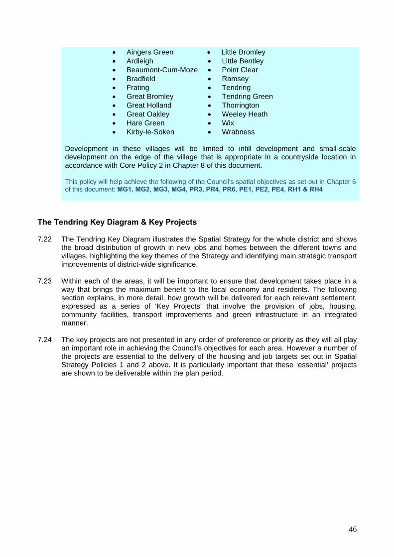
46
Aingers Green Ardleigh Beaumont-Cum-Moze Bradfield Frating Great Bromley Great Holland Great Oakley Hare Green Kirby-le-Soken
Little Bromley Little Bentley Point Clear Ramsey Tendring Tendring Green Thorrington Weeley Heath Wix Wrabness
Development in these villages will be limited to infill development and small-scale development on the edge of the village that is appropriate in a countryside location in accordance with Core Policy 2 in Chapter 8 of this document. This policy will help achieve the following of the Council’s spatial objectives as set out in Chapter 6 of this document: MG1, MG2, MG3, MG4, PR3, PR4, PR6, PE1, PE2, PE4, RH1 & RH4
The Tendring Key Diagram & Key Projects 7.22 The Tendring Key Diagram illustrates the Spatial Strategy for the whole district and shows
the broad distribution of growth in new jobs and homes between the different towns and villages, highlighting the key themes of the Strategy and identifying main strategic transport improvements of district-wide significance.
7.23 Within each of the areas, it will be important to ensure that development takes place in a
way that brings the maximum benefit to the local economy and residents. The following section explains, in more detail, how growth will be delivered for each relevant settlement, expressed as a series of ‘Key Projects’ that involve the provision of jobs, housing, community facilities, transport improvements and green infrastructure in an integrated manner.
7.24 The key projects are not presented in any order of preference or priority as they will all play
an important role in achieving the Council’s objectives for each area. However a number of the projects are essential to the delivery of the housing and job targets set out in Spatial Strategy Policies 1 and 2 above. It is particularly important that these ‘essential’ projects are shown to be deliverable within the plan period.

47
Insert Key Diagram

48

49
Clacton Key Projects 7.25 Clacton will deliver the largest proportion of the district’s growth between 2011 and 2031
including some 4,100 new homes and up to 3,500 new jobs. Clacton is well placed to accommodate this level of growth because it is the district’s largest settlement with the greatest potential for growth in the town centre economy; it is best served by existing and potential infrastructure and, importantly, it is least affected by environmental constraints. Clacton will also have the strongest level of market demand for new housing compared with anywhere else in the district as the wider economy recovers from the recent downturn. Key Projects 1 to 11 for delivering change in Clacton are shown on the diagram below:
Project 1 – Rejuvenating Clacton Seafront Project 2 – Economic Growth in Clacton Town Centre ▲ Project 3 – Regenerating Jaywick Project 4 – St. John’s Relief Road ▲ Project 5 – Hartley Meadows Neighbourhood Development ▲ Project 6 – Brook Business Park ▲ Project 7 – West Clacton Outdoor Leisure Park Project 8 – Martello Bay Watersports Area Project 9 – Expansion of Oakwood Business Park▲ Project 10 – Pickers Ditch Walkway Project 11 – East Clacton Neighbourhood Development ▲ Projects 32 & 34 – See sections on Sustainable Growth for Little Clacton and St. Osyth below
7.26 See Chapter 10 for more detail on the content and delivery of these projects.
▲ = Project essential to the delivery of district housing and jobs targets.

50
Harwich Key Projects 7.27 Harwich will accommodate the second largest proportion of the district’s growth between
2011 and 2031 – some 900 homes and an equivalent number of jobs but with the potential to deliver up to 2,900 jobs in the longer term if the container port proposed for Bathside Bay is developed within the LDF plan period.
7.28 Like Clacton, Harwich is also a priority area for regeneration and relatively well served by
existing infrastructure. However, unlike Clacton, the periphery of Harwich is affected by some significant environmental constraints (including flood risk) that restrict the amount of land that can be developed for housing and other uses. It also has a much weaker economy and a more limited retail offer than Clacton and is not anticipated to enjoy a significant economic upturn until the latter part of the LDF plan period, capitalising on the container port proposed at Bathside Bay (Project 12). The low level of economic activity and a weak housing market in Harwich has major implications for the timing of growth in jobs and equally housing.
Project 12 – Port Expansion at Bathside Bay ▲ Project 13 – Regenerating Harwich Old Town ▲ Project 14 – Rejuvenating Dovercourt Town Centre Project 15 – Stanton Euro Park ▲ Project 16 – Harwich Linear Park Project 17 – Land East of Pond Hall Farm ▲ Project 18 – Urban Extensions in West Harwich ▲
7.29 See Chapter 10 for more detail on the content and delivery of these projects.
▲ = Project essential to the delivery of district housing and jobs targets.

51
Frinton and Walton Key Projects
7.30 Frinton and Walton accommodate a modest proportion of the district’s housing growth – around 600 new jobs and 800 new homes. Although it is a large settlement that is relatively well served by public transport, it is environmentally sensitive to peripheral growth and does not have such a diverse range of job opportunities as Clacton or Harwich – primarily due to its unusual demographics and its weaker connection to the strategic road network.
7.31 There is anticipated to be a strong level of demand for new housing in this area and
Walton-on-the-Naze in particular could enjoy an economic resurgence during the LDF plan period as a result of proposed regeneration programmes.
7.32 Key Projects 19 to 22 for delivering change in Frinton and Walton are shown on the
diagram below:
Project 19 – Regenerating Walton-on-the-Naze ▲ Project 20 – Protecting and Enhancing Frinton Town Centre Project 21 – Hamford Urban Extension ▲ Project 22 – Expansion of Kirby Cross Trading Estate
7.33 See Chapter 10 for more detail on the content and delivery of these projects.
▲ = Project essential to the delivery of district housing and jobs targets.

52
Manningtree and Lawford Key Projects 7.34 Lawford and Manningtree will accommodate a small proportion of the district’s housing
growth – around 150 new homes with an equivalent number of jobs. For a relatively small urban settlement it is well served by mainline rail services to London but is environmentally sensitive to peripheral growth, has weaker connection to the strategic road network and contains a historic street patters that are not well suited to motorised travel.
7.35 Key Projects 23 and 24 for delivering change in Lawford and Manningtree are shown on the
diagram below:
Project 23 – Growth in Manningtree Town Centre ▲
Project 24 – Lawford Urban Extension ▲
Project 33 – See ‘Sustainable Growth for Mistley’ below
7.36 See Chapter 10 for more detail on the content and delivery of these projects.
▲ = Project essential to the delivery of district housing and jobs targets.

53
Brightlingsea Key Projects
7.37 Like Lawford and Manningtree, Brightlingsea will only accommodate a small proportion of the district’s housing growth – around 150 new homes with an equivalent number of jobs. There is expected to be a demand for family housing and affordable housing in the area that has not been satisfied in recent years due to the high level of luxury waterside development. However, the town is environmentally sensitive to peripheral growth, is poorly served by public transport with no railway station and has extremely poor connections with the strategic road network, served only by the B1029. Growth in Brightlingsea will be limited to a level that addresses some local demand, supports growth in the local economy and that can be accommodated within existing environmental and infrastructure constraints.
7.38 Key Projects 25 to 28 for delivering change in Brightlingsea are shown on the diagram
below:
Project 25 – Protecting and Enhancing Brightlingsea Town Centre
Project 26 – Rejuvenating Brightlingsea Waterfront Project 27 – Brightlingsea East Urban Extension ▲ Project 28 – Expansion of Morses Lane Industrial Estate
7.39 See Chapter 10 for more detail on the content and delivery of these projects.
▲ = Project essential to the delivery of district housing and jobs targets.

54
Sustainable Growth for Alresford (Project 29) ▲ 7.40 Alresford is located in the west of the district close to the boundary with Colchester so has a
stronger relationship with Colchester than most of Tendring’s main urban settlements. 7.41 The village is well located to accommodate limited development to support existing services
and facilities in the village centre as well as the local primary school. Whilst there will be few opportunities for significant levels of job growth in the village, there may be some scope for some small business units.
Sustainable Growth for Elmstead Market (Project 30) ▲ 7.42 Elmstead Market is located in the west of the district close to the boundary with Colchester
and has a strong relationship with Colchester. The village is not served by train and has very limited capacity in the local primary school to accommodate any population growth as a result of new housing.
7.43 Planning permission has been granted for a small development of business units to the
east of the village along the A133 which will provide local employment opportunities and small-scale housing to support local businesses and services and meet local needs.
Sustainable Growth for Great Bentley (Project 31)
7.44 Great Bentley lies in the rural heart of the Tendring district and whilst it is served by rail, it is
poorly connected to the strategic road network and is not well served by bus. In addition, the local primary school will not be able accommodate any scale of population whilst the village centre is already vibrant and healthy. Therefore, Great Bentley is not identified as accommodating further housing although there is an opportunity for local employment growth, through an extension to the existing industrial estate.
Sustainable Growth for Little Clacton (Project 32) ▲ 7.45 Being close to the town of Clacton, the village of Little Clacton is well located to
accommodate some limited development to support existing services and facilities in the village centre and the local primary school. It will also benefit from certain key projects proposed for the edge of Clacton, including a new health centre and employment opportunities.
7.46 A modest development of new homes will address local needs and safeguard the important
countryside gap between the village and the edge of Clacton through the provision of green infrastructure.
Sustainable Growth for Mistley (Project 33) ▲ 7.47 Mistley is located in the north-west of the district, with a frontage onto the Stour Estuary.
The area has specific planning and conservation issues which are being addressed in the Mistley Waterfront and Village Urban Regeneration Area Supplementary Planning Document (SPD) and the Manningtree and Mistley Conservation Area Management Plan (CAMP). The SPD will facilitate the regeneration of the Mistley Quayside and Village area

55
whilst the CAMP focuses on protecting and enhancing the wider Manningtree and Mistley Conservation Area.
7.48 Mistley accommodates a number of large maltings that provide local employment. The
quayside activities have recently changed from a busy working dock to a mixed area containing residential accommodation through recent conversions. Further mixed-use development is likely to come forward in the quayside area guided by the SPD, though this may not satisfy future demand for family housing, including affordable housing, in the village.
7.49 Mistley will benefit from growth proposed through projects in Manningtree and Mistley and,
with its own railway station, is well located to accommodate some development to meet local needs for family housing. The Council will therefore work with the Parish Council and Rural Community Council for Essex to identify a suitable location for a development of up to 20 dwellings that will also deliver green infrastructure.
Sustainable Growth for St. Osyth (Project 34)
7.50 The village of St. Osyth is close to Clacton and will benefit from certain key projects proposed for the edge of the town. Since 2001, St. Osyth has received more housing development than most villages, including affordable housing to meet local needs. There are concerns that further significant growth will exacerbate traffic problems encountered in the area as a result of tight layout of its historic village centre. The junction of Colchester Road, Clacton Road, Mill Street and Spring Road in particular provides the main point of access to the historic Priory and major holiday parks at Seawick and Point Clear which accommodate thousands of holiday makers in the summer.
7.51 Accordingly, it is not proposed that the village will accommodate any planned growth in jobs
or housing. However, there is an identified need for a village car park to prevent on-street parking in the village centre. The Council will work with the Parish Council to identify a suitable location.
7.52 The Priory is of national heritage importance and the Council is committed to its
conservation, preservation and restoration. The Council has been working with English Heritage and the owner of the Priory to determine the extent of work required to bring about its restoration along with the costs involved and possible sources of funding. Enabling development might provide one source of funding and will be considered on its merits in accordance with national planning policy and Development Policies contained in Chapter 9 of this document.
Sustainable Growth for Thorpe-le-Soken (Project 35) ▲
7.53 Thorpe-le-Soken performs a strategically important role as a transport interchange for both rail and road. Thorpe Station, to the south of the village, provides the link between rail services from Clacton and Walton-on-the-Naze to Colchester and London. The village accommodates traffic moving between Clacton and Harwich along the B1414, Colchester and Frinton/Walton along the B1033 and between Manningtree and to and from Manningtree via the B1035.
7.54 Traffic congestion in the centre of the village occurs occasionally, mainly as a result of on-
street parking and tourist traffic going to Frinton and Walton on busy weekends during the summer. The Council has worked with Essex County Council to investigate the possibility of bypassing the village with a new road to relieve the village centre; however it is not

56
currently considered to be economically viable. The Council will continue to work with the County Council to investigate ways of minimising congestion through traffic management measures.
7.55 The village is well located to accommodate some development to support existing services
and facilities in the village centre as well as the local schools, as long as it does not materially add to road congestion. The Council will therefore work with the Parish Council and Rural Community Council for Essex to identify a suitable location for a development of up to 40 dwellings close to the village centre that will also deliver green infrastructure.
7.56 Thorpe Station, to the south of the main built up area of the village, provides an opportunity
for a comprehensive package of enabling development to bring about environmental enhancements in the Conservation Area, the restoration of the listed but dilapidated Thorpe Maltings, employment opportunities and improvements to facilities at the station.
Sustainable Growth for Weeley (Project 36) ▲ 7.57 Weeley is located in the centre of the district on the B1033/B1441 interchange just east of
the busy A133. It contains a variety of employment opportunities (including the offices of the District Council), services and facilities albeit fairly dispersed around the village and not concentrated within a clearly definable village centre. Being served by good roads and rail, the village is well located to accommodate some development to support existing services and facilities in the village including the local primary school, and provide local employment opportunities.
▲ = Project essential to the delivery of district housing and jobs targets.

57
Essential Infrastructure 7.58 Growth in jobs and housing needs to be supported by the necessary facilities and
infrastructure in order to deliver sustainable communities and ensure that the existing infrastructure is not overwhelmed by the proposed increase in population and commercial activities.
7.59 The Council commissioned consultants Roger Tym and Partners to undertake an
‘Infrastructure Study’ for the district to firstly establish any existing infrastructure problems, constraints or spare capacity and secondly investigate the potential implications of new growth in different areas. The range of infrastructure the study looked at included:
Health; Education; Emergency Services (Police, Fire and Ambulance); Transport; Utilities (Electricity, Gas, Telecommunications, Water and Sewerage); Waste; and Cemeteries.
7.60 ‘Green Infrastructure’, including formal and informal open space, was dealt with separately
through the ‘Open Spaces Strategy’ and is the subject of Core Policy 11 in Chapter 8 of this document.
7.61 The organisations responsible for providing the above services have a duty to manage their
resources effectively and ensure that the infrastructure is sufficient to meet the needs of the existing population. Each service provider has investment plans for maintaining facilities and improving their services into the future, and should use the development profile of the LDF to shape and secure their investment requirements over the longer term. However, when an area is identified for major growth, the developers of new housing and commercial development will be required to finance the infrastructure improvements needed to address the additional pressure brought about by those developments.
7.62 Informed by the findings of the Infrastructure Study, the Council has identified the
infrastructure requirements for each of the key projects that are considered essential to the physical delivery of the overall district housing and jobs targets. Spatial Strategy Policy 5 below lists these.
Spatial Strategy Policy 5 – ESSENTIAL INFRASTRUCTURE IMPROVEMENTS The Council will work with the development industry and service providers to ensure that growth in new homes and jobs proposed in Spatial Strategy Policies 1 and 2 is supported by the necessary infrastructure. The following infrastructure improvements are essential to the practical delivery of the spatial strategy:
Upgrading the A133 between Frating and Weeley (see Spatial Strategy Policy 3); Dualling the A120 between Hare Green and Horsley Cross and upgrading it
between Horsley Cross and Ramsey (see Spatial Strategy Policy 3);
The ‘St. John’s Relief Road’ in north-west of Clacton (see Project 4 above);

58
New junction on the A120 to enable access to land East of Pond Hall Farm (see
Project 17 above).
A new primary school with commensurate early years and childcare facilities in north-west Clacton;
A new primary school with commensurate early years and childcare facilities in
east Clacton;
A new medical centre in north-west Clacton;
An electricity sub-station in north-west Clacton; and
Expansion of the Jaywick sewerage works. Schedule 10.1 in Chapter 10 of this document provides more detail as to how these essential infrastructure improvements will be delivered. Other locally important infrastructure required to deliver sustainable communities will be secured in accordance with Core Policy 3 in Chapter 8 of this document. Green Infrastructure will be secured in accordance with Core Policy 11. This policy will help achieve the following of the Council’s spatial objectives as set out in Chapter 6 of this document: MG1, MG2, PR1, PR5, PE1, PE3 & PE6

59
CHAPTER 8
CCOORREE PPOOLLIICCIIEESS

60
8 Core Policies 8.1 ‘Core Policies’ explain, in principle, how the Council will use its planning powers, working in
partnership with other organisations, to tackle some of the big issues facing the district and deliver upon the key objectives. Technical Paper 8: ‘Core Policies’ provides more detail on the background to these policies including their justification and how they are likely to be implemented. These policies are divided into the four spatial themes:
Managing Growth
Core Policy 1 – Containing Urban Growth Core Policy 2 – Development in the Countryside Core Policy 3 – Securing Facilities and Infrastructure Core Policy 4 – Transport Accessibility
Our Place
Core Policy 5 – Achieving a Sense of Place Core Policy 6 – Tackling Climate Change
Core Policy 7 – Flood Risk, Coastal Change and Water Conservation Core Policy 8 – Nature Conservation Core Policy 9 – The Historic Environment Core Policy 10 – The Countryside Landscape Core Policy 11 – Green Infrastructure
Our Prosperity Core Policy 12 – Regeneration Areas Core Policy 13 – Employment sites Core Policy 14 – Freight Transport Core Policy 15 – Tourism Core Policy 16 – Town, District, Village and Neighbourhood Centres
Our People Core Policy 17 – Improving Health Core Policy 18 – Delivering a Mix of New Housing
Core Policy 19 – Gypsies and Travellers Core Policy 20 – Community Facilities Core Policy 21 – Play Pitches and Outdoor Sports Facilities Core Policy 22 – Children’s Play Areas Core Policy 23 – Residential Densities

61
Managing Growth 8.2 Core Policies under the theme of ‘managing growth’ are primarily designed to achieve
sustainable patterns of development, secure the infrastructure needed to deliver growth and ensure high quality design.
Containing Urban Growth 8.3 Urban growth needs to be carefully managed so as not to lead to unsustainable
developments in remote and poorly accessible locations and to avoid the coalescence of settlements and uncontrolled urban sprawl across the open countryside. Where settlements do need to expand to meet district growth requirements, this development will be carefully planned and contained within clearly defined boundaries. Core Policy 1 below sets out the Council’s approach to managing urban growth.
CORE POLICY 1 - CONTAINING URBAN GROWTH To encourage sustainable patterns of growth and to carefully control urban sprawl, each of the settlements listed in the Spatial Strategy’s ‘Settlement Hierarchy’ will be defined within a ‘Settlement Development Boundary’. These boundaries will be depicted on the Proposals Maps as part of the Site Allocations Document. Within the Settlement Development Boundaries, there will be a general presumption in favour of new development subject to detailed consideration against the other relevant Core Policies and Development Policies in this document. Outside of Settlement Development Boundaries, the Council will seek to protect and enhance the character and openness of the countryside. This will be achieved by refusing planning permission for development other than for the categories expressly identified in Core Policy 2 below. For some settlements, the Settlement Development Boundaries will be expanded beyond the extent of existing built development to allow planned settlement expansion where it is required to deliver growth in accordance with the Spatial Strategy. This policy will help achieve the following of the Council’s spatial objectives as set out in Chapter 6 of this document: MG1, MG2, MG3, MG4, PL2, PR3, PR4, PR6, PE1 & PE4
Development in the Countryside 8.4 In general terms, development outside of defined Settlement Development Boundaries will
be the subject of strict control in order to protect and enhance the character and openness of the countryside. However, there are certain forms of development that can and sometimes need to take place in these areas, some of which can bring about positive outcomes for the rural economy.
8.5 Core Policy 2 below lists the categories of development that might be acceptable in a
countryside location and, where necessary, highlights key Development Policies from Chapter 9 of this document that are particularly relevant to that kind of development.

62
CORE POLICY 2 – DEVELOPMENT IN THE COUNTRYSIDE Land outside of defined Settlement Development Boundaries (as depicted on the Proposals Map as part of the Site Allocations Documents) will be classed as ‘countryside’. In the countryside, the following forms of development will be acceptable, in principle, subject to detailed consideration against other relevant Core Policies and Development Policies in this document:
Development on land that is specifically allocated for a particular use in the Site Allocations Document;
Development that supports the essential needs of agriculture, forestry or fishing
(see Policy DP12); Equestrian related development (see Policy DP13);
Open air recreation, including ancillary buildings e.g. changing rooms, visitor
centres etc; Extensions to existing residential properties, commercial & business premises and
caravan & chalet parks;
Renewable energy installations; The replacement or rebuilding of existing residential properties (where the
proposal would not be a replacement for a mobile home, dwelling already demolished or abandoned, or a building not in use as a dwelling house);
The replacement of existing commercial buildings with new commercial buildings;
New dwellings for agricultural or forestry workers (Policy DP12) or affordable
housing allowed through the rural ‘exceptions’ policy (Policy DP18);
Enabling development that is necessary to secure the future of an important listed building (see relevant national planning policy);
The re-use of redundant buildings for business use or self-catering tourist
accommodation and, in exceptional circumstances, residential use (see Policy DP10); and
Farm shops.
This policy will help achieve the following of the Council’s spatial objectives as set out in Chapter 6 of this document: PL2, PR2, PR6, PE2, PE4 & PE6

63
Securing Facilities and Infrastructure 8.6 Core Policy 3 below sets out the Council’s approach to securing facilities and infrastructure
necessary to deliver sustainable communities which will be expanded upon in a Development Plan Document (DPD) on ‘Planning Obligations and Developer Contributions’. This will develop in more detail the range of and costing of infrastructure to serve the development strategy, along with the sources of contribution and funding (i.e. from developers or service providers).
8.7 At the moment, it is anticipated that the setting up of a Community Infrastructure Levy (CIL)
will be introduced and an option in operating developer obligations (this is likely to be in addition to continuing with existing arrangements for affordable housing). The forthcoming Development Plan Document (DPD) will look at the merits and option of introducing CIL or an equivalent tariff-based system of securing developer contributions, along with the possibility of adopting variable contributions for different areas and land uses.
CORE POLICY 3 – SECURING FACILITIES AND INFRASTRUCTURE The Council will work with the development industry and service providers to ensure that growth in new homes and jobs is supported by the necessary facilities and infrastructure to deliver sustainable communities. The Council will also assist service providers in delivering their existing investment plans and securing funding to address any existing infrastructure problems or deficiencies. For each of the ‘Key Projects’ listed in Chapter 7 the new facilities and infrastructure required by those projects will be delivered in accordance with Schedule 10.2 in Chapter 10 of this document and, through the Site Allocations Document, development may be phased to ensure adequate infrastructure is in place at the right time. Elsewhere in the district, planning permission will not be granted for new development unless the individual or cumulative impacts of development on infrastructure can be addressed, at the developer’s cost, either on-site or through financial contributions towards off-site improvements. The Council will use appropriate legal agreements to secure one or more of the following:
Increased capacity for schools, early years and childcare and other education provision;
Emergency Services provision;
Improvements to the transport network; and
Any other infrastructure requirement arising as a result of the proposed
development. The Council will produce a Development Plan Document (DPD) on ‘Planning Obligations and Developer Contributions’ in support of this policy. This policy will help achieve the following of the Council’s spatial objectives as set out in Chapter 6 of this document: MG1, MG2, PR1, PR5, PE1, PE3 & PE6

64
Transport and Accessibility
8.8 To achieve sustainable communities, homes, jobs and other services and facilities should be accessible by a variety of different transport modes including walking, cycling and public transport; not just the private car. Locating development in accessible locations gives people the option to use more sustainable modes of transport that do not contribute towards climate change and that benefit those people in society that do not have access to a car. Equally, there are health benefits to encouraging cycling and walking.
8.9 All proposals for new development will be required to maximise accessibility through their
location to existing services and facilities and by providing safe pedestrian and cycle connections to existing networks as a priority over motorised forms of transport. The hierarchy of transport types set out in Core Policy 4 provides the order of priority for addressing the transport requirements of new development. Generally, any development that fails to demonstrate the provision of transport types in Core Policy 4 (the ‘modal hierarchy’ will not be acceptable.
8.10 However, because the Tendring District is predominantly rural, it is accepted that some
development in countryside locations (see Core Policy 2) will not always be able to secure accessibility in accordance with the hierarchy but in all cases the Council will require that any practical measures to maximise sustainable travel are investigated.
CORE POLICY 4 – TRANSPORT AND ACCESSIBILITY The Council will work with its partners, including Essex County Council, bus and train operators and the development industry, to improve accessibility, change travel behaviour and reduce dependence on the private car. Development proposals must maximise the opportunities for sustainable transport. Proposals will therefore be assessed against the measures to satisfy the following (prioritised) modal hierarchy:
1. walking and providing access for people with mobility impairment 2. cycling 3. public transport (including taxis) where appropriate 4. powered two wheelers (i.e. motorcycles) 5. commercial vehicles (including heavy goods vehicles) 6. cars (shopping and visitors)
Developments will be judged against the current Essex County Council ‘Development Management Policies’ and ‘Car Parking Standards’. This policy will help achieve the following of the Council’s spatial objectives as set out in Chapter 6 of this document: MG2, PL3, PR1 & PE5

65
Our Place 8.11 Under the theme of ‘our place’, the policies are designed to help protect and enhance the
district’s natural and historic environmental assets and contribute towards the global climate change targets.
8.12 Our district’s attractive natural, built and historic environment is undeniably one of its most
important assets that needs to be preserved and enhanced. The pressure for development to provide new homes, employment land and other facilities must be carefully balanced with the need to protect and enhance the environment. The following core policies set out, in broad terms, the measures the Council will take, working with its partners, to achieve that balance.
8.13 Through the policies of the LDF, the Council will work with its partners to protect and
enhance the district’s natural, built and historic environment, countryside, coastline and biodiversity and play its part in meeting the challenges presented by global warming.
Achieving a Sense of Place
8.14 The success of a new place is ultimately judged by how enjoyable it is to live in, use or visit, how safe and secure it feels, how the buildings and adjacent spaces relate to each other and how attractive it looks. Consequently, good design can help stimulate regeneration, improve the quality of life for residents, reinforce civic pride and, ultimately, create a strong ‘sense of place’.
8.15 The Council will insist on high quality design in new developments, and planning
applications will be judged against the criteria set out in Policy DP1 in Chapter 9 along with any other relevant policies in this document.
8.16 The Council will also have regard to the Essex Design Guide for Residential and Mixed-Use
Developments, the ‘Building for Life’ criteria published by the Commission for Architecture and the Built Environment (CABE) and the ‘Manual for Streets’ produced by the Department for Transport and Department for Communities and Local Government (DCLG). In addition, in some cases the Council will require a development to provide a master plan or development brief or undertake this itself, which will require to demonstrate how a ‘sense of place’ is achieved. The Council will also consider local guidance provided in adopted Village Plans and Village Design Statements.
CORE POLICY 5 – ACHIEVING A SENSE OF PLACE The Council will ensure that all new developments are well designed, integrated with the existing environment and contribute positively towards the ‘sense of place’. For the Key Projects listed in Chapter 7 (and set out in more detail in Chapter 10), the Council will work with landowners, the development industry and other partners to prepare master plans and/or development briefs that set out design and layout principles that will be identified in the Site Allocations Document and assist in the preparation of planning applications. All proposals will be judged against the design criteria contained in Policy DP1 in Chapter 9 of this document.

66
The Site Allocations Document will identify areas where special design criteria will apply such as Conservation Areas and other areas of special character along with any specific requirements of individual development sites. The Council will have regard to the Essex Design Guide for Residential & Mixed-Use Developments, ‘Building for Life’ and the ‘Manual for Streets’ in considering development proposals and may seek advice from Essex County Council’s Urban Design Team on large and complex proposals. The Council will work in partnership with the Rural Community Council for Essex to assist Parish Councils in the preparation of Village Plans and Village Design Statements which can be adopted by the Council as a material consideration in the determination of planning applications in rural areas. This policy will help achieve the following of the Council’s spatial objectives as set out in Chapter 6 of this document: MG2, PL2, PL5 & PE5
Tackling Climate Change
8.17 Climate change is a priority issue globally that needs to be tackled at all levels from governments working together on the international stage down to local authorities and even individuals themselves.
8.18 One of the biggest causes of climate change is the ‘greenhouse effect’ and to tackle this
governments are working to reduce the emission of carbon-dioxide into the atmosphere. The Council can play its part in this global challenge by promoting the use of sustainable forms of transport as an alternative to the private car (see Core Policy 5) but by also improving energy efficiency within new buildings, supporting renewable forms of electricity generation and promoting recycling.
CORE POLICY 6 – TACKLING CLIMATE CHANGE The Council will play its part in the global fight against climate change by seeking to reduce carbon emissions and will work with its partners to promote sustainable design and construction, renewable energy and recycling in the district. The Council will support phased improvements to building regulations, which will reduce the carbon emissions of new dwellings. All new residential development will be built to a minimum of level 3 of the Code for Sustainable Homes or at the level required by the latest building regulations. All non-residential development will be encouraged to achieve a BREEAM rating of ‘very good’. The Council will continue to promote recycling of household and commercial waste by improving recycling services and public awareness and by requiring new developments to provide facilities for the collection of waste and recycling. The Council will also work with Essex County Council to consider the need for facilities for the handling and transportation of waste. This policy will help achieve the following of the Council’s spatial objectives as set out in Chapter 6 of this document: PL1, PL4 & PL5

67
Flood Risk, Coastal Change and Water Conservation
8.19 Water is something that, in different ways, poses our district with an unusual dilemma.
Being a peninsula, Tendring is surrounded on three sides by coastal and estuarine water and, as a result, many parts of the district are at risk of tidal flooding including some of our built up areas. However, this part of the country is also recognised as having the lowest average rainfall and therefore maintaining a supply of fresh water for drinking and the irrigation of crops is a high priority. The presence of and indeed lack of water is therefore a very important consideration when planning for growth in new homes and jobs.
CORE POLICY 7 – FLOOD RISK, COASTAL CHANGE AND WATER CONSERVATION In order to manage the risk of tidal flooding and coastal erosion to people, property and tourism, the Council will assist the Environment Agency in implementing the Essex Shoreline Management Plan and decisions relating to future development will have regard that plan. All development proposals will be considered against the ‘sequential test’ set out in national planning policy PPS25 ‘Development and Flood Risk’ (along with any subsequent replacements or amendments). For development proposals within defined Settlement Development Boundaries (see Core Policy 1), the sequential test will apply to the whole of the settlement in question. For development proposals in the countryside outside of defined Settlement Development Boundaries (see Core Policy 2), the sequential test will apply to the whole of the Tendring district. Where the benefits of development for regeneration outweigh the risk of flooding, proposals will be assessed against the ‘exceptions test’ set out in PPS25 and the Council will work with the Environment Agency to ensure that the development meets the detailed criteria of that test. Sustainable Drainage Systems (SuDS) should be incorporated into all built development (excluding householder development) as a means of reducing flood risk, improving water quality, enhancing the green infrastructure network and providing amenity benefit. Justification must be given for not using SuDS. Planning permission for new development will not be granted unless it can be demonstrated that any wastewater from the development can be dealt with within the confines of existing sewerage ‘discharge consents’. In this regard, Anglian Water and the Environment Agency will be important consultees. To maintain a supply of fresh water and to ensure it is used efficiently, the Council will:
Work with Veolia Water to implement their investment plans and improve the infrastructure network;
Require water efficiency measures to be incorporated into new residential
development in accordance with the Code for Sustainable Homes at the level required by the latest building regulations; and
Support proposals for agricultural reservoirs and/or winter storage facilities subject
to detailed consideration against relevant Development Policies in Chapter 9 of this document.
68
This policy will help achieve the following of the Council’s spatial objectives as set out in Chapter 6 of this document: MG3, PL1, PL3 & PR4
Nature Conservation and Geo-diversity
8.20 The Tendring district is blessed with many habitats of different sizes containing a variety of plant and animal species. Many of these habitats are designated for their nature conservation interests and some are protected by international, European and English law. National planning policy contained in PPS9 provides the principal planning framework for the protection and enhancement of these sites.
8.21 Ramsar Sites, Special Protection Areas (SPA) and Special Areas of Conservation (SAC)
are protected under the Ramsar Convention, the Birds Directive and the Habitats Directive respectively and, in and around Tendring, these areas include the Stour and Orwell Estuaries, Hamford Water and parts of the Colne Estuary. These areas are recognised for their wetlands of international importance, habitats for endangered and migratory bird species and listed habitats – some of which contain over 1,000 species of plants and animals.
8.22 In accordance with the Habitats Directive, development affecting any of these sites must be
the subject of ‘Appropriate Assessment’ which will ascertain whether the development will adversely affect the integrity of the site in view of its conservation objectives. Planning permission will only be granted where the Council is certain that there will be no adverse effects as a result of the development, alternative sites are not available and unless there are imperative reasons of overriding public interest (e.g. such as in relation to port expansion at Bathside Bay, Harwich) - in which case a compensatory habitat must be provided.
8.23 Sites of Special Scientific Interest (SSSI) are protected under the provisions of English law
contained in the Wildlife and Countryside Act 1981, as amended, and the Countryside and Rights of Way Act 2000. Examples within Tendring include Ardleigh Gravel Pit, Clacton Cliffs, Harwich Foreshore, Holland-on-Sea Cliff, Little Oakley, St. Osyth Pit and The Naze at Walton.
8.24 At the local level, the Council has worked with the Essex Wildlife Trust to identify over 100
‘Local Wildlife Sites’ within the Tendring District that, whilst not protected by law, are worthy of nature conservation and are protected primarily through Core Policy 8 below. Many of these sites provide important wildlife refuges and stepping stones in the green infrastructure network, linking different habitats and helping to maintain biodiversity. The district also contains a number of ‘Special Roadside Verges’ which contain rare and valuable plants.
8.25 The Council also supports the identification, protection and enhancement of ‘Living
Landscapes’ through the Essex Biodiversity Project. Living Landscapes are large landscape scale areas of the countryside like river valleys, estuaries, forested ridges, and grass and heath mosaics, which are ecologically stable and provide a superb range of habitats for many species of wild plants and animals. Their inter-connectivity allows wildlife to move through them and makes them more resilient to threats such as climate change, floods, droughts, sea level rises and development pressure. Living Landscapes in Tendring include Alresford Mineral Sites Complex, the Naze, Holland Brook and the Stour Estuary.
69
8.26 Whilst these various wildlife designations exist, a site does not necessarily have to be designated to be of value to nature conservation. Where a site is likely to contain important wildlife habitats, protected species (as protected in the 1981 Wildlife and Countryside Act, as amended) or important features identified in the UK or Essex Biodiversity Action Plans (BAP), developers will be required to undertake a survey. Where development is likely to harm the nature conservation interest of a site, planning permission will only be granted where the benefits of the development outweigh the harm caused. In such instances, development must minimise the impact on biodiversity and, where possible, seeks to retain or replace key features like important trees, hedges or water features.
8.27 Throughout the course of the LDF plan period, the Council will work with developers, the
Essex Wildlife Trust and other partners to create new wildlife habitats both as an integral part of new development through tree planting, green corridors or Sustainable Drainage Systems (SuDS) and as stand-alone projects like the recent tree planting scheme north of Elmstead Market. Policy DP6 in Chapter 9 is the Council’s policy on development affecting protected trees and hedges.
CORE POLICY 8 – NATURE CONSERVATION AND GEO-DIVERSITY All areas designated for their value to nature conservation and/or geo-diversity will be shown on the Proposals Map as part of the Site Allocations Document. Sites designated for their international, European and national importance to nature conservation including Ramsar Sites, Special Protection Areas (SPA), Special Areas of Conservation (SAC), National Nature Reserves and Sites of Special Scientific Interest (SSSI) will be protected from harmful development in line with the relevant International, European and English law. The Council will work with its partners to produce management plans for these areas. Sites designated for their local importance to nature conservation including Local Wildlife Sites (LoWS) and Local Nature Reserves will be protected from development that is likely to have an adverse impact. Elsewhere, where development is likely to harm nature conservation or geo-diversity interests, planning permission will only be granted in exceptional circumstances, where the benefits of the development clearly outweigh the harm caused and where appropriate mitigation measures must be incorporated into the development. Consideration will be given to the potential for new wildlife habitats in new development and green infrastructure. Where these are created, measures may be taken to ensure suitable permanent management, and public access. In these matters, the Council may be guided by the UK and Essex Biodiversity Action Plans. This policy will help achieve the following of the Council’s spatial objectives as set out in Chapter 6 of this document: MG3, PL2, PL3 & PR2
The Historic Environment 8.28 The historic environment has a powerful influence on people’s quality of life generally giving
them a sense of identity and civic pride. Its enduring physical presence contributes significantly to the character and ‘sense of place’ of rural and urban environments. In our district, this resource is rich, complex and irreplaceable.

70
8.29 Some of this resource lies hidden and often unrecognised beneath the ground in the form
of archaeological deposits, but other heritage assets are more visible including those within the historic landscape that provide a record of past agricultural and industrial practices and the physical buildings and spaces that make up our town centres and historic villages.
8.30 In 2008, Essex County Council undertook the ‘Tendring Historic Characterisation Project’
which provides a comprehensive account of the character of the district’s historic environment and the heritage assets that contribute towards that character; assets that, wherever possible, should be preserved, enhanced or even incorporated into new development for the enjoyment of future generations.
8.31 Some heritage assets, such as Listed Buildings and Scheduled Ancient Monuments are
afforded statutory protection and the government’s planning policy contained in PPS5 ‘Planning for the Historic Environment’ which contains comprehensive guidance for dealing with planning issues affecting historic structures and archaeological interests.
8.32 Core Policy 9 below sets out the Council’s approach, working with key partners, to
understand, protect and enhance the district’s historic environment.
CORE POLICY 9 – THE HISTORIC ENVIRONMENT The Council will work with its partners including Essex County Council and English Heritage to understand, protect and enhance the district’s historic environment by:
Having regard to the Tendring Historic Environment Characterisation Project, the Essex Historic Environment Record, specialists advice and the heritage assets themselves when considering proposals for new development, and working with developers to secure the retention or safeguard the integrity of any heritage assets identified features of importance to the historic environment;
Undertaking periodic reviews of Conservation Areas, preparing and using
Conservation Area Appraisals and Conservation Area Management Plans (CAMP) and refusing planning permission for development that would harm the character or appearance of a Conservation Area (or its setting) or lead to the loss of buildings or structures that positively contribute towards that character (see Policy DP7);
Refusing planning permission and Listed Building consent for development that
would harm the character, appearance or setting of a Listed Building (see Policy DP8), working with property owners to secure improvements to Listed Buildings that are identified as being in poor condition or at risk of disrepair;
Refusing planning permission for development that will adversely affect a
Scheduled Monument, nationally important archaeological site or their setting;
Requiring archaeological evaluation to be undertaken for schemes affecting sites that might contain archaeological remains which, in some cases, may require excavation and recording prior to commencement of development;
Refusing planning permission for development that would adversely affect
Registered Parks and Gardens and continuing to promote these gardens as tourist attractions;

71
Protecting areas of ancient woodland, other important and historic trees and protected lanes from loss or damage as a result of development; and
Compiling and thereafter maintaining a ‘local list’ of structures of particular local
historic and architectural significance to be protected and enhanced along with their setting;
Taking account of the desirability of enhancing the significance of the district’s
heritage assets, securing their long term conservation and utilising their positive contribution to place-making when determining planning application.
Conservation Areas, Scheduled Ancient Monuments, Historic Parks and Gardens and Ancient Woodlands will be shown on the Proposals Map as part of the Site Allocations Document. This policy will help achieve the following of the Council’s spatial objectives as set out in Chapter 6 of this document: PL2, PL3, PL5, PR2, PR4, PR6, CL2, CL7, HA3, HA4, FW1, RH1 & RH2
The Countryside Landscape 8.33 The countryside in our district is one of its key assets both in terms of tourism and the living
environment of our residents. The district is diverse in its landscape character and appearance and certain areas are particularly sensitive to development and change.
8.34 The most notable countryside landscapes include the Dedham Vale Area of Outstanding
Natural Beauty (AONB) in the north west of the district and the coastal slopes around the district which afford spectacular views to and from the coast and estuaries.
8.35 The southern shore of the Stour Estuary is recognised in particular for its natural beauty
and whilst it is not currently designated as an AONB, the Council supports the inclusion of this area in the Suffolk Coast and Heaths AONB which currently covers only the northern shore of the Stour Estuary in Suffolk. The Council will work with its partners in Suffolk to seek the formal designation of the area as an AONB but in the meantime, it will be subjected to the highest level of protection in order to protect its quality and character.
8.36 The ‘Coastal Protection Belt’ was identified by Essex County Council in the 1980s in
recognition that the undeveloped coast is a unique, finite and irreplaceable resource in its own right which justifies its protection, regardless of its other qualities. Policy CC1 of the now superseded Essex and Southend-on-Sea Replacement Structure Plan was formally ‘saved’ by the Secretary of State when the East of England Plan was adopted in 2008 and provides the policy justification for retaining the Coastal Protection Belt within the LDF. In accordance with this policy development will only be permitted within the Coastal Protection Belt in exceptional circumstances.
8.37 In 2001 a Landscape Character Assessment was carried out which identified 30 different
landscape areas with different characteristics and highlighted key sensitivities that need to be taken into account when considering development proposals in the countryside in any part of the district whether it is covered by a landscape designation or not.
8.38 Core Policy 10 below sets out the Council’s approach, working with its partners, to
protecting and enhancing the district’s unique countryside landscape.
72
CORE POLICY 10 – THE COUNTRYSIDE LANDSCAPE The Council will work with adjoining authorities to ensure the continued protection of the Dedham Vale Area of Outstanding Natural Beauty (AONB) and will refuse planning permission for any development that would harm or otherwise fail to conserve its natural beauty, including views towards it from the outside. The Dedham Vale AONB will be depicted on the Proposals Map as part of the Site Allocations Document. The Council will also work in partnership with adjoining authorities on the ‘Stour Project’ to secure the extension to the Suffolk Coast and Heaths AONB to cover the southern part of the Stour Estuary between Mistley and Ramsey. The extent of the proposed area will be depicted on the Proposals Map as part of the Site Allocations Document and, until it is formally designated as an AONB, will be subject to a high level of protection to protect its quality and character. The tourism potential of these valuable areas will be promoted and opportunities to improve public access and provide appropriate tourist facilities and visitors centres will be supported subject to detailed consideration against Development Policies contained in Chapter 9 of the Document. The Council will seek to protect the open character of the undeveloped coastline by refusing planning permission for developments in the ‘Coastal Protection Belt’ that do not have a compelling functional or critical operational requirement to be located there. The Coastal Protection Belt will be shown on the Proposals Map as part of the Site Allocations Document. In all parts of the district’s countryside, all development proposals will be judged against Policy DP5 having particular regard to the Landscape Character Assessment and will require any adverse visual and landscape impacts to be mitigated. This policy will help achieve the following of the Council’s spatial objectives as set out in Chapter 6 of this document: MG3, PL2, PL5 & PR2
Green Infrastructure 8.39 ‘Green Infrastructure’ includes parks and gardens, amenity greenspace, natural and semi-
natural greenspaces, public open space, country parks, woodland, allotments and green corridors running through developments. Green infrastructure can perform many functions and provide a number of benefits to the environment and the community including:
Formal and informal outdoor recreation; Wildlife habitats; Sustainable Drainage Systems (SuDS); Safe routes for walking, cycling and horse-riding; Improving the visual impact of development; Providing allotments for local sustainable food production; Counteracting air pollution and carbon emissions; and Improving the quality of life for residents and tourists.
8.40 The Haven Gateway Green Infrastructure Study identified our district as an area deficient in
green infrastructure and the Council will work with its partners to try and rectify existing deficiencies and, where appropriate, secure developer contributions towards green

73
infrastructure both as an integral part of major developments and through financial contributions to ensure that deficiencies are not exacerbated by future population growth.
8.41 The protocol for securing and spending developer contributions from smaller developments
that cannot provide green infrastructure on-site (but that cumulatively could compound any existing deficiencies) will be set out in the Council’s Development Plan Document on ‘Planning Obligations and Developer Contributions’.
8.42 The Open Spaces Strategy was prepared in 2009 to identify the nature of any existing
surpluses and deficiencies and provide size and quality standards for the provision of green infrastructure in the district in the future. Chapter 7 of this document lists the key Green Infrastructure Projects that the Council will seek to deliver over the course of the LDF Plan period 2011 to 2026 both working with its partners to secure funding and securing developer contributions. These key strategic projects along with any other more local projects will be identified on the Proposals Maps as part of the Site Allocations Document.
8.43 Core Policy 21 sets out the Council’s approach to securing playing pitches and outdoor
sports facilities, which contains more specific standards. Policy DP16 in Chapter 9 of this document sets out the green infrastructure requirements of new residential development.
CORE POLICY 11 – GREEN INFRASTRUCTURE The district’s existing green infrastructure network will be maintained, enhanced and protected against redevelopment in accordance with government planning policy contained in PPG17 ‘ Planning for Open Space and Recreation’ (along with any subsequent replacements or amendments). The Council will work with Essex County Council, the development industry and other partners to deliver the key green infrastructure projects set out in the Spatial Strategy (Chapter 7 of this document) and other more local projects. These project areas will be shown on the Proposals Map as part of the Site Allocations Document. All new development will be considered in relation to the contribution it can make to the district’s green infrastructure network and the Council will secure contributions towards the provision of green infrastructure either on-site or through financial contributions to meet the needs of a the growing population whilst working with its partners to secure funding to rectify existing deficiencies. In line with the Council’s Open Spaces Strategy, the Council will aim to achieve the following green infrastructure accessibility and quantity standards in the district:
Type of Green Infrastructure
Accessibility Standard Quantity Standard
Parks and Gardens
Within 15 minutes walk (1km) for urban populations
1ha per 1,000 people
Amenity Greenspace
Within 10-15 minutes walk (600-m-1km) of whole population.
0.75ha per 1,000 people
Natural and Semi-Natural Greenspaces
At least one publicly accessible site of a minimum of 2ha in size within 20 minutes walk time (1.6km) of whole population.
2.1ha per 1,000 people

74
Green Corridors/Seafront
One publicly accessible green corridor/promenade within 1km/15mins walk of the entire urban population.
0.75ha per 1,000 people
Allotments
At least one site within 15 minutes walking time/100m of the urban population. At least one site within 20 minutes drive time/5km of the rural population
0.25ha per 1,000 people
Playing Pitches and Outdoor Sports Facilities
See Core Policy 21
Development Policy DP16 in Chapter 9 of this document sets out the Council’s approach to securing green infrastructure as part of new residential development and the Council will produce a Development Plan Document (DPD) on ‘Planning Obligations and Developer Contributions’ that will set out the protocol for securing and spending developer contributions for the provision of Green Infrastructure. This policy will help achieve the following of the Council’s spatial objectives as set out in Chapter 6 of this document: MG2, MG3, PL1, PL2, PL3, PL5, PR1, PR2, PE3, PE5 & PE6

75
Our Prosperity 8.44 Objectives under this theme will provide the right conditions to allow businesses to flourish
to achieve economic growth in our district.
Regeneration Areas 8.45 There are certain areas within our district where the quality of life, the economy and the
physical environment need to be improved for the benefit of both existing and future residents. The Council has identified eight individual ‘Regeneration Areas’ where improvements are needed, five of which are in Clacton and Harwich.
8.46 Each of the Regeneration Areas listed in Core Policy 12 (below) is the subject of at least
one of the ‘Key Projects’ in Chapter 7 of this document that are designed to bring about the necessary improvements. The particular issues facing each area are explained within the narrative of those projects along with the measures that the Council, working with its partners, will take to deliver regeneration.
8.47 Core Policy 12 broadly explains the Council’s approach to regeneration in the eight
regeneration areas and what proposals for new development in those areas will be required to achieve.
CORE POLICY 12 – REGENERATION AREAS The following areas within the Tendring District are identified as ‘Regeneration Areas’:
Clacton Town Centre and Seafront; Jaywick; West Clacton; Walton-on-the-Naze; Dovercourt Town Centre and Adjoining Areas; Harwich; Mistley Waterfront; and Brightlingsea Waterfront.
These areas will be the focus for investment in social, economic and physical infrastructure and initiatives to improve vitality, environmental quality, social inclusion, economic prospects, education, health, community safety and accessibility. Within these areas, the Council will:
Work with its partners to deliver the relevant Key Projects (as listed in Chapter 7 of this document);
Support development that reinforces and/or enhances the function, character
and appearance of the area and contributes towards regeneration and renewal (subject to detailed consideration against the Development Policies contained in Chapter 9 of this document); and
Refuse planning permission for development that would have an adverse impact
on the revitalisation of any of these Regeneration Areas.

76
The boundaries of each individual Regeneration Area will be shown on the proposals maps as part of the Site Allocations Document. This policy will help achieve the following of the Council’s spatial objectives as set out in Chapter 6 of this document: MG1, MG4, PL1, PL2, PL3, PL5, PR3, PR4, PR5, PR7, PE1, PE2, PE3, PE4, PE5, & PE6
Employment Sites 8.48 One of the Council’s objectives for creating new jobs is to maintain a flexible supply of
suitable employment land in the right places to attract inward investment in the industrial, storage and distribution sectors and to provide appropriate locations for existing businesses to expand or relocate. The district contains a number of ‘employment sites’ of varying size and character that provide valuable local employment in industry, warehousing and other businesses.
8.49 The Council will protect these sites for development within use classes B1(b): Research
and Development, B1(c): Light Industry, B2: General Industry and B8: Storage or Distribution and resist proposals to redevelop these sites for non-employment related uses, particularly housing. The sites that will be protected for employment use will be shown on the Proposals Map as part of the Site Allocations Document.
8.50 Whilst the above uses are the most appropriate for employment sites, the Council will
consider alternative forms of employment-related development where they do not conflict with other policies in this document or relevant national or regional planning policy. In such cases, applicants for development must demonstrate how the proposed use will either create new job opportunities or support existing ones.
8.51 The Employment Study suggests that during the LDF plan period there will be limited
growth in the need for industrial and warehousing land and, in some areas, a decline. However, adopting a flexible approach enables the Council to secure inward investment in these sectors if economic conditions change or to allow companies to relocate in order to expand. Some of the Key Projects set out in Chapter 7 therefore involve identifying land for the expansion of existing employment sites or creation of new sites. Land within these areas will be shown in the Site Allocations Document for B1(b & c), B2 and B8 use or other appropriate forms of employment and, as with existing established sites, will be protected against development for non-employment related uses.
CORE POLICY 13 – EMPLOYMENT SITES The Council will identify ‘employment sites’ in the Site Allocations Document that will be safeguarded and promoted for B1(b & c), B2 and B8 use in order to maintain a flexible supply of suitable employment land to attract inward investment in the industrial, storage and distribution sectors, provide appropriate locations for existing businesses to expand or relocate and safeguard local employment. The change of use or redevelopment of land or buildings on those identified employment sites for purposes other than class B1 (b & c), B2 or B8 uses (or their existing employment use) will not be permitted unless it can be demonstrated that the proposal would create permanent employment opportunities and would not conflict with any other policies contained in this document.

77
This policy will help achieve the following of the Council’s spatial objectives as set out in Chapter 6 of this document: MG4, PR3, PR6, PR7, PE1 & PE2.
Freight Transport
8.52 If our district is to develop as a dynamic economy, it is important that there is provision for the efficient movement of goods. However, such movements by road can be environmentally damaging particularly upon residential and other environmentally sensitive areas. Their impact needs to be minimised. For larger scale movement of freight and goods, for example to and from the port of Harwich, we need to consider the potential to maximise transporting of goods by rail.
8.53 Core Policy 14 explains how we will work with Essex County Council and other partner
organisations to minimise the impact of freight traffic and identify the most suitable routes.
CORE POLICY 14 – FREIGHT TRANSPORT Development likely to generate significant freight or goods movements will be located where there is (or the potential exists to create) good access onto the railway network without causing adverse effects on environmentally sensitive areas or existing communities. Where this is not possible, such proposals should be located where there is good access to suitable highway routes based on the strategic road hierarchy set out in Essex County Council’s ‘Development Management Policy Document’. This policy will help achieve the following of the Council’s spatial objectives as set out in Chapter 6 of this document: MG1, MG2 & PR1.
Tourism 8.54 Tourism plays a particularly important economic role in our district and one of the Council’s
key objectives is to promote growth in tourism to bring about the creation of new jobs. Around 16% of our district’s jobs are related to tourism whether that be directly in hotels, caravan and chalet parks and tourist attractions or indirectly in shops, cafés and restaurants. The Council’s Employment Study suggests that a significant proportion of new jobs in our district could come from tourism if the right action is taken by providing an appropriate range of tourist attractions and holiday accommodation.
8.55 Some of the Key Projects set out in Chapter 7 will deliver growth in tourism, particularly
selected projects in Clacton, Harwich and Walton-on-the-Naze. However Core Policy 15 broadly sets out the Councils approach to delivering improved tourist attractions and accommodation elsewhere in the district to maximise the potential of, particularly, its heritage, countryside and coastal assets.
8.56 The Council has prepared a Tourism Strategy identifying the tourism opportunities across
Tendring, reflecting the various characteristics and strengths the district offers, such as capitalising on the maritime heritage of Harwich or the coastal resort potential of Clacton, as well as the benefits that can be realised in the rural areas. The LDF will provide a key means of delivery, especially in identifying allocations within the relevant development plan documents.

78
CORE POLICY 15 – TOURISM The Council will maximise the economic potential of tourism to create new jobs in the district by developing a new and inventive marketing strategy for the district and working with its partners to improve the quality and range of tourist attractions and accommodation. Accordingly, the Council will work with partners to:
Deliver the Key Projects listed in Chapter 7 of this document, some of which are specifically aimed at facilitating growth and diversity in tourist activity;
Improve the strategic transport network in accordance with the Spatial Strategy
(See Spatial Strategy Policy 3);
Support proposals for new tourist attractions and educational visitors centres related to access to the district’s heritage, countryside and coastal assets and emerging role of renewable energy where they do not conflict with other policies contained in this document;
Support proposals for imaginative proposals in seafront core visitor areas; Supporting proposals for leisure activities as part of farm diversification schemes
where they do not conflict with other policies in this document;
Safeguard existing caravan and chalet parks (as shown on the Proposals Map as part of the Site Allocations Document) and support proposals for the expansion of and improvement of facilities at those parks, the provision of higher specification accommodation and their relocation away from areas at risk of flooding and erosion where they do not conflict with other policies contained in this document;
Support appropriate proposals for new hotels and conference facilities and the
extension of existing hotels in accordance with Core Policy 16; and
Support appropriate proposals involving the conversion of redundant rural buildings to self-catering holiday accommodation (see Policy DP10 in Chapter 9 of this document).
This policy will help achieve the following of the Council’s spatial objectives as set out in Chapter 6 of this document: PL1, PL2, PR1, PR2, PR3, PR4, PR6 & PE2
Town, District, Village and Neighbourhood Centres
8.57 Our towns, district, village and neighbourhood centres provide a significant amount of employment and a range of services, facilities and activities to meet the needs of local people and visitors.
8.58 Town centres provide a full range of facilities and services serving large catchment areas.
Clacton town centre is the district’s largest centre, which includes the main offices of the District Council, and serves a particularly wide catchment area; it is therefore defined as a

79
‘Major Town Centre’. The other town centres generally serve the population of their respective town and immediately surrounding villages.
8.59 District centres, such as Old Road in Clacton, usually comprise groups of shops often
containing a small or medium sized supermarket, a range of non-retail services and public facilities that often play an important supporting role in urban settlements with larger town centres.
8.60 Village centres, which are found in selected Key Rural Service Centres of the district,
include a range of small shops and facilities that serve the day to day needs of the village and, in some cases, other nearby smaller settlements and hamlets. Similarly, neighbourhood centres serve a smaller catchment area in suburban settlements that have expanded and tend to provide a range of small shops and other services.
8.61 The Council will protect and enhance the vitality and viability of these centres to help deliver
new jobs and maintain the quality of life for district residents. A number of the projects listed in Chapter 7 will bring about regeneration, economic growth or public realm improvements in these centres. Also for the major neighbourhood developments proposed on the edge of Clacton, new neighbourhood centres are planned, providing a range of new shops and services.
8.62 In accordance with national planning policy contained in PPS4 (along with any subsequent
replacements or amendments) proposals involving ‘town centre uses’ will be directed towards, town, village and neighbourhood centres rather than locations that might detract from the role and function of those centres. These uses are defined as;
retail (including warehouse clubs and factory outlet centres); leisure, entertainment facilities, and the more intensive sport and recreation uses
(including cinemas, restaurants, drive-through restaurants, bars and pubs, night-clubs, casinos, health and fitness centres, indoor bowling centres, and bingo halls);
offices, both commercial and those of public bodies; and arts, culture and tourism (theatres, museums, galleries and concert halls, hotels, and
conference facilities). 8.63 Development proposals involving these town centre uses will be assessed against the
requirements of PPS4 which includes a ‘sequential test’ that requires all opportunities for development in defined centres to be considered before more peripheral locations. The Council will only allow development involving town centre uses outside defined centres in exceptional cases, where the PPS4 sequential test has been fulfilled or where it can be demonstrated that there are practical or functional reasons why a development should not be located in a defined centre.
8.64 The district additionally contains a number of large modern retail parks or stand-alone
supermarkets on the edge of some of the district’s urban settlements that often fulfil a need for bulky-goods retail that cannot be accommodated in the town centre. The thrust of national planning policy is to avoid developments of this nature in the future unless it can be demonstrated that they will not impact negatively on the vitality or viability of nearby centres. However, these existing sites will be protected against redevelopment for non-employment uses (particularly housing) in recognition of the local employment they provide.
8.65 Core Policy 16 below sets out the Council’s approach to town, village and neighbourhood
centres

80
CORE POLICY 16 – TOWN, DISTRICT, VILLAGE AND NEIGHBOURHOOD CENTRES The Council will protect and enhance the vitality and viability of its town and village centres as well as its existing and proposed neighbourhood centres which will be defined on the Proposals Maps as part of the Site Allocations Document. Within these centres, the Council will work with its partners to deliver the relevant Key Projects (listed in Chapter 7) and may identify specific development opportunities in the Site Allocations Document or relevant Area Action Plans. Proposals for development involving the provision of ‘town centre uses’ will be judged against national planning policy contained in PPS4 (or as superseded by subsequent replacements or amendments) and must be properly related in their scale and nature to the hierarchy set out below: Major Town Centres
Clacton Town Centre Town Centres
Dovercourt Town Centre Frinton-on-Sea Town Centre (Connaught Avenue) Walton-on-the-Naze Town Centre Brightlingsea Town Centre Manningtree Town Centre
District Centres
Old Road, Clacton Great Clacton Holland-on-Sea (Frinton Road) The Triangle, Frinton
Village Centres
Alresford Village Centre Elmstead Market Village Centre Great Bentley Village Centre Little Clacton Village Centre St. Osyth Village Centre Thorpe-le-Soken Village Centre
Existing and Proposed Neighbourhood Centres
Upper Dovercourt Broadway, Jaywick Bockings Elm, Clacton Proposed Neighbourhood Centre at Jaywick Lane Proposed Neighbourhood Centre off the St. John’s Relief Road Proposed Neighbourhood Centre in East Clacton
All proposals for development in these centres will be judged against Policy DP9 In Chapter 9 of this document. Proposals outside the defined centres above will be refused unless shown to satisfy the

81
sequential requirements of relevant national policy guidance. Proposals for the redevelopment of existing retail parks and supermarkets falling outside the defined centres for non-employment uses will not be permitted. These will be identified on the Proposals Map as part of the Site Allocations Document. This policy will help achieve the following of the Council’s spatial objectives as set out in Chapter 6 of this document: MG1, MG2, MG4, PL2, PL5, PR2, PR3, PR4, PE1 & PE6.
82
Our People 8.66 Core Policies under the theme of ‘our people’ are primarily designed to improve the quality
of life of all Tendring’s residents, particularly the most disadvantaged. Improving Health 8.67 Health is a major issue in our district with 24% of our residents suffering with some form of
long-term illness. Other than supporting the NHS in providing primary health care, the Council can improve environmental conditions and encourage walking, cycling and sports by securing green infrastructure.
8.68 The Council recognises that development has the potential to impact on the health services
and facilities of the district will therefore expect new development to be designed to promote healthier living. The environmental impacts upon health can be gauged by a Health Impact Assessment (HIA) which would include considering if the proposal would cause noise or pollution of various kinds which needs to be strictly controlled. Policy DP14 in Chapter 9 requires HIA for certain types of development.
CORE POLICY 17 – IMPROVING HEALTH To improve the health of Tendring residents, the Council will work with its partners, including the NHS, to:
improve the quality of, and accessibility to, primary health care; improve opportunities for active travel, healthy life-styles and community well-
being, increasing participation in regular physical activity and improving sports and recreation facilities;
delivering high quality development;
require that a ‘Health Impact Assessments (HIA)’ be carried out for developments
of a certain type (see Policy DP14 in Chapter 9); and
ensuring the design and layout of new buildings and spaces maximise the positive affect on the health and wellbeing of communities as well as encouraging walking and cycling.
This policy will help achieve the following of the Council’s spatial objectives as set out in Chapter 6 of this document: PL2, PL3, PR5, PE3, PE4 & PE6
Delivering a Mix of Housing 8.69 Within the housing growth proposed for the district, the Council will work with the
development industry, registered social landlords (RSLs) and other partners to deliver a mix of housing type, size and tenure. This will provide a choice of accommodation for a variety of household needs and therefore bring about the creation of inclusive, mixed and balanced communities.
8.70 In 2008, the Council commissioned consultants Fordham Research to undertake a
‘Strategic Housing Market Assessment‘(SHMA), working in partnership with developers and

83
other relevant stakeholders as part of a ‘Housing Market Partnership’. The SHMA was updated in 2009 to take into account the recent economic downturn and showed that the Tendring district was experiencing low levels of demand for new housing, reflecting the national picture. However, it is anticipated that the housing market will strengthen in the early part of the LDF Plan period as the wider economy recovers. In a strong market, there will be a demand for new housing in the region of 1,000 dwellings per annum – around three times the amount of housing that will actually be built. Most of the demand for new housing is in the Clacton area, and this is reflected in the spatial strategy.
8.71 Approximately half of this demand will be driven by the formation of new households within
the district. This will be the result of population growth, people living longer and changes in household trends e.g. more people are choosing to live alone. The other half of the demand for new housing will be driven by in-migration i.e. people moving into the district from other parts of the country. Many of these people move to Tendring to enjoy a quieter, more rural lifestyle and to retire.
8.72 For development sites with a dwelling capacity lower than 10 (net) dwellings, it may not
always be practical or viable to deliver a meaningful mix of housing. However, on development sites with a capacity of 10 or more (net) dwellings, the Council will expect to see a variety of housing type, size and tenure, including affordable housing. On sites with a lower capacity, the Council will require a broad mix of housing size and type where it can be practically achieved in terms of design and layout.
Housing Tenure
8.73 Approximately 60% of the total demand for new housing will be for ‘market housing’ either to buy or rent. About a third of this demand is generated by multi-adult households with no children, just one quarter by households with children, one quarter from pensioner households and about one fifth from single people (non-pensioners).
8.74 The remaining 40% of the total housing demand will be for ‘affordable housing’; for people
with lower incomes who cannot afford to buy or rent property on the open market. The Council has a statutory duty to provide for the housing needs of households on lower incomes and, to do this, maintains a stock of Council Housing, provides housing benefit to those who need it and works closely with developers and RSLs to deliver additional affordable housing.
8.75 The vast majority of demand for affordable housing comes from households already living
within the district who are in accommodation that is either too expensive to afford, overcrowded or, in some cases, unsafe.
8.76 In Tendring, there is a significant shortage of affordable housing compared with
neighbouring authorities. To overcome this, there would need to be around 1,500 new affordable homes built every year between now and 2026. This could not be delivered without major negative impact on infrastructure and the environment, but it more than justifies the Council securing as much affordable housing as possible within the proposed housing growth.
8.77 Four-fifths of the requirement for affordable housing will be for ‘social rented housing’ which
is ideal for those households on very low incomes. One fifth of the requirement will be for ‘intermediate housing’ which can provide for those households with incomes just below that required to access open market housing. Intermediate housing will mainly comprise intermediate rented accommodation but, where shown to be required, could include other intermediate housing products such as shared ownership.

84
Housing Size 8.78 It is estimated that over two thirds of the market housing demand will be for two and three
bedroom properties, with about 18% of the demand for larger 4+ bed dwellings and around 12% of the demand being for one-bed units.
8.79 Nearly 40% of the social rented housing demand will be for three bedroom properties with
broadly 20% one bed, two bed and four bed+ respectively. 8.80 Within the intermediate housing bracket, around 60% of the demand will be for two and
three bedroom properties with approximately one fifth of the demand for larger properties and similarly one fifth for one bed units.
Housing Type 8.81 The type of housing that will be required will largely reflect the size profile of
accommodation being provided, the location and context of the development and the minimum density requirements that are set out in national planning policy. To deliver housing growth in accordance with the spatial strategy, a variety of opportunities will be made available for a mixture of different housing types.
8.82 To meet the needs of a diverse population and a range of physical abilities, ‘Lifetime Home
Standards’ are being introduced throughout the country and require the incorporation of 16 design features that together create a flexible blueprint for accessible and adaptable housing in any setting. The Lifetime Homes concept increases choice, independence and longevity of tenure, vital to individual and community well being. From 2011, all new publicly funded housing will be required, through building regulations, to achieve Lifetime Homes Standards.
8.83 The Council is aware that the government is looking to make lifetime homes standards a
mandatory requirement for all housing through building regulations from 2013. The Council fully supports this and will adopt mandatory requirements when they are introduced. More guidance on these standards is available on the Lifetimes Homes website: www.lifetimehomes.org.uk
Securing Affordable Housing
8.84 Whilst the 2009 SHMA update suggests the Council would be justified in trying to secure
40% affordable housing within residential developments, this has to be carefully weighed up with issues of economic viability which, in Tendring, is particularly relevant due to lower house prices and land values compared to neighbouring authorities.
8.85 Provision also needs to be carefully balanced with the need for development to finance
other important requirements, including transport and social infrastructure, high quality design and sustainable construction. For this reason, the Council will expect residential developments above 10 dwellings to comprise 30% affordable housing. More detailed requirements are set out in Development Policy DP17 in Chapter 9 of this document.
8.86 Housing allocations in Key Rural Service Centres primarily address local requirements
where the priority will be to secure housing to meet the needs of local people within the 30% affordable housing requirement. Again, more detailed requirements are set out in Development Policy DP17.
8.87 The delivery of affordable housing in rural areas, both Key Rural Service Centres and Other
Rural Settlements can be supplemented through the rural ‘exceptions’ policy DP18 which

85
enables 100% affordable housing schemes to be provided to meet the needs of people the parish.
8.88 The Council will work closely with developers, RSLs and the Homes and Communities
Agency to attract grant funding for the provision of affordable housing over the course of the LDF plan period.
‘Aspirational’ Housing
8.89 As well as providing for lower income households through the delivery of much needed
affordable housing, the Council is also keen to provide larger, more spacious and ‘aspirational’ homes that will appeal to higher-earning households and bring more choice to the housing market. The evidence in the SHMA shows that the proportion of larger properties in the higher Council Tax bands in Tendring is much lower than the regional average and, in certain locations and where demand allows, there will be opportunities to address this.
8.90 The Council will identify locations where ‘aspirational housing’ will be appropriate and, on
those particular sites, the objective will be for at least 3% of all homes to meet the definition of aspirational housing set out in Policy DP19 in Chapter 9 of this document.
Specialist Residential Accommodation
8.91 The Council recognises that there are certain types of residential accommodation which cater for sections of the community with specific needs. These are often related to the more vulnerable members of society, or those who would benefit from a higher level of on-site support. Potentially, two such groups are the growing elderly population, particularly the frail, and those who may need specialist social support for other health reasons. However the isolation of such groups is not considered to be conducive to social inclusion, balanced communities and sustainable development.
8.92 The objective of the Council and its partners is to encourage accommodation that will allow
people of varying abilities to live an independent lifestyle for as long as possible with social care provided at home where required. But where more intensive institutional care is required, such as nursing homes will cater for residents with very it is important for these types of development are located in accessible areas, close to main facilities and public transport routes to best cater for residents, staff and visitors, and promote social inclusion.
8.93 The Council will make provision for new facilities within larger neighbourhood developments
proposed within certain Key Projects set out in Chapter 7 of this document and support proposals elsewhere that meet the criteria of Policy DP20 in Chapter 9 of this document.
CORE POLICY 18 – DELIVERING A MIX OF HOUSING The Council will work with the development industry, registered social landlords (RSLs) and other partners to deliver a mix of dwelling types, sizes and tenure within the housing growth proposed for the district. The Council will have regard to evidence on housing demand and need contained in its latest Strategic Housing Market Assessment (SHMA) which will be the subject of periodic review. On any proposal involving the development of 10 or more (net) dwellings, the Council will require a mix of house type, sizes and tenure (including affordable housing) that broadly reflects the findings of the SHMA – unless there are genuine physical or economic viability reasons why this cannot be achieved. On smaller developments, the Council will require a

86
broad mix of housing size and type where it can be practically achieved in terms of design and layout. Housing will be built to mandatory Lifetime Home Standards, as required through by the latest building regulations. Affordable housing will be delivered in the following ways:
Securing affordable housing in accordance with Policy DP17; Supporting the provision in rural communities in accordance with the rural
‘exceptions’ policy DP18; and Working with RSLs to secure grant funding from the Homes and Communities
Agency for the delivery of affordable housing. In certain locations, to be identified in the Site Allocations Document, the Council will seek at least 3% of new housing to be ‘aspirational housing’; meeting the criteria set out in Policy DP19. Specialist residential accommodation including extra care housing, residential care homes, nursing homes and other non-custodial institutions to meet local needs will be delivered as an integral part of certain Key Projects set out in Chapter 7 of this document and elsewhere where appropriate in accordance with Policy DP20. To improve the supply of family housing, the replacement of bungalows with two-storey houses will be supported where appropriate in accordance with Development Policies in Chapter 9 of this document. This policy will help achieve the following of the Council’s spatial objectives as set out in Chapter 6 of this document: PE1, PE2 & PE4
Gypsies and Travellers 8.94 The Council has a statutory duty to address the accommodation needs of gypsies and
travellers and has to identify sites to accommodate a certain number of permanent ‘pitches’. The Essex Gypsy and Traveller Accommodation Assessment (GTAA) is the principal source of evidence providing a forecast of future need and identifies a need for 8 pitches (over and above the district’s 5 existing pitches) between now and 2021. A number of these may be identified through the development control process before 2011 and therefore it will be the discounted remainder that will be brought forward through the LDF Site Allocations Document post 2011.
8.95 The Council has commissioned consultants Mott McDonald to undertake a Gypsy and
Traveller Site Study to identify the appropriate locations and sites to meet the identified need and this has informed the approach set out in Core Policy 19 below and will also inform the Council’s approach to allocating specific sites in the Site Allocation Document. In identifying sites, due regard will be given to Circular 01/2006, Planning for Gypsy and Traveller Caravan Sites and Circular 04/2007, Planning for Travelling Showpeople or any subsequent amendments or replacements.

87
8.96 Additional assessments might be needed to identify the district requirements for transit pitches, as well as the separate needs of travelling showpeople. This Council will work with Essex County Council in identifying requirements, if any.
8.97 In the meantime, the following policy sets out the broad criteria for identifying new gypsy
and traveller sites.
CORE POLICY 19 – GYPSIES AND TRAVELLERS The Council will identify sites on the Proposals Map as part of the Site Allocations Document for the permanent accommodation of gypsies and travellers to address the likely future need for such accommodation as identified in the 2009 Essex Gypsy and Traveller Accommodation Assessment (GTAA). The future pitch requirement at 1st April 2010 is 8 pitches over and above the 5 lawful pitches that already exist in the district. Any sites granted planning permission for pitches prior to the publication of the Site Allocations Document will be discounted from future requirement to avoid double counting. Key factors to be taken into account when selecting sites or assessing planning applications for sites, have been derived from national Circular and planning policy guidance, in addition to Gypsy and Traveller opinion. They include: Avoidance of nationally or locally designated protected areas and areas prone to
flooding; Reasonable access by walking or public transport to key facilities (normally 30
minutes to primary schools, doctors’ surgeries and convenience shops; 40 minutes to secondary schools and major employment);
Sites should be within or close to the boundaries of settlements, recognising the
scale of nearby communities, with a preference for previously developed sites; Sites should be a maximum of 6 pitches in size and preferably smaller than this,
with an allowance of 250sqm per pitch including circulation and amenity space. Large sites should normally be 3 miles apart with scope for smaller sites to be closer than this;
Site conditions should include flat well drained ground, safe access for large
vehicles from the local road network and access to mains services; Other considerations are safety for children, aesthetic compatibility with the
surroundings; scope for visual and acoustic screening to protect the amenity of nearby residents; and impact on high grade utilised agricultural land; and
Sites should be of a high quality design and landscaping, providing a good
standard of residential amenity for their occupiers. Any planning applications submitted prior to the adoption of the Site Allocations Document will be assessed against relevant adopted planning policies and with full regard to national Circular and planning policy guidance. The Council will not support proposals for gypsy and traveller sites that will increase the district’s total number of pitches over and above the identified need set out in the GTAA. This policy will help achieve the following of the Council’s spatial objectives as set out in Chapter 6

88
of this document: PE4
Community Facilities
8.98 It is important that communities are supported by a range of community facilities as the
provide local employment opportunities, are a focal point for community life and can help reduce the need for people to travel long distances for essential goods and services. For the purposes of this policy, community facilities include:
Schools; Doctors Surgeries and other Primary Health Care provision (dentists etc); Sport and Recreational Facilities; Community Halls; Libraries; Places of Worship; Public Houses; Post Offices; and Convenience Shops (particularly in rural settlements).
8.99 The Council will seek to secure new community facilities within certain of the Key Projects
listed in Chapter 7 of this document; sometimes these will provided within new ‘neighbourhood centres’ proposed for the major developments around Clacton.
8.100 For existing community facilities, the Council will work with its partners to secure future
improvements and will protect them against redevelopments for alternative uses, particularly housing. Proposals involving the loss of any community facility will be judged against Policy DP15 in Chapter 9 of this document.
CORE POLICY 20 – COMMUNITY FACILITIES The Council will work with the development industry and other key partners to secure a range of new community facilities, as required, within each of the Key Projects listed in Chapter 7 of this document. For each of the ‘Key Projects’, the new facilities required by those projects will be delivered in accordance with Schedule 10.2 in Chapter 10 of this document. Elsewhere, the Council will work with its partners to improve existing community facilities and will resist proposals involving their loss to an alternative use unless they meet the exceptional criteria set out in Policy DP15 in Chapter 9 of this document. Proposals for new community facilities will be judged against relevant development policies in Chapter 9. This policy will help achieve the following of the Council’s spatial objectives as set out in Chapter 6 of this document: MG1, PR5, PR6, PE1, PE2, PE3 & PE6
Playing Pitches and Outdoor Sports Facilities 8.101 An important element of improving the health of the district’s residents is ensuring an
adequate supply of publicly available and accessible sports facilities. The Council’s Open Spaces Strategy (2009) assesses playing pitch and outdoor sports facility provision in

89
Tendring as part of the district’s wider network of green infrastructure. It identifies deficits in certain kinds of facilities in different parts of the district. It also sets out standards for accessibility, quantity and quality that the Council will strive to achieve over the course of the LDF plan period.
8.102 In delivering these standards, the Council will protect and improve existing provision whilst
securing new facilities as part of some of the Key Projects set out in Chapter 7 of this document, and through financial contributions from residential developments. Core Policy 21 broadly sets out how this will be achieved.
8.103 Playing pitches exclude those school playing fields that are not publicly accessible which
Essex County Council, as the education authority, will manage and maintain to meet the requirements of the schools in question.
CORE POLICY 21 – PLAYING PITCHES AND OUTDOOR SPORTS FACILITIES The district’s existing playing pitches and outdoor sports facilities will be shown on the Proposals Maps as part of the Site Allocations Document and protected against development in accordance with government planning policy contained in national planning policy. These facilities will be maintained and improved by the Council to best reflect the needs of the district. The Council will also work with the operators of privately-owned playing fields and sports facilities to improve accessibility to the wider community. New playing fields and outdoor sports facilities to meet the needs of the growing population will be delivered as an integral part of certain Key Projects listed in Chapter 7 of this document. The new facilities required by those projects will be delivered in accordance with Schedule 1 in Chapter 10 of this document. Outside of the key projects, the Council will secure financial contributions from residential development towards the provision of playing fields and outdoor sports facilities to meet needs arising from an accumulation of housing developments. The Site Allocations Document will identify areas of land where new facilities will be delivered using a combination of developer contributions, grant funding and the Council’s own resources. In line with the Council’s Open Spaces Strategy, the Council will aim to achieve the following standards for the provision of playing pitches and outdoor sports facilities:
Type of Pitch or Facility
Accessibility Standard Quantity Standard
Adult Football Pitches
At least one pitch within 10 minutes travel time of the whole population.
One 2ha pitch per 1,000 people aged 16-45.
Junior Football Pitches
At least one pitch within 10 minutes travel time of the whole population.
One 1ha pitch per 240 people aged 10-15.
Mini-Football Pitches
At least one pitch within 10 minutes travel time of the whole population.
One 0.6ha pitch per 375 people aged 6-9.
Cricket Pitches At least one pitch within 10 minutes travel time of the whole population.
One 2ha pitch per 3,000 people aged 11-55.

90
Rugby Pitches At least one pitch within 10 minutes travel time of the whole population.
One 2ha pitch per 7,000 people aged 13-45.
Hockey Pitches (synthetic turf)
At least one pitch within 20 minutes travel time of the whole population.
One 0.6ha pitch per 20,000 people aged 11-45.
Tennis Courts At least one court within 10 minutes travel time of the whole population.
One court per 1,750 people.
Outdoor Bowling Greens
At least one green within 20 minutes travel time of the whole population.
One green per 10,000 people.
Golf Courses
At least one course within 20 minutes travel time of the whole population.
One course per 30,000 people.
Athletics Tracks At least one track within 30 minutes travel time of the whole population.
One synthetic track per 250,000 people.
Multi-Use Games Areas (MUGA)
At least one MUGA within 10 minutes travel time of the whole population.
One MUGA per 10,000 people.
This policy will help achieve the following of the Council’s spatial objectives as set out in Chapter 6 of this document: PL3, PE1, PE2, PE3, PE5, & PE6
Children’s Play Areas 8.104 The Open Space Strategy also sets out standards for the provision of children’s play areas
which include:
Local Areas for Play (LAP): These are small landscaped areas of open space designated for young children (under 6 years old) and their parents of carers for play activities and socialisation close to where they live. A LAP should be a safe, attractive and stimulating environment which will give young children the opportunity to play and interact with their peers away from their own back garden, thus encouraging the development of a range of social and educational skills. Local Equipped Areas for Play (LEAP): A LEAP is an unsupervised play area mainly for children of early school age (4-12 years) but with consideration for other ages. Unlike LAP, a LEAP is equipped with formal play equipment and it should provide a focal point for children when they are responsible enough to move away from the immediate control of parents. Neighbourhood Equipped Areas for Play (NEAP): A NEAP will serve a substantial residential development and as such should cater for a wide range of children including those with special needs. Play equipment should be aimed primarily at those aged between 4 and 14 and should aim to stimulate physical, creative, intellectual, social and solitary play. Teenage provision should be in the form of kickabout/basketball areas, opportunities for wheeled play (skateboarding, roller-skating, etc.) and meeting areas.

91
8.105 In delivering these standards, the Council will seek to protect existing provision and bring about improvements to the quality and accessibility whilst securing new facilities as part of some of the Key Projects listed in Chapter 7 of this document, other large residential developments and through developer contributions from smaller residential developments. Core Policy 22 broadly sets out how this will be achieved and policy DP16 in Chapter 9 sets out the detailed mechanism for securing children’s play areas through new development.
CORE POLICY 22 – CHILDREN’S PLAY AREAS In line with the Council’s Open Spaces Strategy, the Council will aim to achieve the following standards for the provision of children’s play areas:
0.15ha per 1,000 people within 400m from any home for younger children
0.1ha per 1,000 people within 1,000m from any home for older children To achieve this, the district’s existing LAP, LEAP and NEAP areas, as owned and maintained by the Council will be safeguarded and enhanced. New children’s play areas and facilities to meet the needs of the growing population will be delivered as an integral part of certain Key Projects listed in Chapter 7 of this document and as part of other residential developments in accordance with Policy DP16 in Chapter 9 of this document. The new facilities required by the Key Projects will be delivered in accordance with Schedule 1 in Chapter 10 of this document. Outside of the key projects and residential developments where on-site facilities will be provided, the Council will secure financial contributions from residential development towards the provision of children’s play areas and facilities to meet needs arising from an accumulation of smaller housing developments. The Site Allocations Document will identify areas of land where new facilities will be delivered using a combination of developer contributions, grant funding and the Council’s own resources. This policy will help achieve the following of the Council’s spatial objectives as set out in Chapter 6 of this document: MG1, PE1, PE3, PE5, & PE6
Residential Densities 8.106 It is important that the density of residential development is at a level that reflects
accessibility to local services, the need for appropriate levels of private amenity space, the required mix of housing type and size and the character of development in the immediate area. Core Policy 23 below sets out how the Council will seek to ensure that correct residential densities are achieved in different parts of the district.
CORE POLICY 23 – RESIDENTIAL DENSITIES To ensure that residential development is built at a density that reflects accessibility to local services, the need for appropriate levels of private amenity space (see Policy DP4 in Chapter 9), the required mix of housing type and size and the character of development in the immediate area, the Council will specify the residential densities or range of densities

92
in the Site Allocations Document to be applied to those sites specifically allocated for housing or mixed-use development. The Site Allocations Document will also identify areas of existing residential development where special regard needs to be had to the special character of the area and where specific residential densities will be allowed. For proposals for residential or mixed-use development on sites not specifically allocated for that use in the Site Allocations Document, will be judged on their own merits, using the density range 30-50 dwellings per hectare as a guideline, unless local circumstances suggest that this would not be appropriate having considered the various factors mentioned above. This policy will help achieve the following of the Council’s spatial objectives as set out in Chapter 6 of this document: MG2, PL2, PL5 & PE5

93
CHAPTER 9
DDEEVVEELLOOPPMMEENNTT PPOOLLIICCIIEESS
94
9 Development Policies 9.1 The development policies set out the detailed criteria against which individual planning
applications for new development will be assessed. These policies supplement and, where necessary, elaborate on the broad principles set out in the Core Policies from Chapter 8 and further reinforce the strategic objectives set out in Chapter 6.
9.2 Whilst these policies deal with a wide range of planning scenarios, they do not deal with the
specific development requirements of an individual area or site where special ‘one-off’ policies might apply. Therefore, anyone applying for planning permission should also have regard to area-based policies contained in the Site Allocations Document or Area Action Plans. Technical Paper 9: ‘Development Policies’ provides more detail on the background to these policies including their justification and how they are likely to be implemented.
9.3 Like the Core Policies, the Development Policies are divided into the four spatial themes:
Managing Growth Policy DP1 – Design of New Development Policy DP2 – Backland Residential Development
Policy DP3 – Garden Extensions into the Countryside Policy DP4 – Private Amenity Space for Residential Development Our Place
Policy DP5 – Landscape Impacts Policy DP6 – Development Affecting Protected Trees and Hedges Policy DP7 – Development in Conservation Areas Policy DP8– Development Affecting Listed Buildings
Our Prosperity
Policy DP9 – Development in Defined Centres Policy DP10 – Conversion and Re-Use of Redundant Buildings in the Countryside Policy DP11 – Occupancy Timescales for Tourist Accommodation Policy DP12 – Agricultural/Forestry Buildings and Structures Policy DP13 – Equestrian Development
Our People Policy DP14 – Health Impact Assessments Policy DP15 – Protecting Existing Community Facilities Policy DP16 – Provision of Green Infrastructure for New Residential Development Policy DP17 – Affordable Housing in New Developments Policy DP18 – Rural Exception Sites Policy DP19 – Aspirational Housing Policy DP20 – Residential Institutions and Care

95
Managing Growth 9.4 Development Policies under the theme of ‘managing growth’ provide the design criteria that
planning applications for new development will be considered against as well as criteria for ‘backland’ development and garden extensions into the countryside which can, by their nature, have adverse impact if not controlled. This section also includes the standards for private amenity space within residential developments.
Design of New Development
9.5 Policy DP1 contains the design criteria against which every planning application for
development will be considered which expand upon the principles set out in Core Policy 5 on ‘achieving a sense of place’. Part A of the policy provides the local planning criteria for ensuring development is well designed and relates well to its surroundings and part B ensures that practical requirements have been addressed.
9.6 When considering whether a development proposal meets these criteria, the Council will
have regard, where applicable, to the criteria set out in ‘Building for Life’ and other guidance including the Essex Design Guide for Residential and Mixed-Use Areas, any design/development briefs for particular sites, and adopted Village Design Statements. Schemes which include 10 or more dwellings will be expected to achieve a ‘Good’ or ‘Very Good’ rating against the ‘Building for Life’ criteria. It will also be considered against other policies in this document whilst the Site Allocations Document will provide additional design standards for certain developments or areas such as Conservation Areas (Policy DP7).
POLICY DP1 – DESIGN OF NEW DEVELOPMENT
PART A - Design
All new development must make a positive contribution to the quality of the local environment and protect or enhance local character. The following criteria must be met:
i. new buildings, alterations and structures are well designed and maintain or enhance local character and distinctiveness;
ii. the development relates well to its site and surroundings particularly in relation to its siting, height, scale, massing, form, design and materials;
iii. the development respects or enhances views, skylines, landmarks, existing street patterns, open spaces and other locally important features;
iv. the design and layout of the development incorporates or enhances important existing site features of landscape, ecological or amenity value such as trees, hedges, water features, buffer zones, walls and buildings; and
v. boundary treatments and hard and soft landscaping are designed as an integral part of the development reflecting the function and character of the development and its surroundings.
PART B – Practical Requirements New development should meet practical requirements. The following criteria must be met:
i. access to the site is practicable and the highway network will be able to safely

96
accommodate the additional traffic the proposal will generate;
ii. the design and layout of the development maintains and/or provides safe and convenient access for people with mobility impairments;
iii. the development incorporates or provides measures to minimise opportunities for crime and anti-social behaviour;
iv. buildings and structures are designed and orientated to ensure adequate daylight, outlook and privacy for future and existing residents; and
v. provision is made for private amenity space, waste storage, separation and recycling facilities, servicing, vehicle and cycle parking.
PART C – Impacts and Compatibility
New development should be compatible with surrounding uses and minimise any adverse environmental impacts. The following criteria must be met:
i. the development will not have a materially damaging impact on the privacy, daylight or other amenities of occupiers of nearby properties;
ii. the development, including any additional road traffic arising, will not have a
materially damaging impact on air, land, water (including ground water), amenity, health or safety through noise, smell, dust, light, heat, vibration, fumes of other forms of pollution or nuisance; and
iii. the health, safety or amenity of any occupants or users of the proposed
development will not be materially harmed by any pollution from an existing or committed use.
Any measures necessary to meet the above requirements are to be established by the applicant/developer.
This policy will help achieve the following of the Council’s spatial objectives as set out in Chapter 6 of this document: MG1, MG2, PL2, PL3, PL4, PL5 & PE5
Backland Residential Development
9.7 “Backland” developments are, for the purposes of Policy DP2 below, defined as the proposed erection of one or more dwelling houses on a parcel of land:
a. which lies generally behind the line of existing frontage development;
b. has little or no frontage to existing public highway; and
c. which would constitute piecemeal development in that it does not form part of a large area allocated for development.
9.8 Typical sites include the back gardens of existing dwellings, “Tandem” development sites of the kind found in Jaywick, smallholdings, yards, or small vacant sites. On these sites, it will often be difficult to achieve the design requirements of Policy DP1 due to a combination of location, restricted access and intensity of residential use in the vicinity.

97
9.9 The main problems that can arise as a result of backland development include undermining
the established character of an area (especially if similar schemes were to be repeated elsewhere in a locality); dwelling plots appearing cramped relative to their surroundings; the fragmentation of established gardens with a loss of mature landscaping; and the infringement of neighbouring residents’ amenities. Development behind an established building line can also appear incongruous, particularly isolated dwellings. To avoid these problems, backland development requires particularly thorough planning, and Policy DP2 provides specific criteria that the Council will apply in such proposals.
9.10 The Council will have particular regard to Policy DP4 and to the existing character of the
area in terms of space about buildings. 9.11 There must also be proper means of access to backland development, which is safe and
convenient for both drivers and pedestrians, with a turning area where necessary to avoid the need for vehicles to reverse onto a public highway. A proposed access should avoid excessive disturbance or loss of privacy to neighbouring residents through, for example, an access drive passing unreasonably close to an adjoining dwelling. The likely frequency of use by vehicular traffic and the suitability of the access for service vehicles and the emergency services will also be relevant material considerations.
9.12 “Tandem” development consists of a dwelling or dwellings immediately behind an existing
residential frontage which are served by a shared access. It is generally unsatisfactory because of the difficulties of access to the dwelling at the rear and the disturbance and lack of privacy suffered by the residents of the dwelling in front.
POLICY DP2 – BACKLAND RESIDENTIAL DEVELOPMENT
Proposals for the residential development of “backland” sites must comply with the following criteria:
i. a safe and convenient means of vehicular and pedestrian access/egress can be provided that does not cause undue disturbance or loss of privacy to neighbouring residents or visual detriment to the street scene. Long or narrow driveways will be discouraged;
ii. the proposal does not involve “tandem” development using a shared access;
iii. the site does not comprise an awkwardly shaped or fragmented parcel of land likely to be difficult to develop in isolation or involve development which could prejudice a more appropriate comprehensive development solution;
iv. the site is not on the edge of defined settlements and likely to produce a hard urban edge or other form of development out of character in its particular setting; and
v. the proposal would not be out of character with the area or set a harmful precedent for other similar forms of development.
This policy will help achieve the following of the Council’s spatial objectives as set out in Chapter 6 of this document: MG3, PL5 & PE5

98
Garden Extensions into the Countryside
9.13 Proposals to extend domestic gardens into the adjoining countryside can lead to
considerable landscape impact and visual amenity problems. They have the potential to undermine the open character of the countryside by introducing an urban, residential type of land use which carries with it certain permitted development rights for a range of domestic activities, such as swimming pools, greenhouses and garden sheds. However, in many cases, garden extensions do not raise any significant concerns and can be readily approved.
9.14 Policy DP3 provides criteria against which any proposal to extend a domestic garden into
adjoining countryside will be considered.
POLICY DP3 – GARDEN EXTENSIONS INTO THE COUNTRYSIDE
Proposals for the extension of a domestic garden into the countryside will only be permitted if:
i. there is no material visual harm to the surrounding countryside; and
ii. there would be no material loss of existing trees, shrubs or hedgerows or damage to other habitats of nature conservation value.
To secure privacy and attain a good standard of visual amenity for the countryside, the planting (and retention thereafter) of native species trees and hedging may be required.
This policy will help achieve the following of the Council’s spatial objectives as set out in Chapter 6 of this document: MG3 & PL2
Private Amenity Space for Residential Development 9.15 New residential development must incorporate ‘private amenity space’ – effectively a back
garden or balcony area directly accessible via residential dwellings and that is not overlooked by adjacent or opposite living rooms or outdoor seating areas.
9.16 Private amenity space is important to provide privacy, open outlook, light and fresh air for
safe recreation and storage. The degree of privacy and size of private outdoor amenity space will vary in relation to location and the type of accommodation so policy DP4 below sets out the size standards that development will be expected to achieve. These standards take into account the need to achieve minimum residential densities set out in government planning policy in PPS3.
9.17 The degree to which developments can achieve these standards in town centre locations
(where high density development will be preferred) will be considered on their merits, and a lower level of private amenity space provision may be acceptable. Elsewhere, development will be expected to achieve the necessary private amenity space standards. In exceptional cases, flexibility will be applied to enable design and layout requirements to be practically achieved.
9.18 The requirements for private amenity space are in addition to the requirements for public
open space set out in Policy DP17.

99
POLICY DP4 – PRIVATE AMENITY SPACE FOR RESIDENTIAL DEVELOPMENT
Private amenity space shall be provided for new dwellings in accordance with the following minimum standards:
For houses:
three or more bedroom house - 100 square metres;
two bedroom house - 75 square metres;
one bedroom house - 50 square metres;
For flats, apartments or maisonettes:
i. 25 square metres per dwelling provided communally; and
ii. 50 square metres private garden area for a ground floor dwelling and a minimum balcony area of 5 square metres for units above.
In Town Centres, a lower provision of private amenity space may be acceptable.
Proposals involving the change of use, development or sub-division of existing areas of private amenity space must ensure that the above minimum standards are maintained for those existing properties.
For proposals for specialist residential accommodation, including care homes, nursing homes and other non-custodial institutions, the development must ensure sufficient external space to accommodate the normal recreational and other needs of residents, visitors or employees.
This policy will help achieve the following of the Council’s spatial objectives as set out in Chapter 6 of this document: PL5 & PE5

100
Our Place 9.19 Development Policies under the theme of ‘our place’, contain criteria that development
must meet to ensure the impact on the built, natural and historic environment is minimised, mitigated and, where possible, brings positive outcomes.
Landscape Impacts
9.20 Policy DP5 elaborates upon Core Policies 9 and 10 on the historic environment and
countryside landscape by requiring that proposals for new development fully consider the likely impacts on important features that contribute towards the character of the wider landscape.
9.21 This policy will primarily apply to development proposals in the countryside but
development proposals within a built up area which could detract visually from key landscape or settlement characteristics of its surroundings would also be considered against the criteria of this policy (in other areas listed building and Conservation Area policies will provide such protection). In applying the policy, the Council will refer to the Tendring Landscape Character Assessment (2001).
POLICY DP5 – LANDSCAPE IMPACTS
The quality of the district’s landscape and its distinctive local character will be protected and, wherever possible, enhanced. Any development which would significantly harm landscape character or quality will not be permitted. The Council will seek in particular to conserve the following natural and man-made features which contribute to local distinctiveness:
a. estuaries and rivers, and the undeveloped coast;
b. skylines and prominent views, including those of ridge tops and plateau edges;
c. the settings and character of settlements and of attractive and/or vernacular buildings within the landscape;
d. historic landscapes and listed parks and gardens, ancient woodlands, and other important woodland, hedgerows and trees; and
e. the traditional character of protected lanes, other rural lanes, bridleways and footpaths.
Where a local landscape is capable of accommodating development, any proposals shall include suitable measures for landscape conservation and enhancement.
This policy will help achieve the following of the Council’s spatial objectives as set out in Chapter 6 of this document: MG3, PL2 & PL5

101
Development affecting Protected Trees and Hedges 9.22 Policy DP6 expands upon the principles of Core Policy 8 on nature conservation by setting
out the Council’s position on development affecting protected trees and hedges which provide important habitats for a range of wildlife, contribute towards the appearance and quality of the environment, provide shelter and help reduce noise and atmospheric pollution.
9.23 Development that would result in the loss of or damage to protected woodlands, trees and
hedgerows, will not normally be granted planning permission. When it is not feasible to retain a preserved tree or important hedgerow, the Council will require the provision of appropriate replacements.
POLICY DP6 – DEVELOPMENT AFFECTING PROTECTED TREES AND HEDGES
Planning permission will be refused for development that would cause demonstrable harm to protected woodland, trees and hedgerows or conditions will be imposed requiring the developer to secure their protection. Where the felling of a preserved tree or removal of a hedgerow is permitted a replacement tree or hedge of an appropriate type, size and in a suitable location, will be required. This policy will help achieve the following of the Council’s spatial objectives as set out in Chapter 6 of this document: PL2
Development in Conservation Areas
9.24 Policy DP7 provides criteria against which proposals for development both in and, in certain cases affecting the setting of, a Conservation Area will be judged. These supplement the requirements of national planning policy and expand upon the principles set out in Core Policy 9 which seek to protect and enhance the historic environment.
9.25 The designation of a Conservation Area gives the Council additional control over
advertisements, the demolition of structures and the lopping and removal of trees. Proposals for advertisements including hoardings, sign boards or fascia boards will require ‘advertisement consent’ and must be well designed, respect the their surroundings and not introduce a hazard to people or traffic.
9.26 A proposal to demolish buildings, structures and others features will normally require
‘conservation area consent’ which will sometimes only be allowed if planning permission has been granted for buildings or replacement structures that would result in an enhancement to the character and appearance of the Conservation Area. This is to avoid vacant and unsightly gaps appearing in the historic built environment.
9.27 Trees within Conservation Areas are afforded legal protection and any felling or lopping will
require the express consent of the Council. 9.28 Outline planning applications will not normally be approved for development in
Conservation Areas because they provide insufficient information to determine the impact of development on the character and appearance of the area.

102
9.29 The Council will seek to enter into planning obligations with developers to secure improvements to the public realm of conservation areas, to ensure that the overall impact of development on an area’s character and appearance is positive.
9.30 Any proposals for development outside of a Conservation Area that, due to its proximity,
will impact upon the setting of important features within the Conservation Area will not be approved where it detracts from the special architectural and historic character of the area.
POLICY DP7 – DEVELOPMENT IN CONSERVATION AREAS
Within a Conservation Area, development will not be permitted unless the proposal: a) is of a design and/or scale that preserves or enhances the special character or
appearance of the area and is compatible with neighbouring buildings and spaces; b) uses building materials, finishes and building techniques, including those for
features such as walls, railings, gates and hard surfacing, that are appropriate to the local context;
c) retains historically significant boundaries, important open spaces and other
elements of the area’s established pattern of development, character and historic value, including gardens, roadside banks and verges;
d) retains and restores, where relevant, traditional features such as shop fronts, walls,
railings, paved surfaces and street furniture, and improves the condition of structures worthy of retention;
e) does not harm important views into, from or within the area;
f) protects trees, hedgerows and other significant landscape features and
incorporates landscaping appropriate to the special character and appearance of the Conservation Area; and
g) results, where relevant, in the removal of unsympathetic features and the
restoration or reinstatement of missing features. Permission for development involving demolition within Conservation Areas will only be granted if it can be demonstrated that: 1. the proposed structure/development would result in a material visual improvement
to the appearance of the area; or 2. the existing structure is beyond repair, incapable of beneficial use or is itself harmful
to the character of the Conservation Area. Permission will not be granted for development outside but near to a Conservation Area if it detracts from that Area’s character, applying the above criteria. In applying this policy, the Council will have regard to its Conservation Area Appraisals. This policy will help achieve the following of the Council’s spatial objectives as set out in Chapter 6 of this document: PL2 & PL5
103
Development Affecting Listed Buildings
9.31 Policy DP8 supplements the requirements of national planning policy and expands upon the principles set out in Core Policy 9 which seek to protect and enhance the historic environment.
9.32 ‘Listed Buildings’ are identified by the Secretary of State for Culture, Media and Sport as
being of special architectural or historic interest and through the planning legislation are subject to special planning controls over their demolition, partial demolition, alteration or extension in any manner which affects their special character. For any such works, which can include both internal and external alterations, an applicant would require listed building consent.
9.33 Development affecting the setting of a Listed Building can have as dramatic an impact its
character and appearance. Therefore any proposal for new development affecting a Listed Building either directly or indirectly will be considered against the criteria set out in this policy.
POLICY DP8 – DEVELOPMENT AFFECTING LISTED BUILDINGS
Development affecting a Listed Building or its setting will only be permitted where it: a) is justified through an assessment of the works and their impact on the listed
building and its setting provided as part of the application; b) does not have an unacceptable effect on the special architectural or historic
character and appearance of the building or setting; c) uses building materials, finishes and building techniques, including those for
features such as walls, railings gates and hard surfacing, that respect the listed building and its setting;
d) incorporates landscaping that has regard to the character and appearance of the
Listed Building where landscaping is needed; e) is of appropriate scale and design; f) results, where relevant, in the removal of unsympathetic features and the
restoration or reinstatement of missing features; and g) would contribute towards ensuring the continued use of the building.
This policy will help achieve the following of the Council’s spatial objectives as set out in Chapter 6 of this document: PL2 & PL5

104
Our Prosperity 9.34 Objectives under this theme are intended to provide the right conditions to allow businesses
to flourish and achieve economic growth in our district. The following policies relate to certain kinds of employment-related developments.
Development in Defined Centres
9.35 Core Policy 16 of this document lists the Town, District, Village and Neighbourhood Centres
in the Tendring district where the Council will promote commercial activity and protect and enhance their vitality and viability to safeguard local services and job opportunities. These areas will be the focus for new ‘town centre uses’ as defined in PPS4 (or as superseded by subsequent replacements or amendments).
9.36 Policy DP9 below expands upon Core Policy 16 and the requirements of PPS4 by setting
out the criteria that proposals for new development in the defined centres must achieve. Importantly, the Council will seek to secure a mix of town centre uses. Whilst residential development can add to the vitality of a town centre, it should not result in the loss of opportunities for commercial, leisure and other non-residential activities especially on the ground floor. Therefore Policy DP9 will only allow ground floor residential accommodation in exception circumstances.
9.37 Developments should have ‘active’ street frontages which add interest, life and vitality to
the public realm. This includes doors and windows avoiding blank walls; narrow frontage buildings; well articulated facades (e.g. with bays and entrance porches/ canopies); and easily visible internal uses, which may have scope to spill onto the street.
POLICY DP9 – DEVELOPMENT IN DEFINED CENTRES Development will be expected to provide an appropriate mix of ‘town centre uses’ with active street frontages at ground floor level within any of the defined town, district, village or neighbourhood centres listed in Core Policy 16 of this document. The development of (or change of use to) residential use at ground floor level will only be permitted where it: i. lies to the rear of a ‘town centre use’ with an active street frontage and does not
jeopardise the operation or economic viability of that town centre use; or
ii. involves the replacement of a building that already has 100% residential use at ground floor level.
Proposals for development in Clacton Town Centre will additionally be assessed against the policies contained in the Clacton Town Centre Area Action Plan (CAAP). This policy will help achieve the following of the Council’s spatial objectives as set out in Chapter 6 of this document: MG4, PL5, PR2, PR4, PR7, PE1 & PE5

105
Conversion and Re-Use of Redundant Buildings in the Countryside 9.38 In the interest of encouraging a lively and viable rural economy PPS7 encourages the
diversification of declining farms and agricultural land holdings including the re-use or conversion of rural buildings for employment purposes. Some rural buildings may also be suitable for recreational/tourism purposes. Core Policy 2 therefore identifies the conversion and re-use of redundant buildings for business use or self-catering tourist accommodation as an appropriate form of development in the countryside.
9.39 In exceptional cases, the replacement of an existing redundant building might be
acceptable where the building in question is physically unsuitable for business/tourism use or structurally unsound. In these instances, the new building will be required to be of similar dimensions to the original building and bring about a net environmental improvement to the locality.
9.40 For rural buildings of historical or architectural interest (both listed and unlisted) or attractive
buildings that make a valuable contribution to the character of the countryside through their positive presence in the landscape, the conversion or re-use for residential use might be acceptable in exceptional circumstances where it will safeguard the future of that building and where a business or tourism use has been shown to be inappropriate or unviable.
9.41 In making a case for the residential re-use of redundant rural building, a planning
application will need to be supported by a full structural survey to demonstrate that the building can be converted with minimal alterations. Where substantial reconstruction is necessary, the proposal will be considered in the same way as a new building in the countryside and will not be permitted.
9.42 This policy will not necessarily apply to buildings erected under a “prior notification”, which
may need to be removed if redundant.
POLICY DP10 – CONVERSION AND RE-USE OF REDUNDANT BUILDINGS IN THE COUNTRYSIDE The re-use or conversion of a redundant building in the countryside for business use or self-catering tourist accommodation will only be permitted where it meets all the requirements of Policy DP1 and other relevant policies in this document. The replacement of a redundant building in the countryside with a new building to accommodate business use or self-catering tourist accommodation will only be permitted in exceptional circumstances where: i. The existing building is not physically suitable or structurally sound for the proposed
use; ii. The replacement building is no greater in height or floor area than the original
building and would bring about a net environmental improvement to its location and setting; and
iii. It would meet all the requirements of Policy DP1 and other relevant policies in this
document. The re-use or conversion of a redundant building in the countryside for residential use will only be permitted where it meets all of the following:

106
i. It is essential to retain the building because of its architectural or historical interest, its contribution to the character of the countryside through its positive presence in the landscape, or its contribution to a group of buildings in the countryside;
ii. The applicant has demonstrated to the satisfaction of the Council that the building is
unsuitable or not economically viable for its current use and for alternative non-residential uses and that residential use is the only possible way that the building can be saved;
iii. The building is practical for residential use and will not require substantial alteration
or extension. iv. The creation of a residential curtilage will not have a harmful impact on the
character of the countryside; v. It only involves the creation of one single residential dwelling per building; and
vi. It would meet all the requirements of Policy DP1 and other relevant policies in this
document. The replacement of a redundant building in the countryside with a new building for residential use will not be permitted. This policy will help achieve the following of the Council’s spatial objectives as set out in Chapter 6 of this document: MG3, PL2, PR2 & PR6
Occupancy Timescales for Tourist Accommodation 9.43 The holiday occupation period in Tendring covers 10½ months of the year because the
accommodation is often unsuitable for permanent occupation and the loss of holiday accommodation to permanent residential use displaces accommodation intended for tourism use, which has a knock-on effect on the district’s economy. Additionally, most of the district’s holiday accommodation is located in areas that are vulnerable to flooding.
POLICY DP11 – OCCUPANCY TIMESCALES FOR TOURIST ACCOMMODATION The occupation of all types of holiday units, including chalets and caravans, will only be permitted between 1st March in any one year and 14th January in the subsequent year (inclusive). Occupancy will be further restricted to the period 1st March to 31st October in any one year where the site:
i. lacks the necessary and appropriate infrastructure and services for longer
occupation; or
ii. is located in an area of flood risk, or in the vicinity of a site designated for nature conservation.
This policy will help achieve the following of the Council’s spatial objectives as set out in Chapter 6 of this document: PL1 & PR2

107
Agricultural and Forestry Buildings and Structures 9.44 Agriculture plays an important role in the economy of Tendring District which is
predominantly rural. Core Policy 2 states that agricultural-related development generally requires a countryside location, and policy DP12 contains criteria against which proposals for agricultural and forestry buildings and structures will be considered.
9.45 Certain types of agricultural-related development do not require planning permission but for
those that do, it is essential that buildings or structures have a minimum impact on the environment. Modern farming techniques require larger buildings for storage and processing which can impact on the landscape and potentially pollute watercourses and sources of ground water supply.
9.46 Accordingly, the Council may require applicants to provide evidence to justify the need for a
new building as well as its size. New buildings should be located close to existing farm buildings or an existing settlement to minimise physical intrusion into the open countryside.
9.47 The Haven Gateway Partnership has produced a ‘Farmer’s Guide to Planning’ which
provides useful advice to those proposing new agricultural related development. 9.48 National planning policy allows for residential accommodation for workers involved in
agriculture, forestry and, in exceptional cases, other rural-based enterprises where the nature and demands of the operation make it essential for the worker(s) engaged in the enterprise to live at, or very close to, the site of their work.
9.49 Annex A of PPS7, which may be replaced or amended during the LDF plan period,
provides the detailed criteria against which proposals for such residential accommodation will be considered.
9.50 Any permitted dwelling will be restricted, through the use of occupancy conditions, to the
use of those workers with an essential need for the accommodation and their families. Any application to relax these conditions will be judged against policy DP12.
POLICY DP12 – AGRICULTURAL/FORESTRY BUILDINGS AND STRUCTURES Planning applications for agricultural and forestry buildings will only be permitted where all of the following criteria are met:
i. the proposal demonstrates it is essential in support of agriculture or forestry;
ii. it is well related to an existing farmstead or groups of buildings, or located adjacent to an existing settlement; and
iii. the proposal satisfies the criteria set out in other relevant policies in this document. Proposals for temporary or permanent agricultural workers dwellings will be additionally considered against Annex A of PPS7 (or as superseded by subsequent replacements or amendments) and the criteria set out in Policy DP1 and other relevant policies in this document. The Council will impose planning conditions to restrict occupancy to agricultural or forestry workers and their families. Planning permission will only be granted for the relaxation of a restrictive agricultural worker occupancy condition where it can be demonstrated, to the Council’s satisfaction, that there is no long-term need for an agricultural worker’s dwelling in the locality.

108
This policy will help achieve the following of the Council’s spatial objectives as set out in Chapter 6 of this document: MG3, MG4, PL2, PL5 & PR6
Equestrian Development 9.51 Horse riding and keeping of horses, for both commercial and recreational use, is an ever
growing activity within Tendring. The Council recognises the contribution these activities can make to the rural economy and Core Policy 2 identifies equestrian related development as one form of development that, in principle, is acceptable in a countryside location.
9.52 It is important however to ensure that there is minimal harm to the character and
appearance of the countryside and biodiversity, as well as the amenities of neighbouring areas. Given the recent proliferation of these uses and their impact on the landscape Policy DP13 local policy complements the national policy set out PPS7 ‘Sustainable Development in Rural Areas’.
9.53 New stable blocks and field shelters can often appear isolated and intrusive on
undeveloped land. Therefore, where possible the reuse of existing buildings will be encouraged.
9.54 Associated development such as hard standing, access roads, parking, fencing, lighting,
storage, waste disposal, ménages and sub division of fields can be prominent features in the landscape. These uses and structures can individually and cumulatively change the character of the landscape. It is essential that any equestrian development does not have an adverse impact on the special qualities of the landscape, or undeveloped coast. Proposals must provide a comprehensive approach to all the required development. Details of the development, such as size, materials and fencing will be required.
9.55 New establishments should be sensitively sited, making use of the natural form of the
landscape. Elevated or skyline sites should be avoided. Landscaping can usually help to reduce the visual impact of such equestrian development. Any new landscaping should complement existing tree and hedge cover rather than producing unnatural features in the landscape.
9.56 In most cases conditions will be attached to the planning permission, requiring stables and
field shelters to be used only for private use and not business and commercial uses.
POLICY DP13 – EQUESTRIAN DEVELOPMENT Planning permission will only be granted for equestrian related development if:
i. it uses existing buildings on a site; or ii. it can be demonstrated that the re-use of existing buildings on the site is not
appropriate before new or replacement buildings are considered; iii. does not result in sporadic development leading to an intensification of buildings in
the countryside, particularly in an urban fringe location; iv. the proposal is appropriate in scale and level of activity, and in keeping with its
location and surroundings; and

109
v. the proposal satisfies the criteria set out in other relevant policies in this document.
This policy will help achieve the following of the Council’s spatial objectives as set out in Chapter 6 of this document: MG3, PL2, PL5, PR6 & PE3
110
Our People 9.57 Core Policies under the theme of ‘our people’ are designed to improve the quality of life of
all Tendring’s residents. Health Impact Assessments
9.58 Most development has a potential impact upon the health services and facilities in the
District. At the same time, through the design of new development, healthy living can be promoted. The extent of these impacts needs to be assessed to ensure that adequate health and services are provided for the community as a whole. The current Essex Local Area Agreement (LAA) also gives a target for the introduction of Health Impact Assessments (HIAs) for developments over 50 residential units and requires the District Council to promote healthy living environments and secure health services provision.
9.59 The health implications of sites allocated for new development in the Site Allocations
Document will be assessed by the Council working in partnership with the Primary Care Trust. However, proposals that come forward with planning applications on sites not specifically allocated but involving more than 50 residential units or 1,000m2 of non-residential floor space must be accompanied by a HIA. Any significant impacts identified in the HIA will need to be addressed.
POLICY DP14 – HEALTH IMPACT ASSESSMENTS A Health Impact Assessment must be submitted with any application for residential development in excess of 50 units and non-residential development in excess of 1,000m2
floor space. Where significant impacts are identified, planning permission will be refused unless measures to meet the health service requirements of the development are provided. This policy will help achieve the following of the Council’s spatial objectives as set out in Chapter 6 of this document: MG1 & PE3
Protection of Existing Community Facilities
9.60 Policy DP15 expands upon the principles contained in Core Policy 20 relating to the provision and protection of community facilities. It provides the criteria for proposals involving the loss of a community facility (as listed in the supporting narrative to Core Policy 20).
9.61 Public houses, in particular, perform a useful social role in rural communities and are a
source of local employment. They frequently occupy historic buildings and make a significant contribution to the character of the locality. The Council considers that the increasing number of proposals to convert pubs to other uses (most notably residential) warrants endorsement of the ‘Public House Viability Test’ produced by the Campaign For Real Ale (CAMRA) which will help to determine whether a pub meets criteria i. of Policy DP15. The test is available on the CAMRA website www.camra.org.uk
111
POLICY DP15 – PROTECTION OF EXISTING COMMUNITY FACILITIES Proposals for redevelopment or change of use of any premises that provide community facilities, as listed in the narrative to Core Policy 20, will only be permitted where the Council is satisfied that: i. the use concerned is not economically viable or the building involved is genuinely
redundant and the premises or site cannot readily be used for, or converted to any other community facility; or
ii. the facility or service which will be lost will be met by an easily accessible existing
or new facility within 800 metres of the premises concerned. This policy will help achieve the following of the Council’s spatial objectives as set out in Chapter 6 of this document: PR7 & PE6
Green Infrastructure in New Residential Development
9.62 Core Policies 11, 21 and 22 in Chapter 8 of this document set out the standards for green infrastructure, including playing fields, outdoor sports facilities and children’s play areas that the Council will strive to achieve. These are taken from the Council’s Open Spaces Strategy.
9.63 New residential development can lead to a deficiency of green infrastructure in an area if it
is not accompanied by an appropriate amount of new provision. Therefore, certain of the key projects in Chapter 7 propose new areas of formal and informal green infrastructure that will be delivered in accordance with Schedule 10.2 in Chapter 10. Elsewhere, residential development will be required to make a contribution towards green infrastructure either on-site or through a financial contribution.
9.64 Sites of 1.5 hectares or above have the scope to incorporate green infrastructure on site
whilst, in order to address the cumulative impact of numerous smaller developments below that threshold, financial contributions will be sought. The contributions will deliver new areas of green infrastructure as identified on the Proposals Maps as part of the Site Allocations Document.
9.65 Further guidance on the level of contributions required and the methodology for their
calculation will be set out in a Development Plan Document (DPD) on ‘Planning Obligations and Developer Contributions’ along with the arrangements for securing commuted payments and maintenance through planning obligations.
POLICY DP16 – GREEN INFRASTRUCTURE IN NEW RESIDENTIAL DEVELOPMENT
Proposals for residential development on a site of 1.5 hectares and above, outside the ‘Key Projects’ listed in Chapter 7 of this document, are required to provide 10% of the gross site area as public open space.
In exceptional cases where the District Council agrees that provision would be best met off-site a financial contribution, in lieu of on-site provision, may be made. This must include the cost of appropriate equipment, which has been agreed in advance with the

112
Council.
The nature of the public open space will be expected to be:
usable in terms of location, size and shape, with no single area being less than 0.15 hectares;
integrate with the development that it serves;
landscaped and designed with the safety and security of children in mind, including traffic calming of the access to the open space where this involves crossing a road; and
provided through a range of different types of play areas in the larger sites, to cater for different user groups in accordance with the standards set out in the Council’s Open Spaces Strategy.
For residential development below 1.5 hectares in size, where existing open space facilities are inadequate to meet the projected needs of the future occupiers of the development, a financial contribution will be made towards the provision of new or improved off-site facilities to meet these needs. This policy will help achieve the following of the Council’s spatial objectives as set out in Chapter 6 of this document: PL3, PL5, PE3, PE5 & PE6
Affordable Housing in New Developments
9.66 Core Policy 19 sets out the Council’s approach to ensuring that an appropriate mix of new housing is provided in the district that reflects future demands and needs as set out in the Council’s Strategic Housing Market Assessment (SHMA). That policy states that the Council will seek to secure 30% affordable housing within new housing developments above a certain size; a level that is well short of what the district requires, but a level that is potentially deliverable on most sites above 10 dwellings taking into account the economics of development.
9.67 To avoid an over-concentration of affordable housing in any one area, on sites of 30 or
more dwellings or a site area of 0.9 hectares or greater, affordable housing should not exceed 30% of the total number of dwellings.
9.68 Policy DP17 below provides the detailed requirements for the provision of affordable
housing as part of new developments. Any new housing (or mixed-use) development that either has a capacity for 10 or more (net) dwellings or a site area of 0.3 hectares or greater (irrespective of the number of dwellings), will be required to provide up to 30% of all new dwellings as affordable housing. The nature of that affordable housing provision will vary for different types of settlement within the Settlement Hierarchy set out in Spatial Strategy Policy 4 in Chapter 7 of this document.
Developments in Urban Settlements
9.69 For urban settlements, the Council will require an appropriate mix of dwelling size and type
within the affordable housing secured as part of new development that reflects the findings of the latest SHMA. The Council will expect approximately 80% social rented housing with 20% intermediate provision.

113
9.70 To ensure that affordable housing remains available in perpetuity it will normally be
provided by a Registered Social Landlord (RSL) and secured through a legal agreement pursuant of s106 of the Town and Country Planning Act (as amended). The Council’s baseline position is for fully serviced dwellings let through an RSL with no additional public subsidy requirement.
Developments in Key Rural Service Centres 9.71 In rural areas, opportunities for residential developments of sufficient scale to support the
provision of on-site affordable housing are very limited. In certain ‘Key Rural Service Centres’, the Council will identify opportunities for new housing developments in the Site Allocations Document.
9.72 To ensure that affordable housing in Key Rural Service Centres is primarily provided to
meet local needs, the Council will require the developers/applicants to undertake a local housing needs survey in partnership with the relevant Parish Council, an RSL and the Rural Community Council for Essex. The survey will accompany the planning application. and identify the need for housing amongst local people unable to afford accommodation where they have close local or family ties to the parish in question, define the local client group which would genuinely required dwellings in the scheme together with their specific housing requirements, what they can afford in housing costs, and how they meet the local need criteria.
9.73 All provision, in terms of size, type and tenure must meet the need for affordable housing
identified in the local survey. If the total amount of affordable housing required to achieve 30% is greater than the level of identified local need, the residual amount of affordable housing will be required to deliver 80% social rented and 20% intermediate housing to help address the wider needs of the district.
9.74 To ensure that the housing remains affordable in perpetuity it will be provided by a
Registered Social Landlord (RSL) and secured through a s106 legal agreement. That agreement will:
a) ensure that the dwellings specifically provided to meet a the local need within the
parish remain exclusively for local need through control of occupation during the lifetime of the development and pass on to subsequent occupants meeting the criteria of local need;
b) permanently secure the long-term management of those dwellings;
c) ensure that where a vacated dwelling cannot be filled through local need within the
relevant parish, that the dwelling be made available over a wider geographical area on the same basis of need; and
d) ensure that any affordable housing not specifically provided to meet the local need
remains affordable to meet district housing needs. 9.75 As with the provision of affordable housing in urban settlements, the Council’s baseline
position is for fully serviced dwellings let through an RSL with no additional public subsidy requirement. However, the Council will work with the relevant RSL to secure central government grants if and when they are available.

114
Developments in Other Rural Settlements 9.76 In other rural settlements, the Council will seek to secure 30% affordable housing in the
same way as for urban settlements when opportunities arise.
Small sites forming part of a larger site
9.77 Where a specific site forms part of a larger development site or allocation, the Council will require the provision of affordable housing on the basis of the site in its totality, and apply the affordable housing requirement proportionally for each part. Examples include where a larger site has been sub-divided into smaller plots, or where there are a number of adjacent sites in different ownerships that could be developed for housing. The Council will therefore consider the need for affordable housing on the basis of the requirements of the larger site and apply the affordable housing requirement proportionally for each smaller site.
Design and Integration of Affordable Housing
9.78 Applicants must demonstrate how the affordable element will be realised within the overall
development. The objective is to provide socially balanced, integrated and mixed schemes and where the visual quality and residential environment of the affordable housing should be of no less quality than that for the private market housing within the development.
9.79 The affordable housing mix on any site should either be ‘pepper-potted’ or ‘clustered’
throughout the scheme in groups to avoid an obvious over-concentration in one location. The size of any one cluster of affordable housing should be agreed with the Council.
Viability and Use of Public Subsidy
9.80 It is recognised that sometimes it might be a challenge to achieve 30% affordable housing
on a site particularly where other development costs are abnormally high. Developers should therefore factor prospective planning obligations and contributions as well as other predictable development costs into land price negotiations. Nonetheless, on a minority of sites it may not be possible to achieve the level of affordable housing provision sought by policy DP17.
9.81 To depart from the expectation of a 30% affordable housing contribution, the applicant
should demonstrate to the Council’s satisfaction that:
The cost to overcome existing physical and/or site development costs would make the development economically unviable; and
The proposal meets the Council’s other policy requirements identified in the LDF.
9.82 This will require the developer to provide a detailed financial breakdown of residential
development, including selling prices, build costs, other fees and costs, and profit margins, alternative land values and land purchase price. The Council will either use an economic appraisal tool or seek professional advice to assess the developer’s contentions regarding the viability of the site to support the expected level of affordable housing provision.
9.83 Applicants are encouraged to consult with the Council at an early stage, to consider how
any such constraints and costs to the delivery of affordable housing can be reduced. 9.84 Where the Council has accepted that a 30% affordable housing contribution results in a site
not being viable, it will consider giving support for public subsidy bids to maximise

115
affordable housing contribution. The Council will also support bids for public subsidy where a developer wishes to provide in excess of 30% affordable housing or provide 100% rented tenure homes which addressed the Council’s priority needs. In these circumstances, the mechanism that will allow the number of affordable units to be increased according to the levels of public subsidy available, will be specified in the s106 Agreement.
Commuted payments in-lieu of on-site provision
9.85 Policy DP17 emphasises that affordable housing should be provided on site. However national planning policy shows that, where exceptional circumstances can be robustly demonstrated, off-site provision, or a financial contribution in-lieu of on-site provision, may be acceptable where this contributes to the creation of mixed communities. However, these arrangements should not be used where sites are inherently unsuitable for the provision of affordable housing. The Council’s Development Plan Document on ‘Planning Obligations and Developer Contributions’ will set out the arrangements for securing commuted payments in these exceptional cases.
POLICY DP17 – AFFORDABLE HOUSING IN NEW DEVELOPMENTS
The Council will expect 30% of new dwellings, (including conversions) to be made available in the form of affordable housing to be provided on site, in the following cases:
a) housing developments for 10 or more (net) dwellings or residential sites of 0.3 hectare or more; or
b) applications of below the above site-size thresholds where the site forms part of a larger development site that would, in total, be above that threshold.
To avoid an over-concentration of affordable housing on one location, on housing developments for 30 or more (net) dwellings or residential sites of 0.9 hectares or more, affordable housing will not exceed 30% of the total number of dwellings.
In ‘Urban Settlements’ and ‘Other Rural Settlements’, the Council will expect 80% of the affordable housing to be social rented accommodation with 20% intermediate housing. The developer should incorporate a mix of dwelling type and size that reflects the district’s affordable housing needs. In ‘Key Rural Service Centres’, planning applications must be accompanied by detailed and up to date evidence of local need for affordable housing within the relevant rural parish. The detail of any planning application should show that the affordable housing reflects or contributes to the number, size and tenure of dwellings required to meet the identified local housing need. Where the amount of affordable housing exceeds the identified local housing need, the residual amount should deliver 80% social rented and 20% intermediate housing and incorporate a mix of dwellings type and size that reflects the wider district’s affordable housing need. In exceptional circumstances, where high development costs undermine the viability of housing delivery on brownfield sites, developers will be expected to demonstrate an alternative affordable housing provision. The Council will require developments to integrate affordable housing and market housing, with a consistent standard of quality design and public spaces, to create mixed and sustainable communities.

116
Prior to granting planning permission, the Council must be satisfied that secure arrangements are in place to ensure that the benefits of affordable housing will be enjoyed by successive occupiers of the dwellings. This will be achieved by a S106 planning obligation under the Town and Country Planning Act (as amended). This policy will help achieve the following of the Council’s spatial objectives as set out in Chapter 6 of this document: PE1, PE2 & PE4
Rural Exception Sites 9.86 To enable the delivery of affordable housing in rural areas, the ‘Rural Exception Scheme’
advocated in PPS3 allows small developments abutting villages to come forward as an exception to normal settlement policy. Such schemes are intended to meet the housing needs of local people unable to afford accommodation in the villages where they live or have close local family or employment ties. The rural exception policy DP18 will be particularly useful in delivering housing in ‘other rural settlements’ where no specific growth in proposed through the LDF but may also play a role in delivering housing in the larger key rural service centres where limited proposed growth is not sufficient to address all local needs. The parishes that qualify for grant funding in accordance with this policy are listed in statutory instrument (S.I.) 1997 No. 623.
9.87 In considering planning applications for affordable local needs housing, the Council should
be provided with evidence to show a scheme meets a demonstrated local need. Such evidence should define the local client group requiring housing and their specific housing requirements.
9.88 In addition, information detailing the number, size and tenure of dwellings proposed (e.g.
rental units or shared ownership) will be required. Otherwise the exceptional need for a proposal, in particular whether it meets or contributes to the identified local need, cannot be established. In such circumstances a detailed planning application will normally be needed.
9.89 It is essential to demonstrate that the proposed housing realistically meets or contributes to
the identified local need and will be exclusively reserved and managed in perpetuity as affordable housing for the long-term benefit of the local community. Therefore, arrangements which will secure this must be in place before planning permission is granted and when the rental values or selling prices are accurately predicted. These would normally take the form of voluntary planning obligations and covenants offered by the agency involved in managing the scheme and agreed by the landowner, the developer and the Council. Management of the scheme by a housing association, charitable trust or similar organisation will generally offer the required assurances. Restricting the occupation of property to people falling within the identified categories of local need will ensure that units remain affordable.
9.90 Rural exception schemes supported by a Parish Council have a far greater chance of being
successful and being integrated into a village. This is important given that schemes are specifically intended to benefit the local rural community over the long term by meeting particular local housing needs. It is expected that the developer would consult the Parish Council on the selection of tenants including in relation to any subsequent vacancy of dwellings in the scheme. Contacts such as the Rural Community Council for Essex (RCCE), can help Parish Councils with local housing needs surveys and progressing schemes. The District Council also has a pro-active commitment to enabling additional rural

117
exception housing schemes including supporting appropriate bids to the Homes and Communities Agency for grant funding
POLICY DP18 – RURAL EXCEPTION SITES
Affordable housing may exceptionally be permitted on small sites adjoining those existing rural settlements listed in Appendix 3 of this document, where such development can be demonstrated to meet a proven local need that cannot be otherwise met. For rural communities where settlement development boundaries are defined, sites should abut that boundary.
The general justification for exception schemes is the Council’s Strategic Housing Market Assessment (SHMA). Local evidence must additionally demonstrate a shortage of affordable housing, where provision would offer long term security of tenure for the following groups:
i. existing residents within the “designated area” needing separate accommodation in that area; and
ii. other persons with strong local connections within the “designated area” in terms of employment or longstanding family or previous residence links and who require accommodation within that area.
The “designated area” will normally be the rural parish in which the affordable housing scheme to meet local needs is proposed but may, when justified, comprise a small group of contiguous rural parishes.
Proposals will be expected to meet all of the following criteria:
i. Evidence of Local Need
The proposal must include detailed and up to date evidence of local need for affordable housing within the “designated area”, proven to the satisfaction of the District Council. The detail of any planning application should show that the scheme will not exceed the number, size and tenure of dwellings genuinely required to meet the identified local housing need.
ii. Secure Arrangements
Secure arrangements must be in place, before the granting of planning permission, that:-
a. ensure that all the dwellings remain exclusively for local need through control of occupation during the lifetime of the development and that the low-cost benefits of the housing provision pass on to subsequent occupants meeting the criteria of local need;
b. ensure that the necessary long-term management of the scheme is permanently secured; and
c. provide that where a vacated dwelling in the scheme cannot be filled by persons in local need within the “designated area”, that the dwelling is made available over a wider geographical area on the same basis of need to

118
secure its occupation.
iii. The Content of Schemes
A proposal shall cater exclusively for local needs. No mixed developments involving any open market housing or other speculative element will be acceptable.
iv. Location and Environmental Considerations
The proposal shall have no material adverse impact on the landscape, residential amenity, highway safety, or the form and character of the settlement to which it adjoins.
This policy will help achieve the following of the Council’s spatial objectives as set out in Chapter 6 of this document: MG3, MG4, PE2 & PE4
Aspirational Housing 9.91 To provide a wide range of choice within the housing growth planned for the district, the
Council will seek to secure an element of larger, more spacious residential properties within certain housing developments. These will achieve the spatial standards set out in Policy DP19 below.
POLICY DP19 – ASPIRATIONAL HOUSING
On certain sites allocated for housing development, to be specified in the Site Allocations Document, at least 3% of new homes will be required within the mix of housing size type and tenure, to meet the following spatial standards to be classed as ‘aspirational housing’. These dwellings will:
a) be detached;
b) have at least four bedrooms and two bathrooms; and
c) be sited on large plots with a built footprint in excess of 100m2 and rear gardens of at least 200m2.
This policy will help achieve the following of the Council’s spatial objectives as set out in Chapter 6 of this document: PE2 & PE4
Residential Institutions and Care 9.92 The provision of specialist residential care is a particular issue for Tendring mainly due to
its high proportion of older residents and people with a long term illness. The Council’s priority objective, working with its partners, is to enable people to live in their own homes as long as possible through promoting lifetime homes standards and the provision of extra care housing where care and assistance can be provided at home rather than in an institution. However, for people with more severe illnesses or disabilities such as advanced

119
Dementia, the provision of care within a specialist care home or nursing home can be the only practical option.
9.93 Whilst the Council supports the provision of care to those residents that need it, there is a
concern that the migration of older people into the Tendring District from other parts of the country to receive specialist care will compound the imbalance in the district’s population structure (highlighted as an issue in Chapter 5 of this document). Therefore, in accordance with Policy DP20 below, any proposals for new residential institutions will need to demonstrate that they will principally meet identified future care needs of the district’s population.
9.94 In addition, there are locations mainly in Clacton and Frinton where there has been a high
demand for the provision of institutional accommodation but where concentrations of such uses has the potential to lead to various problems, including the cumulative effect such developments can have on the character, image and tourism function of those areas. Therefore in central parts of Clacton and Frinton (to be defined in the Clacton Town Centre and Seafront Area Action Plan and the Site Allocations Document), these uses will not be permitted.
9.95 Residential institutions have the potential to accommodate a significant number of
residents, employ substantial numbers of staff and enjoy regular visits from friends and family. Therefore they need to be located in accessible locations within the Settlement Development Boundaries of the district’s Urban Settlements and Key Rural Service Centres (see Spatial Strategy Policy 4 in Chapter 7 of this document) as opposed to the ‘Other Rural Settlements’ or countryside locations where there tend to be fewer local services and facilities, limited access to public transport and where the introduction of such development can often have a detrimental impact on the rural character of that community.
9.96 Secure Residential Institutions, which come under use class C2A can include secure
hospitals, detention centres and even prisons. These institutions also have the potential to employ significant numbers of people but in some instances can have a detrimental impact on their immediate surroundings in terms of noise and disturbance. Proposals for these kinds of institutions will be considered on their own merits subject to meeting the requirements of other policies in this document and demonstrating a local need.
9.97 Specialist care can also be provided within a dwelling house for up to six people living
together as a single household under use class C3 (part B), often for residents with learning difficulties or mental health problems. However, as with the provision of institutional care, there is a local concern that the cumulative affects of an over-concentration of this kind of care in certain areas can impact upon the character, image and tourism function of an area. The Council will therefore investigate the use of available planning and legal powers to control this.
POLICY DP20 – RESIDENTIAL INSTITUTIONS AND CARE
The development of new (or change of use to) residential institutions (use class C2) will only normally be permitted:
a) within the Settlement Development Boundaries of Urban Settlements or Key Rural Service Centres (see Spatial Strategy Policy 4);
b) outside of the ‘Control of Residential Institutional Uses Areas’ in Clacton and Frinton as defined on the Proposals Maps as part of the Site Allocations Document and Clacton Town Centre and Seafront Area Action Plan; and

120
c) where the applicant can demonstrate, through robust evidence, that the proposal will address a locally generated future need for institutional care.
Proposals for the development of new (or change of use to) secure residential institutions (use class C2A) will be considered on their own merits and will be required to meet criteria b) and c) above.
The Council will use available planning powers in the Control of Residential Institutional Uses Areas to control the use of dwelling houses as non-institutional care homes within use class C3.
This policy will help achieve the following of the Council’s spatial objectives as set out in Chapter 6 of this document: PE2 & PE4

121
CHAPTER 10
IIMMPPLLEEMMEENNTTAATTIIOONN AANNDD MMOONNIITTOORRIINNGG

122
10 Implementation and Monitoring 10.1 The previous Chapters of this document contain various projects and policies to deliver the
vision and objectives for the future of the district. However, there also needs to be a clear understanding of how they are to be implemented and funded, when they will be delivered and by whom.
10.2 Equally, it is important to have a robust system of monitoring in place to measure the
success of planning policies to identify policies that are failing, and the changes that might be needed when reviewing the LDF.
10.3 This Chapter contains three schedules. The first provides detail on the delivery of the
essential infrastructure improvements set out in Spatial Policy 5 of Chapter 7. The second schedule contains more details as about the 36 Key Projects listed in Chapter 7 and how they will be delivered. The third schedule sets out a series of targets and ‘indicators’ that the Council will periodically measure to determine the success of the LDF in delivering the overarching objectives. The results of this monitoring will usually be reported as part of the Annual Monitoring Report (AMR).
10.4 Schedules 10.1 and 10.2, which relate to the implementation of key projects in the district,
contain columns for:
Requirements – the main aspects of a particular project which can include infrastructure, phasing, or a particular element of a regeneration programme – e.g. public realm improvements. These are expressed in broad terms without being overly prescriptive at this ‘strategic’ level. The Site Allocations Document and relevant Area Action Plans will elaborate and expand upon these requirements with greater levels of detail.
Funding Status – an indication as to the potential and/or committed funding for
particular elements of the key projects. This may combine public and private investment, grant funding or developer contributions, or a requirement might be an integral to the development so wholly developer funded. The sources of funding indicate where funds are likely to come from without being overly prescriptive at this strategic stage. This will allow alternative sources of funding to be confirmed and updated in the Site Allocations Document or relevant Area Action Plans if appropriate.
Delivery Body – in some cases a project will be delivered by a number of parties
working together and these potential bodies are identified. Other partners may be involved when the projects are drawn up in more detail through the Site Allocations Document or relevant Area Action Plans. For the purposes of the schedule, the following abbreviations are used:
TDC – Tendring District Council (and its Regeneration Company) ECC – Essex County Council EA – The Environment Agency EEDA – East of England Development Agency RSL – A Registered Social Landlord
Timing – a broad indication of when, within the 20-year LDF plan period (2011 to 2031), the required works are likely to take place taking into account economic and other delivery factors. The broad time scales are ‘short-term’ (2011-2016), ‘medium term’ (2016 to 2021), ‘long term’ (post 2021) and ‘ongoing’.

123
10.5 Technical Paper 10: ‘Implementation and Monitoring’ provides more detail on each of the listed projects, how they were identified and how they may be implemented during the LDF plan period.
Schedule 10.1 – Delivering Essential Infrastructure Improvements
Project
Requirements
Funding Status
Delivery Body
Timing
Upgrading the A133
Make necessary improvements to the A133 between Frating and Weeley to accommodate additional vehicle movements brought about by growth in housing and new jobs.
Anticipated to be funded through a combination of developer contributions and Local Transport Plan funding.
ECC/Developers.
Medium term.
Upgrading the
A120
Upgrade A120 to dual carriageway standards between Hare Green and Horsley Cross and carry out other necessary improvements between Horsley Cross and Ramsey.
To be funded by the port developers as a pre-requisite of planning permission for a new container port at Bathside Bay.
Port Developers/ Highways Agency.
Medium to long term.
St. John’s Relief Road
Deliver a link road to the west of the urban area to relieve local traffic and provide access to land required for major neighbourhood development.
To be delivered as an integral part of the ‘Hartley Meadows Neighbourhood Development’ (see projects 4 and 5).
Developers.
Short to medium term.
New Junction on A120
Provide an ‘at grade’ roundabout on the A120 to enable access to land East of Pond Hall Farm.
Private investment to be secured.
Developers/ Highways Agency.
Short term.
New Primary School in North-
West Clacton
1 x two form entry primary school with commensurate early years and childcare facilities
To be delivered as an integral part of the ‘Hartley Meadows Neighbourhood Development’ (see project 5).
Developers/ECC.
Medium term.

124
Project
Requirements
Funding Status
Delivery Body
Timing
New Primary School in East
Clacton
1x single-form entry primary school with commensurate early years and childcare facilities.
To be delivered as an integral part of the ‘East Clacton Neighbourhood Development’ (see project 11).
Developers/ECC.
Medium term.
New Medical Centre in North-
West Clacton
Land provided by developer as an integral part of neighbourhood development at no cost. Facilities provided by NHS through the LIFT scheme.
To be delivered as an integral part of the ‘Hartley Meadows Neighbourhood Development’ (see project 5).
Developer/NHS
Short-term
Electricity Sub-
Station for North-West
Clacton
New sub-station required to deal with the additional demand brought about by major neighbourhood development in north-west Clacton.
To be delivered as an integral part of the ‘Hartley Meadows Neighbourhood Development’ (see project 5).
Developer/electricity provider.
Short term.
Expansion of the Jaywick Sewerage Treatment
Works
Expansion of existing sewerage treatment works to deal with the additional demand brought about by major neighbourhood development in north-west Clacton.
Combination of developer contributions and Anglian Water capital funding.
Developers/ Anglian Water
Short term.

125
Schedule 10.2 – Implementing Key Projects
▲ = Project essential to the delivery of district housing and jobs targets. Project 1: Rejuvenating Clacton Seafront The seafront is Clacton’s most important asset and the main reason why the town was originally established as a holiday resort in the late 19th Century. Two of the Council’s objectives for Clacton are to promote the town as a ‘21st Century year-round resort’ and to protect and enhance its core visitor area on the seafront. These are also main objectives in the Council’s Regeneration and Tourism Strategies. In 2010, the Council worked with its Regeneration Company, specialist consultants and designers, in consultation with local businesses and residents, to prepare a strategy for rejuvenating the seafront focussing, in particular, on the area around the Pier. The strategy entitled ‘Celebrate-on-Sea’ will help to create a significant number of new jobs both directly through the provision of new tourist attractions and business opportunities and indirectly through increasing visitor numbers and thus supporting the wider leisure and town centre economy. The Council will work with its partners including local businesses, property owners, the Environment Agency and English Heritage to implement key elements of this strategy which will include:
o Refurbishing and improving the indoor and outdoor leisure attractions and facilities around Pier Gap (including the Pier itself, the Pavilion and the Atlanta Café), encouraging the use of underused buildings, introducing new attractions and business opportunities and maximising the attraction of the Gunfleet Sands off-shore wind farm for educational and tourism purposes;
o Enhancing and better utilising the greensward, cliffs, promenades, seafront gardens and beach
huts and improving their accessibility and attractiveness;
o Introducing a new public realm and lighting schemes along the seafront aimed at encouraging increased and safe use of the area both at day time and at night;
o Implementing the Essex and South Suffolk Shoreline Management Plan in protecting the town
from the sea, replenish beaches and minimise the further loss of important beaches to coastal erosion, particularly at the eastern end of the seafront at Holland-on-Sea;
o Make adequate provision for important on-street and off-street coach and car parking along the
seafront, along with suitable proposals for new hotels with conference facilities; and
o Improving visitor information points, signage and the quality of pedestrian links between the station, town centre and seafront; and
o Promoting Martello Bay as a ‘Water Sports Zone’ (see Project 8).
The Council will also promote the continued protection and enhancement of the most important historic character of Clacton Seafront Conservation Area, which contains some of Clacton’s original Victorian Buildings and encourage contemporary and traditional developments of the highest quality of design. Where appropriate, the main proposals for rejuvenating the seafront will be incorporated into the Clacton Town Centre and Seafront Area Action Plan (CAAP). This project will help achieve the following of the Council’s spatial objectives as set out in Chapter 6 of this document: PL1, PR2, CL1 & CL2

126
Project 1
Requirements
Funding Status
Delivery Body
Timing
Maintenance of greensward, seafront gardens, cliffs and promenades.
To be funded through the Council’s own revenue stream.
TDC.
Ongoing.
Implementing the Essex and South Suffolk Shoreline Management Plan.
To be funded by Central Government through the Environment Agency (EA).
EA/ECC/TDC.
Ongoing.
Improvements to attractions at the Pier and around Pier Gap.
Private investment and grant funding to be secured.
Property owners/TDC
Short to medium term.
Public realm and lighting improvements.
To be secured.
TDC/ECC
Short term.
Martello Bay water sports zone.
See project 8 below.
See project 8 below.
See project 8 below.
Promoting the off-shore wind farm as an attraction.
To be secured.
TDC/ Energy Company.
Short term.
Make adequate provision for parking.
To be funded through the Council’s own revenue stream.
TDC.
Ongoing.
Project 2: Economic Growth in Clacton Town Centre ▲ Major economic growth in Clacton Town Centre will deliver the largest proportion of the town’s new jobs, predominantly in the retail and office sectors. The main drivers of retail growth will be the increase in ‘catchment population’ brought about by the proposed housing developments; the ‘clawing back’ of some of the trade lost to Colchester through improving the town’s retail offer; and an increase in tourist activity as a result of proposals in Project 1 above. The office sector is anticipated to grow over the course of the LDF plan period and the town centre will accommodate some of this growth. The Council’s Retail Study suggests that there is likely to be a demand for a further 14,000m2 or comparison goods floor space (non food) and 1,500m2 of convenience floor space (mainly food) in Clacton over the first 15 years of the LDF plan period.
The Clacton Town Centre and Seafront Area Action Plan (CAAP) will propose key environmental enhancements and transport improvements and identify opportunities for inward investment and mixed-use development so that the town centre can expand, capture increased spending, improve the retail offer and provide increases job opportunities. It will also contains specific planning policies designed to safeguard the vitality and viability of the town centre. The Council will prepare a parking strategy for the town centre to ensure that an appropriate level of car parking is provided. The Council will work with key partners including the Highways Authority, the Council’s Regeneration Company and the private sector to implement the proposals in the CAAP over the plan period to 2031. This project will help achieve the following of the Council’s spatial objectives as set out in Chapter 6 of this document: MG4, PL5, PR2, PR3, PR4, PE1, PE2, PE4, PE5, PE6, CL1 & CL3
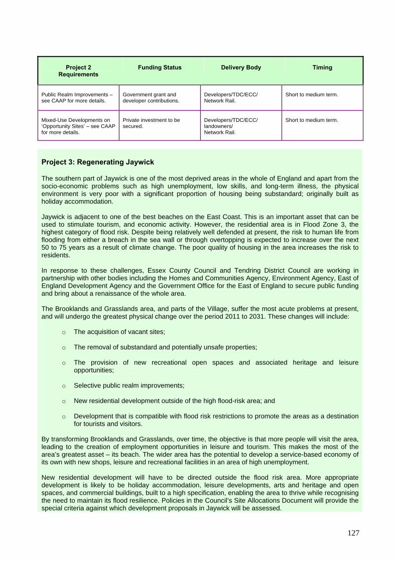
127
Project 2 Requirements
Funding Status
Delivery Body
Timing
Public Realm Improvements – see CAAP for more details.
Government grant and developer contributions.
Developers/TDC/ECC/ Network Rail.
Short to medium term.
Mixed-Use Developments on ‘Opportunity Sites’ – see CAAP for more details.
Private investment to be secured.
Developers/TDC/ECC/ landowners/ Network Rail.
Short to medium term.
Project 3: Regenerating Jaywick
The southern part of Jaywick is one of the most deprived areas in the whole of England and apart from the socio-economic problems such as high unemployment, low skills, and long-term illness, the physical environment is very poor with a significant proportion of housing being substandard; originally built as holiday accommodation.
Jaywick is adjacent to one of the best beaches on the East Coast. This is an important asset that can be used to stimulate tourism, and economic activity. However, the residential area is in Flood Zone 3, the highest category of flood risk. Despite being relatively well defended at present, the risk to human life from flooding from either a breach in the sea wall or through overtopping is expected to increase over the next 50 to 75 years as a result of climate change. The poor quality of housing in the area increases the risk to residents.
In response to these challenges, Essex County Council and Tendring District Council are working in partnership with other bodies including the Homes and Communities Agency, Environment Agency, East of England Development Agency and the Government Office for the East of England to secure public funding and bring about a renaissance of the whole area.
The Brooklands and Grasslands area, and parts of the Village, suffer the most acute problems at present, and will undergo the greatest physical change over the period 2011 to 2031. These changes will include:
o The acquisition of vacant sites; o The removal of substandard and potentially unsafe properties; o The provision of new recreational open spaces and associated heritage and leisure
opportunities; o Selective public realm improvements; o New residential development outside of the high flood-risk area; and
o Development that is compatible with flood risk restrictions to promote the areas as a destination
for tourists and visitors.
By transforming Brooklands and Grasslands, over time, the objective is that more people will visit the area, leading to the creation of employment opportunities in leisure and tourism. This makes the most of the area’s greatest asset – its beach. The wider area has the potential to develop a service-based economy of its own with new shops, leisure and recreational facilities in an area of high unemployment.
New residential development will have to be directed outside the flood risk area. More appropriate development is likely to be holiday accommodation, leisure developments, arts and heritage and open spaces, and commercial buildings, built to a high specification, enabling the area to thrive while recognising the need to maintain its flood resilience. Policies in the Council’s Site Allocations Document will provide the special criteria against which development proposals in Jaywick will be assessed.
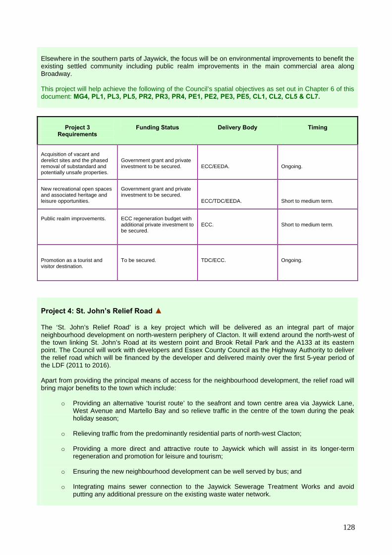
128
Elsewhere in the southern parts of Jaywick, the focus will be on environmental improvements to benefit the existing settled community including public realm improvements in the main commercial area along Broadway. This project will help achieve the following of the Council’s spatial objectives as set out in Chapter 6 of this document: MG4, PL1, PL3, PL5, PR2, PR3, PR4, PE1, PE2, PE3, PE5, CL1, CL2, CL5 & CL7.
Project 3 Requirements
Funding Status
Delivery Body
Timing
Acquisition of vacant and derelict sites and the phased removal of substandard and potentially unsafe properties.
Government grant and private investment to be secured.
ECC/EEDA.
Ongoing.
New recreational open spaces and associated heritage and leisure opportunities.
Government grant and private investment to be secured.
ECC/TDC/EEDA.
Short to medium term.
Public realm improvements.
ECC regeneration budget with additional private investment to be secured.
ECC.
Short to medium term.
Promotion as a tourist and visitor destination.
To be secured.
TDC/ECC.
Ongoing.
Project 4: St. John’s Relief Road ▲ The ‘St. John’s Relief Road’ is a key project which will be delivered as an integral part of major neighbourhood development on north-western periphery of Clacton. It will extend around the north-west of the town linking St. John’s Road at its western point and Brook Retail Park and the A133 at its eastern point. The Council will work with developers and Essex County Council as the Highway Authority to deliver the relief road which will be financed by the developer and delivered mainly over the first 5-year period of the LDF (2011 to 2016). Apart from providing the principal means of access for the neighbourhood development, the relief road will bring major benefits to the town which include:
o Providing an alternative ‘tourist route’ to the seafront and town centre area via Jaywick Lane,
West Avenue and Martello Bay and so relieve traffic in the centre of the town during the peak holiday season;
o Relieving traffic from the predominantly residential parts of north-west Clacton; o Providing a more direct and attractive route to Jaywick which will assist in its longer-term
regeneration and promotion for leisure and tourism;
o Ensuring the new neighbourhood development can be well served by bus; and
o Integrating mains sewer connection to the Jaywick Sewerage Treatment Works and avoid putting any additional pressure on the existing waste water network.

129
The route of the St. John’s Relief Road will be shown on the Proposals Maps as part of the Site Allocations Document. This project will help achieve the following of the Council’s spatial objectives as set out in Chapter 6 of this document: PR1, PR2, PR4, CL1, CL3, CL4, CL6 & CL7
Project 4 Requirements
Funding Status
Delivery Body
Timing
Section 1: A133 to Little Clacton Road.
Integral part of relevant phase of neighbourhood development in Project 5.
Developer.
Short to medium term.
Section 2: Little Clacton Road to St. John’s Road.
Integral part of relevant phase of neighbourhood development in Project 5.
Developer.
Short to medium term.
Section 3: St. John’s Road to Jaywick Lane.
Integral part of relevant phase of neighbourhood development in Project 5.
Developer.
Short to medium term.
Project 5: Hartley Meadows Neighbourhood Development ▲ The north-western periphery of Clacton is relatively unaffected by significant physical and environmental constraints and will therefore be the location of the LDF’s largest neighbourhood development. The development will be delivered partly in conjunction with the creation of the St. John’s Relief Road (Project 4) and the Brook Business Park (project 6) and will provide approximately 3,100 new homes along with other uses and community benefits. The development will make a significant contribution to the provision of affordable housing, will include an element of extra care housing for older and disabled residents and ‘aspirational housing’ to cater for a wide range of income groups, lifestyles and abilities. As well as providing a mix of new housing, the development will deliver a new primary school, a new primary health care centre, a new ambulance station and two new neighbourhood centres which will include local shops, services and community facilities. The non-housing elements of the development will deliver a significant number of local jobs in the public and private sector, particularly in health, education and retail. The overall increase in new households will help support growth in the wider economy including spending and investment in the town centre and other service-sector industries. The development will deliver recreational open spaces and other green infrastructure including the completion and extension of the north-west portion of the ‘Picker’s Ditch Walkway’, sustainable drainage and new wildlife habitats. The development will also be required to retain and strengthen the countryside gap separating north Clacton and the village of Little Clacton and the gap between Clacton-on-Sea and Jaywick to safeguard the individual identities of these areas, enhance the appearance of the urban edge, provide strategic open space and improve public access to the countryside. This development will be required to fund increased capacity at the sewerage treatments works in Jaywick and in Clacton in order to accommodate the additional growth and contribute financially towards the upgrade of the A133 between Weeley and Frating. The development is anticipated to take place over the full 20 years of the LDF period (2011 to 2031) and

130
will provide a significant number of jobs in the construction industry over that period. The Council will work with landowners, developers and other partners to produce a comprehensive Master Plan for the area and the precise extent of growth in North-West Clacton will be shown on the Proposals Map as part of the Site Allocations Document. This project will help achieve the following of the Council’s spatial objectives as set out in Chapter 6 of this document: MG1, MG2, MG3, MG4, PL3, PL4, PL5, PR3, PR4, PR5, PE1, PE2, PE3, PE4, PE5, PE6, CL3, CL4, CL5 & CL6
Project 5 Requirements
Funding Status
Delivery Body
Timing
3,100 new homes.
Private investment to be secured.
Developer/RSL.
Short to long term.
St. John’s Relief Road.
See project 4 above.
See project 4 above.
See project 4 above.
1 x two form entry primary school with commensurate early years and childcare facilities plus minor expansion of existing permanent facilities.
New facilities to be an integral part of neighbourhood development. Developer contributions for expansion of existing facilities.
Developer/ECC.
Short term.
Medical Centre and Ambulance Station.
Land provided by developer as an integral part of neighbourhood development at no cost. Facilities provided by NHS through the LIFT scheme and through East of England Ambulance Service capital funding.
Developer/NHS/East of England Ambulance Service.
Short term.
2 x neighbourhood centres comprising new shops and community facilities (mix of uses, specification and management arrangements to be included in the Site Allocations Document).
Integral part of neighbourhood development.
Developer.
Short term.
Electricity Sub-Station.
Integral part of neighbourhood development.
Developer/electricity provider.
Short term.
Expand Sewerage Treatment Works Capacity.
Combination of developer contributions and Anglian Water capital funding.
Developer/ Anglian Water.
Short term.
Pickers Ditch Walkway.
See project 10 below.
See project 10 below.
See project 10 below.
Contribution toward the upgrade of the A133.
See Table 10.1 above.
See Table 10.1 above.
See Table 10.1 above.
Green Infrastructure provided

131
in accordance with standards set out in Core Policies 11, 21, 22 and Policy DP16.
Integral part of neighbourhood development.
Developer.
Short to medium term.
Project 6: Brook Business Park ▲ The Council’s Employment Study identifies offices as one sector that could grow over the course of the LDF plan period and that could provide jobs in Clacton. Whilst office developments are best located in town centres, if the demand for office space grows to the extent indicated in the Employment Study, Clacton town centre may not have sufficient capacity to accommodate all of this growth. Therefore, in association with the Hartley Meadows Neighbourhood Development (Project 5) the Council will identify land on the edge of the town for a small high quality business park in the vicinity of the A133, St. John’s Relief Road and Brook Retail Park where landmark office buildings and other commercial uses at the gateway of the town will be promoted along with further expansion of Brook Country Park to reinforce the countryside gap between Clacton and Little Clacton. The Council will work with landowners, developers and other partners to produce a comprehensive Master Plan for the area and the precise extent of growth in North-West Clacton (including Project 5) will be shown on the Proposals Map as part of the Site Allocations Document. This project will help achieve the following of the Council’s spatial objectives as set out in Chapter 6 of this document: MG1, MG2, MG4, PL5, PR1, PR3, PE1, PE2 & CL6
Project 6 Requirements
Funding Status
Delivery Body
Timing
St. John’s Relief Road.
See project 4 above.
See project 4 above.
See project 4 above.
Landmark commercial development including office accommodation.
Private investment to be secured.
Developer.
Short to medium term.
Project 7: West Clacton Outdoor Leisure Park The wedge of open countryside between Jaywick and West-Clacton forms an important green lung that is contained within strongly defined urban boundaries. It provides an open area between the settlements and is the home to a number of important outdoor leisure activities and sports clubs. These include Clacton Golf Club, Millers Barn Golf Club and driving range, Clacton Aero Club, Clacton Football Club and publicly available sports facilities at Clacton Coastal Academy. The area also plays host to popular events including a circus, car boot sales and fireworks display. The Council will safeguard this area and will work with its partners to promote it as a outdoor leisure park serving the western side of the town, secure environmental enhancements, built upon the range of leisure activities already provided and improve access to the countryside for walking, cycling and horse-riding. This area is relatively well located to the seafront and town centre and the St. John’s Relief Road (Project 4) will direct tourist traffic along Jaywick Lane and West Avenue, through the Country Park. This area therefore will have the potential to harness tourist activity, create jobs, provide seasonal park and ride facilities and contribute towards Clacton’s vision to develop into a 21st Century Resort.

132
The Council will work with the developers of the Hartley Meadows Neighbourhood Development (Project 5) to secure a strong linkage between this area and the extended Pickers Ditch Walkway as part of the wider green infrastructure strategy. In this area, the Council will support proposals for expansion or additional facilities for any of the existing activities and sports clubs and the introduction of new outdoor leisure pursuits or facilities that would support the tourism role of the town. This project will help achieve the following of the Council’s spatial objectives as set out in Chapter 6 of this document: MG3, PL2, PL3, PL2, PL3, PE1, PE3, CL1 & CL5
Project 7 Requirements
Funding Status
Delivery Body
Timing
Environmental enhancements.
Public and private investment to be secured.
TDC/Landowners.
Short to medium term.
Improved access to the countryside for walking, cycling and horse riding.
Public and private investment to be secured.
TDC/ECC/ Landowners.
Short to medium term.
Seasonal Park and Ride Facility.
Public and private investment to be secured.
TDC/ECC/ Landowners.
Short to medium term.
New outdoor leisure activities.
Public and private investment to be secured.
TDC/Landowners.
Short to medium term.
Project 8: Martello Bay Watersports Area
Due to major sea defence works in recent years, the sands at Martello Bay have become one of the most popular stretches of Clacton beach. The concept of promoting the area as a water sports centre has evolved over time and the area now contains a chain restaurant, coach and visitor parking, a coastguard station, a lifeboat house and a boat launching ramp. The area does however contain vacant areas of land that could be used for appropriate water-based leisure and tourism uses. As the St. John’s Relief Road will direct incoming tourists to the seafront and town centre via Martello Bay, the potential for this area to expand as a tourist attraction and provide additional jobs will increase. Therefore the Council will work with its partners to expand upon the facilities provided in this area and support proposals for water-based leisure and tourism activities. The promotion of this area for watersports accords with the Council’s Tourism Strategy and the strategy for rejuvenating the wider seafront (see Project 1) and opportunity sites within the Martello Bay area will be identified on the Proposals Map as part of the Site Allocations Document. This project will help achieve the following of the Council’s spatial objectives as set out in Chapter 6 of this document: PR2, PR3, PE1, PE2, PE3, CL1 & CL2

133
Project 8 Requirements
Funding Status Delivery Body Timing
Water-based commercial, leisure and tourism activities.
To be secured.
TDC/ Developers.
Short term.
Project 9: Expansion of Oakwood Business Park ▲ Whilst the Council’s Employment Study suggests that the industrial and warehousing sector is unlikely to grow significantly in Clacton between 2011 and 2031, reflecting a national decline, the Council will seek to retain a flexible supply of land to accommodate industry and warehousing proposals that would bring additional jobs to the area if economic conditions change. The most appropriate locations for businesses of this type in Clacton are Oakwood and Crusader Business Park and Gorse Lane Industrial Essex in the north-west of the town which is relatively unaffected by significant physical and environmental constraints and provides the best access to the strategic road network for heavy goods vehicles. The Council will identify deliverable land for the expansion of this key industrial area in the Site Allocations Document for development in use classes B1(b&c), B2 & B8 which primarily include light industry, research and development and warehousing. This project will help achieve the following of the Council’s spatial objectives as set out in Chapter 6 of this document: MG1, MG4, PR3 & PE2
Project 9 Requirements
Funding Status
Delivery Body
Timing
Provision of serviced business units.
Private investment to be secured.
Developer.
Short to medium term.
Off-site transport improvements.
To be financed by development.
Developer/ECC.
Short to medium term.
Project 10: Pickers Ditch Walkway Pickers Ditch extends from Hartley Wood to the north west of Clacton around the northern edge of the town via Brook Retail Park, Bursville Cemetery, Valley Farm Holiday Park and along the northern edge of Holland-on-Sea at it eastern end before feeding into Holland Brook. The concept behind the Pickers Ditch Walkway is to provide a pleasant green corridor for walking, cycling and horse riding that extends round the edge of the town mostly following the route of Pickers Ditch. The completion of the Pickers Ditch Walkway supports the Council’s objectives to expand the green infrastructure network, promote healthy living and encourage walking and cycling as alternatives to the private car and is identified as a key project in the Haven Gateway Green Infrastructure Study. Over the course of the LDF plan period, the Pickers Ditch Walkway will be completed and extended as an integral part of the neighbourhood developments proposed for north-west Clacton and east Clacton. When complete, the uninterrupted walkway will extend from the proposed West Clacton Country Park and

134
connect with Holland Haven Country Park in the east. The walkway will not only benefit the existing and future residents of the area and provide a visitor attraction in its own right that can be used for recreational cycling and horse riding but also sports events such as cross-country running. The green corridor will also provide space for accommodating sustainable drainage systems (SuDS) and wildlife habitats. In the longer-term, the Pickers Ditch Walkway will form an important part of the district-wide ‘Tendring Way’ proposal. The precise route and dimensions of the Pickers Ditch Walkway will be shown on the Proposals Map as part of the Site Allocations Document. This land will be transferred to the Council, as a condition of development, for future maintenance. This project will help achieve the following of the Council’s spatial objectives as set out in Chapter 6 of this document: MG2, PL1, PL2, PL3, PL5, PR1, PR2, PE3, PE5, PE6, CL1 & CL5
Project 10 Requirements
Funding Status
Delivery Body
Timing
Section 1: A133 to Jaywick Lane.
Integral part of neighbourhood development in Project 5.
Developer.
Short to medium term.
Section 2: Valley Farm to Holland Haven.
Mainly and integral part of neighbourhood development in Project 11.
Developer/TDC
Medium term.
Project 11: East Clacton Neighbourhood Development ▲ The eastern periphery of Clacton is more sensitive in environmental terms than the north-west and the potential for neighbourhood growth is consequently more limited. The east of the town can accommodate a reasonable neighbourhood development that could deliver around 700 new homes, other uses and community benefits along with the upgrading and expansion of Valley Farm Holiday Park. The development will make a significant contribution to the provision of affordable housing, will include an element of extra care housing for older and disabled residents and ‘aspirational housing’ to cater for a wide range of income groups, lifestyles and abilities. As well as providing a mix of new housing, the development will deliver a new primary school and new neighbourhood centres which will include local shops, services and community facilities. The non-housing elements of the development will deliver some local jobs in the public and private sector, particularly in education and retail. The overall increase in new households will help support growth in the wider economy including spending and investment in the town centre and other service-sector industries. The development will required a new access road and will contribute financially towards the upgrade of the A133 between Weeley and Frating. The development will deliver recreational open spaces and other green infrastructure including the completion and extension of the eastern portion of the ‘Picker’s Ditch Walkway’, sustainable drainage and new wildlife habitats. The development will also be required to retain and strengthen the countryside gap separating Holland-on-Sea and the edge of Clacton to safeguard the individual identities of these areas, enhance the appearance of the urban edge, provide strategic open space and improve public access to the countryside.

135
The development is anticipated to take place over the final 15-years of the LDF period and will provide a significant number of jobs in the construction industry over that period and the upgrade of the Holiday Park will contribute towards the new vision for Clacton as a 21st Century year-round resort. The Council will work with landowners, developers and other partners to produce a comprehensive Master Plan for the area and the precise extent of growth in East Clacton will be shown on the Proposals Map as part of the Site Allocations Document. This project will help achieve the following of the Council’s spatial objectives as set out in Chapter 6 of this document: MG1, MG2, MG3, MG4, PL3, PL4, PL5, PR3, PR4, PR5, PE2, PE3, PE4, PE5, PE6, CL3, CL4 & CL5
Project 11 Requirements
Funding Status
Delivery Body
Timing
700 New Homes.
Private Investment to be secured.
Developer/RSL.
Medium to long term.
Upgrade and expansion of Valley Farm Holiday Park.
Integral part of neighbourhood development.
Developer/Holiday Park Operator.
Medium to long term.
1x single-form entry primary school with commensurate early years and childcare facilities.
Integral part of neighbourhood development.
Developer.
Medium term.
Pickers Ditch Walkway.
See project 10 above.
See project 10 above.
See project 10 above.
Neighbourhood centre comprising new shops and community facilities (mix of uses, specification and management arrangements to be included in the Site Allocations Document).
Integral part of neighbourhood development.
Developer.
Medium term.
Contribution toward the upgrade of the A133.
See Table 10.1 above.
See Table 10.1 above.
See Table 10.1 above.
Green Infrastructure provided in accordance with standards set out in Core Policies 11, 21, 22 and Policy DP16.
Integral part of neighbourhood development.
Developer.
Short to medium term.
Project 12 – Port Expansion at Bathside Bay ▲ In 2006, a planning application by Hutchinson Ports (UK) Ltd for Container Port at Bathside Bay was granted a 10-year planning permission. The Council fully supports the proposal which will bring about a much needed economic recovery in Harwich and the wider Haven Gateway area. The scheme includes a deep water quayside between Parkeston and the old town of Harwich capable of handling up to four deep-sea container vessels simultaneously along with an associated rail terminal and logistics facilities. The development will involve the reclamation of approximately 72 hectares of inter-tidal

136
land and will create around 700 jobs directly associated with the port with an addition 1,000 jobs resulting from growth in businesses, industry, warehousing and other support services. The Council will consider the need to identify land in the Site Allocations Document to accommodate the associated logistics operations, as required. The development is conditional on the upgrading, at the developers expense, of the A120 between Hare Green and Ramsey to accommodate the additional freight traffic, junction improvements at the Crown Interchange in Ardleigh and locally, and the provision of a compensatory wildlife habitat at Hamford Water to mitigate the environmental impact of the development. The recent economic downturn combined with the lead-in time for upgrading the A120 means that the port expansion is unlikely to take place until later on in the LDF plan period. It is unlikely that the expanded port will be operational until the second half of LDF period post 2021. However, if development at Bathside Bay commences in 2015, this may generate speculative investment in the area which could deliver some jobs from the middle part of the LDF plan period. Economic growth at Harwich is heavily dependent on this development and so is the delivery of the proposed number of homes and jobs set out in the spatial strategy. The Council will closely monitor the progress of the Bathside Bay development and will assist, wherever possible, the port company and the Highways Agency in delivering the scheme. However, if the expansion of the port does not commence before 2016 or remains highly uncertain, the Council will review the LDF Core Strategy, such is the importance of this scheme. In the meantime, there may be scope for an interim windfarm related development. This project will help achieve the following of the Council’s spatial objectives as set out in Chapter 6 of this document: MG1, MG4, PR1, PR3, PR4, PE1, HA1 & HA2
Project 12 Requirements
Funding Status
Delivery Body
Timing
Interim facility for transportation and assembly of windfarm technology.
Private investment to be secured.
Port Company/ Energy Company.
Short term.
Expansion of the port.
Private investment.
Port Company/Developer.
Medium to long term.
Upgrading the A120.
See schedule 10.1 above.
See schedule 10.1 above.
See schedule 10.1 above.
Compensatory habitat at Hamford Water.
To be funded through developer.
Developer.
Short to medium term.
Project 13 – Regenerating Harwich Old Town ▲ Harwich Old Town is recognised as an area in need of economic and physical regeneration. However it also has a rich maritime heritage that, if enhanced and complemented, with sympathetic contemporary development, new leisure activities and improvements to the public realm, has a huge potential to attract tourist visitors and create new jobs. One potential would be by encouraging a greater numbers of cruise-liner passengers that pass through the port to visit and stay in Harwich as part of their touring experience. The Haven Gateway Partnership working with the East of England Development Agency (EEDA), Trinity House, the Harwich Haven Authority and the Council prepared a Master Plan for the Old Town area, adopted in 2006. The Master Plan identified a number of development opportunities including proposals for around 400 new homes, new retail provision and a 500- berth marina.

137
However, for a variety of reasons many of the proposals in the Master Plan have since shown to be undeliverable. Therefore, the Council will work with its partners to deliver an alternative strategy for the Old Town, promoting a stronger focus on tourism – a sector that has the potential to grow in the early part of the LDF plan period. Key priorities will include:
providing new tourist attractions that reflect the town’s unique maritime history;
creating attractive open spaces;
selective new mixed-use developments incorporating retail, leisure and residential uses; and
facilities for water sport activities. Much of the old town is in Flood Zone 3, the highest category of flood risk. The Council will therefore work closely with the Environment Agency to ensure that the flood-risk implications of any development proposals are fully understood and minimised in accordance with the ‘exceptions test’ contained in PPS25 – the government’s planning policy on ‘Development and Flood Risk’. The old town was designated as a Conservation Area in 1969 and contains the district’s largest concentration of listed buildings. Therefore, whilst development in the area will be required to stimulate regeneration, it must be of the highest quality of design in order to protect and enhance the area’s special character and contribute towards improvements to the public realm. This regeneration project will take place over the first 10 years of the LDF period (2011 to 2021) and will provide a significant number of jobs in the construction industry over that period. Individual development proposals and public realm enhancements will be identified in the Site Allocations Document along with mechanisms for their delivery. This project will help achieve the following of the Council’s spatial objectives as set out in Chapter 6 of this document: MG1, MG2, MG3, MG4, PL2, PL5, PR3, PR4, PR5, PE1, PE4, PE5, PE6, HA3, HA4 & HA5.
Project 13 Requirements
Funding Status
Delivery Body
Timing
Public Realm Improvements.
Combination of government grant and developer contributions.
TDC/ECC/ Developers.
Short to medium term.
Mixed-Use Developments on ‘Opportunity Sites’.
Private investment to be secured.
Developers/TDC/ landowners/Network Rail.
Short to medium term.
Project 14 – Rejuvenating Dovercourt Town Centre Dovercourt Town Centre is the largest area of retail activity in Harwich urban area but has witnessed a decline both economically and physically over a number of years. Being a primarily linear shopping area constrained by the geography of the town, there are few opportunities to physically expand. Therefore, the focus for stimulating economic growth in this area will be related to environmental enhancements designed to improve the shopping experience for both residents and tourists, enhance the historic character of the area and attract inward investment in retail and other town centre activities. Identified as an area in need of regeneration, the Council commissioned a Regeneration Study in 2005 which identified proposals for the enhancement of key areas and important historic buildings within the town centre including Dovercourt railway station and its forecourt and the intention to relocate the market.

138
The Council will work with Essex County Council, Network Rail and individual businesses within the town centre to secure funding to deliver these improvements. The Council is also currently working with its regeneration company, specialist consultants and other partners to update the regeneration programme which will identify a number of selective opportunity sites for mixed-use development including retail and housing, and investigate ways of improving parking and transport and accommodating a street market. The town centre economy will benefit from development proposals elsewhere in Harwich including the expansion of the port, regeneration in Harwich Old Town, the increase in ‘catchment population’ brought about by the new housing proposed for the town and an increase in tourism. This project will help achieve the following of the Council’s spatial objectives as set out in Chapter 6 of this document: MG2, MG4, PL2, PL5, PR2, PR3, PR4, PE1, PE2, PE5, HA3 & HA4.
Project 14 Requirements
Funding Status
Delivery Body
Timing
Public realm improvements.
Public and private investment to be secured.
Property Owners/ Network Rail TDC/ECC.
Short term.
Mixed-Use Developments on ‘Opportunity Sites’.
Private investment to be secured.
Developers/TDC/ landowners/Network Rail.
Short to medium term.
Project 15 – Stanton Euro Park ▲ Stanton Euro Park is a major mixed-use development centred around ‘St. Nicholas Roundabout’ the interchange on the A120 serving Harwich International Port that comprises reclaimed land close to Bathside Bay, the area proposed for port expansion. Having been earmarked for development in the 1980s, the area has already seen significant growth and provides a range of edge-of-town commercial businesses including two supermarkets, five non-food retail warehouses, a hotel and a pub. The area has also seen the commencement of a major residential development that is anticipated to deliver some 200 dwellings in the early part of the LDF period post 2011 as the wider housing market recovers from the recent downturn. The area also comprises 5 hectares of land that remains undeveloped, originally earmarked for business and industrial development. The area is in Flood Zone 3, the highest category of flood risk and since the introduction of PPS25, the government’s planning policy on ‘Development and Flood Risk’ the only acceptable use for the land is port-related development including container storage. The port expansion at Bathside Bay will increase the demand for such activities and so this land will be safeguarded for port-related uses likely to deliver new jobs in logistics and other support services in the latter part of the LDF plan period post 2021. The Council will work with the landowners and the port logistics industry to deliver this development. The development will take place throughout the LDF period and will provide a significant number of jobs in the construction industry over that period. The individual development proposals within Stanton Euro Park will be shown in the Site Allocations Document. This project will help achieve the following of the Council’s spatial objectives as set out in Chapter 6 of this document: MG1, MG2, MG3, MG4, PL5, PR3, PR4, PE1, PE2, PE4, PE5, HA1, HA2 & HA5

139
Project 15
Requirements
Funding Status
Delivery Body
Timing
200 new homes (as per existing planning permissions).
Private investment.
Developers.
Short term.
Port related development.
Private investment to be secured.
Developers.
2016-2026
Project 16 – Harwich Linear Park The valley along Ramsey Creek comprises a large area of land between Ramsey and Parkeston, to the north of Dovercourt and the A120. It is at risk of flooding and is unsuitable for most development. This area is identified in the Haven Gateway Green Infrastructure Study for the creation of a ‘Harwich Linear Park’ which the Council, working in partnership with Essex County Council and the landowners will deliver in the LDF plan period, with funding from the Haven Gateway Partnership. The Linear Park will comprise approximately 50 hectares of land that will:
o Provide strategic landscaping and tree planting; o Create a wetland wildlife habitat;
o Provide managed public access to the countryside for local residents, tourists and for
educational purposes; and o Provide green corridor for walking, cycling and horse riding that extends round the north of the
town linking with the ‘Hangings’ and the landscaping proposed as part of the Bathside Bay development.
The Harwich Linear Park will eventually form an important part of the district-wide ‘Tendring Way’ proposal. The precise route and dimensions of the Harwich Linear Park will be shown in the Site Allocations Document. This project will help achieve the following of the Council’s spatial objectives as set out in Chapter 6 of this document: MG2, MG3, PL1, PL2, PL3, PL5, PR1, PR2, PE3, PE6 & HA6.
Project 16 Requirements
Funding Status
Delivery Body
Timing
Country park
Part Haven Gateway grant funding, part delivery as an integral part of Project 17 (below) and other grant funding.
ECC/TDC/ Developers.
Short to medium term.
Extending the ‘Hangings.
Developer contributions.
Developers/TDC.
Short term.

140
Project 17 – Land East of Pond Hall Farm ▲ Land south of the A120 east of ‘Pond Hall Farm’ provides a site on the periphery of Harwich for major business and industrial development and that is located in a sustainable location close to existing services and facilities with good access to the A120 and the port. The area will deliver a mixed-use development including approximately 20 hectares of land for employment in use classes B1(b&c), B2 & B8 (light industry, research and development and warehousing) and approximately 200 new homes. Development can commence in the early part of the LDF plan period. Building work is likely to continue throughout the course of the LDF plan period, with completion unlikely to occur before the port expansion at Bathside Bay, which will significantly increase commercial demand. The development is dependent on the creation of a new roundabout directly onto the A120. The Council will work with the landowners and the Highways Agency to deliver the roundabout as early as possible to unlock the site for development and secure inward investment. The residential element of the scheme will need to be accessed via the existing urban road network as opposed to the A120 to keep it free for the movement of cars and lorries going in an out of the town rather than local traffic. Parts of the area are close to Ramsey Creek and are affected by Flood Zone 3 and the Council will seek to minimise built development in these low-lying areas and integrate them with the adjoining Harwich Linear Park and provide an attractive setting for the development. The development will be expected to incorporate pedestrian and cycle ways to enable movement between the existing built up area of Dovercourt and the proposed Linear Park. The development will take place throughout the LDF period and will provide a significant number of jobs in the construction industry over that period. The precise extent and nature of the Pond Hall Farm development will be shown in the Site Allocations Document. This project will help achieve the following of the Council’s spatial objectives as set out in Chapter 6 of this document: MG1, MG2, MG3, MG4, PL3, PR1, PR3, PR4, PE1, PE2, PE3, PE4, PE5, HA1, HA2 & HA5.
Project 17 Requirements
Funding Status
Delivery Body
Timing
New junction to enable direct access from the A120.
Private investment to be secured.
Developers/ Highways Agency.
Short-term.
Serviced industrial units and other employment uses.
Private investment to be secured.
Developer.
Short to medium term.
200 new homes.
Private investment to be secured.
Developer/RSL.
Short to medium term.
Part of Harwich Linear Park (see Project 16 above).
Integral part of mixed-use development.
Developer/ECC.
Short to medium term.
Expand Sewerage Works Treatment Capacity.
Developer Contributions.
Developer/ Anglian Water.
Short to medium term.
Expand primary school and
Financial contribution from

141
early years and childcare capacity.
development Developer/ECC Short to medium term.
Green Infrastructure provided in accordance with standards set out in Core Policies 11, 21, 22 and Policy DP16.
Integral part of neighbourhood development.
Developer.
Short to medium term.
Project 18 – Urban Extensions in West Harwich ▲ The physical and environmental constraints affecting Harwich limit opportunities for major neighbourhood developments without significant environmental impacts. Therefore housing growth outside the existing built-up area will be limited to modest sustainable urban extensions to the west of the town in the vicinity of Ramsey to deliver approximately 200 new homes. Development is likely to take place in the second half of the LDF plan period post 2021 as the housing market in Harwich is boosted by the emerging development at the port but could take. The development would provide a number of jobs in the construction industry and will include an element of affordable housing and ‘aspirational housing’ to cater for a wide range of income groups, lifestyles and abilities. The Council will work with landowners, developers and other partners to produce a Master Plan for the area and the precise extent of growth in this area will be shown on the Proposals Map as part of the Site Allocations Document. This project will help achieve the following of the Council’s spatial objectives as set out in Chapter 6 of this document: MG1, MG2, MG4, PL5, PR4, PE2, PE4 & HA5.
Project 18 Requirements
Funding Status
Delivery Body
Timing
200 new homes.
Private investment to be secured.
Developer/RSL.
Short to medium term.
Expand primary and early years and childcare capacity.
Financial contribution from development.
Developer/ECC.
Short to medium term.
Expand Sewerage Treatment Capacity.
Developer Contributions.
Developer/ Anglian Water.
Short to medium term.
Green Infrastructure provided in accordance with standards set out in Core Policies 11, 21, 22 and Policy DP16.
Integral part of neighbourhood development.
Developer.
Short to medium term.

142
Project 19 – Regenerating Walton-on-the-Naze ▲ Walton-on-the-Naze is an area in need of economic and physical regeneration but also offers great potential for growth in tourism thanks to its coastal assets. The economy is currently seasonal and, with only a small residential population, this small Victorian seaside town effectively closes for business in the winter months. To deliver regeneration in an integrated way, the Council commissioned a ‘Regeneration Framework’ which identifies measures to:
o Build a strong year round economy by diversifying and extending the local economy to create new business and employment opportunities;
o Create a unique destination which maximises its environmental and heritage assets – releasing
the largely untapped potential of Walton presented by its natural environmental and heritage to create a destination unlike any other in the region;
o Make Walton a place where people will choose to live and realise their potential – a town with a
good range of housing, retail, community and leisure facilities which will attract people of all ages and encourage them to stay; and
o Ensure a sustainable future for Walton – maintaining a balance between economic growth and
environmental management. Seasonal trade will continue be the mainstay of Walton’s economy. However, there will be growth in local retail and leisure activities that will benefit the resident population. The main drivers of retail growth in the town centre will be the increase in ‘catchment population’ brought about the development of approximately 500 new homes; ‘clawing back’ of some of the trade that is currently lost to other town centres; and diversification in the tourist accommodation to provide quality hotel accommodation, holiday homes and improve tourist attractions including the Pier and the reinstatement of Walton Mere as a boating lake. The overall package will deliver around 4,000m2 of new retail floor space and 6,000m2 of new leisure floor space. The Regeneration Framework identifies development opportunities within the area for housing, tourist accommodation, leisure facilities and other commercial activities and where appropriate, these could be formally included in the Site Allocations Document. This project will help achieve the following of the Council’s spatial objectives as set out in Chapter 6 of this document: MG1, MG2, MG3, MG4, PL2, PL5, PR2, PR3, PR4, PR5, PE1, PE2, PE3, PE4, PE6, FW1, FW2 & FW3
Project 19 Requirements
Funding Status
Delivery Body
Timing
500 new homes.
Private investment to be secured.
Developer/RSL.
Medium term.
Leisure and tourism facilities (including new holiday accommodation and the restoration of the Mere).
Part funded through Government grant and private investment through mixed-use development and enabling development.
Developers/TDC/ owners of existing attractions.
Short to medium term.
New retail and leisure floor space.
Private investment to be secured.
Developer/retailers.
Short to medium term.
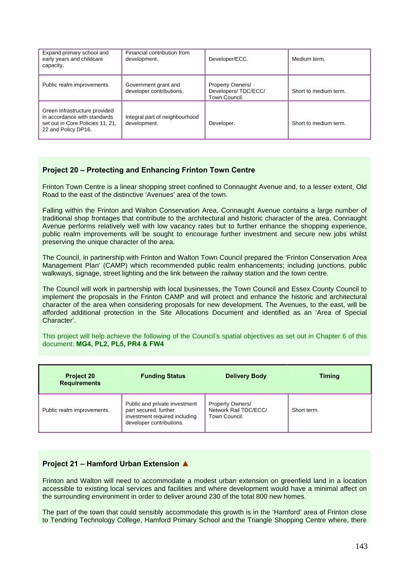
143
Expand primary school and early years and childcare capacity.
Financial contribution from development.
Developer/ECC.
Medium term.
Public realm improvements.
Government grant and developer contributions.
Property Owners/ Developers/ TDC/ECC/ Town Council.
Short to medium term.
Green Infrastructure provided in accordance with standards set out in Core Policies 11, 21, 22 and Policy DP16.
Integral part of neighbourhood development.
Developer.
Short to medium term.
Project 20 – Protecting and Enhancing Frinton Town Centre Frinton Town Centre is a linear shopping street confined to Connaught Avenue and, to a lesser extent, Old Road to the east of the distinctive ‘Avenues’ area of the town. Falling within the Frinton and Walton Conservation Area, Connaught Avenue contains a large number of traditional shop frontages that contribute to the architectural and historic character of the area. Connaught Avenue performs relatively well with low vacancy rates but to further enhance the shopping experience, public realm improvements will be sought to encourage further investment and secure new jobs whilst preserving the unique character of the area. The Council, in partnership with Frinton and Walton Town Council prepared the ‘Frinton Conservation Area Management Plan’ (CAMP) which recommended public realm enhancements; including junctions, public walkways, signage, street lighting and the link between the railway station and the town centre. The Council will work in partnership with local businesses, the Town Council and Essex County Council to implement the proposals in the Frinton CAMP and will protect and enhance the historic and architectural character of the area when considering proposals for new development. The Avenues, to the east, will be afforded additional protection in the Site Allocations Document and identified as an ‘Area of Special Character’. This project will help achieve the following of the Council’s spatial objectives as set out in Chapter 6 of this document: MG4, PL2, PL5, PR4 & FW4
Project 20 Requirements
Funding Status
Delivery Body
Timing
Public realm improvements.
Public and private investment part secured, further investment required including developer contributions.
Property Owners/ Network Rail TDC/ECC/ Town Council.
Short term.
Project 21 – Hamford Urban Extension ▲ Frinton and Walton will need to accommodate a modest urban extension on greenfield land in a location accessible to existing local services and facilities and where development would have a minimal affect on the surrounding environment in order to deliver around 230 of the total 800 new homes. The part of the town that could sensibly accommodate this growth is in the ‘Hamford’ area of Frinton close to Tendring Technology College, Hamford Primary School and the Triangle Shopping Centre where, there
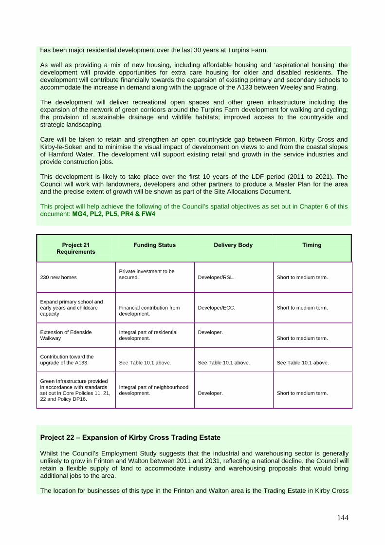
144
has been major residential development over the last 30 years at Turpins Farm. As well as providing a mix of new housing, including affordable housing and ‘aspirational housing’ the development will provide opportunities for extra care housing for older and disabled residents. The development will contribute financially towards the expansion of existing primary and secondary schools to accommodate the increase in demand along with the upgrade of the A133 between Weeley and Frating. The development will deliver recreational open spaces and other green infrastructure including the expansion of the network of green corridors around the Turpins Farm development for walking and cycling; the provision of sustainable drainage and wildlife habitats; improved access to the countryside and strategic landscaping. Care will be taken to retain and strengthen an open countryside gap between Frinton, Kirby Cross and Kirby-le-Soken and to minimise the visual impact of development on views to and from the coastal slopes of Hamford Water. The development will support existing retail and growth in the service industries and provide construction jobs. This development is likely to take place over the first 10 years of the LDF period (2011 to 2021). The Council will work with landowners, developers and other partners to produce a Master Plan for the area and the precise extent of growth will be shown as part of the Site Allocations Document. This project will help achieve the following of the Council’s spatial objectives as set out in Chapter 6 of this document: MG4, PL2, PL5, PR4 & FW4
Project 21 Requirements
Funding Status
Delivery Body
Timing
230 new homes
Private investment to be secured.
Developer/RSL.
Short to medium term.
Expand primary school and early years and childcare capacity
Financial contribution from development.
Developer/ECC.
Short to medium term.
Extension of Edenside Walkway
Integral part of residential development.
Developer.
Short to medium term.
Contribution toward the upgrade of the A133.
See Table 10.1 above.
See Table 10.1 above.
See Table 10.1 above.
Green Infrastructure provided in accordance with standards set out in Core Policies 11, 21, 22 and Policy DP16.
Integral part of neighbourhood development.
Developer.
Short to medium term.
Project 22 – Expansion of Kirby Cross Trading Estate Whilst the Council’s Employment Study suggests that the industrial and warehousing sector is generally unlikely to grow in Frinton and Walton between 2011 and 2031, reflecting a national decline, the Council will retain a flexible supply of land to accommodate industry and warehousing proposals that would bring additional jobs to the area. The location for businesses of this type in the Frinton and Walton area is the Trading Estate in Kirby Cross
145
which is a modern facility with good access to the B1033, close to a railway station and which currently provides business units that accommodate a range of local employment opportunities and services. The Trading Estate has scope to expand eastwards with minimal environmental impact; this will be identified in the Site Allocations Document and safeguarded as an employment site. This project will help achieve the following of the Council’s spatial objectives as set out in Chapter 6 of this document: MG1, MG2, MG3, MG4 & PR3
Project 22 Requirements
Funding Status
Delivery Body
Timing
Expansion of existing trading estate into adjoining land.
Private investment to be secured.
Developer.
Short to long term.
Project 23 – Growth in Manningtree Town Centre ▲ Manningtree is the smallest town in England but actually serves a wide catchment area, including Lawford to the west, Mistley to the east, and a number of surrounding villages. The town centre contains a variety of shops and services, attractive gardens and water features, and has a relatively low retail vacancy rate. The 2006 Retail Study showed there was little requirement to provide additional retail floorspace in the town centre however it was acknowledged that a significant amount of expenditure is “leaked” from the area with a large number of local residents choosing to shop in Colchester or Ipswich. This will involve increasing the range of shops and services and improving the shopping experience through appropriate public realm enhancements. The underdeveloped parts of Lawford Dale Industrial Estate, immediately to the west of the existing town centre, provides an opportunity to review the town centre ‘offer’ and realise environmental, parking, pedestrian access and public realm improvements. Therefore, the Council has worked with Essex County Council, the relevant Town and Parish Councils, local businesses and the retail sector to prepare a comprehensive Development Brief for Manningtree Town Centre that:
Identifies key public realm improvements including improved links to the railway station, environmental enhancements to the main shopping area and the adjoining industrial estate and improved access to the attractive waterfront area;
Expands upon the key proposals for the Conservation Area contained in the Manningtree and
Mistley CAMP and investigate mechanisms for funding these improvements as a comprehensive package of measures;
Identifies development opportunities to enable the town centre to expand westwards into adjoining
Lawford, provide additional parking, new jobs and expansion of town centre uses; and
Provides guidance on future design and layout of key areas within the town centre that can be used in the determination of planning applications.
The Development Brief will inform the content of the Site Allocations Document. This project will help achieve the following of the Council’s spatial objectives as set out in Chapter 6 of this document: MG4, PL2, PL5, PR4 & ML2

146
Project 23
Requirements
Funding Status
Delivery Body
Timing
New town centre and retail development.
Private investment to be secured.
Developer.
Short term.
Public realm improvements
Developer contributions from town centre development.
Developers/ Property Owners/ Network Rail/ TDC/ECC/ Town Council.
Short term.
Project 24 – Lawford Urban Extension ▲ There is very little brownfield land in Lawford to meet demand for new housing in the Lawford and Manningtree Area. Therefore it is proposed that Lawford will accommodate a modest urban extension to deliver approximately 150 new homes in a location accessible to existing local services and facilities and which would have a minimal affect on the surrounding environment. The development will support existing retail and services whilst other job opportunities may be generated in education through the expansion of the schools and in health care. As well as providing a mix of new housing, including affordable provision and aspirational housing, the development must contribute financially towards the expansion of the existing doctors’ surgery to accommodate the increase in demand. It will also deliver recreational open spaces and other green infrastructure including sustainable drainage and wildlife habitats; improved access to the countryside and strategic landscaping. Care will be taken to retain an open countryside gap between different parts of Lawford, minimise the visual impact of development on views to and from the Dedham Vale Area of Outstanding Natural Beauty and protect and enhance the character and setting of Dale Hall, a listed building. This development can take place mainly over the first 10 years of the LDF period (2011 to 2021), conditional upon delivering the school expansion requirement. The precise extent of growth in the Lawford will be shown on the Proposals Map as part of the Site Allocations Document. This project will help achieve the following of the Council’s spatial objectives as set out in Chapter 6 of this document: MG4, PL2, PL5, PR4 & ML3
Project 24 Requirements
Funding Status
Delivery Body
Timing
150 new homes
Private investment to be secured.
Developer/RSL.
Short to medium term.
Green Infrastructure provided in accordance with standards set out in Core Policies 11, 21, 22 and Policy DP17.
Integral part of neighbourhood development.
Developer.
Short to medium term.
Extension to local doctors’ surgery.
Developer contributions.
Developer/NHS.
Short to medium term.

147
Project 25 – Protecting and Enhancing Brightlingsea Town Centre Brightlingsea Town Centre contains a variety of shops and services, attractive gardens and water features, relatively low vacancy rates and the street furniture and paving is of high quality and in good condition. The Council will work with its partners to deliver steady economic growth in the area by promoting a range of shops, services and other facilities, maintaining an adequate supply of off-street car parking and continuing to protect and enhance the unique historic character of the Conservation Area. The town centre economy will benefit from development proposals elsewhere in Brightlingsea including the promotion of leisure and tourism activities on the waterfront, construction and maintenance jobs servicing the off-shore wind farm at Gunfleet Sands and the increase in catchment population brought about by the modest new housing proposed for the town. This project will help achieve the following of the Council’s spatial objectives as set out in Chapter 6 of this document: MG4, PL2, PL5, PR4 & BR2
Project 25 Requirements
Funding Status
Delivery Body
Timing
Public realm improvements.
To be secured.
Property Owners/ TDC/ECC.
Short to medium term.
Project 26 – Rejuvenating Brightlingsea Waterfront The Brightlingsea Waterfront is identified as an area in need of physical regeneration where the Council will promote development and public realm improvements that enhance the function, character and appearance of the area and provide opportunities for water-related leisure activities. Recent years have seen the progressive redevelopment of the former James and Stone Shipyard into a development of luxury homes with associated marina facilities and commercial units; a development that will be completed in the early part of the LDF plan period. To the east of the James and Stone development, the Council will seek to protect existing commercial activities, many of which are related to sailing, boat building, sales, maintenance and mooring. It will also work with Essex County Council to implement traffic calming measures and parking restrictions and maintain a supply of off-street car parking to minimise the conflict between different vehicular activities and improve public access to the waterside. The area west of the James and Stone development contains various leisure based activities including a boating lake, caravan and camping sites, a sailing club, paddling pool and beach huts. The Council will safeguard this area and will work with its partners to secure environmental enhancements, built upon the range of leisure activities already provided and improve access to them. The waterside area is affected by environmental designations of international importance so the Council will work with the Colne Estuary Partnership to ensure that any new leisure activities are compatible with the nature conservation value of the area. This project will help achieve the following of the Council’s spatial objectives as set out in Chapter 6 of this document: MG4, PL2, PL5, PR7, HM3, HM6 & BR1

148
Project 26
Requirements
Funding Status
Delivery Body
Timing
Public realm improvements and parking.
To be secured.
Property Owners/ Developers/ TDC/ECC/ Town Council.
Short term.
New leisure facilities.
To be secured.
TDC.
Short to medium term.
Project 27 – Brightlingsea East Urban Extension ▲ In recent years, there has been a high level of luxury development on the Waterfront which will continue into the early part of the LDF plan period. However, this kind of development will not satisfy future demand for new family housing, including affordable housing in Brightlingsea. Furthermore, there is a very limited supply of suitable brownfield land in Brightlingsea to deliver housing of the size, type and tenure that is required. Therefore Brightlingsea will accommodate a modest urban extension on greenfield land in a location accessible to existing local services and facilities and where development would have a minimal affect on the surrounding environment in order to deliver around 60 of the total 150 new homes. As well as providing a mix of new housing, the development will financially contribute towards the expansion of existing primary and secondary schools to accommodate the increase in demand and will include land for a small ambulance station to serve the town. The development will also deliver recreational open spaces and a country park for the east of the town and expand the network of walking and cycling, include the provision of sustainable drainage, wildlife habitats and strategic landscaping. Care will be taken to minimise the visual impact of development on views to and from the coastal slopes of Brightlingsea Creek. The development will support existing retail and services in the town centre and in addition to construction jobs, other job opportunities may be generated in education through the expansion of local schools and health care. This development can take place mainly over the first 10 years of the LDF period (2011 to 2021). The precise extent of growth in east Brightlingsea will be shown on the Proposals Map as part of the Site Allocations Document. This project will help achieve the following of the Council’s spatial objectives as set out in Chapter 6 of this document: MG4, PL2, PL5, PR4, BR3 & BR4
Project 27 Requirements
Funding Status
Delivery Body
Timing
60 new homes
Private investment to be secured.
Developer/RSL.
Short term.
Expand early years and childcare capacity
Financial contribution from development
Developer/ECC
Short term.
1x ambulance branch station
Integral part of residential development.
Developer/ East of England Ambulance

149
Service.
Short term.
Green Infrastructure provided in accordance with standards set out in Core Policies 11, 21, 22 and Policy DP16.
Integral part of neighbourhood development.
Developer.
Short term.
Project 28 – Expansion of Morses Lane Industrial Estate Whilst the Council’s Employment Study suggests that the industrial and warehousing sector is generally unlikely to grow in Brightlingsea between 2011 and 2026, reflecting a national decline, the Council will retain a flexible supply of land to accommodate industry and warehousing proposals that would bring additional jobs to the area. The location for businesses of this type in the Brightlingsea area is the Morses Lane Industrial Estate which is a modern facility with good access to the B1029 which currently provides business units that accommodate a range of local employment opportunities and services. The Industrial Estate has scope to expand eastwards with low environmental impact; this will be identified in the Site Allocations Document and safeguarded as an employment site. This project will help achieve the following of the Council’s spatial objectives as set out in Chapter 6 of this document: MG1, MG2, MG3, MG4 & PR3
Project 28 Requirements
Funding Status
Delivery Body
Timing
Expansion of existing industrial estate into adjoining land.
Private investment to be secured.
Developer.
Short to long term.
Project 29 – Sustainable Growth for Alresford ▲ The Council will work with Alresford Parish Council, local businesses and the Rural Community Council for Essex to deliver a small development of houses (up to 40 dwellings) and business units on suitable site on the edge of Alresford that will also provide green infrastructure to improve access to the countryside. The development will be strongly connected to the village centre and railway station so it best supports local services and the use of public transport. The precise site will be identified in the Site Allocations Document. This project will help achieve the following of the Council’s spatial objectives as set out in Chapter 6 of this document: MG1, MG2, MG4, PL3, PL5, PR3, PR6, PE4, RH4 & RH5.
Project 29 Requirements
Funding Status
Delivery Body
Timing
Local Housing Needs Survey .
To be secured.
Parish Council/ RCCE/Developer.
Short to long term.

150
A development of up to 40 new homes and land for employment uses.
To be secured.
Developer/RSL.
Short to long term.
Green Infrastructure provided in accordance with standards set out in Core Policies 11, 21, 22 and Policy DP16.
Integral part of neighbourhood development.
Developer.
Short to long term.
Project 30 – Sustainable Growth for Elmstead Market ▲ The Council will work with Elmstead Parish Council, local businesses and the Rural Community Council for Essex to deliver a small development of houses (up to 20 dwellings) close to the centre of the village that will also provide green infrastructure to improve access to the countryside and promote recreation. The Council supports the development of business units to the east of the village (at the former Rolt’s Garden Centre) in accordance with the extant planning permission. The precise location of the sites will be identified in the Site Allocations Document. This project will help achieve the following of the Council’s spatial objectives as set out in Chapter 6 of this document: MG1, MG2, MG4, PL3, PL5, PR3, PR6, PE4, RH4 & RH5.
Project 30 Requirements
Funding Status
Delivery Body
Timing
Local Housing Needs Survey.
To be secured.
Parish Council/ RCCE/Developer.
Short to long term.
A development of up to 20 new homes.
To be secured.
Developer/RSL.
Short to long term.
Business Park at former Rolt’s Garden Centre site as per extant planning permission.
Private investment.
Developer.
Short term.
Allotments.
Either integral part of local housing development or through developer contributions.
Developer/ Parish Council/TDC.
Short to long term.
Project 31 – Sustainable Growth for Great Bentley The village of Great Bentley is not identified to accommodate planned housing development beyond the existing built-up area but land will be identified for the expansion of the Plough Road Industrial Estate to accommodate additional businesses. The precise site will be identified in the Site Allocations Document. This project will help achieve the following of the Council’s spatial objectives as set out in Chapter 6 of this document: MG4, PR3, PR6 & RH4

151
Project 31 Requirements
Funding Status
Delivery Body
Timing
Expansion of the Plough Road Industrial Estate
Private investment to be secured.
Developer
Short to long term.
Project 32 – Sustainable Growth for Little Clacton ▲ The Council will work with Little Clacton Parish Council, local businesses and the Rural Community Council for Essex to deliver a small development of houses (up to 40 dwellings) close to the centre of the village and linked by public transport to the opportunities that will arise through growth on the edge of Clacton (including the new medical centre). The development will also deliver green infrastructure to improve access to the countryside and safeguard the open countryside gap between the village and neighbouring Clacton. The precise site will be identified in the Site Allocations Document. This project will help achieve the following of the Council’s spatial objectives as set out in Chapter 6 of this document: MG2, MG3, MG4, PL3, PR3, PR6, RH4 & RH6
Project 32 Requirements
Funding Status
Delivery Body
Timing
Local Housing Needs Survey.
To be secured
Parish Council/ RCCE/Developer.
Short to long term.
A development of up to 40 new homes.
To be secured
Developer/RSL
Short to long term.
Green Infrastructure provided in accordance with standards set out in Core Policies 11, 21, 22 and Policy DP16.
Integral part of neighbourhood development.
Developer.
Short to long term.
Project 33 – Sustainable Growth for Mistley ▲ The Council will work with its partners to deliver physical regeneration along Mistley Waterfront and conservation enhancements in accordance with the Manningtree and Mistley CAMP and informed by the Mistley Waterfront Supplementary Planning Document (SPD). The Council is working with the landowner of Mistley Quay and a number of local businesses and organisations to deliver a mixed-use scheme to regenerate the Quayside, whilst supporting the operations of Mistley Port and respecting the area’s industrial heritage and sensitive setting. The Council will work with Mistley Parish Council, local businesses and the Rural Community Council for Essex to deliver a small development of houses (up to 20 dwellings) on the edge of the village which will bring new green infrastructure.
152
Proposals will be identified in the Site Allocations Document. This project will help achieve the following of the Council’s spatial objectives as set out in Chapter 6 of this document: MG2, MG3, MG4, PL2, PL3, PL5, PR2, PR3, PR6, PE2, PE4, PE5, RH1, RH4 & RH6
Project 33 Requirements
Funding Status
Delivery Body
Timing
Local Housing Needs Survey.
To be secured.
Parish Council/ RCCE/Developer
Short to long term.
A development of up to 40 new homes.
To be secured.
Developer/RSL
Short to long term.
Allotments.
Integral part of local housing development.
Developer
Short to long term.
Other green infrastructure provided in accordance with standards set out in Core Policies 11, 21, 22 and Policy DP17.
Integral part of neighbourhood development.
Developer.
Short to long term.
Regeneration of the Quayside.
To be secured.
Developer/ property owners/ port operators.
Short to medium term.
Project 34 – Sustainable Growth for St. Osyth The village of St. Osyth is not identified to accommodate planned housing or employment development beyond the existing built-up area. The Council will ensure that the village will benefit from the growth in housing, jobs and community facilities proposed for the edge of Clacton by ensuring the provision of regular bus services. The Council will work with English Heritage and the owner of St. Osyth Priory to ensure its conservation, preservation and restoration. Any proposals for enabling development, which could include residential development, will be considered on their merits in accordance with national planning policy and other policies contained in this document. The Council will also work with the Parish Council to identify a suitable location for a village car park for inclusion in the Site Allocations Document This project will help achieve the following of the Council’s spatial objectives as set out in Chapter 6 of this document: PL2, PR2, PR4, PR6, RH1 & RH6
Project 34 Requirements
Funding Status
Delivery Body
Timing
Village Centre Car Park.
To be secured.
TDC/Parish Council/ property owners.
Short term.
Restoration of St. Osyth Priory.
To be secured.
Landowner/TDC/ECC/ English Heritage.
Short to medium term.

153
Project 35 – Sustainable Growth for Thorpe-le-Soken ▲ The Council will work with Thorpe-le-Soken Parish Council, the development industry and the Rural Community Council for Essex to deliver a small development of houses (up to 40 dwellings) close to the centre of the village that will also provide green infrastructure to improve access to the countryside and promote recreation. At Thorpe Station and Maltings Conservation Area and adjoining areas, the Council will work with English Heritage, Network Rail, and land owners to deliver a comprehensive package of mixed-use development that will bring environmental enhancements, job opportunities, improvements to station facilities and improved pedestrian and cycle linkages to the village centre. The Council will also work with Essex County Council to investigate traffic management measures to relieve congestion in the centre of the village. This project will help achieve the following of the Council’s spatial objectives as set out in Chapter 6 of this document: MG1, MG2, MG4, PL2, PL3, PL5, PR1, PR3, PR4, PR6, PE4, RH4, RH5 & RH6.
Project 35
Requirements
Funding Status
Delivery Body
Timing
Local Housing Needs Survey.
To be secured.
Parish Council/ RCCE/Developer.
Short to long term.
A development of up to 40 new homes.
To be secured.
Developer/RSL.
Short to long term.
Allotments.
Integral part of local housing development.
Developer
Short to long term.
Other green infrastructure provided in accordance with standards set out in Core Policies 11, 21, 22 and Policy DP16.
Integral part of neighbourhood development.
Developer.
Short to long term.
Comprehensive mixed-use development in Thorpe Station and Maltings Conservation Area.
To be secured.
Developer/TDC/ECC/ English Heritage/Network Rail/landowners.
Short to medium long term.
Project 36 – Sustainable Growth for Weeley ▲ The Council will work with Weeley Parish Council, local businesses and the Rural Community Council for Essex to deliver a small development of houses (up to 40 dwellings) and identify land to accommodate business units. The housing development will also provide green infrastructure to improve access to the countryside and will strongly connect to the village shops, school and railway station to best support local services and the use of public transport. The precise site will be identified in the Site Allocations Document.
154
This project will help achieve the following of the Council’s spatial objectives as set out in Chapter 6 of this document: MG1, MG2, MG4, PL3, PL5, PR3, PR6, HM4, RH4 & RH5.
Project 36 Requirements
Funding Status
Delivery Body
Timing
Local Housing Needs Survey
To be secured.
Parish Council/ RCCE/Developer.
Short to long term.
A development of up to 40 new homes and land for employment uses
To be secured.
Developer/RSL.
Short to long term.
Green infrastructure provided in accordance with standards set out in Core Policies 11, 21, 22 and Policy DP16.
Integral part of neighbourhood development.
Developer.
Short to long term.

155
10.6 Schedule 10.3 provides a mechanism for monitoring the success (or otherwise) of the Core Strategy and Development Policies Document, particularly in relation to the ‘Overarching Objectives’ set out in Chapter 6 of this document. For each of the overarching objectives, the following schedule identifies one or more ‘indicators’ that can be measured periodically accompanied, where appropriate, by targets. Performance against these indicators will normally be published as part of the Council’s Annual Monitoring Report (AMR) alongside a number of national indicators that are required by Government.
Schedule 10.3 – Monitoring the Effectiveness of this Core Strategy Objective
Indicator
Target
Frequency
Objective MG1 Direct new development towards locations that are either already well served by existing infrastructure, services and facilities or can accommodate their provision or improvement, as necessary, as part of a comprehensive delivery package.
Proportion of new homes and commercial floor space delivered in, and on the periphery of, ‘urban settlements’ as identified in Spatial Strategy Policy 4.
95% for new homes. 75% for commercial floor space.
Annual – to be reported as part of the Annual Monitoring Report.
Proportion of people using the private car to access work, shopping or leisure.
A decrease from 2001 Census levels.
Every 10 years through the Census (to be undertaken in 2011 and 2021).
Objective MG2 Promote a shift in travel behaviour away from reliance on private car use by maximising the opportunities for walking, cycling and the use of public transport.
‘Congestion Reference Flow’ on the district’s road network.
All stretches of road to have a Congestion Reference Flow of less than 1.00.
Annual – to be reported as part of Essex County Council’s Traffic Monitoring Report.
Proportion of new homes and commercial floor space delivered within ‘settlement development boundaries’ as identified on the proposals map as part of the Site Allocations Document.
95% for new homes. 75% for commercial floor space.
Annual – to be reported as part of the Annual Monitoring Report.
Objective MG3 Manage urban growth to minimise environmental impacts, maximise the re-use of previously developed land, prevent uncontrolled sprawl into the open countryside or along the coast and maintain and secure important countryside gaps between different settlements.
Proportion of new homes and commercial floor space delivered on previously developed ‘brownfield’ land.
For new homes: 25% over the total plan period 2011 to 2026; 35% for 2011 to 2016; 25% for 2016 to 2021; and 15% for 2021 to 2031. 75% for commercial floor space.
Annual – to be reported as part of the Annual Monitoring Report.

156
Objective
Indicator
Target
Frequency
Net change in the number of ‘full-time equivalent’ (FTE) jobs in the district (see Spatial Strategy Policy 1).
+ 7,000 over the total plan period 2011 to 2031: + 350 per annum.
Annual – to be reported as part of the Annual Monitoring Report using ‘NOMIS’ employment statistics.
Objective MG4 Link housing and job growth to tackle unemployment and minimise the need to commute outside the district.
Net change in the number of FTE jobs per ‘sub-area’ of the district.
Clacton: +175 p.a. Frinton: + 30 p.a. Harwich: + 145 p.a. Manningtree: + 8 p.a. Brightlingsea: + 8 p.a. Mid-Tendring: No target West-Tendring: No target
Annual – to be reported as part of the Annual Monitoring Report using ‘NOMIS’ employment statistics.
Objective PL1 Minimise the risk to human life and property from flooding and coastal erosion taking into account the likely impacts of climate change.
Number of planning applications granted contrary to Environment Agency advice on flooding and water quality grounds.
Zero. Annual – to be reported as part of the Annual Monitoring Report.
Net change in areas of importance for nature conservation (see Core Policy 8).
Zero or positive change.
Annual – to be reported as part of the Annual Monitoring Report.
Loss of Listed Buildings or Scheduled Ancient Monuments.
Zero. Annual – to be reported as part of the Annual Monitoring Report.
Objective PL2 Protect and enhance the district’s biodiversity, attractive countryside, its coastal assets and the character of its historic and architecturally important assets.
Number of structures of the ‘at risk’
Zero Annual – to be reported as part of the Annual Monitoring Report.
Objective PL3 Expand the district’s network of green infrastructure as a means of creating new wildlife habitats, achieving sustainable drainage and delivering green corridors and open spaces that improve the health and quality of the environment for residents and visitors.
Performance against green infrastructure standards set out in Core Policies 11 and 21.
Net improvement on levels of provision identified in the Council’s Open Spaces Strategy.
Annual – to be reported as part of the Annual Monitoring Report.
Objective PL4 Conserve natural resources through the promotion of energy and water-efficient design in new development, renewable energy and the effective management and re-cycling and waste.
Number of new residential developments of more than 10 dwellings or 1,000m2 of non-residential floor space that achieve 10% on-site renewable energy targets (see Core Policy 6).
100% Annual – to be reported as part of the Annual Monitoring Report.
157
Objective
Indicator
Target
Frequency
Objective PL5 Promote high quality, energy efficient design that respects local character and contributes positively to achieving a ‘sense of place’.
Number of new residential developments achieving at least Code for Sustainable Homes Level 3.
100% Annual – to be reported as part of the Annual Monitoring Report.
‘Congestion Reference Flow’ on the district’s road network.
All stretches of road to have a Congestion Reference Flow of less than 1.00.
Annual – to be reported as part of Essex County Council’s Traffic Monitoring Report.
Objective PR1 Improve the strategic transport and communications network.
Broadband coverage. 100% broadband coverage in the district.
Annual, reported by the telecommunications industry.
Objective PR2 Support and promote growth and diversification in tourism, making best use of the district’s natural and man made features.
Net change in the number of FTE jobs per ‘sub-area’ of the district (see Appendix 2).
Clacton: +175 p.a. Frinton: + 30 p.a. Harwich: + 145 p.a. Manningtree: + 8 p.a. Brightlingsea: + 8 p.a. Mid-Tendring: No target West-Tendring: No target
Annual – to be reported as part of the Annual Monitoring Report using ‘NOMIS’ employment statistics.
Development on sites allocated for employment or town centre uses.
Deliver completed development in accordance with any timescales set out in Site Allocations Document or Area Action Plans.
Annual – to be reported as part of the Annual Monitoring Report.
Objective PR3 Attract inward investment by identifying sustainable and commercially attractive development opportunities, creating regeneration opportunities in its deprived areas and improving skills.
Net change in the number of FTE jobs per ‘sub-area’ of the district (see Appendix 2).
Clacton: +175 p.a. Frinton: + 30 p.a. Harwich: + 145 p.a. Manningtree: + 8 p.a. Brightlingsea: + 8 p.a. Mid-Tendring: No target West-Tendring: No target
Annual – to be reported as part of the Annual Monitoring Report using ‘NOMIS’ employment statistics.
Development on sites allocated for town centre uses within the district’s town, village and neighbourhood centres (see Core Policy 16).
Deliver completed development in accordance with any timescales set out in Site Allocations Document or Area Action Plans.
Annual – to be reported as part of the Annual Monitoring Report.
Objective PR4 Improve the vitality and viability of the district’s town, village and neighbourhood centres through public realm improvements, creating jobs and achieving sustainable housing growth.
Mix of uses within the district’s town, village and neighbourhood centres.
0% Every three years through a land-use survey of defined centres.
Availability of school places.
Correct level of school places in all of the district’s primary and secondary schools.
Annual – to be reported as part of Essex County Council’s Schools Organisation Plan.
Objective PR5 Deliver growth in public sector services to support the growing population.
Number of patients per GP.
Less than 2,000 patients per GP.
NHS 5-year investment plans.
Objective PR6 Support growth and stability in the rural economy.
Amount of commercial floor space delivered outside of urban settlements.
No target.
Annual – to be reported as part of the Annual Monitoring Report.
Objective PR7 Resist the loss of existing job opportunities.
Amount of employment land lost to residential use (see Core Policy 13).
0 hectares
Annual – to be reported as part of the Annual Monitoring Report.

158
Objective
Indicator
Target
Frequency
Percentage of new homes and commercial floorspace delivered in Clacton, Harwich and Walton-on-the-Naze
80%
Annual – to be reported as part of the Annual Monitoring Report.
Objective PE1 Deliver new housing, jobs, services and facilities in the district’s most deprived areas.
Indices of deprivation. No super output areas within Tendring to feature within the most deprived.
Annual – reported by the Office of National Statistics.
Objective PE2 Bring balance to the district’s ageing population by improving the opportunities for younger people to live and work in the area whilst still providing for the needs of its older residents.
Percentage of residents over the age of 65.
22% or lower (halving the gap between the current district level of 27% and the regional average of 17%).
Every 10 years through the Census (to be undertaken in 2011 and 2021).
Objective PE3 Improve the health of the district’s residents by improving access to recreational activities and healthcare services.
Percentage of residents suffering with a long-term limiting illness.
20% or lower (halving the gap between the current district level of 24% and the regional average of 16%).
Every 10 years through the Census (to be undertaken in 2011 and 2021).
Size, type and tenure of new housing.
Proportions of new homes to reflect the site, type and tenure of housing required according to the latest Strategic Housing Market Assessment (SHMA) within 5% tolerance.
Annual – to be reported as part of the Annual Monitoring Report.
New affordable housing as a percentage of all new housing development.
30% Annual – to be reported as part of the Annual Monitoring Report.
Objective PE4 Create a more balanced housing stock by delivering a mix of new homes and other accommodation to meet local demands and needs.
Crime figures No increase on current levels of crime (66 offences per 1,000 people).
Annual – figures published by Essex Police.
Number of community facilities lost to residential development
None. Annual – to be reported as part of the Annual Monitoring Report.
Objective PE6 Resist the loss of existing community, leisure and sports facilities and deliver new facilities to support a growing population of all ages and abilities.
Performance against green infrastructure standards set out in Core Policy 21.
Net improvement on levels of provision identified in the Council’s Open Spaces Strategy.
Annual – to be reported as part of the Annual Monitoring Report.


160
Planning Services
Council Offices, Thorpe Road, Weeley, Clacton-on-Sea, Essex CO16 9AJ
Tel: 01255 686177 Fax: 01255 686417 Website: www.tendringdc.gov.uk