TEL: 976-11-283014 Civil Aviation Authority of Mongolia ... · 1.1 The International Civil Aviation...
24
- 1 - Policy and Procedures of Reduced Vertical Separation Minimum (RVSM) in the Airspace of Mongolia 1. Introduction 1.1 The International Civil Aviation Organization (ICAO) Third Asia/Pacific Regional Air Navigation Meeting recommended that Reduced Vertical Separation Minimum (RVSM) should be introduced in the Asia and Pacific region after successful implementation in the North Atlantic region. This is due to the significant benefits to be gained by aircraft operators and air traffic services (ATS) providers. ICAO Document 9574, Manual on Implementation of a 300m (1000 ft) Vertical Separation Minimum Between FL290 and FL410 Inclusive contains an explanation of RVSM. 1.2 The ICAO Asia/Pacific RVSM Implementation Task Force has harmonized the basic content of this document. The following policies are addressed in the paragraphs of this document: 2. Identification of RVSM Airspace and Flight Level Allocation Scheme (FLAS) 3. Airworthiness and Operational Approval and Monitoring 4. Airspace Safety Assessment and Monitoring 5. ACAS II and Transponder Equipage 6. In-flight Procedures within RVSM Airspace 7. Transition areas 8. Flight Planning Requirements 9. Procedures for Operation of Non-RVSM Approved Aircraft in RVSM Airspace 10. Continuous Climb/Descent of Non-Compliant Aircraft through RVSM Airspace 11. Delivery Flights for Aircraft that are RVSM Compliant on Delivery 12. Procedures for Suspension of RVSM 13. Guidance for Pilots and Controllers for Actions in the Event of Aircraft System Malfunction or Turbulence Greater than Moderate 14. Procedures for Air-Ground Communication Failure ATTACHMENT A: Diagram of Flight Level Allocations Table A: Table of Flight Level Allocations ATTACHMENT B: Large Height Deviation Report Table B: Report of an Altitude Deviation of 90m (300 ft) or more between 8900m and 12500m ATTACHMENT C: Phraseology Related to RVSM Operations for Controller - Pilot Table C: Pronunciation of Flight Levels ATTACHMENT D: Contingency Actions for Weather Encounters and Aircraft System Failures ATTACHMENT E: Flight Level Transition Procedures between different FLAS system ATTACHMENT F: Mongolia RVSM Switchover Arrangements 2. Identification of RVSM Airspace and Flight Level Allocation Scheme (FLAS) 2.1 Mongolia RVSM Implementation FIR From 17 November at 0001 UTC, Metric RVSM will be implemented in the Ulaanbaatar FIR between 8900m (29100ft) and 12500m (41100ft) inclusive. The Airspace between 8900m (29100ft) and 12500m (41100ft) is defined as RVSM airspace. Mongolia RVSM air- space is exclusive RVSM airspace, aircraft that are not RVSM compliant may not operate into Mongolia RVSM airspace between 8900m (29100ft) and 12500m (41100ft) except for the following situations as detailed in 9.4. 2.2 Mongolia RVSM Flight Level Allocation Scheme (FLAS) is based on Metric Flight Level. Mongolia RVSM Flight Level Allocation Scheme (FLAS) is attached in ATTACHMENT A. 2.3 To prevent undesirable ACAS TA/RA triggering in RVSM airspace, most civil aircraft use FEET as the primary altitude reference with a minimum selectable interval of 100 feet. ATC will issue the Flight Level clearance in meters. 2.4 Pilots shall use the Mongolia RVSM FLAS Diagram (see Attachment A) to determine the corresponding flight level in feet. The aircraft shall be flown using the flight level in FEET. 2.5 Pilots should be aware that due to the rounding differences, the metric readout of the onboard avionics will not necessarily correspond Civil Aviation Authority of Mongolia Aeronautical Information Services Division Chinggis Khaan International Airport P. O. Box-59 Ulaanbaatar 17120 Mongolia TEL: 976-11-283014 FAX: 976-11-313157 AFTN: ZMUBYOYX SITA: ULNNTOM E-mail: [email protected] AIC Series A 03/11 22 SEP 2011
Transcript of TEL: 976-11-283014 Civil Aviation Authority of Mongolia ... · 1.1 The International Civil Aviation...
- 1 -
Policy and Procedures of Reduced Vertical Separation Minimum (RVSM) in the Airspace of Mongolia
1. Introduction
1.1 The International Civil Aviation Organization (ICAO) Third Asia/Pacific Regional Air Navigation Meeting recommended that Reduced
Vertical Separation Minimum (RVSM) should be introduced in the Asia and Pacific region after successful implementation in the North
Atlantic region. This is due to the significant benefits to be gained by aircraft operators and air traffic services (ATS) providers. ICAO
Document 9574, Manual on Implementation of a 300m (1000 ft) Vertical Separation Minimum Between FL290 and FL410 Inclusive
contains an explanation of RVSM.
1.2 The ICAO Asia/Pacific RVSM Implementation Task Force has harmonized the basic content of this document. The following policies are
addressed in the paragraphs of this document:
2. Identification of RVSM Airspace and Flight Level Allocation Scheme (FLAS)
3. Airworthiness and Operational Approval and Monitoring
4. Airspace Safety Assessment and Monitoring
5. ACAS II and Transponder Equipage
6. In-flight Procedures within RVSM Airspace
7. Transition areas
8. Flight Planning Requirements
9. Procedures for Operation of Non-RVSM Approved Aircraft in RVSM Airspace
10. Continuous Climb/Descent of Non-Compliant Aircraft through RVSM Airspace
11. Delivery Flights for Aircraft that are RVSM Compliant on Delivery
12. Procedures for Suspension of RVSM
13. Guidance for Pilots and Controllers for Actions in the Event of Aircraft System Malfunction or Turbulence Greater than Moderate
14. Procedures for Air-Ground Communication Failure
ATTACHMENT A: Diagram of Flight Level Allocations
Table A: Table of Flight Level Allocations
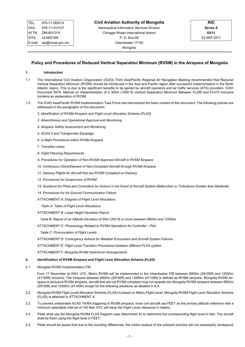
ATTACHMENT B: Large Height Deviation Report
Table B: Report of an Altitude Deviation of 90m (300 ft) or more between 8900m and 12500m
ATTACHMENT C: Phraseology Related to RVSM Operations for Controller - Pilot
Table C: Pronunciation of Flight Levels
ATTACHMENT D: Contingency Actions for Weather Encounters and Aircraft System Failures
ATTACHMENT E: Flight Level Transition Procedures between different FLAS system
ATTACHMENT F: Mongolia RVSM Switchover Arrangements
2. Identification of RVSM Airspace and Flight Level Allocation Scheme (FLAS)
2.1 Mongolia RVSM Implementation FIR
From 17 November at 0001 UTC, Metric RVSM will be implemented in the Ulaanbaatar FIR between 8900m (29100ft) and 12500m
(41100ft) inclusive. The Airspace between 8900m (29100ft) and 12500m (41100ft) is defined as RVSM airspace. Mongolia RVSM air-
space is exclusive RVSM airspace, aircraft that are not RVSM compliant may not operate into Mongolia RVSM airspace between 8900m
(29100ft) and 12500m (41100ft) except for the following situations as detailed in 9.4.
2.2 Mongolia RVSM Flight Level Allocation Scheme (FLAS) is based on Metric Flight Level. Mongolia RVSM Flight Level Allocation Scheme
(FLAS) is attached in ATTACHMENT A.
2.3 To prevent undesirable ACAS TA/RA triggering in RVSM airspace, most civil aircraft use FEET as the primary altitude reference with a
minimum selectable interval of 100 feet. ATC will issue the Flight Level clearance in meters.
2.4 Pilots shall use the Mongolia RVSM FLAS Diagram (see Attachment A) to determine the corresponding flight level in feet. The aircraft
shall be flown using the flight level in FEET.
2.5 Pilots should be aware that due to the rounding differences, the metric readout of the onboard avionics will not necessarily correspond
Civil Aviation Authority of Mongolia
Aeronautical Information Services Division
Chinggis Khaan International Airport
P. O. Box-59
Ulaanbaatar 17120
Mongolia
TEL: 976-11-283014
FAX: 976-11-313157
AFTN: ZMUBYOYX
SITA: ULNNTOM
E-mail: [email protected]
AIC
Series A
03/11
22 SEP 2011

- 2 -
to the cleared Flight Level in meters, however the difference will never be more than 30 meters.
2.6 Aircraft equipped with metric and feet altimeters such as the IL-96, IL-62, Tu-214 or Tu-154 shall use the feet altimeter within RVSM flight
level band. When these aircraft operating outside of RVSM flight level band, the aircraft can use metric altimeter or feet altimeter. Aircraft
equipped with the altimetry system not capable of flying in feet in accordance with 2.4 should not flight plan in the RVSM airspace and
shall comply with paragraph 9 as required.
2.7 Operator shall make available to the pilots the conversion table for meter and feet in accordance with Mongolia RVSM FLAS Diagram
when operating in Mongolia RVSM airspace.
3. Airworthiness and Operational Approval and Monitoring
3.1 Approval date
Operator/aircraft shall be approved by 17 November 2011 and that will enable air traffic service providers to plan for orderly RVSM
implementation.
3.2 Approval process
Operators must obtain airworthiness and operational approval from the State of Registry or State of the Operator, as appropriate, to
conduct RVSM operations. Relevant requirements will be contained in RVSM airworthiness and flight standards policies of Civil Aviation
Authority of Mongolia.
3.3 Aircraft altitude-keeping performance monitoring
Operators are required to participate in the RVSM aircraft monitoring program. This is an essential element of the RVSM implementation
program in that it confirms that the aircraft altitude-keeping performance standard is being met. Monitoring Agency for Asia Region
(MAAR) will process the results of monitoring. For further information on RVSM monitoring, the MAAR website can be accessed by:
a) Accessing the ’MAAR (Monitoring Agency for Asia Region)’ section of AEROTHAI website and clicking ’Monitoring Program’;
b) Using this Interned address: http://www.aerothai.co.th/maar/.
4. Airspace Safety Assessment and Monitoring
4.1 In order to conduct the airspace safety assessment and monitoring required by the ICAO Doc 9574, large height deviation report will be
collected. Information contained in the collected reports will not be used for other purposes than the airspace safety assessment and
safety monitoring.
4.2 Applicable airspace
Large height deviation occurrences will be collected from the entire Ulaanbaatar FIR.
4.3 Applicable level stratum
Large height deviation occurrences will be collected between 8900m (29100ft) and 12500m (41100ft).
4.4 Action taken by Pilot
Pilot of aircraft operating in accordance with IFR, when deviating for any reason by 90m (300ft) or more from cleared flight level by ATC
in RVSM airspace, shall report to the relevant ATS unit concerned via radio or if available, data link as soon as practicable, on the level
deviation. After completion of the flight, the pilot shall also report to the operator the details of deviation.
4.5 Action taken by State and Aircraft Operators
When large height deviation is reported by a pilot as described in 4.4, the State of Registry of the operator shall submit the report, in
principle, using the Table B in Attachment B, as soon as possible to the RMA (Regional Monitoring Agency) and copy to the following
address:
Air Traffic Services Division
Civil Aviation Authority of Mongolia
Chinggis Khaan International Airport
P.O.Box-35, Ulaanbaatar 17120, Mongolia
AFTN: ZMUBZRZX
e-mail: [email protected]
Tel: 976-11-281174
Fax: 976-11-379525
5. ACAS II and Transponder Equipage
5.1 The ICAO Asia/Pacific RVSM Implementation Task Force recommends that those aircraft equipped with ACAS and operated in RVSM
airspace shall be equipped with ACAS II. (TCAS II systems with Version 7.0 incorporated meet ICAO ACAS II standards).
5.2 Operators shall equip their aircraft with ACAS II and SSR transponder as required by AIP Mongolia.
6. In-flight Procedures within RVSM Airspace
6.1 Before entering RVSM airspace, the pilot should review the status of required equipment. The following equipment should be operating
normally:
a) Two primary altimetry systems;
Note: Altimetry system requirement should be in accordance with paragraph 2.4 that aircraft shall be flown using the flight level in FEET.
b) One automatic altitude-keeping device; and

- 3 -
c) One altitude-alerting device.
6.2 In contingencies, the pilot must notify ATC whenever the aircraft:
a) Is no longer RVSM compliant due to equipment failure; or
b) Experiences loss of redundancy of altimetry systems; or
c) Encounters turbulence that affects the capability to maintain flight level.
6.3 Transition between FL’s
During cleared transition between levels, the aircraft should not overshoot or undershoot the assigned FL by more than 45m (150ft).
6.4 Pilot level call
Within RVSM airspace, pilots shall report reaching any assigned altitude.
6.5 Procedures for wake turbulence
Pilots encountering or anticipating wake turbulence in Mongolia RVSM airspace have the option of requesting FL change, or if capable,
a vector, or a lateral offset.
6.6 Procedures for Strategic lateral offset (SLOP)
6.6.1 The flight crew may apply strategic lateral offset in remote continental airspace within the airspace of Mongolia when the aircraft is
equipped with automatic offset tracking capability. The decision to apply a strategic lateral offset shall be the responsiblity of the flight
crew.
6.6.2 Within the airspace of Mongolia, the strategic lateral offset shall be established at a distance of 2 NM to the right of the centre line of the
route relative to the direction of flight. Pilots are not required to inform ATC that a strategic lateral offset is being applied.
6.7 Phraseology Related to RVSM Operations
Phraseology Related to RVSM Operations is in Attachment C.
7. Transition areas
7.1 Transition areas and procedures for transition between Mongolia RVSM airspace and adjacent FIRs in Russian Federation are provided
in Attachment E.
8. Flight Planning Requirements
8.1 Unless special arrangement is made as detailed below, RVSM approval is required for operators and aircraft to operate within designated
RVSM airspace. The operator must determine that the appropriate State authority has granted them RVSM operational approval and
they will meet the RVSM requirements for the filed route of flight and any planned alternate routes. The letter "W" shall be inserted in
Item 10 (Equipment) of the ICAO standard flight plan to indicate that both the aircraft and operator are RVSM approved. The request
metric flight level within Mongolia RVSM airspace in Flight Plan shall be expressed as S followed by 4 figures (such as S1250, S1220
and S1190 represent 12500m, 12200m and 11900m respectively).
9. Procedures for Operation of Non-RVSM Approved Aircraft in RVSM Airspace
9.1 Flight priority
It should be noted that RVSM approved aircraft will be given priority for level allocation over non-RVSM approved aircraft.
9.2 Vertical separation applied
The vertical separation minimum between non-RVSM aircraft operating in the RVSM stratum and all other aircraft is 600m (2000ft).
9.3 Phraseology
Non-RVSM approved aircraft operating in RVSM airspace should use the phraseology contained in Attachment C.
9.4 Special coordination procedures for cruise operation of Non-RVSM approved aircraft in RVSM airspace.
Aircraft that are not RVSM compliant may not flight plan between 8900m (29100ft) and 12500m (41100ft), except for the following
situations:
a) The aircraft is being initially delivered to the State of Registry or Operator (see paragraph 11 for additional details and information); or
b) The aircraft was RVSM approved but has experienced an equipment failure and is being flown to a maintenance facility for repairing
in order to meet RVSM requirements and/or obtain approval; or
c) The aircraft is being utilized for mercy or humanitarian purposes; or
d) State aircraft (those aircraft used in military, custom and police services shall be deemed state aircraft).
9.4.1 Aircraft operators requesting that approval shall, if departing from an airport within Ulaanbaatar FIR, obtain approval from the ATFM and
Flight Permit Department of Civil Aviation Authority of Mongolia and Tactical Planning Unit of Air Traffic Services Division of Civil Aviation
Authority of Mongolia. ATFM and Flight Permit Department and Tactical Planning Unit will provide notification of approval via AFTN, SITA
or e-mail as appropriate; and
9.4.2 The assignment of cruising levels to non-RVSM approved aircraft listed in paragraph 9.4 (a) to (d) shall be subject to an ATC clearance.
Aircraft operators shall include the ’STS/Category of operations (i.e. FERRY/HUMANITARIAN/MILITARY/CUSTOMS/POLICE/STATE)
/ NON-RVSM COMPLIANT’ in Field 18 of the ICAO Flight Plan;

- 4 -
9.4.3 The department may be contacted as follows:
ATFM and Flight Permit Department
Civil Aviation Authority of Mongolia
Chinggis Khaan International Airport
P.O.Box-05, Ulaanbaatar 17120
Mongolia
AFTN: ZMUBYAYX
SITA: ULNUGOM
Tel: 976-11-282012, 976-11-282014, 976-11-282120, 976-11-282104
Fax: 976-11-379981
e-mail: [email protected]
9.4.4 The unit may be contacted as follows:
Tactical Planning Unit of Air Traffic Services Division
Civil Aviation Authority of Mongolia
Chinggis Khaan International Airport
P.O.Box-35, Ulaanbaatar 17120
Mongolia
AFTN: ZMUBZGZX
SITA: ULNKKOM
Tel: 976-11-281602
Fax: 976-11-379680, 976-11-281512
e-mail: [email protected]
9.4.5 This approval process is intended exclusively for the purposes indicated above and not as a means to circumvent the normal RVSM
approval process.
10. Continuous Climb/Descent of Non-compliant Aircraft through RVSM Airspace
10.1 Non-RVSM compliant aircraft may be cleared to climb to and operate above 12500m (41100ft) or descend to and operate below 8900m
(29100ft) provided that they:
a) Do not climb or descend at less than the normal rate for the aircraft; and
b) Do not level off at an intermediate level while passing through the RVSM stratum.
11. Delivery Flights for Aircraft that are RVSM Compliant on Delivery
11.1 An aircraft that is RVSM compliant on delivery may operate in RVSM airspace provided that the crew is trained on RVSM policies and
procedures applicable in the airspace and the responsible State issues the operator a letter of authorization approving the operation.
State notification to MAAR should be in the form of a letter, e-mail or fax documenting the one-time flight. The planned date of the flight,
flight identification, registration number and aircraft type/series should be included.
12. Procedures for Suspension of RVSM
12.1 Air traffic services will consider suspending RVSM procedures within affected areas of Ulaanbaatar FIR when there are pilot reports of
greater than moderate turbulence. Within areas where RVSM procedures are suspended, the vertical separation minimum between all
aircraft will be 600m (2000ft).
13. Guidance for Pilots and Controllers for Actions in the Event of Aircraft System Malfunction or Turbulence Greater than
Moderate
13.1 See Attachment D for guidance in these circumstances.
14. Procedures for Air-Ground Communication Failure
14.1 The air-ground communication failure procedures specified in ICAO PANS-ATM Doc 4444 should be applied, in conjunction with AIP
Mongolia.

- 5 -
ATTACHMENT A: DIAGRAM OF FLIGHT LEVEL ALLOCATIONS
Note: ATC will issue the Flight Level clearance in meters. Pilots shall use the Mongolia RVSM FLAS Diagram to determine the corresponding
flight level in feet. The aircraft shall be flown using the flight level in FEET. Pilots should be aware that due to the rounding differences, the metric
readout of the onboard avionics will not necessarily correspond to the cleared Flight Level in meters however the difference will never be more
than 30 meters.
600m
600m
300m
300m 300m
500m
14900 48900
13700 44900
12500 41100
11900 39100
11300 37100
10700 35100
10100 33100
9500 31100
8900 29100
8100 26600
7500 24600
6900 22600
6300 20700
5700 18700
5100 16700
4500 14800
3900 12800
3300 10800
2700 8900
2100 6900
1500 4900
900 3000
50900 15500
46900 14300
43000 13100
40100 12200
38100 11600
36100 11000
34100 10400
32100 9800
30100 9200
27600 8400
25600 7800
23600 7200
21700 6600
19700 6000
17700 5400
15700 4800
13800 4200
11800 3600
9800 3000
7900 2400
5900 1800
3900 1200
Meters Feet Feet Meters
3590MAG 00MAG
1800MAG 1790MAG

- 6 -
TABLE A: TABLE OF FLIGHT LEVEL ALLOCATIONS
180°-359°MAG 000°-179°MAG
Flight Levels Flight Levels
M FT M FT
15500 50900 14900 48900
14300 46900 13700 44900
13100 43000
12500 41100
12200 40100 11900 39100
11600 38100 11300 37100
11000 36100 10700 35100
10400 34100 10100 33100
9800 32100 9500 31100
9200 30100 8900 29100
8400 27600 8100 26600
7800 25600 7500 24600
7200 23600 6900 22600
6600 21700 6300 20700
6000 19700 5700 18700
5400 17700 5100 16700
4800 15700 4500 14800
4200 13800 3900 12800
3600 11800 3300 10800
3000 9800 2700 8900
2400 7900 2100 6900
1800 5900 1500 4900
1200 3900 900 3000
M FT M FT

- 7 -
ATTACHMENT B: LARGE HEIGHT DEVIATION REPORT
Name of FIR:
Please complete Section I or II as appropriate:
If there were no reports of large altitude deviation, only Section I should be finished.
If there were reports of large altitude deviation, please finish both Section I and Section II. If there were more than one report, each report
should write a separate piece of Table B.
Section I:
There were no reports of large altitude deviation for the month of ........................................
Section II:
There was/were ........................ report(s) of an altitude deviation of 90m (300ft) or more between 8900m and 12500m. Details of the altitude
deviation are attached (Table B).
(Please use a separate table for each report of large height deviation).
Section III:
When complete, please return to the following e-mail: [email protected]
- 8 -
Table B: Report of an Altitude Deviation of 90m (300ft) or more between 8900m and 12500m
(Please use a separate table for each report of large height deviation).
(1) This is the ................................... large height event reported this month.
(2) Reporting agency: ...........................................................................................
Location of Deviation
(3) • ATS Route: ............................................... / .........................................................
• Fixes (Fixes between the locations of deviation): ...........................................................
(4) Date of Occurrence (UTC: yyyy-mm-dd): .........................................................
(5) Flight Identification and Type: ..............................................................
(6) Flight Level Assigned (Record in the picture is also admitted): ...........................................
(7) Observed/Reported Final Level Mode C/Pilot Report: (Record in the picture is also admitted):
.................................................................... / ...................................................................................
(8) Cause of Deviation: ....................................................
(9) Other traffic: ...............................................................
(10) Crew comments (if any, when noted): ..................................................................
(11) Remarks:
.............................................................................................................................................................................................................................
.............................................................................................................................................................................................................................
(12) Duration at Flight Level: .................................................................................................

- 9 -
ATTACHMENT C: PHRASEOLOGY RELATED TO RVSM OPERATIONS FOR CONTROLLER - PILOT
Example 1:
A non-RVSM approved aircraft, maintaining 7800m, subsequently requests a climb to 9800m.
Pilot: (call sign) REQUEST 9800m, NEGATIVE RVSM
Controller: (call sign) CLIMB TO 9800m
Pilot: (call sign) CLIMB TO 9800m, NEGATIVE RVSM
Example 2:
A non-RVSM approved aircraft, maintaining 11000m, subsequently requests a climb to 11600m.
Pilot: (call sign) REQUEST 11600m, NEGATIVE RVSM
Controller: (call sign) CLIMB TO 11600m
Pilot: (call sign) CLIMB TO 11600m, NEGATIVE RVSM
Example 3:
A non-RVSM approved civil aircraft maintaining 8400m, subsequently requests a climb to 9800m.
Pilot: (call sign) REQUEST 9800m, NEGATIVE RVSM
Controller: (call sign) UNABLE ISSUE CLEARANCE INTO RVSM AIRSPACE, MAINTAIN 8400m
Message Phraseology
For a controller to ascertain the RVSM approval status of an
aircraft:
(call sign) CONFIRM RVSM APPROVED
For a pilot to report non-RVSM approval status:
i) On the initial call on any frequency within the RVSM airspace
(controller shall provide a read-back with the same phrase);
and
ii) In all requests for flight level changes pertaining to flight
levels within the RVSM airspace; and
iii) In all read-backs to flight level clearances pertaining to flight
levels within the RVSM airspace.
Additionally, except for State aircraft, pilots shall include this
phrase to read back flight level clearances involving the vertical
transit through 8900m or 12500m.
See examples that follow.
NEGATIVE RVSM
For a pilot to report RVSM approval status: AFFIRM RVSM
For a pilot of a non-RVSM approved State aircraft to report non-
RVSM approval status, in response to the phrase (call sign)
CONFIRM RVSM APPROVED:
NEGATIVE RVSM, STATE AIRCRAFT
Denial of clearance into the RVSM airspace: (call sign) UNABLE ISSUE CLEARANCE INTO RVSM AIRSPACE,
MAINTAIN [or DESCEND TO, or CLIMB TO] FLIGHT LEVEL
For a pilot to report when severe turbulence affects the aircraft’s
capability to maintain the height-keeping requirements for RVSM.
UNABLE RVSM DUE TURBULENCE
For a pilot to report that the aircraft’s equipment has degraded
enroute below that required MASPS Minimum Aviation System
Performance Standards for flight within the RVSM airspace.
(This phrase is to be used to convey both the initial indication of the
non-MASPS compliance, and henceforth, on initial contact on all
frequencies within the lateral limits of the RVSM airspace until such
time as the problem ceases to exist, or the aircraft has exited the
RVSM airspace.)
UNABLE RVSM DUE EQUIPMENT
For a pilot to report the ability to resume operations within the
RVSM airspace after an equipment or weather-related
contingency.
READY TO RESUME RVSM
For a controller to confirm that an aircraft has regained its RVSM
approval status or to confirm that the pilot is ready to resume
RVSM operations.
REPORT WHEN ABLE TO RESUME RVSM

- 10 -
Example 4:
Air traffic controller instructs a RVSM approved civil aircraft to maintain 9200m, but he finds the aircraft is actually flying FL302. ATC will inform
the Pilot to use the Mongolia RVSM FLAS Diagram to determine the corresponding flight level in feet.
Controller: (call sign) MAINTAIN 9200m
Pilot: (call sign) MAINTAIN 9200m
Controller: (call sign) MAINTAIN 9200m, CONVERT ALTITUDE WITH MONGOLIA RVSM FLIGHT LEVEL CHART.
The Pilot shall use the Mongolia RVSM FLAS Diagram to determine that, for 9200m, the corresponding flight level in feet is FL301, then flies the
aircraft at FL301, and then:
Pilot: (call sign) MAINTAIN 9200m
Coordination between ATS units
Para Message Phraseology
1 To verbally supplement an automated estimate message
exchange which does not automatically transfer Item 18
flight plan information.
NEGATIVE RVSM or NEGATIVE RVSM STATE AIRCRAFT
[as applicable]
2 To verbally supplement estimate messages of non-RVSM
approved aircraft.
NEGATIVE RVSM or NEGATIVE RVSM STATE AIRCRAFT
[as applicable]
3 To communicate the cause of a contingency relating to an
aircraft that is unable to conduct RVSM operations due to
severe turbulence or other severe weather-related
phenomenon [or equipment failure, as applicable].
UNABLE RVSM DUE TURBULENCE [or EQUIPMENT, as
applicable]

- 11 -
Table C: Pronunciation of Flight Levels
Flight Level English Pronunciation
600m SIX HUN-dred METERS
900m NIN-er HUN-dred METERS
1200m WUN TOU-SAND TOO HUN-dred METERS
1500m WUN TOU-SAND FIFE HUN-dred METERS
1800m WUN TOU-SAND AIT HUN-dred METERS
2100m TOO TOU-SAND WUN HUN-dred METERS
2400m TOO TOU-SAND FOW-er HUN-dred METERS
2700m TOO TOU-SAND SEV-en HUN-dred METERS
3000m TREE TOU-SAND METERS
3300m TREE TOU-SAND TREE HUN-dred METERS
3600m TREE TOU-SAND SIX HUN-dred METERS
3900m TREE TOU-SAND NIN-er HUN-dred METERS
4200m FOW-er TOU-SAND TOO HUN-dred METERS
4500m FOW-er TOU-SAND FIFE HUN-dred METERS
4800m FOW-er TOU-SAND AIT HUN-dred METERS
5100m FIFE TOU-SAND WUN-HUN-dred METERS
5400m FIFE TOU-SAND FOW-er HUN-dred METERS
5700m FIFE TOU-SAND SEV-en HUN-dred METERS
6000m SIX TOU-SAND METERS
6300m SIX TOU-SAND TREE HUN-dred METERS
6600m SIX TOU-SAND SIX HUN-dred METERS
6900m SIX TOU-SAND NIN-er HUN-dred METERS
7200m SEV-en TOU-SAND TOO HUN-dred METERS
7500m SEV-en TOU-SAND FIFE HUN-dred METERS
7800m SEV-en TOU-SAND AIT HUN-dred METERS
8100m AIT TOU-SAND WUN HUN-dred METERS
8400m AIT TOU-SAND FOW-er HUN-dred METERS
8900m AIT TOU-SAND NIN-er HUN-dred METERS
9200m NIN-er TOU-SAND TOO HUN-dred METERS
9500m NIN-er TOU-SAND FIFE HUN-dred METERS
9800m NIN-er TOU-SAND AIT HUN-dred METERS
10100m WUN ZE-RO TOU-SAND WUN HUN-dred METERS
10400m WUN ZE-RO TOU-SAND FOW-er HUN-dred METERS
10700m WUN ZE-RO TOU-SAND SEV-en HUN-dred METERS
11000m WUN WUN TOU-SAND METERS
11300m WUN WUN TOU-SAND TREE HUN-dred METERS
11600m WUN WUN TOU-SAND SIX HUN-dred METERS
11900m WUN WUN TOU-SAND NIN-er HUN-dred METERS
12200m WUN TOO TO-SAND TOO HUN-dred METERS

- 12 -
12500m WUN TOO TO-SAND FIFE HUN-dred METERS
13100m WUN TREE TOU-SAND WUN HUN-dred METERS
13700m WUN TREE TOU-SAND SEV-en HUN-dred METERS
14300m WUN FOW-er TOU-SAND TREE HUN-dred METERS
14900m WUN FOW-er TOU-SAND NIN-er HUN-dred METERS
Flight Level English Pronunciation

- 13 -
ATTACHMENT D: Contingency Actions for Weather Encounters and Aircraft System Failures
Initial Pilot Actions in Contingency Situations
Severe Turbulence and/or Mountain Wave Activity (MWA) Induced Altitude Deviations of Approximately 60m (200ft)
Mountain Wave Activity (MWA) Encounters - General
Note: MWA encounters do not necessarily result in altitude deviations on the order of 60m (200ft). The guidance below is intended to address
less significant MWA encounters.
Wake Turbulence Encounters
Unable RVSM Due Equipment (Failure of Automatic Altitude Control System, Altitude Alerter or All Primary Altimeters)
Initial Pilot Actions when unable to maintain flight level (FL) or unsure of aircraft altitude-keeping capability:
• Notify ATC and request assistance as detailed below.
• Maintain cleared flight level, to the extent possible, while evaluating the situation.
• Maintain watch for conflicting traffic both visually and by reference to TCAS.
• Alert nearby aircraft by illuminating exterior lights.
• If unable to contact ATC, broadcast position, flight level and intention on 121.5 MHZ (or, as a backup 5680KHZ).
Pilot will:
• When experiencing severe turbulence and/or MWA induced
altitude deviations of approximately 60m (200ft) or greater, pilot
will contact ATC and state ’Unable RVSM Due (state reason)’
(e.g., turbulence, mountain wave).
• If not issued by the controller, request vector clear of traffic at
adjacent FL’s.
• If desired, request FL change.
• Report location and magnitude of turbulence or MWA to ATC.
Controller will:
• Assess the traffic situation to determine if the aircraft can be
accommodated through the provision of lateral, longitudinal or
increased vertical separation and, if so, apply the appropriate
minimum.
• Advise pilot of conflicting traffic.
• Issue FL change, traffic permitting.
• Issue PIREP to other aircraft.
Pilot actions:
• Contact ATC and report experiencing MWA.
• Report location and magnitude of MWA to ATC.
• If so desired, pilot may request a FL change or deviation from
the intended route.
Controller actions:
• Advise pilot of conflicting traffic at adjacent FL.
• If pilot requests, vector aircraft to avoid merging target with traffic at
adjacent RVSM flight levels, traffic permitting.
• Issue FL change or re-route, traffic permitting.
• Issue PIREP to other aircraft.
Pilot should:
• Contact ATC and request vector, FL change or, if capable, a
lateral offset to right 2NM.
Controller should:
• Issue clearance of vector, FL change or lateral offset to right 2NM,
traffic permitting.
Pilot will:
• Contact ATC and state "Unable RVSM Due Equipment".
• Request clearance out of RVSM airspace unless operational
situation dictates otherwise.
Controller will:
• Provide 600m (2000ft) vertical separation or appropriate horizontal
separation.
• Clear aircraft out of RVSM airspace unless operational situation
dictates otherwise.

- 14 -
One Primary Altimeter Remains Operational
Transponder Failure
Contingency Procedures for Aircraft Requiring Rapid Descent
Pilot will:
• Cross check stand-by altimeter.
• Notify ATC of operation with single primary altimeter.
• If unable to confirm primary altimeter accuracy, follow actions for
failure of all primary altimeters.
Controller will:
• Acknowledge operation with single primary altimeter.
Note: Aircraft are able to operate in RVSM airspace at this situation
except that pilot report unable RVSM due equipment.
• Relay to other controllers or facilities who will subsequently handle
the aircraft and any special handling requirement or being provided.
Pilot will:
• Contact ATC and request authority to continue to operate at
cleared flight level.
• Comply with revised ATC clearance, if issued.
Controller will:
• Consider request to continue to operate at cleared flight level.
• Issue revised clearance, if necessary.
Pilot will:
• Notify ATC of aircraft location and request FL change as
required.
• Upon declaring an emergency a pilot may exercise his right and
change his assigned flight level. He shall notify ATC immedi-
ately and submit a report upon arrival at the destination.
• If unable to contact ATC and rapid descent required:
a) Deviation procedure for level change: 30° right and track
out 20 kilometers (i.e. deviate right of airway centerline by
10 km or 5 NM), then turn left to track parallel the original
route, then climb or descend to the new level, and then return
to the original one (when appropriate).
Note: When return to the original route, it is possible to have
conflict traffic on that route.
b) Establish communications with and alert nearby aircraft by
broadcasting, at suitable intervals: flight identification, flight
level, aircraft position and intention on the frequency in use,
as well as on frequency 121.5 MHZ (or, as a backup
5680KHZ).
c) Establish visual contact with conflicting traffic.
d) Turn on all aircraft exterior lights.
Controller will:
• Issue ATC clearance to change flight level.

- 15 -
ATTACHMENT E: Flight Level Transition Procedures between Different FLAS system
Transition procedure between Muren ACC and Barnaul ACC (NOPUS)
!!6900(226)!
FL230!
!!6600(217)!
FL220!
Level-off Zone
5 min
NOPUS
Russia Mongolia
12500(411)
FL410
11900(391)
FL390
11300(371)
FL370
10700(351)
FL350
10100(331)
FL330
9500(311)
FL310
8900(291)
FL290
13700(449)
FL450
8100(266)
FL270
7500(246)
FL250
6300(207)
FL210
5700(187)
FL190
14300(469)
FL470
12200(401)
FL400
11600(381)
FL380
11000(361)
FL360
10400(341)
FL340
9800(321)
FL320
9200(301)
FL300
8400(276)
FL280
7800(256)
FL260
7200(236)
FL240
6000(197)
FL200
13100(430)FL430

- 16 -
Transition procedure between Sainshand ACC and Chita ACC (SULOK)
SULOK
Level-off Zone
5 min
Russia Mongolia
Indicates the position where the pilot is expected to receive the FL instruction from ATC for FLAS transition and then begin to use Mongolia RVSM conversion table to fly in FEET. Flight level transition shall be conducted in accordance with ATC instruction. In case ATC did not issue the instruction as expected, pilots are to clarify with ATC.
!!7200(236)!
FL240!
14300(469)
FL470
12200(401)
FL400
11600(381)
FL380
11000(361)
FL360
10400(341)
FL340
9800(321)
FL320
9200(301)
FL300
8400(276)
FL280
7800(256)
FL260
6600(217)
FL220
13100(430)FL430
13700(449)
FL450
7500(246)
FL250
8100(266)
FL270
6900(226)
FL230
6300(207)
FL210
11900(391)
FL390
11300(371)
FL370
10700(351)
FL350
10100(331)
FL330
9500(311)
FL310
8900(291)
FL290
12500(411)
FL410
6300m (207) means when ATC assign the 6300m, the pilot shall use the Mongolia RVSM conversion table to fly 20700 feet.

- 17 -
Transition procedure between Muren ACC and Krasnoyarsk ACC (GINOM)
Level-off Zone
5 min
Russia Mongolia
12500(411)
FL410
11900(391)
FL390
11300(371)
FL370
10700(351)
FL350
10100(331)
FL330
9500(311)
FL310
8900(291)
FL290
13700(449)
FL450
8100(266)
FL270
7500(246)
FL250
6900(226)
FL230
6300(207)
FL210
GINOM

- 18 -
Transition procedure between Muren ACC and Krasnoyarsk ACC (DARNO)
Russia Mongolia
Level-off Zone
DARNO
12500(411)
FL410
11900(391)
FL390
11300(371)
FL370
10700(351)
FL350
10100(331)
FL330
9500(311)
FL310
8900(291)
FL290
13700(449)
FL450
8100(266)
FL270
7500(246)
FL250
6900(226)
FL230
6300(207)
FL210
14300(469)
FL470
12200(401)
FL400
11600(381)
FL380
11000(361)
FL360
10400(341)
FL340
9800(321)
FL320
9200(301)
FL300
8400(276)
FL280
7800(256)
FL260
7200(236)
FL240
6600(217)
FL220
13100(430)FL430

- 19 -
Transition procedure between Muren ACC and Krasnoyarsk ACC (NIGOR)
Level-off Zone
5 min
NIGOR
Russia Mongolia
12500(411)
FL410
11900(391)
FL390
11300(371)
FL370
10700(351)
FL350
10100(331)
FL330
9500(311)
FL310
8900(291)
FL290
14300(469)
FL470
12200(401)
FL400
11600(381)
FL380
11000(361)
FL360
10400(341)
FL340
9800(321)
FL320
9200(301)
FL300
7800(256)
FL260
6000(197)
FL200
13100(430)FL430
7500(246)
FL250
6600(217)
FL220
13700(449)
FL450
7200(236)
FL240
5400(177)
FL180
4800(157)
FL160
8100(266)
FL270 8400(276)
FL280

- 20 -
Transition procedure between Ulaanbaatar ACC and Irkutsk ACC (SERNA)
Level-off Zone
Russia Mongolia
SERNA
7200(236)
FL240
12500(411)
FL410
11900(391)
FL390
11300(371)
FL370
10700(351)
FL350
10100(331)
FL330
9500(311)
FL310
8900(291)
FL290
13700(449)
FL450
8100(266)
FL270
7500(246)
FL250
6900(226)
FL230
6300(207)
FL210
14300(469)
FL470
12200(401)
FL400
11600(381)
FL380
11000(361)
FL360
10400(341)
FL340
9800(321)
FL320
9200(301)
FL300
8400(276)
FL280
7800(256)
FL260
6600(217)
FL220
13100(430)FL430

- 21 -
Transition procedure between Ulaanbaatar ACC and Irkutsk ACC (LETBI)
Level-off Zone
Russia Mongolia
LETBI
9200(301)
FL300
12500(411)
FL410
11900(391)
FL390
11300(371)
FL370
10700(351)
FL350
10100(331)
FL330
9500(311)
FL310
8900(291)
FL290
13700(449)
FL450 14300(469)
FL470
12200(401)
FL400
11600(381)
FL380
11000(361)
FL360
10400(341)
FL340
9800(321)
FL320
13100(430)FL430
8400(276)
FL280
8100(266)
FL270
7800(256)
FL260
7500(246)
FL250

- 22 -
Transition procedure between Ulaanbaatar ACC and Irkutsk ACC (AMUTA)
Level-off Zone
5 min
Mongolia Russia
14300(469)
FL470
8400(276)
FL280
12200(401)
FL400
11600(381)
FL380
11000(361)
FL360
10400(341)
FL340
9800(321)
FL320
9200(301)
FL300
13100(430)FL430
AMUTA
- 23 -
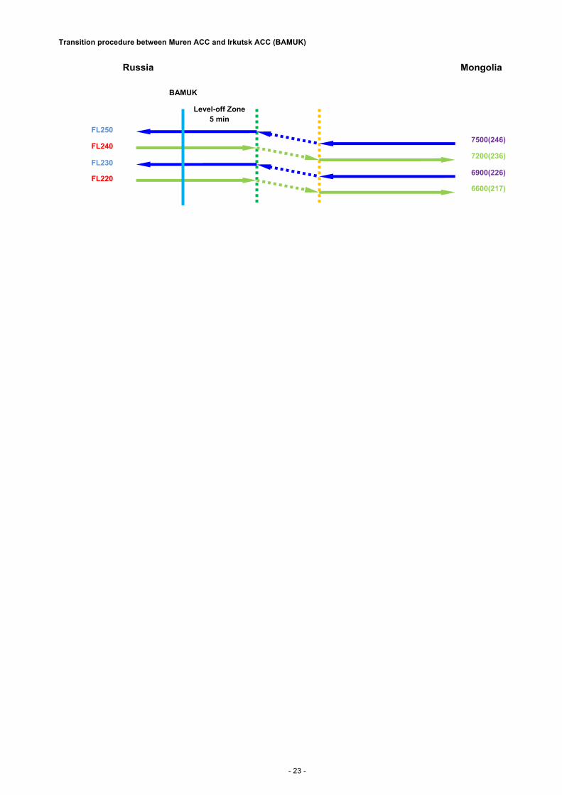
Transition procedure between Muren ACC and Irkutsk ACC (BAMUK)
Level-off Zone
5 min
Russia Mongolia
BAMUK
7200(236)
FL240
6600(217)
FL220
7500(246)
FL250
6900(226)
FL230

- 24 -
ATTACHMENT F:Mongolia RVSM Switchover Arrangements
Guidelines for operators during the transition to Mongolia RVSM on 17 November 2011 at 0001 UTC as follows:
All aircraft that operate or are planning to operate in the RVSM levels within the airspace of Mongolia at and beyond 0001 UTC on 17 November
2011 shall comply with the RVSM requirements in the AIP Mongolia.
All aircraft entering the airspace of Mongolia between 8900m (29100ft) and 12500m (41100ft) inclusive, at and beyond 0001 UTC on 17
November 2011 will be assigned a level in accordance with the Mongolia RVSM level allocation.
All aircraft departing from airports in the airspace of Mongolia that need to file a level between 8900m (29100ft) and 12500m (41100ft) inclusive,
at and beyond 0001 UTC on 17 November 2011 will be assigned a level in accordance with the Mongolia RVSM level allocation.
RVSM non-approved aircraft should not flight plan into the RVSM airspace if they expected to operate in the airspace after 0001 UTC 17
November 2011. Aircraft operating within the airspace of Mongolia at 0001 UTC on 17 November 2011 can expect:
Implementation Phase on 16 November 2011 from 2300 - 0030 UTC
2300 UTC
ATC will broadcast: "Attention all aircraft, RVSM operations will begin in 1 hour."
2300 - 2330 UTC
ATC will accommodate RVSM non-approved aircraft at and below 8400m (27600ft).
2340 UTC
ATC will broadcast: "Attention all aircraft, RVSM operations will begin at 0001 UTC."
0001 - 0030 UTC and onward
ATC will clear RVSM approved aircraft to climb or descend to the nearest appropriate RVSM level in accordance with the Mongolia RVSM level
allocation.
All aircraft operating in RVSM airspace will be cleared in accordance with the Mongolia RVSM level allocation.
- END -