Chapter 6 Volcanoes Volcanoes & Plate Tectonics Volcanic Activity Volcanoes in Idaho??? .

Why the Sentinel-1 is a game changer for monitoring our restless planet:
early results from INSARAP-B Tim Wright, Andy Hooper, Pablo J. González, Richard
Walters (COMET, University of Leeds, UK); Yngvar Larsen (Norut, Tromsø, Norway);
Petar Marinkovic (PPO.labs, the Netherlands); John Elliott (COMET, University of Oxford, UK)
INSARAP

Summary / Outline
Sentinel-1 Other SAR mission archives 1. Systematic acquisitions for tectonics and volcanoes: “InSAR everywhere all the time”
Haphazard acquisitions (multiple modes, no unified strategy)
2. TOPS: 250 km x 1000+ km: Continental scale InSAR
Small areas imaged, usually less than 100 km swaths.
3. Small perpendicular baselines, acquisitions every 6/12/24 days, ascending and descending -> high coherence
Typically large perpendicular baselines and long gaps between acquisitions -> poor coherence
4. 20 year operational program, designed for InSAR
Stand-alone missions not designed for InSAR
5. Free, full and open data policy, enables mass processing.
Restricted data access, often commercial pricing

1. “InSAR everywhere, all the time” (NASA Solid Earth Science Working Group Report, 2002, NASA InSAR Workshop Report, 2004)
We can’t give short-term predictions for which faults will fail in earthquakes, and many
volcanoes erupt without warning.

1. “InSAR everywhere, all the time” (NASA Solid Earth Science Working Group Report, 2002, NASA InSAR Workshop Report, 2004)
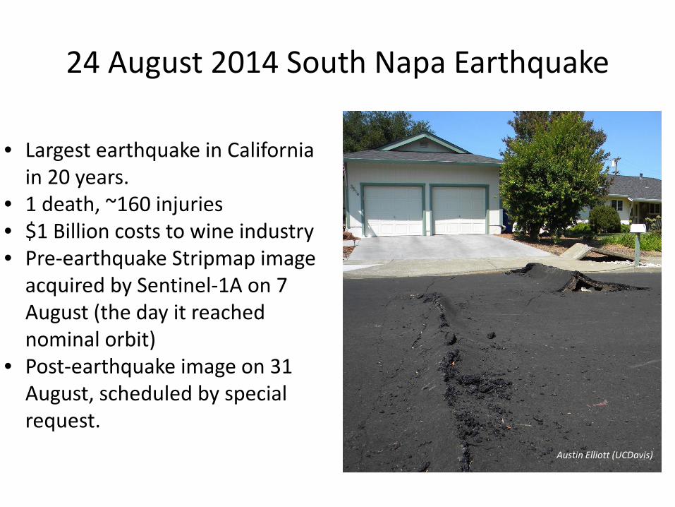
24 August 2014 South Napa Earthquake
• Largest earthquake in California in 20 years.
• 1 death, ~160 injuries • $1 Billion costs to wine industry • Pre-earthquake Stripmap image
acquired by Sentinel-1A on 7 August (the day it reached nominal orbit)
• Post-earthquake image on 31 August, scheduled by special request.
Austin Elliott (UCDavis)

Sentinel-1a (2014.08.31)
INSARAP

COSMO-SkyMed (2014.08.27)

PI: Andrea Donnellan, Jay Parker
UAVSAR (2014.08.29)

Source model from InSAR and GPS data model residual
Slip Uncertainty N S N S

~1 km Portela
~2.7 km
Eruption site
N
Pico do
Fogo
Bangaeira
2014 Pico do Fogo eruption (Ilha do Fogo, Cabo Verde)
wikicommons

23 Nov 2014 Pico do Fogo Eruption
• 1st eruption in 20 yrs (1995)
• Flights to S. America diverted
• ~1500 evacuated people
• Damages not yet evaluated
• Up to today, two towns completely destroyed
Samara Donis (InVOLCAN) David Calvo (InVOLCAN)

Observations
Ascending (20141103-20141127)
Descending (20141108-20141202)

Preferred Model
10-5 km ?
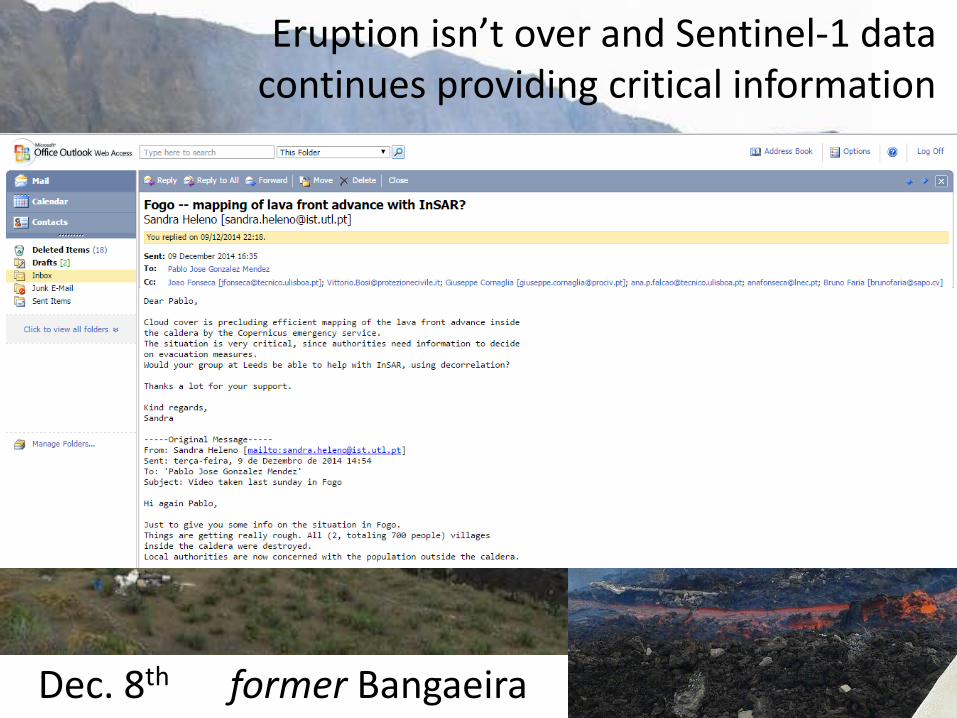
Eruption isn’t over and Sentinel-1 data continues providing critical information
Dec. 8th former Bangaeira

2. Continental Scale InSAR

3. Short revisit and Small perpendicular baselines -> Excellent Coherence
Creeping section of the North Anatolian Fault, 12-days

3. Short revisit and Small perpendicular baselines -> Excellent Coherence
Creeping section of the North Anatolian Fault, 24-days

3. Short revisit and Small perpendicular baselines -> Excellent Coherence
Creeping section of the North Anatolian Fault, 24-days
Typical ERS coherence (Cakir et al., 2005)

3. Short revisit -> rapid phenomena Napa Postseismic deformation: 31 August – 12 September 2014
Afterslip model
N S

3. Short revisit -> rapid phenomena Napa Postseismic deformation: 31 August – 24 September 2014
Afterslip model
N S

3. Short revisit -> rapid phenomena Napa Postseismic deformation: 31 August – 6 October 2014
Afterslip model
N S

3. Short revisit -> rapid phenomena Napa Postseismic deformation: 31 August – 18 October 2014
Afterslip model
N S

3. Short revisit -> rapid phenomena Napa Postseismic deformation: 31 August – 30 October 2014
Afterslip model
N S

Duration of time series (years)
0.1 1 2 3 4 5 Le
ngth
scal
e of
obs
erva
tion
(km
)
4. 20-year operational program
1 mm/yr rates over 100 km can be achieved with 5 years of acquisitions (12 day revisit)

Ability of Sentinel-1 to map tectonic strain above target threshold (1 mm/yr over 100 km)
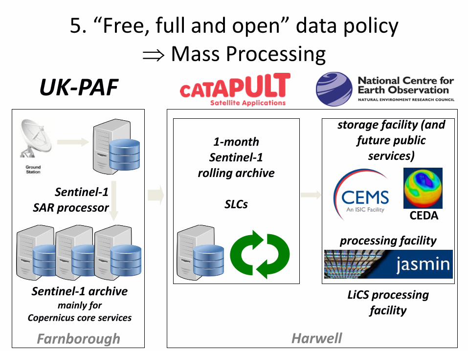
UK-PAF
Sentinel-1 archive mainly for
Copernicus core services
1-month Sentinel-1
rolling archive
SLCs
LiCS processing facility
processing facility
storage facility (and future public
services)
Harwell Farnborough
Sentinel-1 SAR processor CEDA
5. “Free, full and open” data policy ⇒ Mass Processing

Conclusions • The Sentinel-1 constellation will be
transformative for Tectonic and Volcanic Geodesy.
• Early results are very encouraging. • Once data access issues are fully resolved, we
look forward to two decades of incredible science from this mission.


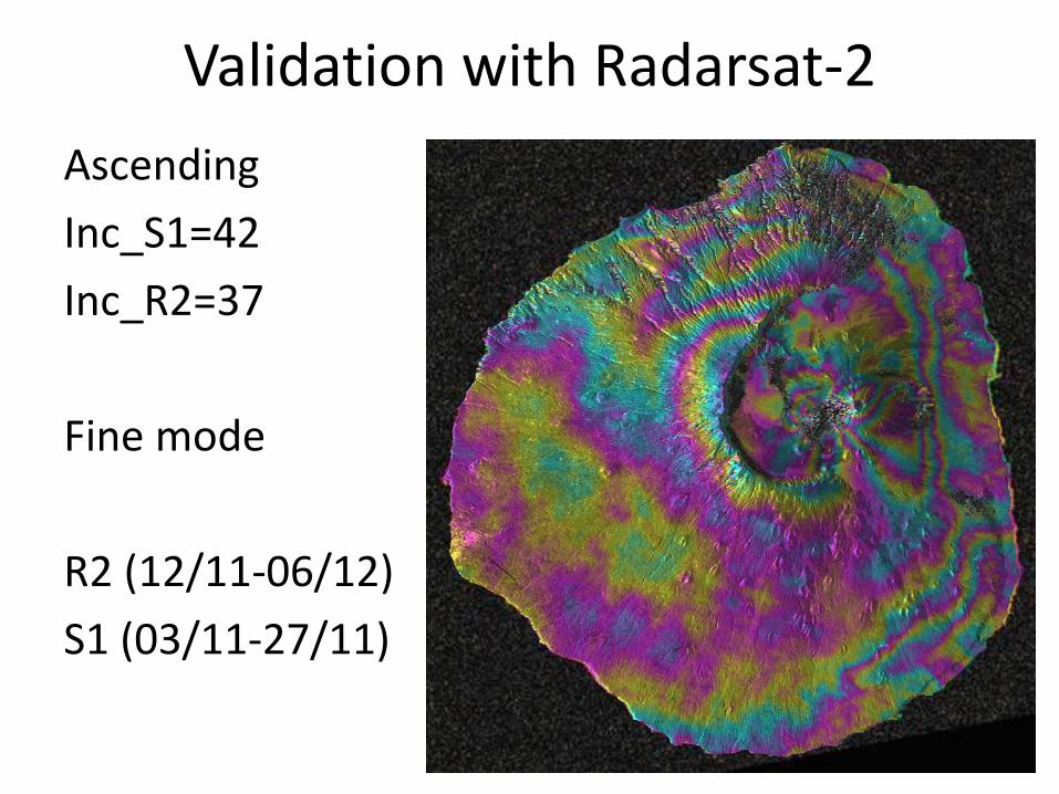
Validation with Radarsat-2 Ascending Inc_S1=42 Inc_R2=37 Fine mode R2 (12/11-06/12) S1 (03/11-27/11)

Volcano with very steep topo Local researchers’ concerns on unexpected evolution Sentinel-1 data helped to answer critical questions
Day et al., (1999)
E W
A
Masson et al., (2008)