Tectonic history of the Calcatapul Formation, Chubut ... · Argentina, and the “Gastre fault...
16
Tectonic history of the Calcatapul Formation, Chubut province, Argentina, and the “Gastre fault system” W. von Gosen a, * , W. Loske b a Geological Institute, University of Erlangen-Nu ¨rnberg, Schlossgarten 5, D-91054 Erlangen, Germany b Department Geosciences and Environmental Sciences, Section Geology, University of Munich, Luisenstrasse 37, D-80333 Munich, Germany Received 1 July 2003; accepted 1 August 2004 Abstract Field mapping, structural analysis, and U–Pb dating of rocks in the western part of the North Patagonian Massif (Argentina) yield a revised interpretation of structural evolution in the area of the ‘Gastre fault system’ that previously has been interpreted as an important dextral lineament. The Calcatapul Formation predominantly consists of metapyroclastic rocks and does not represent mylonites with a dextral sense of shear. The succession can be assigned broadly to the Early Paleozoic (?Silurian–Devonian). The Yancamil granite, dated here as Permian, intruded the Calcatapul Formation. Both units were affected by a first deformation under wNE–SW compression, accompanied by a lower greenschist facies metamorphism. This Permian (–?Triassic) event took place prior to the intrusions of the Triassic Lipetre ´n Formation. The second deformation, with comparable compression, affected the Calcatapul Formation and Yancamil granite, as well as injected dykes of the Lipetre ´n Formation. Minor mylonite strips in the Lipetre ´n Formation intrusions display different orientations and senses of shear and do not fit with a large-scale dextral shear zone. NW–SE-striking fracture zones in this sector of the North Patagonian Massif can be interpreted also as the result of downfaulting instead of large-scale strike-slip fault lines. These observations from the Gastre area do not support the existence of the dextral Gastre fault system as a large-scale, intracontinental structural element that traverses extra-Andean Patagonia. q 2004 Elsevier Ltd. All rights reserved. Keywords: Patagonia; Gastre area; Tectonics; U-Pb dating; Late Paleozoic; Triassic 1. Introduction The North Patagonian Massif in southern Argentina (Fig. 1) is delimited by the Rı ´o Chubut in the south, the Rı ´o Negro in the north, the Atlantic coast in the east, and the foothills of the Patagonian Cordillera in the west. It consists of poorly exposed Precambrian–Early Paleozoic rocks intruded by Early to Late Paleozoic granitoids and some younger plutons. These units are covered and obscured by widely distributed Triassic to Tertiary magmatic and sedimentary rocks. Different geotectonic interpretations have been ascribed to Patagonia. It has been interpreted as either a terrane, accreted to the southwestern margin of Gondwanan South America during the Late Paleozoic–Triassic (Ramos, 1984, 1986), or an integral part of South America since the Early Paleozoic (e.g. Dalla Salda et al., 1992a,b, 1993, 1994). In the western part of the massif, the Central Patagonia Batholith (Rapela and Kay, 1988) is represented by scattered exposures of intrusions from the Gastre area in the southeast to the Patagonian Cordillera in the northwest (e.g. Rapela et al., 1992). The Upper Triassic–Lower Jurassic age of the intrusions has been shown by radiometric dating (e.g. Alonso, 1987; Rapela et al., 1991, 1992; Linares et al., 1997). The magmatic rocks of the batholith are distinct from the Mamil Choique Formation intrusive rocks, which are interpreted as Precambrian to Early Paleozoic and/or Late Paleozoic in age (e.g. Ravazzoli and Sesana, 1977; Proserpio, 1978b; Nullo, 1978b; Llambı ´as et al., 1984; Rapela et al., 1992). In the northern part of the Chubut province, the NW–SE-trending and tens of kilometers wide ‘Megafalla de Gastre’ (Rapela et al., 1991), ‘Gastre Shear Zone System’ 0895-9811/$ - see front matter q 2004 Elsevier Ltd. All rights reserved. doi:10.1016/j.jsames.2004.08.007 Journal of South American Earth Sciences 18 (2004) 73–88 www.elsevier.com/locate/jsames * Corresponding author. Tel.: C49 9131 852 2699; fax: C49 9131 852 9295. E-mail addresses: [email protected] (W. von Gosen), [email protected] (W. Loske).
Transcript of Tectonic history of the Calcatapul Formation, Chubut ... · Argentina, and the “Gastre fault...
Tectonic history of the Calcatapul Formation, Chubut province,
Argentina, and the “Gastre fault system”
W. von Gosena,*, W. Loskeb
aGeological Institute, University of Erlangen-Nurnberg, Schlossgarten 5, D-91054 Erlangen, GermanybDepartment Geosciences and Environmental Sciences, Section Geology, University of Munich, Luisenstrasse 37, D-80333 Munich, Germany
Received 1 July 2003; accepted 1 August 2004
Abstract
Field mapping, structural analysis, and U–Pb dating of rocks in the western part of the North Patagonian Massif (Argentina) yield a revised
interpretation of structural evolution in the area of the ‘Gastre fault system’ that previously has been interpreted as an important dextral
lineament. The Calcatapul Formation predominantly consists of metapyroclastic rocks and does not represent mylonites with a dextral sense
of shear. The succession can be assigned broadly to the Early Paleozoic (?Silurian–Devonian). The Yancamil granite, dated here as Permian,
intruded the Calcatapul Formation. Both units were affected by a first deformation under wNE–SW compression, accompanied by a lower
greenschist facies metamorphism. This Permian (–?Triassic) event took place prior to the intrusions of the Triassic Lipetren Formation. The
second deformation, with comparable compression, affected the Calcatapul Formation and Yancamil granite, as well as injected dykes of the
Lipetren Formation. Minor mylonite strips in the Lipetren Formation intrusions display different orientations and senses of shear and do not
fit with a large-scale dextral shear zone. NW–SE-striking fracture zones in this sector of the North Patagonian Massif can be interpreted also
as the result of downfaulting instead of large-scale strike-slip fault lines. These observations from the Gastre area do not support the existence
of the dextral Gastre fault system as a large-scale, intracontinental structural element that traverses extra-Andean Patagonia.
q 2004 Elsevier Ltd. All rights reserved.
Keywords: Patagonia; Gastre area; Tectonics; U-Pb dating; Late Paleozoic; Triassic
1. Introduction
The North Patagonian Massif in southern Argentina
(Fig. 1) is delimited by the Rıo Chubut in the south, the Rıo
Negro in the north, the Atlantic coast in the east, and the
foothills of the Patagonian Cordillera in the west. It consists
of poorly exposed Precambrian–Early Paleozoic rocks
intruded by Early to Late Paleozoic granitoids and some
younger plutons. These units are covered and obscured
by widely distributed Triassic to Tertiary magmatic and
sedimentary rocks.
Different geotectonic interpretations have been ascribed
to Patagonia. It has been interpreted as either a terrane,
accreted to the southwestern margin of Gondwanan South
0895-9811/$ - see front matter q 2004 Elsevier Ltd. All rights reserved.
doi:10.1016/j.jsames.2004.08.007
* Corresponding author. Tel.: C49 9131 852 2699; fax: C49 9131 852
9295.
E-mail addresses: [email protected] (W. von Gosen),
[email protected] (W. Loske).
America during the Late Paleozoic–Triassic (Ramos, 1984,
1986), or an integral part of South America since the Early
Paleozoic (e.g. Dalla Salda et al., 1992a,b, 1993, 1994).
In the western part of the massif, the Central Patagonia
Batholith (Rapela and Kay, 1988) is represented by
scattered exposures of intrusions from the Gastre area in
the southeast to the Patagonian Cordillera in the northwest
(e.g. Rapela et al., 1992). The Upper Triassic–Lower
Jurassic age of the intrusions has been shown by
radiometric dating (e.g. Alonso, 1987; Rapela et al.,
1991, 1992; Linares et al., 1997). The magmatic rocks of
the batholith are distinct from the Mamil Choique
Formation intrusive rocks, which are interpreted as
Precambrian to Early Paleozoic and/or Late Paleozoic in
age (e.g. Ravazzoli and Sesana, 1977; Proserpio, 1978b;
Nullo, 1978b; Llambıas et al., 1984; Rapela et al., 1992).
In the northern part of the Chubut province, the
NW–SE-trending and tens of kilometers wide ‘Megafalla
de Gastre’ (Rapela et al., 1991), ‘Gastre Shear Zone System’
Journal of South American Earth Sciences 18 (2004) 73–88
www.elsevier.com/locate/jsames
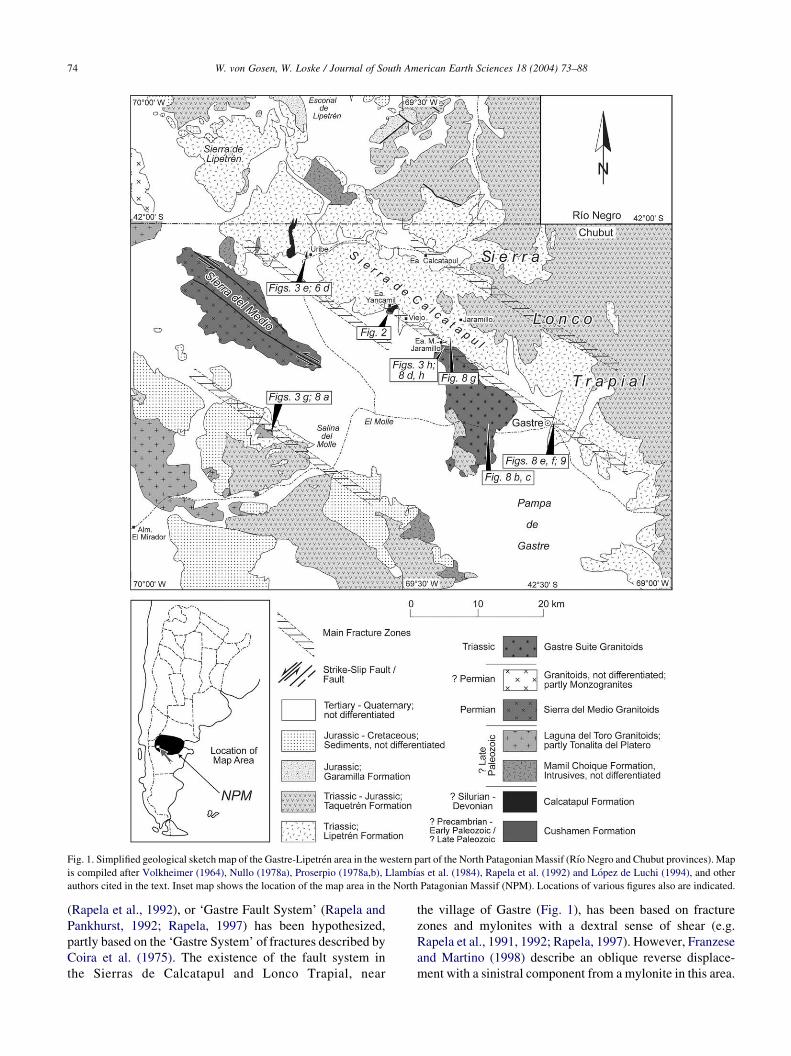
Fig. 1. Simplified geological sketch map of the Gastre-Lipetren area in the western part of the North Patagonian Massif (Rıo Negro and Chubut provinces). Map
is compiled after Volkheimer (1964), Nullo (1978a), Proserpio (1978a,b), Llambıas et al. (1984), Rapela et al. (1992) and Lopez de Luchi (1994), and other
authors cited in the text. Inset map shows the location of the map area in the North Patagonian Massif (NPM). Locations of various figures also are indicated.
W. von Gosen, W. Loske / Journal of South American Earth Sciences 18 (2004) 73–8874
(Rapela et al., 1992), or ‘Gastre Fault System’ (Rapela and
Pankhurst, 1992; Rapela, 1997) has been hypothesized,
partly based on the ‘Gastre System’ of fractures described by
Coira et al. (1975). The existence of the fault system in
the Sierras de Calcatapul and Lonco Trapial, near
the village of Gastre (Fig. 1), has been based on fracture
zones and mylonites with a dextral sense of shear (e.g.
Rapela et al., 1991, 1992; Rapela, 1997). However, Franzese
and Martino (1998) describe an oblique reverse displace-
ment with a sinistral component from a mylonite in this area.

W. von Gosen, W. Loske / Journal of South American Earth Sciences 18 (2004) 73–88 75
Rapela et al. (1992) and Rapela and Pankhurst (1992)
propose that movements along the fault zone were related to
intracontinental dextral shearing during the Late Triassic–
Early Jurassic, followed by a large-scale transfer (w400–
500 km) of the southern, intra-Patagonian block during
Early to Mid-Jurassic times. They interpret the emplace-
ment of the intrusions in the Gastre area as synchronous
with the developing fault system and postulate that NW–SE-
striking equivalents of the fault system continue northwest
into the Patagonian Cordillera. Beyond a cover of Upper
Jurassic and younger sedimentary sequences, the fault
system was thought to appear again at the Atlantic coast
(w458S), associated with volcanic rocks of the Marifıl
Group.
In the working hypothesis of Rapela et al. (1992), Rapela
and Pankhurst (1992), and Rapela (1997), the Gastre fault
system was a tool for plate tectonic interpretations of the
South American–South African separation. It has been
interpreted as a precursor and onshore continuation of the
Falklands–Agulhas Fracture Zone. Later plate tectonic
reconstructions that focus on the fragmentation of southern
Gondwana include the Gastre fault system as an important
structural element in southern South America (e.g. Marshall,
1994; Richards et al., 1996; Watkeys and Sokoutis, 1998).
In this article, we report new evidence from the area
between the village of Gastre and the northern part of the
Sierra de Calcatapul (Fig. 1). The results shed doubt on the
existence of the Gastre fault system as it has been proposed
in previous interpretations, particularly in terms of
Fig. 2. Simplified geological map of the Calcatapul Formation and adjacent intrus
Map is based on field mapping. For location, see Fig. 1. The line of the profile in
the dextral sense of displacement, intracontinental dimen-
sions, and plate tectonic importance. The evidence leads to a
different structural interpretation of that area in the western
part of the North Patagonian Massif.
2. Lithological units
In the Gastre area, the Cushamen Formation is exposed
in two small areas (Fig. 1). Its metapsammitic to metapelitic
succession has been interpreted as Precambrian and/or Early
Paleozoic in age (e.g. Volkheimer, 1964, 1973; Ravazzoli
and Sesana, 1977; Proserpio, 1978b; Volkheimer and Lage,
1981; Llambıas et al., 1984; Dalla Salda et al., 1990; Ostera
et al., 2001). Duhart et al. (2002), however, provide
evidence of a Late Paleozoic age for at least parts of the
Cushamen Formation.
Northwest of the village of Gastre, at the western margin
of the Sierra de Calcatapul and to the northwest (Fig. 1), a
distinct lithological unit, mentioned by Volkheimer (1965),
was mapped, described, and named as Calcatapul Formation
by Proserpio (1978a,b). Its simply deformed, low-grade
metamorphic rocks (Proserpio, 1978b; Nullo, 1978b) are
exposed in two occurrences indicated on the overview maps
of Proserpio (1978a) and Nullo (1978a) and an additional
small occurrence just west of Puesto Uribe (Fig. 1).
According to Proserpio (1978b) and Nullo (1978b), the
Calcatapul Formation mostly consists of acid to intermedi-
ate metapyroclastic and volcanic rocks. In the area of
ions in the Yancamil area at the western slope of the Sierra de Calcatapul.
Fig. 4 and location of the sketch map in Fig. 5 are indicated.
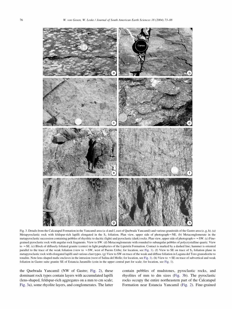
Fig. 3. Details from the Calcatapul Formation in the Yancamil area (a–d and f, east of Quebrada Yancamil) and various granitoids of the Gastre area (e, g, h). (a)
Metapyroclastic rock with feldspar-rich lapilli elongated in the S1 foliation. Plan view, upper side of photographZNE. (b) Metaconglomerate in the
metapyroclastic succession containing pebbles of rhyolitic to dacitic (light) and pyroclastic (dark) rocks. Plan view, upper side of photographZwSW. (c) Fine-
grained pyroclastic rock with angular rock fragments. View to SW. (d) Metaconglomerate with rounded to subangular pebbles of polycrystalline quartz. View
to wSE. (e) Block of diffusely foliated granite (center) in light porphyries of the Lipetren Formation. Contact is marked by a dashed line; hammer is oriented
parallel to the trace of the weak foliation (view to wSW, west of Puesto Uribe; for location, see Fig. 1). (f) View to SE on trace of S1 foliation plane in
metapyroclastic rock with elongated lapilli and various clast types. (g) View to SW on trace of the weak and diffuse foliation in Laguna del Toro granodiorite to
tonalite. Note lens-shaped mafic enclaves in the intrusion (west of Salina del Molle; for location, see Fig. 1). (h) View to wSE on trace of subvertical and weak
foliation in Gastre suite granite SE of Estancia Jaramillo (coin in the upper central part for scale; for location, see Fig. 1).
W. von Gosen, W. Loske / Journal of South American Earth Sciences 18 (2004) 73–8876
the Quebrada Yancamil (NW of Gastre; Fig. 2), these
dominant rock types contain layers with accumulated lapilli
(lens-shaped, feldspar-rich aggregates on a mm to cm scale;
Fig. 3a), some rhyolite layers, and conglomerates. The latter
contain pebbles of mudstones, pyroclastic rocks, and
rhyolites of mm to dm sizes (Fig. 3b). The pyroclastic
rocks occupy the entire northeastern part of the Calcatapul
Formation near Estancia Yancamil (Fig. 2). Fine-grained

Fig. 4. Simplified schematic block profile across the southwestern part of the Calcatapul Formation in the Yancamil area (for location, see Fig. 2). Note S1
foliation cutting across the intrusive contacts of the Yancamil granite in the southwest and northeastern part of the section. The L1 lineation is subvertical. A
conjugate set of dextral and sinistral C2 planes also cross-cuts the dykes of the Lipetren Formation and is locally condensed with a dominant dextral sense of shear.
W. von Gosen, W. Loske / Journal of South American Earth Sciences 18 (2004) 73–88 77
varieties contain angular rock fragments of mm to cm sizes
(see also Proserpio, 1978b; present Fig. 3c). In the
southwestern part of the Formation, thick layers of
metavolcanic rocks represent lava flows (Fig. 4) separated
from one another by several m thick layers of dark phyllitic
mud-/siltstone. In addition, dm-thick lenses of sandstones
with quartz-conglomerates occur (Figs. 3d and 4).
According to the subvertical orientation of the main
foliation, mostly parallel to the compositional layering (relic
of bedding), the Calcatapul Formation is at least 1 km thick
in the Yancamil exposure, without taking into account
possible repetitions by folding. An along-strike continuation
to the southeast is possible but not substantiated. There are
no fossils reported from the unit, and such relics could not
be found during our fieldwork. A (?) Middle Paleozoic
(?Silurian, ?Devonian) age of the Formation was assumed
by Proserpio (1978a,b).
In the area of Yancamil, the deformed Calcatapul
Formation also has been interpreted as mylonites. Together
with additional occurrences, these were used as an essential
argument for the existence of the dextral Gastre fault system
(e.g. Rapela et al., 1991, 1992). Along its southwestern
margin, the Formation is intruded by a coarse-grained
granite (Figs. 2 and 4), which shall be named Yancamil
granite. Slices of pyroclastic rocks were enclosed by
the granite just south of the irregular, wNW–SE-striking
intrusive contact and farther southeast (Figs. 2, 5 and 6a).
A later leucogranite facies intruded a dyke of the granite and
the country rocks. Both types of intrusion are foliated
together with the Calcatapul Formation rocks.
In the area of Gastre, a suite of various granodiorites and
granites has been named the “Gastre Suite” (or “superunit”)
and dated as 220G3 Ma (Rb–Sr, whole-rock) by Rapela
et al. (1992). In several outcrops from Gastre to the northwest
of Sierra de Calcatapul (west of Puesto Uribe), m- to 10 m-
wide blocks of weakly foliated granites are enclosed by
younger intrusive rocks of the Lipetren Formation (Fig. 3e).
The latter is widely distributed from Gastre to the north-
western parts of Sierra de Calcatapul and farther northwest
(Fig. 1). It has been interpreted as Permian or Permo-Triassic
in age (e.g. Proserpio, 1978b; Nullo, 1978b, 1979; Volkhei-
mer and Lage, 1981; Cucchi, 1993). The Formation consists
of various unfoliated granites, rhyolites, porphyries, and
aplites. The rocks have been collectively assigned to the
“Lipetren Suite” (or “superunit”) and dated as 208G1 Ma
(Rb–Sr, whole-rock) by Rapela et al. (1992). They intrude
the Calcatapul Formation (Fig. 2) and lead to contact
metamorphism of the northern occurrence (Nullo, 1978b).
Injected dykes of its porphyries, mentioned by Proserpio
(1978b), cut across the steeply inclined succession and
Yancamil granite intrusion (Fig. 4). The dykes mostly strike
between W–E and NW–SE (Fig. 6b).
The Triassic ages of the igneous rocks of both suites
(based on Gradstein and Ogg’s, 1996 time scale), however,

Fig. 5. Simplified sketch map of the irregular contact between the
Calcatapul Formation and intruded Yancamil granite east of Quebrada
Yancamil, based on field mapping (for location, see Fig. 2). Small arrows
depict the steep dip of the contact.
W. von Gosen, W. Loske / Journal of South American Earth Sciences 18 (2004) 73–8878
should be considered in light of a new dating of the
Taquetren Formation performed by Franzese et al. (2002),
which yields a Lower Triassic age (242.9G2.5 Ma, U–Pb,
zircon, SHRIMP). Its volcanic rocks and sediments, which
overlie the Lipetren Formation rocks (Fig. 1), previously
were assigned to the Upper Jurassic (Nullo and Proserpio,
1975; Proserpio, 1978b). As Franzese et al. (2002) point out
however, the Taquetren Formation includes products of at
least two different magmatic events (Triassic, Jurassic), and
a redefinition of its age and areal extent is necessary. The
Taquetren Formation is overlain by Garamilla Formation
volcanic rocks (Nullo, 1978b), which yield a Jurassic age
(188.1G1.5 Ma, U–Pb, zircon, SHRIMP, Franzese et al.,
2002). In view of the new results and on the basis of the
geological situation, we assume that parts of the Lipetren
Formation have a greater age.
The Mamil Choique Formation intrusions occur north
and southeast of Sierra del Medio (Fig. 1). Former age
estimates for the granitoids of this Formation span the
Precambrian-Late Paleozoic interval (e.g. Ravazzoli and
Sesana, 1977; Nullo, 1978b, 1979; Proserpio, 1978b; Dalla
Salda et al., 1994). A radiometric date from a granodiorite
gneiss of the Sierra del Medio Granitoids yields 267G27 Ma (Rb–Sr, whole-rock, isochron, Rapela et al., 1992).
Similar Permian ages have been reported from intrusions at
Mamil Choique (NW of Gastre; e.g. Linares et al., 1997;
Lopez de Luchi et al., 2000) and the areas of Comallo and
Paso Flores (Varela et al., 1999), which are located more
than 150 km northwest of Gastre. These ages suggest that
the Mamil Choique Formation intrusions, at least in parts,
are Late Paleozoic (Permian) in age, as is also supported by
the dating of the granites at Rıo Collon Cura (Linares et al.,
1988).
In the Gastre area, the Laguna del Toro Granitoids
(Rapela et al., 1992) correspond to the Tonalita del Platero
(Volkheimer, 1964) or El Platero Formation (Volkheimer
and Lage, 1981) exposed in the western areas. According to
an isotopic date of a tonalite approximately 10 km NNW of
Almacen El Mirador (280G10 Ma, Proserpio, 1978b) and a
poorly defined Rb–Sr whole-rock date of a biotite
granodiorite gneiss west of Gastre (346G35 Ma, Rapela
et al., 1992), it is possible that at least parts of the El Platero
Formation, Laguna del Toro granitoids, and Sierra del
Medio granitoids belong to the same Late Paleozoic
plutonism. A preliminary Rb/Sr isochron from the El
Platero tonalite, however, yields 211G10 Ma (Linares et
al., 1997) and suggests that parts of this group of intrusions
are younger.
3. Structures in the Calcatapul Formation and intrusives
3.1. D1 deformation
Within the Calcatapul Formation at Estancia Yancamil, a
penetrative but heterogeneously developed S1 foliation
affects all rock types, along with various clasts and lapilli
(Figs. 3f and 4). In the entire area, S1 planes strike NW–SE
and steeply dip to the SW or NE or are vertical (see also
Proserpio, 1978b). On S1 planes, a pronounced L1 lineation
is indicated by aligned sericite, pressure shadows at clasts,
lens-shaped elongated lapilli, and stretched, disrupted, and
extended clasts. It steeply plunges wSW or wNE or is
vertical (Fig. 6c). We found no evidence for a gently
plunging or subhorizontal orientation of L1. West of Puesto
Uribe, the L1 lineation plunges E to ENE (Fig. 6d).
In a few places in the Yancamil section, we detected
relics of S0/S1 cross-cutting relationships (Fig. 4). The
intersection lineation strikes wNW–SE (Fig. 6e). In most
places, S1 planes are parallel to bedding planes. Neither F1
folds nor way-up indicators were found.
At the southwestern margin of the Calcatapul Formation,
the S1 foliation cuts across the intrusive contact of
the Yancamil granite (Fig. 4) and through a slice of the
pyroclastic rocks enclosed by the granite (Fig. 5). To the
southwest, however, the foliation in the granite is weakly and
heterogeneously developed, as in the metavolcanic rocks
(lava flows) of the Calcatapul Formation northeast of the
contact. One dyke of the granite in the Calcatapul Formation
rocks (Fig. 4), along with a leucogranite in its central part, is
penetratively foliated and partly mylonitized. As in the main
granite body, the steeply plunging L1 lineation is recorded by

Fig. 6. Lower hemisphere, equal area stereoplots of structural elements in the Calcatapul Formation and intrusions of the Yancamil area except (d), which is
from the exposure west of Puesto Uribe (for location, see Fig. 1). (a) Contact planes between Yancamil granite and Calcatapul Formation. (b) Orientation of
dykes of the Lipetren Formation in the foliated Calcatapul Formation and Yancamil granite. (c and d) L1 lineation on S1 planes in the Calcatapul Formation
(Hoeppener plots). (e) Bedding planes and intersection lineation in the Calcatapul Formation. (f) L1 lineation on S1 planes with a southwest-directed relative
sense of shear in the foliated Yancamil granite (Hoeppener plot). (g and h) Hoeppener plots of slickensides on dextral (white) and sinistral (black) C2 shear
planes in the Calcatapul Formation (g) and Yancamil granite (h). In all Hoeppener plots (Hoeppener, 1955), the lineation is projected on the respective pole of
the plane, and arrows indicate the relative sense of shear of the hangingwalls.
W. von Gosen, W. Loske / Journal of South American Earth Sciences 18 (2004) 73–88 79

Fig. 7. Photomicrographs from thin sections; 1 mm scale bars; crossed polarizers except (a) and (b) with plane polarized light. (a) Metatuff from the Calcatapul
Formation east of Quebrada Yancamil (NW of Gastre). Clasts of single feldspar grains and polycrystalline aggregates (lapilli) depict asymmetric s-shapes of
pressure shadows in the penetrative S1 foliation. Relative sense of shear is reverse (ENE side up), shown by half arrows. (b) Metatuffitic rock from the
Calcatapul Formation in Yancamil (east of Quebrada Yancamil). Various clasts of feldspar, feldspar aggregates, and dark volcanic rocks (arrow) are affected by
the penetrative S1 foliation. (c) Metavolcanic rock (lava flow) from the southwestern part of the Calcatapul Formation (east of Quebrada Yancamil).
Plagioclase ledges display relics of intersertal textures in a dense matrix. They are partly bent, kinked, or broken due to the D1 deformation. Orientation of trace
of S1 planes at the right side is depicted by thin dashed line. (d) Metaconglomerate from the southwestern part of the Calcatapul Formation (east of Quebrada
Yancamil). Deformed pebbles of feldspar, single, and polycrystalline quartz are affected by the sericite-rich S1 foliation (indicated by dashed lines). (e)
Mylonitized Yancamil granite southeast of Quebrada Yancamil. s-shapes of ductilely deformed quartz lenses and pressure shadows at feldspar clasts record a
reverse sense of shear (NE side up), shown by half arrows. (f) Laguna del Toro tonalite to granodiorite west of Salina del Molle (W of Gastre). The trace of
W. von Gosen, W. Loske / Journal of South American Earth Sciences 18 (2004) 73–8880

3
W. von Gosen, W. Loske / Journal of South American Earth Sciences 18 (2004) 73–88 81
elongated quartz and aligned muscovite/sericite and has the
same orientation as that of the country rocks.
The observations suggest that both the Calcatapul
Formation and the Yancamil granite intrusion were affected
by wNE–SW compression. The entire succession has been
elongated parallel to the steeply plunging to subvertical L1
lineation. Because of the heterogeneous foliation develop-
ment, the section at Yancamil does not represent a mylonite
zone. Only parts of the Yancamil granite and some
metapyroclastic layers were affected by mylonitization.
3.2. Microfabrics and metamorphism
3.2.1. Calcatapul Formation
In the metapyroclastic rocks, the penetrative S1 foliation is
recorded by aligned sericite. The matrix consists of finest-
grained feldspar and dynamically recrystallized quartz.
Angular porphyroclasts of K-feldspar, single quartz
grains, and feldspar aggregates are affected by stretching.
They are partly disrupted and/or displaced within the
foliation. Pressure shadows are filled with quartz, sericite,
and Gchlorite. Only some layers can be described as
mylonites, whereas most parts display a penetrative S1
foliation.
Single quartz grains in the matrix do not record corrosion
phenomena. Small lenses are filled with coarser quartz
and/or feldspar (Fig. 7a), partly converted into epidote and
clinozoisite, and interpreted as lapilli. This is also assumed
for some (polycrystalline) clasts that consist of plagioclase
and K-feldspar within a finest-grained matrix of quartz.
Clasts with randomly oriented plagioclase ledges in a finest-
grained matrix (see also Proserpio, 1978b) filled with dense
opaque dust (Fig. 7b) are directly comparable to lava flows.
Others consist of either sericite and a fine-grained matrix of
quartz or coarser-grained quartz and feldspar (compare
Proserpio, 1978b). Sericite flakes often are impregnated by
opaque dust and also point to a clastic input within dacitic to
rhyodacitic volcanic rocks.
In the southwestern part of the Yancamil section, the
metavolcanic rocks display a dense fabric of plagioclase
ledges that record (relics of) intersertal and partly fluidal
textures (Fig. 7c) and therefore are interpreted as lava flows.
The finest-grained matrix consists of quartz, chlorite, and
microbiotite and is densely filled with opaque grains and
dust. Lenses and thin layers in the rocks are filled with
quartz, plagioclase, and microbiotiteGsericite. They could
represent amygdaloidal textures, whereas other lenses, filled
with coarse-grained quartz and feldspar, are interpreted as
rock fragments. Lens-shaped biotite aggregates with diffuse
a diffuse foliation (marked by dashed line) is roughly indicated by long axes orient
from thin strip east of Gastre village. Asymmetric s-shapes of pressure shadows a
west-dipping Smy foliation. Section is perpendicular to Smy foliation and parallel to
the Lipetren Formation northeast of Estancia Jaramillo (NW of Gastre). Displaced
dextral sense of shear (half arrows) in the WSW-dipping Smy foliation. Section
marginZSSE).
boundaries could be derived from mafic minerals, though
these are not preserved. Also on the basis of the field
observations, we assume that these lava flows represent
diabase (spilites) or trachytic volcanics. We found no
evidence to postulate dykes.
The volcanic rocks are heterogeneously affected by the
S1 foliation. The magmatic texture is cross-cut by single S1
planes (Fig. 7c), and plagioclase is successively rotated into
these planes. Such areas can change into those in which a
clear foliation is developed. There, plagioclase is bent,
kinked, and broken, and spaces between the dismembered
fragments are filled with quartz and/or biotite. The latter is
grown parallel to the S1 planes.
Within the thin lenses of metaconglomerates, a penetrat-
ive S1 foliation is recorded by aligned sericite, chlorite, and
Gmicrobiotite and is not mylonitic (Fig. 7d). Quartz and
feldspar exhibit ductile and brittle deformation, respect-
ively. Dynamically generated quartz recrystallization grains
occur in the matrix. Single clastic biotite is replaced by
recrystallization grains. The microstructures in the metape-
litic layers are directly comparable. There, the cross-cutting
relationship between bedding (S0) and S1 foliation follows
that found in the field.
The pebble content of the metaconglomerates can be
assigned to several groups. Coarse K-feldspar clasts, partly
with micrographic intergrowths, may be related to eroded
intrusions. Single quartz grains with corrosion phenomena
probably were derived from acid volcanics. As in the
metapyroclastic rocks, single polycrystalline quartz pebbles
internally consist of coarsely recrystallized quartz grains
deformed by the S1 foliation. These clasts originated from a
metamorphic complex. In the metapelitic layers and some
metapyroclastic rocks, single flakes of mudstones, impreg-
nated by opaque dust, were derived from a sedimentary
complex.
The clasts’ content supports the field observations that
the metapyroclastic rocks are tuffs to tuffites (see also
Volkheimer, 1965; Proserpio, 1978b; Nullo, 1978b) with
variable contents of volcanic and clastic debris. In this part
of the Formation, pebbles also are accumulated within
conglomerate layers. These clasts are affected by the
penetrative S1 foliation and do not record an older foliation
fabric. Except for those from a metamorphic complex, they
probably were derived from the local succession.
3.2.2. Yancamil granite
In the interior, southwestern parts of the granite,
sericite grew parallel to weakly developed S1 planes.
Magmatic quartz is elongated with sericiteGchlorite
ations of plagioclase and partly an elongation of quartz. (g) Gastre mylonite
t feldspar clasts depict (oblique) reverse sense of shear (half arrows) in the
Lmy lineation (right marginZNW). (h) Gastre mylonite from a thin strip in
fragments of a broken feldspar clast and shear band (dashed line) depict a
is perpendicular to Smy and parallel to gently plunging Lmy lineation (left

W. von Gosen, W. Loske / Journal of South American Earth Sciences 18 (2004) 73–8882
beards in pressure shadows and records incipient dynamic
recrystallization. In the marginal parts of the granite,
quartz is ductilely elongated within the penetrative, partly
mylonitic S1 foliation and contains finest-grained, dyna-
mically generated recrystallization grains. K-feldspar and
plagioclase exhibit brittle deformation, and incipient fine-
grained recrystallization is detected only in high-strain
areas. Magmatic biotite and muscovite are affected by
shearing and replaced by microbiotite and sericite,
respectively.
In the granite/leucogranite dyke, the partly mylonitic
foliation is recorded by extremely elongated quartz that
records subgrain formation and dynamic recrystallization.
Feldspar exhibits brittle deformation.
The microstructures suggest that the Yancamil granite
was affected by a heterogeneous, solid-state deformation
after cooling. The deformation took place under lower
greenschist facies metamorphic conditions that also appear
in the Calcatapul Formation rocks, as shown by the growth
of sericiteCchloriteGbiotite, the dynamic recrystallization
of quartz, and the mostly brittle deformation of feldspar in
both units. According to Nullo (1978b), deformation and
metamorphism took place prior to the intrusion of the
Lipetren Formation magmatic rocks. Other than in parts of
the Yancamil granite and some layers of the pyroclastic
rocks, where shearing is intensified and mylonites occur, the
heterogeneously foliated rock succession generally cannot
be interpreted as mylonites.
3.3. Sense of shear
At and near the contact with the Calcatapul Formation,
s-shapes of feldspar clasts within the S1 foliation of the
Yancamil granite indicate a top-to-southwest sense of shear
parallel to the steeply plunging L1 lineation (Figs. 4 and 6f).
Comparable feldspar s-clasts within the granite dyke
support this uplift of the northeastern block parallel to the
pronounced L1 lineation (Fig. 4). On the microscale, this
relative sense of shear is supported by s-shapes of
polycrystalline quartz lenses (Fig. 7e), pressure shadows
at feldspar porphyroclasts, displaced feldspar clasts, S/C
fabrics, and micro shear bands.
Microscale shear sense indicators in the metapyroclastic
rocks of the Calcatapul Formation are asymmetric s-shapes
of pressure shadows (Fig. 7a), displaced porphyroclasts, and
some S/C fabrics. They are comparable to s-shapes of
pressure shadows at single plagioclase grains and quartz-
feldspar lenses and displaced plagioclase grains in the
metavolcanic rocks. In the metaconglomerates, some
asymmetric s-shapes of pressure shadows occur.
All macro- and microscale shear sense indicators in the
different lithological units prove a general uplift of
the northeastern blocks parallel to the steeply plunging L1
lineation. No evidence for a dextral sense of shear was
found.
3.4. D2 deformation
The D1 structures in the Calcatapul Formation and
Yancamil granite are cross-cut by a conjugate set of steeply
inclined to subvertical, dextral and sinistral, C2 shear planes
(Figs. 4 and 6g and h). Their relative sense of shear
is depicted by subhorizontal slickensides. Both planes
are spaced on the dm scale. In some m-wide parts of
the outcrops, however, they are condensed to the cm scale.
There, both plane sets are rotated toward the finite
orientation of the S1 foliation planes, and the wNW–SE-
striking dextral planes partly dominate (Fig. 4).
The conjugate set of C2 planes also cuts across cm- to
dm-thick rhyolitic to granitic dykes of the Lipetren
Formation, which intruded the Yancamil granite and
Calcatapul Formation rocks after the ductile D1 deformation
(Fig. 4). These planes are the first deformational structures
in the dykes. At the northeastern margin of the Calcatapul
Formation, the conjugate set of C2 planes also cuts across
the Lipetren Formation magmatic rocks, which intruded the
vertical Calcatapul Formation succession. On the basis of
the orientation of the set of dextral and sinistral C2 planes
(Fig. 6g and h), we can estimate a NE–SW compression
with a subhorizontal orientation of s1.
4. Laguna del Toro and Gastre suite granitoids
Southwest of Sierra de Calcatapul, west of Salina del
Molle, a tonalite to granodiorite of the Laguna del Toro
Granitoids (Rapela et al., 1992) is exposed in an area mostly
occupied by rocks of the Lipetren Formation (Fig. 1). The
rocks record a weak, diffuse foliation in which lens-shaped
mafic enclaves occur (Fig. 3g). The steeply inclined to
vertical foliation strikes N–S to NE–SW. Poorly developed
feldspar s-clasts display an oblique sinistral sense of shear
(Fig. 8a) parallel to the weak lineation recorded by aligned
feldspar, amphibole, and biotite.
On the microscale, the poorly defined foliation does not
record evidence of a clear solid-state deformation (Fig. 7f).
Plagioclase, biotite, and, partly, amphibole depict a weak
alignment of the long axes. Coarse-grained magmatic quartz
is elongated only in some parts and can contain single,
coarse recrystallization grains. The partial conversion of
biotite into chlorite, undulatory extinction of quartz, and
bending of single plagioclase can be assigned to the effects
of a younger slight deformation. The structures in the
outcrop suggest that the intrusion was deformed during
emplacement and/or cooling.
A comparable mechanism is reasonable for the studied
Gastre Suite granites. West of Gastre, a hornblende-biotite
granite, described by Rapela et al. (1992), depicts a diffuse
and steeply NE-dipping foliation with a weak lineation
(Fig. 8b). Clear shear sense indicators could not be found. A
cross-cutting conjugate set of subvertical, wN–S- and
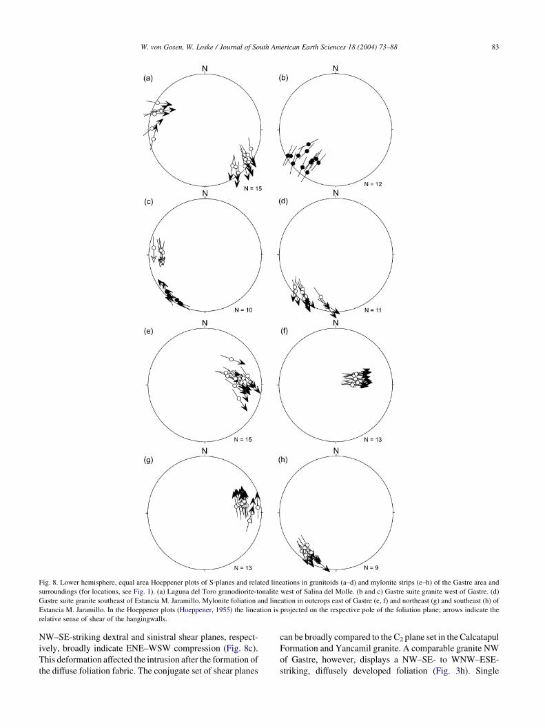
Fig. 8. Lower hemisphere, equal area Hoeppener plots of S-planes and related lineations in granitoids (a–d) and mylonite strips (e–h) of the Gastre area and
surroundings (for locations, see Fig. 1). (a) Laguna del Toro granodiorite-tonalite west of Salina del Molle. (b and c) Gastre suite granite west of Gastre. (d)
Gastre suite granite southeast of Estancia M. Jaramillo. Mylonite foliation and lineation in outcrops east of Gastre (e, f) and northeast (g) and southeast (h) of
Estancia M. Jaramillo. In the Hoeppener plots (Hoeppener, 1955) the lineation is projected on the respective pole of the foliation plane; arrows indicate the
relative sense of shear of the hangingwalls.
W. von Gosen, W. Loske / Journal of South American Earth Sciences 18 (2004) 73–88 83
NW–SE-striking dextral and sinistral shear planes, respect-
ively, broadly indicate ENE–WSW compression (Fig. 8c).
This deformation affected the intrusion after the formation of
the diffuse foliation fabric. The conjugate set of shear planes
can be broadly compared to the C2 plane set in the Calcatapul
Formation and Yancamil granite. A comparable granite NW
of Gastre, however, displays a NW–SE- to WNW–ESE-
striking, diffusely developed foliation (Fig. 3h). Single

W. von Gosen, W. Loske / Journal of South American Earth Sciences 18 (2004) 73–8884
feldspar s-clasts indicate an oblique dextral sense of shear
(Fig. 8d).
The few granitoids studied do not demonstrate a
consistent overall trend of structures or sense of shear.
Their diffuse foliations suggest that they were affected by
compression during emplacement and/or cooling (magmatic
foliation of Rapela et al., 1991 and Rapela and Pankhurst,
1992). However, we could find no clear indication of a
direct relation with a developing Gastre fault system. Some
parts could represent equivalents of the weakly foliated
granites enclosed by the unfoliated intrusive rocks of the
Lipetren Formation.
5. Gastre mylonites
East of the village of Gastre, an approximately 30 m
thick mylonite strip is exposed within porphyries and fine-
grained granites of the Lipetren Formation (Fig. 1), which
contain blocks of a weakly foliated granite. The dark
mylonite zone strikes wN–S and dips to the wW (Fig. 9).
Feldspar s- and d-clasts, and single S/C fabrics in the
mylonite foliation (Smy) indicate an uplift of the western
block parallel to the mylonite lineation (Lmy) but with a
sinistral component (Fig. 8e). This mylonite zone was the
thickest strip found in the entire area. A nearby w3 m thick
mylonite strip in the Lipetren Formation also dips to the
west and records a top-to-east sense of shear (Fig. 8f). It
should be noted that Nullo (1978b) also mentions mylonite
strips in the Lipetren Formation that record a dip between 85
and 908 to the east.
Northwest of this location, NE and SE of Estancia
Jaramillo, we found two additional w20 cm thick mylonite
Fig. 9. Simplified schematic block sketch of structural elements in the
mylonite zone east of Gastre. The relative sense of shear is indicated by
feldspar s-, single d-clasts, and S/C fabrics. For location, see Fig. 1.
strips (Fig. 1). The first one, in the Lipetren Formation,
strikes N–S and dips steeply wW. It records a dextral sense
of shear (Fig. 8g) and laterally thins out in the porphyric
rocks. The second, a wNW–SE striking mylonite strip in
the Gastre suite granite, indicates a dextral sense of shear
(Fig. 8h) that follows that of the weak older foliation at the
same locality (cf. Fig. 8d).
On the microscale, the foliation of the mylonite strips is
recorded by aligned sericite and extremely elongated quartz
lenses, which are partly to entirely replaced by subgrains
and dynamically generated recrystallization grains. In the
mylonitized Gastre suite granite, elongated quartz records
relics of former coarse recrystallization grains formed
during the initial foliation development (emplacement-
related and/or during cooling). Porphyroclasts of K-feldspar
and plagioclase in the mylonites exhibit brittle deformation
and record alterations to sericite. The relative sense of shear
is indicated by displaced feldspar, single S/C fabrics, and
shear bands, as well as asymmetric s-shapes of quartz
lenses and pressure shadows at feldspar porphyroclasts
(Fig. 7g and h), which confirms the shear sense found in the
field. According to the microfabrics, the local mylonite
formation took place under lower greenschist metamorphic
conditions, whereas single cross-cutting shear planes were
formed under brittle conditions.
In the Lipetren Formation of Sierra de Calcatapul, the
NW–SE-trending cataclastic fault line just northeast of
Gastre (Fig. 1), indicated as an inferred fault on Proserpio’s
(1978a) geological map, can be confirmed. It and three
additional zones have been interpreted as the main fracture
zones of the Gastre fault zone by Rapela et al. (1992).
Northeast of Estancia Jaramillo, the fracture zone covers an
area farther northeast in the Lipetren Formation rocks. In
different outcrops, however, the various brittle structures do
not reveal a clear dextral sense of shear. We could detect no
clear offsets of different lithological units in the field, nor are
they depicted on the maps.
Furthermore, the few and thin mylonites with different
orientations record a variable but not consistent (dextral)
sense of shear. Their relations to the cataclastic rocks of the
fracture zones are unclear. In general, they do not represent
important mylonites that can be related to a large-scale,
NW–SE-trending shear zone; the deformed Calcatapul
Formation also does not represent a dextral mylonite zone.
6. Age of the Yancamil granite
To provide evidence about the age of the Yancamil
granite, a sample for radiometric dating was taken from the
Yancamil section w20 m southwest of the intrusive contact.
There, the coarse-grained granite is slightly deformed and
not penetratively foliated. We provide a description of the
sample preparation and analytical procedures in Appendix A.
The Yancamil granite is dominated by colorless, clear
zircons. Opaque inclusions are scarce, whereas colorless,

Table 1
Isotopic data of zircons from the Yancamil granite
Sample name Yancamil granite
Number of grains 3 2 1 3 3 1
U (ppm) 3617.1 2641.9 1299.3 3495.0 4225.8 1194.2
Pb (ppm) 201.7 124.2 57.7 159.7 190.2 55.5
206/204 487.2 303.2 256.9 443.5 314.6 159.3
207/206 0.065109 0.051207 0.051698 0.051681 0.051531 0.051189
Err 0.000204 0.000349 0.000437 0.000446 0.000462 0.000544
207/235 ratio 0.479636 0.313367 0.305511 0.315165 0.299292 0.293702
Err 0.002327 0.002553 0.003013 0.003237 0.003335 0.003979
206/238 ratio 0.053428 0.044383 0.042860 0.044229 0.042124 0.041613
Err 0.000188 0.000168 0.000167 0.000208 0.000247 0.000295
206/238 age (m.y.) 335.5 279.9 270.5 279.0 266.0 262.8
207/235 age (m.y.) 397.8 276.8 270.7 278.2 265.8 261.5
207/206 age (m.y.) 777.9 250.2 272.1 271.3 264.7 249.4
Rho 0.759 0.551 0.531 0.546 0.596 0.627
Notes. Errors are quoted at 1-sigma level.
W. von Gosen, W. Loske / Journal of South American Earth Sciences 18 (2004) 73–88 85
crystal-shaped (apatite?) needles are frequent, in addition to
irregular, bubble-shaped, gas-filled inclusions. The crystal
surfaces often show a mother-of-pearl-like luster, which
may be due to corrosive attacks after crystallization. Most of
the crystals have a short prismatic habit and fractures, and
many are broken into pieces. Taking into account the slight
deformation of the granite, we believe the fractures are of
primary origin and not artifacts of the sample preparation.
The Pupin (e.g. 1988) characteristics of the crystals are
dominated by S13/S14 and S8/S9 types. This equilibrium of
the forms and the rather high uranium contents of the
zircons (ca. 1200 ppm, see Table 1) support the assumption
of a hybrid to crustal origin (Pupin, 1992, 1994) for the
granite, which is compatible with a Paleozoic arc/backarc
situation for the investigated area.
The 206Pb/238U and 207Pb/235U apparent ages of five of
the analyzed zircon fractions (1–3 grains) scatter between
262.8 and 279.9 Ma. Another fraction (3 grains) yields a
highly discordant age (Fig. 10a), which we believe is
caused by inherited zircons from the intruded country
rocks, incorporated into the melt during the injection of the
granite.
Assuming recent Pb-loss, the calculated discordia of the
five analyses, when forced through a lower intercept of 0,
yields an upper intercept age of 261C16/K17 Ma (MSWD
0.33; Fig. 10b). This Permian age is the probable minimum
age of the Yancamil granite.
7. Evolutionary scenario
The structural evidence from the study areas suggests
successive stages of events. As the ages, these contrast with
previous interpretations and conclusions and can be
summarized as follows:
1.
Deposition of the Calcatapul Formation. A thick pile ofpyroclastic rocks containing reworked clastic and
volcanic rocks, along with layers of rhyolite, minor
clastic, and metavolcanic rocks (lava flows), makes it
possible to infer a depositional area of a magmatic arc
or backarc basin. The age of the succession is unclear.
On the basis of the geological situation and regional
comparisons, a ?Silurian–?Devonian age seems most
probable, in accordance with Proserpio’s (1978b)
interpretation.
2.
Granite intrusion. The Calcatapul Formation wasintruded by the Yancamil granite. On the basis of the
U–Pb dating of zircons from the granite and the relative
and absolute ages of the younger igneous rocks, a Late
Paleozoic, probably Permian, age for this granite is
reasonable.
3.
The D1 deformation of the Calcatapul Formation andYancamil granite was the result of wNE–SW com-
pression. In neither unit do we find indications of dextral
shearing during this event. Shear sense indicators suggest
a relative uplift of the northeastern block parallel to the
L1 lineation. Because the S1 foliation and slight
greenschist facies metamorphism also affected the
Permian Yancamil granite but predated the intrusion of
the Triassic Lipetren Formation, a Permian (–?Triassic)
age for the D1 event seems reasonable.
4.
The intrusions of the Lipetren Formation affected thedeformed Calcatapul Formation, heterogeneously foli-
ated Yancamil granite, and Gastre suite intrusions.
According to the overlying volcanic rocks of the
Taquetren Formation, which presumably spans the
Triassic-Jurassic interval, and the ductile D1 deformation
in the study area with the above age, the Lipetren
Formation rocks should be Triassic in age.
5.
The local and thin mylonite strips in the LipetrenFormation do not follow a large-scale, dextral shear
zone. The different mylonites may have formed during
the same broad interval of compressive deformation,
which created the conjugate set of dextral and sinistral C2
shear planes within the Calcatapul Formation, Yancamil
granite, and younger dykes of the Lipetren Formation.

Fig. 10. U–Pb concordia diagrams of zircons of the Yancamil granite. (a) Five
nearly concordant analyses from granite zircons and one highly discordant
analysis of supposed country rock zircons. (b) 261C16/K17 Ma age (95%
confidence level) is based on five analyses assuming a recent Pb-loss.
W. von Gosen, W. Loske / Journal of South American Earth Sciences 18 (2004) 73–8886
Dextral shear planes dominate in some small parts of the
outcrops. In general, a Triassic or younger age for this
post-Lipetren deformation and brittle fracturing along
the NW–SE-striking cataclastic zones can be estimated,
though additional younger events cannot be excluded.
8. Regional implications and conclusions
In view of its composition, the Calcatapul Formation
seems to represent a small cutout of a former magmatic
arc or backarc basin environment and thereby indicates
?Early Paleozoic volcanic activity in this western part of
north Patagonia. The Permian age of the Yancamil granite
must be considered in conjunction with the Late Paleozoic
ages of other granitoids in the western part of the North
Patagonian Massif, as reported by, for example, Linares et
al. (1997), Varela et al. (1999), and Lopez de Luchi et al.
(2000). We can only assume that this plutonism was the
result of subduction beneath the western Patagonia margin.
In this study, we found no clear indications for the
existence of an intracontinental dextral Gastre fault system.
This finding applies to the thin mylonite occurrences, which
do not depict an overall NW–SE-striking shear zone and are
not of regional importance. The Calcatapul Formation
indicates a polyphase evolution that comprises several
events from the ?Silurian–?Devonian (deposition) to Triassic
and/or later times (latest stage deformation). It does not
represent a dextral mylonite zone that might be related to a
shear zone with regional and plate tectonic significance.
In the NW–SE-striking fracture zones, which depict the
wide Gastre fault system, no clear proof of a dextral sense of
shear has been reported. As the thin mylonites, they do not
record a clear offset of different lithological units. It should be
mentioned that various authors have shown sinistral dis-
placements along the main faults of the fault system (e.g.
Coira et al., 1975; Nullo, 1978b; Proserpio, 1978b;
Volkheimer and Lage, 1981). Detailed field studies from
the different faults, however, are still lacking. Furthermore,
Proserpio (1978b) and Llambıas et al. (1984) describe sinis-
tral faults in the interior of the Sierra del Medio. Llambıas
et al. (1984) relate the injection of microdioritic dykes with a
K–Ar age of 215G10 Ma to this fault tectonics in the sierra.
The overall picture of initial fault tectonics and
magmatism has been related to the Triassic episode of
rifting (Rapela et al., 1992 and Rapela and Pankhurst, 1992),
which produced NW–SE-trending troughs (e.g. Uliana
et al., 1989). In contrast, Coira et al. (1975) assume that
the onset of sinistral displacements took place during the
Late Paleozoic. In the Gastre area, fracturing and local
mylonite formation in the Triassic Lipetren Formation is the
only argument for the onset of faulting.
In general, fault tectonics took place and/or continued
through post-Late Jurassic, Cretaceous, and Tertiary times
(e.g. Volkheimer, 1965, 1973; Coira et al., 1975; Nullo,
1978b, 1979; Rapela and Pankhurst, 1992; Rapela, 1997). In
this context, a (subsequent) formation of horst-and-graben
structures seems probable, as noted by Volkheimer (1965,
1973) and Llambıas et al. (1984) for the latest stage
deformation in the Sierra del Medio area. Therefore, we can
also interpret the fracture zones of the Gastre fault system as
the result of (several stages of) downfaulting of different
blocks that led to the formation of distinct young basins.
The evidence from the Gastre area shows no clear
indication of the existence of the dextral Gastre fault system
as a large-scale structural element. It seems more probable
that the fracture zones are related to the formation of
depressions (e.g. Pampa de Gastre southwest of Sierra de
Calcatapul), which may represent downfaulted basins also
outside the study area. Evidence of fracturing and thin
mylonite strips is not sufficient for an important dextral
lineament. Contrasting interpretations of a sinistral sense of
W. von Gosen, W. Loske / Journal of South American Earth Sciences 18 (2004) 73–88 87
shear or displacements along fracture/fault zones in this part
of the North Patagonian Massif do not give a consistent
picture and do not support a large-scale, intracontinental,
dextral fault system traversing extra-Andean Patagonia.
Acknowledgements
We are grateful to C. Prozzi (Bahıa Blanca) for his help
and support during fieldwork in Argentina. Discussions with
E. Llambıas, A. Sato, and P. Gonzalez (La Plata) improved
our understanding of the North Patagonian Massif. Many
thanks also to D. Gregori (Bahıa Blanca) and J. Ranalli
(Mendoza) for all their help and many discussions during
fieldwork in Patagonia and to E. Bouhier (Direccion de
Minas, San Antonio Oeste/Rıo Negro) for his support. We
thank K. Mezger and his crew (especially H. Beier and
E. Trapp) for the opportunity to carry out the isotope work at
the Central Laboratory for Geochronology/Institute for
Mineralogy of the University of Munster. Many thanks to
H. Miller and both reviewers, J.H. Kruhl and R.J. Pankhurst,
for their constructive comments and suggestions that helped
improve the manuscript. The studies were enabled by
grants from the German Research Foundation (DFG, Proj.
GO 405/4-1 and 4-2), which are gratefully acknowledged.
This article is a contribution to IGCP 436.
Appendix A
A.1. Sample preparation
The cleaned samples were crushed in a jaw breaker to a
!10 mm grain size. Further grinding to a grain size of
!1 mm was done by a disk mill. The heavy minerals in the
sieved fractions of !0.25 mm were concentrated using a
Wilfley-type wet shaking table. Further concentration of the
zircons was achieved by the use of heavy liquids and a
Frantz isodynamic separator. The high-quality zircons for
single grain analyses were selected from the bulk sample.
No air abrasion was carried out.
A.2. Analytical procedure
The handpicked crystals were washed with 3.5 N
HNO3 for 30 min at 80 8C, then rinsed with distilled
water and dried with acetone. Individual crystals and
fractions were decomposed with 2 ml 24 N HF in steel-
cased multi- or single-hole Teflon containers for 3–4 days
at 180 8C. The decomposed zircon was spiked with an
appropriate amount (2 ml) of a 205Pb–233U tracer solution.
After drying, the sample was converted to the chloride
form with 2 ml of 6 N HCl overnight. The dried sample
was loaded with a mixture of silica gel, HCl, and
phosphoric acid on a Re single filament. Measurement of
U and Pb was performed on a VG 354 mass spectrometer
equipped with a Daly multiplier and an ion-counting
device by peak hopping, with Pb at 1250–1350 8C and U
at 1400–1450 8C. Mass fractionation was controlled by the
measurement of the standards NBS 982 (0.3%) and U 500
(no mf). The maximum measured 206Pb/204Pb ratio during
the course of the analyses was 487 for the fraction (3
grains) with the highest apparent ages, whereas single
zircons were at 159.3 and 256.9. This is indicative for a
constant and low procedure blank. Calculations were
corrected with a maximum Pb blank of 0.01 pg with the
following composition: 6/4Z17.72, 7/4Z15.52, 8/4Z37.7
and a U blank of 0.5 pg. The initial Pb composition was
calculated according to Stacey and Kramers’s (1975) Pb
evolution model. The errors in Table 1 and Fig. 10 are
quoted at the 1-sigma level, whereas the error of the
calculated discordia is given for a 95% confidence level
(see Ludwig, 1993).
References
Alonso, G.B., 1987. Resultados geoquımicos y geocronologicos prelimi-
nares de los cuerpos granıticos de Pilcaniyeu, Provincia de Rıo Negro.
X Congreso Geologico Argentino (San Miguel de Tucuman), Actas 4,
27–29.
Coira, B.L., Nullo, F., Proserpio, C., Ramos, V.A., 1975. Tectonica de
basamento de la region occidental del Macizo Nordpatagonico (Prov.
de Rıo Negro y Chubut) Republica Argentina. Revista de la Asociacion
Geologica Argentina 30 (3), 361–383.
Cucchi, R.J., 1993. La Formacion Lipetren en el marco del Gondwana:
sector occidental del Macizo Nordpatagonico. XII Congreso Geologico
Argentino y II Congreso de Exploracion de Hidrocarburos (Mendoza),
Actas IV, 105–122.
Dalla Salda, L., Cingolani, C.A., Varela, R., 1990. El basamento de la
region occidental del Macizo Norpatagonico, Argentina. XI Congreso
Geologico Argentino (San Juan), Actas II, 11–14.
Dalla Salda, L.H., Cingolani, C., Varela, R., 1992a. Early Paleozoic
orogenic belt of the Andes in southwestern South America: Result of
Laurentia-Gondwana collision?. Geology 20, 617–620.
Dalla Salda, L.H., Dalziel, I.W.D., Cingolani, C.A., Varela, R., 1992b. Did
Taconic Appalachians continue into southern South America?. Geology
20, 1059–1062.
Dalla Salda, L., Cingolani, C., Varela, R., 1993. A pre-Carboniferous
tectonic model in the evolution of southern South America. Comptes
Rendus 12th International Congress on Carboniferous-Permian (Buenos
Aires) 1, 371–384.
Dalla Salda, L.H., Varela, R., Cingolani, C., Aragon, E., 1994. The
Rio Chico Paleozoic crystalline complex and the evolution of
northern Patagonia. Journal of South American Earth Sciences 7
(3/4), 377–386.
Duhart, P., Haller, M., Herve, F., 2002. Diamictitas como parte del protolito
de las metamorfitas de la Formacion Cushamen en Rıo Chico,
Provincias de Rıo Negro y Chubut, Argentina, in: Cingolani, C.A.,
Cabaleri, N., Linares, E., Lopez de Luchi, M.G., Ostera, H.A.,
Panarello, H.O. (Eds.), XV Congreso Geologico Argentino (El
Calafate/Santa Cruz), Actas II, pp. 97–100.
Franzese, J., Martino, R., 1998. Aspectos cinematicos y tectonicos de la
zona de cizalla de Gastre en la Sierra de Calcatapul, Provincia de
Chubut; Argentina. X Congreso Latinoamericano de Geologıa y VI
Congreso Nacional de Geologıa Economica (Buenos Aires), Actas II, 3.
Franzese, J.R., Pankhurst, R.J., Rapela, C.W., Spalletti, L.A., Fanning, M.,
Muravchick, M., 2002. Nuevas evidencias geocronologicas sobre el

W. von Gosen, W. Loske / Journal of South American Earth Sciences 18 (2004) 73–8888
magmatismo gondwanico en el noroeste del Macizo Norpatagonico, in:
Cingolani, C.A., Cabaleri, N., Linares, E., Lopez de Luchi, M.G.,
Ostera, H.A., Panarello, H.O. (Eds.), XV Congreso Geologico
Argentino (El Calafate/Santa Cruz), Actas I, pp. 144–148.
Gradstein, F.M., Ogg, J., 1996. A Phanerozoic time scale. Episodes 19
(1, 2), 3–5.
Hoeppener, R., 1955. Tektonik im Schiefergebirge. Geologische
Rundschau 44, 26–58.
Linares, E., Cagnoni, M.C., Do Campo, M., Ostera, H.A., 1988.
Geochronology of metamorphic and eruptive rocks of southeastern
Neuquen and northwestern Rıo Negro Provinces, Argentine Republic.
Journal of South American Earth Sciences 1 (1), 53–61.
Linares, E., Haller, M.J., Ostera, H.A., Cagnoni, M.C., Galante, G., 1997.
Radiometric ages of the crystalline basement of the Rıo Chico region,
Norquinco department, Rıo Negro Province, Argentina. South Amer-
ican Symposium on Isotope Geology (Sao Paulo/Brazil, June 15–19,
1997), Extended Abstracts) 1997, 170–175.
Llambıas, E.J., Llano, J.A., Rossa, N., Castro, C.E., Puigdomenech, H.H.,
1984. Petrografıa de la Formacion Mamil Choique en la Sierra del
Medio-Departamento Cushamen–Provincia del Chubut. IX Congreso
Geologico Argentino (San Carlos de Bariloche/Rıo Negro), Actas 2,
554–567.
Lopez de Luchi, M.G., 1994. Geologıa de las unidades plutonicas del
Macizo Norpatagonico en la zona de Rıo Chico-Mamil Choique,
Provincia de Rıo Negro, Republica Argentina. 7 Congreso Geologico
Chileno (Concepcion), Actas 1, 91–95.
Lopez de Luchi, M.G., Ostera, H., Cerredo, M.E., Cagnoni, M.C.,
Linares, E., 2000. Permian magmatism in Sierra de Mamil Choique,
North Patagonian Massif, Argentina. IX Congreso Geologico Chileno,
Actas 2 (4), 750–754.
Ludwig, K.R., 1993. ISOPLOT-Ver.2.70: A plotting and regression
program for radiogenic isotope data. US Geological Survey, Open-
File Report, 91-445, 42 pp.
Marshall, J.E.A., 1994. The Falkland Islands: a key element in Gondwana
paleogeography. Tectonics 13 (2), 499–514.
Nullo, F.E., 1978a. Carta Geologico-Economica de la Republica Argentina,
Hoja 41d, Lipetren, Provincia de Rıo Negro (1:200000), Servicio
Geologico Nacional, Departamento Carta Geologica, Buenos Aires
1978.
Nullo, F.E., 1978b. Descripcion Geologica de la Hoja 41d, Lipetren,
Provincia de Rıo Negro. Ministerio de Economıa, Secretarıa de Estado
de Minerıa, Boletın 158, 1–88.
Nullo, F.E., 1979. Descripcion Geologica de la Hoja 39c, Paso Flores,
Provincia de Rıo Negro. Ministerio de Economıa, Secretarıa de Estado
de Minerıa, Boletın 167, 1–79.
Nullo, F., Proserpio, C., 1975. La Formacion Taquetren en Canadon del
Zaino (Chubut) y sus relaciones estratigraficas en el ambito de la
Patagonia, de acuerdo a la flora, Republica Argentina. Revista de la
Asociacion Geologica Argentina 30 (2), 133–150.
Ostera, H.A., Linares, E., Haller, M.J., Cagnoni, M.C., Lopez de Luchi, M.,
2001. A widespread Devonian metamorphic episode in northern
Patagonia, Argentina III South American Symposium on Isotope
Geology (Sociedad Geologica de Chile, Santiago), Extended Abstracts
Volume (CD), pp. 600–603.
Proserpio, C.A., 1978a. Carta Geologico-Economica de la Republica
Argentina, Hoja 42d, Gastre, Provincia del Chubut (1:200000), Servicio
Geologico Nacional, Departamento Carta Geologica (Buenos Aires)
1978.
Proserpio, C.A., 1978b. Descripcion Geologica de la Hoja 42d, Gastre,
Provincia del Chubut. Ministerio de Economıa, Secretarıa de Estado de
Minerıa, Boletın 159, 1–75.
Pupin, J.P., 1988. Granites as indicators in paleogeodynamics. Rendiconti
della Societa Italiana di Mineralogia e Petrologia 43 (2), 237–262.
Pupin, J.P., 1992. Les zircons des granites oceaniques et continentaux.
Couplage typologie-geochimie des elements en traces. Bulletin de la
Societe Geologique de France 163 (4), 495–507.
Pupin, J.P., 1994. Caracterisation des protolithes des migmatites et granites
anatectiques crusteaux d’apres l’etude des zircons. Comptes Rendus de
l’Academie de Scienes Paris 319 (Serie II), 1191–1197.
Ramos, V.A., 1984. Patagonia: ¿Un continente Paleozoico a la deriva?. IX
Congreso Geologico Argentino (San Carlos de Bariloche/Rıo Negro),
Actas II, 311–325.
Ramos, V.A., 1986. Tectonostratigraphy, as applied to analysis of South
African Phanerozoic basins by H. De La R. Winter, Discussion.
Transactions Geological Society South Africa 89, 427–429.
Rapela, C.W., 1997. El sistema de fallas de Gastre: e pur si muove. Revista
de la Asociacion Geologica Argentina 52 (2), 219–222.
Rapela, C.W., Kay, S.M., 1988. Late Paleozoic to recent magmatic
evolution of northern Patagonia. Episodes 11 (3), 175–182.
Rapela, C.W., Pankhurst, R.J., 1992. The granites of northern Patagonia
and the Gastre Fault System in relation to the break-up of Gondwana,
in: Storey, B.C., Alabaster, T., Pankhurst, R.J. (Eds.), Magmatism and
the Causes of Continental Break-Up, Geological Society of London
Special Publication, vol. 68, pp. 209–220.
Rapela, C.W., Dias, G.F., Franzese, J.R., Alonso, G., Benvenuto, A.R.,
1991. El batolito de la Patagonia central: evidencias de un magmatismo
triasico-jurasico asociado a fallas transcurrentes. Revista Geologica de
Chile 18 (2), 121–138.
Rapela, C.W., Pankhurst, R., Harrison, S.M., 1992. Triassic ‘Gondwana’
granites of the Gastre district, North Patagonian Massif. Transactions of
the Royal Society of Edinburgh, Earth Sciences 83, 291–304.
Ravazzoli, I.A., Sesana, F.L., 1977. Descripcion Geologica de la Hoja 41c,
Rıo Chico, Provincia de Rıo Negro. Ministerio de Economıa, Secretarıa
de Estado de Minerıa, Boletın 1977, 1–148.
Richards, P.C., Gatliff, R.W., Quinn, M.F., Williamson, J.P.,
Fannin, N.G.T., 1996. The geological evolution of the Falkland Islands
continental shelf, in: Storey, B.C., King, E.C., Livermore, R.A. (Eds.),
Weddell Sea Tectonics and Gondwana Break-up, Geological Society of
London Special Publication, vol. 108, pp. 105–128.
Stacey, J.S., Kramers, J.D., 1975. Approximation of terrestrial lead
evolution by a two-stage model. Earth and Planetary Science Letters
26, 207–221.
Uliana, M.A., Biddle, K.T., Cerdan, J., 1989. Mesozoic extension and the
formation of Argentine sedimentary basins, in: Tankhard, A.J.,
Balkwill, H.R. (Eds.), Extensional Tectonics and Stratigraphy of the
North Atlantic Margins, American Association of Petroleum Geol-
ogists, Memoir, vol. 46, pp. 599–614.
Varela, R., Basei, M.A.S., Brito Neves, B.B., Sato, A.M., Teixeira, W.,
Cingolani, C., Siga, O., 1999. Isotopic study of igneous and
metamorphic rocks of Comallo-Paso Flores, Rıo Negro, Argentina.
Actas II South American Symposium on Isotope Geology (Villa Carlos
Paz/Cordoba) 1999, 148–151.
Volkheimer, W., 1964. Estratigrafıa de la zona extrandina del Departa-
mento de Cushamen (Chubut) entre los paralelos 428 y 428 30’ y los
meridianos 708 y 718. Revista de la Asociacion Geologica Argentina 19
(2), 85–107.
Volkheimer, W., 1965. Bosquejo geologico del noroeste del Chubut
extraandino (zona Gastre-Gualjaina). Revista de la Asociacion
Geologica Argentina 20 (3), 326–350.
Volkheimer, W., 1973. Observaciones geologicas en el area de Ingeniero
Jacobacci y adyacencias (Provincia de Rıo Negro). Revista de la
Asociacion Geologica Argentina 28 (1), 13–36.
Volkheimer, W., Lage, J., 1981. Descripcion Geologica de la Hoja 42c,
Cerro Mirador, Provincia del Chubut. Ministerio de Economıa,
Secretarıa de Estado de Minerıa, Boletın 181, 1–71.
Watkeys, M.K., Sokoutis, D., 1998. Transtension in southeastern Africa
associated with the Gondwana break-up, in: Holdsworth, R.E.,
Strachan, R.A., Dewey, J.F. (Eds.), Continental Transpressional and
Transtensional Tectonics, Geological Society of London Special
Publication, vol. 135, pp. 203–214.