TECHNO-ECONOMIC ASSESSMENT STUDY OSHPC...
28
OSHPC BARKI TOJIK TECHNO-ECONOMIC ASSESSMENT STUDY FOR ROGUN HYDROELECTRIC CONSTRUCTION PROJECT Geology assessment February 2013
-
Upload
duongthuan -
Category
Documents
-
view
223 -
download
1
Transcript of TECHNO-ECONOMIC ASSESSMENT STUDY OSHPC...

OSHPC BARKI TOJIK TECHNO-ECONOMIC ASSESSMENT STUDY FOR ROGUN HYDROELECTRIC CONSTRUCTION PROJECT
Geology assessment February 2013

TECHNO-ECONOMIC ASSESSMENT STUDY FOR ROGUN HYDROELECTRIC CONSTRUCTION PROJECT
• Previous investigations provided abundant data for many geological issues
• Additional investigations were deemed necessary for the following issues: – Slope stability conditions in the Right Bank downstream of the dam site
– The salt wedge and Ionaksh fault
– Permeability, principally of the Right Abutment of the dam
– Ground water in the dam foundation
Geological investigations

TECHNO-ECONOMIC ASSESSMENT STUDY FOR ROGUN HYDROELECTRIC CONSTRUCTION PROJECT
Geological investigations
• Surface geological mapping at 1:5 000 scale
• Drilling with core recovery and permeability testing (4 boreholes, 608 m)
• Refraction seismic profiles: 3 lines, with cumulated length of 2380 m
• Microgravimetry measurements: 684 stations on 25 profiles
• Installation of 30 stations for monitoring of potential slope movements
• Inspection of existing galleries, purposely rehabilitated
• Springs: discharges measurements, chemical analyses
• Piezometer drilling and measurements (19 piezometers installed and followed-up)
• Pumping-dissolution test of Ionaksh fault zone.
TECHNO-ECONOMIC ASSESSMENT STUDY FOR ROGUN HYDROELECTRIC CONSTRUCTION PROJECT
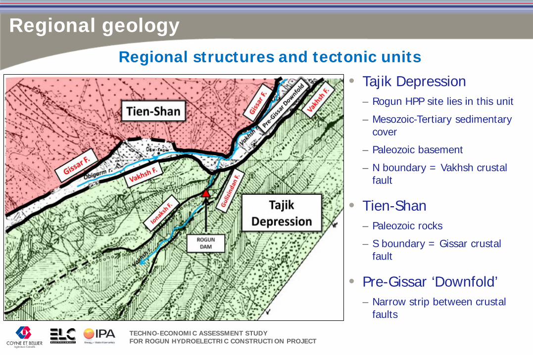
Regional geology
Regional structures and tectonic units • Tajik Depression
– Rogun HPP site lies in this unit
– Mesozoic-Tertiary sedimentary cover
– Paleozoic basement
– N boundary = Vakhsh crustal fault
• Tien-Shan – Paleozoic rocks
– S boundary = Gissar crustal fault
• Pre-Gissar ‘Downfold’ – Narrow strip between crustal
faults

TECHNO-ECONOMIC ASSESSMENT STUDY FOR ROGUN HYDROELECTRIC CONSTRUCTION PROJECT
• Crustal faults – >500 km long, 50 km deep
– Guissar-Kokshal fault, S boundary of Tien Shan
– Illiak-Vakhsh fault, N boundary of the Tajik Depression, with evaporite domes at surface
• Regional faults in the TD – ~100 km long, rooted in
Jurassic salt layer
– Ionaksh fault
– Gulizindan fault
• Local faults – <5 km long
– Fault no.35, in dam foundation
Principal faults
Regional geology

TECHNO-ECONOMIC ASSESSMENT STUDY FOR ROGUN HYDROELECTRIC CONSTRUCTION PROJECT
Regional geology
Tectonic units and regional faults
View upstream
View downstream

TECHNO-ECONOMIC ASSESSMENT STUDY FOR ROGUN HYDROELECTRIC CONSTRUCTION PROJECT
Regional geology
• Background map: recent tectonic deformation
• Knot of faults
• Sharp bend of regional faults to NW: Gissar, Vakhsh
• Sharp bend of the Vakhsh River course to the S – In the reservoir: runs parallel to the
Vakhsh Fault
– Dam site: cuts across the regional geological structures including Ionaksh fault
– Downstream: again parallel to the regional structures
Particularities of the Rogun HPP site

TECHNO-ECONOMIC ASSESSMENT STUDY FOR ROGUN HYDROELECTRIC CONSTRUCTION PROJECT
• 3 units (old to recent):
Marine sedimentary layers (RB) Continental sedimentary layers (LB)
Ionaksh fault
• Upper Jurassic evaporite: halite, gypsum, anhydrite, 400 m thick; 20 m reddish mudstone cap
• Lower Cretaceous continental series: alternant sandstone, siltstone, mudstone, 1100 m thick
• Marine sedimentary series: siltstone, shales, gypsum, dolomite, limestone; often fossiliferous; 550 m thick
Site geology – Lithology

TECHNO-ECONOMIC ASSESSMENT STUDY FOR ROGUN HYDROELECTRIC CONSTRUCTION PROJECT
Top of salt wedge 952-970 masl, close to the GWL
Thickness increasing 15 m / 100 m depth
Base of the salt layer at Rogun HPP site ~2000 m below the river level
The salt wedge is watertight, but the residual cap is locally very permeable
Extrusion rate of salt wedge is estimated at 2.5 cm/year
Site geology – Salt dome

TECHNO-ECONOMIC ASSESSMENT STUDY FOR ROGUN HYDROELECTRIC CONSTRUCTION PROJECT
Site geology - Morphology
River valley across the main geological structures
Favourable topography
Narrow valley, steep slopes
Atypical flat area RB above 1600 masl
Downstream view
Upstream view

TECHNO-ECONOMIC ASSESSMENT STUDY FOR ROGUN HYDROELECTRIC CONSTRUCTION PROJECT
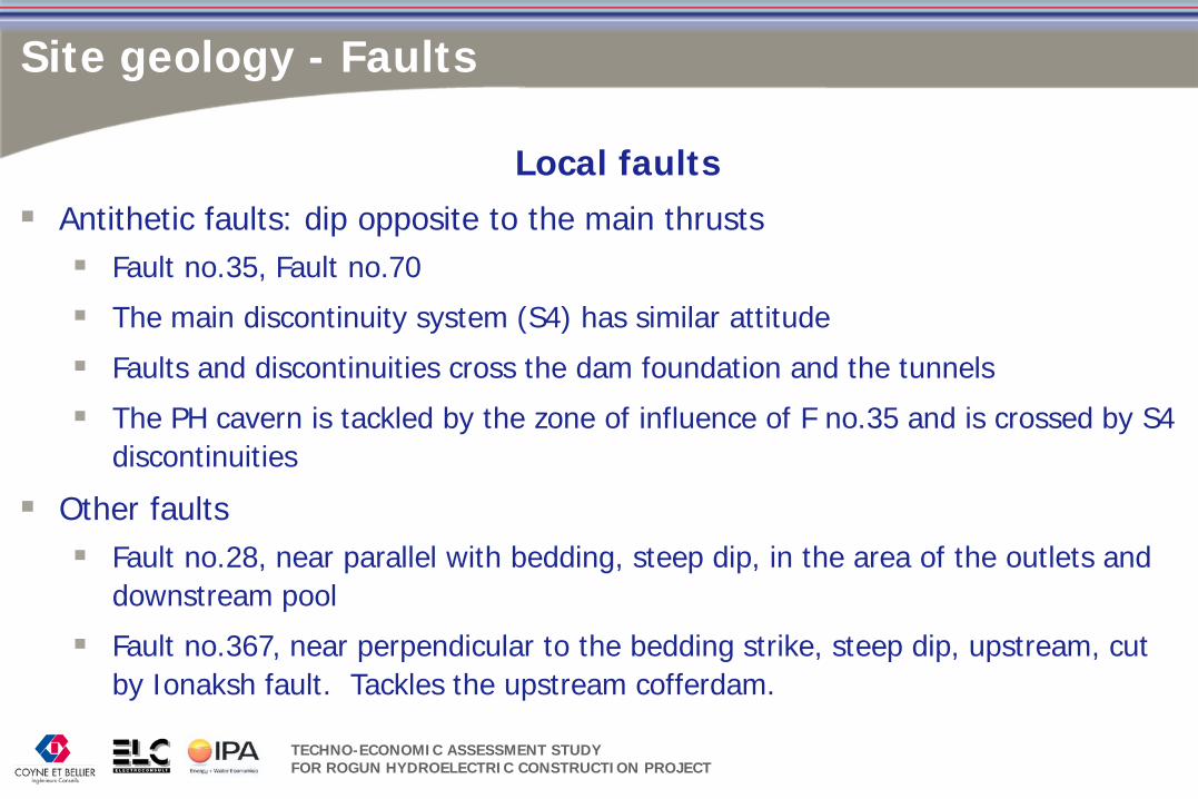
Regional thrust faults: • IONAKSH, GULIZINDAN
Local faults • Antithetic: Fault no.35,
Fault no.70
• Other faults: Fault no.28, Fault no.367
Site geology - Faults

TECHNO-ECONOMIC ASSESSMENT STUDY FOR ROGUN HYDROELECTRIC CONSTRUCTION PROJECT
Site geology - Faults
• IONAKSH fault, GULIZINDAN fault • Rooted in the Jurassic salt layer, salt wedges extruded in the hanging wall • Oriented NE-SW, steep dip SE, SE bloc thrusts over NW bloc • Fault zone acts as hydraulic barrier in the upstream – downstream
direction, except for the residual cap above the salt wedges • IONAKSH fault – medium-high permeability measured in BH-DZ1 in the
atypical zone, at elevation 1450 (150 m above the FSL)
Regional thrust faults within the Tajik Depression unit
TECHNO-ECONOMIC ASSESSMENT STUDY FOR ROGUN HYDROELECTRIC CONSTRUCTION PROJECT
Site geology - Faults
Local faults Antithetic faults: dip opposite to the main thrusts Fault no.35, Fault no.70
The main discontinuity system (S4) has similar attitude
Faults and discontinuities cross the dam foundation and the tunnels
The PH cavern is tackled by the zone of influence of F no.35 and is crossed by S4 discontinuities
Other faults Fault no.28, near parallel with bedding, steep dip, in the area of the outlets and
downstream pool
Fault no.367, near perpendicular to the bedding strike, steep dip, upstream, cut by Ionaksh fault. Tackles the upstream cofferdam.
TECHNO-ECONOMIC ASSESSMENT STUDY FOR ROGUN HYDROELECTRIC CONSTRUCTION PROJECT
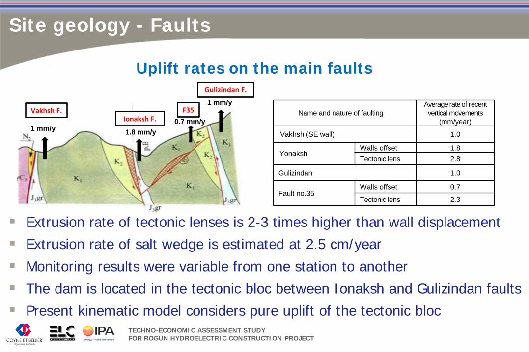
Site geology - Faults
Vakhsh F. Ionaksh F.
Gulizindan F.
1 mm/y 1.8 mm/y
1 mm/y
0.7 mm/y F35
Uplift rates on the main faults
Name and nature of faulting Average rate of recent vertical movements
(mm/year)
Vakhsh (SE wall) 1.0
Yonaksh Walls offset 1.8 Tectonic lens 2.8
Gulizindan 1.0
Fault no.35 Walls offset 0.7
Tectonic lens 2.3
Extrusion rate of tectonic lenses is 2-3 times higher than wall displacement Extrusion rate of salt wedge is estimated at 2.5 cm/year Monitoring results were variable from one station to another The dam is located in the tectonic bloc between Ionaksh and Gulizindan faults Present kinematic model considers pure uplift of the tectonic bloc

TECHNO-ECONOMIC ASSESSMENT STUDY FOR ROGUN HYDROELECTRIC CONSTRUCTION PROJECT
Site geology – Joint pattern
Most conspicuous discontinuity systems: bedding planes and S4 joints, antithetic to regional thrusts
Frequent low angle discontinuities with decimetric offset, uncertain kinematic role
S4 S4
Right Bank Left Bank

TECHNO-ECONOMIC ASSESSMENT STUDY FOR ROGUN HYDROELECTRIC CONSTRUCTION PROJECT
Site geology – Faults and joint pattern
TEAS conclusions
Most of the deformation is accommodated by displacements along the major faults which were studied by monitoring
Part of the deformation is diffuse, takes place as displacement along minor discontinuities
The nature of the deformation on minor discontinuities is not known ( creeping / seismic rupture ?)
The creeping rate on major faults is in the order of 1 – 2 mm/year. The rate of the minor deformation could be one or two orders of magnitude lower: 0.1 to 0.01 mm/year
This diffuse deformation is difficult to predict
The kinematic model should be refined

TECHNO-ECONOMIC ASSESSMENT STUDY FOR ROGUN HYDROELECTRIC CONSTRUCTION PROJECT
Slope stability – General considerations
Rock falls
Frequent occurrence, mainly a safety threat
Recommended: cleaning, rock bolts, wire meshes and monitoring
Landslides involving Quaternary deposits
Well identified since the early stages
Standard mitigation measures are recommended to prevent their development (drainage, reshaping the slopes, retention structures)
Landslides controlled by structural discontinuities (following slides)
Downstream Right Bank
Left Bank

TECHNO-ECONOMIC ASSESSMENT STUDY FOR ROGUN HYDROELECTRIC CONSTRUCTION PROJECT
Atypical zone initially interpreted as ancient landslide, now stabilized
TEAS observations: large scale folding overturning the sequence and small scale, tight, highly plastic folding recalling the bubble wrap folds in the Left Bank
Slope stability – Downstream Right Bank

TECHNO-ECONOMIC ASSESSMENT STUDY FOR ROGUN HYDROELECTRIC CONSTRUCTION PROJECT
Interpretive cross section of the Right Bank
• TEAS conclusions privilege tectonic deformation instead of landslide
• Consequences of this interpretation: • Low risk of massive landslide, provided that pore water pressure is controlled by drainage
• The NE boundary of the atypical zone is not a tear-off landslide boundary
Slope stability – Downstream Right Bank
Recommendations 1. Boreholes to investigate the piezometric level
and the permeability
2. Design of adequate drainage to control the pore water pressure
3. Exploratory gallery for investigation and monitoring of the NE boundary of the atypical zone

TECHNO-ECONOMIC ASSESSMENT STUDY FOR ROGUN HYDROELECTRIC CONSTRUCTION PROJECT
Slope stability – Left Bank
The risk is related with gravitational sliding along S4 discontinuities
S4 discontinuities daylight on the slopes above the Diversion Tunnels inlets and water intake
Damages to reinforced concrete already reported at the inlet of the DT
Risk expected to increase during impounding
Recommendations
Identification of persistent daylighting discontinuities
Carry out stability calculations integrating pore water pressure variation during impounding and fluctuation of reservoir level

TECHNO-ECONOMIC ASSESSMENT STUDY FOR ROGUN HYDROELECTRIC CONSTRUCTION PROJECT
Rock mass ClassThickness or
upper boundary
Modulus of deformability
(GPa)
Permeability (Lugeon Units)
Class I 7 to 40 1.2 - 2.5 20Class II 15-25 to 40-50 3.5 - 4.5 1 - 3Class III Top at 20 - 80 > 4 < 1Class IV Top at 60 - 140 > 4 << 1
The main distinctive characteristics of the rock mass classes (TD, 1978)
TEAS conclusions
Permeability data does not include the anisotropy mudstone/sandstone
High convergence and creeping related with siltstones in PH cavern highlighted the overestimation of rigidity and behaviour of the weak layers
Engineering geology – rock mass zoning

TECHNO-ECONOMIC ASSESSMENT STUDY FOR ROGUN HYDROELECTRIC CONSTRUCTION PROJECT
Engineering geology – Dam foundation
The core is judiciously founded in the mudstones of the Lower Obigarm formation – low permeability, relatively lower fracturing degree at the foundation level.
All unstable rock masses and slope deposits will have to be removed
At this stage, the designed depth of the grout curtain seems appropriate
The design of the lateral extent in the Right Bank has to be based on additional investigations of the GWL and of the permeability
TECHNO-ECONOMIC ASSESSMENT STUDY FOR ROGUN HYDROELECTRIC CONSTRUCTION PROJECT
Engineering geology – PH and TH caverns
The caverns are located principally in sandstone, subordinately in siltstone, deep away from the surface
Monitoring of convergence, geophysical investigations, in situ testing and joint survey showed:
Unexpected weakness of the siltstone rock mass
Impact on stability of S4 discontinuities
The proximity of the Fault no.35 calls for the accurate location of its zone of influence, in order to conceive the appropriate support measures
TECHNO-ECONOMIC ASSESSMENT STUDY FOR ROGUN HYDROELECTRIC CONSTRUCTION PROJECT
Engineering geology – Tunnels
Reported damages to the reinforced concrete lining occurred in different geological settings: Weak zone near Ionaksh fault (inlet of the Diversion Tunnels)
S4 discontinuities (near the inlet of the DT)
Tectonic lens near intersection of Fault no.35 and discontinuity no.111
Major lithological contact between sandstones and siltstones
TEAS conclusion The causes of the damages have to be clearly determined
The lining could be sheared by deformation on minor faults, difficult to predict by the simplified kinematic model involving only major faults
Monitoring of the deformation should be resumed and extended

TECHNO-ECONOMIC ASSESSMENT STUDY FOR ROGUN HYDROELECTRIC CONSTRUCTION PROJECT
Reservoir geology
The reservoir is roughly aligned on the Vakhsh and Gissar fault systems
Particularity: evaporite masses extruded along the Vakhsh fault
Sinkholes in Passimurakho valley
Sinkholes at the foot of the Vakhsh Ridge

TECHNO-ECONOMIC ASSESSMENT STUDY FOR ROGUN HYDROELECTRIC CONSTRUCTION PROJECT
Reservoir geology - landslides
Particular mechanism: slope adapting to dissolution of salt at the foot of the slope
Currently developing in the left bank of Passimurakho valley (photo)
TEAS conclusions • Field observations indicate slow development
• The risk of sudden occurrence of massive sliding seems low
• However, impounding and reservoir level fluctuations are rapid changes of natural conditions. The impact of these changes has to be assessed.

TECHNO-ECONOMIC ASSESSMENT STUDY FOR ROGUN HYDROELECTRIC CONSTRUCTION PROJECT
Reservoir geology - leakage
The shortest potential by-pass would be the Gulizindan Fault
Geological and geophysical investigations showed that this fault is watertight
At Technical Design stage, a 1 km long grouting gallery driven parallel to the fault, upstream along the Obishur valley was envisaged. This preventing measure is supported by TEAS and it should be implemented.

TECHNO-ECONOMIC ASSESSMENT STUDY FOR ROGUN HYDROELECTRIC CONSTRUCTION PROJECT
Assessment in progress
Issues related with the salt dome
Geotechnical assessment
Construction materials