Technical Report on the Sudbury Camp Joint Venture ... - Wallbridge Mining · Sudbury Camp Joint...
72
Technical Report on the Sudbury Camp Joint Venture (SCJV) Projects Located near Sudbury, Ontario Including the Cascaden, Creighton South, Drury, Foy, Skynner Lake, Trill, Trill West, Windy Lake and Worthington Properties Prepared for: Wallbridge Mining Company Limited Prepared by: Attila Péntek, Ph.D., P.Geo. Effective Date: December 31, 2013
Transcript of Technical Report on the Sudbury Camp Joint Venture ... - Wallbridge Mining · Sudbury Camp Joint...
Technical Report on the
Sudbury Camp Joint Venture (SCJV) Projects
Located near Sudbury, Ontario
Including the Cascaden, Creighton South, Drury, Foy, Skynner Lake, Trill,
Trill West, Windy Lake and Worthington Properties
Prepared for:
Wallbridge Mining Company Limited
Prepared by:
Attila Péntek, Ph.D., P.Geo.
Effective Date: December 31, 2013
Page 2 of 72
TABLE OF CONTENTS
Table of Contents .................................................................................................................................................................... 2
List of Tables ........................................................................................................................................................................... 2
List of Figures .......................................................................................................................................................................... 3
1. Executive Summary ............................................................................................................................................................. 4
2. Introduction ...................................................................................................................................................................... 10
3. Reliance on Other Experts................................................................................................................................................. 10
4. Property Description and Location ................................................................................................................................... 11
5. Accessibility, Climate, Local Resources, Infrastructure and Physiography ....................................................................... 22
6. History ............................................................................................................................................................................... 22
7. Geological Setting and Mineralization .............................................................................................................................. 28
8. Deposit Types .................................................................................................................................................................... 44
9. Exploration ........................................................................................................................................................................ 49
10. Drilling ............................................................................................................................................................................. 55
11. Sample Preparation, Analyses, and Security ................................................................................................................... 61
12. Data Verification ............................................................................................................................................................. 62
13. Mineral Processing and Metallurgical Testing ................................................................................................................ 63
14. Mineral Resource Estimates ........................................................................................................................................... 63
15. Mineral Reserve Estimation ............................................................................................................................................ 63
23. Adjacent Properties ........................................................................................................................................................ 63
24. Other Relevant Data and Information ............................................................................................................................ 64
25. Interpretation and Conclusions ...................................................................................................................................... 65
26. Recommendations .......................................................................................................................................................... 70
27. References ...................................................................................................................................................................... 71
Signature Page ...................................................................................................................................................................... 72
LIST OF TABLES
Table 1. The SCJV as of December 31, 2013. ........................................................................................................................ 11
Table 2. SCJV Land Status ...................................................................................................................................................... 13
Table 3. Mineralized grab samples from the Nipissing Gabbro-hosted Ni-Cu-(PGE) showing near the southern property
boundary on the West Block ................................................................................................................................................. 37
Table 4. Mineralized grab samples taken from alteration in Nipissing Gabbro on the West Block ..................................... 38
Table 5. Mineralized grab sample taken from leucogabbro on the Central Block ............................................................... 38

Page 3 of 72
Table 6. Mineralized grab samples from Cu-Au-Ag bearing quartz-veins in metavolcanic unit on the Central Block ......... 38
Table 7. Diamond drill hole intersects from Ryanor’s 1973 drill campaign .......................................................................... 38
Table 8. Mineralized grab samples from the metavolcanic/metasedimentary-hosted Cu mineralization .......................... 39
Table 9. Summary of assay results from the sulfide intersection in WSK-026 .................................................................... 39
Table 10. Channel sample highlights from the Trill Ni-Cu-PGE Showing .............................................................................. 40
Table 11. Highlight drill hole intersections from the Trill Ni-Cu-PGE Showing ..................................................................... 41
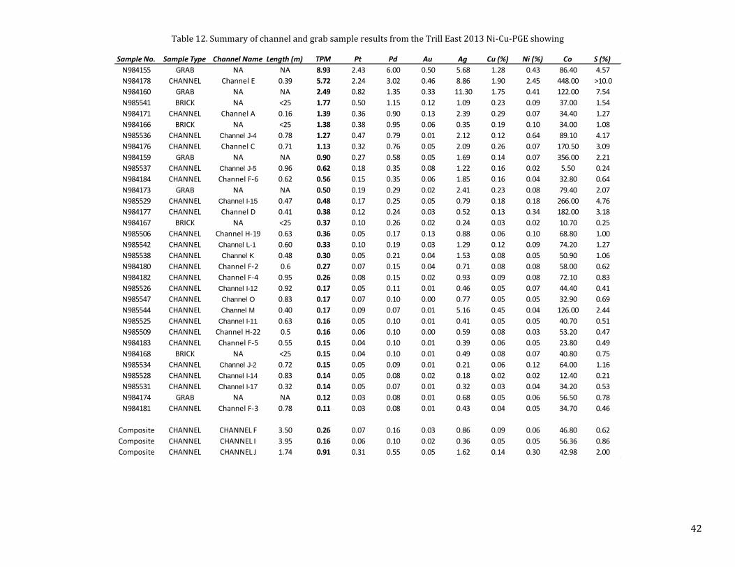
Table 12. Summary of channel and grab sample results from the Trill East 2013 Ni-Cu-PGE showing ............................... 42
Table 13. Mineralized drill hole intercepts of Cu-Ni-PGE mineralization at the Windy Lake Embayment ........................... 43
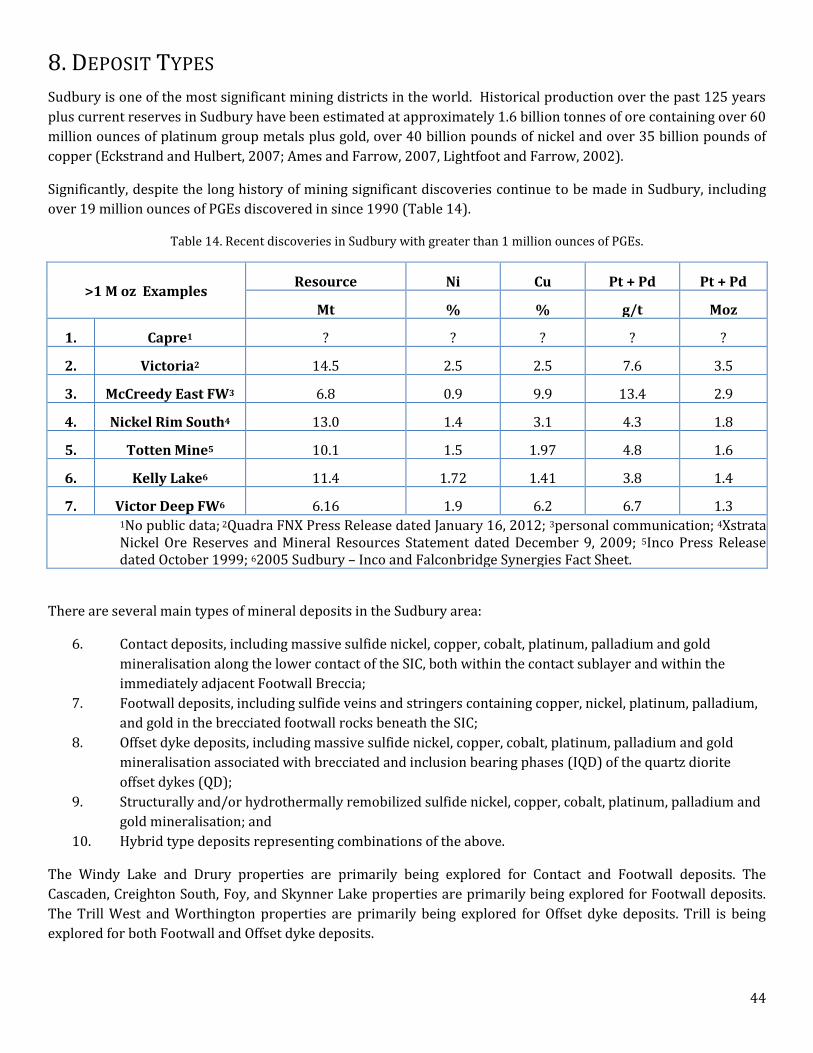
Table 14. Recent discoveries in Sudbury with greater than 1 million ounces of PGEs. ........................................................ 44
Table 15. Wallbridge drilling on the Cascaden property ...................................................................................................... 55
Table 16. Wallbridge drilling on the Creighton South Property ........................................................................................... 55
Table 17. Wallbridge drilling on the Drury Property ............................................................................................................. 55
Table 18. Wallbridge drilling on the Foy Property ................................................................................................................ 55
Table 19. Wallbridge drilling on the Skynner lake Property ................................................................................................. 56
Table 20. Wallbridge drilling carried out on the Trill Property ............................................................................................. 57
Table 21. Wallbridge drilling on the Trill West property ...................................................................................................... 59
Table 22. Wallbridge drilling on the Windy Lake property ................................................................................................... 59
Table 23. Wallbridge drilling on the Worthington property ................................................................................................. 60
Table 24. Approved 2014 SCJV Scope of Work ..................................................................................................................... 70
LIST OF FIGURES
Figure 1. SCJV location and property map. ........................................................................................................................... 12
Figure 2. Sudbury Igneous Complex and Offset Dykes (Ames and Farrow, 2007). .............................................................. 29
Figure 3. Compilation map of the Cascaden and Windy Lake Properties (Bailey, 2011). ..................................................... 30
Figure 4. Creighton South Property Geology (Bailey, 2011). ................................................................................................ 31
Figure 5. Compilation map of the Drury and Worthington Properties. ................................................................................ 32
Figure 6. Foy Property Geology showing Levack gneiss (stippled purple) and Sudbury breccia structures (yellow)(Bailey,
2011). .................................................................................................................................................................................... 33
Figure 7. Compilation map of the Skynner Lake Property .................................................................................................... 34
Figure 8. Compilation map of the Trill Property ................................................................................................................... 35
Figure 9. Compilation map of the Trill West property. ......................................................................................................... 36
Figure 10. Schematic Contact/Footwall Deposit Model after Davis, 2007. .......................................................................... 47
Figure 11. Long section section of the Copper Cliff Offset dyke (Farrow and Lightfoot, 2002). .......................................... 48
Figure 12. Long Section of the Victoria deposit (Frayne, 2013). ........................................................................................... 48
Page 4 of 72
1. EXECUTIVE SUMMARY
INTRODUCTION The Sudbury Camp Joint Venture (SCJV) was formed between Wallbridge Mining Company Limited (Wallbridge)
and Lonmin Plc (Lonmin) on January 14, 2002, to explore a suite of Wallbridge properties near Sudbury for
platinum group metals (PGEs).
This technical report was prepared by Wallbridge technical staff to summarize the results of exploration on the
SCJV properties to December 31, 2013 and to provide recommendations for further work. This report has been
prepared in compliance with the requirements of National Instrument 43-101 and Form 43-101F1 and was
prepared for use in support of the disclosure made in its Annual Information Form. Attila Péntek, Ph.D., P.Geo.,
Senior Geologist for Wallbridge Mining Company Limited, is the Qualified Person responsible for the technical
content of this report. The author has been actively taking part in the planning, supervision and execution of
exploration programs on the SCJV properties and has visited the properties most recently in March 2014. A list of
specific reference material is provided at the end of this report.
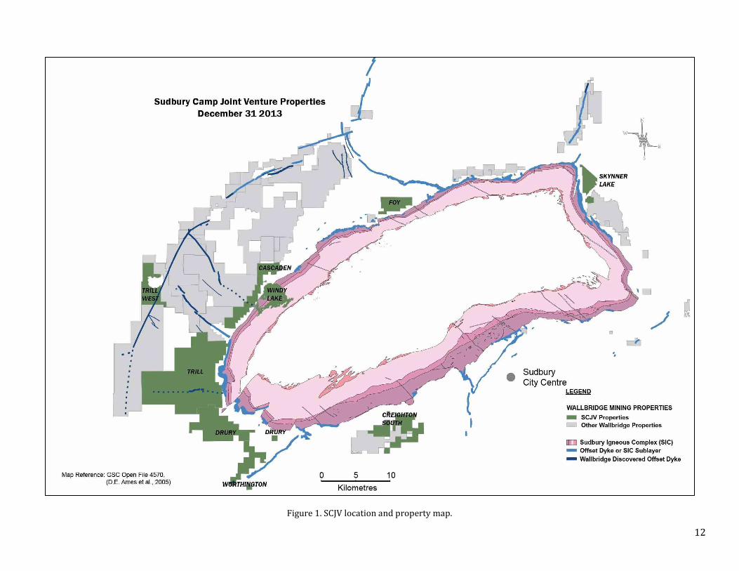
PROPERTY DESCRIPTION AND LOCATION SCJV consists of nine Wallbridge properties including the Cascaden, Creighton South, Drury, Foy, Skynner Lake,
Trill, Trill West, Windy Lake and Worthington. These include 112 unpatented mining claims, three patents, one
lease and an Exploratory License of Occupation that cover a total of 202 square kilometres in the Sudbury area.
THE SUDBURY CAMP JOINT VENTURE AGREEMENT The SCJV properties are subject to the Sudbury Camp Joint Venture Agreement between Wallbridge Mining
Company Limited (Wallbridge) and Lonmin Plc (Lonmin) dated January 14, 2002. Under the terms of the SCJV
Agreement, Lonmin must fund a minimum of $1 million in expenditures each year to maintain the option to earn
up to a 50 % interest in any property, based on its proportionate spend, at the point at which an Indicated
Resource is established on that property. Lonmin has the option to earn an additional 15 % interest by funding
work through completion of a feasibility study and securing the Wallbridge portion of financing through to
commercial production.
CALLINAN ROYALTIES CORPORATION AGREEMENT The Drury and Worthington properties are subject to a Master Agreement, First Option Agreement, and Second
Option Agreement with Callinan Royalties Corporation (Callinan), each dated December 12, 2012. Under these
agreements, Callinan may purchase up to a 2% NSR royalty on the Drury and Worthington properties at any time
during the option term by paying the following:
For the first 1 % NSR, $2M with an inflation adjustment, and
For the second 1 % NSR, a value equal to the after-tax NPV using a negotiated discount rate.
GEOLOGICAL SETTING AND MINERALIZATION Ni-Cu-PGE deposits in Sudbury occur within and adjacent to the Sudbury Structure that formed as a result of a
major Early Proterozoic meteorite impact 1,850 million years ago (Ames and Farrow, 2007; Figure 2). The
Sudbury Structure straddles the unconformity between Archean gneisses and plutons of the Superior Province and
overlying Paleoproterozoic Huronian supra-crustal rocks of the Southern Province. It is geographically divided
into the North, South, and East Ranges and comprises four geologic domains:
1. The Sudbury Igneous Complex (SIC) occurs as a 60 km x 27 km elliptical bowl-shaped body that formed
from a meteorite impact melt sheet. It consists of a basal xenolithic norite breccia (contact sublayer)

Page 5 of 72
overlain by norite, quartz-gabbro and granophyre and historically has been referred to as the "Nickel-
Bearing Irruptive", the "Sudbury Nickel Irruptive" and the "Nickel Irruptive".
2. Concentric and radial dykes of diorite, granodiorite, and quartz diorite.
3. The footwall to the SIC contains a zone, up to 80 km wide, of Archean and Proterozoic rocks that are
fractured, brecciated (Sudbury breccia), and locally partially melted (e.g. Late Granite Breccia) or
recrystallized due to the meteorite impact and subsequent emplacement of the SIC.
4. The SIC is overlain by the Whitewater Group, comprising “fall-back” super-crustal breccia of the
Onaping Formation and the overlying basin-fill sedimentary rocks of the Onwatin and Chelmsford
Formations.
MINERALIZATION Cascaden
The highest precious metal concentrations were found on the North Block and include samples returning 661 ppb
TPM and 79 ppb TPM. The latter is of particular interest in that it also had anomalous levels of copper, silver,
bismuth, tin, and tellurium and occurred within a large area of thermally altered Sudbury breccia that is mapped as
a pronounced magnetic low.
Historical grab samples on the Peninsula block assayed up to 1.72 % Cu and 0.81 % Ni in disseminations and veins
of pyrrhotite, pyrite and chalcopyrite mineralization. Sampling by Wallbridge returned values up to 0.77 % Cu, up
to 0.05 % Ni, and very weakly anomalous precious metals (up to 25ppb TPM). In the central portion of the
Peninsula Block, up to 5 % disseminated pyrite and chalcopyrite mineralization occurs with coarse epidote (±
amphibole) alteration in fracture fillings, massive patches, veinlets and stockworks. This mineralization is in an
area of thermally altered and bleached Sudbury breccia and thus may represent a dispersion halo of Sudbury type
mineralization.
Disseminated pyrite, chalcopyrite and pyrrhotite mineralization occur across the Cascaden property and is likely
Archean in age and of little economic significant.
Creighton South
In 2005, drill hole WG-004 intersected 0.395g/t TPM (0.18 g/t Pt, 0.19 g/t Pt and 0.02 g/t Au) over a 0.3 metre
wide zone of chlorite, biotite, and pyrite alteration with trace chalcopyrite. Fluid inclusion analysis of the alteration
assemblage reported high temperature (>400°C) and highly saline (>60wt. % equiv. NaCl) conditions, similar to
fluid inclusion results from footwall ore zones throughout Sudbury.
Grab samples from several generations of quartz veins on the property carry up to 1.48 % Cu and 0.431 ppm Au.
The different generations of these veins have not been well defined and their relationship to the SIC is uncertain.
Drury
Several mineralization styles have been identified and sampled on the property. These include:
Nipissing Gabbro-hosted Ni-Cu-PGE
Semi-massive to massive pyrrhotite and minor chalcopyrite as well as veinlets of quartz-chalcopyrite occur beside
two historical pits close to the southern property boundary of the West Block. The mineralization trends NW-SE
parallel to the Nipissing Gabbro intrusion over a strike length of approximately 200 m.
In 2012 narrow mm-scale chalcopyrite veinlets associated with pervasive quartz-chlorite alteration/veining was
located in Nipissing Gabbro approximately 300 m away from the showing described above. Sample N986030 taken
at this location returned favorable PGE tenors with 1.5 g/t TPM associated with 0.71 % Cu.

Page 6 of 72
Leucogabbro-hosted (Drury Intrusion?) Ni-Cu-PGE
A 1 metre diameter patch containing blebby chalcopyrite was found hosted in coarse-grained leucogabbro of what
is believed to be Drury Intrusion, part of the East Bull Lake suite. The sample N984477 taken at this location
contained 1.01 g/t TPM and 1.82 % Cu.
Quartz-vein associated Au-Cu
Chalcopyrite mineralization was found associated with massive quartz veins cutting a metavolcanic unit in one
location on the Central Block. The mineralization contains anomalous Au and Ag concentrations.
Metavolcanic/metasediment-hosted Cu
In 1968 Rio Tinto and 1973 Ryanor conducted drilling and trenching to test a zone of copper mineralization hosted
in metavolcanic/metasedimentary in the Central Block. This mineralization style is probably pre-Sudbury in origin.
The mineralization contains Cu ± anomalous Ni and no anomalous PGE’s.
Foy
In south-central Foy, precious metal values up to 1.0g/t TPM and copper values of 0.79% and 0.12% with
anomalous Ag and Te were found in two samples of intermediate gneiss. The samples contained 10-15% pyrite ±
chalcopyrite and were collected on the contact with Sudbury breccia.
In the south-western portion of the property, samples of partially melted felsic gneiss with pyrite and extensive
epidote alteration returned 696ppm Cu and 23ppb TPM. Both of these occurrences may reflect primary dispersion
haloes of Sudbury-type footwall mineralization.
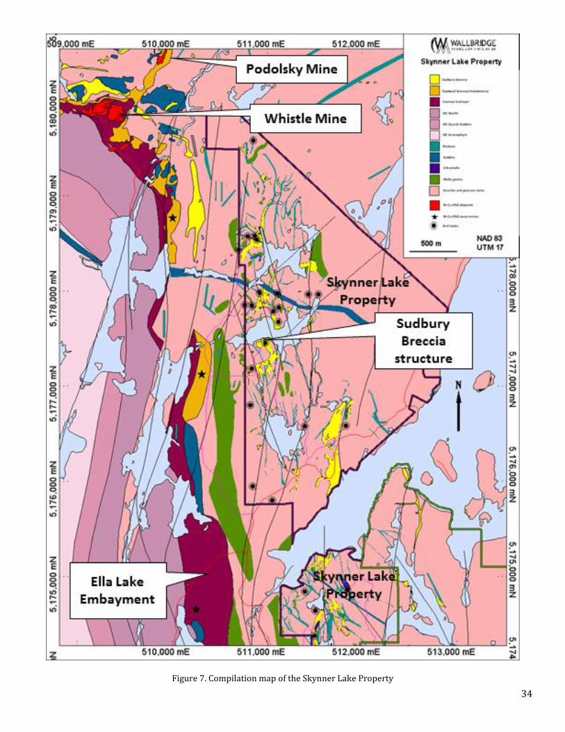
Skynner Lake
No SIC-related mineralization was identified on the property.
Occurrences of semi-massive and massive sulfide have been found in several areas in the property. These zones
occur in intermediate to mafic gneisses, follow the fabric of these rocks and are believed to be pre-Sudbury
(Archean?) in origin. The mineralization is dominated by pyrrhotite and pyrite with minor amounts of chalcopyrite
and is of little economic interest. Most recently in 2013, hole WSK-026 intersected an approximately 40 m wide
zone of such mineralization, Table 8 shows the assays results from the samples with anomalous Cu, Ni and Ag
values.
Trill
Trill Showing Ni-Cu-PGE mineralization
In June of 2005, a high grade Ni-Cu-PGE sulfide lens was discovered on the Trill property hosted within the
previously unrecognized Trill Offset dyke. The massive sulfide lens is approximately 65 m long, 5 m wide, dips
steeply to the north and is known to extend to about 35 m depth. Mineralization consists of pyrrhotite,
chalcopyrite, pentlandite, pyrite and magnetite within an inclusion quartz diorite which is flanked by a non-
inclusion phase of quartz diorite. These relationships are typical of offset hosted Ni-Cu-PGE mineralization in the
Sudbury camp. Minor violarite occurs as an oxidation product of pentlandite and merenskyite and michenerite
were identified as the main PGE-bearing phases using electron microprobe analysis. There is a crude zonation in
the mineralization where the core contains massive or inclusion bearing nickel-rich sulphides whereas the flanks
contain copper-rich vein and disseminated style mineralization.
Trill East Ni-Cu-PGE Showing
In September 2013 a new Ni-Cu-PGE showing was discovered during mechanical stripping of a new occurrence of
Inclusion QD in the Eastern part of the Trill property. The pyrite-pyrrhotite-chalcopyrite-millerite mineralization
Page 7 of 72
occurs mainly as irregular veins, and blebs within a chaotic breccia unit at the contact of the Trill Offset with
Sudbury breccia and granite. This assimilation/mixing breccia is referred to as metabreccia or footwall breccia
based on analogues in other Sudbury offset dyke settings. Pyrite-dominated hydrothermal veins occur cutting
granite and Sudbury breccia and contain the highest PGE tenors.
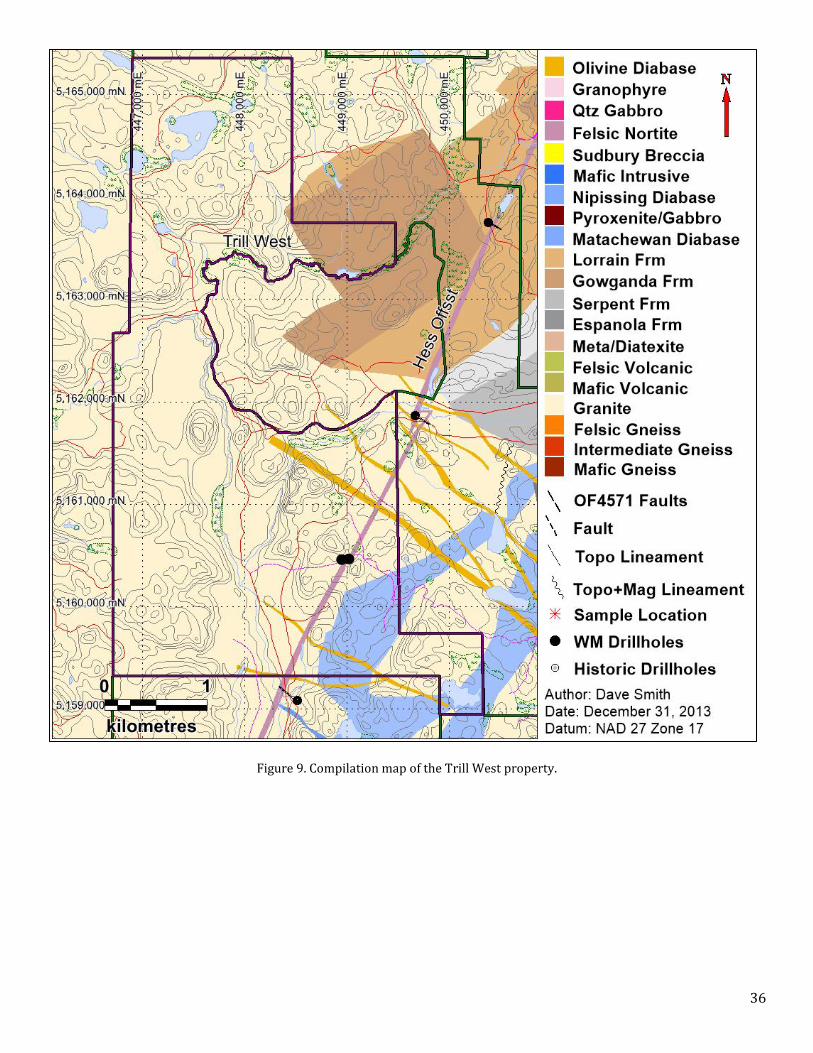
Trill West
Two kilometre strike length of the Hess Offset Dyke occurs on the Trill West property. Trenching exposed blebby
to vein-style sulfide mineralization in Inclusion-bearing QD with grab sample results up to 0.65 g/t TPM (0.24 g/t
Pt, 0.34 g/t Pd, 0.07 g/t Au), 0.17 % Cu and 0.13 % Ni.
Windy Lake
Drilling at Windy Lake has identified contact-style pyrrhotite-pentlandite-chalcopyrite mineralization hosted within sublayer norite and minor footwall Cu-PGE sulfide hosted in the footwall rocks. See mineralized drill hole intersects in.
Worthington
The Worthington property hosts a four hundred metre strike length of the Worthington Offset Dyke. Trenching and
drilling on the property located weak, blebby Ni-Cu-PGE mineralization hosted within the dyke. The best intercept
was 0.49 g/t Pt + Pd + Au over 1.5 m.
Nipissing Gabbro on the property hosts several showings of Ni-Cu mineralization. Grab sample values from these
showings contained up to 1.07 % Cu and 0.69 %. The Nipissing gabbro on the property has not been explored in a
systematic and detailed manner.
DEPOSIT TYPES Sudbury is one of the most significant mining districts in the world. Historical production over the past 125 years
plus current reserves in Sudbury have been estimated at approximately 1.6 billion tonnes of ore containing over 60
million ounces of platinum group metals plus gold, over 40 billion pounds of nickel and over 35 billion pounds of
copper (Eckstrand and Hulbert, 2007; Ames and Farrow, 2007, Lightfoot and Farrow, 2002).
Significantly, despite the long history of mining significant discoveries continue to be made in Sudbury, including
over 19 million ounces of PGEs discovered in since 1990.
There are several main types of mineral deposits in the Sudbury area:
1. Contact deposits, including massive sulfide nickel, copper, cobalt, platinum, palladium and gold
mineralisation along the lower contact of the SIC, both within the contact sublayer and within the
immediately adjacent Footwall Breccia;
2. Footwall deposits, including sulfide veins and stringers containing copper, nickel, platinum, palladium,
and gold in the brecciated footwall rocks beneath the SIC;
3. Offset dyke deposits, including massive sulfide nickel, copper, cobalt, platinum, palladium and gold
mineralisation associated with brecciated and inclusion bearing phases (IQD) of the quartz diorite
offset dykes (QD);
4. Structurally and/or hydrothermally remobilized sulfide nickel, copper, cobalt, platinum, palladium and
gold mineralisation; and
5. Hybrid type deposits representing combinations of the above.
The Windy Lake and Drury properties are primarily being explored for Contact and Footwall deposits. The
Cascaden, Creighton South, Foy, and Skynner Lake properties are primarily being explored for Footwall deposits.

Page 8 of 72
The Trill West and Worthington properties are primarily being explored for Offset dyke deposits. Trill is being
explored for both Footwall and Offset dyke deposits.
DRILLING So far the SCJV has completed 138 drill holes totalling 71,684 metres on the nine properties.
INTERPRETATION AND CONCLUSIONS In terms of metal endowment, infrastructure, community support and regulatory stability, Sudbury is the most
attractive place in the world to explore for and develop large-scale copper, nickel and PGE mining projects. Despite
over 125 years of mining in the Sudbury area, very large and high grade deposits continue to be discovered.
All of the Sudbury Camp Joint Venture properties contain favourable geology for Sudbury-type deposits. A number
of geological/structural targets have been identified on each of the properties which warrant systematic deep
drilling. Highlights of the activities on SCJV properties are:
Identification of chargeability anomalies and drill targets within the strongly recrystallized Sudbury breccia
structure at Skynner Lake on the East Range of the Sudbury basin between Vale’s Victor-Capre
development project and KGHM International’s Podolsky mine,
High grade platinum group metals, nickel and copper sulfide along a 140 m mineralized trend within the
Trill Offset dyke that was discovered by Wallbridge in 2005 with drill hole intersections including 6.41 g/t
Pt + Pd + Au, 0.79 % Cu and 1.2 % Ni over 10.3 metres in WTR-012 and 8.11 g/t Pt + Pd + Au, 1.01 % Cu
and 0.81 % Ni over 8.76 metres in WTR-028. Discovery of the Trill East showing in 2013 with grab and
brick samples up to 8.93 g/t Pt + Pd + Au, 1.9 % Cu and 2.45 % Ni.
The discovery of two km of Hess Offset dyke on the Trill West Property in 2010 including disseminated
nickel, copper and PGE sulfide mineralization associated with inclusion bearing phases of the dyke. Surface
sampling has returned maximum values of 0.24 g/t Pt, 0.34 g/t Pd, 0.07 g/t Au, 0.3 % Ni and 0.17 % Cu,
Identification of a large unexplored section of the basal contact of the Sudbury Igneous Complex (SIC) at
Windy Lake immediately adjacent to numerous deposits, active mines and past producing mines in the
Onaping-Levack area,
Identification of chargeability anomaly drill targets within the Sudbury breccia structure at Foy with
several occurrences of weak mineralization including up to 1.0 g/t TPM and
The intersection of Sudbury breccia structures at Creighton South which extend from the nearby giant
deposits at Vale’s Frood-Stobie and Creighton mine and KGHM International’s Victoria discovery.
Several showings of Ni-Cu-PGE mineralization occur in East Bull Lake- and Nipissing-suite mafic rocks of
the Drury property. Grab samples returned up to 1.82 % Cu and 1.52 g/t Pt + Pd + Au. The South Range
Shear Zone exits the SIC in this area and due to the large-scale displacements along the contact there is a
possibility for the occurrence of SIC outliers.
There is a 400 m strike length of the Worthington Offset Dyke with blebby sulfide mineralization located on
the Worthington property.

Page 9 of 72
RECOMMENDATIONS Currently, the 2014 SCJV scope of work and budget approved at the Joint Venture Exploration Committee meeting
held October 17th, 2013, is underway. The approved 2014 budget totals USD $1,600,000 funded by Lonmin, a large
portion of which ($1,228,606) is budgeted for Trill property.
The approved scope of work and budget includes further trenching, detailed mapping, structural analysis, line
cutting, surface EM, drilling and BHEM in Trill property and further drilling in Skynner property as well as minor
maintenance and survey for Cascaden, Creighton South, Foy, Windy Lake and Trill West properties.
Approved 2014 SCJV Scope of Work
In addition to the 2014 Scope of Work further significant work is required on the SCJV properties to explore for Ni-
Cu-PGE mineralization.
10
2. INTRODUCTION
The Sudbury Camp Joint Venture (SCJV) was formed between Wallbridge Mining Company Limited (Wallbridge)
and Lonmin Plc (Lonmin) on January 14, 2002, to explore a suite of Wallbridge properties near Sudbury for
platinum group metals (PGEs).
This technical report was prepared by Wallbridge technical staff to summarize the results of exploration on the
SCJV properties to December 31, 2013 and to provide recommendations for further work. This report has been
prepared in compliance with the requirements of National Instrument 43-101 and Form 43-101F1 and was
prepared for use in support of the disclosure made in its Annual Information Form. Attila Péntek, Ph.D., P.Geo.,
Senior Geologist for Wallbridge Mining Company Limited, is the Qualified Person responsible for the technical
content of this report. The author has been actively taking part in the planning, supervision and execution of
exploration programs on the SCJV properties and has visited the properties most recently in March 2014. A list of
specific reference material is provided at the end of this report.
Metric units are used throughout this report unless otherwise specified. Assay and analytical results are quoted in
grams per tonne (g/t), parts per million (ppm), parts per billion (ppb) or weight percent (%). 1 g/t is equivalent to
1 ppm and 1000 ppb; 10,000 g/t is equivalent to 1%. Total precious metals (TPM) are the sum of platinum (Pt),
palladium (Pd) and gold (Au) values returned for a sample. The abbreviation for copper is Cu and nickel is Ni.
Conversion to grams per metric tonne (g/t) is done by multiplying troy ounces per short ton (Oz/t) by 34.2857142.
All dollar amounts are expressed in Canadian funds.
3. RELIANCE ON OTHER EXPERTS
Third party contractors performed and interpreted geophysical surveys for the SCJV on various properties as
indicated through the report. Similarly, third party ISO certified laboratories performed analytical work, as
described in Sections 11 and 12. The author has made every reasonable effort to ensure data quality but cannot
absolutely guarantee the data integrity. Based on their review of third party data, the author has no reason to
believe that significant errors in the data exist.

11
4. PROPERTY DESCRIPTION AND LOCATION
SCJV consists of nine Wallbridge properties including the Cascaden, Creighton South, Drury, Foy, Skynner Lake,
Trill, Trill West, Windy Lake and Worthington (Figure 1). These include 112 unpatented mining claims, three
patents, one lease and an Exploratory License of Occupation that cover a total of 202 square kilometres in the
Sudbury area (Table 1).
THE SUDBURY CAMP JOINT VENTURE AGREEMENT The SCJV properties are subject to the Sudbury Camp Joint Venture Agreement between Wallbridge Mining
Company Limited (Wallbridge) and Lonmin Plc (Lonmin) dated January 14, 2002. Under the terms of the SCJV
Agreement, Lonmin must fund a minimum of $1 million in expenditures each year to maintain the option to earn
up to a 50 % interest in any property, based on its proportionate spend, at the point at which an Indicated
Resource is established on that property. Lonmin has the option to earn an additional 15 % interest by funding
work through completion of a feasibility study and securing the Wallbridge portion of financing through to
commercial production.
CALLINAN ROYALTIES CORPORATION AGREEMENT The Drury and Worthington properties are subject to a Master Agreement, First Option Agreement, and Second
Option Agreement with Callinan Royalties Corporation (Callinan), each dated December 12, 2012. Under these
agreements, Callinan may purchase up to a 2% NSR royalty on the Drury and Worthington properties at any time
during the option term by paying the following:
For the first 1 % NSR, $2M with an inflation adjustment, and
For the second 1 % NSR, a value equal to the after-tax NPV using a negotiated discount rate.
Table 1. The SCJV as of December 31, 2013.
Project Hectares Property description Terms
1 Cascaden 1,696 Staked claims 100% Wallbridge
2 Creighton South 8,957.22 Staked claims, patent 100% Wallbridge
3 Drury 2784 Staked claims 100% Wallbridge
4 Foy 1,248 Staked claims 100% Wallbridge
5 Skynner Lake 1,179 Staked claims 100% Wallbridge
6 Trill 1,776 Staked claims, mining lease, patent 100% Wallbridge
7 Trill West 816 Staked claims 100% Wallbridge
8 Windy Lake 672 Exploratory license 100% Wallbridge
9 Worthington 1088.75 Staked claims, patent 100% Wallbridge
Total 20,216.97
12
Figure 1. SCJV location and property map.
13
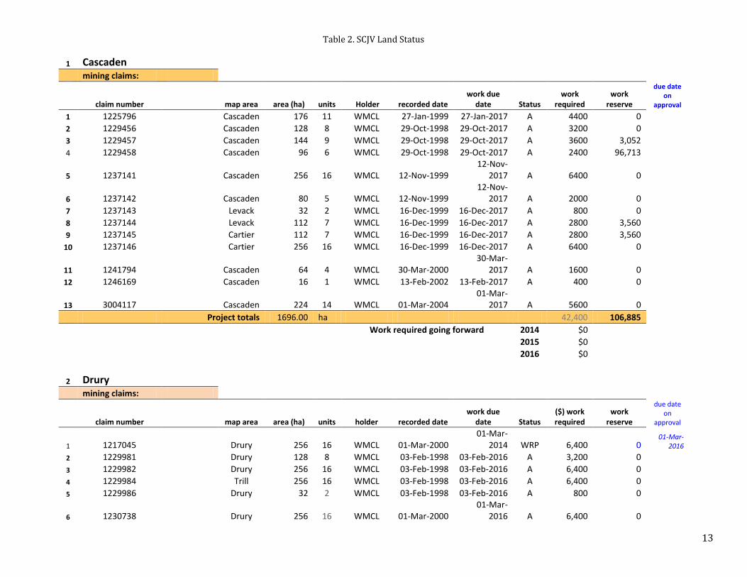
Table 2. SCJV Land Status
1 Cascaden mining claims:
claim number map area area (ha) units Holder recorded date work due
date Status work
required work
reserve
due date on
approval
1 1225796
Cascaden 176 11 WMCL 27-Jan-1999 27-Jan-2017 A 4400 0 2 1229456
Cascaden 128 8 WMCL 29-Oct-1998 29-Oct-2017 A 3200 0 3 1229457
Cascaden 144 9 WMCL 29-Oct-1998 29-Oct-2017 A 3600 3,052 4 1229458
Cascaden 96 6 WMCL 29-Oct-1998 29-Oct-2017 A 2400 96,713
5 1237141
Cascaden 256 16 WMCL 12-Nov-1999 12-Nov-
2017 A 6400 0
6 1237142
Cascaden 80 5 WMCL 12-Nov-1999 12-Nov-
2017 A 2000 0 7 1237143
Levack 32 2 WMCL 16-Dec-1999 16-Dec-2017 A 800 0 8 1237144
Levack 112 7 WMCL 16-Dec-1999 16-Dec-2017 A 2800 3,560 9 1237145
Cartier 112 7 WMCL 16-Dec-1999 16-Dec-2017 A 2800 3,560 10 1237146
Cartier 256 16 WMCL 16-Dec-1999 16-Dec-2017 A 6400 0
11 1241794
Cascaden 64 4 WMCL 30-Mar-2000 30-Mar-
2017 A 1600 0 12 1246169
Cascaden 16 1 WMCL 13-Feb-2002 13-Feb-2017 A 400 0
13 3004117 Cascaden 224 14 WMCL 01-Mar-2004 01-Mar-
2017 A 5600 0 Project totals 1696.00 ha 42,400 106,885
Work required going forward 2014 $0
2015 $0
2016 $0
2 Drury
mining claims:
claim number map area area (ha) units holder recorded date work due
date Status ($) work required
work reserve
due date on
approval
1 1217045
Drury 256 16 WMCL 01-Mar-2000 01-Mar-
2014 WRP 6,400 0 01-Mar-
2016
2 1229981
Drury 128 8 WMCL 03-Feb-1998 03-Feb-2016 A 3,200 0 3 1229982
Drury 256 16 WMCL 03-Feb-1998 03-Feb-2016 A 6,400 0 4 1229984
Trill 256 16 WMCL 03-Feb-1998 03-Feb-2016 A 6,400 0 5 1229986
Drury 32 2 WMCL 03-Feb-1998 03-Feb-2016 A 800 0
6 1230738
Drury 256 16 WMCL 01-Mar-2000 01-Mar-
2016 A 6,400 0
14
7 1230739
Drury 256 16 WMCL 01-Mar-2000 01-Mar-
2016 A 6,400 0
8 1230740
Drury 176 11 WMCL 01-Mar-2000 01-Mar-
2016 A 4,400 0 9 1246137 Hyman 256 16 WMCL 17-Jul-2002 17-Jul-2014 abn 0 0 10 1246138
Hyman 208 13 WMCL 17-Jul-2002 17-Jul-2014 abn 0 0 11 1246139
Hyman 256 16 WMCL 17-Jul-2002 17-Jul-2014 abn 0 0 12 1246141 Hyman 128 8 WMCL 17-Jul-2002 17-Jul-2014 abn 0 0 13 3018868
Drury 256 16 WMCL 03-Feb-1998 03-Feb-2016 A 6,400 0
14 4212983 isolated Drury 64 4 WMCL 13-Mar-2008 13-Mar-
2014 abn 0 0 Project totals 2784 ha 46,800 $0
Work required going forward 2014 $0
2015 $0
2016 $0
Note:
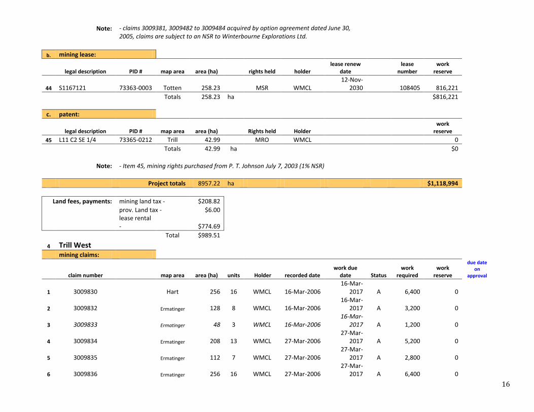
3 Trill
a. mining claims:
claim number map area area (ha) units Holder recorded date work due
date Status work
required work
reserve
due date on
approval
1 1167119
Totten 256 16 WMCL 23-Oct-2001 23-Oct-2016 A 6,400 0 2 1167120
Totten 256 16 WMCL 23-Oct-2001 23-Oct-2016 A 6,400 0
3 1229363
Trill 256 16 WMCL 29-Oct-1998 29-Oct-2015 WRP 6,400 0 29-Oct-
2016
4 1229501
Trill 80 5 WMCL 23-Jun-1998 23-Jun-2016 A 2,000 0
5 1229502
Trill 176 11 WMCL 23-Jun-1998 23-Jun-2015 WRP 4,400 0 23-Jun-
2016
6 1229503
Trill 160 10 WMCL 23-Jun-1998 23-Jun-2015 WRP 4,000 0 23-Jun-
2016
7 1229948
Trill 256 16 WMCL 21-Feb-2000 21-Feb-2016 A 6,400 26,795
8 1229976
Trill 240 15 WMCL 03-Feb-1998 03-Feb-2015 WRP 6,000 178,485 03-Feb-
2016
9 1229977
Trill 256 16 WMCL 03-Feb-1998 03-Feb-2015 WRP 6,400 0 03-Feb-
2016
10 1230737
Trill 96 6 WMCL 21-Feb-2000 21-Feb-2015 WRP 2,400 0 21-Feb-
2016
11 1241793
Trill 48 3 WMCL 30-Mar-2000 30-Mar-
2016 A 1,200 0 12 1246135
Trill 48 3 WMCL 18-Jun-2002 18-Jun-2016 A 1,200 0 13 3009381 Winterbourne Totten 96 6 WMCL 04-Jun-2004 04-Jun-2016 A 2,400 0 14 3009482 Winterbourne Totten 256 16 WMCL 04-Jun-2004 04-Jun-2016 A 6,400 81,019 15 3009483 Winterbourne Totten 256 16 WMCL 04-Jun-2004 04-Jun-2016 A 6,400 0
15
16 3009484 Winterbourne Totten 256 16 WMCL 04-Jun-2004 04-Jun-2016 A 6,400 13,296 17 3017386
Totten 32 2 WMCL 07-Jul-2005 07-Jul-2016 A 800 0 18 3017425
Totten 32 2 WMCL 07-Jul-2005 07-Jul-2016 A 800 0 19 3018802
Totten 256 16 WMCL 25-Jul-2005 25-Jul-2015 A 6,400 0 20 3018803
Totten 256 16 WMCL 25-Jul-2005 25-Jul-2015 A 6,400 0 21 3018804
Totten 256 16 WMCL 25-Jul-2005 25-Jul-2016 A 6,400 0 22 3018805
Totten 256 16 WMCL 25-Jul-2005 25-Jul-2016 A 6,400 0 23 3018806
Totten 256 16 WMCL 25-Jul-2005 25-Jul-2016 A 6,400 0 24 3018807
Totten 256 16 WMCL 25-Jul-2005 25-Jul-2015 A 6,400 0 25 3018808
Totten 256 16 WMCL 25-Jul-2005 25-Jul-2016 A 6,400 0 26 3018809
Totten 256 16 WMCL 25-Jul-2005 25-Jul-2016 A 6,400 0 27 3018810 review Totten 256 16 WMCL 25-Jul-2005 25-Jul-2015 A 6,400 0 28 3018811
Totten 208 13 WMCL 25-Jul-2005 25-Jul-2016 A 5,200 0 29 3018844
Totten 256 16 WMCL 25-Jul-2005 25-Jul-2016 A 6,400 0
30 3018845
Totten 224 14 WMCL 08-Jul-2005 08-Jul-2014 WRP 5,600 1,386 08-Jul-2016
31 3018846 review Totten 224 14 WMCL 08-Jul-2005 08-Jul-2014 A 5,600 0 32 3018847
Totten 256 16 WMCL 08-Jul-2005 08-Jul-2016 A 6,400 0 33 3018848
Totten 256 16 WMCL 08-Jul-2005 08-Jul-2016 A 6,400 0
34 3018849
Totten 256 16 WMCL 25-Jul-2005 25-Jul-2014 WRP 6,400 0 25-Jul-2015
35 3018850
Totten 256 16 WMCL 25-Jul-2005 25-Jul-2014 WRP 6,400 0 25-Jul-2015
36 4207192
Ermatinger 128 8 WMCL 25-May-
2005 25-May-
2016 A 3,200 0
37 4207193
Ermatinger 256 16 WMCL 25-May-
2005 25-May-
2016 A 6,400 0
38 4207194
Ermatinger 128 8 WMCL 25-May-
2005 25-May-
2014 WRP 3,200 0 25-May-
2016
39 4207195
Totten 256 16 WMCL 25-May-
2005 25-May-
2016 A 6,400 0
40 4207196
Totten 256 16 WMCL 25-May-
2005 25-May-
2016 A 6,400 0
41 4207197 review Totten 256 16 WMCL 25-May-
2005 25-May-
2014 A 6,400 0
42 4207198
Totten 64 4 WMCL 25-May-
2005 25-May-
2016 A 1,600 1,792
43 4212979 review Totten 16 1 WMCL 14-Dec-2006 14-Dec-
2014 A 400 0
Totals 8656.00 ha
216,400 302,773
Work required going forward 2014 $12,400
2015 $65,200
2016 $216,400
16
Note: - claims 3009381, 3009482 to 3009484 acquired by option agreement dated June 30,
2005, claims are subject to an NSR to Winterbourne Explorations Ltd.
b. mining lease:
legal description PID # map area area (ha) rights held holder lease renew
date lease
number work
reserve
44 S1167121 73363-0003 Totten 258.23 MSR WMCL 12-Nov-
2030 108405 816,221
Totals 258.23 ha
$816,221
c. patent:
legal description PID # map area area (ha) Rights held Holder work
reserve 45 L11 C2 SE 1/4 73365-0212 Trill 42.99 MRO WMCL 0
Totals 42.99 ha
$0
Note: - Item 45, mining rights purchased from P. T. Johnson July 7, 2003 (1% NSR)
Project totals 8957.22 ha $1,118,994
Land fees, payments: mining land tax - $208.82
prov. Land tax - $6.00
lease rental - $774.69
Total $989.51
4 Trill West
mining claims:
claim number map area area (ha) units Holder recorded date work due
date Status work
required work
reserve
due date on
approval
1 3009830
Hart 256 16 WMCL 16-Mar-2006 16-Mar-
2017 A 6,400 0
2 3009832
Ermatinger 128 8 WMCL 16-Mar-2006 16-Mar-
2017 A 3,200 0
3 3009833
Ermatinger 48 3 WMCL 16-Mar-2006 16-Mar-
2017 A 1,200 0
4 3009834
Ermatinger 208 13 WMCL 27-Mar-2006 27-Mar-
2017 A 5,200 0
5 3009835
Ermatinger 112 7 WMCL 27-Mar-2006 27-Mar-
2017 A 2,800 0
6 3009836
Ermatinger 256 16 WMCL 27-Mar-2006 27-Mar-
2017 A 6,400 0

17
7 3009837
Ermatinger 208 13 WMCL 27-Mar-2006 27-Mar-
2017 A 5,200 114,407
8 3009840
Ermatinger 32 2 WMCL 27-Mar-2006 27-Mar-
2017 A 800 0 Project totals 1248.00 ha 31,200 114,407
Work required going forward 2014 $0
2015 $0
2016 $0
Note:
5 Windy Lake
exploratory licence (ELO):
licence number map area area (ha) Rights held Holder renewal date Status work
reserve 1 14930 Dowling &
Cascaden 1179.00 MRO WMCL 30-Nov-
2012 EXT 4,485,112
Project totals 1179.00 ha $4,485,112
Note: - Exploratory license (ELO) for Lands under the bed of Windy Lake
- This ELO is currently under extension of time for lease to June 2014; Legal survey commenced in April 2013 to complete by September 2013; lease issuance may occur by end 2013 to mid 2014; Two leases to issue.
- WMCL leases surface of Sugarloaf Island (designated area) until Nov. 30th, 2016, to occupy from November 1st – April 30th each year, a monthly fee of $1,500 applies (only when occupied).
Land fees, payments: ELO fee - $1,000.00
6 Worthington
mining claims:
claim number map area area (ha) units holder recorded date work due
date Status work
required work
reserve
due date on
approval
1 1217043
Drury 256 16 WMCL 14-May-
1998 14-May-
2015 WRP 6,400 0 14-May-
2016
2 1229772
Lorne 64 4 WMCL 14-May-
1998 14-May-
2015 WRP 1,600 0 14-May-
2016
3 1229991
Drury 112 7 WMCL 14-May-
1998 14-May-
2015 WRP 2,800 0 14-May-
2016
4 1229993
Drury 96 6 WMCL 14-May-
1998 14-May-
2015 WRP 2,400 0 14-May-
2016
5 1229994
Drury 64 4 WMCL 14-May-
1998 14-May-
2014 abn 0 0 abandon

18
6 1229995
Drury 256 16 WMCL 14-May-
1998 14-May-
2015 WRP 6,400 0 14-May-
2016
7 1229996
Lorne 96 6 WMCL 14-May-
1998 14-May-
2015 WRP 2,400 7,725 14-May-
2016
8 3004121
Drury 32 2 WMCL 09-Jun-2003 09-Jun-2015 WRP 800 0 09-Jun-
2016
9 4212990 isolated Lorne 48 3 WMCL 13-Mar-2008 13-Mar-
2014 abn 0 0 abandon
Totals 1024 ha
22,800 $7,725
Work required going forward 2014 $0
2015 $0
2016 $22,800
patent(s):
legal description PID # map area area (ha)
rights held holder
lease renewal date
work reserve
10 L4 C2 N1/2 73383-0122 Drury 64.752 MSR Gr. Sud 13-Dec-
2018 0 **Note: Wallbridge leases the above lands (item 10) from the City of Greater Sudbury in a lease dated January 1, 2009.
Totals 64.752 ha
$0
Project totals 1088.75 ha $7,725
Land fees and payments:
lease rent -
$ 800.00
7 Creighton S
a. mining claims:
claim number map area area (ha) units Holder recorded date work due
date Status work
required work
reserve
due date on
approval
1 1214603
Waters 192 12 WMCL 26-Nov-1997 26-Nov-
2018 A 4800 12,827
2 1214605
Waters 64 4 WMCL 26-Nov-1997 26-Nov-
2018 A 1600 18,980
3 1229749
Graham 64 4 WMCL 26-Nov-1997 26-Nov-
2018 A 1600 6,026
4 1229750
Graham 64 4 WMCL 26-Nov-1997 26-Nov-
2018 A 1600 14,306
5 1229751 isolated Graham 16 1 WMCL 26-Nov-1997 26-Nov-
2018 A 400 2,470

19
6 1229752
Graham 64 4 WMCL 26-Nov-1997 26-Nov-
2018 A 1600 17,847
7 1229753
Graham 64 4 WMCL 26-Nov-1997 26-Nov-
2018 A 1600 31,907
8 1229754
Graham 64 4 WMCL 26-Nov-1997 26-Nov-
2018 A 1600 12,619
9 1229755
Graham 64 4 WMCL 26-Nov-1997 26-Nov-
2018 A 1600 21,629
10 1229756
Waters 32 2 WMCL 26-Nov-1997 26-Nov-
2018 A 800 6,226
11 1229757
Graham 256 16 WMCL 26-Nov-1997 26-Nov-
2018 A 6400 22,819
12 1229758
Graham 192 12 WMCL 26-Nov-1997 26-Nov-
2018 A 4800 379,966
13 1229759
Graham 32 2 WMCL 26-Nov-1997 26-Nov-
2018 A 800 2,138
14 1229760
Graham 64 4 WMCL 26-Nov-1997 26-Nov-
2018 A 1600 10,990
15 1229761
Graham 96 6 WMCL 26-Nov-1997 26-Nov-
2018 A 2400 89,746
16 1229762
Graham 192 12 WMCL 26-Nov-1997 26-Nov-
2018 A 4800 12,827
17 1229763
Graham 32 2 WMCL 26-Nov-1997 26-Nov-
2018 A 800 2,138
18 1229766
Graham 64 4 WMCL 26-Nov-1997 26-Nov-
2018 A 1600 4,276
19 1229767
Waters 32 2 WMCL 26-Nov-1997 26-Nov-
2018 A 800 16,841 20 1230743 Waters 64 4 WMCL 09-Feb-1998 09-Feb-2018 A 1,600 18,978
Totals 1712.00 ha
42,800 $705,556
Work required going forward 2014 $0
2015 $0
2016 $0
b. patent(s):
legal description PID # map area area (ha) Rights held Holder
work reserve
21 L1 C5 all of W1/2 73381-0724 Graham 64.00 MRO WMCL 20,716
Totals 64.00 ha
$20,716
Project totals 1776.00 ha $726,272

20
Note: **Item 21, MRO purchased from Creighton Lively Conservation Club, who hold a 1% NSR.
- mineral land tax NOT ON ROLL
8 Foy
mining claims:
claim number map area area (ha) units Holder recorded date work due
date Status work
required work
reserve
due date on
approval
1 1222801 Kosovsky Foy 256 16 WMCL 11-Mar-1997 08-May-
2018 A 6400 326,456
2 1222811 Kosovsky Foy 192 12 WMCL 11-Mar-1997 08-May-
2018 A 4800 395,654
3 1222875 Kosovsky Foy 192 12 WMCL 11-Mar-1997 08-May-
2018 A 4800 80,730
4 1237139
Foy 32 2 WMCL 12-Nov-1999 12-Nov-
2018 A 800 2,411
5 1237140
Morgan 32 2 WMCL 12-Nov-1999 12-Nov-
2018 A 800 3,365
6 1246133
Morgan 48 3 WMCL 05-Mar-2001 05-Mar-
2018 A 1200 12,681
7 1246134
Morgan 64 4 WMCL 05-Mar-2001 05-Mar-
2018 A 1600 16,646 Project totals 816.00 ha 20,400 $837,943
Work required going forward 2014 $0
2015 $0
2016 $0
Note: - claims 1, 2 & 3 are subject to the Kosovsky agreement
9 Skynner Lake
mining claims:
claim number map area area (ha) units Holder recorded date work due
date Status work
required work
reserve
due date on
approval
1 1229364
Norman 48 3 WMCL 29-Oct-1998 29-Oct-2019 A 1200 114,637 2 1229365 isolated Norman 96 6 WMCL 29-Oct-1998 29-Oct-2019 A 2400 602,223 3 1244361
Norman 224 14 WMCL 28-Jul-2000 28-Jul-2019 A 5600 9,235 4 1244362
Norman 160 10 WMCL 28-Jul-2000 28-Jul-2019 A 4000 805,397 5 1244363
Norman 144 9 WMCL 28-Jul-2000 28-Jul-2019 A 3600 587,208 Project totals 672.00 ha 16,800 $2,118,700
Work required going forward 2014 $0
2015 $0
2016 $0
21
Note:
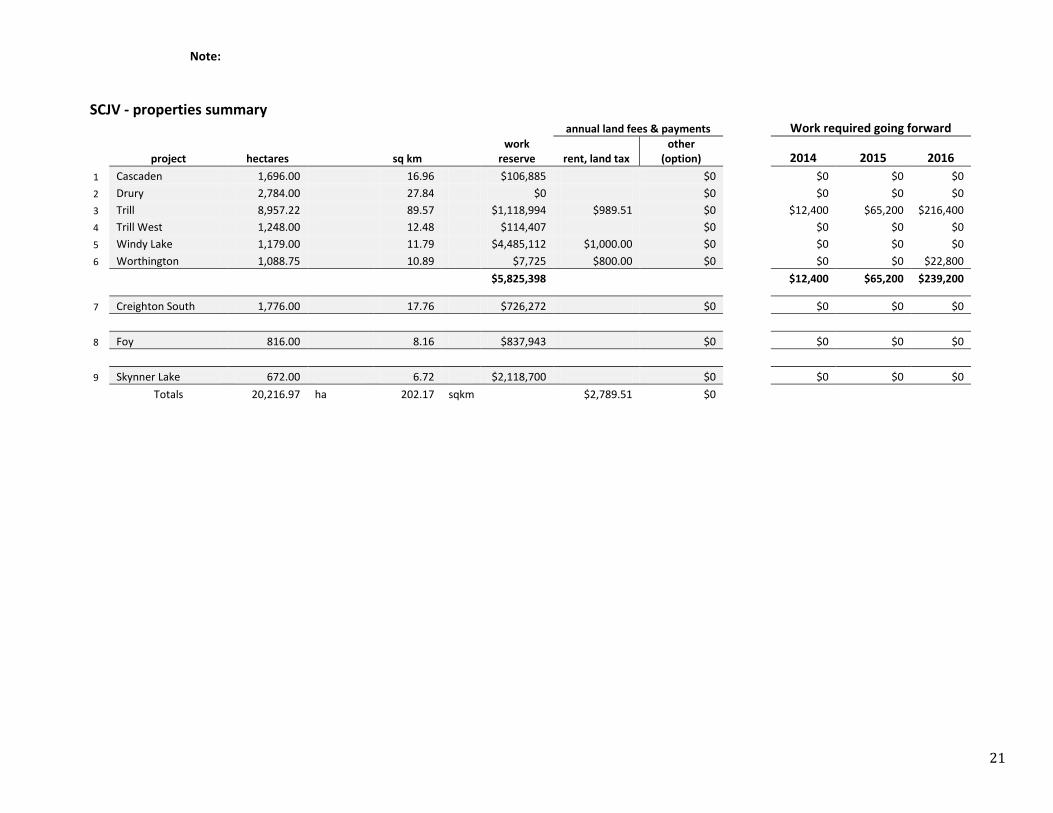
SCJV - properties summary
annual land fees & payments
Work required going forward
project hectares sq km work
reserve rent, land tax other
(option)
2014 2015 2016
1 Cascaden 1,696.00 16.96 $106,885 $0
$0 $0 $0
2 Drury 2,784.00 27.84 $0 $0
$0 $0 $0
3 Trill 8,957.22 89.57 $1,118,994 $989.51 $0
$12,400 $65,200 $216,400
4 Trill West 1,248.00 12.48 $114,407 $0
$0 $0 $0
5 Windy Lake 1,179.00 11.79 $4,485,112 $1,000.00 $0
$0 $0 $0
6 Worthington 1,088.75 10.89 $7,725 $800.00 $0
$0 $0 $22,800
$5,825,398
$12,400 $65,200 $239,200
7 Creighton South 1,776.00 17.76 $726,272 $0
$0 $0 $0
8 Foy 816.00 8.16 $837,943 $0
$0 $0 $0
9 Skynner Lake 672.00 6.72 $2,118,700 $0
$0 $0 $0
Totals 20,216.97 ha 202.17 sqkm $2,789.51 $0
22
5. ACCESSIBILITY, CLIMATE, LOCAL RESOURCES, INFRASTRUCTURE AND
PHYSIOGRAPHY
The nine properties are located within a 20 km radius of the City of Greater Sudbury, Ontario (Figure 1) and are
serviced by a variety of primary and secondary paved and gravel roads, logging roads, and ATV, skidoo and drill
trials. Exploration is possible year round.
Sudbury, Ontario is Canada’s premiere mining community and has been producing nickel, copper and platinum
group metal ore for over 125 years. Highlights of the region include multiple active mines, two mills, two smelters,
quality transportation, water and power infrastructure, a well-trained mining workforce, an internationally
recognized mining service and supply sector, a community that understands and appreciates mining as part of its
heritage, and a stable political regime. Sudbury is a major northern centre of education, health services and
industry, and is the location of the main office for the Ontario Geological Survey.
Land uses in the City of Greater Sudbury and outlying area include private and public recreational activities
(hunting, fishing, canoeing, cottages, and camping), mining, mineral exploration, forestry and commercial fishing.
The Sudbury Basin is drained by watersheds of the Wanapitei, Vermillion and Spanish Rivers, which define
Traditional Lands of the Wahnapitae, Sagamok and Whitefish First Nations, respectively. Wanapitei Lake is one of
the water sources for the City of Greater Sudbury. Ontario Hydro has a dam for hydro-electric power generation at
the south end of Outlet Bay in Scadding Twp., which also controls the water levels on the lake.
Elevations in the area range from about 260 to 500 m above sea level. The topography includes rolling hills, linear
lakes, steep north-south trending bluffs (<50 metres relief), and expansive low, marshy, areas. Vegetation consists
of white spruce, black spruce, white pine, red pine, jack pine, poplar, various maple species and oak. Alder, cedar,
white ash, Labrador Tea, grasses and cattails grow in the lower wet areas.
6. HISTORY
CASCADEN 1953: Mining Corporation of Canada
Two diamond drill holes totalling 220 m
1956–57: Eastview Mines Ltd.
Ground resistivity survey, mapping, discovery of three mineralized showings (pyrite + chalcopyrite ±
pyrrhotite) with one sample value of 1.72 % Cu, and 0.81 % Ni
1950’s: Pacemaker Mines & Oil / Starlight Mines Ltd. / Canadian Radium Corp.
Drilled two drill holes totalling 739 m intersected SIC prospective lithologies with reported sulphide
mineralization in drill logs, ground magnetic and resistivity surveys, geological mapping
1957: A.E. Rosen
Ground EM survey covering part of the southwest corner
1965: Airnorth Mines Ltd.
Drill holes totalling 468 m near Pacemaker showings with reported disseminated pyrite and chalcopyrite
in drill logs

23
1967: Airnorth Mines Ltd.
One drill hole totalling 244 m, ground magnetic and electro-magnetic surveys
1988: Falconbridge
Regional soil and humus sampling program
1991: Falconbridge
Collection of 15 samples near Pacemaker second showing
2003: Falconbridge
Mapping (geology and structure)
CREIGHTON SOUTH 1939: Hans Lundberg
Magnetometer survey over central Graham township
1952-3: New Alger Mines Ltd
Geological and magnetometer survey, 4 drill holes totalling 460 m
1953: Mogul Mining Co
Magnetometer and EM surveys and detection of several unexplained anomalies
1955-6: Arcadia Nickel Corporation Limited
Magnetometer survey, three drill holes totalling 371 m
1960: Geological Survey of Canada
Flew an aeromagnetic survey
1968: Palco Exploration Ltd.
Conducting a VLF-EM survey and outlining several unexplained strong to weak conductors
1969: Palco Exploration Ltd.
Two drill holes totalling 145 m
1969: Falconbridge
Three drill holes, conducting magnetometer and horizontal loop EM surveys
1988: BP Resources
Airborne VLF-EM around the basin including Graham township
DRURY 1953: Noranda Mines
Ground magnetic (Mag) survey
1952– 4: INCO
Mag and electro-magnetic (EM) surveys; 5 drill holes totalling 275.84 m
1953– 4: Prospectors Airways G
Ground EM and Mag survey; mapping
1955: Garrison Harbour Gold Mines

24
7 diamond drill holes; 2 to the northeast of the property
1956: Garrison Harbour Mines Ltd.
Ground EM and Mag
1956: Prospectors Airways
3 drill holes totalling 397.15 m
1958: E. Maki/ W. Alanen
5 drill holes totalling 493.54 m, highest assay had 1.95% Cu over 0.46 m
1958: E. Maki
1 drillhole of 137.77 m
1960– 61: OGS
Mapping at 1”: ½ mile
1961: Rio Tinto Exploration Canada
1 drillhole of 36.88 m
1965: ODM-GSC
Airborne Mag survey
1966: Kerr Addison Mines Ltd.
4 drill holes totalling 128.92 m
1967: Lang
2 diamond drill holes totalling 68m
1968: Rio Tinto
1 diamond drill hole of 37.23 m, intersecting 0.35% Cu over 4.11 m and 0.60% Cu over 3.96 m
1973: Ryanor
3 trenches with mineralization striking E-W over 350 m; 10 drill holes totalling 631.54 m
1975–1976: Espina Copper Development
8 drill holes totalling 639.78 m
1976: Kerr Addison Mines Ltd.
8 drill holes totalling 2,022m
2000: Mustang Minerals
25 km of line cutting/mapping
2001: Mustang Minerals
Mapping including the collection of 202 samples; 21.4 km of ground Mag and IP
FOY 1953: INCO
Mapping and ground magnetic survey adjacent to property
1958/61: Falconbridge
6 drill holes totalling 498.65 m

25
1970: INCO
6 drill holes totalling 1,227 m adjacent to property
1972: INCO-United Reef JV
Mapping and drilling adjacent to property
1989: Falconbridge
Regional soil survey and rock analyses
1990: Canadian Nickel Co. Ltd.
One drill hole totalling 652 m adjacent to property
2001: Falconbridge
Detailed mapping to the northwest of the property
2003: Falconbridge
Mapping (part of a regional study/collaboration)
2004: OGS
Releasing the results of 2001 lake bottom sediment survey
SKYNNER 1956: Cleveland Copper Corp.
Conducting a magnetometer survey, 4 drill holes totalling 862 m
1956: El Pen-Ray Oil and Mines Ltd.
Performing Mag and EM surveys, 6 drill holes
1987: Falconbridge
Conducting a soil humus survey
1988: Barti Engineering Association Inc.
Prospecting and sampling
1989: Falconbridge
Completing a humus survey
TRILL 1951-53: Falconbridge
5 drill holes totalling 182.88 m (intersected QD)
1952-53: Noranda Mines Ltd.
Ground magnetic (Mag) survey and mapping
1953-56: Transnorthern Nickel & Copper/Callinan Flin Flon Mines
Mapping, 22 drill holes totalling 982.46 m, ground Mag
1954: F. Dunn
Ground Mag.
1954: J.B. Aird
26
30 km line cutting, limited mapping, 30 km ground Mag
1956: Nickel Rim Mines Ltd.
Two drill holes on adjacent property to the east
1969: Canadex Mining Corp. Ltd.
16.1 miles line cutting, 16.1 miles ground VLF, 16.1 miles ground Mag
1969-72: Falconbridge
Three drill holes totalling 434.46 m on east of the property
1970: Canadex Mining Corp. Ltd.
4.7 miles ground IP
1970-71: S. Grimsell / W. Alanen / D.E. Rastall
Small ground Mag survey
1970’s: Geological Survey of Canada
Low resolution airborne magnetic survey
1971: Earth Physics- Department of Energy, Mines and Resources
Released results and interpretation of a regional gravity survey, soil survey
1995: Falconbridge
MaxMin and Mag surveys
2002: Winterbourne Exploration
Lithogeochemical survey and mapping over a gravity anomaly
TRILL WEST 1982: Ontario Geological Survey
Mapping
1988: Champion Bear Resources
Helicopter magnetic, EM and VLF covering a small portion of the property
WINDY LAKE 1950’s and 60’s: Falconbridge / INCO / Ontario Department of Mines / Airnorth Mines / Arcadia Nickel Mines;
mapping, limited ground EM surveys, drilling
1954: Falconbridge
6 drill holes totalling 1663 m
1979-80: Falconbridge
7 drill holes adjacent to Windy Lake property totalling 3915 m with one anomalous Cu and Ni result in
drill hole CASC-07 (0.08 % Cu, 0.18 % Ni, 5.07 g/t Pt and 0.03 g/t Pd over 1.58 m).
1979: INCO
One drill hole adjacent to Windy Lake property totalling 3444 m intersecting sublayer and
football breccia
27
WORTHINGTON 1954/7: W. Alanen
7 drill holes totalling less than 91.44 m
1954/7: H. Autio
8 drill holes totalling 110.34 m
1955: Noranda Mines Ltd.
Electro-magnetic (EM) and magnetic (Mag) surveys
1955: R. Robb
2 drill holes totalling 305.10 m
1956: Mining Endeavor Co. Ltd.
16 drill holes totalling 739.11m within and adjacent to the current Property extents
1957: J. Wallace
1 diamond drill hole of 206.04 m
1957: L. Maki
5 diamond drill holes totalling 177.09 m
1957: Aer Nickel Corp.
1 diamond drill hole of 206.04 m
1957: Prosco Ltd
Mag survey
1959: L. Maki
1 diamond drill hole of 108.20 m
1950’s - 60’s: Worthington Mines Ltd.
7 drill holes totalling 1112.52 m; mapping and Mag survey
1967: S. Grimsell
Stripping and 7 diamond drill holes totalling 160.32 m
1968: Paramaque Mines Ltd
Mapping; 5 drill holes totalling 316.08 m
1972: J. Wallace
1 diamond drill hole of 307.85 m
1972: S. Grimsell
Stripping
28
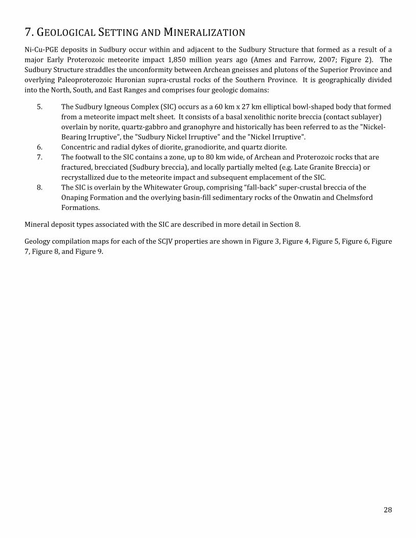
7. GEOLOGICAL SETTING AND MINERALIZATION
Ni-Cu-PGE deposits in Sudbury occur within and adjacent to the Sudbury Structure that formed as a result of a
major Early Proterozoic meteorite impact 1,850 million years ago (Ames and Farrow, 2007; Figure 2). The
Sudbury Structure straddles the unconformity between Archean gneisses and plutons of the Superior Province and
overlying Paleoproterozoic Huronian supra-crustal rocks of the Southern Province. It is geographically divided
into the North, South, and East Ranges and comprises four geologic domains:
5. The Sudbury Igneous Complex (SIC) occurs as a 60 km x 27 km elliptical bowl-shaped body that formed
from a meteorite impact melt sheet. It consists of a basal xenolithic norite breccia (contact sublayer)
overlain by norite, quartz-gabbro and granophyre and historically has been referred to as the "Nickel-
Bearing Irruptive", the "Sudbury Nickel Irruptive" and the "Nickel Irruptive".
6. Concentric and radial dykes of diorite, granodiorite, and quartz diorite.
7. The footwall to the SIC contains a zone, up to 80 km wide, of Archean and Proterozoic rocks that are
fractured, brecciated (Sudbury breccia), and locally partially melted (e.g. Late Granite Breccia) or
recrystallized due to the meteorite impact and subsequent emplacement of the SIC.
8. The SIC is overlain by the Whitewater Group, comprising “fall-back” super-crustal breccia of the
Onaping Formation and the overlying basin-fill sedimentary rocks of the Onwatin and Chelmsford
Formations.
Mineral deposit types associated with the SIC are described in more detail in Section 8.
Geology compilation maps for each of the SCJV properties are shown in Figure 3, Figure 4, Figure 5, Figure 6, Figure
7, Figure 8, and Figure 9.

29
Figure 2. Sudbury Igneous Complex and Offset Dykes (Ames and Farrow, 2007).
30
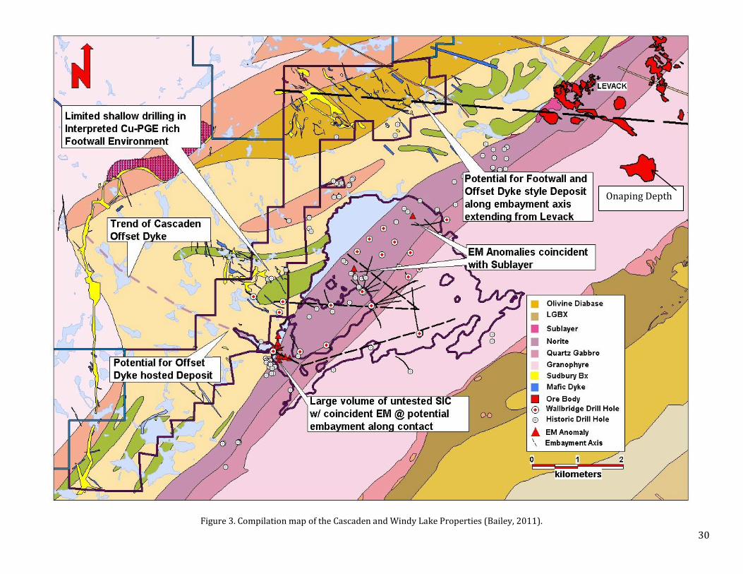
Figure 3. Compilation map of the Cascaden and Windy Lake Properties (Bailey, 2011).
Onaping Depth

31
Figure 4. Creighton South Property Geology (Bailey, 2011).

32
Figure 5. Compilation map of the Drury and Worthington Properties.
33
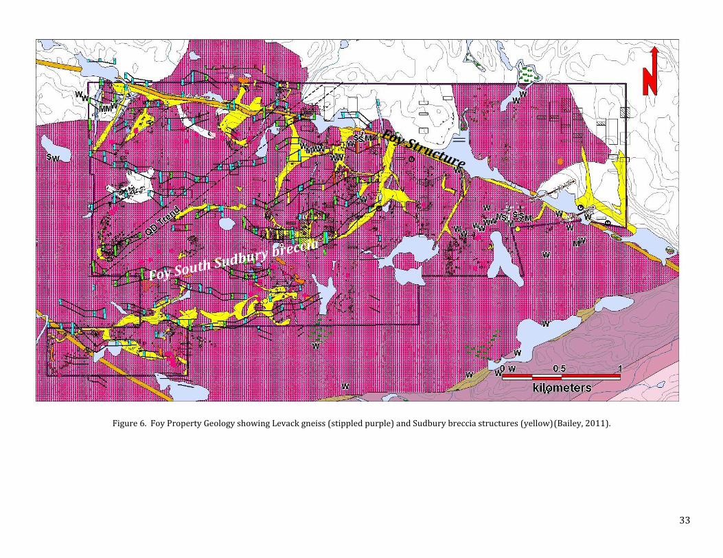
Figure 6. Foy Property Geology showing Levack gneiss (stippled purple) and Sudbury breccia structures (yellow)(Bailey, 2011).
34
Figure 7. Compilation map of the Skynner Lake Property

35
Figure 8. Compilation map of the Trill Property
36
Figure 9. Compilation map of the Trill West property.

37
MINERALIZATION
CASCADEN The highest precious metal concentrations were found on the North Block and include samples returning 661 ppb
TPM and 79 ppb TPM. The latter is of particular interest in that it also had anomalous levels of copper, silver,
bismuth, tin, and tellurium and occurred within a large area of thermally altered Sudbury breccia that is mapped as
a pronounced magnetic low.
Historical grab samples on the Peninsula block assayed up to 1.72 % Cu and 0.81 % Ni in disseminations and veins
of pyrrhotite, pyrite and chalcopyrite mineralization. Sampling by Wallbridge returned values up to 0.77 % Cu, up
to 0.05 % Ni, and very weakly anomalous precious metals (up to 25ppb TPM). In the central portion of the
Peninsula Block, up to 5 % disseminated pyrite and chalcopyrite mineralization occurs with coarse epidote (±
amphibole) alteration in fracture fillings, massive patches, veinlets and stockworks. This mineralization is in an
area of thermally altered and bleached Sudbury breccia and thus may represent a dispersion halo of Sudbury type
mineralization.
Disseminated pyrite, chalcopyrite and pyrrhotite mineralization occur across the Cascaden property and is likely
Archean in age and of little economic significant.
CREIGHTON SOUTH In 2005, drill hole WG-004 intersected 0.395g/t TPM (0.18 g/t Pt, 0.19 g/t Pt and 0.02 g/t Au) over a 0.3 metre
wide zone of chlorite, biotite, and pyrite alteration with trace chalcopyrite. Fluid inclusion analysis of the alteration
assemblage reported high temperature (>400°C) and highly saline (>60wt. % equiv. NaCl) conditions, similar to
fluid inclusion results from footwall ore zones throughout Sudbury.
Grab samples from several generations of quartz veins on the property carry up to 1.48 % Cu and 0.431 ppm Au.
The different generations of these veins have not been well defined and their relationship to the SIC is uncertain.
DRURY Several mineralization styles have been identified and sampled on the property. These include:
1) Nipissing Gabbro-hosted Ni-Cu-PGE
Semi-massive to massive pyrrhotite and minor chalcopyrite as well as veinlets of quartz-chalcopyrite occur beside
two historical pits close to the southern property boundary of the West Block. The mineralization trends NW-SE
parallel to the Nipissing Gabbro intrusion over a strike length of approximately 200 m. Mineralized samples taken
from this location were compiled in Table 3.
Table 3. Mineralized grab samples from the Nipissing Gabbro-hosted Ni-Cu-(PGE) showing near the southern property boundary on the West Block

38
In 2012 narrow mm-scale chalcopyrite veinlets associated with pervasive quartz-chlorite alteration/veining was
located in Nipissing Gabbro approximately 300 m away from the showing described above. Sample N986030 taken
at this location returned favorable PGE tenors with 1.5 g/t TPM (Table 4) associated with 0.71 % Cu.
Table 4. Mineralized grab samples taken from alteration in Nipissing Gabbro on the West Block
2) Leucogabbro-hosted (Drury Intrusion?) Ni-Cu-PGE
A 1 metre diameter patch containing blebby chalcopyrite was found hosted in coarse-grained leucogabbro of what
is believed to be Drury Intrusion, part of the East Bull Lake suite. The sample N984477 taken at this location
contained 1.01 g/t TPM and 1.82 % Cu (Table 5).
Table 5. Mineralized grab sample taken from leucogabbro on the Central Block
3) 3) Quartz-vein associated Au-Cu
Chalcopyrite mineralization was found associated with massive quartz veins cutting a metavolcanic unit in
one location on the Central Block. The mineralization contains anomalous Au and Ag concentrations (Table 6).
Table 6. Mineralized grab samples from Cu-Au-Ag bearing quartz-veins in metavolcanic unit on the Central Block
4) Metavolcanic/metasediment-hosted Cu
In 1968 Rio Tinto and 1973 Ryanor conducted drilling and trenching to test a zone of copper
mineralization hosted in metavolcanic/metasedimentary in the Central Block.
Table 7 shows drill hole intersects as reported by Ryanor. Wallbridge re-sampled this mineralization in 2002 and
2008. These assays are found in Table 8. This mineralization style is probably pre-Sudbury in origin. The
mineralization contains Cu ± anomalous Ni and no anomalous PGE’s.
Table 7. Diamond drill hole intersects from Ryanor’s 1973 drill campaign
Hole Mineralization
R-1 0.50% Cu over 53 feet
R-2 0.75% Cu over 23 feet
R-3 not reported
R-4 0.27% Cu over 5 feet
R-5 0.47% Cu over 26.5 feet
R-6 0.47% Cu over 49 feet
R-7 0.76% Cu over 36 feet

39
Table 8. Mineralized grab samples from the metavolcanic/metasedimentary-hosted Cu mineralization
FOY In south-central Foy, precious metal values up to 1.0g/t TPM and copper values of 0.79% and 0.12% with
anomalous Ag and Te were found in two samples of intermediate gneiss. The samples contained 10-15% pyrite ±
chalcopyrite and were collected on the contact with Sudbury breccia.
In the south-western portion of the property, samples of partially melted felsic gneiss with pyrite and extensive
epidote alteration returned 696ppm Cu and 23ppb TPM. Both of these occurrences may reflect primary dispersion
haloes of Sudbury-type footwall mineralization.
SKYNNER LAKE No SIC-related mineralization was identified on the property.
Occurrences of semi-massive and massive sulfide have been found in several areas in the property. These zones
occur in intermediate to mafic gneisses, follow the fabric of these rocks and are believed to be pre-Sudbury
(Archean?) in origin. The mineralization is dominated by pyrrhotite and pyrite with minor amounts of chalcopyrite
and is of little economic interest. Most recently in 2013, hole WSK-026 intersected an approximately 40 m wide
zone of such mineralization, Table 9 shows the assays results from the samples with anomalous Cu, Ni and Ag
values.
Table 9. Summary of assay results from the sulfide intersection in WSK-026

40
TRILL
1) Trill Showing Ni-Cu-PGE mineralization
In June of 2005, a high grade Ni-Cu-PGE sulfide lens was discovered on the Trill property hosted within the
previously unrecognized Trill Offset dyke. The massive sulfide lens is approximately 65 m long, 5 m wide, dips
steeply to the north and is known to extend to about 35 m depth. Mineralization consists of pyrrhotite,
chalcopyrite, pentlandite, pyrite and magnetite within an inclusion quartz diorite which is flanked by a non-
inclusion phase of quartz diorite. These relationships are typical of offset hosted Ni-Cu-PGE mineralization in the
Sudbury camp. Minor violarite occurs as an oxidation product of pentlandite and merenskyite and michenerite
were identified as the main PGE-bearing phases using electron microprobe analysis. There is a crude zonation in
the mineralization where the core contains massive or inclusion bearing nickel-rich sulphides whereas the flanks
contain copper-rich vein and disseminated style mineralization.
See highlight channel samples and drill hole intersections in Table 10 and Table 11, respectively.
Table 10. Channel sample highlights from the Trill Ni-Cu-PGE Showing
Channel Length (m) TPM Pt Pd Au Ag Cu Ni
ppm ppm ppm ppm ppm wt.% wt.%
CHAN_A 3.45 9.41 2.12 6.59 0.70 4.28 0.94 1.46
including… 1.25 11.31 2.14 9.05 0.12 3.74 0.93 3.38
CHAN_B 4.30 6.06 1.74 3.93 0.39 5.22 1.12 1.07
including… 0.65 10.18 2.74 6.99 0.45 3.63 0.71 2.72
CHAN_C 3.67 5.12 1.57 3.32 0.23 3.20 0.68 1.42
including… 1.3 8.59 2.61 5.80 0.18 3.94 0.48 3.34
CHAN_D 2.42 5.44 1.52 3.57 0.35 1.73 0.65 0.55
including… 0.7 9.16 3.21 5.31 0.64 3.00 0.97 0.86
CHAN_E 1.45 4.66 1.43 2.91 0.31 3.38 0.92 0.81
CHAN_F 3.25 9.96 1.69 8.01 0.27 4.30 1.17 0.42
CHAN_G 6.00 4.24 1.26 2.61 0.37 2.88 1.12 0.23
including… 0.8 6.84 1.88 3.80 1.16 7.00 2.42 0.22
CHAN_H 2.43 6.69 2.28 3.73 0.68 4.80 0.66 0.11
including… 0.73 10.86 3.39 6.16 1.31 9.00 0.94 0.16

41
Table 11. Highlight drill hole intersections from the Trill Ni-Cu-PGE Showing
2) Trill East Ni-Cu-PGE Showing
In September 2013 a new Ni-Cu-PGE showing was discovered during mechanical stripping of a new occurrence of
Inclusion QD in the Eastern part of the Trill property. The pyrite-pyrrhotite-chalcopyrite-millerite mineralization
occurs mainly as irregular veins, and blebs within a chaotic breccia unit at the contact of the Trill Offset with
Sudbury breccia and granite. This assimilation/mixing breccia is referred to as metabreccia or footwall breccia
based on analogues in other Sudbury offset dyke settings. Pyrite-dominated hydrothermal veins occur cutting
granite and Sudbury breccia and contain the highest PGE tenors.
See a summary of channel and grab samples in Table 12.
Drillhole From To Length (m) TPM Pt Pd Au Ag Cu Ni
ppm ppm ppm ppm ppm wt.% wt.%
WTR-012 0.70 12.00 10.30 6.41 1.98 4.18 0.26 4.20 0.79 1.20
including… 4.88 5.83 0.95 15.84 4.32 11.35 0.17 6.69 1.08 4.19
WTR-028 20.81 29.57 8.76 8.11 2.65 4.48 0.98 5.00 1.01 0.81
including… 22.22 22.56 0.34 20.87 6.48 14.13 0.26 5.00 0.78 3.57
and… 25.05 25.30 0.25 9.77 3.08 6.34 0.35 46.00 10.65 0.17
WTR-011 18.06 25.45 7.39 9.17 1.98 5.95 1.24 3.11 0.67 1.08
including… 19.30 20.00 0.70 14.80 3.74 10.90 0.16 0.31 0.61 5.05
WTR-006 34.49 38.85 4.36 2.21 0.59 1.46 0.16 1.72 0.25 0.16
WTR-009 40.66 41.25 0.59 1.68 0.34 1.28 0.06 1.11 0.37 0.22
WTR-010 47.97 51.24 3.27 2.27 1.01 1.15 0.11 1.69 0.15 0.20
WTR-010 57.92 60.59 2.67 5.08 0.80 4.09 0.20 4.72 1.11 0.20
WTR-026 40.65 44.00 3.35 4.78 1.35 3.22 0.21 1.88 0.29 0.23
WTR-027 25.78 27.89 2.11 5.98 2.22 3.32 0.44 3.00 0.46 0.12
WTR-028 33.92 34.62 0.70 13.29 3.78 8.69 0.82 3.34 0.45 2.73
WTR-028 41.07 41.44 0.37 9.66 5.51 6.50 4.15 2.00 0.64 0.29
WTR-030 10.16 14.00 2.86 3.28 1.08 2.08 0.13 4.26 0.22 0.39
WTR-031 20.90 23.65 2.75 3.18 0.82 2.24 0.11 1.75 0.22 0.89
WTR-032 35.20 35.60 0.40 1.01 0.33 0.55 0.13 2.00 0.13 0.06
WTR-034 13.84 18.00 4.16 6.24 1.93 3.88 0.43 5.54 0.73 0.73
WTR-034 26.80 27.75 0.95 3.46 1.11 2.23 0.11 5.05 0.23 1.39
WTR-034 34.79 36.00 1.21 2.49 0.54 0.95 0.99 0.00 0.10 0.10
WTR-035 32.33 33.60 1.27 1.45 0.56 0.70 0.19 2.46 0.23 0.04
42
Table 12. Summary of channel and grab sample results from the Trill East 2013 Ni-Cu-PGE showing
Sample No. Sample Type Channel Name Length (m) TPM Pt Pd Au Ag Cu (%) Ni (%) Co S (%)
N984155 GRAB NA NA 8.93 2.43 6.00 0.50 5.68 1.28 0.43 86.40 4.57
N984178 CHANNEL Channel E 0.39 5.72 2.24 3.02 0.46 8.86 1.90 2.45 448.00 >10.0
N984160 GRAB NA NA 2.49 0.82 1.35 0.33 11.30 1.75 0.41 122.00 7.54
N985541 BRICK NA <25 1.77 0.50 1.15 0.12 1.09 0.23 0.09 37.00 1.54
N984171 CHANNEL Channel A 0.16 1.39 0.36 0.90 0.13 2.39 0.29 0.07 34.40 1.27
N984166 BRICK NA <25 1.38 0.38 0.95 0.06 0.35 0.19 0.10 34.00 1.08
N985536 CHANNEL Channel J-4 0.78 1.27 0.47 0.79 0.01 2.12 0.12 0.64 89.10 4.17
N984176 CHANNEL Channel C 0.71 1.13 0.32 0.76 0.05 2.09 0.26 0.07 170.50 3.09
N984159 GRAB NA NA 0.90 0.27 0.58 0.05 1.69 0.14 0.07 356.00 2.21
N985537 CHANNEL Channel J-5 0.96 0.62 0.18 0.35 0.08 1.22 0.16 0.02 5.50 0.24
N984184 CHANNEL Channel F-6 0.62 0.56 0.15 0.35 0.06 1.85 0.16 0.04 32.80 0.64
N984173 GRAB NA NA 0.50 0.19 0.29 0.02 2.41 0.23 0.08 79.40 2.07
N985529 CHANNEL Channel I-15 0.47 0.48 0.17 0.25 0.05 0.79 0.18 0.18 266.00 4.76
N984177 CHANNEL Channel D 0.41 0.38 0.12 0.24 0.03 0.52 0.13 0.34 182.00 3.18
N984167 BRICK NA <25 0.37 0.10 0.26 0.02 0.24 0.03 0.02 10.70 0.25
N985506 CHANNEL Channel H-19 0.63 0.36 0.05 0.17 0.13 0.88 0.06 0.10 68.80 1.00
N985542 CHANNEL Channel L-1 0.60 0.33 0.10 0.19 0.03 1.29 0.12 0.09 74.20 1.27
N985538 CHANNEL Channel K 0.48 0.30 0.05 0.21 0.04 1.53 0.08 0.05 50.90 1.06
N984180 CHANNEL Channel F-2 0.6 0.27 0.07 0.15 0.04 0.71 0.08 0.08 58.00 0.62
N984182 CHANNEL Channel F-4 0.95 0.26 0.08 0.15 0.02 0.93 0.09 0.08 72.10 0.83
N985526 CHANNEL Channel I-12 0.92 0.17 0.05 0.11 0.01 0.46 0.05 0.07 44.40 0.41
N985547 CHANNEL Channel O 0.83 0.17 0.07 0.10 0.00 0.77 0.05 0.05 32.90 0.69
N985544 CHANNEL Channel M 0.40 0.17 0.09 0.07 0.01 5.16 0.45 0.04 126.00 2.44
N985525 CHANNEL Channel I-11 0.63 0.16 0.05 0.10 0.01 0.41 0.05 0.05 40.70 0.51
N985509 CHANNEL Channel H-22 0.5 0.16 0.06 0.10 0.00 0.59 0.08 0.03 53.20 0.47
N984183 CHANNEL Channel F-5 0.55 0.15 0.04 0.10 0.01 0.39 0.06 0.05 23.80 0.49
N984168 BRICK NA <25 0.15 0.04 0.10 0.01 0.49 0.08 0.07 40.80 0.75
N985534 CHANNEL Channel J-2 0.72 0.15 0.05 0.09 0.01 0.21 0.06 0.12 64.00 1.16
N985528 CHANNEL Channel I-14 0.83 0.14 0.05 0.08 0.02 0.18 0.02 0.02 12.40 0.21
N985531 CHANNEL Channel I-17 0.32 0.14 0.05 0.07 0.01 0.32 0.03 0.04 34.20 0.53
N984174 GRAB NA NA 0.12 0.03 0.08 0.01 0.68 0.05 0.06 56.50 0.78
N984181 CHANNEL Channel F-3 0.78 0.11 0.03 0.08 0.01 0.43 0.04 0.05 34.70 0.46
Composite CHANNEL CHANNEL F 3.50 0.26 0.07 0.16 0.03 0.86 0.09 0.06 46.80 0.62
Composite CHANNEL CHANNEL I 3.95 0.16 0.06 0.10 0.02 0.36 0.05 0.05 56.36 0.86
Composite CHANNEL CHANNEL J 1.74 0.91 0.31 0.55 0.05 1.62 0.14 0.30 42.98 2.00
43
TRILL WEST Two kilometre strike length of the Hess Offset Dyke occurs on the Trill West property. Trenching exposed blebby
to vein-style sulfide mineralization in Inclusion-bearing QD with grab sample results up to 0.65 g/t TPM (0.24 g/t
Pt, 0.34 g/t Pd, 0.07 g/t Au), 0.17 % Cu and 0.13 % Ni.
WINDY LAKE
Drilling at Windy Lake has identified contact-style pyrrhotite-pentlandite-chalcopyrite mineralization hosted within sublayer norite and minor footwall Cu-PGE sulfide hosted in the footwall rocks. See mineralized drill hole intersects in Table 13.
Table 13. Mineralized drill hole intercepts of Cu-Ni-PGE mineralization at the Windy Lake Embayment
WORTHINGTON The Worthington property hosts a four hundred metre strike length of the Worthington Offset Dyke. Trenching and
drilling on the property located weak, blebby Ni-Cu-PGE mineralization hosted within the dyke. The best intercept
was 0.49 g/t Pt + Pd + Au over 1.5 m.
Nipissing Gabbro on the property hosts several showings of Ni-Cu mineralization. Grab sample values from these
showings contained up to 1.07 % Cu and 0.69 %. The Nipissing gabbro on the property has not been explored in a
systematic and detailed manner.
Drillhole From To Length (m) TPM Pt Pd Au Ag Cu Ni
ppm ppm ppm ppm ppm wt.% wt.%
WWL-018 1038.50 1040.00 1.5 2.11 0.66 0.99 0.46 0.15 0.02 0.01
WWL-009 1642.65 1645.50 2.85 1.17 0.37 0.44 0.36 19.60 0.32 0.04
WWWL-009B 1664.75 1744.35 79.6 0.08 0.03 0.04 0.01 0.67 0.10 0.10
including… 1740.40 1741.60 1.2 0.31 0.12 0.13 0.06 4.10 0.60 0.31
WWWL-009B 1760.25 1775.75 15.5 0.10 0.04 0.05 0.02 1.14 0.14 0.11
WWL-003 1132.50 1133.56 1.06 0.02 0.01 0.01 0.00 2.29 0.51 0.03
WWL-023 399.33 400.45 1.12 0.57 0.05 0.51 0.01 0.03 0.08 0.14
WWL-023 402.00 403.51 1.51 0.81 0.05 0.75 0.02 0.03 0.13 0.17
WWL-002 708.00 708.12 0.12 0.45 0.17 0.12 0.16 4.67 1.15 0.08
WWL-002 909.65 909.97 0.32 0.02 0.01 0.01 0.01 0.99 0.47 0.01
WWL-025 256.90 257.50 0.6 0.53 0.17 0.18 0.18 10.90 0.44 0.02
44
8. DEPOSIT TYPES
Sudbury is one of the most significant mining districts in the world. Historical production over the past 125 years
plus current reserves in Sudbury have been estimated at approximately 1.6 billion tonnes of ore containing over 60
million ounces of platinum group metals plus gold, over 40 billion pounds of nickel and over 35 billion pounds of
copper (Eckstrand and Hulbert, 2007; Ames and Farrow, 2007, Lightfoot and Farrow, 2002).
Significantly, despite the long history of mining significant discoveries continue to be made in Sudbury, including
over 19 million ounces of PGEs discovered in since 1990 (Table 14).
Table 14. Recent discoveries in Sudbury with greater than 1 million ounces of PGEs.
>1 M oz Examples Resource Ni Cu Pt + Pd Pt + Pd
Mt % % g/t Moz
1. Capre1 ? ? ? ? ?
2. Victoria2 14.5 2.5 2.5 7.6 3.5
3. McCreedy East FW3 6.8 0.9 9.9 13.4 2.9
4. Nickel Rim South4 13.0 1.4 3.1 4.3 1.8
5. Totten Mine5 10.1 1.5 1.97 4.8 1.6
6. Kelly Lake6 11.4 1.72 1.41 3.8 1.4
7. Victor Deep FW6 6.16 1.9 6.2 6.7 1.3 1No public data; 2Quadra FNX Press Release dated January 16, 2012; 3personal communication; 4Xstrata Nickel Ore Reserves and Mineral Resources Statement dated December 9, 2009; 5Inco Press Release dated October 1999; 62005 Sudbury – Inco and Falconbridge Synergies Fact Sheet.
There are several main types of mineral deposits in the Sudbury area:
6. Contact deposits, including massive sulfide nickel, copper, cobalt, platinum, palladium and gold
mineralisation along the lower contact of the SIC, both within the contact sublayer and within the
immediately adjacent Footwall Breccia;
7. Footwall deposits, including sulfide veins and stringers containing copper, nickel, platinum, palladium,
and gold in the brecciated footwall rocks beneath the SIC;
8. Offset dyke deposits, including massive sulfide nickel, copper, cobalt, platinum, palladium and gold
mineralisation associated with brecciated and inclusion bearing phases (IQD) of the quartz diorite
offset dykes (QD);
9. Structurally and/or hydrothermally remobilized sulfide nickel, copper, cobalt, platinum, palladium and
gold mineralisation; and
10. Hybrid type deposits representing combinations of the above.
The Windy Lake and Drury properties are primarily being explored for Contact and Footwall deposits. The
Cascaden, Creighton South, Foy, and Skynner Lake properties are primarily being explored for Footwall deposits.
The Trill West and Worthington properties are primarily being explored for Offset dyke deposits. Trill is being
explored for both Footwall and Offset dyke deposits.
45
CONTACT DEPOSITS The best Contact deposit analogue for Windy Lake would be Glencore’s Onaping depth deposit located in the
Levack area along strike of Windy Lake 4 kms to the east (Figure 3). The Onaping depth deposit includes Measured
and Indicated resources totalling 14.5 million tonnes grading 1.67 % nickel, 1.25 % copper, 0.06 % cobalt, 0.45 g/t
platinum, and 0.52 g/t palladium and Inferred resources totalling 1.2 million tonnes grading 3.6 % nickel, 1.2 %
copper, 0.1 % cobalt, 0.5 g/t platinum and 0.5 g/t palladium (Xstrata Mineral Resources and Ore Reserves as at
June 30, 2010). Wallbridge’s conceptual exploration target for Contact deposits includes 10 to 20 million tonnes
containing 1-1.2 g/t platinum plus palladium plus gold, 1.5-4 % nickel, and 1-1.5 % copper. This represents a body
that is several hundred metres in strike length, 10-20 metres in thickness and 100’s of metres of plunge extent.
This target is conceptual in nature, is based on examples of Offset dyke deposits elsewhere in Sudbury and is not
necessarily indicative of mineralisation on the SCJV properties. There has been insufficient work on the SCJV
properties to determine whether deposits of this size and grade exist on the Property
Target mineralization includes shallowly dipping massive and semi-massive accumulations of sulphide, including
pyrrhotite > chalcopyrite > pentlandite concentrated within embayment depressions along the base of the Sudbury
Igneous Complex.
The massive and semi-massive accumulations of sulphide are strongly conductive and borehole EM is used
routinely on all drill holes of significant depth. The rule of thumb is that current borehole EM technology (BHUTEM
4) can detect an off-hole conductor about the same distance as the median dimension of that conductor, with
several practical caveats. Maximum effectiveness requires strong coupling between the loop configuration and the
conductor. As well, quality low-noise data depends on precise knowledge of transmitter-receiver geometry, which
requires gyro surveying of the borehole and sub-metre GPS surveying of the borehole collar and loop
configuration. Due to the fragmental nature of the ore deposits and host rocks, a deposit might not be electrically
continuous and actually made up of several conductors; in this case the distance it can be detected from will be
reduced relative to the overall size of the sulphide mass. In practice, for the target type in question and providing
there is quality data, borehole EM is thought to dependably test a radius of 75-100 metres around the drill hole.
FOOTWALL DEPOSITS Examples of recent Footwall deposit discoveries in the region include the McCreedy East Footwall deposits at
Vale’s Coleman Mine (the 148, 153 and 170 orebodies; Table 14, Figure 10), the Footwall ore bodies at Glencore’s
Nickel Rim South Mine (Table 14, Figure 10), and the footwall deposits at Vale’s Victor and Capre development
project (Table 14, Figure 10). The conceptual exploration target for Footwall deposit targets includes 2 to 10
million tonnes containing 1-5 g/t platinum, 1-5 g/t palladium, 1-10 % copper, 0.5-2 g/t gold, and 0.1-3 % nickel.
This represents a body that is 50-100 metres in strike length, 10-20 metres in thickness and 100’s of metres of
plunge extent. This target is conceptual in nature, is based on examples of Footwall deposits elsewhere in Sudbury
and is not necessarily indicative of mineralization on the SCJV Properties. There has been insufficient work on the
property to determine whether deposits of this size and grade exist on the SCJV Properties.
Target mineralization includes networks of meter to ten meter sized massive sulfide veins, stockworks of smaller
centimeter to meter sized sulfide veinlets and low sulfide alteration zones with weak sulfide disseminations,
including chalcopyrite > pentlandite +/- pyrrhotite, millerite, cubanite, bornite, and pyrite. Footwall deposits are
hosted by Sudbury breccia structures.
Sulfide veins within Footwall deposits are variably conductive and chargeable. Airborne, ground and borehole EM
as well as ground and borehole DCIP surveys can be effective in directly detecting the sulfide veins. However, due
to the potentially small physical size of individual conductive veins and the low sulfide nature of some of the PGE
46
rich Footwall deposits, the detectable distance of geophysical techniques may be quite limited. Exploration
requires careful geological mapping to understand structural controls, drilling and extensive sampling.
OFFSET DYKE DEPOSITS Examples of recent Offset dyke deposit discoveries in the region include the Kelly Lake Deposit within the Copper
Cliff Offset dyke (Table 14, Figure 11) and the Totten and Victoria deposits within the Worthington Offset dyke
(Table 14, Figure 12). The conceptual exploration target for Offset deposit target includes 2 to 10 million tonnes
containing 1-3 g/t platinum, 1-3 g/t palladium, 1-3 % copper, 0.5-2 g/t gold, and 1-3 % nickel. This represents a
body that is 50-100 metres in strike length, 10-20 metres in thickness and 100’s of metres of plunge extent. This
target is conceptual in nature, is based on examples of Offset dyke deposits elsewhere in Sudbury and is not
necessarily indicative of mineralisation on the SCJV Properties. There has been insufficient work on the SCJV
Properties to determine whether deposits of this size and grade exist on the Property.
Target mineralization includes massive and semi-massive accumulations of sulphide, including pyrrhotite >
chalcopyrite > pentlandite. Sulphide accumulations are associated with inclusion bearing phases of quartz diorite
and are known to concentrate in structural traps such as vertical or horizontal pinches or terminations in the dyke,
bends in the dyke, splays/convergences of dyke branches, along the margins or within “pressure shadows” of large
blocks caught up in the dyke, and at intersections of the offset dykes with coarse mafic intrusions in the wall rock.
Increased PGEs are typically associated with more fractionated chalcopyrite rich zones within Offset dyke deposits,
which can extend from the dyke outwards into the surrounding country rock, where it often associated with
adjacent zones of Sudbury breccia, meta-breccia or anatexite.
These structural traps are largely controlled by the geology of the wall rock to the Offset dykes (geological units,
contacts and structures). Understanding these wall rocks is crucial to developing and prioritizing drill targets
below the depth of penetration of surface geophysics.
The massive and semi-massive accumulations of sulphide are strongly conductive and borehole EM is used
routinely on all drill holes of significant depth. The rule of thumb is that current borehole EM technology (BHUTEM
4) can detect an off-hole conductor about the same distance as the median dimension of that conductor, with
several practical caveats. Maximum effectiveness requires strong coupling between the loop configuration and the
conductor. As well, quality low-noise data depends on precise knowledge of transmitter-receiver geometry, which
requires gyro surveying of the borehole and sub-metre GPS surveying of the borehole collar and loop
configuration. Due to the fragmental nature of the ore deposits and host rocks, a deposit might not be electrically
continuous and actually made up of several conductors; in this case the distance it can be detected from will be
reduced relative to the overall size of the sulphide mass. In practice, for the target type in question and providing
there is quality data, borehole EM is thought to dependably test a radius of 75-100 metres around the drill hole.
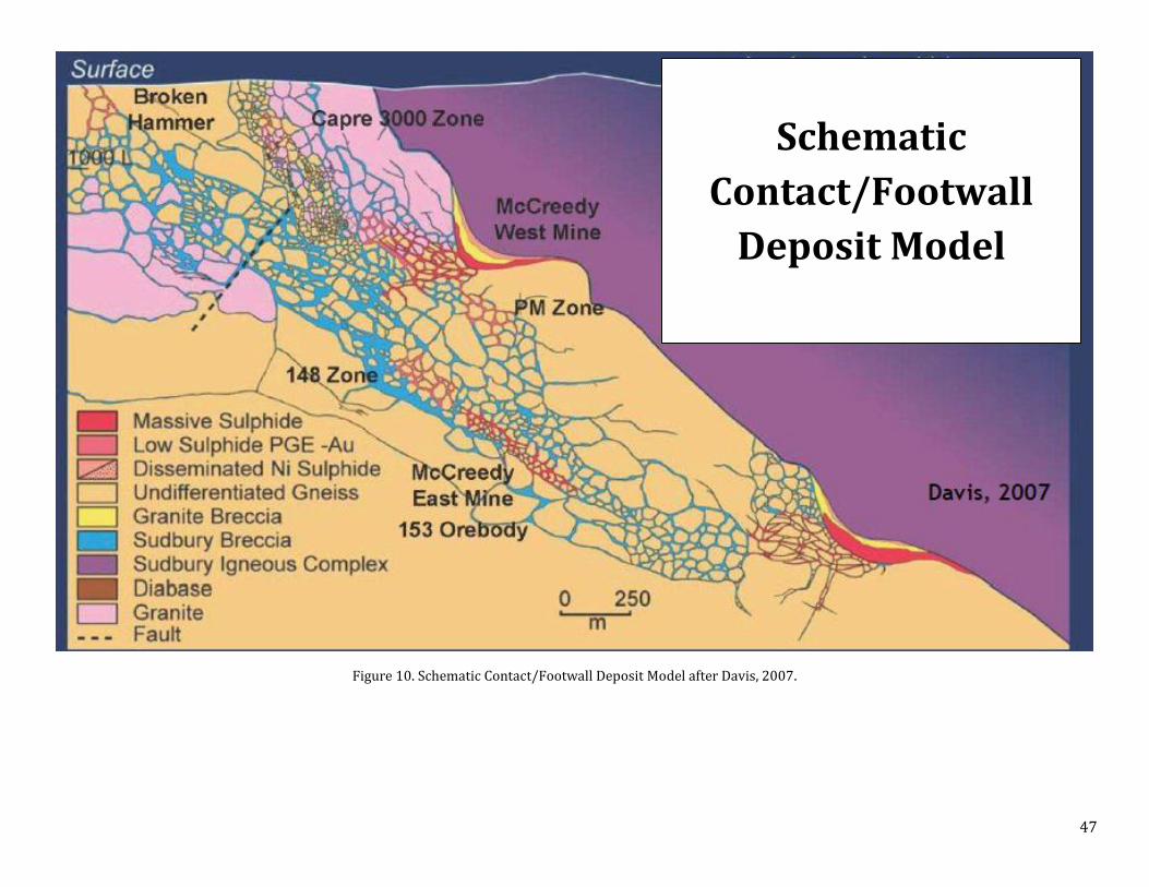
47
Figure 10. Schematic Contact/Footwall Deposit Model after Davis, 2007.
Schematic
Contact/Footwall
Deposit Model

48
Figure 11. Long section section of the Copper Cliff Offset dyke (Farrow and Lightfoot, 2002).
Figure 12. Long Section of the Victoria deposit (Frayne, 2013).
49
9. EXPLORATION
The following provides a brief summary of exploration on the SCJV properties. Significant results are discussed in
Section 25.
CASCADEN 1999: Airborne electro-magnetic and magnetic surveys
2000: 7.75 km line cutting, mapping at 1:5000 including the collection of 196 samples and generation of 185
thin sections, one drill hole totalling 524 m intersected warm Sudbury breccia, 34 AMT stations
2001: Mapping at 1:2500 including the collection of 16 samples and analysing of 7 of them, AMT of central
portion of the property which covered by Windy Lake survey
2002: 143.17 km line cutting, 110.7 line km ground magnetic survey, 78.125 line km IP, mapping at 1:2500
including the collection of two samples one of which with 0.1462 % Cu
2004: Mapping including the collection of 225 samples one of which with 0.3315 % Cu, airborne electro-
magnetic (948.6 km) and ground IP
2005: Mapping of North Block as well as a traverse along Highway 144 including the collection of 31 samples
2007: Mapping at 1:2000 including the collection of 76 samples, 12 km of line cutting, one fluid inclusion
analysis
2008: 8.8 km Titan 24 DCIP/MT with 3D inversions, mapping at 1:2000 including the collection of 49 samples,
one drill hole totalling 180 m
2009: Limited mapping and prospecting including the collection of 9 samples, drilling of one borehole totalling
354m, borehole PEM survey (two loops)
2010: Mapping and prospecting including the collection of 51 samples, one drill hole totalling 340 m, one
borehole PEM survey (two loops)
2011: No significant exploration activity
2012: Mapping and prospecting including the collection of 58 samples, one drill hole totalling 319 m
CREIGHTON SOUTH 1998: 72 km of line cutting, mapping at 1:2500 scale including the collection of 245 samples and generation of
678 thin sections
1999-2001: 96 AMT stations (three sections), limited mapping
2001: Mapping including the collection of 43 samples
2002: Limited mapping
2003: Mapping by Daniel Lieger, detecting a belt of thermally metamorphosed breccias
2005: Mapping of 3.2 km2 including the collection of 183 samples, two drill holes totalling 253 m
2006: Mapping of 0.9 km2 at 1:2000 scale including the collection of 27 samples, one hot (450ºC) fluid inclusion
analysis
50
2007: Mapping (4.63 km2) at 1:2000 including the collection of 163 samples, two drill holes totalling 848m,
two BHUTEM surveys, 42.1 line km of IP, 7.4 line km of DC/IP, 4.8 line km MT (Titan 24 Survey), two fluid
inclusion analysis
2008: 11 fluid inclusion analysis, mapping 2.3 km2 at 1:2000 including the collection of 145 samples,
reinterpretation of the 2007 IP survey, two drill holes totalling 957.5 m, one borehole UTEM survey (two
loop)
2009: Mapping including the collection of 41 samples and over 200 structural measurements, one drill hole
totalling 870 m, one borehole PEM survey, two fluid inclusion analysis
2010: Mapping and prospecting including the collection of 42 samples, VTEM survey (1198 line km including
the Graham Property)
2011: Modelling of VTEM data, mapping and sampling VTEM anomalies including the collection of 20 samples
2012: Mapping and prospecting including the collection of 123 samples, magnetic susceptibility and beep mat
surveys
DRURY 1998: Reconnaissance mapping including the collection of 5 samples to confirm cp mineralization reported in
trenches by Ryanor.
1999: Reconnaissance mapping did not find “mineralized quartz-diorite” as reported in drill log by Garrison,
Airborne EM and Mag
2000: 154.2 km of line-cutting; 89 AMT stations
2002: Mapping at 1:2500 including the collection of ~30 samples; 2 diamond drill holes totalling 993.61 m; 1
borehole pulse EM; 16.2 km of ground Mag; 110 km of IP and resistivity
2004: Limited mapping , including the collection of 8 samples for assay and 10 for thin section
2005: Mapping and sample collection
2006: Mapped 0.35 km2 at 1:2000, including the collection of 6 samples; Cut 4.8 line km; 7.275 km of VLF-EM
2007: Mapped and beep matted 0.16 km2 at 1:2000; 1.6 line km of HLEM
2008: Mapping of 1.8 km2 (1:2,000), including the collection of 61 samples; 266.4 km AeroTEM III
2009: Magnetic susceptibility study, including the collection of 6 samples
2010: Airborne gravity survey – 160 line km
2011: Modelling of airborne gravity and mag data
2012: Mapping, reconnaissance mapping and prospecting at 1:5,000, including 144 samples; structural
interpretation
FOY 1999: Airborne electro-magnetic (EM) and Mag surveys over entire property, 3.525 line km MaxMin, 1.825 line
km Crone EM, 4.55 km of line cutting, one drill hole totalling 62 m intersecting around three metres of 10-
15 % pyrrhotite-pyrite mineralization at 34.5 m

51
2000: Limited mapping and sample collection (C. Wood)
2001: 30 km of line cutting, 29.6 line km of ground Mag, mapping 3.5 line km at 1:5000 including the collection
of 13 samples
2002: 18.8 km line cutting, mapping of 85.25 line km at 1:2500 including the collection of 65 samples, 80.7 line
km ground Mag, 42.275 line km gradient IP and ground Mag
2003: Geological mapping
2004: Limited mapping (following up IP and Mag anomalies) including the collection of 17 samples
2005: Mapping 20 line km including the collection of 53 samples, 126 km of airborne VTEM, AeroTEM test
survey, 850 m of line cutting, 850 m ground magnetic survey, two MaxMin surveys (750 m survey: 50 m
cable, and a 600 m survey: 100 m cable), two drill holes totalling 406 m both intersected pyrrhotite-pyrite
mineralization, one BHUTEM survey
2006: Mapping 0.8 km2 at 1:2000 including the collection of 79 samples, 200 m of trenching, one drill hole
totalling 118.07 m, one borehole UTEM survey, MaxMin survey, two fluid inclusions analysis
2007: Prospecting including the collection of 59 samples, 6.5 line km MMI sampling (272 samples), one drill
hole totalling 381 m including the collection of 108 samples, one borehole UTEM survey, limited ground
EM survey over airborne EM anomaly, three fluid inclusion analysis
2008: 10 fluid inclusion analysis, mapping and prospecting including the collection of 78 samples, two drill
holes totalling 642 m including the collection of 88 samples
2009: Mapping and prospecting including the collection of 121 samples, three drill holes totalling 457 m, two
televiewer borehole surveys, three fluid inclusion analysis, 12.2 line km cut and 64 line km refurbished,
70.75 km IP survey
2010: Collection of 29 lake bottom sediment samples, limited mapping and prospecting including the collection
of 17 samples
2011: Minor prospecting
2012: One drill hole totalling 201 m including the collection of 57 samples, 16 line km InfiniTEM II survey
SKYNNER LAKE 1999: 543 line km airborne Mag and EM survey
2001: 31.5 km of line cutting, 8 km of mapping at 1:2500 including the collection of 10 samples
2002: 23 km of mapping including the collection of 27 samples, 24.9 km ground magnetic, 7.025 km of IP
Survey
2004: Reconnaissance mapping including the collection of 9 samples, 7.025 line km of gradient IP
2005: 1:2000 mapping (3 km2) including the collection of 170 samples, 12 fluid inclusion analysis, 8 drill holes
totalling 1,756 m (715 samples), 2.65 km ground IP survey, 180 km airborne VTEM, two BHIP surveys,
trenching and blasting of a small 2 x 3 m pit

52
2006: 1:2000 mapping (2.5 km2) including the collection of 69 samples, 5.15 km ground IP, 103 stations AMT
survey of 200 m spacing, 4 drill holes totalling 1,307.5 m (150 samples), 6 BHUTEM surveys, 13 km line
cutting, 15 fluid inclusion analysis
2007: 24 line km Titan 24 DCIP/MT Survey, two drill holes totalling 1,502 m including the collection of 408
samples, two BHUTEM surveys, 24 km line cutting
2008: Prospecting and mapping including the collection of 10 samples, constrained inversion and 3D model of
Titan data, three fluid inclusion analysis
2009: Two drill holes totalling 1,425.5 m including the collection of 177 samples, three borehole PEM surveys
(three loops), ground exploration (0.85 km2; 22 samples)
2010: Mapping and prospecting including the collection of 20 samples, 4 drill holes totalling 1,660 m including
the collection of 230 samples, 6 BHPEM surveys (6 loops)
2011: Prospecting including the collection of two samples, two drill holes totalling 701 m (12 samples), 30 km
line cutting, 25 km InfiniTEM surface-EM survey, one BHPEM survey (one loop)
2012: One borehole EM (one loop)
2013: Re-processing (3D inversion) of the 2007 Titan DCIP data; five drill holes and deepening of one existing
hole totalling 3,030 m (93 samples); BHUTEM survey on 6 holes
TRILL 1999: 43 AMT stations, airborne Mag and EM on the North Range (76 % of the Trill property)
2001: 30 AMT stations
2002: Mapped 198 line km at 1:2500 including the collection of 60 samples, 75.7 km ground IP, 239.3 line km
ground Mag
2004: Mapping on targeted areas at 1:1500 including the collection of 107 samples, 203 soil samples for MMI,
1,143.6 km of airborne EM, 8.150 line km of IP, 8.5 line km of Mag
2005: Mapping and beep mat surveying including the collection of 147 samples, trenching of newly found QD
with chalcopyrite-pyrrhotite-pyrite mineralization, three channel sampling, 59 line km of line cutting and
line refreshing, 44.3 line km of ground Mag, 7.64 line km of MaxMin (HLEM), 20 drill holes totalling 3,320
m, 10 borehole pulse EM, around 34 line km of surface PEM, 1,331 km airborne VTEM and Mag
2006: 37.85 km of line cutting, 12 line km of MaxMin, Re-flight of 2005 airborne VTEM and Mag, mapping of 12
km2 at 1:2000 including the collection of 237 samples, 5 drill holes totalling 2,579 m, 9 channel sampling
(59 samples), 21.25 km of ground InfiniTEM, 31.5 km of gravity surveying with stations every 200 m, 53
AMT stations, 24.45 km ground Mag, 1,300 m borehole survey, limited in-house vertical loop EM, two
fluid inclusion analysis
2007: Mapping of 2.3 km2 at 1:2000 including the collection of 106 samples, two fluid inclusion analysis, 92.05
km line cutting, 32.5 line km IP, 50.25 line km Titan 24 DCIP/MT Survey, Crone step inversions for 2005
surface survey (Loops 1- 4), limited in-house magnetometer surveys, 14 drill holes totalling 2,316 m (426
53
samples), three water samples, three leach samples, two fluid inclusion analysis, one geochronological
study, trenching
2008: One drill hole as well as a wedge totalling 989 m, two borehole UTEM surveys (3 loops), 11.45 line km of
IP including re-chaining of lines, local in-house magnetometer surveys, 4 fluid inclusion studies
2009: 5 drill holes totalling 1,526.50 m including the collection of 257 samples, one borehole PEM survey (2
loops), local in-house magnetometer surveys
2010: Limited prospecting and sampling including the collection of 14 samples, 17.5 km line cutting, 14.5 line
km InfiniTEM survey, 130 line km airborne gravity survey (300 m spaced lines), two drill holes totalling
2,064 m (252 samples), 4 BHUTEM surveys (4 loops)
2011: 3D modeling of gravity and Mag data, one drill hole totalling 501 m
2013: Mapping and prospecting (34 samples), discovery of new Ni-Cu-PGE showing associated with Trill
Offset; trenching; 3 drill holes totalling 1,623 m (130 samples)
TRILL WEST 1999: GeoTEM EM and magnetic survey covering the most eastern claims
2006: Mapping 1.12 km2 at 1:2000, prospecting including the collection of five samples
2007: Mapping at 1:2000, one fluid inclusion analysis
2008: 335.51 km AeroTEM survey
2011: Mapping and prospecting, 104 km VTEM survey, 28 km line cutting, 11.5 km InfiniTEM survey,
2012: Completed a 2.5 km Max Min survey on five 100m lines; two drill holes totaling 185 m , mapping and
prospecting including the collection of 58 samples,
WINDY LAKE 1999: Regional airborne EM and Mag
2000: 38 AMT stations
2001: 142 AMT stations
2002: 103.1 km of line cutting (on ice), 95.215 line km of ground Mag, 90 AMT stations, 30.175 km of ground
EM, 9 drill holes totalling 11,664 m, 9 borehole PEM surveys, three boreholes physical properties
2003: 14 drill holes totalling 16,790 m, 11 borehole UTEM surveys (7 holes), two borehole RIM surveys, one
borehole physical properties
2004: One drill hole totalling 2300 m
2005: One drill hole totalling 900 m
2007: Deepening of a drill hole to 732 m including the collection of 251 samples
2008: Two BHUTEM (4 loops total), three fluid inclusion analysis
2009: Rehabilitation of WWL-010 drill site
2010: VLEM survey, one drill hole totalling 350 m, one BHUTEM survey
2011: Two drill holes totalling 910 m, two borehole surveys (two loops)

54
2012: Two drill holes totalling 1140 m (92 samples), BHUTEM (three loops)
WORTHINGTON 1998: Reconnaissance sample: 0.69% Ni
1999: 2 reconnaissance lines of IP; Airborne Mag and EM (330.65 line km)
2000: 18 AMT stations
2001: 5.4 km ground Mag
2002: 106.1 km line-cutting; 106.1 km ground Mag; Mapped 106.1 line km at 1:2,500, including the collection
of 73 samples; extended the Worthington offset dyke; 39.6 km ground IP
2003: Mapping, including the collection of 27 samples; extended the Worthington offset dyke; 12 trenches
mapped at 1:500, including the collection of 204 samples; reconnaissance EM-31 to aid in trenching; 6.6 km
Max-Min survey; 6.4 km of line-cutting; 10.9 km of ground Mag; ~ 6 km of IP; 6 drill holes totalling 2504.04
m, including 259 drill hole samples; 4 borehole UTEM surveys
2004: 1 borehole UTEM survey
2005: Lithogeochemical study
2006: Mapping of 0.08 km2 at 1:2000, including the collection of 4 samples
2007: Mapping of 0.21 km2 at 1:2000, including the collection of 4 samples
2009: Magnetic susceptibility study on claim 4212990
2010: Small overlap of Drury airborne gravity
2012: Beep mat survey of isolated claim (4212990)

55
10. DRILLING
So far the SCJV has completed 138 drill holes totalling 71,684 metres on the nine properties.
CASCADEN So far, the SCJV has completed 5 drill holes for a total of 1,680 metres on the Cascaden Property (Table 15).
Table 15. Wallbridge drilling on the Cascaden property
Hole ID Easting Northing Elevation(m) Datum Claim Contractor Azimuth Dip Length(m) Year
WCA-001 463494 5160078 340 NAD27 1229458 Sparta Drilling 360 -90 524 2000
WCA-002 463420 5159840 360 NAD27 1229458 FORACO 114 -56 143 2008
WCA-003 462850 5160184 380 NAD27 1229458 Downing Drilling 303 -56 354 2009
WCA-004 462923 5160238 380 NAD27 1229458 Summit Drilling 202 -32 340 2010
WCA-005 463178 5159202 349 NAD27 1229458 Wolf Mountain 202 -32 319 2012
CREIGHTON SOUTH So far, the SCJV has completed 7 drill holes for a total of 3,177 metres on the Creighton South Property (Table 16).
Table 16. Wallbridge drilling on the Creighton South Property
Hole ID Easting Northing Elevation(m) Datum Claim Contractor Azimuth Dip Length(m) Year
WG-004 484604 5141191 317 NAD27 1229761 NOREX 185 -45 101 2005
WG-005 482358 5141111 294 NAD27 1229768 NOREX 30 -89 152 2005
WG-006 482179 5141137 290 NAD27 1229758 Downing Drilling 180 -90 397 2007
WG-007 482489 5140832 290 NAD27 1229758 Downing Drilling 167 -53 450 2007
WG-008 484627.43 5141300.09 313 NAD27 1229761 FORACO 180 -60 202.5 2008
WG-009 482183.66 5141257.08 290 NAD27 1229758 FORACO 180 -90 755 2008
WG-010 482200 5141540 278 NAD27 1229758 Summit Drilling 360 -90 870 2009
WG-011 480864 5138891 272 NAD27 91646 FORACO 190 -45 249 2009
DRURY So far, the SCJV has completed 2 drill holes for a total of 994 metres on the Drury Property (Table 17).
Table 17. Wallbridge drilling on the Drury Property
Hole ID Easting Northing Elevation(m) Datum Claim Contractor Azimuth Dip Length(m) Year
WDR-001 458016 5143067 315 NAD27 1229984 Boart Longyear 315 -45 683.6 2002
WDR-002 457778 5142992 315 NAD27 1229984 Boart Longyear 135 -50 310 2002
FOY So far, the SCJV has completed 10 drill holes for a total of 2,203 metres on the Foy Property (Table 18).
Table 18. Wallbridge drilling on the Foy Property
Hole ID Easting Northing Elevation(m) Datum Claim Contractor Azimuth Dip Length(m) Year
WFY-001 484988 5173756 420 NAD27 1222811 Norex 5 -54 206 2005

56
WFY-002 485108 5173757 412 NAD27 1222811 Norex 5 -54 200 2005
WFY-003 483770 5174492 420 NAD27 1222801 Norex 184 -61 118 2006
WFY-004 485718 5173865 395 NAD27 1222811 Downing Drilling 239 -44 381 2007
WFY-005 483086 5173547 375 NAD27 1222801 Summit Drilling 335 -41 143 2008
WFY-006 485554 5174084 367 NAD27 1222811 FORACO 241 -47 499 2008
WFY-007 483062 5173680 401 NAD27 1222801 Downing Drilling 178 -45 151 2009
WFY-008 482979 5173686 391 NAD27 1222801 Downing Drilling 204 -46 156 2009
WFY-009 482979 5173686 391 NAD27 1222801 Downing Drilling 204 -70 150 2009
WFY-010 484424 5174407 383 NAD27 1222811 Levert Drilling 180 -52 199 2012
SKYNNER LAKE So far, the SCJV has completed 26 drill holes for a total of 11,282 metres on the Skynner Lake property (Table 19).
Table 19. Wallbridge drilling on the Skynner lake Property
Hole ID Easting Northing Elevation(m) Datum Claim Contractor Azimuth Dip Length(m) Year
WSK-001 510985 5177455 324 NAD83 1244363 NOREX 27 -44 251 2005
WSK-002 510800 5178575 328 NAD83 1244362 NOREX 275 -48 101 2005
WSK-003 510875 5178580 323 NAD83 1244362 NOREX 98 -62 150 2005
WSK-004 511121 5177676 322 NAD83 1244362 NOREX 215 -61 200 2005
WSK-005 510985 5177455 324 NAD83 1244363 NOREX 27 -44 251 2005
WSK-006 510930 5177980 320 NAD83 1244362 NOREX 268 -47 101 2005
WSK-007 510897 5178538 322 NAD83 1244362 NOREX 40 -46 250 2005
WSK-008 510843 5177184 345 NAD83 1244363
NOREX/
Jacob &
Samuel
92 -68 968 2005/2013
WSK-009 511130 5177830 322 NAD83 1244362 Cabo 90 -60 295 2006
WSK-010 511111 5177978 320 NAD83 1244362 Cabo 90 -60 303 2006
WSK-011 511438 5177965 320 NAD83 1244362 Cabo 90 -60 254 2006
WSK-012 511402 5174845 293 NAD83 1229365 Logan Drilling 295 -68 750 2007
WSK-013 511851 5174860 330 NAD83 1229365 Logan Drilling 340 -89 752 2007
WSK-014 510772 5177857 326 NAD83 1244362 Summit Drilling 90 -60 773 2009
WSK-015 510707 5178436 343 NAD83 1244362 Summit Drilling 135 -60 653 2009
WSK-016 510845 5177848 320 NAD83 1244362 Summit Drilling 95 -89 350 2010
WSK-017 510845 5177848 320 NAD83 1244362 Summit Drilling 95 -85 344 2010
WSK-018 511072 5177788 323 NAD83 1244362 Summit Drilling 90 -85 564 2010
WSK-019 511502 5174381 315 NAD83 1244362 Summit Drilling 90 -85 402 2010
WSK-020 510858 5179580 330 NAD83 1244362 Levert Drilling 90 -85 501 2011
WSK-021 511835 5176585 290 NAD83 1229364 Levert Drilling 90 -45 200 2011
WSK-022 511061 5175803 308
NAD83 1244363
Jacob &
Samuel 87 -48 636 2013
WSK-023 510857 5175947 324
NAD83 1244363
Jacob &
Samuel 90 -70 500 2013
WSK-024 511400 5176580 320
NAD83 1244363
Jacob &
Samuel 119 -60 479 2013
WSK-025 511512 5174643 285 NAD83 1229365 Jacob & 88 -47 354 2013

57
Samuel
WSK-026 510830 5176800 345
NAD83 1244363
Jacob &
Samuel 90 -56 596 2013
TRILL So far, the SCJV has completed 52 drill holes for a total of 14,929 metres on the Trill property (Table 20).
Table 20. Wallbridge drilling carried out on the Trill Property
Hole ID Easting Northing Elevation(m) Datum Claim Contractor Azimuth Dip Length(m) Year
WTR-001 457016 5149297 370 NAD27 1229948 Major Ideal
Drilling 270 -45 366 2005
WTR-002 456887 5149739 370 NAD27
1229948 Major Ideal
Drilling 345 -45 149 2005
WTR-003 457090 5149114 370 NAD27
1229976 Major Ideal
Drilling 270 -45 150 2005
WTR-004 457016 5149297 370 NAD27
1229948 Major Ideal
Drilling 270 -60 246 2005
WTR-005 454854 5147142 352 NAD27 1167121 NOREX 125 -44 200 2005
WTR-006 454858 5147086 357 NAD27 1167121 NOREX 180 -45 149 2005
WTR-007 454801 5147103 340 NAD27 1167121 NOREX 180 -45 101 2005
WTR-008 454852 5147145 353 NAD27 1167121 NOREX 180 -45 131 2005
WTR-009 454959 5147090 369 NAD27 1167121 NOREX 180 -45 101 2005
WTR-010 454916 5147089 373 NAD27 1167121 NOREX 180 -45 101 2005
WTR-011 454863 5147067 358 NAD27 1167121 NOREX 180 -45 50 2005
WTR-012 454846 5147050 357 NAD27 1167121 NOREX 5 -70 101 2005
WTR-013 454901 5147169 359 NAD27 1167121 NOREX 180 -45 251 2005
WTR-014 454866 5147209 355 NAD27 1167121 NOREX 180 -44 200 2005
WTR-015 454858 5147121 354 NAD27 1167121 NOREX 180 -45 101 2005
WTR-016 454914 5147074 371 NAD27 1167121 NOREX 345 -45 227 2005
WTR-017 455014 5147088 360 NAD27 1167121 NOREX 180 -45 143 2005
WTR-018 455025 5147164 361 NAD27 1167121 NOREX 180 -45 250 2005
WTR-019 455798 5147021 370 NAD27 1167121 NOREX 180 -45 152 2005
WTR-020 455803 5147075 370 NAD27 1167121 NOREX 180 -45 150 2005
WTR-021 455629 5151073 380 NAD27 1167119 NOREX 230 -45 299 2006
WTR-022 454849 5147535 360 NAD27 1167121 NOREX 360 -45 338 2006
WTR-023 456018 5147347 360 NAD27 1167121 NOREX 180 -45 338 2006
WTR-024 455927 5147524 392 NAD27 1230736 NOREX 165 -45 302 2006
WTR-025 454426 5144804 358 NAD27 3018845 Heath &
Sherwood 253 -71 1302 2006
WTR-026 454868 5147021 356 NAD27 1167121 Downing Drilling 180 -45 87 2007
WTR-027 454919 5147024 358 NAD27 1167121 Downing Drilling 360 -45 51 2007
WTR-028 454880 5147030 358 NAD27 1167121 Downing Drilling 360 -45 63 2007
WTR-029 454880 5147018 355 NAD27 1167121 Downing Drilling 360 -45 75 2007
WTR-030 454837 5147071 352 NAD27 1167121 Downing Drilling 180 -45 51 2007
WTR-031 454893 5147026 357 NAD27 1167121 Downing Drilling 360 -45 33 2007
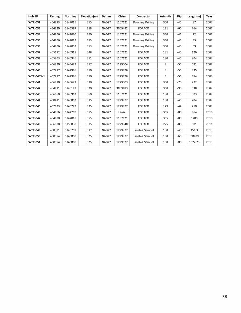
58
Hole ID Easting Northing Elevation(m) Datum Claim Contractor Azimuth Dip Length(m) Year
WTR-032 454893 5147015 355 NAD27 1167121 Downing Drilling 360 -45 87 2007
WTR-033 454320 5146397 318 NAD27 3009482 FORACO 181 -60 764 2007
WTR-034 454906 5147030 360 NAD27 1167121 Downing Drilling 360 -45 72 2007
WTR-035 454906 5147013 355 NAD27 1167121 Downing Drilling 360 -45 53 2007
WTR-036 454906 5147003 353 NAD27 1167121 Downing Drilling 360 -45 69 2007
WTR-037 455192 5146918 348 NAD27 1167121 FORACO 181 -45 126 2007
WTR-038 455803 5146946 351 NAD27 1167121 FORACO 180 -45 204 2007
WTR-039 456920 5145473 357 NAD27 1129504 FORACO 9 -55 581 2007
WTR-040 457217 5147986 350 NAD27 1229976 FORACO 9 -55 335 2008
WTR-040W1 457217 5147986 350 NAD27 1229976 FORACO 9 -55 654 2008
WTR-041 456910 5146672 330 NAD27 1229503 FORACO 360 -70 272 2009
WTR-042 454911 5146143 320 NAD27 3009483 FORACO 360 -90 538 2009
WTR-043 456060 5146962 360 NAD27 1167121 FORACO 180 -45 303 2009
WTR-044 458411 5146802 315 NAD27 1229977 FORACO 180 -45 204 2009
WTR-045 457623 5146773 335 NAD27 1229977 FORACO 179 -44 210 2009
WTR-046 454866 5147209 355 NAD27 Lease FORACO 355 -80 864 2010
WTR-047 454880 5147018 355 NAD27 1167121 FORACO 355 -80 1200 2010
WTR-048 456900 5150030 375 NAD27 1229948 FORACO 225 -80 501 2011
WTR-049 458381 5146759 317 NAD27 1229977 Jacob & Samuel 180 -45 156.3 2013
WTR-050 458354 5146800 325 NAD27 1229977 Jacob & Samuel 180 -60 398.09 2013
WTR-051 458354 5146800 325 NAD27 1229977 Jacob & Samuel 180 -80 1077.73 2013

59
TRILL WEST So far, the SCJV has completed two drill holes for a total of 186 metres on the Trill West property (Table 21).
Table 21. Wallbridge drilling on the Trill West property
Hole ID Easting Northing Elevation(m) Datum Claim Contractor Azimuth Dip Length(m) Year
WTW-001 449023 5160475 368 NAD27 3009837 Levert Drilling 162 -64 75 2012
WTW-002 448950 5160470 368 NAD27 3009837 Levert Drilling 107 -45 111 2012
WINDY LAKE So far, the SCJV has completed 28 drill holes including one wedge-cut for a total of 34,729 metres on the Windy
Lake property (Table 22).
Table 22. Wallbridge drilling on the Windy Lake property
Hole ID Easting Northing Elevation(m) Datum Claim Contractor Azimuth Dip Length(m) Year
WWL-001 465268 5160306 352 NAD27 S29093 Boart Longyear 58 -57 1241 2002
WWL-002 464464 5159105 355 NAD27 S36057 Boart Longyear 128 -80 1021 2002
WWL-003 465269 5160300 352 NAD27 S29093 Boart Longyear 154 -78 1221 2002
WWL-004 463877 5158968 372 NAD27 S36343 Boart Longyear 320 -45 599 2002
WWL-005 465268 5160306 352 NAD27 S29093 Boart Longyear 47 -64 1502 2002
WWL-006 465279 5160286 352 NAD27 S29093 Boart Longyear 83 -76 1381 2002
WWL-007 467127 5161888 346 NAD27 S28353 Boart Longyear 249 -61 1448 2002
WWL-008 465259 5160300 352 NAD27 S29093 Boart Longyear 33 -65 1038 2002
WWL-009 465474 5159961 354 NAD27 S29093 Boart Longyear 180 -45 2213 2002
WWL-009A 465474 5159961 354 NAD27 S29093 Boart Longyear 13 -53 1396 2003
WWL-009B 465474 5159961 354 NAD27 S29093 Boart Longyear 56 -66 2083 2003
WWL-010 465461 5159980 356 NAD27 S29093 Boart Longyear 157 -80 2573 2003/2008
WWL-011 465462 5159977 357 NAD27 S29093 Boart Longyear 61 -59 2070 2003
WWL-012 465145 5161188 339 NAD27 ELO Boart Longyear 71 -57 102 2003
WWL-013 465410 5161467 339 NAD27 ELO Boart Longyear 167 -89 290 2003
WWL-014 465730 5161697 339 NAD27 ELO Boart Longyear 272 -89 419 2003
WWL-015 465688 5161116 339 NAD27 ELO Boart Longyear 326 -89 797 2003
WWL-016 465972 5161397 339 NAD27 ELO Boart Longyear 260 -89 763 2003
WWL-017 466070 5160838 339 NAD27 ELO Boart Longyear 313 -90 1183 2003
WWL-018 466316 5161162 339 NAD27 ELO Boart Longyear 78 -72 1146 2003
WWL-019 466269 5160628 339 NAD27 ELO Boart Longyear 252 -90 1522 2003
WWL-020 466521 5160797 339 NAD27 ELO Boart Longyear 77 -71 1375 2003
WWL-021 465461 5159980 356 NAD27 S29093 Boart Longyear 78 -72 1791 2003
WWL-022 466515 5159365 340 NAD27 ELO Boart Longyear 255 -46 2253 2004
WWL-023 464563 5159996 350 NAD27 S36055 Major Ideal
Drilling 339 -65 900 2005
WWL-024 463295 5158968 350 NAD27 PR Canadian Driller 61 -46 350 2010
WWL-025 463870 5158962 372 NAD27 S36343 FORACO 255 -46 560 2011
WWL-026 463870 5158962 372 NAD27 S36343 FORACO 255 -55 350 2011
WWL-027 463456 5158433 360 NAD27 S53945 Canadian Driller 46 -38 571 2012
WWL-028 463456 5158433 360 NAD27 S53945 Levert Drilling 33 -65 572 2012
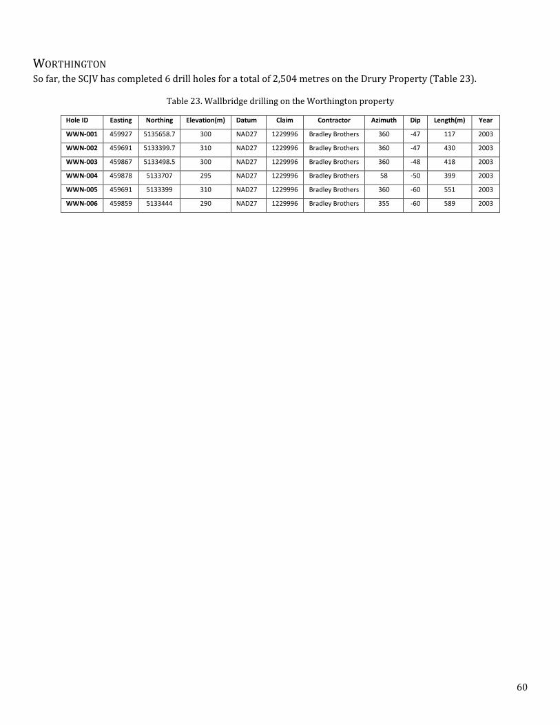
60
WORTHINGTON So far, the SCJV has completed 6 drill holes for a total of 2,504 metres on the Drury Property (Table 23).
Table 23. Wallbridge drilling on the Worthington property
Hole ID Easting Northing Elevation(m) Datum Claim Contractor Azimuth Dip Length(m) Year
WWN-001 459927 5135658.7 300 NAD27 1229996 Bradley Brothers 360 -47 117 2003
WWN-002 459691 5133399.7 310 NAD27 1229996 Bradley Brothers 360 -47 430 2003
WWN-003 459867 5133498.5 300 NAD27 1229996 Bradley Brothers 360 -48 418 2003
WWN-004 459878 5133707 295 NAD27 1229996 Bradley Brothers 58 -50 399 2003
WWN-005 459691 5133399 310 NAD27 1229996 Bradley Brothers 360 -60 551 2003
WWN-006 459859 5133444 290 NAD27 1229996 Bradley Brothers 355 -60 589 2003
61
11. SAMPLE PREPARATION, ANALYSES, AND SECURITY
All Wallbridge staff members are trained on the importance of sample security and integrity. For samples collected
by Wallbridge since July 2005, the following procedures were followed.
Grab samples and representative splits were described, bagged, and assigned a sample number in the field,
brought to the Wallbridge office in Lively, Ontario, and then transported to a sample preparation laboratory in
Sudbury, Ontario. Representative sample splits were stored, either permanently or temporarily, for future
reference at the Wallbridge head office in Lively, Ontario.
Field samples were taken of outcrops with visible sulfides or strong epidote, amphibole, chlorite, or hematite
alteration or signs of SIC-related partial melting. Representative samples of Sudbury breccia matrix were taken for
TPM (fire assay, ICP-AES), ICP-MS and Cl and F analyses, and thin sections were made to determine the degree of
thermal metamorphism and alteration of the breccia. Any rock that was suspected to be quartz diorite, or was
suspected to be the cause of any geophysical anomaly was sampled and sent for whole rock and REE analysis in
addition to Wallbridge’s standard ICP-MS and TPM (fire assay, ICP-AES) analytical methods. Samples and
representatives were numbered and bagged in the field, sample locations were recorded using a handheld GPS or
plotted from field maps, and a metal tag with the sample number was generally left at the site. Sample sites also
were flagged, with the sample number written on the flag.
During the drilling programs, core samples were transported from the field to the Wallbridge head office by
company personnel. Cores were logged and sample intervals marked by Wallbridge geologists, or by personnel
under their supervision. Drill core sampling was controlled by lithology, alteration or visible mineralization, with a
maximum sample length of 1.5m. All Sudbury breccia and quartz diorite was sampled. Diabase was sampled to
provide background values and to build a database of geochemical data that could be used to differentiate this rock
type from quartz diorite.
All drill core samples were split using a water cooled diamond saw that is cleaned regularly to avoid sample to
sample contamination. Half of the core was submitted to the lab for analysis and the other half was retained on
outdoor, roofed core racks at the Wallbridge head office at 129 Fielding Road, Lively, Ontario as a representative
sample or for possible re-sampling. Every effort was taken to ensure that the sample sent to the lab was
representative of the entire section of core; however, due to nugget effects and the heterogeneity that is common
with PGE mineralization, it is not guaranteed that an assay could be repeated.
All samples were sealed (stapled) in individual, labelled plastic bags with a sample tag. If a thin section was
requested, a portion of the sample was cut from the grab sample at the same time. Standards (LDI-3 STD) and field
blanks are submitted at least every twentieth sample, or as the last samples to be submitted in a batch. The sample
book used to track the samples has four partitions with the sample number on each tag. One tag goes with the
geological reference, one with the lab sample, one with the thin section and the remaining part of the tag book is
stored at the Wallbridge Office in Lively, Ontario.
Since July, 2005, samples have been sent to ALS Minerals, an ISO 9001:2008 and ISO/IEC 17025:2005 certified
service provider, for geochemical analyses. Before December, 2005, samples shipped to ALS Minerals were
delivered to the preparation facility in Toronto by an independent trucking company.
At ALS Minerals, samples were checked against requisition documents prior to being dried, weighed, crushed to
≥70% passing 2mm and split to 250 gram fractions using a Jones riffle and pulverized split to ≥85% passing 75
micron and then transported by ALS Minerals to their analytical facilities in Vancouver, British Columbia. In 2011,
Wallbridge began adopting the use of 1kg splits to improve compositional representation for some sampling.
62
Samples were analyzed for gold, platinum, and palladium by standard lead collection fire assay fusion followed by
a combination of inductively coupled plasma mass spectrometry (ICP-MS) and atomic emission spectrometry (ICP-
AES). Samples were also analyzed for 48 base metals and trace elements using a four acid (HNO3-HCIO4-HF and
HCI) near total digestion and a combination of ICP-MS and ICP-AES. ICP-MS over limits were re-analyzed using HF-
HNO3-HClO4 acid digestion, HCl leach and ICP-AES. In the event of higher grade mineralization, the preference
was to analyze sample groups by submitting the samples directly for analytical methods described for over limits.
These analytical methods, also referred to as High Grade/Ores Methods, are comprised of HF-HNO3-HClO4 acid
digestion, HCl leach and ICP-AES. In addition to High Grade/Ores Methods, sulphur was analyzed using Total
Sulphur by LECO to accommodate the anticipated higher sulphur levels.
Selected samples were subjected to whole rock and rare earth element (REE) analysis. These samples were
subjected to Lithium Borate fusion with ICP-AES for oxides, and Lithium Metaborate fusion with ICP-MS for trace
and rare earth element evaluation.
Selected samples of Sudbury breccia matrix were analyzed for chlorine and fluorine using KOH fusion specific ion
electrode (ELE81A) and Neutron Activation (NAA-06) procedures.
ALS Minerals has a rigorous internal security and client confidentiality policy; details are available through their
website: www.alsglobal.com.
ALS Minerals provided assay results to the Wallbridge Assay Manager who sends them to the project geologist via
email.
Prior to July 2005, Wallbridge core and grab samples were analyzed by SGS Mineral Services, an ISO 9000 certified,
geochemical exploration and research analysis facility which maintains a sample preparation lab in Sudbury.
Samples sent to them were routinely dried, crushed, riffle split, and pulverized to produce 250 gram 85% -75
micron assay grade pulps. These pulps were subsequently transported to SGS analytical facilities in Rouyn-
Noranda, PQ, for platinum group element analyses by fire assay, and to Toronto for ICP multi-element geochemical
analysis.
SGS analyzed the submitted samples for platinum group metals using a nominal 30 gram trace level fire assay lead
collection procedure with ICP finish. Over-limit samples were subjected to an ore grade fire assay gravimetric
analysis method. Base metal assaying was done in their Toronto laboratory using a combination of multi-acid
digestion (ICP-40B) and ICP-MS methods to produce a 32 element suite of base metal and background results.
Over-limit samples from the ICM40B method for Cu, Ni, and Co were treated to dedicated analysis using a sodium
peroxide fusion ICP - resource definition procedure. Silver and sulfur values were determined by aqua-regia
digest, AA finish, and LECO titration methods.
12. DATA VERIFICATION
A reference material standard (LDI-3 STD) was submitted at least every twentieth sample, or as the second to last
sample to be submitted in a batch. Blanks from un-mineralized quartzite were also submitted in sequence
following the standard and potentially high grade samples to check for contamination during the sample
preparation. LDI-3 is a non-certified standard supplied by North American Palladium Ltd. It comprises high grade
gabbro collected in 2001 at the Lac des Iles PGE deposit, located 85km north of Thunder Bay Ontario. Provisional
compositional data for it is provided by the Ontario Geoscience Laboratories.

63
ALS Minerals has accreditation to ISO 9001:2000 standards and completes a rigorous internal quality-assurance,
quality control assessment prior to releasing the finalized analytical results with a certificate. Details are available
on their website: www.alsglobal.com
An initial visual inspection of the Wallbridge submitted standard and blank data included or related to this report
has been made. If there had been a discrepancy between the measured and reported values of the standard and
blank samples then the lab would have been contacted. The results of the Wallbridge quality control analyses done
by ALS Minerals for drill core samples are stored in the drill core database and those from the field samples are
stored in the report database. ALS Minerals also supplies their internal QC data which consists of standards, blanks
and duplicates; Wallbridge stores these in certificate form.
13. MINERAL PROCESSING AND METALLURGICAL TESTING
No metallurgical test work has been carried out.
14. MINERAL RESOURCE ESTIMATES
No estimates of mineral resources have been prepared for mineralization on any of the properties.
15. MINERAL RESERVE ESTIMATION
No estimates of mineral reserves have been prepared for mineralization on any of the properties.
23. ADJACENT PROPERTIES
Information regarding adjacent properties is gathered from the author’s experience working in the area and
sources that are believed to be reliable. The author is unable to verify information regarding adjacent properties.
Information on adjacent properties is not necessarily indicative of mineralization on the SCJV properties.
The SCJV properties are located in the Sudbury Mining Camp, an area that has been mined and explored for the
past 125 years. Adjacent properties include those being mined and/or aggressively explored by Vale, Glencore
Xstrata, and KGHM International. While the location of the SCJV properties adjacent to these various operations is
highly favourable, results on adjacent properties will not necessarily reflect results on the SCJV properties.
CASCADEN The Cascaden property is in the immediate footwall to the Windy Lake Embayment, discovered by Wallbridge. The
property is also within 5 km of the Onaping-Levack Embayment, which is one of the most endowed Ni-Cu-PGE
mining areas in Sudbury and has supported several important mines of Vale, Glencore Xstrata and KGHM
International over the past 100 years.
CREIGHTON SOUTH The Creighton South property is located on the South Range immediately south of Vale’s Creighton and Gertrude
mines. The Creighton mine has been in almost continuous production for over 100 years. Vale’s mined-out Crean
Hill deposit is less than 5km to the north-west and hosts a new footwall-style PGE discovery made by the
Lonmin/Vale Inco joint venture. Within 4km of the north-western Creighton claim boundary is First Nickel’s
64
Lockerby Mine (formerly owned by Glencore Xstrata), and their West Graham open pit resource. There are
numerous other occurrences between Lockerby and Creighton Mine.
DRURY The Dury property is in the footwall of an embayment that hosts the Sultana deposit and is being actively explored
by Glencore Xstrata in the recent years. The property is also within 10 km Northwest of Vale’s new Totten Mine
and KGHM International’s recent discovery on their Victoria property.
FOY The Foy property lies adjacent to Glencore Xstrata’s Premier Ridge deposit, which hosts contact- and footwall-style
Ni-Cu-PGE mineralization in a near surface resource. Recent drilling less than 500 m to the south of the Foy
property has discovered contact- and footwall-style mineralization at depth, which bodes well for a discovery on
the Foy property.
On Wallbridge’s Rudy’s Lake property to the Southwest of Foy across the Sandcherry Creek fault there are
occurrences of QD pods and dykelets in Sudbury breccia, which is trending NE, towards the Foy property. It is
unclear what the offset on the Sandcherry fault zone is, however the potential exists for the QD-bearing Sudbury
breccia to be present on the Foy property as well.
SKYNNER LAKE The Skynner Lake property is south and contiguous with KGHM International’s Podolsky Mine property and the
historic Whistle Mine. Skynner Lake is also north and contiguous with Wallbridge’s Frost Lake Joint Venture that
includes the Amy Lake Cu-PGE occurrence. Immediately west of Skynner Lake is an area that is being aggressively
explored by both Vale and Glencore Xstrata.
TRILL On the western end of the basin, the Trill property is adjacent to the Trill embayment within which two Ni-Cu-PGE
deposits have been defined by Vale. It is 10-12 km to the northwest of Vale’s new Totten Mine and KGHM
International’s recent discovery on their Victoria property.
TRILL WEST The Trill West property lies adjacent to the Ministic Embayment and Offset Dyke, and the Windy Lake Embayment,
discovered by Wallbridge.
WINDY LAKE On the Windy Lake property Wallbridge discovered an embayment structure that is within 10 km southwest of the
Onaping-Levack Embayment, which is one of the most endowed Ni-Cu-PGE mining areas in Sudbury and has
supported several important mines of Vale, Glencore Xstrata and KGHM International over the past 100 years.
WORTHINGTON The Worthington property exposes 400 m strike lengths of the Worthington Offset Dyke which is one of the most
significant offset dykes in Sudbury. Among numerous other deposits, this dyke hosts Vale’s new Totten Mine and
KGHM International’s recent discovery on their Victoria property.
24. OTHER RELEVANT DATA AND INFORMATION
There is no other relevant data or information that the author is aware of that should be included in this report.

65
25. INTERPRETATION AND CONCLUSIONS
In terms of metal endowment, infrastructure, community support and regulatory stability, Sudbury is the most
attractive place in the world to explore for and develop large-scale copper, nickel and PGE mining projects. Despite
over 125 years of mining in the Sudbury area, very large and high grade deposits continue to be discovered.
All of the Sudbury Camp Joint Venture properties contain favourable geology for Sudbury-type deposits. A number
of geological/structural targets have been identified on each of the properties which warrant systematic deep
drilling. Highlights of the activities on SCJV properties are:
Identification of chargeability anomalies and drill targets within the strongly recrystallized Sudbury breccia
structure at Skynner Lake on the East Range of the Sudbury basin between Vale’s Victor-Capre
development project and KGHM International’s Podolsky mine,
High grade platinum group metals, nickel and copper sulfide along a 140 m mineralized trend within the
Trill Offset dyke that was discovered by Wallbridge in 2005 with drill hole intersections including 6.41 g/t
Pt + Pd + Au, 0.79 % Cu and 1.2 % Ni over 10.3 metres in WTR-012 and 8.11 g/t Pt + Pd + Au, 1.01 % Cu
and 0.81 % Ni over 8.76 metres in WTR-028. Discovery of the Trill East showing in 2013 with grab and
brick samples up to 8.93 g/t Pt + Pd + Au, 1.9 % Cu and 2.45 % Ni.
The discovery of two km of Hess Offset dyke on the Trill West Property in 2010 including disseminated
nickel, copper and PGE sulfide mineralization associated with inclusion bearing phases of the dyke. Surface
sampling has returned maximum values of 0.24 g/t Pt, 0.34 g/t Pd, 0.07 g/t Au, 0.3 % Ni and 0.17 % Cu,
Identification of a large unexplored section of the basal contact of the Sudbury Igneous Complex (SIC) at
Windy Lake immediately adjacent to numerous deposits, active mines and past producing mines in the
Onaping-Levack area,
Identification of chargeability anomaly drill targets within the Sudbury breccia structure at Foy with
several occurrences of weak mineralization including up to 1.0 g/t TPM and
The intersection of Sudbury breccia structures at Creighton South which extend from the nearby giant
deposits at Vale’s Frood-Stobie and Creighton mine and KGHM International’s Victoria discovery.
Several showings of Ni-Cu-PGE mineralization occur in East Bull Lake- and Nipissing-suite mafic rocks of
the Drury property. Grab samples returned up to 1.82 % Cu and 1.52 g/t Pt + Pd + Au. The South Range
Shear Zone exits the SIC in this area and due to the large-scale displacements along the contact there is a
possibility for the occurrence of SIC outliers.
There is a 400 m strike length of the Worthington Offset Dyke with blebby sulfide mineralization located on
the Worthington property.
CASCADEN The Cascaden Property is located on the North Range of the Sudbury Basin in the immediate footwall to the SIC at
Windy Lake. It is being explored for Sudbury Offset Dyke hosted and Sudbury Footwall type deposits.
Mapping on Wallbridge’s Cascaden North property has outlined a new Sudbury Offset Dyke (Cascaden Offset Dyke)
five kilometres to the northwest. The projected trend of the dyke crosses the Cascaden property and intercepts the
SIC contact in the Windy Lake area.
The northern claim block of the property is within two kilometres of the prolific mineralized Levack Embayment.
Mapping and sampling in the block has outlined areas with anomalous PGE concentrations and geophysical
surveys have produced some suspicious geophysical trends, however nothing was definitive. One of the most

66
interesting trends that has not been adequately explored is a curvilinear magnetic low believed to be part of the
North Range Breccia Belt. The belt is a 29 kilometre long curvilinear Sudbury breccia structure that is up to 200
metres wide and forms a continuous topographic and magnetic lineament. The lineament extends from the
Trillabelle Embayment in the southwest, crossing the northern block of the Cascaden Property and trends towards
the Levack Embayment in the northeast.
The North Range Breccia Belt may represent a similar structural setting as the South Range Breccia Belt, which
host the world class Frood-Stobie deposit. Both have significant strike lengths and width suggesting their
significance as major zones of weakness and permeability active during the formation of the SIC.
There remain a number of unexplained Titan chargeability and resistivity low responses in central Cascaden. The
anomalous Cu, Ag and Pb values, well-developed epidote +/- actinolite and hematite alteration encountered in drill
holes and in surface mapping, and the coincident geophysical evidence such as magnetic low extending from a
mineralized embayment suggest this area is favourable for footwall mineralization.
CREIGHTON SOUTH The Creighton South property occurs just south of Vale’s Creighton Mine, one of the richest and longest lived mines
in Canada’s history, having been in near continuous production for over 100 years. Numerous Sudbury breccia
structures have been mapped both radiating from the SIC near the Creighton mine, and some striking parallel to
the SIC as part of the South Range breccia belt. These structures and surrounding rocks are prospective for
platinum, palladium, nickel, copper and gold mineralization. Further work is warranted to understand these
structures and explore them to depth.
Sudbury breccia has long been a focal point of the Creighton South property. KGHM’s recent deep mineralization at
their Victoria property is associated with SDBX and thus similar to the Frood-Stobie complex. Creighton South is
interpreted to host the central portion of the SDBX belt that connects these two zones, and could host similar
mineralization at depth.
DRURY Several Ni-Cu-PGE mineralization styles were recognized associated with gabbroic rocks of Nipissing- and East Bull
Lake affinity. Both mafic suites are known to host potentially economic Ni-Cu-PGE zones in the wider Sudbury area.
Trenching of some of the showings is warranted to better understand the distribution of the PGE-bearing
assemblages. Airborne EM is recommended to test for conductors associated with these rock types.
The property is located where the South Range Shear Zone exits the SIC and there are significant displacements
along some of the faults. This resulted the emplacement of the Perimaki outlier into the SIC footwall, detached from
the rest of the SIC. Structural modeling by Wallbridge suggests that it is possible other outliers exist at depth on the
Drury property in the form of buried SIC slabs at depth.
FOY The Foy Property is located in the footwall to the North Range of the SIC, 350m from Glencore Xstrata’s Premier
Ridge deposit. Work to date has identified a number of prospective geological targets on the property and
additional work is warranted.
One of the exploration targets for the SCJV was the Foy structure, a large NW-SE fault zone that intersects the SIC at
the Premier Ridge deposit, which is depleted in Cu and PGE suggesting that these metals may have migrated into
the footwall, potentially along the large scale Foy structure.
The Southern part of Foy is underlain by massive zones of strongly recrystallized Sudbury breccia with SIC-related
partial melting and hydrothermal alteration and anomalous Cu and PGE concentrations. These are all indicators
67
that this area is a favourable environment to host footwall-style mineralization. This area has had limited drilling
and significant further work is warranted.
SKYNNER LAKE The East Range Sudbury breccia structure extends for 5 kilometres strike length across the Skynner Lake property.
This structure hosts significant mineralization south of the property at the Amy Lake PGE zone on Wallbridge’s
adjacent Frost Lake property and at Vale’s deposits.
Much of the drilling carried out by the SCJV on the property was aimed at testing geophysical anomalies associated
with the Sudbury breccia structure.
Most recently, the 2013 exploration program outlined a Sudbury breccia zone south of Skynner Lake in the North
Block of the Property. Deepening of WSK-008 revealed that this area is underlain by massive Sudbury breccia that
has been recrystallized to depths of at least 800-900 metres by heat generated from the SIC. Surface mapping and
the shallow drill holes WSK-001 and -005 indicate that this breccia zone extends about 500-600 m North of WSK-
008. Although no footwall-style mineralization was encountered so far in the area, SIC-related partial melting and
hydrothermal alteration is abundant in this recrystallized Sudbury breccia which is in the footwall to sulfide-
bearing Sublayer just west of the property boundary. This breccia zone represents a favorable geologic
environment for Cu-Ni-PGE mineralization. Drilling of two deep (1,000-1,200 m) holes is warranted to explore this
Sudbury breccia target.
The Sudbury breccia structure remains untested in the Northern part of the property and over most of its strike
length below 500 m depth.
TRILL The Trill Property is a large property on the western rim of the Sudbury basin and has a number of different
targets on it. The property is adjacent to the Trill embayment within which a couple of Ni-Cu-PGE deposits have
been defined by Vale. Wallbridge has mapped a number of Sudbury breccia structures in the footwall to this
embayment which are prospective for footwall style Cu-Ni-PGE’s.
In 2005, Wallbridge discovered high grade Ni-Cu-PGE mineralization within the previously unrecognized Trill
Offset dyke. This occurrence is located over four kilometres away from the main body of the SIC and subsequent
mapping defined the dyke over a two kilometre strike length before losing it beneath deep overburden to the east.
Drilling in 2010 confirmed that Trill Offset extends to depth below the showing; most of the Trill Offset remains
virtually unexplored.
The discovery of the Trill East Cu-Ni-PGE showing in 2013 associated with the Trill offset 3.5 km away from the
previously known showing is encouraging as it highlights the potential of the Trill offset to host sulfide
mineralization along a substantial strike length.
Significant drilling is warranted along the Trill offset to test for sulfide mineralization. Drilling at shallow depth is
required to understand the geometry of the QD system as the Trill offset corridor tends to be quite wide (150 to
250 m in some areas) and complicated by primary irregularities (bends, splays etc.) and later displacements. This
shallow drilling should be followed by deeper cuts through the dyke to test for mineralization below EM coverage.
Review of 3D Mag data resulted in the identification of a Mag-high anomaly in the Northern part of the property.
This unexplained discrete, strongly magnetic feature appears to plunge toward the Trill embayment and shows up
also as a strong IP chargeability anomaly. As this target is identified by two independent geophysical systems drill
testing is certainly warranted.
68
TRILL WEST Wallbridge discovered two kilometres of the Hess Offset Dyke on the Trill West Property after a 35 metre long and
up to 18 metre wide segment of the Hess Offset dyke was exposed. It contains a 1-2 metre wide mineralized, exotic
mafic inclusion-bearing phase of the quartz diorite dyke. The mineralization occurs at the hinge of a sharp bend in
the dyke. The Ni-Cu-PGE mineralization was concentrated in stringers which was not detected by the geophysics,
but indicates that there is offset mineralization in the dyke in this area.
Drill holes through the Hess offset dyke to the east and south of the Trill West property indicate that the dyke is a
complex network of numerous dykes. South of the property a drill hole intersected a 50 metre wide corridor of QD
consisting of narrow spherulitic QD (SQD) centered on a 40m wide inclusion bearing dyke. North of the property
drilling identified a 95 metre wide corridor consisting of a 12 metre and 4 metre wide QD dykes and two 20 cm
SQD dykes. This indicates additional parallel dykes likely also occur on the Trill West property but have not been
delineated. These parallel dykes may bend, pinch, swell, merge and splay, creating structural traps for sulfide
mineralization.
Offset dyke mineralization often occurs where the dyke cuts large mafic bodies. Surface mapping on Trill West has
delineated a large Nipissing Gabbro sill within 100 metres of the Hess Offset trend. The plunge direction of the sill
is not known at this point. It is important that this be determined because if it plunges towards the Hess Offset,
where the two intersect would be an important exploration target.
To fully test the potential of the property additional mapping and drilling is required.
WINDY LAKE The Windy Lake property is located on the North Range of the SIC. The property contains approximately 13km2 of
the SIC contact, an important ore hosting environment in Sudbury. An estimated 70% of the 13km2 has not been
explored for contact deposits. Included in that is a trend of EM anomalies on the western portion of the property
near Tower Bay. Nearly all the property is unexplored for footwall deposits below the SIC.
Mapping on Wallbridge’s Cascaden North property has outlined a new Sudbury Offset Dyke (Cascaden Offset Dyke)
seven kilometres to the northwest. The projected trend of the dyke indicates it will likely intercept the SIC contact
in the Tower Bay area. Where the dyke intersects the SIC could possess significant economic potential as radial
Offset dykes can be
2011 -2012 Wallbridge drilling and circa 1950’s INCO drill holes collared in the SIC, east of WWL-024, support the
possibility of an Embayment structure in Tower Bay. Wallbridge drilling in Tower Bay indicates that the SIC
contact is dipping at approximately -20o. INCO drilling located to the south, on the southwest shore of Tower Bay,
indicates the contact is dipping at -45°. Somewhere in between the contacts dip changes. Three possible scenarios
causing the change include a gradual sloping of the contact, a sharp change due to faulting or a sharp change in dip
with a flexure at the base. In addition, WWL-028 intersected approximately 24 meters of mineralized Sublayer
before intersecting a fault which is further evidence for a possible embayment structure in Tower Bay.
Drilling east of the Peninsula has outlined sub-economic grades and volumes of contact mineralization hosted in an
embayment structure which has been closed off in all directions but down dip to the southwest between WWL-011
and WWL-021. A RIM survey conducted between those holes suggests that there may be a zone of decreased
resistivity in that gap.
WORTHINGTON Four hundred metres strike length of the Worthington Offset Dyke occurs on the Worthington property. The quartz
diorite dyke appears to have many of the characteristics typical of mineralized offset dyke environments, such as:

69
bottle-necking, clast abundance, presence of Sudbury breccia in the adjacent country rocks, and significant width.
All of these characteristics serve as favourable indicators for sulphide accumulation.
Twelve trenches and six drill holes have tested the known strike length to the 400 m level and BHUTEM
geophysical surveying has tested to approximately the 500 m level. Thus far, no significant grade Cu, Ni or PGE
mineralization has been intersected within the offset dyke. In general, the channel sampling indicated that assay
values decrease westward along the dyke and that the inclusion-bearing quartz diorite rock type is more
anomalous in Cu, Ni and PGE elements than the massive quartz diorite phase and wall rocks.
There is potential that another segment of the Worthington offset dyke may be found on the Worthington Property.
One area that should be reviewed is the gabbro outcrops on the north side of the Murray Fault system. Due to the
complexity of the fault system and the similarity in the appearance between the quartz diorite and the Sudbury
gabbro previous mapping may have missed the continuation of the dyke.
The concept that Nipissing gabbro represents a viable exploration target is not a new idea in the Sudbury Basin.
The non-SIC related mineralization in the Nipissing gabbro remains prospective and warrants consideration on the
property. The Nipissing gabbro on the property has not been explored in a systematic and detailed manner.

70
26. RECOMMENDATIONS
Currently, the 2014 SCJV scope of work and budget approved at the Joint Venture Exploration Committee meeting
held October 17th, 2013, is underway. The approved 2014 budget totals USD $1,600,000 funded by Lonmin, a large
portion of which ($1,228,606) is budgeted for Trill property (Table 24).
The approved scope of work and budget includes further trenching, detailed mapping, structural analysis, line
cutting, surface EM, drilling and BHEM in Trill property and further drilling in Skynner property as well as minor
maintenance and survey for Cascaden, Creighton South, Foy, Windy Lake and Trill West properties.
Table 24. Approved 2014 SCJV Scope of Work
In addition to the 2014 Scope of Work further significant work is required on the SCJV properties to explore for Ni-
Cu-PGE mineralization.

71
27. REFERENCES
Ames, D.E., and Farrow, C.E.G. (2007) Metallogeny of the Sudbury mining camp, Ontario, in Goodfellow, W.D., ed.,
Mineral Deposits of Canada: A Synthesis of Major Deposit-Types, District Metallogeny, the Evolution of
Geological Provinces, and Exploration Methods: Geological Association of Canada, Mineral Deposits
Division, Special Publication No.5, p. 329-350.
Bailey, J. (2011) Technical Report on the Sudbury Camp Joint Venture Properties, Sudbury, Ontario.
Davis, C. (2007) Lonmin – CVRD Inco Sudbury PGE Joint Venture: The Search for Economic Low Sulphide High
PGE-Au Deposits. PDAC Convention Presentation.
Eckstrand, O.R., and Hulbert, L.J. (2007) Magmatic nickel-copper-platinum group element deposits, in Goodfellow,
W.D., ed., Mineral Deposits of Canada: A Synthesis of Major Deposit Types, District Metallogeny, the
Evolution of Geological Provinces, and Exploration Methods: Geological Association of Canada, Mineral
Deposits Division, Special Publication No. 5, p. 205-222.
Frayne, M. (November, 2013) KGHM International. Victoria Advance Exploration Project Past, Present and What’s
Next. Presentation to the Sudbury Prospectors and Developers Association
Lightfoot, P.C., and Farrow, C.E.G. (2002) Geology, Geochemistry, and Mineralogy of the Worthington Offset Dike: A
Genetic Model for Offset Dike Mineralization in the Sudbury Igneous Complex. Economic Geology, Vol.
97, no. 7, p. 1419-1446.

72
SIGNATURE PAGE
To Accompany the Technical Report entitled
“TECHNICAL REPORT ON THE SUDBURY CAMP JOINT VENTURE (SCJV) PROJECTS LOCATED NEAR SUDBURY, ONTARIO” Effective December 31st, 2013.
I, Attila Péntek, Ph.D., P.Geo., residing at 1491 Kingslea Court, Sudbury, Ontario P3A 3P6, do hereby certify that:
1. I am currently employed as a Senior Geologist with Wallbridge Mining Company Ltd. As an employee of Wallbridge Mining, I do not qualify as an independent Qualified Person.
2. I am a Qualified Person as defined in National Instrument 43-101.
3. I am a member in good standing of the Association of Professional Geoscientists of Ontario (#2163).
4. I am primarily responsible for all sections of this report and have been actively taking part in the planning, supervision and execution of exploration programs on the SCJV properties. Most recently I visited the properties in December, 2013 during a drill program.
5. I graduated from Eötvös Loránd University, Budapest (Hungary) in 2006 with a M.Sc. and in 2010 with a Ph.D. in Geology.
6. I have experience working in the Sudbury area. Both my M.Sc. and Ph.D. thesis projects where completed (2005-2010) on properties of Wallbridge Mining Company in the North and East Ranges of the Sudbury Structure. Since 2010 I have been working continuously with Wallbridge conducting exploration in Sudbury.
7. I am not aware of any material fact or change with respect to the subject matter of this technical report which is not reflected in the technical report effective December 31st, 2013. Exploration of the property is ongoing and an updated technical report may be prepared in the future.
8. This technical report has been prepared by me for use in conjunction with Wallbridge’s Annual Information Form (AIF) and other corporate purposes.
9. I have read National Instrument 43-101 and Form 43-101F1. This technical report has been prepared in compliance with those documents.
Effective as of December 31st, 2013.
Attila Péntek, Ph.D., P.Geo.
This 13th day of March 2013