Technical Report On the Kibi Goldfields Mine Kwabeng … the Kibi Goldfields Mine Kwabeng Gold...
73
1 CHEVYROCK ENGINEERING 2010 CHEVYROCK ENGINEERING ATEWA RANGE KWABENG PROJECT 2010 1 Technical Report On the Kibi Goldfields Mine Kwabeng Gold Project GHANA, WEST AFRICA For CHEVYROCK ENGINEERING LLC. NAPLES, FLORIDA CHEVYROCK ENGINEERING, LLC. Ron Anthony, Managing Director John Rae, P.Geo Kofi Agyemang, Geologist Dr. Robert J. Griffis, Geologist
Transcript of Technical Report On the Kibi Goldfields Mine Kwabeng … the Kibi Goldfields Mine Kwabeng Gold...

1 CHEVYROCK ENGINEERING 2010
CHEVYROCK ENGINEERING ATEWA RANGE KWABENG PROJECT 2010 1
Technical Report On the Kibi Goldfields Mine
Kwabeng Gold Project GHANA, WEST AFRICA
For CHEVYROCK ENGINEERING LLC.
NAPLES, FLORIDA
CHEVYROCK ENGINEERING, LLC. Ron Anthony, Managing Director
John Rae, P.Geo Kofi Agyemang, Geologist
Dr. Robert J. Griffis, Geologist

2 CHEVYROCK ENGINEERING 2010
CHEVYROCK ENGINEERING ATEWA RANGE KWABENG PROJECT 2010 2
November 7, 2009 Table of Contents The following report information regarding the ChevyRock Engineering, LLC (CE) gold and diamond mining operation in the Atewa Range, Ghana, West Africa and all attachments thereof are confidential, internal company documents. They are strictly for use by CE members and management and also select Recipients outside CE who have requested this information for the purposes of evaluating the project. By reading this document you are agreeing to abide by the Non-Compete / Non-Disclosure Agreement provided to you. CONTENTS OF THE TECHNICAL REPORT Item 1: Title Page Item 2: Table of Contents Item 3: Summary Item 4: Introduction Item 5: Reliance on Other Experts Item 6: Property Description and Location Item 7: Accessibility, Climate, Local Resources, Infrastructure and Physiography Item 8: History Item 9: Geological Setting Item 10: Deposit Types Item 11: Mineralization – Primary Project Kibi Goldfields - Kwabeng Item 12: Exploration Item 13: Drilling Item 14: Sampling Method and Approach Item 15: Sample Preparation, Analyses and Security Item 16: Data Verification Item 17: Adjacent Properties Item 18: Mineral Processing and Metallurgical Testing Item 19: Mineral Resource and Mineral Reserve Estimates Item 20: Other Relevant Data and Information Item 21: Interpretation and Conclusions Item 22: Recommendations Item 23: References Item 24: Date and Signature Page Item 25: Additional Requirements for Technical Reports on Development Properties and Production Properties Item 26: Illustrations

3 CHEVYROCK ENGINEERING 2010
CHEVYROCK ENGINEERING ATEWA RANGE KWABENG PROJECT 2010 3
3.0 SUMMARY Rae International (“Rae”) have been retained by Chevyrock Engineering, LLC. (“Chevyrock”), to carry out an evaluation of the Kwabeng Gold Project. The project consists of the Kwabeng concession which is located along the west flanks of the Atewa Range, in the Kibi district of southern Ghana, West Africa. This concession is known to have alluvial gold mineralization and there has been extensive historical alluvial mining in the area. Chevyrock has signed a Letter of Intent (LOI), dated November 11, 2009, with Xtra‐Gold (“Xtra”) to acquire the mineral rights to this concession along with the 150m3/hr IHC designed alluvial process plant. Chevyrock has engaged Rae to provide a technical report to assess the alluvial resources and the production potential of the properties in compliance with NI 43‐101. The Atewa Range is a very rugged region, approx. 50 km long and up to 10 km wide; it is located 75 km NNW of the country’s capital, Accra. It has a relief of up to 700m and has very steep slopes; most of the summit areas of the range are within a National Forest Reserve. This area has considerable rainfall (1500‐2000mm/yr), which supports a lush tropical flora, and it is the headwaters for two major rivers, the Birim and the Densu. The area is also known as the Kibi district and it is the homeland area of the Akims, a large tribal group whose influential leader/king, the Okyenhene, is based in the town of Kibi. The Kwabeng concession is centered around the village of Kwabeng which is readily accessible by good roads and it has quite a decent infrastructure. The geology of the Atewa Range is dominated by a narrow, NNE trending volcanic belt that is flanked by thick sequences of sediments, especially to the northwest in the Birim River Basin, which is the type locality for Birimian sediments. These units are 2100‐2200 Ma years old and they were caught up in the Eburnean Orogeny, which peaked at about 2100 Ma. The Eburnean left a strong metamorphic and tectonic imprint on the area and was probably responsible for remobilizing and concentrating gold within a highly tectonized band of metasediments, volcaniclastics, and chemical sediments that are widespread along almost the entire western flank of the Range and which extend to areas along the NE flank of the Range. While this area has long been known for its alluvial gold occurrences, the bedrock gold occurrences are mostly narrow veins with limited size potential. In the early 1990s, Shefford Resources Ltd. completed an extensive pitting program on the Kwabeng concession. This program tested the grade and volume of the gold bearing gravels in many of the drainages. This work led to the formation of the Goldenrae Mining Company Ltd. and the commissioning of Minproc Engineers Pty. Ltd. of Perth, Australia to complete a 2 Feasibility Study for the property. The study indicated there were mineable reserves on the

4 CHEVYROCK ENGINEERING 2010
CHEVYROCK ENGINEERING ATEWA RANGE KWABENG PROJECT 2010 4
Awusu drainage of 4,662,000 cubic meters at 0.55 grams of raw gold per cubic meter for a total of 77,000 fine ounces of gold. Goldenrae then joint ventured the project with ITM International and the mine went into production in October 1990 and operated until December 1993 when the project was shut down due mainly to low gold prices. The mine produced a little over 16,000 fine ounces of gold in that period. The project sat dormant for several years before Xtra Gold Resources Corp. out of Toronto acquired the concession and using the original washplant from the Goldenrae 1990’s operation, put the project in production in January 2007. Mining continued until November 2008 and 8,700 ounces of fine gold was produced. While higher gold prices were realized, the high cost of fuel and used, rental equipment resulted in the project being put on care and maintenance at this time while mining options were being reviewed. Chevyrock Engineering has signed a Letter of Intent with Xtra Gold Resources Corp. on a transaction whereby Chevyrock would acquire the exclusive rights to mine the alluvial gold deposits on Xtra’s Kwabeng concession. This report has identified that a “measured and indicated reserve” of 4,540,000 m3 at an average 0.52 g Au/m3 for 74,488 raw ounces of gold exists on the property. Two options have been reviewed to put these deposits into commercial production. Mining would be done using traditional open pit mining practices which would extract the gold bearing gravel. The gravel would then be transported to a gravity recovery plant which would extract the gold. There is currently a 150 m3 per hour production plant on site and the purchase of this plant has been negotiated by Chevyrock. Two production options have been reviewed; the first using the existing plant and two used plants and a fleet of used earthmoving equipment which available for purchase near the Kwabeng property and the second option also uses the existing plant but is based on purchasing new‐near new earthmoving equipment and two other plants from North America or Europe. The capital costs for Option 1 using used equipment available locally, is $5,000,000 and operating costs are anticipated to be $6.52 per cubic meter processed or $428 per ounce when all three plants are operating. The capital cost for Option 2 using newer equipment, is $10,000,000 and operating costs are calculated to be $5.10 per cubic meter of gravel processed or a little over $334 per ounce when operating the three plants.

5 CHEVYROCK ENGINEERING 2010
CHEVYROCK ENGINEERING ATEWA RANGE KWABENG PROJECT 2010 5
At current gold prices the project looks very robust and it is recommended that the Wyoming equipment be acquired and moved to the Kwabeng deposit as soon as possible. This equipment, in conjunction with the Xtra Gold’s wash plant and the acquisition of a dozer and two front end loaders, will enable Chevyrock to begin producing gold within a very short time.
ChevyRock Kibi Project Map 4.0 INTRODUCTION

6 CHEVYROCK ENGINEERING 2010
CHEVYROCK ENGINEERING ATEWA RANGE KWABENG PROJECT 2010 6
Rae International (“Rae”) was engaged by Chevyrock Engineering, LLC. (“Chevyrock”) to complete an assessment of an alluvial gold mining project , in the Eastern Region of Ghana, namely “The Kwabeng Gold Project” which is owned by Xtra Gold Resources Corp. (“Xtra”). 4.1 Terms of Reference John Rae was retained by Chevyrock to provide an independent Technical Report on the alluvial Resources and Reserves for the Kwabeng Gold Project, as at November 1st, 2009. This Technical Report has been prepared to be compliant with the provisions of National Instrument 43‐101 ‐ Standards of Disclosure for Mineral Projects (“NI 43‐101”). The report was prepared by John Rae at the request of R. Stuart (President & CEO) for Chevyrock, a Florida based company: 2338 Immokalee Road, Suite 157, Naples Florida 34110 The report is considered current as of November 1, 2009. The Qualified Person responsible for the preparation of this report is John Rae (,P.Geol), an independent mining consultant. In addition to the site visit, Rae carried out a study of all relevant parts of the available literature and documented results concerning the project and held discussions with technical personnel from Chevyrock and Xtra regarding all pertinent aspects of the project. The reader is referred to these data sources, which are outlined in the “Sources of Information” section of this report, for further details. The purpose of the current report is to provide an independent Technical Report on the alluvial gold mineralization present on the Kwabeng concessions including resources and reserves in conformance with the standards required by NI 43‐101 and Form 43‐101F1. The estimate of mineral resources contained in this report conforms to the CIM Mineral Resource and Mineral Reserve definitions (December, 2005) referred to in NI 43‐101. John Rae was responsible for the design and implementation of the initial pitting program at Kwabeng in the late 1980’s. This exploration pitting program led to the resource calculation and ultimately reserve base established by Minproc Engineers during the completion of the Feasibility Study on the property in 1988. Mr. Rae was one of the founding members of the Goldenrae team which put the project into production and he remained on as Exploration and Production Manager when the project was joint ventured with ITM International. He remained with the project until 1993. He later co‐authored the evaluation report for Xtra‐Gold on the project in early 2006 with Dr. Griffis and Kofi Agyemang and has been recently, actively mining alluvial gold in Ghana with

7 CHEVYROCK ENGINEERING 2010
CHEVYROCK ENGINEERING ATEWA RANGE KWABENG PROJECT 2010 7
Wyoming resources Inc. at Abomosu up to September 2009. He has visited the Kwabeng property on numerous occasions in the last year. Kofi Agyemang, started as a geologist undertaking the exploration pitting program with Mr. Rae on the Kwabeng concession in 1987. He remained with Goldenrae overseeing the geology and grade control department until the mine was shut down and then worked with Xtra when they reactivated the mine in 2007. He has worked extensively on alluvial gold and diamond projects both in Ghana and in other Africa countries. He has also undertaken several contracts with the Minerals Commission studying alluvial gold occurrences in Ghana to identify targets for small scale mining. Robert Griffis has worked extensively in the Kibi district in the past, mainly in his capacity as the head of exploration with one of the early partners on the Goldenrae alluvial project and later in his capacity as a Director of Goldenrae. He is thoroughly familiar with the geology of the area and was co‐author on an evaluation report for Xtra‐Gold on the Goldenrae alluvial project in early 2006. He has been on all the properties concerned within the past few months. 4.2 Disclaimer The estimated resources on the Kwabeng concession has been largely based on exploration programs designed and implemented by the authors. This was followed by a Feasibility study completed by Minproc Engineers Pty Ltd, of Perth Western Australia, which identified measured and indicated reserves on the property. The project was developed to production and operated for several years before lower gold prices together with mining technical problems forced the company to put the project on a care and maintenance. Xtra Gold Resources Inc. acquired a number of properties in 2005, and commissioned Rae International to complete an evaluation of the properties, in a report dated March 2006. That evaluation included check pitting on 3 concessions (Kwabeng, Pameng and Apapam) and followed guidelines set out in National Instrument 43‐101 standards of practice for the mining and exploration industry in Canada. It was therefore decided that further test pitting was not required on the Kwabeng concessions for this report. The Minerals Commission has confirmed that the legal status is in good standing for the development of the Kwabeng Mining lease. Once a formal agreement is reached with Xtra, a more thorough and official search on the status of the property and company needs to be undertaken, as well as confirming the status of the environmental and, mining permits, which are required before mining or exploration gets underway. 5.0 RELIANCE OF OTHER EXPERTS

8 CHEVYROCK ENGINEERING 2010
CHEVYROCK ENGINEERING ATEWA RANGE KWABENG PROJECT 2010 8
This technical report has benefited greatly from the information and ideas shared and discussed with Ben Suringar, a mining engineer formally with IHC Holland and involved with the initial design, set up and operation of the Xtra IHC floating washplant in the early 1990’s. Mr. Suringar has been involved with the design and installation of many gravity recovery plants and has operational experience in many parts of the world. Doug Mills has considerable experience in operating alluvial gold projects, most notably in Ghana. His comments has been a great help providing operational ideas as he has experience with the start up of operations at Kwabeng with Xtra in 2007. Sam Tookorno, a Ghanaian consulting geologist, has provided assistance with the geology of the area and with background on alluvial gold operations in the area. Peter Koratang, Mine Manager of Med Mining, has provided first hand, operational information on the area. Mr. Korateng was formally the Metallurgist for Goldenrae Mining and his ideas shared regarding the IHC plant were helpful when reviewing the operations. 6.0 PROPERTY DESCRIPTION AND LOCATION The accompanying map in Figure 2, showing the topography of the Atewa Range also gives the locations of all the concessions in the area. The Kwabeng concession is one of 3 mining leases held by Xtra Gold Mining Limited – a subsidiary of Xtra Gold Resources LTd. The Kwabeng mining lease is approximately 44 km2 and is centered around the town of Kwabeng, on the northwestern flank of the Atewa Range; the mining lease was granted on the 26th of July 1989. The lease is valid until 2019 (30 years). The official locations of the Kwabeng mining Lease is shown on the map that accompany the lease indentures (contract with the Ghana Government) and is located in the Appendix A of this report. Figure 2 is a cadastral map from the Minerals Commission showing the location of all concessions around the Atewa Range; this was from an official search so the locations of the concessions should be accurate and fairly up to date. Figure 3 is a slightly larger version of a map locating the various concessions and also showing the location of areas with established alluvial resources including Kwabeng.

9 CHEVYROCK ENGINEERING 2010
CHEVYROCK ENGINEERING ATEWA RANGE KWABENG PROJECT 2010 9
Figure 2: Cadastral map showing Xtra‐Gold concessions. 6.1 Applicable Laws and Regulations The new Mining and Minerals Act (Act 703) of 2006 is now the primary law governing exploration and mining activity in Ghana. New regulations guiding the activities of the mining industry have been under review and should be vetted by Parliament in the very new future. In essence, these new regulations are intended to streamline procedures and to lessen the discretionary authority of the Ministry and to make the permitting procedures and rights more automatic. It is also anticipated that there will be new regulations concerning the payment of royalties to the Government with the net result that the majority of current operations will probably pay a royalty of about 5% as opposed to about 3%, which most are now paying. It also seems likely that the royalty payments will be more evenly distributed to include a larger proportion going to the communities where mining is taking place.

10 CHEVYROCK ENGINEERING 2010
CHEVYROCK ENGINEERING ATEWA RANGE KWABENG PROJECT 2010 10
One of the main features of the new Act is to introduce a cadastral system to define areas applied for exploration and mining. This new system defines a cadastral ‘block’ as covering an area of 15 seconds along a meridian (N‐S) by 15 seconds along a line of latitude (E‐W) based on the official Ghana National grid. Thus, the actual area for each block will vary slightly in different parts of the country. Although the distances along the meridians will 9 remain the same, the distances along the lines of latitude will decrease slightly as you go north away from the equator. In southern Ghana, the cadastral ‘blocks’ are about 21.2 hectares each. The Minerals Commission is the main agency overseeing the mining industry and it reports directly to the Minister of Lands and Natural Resources. The executive branch of the Commission is responsible to receive and process all applications for exploration or mining leases and to monitor activities within the sector. This latter function is largely carried out by the Mines Department, which now comes under the jurisdiction of the Minerals Commission. The Mines Department also issues permits to carry out prospecting and mining activities; these permits are intended to ensure that qualified personnel will be responsible to oversee such activities, especially in making sure that operating mines have effective safety policies in place.

11 CHEVYROCK ENGINEERING 2010
CHEVYROCK ENGINEERING ATEWA RANGE KWABENG PROJECT 2010 11
Figure 3 Concession location map with areas of known alluvial resources identified.

12 CHEVYROCK ENGINEERING 2010
CHEVYROCK ENGINEERING ATEWA RANGE KWABENG PROJECT 2010 12
There are four main types of leases that currently are issued by the Government; these include the following: 11‐Reconnaissance exploration lease is valid for 1 year and is intended for the earliest stage of exploration work, involving minimal disturbance of the land. The maximum sized area is 5000 cadastral blocks (about 1050 km2) and the license period can be extended once only for up to a 12‐month period at the discretion of the Government. ‐Prospecting licenses are valid for up to 3 years and can cover up to 750 cadastral blocks (almost 160 km2); they can be renewed from time to time but areas need to be shed upon the first and second renewals. Work carried out under this license covers post reconnaissance exploration right through to a feasibility stage. ‐Mining leases currently cover up to a maximum of 300 cadastral blocks (approx. 64 km2) and are valid for up to 30 years. ‐Small‐Scale mining leases cover up to about 10 hectares and are good for up to 5 years but are also renewable. This type of lease is intended for local companies and individuals seeking to carry out artisanal mining. Whereas in the past there have been strict restrictions on the type of mining that can be carried under this license, the new Act now permits these operations to use dynamite, with appropriate written permission from the Minister, and also to use mercury, purchased from an authorized dealer, if so required. As noted above, new regulations should soon be in place that will modify previous practice and policy considerably. For example, renewals of licenses will be more straightforward and there will be more work obligations to fulfill in order to maintain tenure on the leases. The Environmental Protection Agency is now playing an increasing role in virtually all aspects of exploration and mining in Ghana and this trend will continue as environmental issues come more to the forefront of public attention. All types of exploration and mining licenses also now require a permit from the EPA and exploration/mining licenses, with the exception of small‐scale licenses, are not issued by the Minerals Commission until such time as the EPA permit is in place. To date, the EPA has not been a major bottleneck for most exploration and mining activity in Ghana but it is sensitive to public opinion, and some mining projects have been delayed pending a more thorough review of environmental and social issues. In addition, the EPA is likely to play a bigger role in small‐scale mining activities due to the highly publicized environmental damage caused by such activities, especially in the Kibi district.

13 CHEVYROCK ENGINEERING 2010
CHEVYROCK ENGINEERING ATEWA RANGE KWABENG PROJECT 2010 13
6.2 ENVIRONMENTAL, SAFETY AND SOCIAL ISSUES In recent years, the Environmental Protection Agency (EPA) has become more pro‐active in overseeing alluvial operations, especially where those operations are being run by foreign groups. In fact, in most cases, the EPA insists on having substantial reclamation bonds put up by alluvial mining companies prior to them finally approving a permit for them to proceed with their mining plan. Environmental issues related to mining have received much attention in the Ghanaian press as a result of the efforts of a number of fairly effective and aggressive NGOs. This has forced the Government to take overdue action to enforce existing legislation in a more comprehensive and consistent manner. If anything, this trend will continue and mining operations will simply have to do a lot more to minimize environmental damage and expend greater effort to rehabilitate mine sites and establish better relations with the communities in the areas where they operate. Notwithstanding the EPA’s limited resources to effectively monitor mining operations, mining companies themselves must become more pro‐active in establishing and maintaining the industry’s ‘best practices’ when it comes to such matters as land compensation, reclamation, water management, as well as health and safety issues. This means not merely paying lip service to these matters but putting in policies and practices from day‐1 of the project that will ensure that these issues are fully addressed. There is a substantial cost to this work and it must be regarded as being every bit as important as actual mining and processing the gravels. The proposed alluvial operations will affect many communities in a very large area, especially if Option 3 becomes a reality. Maintaining effective communications with all these communities is a major undertaking but one that must be done. This is not to say that the mining company has to become the financier for every town’s favorite social program and takeover the Government’s responsibility to provide infrastructure, health and education. However, it must become engaged in the local issues, allow the local community to voice their views and to assist on selected programs. Being a responsible corporate citizen to the area will bring big dividends. There are a number of ways in which the company can help local communities in a very earningful manner and at very modest cost. To cite one example, the alluvial operation at Abomosu (Eastern Region) did do one thing very effectively and that was to make sand and gravel available to the nearby communities at very concessionary rates. In an alluvial operation, this can be done at very low cost because the sand and gravel fractions are washed and screened as part of the treatment process and then returned to one of the mining areas for land reclamation. Because of an approximate 20% swell factor for the overburden and gravels, taking 10% of the overall mined material (less than ½ the sand and gravel fraction) will have little adverse effect on the land reclamation program. That sand and gravel can be provided to local communities at cost, or as a donation in some cases, in cooperation with the District

14 CHEVYROCK ENGINEERING 2010
CHEVYROCK ENGINEERING ATEWA RANGE KWABENG PROJECT 2010 14
Assembly so as to be fair and equitable and not merely for the benefit of a few privileged citizens. In recent months, the Kibi area itself has attracted much very negative attention due to the rampant small‐scale mining along the Birim River, immediately downstream from Kibi town itself, where ongoing mining has devastated the landscape and polluted the nearby Birim River. Various Government officials have visited the area and condemned these activities; none more so than the Okyehene who has himself been a longtime proponent of environmental issues. In the past, the small‐scale mining practices have been devastating enough but most recently, the use of much larger earthmoving equipment by local small scale miners have further compounded the problem. They have made no effort whatsoever to rehabilitate land that has been mined and they mine right up to the rivers’ edge, and if need be, they divert the river so they can mine below the former channel. It is probable that forceful action will be taken by the Government on these problems in the near future. One only needs to examine the current upstream areas of the Awusu River at Kwabeng where the original Goldenrae mining took place to see that natural re‐vegetation can take hold effectively. This area once had quite poor drainage and poor farming conditions, which were upgraded by careful planning and very modest expenditures on rehabilitation. Similar results were also seen at the Med Mining operations where reclaimed land was substantially re‐vegetated and should soon be put back to use for farming. If this type of reclamation is carried out as mining progresses, the costs are modest and the land can quickly be returned to productive use by local farmers. In the concessions under discussion, most already have mining leases and have completed environmental baseline studies and will now only have to submit environmental impact studies to demonstrate how the harmful effects of mining will be mitigated. This has the tremendous advantage of speeding up the environmental permitting process so that a quick start‐up at most of the proposed mining sites can take place. This includes the Kwabeng, Pameng and Apapam concessions of Xtra‐Gold as well as the Osino concession of Kibi Goldfields. In the latter case, an amended mining plan will also be required as originally it had been planned to operate a dredge but now a dry mining option is preferred. In the case of Mos Mining, as the resource definition program gets underway, it would be prudent to prepare a baseline followed by an impact study so that mining could commence in a timely fashion once the resources are confirmed and a mining plan in place.

15 CHEVYROCK ENGINEERING 2010
CHEVYROCK ENGINEERING ATEWA RANGE KWABENG PROJECT 2010 15
7.0 ACCESSIBILITY, CLIMATE, LOCAL RESOURCES, INFRASTRUCTURE AND PHYSIOGRAPHY 7.1 Accessibility The Kibi area, which is also known as the Akim (also Akyem) East district, is located only about 75 km NNW of the capital Accra. Road accessibility to the area is quite good; the main Accra‐Kumasi highway, which is being considerably upgraded in Greater Accra Area, passes through the area just east of Kibi and across the north tip of the Atewa Range at Anyinam. There is also a partially tarred road along much of the western flank of the Range from Anyinam southwards to Kwabeng. This road continues southward past Pameng, Akropong, Takyman, Apinamang, Kobreso and thence to Osenasi where it joins up with the main road from Nsawam to Asamankese, Akwatia and Kade. , 7.2 Topography and Climate The Atewa Range is a prominent hill that stands well above the surrounding countryside (Plate 1 and Plate2). It is a continuous, steep‐sided but flat‐topped range that is about 50km long and 10‐15km wide. The maximum elevations on the range are over 800m ASL, whereas the nearby lowlands are at about 180‐200m ASL. The area has abundant rainfall; 1500‐2000mm/yr for most of the region but it increases to 2000+ mm/yr along the summit area. Daytime temperatures for much of the district peak in the range 30‐35 0 C whereas at night the range is usually 23‐280 C. At the top of the Range, the temperature will generally be about 50 C cooler than in the nearby valleys. The Atewa Range is very important as it is the headwaters for the important Birim and Densu river systems; the latter supplies water for large parts of metropolitan Accra. Most of the Range is within a large, national forest reserve where substantial primary forest is preserved but persistent timber poaching continues to be a major problem. The steep flanks feature a wide variety of high canopy tropical hardwoods typical of southwestern Ghana whereas the summit has a diverse flora, including extensive hanging vines, which are unusual in southern Ghana.

16 CHEVYROCK ENGINEERING 2010
CHEVYROCK ENGINEERING ATEWA RANGE KWABENG PROJECT 2010 16
Plate 1: Typical forest cover on the upper slopes of the Atewa Range
7.3 Infrastructure, Local Economy, Resources and Governance The district has quite a large population (well over 100,000) that is spread out in many towns (1000‐5000 population) and villages; small farming hamlets also occur throughout the area. The district capital is Kibi (also Kyebi), which is also the seat of the Paramount Chief, or Okyenhene, King of the Akim people. Kibi is a small city with considerable infrastructure (schools, hospital, police headquarters, etc.). The population is dominantly Christian but all the major towns have a significant Muslim community and animist traditions continue to play a role in the lives of most people. Power has now been distributed along virtually all of the main roads throughout the region and cellular telephone coverage is also very widespread. The main towns have water and sewerage systems but most of the villages depend on getting water directly from boreholes in town or from the many streams and rivers that drain off the Atewa Range. The local economy, as in virtually all parts of rural Ghana, is dominated by farming. This includes mostly subsistence

17 CHEVYROCK ENGINEERING 2010
CHEVYROCK ENGINEERING ATEWA RANGE KWABENG PROJECT 2010 17
farming to provide food for the local population and also for regional markets, especially the large urban centers. The main farm products are cassava, plantain, maize, cocoyam and bananas; citrus fruits and pineapple are also widespread as are vegetables such as tomatoes, garden eggs, cucumber and okro. Cash crops are the most important source of income to much of the population and the area is a major source of cocoa and oil palm plantations are also very widespread. A longstanding Government agricultural research center at Bunso attests to the importance of agriculture to this area. Small‐scale mining is also a very important income earning activity throughout the district as it has been for many generations. However, in the past year or more, many problems have risen as the result of unparalleled small‐scale mining activity, especially in the upper reaches of the Birim River just downstream from Kibi. In this area, rampant artisanal mining, which is largely unlicensed, has resulted in major pollution of the Birim River that remains an important source of water for many communities downstream. The artisanal miners now utilize large earthmoving equipment so the scale of their operations are much larger than in the past and they often invade the concessions of existing lease holders. There is also extensive legal small‐scale mining along some of the major valleys such as the Suhen and Emuo (also Amaw) rivers, on the SW flank of the Range (see Plate 5).
Plate 1: Small‐scale mining in the Suhen valley, SW flank of the Atewa Range.

18 CHEVYROCK ENGINEERING 2010
CHEVYROCK ENGINEERING ATEWA RANGE KWABENG PROJECT 2010 18
Ghana appears to have solidified its good governance credentials as the result of several successful national elections,. The 1992 Constitution has attempted to marry up conventional democratic practices with local traditions in order to provide a home‐grown formula that is effective and fair. On the district level, the District Chief Executive is the top government official and is appointed by the Office of the President. However, much of the local budgets are overseen by District Assemblies whose members are voted in by local registered voters on the basis of universal suffrage. Notwithstanding the importance of the elected officials, the local traditional rulers also play a vital part in the lives of the local population. In the case of the Atewa Range, it is in the heartland of the Okyenhene, the King of the Akyem people, whose official residence/palace is located in Kibi. The current Okyehene is a very influential national figure who has been a persistent and outspoken advocate on economic and environmental issues. Any major mining operation in the area must secure his support. Any planned mining operation in the area will benefit substantially from the extensive infrastructure and also from a large labor force available in the nearby towns and villages. There is considerable local expertise in mining and the use of heavy equipment and accommodation for a large work force in established towns will be a real cost benefit as there should be little need to build large housing sites. 8.0 HISTORY 8.1 Past Mining and Exploration Virtually all of the past gold mining activity has focused on alluvial gold occurrences in many river valleys throughout the area. Long before Europeans arrived, the local villagers mined the area for generations using the traditional pitting methods to penetrate through 2‐3 meters of barren overburden into the underlying gravels, which often contain coarse gold. The area was mentioned in early historical accounts as containing the highest quality gold in the region. The Akim region was very much coveted by the Ashanti Empire because of its known wealth in gold and, in their rise to become a regional power over 200 years ago, it was one of their earliest conquests. Direct European interest in the area started mainly in a short‐lived gold rush that started in 1898 when mining funds destined for South Africa were redirected to West Africa because of the Boer War. The 1902 concession map of the Gold Coast shows many small to quite large concessions covering virtually the entire Atewa Range and adjacent areas with most of the area under the control of Goldfields of Eastern Akim. Many of the concessions were concentrated along major streams coming off the range where extensive artisanal mining was evident. The most famous of these areas was known as Pusupusu, a small village at the base of the northeast flank of the range, approximately 5km due north of the village of Asiakwa. Junner

19 CHEVYROCK ENGINEERING 2010
CHEVYROCK ENGINEERING ATEWA RANGE KWABENG PROJECT 2010 19
(1935) reported that Europeans started alluvial mining operations in this area in 1903 and continued intermittently until 1930. The area was known for coarse nuggets of gold and recorded historical production from the companies during the 1920s was over 8,600 ozs from about 390,000 yd3 making a recovered grade in the range 0.6‐0.7g/yd3 or about 0.8‐0.9g/m3. In the nearby Birim River, which is a relatively small river in its headwater area, dredging was attempted in 1904‐5 but it was unsuccessful. In the mid to late 1920s, a London‐based junior, Akim (1928), Ltd carried out some exploration and substantial development work on a large quartz vein at the Kibi Mine on the outskirts of the town of Kibi and which is now well within the town itself. Considerable underground development was carried out (Junner, 1935) to depths of 160 ft but it appears that production was quite limited due to the narrow, pinching nature of the vein and erratic values. In the big exploration boom of the 1930s, it is likely some of the other known vein occurrences in the region were explored at places like Kwabeng, Tumfa and Akantin but apparently with little success (Junner, 1935). For several decades, exploration throughout the area languished but when exploration interest picked up in the mid 1980s, quite a few properties in the area were applied for and granted to small Ghanaian companies, in some cases in partnership with foreign backers. Their interest was pretty much exclusively on alluvial gold. Two groups, Sun Gold International and Kibi Goldfields, picked up prospecting concessions on the northwestern and northeastern margins of the Atewa Range. The Sun Gold group of Chicago, USA was in partnership with the Akyem‐Abuakwa Development Corporation and they were granted two mining concessions (totaling 85km2) in 1987 at Kwabeng and Pameng on the NW margin of the Atewa hills. However, they were unable to finance the project and Shefford Resources of Toronto entered the picture in late 1988. Shefford did an initial evaluation, which proved encouraging, and then went immediately ahead with a full test‐pitting program to assess the resource potential. This was followed by Minproc Engineers of Perth, Australia who completed a bankable feasibility study in 1989. The project was then completely restructured whereby the mining leases were put into a new company, Goldenrae Mining Company, and Sikaman Gold Resources of Toronto amalgamated with Shefford. Sikaman then brought in a senior partner, the London‐based ITM group, who had a great variety of business interests throughout Africa, including management of some alluvial diamond operations in Angola. The ITM group provided additional equity funding and assisted to arrange debt finance with Dutch and German government banks. The project went into production on substantial alluvial resources at Kwabeng in late 1990 and, although the resource base was well confirmed by subsequent mining, the project encountered a variety of technical and financial difficulties and it eventually had to be closed down in late 1993. See the following section for more details on the Goldenrae operational difficulties and experience.

20 CHEVYROCK ENGINEERING 2010
CHEVYROCK ENGINEERING ATEWA RANGE KWABENG PROJECT 2010 20
Xtra‐Gold Corporation of Canada took over the Goldenrae properties several years ago and carried out alluvial mining at Kwabeng from mid 2007 until late 2008; they recovered 8736 fine ounces and from about 360,000 m3 of gravels processed (recovered grade of about 0.75 g/m3). Details are presented in Ch 7 of this report. 8.2 Experience at Goldenrae The Goldenrae project started up in 1988 and by 1990 it had commenced production using a floating washplant. The projected throughput was never sustained for a lengthy period and therefore the unit cost projections were never achieved. In addition, lower gold prices and serious financial problems experienced by the senior partner of the project led to the closure of the operation in 1994. The early exploration work in this area focused on carrying out extensive pitting to establish alluvial gold resources. These 1x1m pits (see plate 9) were all hand‐dug; this proven to be cost effective and fairly accurate in establishing resource estimates,. Details on various exploration methods are further discussed in chapter 6 of this report. However, later work revealed that a more rigorous treatment of the gravels by washing them in a cement mixer, which was the method employed by the Bonte mining group, followed by recovery of a concentrate through a small Knelson bowl produced significantly higher grades from roughly the same areas on a consistent basis.
Plate 2: Goldenrae 1 x1m hand‐dug pit used in estimating resources at Kwabeng Mining at Goldenrae allowed a comparison of recovered grades versus reserve projected grades based on the pitting. There appeared to be a fairly consistent pattern that demonstrated that in the upstream areas, where the gravels and the gold are coarse, the recovered grades were approximately 10 % higher than the reserve estimates. As mining progressed downstream and the gravels and the gold became finer grained, the recovered and estimated grades were
21 CHEVYROCK ENGINEERING 2010
CHEVYROCK ENGINEERING ATEWA RANGE KWABENG PROJECT 2010 21
very close. As the initial target areas had been identified, the early work confirmed resource potential by establishing a grid with cross‐lines 800m apart and pits located at 100m intervals along the lines, which were oriented across the river valleys. Once the potential was confirmed, the grids were extended to include cross‐lines 400m apart and pit intervals of 50m. In selected areas, the grids were tightened up to 200m cross‐lines and 25m pit intervals. This pattern and detail of pitting is clearly sufficient to define inferred, indicated and measured resources. At the feasibility stage, the Goldenrae consultants, Minproc Engineers, proposed a scheme that would involve a floating washplant being fed by an excavator from an adjacent bank. This is a method used quite successfully along the west coast of the south island of New Zealand on some major rivers with large but fairly low‐grade alluvial gold resources. The attraction of this method is that the plant moves along with the mining activities and the treated gravels go right back into mined areas so there is very little trucking involved since the area also has minimal overburden and the gravels are quite thick. In reality, the wet mining scheme was a bad choice for Goldenrae. It suffers from loss of gravels/gold because the mining is done under water and the gravel and bedrock cannot be seen by the equipment operator. The ground conditions upon which the excavator must operate were often very poor as a result of soggy ground and thus operating efficiency was much reduced. A third important factor is the increased wear on the equipment working in wet conditions that increase maintenance costs significantly. A fourth problem is that in most of the upstream parts of the main valleys, where the best grades are usually located, there are quite large boulders to deal with and this is difficult when mining under water. The end result of this approach was significant gold losses, lower production and performance from the mining equipment, and higher maintenance costs. A successful mining scheme at Kwabeng and other similar settings within the Kibi District, will almost certainly involve mostly dry mining. This will maximize recoveries of gold and allow effective use of the mining equipment. An additional key factor will be devising a method to minimize trucking costs; trucking both pay gravels and overburden will be very costly, and even at today’s elevated gold prices, it will be critical to keep trucking to a minimum. This will also insulate the project a little from spikes in the price of fuel, which is probably the largest single cost item in an alluvial project. The dry mining would likely be done by one of two equipment choices; draglines or by excavators. To the southwest of the Atewa Range, draglining has been carried out for many decades along the Birim River at Akwatia where alluvial diamonds are widespread. Certainly, the working conditions for draglines in the middle and lower parts of the tributary valleys to the Birim River, such as the Awusu and Merepong, could well suit draglines but the higher grade upstream areas will be much more difficult because of the high boulder content. In addition, penetrating the laterized gravels would be a challenge for the draglines unless the gravels had been ‘ripped’ by a bulldozer prior to draglining.

22 CHEVYROCK ENGINEERING 2010
CHEVYROCK ENGINEERING ATEWA RANGE KWABENG PROJECT 2010 22
On balance, dry mining pay gravels with an excavator will likely be the most flexible and efficient means under a variety of different operating conditions in the Kibi District. The gravels would then be trucked a short distance to the wash plant. In order to avoid trucking the overburden as well as the gravels, it should be possible to strip the overburden in long panels using draglines that side cast the material. Alternatively, where the overburden is not too thick, large dozers can push the overburden aside and then back fill the piles after the gravels have been mined and the oversize material back‐hauled and dumped into the mined out portion of the panel. It has long been acknowledged that, except for very fine‐grained gold, the recovery of alluvial gold particles is relatively easy and inexpensive once it has been liberated. Therefore, the key to gold recovery is an effective means to wash the gravels and liberate the gold. In the case of the Kibi District alluvials, the gold is relatively coarse and the pay gravels are relatively easy to wash as the clay content is not high. Goldenrae initially bought a lightweight plant from the USA. After a very short period of operations, it became abundantly clear that the plant would never achieve the design capacity (approx. 150 m3/hr) and that most of the parts exposed to abrasion were wearing out very fast. In the end, Goldenrae had to purchase a new plant from the IHC group in Holland and it proved to be a far more robust plant and is the one currently in the Awusu valley on the outskirts of Kwabeng. In any alluvial project, the management of the plant water supply is critically important. Poor water quality leads to lower gold recoveries, increases wear on equipment and increases maintenance costs. Inadequate water supply leads to lower production and higher overall operating costs. All these problems were encountered at Goldenrae. Much of southern Ghana and certainly the Atewa Range area are blessed with abundant rainfall (1500+ mm/yr) but, nevertheless, water can become quite scarce, especially in the dry season. In many cases, it seems that either you have way too much water or not enough. The best solution is to adopt a water management program utilizing existing surface water and to plan to re‐circulate plant water as much as possible by establishing settling ponds and utilizing clarifying agents/flocculants to settle clays. In fact, current demands by the EPA require virtually zero process water discharge from alluvial operations so having effective resettlement ponds and re‐circulating water for processing is an absolute must. On the current concessions under consideration, most of the existing gold resources are close to perennial rivers (Awusu, Merepong, Birim, Akusu, Pusupusu etc.), which can provide the necessary water for mining. However, there are some good gold resources along some of the minor valleys with limited water supplies. These may have to be mined on a seasonal basis, with perhaps smaller capacity plants, or a more permanent source of water will be required during the dry season.

23 CHEVYROCK ENGINEERING 2010
CHEVYROCK ENGINEERING ATEWA RANGE KWABENG PROJECT 2010 23
The original Goldenrae Feasibility Study projected operating costs of about 3 to 3.50 USD/bcm (bank cubic meter) based on an annual throughput of around 1 million bcm; this amounts to about 150 bcm/hr for 20 hrs per day for 330‐340 days per year. In actual fact, the Goldenrae project rarely achieved monthly costs of less than 7 USD/bcm and monthly costs varied considerably depending on the problem‐of‐the‐month. The main reason for the high operational costs at Goldenrae was an inability to sustain high throughputs for more than short periods.
Plate 3: IHC Floating washplant at Kwabeng. 9.0 GEOLOGICAL SETTING The earliest systematic geological mapping in SW Ghana was carried out mainly in the period 1920‐1940 and this work recognized the existence of relatively long, narrow NE trending belts containing variable amounts of Precambrian (Lower Proterozoic), metamorphosed volcanic extrusives, pyroclastics and derived volcaniclastic sediments. Between these belts are intervening areas representing broad sedimentary basins dominated mainly by marine clastic sediments with variable amounts of volcaniclastic units. It has long been recognized and generally accepted that intrusive activity within the belts was distinct from similar activity in the adjacent basins. The Atewa Range/Kibi district consists of one these volcanic belt flanked by sedimentary basins on both margins. The northwestern margin of the belt features very thick

24 CHEVYROCK ENGINEERING 2010
CHEVYROCK ENGINEERING ATEWA RANGE KWABENG PROJECT 2010 24
sequences of Birimian marine clastic units, which are part of the Birim River Basin, the type locality for Birimian metasediments. By the late 1980's, the relationships between the basin and the belt geological domains were re‐examined through an extensive mapping program under a joint agreement between the Ghana Geological Survey and the BGR survey group of Germany. This program has provided quite strong evidence to substantiate their contention that, for the most part, the basin sediments and belt volcanic and volcaniclastic units formed contemporaneously (Hirdes and others, 1993). The basin sediments are largely erosional products deposited in broad marine basins and derived from nearby volcanic belts. Along the margins of the basins and belts, many of the sedimentary and volcaniclastic units are interbedded. Early Proterozoic Tarkwaian clastic sediments, which are mainly preserved in the Ashanti and Bui belts, may also be present in the central core of the Kibi Belt but these are as yet not well substantiated or at least they have not been distinguished in the regional mapping as separate units. However, in the Winneba area, which almost certainly represents the southern extension of the Kibi Belt, there are units within the greenstone belt that are more clearly correlated with typical Tarkwain clastics. As yet, no comprehensive regional evaluation has been completed on the structural history of southern Ghana which is very complex and poorly understood. On a regional scale, the structure consists of broad anticlinoriums (mainly the sedimentary basins) and synclinoriums (volcanic‐intrusive belts). Isoclinal folding is commonly observed within the sedimentary basins whereas open‐folding is more typical of the belt regions. Faulting is very widespread and especially prominent along the margins between the belt and basin domains. It has long been recognized in all of the Birimian mining districts that broad NE trending fault systems play a paramount role in localizing gold mineralization, most often along the margins of the belts. These fault systems are usually of regional extent and display a long and complex history of movements, which may include thrusting, reverse, normal and strike‐slip movements at different stages. Throughout southern Ghana, most of the Birimian and Tarkwaian rocks have been severely affected by the Eburnean orogeny (approx. 2‐2.1 billion years) and the consequent metamorphism. Typically, in southern Ghana, the metamorphic grades are observed to be in the lower greenschist facies although it is also noted that, in some cases, the metamorphic grades were in the higher amphibolite facies. It is also noted that as you go northwards in Ghana, the degree of metamorphism increases (amphibolites+ facies), probably as a result of deeper levels of erosion in the northern belts and basins. Currently, the preferred tectonic model envisages that the Birimian volcanic sequences formed as a chain of volcanic islands in an extensional marine environment, probably with more than one belt being developed at the same time, and being eroded into adjacent sedimentary basins. These belts and basins developed over a period from about 2250 Ma to maybe as late as about

25 CHEVYROCK ENGINEERING 2010
CHEVYROCK ENGINEERING ATEWA RANGE KWABENG PROJECT 2010 25
2150 Ma. Once many of the belts and basins were well established, there was a general period of uplift along the volcanic chains and the subsequent development of inter‐montane basins where the more mature Tarkwaian clastic units were deposited, along with very significant accumulations of alluvial gold in a few areas. The uplifting of the volcanic belts may have been the beginning of regional changes that marked the early stages of the Eburnean Orogeny. The peak period for the deformation and metamorphism of the Eburnean in southern Ghana has been estimated to be about 2100‐2090 Ma, which also coincides closely with the development of the large basin granitoids. Certainly by about 2000 Ma, thick piles of new Paleo‐Proterozoic crust had been more or less stabilized although there were a few waning stages of alkaline magmatism but in restricted localities. By this point, the thickness of the new continental crust was probably much as is seen today. The Kibi Belt geology (see Figure 4) consists of a tightly folded, slightly overturned, NNE trending syncline featuring a variety of metavolcanics, mafic intrusions and metasediments. The western margin of the belt is dominated by steeply dipping, highly deformed and fractured metasediments, often with extensive bands of graphite. These are flanked by metavolcanic flows (mafic to intermediate) and metavolcaniclastics with interbedded metasediments; within these there are numerous shallow level mafic plutons (mostly epidiorites). In the central part of the belt, which more or less coincides with the main Birim River valley, the dominant lithologies are clastic metasediments, some of them quite coarse, whereas on the eastern margin of the belt, along the summit of the prominent Apedwa Hills, mafic and intermediate to possibly felsic metavolcanics, are more widespread and appear to be overturned to the NW. As in most greenstone belts of southern Ghana, the Kibi Belt has been extensively folded and faulted. In particular, the western margin of the belt has been severely tectonized and there are indications of mylonitic textures along with intense silicification in many exposures. There also appear to be numerous steeply dipping NNE trending faults within the interior of the belt. The regional geophysical data also suggest there are many late‐stage approx. NW‐trending cross‐faults and based on the drainage patterns along the flanks of the Atewa Range, there appear to be important ENE‐trending cross‐faults that may play an important role in localizing gold mineralization. 10.0 DEPOSIT TYPES During much of the Early Proterozoic (Eburnean), gold was being deposited over large areas within West Africa. Not all greenstone belts are created equal and some appear to have received a much greater gold endowment. In Ghana, the prolific Ashanti Belt has been exceedingly well‐endowed and in recent years it has become clear that the Sefwi Belt also contains vast resources of gold and both belts contain world class operations. The Kibi Belt is a much narrower greenstone belt than either the Ashanti or Sefwi belts but it has many of the

26 CHEVYROCK ENGINEERING 2010
CHEVYROCK ENGINEERING ATEWA RANGE KWABENG PROJECT 2010 26
same features. Clearly, the Kibi Belt hosts a large resource of bedrock gold as evidenced by the widespread alluvial gold throughout the area. It could well be that substantial bedrock sources of gold are yet to be discovered in the area and this may be simply due to the lack of systematic exploration as well as due to the presence of extensive alluvial cover all along the lower slopes of the Range and in the nearby valleys. Ultimately, the original gold endowment of the region has to have been of magmatic origin but the gold was subsequently reworked and remobilized, especially during the Eburnean Orogeny. Virtually all of the major gold districts reveal several pulses of fluid generation and movement, which enriched and modified existing gold occurrences. The following are the main types of gold deposits of interest in southern Ghana and the kind that are of potential interest in the Kibi Belt. More detailed discussions of the various types of deposits are presented by Griffis and others (2002).

27 CHEVYROCK ENGINEERING 2010
CHEVYROCK ENGINEERING ATEWA RANGE KWABENG PROJECT 2010 27
Figure 4: Kibi Belt geology. 10.1 Birimian‐Hosted Deposits

28 CHEVYROCK ENGINEERING 2010
CHEVYROCK ENGINEERING ATEWA RANGE KWABENG PROJECT 2010 28
Although the early European explorers in the late 1890s were initially attracted to the Tarkwa district where gold mineralization similar to the vast deposits of the Witwatersrand was known, it was really the opening up of the high‐grade quartz vein systems at Obuasi in the Ashanti Region that spurred on future generations of explorers. These vein systems produced one of the richest gold operations in the world and they are being mined to this day. The Ashanti‐type of gold occurrence usually features complicated quartz vein systems commonly associated with extensive disseminated sulphides. The vein systems usually appear to be related to regional NNE to NE trending regional structures (tectonic corridors), which are typically concentrated along the margins of various Birimian ‘greenstone’ belts and adjacent metasedimentary basins. The most favored hostrocks are usually interbedded argillites, greywackes and volcaniclastic units frequently deposited in the transitional zones between the belts and basins. These transitional zones also commonly feature a variety of fine‐grained chemical sediments (silica, graphite, manganese, carbonate, fine‐grained sulphides, etc), which in many areas appear to have high background levels of gold. These gold deposits feature extensive, steeply dipping vein systems, usually with multiple stages of vein development. In some deposits, the veins are relatively narrow (1‐2m) and discrete and there may be several parallel sets within broad structural zones; some are relatively barren in gold whereas others can be extremely high‐grade. Individual vein systems can be traced for long distances along strike (1000+m) and be up to 10+m wide (Obuasi, Bibiani) although most are narrower (Prestea, Konongo). The veins also can extend to considerable depth (300+m). An individual vein system can pinch out rapidly but a separate one can be discovered along strike, down dip or anywhere within the confines of the favorable structural zone. The mineralized veins often feature medium to fairly dark grey quartz and commonly contain visible gold along with relatively abundant granular pyrite and arsenopyrite, usually in relatively fine‐grained, acicular form. However, in many of the mineralized vein systems, visible gold is quite rare. In the more fortunate vein occurrences (Obuasi, Prestea), much of the gold (40‐60%) occurs in a free‐milling form whereas the remainder is usually tied up within grains and crystals of pyrite and/or arsenopyrite. Gangue minerals typically include chlorite, sericite, carbonate and carbonaceous matter, which give the vein the grey color seen in many deposits. The quartz vein systems are intimately tied up with wide zones of disseminated sulphides in the hostrocks. This feature has long been recognized at virtually all of the major gold producers but the zones were too low grade to be mined in the past. However, in past two decades, they have become very important sources of new ore reserves. The disseminated sulphides consist mainly of pyrite and arsenopyrite in variable amounts. The gold in these zones is frequently locked up in the sulphide minerals on a submicroscopic scale and a lot of the mineralization is highly refractory. However, some of the more recent gold discoveries (Ahafo, Akyem, Chirano), which

29 CHEVYROCK ENGINEERING 2010
CHEVYROCK ENGINEERING ATEWA RANGE KWABENG PROJECT 2010 29
include vein systems and disseminated sulphides, appear to contain substantial free‐milling gold within the sulphide zones. There appears to be a relatively common alteration pattern at most of these occurrences, which consists of intense silicification, chlorite and carbonate alteration, sericite and minor feldspar. Albitization has become increasingly recognized in recent years in many deposits and carbonate replacement of the original hostrocks is pervasive in some deposits. It has long been recognized that structure is probably the key factor in controlling the lode gold deposits of southern Ghana. Most of the early workers recognized the favorable structural settings, particularly along the northwestern margin of the Ashanti Belt where many of the major lode deposits are located. The same can be said for the major new discoveries in the Ahafo district along the northern margin of the Sefwi Belt. The substantial occurrences at Chirano occur along a highly tectonized section on the southern margin of the Sefwi Belt. The term ‘structural corridor’ for many of the structural zones along the margins of the belts and basins is rather convenient because they certainly feature a variety of structures of considerable complexity, the details of which are commonly lacking due to poor exposures. These zones were developed during the extended Eburnean folding and faulting events and much strain was concentrated along these zones because of the marked contrast in the competency of the basin sediments and the volcanic belts. The corridors were probably reactivated over extended periods with changes in the local stress regime, which produced a variety of shear and tensile structures. At different times, the fracture systems or portions of them were obviously very effective plumbing systems for large volumes of hydrothermal fluids, mostly originating as connate water in the basin sediments, which led to several episodes of gold remobilization. Although the NE trending ‘structural corridors’ may be of prime importance, there is increasing evidence to indicate that other structures may have played a very important role as well, and some may be responsible for the development of the really large vein deposits. The existence of cross‐cutting structures was known to early workers in some of the mining districts but their full extent and the role they may have played in the localizing of vein deposits was not and is still not well understood. The potential significance of crosscutting structures has been highlighted mainly as a result of the availability of satellite imagery, detailed digital topographic data, and airborne geophysical data. This new data clearly identifies an abundance of structural features not fully recognized and appreciated in the past. Certainly such features may be important in the Kibi area. 10.2 Deposits Associated with Birimian Intrusives Although relatively minor intermediate to felsic intrusives have long been identified in close association with some of the typical vein‐type occurrences (for example, at Bibiani), they have not previously been observed as particularly favorable hostrocks. However, in the recent

30 CHEVYROCK ENGINEERING 2010
CHEVYROCK ENGINEERING ATEWA RANGE KWABENG PROJECT 2010 30
exploration boom, as more systematic exploration was carried out in areas with known gold vein occurrences, a few important occurrences were discovered where granitoids have turned out to be very favorable hostrocks. In the early 1990s, exploration at Ayanfuri outlined several gold deposits hosted in intermediate granitoids; the mineralization is contained mainly in quartz stockwork systems. The granitoids have intruded Birimian metasediments and the mineralized systems occur in both the metasediments and granitoids. Shortly after the Ayanfuri discoveries, work in the Manso Nkwanta district also revealed a very similar pattern where comparatively small intermediate granitoids and the host metasediments/volcaniclastics contain numerous significant gold deposits. In the Sefwi Belt, there are a series of significant gold deposits in the Chirano area south of Bibiani. Several of these occurrences feature vein systems hosted in intermediate granitoids. On the north side of the Sefwi Belt, the rapidly emerging, world‐class Ahafo gold district, which is now being developed on a very major scale by Newmont, features several gold deposits hosted in belt‐type intermediate intrusive. Pyrite is very common and often closely reflects the amount of gold present; virtually all of the ores are non‐refractory. The mineralized systems in these major new discoveries occur over a very broad range of structural conditions from high level brittle fracture to much deeper ductile environments, which cover a vertical depth range in the upper crust of many kilometers. This is a common apparent feature in most of the major gold districts in southern Ghana. Of special significance to the Kibi district is the recent exploration successes reported by Xtra‐Gold on their Apapam concession. Their regional exploration work, which now includes considerable drilling, has discovered a substantial mineralized quartz vein system hosted in a belt‐type granitoid. This is especially significant as it holds the promise of substantial volumes of mineralization and further confirms the overall potential of the belt for major discoveries of bedrock gold mineralization. In southern Ghana, there are few if any significant gold deposits associated with late‐stage, basin‐type granitoid intrusions. This may be partially due to the fact that the geochemistry of these intrusions is less favorable; for example, they have less Fe‐rich minerals to react with mineralizing solutions. However, the more likely reasons are that they are far removed from most of the tectonic/structural activity, also from most of the primary gold sources, and where most of the mineralizing fluids from the basin reservoirs (connate water/brine) migrate to during extended periods within the orogenic cycle. Nevertheless, they may actually play significant roles in the grand scheme of things by acting as ‘heat engines’ driving fluids from the basins into the structural conduits along the margins of the basin and adjacent belt(s).

31 CHEVYROCK ENGINEERING 2010
CHEVYROCK ENGINEERING ATEWA RANGE KWABENG PROJECT 2010 31
10.3 Tarkwaian Hosted Paleoplacer Deposits The banket quartz conglomerates of the Tarkwa district have now produced 12+ million ounces of gold over the past 100 years and although the last remaining underground mine closed in 1999, the district now has very substantial open‐pit gold production and the regional resource potential is excellent. To date, virtually all of the gold mined from Tarkwaian paleoplacers have come from the immediate vicinity of the Tarkwa district although there has been some very minor production from a few known occurrences (Ntronang and Banka) in the northern part of the belt. Similar sedimentary sequences are known in many of the other belts in Ghana and other Early Proterozoic belts of West Africa, but none of them has had any major mines. In the Tarkwa district, the ‘basal’ or B conglomerate in the Banket series usually contains the best gold values but the overlying conglomerates also contain substantial gold and the intervening cross‐bedded quartzites frequently contain low gold values. On the eastern margin of the Tarkwa Syncline, where most of the underground mining has been concentrated, the banket conglomerates are comparatively thin (often less than 1m) whereas they thicken towards the west. The high‐grade zones (15‐45g/t) are largely confined to the thin conglomerate beds that contain a high proportion of well‐rounded, coarse quartz pebbles. The gold is virtually restricted to the matrix of the conglomerates where it occurs as quite fine (10‐15 microns) grains or clusters, often in zones with abundant hematite (up to 60% hematite in the matrix of some high‐grade shoots). The Tarkwaian gold is typically very pure, with a fineness commonly exceeding 950. Although a few geologists have speculated on an epigenetic origin for the Tarkwaian gold occurrences, the vast majority of opinions by those most familiar with the area, are essentially unanimous that these deposits are true paleoplacers. However, they have been modified after deposition and the source of gold appears to be somewhat more controversial and will no doubt be the subject of much debate for future generations of geologists. Some Tarkwaian‐like clastics have been reported by Junner (1935) along the eastern flank of the Atewa Range However, this has never been fully confirmed but Griffis and others (1988 and 2002) have noted that along this flank there is a band of clastic units that is rich in radiometric K and this could reflect arkosic sediments similar to those found in some of the Tarkwaian strata in the Ashanti Belt. Therefore, Tarkwaian hosted gold mineralization cannot be fully dispelled in the area.

32 CHEVYROCK ENGINEERING 2010
CHEVYROCK ENGINEERING ATEWA RANGE KWABENG PROJECT 2010 32
10.4 Tarkwaian‐Hosted Vein Systems Quartz veins are very common in the Tarkwaian Group (Junner, 1935) but, historically, these have been of no commercial interest. This all changed in the late 1980s when a large mineralized stockwork system was discovered at Damang, just to the NNE of Tarkwa. The Damang quartz stockwork system is hosted in the Banket Formation units on the east limb of a tight anticlinal structure with a NNE trend. The fracture system has been traced for several kilometers along strike and features two dominant, generally NS trending vein systems; one dips shallow (20‐35°) to the east whereas the second set dips more steeply (60‐75°) to the east. The fracture systems also appear to be related to a late‐stage regional fault. Although the quartz veins contain some visible gold, the majority of the gold is located in the selvages of the veins in close association with extensive silicification, pyrite and pyrrhotite mineralization. Virtually all of the gold is non‐refractory. There seems to be very limited potential for this type of gold mineralization in the Kibi district. 10.5 Oxide and Laterite Occurrences Virtually all of the primary (and paleoplacer) gold deposits in Ghana have been intensely weathered to produce oxide caps. These oxide cappings (also called saprolite) have been a major target for exploration over the past 15 years because they are usually amenable to inexpensive surface mining and treatment schemes. Oxide deposits are gradational with underlying primary mineralization and the extent of oxidation is usually dependent on the climate and geomorphology. Oxide caps on the crest or flanks of hills may be 50‐100m thick whereas oxidized zones in low‐lying valleys may be less than 5m thick. The lateral extent of oxide zones, in most cases, is largely controlled bythe geometry and nature of the underlying primary mineralization and by the extent of the in‐situ weathering. It is not generally typical of most of the oxide zones in the tropical climatic conditions of southern Ghana to develop pronounced mushroom‐shaped vertical profiles and most of the oxide zones are only marginally larger than the underlying primary zones of gold mineralization. It also generally appears that the overall grades within the oxide zones are similar to underlying primary mineralization and that supergene enrichment within the oxide zone does not appear to have been very extensive although there may be important exceptions to this general trend. Within the oxide zones, the gold appears to be relatively evenly distributed in a very fine‐grained form, which is easily dissolved in cyanide solutions, either in conventional milling systems or by heap leaching and where a high proportion of the gold exists. The effects of oxidation and near‐surface weathering have had a particularly beneficial effect on those deposits with extensive disseminated sulphides in the primary zone was originally contained within the sulphide grains. The liberation of gold from the sulphides has rendered

33 CHEVYROCK ENGINEERING 2010
CHEVYROCK ENGINEERING ATEWA RANGE KWABENG PROJECT 2010 33
many of the oxide caps suitable for mining whereas the underlying primary zones may be too low grade to justify more expensive refractory recovery systems. Of course, the physical effects resulting from the weathering have also resulted in many benefits such as softer ores that require minimum blasting as well as substantially increasing the permeability of the hostrocks, which may permit very low‐cost heap‐leach methods to recover the gold. There appear to be few examples in Ghana where gold in laterites have been developed on a large scale but certainly it appears that a considerable amount of artisanal mining has involved washing of lateritic material for gold. Some of the early exploration efforts during the recent exploration boom were targeting possible bauxite targets similar to the Boddington‐type of Western Australia. Areas in the Bibiani Range and at Awaso, where extensive bauxite occurrences are known, were examined and a reconnaissance survey was also done in the Atewa Range, which is capped by large bauxite deposits as mentioned in an earlier chapter of this report. These studies did not detect any major targets but future work may be more successful. It is likely that at a time in the early to mid Tertiary, laterite and bauxite deposits were far more extensive over the Atewa Range and the neighboring Kibi district. Almost certainly these laterites contained substantial amounts of gold weathered from in‐situ bedrock sources similar to those from which the widespread modern alluvials have been derived. In places, some 200‐300m of mineralized bedrock was eroded away to achieve the present landscape. Some of the gold from these eroded units may remain in the modern river system of southern Ghana but it is also likely that a good proportion was probably transported into the offshore region. 10.6 Kwabeng Alluvial Gold Deposits The vast majority of historical gold production from Ghana prior to the 20th century came from a myriad of small streams and rivers draining areas with underlying oxide and primary gold deposits. In addition, several of the major rivers have been mined with dredges starting in the early 1900s and in the 1990s, large alluvial operations were started up on river valleys in several districts. With the recent increase in the gold price over the past several years, the amount of small‐scale gold mining, primarily of alluvial deposits, has increased dramatically throughout Ghana and especially in places like the Atewa Range, where substantial alluvial gold resources are known. There is very little detailed information on the ages of the alluvial terraces and river sediments observed in the present inland river system but most appear to be relatively young and are probably of Late Quaternary age. Sestini (1971) estimated that the present valley of the Ofin River is probably less than 30,000 years old and that the deepest incisions in the valley floor probably correlate with a lowering of the sea up to 100m below present levels. Hall and others (1985) estimate that in the Birim River valley, the majority of the sediments are younger than 15,000 BP and the basal gravels, containing abundant diamonds with accessory gold, were probably formed in the period 7‐14,000 BP.

34 CHEVYROCK ENGINEERING 2010
CHEVYROCK ENGINEERING ATEWA RANGE KWABENG PROJECT 2010 34
The same general pattern probably applies to most of the current inland river systems of Ghana. Alluvial gold was concentrated mainly in basal gravels overlying weathered Birimian units and this occurred at a time when there was high rainfall, minimal vegetation cover and at least moderate relief and a significant drop of the sea level may have accentuated the relief. Evidence of earlier Quaternary erosion and depositional activity is present in the raised terraces but, in general, it would appear that the majority of the alluvials in the current river systems are Late Quaternary (Holocene) in age and therefore less than about 10,000 BP. 11.0 Mineralization The deposits on the Kwabeng concession which are the main subject of this report, are comprised solely of alluvial gold mineralization. The gold mineralization is contained within fluvial conglomerates (gravels) with a fine grained sand to clay matrix. The deposits are distributed across the floors of the present river valleys with limits defined by the steep hillslopes in the upstream parts of the drainage systems while the downstream areas lateral extent is often poorly defined by geographical features and established by detailed pitting programs and recovered gold results. The gold bearing gravels directly overlie weathered and clay rich bedrock and in turn are overlain by a layer of fine grained silt and clay (overburden). The deposits lie in the Awusu, Kutuani, Animaninsu, Abodusu, Asuofu and Anikawkaw drainages which are a series of parallel streams running easterly off of the Atewa Range. The deposits that occur in these drainages, vary from 75‐100 meters wide on the smaller ones to as much as up to 400 meters wide on the main, Awusu drainage. The main Awusu drainage shows economic gold mineralization in the gravels over a distance of at least 6 km while the smaller drainages cover a strike length of 1.5‐3 km each. The term “gravels” often used in this report, represents a deposit of clast supported conglomerate with a matrix of clay and sand sized material. The deposits are comprised of gravel containing gold and the gold is found in the form of nuggets, flakes and grains within the gravel layer,(see Section 18 for gold particle size analysis and fineness). Clast dimensions vary from large boulders down to cobble and coarse pebble size. The very large boulders are more restricted to the headwater regions of the drainage and include a variety of rock types sourced from the Birimian basement metasediments and metavolcanics. In downstream areas, clasts are almost entirely made up of subrounded to well rounded cobble and pebble sized fragments of water washed, white to brown cloured vein quartz. Matrix material is quartz sand, silt‐clay and minor amounts of heavy minerals. A size analysis of the gravel can be found in Section 18.

35 CHEVYROCK ENGINEERING 2010
CHEVYROCK ENGINEERING ATEWA RANGE KWABENG PROJECT 2010 35
Gravel colour varies from red‐brown and often mottled, a feature possibly caused by incipient laterization, to a pale grey‐brown colour when the gravels are water saturated. The gravel has clearly defined contacts with both the underlying bedrock and overlying overburden. Vertical sections through the gravels lack any indication of horizontal layering or stratification, defined either by heavy minerals layers or graded beds and clay bands. Variation in the vertical section is limited to a tendency for a gradual decrease upwards in the amount of boulder sized clasts, to a greater proportion of cobble and coarse gravel clasts. Alluvial gold is present through the complete gravel section with concentrations noted towards the base of the gravel unit, at the gravel‐bedrock interface. The gravel deposits are overlain by a layer of fine grained, predominantly silt and clay material. this overlying layer varies from negligeable amounts to up to 6.8 meters with an average of 2 meters thick. The gravel layer varies from 0.8 meters up to 8.9 meters thick averaging 2.6 meters thick at Kwabeng. The bedrock immediately beneath the gold bearing gravels is either a weathered and clay rich fine grained metasediment or a weathered granodiorite.
Plate 4: Coarse grained nuggets recovered from Kwabeng plant.

36 CHEVYROCK ENGINEERING 2010
CHEVYROCK ENGINEERING ATEWA RANGE KWABENG PROJECT 2010 36
12.0 EXPLORATION Many of the major valleys originating in the Atewa Range have known alluvial gold occurrences. With very few exceptions, there are almost always some indications in these areas of historical workings, which usually consist of clusters of the typical ‘Ashanti‐type’ circular pits. As part of an assessment of the alluvial gold potential of the west side of the Atewa Range, Shefford Resources Limited undertook a large exploration pitting program in 1987‐1989. These programs were designed and overseen by the author and resulted in the completion of the Kibi Alluvial Gold Project Feasibility Study completed by Minproc Engineers Pty. Ltd. out of Perth, Australia. Over 600 one meter x one meter pits were dug on the Awusu drainage through the overburden and gravel to bedrock, with the entire gravel sample being recovered and processed to yield the contained “free” gold within the gravel. An additional 80 pits were completed on the parallel, smaller drainages. This comprehensive exploration program and subsequent Feasibility Study was followed by the formation of the Goldenrae Mining Co. Ltd. which put the deposits into production. During the course of mining the deposits by Goldenrae, some additional grade control pitting was completed on the property. In 2005, Rae International was contracted by Xtra to review the resource potential of the area and undertook a small program to check old pits by twinning these pits with new pits. The pits were dug and processed in the same fashion as the original pits and results compared. To the best of this author’s knowledge, no additional exploration pitting programs have been conducted on this concession since this time. 13.0 DRILLING The exploration on the Kwabeng project alluvial deposits was primarily done using hand dug, one meter by one meter pits. The purpose for this was to extract a large sample of gravel for which to determine ‘free gold” grades. Thirty, six inch diameter Banka drill holes were however completed in the downstream section of the Awusu drainage at the beginning of the program and this drilling provided some advance information on overburden and gravel thickness and depth to bedrock. The principal problem with using drilling for an exploration tool in these deposits is the small diameter of the drill rods compared to the larger dimensions of the clasts commonly encountered in the gravel. The drill sites were subsequently sampled with pits which was found to provide a more reliable sample volume.

37 CHEVYROCK ENGINEERING 2010
CHEVYROCK ENGINEERING ATEWA RANGE KWABENG PROJECT 2010 37
14.0 SAMPLING METHODS AND APPROACH The resource potential is initially assessed by widely spaced pitting along the targeted valley. Thus, a grid is established with cross‐lines 800m apart and pits located at 100m intervals along the lines, which are oriented across the river valleys. Once the potential is confirmed, the grids are extended to include cross‐lines 400m apart and pit intervals of 50m. In selected areas, the grids are sometimes reduced to 200m cross‐lines and 25m pit intervals. Hand‐dug pits are preferred for sampling the deposit as labour is readily available in the area, and samples can be carefully, and accurately taken from a precise column of gravel. Pits are sunk from surface to 20‐30cm into the underlying weathered bedrock; some pits can safely go up to about 8m deep but most will probably be in the range 4‐6m with the overburden and gravel each being 2‐3m thick on average. Experience in the region has consistently shown that overburden is barren so only the gravels are processed at the field site. The gravels are treated in 50cm intervals in the pit and all of the material is processed. Also, 30cm of the underlying weathered bedrock is processed separately as it frequently contains significant gold and mining invariably involves digging into the top layer of the bedrock. It should be emphasized that each of the pits in fact represents a bulk sample of the mineralized zone; if we assume an average thickness of the gravel to be 2.4m and the bulk density of the in‐situ gravel to be about 1.8, then the 2.4 cubic meters of material from the average pit would weigh about 4320 kilograms. 15.0 SAMPLING PREPARATION, ANALYSIS AND SECURITY One of the preferred small portable treatment plants used in the field is the Goldfields ‘Prospector’, which is manufactured in the US, and it consists mainly of a shaking screen with strong water spray and underlying sluice with an astro‐turf bedding that captures most of the gold. A petrol‐driven water pump with long hoses is provided as well so the gravels do not usually have to be transported too far. In most cases, the gravels are passed through the Prospector twice in order to make sure that any gold particles are liberated. In many cases, the screen undersize is stored in a barrel and processed through a Knelson centrifugal bowl in order to capture any of the fine‐grained gold that may have passed over the sluice. Experience has shown that very little gold is lost when processed twice through the Prospector so that processing the Prospector tails is not done routinely. When using the Prospector, concentrates of heavy minerals from the astro‐turf are taken to a central laboratory and subsequently panned carefully by an expert who can usually extract virtually all of the gold by hand. The gold is then weighed and placed in a glass vial for storage and future reference. In some cases, mercury has been introduced into concentrates with a

38 CHEVYROCK ENGINEERING 2010
CHEVYROCK ENGINEERING ATEWA RANGE KWABENG PROJECT 2010 38
substantial amount of fine‐grained gold; the mercury is then burned off under a well‐ventilated hood and the small ‘sponge’ of gold (+/‐ traces of Ag) left from the amalgam is then weighed and stored. In the vast majority of cases, the gold at Kwabeng is sufficiently coarse and the technicians are sufficiently adept at recovering the gold so that mercury is rarely needed. Measurements of the loose volume of the gravels and the bank volumes indicate that a swell factor of 1.20 is used to divide the loose volume to determine the bank volume (bank cubic meter or bcm), which is what the resource estimates are based upon. In addition, a considerable number of assays of the raw gold have shown that most of the alluvial gold from this area has a fineness of 930+, which is quite pure and consistent with historical reports from the area. The author oversaw the digging of the exploration pits and extraction of gold bearing gravels. Samples processed in the field were overseen by senior technicians and the concentrate was transported to the secure gold room by the project geologist. The concentrates containing the gold, was further processed under the supervision of the project geologist. Samples were not sent to a commercial laboratory for analysis, it was determined that with this type of deposit, analysis of bulk samples on site would provide an appropriate commercially recoverable grade. In the 2006 evaluation by Rae International, it was decided that some additional independent pitting be carried out in order to compare results with some of the Goldenrae pits. Three pit sites (50m apart on same cross‐line) were selected on the Awusu drainage (Kwabeng), in an area with relatively high grades. Due to time and cost constraints, the Goldenrae procedure of treating all the samples in the field through a Prospector plant was used. However, all the undersize from each sample was collected and processed through a Knelson bowl back at the old Kwabeng goldroom. In the field, the samples were washed carefully and passed through the Prospector twice in order to ensure that virtually all of the gold was liberated. The team was quite confident that over 90% of the gold was recovered with this procedure. Although the pit samples are initially treated in the field, a security person was placed at the site throughout the day and night so that no unauthorized personnel would have access to the samples once they were dug. In addition, the project manager, Kofi Agyemang, was present when most of the gravels were treated and he emphasized the need for thorough washing of all gravels. This approach is not entirely secure but the field personnel were carefully selected and monitored to ensure that the integrity of the sampling was well maintained.

39 CHEVYROCK ENGINEERING 2010
CHEVYROCK ENGINEERING ATEWA RANGE KWABENG PROJECT 2010 39
16.0 DATA VERIFICATION The author was involved with the original pitting program and has given his opinion on the validity of the data used to calculate the mineral resources. The most important criteria for the accuracy of the data is that the data was acceptable to the third party consulting firm, Minproc Engineers, to complete their Feasibility Study. The analytical procedures used to determine gravity recoverable gold grades is further confirmed by the Rae International Assessment program and report completed in 2006. 17.0 ADJACENT PROPERTIES Xtra Gold has five properties located on the eastern side of the Atewa Range in the Eastern Region of Ghana. The subject of this report is the Kwabeng concession but in additiona, Xtra has the Pameng and Apapam mining concession and the Muoso and Banso exploration concessions. These are described in more detail below: Pameng mining lease: 36 km2 and located to the south of Kwabeng on the central‐western flank of the Range, around the towns of Akropong and Pameng; the mining lease was granted the same time the Kwabeng lease was granted on the 26th of July 1989. The lease is valid until 2019 (30 years). Apapam mining lease; 29.1 km2 and located on the central‐eastern flank of the Range, and includes the district capital of Kibi. This lease was granted in January 2009 and it is valid until 2016 (7 years) Banso prospecting concession; approx. 52 km2 and covering the area between the Kwabeng and Pameng leases; this lease is valid until 2010. Muoso prospecting concession; approx. 56 km2 and is located just to the north of Kwabeng at the very northern end of the Atewa Range and covering over to the boundary of the Kibi Goldfields concession. This lease is also valid until 2010. These concessions also contain alluvial gold resources and this information was available from the Minproc Engineers Feasibility Study, the Kibi Alluvial Gold Project, 1989. The Rae International report of 2006 identified an additional resource of 3,196,000 bcm of gravel containing 57,533 raw ounces of gold at Pameng and 3,717,000 bcm containing 75,288 raw ounces at Apapam. Banso and Muoso have very good exploration potential. At present, there is a small alluvial operation owned by Med Mining located at Mpeasem just south of Takyman and also south of Xtra‐Gold’s Pameng mining lease. This is a relatively small dry mining operation (approx. 50‐70 m3/hr or about 20,000m3/month) that has now been operating for over 5 years. Plate 7 is the Med Mining alluvial gold plant at Mpeasem with Atewa

40 CHEVYROCK ENGINEERING 2010
CHEVYROCK ENGINEERING ATEWA RANGE KWABENG PROJECT 2010 40
Range in the background. Plate 8 is typical alluvial gold recovered in Med Mining alluvial plant. The project is owned by a Turkish group but the operation was set up by a Ghanaian engineer with considerable alluvial experience. A recent visit to the site indicates that the operation is doing quite well at existing gold prices, with monthly gold production reported to be 250‐400 ounces.
Plate 5: Med Mining plant currently operating Plate 8: Typical coarse gold recovered at Med Wyoming Resources Ltd. has an alluvial mining operation at Abomosu. This property is approximately 20 km west of Kwabeng and covers the alluvial flats and terraces of a section of the Birim River. Thick overburden overlying the gravel (6‐8 meters) as well as a thinner gold bearing gravel layer(1‐1.5 meter) make these deposits much more difficult to mine. With average grades slightly lower than at Kwabeng (0.5 g/m3), the project was challenging with the 6:1 stripping ratio. Wyoming did however operate for four months before running out of pit defined ore. The company is currently seeking new resources within the area to place their equipment on.

41 CHEVYROCK ENGINEERING 2010
CHEVYROCK ENGINEERING ATEWA RANGE KWABENG PROJECT 2010 41
Plate 9: Wyoming – ChevyRock plant operating in August 2009 at Abomosu
On the east side of the Atewa Range there are several alluvial gold deposits in addition to Xtra’s Apapam property. Mos Mining has the adjacent concession to the north of Apapam and alluvial gold is known to exist along the Birim River in this area east and northeast of the town of Kibi. Ashanti Goldfields had an operation on this concession in a joint venture with Midrase Mining 10 years ago. Several thousand ounces was recovered before the operation was shut down. On the Mos Mining concession there are currently a number of illegal miners operating and producing gold. To the north of the Mos Mining concession, MGR has a concession they are currently attempting to put into production as they have a sizeable resource (personal communication) and to the north of MGR, Kibi Goldfiels International has a concession which has had an extensive alluvial exploration pitting program completed on it. Minproc completed a Feasibility Study for the alluvial gold deposits on this project as well in the early 1990’s. 18.0 MINERAL PROCESSING AND METALLURGICAL TESTING For alluvial prospects, the pitting and processing of gravels is in fact the beginning of metallurgical testing and mineral processing as these provide information on the grain sizes of the gravel as well as the gold and gives a clear indication of what recovery methods will be most effective. Further information is also acquired in the process of bulk sampling and during the

42 CHEVYROCK ENGINEERING 2010
CHEVYROCK ENGINEERING ATEWA RANGE KWABENG PROJECT 2010 42
actual mining stage. At present, there is an abundant history of alluvial gold operations on the Kwabeng Project so very little additional metallurgical testing is required. Considerable testing of the gravel took place in 1988 and 1989 during the exploration pitting exercise which culminated in the Minproc Feasibility Study. The author was responsible for overseeing not only the pit sampling program, but also the supporting engineering test work. This work was done under close supervision of qualified technicians, geologists and engineers.

43 CHEVYROCK ENGINEERING 2010
CHEVYROCK ENGINEERING ATEWA RANGE KWABENG PROJECT 2010 43
18.1 Gravel Size Distribution The gravel size distribution was determined by collecting the gold bearing gravels from several pits, at several locations in the deposit, and screening the material to determine the various percentages. The measurements are in volume percent, based on volumetric estimations of each size fractions.

44 CHEVYROCK ENGINEERING 2010
CHEVYROCK ENGINEERING ATEWA RANGE KWABENG PROJECT 2010 44
18.2 Gold Size Distribution Alluvial gold is found distributed throughout the complete gravel section with maximum concentrations of gold toward the base of the gravel unit. Gold particle size distributions were determined on a series of composite samples made up by combining the gold recovered from all the test pits on selected cross lines. Each composite sample was carefully sieved through a series of laboratory test sieves (Endicott Certified mesh sizes) and the weight retained at each mesh size measured.
18.3 Gold Fineness Gold fineness was determined on two samples made up of composites of 31 grams of gold recovered from 14 BCM of gravel from pits on line 5000 N and 34 BCM of gravel from pits on line 6600 N. The gold fineness is high and increases slightly downstream with individual gold particles varying in shape from subrounded to elongated, with ragged and pitted surfaces which reflect limited transport in the alluvial environment.
18.4 Gravel Density, Swell Factors and Gravel Characteristics

45 CHEVYROCK ENGINEERING 2010
CHEVYROCK ENGINEERING ATEWA RANGE KWABENG PROJECT 2010 45
The exploration pit sampling allowed for additional test work to determine gravel characteristics. Gravel samples extracted from the pits were placed in a wooden box (0.1m3) and measured to determine the loose volume of the sample. This was then compared to the measured insitu dimensions of the sample and compared to the loose measurement to determine the swell factor. Numerous pit samples were measured and the average swell factor was calculated to be 20%. In addition to measuring the swell factor, the gravel was weighed on numerous pit samples and an average density of 1.8 tonne per BCM was recorded. Concentrates from each sample were collected and once the free gold was removed, were weighed, tagged and stored. The concentrate recovered in the pit sampling program was relatively low at 0.15 g/BCM, it is likely the true heavy mineral content (magnetite etc.) will be much higher (0.5‐1kg/BCM). 19.0 MINERAL RESOURCE AND MINERAL RESERVE ESTIMATES The resources on the Kwabeng Concession is based on information from the initial pitting program and subsequent Feasibility Study completed in 1989 as well as an independent review of the alluvial gold potential on the Xtra‐Gold concessions by Rae International in 2006. Rae International recently provided an update of the resources at Kwabeng following some mining by Xtra‐Gold in 2007‐2008. 19.1 Minproc Feasibility Study 1989 An extensive pit sampling program was undertaken in 1988‐1989 which culminated in the original feasibility study by Minproc Engineers Pty. Ltd. in June 1989. As part of this study, Minproc calculated a resource for the Goldenrae concessions at Kwabeng and Pameng. Sample pit information, including weight of recovered gold, sample volumes, location, gravel depths, overburden depths and bedrock depths were keyed into computer files. Datamine mining software was then used to generate resource estimates from the data base files. Variograms were computed to evaluate the lateral distribution of gold. A two dimensional block model was constructed with a block size of 100 x 25 meters within constraints first set by limits to the lateral extent of the gravels as defined by the drainage contours or the extent of the pits on the outside perimeter of the drainage. Interpretation of various values into the blocks was then carried out using inverse distance weighting, with interpolation parameters optimized to produce the best fit in the block model to the manually interpreted distributions of grade and thickness values.

46 CHEVYROCK ENGINEERING 2010
CHEVYROCK ENGINEERING ATEWA RANGE KWABENG PROJECT 2010 46
For calculation of mineable reserves, an economic cut‐off grade was selected based on a consideration of preliminary cost information. A break‐even grade for total project costs was established at 0.2 g/m3 Au based on a gold price of $400 per ounce. Table1 represents the resource data provided by Minproc in the 1989 report to Goldenrae. This report will deal only with the resources on the Kwabeng concession and the accompanying Goldenrae resource maps for Kwabeng can be found in Appendix B.
Table 1: Goldenrae 1989 resource data. 19.2 Goldenrae Mining Company Limited 1990‐1993 Goldenrae mined and processed 913,282 bank cubic meters of gravel from the Kwabeng – Awusu Deposit from 1990 to 1993. They recovered 17,708 ounces of raw gold (16,292 fine ounces) for a recovered raw gold grade of 0.60 g/Au/bcm. The Minproc Feasibility study estimated the raw gold gravel grade in the Upstream Awusu resource area, based on block modelling utilizing the results of the 400 x 50 meter exploration pitting program, a grade of 0.62 grams of raw gold per bcm. Since this mined area did not cover the entire Upstream Awusu resource area, Goldenrae kept track on a monthly basis the Theoretical grade based on the Minproc Study for that particular area. The Theoretical grade predicted from the Minproc report for that specific area mined was calculated at 0.64 grams of raw gold per bcm versus the 0.60 g/bcm recovered. An attempt was made by Goldenrae to test the recovery of the plant by undertaking fairly detailed sampling of the tailings discharge points to compare with recoveries. This was done daily and the calculated weighted average loss over the 3 year’s of mining was 0.07 g/bcm. When added to the recovered grade, this represents a head grade of 0.67 g/bcm. While there may other losses during the mining of the gravels underwater, the plant recovery is calculated at 90%. This compares well with a 48 hour performance test conducted by

47 CHEVYROCK ENGINEERING 2010
CHEVYROCK ENGINEERING ATEWA RANGE KWABENG PROJECT 2010 47
Goldenrae on the IHC plant when it arrived and was being commissioned. The test was performed by Goldenrae under the supervision of IHC technical staff from Holland and a 3rd party consultant from Bateman Engineers out of South Africa. This test was for the determination of a withheld 10% performance bond. After the test was complete, the plant had recovered 93.8% at a throughput of 150 bcm per hour over the 48 hours. The grade calculated from the results of the pitting program and further processed to a resource/reserve during the Minproc Feasibility Study identified a head grade of 0.64 g/m3, the plant recovered 0.6 g/3 after nearly one million m3 of gravel processed and with typical plant losses, the actual head grade is calculated at 0.67 g/m3 or 5% higher. As mentioned earlier, there may have been additional losses during mining which would suggest the grade may have been up to 10% higher. 19.3 Rae International Review 2006 In the 2006 evaluation by Rae International, additional independent pitting was carried out in order to compare results with some of the Goldenrae pits. Three pit sites (50m apart on same cross‐line) were selected on the Awusu drainage on the Kwabeng Concession. Due to time and cost constraints, the Goldenrae procedure of treating all the samples in the field through a Prospector plant was used. However, all the undersize from each sample was collected and processed through a Knelson bowl back at the old Kwabeng goldroom. In the field, the samples were washed carefully and passed through the Prospector twice in order to ensure that virtually all of the gold was liberated. The team was quite confident that over 90% of the gold was recovered with this procedure. Although the pit samples are initially treated in the field, a security person was placed at the site throughout the day and night so that no unauthorized personnel would have access to the samples once they were dug. In addition, the project manager, Kofi Agyemang, was present when most of the gravels were treated and he emphasized the need for thorough washing of all gravels. This approach is not entirely secure but the field personnel were carefully selected and monitored to ensure that the integrity of the sampling was wellmaintained. The general procedures followed were very similar to those used by Goldenrae and they are summarized as follows: The overburden is not sampled as it has been shown to be barren in all the previous work. The gravels are sampled in 50cm intervals form the top downwards. The last sample in the gravels will usually be 10‐40cm followed by a 30cm sample in the underlying bedrock. Each of the samples is placed beside the pit on a plastic tarpaulin and kept under security. This material is then transported in wooden boxes to a nearby water source where the processing is carried out. Each sample is measured in wooden boxes to determine the loose volume and then processed through the Prospector.

48 CHEVYROCK ENGINEERING 2010
CHEVYROCK ENGINEERING ATEWA RANGE KWABENG PROJECT 2010 48
The Prospector has a 6mm vibrating screen with water jets to clean the gravel by hand; the oversize is also measured in boxes in order to estimate the different size fractions in the gravel. The oversize is washed on the screen and the operator will “hand scour” the +6mm gravels to ensure they are properly washed free of silt or clay. Gold loss can occur if the oversize material is not properly screened or washed free of the finer gravels. The undersize washes across a sluice box with astro‐turf where most of the gold is retained along with other heavy minerals. The minus 6 mm fraction discharged from the sluice was collected in tubs and passed for a second time through the Prospector. In this program the minus 6mm material was again collected and run through a small Knelson centrifugal bowl, which has become the industry standard for recovering fine grained free gold down to 50 microns in size. In the initial Goldenrae pitting program, tailings were checked periodically for significant gold loss primarily by simple panning checks. After washing each complete gravel sample, the heavy mineral concentrate including free gold was removed from the sluice box and from the Knelson bowl. The two concentrates were further panned and the free gold was removed, dried and weighed. The results of the pitting by Rae International/Xtra‐Gold on the Awusu drainage resource on the Kwabeng property versus the original Goldenrae pitting in the same area were generally comparable; therefore, Goldenrae resource estimates were accepted. The 3 pits in the Awusu drainage confirm high‐grade values that closely match the original Goldenrae pits. The 3 new pits yield an average of 1.38 g/bcm over a cumulated thickness of gravels of 7.3m versus an average grade of 1.37 g/bcm over 7.7m of cumulated gravels in the original work. It should be noted that the gravels in this part of the drainage are partially laterized, which means that the Xtra‐Gold processing scheme may not liberate all of the gold.
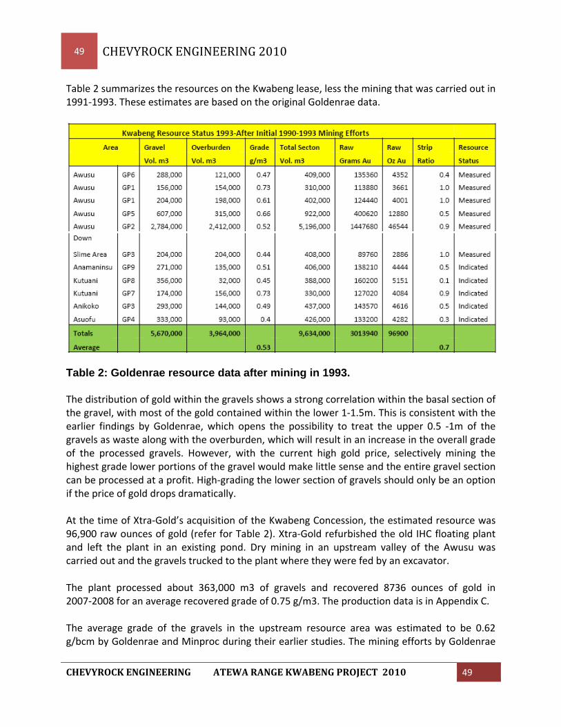
49 CHEVYROCK ENGINEERING 2010
CHEVYROCK ENGINEERING ATEWA RANGE KWABENG PROJECT 2010 49
Table 2 summarizes the resources on the Kwabeng lease, less the mining that was carried out in 1991‐1993. These estimates are based on the original Goldenrae data.
Table 2: Goldenrae resource data after mining in 1993. The distribution of gold within the gravels shows a strong correlation within the basal section of the gravel, with most of the gold contained within the lower 1‐1.5m. This is consistent with the earlier findings by Goldenrae, which opens the possibility to treat the upper 0.5 ‐1m of the gravels as waste along with the overburden, which will result in an increase in the overall grade of the processed gravels. However, with the current high gold price, selectively mining the highest grade lower portions of the gravel would make little sense and the entire gravel section can be processed at a profit. High‐grading the lower section of gravels should only be an option if the price of gold drops dramatically. At the time of Xtra‐Gold’s acquisition of the Kwabeng Concession, the estimated resource was 96,900 raw ounces of gold (refer for Table 2). Xtra‐Gold refurbished the old IHC floating plant and left the plant in an existing pond. Dry mining in an upstream valley of the Awusu was carried out and the gravels trucked to the plant where they were fed by an excavator. The plant processed about 363,000 m3 of gravels and recovered 8736 ounces of gold in 2007‐2008 for an average recovered grade of 0.75 g/m3. The production data is in Appendix C. The average grade of the gravels in the upstream resource area was estimated to be 0.62 g/bcm by Goldenrae and Minproc during their earlier studies. The mining efforts by Goldenrae

50 CHEVYROCK ENGINEERING 2010
CHEVYROCK ENGINEERING ATEWA RANGE KWABENG PROJECT 2010 50
realized a recovered grade of 0.6 g/bcm and indications were that with a 90% recovery, the actual head grade to the plant was 0.67 g/bcm. Xtra Gold Resources realized an average recovered fine gold grade of 0.75 g/bcm (0.8 g/raw Au/m3) during their mining opertions and this was a result of dry mining the gravels to avoid losses under water and secondly; they removed the top 0.5 to 1 meter of upper, lower grade gravel to upgrade their plant feed. This resulted in Xtra covering a larger area of the resource during their operations. Xtra Gold started with a resource at Kwbeng of 96,900 raw ounces of gold and they mined approximately 9,300 raw ounces from 2007‐2008. This would suggest that there should be 87,600 raw ounces of gold remaining in a resource. An examination of the area suggests that in some areas, the lower grade upper gravels were discarded with overburden. At todays high gold price, this would not happen and in fact, a closer inspection of the resource area using a lower cut off grade will likely add considerable resources in the fringes of the current mining path. 19.4 Summary of Current Resources A review of the current resource situation was carried out recently which took into consideration the original exploration pitting program and subsequent resource/reserve calculations (Minproc 1989), the results of the mining that took place by Goldenrae (1993) and the check pit sampling in 2005 by Rae International and the results of the subsequent mining of the gravel by Xtra Gold from January 2007 up until October 2008. The results of this test work and mining indicates that the original resource figures used were accurate to verify measured and indicated resources. The mining of the deposit reduced the resource totals and the following table 3, indicates the current resource situation. The resource was calculated by Minproc Engineers by taking all of the sample pit information, including recovered gold, sample volumes, location, gravel depths, overburden depths and bedrock depths were keyed into computer files. The values of gravel and overburden thickness, gravel and total section grades were manually contoured to define trends within the deposit. A two dimensional block model was constructed with a block size of 100 x 25 meters with constraints set by limits to the lateral extent of the gravels. The lateral extent was defined by topography or by the extent of pits on cross lines. Interpolation of various values into the blocks was then carried out using inverse distance weighting, with interpolation parameters optimized to produce the best fit in the block model to the manually interpreted distribution of grade and thickness values. In the block modeling process, calculation of the grade for each block was based on interpolation of the gold metal content derived from the sample pit raw data. The gold metal content interpolated into each block was then divided by the calculated volume for each block to determine the weighted average grade for the block.

51 CHEVYROCK ENGINEERING 2010
CHEVYROCK ENGINEERING ATEWA RANGE KWABENG PROJECT 2010 51
The calculation of resources was done by selecting a cut off grade based on preliminary cost information. This information provides a breakeven grade of 0.2 g/m3 and the measured and indicated resource was calculated based on this parameter. Resource’s on the Awusu drainage where the bulk of the mining has taken place is classified as “measured”. The resources on the adjacent, parallel drainages are classified as “indicated” as they do not have the results of a bulk sample.
19.5 Mining Reserves To convert the resource to a mining reserve required looking at several factors which could affect the viability of mining the gravel resource. The grade does vary within the gravel section and generally increases closer to the bedrock interface. The upper, lower gravels still support mining and processing so it is not practical to selectively remove these gravels and send to waste. The pitting program historically took 20‐30 cm of bedrock material in the last sample interval. Therefore during mining the same procedure will be used and no significant dilution of the gravel pay zone is anticipated. The interface between the overburden and gravel is well defined and clearly visible when stripping off overburden. No significant dilution is anticipated when stripping overburden is anticipated as well.

52 CHEVYROCK ENGINEERING 2010
CHEVYROCK ENGINEERING ATEWA RANGE KWABENG PROJECT 2010 52
Dry mining of the gold bearing gravel layer using hydraulic excavator is proposed and these machines are adept at very controlled and precise mining of the gravel section. Therefore no dilution is being applied to the resource and the mineable reserve is calculated as consisting of all the blocks with a total section grade above 0.2 g Au/bcm.

53 CHEVYROCK ENGINEERING 2010
CHEVYROCK ENGINEERING ATEWA RANGE KWABENG PROJECT 2010 53
The mining reserve above indicates as total “measured reserve” of 3,580,000 m3 of gravel averaging 0.53 g Au/m3 for 60,612 raw ounces of gold. An “indicated reserve” of 960,000 m3 of gravel averaging 0.45 g Au/m3 for 13,877 raw ounces of gold is also identified. Total “measured and indicated reserves” are calculated at 4,540,000 m3 at an average 0.52 g Au/m3 for 74,488 raw ounces of gold. 20.0 OTHER RELEVANT DATA AND CONCLUSIONS To the best of the author’s knowledge, no additional data or information that is relevant to the assessment of the Kwabeng Gold Project is available. 21.0 INTERPRETATIONS AND CONCLUSIONS A large alluvial project on the proposed concessions should be guided by the following:
1. Dry mining is the only sensible approach in most of the upstream areas where grades are often quite high and the gravels frequently contain large boulders.
2. The current IHC floating plant at Kwabeng can be operational in very short order. After processing available gold bearing gravels in the upstream Awusu deposit area, the plant should be floated downstream as dry mining progresses. However, the possibility of dismantling it and putting it on skids needs further review.
3. Dry mining will involve trucking the gravels to a plant and the overburden can be
effectively removed by bulldozing. Mining fleets must be standardized as much as possible. Plants will need to be moved easily in order to keep one‐way haulage distances to less than 1 km.
4. The relatively coarse nature of the gold throughout the district indicates that most recovery methods will be effective as long as the gravels are washed thoroughly so that the gold is liberated. A plant design incorporating an effective scrubber, horizontal vibrating screens, a sluice and/or nugget trap combined with Knelson bowls will be very effective and has been well‐proven in Ghana and elsewhere. Aside from the one floating plant at Kwabeng, all other plants will be skid‐mounted and capable of moving quickly and easily from one setup to another.
5. Production levels must be substantial in order to reduce unit costs and support management and administrative costs. The initial plan should include 3 production units with a collective treatment capacity of 1+ Mm3/year of gravels. The two main plants should each be able to treat 100‐150 m3/hr, whereas the 3rd plant should be smaller

54 CHEVYROCK ENGINEERING 2010
CHEVYROCK ENGINEERING ATEWA RANGE KWABENG PROJECT 2010 54
(50‐75 m3/hr) and very mobile so that it can be easily used on narrower drainages that may only be mined when nearby water is available in the wet season.
6. The mine and production plan must be flexible in order to adjust quickly to changing circumstances, such as the seasonal availability of water. Any development scheme must have an effective plan to supply sufficient good quality water to all production units. Re‐cycling will be essential and it will be vitally important that mining minimize any impact on water supplies to local communities.
7. A commitment to effective land reclamation and communications with the local population must be a priority from the outset and not an afterthought. The local population must be given preference in jobs and the company needs to be active in community affairs. Usually alluvial projects have relatively short mine lives and at the earliest stages of the operations, the company must work towards establishing other business activities that will continue after the mining has stopped. There is a substantial cost to all such activities but they need to be seen as essential investments critical to the success of the mining operations. This investment in the local communities must commence at the beginning of the project, not when it is well along in the mine life.
8. Many alluvial projects fail because of lack of experienced personnel and the lack of funds to deal with problems during the startup period. Experienced management personnel, especially senior Ghanaian staff, will be critical to the success of the mining project. Having sufficient capital for all the projected costs is obviously essential but it is also vital to have a very substantial contingency fund and working capital to deal with unforeseen events and problems.
9. Whereas short‐term contracting for certain earthmoving requirements is likely to be needed on occasion, especially in the start‐up phase, as much as possible, the mining equipment should be owned and maintained by Hawk Uranium. However, this should not be a policy cast in stone as once the operation achieves a sizeable scale, it may be possible to negotiate a comprehensive and competitive contract with a proven mine contractor.
22.0 RECOMMENDATIONS The initial plan must be to restart the IHC floating plant. This plant needs considerable maintenance and some minor refurbishment but it can be operational within a few weeks. All the permitting is in place and a reclamation bond is on deposit with the EPA. There is nearby ore (198,800 m3), immediately upstream from the current position of the plant as well as a good block of ore just downstream from the main road. Thus, trucking of pay gravels from

55 CHEVYROCK ENGINEERING 2010
CHEVYROCK ENGINEERING ATEWA RANGE KWABENG PROJECT 2010 55
these sites to the current position of the plant is short and can sustain production (150m3/hr) for at least 3 months. There also exists a gravel resource of 388,000 m3 of gravel in the upstream reaches of the Abodusu and Awusu drainages. This falls within the loosely defined Forest Reserve and permission should be acquired to mine this area during the initial year of production. During that initial 6 months, a 2nd plant should be established at Asuofu and operating at a rate of 100m3/hr. This will require getting a new plant to site, acquiring the appropriate permits and getting the plant set up with supporting tailings ponds, access roads and plant civils. While the initial mining commences at Kwabeng, a plan to move the plant downstream from its present position must be implemented. The most sensible approach involves temporarily re‐routing the main road to Banso and Pameng in order to dig a channel along the margins of the Awusu reserves so the plant can be floated to a new position downstream. This approach has a big advantage of having minimum downtime on the operations as the channel will be prepared beforehand and the plant moved into a new position within a very few days. An aggressive sampling program will be intiated to begin testing of other drainages on the Kwabeng lease and a 3rd plant (50 m3/hr) will be used to bulk sample the pit tested areas to establish during these programs. This will serve as a 3rd production unit capable of mining high grade areas in the foothills of the smaller drainages. A central office, gold room, camp for senior staff, parts storage and maintenance complex will be needed at an early stage. If the existing Xtra‐Gold camp at Kwabeng is unavailable, a similar facility should be established nearby. Getting a quick start will have many benefits and this may be further speeded up by buying existing used equipment in the country and possibly even building and assembling a plant locally. Buying used equipment always adds another element of risk; it makes it more difficult to standardize and almost certainly it will need to be replaced within a fairly short period but that can probably be done from cash flow. There is a lot of local equipment available and having an experienced heavy equipment crew assessing available equipment in the country could help one achieve a very speedy start up. At current gold prices the project looks very robust and it is recommended that the Wyoming equipment be acquired and moved to the Kwabeng deposit as soon as possible. This equipment, in conjunction with the Xtra Gold’s wash plant and the acquisition of a dozer and front end loader, will enable Hawk to begin producing gold within a very short time.

56 CHEVYROCK ENGINEERING 2010
CHEVYROCK ENGINEERING ATEWA RANGE KWABENG PROJECT 2010 56
23.0 REFERENCES
1. Griffis, R.J. et. al., 2002. Gold Deposits of Ghana, Minerals Commission, Accra.
2. Griffis, R. J., 1998. Explanatory Notes ‐ Geological Interpretation of Geophysical Data from Southwestern Ghana, Minerals Commission, Accra, 51p.
3. Junner, N. R., 1935. Gold in the Gold Coast. Gold Coast Geol. Surv. Mem. 4, 67p,
Accra. (reprinted 1973).
4. Mining and Minerals Act (Act 703) of 2006
5. Minproc 1989. Kibi Alluvial Gold Project Ghana Feasibility Study for Stefford Resources Limited.
6. Minproc 1991. Review of Mining Operations and Alternatives Feasibility Study for
Goldenrae Mining Limited.
7. Minproc 1992. Osino Alluvial Gold Project Ghana Feasibility Study for Kibi Goldfields International Limited.
8. Newmont Ghana Gold Limited, 2006; Annual Report on the Pusupusu Propspecting
Licence.
9. Rae, J. A., and K. Agyemang, 1991. A Case History of the Goldenrae Alluvial Gold Project: in K. Barning(ed.),Symposium on Gold Exploration in Tropical Rain Forest Belts of Southern Ghana, Minerals Commission, Accra, pp. 135 – 15
10. Rae, J. A., and K. Agyemang, R. J. Griffis, 2006. Goldenrae Evaluation for Xtra‐Gold
Resources Corp.
11. Sestini, G., 1973. Sedimentology of a paleoplacer: the gold bearing Tarkwaian of Ghana; in Amstutz, G. C. and A. J. Bernard (Eds):Ores in Sediments, pp. 275‐305, Springer‐Verlag, Heidelberg.

57 CHEVYROCK ENGINEERING 2010
CHEVYROCK ENGINEERING ATEWA RANGE KWABENG PROJECT 2010 57
25.0 ADDITIONAL REQUIREMENTS FOR TECHNICAL REPORTS ON DEVELOPMENT PROPERTIES AND PRODUCTION PROPERTIES 25.1 Proposed Mining It is proposed that mining begin immediately on the Kwabeng property of the Xtra Gold Concessions. The Floating Washplant and the newly purchased earthmoving equipment will be used for mining the Awusu Creek reserve area. The plant is designed and built to float so this attribute would be factored into the mining plan. The original plan used in the early 1990’s by Goldenrae was to float the plant in its own pond and feed it by using an excavator perched on the exposed gravel orebody. This approach would not be used this time as this led to difficulty in mining due to the saturated nature of the gravel and also some gold loss when digging under water. This problem was reviewed by Minproc, Osborne and Chappel and Alluvial Dredging and Mining Services in the 1990’s, and several options were provided. The preferred system will utilize a 3000 meter long canal dug on the north side of the Awusu drainage to float the plant along the reserve area. The plant will be initially floated to an area approximately 2.5 km downstream and set up to be fed with the front end loaders. The mining sequence will involve first clearing the vegetation utilizing the D8 dozer and pushing the topsoil into a separate windrow outside the mining block. Overburden is then stripped off using an excavator and trucks and a D8 dozer and pushed or piled in windrows on the edge of the mining block. Gravel is then mined using an excavator and trucks and the ore is hauled to a stockpile adjacent to the docked Floating Washplant. In this system, the gravel will be dry mined and hauled to the plant with the tailings being hauled back to the excavation. The slurried tailings will be pumped to a series of settling ponds downstream on the property boundary and mining will work from downstream‐up. The dry mining will allow for proper cleaning of the high grade gravel‐bedrock interface and also improve grade control and volume measurements. The plant will be set up so that the maximum haulage is 500 meters. Three 40 ton articulated trucks are used for hauling gravel. A 40 ton truck will carry approximately 18 BCM and with a 15 minute cycle, the three trucks will haul 216 BCM or more than enough to supply the plant which is operating at 150 BCM per hour. The remaining truck along with the excess haulage capacity of the 3rd gravel truck will work with the D8 dozer to remove overburden. With a stripping ratio of 0.8:1, there will be 120 BCM

58 CHEVYROCK ENGINEERING 2010
CHEVYROCK ENGINEERING ATEWA RANGE KWABENG PROJECT 2010 58
per hour of overburden that needs to be removed. Maximum haulage for overburden will be approximately 300 meters with dozer pushing a maximum of 100 meters. The front end loaders that feed the plant will be equipped with 5 BCM buckets and will feed the dump box at a rate of one every 5 minutes. Oversize tailings will be loaded into trucks returning to the mine cut as part of reclamation. Two front end loaders are assigned to the plant which will allow for service and cleanup. The plant will be floating in the canal at a prescribed location until such time that the haulage distance exceeds its limit. The plant is then floated to the next location and the appropriate ramp and stockpiles set up to begin production further upstream. It is anticipated that with proper pre‐planning, the plant can be moved and operating at its new location within 2 days.

59 CHEVYROCK ENGINEERING 2010
CHEVYROCK ENGINEERING ATEWA RANGE KWABENG PROJECT 2010 59

60 CHEVYROCK ENGINEERING 2010
CHEVYROCK ENGINEERING ATEWA RANGE KWABENG PROJECT 2010 60
The wash plant is currently within a pond on the north side of the road where Xtra left it when they ceased operations. They had been hauling gravel to the plant and processing at this location. There is a still an estimated 200,000 BCM within 800 meters of the current plant location. It is proposed that this area be mined first while the canal and supporting ponds are being constructed.
Once the canal is constructed and the downstream section of reserve dry mined for ponds, the plant will be floated down to line 9000mN to be set up for processing ore from the ponds and within a 500 meter radius of the plant location.

61 CHEVYROCK ENGINEERING 2010
CHEVYROCK ENGINEERING ATEWA RANGE KWABENG PROJECT 2010 61
25.2 Capital Cost Estimates The capital costs were looked at in two ways; the first is using new, or near new equipment purchased offshore and shipped to Ghana and the second was purchasing the used equipment package belonging to Wyoming Resources located near the project site in Ghana. The IHC 150 BCM/hr plant that is located at the Kwabeng site, would be part of the agreement with Xtra and so this was included in each list. Since Wyoming was operating an alluvial gold operation nearby, the equipment list that they are selling, is very similar to that required by Hawk in the development of their alluvial gold operation. Wyoming has 2 small, skid mounted plants which would be appropriate for mining the narrower, parallel drainage resources at Kwabeng. They have a fleet of Moxy 40 ton articulated trucks, 345 excavators, camp and service equipment and tools. This option greatly reduces the capital requirements for the project. As of 2009 the equipment is in reasonable shape and provision was made in the budget for refurbishing equipment, the use of this older used equipment presents further risks and a higher operating cost. It is felt that with a proper refurbishment of equipment prior to startup and a diligent maintenance program, the risk and costs will be minimized.

62 CHEVYROCK ENGINEERING 2010
CHEVYROCK ENGINEERING ATEWA RANGE KWABENG PROJECT 2010 62
Chevyrock Engineering has optioned to acquire newer equipment from North America or Europe as very little equipment is normally available in Ghana. The cost of new/near new earthmoving equipment will be higher buying on piecemeal basis but after evaluation of Wyoming’s equipment we felt it best to buy newer equipment direct from Caterpillar.

63 CHEVYROCK ENGINEERING 2010
CHEVYROCK ENGINEERING ATEWA RANGE KWABENG PROJECT 2010 63
25.3 Operating Cost Estimates The operating costs are based on examining specific parameters but are also based on operational experience in this type of mining, in this exact environment. The previous operating costs realized during the Goldenrae mining of the Kwabeng resource in the early 1990’s provided insight into using a floating washplant. More recently (2007‐8), Xtra mined the same resource with this washplant only dry mining and earlier this year, Wyoming Resources Ltd. mined gold bearing gravels on the Birim River at Abomosu using a more portable, land based plant. Earthmoving was similar in each case as overburden and topsoil were stripped off of the gold bearing gravel. The gravel was then dry mined and trucked to these process plants consisting of a washing and screening section and a gold recovery unit, either jigs or centrifugal bowls. These are basically gravel operations with the addition of a gravity recovery circuit for the gold. There are no chemicals used, no drilling or blasting, no crushing and grinding. While fairly simple, they operate on a fairly narrow margin and if proper care is not taken in the design and acquisition of the right process plant and matching earthmoving fleet, lower recoveries and plant throughput can quickly drive up the unit operating cost. The original Minproc Feasibility Studies done in the late 1980’s and early 1990’s, at Kwabeng, Pameng and Kibi, indicated an operating cost of $2.50‐$3.00 per BCM. While fuel costs have tripled since 1990, labor and equipment costs have increased modestly. We have been involved with two 100 BCM per hour (50,000 BCM/month) similar gravel operations, one in Ghana and one in Alaska, and their direct operating costs have been running $300‐$350,000 per month or $7.00 per BCM. The key to lowering operating costs is to expand the operation and increase production. With two or three or more plants, overheads can be shared and unit costs will be significantly lower. Equipment excess capacity can be taken advantage of if individual operations are close enough to each other and the addition of a tractor and lowboy enhances this option. Supervision can be shared and camp facilities including workshop would service the three plants.

64 CHEVYROCK ENGINEERING 2010
CHEVYROCK ENGINEERING ATEWA RANGE KWABENG PROJECT 2010 64
Operating costs are further broken into the following categories: Mining Costs ‐Gravel Extraction ‐Overburden Removal ‐Reclamation Treatment Costs ‐Washplant Operations ‐Gold Room ‐Relocation Maintenance Overheads ‐Expats ‐Administration ‐Head Office ‐Security Methodology Labor and Remuneration Schedule Labor force and remuneration scales were determined from similar operations in the area. Direct Equipment Operating Costs All equipment has been cost out on the basis of fuel usage, lube and filter costs, and maintenance supplies. Fuel has been cost based on historic costs in local currency and converted to US dollar using the current exchange rate. Equipment fuel consumptions were from supplier ratings. Lube and filter costs have been cost out using 20% of total fuel consumption costs. Maintenance supplies for mining equipment have been determined by allocating an annual cost based on 70% of the annual depreciated value of the equipment item. This takes into account the cost of major equipment overhauls and rebuilds. Maintenance supplies for the treatment plants have been apportioned on a 10% value of the overall capital cost. The costs reflex the use of near new earthmoving equipment with minimal major overhauls or problems in the first 3 years of operation. If using the Wyoming equipment fleet, it is anticipated that there will initially be a cost to refurbish this equipment and then further costs

65 CHEVYROCK ENGINEERING 2010
CHEVYROCK ENGINEERING ATEWA RANGE KWABENG PROJECT 2010 65
and overhauls will be experienced over the next 3years. This has been taken into consideration in the accompanying cash flow projection for this option. Two production options have been reviewed; the first using the existing plant and two used plants and a fleet of used earthmoving equipment which available for purchase near the Kwabeng property and the second option also uses the existing plant but is based on purchasing new‐near new earthmoving equipment and two other plants from North America or Europe. The capital costs for Option 1 using used equipment available locally, is $5,000,000 and operating costs are anticipated to be $6.52 per cubic meter processed or $428 per ounce when all three plants are operating. The capital cost for Option 2 using new equipment, is $10,000,000 and operating costs are calculated to be $5.10 per cubic meter of gravel processed or a little over $334 per ounce when operating the three plants. The Wyoming package of equipment can be found in Appendix 4. Capital and operating costs for each scenario are found in the attached tables.

66 CHEVYROCK ENGINEERING 2010
CHEVYROCK ENGINEERING ATEWA RANGE KWABENG PROJECT 2010 66
APPENDIX A‐ Site Maps of Concessions

67 CHEVYROCK ENGINEERING 2010
CHEVYROCK ENGINEERING ATEWA RANGE KWABENG PROJECT 2010 67

68 CHEVYROCK ENGINEERING 2010
CHEVYROCK ENGINEERING ATEWA RANGE KWABENG PROJECT 2010 68
Appendix B‐ Resource Maps

69 CHEVYROCK ENGINEERING 2010
CHEVYROCK ENGINEERING ATEWA RANGE KWABENG PROJECT 2010 69
Xtra‐Gold Kwabeng resource

70 CHEVYROCK ENGINEERING 2010
CHEVYROCK ENGINEERING ATEWA RANGE KWABENG PROJECT 2010 70
APPENDIX C‐ Goldenrae and Xtra‐Gold Production Data

71 CHEVYROCK ENGINEERING 2010
CHEVYROCK ENGINEERING ATEWA RANGE KWABENG PROJECT 2010 71
Goldenrae Production Figures from 1990 – 1993.

72 CHEVYROCK ENGINEERING 2010
CHEVYROCK ENGINEERING ATEWA RANGE KWABENG PROJECT 2010 72
Xtra‐Gold Test Production Figures from 2007 – 2008.
Xtra-Gold Test Project At this time I would like to answer a question that has been frequently asked of us at Chevyrock Engineering. Question: If this land is so valuable and has the certified reports that verify the gold content in the ground, why would Xtra Gold, a publically traded company be willing to sell-off this valuable land? And why not mine it for their own financial benefit? Answer: Xtra Gold are experts in Hard Rock Mining, whereas they only endeavor into hard rock gold mining reserves. They own several areas that are hard rock mining concessions and they also own Alluvial Mining Concessions as well. Chevyrock Engineering specializes in Alluvial Mining extraction procedures used in the gold recovery process. Therefore it makes good business sense for Xtra-Gold to sell off at a profit the alluvial concessions. The Xtra-Gold Test Project in conjunction with John Rae and Chevyrock Engineering was a complete success that scientifically convinced us to seek funding for the Large Scale Mining Operation that Chevyrock Engineering is now proposing. Please note and understand that during the testing phase of the finalized analysis of the gold reserve’s location and contents, Xtra-Gold produced 8,735 refined gold equal to over 9.6 Million Dollars USD in today’s market place. The equipment used for testing was smaller prospector type testing equipment and they periodically used a large wash plant as well.

73 CHEVYROCK ENGINEERING 2010
CHEVYROCK ENGINEERING ATEWA RANGE KWABENG PROJECT 2010 73
Information received via Ghana Rae Gold and Chevyrock Engineering, LLC
Ron Anthony, Managing Director 2338 Immokalee Road Suite 157
Naples, Florida 34110
239.776.5693 Fax: 239.790.2654 [email protected]
Ron Anthony Presents THE CERTIFICATE OF AUTHOR AND PROJECT SCOPE OF CHEVYROCK
I, John A. Rae, P.Geo. do hereby certify that: 1/ I am an independent contractor and reside at 14 Walt St., Smithfield, ON, K0K 1H0. 2/ I graduated from Haileybury School of Mines in 1978 from their mining engineering technician program. 3/ I am a member of the Ontario Association of Professional Geoscientists. 4/ I have worked as a geoscientist for 38 years. 5/ I have read the definition of “qualified person” set out in National Instrument 43‐101 (“NI 43‐101”) and certify that by reason of my education and past relevant work experience, I fulfill the requirements to be a “qualified person” for the purposes of this report. 6/ I am responsible for the preparation of all sections of this report titled “Technical Report for the Kwabeng Gold Project” dated November 15, 2009. I do not hold any interest in the property herein described. 7/ I Ronald J. Anthony, Managing Director for Chevyrock Engineering LLC, of Naples, Florida has engaged my company to assist him in the general project management program for the Kwabeng and additional ATEWA Range gold reserve leases. 8/ I, Ronald J. Anthony have diligently worked in the mining sector in Ghana since 1997. Having developed a successful full scale mining operation in Ghana, we have taken focus on acquiring all mineral rights to the large scale reserves from Xtra Gold, namely the “Kwabeng” Project. 9/ Our focus will ultimately bring our attention to acquiring additional rich gold bearing reserves adjacent to the Kwabeng lease creating a total reserve potential of well over 900,000 ounces of gold ore. 10/ As the Managing Director and Principal of Chevyrock Engineering, we forecast well over 20 years of mining activities in the ATEWA Range Areas. 11/ It is acknowledged that CE does not make any representations or warranties as to the accuracy or completeness of the Evaluation Material. It is agreed that neither the CE nor its Representatives shall have any liability to Recipient or its Representatives resulting from its or their use of the Evaluation Material.