Technical Report 7 - Clark County Washington County had its beginning as the District of Vancouver...
30
Technical Report 7 Highway 99 Cultural and Historic Opportunities
Transcript of Technical Report 7 - Clark County Washington County had its beginning as the District of Vancouver...

Technical Report 7 Highway 99 Cultural and Historic Opportunities

HIGHWAY 99 SUB AREA PLAN
INTRODUCTION History of Clark County and Highway 99 Sub-Area The Highway 99 Sub-Area Planning Area, located in Clark County, Washington, is rich in local lore and tied to the earliest settlements in the Pacific Northwest. Local history buffs call Clark County the “Cradle of Pacific Northwest History,”i reflecting the importance of the
626-square mile southwest corner of Washington State. The county can trace its roots to the arrival of the Lewis and Clark Expedition in 1806. Captain Meriwether Lewis wrote at length in his journal that “this valley would be competent to the maintenance of 40 or 50 thousand souls if properly cultivated and is indeed the only desirable situation for a settlement which I have seen on the west side of the Rocky mountains.”ii
Merriweather Lewis & William Clark
By 1825, Ft. Vancouver one of the oldest settlements in Washington, was established by the Hudson's Bay Company. The Hudson Bay Company headquartered at Ft. Vancouver, would oversee the immense Columbia Department that stretched from Alaska south to Mexican California and east to the Rocky Mountains; an area estimated at over 700,000 square miles. The headquarters would ultimately be built on a plain within easy reach of the Columbia River yet just outside of its flood plain. The surrounding area showcased areas of prairie surrounded by trees sloping upward to dense fir forests. “It was known as Jolie Prairie or Belle Vue Point because of its intense natural beauty.”iii Fort Vancouver
As with all sublime and bucolic areas, the Euro-American explorers were not the first to explore Clark County. Highway 99 has a long standing link to Chinook Indian villages. The Chinook lived along the banks of the Columbia River and utilized a trail between the fertile Willamette Valley and Puget Sound. Clark County had its beginning as the District of Vancouver established by the Oregon Provisional Government on June 27, 1844. The district encompassed all of what is now the state of Washington. In 1845, the provisional government changed “district” to “county” and in 1849 changed “Vancouver” to “Clarke” in honor of the explorer William Clark of the 1804-1806 Lewis and Clark Expedition.”iv Many years later, the Washington State Legislature corrected the county’s name to Clark removing the “e” on the end. In 1849, the Hudson's Bay Company transferred its headquarters to Fort Victoria in British Columbia and abandoned Fort Vancouver and trading business in the area. In that same year, Congress sent troops and established a territorial government. The Vancouver Barracks became the largest military installation west of the Mississippi River. Authorized by the U.S. Congress in 1853, a military road was built from Ft. Vancouver north through Olympia to Seattle and was completed in 1860.
Technical Report 7: Highway 99 Cultural and Historic Opportunities 2
HIGHWAY 99 SUB AREA PLAN
Technical Report 7: Highway 99 Cultural and Historic Opportunities 3
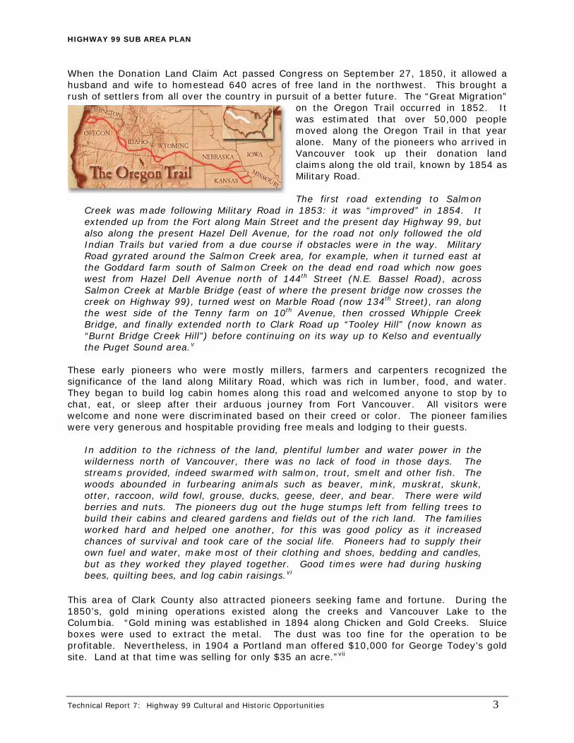
When the Donation Land Claim Act passed Congress on September 27, 1850, it allowed a husband and wife to homestead 640 acres of free land in the northwest. This brought a rush of settlers from all over the country in pursuit of a better future. The “Great Migration”
on the Oregon Trail occurred in 1852. It was estimated that over 50,000 people moved along the Oregon Trail in that year alone. Many of the pioneers who arrived in Vancouver took up their donation land claims along the old trail, known by 1854 as Military Road. The first road extending to Salmon
Creek was made following Military Road in 1853: it was “improved” in 1854. It extended up from the Fort along Main Street and the present day Highway 99, but also along the present Hazel Dell Avenue, for the road not only followed the old Indian Trails but varied from a due course if obstacles were in the way. Military Road gyrated around the Salmon Creek area, for example, when it turned east at the Goddard farm south of Salmon Creek on the dead end road which now goes west from Hazel Dell Avenue north of 144th Street (N.E. Bassel Road), across Salmon Creek at Marble Bridge (east of where the present bridge now crosses the creek on Highway 99), turned west on Marble Road (now 134th Street), ran along the west side of the Tenny farm on 10th Avenue, then crossed Whipple Creek Bridge, and finally extended north to Clark Road up “Tooley Hill” (now known as “Burnt Bridge Creek Hill”) before continuing on its way up to Kelso and eventually the Puget Sound area.v
These early pioneers who were mostly millers, farmers and carpenters recognized the significance of the land along Military Road, which was rich in lumber, food, and water. They began to build log cabin homes along this road and welcomed anyone to stop by to chat, eat, or sleep after their arduous journey from Fort Vancouver. All visitors were welcome and none were discriminated based on their creed or color. The pioneer families were very generous and hospitable providing free meals and lodging to their guests.
In addition to the richness of the land, plentiful lumber and water power in the wilderness north of Vancouver, there was no lack of food in those days. The streams provided, indeed swarmed with salmon, trout, smelt and other fish. The woods abounded in furbearing animals such as beaver, mink, muskrat, skunk, otter, raccoon, wild fowl, grouse, ducks, geese, deer, and bear. There were wild berries and nuts. The pioneers dug out the huge stumps left from felling trees to build their cabins and cleared gardens and fields out of the rich land. The families worked hard and helped one another, for this was good policy as it increased chances of survival and took care of the social life. Pioneers had to supply their own fuel and water, make most of their clothing and shoes, bedding and candles, but as they worked they played together. Good times were had during husking bees, quilting bees, and log cabin raisings.vi
This area of Clark County also attracted pioneers seeking fame and fortune. During the 1850’s, gold mining operations existed along the creeks and Vancouver Lake to the Columbia. “Gold mining was established in 1894 along Chicken and Gold Creeks. Sluice boxes were used to extract the metal. The dust was too fine for the operation to be profitable. Nevertheless, in 1904 a Portland man offered $10,000 for George Todey’s gold site. Land at that time was selling for only $35 an acre.”vii
HIGHWAY 99 SUB AREA PLAN
Early Settlement of Hazel Dell & Salmon Creek Early Settlement of Hazel Dell & Salmon Creek The planning area consists of two distinct settlements; Hazel Dell and Salmon Creek. Hazel Dell's destiny was to occupy a strategic point on the old road leading north from Vancouver through the woods to Salmon Creek and beyond. A county land map from the 1880s identifies the locality as Anderson; named for a pioneer family residing there.
The planning area consists of two distinct settlements; Hazel Dell and Salmon Creek. Hazel Dell's destiny was to occupy a strategic point on the old road leading north from Vancouver through the woods to Salmon Creek and beyond. A county land map from the 1880s identifies the locality as Anderson; named for a pioneer family residing there.
The best-known member of this family was Sarah J. Anderson, whose name has been given to the elementary school located on NE 104th Street. The home of William and Sarah Anderson was a stopping place for travelers. Sarah could converse fluently in several Indian tongues and is said to have entertained the visitors with a violin.
The best-known member of this family was Sarah J. Anderson, whose name has been given to the elementary school located on NE 104th Street. The home of William and Sarah Anderson was a stopping place for travelers. Sarah could converse fluently in several Indian tongues and is said to have entertained the visitors with a violin.
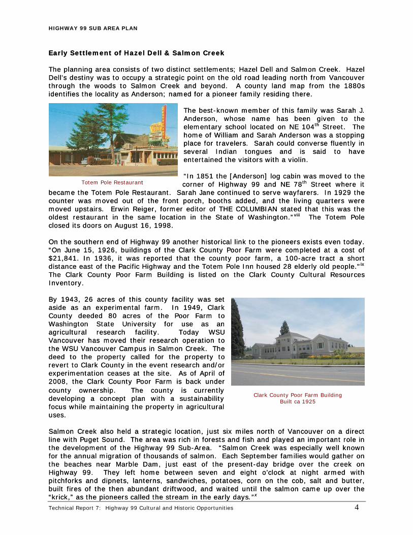
Totem Pole Restaurant t “In 1851 the [Anderson] log cabin was moved to the corner of Highway 99 and NE 78th Street where it
became the Totem Pole Restaurant. Sarah Jane continued to serve wayfarers. In 1929 the counter was moved out of the front porch, booths added, and the living quarters were moved upstairs. Erwin Reiger, former editor of THE COLUMBIAN stated that this was the oldest restaurant in the same location in the State of Washington.”viii The Totem Pole closed its doors on August 16,
“In 1851 the [Anderson] log cabin was moved to the corner of Highway 99 and NE 78th Street where it
became the Totem Pole Restaurant. Sarah Jane continued to serve wayfarers. In 1929 the counter was moved out of the front porch, booths added, and the living quarters were moved upstairs. Erwin Reiger, former editor of THE COLUMBIAN stated that this was the oldest restaurant in the same location in the State of Washington.”
1998. 1998.
viii The Totem Pole closed its doors on August 16, On the southern end of Highway 99 another historical link to the pioneers exists even today. “On June 15, 1926, buildings of the Clark County Poor Farm were completed at a cost of $21,841. In 1936, it was reported that the county poor farm, a 100-acre tract a short distance east of the Pacific Highway and the Totem Pole Inn housed 28 elderly old people."ix The Clark County Poor Farm Building is listed on the Clark County Cultural Resources Inventory.
On the southern end of Highway 99 another historical link to the pioneers exists even today. “On June 15, 1926, buildings of the Clark County Poor Farm were completed at a cost of $21,841. In 1936, it was reported that the county poor farm, a 100-acre tract a short distance east of the Pacific Highway and the Totem Pole Inn housed 28 elderly old people."ix The Clark County Poor Farm Building is listed on the Clark County Cultural Resources Inventory. By 1943, 26 acres of this county facility was set aside as an experimental farm. In 1949, Clark County deeded 80 acres of the Poor Farm to Washington State University for use as an agricultural research facility. Today WSU Vancouver has moved their research operation to the WSU Vancouver Campus in Salmon Creek. The deed to the property called for the property to revert to Clark County in the event research and/or experimentation ceases at the site. As of April of 2008, the Clark County Poor Farm is back under county ownership. The county is currently developing a concept plan with a sustainability focus while maintaining the property in agricultural uses.
By 1943, 26 acres of this county facility was set aside as an experimental farm. In 1949, Clark County deeded 80 acres of the Poor Farm to Washington State University for use as an agricultural research facility. Today WSU Vancouver has moved their research operation to the WSU Vancouver Campus in Salmon Creek. The deed to the property called for the property to revert to Clark County in the event research and/or experimentation ceases at the site. As of April of 2008, the Clark County Poor Farm is back under county ownership. The county is currently developing a concept plan with a sustainability focus while maintaining the property in agricultural uses.
Clark County Poor Farm Building Built ca 1925
Salmon Creek also held a strategic location, just six miles north of Vancouver on a direct line with Puget Sound. The area was rich in forests and fish and played an important role in the development of the Highway 99 Sub-Area. “Salmon Creek was especially well known for the annual migration of thousands of salmon. Each September families would gather on the beaches near Marble Dam, just east of the present-day bridge over the creek on Highway 99. They left home between seven and eight o’clock at night armed with pitchforks and dipnets, lanterns, sandwiches, potatoes, corn on the cob, salt and butter, built fires of the then abundant driftwood, and waited until the salmon came up over the “krick,” as the pioneers called the stream in the early days.”x
Salmon Creek also held a strategic location, just six miles north of Vancouver on a direct line with Puget Sound. The area was rich in forests and fish and played an important role in the development of the Highway 99 Sub-Area. “Salmon Creek was especially well known for the annual migration of thousands of salmon. Each September families would gather on the beaches near Marble Dam, just east of the present-day bridge over the creek on Highway 99. They left home between seven and eight o’clock at night armed with pitchforks and dipnets, lanterns, sandwiches, potatoes, corn on the cob, salt and butter, built fires of the then abundant driftwood, and waited until the salmon came up over the “krick,” as the pioneers called the stream in the early days.”x
Technical Report 7: Highway 99 Cultural and Historic Opportunities 4

HIGHWAY 99 SUB AREA PLAN
In 1852, the Goddard family came west and was one of the first to settle in the “promised land” of the Salmon Creek area. Goddard filed a land claim on February 1, 1853, approved by President Franklin Pierce. The land claim was completely isolated and difficult to reach. His land was in several sections on both sides of Salmon Creek. He built a log cabin south of Salmon Creek on the dead end road which goes west from Hazel Dell Avenue north of N.E. Bassel Road. The Goddards were active Methodists and were soon joined by two other Methodist families, the John E. Messenger family and the Abraham Gentis family. In addition, several Catholic families and one Baptist Family joined them in the area, which prompted these multi-religion families to start the Salmon Creek Methodist Church. The first services were held in the Goddard’s cabin and Mrs. Hester Ann Goddard taught school to the young children in the area, which was the first school in the district.
Salmon Creek Methodist Church
In 1900, the Pioneer Chapel was constructed on the north side of Salmon Creek and still stands today. The Pioneer Chapel, otherwise known as the Salmon Creek Methodist Church is listed on the Clark County Cultural Resources Inventory. “The Pioneer Chapel of the Salmon Creek United Methodist Church has been a Clark County landmark since 1900. The history of this church goes back another 50 years to the original pioneer families that came to this area with dreams of a new life.”xi The chapel was one of the first two churches in Clark County. Early families that emigrated west and settled in the area in the year 1852 were the Butler and Ansil Marble families. Ansil Marble, Butler Marble’s son, built his first home near present day Hazel Dell Avenue and NE 85th Street, but later moved his family to their
second land claim in Salmon Creek. He retained the cabin in Hazel Dell and allowed new pioneer families to live there until they were able to build their own homes and claim their own land. Marble was attracted to the water resources of Salmon Creek and built his second home and sawmill along the river, circa 1859. “Many of the descendents and other ‘old-timers’ remember vividly the old Marble home and mill as outstanding meeting places for community gatherings for friends, families, and even strangers who needed to do business, chat and have good times.”xii The Old Marble House still stands today on the south bank of Salmon Creek
on NE 119th Street and is listed on the Clark County Cultural Resources Inventory.
Marble House – Built ca 1859
Highway 99 History As stated earlier, in 1853 a military road was built from Ft. Vancouver north through Olympia to Seattle and was completed in 1860. This original trail linked the homestead settlers to the army barracks at Ft. Vancouver and the Columbia River crossing into Oregon. Soon after, the first roads were made and were constructed by using the spit log drag method which allowed water to run in side ditches, an improvement over the primitive Indian trails and military roads. “Comprehensive and sustained action to build a usable transportation system – to get Split Log Drag Method
Technical Report 7: Highway 99 Cultural and Historic Opportunities 5
HIGHWAY 99 SUB AREA PLAN
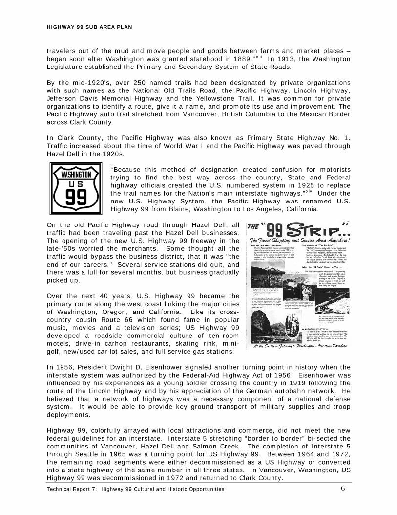
travelers out of the mud and move people and goods between farms and market places – began soon after Washington was granted statehood in 1889.”xiii In 1913, the Washington Legislature established the Primary and Secondary System of State Roads. By the mid-1920's, over 250 named trails had been designated by private organizations with such names as the National Old Trails Road, the Pacific Highway, Lincoln Highway, Jefferson Davis Memorial Highway and the Yellowstone Trail. It was common for private organizations to identify a route, give it a name, and promote its use and improvement. The Pacific Highway auto trail stretched from Vancouver, British Columbia to the Mexican Border across Clark County. In Clark County, the Pacific Highway was also known as Primary State Highway No. 1. Traffic increased about the time of World War I and the Pacific Highway was paved through Hazel Dell in the 1920s.
“Because this method of designation created confusion for motorists trying to find the best way across the country, State and Federal highway officials created the U.S. numbered system in 1925 to replace the trail names for the Nation's main interstate highways.”xiv Under the new U.S. Highway System, the Pacific Highway was renamed U.S. Highway 99 from Blaine, Washington to Los Angeles, California.
On the old Pacific Highway road through Hazel Dell, all traffic had been traveling past the Hazel Dell businesses. The opening of the new U.S. Highway 99 freeway in the late-'50s worried the merchants. Some thought all the traffic would bypass the business district, that it was "the end of our careers." Several service stations did quit, and there was a lull for several months, but business gradually picked up. Over the next 40 years, U.S. Highway 99 became the primary route along the west coast linking the major cities of Washington, Oregon, and California. Like its cross-country cousin Route 66 which found fame in popular music, movies and a television series; US Highway 99 developed a roadside commercial culture of ten-room motels, drive-in carhop restaurants, skating rink, mini-golf, new/used car lot sales, and full service gas stations. In 1956, President Dwight D. Eisenhower signaled another turning point in history when the interstate system was authorized by the Federal-Aid Highway Act of 1956. Eisenhower was influenced by his experiences as a young soldier crossing the country in 1919 following the route of the Lincoln Highway and by his appreciation of the German autobahn network. He believed that a network of highways was a necessary component of a national defense system. It would be able to provide key ground transport of military supplies and troop deployments. Highway 99, colorfully arrayed with local attractions and commerce, did not meet the new federal guidelines for an interstate. Interstate 5 stretching “border to border” bi-sected the communities of Vancouver, Hazel Dell and Salmon Creek. The completion of Interstate 5 through Seattle in 1965 was a turning point for US Highway 99. Between 1964 and 1972, the remaining road segments were either decommissioned as a US Highway or converted into a state highway of the same number in all three states. In Vancouver, Washington, US Highway 99 was decommissioned in 1972 and returned to Clark County.
Technical Report 7: Highway 99 Cultural and Historic Opportunities 6

HIGHWAY 99 SUB AREA PLAN
Technical Report 7: Highway 99 Cultural and Historic Opportunities 7
Today, one of the largest continuous segments of Highway 99 in the county stretches approximately 4 miles from the Main Street and Interstate 5 interchange in Hazel Dell north to the junction between Interstate 5 and 205 in Salmon Creek. The corridor continues to reflect its long-standing history as part of the great migration and service district for travelers.
HISTORIC RESOURCES The Clark County Historic Preservation Program’s mission is to provide for the identification, evaluation and protection of historic and prehistoric resources within Clark County and to encourage the preservation, restoration and rehabilitation of eligible historic and/or cultural resources within the county for future generations. Historic buildings and properties are the cornerstone of Clark County’s heritage and culture. They are the legacy of the settlers and residents who shaped the land and the history of the region. Older buildings showcase unique architectural styles and technical innovations. They are a symbol of the pioneers' creativity and ingenuity. Clark County Heritage Register Under the provisions of the Clark County Historic Preservation Ordinance, the Historic Preservation Commission is directed to initiate and maintain the Clark County Heritage Register and to review nominations to the Register. Any building, structure, site, or object, may be designated for inclusion in the Clark County Heritage Register if it is significantly associated with the history, architecture, archaeology, engineering, or cultural heritage of the community; if it has integrity; is at least fifty years old, or is of lesser age and has exceptional importance; and if it falls into at least one of the following categories.
1. Is associated with events that have made a significant contribution to the broad patterns of national, state, or local history;
2. Embodies the distinctive architectural characteristics of a type, period, style or method of design or construction, or represents a significant and distinguishable entity whose components may lack individual distinction;
3. Is an outstanding work of a designer, builder, or architect who has made a substantial contribution to their field;
4. Exemplifies or reflects special elements of the county’s history; 5. Is associated with the lives of persons significant in national, state, or local history; 6. Has yielded or may be likely to yield important archaeological information related to
history or prehistory; 7. Is an historic building or cultural resource removed from its original location but which
is significant for architectural value, or association with an historic person or event, or prehistory;
8. Is a birthplace or grave of a prehistoric or historical figure of outstanding importance and is the only surviving structure or site associated with that person;
9. Is a cemetery or burial site which derives its primary significance from age, from distinctive design features, or from association with historic events, or cultural patterns;
10. Is a reconstructed building that has been executed in a historically accurate manner on the original site; or
11. Is a creative and unique example of folk architecture and design created by persons not formally trained in the architectural or design professions, and which does not fit into formal architectural-or-historical-categories.

HIGHWAY 99 SUB AREA PLAN
The Highway 99 Sub-Area boundary has one site listed on the Clark County Heritage Register (CCHR). The Chapman House was listed on the CCHR in 1983. Built in 1905 by Charles Chapman, an attorney and realtor, the house was one of the first homes in Clark County with indoor plumbing. Mr. Chapman played a rather prominent role in Clark County history by donating much of the land for 119th Street, which was previously known as Chapman Road. National Register of Historic Places The National Register of Historic Places is an official listing of historically significant sites and properties throughout the country. It is maintained by the National Park Service, U.S. Department of the Interior. It includes districts, sites, buildings, structures, and objects that have been identified and documented as being significant in American history, architecture, archaeology, engineering or culture. These sites and properties reflect the prehistoric occupation and historical development of our nation, state, and local communities.
Charles Chapman House – Built ca 1905
Clark County is a Certified Local Government (CLG) therefore under the National Historic Preservation Amendments Act of 1980, the Clark County Historic Preservation Commission is responsible for the review of nominations of properties to the National Register of Historic Places. The Historic Preservation Commission reviews the nominations and forwards a recommendation to the Washington Department of Archaeology and Historic Preservation for final approval. The Highway 99 Sub-Area boundary currently has no sites listed on the National Register of Historic Places. Clark County Cultural Resources Inventory The Clark County Historic Preservation Commission is also responsible for the maintenance of the County’s Cultural Resources Inventory. The inventory is a tool for planning and research and includes those resources believed to have prehistoric, historic or cultural significance to Clark County, or even the nation, regardless of current ownership. Those sites listed on the inventory are most likely eligible for listing on the Clark County Heritage Register. There are three sites within the Highway 99 Sub-Area plan boundary that are listed on the Clark County Cultural Resources Inventory. All three sites are mentioned in the Early Settlement of Hazel Dell and Salmon Creek section of this report. They are:
• The Salmon Creek United Methodist Chapel, built circa 1900 • The Marble House, built circa 1859 • The Clark County Poor Farm Building, built circa 1925
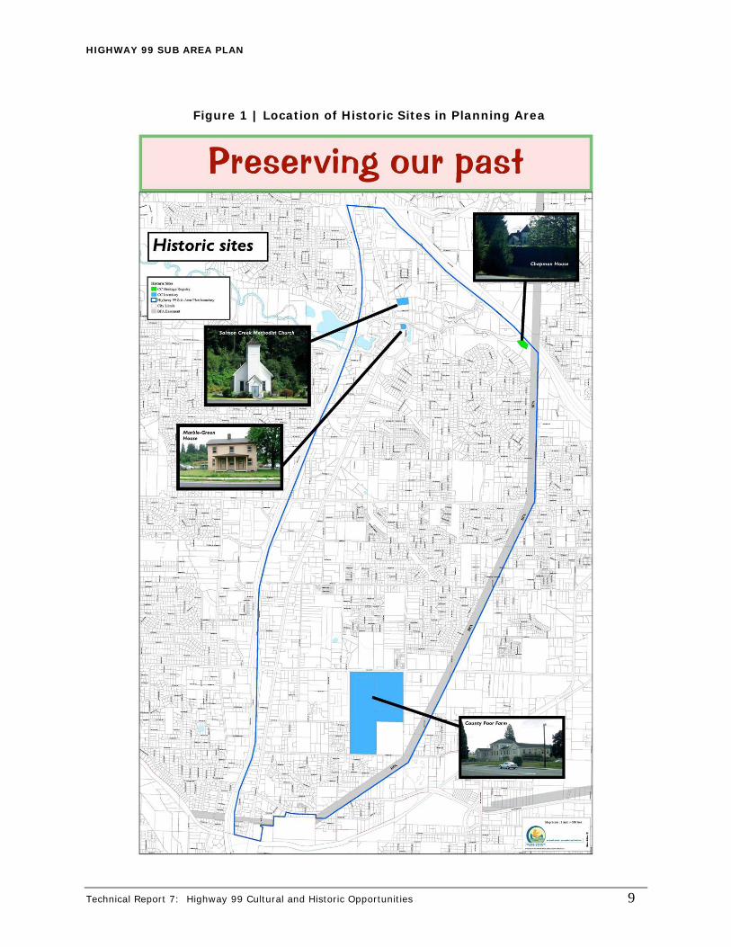
It is also important to note that the state of Washington has begun to acknowledge a growing public interest in historic properties constructed from the post WWII era. Such properties include those associated with America's roadside culture including motels, drive-in restaurants, gas stations and automobile dealerships. However, interest in the recent past goes beyond popular culture to include modernist skyscrapers, shopping centers, churches and suburban housing tracts. Since the county’s inventory was completed in 2000, there is a possibility that additional properties within the Highway 99 Sub-Area may be eligible for listing on the inventory and Heritage Register due to the current age and design of the building/site. Figure 1 below shows the location of the historic sites currently on the County’s Heritage Register (green) and on the Clark County Cultural Resources Inventory (blue) within the Highway 99 Sub-Area.
Technical Report 7: Highway 99 Cultural and Historic Opportunities 8
HIGHWAY 99 SUB AREA PLAN
Figure 1 | Location of Historic Sites in Planning Area
Technical Report 7: Highway 99 Cultural and Historic Opportunities 9

HIGHWAY 99 SUB AREA PLAN
Technical Report 7: Highway 99 Cultural and Historic Opportunities 10
Preservation Incentives There are various federal, state, and local programs available to assist property owners in the maintenance and restoration of landmark structures. These incentives include property and income tax programs, and other assistance intended to make the stewardship of historic landmarks a privilege, not a burden.
Current Use Tax Benefits Program. Many existing sites and structures exemplify Clark County’s rich history. These sites are important to our community’s sense of place, identity, heritage, and the education of our children. Property owners who register their historic properties make a commitment to preserving these sites. One of their rewards is a lower tax assessment for the underlying land. Therefore, every property listed on the Clark County Heritage Register, the Washington State Heritage Register and/or the National Register of Historic Places is eligible for the Current Use Program under the Open Space designation. Property owners must apply for and be granted the reduction and may continue in the program until the historic use is changed or the owner elects to remove it from the program.
Special Valuation Program. In 1985, the Washington State Legislature passed a "special valuation" law which makes it possible for Certified Local Governments (CLG's) to insure that property taxes will not reflect substantial improvements made to certain classes of properties as identified by the CLG for a ten year period. This means that owners of certain types of historic properties have the potential to realize substantial tax savings. Properties on the National Register of Historic Places, Clark County Heritage Register or contributing properties within a Clark County Register Historic District are eligible for special valuation.
Historic Preservation and Sustainability As stated in Technical Report 14: Sustainable Development, the National Trust for Historic Preservation has a new sustainability initiative to help people better understand preservation’s value in fostering development that is environmentally, economically and socially sustainable. The National Trust’s position is that historic preservation can – and should – be an important component of any effort to promote sustainable development. The conservation and improvement of our existing built resources, including re-use of historic and older buildings, greening the existing building stock, and reinvestment in older and historic communities, is crucial to combating climate change. Celebrating Historic and Cultural Heritage As indicated above, the Highway 99 Planning area is rich in its own unique historic, cultural and natural heritage. The history and legacy of the spirited settlers and residents who shaped the land has been relatively untold compared to the rest of Vancouver’s well-known history. The pioneers’ courage, enterprise, hospitality, and many of their ideals are lost to many of us today.
“Their dreams, anticipation and optimism concerning the future of our city, county and state have become reality. We owe them a far greater debt than even they envisioned, for they possessed the power that helped a young northwest get ready for the modern age.”xv
The legacy of the early years resides not only in the tangible structures but in the spirit of stories yet to be told.
HIGHWAY 99 SUB AREA PLAN
Technical Report 7: Highway 99 Cultural and Historic Opportunities 11
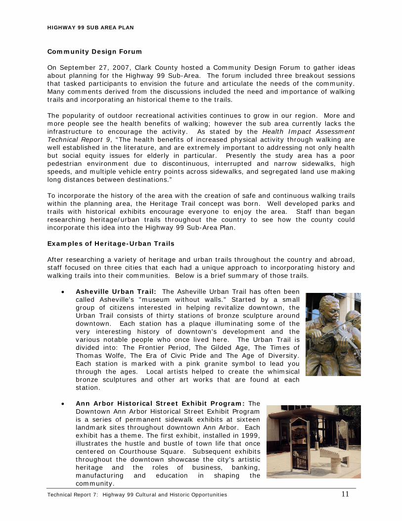
Community Design Forum On September 27, 2007, Clark County hosted a Community Design Forum to gather ideas about planning for the Highway 99 Sub-Area. The forum included three breakout sessions that tasked participants to envision the future and articulate the needs of the community. Many comments derived from the discussions included the need and importance of walking trails and incorporating an historical theme to the trails. The popularity of outdoor recreational activities continues to grow in our region. More and more people see the health benefits of walking; however the sub area currently lacks the infrastructure to encourage the activity. As stated by the Health Impact Assessment Technical Report 9, “The health benefits of increased physical activity through walking are well established in the literature, and are extremely important to addressing not only health but social equity issues for elderly in particular. Presently the study area has a poor pedestrian environment due to discontinuous, interrupted and narrow sidewalks, high speeds, and multiple vehicle entry points across sidewalks, and segregated land use making long distances between destinations.” To incorporate the history of the area with the creation of safe and continuous walking trails within the planning area, the Heritage Trail concept was born. Well developed parks and trails with historical exhibits encourage everyone to enjoy the area. Staff than began researching heritage/urban trails throughout the country to see how the county could incorporate this idea into the Highway 99 Sub-Area Plan. Examples of Heritage-Urban Trails After researching a variety of heritage and urban trails throughout the country and abroad, staff focused on three cities that each had a unique approach to incorporating history and walking trails into their communities. Below is a brief summary of those trails.
• Asheville Urban Trail: The Asheville Urban Trail has often been called Asheville's "museum without walls." Started by a small group of citizens interested in helping revitalize downtown, the Urban Trail consists of thirty stations of bronze sculpture around downtown. Each station has a plaque illuminating some of the very interesting history of downtown's development and the various notable people who once lived here. The Urban Trail is divided into: The Frontier Period, The Gilded Age, The Times of Thomas Wolfe, The Era of Civic Pride and The Age of Diversity. Each station is marked with a pink granite symbol to lead you through the ages. Local artists helped to create the whimsical bronze sculptures and other art works that are found at each station.
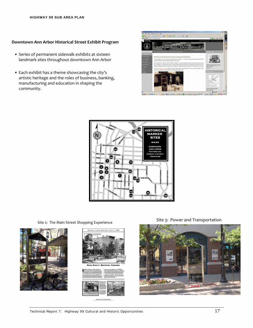
• Ann Arbor Historical Street Exhibit Program: The
Downtown Ann Arbor Historical Street Exhibit Program is a series of permanent sidewalk exhibits at sixteen landmark sites throughout downtown Ann Arbor. Each exhibit has a theme. The first exhibit, installed in 1999, illustrates the hustle and bustle of town life that once centered on Courthouse Square. Subsequent exhibits throughout the downtown showcase the city's artistic heritage and the roles of business, banking, manufacturing and education in shaping the community.

HIGHWAY 99 SUB AREA PLAN
Technical Report 7: Highway 99 Cultural and Historic Opportunities 12
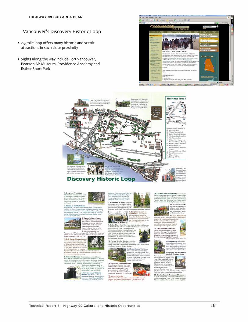
• Vancouver, Washington’s Discovery Loop: Few places in America offer so many historic and scenic attractions in such close proximity as this inviting urban trail. The 2.3-mile loop begins on East Evergreen and winds through Fort Vancouver National Historic Site, Officer's Row, and downtown Vancouver, joining the Waterfront Renaissance Trail at Vancouver Landing. Sights along the way include Fort Vancouver, Pearson Air Museum, Providence Academy and Esther Short Park.
General O.O. Howard House
Each of these trails offers a unique approach of displaying historic exhibits along walking trails. The Asheville Urban Trail utilizes art to portray important elements of the city’s history. The Ann Arbor Historical Street Exhibit Program incorporates permanent sidewalk exhibits which explains the history of the area through text and photographs. The Vancouver Discovery Loop is a trail that leads pedestrians by buildings and sites of historical significance. The Highway 99 Heritage Trail concept in Appendix B could integrate one or all of these ideas as ways to display historic sites and/or exhibits along the trails. (See Appendix A for more photographs illustrating the heritage-urban trails for the above cities.)
ARCHAEOLOGICAL As discussed above, preservation of sites is another key element of our heritage. Staff completed a preliminary archeological inventory. Documents from the Department of Archaeology and Historic Preservation (DAHP) were reviewed to determine if archaeological resources have been recorded within the project area and to determine if any archaeological surveys have been conducted in the project vicinity. In addition, Geographical Information Systems (GIS) data submitted to the Department of Community Development, Clark County by DAHP have been reviewed. Previous Archaeology in the Project Area To date, there have been a total of 49 archaeological investigations conducted within the Highway 99 Sub-Area.- 44 were archaeological predetermination surveys and the remaining 5 were archaeological surveys, testing/evaluation, and Section 106 compliance projects. Recorded historic-period sites include:
45CL199, Ansil S. Marble House. The site is located near the northern terminus of the Highway 99 Sub-Area. Built in the mid to late nineteenth century the house is potentially eligible for listing on the National Register. Currently the house has not been formally evaluated to determine eligibilityxvi (Duncan 1979a). 45CL200, Salmon Creek United Methodist Pioneer Chapel. The site is located near the northern terminus of the Highway 99 Sub-Area. Built in 1900 the chapel is a simple rectangular wood frame structure with a steeply pitched gable roof. A central square tower projects slightly from the west façade. The tower is topped by an open belfry which has groups of gabled entrance projects slightly from the base of the tower, and the fancy butt shingles of each gable end provide the only ornamentation on the building.xvii (Duncan 1979b). 45CL587 is located within the central portion of the Highway 99 Sub-Area. The site consists of a historic-period refuse scatter containing 40 ceramic fragments, 3 pieces of metal, several pieces of composition-shingle roofing material, wire nails, a piece of

HIGHWAY 99 SUB AREA PLAN
Technical Report 7: Highway 99 Cultural and Historic Opportunities 13
cobalt blue glass and a mild glass fragment. Samples of ceramic artifacts found in the disposal area include typical ceramic patterns and shapes from the 1940s.xviii
Prehistoric archaeological site:
45CL463, Holly Go Lightly. The site is located on terraces above Tenny Creek, within the central portion of the Highway 99 Sub-Area. At this site, a total of 152 lithic artifacts were recovered during an enhanced survey. xix (Roulette 1997). The artifacts include 146 pieces of debitage and 6 tools. The tools included 1 basalt biface fragment, 1 cryptocrystalline silicate uniface and 4 core fragments.
Summary of Federal, State and Local Regulations The following is a summary of applicable federal, state, and local regulations, ordinances, and codes that concern archaeological and historic resources in Clark County. Under Clark County’s Unified Development Code Title 40.250.030 Historic Preservation, the county provides for the identification, evaluation, and protection of cultural and historic resources and encourages the preservation, restoration, and rehabilitation of these resources for future generations. This applies to properties that are listed or eligible for listing in the historic or cultural resource inventory for Clark County and to properties that are listed in or eligible to be listed in the National Register of Historic Places (NHRP), the Washington Heritage Register (WHR), and the Clark County Heritage Register (CCHR). The Clark County Historic Preservation Commission serves as the reviewer for historic properties within Clark County. The Clark County cultural resources inventory is a tool for planning and research, and includes “those resources believed to have cultural or historic significance for Clark County, the region, or the nation.” Properties that were listed, and then later demolished, are maintained in the inventory records of historical research purposes. The County encourages the protection of important historic and cultural resources including those listed on the national, state and local registers of historic places; cultural resources inventoried by the State Archaeologist and Clark County; and as yet unrecorded sites, objects or structures. An Archaeological Predictive Model and associated probability maps were completed by Archaeological Investigations Northwest, Inc. in December 1994 and established the following matrix as a guideline for when an archaeological pre-determination should be required. Appendix E shows the archaeological predictive model map for the Highway 99 Sub-Area.
Table 1 | 40.570.080-1 Need for Predeterminations
Predictive Model Map Designation Potential for Impacts
Class Probability Index Low1 Moderate2 High3
1 1% – 20% } Low No No No
2 21% – 40% } Low-Moderate No No Yes
3 41% – 60% } Moderate No Yes Yes
4 61% – 80% } Moderate-High No Yes Yes
5 81% – 100% } High No Yes Yes

HIGHWAY 99 SUB AREA PLAN
Technical Report 7: Highway 99 Cultural and Historic Opportunities 14
1. Low potential impacts: Those activities involving no ground disturbance, normal maintenance and repair of existing structures and facilities, lands that have been substantially disturbed to a depth of more than eight (8) inches, and areas that have been adequately surveyed in the past with no discovery of resources.
2. Moderate potential impacts: Activities involving slight ground disturbance not otherwise characterized as having low or high impact potential.
3. High potential impacts: Activities involving disturbance of more than twelve (12) inches below the ground surface and more than ten thousand (10,000) square feet of area.
An archaeological predetermination will be required for any development in the Highway 99 Sub-Area unless any of the following apply to the proposed development:
• Registers as (Class 1) Low on probability index, • Involves no ground disturbance, or • Involves lands that have been substantially disturbed to a depth of more than eight
(8) inches. Archeological discoveries are also treated in the Revised Code of Washington (RCW) under Chapter 27.53 Archaeological Sites and Resources and Chapter 27.44 Indian Graves and Records. Coordination is often required under RCW Chapter 27.34, State Historical Societies-Historic Preservation and Chapter 27.48, Preservation of Historical Materials. The RCW requires that investigation of known archaeological sites and burials be conducted under a permit issued by the DAHP.

HIGHWAY 99 SUB AREA PLAN
Technical Report 7: Highway 99 Cultural and Historic Opportunities 15
APPENDIX A Heritage-Urban Trail Photographs
HIGHWAY 99 SUB AREA PLAN
Technical Report 7: Highway 99 Cultural and Historic Opportunities 16
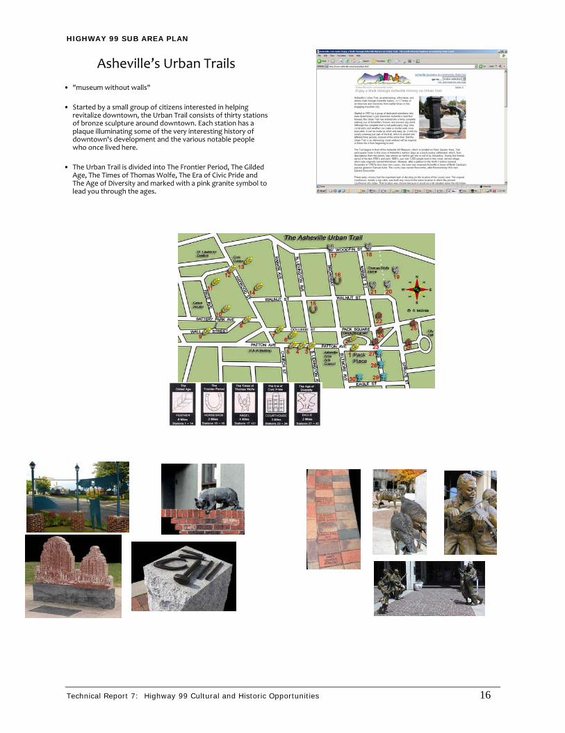
Asheville’s Urban Trails
• "museum without walls"
• Started by a small group of citizens interested in helping revitalize downtown, the Urban Trail consists of thirty stationsof bronze sculpture around downtown. Each station has a plaque illuminating some of the very interesting history of downtown's development and the various notable people who once lived here.
• The Urban Trail is divided into The Frontier Period, The Gilded Age, The Times of Thomas Wolfe, The Era of Civic Pride and The Age of Diversity and marked with a pink granite symbol to lead you through the ages.
HIGHWAY 99 SUB AREA PLAN
Technical Report 7: Highway 99 Cultural and Historic Opportunities 17
Downtown Ann Arbor Historical Street Exhibit Program
• Series of permanent sidewalk exhibits at sixteen landmark sites throughout downtown Ann Arbor
• Each exhibit has a theme showcasing the city’s artistic heritage and the roles of business, banking, manufacturing and education in shaping the community.
Site 2: The Main Street Shopping Experience Site 3: Power and Transportation
HIGHWAY 99 SUB AREA PLAN
Technical Report 7: Highway 99 Cultural and Historic Opportunities 18
Vancouver’s Discovery Historic Loop
• 2.3 mile loop offers many historic and scenic attractions in such close proximity
• Sights along the way include Fort Vancouver, Pearson Air Museum, Providence Academy and Esther Short Park

HIGHWAY 99 SUB AREA PLAN
Technical Report 7: Highway 99 Cultural and Historic Opportunities 19
APPENDIX B HERITAGE TRAIL CONCEPT
HIGHWAY 99 SUB AREA PLAN
HERITAGE TRAIL CONCEPT At the conclusion of the Community Design Forum, Team 99 reviewed a proposal to initiate the process for the creation of a Heritage Trail for the Highway 99 Sub-Area. The proposal outlined the possible steps needed for the project start to completion. A brief explanation of the steps is as follows: • Step One – Establish a Committee: The committee would consist of the key people
representing business, neighborhood, trail, historic, walking, and educational interests.
• Step Two – Decide on Themes & Exhibit Ideas for Trails: The history of the area must be researched to determine significant persons, events and sites that could be used as exhibits along the trails. If the history of the area could be grouped, then various themes could be developed and utilized for a variety of different trail routes.
• Step Three – Decide on Routes & Exhibit Locations for the Trails: This step requires a considerable amount of time and effort to complete in terms of not only deciding on final sites for the trail, but in also spending sufficient time in consultation with the individual landowners, if applicable and the community whose local area is effected by the trail.
• Step Four – Determine Signage Requirements for Each Site: Individual trail sites should be identified with heritage trail signage and of consistent design.
• Step Five – Determine Funding: Once the committee has decided on the route, sites and signage requirements for your proposed trail, the next task to be completed before actually ordering the signage and selecting an artist to complete the sculpture, if applicable, is to raise the funds required to purchase signage, the sculpture and media documents.
• Step Six – Request for Proposals for Artwork/Design: Once the trail themes are determined, the committee should create a list of possible ideas for sites along each trail and send out an RFP for artists to design their interpretation of that idea and the cost of creating the design. The committee will then choose the design that most closely embodies the spirit and intent of the idea for the site. (This step depends on how the exhibits are displayed. Artwork may not be the medium chosen.)
• Step Seven – Development of Trail
• Step Eight – Produce a Brochure & Website
• Step Nine – Open the Trail
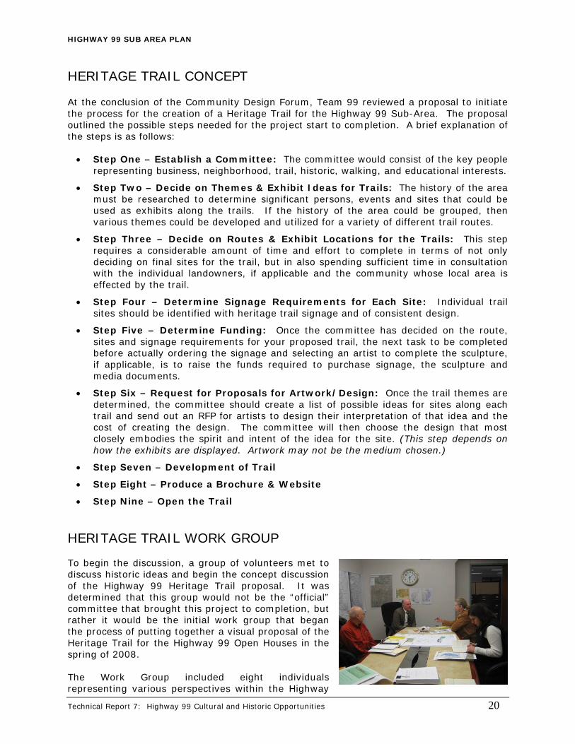
HERITAGE TRAIL WORK GROUP To begin the discussion, a group of volunteers met to discuss historic ideas and begin the concept discussion of the Highway 99 Heritage Trail proposal. It was determined that this group would not be the “official” committee that brought this project to completion, but rather it would be the initial work group that began the process of putting together a visual proposal of the Heritage Trail for the Highway 99 Open Houses in the spring of 2008. The Work Group included eight individuals representing various perspectives within the Highway
Technical Report 7: Highway 99 Cultural and Historic Opportunities 20
HIGHWAY 99 SUB AREA PLAN
Technical Report 7: Highway 99 Cultural and Historic Opportunities 21
99 Community. Those perspectives included:
• Neighborhood Associations • Business Associations • Vancouver-Clark Parks & Recreation • Clark County Historic Preservation Commission • Walking Group • Community Planning Staff
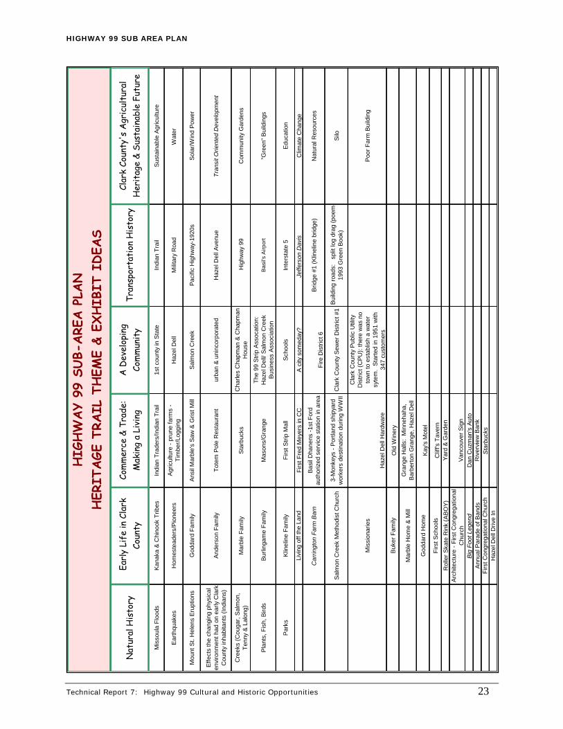
This group met three times during the months of January and February of 2008. The major goal of the group was to determine possible trail themes, exhibits and routes to present to the community for comment at the spring Open Houses. Trail Themes and Exhibits To launch the discussion of possible trail themes and exhibits, staff researched the history of the Hazel Dell and Salmon Creek areas by utilizing the resources at the Clark County Historical Museum and Clark County Genealogical Library. Staff put together a table that broke out seven possible themes for individual trails. Under each of those headings were listed possible exhibit ideas of significant persons, events or sites in the sub-area that could be displayed as an exhibit on the corresponding trail. The work group discussed these ideas and made changes by adding to the exhibit ideas and re-working how they were organized. The group decided on six trail themes. They are:
• Natural History • Early Life in Clark County • Commerce & Trade – Making a Living • A Developing Community • Transportation History • Clark County’s Agricultural Heritage & Sustainable Future
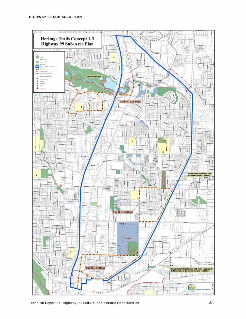
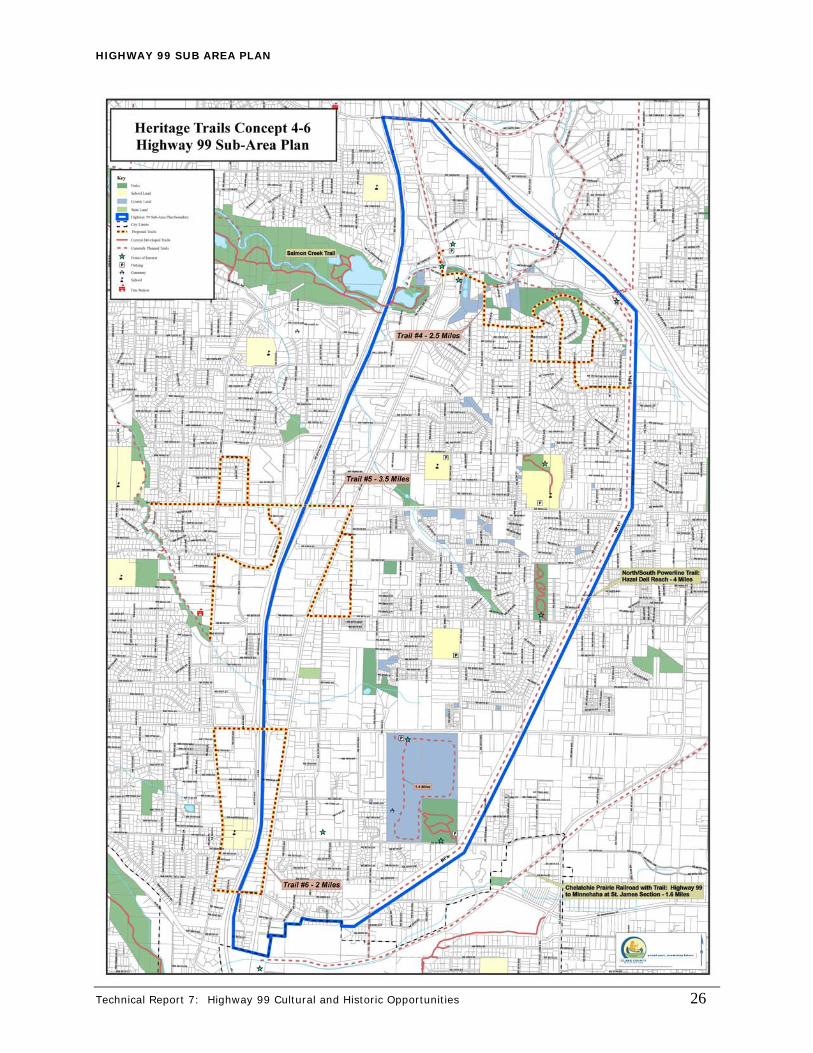
See Appendix C for the above mentioned table that lists the possible trail themes and list of exhibit ideas. Trail Routes The Work Group’s final step was to map out possible trail routes within the Highway 99 Sub-Area boundaries. The group mapped out ten possible routes. Some of these trails connected to existing or proposed trails. Other routes were proposed on existing sidewalks. Please see Appendix D for the three maps indicating possible Heritage Trail Routes throughout the Highway 99 Sub-Area.
NEXT STEPS The Highway 99 Open House scheduled for May 6 and 8 is the next step in the Heritage Trail process. The community will have an opportunity to review the proposals and work that was completed by the Heritage Trail Work Group. That work includes presenting the six possible trail themes and list of proposed historical exhibits. Several maps will also be presented that indicate potential trail routes throughout the Highway 99 Sub-Area. The comments received at the open houses will determine how the project proposal will proceed.

HIGHWAY 99 SUB AREA PLAN
Technical Report 7: Highway 99 Cultural and Historic Opportunities 22
APPENDIX C Trail Theme Ideas
HIGHWAY 99 SUB AREA PLAN
Nat
ural
His
tory
Ear
ly L
ife
in C
lark
Co
unty
Com
mer
ce &
Tra
de:
M
akin
g a
Livi
ngA
Dev
elop
ing
Com
mun
ity
Tran
spor
tati
on H
isto
ryCl
ark
Coun
ty's
Agr
icul
tura
l H
erit
age
& Su
stai
nabl
e Fu
ture
Mis
soul
a Fl
oods
Kana
ka &
Chi
nook
Trib
esIn
dian
Tra
ders
/Indi
an T
rail
1st c
ount
y in
Sta
teIn
dian
Tra
ilS
usta
inab
le A
gric
ultu
re
Ear
thqu
akes
Hom
este
ader
s/P
ione
ers
Agr
icul
ture
- pr
une
farm
s -
Tim
ber/L
oggi
ngH
azel
Del
lM
ilitar
y R
oad
Wat
er
Mou
nt S
t. H
elen
s Er
uptio
nsG
odda
rd F
amily
Ansi
l Mar
ble'
s S
aw &
Gris
t Mill
Sal
mon
Cre
ekPa
cific
Hig
hway
-192
0sSo
lar/W
ind
Pow
er
Effe
cts
the
chan
ging
phy
sica
l en
viro
nmen
t had
on
early
Cla
rk
Cou
nty
inha
bita
nts
(Indi
ans)
Ande
rson
Fam
ilyTo
tem
Pol
e R
esta
uran
tur
ban
& u
ninc
orpo
rate
dH
azel
Del
l Ave
nue
Tran
sit O
rient
ed D
evel
opm
ent
Cre
eks
(Cou
gar,
Sal
mon
, Te
nny
& La
long
)M
arbl
e Fa
mily
Sta
rbuc
ksC
harle
s C
hapm
an &
Cha
pman
H
ouse
Hig
hway
99
Com
mun
ity G
arde
ns
Plan
ts, F
ish,
Bird
sBu
rling
ame
Fam
ilyM
ason
s/G
rang
eTh
e 99
Stri
p A
ssoc
atio
n:
Haz
el D
ell/
Salm
on C
reek
B
usin
ess
Asso
ciat
ion
Bas
il's A
irpor
t"G
reen
" Bui
ldin
gs
Par
ksK
linel
ine
Fam
ilyFi
rst S
trip
Mal
lS
choo
lsIn
ters
tate
5Ed
ucat
ion
Livi
ng o
ff th
e La
ndFi
rst F
red
Mey
ers
in C
CA
city
som
eday
?Je
ffers
on D
avis
C
limat
e C
hang
e
Car
ringt
on F
arm
Bar
nBa
sil D
hane
ns -1
st F
ord
auth
oriz
ed s
ervi
ce s
tatio
n in
are
aFi
re D
istri
ct 6
Brid
ge #
1 (K
linel
ine
brid
ge)
Nat
ural
Res
ourc
es
Salm
on C
reek
Met
hodi
st C
hurc
h3-
Mon
keys
- P
ortla
nd s
hipy
ard
wor
kers
des
tinat
ion
durin
g W
WII
Cla
rk C
ount
y Se
wer
Dis
trict
#1
Bui
ldin
g ro
ads:
sp
lit lo
g dr
ag (p
oem
-19
93 G
reen
Boo
k)Si
lo
Mis
sion
arie
s
Haz
el D
ell H
ardw
are
Cla
rk C
ount
y Pu
blic
Util
ity
Dis
trict
(CPU
): th
ere
was
no
tow
n to
est
ablis
h a
wat
er
syte
m.
Star
ted
in 1
951
with
34
7 cu
stom
ers
Poor
Far
m B
uild
ing
Buke
r Fam
ilyO
ld W
iner
y
Mar
ble
Hom
e &
Mill
Gra
nge
Hal
ls:
Min
neha
ha,
Bar
berto
n G
rang
e, H
azel
Del
l
God
dard
Hom
eK
ay's
Mot
el
Firs
t Sch
ools
Clif
f's T
aver
nR
olle
r Ska
te R
ink
(ABO
Y)Ya
rd &
Gar
den
Arc
hite
ctur
e - F
irst C
ongr
egat
iona
l C
hurc
hVa
ncou
ver S
ign
Big
Foot
Leg
end
Dan
Cuz
man
's A
uto
Annu
al P
arad
e of
Ban
dsR
iver
view
Ban
kFi
rst C
ongr
egat
iona
l Chu
rch
Sta
rbuc
ksH
azel
Del
l Driv
e In
HIG
HW
AY
99 S
UB-
ARE
A P
LAN
HER
ITAGE
TRA
IL T
HEM
E &
EXHIB
IT I
DEA
S
Technical Report 7: Highway 99 Cultural and Historic Opportunities 23

HIGHWAY 99 SUB AREA PLAN
Technical Report 7: Highway 99 Cultural and Historic Opportunities 24
APPENDIX D Heritage Trail Route Ideas
HIGHWAY 99 SUB AREA PLAN
Technical Report 7: Highway 99 Cultural and Historic Opportunities 25
HIGHWAY 99 SUB AREA PLAN
Technical Report 7: Highway 99 Cultural and Historic Opportunities 26

HIGHWAY 99 SUB AREA PLAN
Technical Report 7: Highway 99 Cultural and Historic Opportunities 27
HIGHWAY 99 SUB AREA PLAN
Technical Report 7: Highway 99 Cultural and Historic Opportunities 28
APPENDIX E

HIGHWAY 99 SUB AREA PLAN
Technical Report 7: Highway 99 Cultural and Historic Opportunities 29

REFERENCES
i Gus Norwood, “Cradle of the Pacific Northwest History Clark County in Washington,” page 7.
ii Norwood, page 7.
iii Fort Vancouver Natural Historic Site, “A History of Fort Vancouver,” http://www.nps.gov/archive/fova/history.htm, April 2001.
iv William S. Hanable, HistoryLink.org - The Online Encyclopedia of Washington State History, “History Link Essay: Clark County – Thumbnail History,” http://www.historylink.org/essays/output.cfm?file_id=5644, February 2004.
v Marble Van House, Marianne, “Those Who Dared”. Clark County History: 1978. Fort Vancouver Historical Society, Clark County, Washington. P.39-40.
vi Marble Van House, p.40.
vii Schmaltz, Donna. A History of Hazel Dell. June 29, 2000. p.4.
viii Schmaltz, p. 3-4.
ix Washington State University, “History of Vancouver Research and Extension,” http://vancouverreu.wsu.edu/about/history.htm, August 2005.
x Marble Van House, p. 40.
xi Johnson, page 71.
xii Marble Van House, p. 50
xiii Harold R. Garrett, Washington State Department of Transportation, “Clark County Highway History 1905-1977, A Department of Highways Perspective,” page 21.
xiv Weingroff, page 2.
xv Marble Van house, p.54
xvi Duncan, Mary Ann, 1979a Washington State Archaeological Site Inventory Form, 45CL199. On file at the
Department of Archaeology and Historic Preservation, Olympia. xvii Duncan, Mary Ann, 1979b Washington State Archaeological Site Inventory Form, 45CL200. On file at the
Department of Archaeology and Historic Preservation, Olympia.
xviii Baker, R. Todd, 2004 Washington State Archaeological Site Inventory Form, 45CL587. On file at the Department of Archaeology and Historic Preservation, Olympia.
xix Roulette, Bill R., 1997 Archaeological Investigations at the Tenny Creek Development Property Project Area,
Hazel Dell, Clark County, Washington. Applied Archaeological Research, Portland, Oregon. Prepared for West Bay Investment, Ridgefield, Washington.