Technical Paper 10 Aboriginal Cultural Heritage Assessment ... · Newcastle Inner City Bypass -...
77
Technical Paper 10 – Aboriginal Cultural Heritage Assessment Report Newcastle Inner City Bypass Rankin Park to Jesmond April 2018
Transcript of Technical Paper 10 Aboriginal Cultural Heritage Assessment ... · Newcastle Inner City Bypass -...

Technical Paper 10 – Aboriginal Cultural Heritage Assessment Report Newcastle Inner City Bypass Rankin Park to Jesmond
April 2018

THIS PAGE LEFT INTENTIONALLY BLANK
NEWCASTLE INNER CITY BYPASS RANKIN PARK TO JESMOND, NSW
Aboriginal Cultural Heritage Assessment Report
Prepared for Roads and Maritime Services
City of Newcastle Local Government Area
January 2018
Ref. 1630
KELLEHER NIGHTINGALE CONSULTING PTY LTD Archaeological and Heritage Management
ACN 120 187 671
Level 10, 25 Bligh St SYDNEY NSW 2000
Phone 02 9232 5373
Newcastle Inner City Bypass - Rankin Park to Jesmond: CHAR January 2018
i
Document Summary
Project Name Newcastle Inner City Bypass – Rankin Park to Jesmond:
Aboriginal Cultural Heritage Assessment Report
Project Number 1630
Status Final
Version 2.1
Client Name Roads and Maritime Services
Recipient Matthew Mate, Project Development Manager
Issue Date 18 January 2018
Prepared by Dr Matthew Kelleher; Ben Anderson
Approved by Dr Matthew Kelleher
Newcastle Inner City Bypass - Rankin Park to Jesmond: CHAR January 2018
ii
Executive Summary
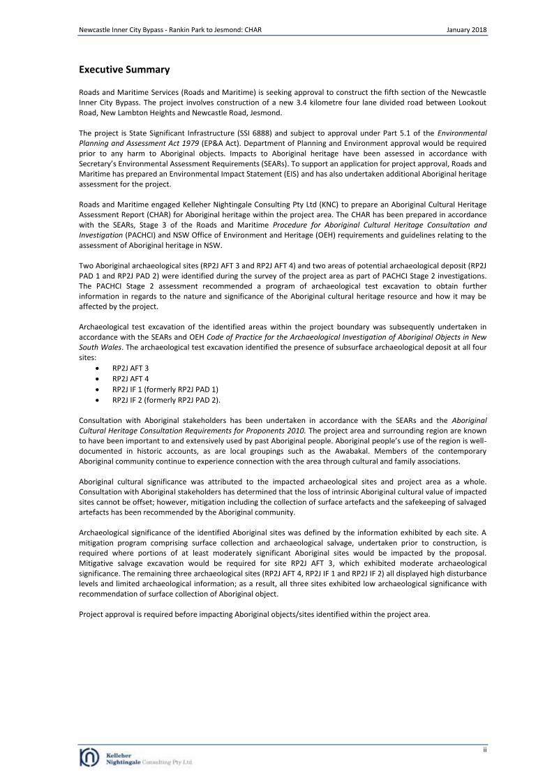
Roads and Maritime Services (Roads and Maritime) is seeking approval to construct the fifth section of the Newcastle Inner City Bypass. The project involves construction of a new 3.4 kilometre four lane divided road between Lookout Road, New Lambton Heights and Newcastle Road, Jesmond. The project is State Significant Infrastructure (SSI 6888) and subject to approval under Part 5.1 of the Environmental Planning and Assessment Act 1979 (EP&A Act). Department of Planning and Environment approval would be required prior to any harm to Aboriginal objects. Impacts to Aboriginal heritage have been assessed in accordance with Secretary’s Environmental Assessment Requirements (SEARs). To support an application for project approval, Roads and Maritime has prepared an Environmental Impact Statement (EIS) and has also undertaken additional Aboriginal heritage assessment for the project. Roads and Maritime engaged Kelleher Nightingale Consulting Pty Ltd (KNC) to prepare an Aboriginal Cultural Heritage Assessment Report (CHAR) for Aboriginal heritage within the project area. The CHAR has been prepared in accordance with the SEARs, Stage 3 of the Roads and Maritime Procedure for Aboriginal Cultural Heritage Consultation and Investigation (PACHCI) and NSW Office of Environment and Heritage (OEH) requirements and guidelines relating to the assessment of Aboriginal heritage in NSW. Two Aboriginal archaeological sites (RP2J AFT 3 and RP2J AFT 4) and two areas of potential archaeological deposit (RP2J PAD 1 and RP2J PAD 2) were identified during the survey of the project area as part of PACHCI Stage 2 investigations. The PACHCI Stage 2 assessment recommended a program of archaeological test excavation to obtain further information in regards to the nature and significance of the Aboriginal cultural heritage resource and how it may be affected by the project. Archaeological test excavation of the identified areas within the project boundary was subsequently undertaken in accordance with the SEARs and OEH Code of Practice for the Archaeological Investigation of Aboriginal Objects in New South Wales. The archaeological test excavation identified the presence of subsurface archaeological deposit at all four sites:
RP2J AFT 3
RP2J AFT 4
RP2J IF 1 (formerly RP2J PAD 1)
RP2J IF 2 (formerly RP2J PAD 2). Consultation with Aboriginal stakeholders has been undertaken in accordance with the SEARs and the Aboriginal Cultural Heritage Consultation Requirements for Proponents 2010. The project area and surrounding region are known to have been important to and extensively used by past Aboriginal people. Aboriginal people’s use of the region is well-documented in historic accounts, as are local groupings such as the Awabakal. Members of the contemporary Aboriginal community continue to experience connection with the area through cultural and family associations. Aboriginal cultural significance was attributed to the impacted archaeological sites and project area as a whole. Consultation with Aboriginal stakeholders has determined that the loss of intrinsic Aboriginal cultural value of impacted sites cannot be offset; however, mitigation including the collection of surface artefacts and the safekeeping of salvaged artefacts has been recommended by the Aboriginal community. Archaeological significance of the identified Aboriginal sites was defined by the information exhibited by each site. A mitigation program comprising surface collection and archaeological salvage, undertaken prior to construction, is required where portions of at least moderately significant Aboriginal sites would be impacted by the proposal. Mitigative salvage excavation would be required for site RP2J AFT 3, which exhibited moderate archaeological significance. The remaining three archaeological sites (RP2J AFT 4, RP2J IF 1 and RP2J IF 2) all displayed high disturbance levels and limited archaeological information; as a result, all three sites exhibited low archaeological significance with recommendation of surface collection of Aboriginal object. Project approval is required before impacting Aboriginal objects/sites identified within the project area.

Newcastle Inner City Bypass - Rankin Park to Jesmond: CHAR January 2018
iii
Contents
EXECUTIVE SUMMARY .....................................................................................................................................II
CONTENTS ..................................................................................................................................................... III
FIGURES ......................................................................................................................................................... IV
TABLES ........................................................................................................................................................... IV
1 INTRODUCTION ....................................................................................................................................... 1
1.1 PROPONENT AND CONSULTANTS .............................................................................................................................. 1 1.2 LOCATION AND SCOPE OF ACTIVITY ........................................................................................................................... 1 1.3 PROJECT REQUIREMENTS........................................................................................................................................ 2
2 LANDSCAPE CONTEXT .............................................................................................................................. 3
2.1 LANDFORM, GEOLOGY AND SOILS ............................................................................................................................. 3 2.2 ETHNOHISTORIC CONTEXT ...................................................................................................................................... 6
3 ARCHAEOLOGICAL ASSESSMENT ............................................................................................................. 8
3.1 PREVIOUS ARCHAEOLOGICAL INVESTIGATIONS .............................................................................................................. 8 3.2 NEWCASTLE INNER CITY BYPASS – RANKIN PARK TO JESMOND: ABORIGINAL ARCHAEOLOGICAL SURVEY REPORT ........................... 9
4 ARCHAEOLOGICAL TEST EXCAVATION ................................................................................................... 12
4.1 AIMS .............................................................................................................................................................. 12 4.2 METHODOLOGY ................................................................................................................................................ 12 4.3 RP2J AFT3 ..................................................................................................................................................... 15 4.3.1. SOILS AND DISTURBANCE ...................................................................................................................................... 15 4.3.2. ARTEFACT DISTRIBUTION ...................................................................................................................................... 16 4.3.3. LITHICS ........................................................................................................................................................... 16 4.3.4. DISCUSSION ..................................................................................................................................................... 17 4.4 RP2J AFT 4 .................................................................................................................................................... 18 4.4.1. SOILS AND DISTURBANCE ...................................................................................................................................... 18 4.4.2. ARTEFACT DISTRIBUTION AND LITHICS ...................................................................................................................... 19 4.4.3. DISCUSSION ..................................................................................................................................................... 19 4.5 RP2J PAD 1 (RP2J IF 1) ................................................................................................................................... 20 4.5.1. SOILS AND DISTURBANCE ...................................................................................................................................... 20 4.5.2. ARTEFACT DISTRIBUTION AND LITHICS ...................................................................................................................... 21 4.5.3. DISCUSSION ..................................................................................................................................................... 21 4.6 RP2J PAD 2 (RP2J IF 2) ................................................................................................................................... 22 4.6.1. SOILS AND DISTURBANCE ...................................................................................................................................... 22 4.6.2. ARTEFACT DISTRIBUTION AND LITHICS ...................................................................................................................... 23 4.6.3. DISCUSSION ..................................................................................................................................................... 23
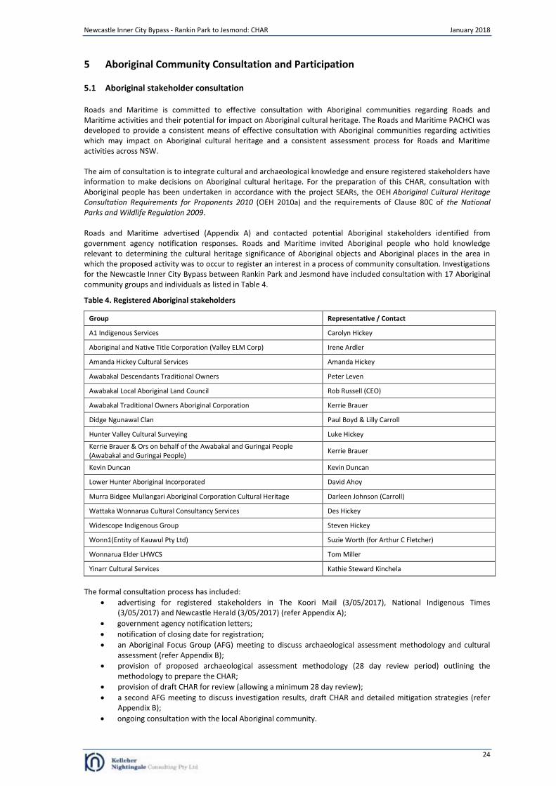
5 ABORIGINAL COMMUNITY CONSULTATION AND PARTICIPATION ......................................................... 24
5.1 ABORIGINAL STAKEHOLDER CONSULTATION ............................................................................................................... 24 5.2 PACHCI STAGE 2: SURVEY AND CULTURAL ASSESSMENT REPORT ................................................................................... 25 5.3 ABORIGINAL CULTURAL VALUES ............................................................................................................................. 25 5.4 CHAR REVIEW .................................................................................................................................................. 25
6 SUMMARY AND ANALYSIS OF BACKGROUND INFORMATION ............................................................... 27
6.1 SUMMARY OF KNOWN ABORIGINAL ARCHAEOLOGICAL SITES WITHIN THE PROJECT AREA ........................................................ 27 6.2 ABORIGINAL ARCHAEOLOGICAL SITES WITHIN THE PROJECT AREA ..................................................................................... 28
7 CULTURAL HERITAGE VALUES AND STATEMENT OF SIGNIFICANCE........................................................ 30
7.1 SIGNIFICANCE ASSESSMENT CRITERIA ....................................................................................................................... 30 7.2 STATEMENT OF SIGNIFICANCE ................................................................................................................................ 32
8 IMPACT ASSESSMENT AND MITIGATION STRATEGIES ........................................................................... 33
8.1 PROPOSED ACTIVITY ........................................................................................................................................... 33 8.2 AVOIDING AND/OR MITIGATING HARM .................................................................................................................... 34
9 MANAGEMENT OUTCOMES................................................................................................................... 36
9.1 MITIGATION THROUGH ARCHAEOLOGICAL SALVAGE EXCAVATION .................................................................................... 36 9.2 MITIGATION THROUGH THE COLLECTION OF SURFACE ARTEFACTS .................................................................................... 36
10 MANAGEMENT PROCEDURES ................................................................................................................ 37
Newcastle Inner City Bypass - Rankin Park to Jesmond: CHAR January 2018
iv
10.1 MANAGEMENT POLICY FOR ABORIGINAL CULTURAL HERITAGE ...................................................................................... 37 10.2 PROCEDURES FOR HANDLING HUMAN REMAINS ........................................................................................................ 38 10.3 PROCEDURE FOR PROPOSED CHANGES TO APPROVED PROJECTS ...................................................................................... 38 10.3.1. CHANGES IN HERITAGE IMPACT .............................................................................................................................. 38 10.4 PROCESS FOR CONTINUED CONSULTATION WITH ABORIGINAL STAKEHOLDERS ..................................................................... 39
REFERENCES ................................................................................................................................................... 40
APPENDIX A ADVERTISEMENT FOR REGISTRATION OF INTEREST .............................................................. 42
APPENDIX B AFG MEETING MINUTES........................................................................................................ 43
APPENDIX C ABORIGINAL STAKEHOLDER COMMENTS .............................................................................. 53
APPENDIX D SALVAGE EXCAVATION METHODOLOGY ............................................................................... 66
Figures
Figure 1. Project area .......................................................................................................................................................... 1 Figure 2. Topography of the project area ............................................................................................................................ 4 Figure 3. Geology and soil landscapes of the project area ................................................................................................... 5 Figure 4. PACHCI Stage 2 survey units and landforms ....................................................................................................... 11 Figure 5. Archaeological test square locations and artefact density at RP2J AFT 3 and RP2J AFT 4 .................................. 13 Figure 6. Archaeological test square locations and artefact density at RP2J PAD 1 and RP2J PAD 2 ................................. 14 Figure 7. TS 13 north section and soil profile description .................................................................................................. 15 Figure 8. TS 18 south section and soil profile description .................................................................................................. 15 Figure 9. TS 29 east section and soil profile description .................................................................................................... 18 Figure 10. TS 31 west section and soil profile description ................................................................................................. 18 Figure 11. TS 35 south section and soil profile description ................................................................................................ 18 Figure 12. TS 40 west section and soil profile description ................................................................................................. 19 Figure 13. TS 20 south section and soil profile description ................................................................................................ 20 Figure 14. TS 25 east section and soil profile description .................................................................................................. 20 Figure 15. TS 1 west section and soil profile description ................................................................................................... 22 Figure 16. TS 8 north section and soil profile description .................................................................................................. 22 Figure 17. Archaeological sites within the project area ..................................................................................................... 29 Figure 18. Proposed impact area and Aboriginal heritage ................................................................................................. 35 Figure 19. Indicative excavation area transects for Phase 1 .............................................................................................. 68
Tables
Table 1. SEARs: Aboriginal Heritage ..................................................................................................................................... 2 Table 2. Test excavation artefact densities at RP2J AFT 3 .................................................................................................. 16 Table 3. RP2J AFT 3 - lithic database .................................................................................................................................. 16 Table 4. Registered Aboriginal stakeholders ...................................................................................................................... 24 Table 5. Identified Aboriginal archaeological sites within the project area ....................................................................... 27 Table 6. Proposed impact to Aboriginal archaeological sites within the project area ....................................................... 33 Table 7. Mitigation measures for impacted Aboriginal sites .............................................................................................. 34 Table 8. Aboriginal cultural heritage sites requiring mitigation (salvage excavation) ....................................................... 36 Table 9. Aboriginal sites requiring mitigation (collection)................................................................................................. 36
Newcastle Inner City Bypass - Rankin Park to Jesmond: CHAR January 2018
1
1 Introduction
1.1 Proponent and consultants
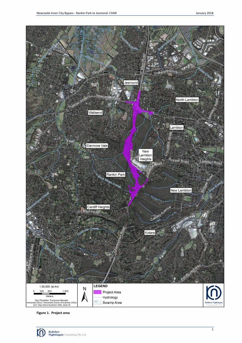
Roads and Maritime Services (Roads and Maritime) is seeking approval to construct the fifth section of the Newcastle Inner City Bypass. The project involves construction of a new 3.4 kilometre four lane divided road between Lookout Road, New Lambton Heights and Newcastle Road, Jesmond. The proposed location of the new bypass and ancillary works are shown in Figure 1 and hereafter referred to as the project area. The project is State Significant Infrastructure (SSI 6888) and subject to approval under Part 5.1 of the Environmental Planning and Assessment Act 1979 (EP&A Act). Department of Planning and Environment approval would be required prior to any harm to Aboriginal objects. Impacts to Aboriginal heritage will be assessed in accordance with Secretary’s Environmental Assessment Requirements (SEARs). To support an application for project approval, Roads and Maritime has prepared an Environmental Impact Statement (EIS) and has also undertaken additional Aboriginal heritage assessment for the project. Roads and Maritime engaged Kelleher Nightingale Consulting Pty Ltd (KNC) to prepare an Aboriginal Cultural Heritage Assessment Report (CHAR) for Aboriginal heritage within the project area. The CHAR has been prepared in accordance with the SEARs, Stage 3 of the Roads and Maritime Procedure for Aboriginal Cultural Heritage Consultation and Investigation (PACHCI) and Office of Environment and Heritage (OEH) Code of Practice for the Archaeological Investigation of Aboriginal Objects in New South Wales.
1.2 Location and scope of activity
Roads and Maritime propose to construct the fifth stage of the Newcastle Inner City Bypass. The Newcastle Inner City Bypass is part of the Roads and Maritime long term strategy to provide an orbital road within Newcastle’s road network to connect the Pacific Highway at Bennetts Green with the Pacific Highway at Sandgate. The fifth stage of this project would include the construction of 3.4 kilometres of new four lane divided road between Lookout Road, New Lambton Heights and Newcastle Road, Jesmond. The Rankin Park to Jesmond section of the Newcastle Inner City Bypass would provide traffic relief to the surrounding road to network, in particular the existing route of Lookout Road, Croudace Street and Newcastle Road. The proposed works involve the following key elements:
New road with two lanes in each direction, separated by a median
Three interchanges, consisting of:
o Northern interchange providing access to Newcastle Road and the existing Jesmond to Shortland section of the Newcastle Inner City Bypass. The full interchange provides all movements to/from the bypass and Newcastle Road
o Hospital Interchange providing access between the John Hunter Hospital precinct and the bypass. The full interchange provides all movements to/ from the bypass
o Southern interchange providing access to Lookout Road and the existing Kotara to Rankin Park section of the Newcastle Inner City Bypass. The bypass would travel under McCaffrey Drive. The half interchange provides connection in both directions on Lookout Road
Structures along the road to allow for drainage, animal and bushwalker access
Tie in and upgrades to connecting roads, including Lookout Road, McCaffrey Drive and Newcastle Road
Large cut and fill embankments due to steep and undulating terrain
Pedestrian and cycling facilities, including a shared path bridge over Newcastle Road
Noise barriers and/or architectural treatment, as required
Permanent operational water quality treatment measures.
The project area is shown in Figure 1.
Newcastle Inner City Bypass - Rankin Park to Jesmond: CHAR January 2018
1
Figure 1. Project area
Newcastle Inner City Bypass - Rankin Park to Jesmond: CHAR January 2018
2
1.3 Project requirements
This CHAR addresses the Aboriginal heritage requirements identified in the project SEARs. The objectives of the CHAR combine Aboriginal community consultation with an archaeological investigation in accordance with:
Secretary’s environmental assessment requirements;
Roads and Maritime PACHCI (Roads and Maritime 2011);
Code of Practice for Archaeological Investigation of Aboriginal Objects in NSW (OEH 2010);
Draft Guidelines for Aboriginal Cultural Heritage Impact Assessment and Community Consultation (DEC 2005); and
Aboriginal cultural heritage consultation requirements for proponents 2010 (OEH 2010). Aboriginal cultural heritage assessment for the project was designed to meet the SEARs. This included:
Assessment of impacts to Aboriginal heritage (both cultural and archaeological significance);
Consultation with Aboriginal communities, including Awabakal Local Aboriginal Land Council and registered Aboriginal stakeholders for the project, to assess impacts and develop mitigation measures;
Preparation of and community consultation on an archaeological assessment methodology. The methodology was distributed to registered Aboriginal stakeholders for review (allowing 28 day review period) and discussed at an Aboriginal Focus Group meeting, resulting in agreement by the stakeholders;
Evaluation of landscape features and potential archaeological significance;
Detailed archaeological assessment of the project to fully identify spatial extent and impacts;
Identification of mitigation and management measures;
Distribution of draft CHAR to Aboriginal stakeholders and an Aboriginal Focus Group meeting to discuss the CHAR results and agree on appropriate mitigation measures.
Specific requirements of the SEARs are outlined in the table below.
Table 1. SEARs: Aboriginal Heritage
Secretary’s Environmental Assessment Requirements Where addressed in this document
Impacts to Aboriginal heritage (including cultural and archaeological significance), in particular impacts to Aboriginal objects and potential archaeological deposits (PAD), should be assessed. Where impacts are identified, the assessment shall:
Section 8
undertake appropriate archaeological investigations generally in accordance with the Code of Practice for Archaeological Investigation of Aboriginal Objects in NSW (DECCW 2010), to establish the full spatial extent and significance of any archaeological evidence across each site/area of PAD, and include the results of these excavations. If an alternative excavation method is proposed, it shall be developed in consultation with OEH.
Sections 8, 9 and
10
be undertaken by a suitably qualified heritage consultant(s); Section 1
demonstrate effective consultation with Aboriginal communities in determining and assessing impacts and developing and selecting options and mitigation measures (including the final proposed measures);
Section 5
Appendices B and
C
assess and document the archaeological and cultural significance of cultural heritage values of affected sites; and
Section 7
outline the proposed mitigation and management measures (including measures to avoid significant impacts and an evaluation of the effectiveness of the measures) generally consistent with the Draft Guidelines for Aboriginal Cultural Heritage Impact Assessment and Community Consultation (DEC 2005) and other relevant guidelines and requirements.
Section 4
Newcastle Inner City Bypass - Rankin Park to Jesmond: CHAR January 2018
3
2 Landscape Context
2.1 Landform, geology and soils
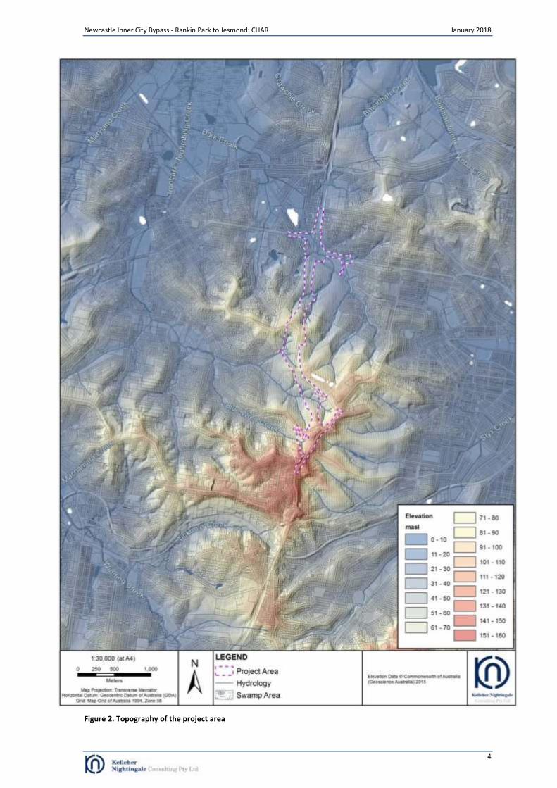
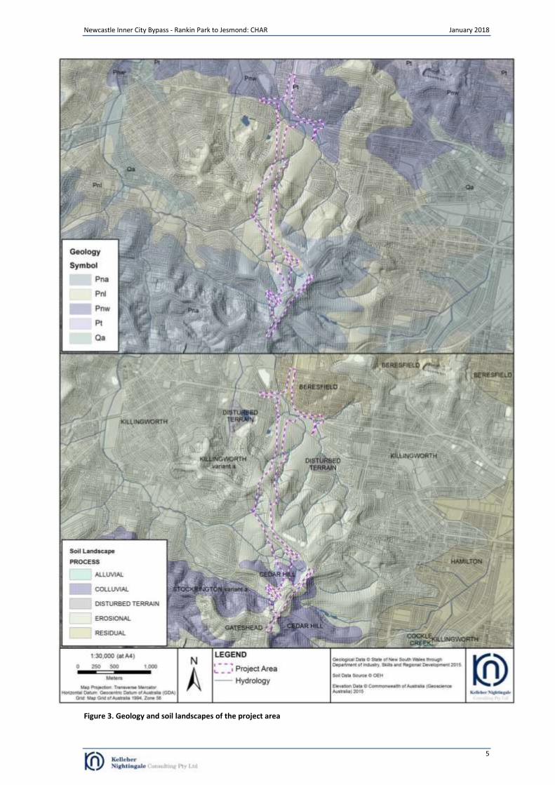
The project area is located within the Lower Hunter Valley, a northern physiogeographic region of the Sydney Basin. The Sydney Basin is a large geological feature that stretches from Batemans Bay to Newcastle and west to Lithgow. The formation of the basin began between 300 to 250 million years ago when river deltas gradually replaced the ocean that had extended as far west as Lithgow. The oldest, Permian layers of the Sydney Basin consist of marine, alluvial and deltaic deposits that include shales and mudstone overlain by coal measures. The topography of the project area is characterised by crest, flat, open depression and slope landforms of a prominent ridgeline which forms the watershed for the catchments of Dark Creek in the north, Ironbark Creek in the west and Styx Creek in the east (Figure 2). The northern portion of the project area is associated with low slopes descending from the crests of the central portion of the project area. The southern portion of the project area is made up of moderate to steep slopes ascending to the crest occupied by Kookaburra Circuit, McCaffrey Drive and Lookout Road. The underlying geology of the project area is predominantly formed from subgroups of the Newcastle Coal Measures, with the northern portion of the project area containing Tomago Coal Measures (Figure 3). The northern low lying hill landforms are formed from Tomago Coal Measures (Pt) geology which consists of siltstone, sandstone, coal, tuff, claystone, conglomerate and minor clay. Waratah Sandstone (Pnw) is a subgroup of the Newcastle Coal Measures that underlies the flat landforms of the Dark Creek flood plain and is characterised by medium grained sandstone. The Lambton Subgroup (Pnl) of the Newcastle Coal Measures is present within the lower elevations of the ridgeline south of Dark Creek and is characterised by sandstone, siltstone, claystone, coal and tuffaceous sandstone. The highest elevations of the ridgeline in the southern portion of the project area are formed from the Adamstown Subgroup (Pna) of the Newcastle Coal Measures and comprise conglomerate, tuff, sandstone, siltstone, claystone and black coal. Soil landscapes in the area are closely related to the basal geology and topography of the project area (Figure 3). The predominant soil type is the Killingworth erosional soil landscape which includes shallow to moderately deep Yellow Podzolic Soils, yellow Soloths, Gleyed Podzolic soils and gleyed Soloths on the crests and hillslopes of the project area. Structured Loams, Bleached Loams and Lithosols are also present on some crests. Cedar Hill colluvial soil landscapes are present on the steep slopes in the southern portion of the project area. These soil types include moderately deep to deep well to imperfectly drained Brown Podzolic and Yellow Podzolic soils. Structured loams which are moderately deep and well drained are also present. Beresfield residual soils overlie Tomago Coal Measures in the northern portion of the project area. These soils occur on crests, are moderately deep and moderately well to imperfectly drained Yellow Podzolic soils, brown Podzolic soils and brown Soloths. Well drained Red Podzolic soils and red Soloths occur on upper slopes with brown Soloths and yellow Soloths occurring on side slopes. Lower slopes in this soil landscape are characterised by imperfectly to poorly drained Yellow Podzolic soils. The majority of the project area has not been affected by contemporary land clearing and is currently covered by uncleared open forest with some open woodland. Several unsealed access tracks and utility easements have been constructed through the vegetated areas. Urban development with associated infrastructure is present in the northern and southern portions of the project area while the John Hunter Hospital precinct is located adjacent to the eastern boundary of the project area. Historically, mining activity has also resulted in land disturbance, clearing and changes to watercourses. The spur south of the Dark Creek floodplain was also the location of the former Hollywood shanty town. The settlement developed during the Great Depression of the 1930s around a north south aligned track and was inhabited by 70 to 80 families by 1949 (Aurecon 2016: 16). The settlement is believed to have continued into the mid to late 1950s when it was cleared by the local council (Baker Archaeology 2016: 17).
Newcastle Inner City Bypass - Rankin Park to Jesmond: CHAR January 2018
4
Figure 2. Topography of the project area
Newcastle Inner City Bypass - Rankin Park to Jesmond: CHAR January 2018
5
Figure 3. Geology and soil landscapes of the project area
Newcastle Inner City Bypass - Rankin Park to Jesmond: CHAR January 2018
6
2.2 Ethnohistoric context
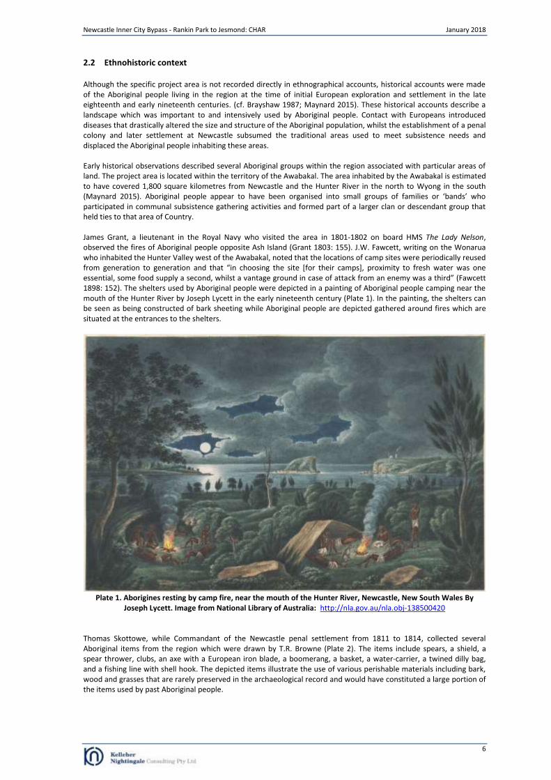
Although the specific project area is not recorded directly in ethnographical accounts, historical accounts were made of the Aboriginal people living in the region at the time of initial European exploration and settlement in the late eighteenth and early nineteenth centuries. (cf. Brayshaw 1987; Maynard 2015). These historical accounts describe a landscape which was important to and intensively used by Aboriginal people. Contact with Europeans introduced diseases that drastically altered the size and structure of the Aboriginal population, whilst the establishment of a penal colony and later settlement at Newcastle subsumed the traditional areas used to meet subsistence needs and displaced the Aboriginal people inhabiting these areas. Early historical observations described several Aboriginal groups within the region associated with particular areas of land. The project area is located within the territory of the Awabakal. The area inhabited by the Awabakal is estimated to have covered 1,800 square kilometres from Newcastle and the Hunter River in the north to Wyong in the south (Maynard 2015). Aboriginal people appear to have been organised into small groups of families or ‘bands’ who participated in communal subsistence gathering activities and formed part of a larger clan or descendant group that held ties to that area of Country. James Grant, a lieutenant in the Royal Navy who visited the area in 1801-1802 on board HMS The Lady Nelson, observed the fires of Aboriginal people opposite Ash Island (Grant 1803: 155). J.W. Fawcett, writing on the Wonarua who inhabited the Hunter Valley west of the Awabakal, noted that the locations of camp sites were periodically reused from generation to generation and that “in choosing the site [for their camps], proximity to fresh water was one essential, some food supply a second, whilst a vantage ground in case of attack from an enemy was a third” (Fawcett 1898: 152). The shelters used by Aboriginal people were depicted in a painting of Aboriginal people camping near the mouth of the Hunter River by Joseph Lycett in the early nineteenth century (Plate 1). In the painting, the shelters can be seen as being constructed of bark sheeting while Aboriginal people are depicted gathered around fires which are situated at the entrances to the shelters.
Plate 1. Aborigines resting by camp fire, near the mouth of the Hunter River, Newcastle, New South Wales By
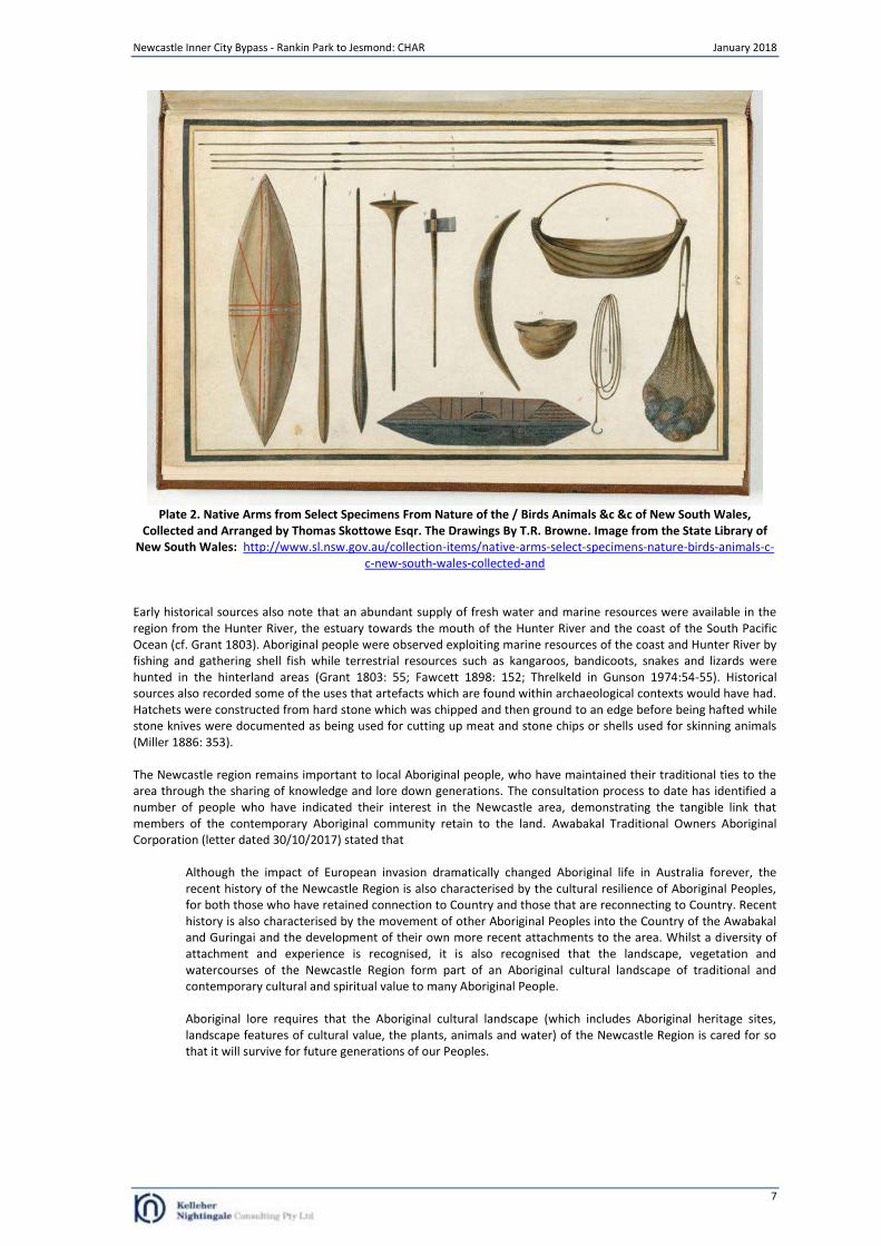
Joseph Lycett. Image from National Library of Australia: http://nla.gov.au/nla.obj-138500420 Thomas Skottowe, while Commandant of the Newcastle penal settlement from 1811 to 1814, collected several Aboriginal items from the region which were drawn by T.R. Browne (Plate 2). The items include spears, a shield, a spear thrower, clubs, an axe with a European iron blade, a boomerang, a basket, a water-carrier, a twined dilly bag, and a fishing line with shell hook. The depicted items illustrate the use of various perishable materials including bark, wood and grasses that are rarely preserved in the archaeological record and would have constituted a large portion of the items used by past Aboriginal people.
Newcastle Inner City Bypass - Rankin Park to Jesmond: CHAR January 2018
7
Plate 2. Native Arms from Select Specimens From Nature of the / Birds Animals &c &c of New South Wales,
Collected and Arranged by Thomas Skottowe Esqr. The Drawings By T.R. Browne. Image from the State Library of New South Wales: http://www.sl.nsw.gov.au/collection-items/native-arms-select-specimens-nature-birds-animals-c-
c-new-south-wales-collected-and
Early historical sources also note that an abundant supply of fresh water and marine resources were available in the region from the Hunter River, the estuary towards the mouth of the Hunter River and the coast of the South Pacific Ocean (cf. Grant 1803). Aboriginal people were observed exploiting marine resources of the coast and Hunter River by fishing and gathering shell fish while terrestrial resources such as kangaroos, bandicoots, snakes and lizards were hunted in the hinterland areas (Grant 1803: 55; Fawcett 1898: 152; Threlkeld in Gunson 1974:54-55). Historical sources also recorded some of the uses that artefacts which are found within archaeological contexts would have had. Hatchets were constructed from hard stone which was chipped and then ground to an edge before being hafted while stone knives were documented as being used for cutting up meat and stone chips or shells used for skinning animals (Miller 1886: 353). The Newcastle region remains important to local Aboriginal people, who have maintained their traditional ties to the area through the sharing of knowledge and lore down generations. The consultation process to date has identified a number of people who have indicated their interest in the Newcastle area, demonstrating the tangible link that members of the contemporary Aboriginal community retain to the land. Awabakal Traditional Owners Aboriginal Corporation (letter dated 30/10/2017) stated that
Although the impact of European invasion dramatically changed Aboriginal life in Australia forever, the recent history of the Newcastle Region is also characterised by the cultural resilience of Aboriginal Peoples, for both those who have retained connection to Country and those that are reconnecting to Country. Recent history is also characterised by the movement of other Aboriginal Peoples into the Country of the Awabakal and Guringai and the development of their own more recent attachments to the area. Whilst a diversity of attachment and experience is recognised, it is also recognised that the landscape, vegetation and watercourses of the Newcastle Region form part of an Aboriginal cultural landscape of traditional and contemporary cultural and spiritual value to many Aboriginal People. Aboriginal lore requires that the Aboriginal cultural landscape (which includes Aboriginal heritage sites, landscape features of cultural value, the plants, animals and water) of the Newcastle Region is cared for so that it will survive for future generations of our Peoples.
Newcastle Inner City Bypass - Rankin Park to Jesmond: CHAR January 2018
8
3 Archaeological Assessment
3.1 Previous archaeological investigations
Previous archaeological investigations within the boundary and vicinity of the project area have generally taken the form of large scale Aboriginal heritage studies and smaller scale archaeological investigations for proposed infrastructure and major development projects. As part of the current project, an archaeological survey of the entire project area was undertaken as part of the PACHCI Stage 2 assessment (see Section 3). In addition, a test excavation of the sites and area of potential archaeological deposit identified during the PACHCI Stage 2 assessment within the project area was undertaken (see Section 4). A summary of the relevant investigations is presented in this section. Newcastle Coastline Dyall (1971) published the results of archaeological fieldwork undertaken along the Newcastle coastline and adjacent areas to the east of the current project area. The majority of Aboriginal sites identified were open camp sites comprising stone artefacts and/or shell midden while five axe-grinding groove locations were identified between Newcastle and Redhead. Open camp sites were generally found in close proximity to marine, estuarine and lagoon resources with large midden sites found where both ocean beach and tidal reef resources were available. The axe grinding groove sites were located on sandstone creek beds and included two locations (AHIMS ID 38-4-0083 and 38-4-0085) located approximately 500 metres east of the current project area. Stone artefacts were predominantly made from chert with tuff/mudstone and quartzite also identified. Dyall identified quarry sites with small boulders of good quality chert at Nobbies, Merewether and Glenrock approximately six kilometres north east of the current project area. The quarry site at Glenrock was associated with broken boulders and implements made from the lumps of chert (ibid: 159). Newcastle LGA An Aboriginal Heritage Study of the Newcastle Local Government Area (LGA) was undertaken by AMBS in 2005. The study aimed to synthesise and evaluate existing information about Aboriginal heritage in the LGA, integrating both physical/material expressions (archaeological sites) and intangible expressions (social and cultural values) to allow the development of a framework for the strategic conservation and management of Aboriginal cultural heritage. The heritage study included an assessment of Aboriginal archaeological sensitivity across the LGA within defined regions based on a landscape model incorporating the distribution pattern of known sites and terrain integrity. The Awaba Hills region, in which the project area is located, encompassed the undulating and low rolling hills in the southern portion of the Newcastle LGA. The spatial distribution of recorded sites within the region was characterised by low density sites along ridges and hillslopes with increased site complexity and density in proximity to coastal landforms. Smaller quantities of axe grinding grooves, quarries and ceremonial sites were also identified within the region and the study noted that sources of tuff/mudstone were present within the Glenrock Nature Reserve approximately three kilometres south east of the current project area. The archaeological sensitivity modelling determined that the lower slopes of the Glenrock Nature Reserve had moderate sensitivity while the upper slopes were assessed as having low archaeological potential (AMBS 2005; 89). Bluegum Vista In 2002, Umwelt (2002b) undertook an archaeological excavation for the Bluegum Vista residential estate project approximately three kilometres to the north of the project area. A total of 3001 flaked stone artefacts were recovered from 316 square metres. Fine grained siliceous tuff/mudstone and silcrete were the most dominant raw material types. Artefact types included flakes, broken flakes, retouched flakes, flaked pieces, cores, hammerstones, an anvil and a grinding stone fragment. Three areas (hillock/headland, open spur crest and sheltered spur crest) were determined to be of very high significance, with the hillock/headland and sheltered spur crest being recommended for conservation. Glendale Dean-Jones (1989) conducted an archaeological constraints assessment, including a field survey, of 90 hectares of land along Winding Creek at Glendale approximately 4 kilometres west of the current project area. The field survey identified nine Aboriginal archaeological sites comprising eight artefact scatters and one culturally modified tree. One artefact scatter consisted of a concentration of 53 artefacts made up of predominantly tuff/mudstone flakes, flaked pieces and cores. The remaining seven sites had less than 10 pieces of flaked stone each. John Hunter Hospital Brayshaw and Kerr (1983) undertook archaeological survey of the then Rankin Park Hospital adjacent to the eastern boundary of the current project area. Although the survey did not identify archaeological evidence of Aboriginal occupation, it was recommended that any further development which may impact upon creek lines involve further archaeological investigation to examine the potential for unrecorded grinding grooves. Archaeological investigations were also undertaken by Umwelt (2002a) for a proposed new access road to John Hunter Hospital. The area was considered to be heavily disturbed by activities associated with the use of an existing service track. No Aboriginal archaeological sites or area of potential archaeological deposit was identified during the survey and the area was determined to be of low archaeological significance.
Newcastle Inner City Bypass - Rankin Park to Jesmond: CHAR January 2018
9
Newcastle Inner City Bypass (formerly State Highway 23) Brayshaw and Associates (1984) undertook an archaeological survey of three potential routes for the State Highway 23 including portions of the current project area. The survey area extended from Lookout Road at New Lambton Heights to Newcastle Road at Jesmond Park. No Aboriginal archaeological sites were identified during the survey. Visibility was assessed as very low with the majority of the survey area having visibility below 5%. ERM undertook archaeological survey of the intersection of Lookout Road and McCaffrey Drive, New Lambton within the southern boundary of the current project area. No Aboriginal archaeological sites were identified within the surveyed area. In addition, no areas of archaeological sensitivity were identified due to past land uses and associated disturbances to the landscape (ERM 2002: 18). Umwelt (2006) conducted an Aboriginal archaeological assessment for three proposed routes for State Highway 23 including portions of the current project area. The assessment comprised background research of the environmental context and cultural context including previous archaeological investigations and an archaeological survey. The assessment noted that based on previous archaeological investigations in the region, artefact scatters (open camp sites) and axe grinding grooves were the sites types most likely to occur within the assessment. Predicative modelling determined that the assessment area would have had transient use by past Aboriginal people with low levels of artefact discard. No Aboriginal archaeological sites or areas of potential archaeological deposit were identified within the surveyed area. Visibility and exposure were assessed as being less than 10% across all landforms within the surveyed area. The assessment noted that no sandstone outcropping occurred within the assessment area and determined that past landuse including vegetation clearance and the construction of tracks in addition to steep slopes and natural processes such as erosion had severely reduced the potential for undisturbed Aboriginal archaeological sites.
3.2 Newcastle Inner City Bypass – Rankin Park to Jesmond: Aboriginal archaeological survey report
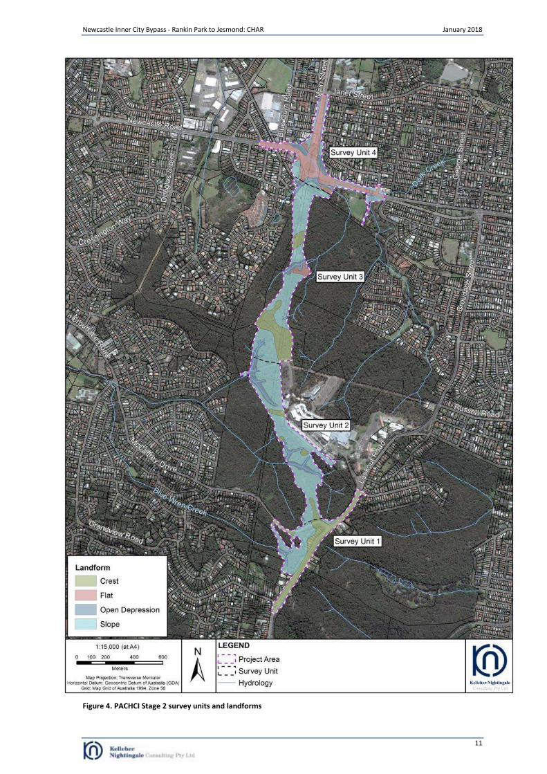
An Aboriginal archaeological survey report (PACHCI Stage 2 survey report) was prepared to inform the Environmental Impact Statement for the project (KNC 2017). The assessment comprised an archaeological survey in addition to a desktop review of previous archaeological investigations and the environmental context. The desktop review included a search of the Aboriginal Heritage Information Management System (AHIMS) and other heritage registers and lists. The AHIMS search identified two grinding groove sites (38-4-0082 and 38-4-0085) which were located approximately 360 metres south east of the project area (within in a nearby section of Blackbutt Reserve that is disconnected from the project); however, no registered Aboriginal archaeological sites or Aboriginal places had been recorded or declared in the project area. No Aboriginal heritage items or places were listed on other heritage registers and lists within or in the vicinity of the project area. The desktop review of previous archaeological investigations demonstrated that the region was utilised for a diverse range of activities by past Aboriginal people. Archaeological sites in the region were predominantly artefact scatters that were spatially more frequent and contained higher densities of stone artefacts in close proximity to marine, estuarine and fresh water resources. Lower density sites occurred along ridges and hillslopes. The location of grinding groove and quarry sites were determined by the local geology. Grinding grooves had been identified in the region on exposed sandstone outcrops bordering creek lines while sources of stone artefact raw material were available at Glenrock approximately three kilometres south east of the current project area. A review of the environmental context of the project area determined that it was located within a landscape with varying levels of natural and human disturbance. The construction of roads, utilities and structures in addition to historic mining, clearance of native vegetation, landscaping and natural process such as erosion had disturbed both subsurface deposits and remove old growth trees. The desktop review determined that while aboriginal objects were unlikely to survive in situ within these contexts ground surface visibility was often increased by these processes, leading to increased identification of surface artefacts in these areas. The survey was undertaken with representatives from the Awabakal Local Aboriginal Land Council and the Awabakal and Guringai People (former Native Title Claimants). The project area was divided for recording purposes into four survey units based on physical features that are shown on Figure 4. The survey closely inspected any areas of surface exposure for artefacts and any mature trees for evidence of Aboriginal bark removal or modification. In addition, bedrock outcropping was inspected for grinding grooves, art and occupation shelters. Surface exposure across the project area was generally low and visibility within surface exposures was high. Surface exposure frequency varied across the project area and was dependant on vegetation density, natural processes such as erosion and modern land use practices. Despite the lack of surface visibility it was still possible to assess the archaeological potential based on landform. The survey identified four new archaeological sites (RP2J AFT 1, RP2J AFT 2, RP2J AFT 3 and RP2J AFT 4) and two potential archaeological deposits (PAD) (RP2J PAD 1 and RP2J PAD 2). Site RP2J AFT 1 was located approximately 10 metres outside the project area while site RP2J AFT 2 was located approximately 24 metres outside the project area.
Newcastle Inner City Bypass - Rankin Park to Jesmond: CHAR January 2018
10
Artefacts identified during the survey included stone flakes, flaked pieces and fragments. Artefacts were made from mudstone/tuff, silcrete and greywacke. Sites RP2J AFT 1 and RP2J AFT 2 were highly disturbed artefact scatters within offsite informal tracks. The surface artefact scatter at site RP2J AFT 1 comprised one silcrete flake and two greywacke flakes that were identified on a gravel track. The surface artefact scatter at site RP2J AFT 2 comprised a tuff medial flake fragment and one silcrete flake that were identified along an eroded track. The sites exhibited low archaeological value as no subsurface deposit was present and the artefacts were found within imported gravels. Site RP2J AFT 3 was a low density artefact scatter located on an elevated flat overlooking the junction of two unnamed north east flowing ephemeral creeks. The surface artefact scatter comprised one tuff/mudstone flake and two pieces of a tuff/mudstone flake which were identified on an informal offroad bicycle (BMX) track. The site exhibited variable levels of disturbance with low to moderate levels of disturbance from the ad hoc construction of the BMX track and associated dirt mounds, while the adjacent areas contained remnant native vegetation and little visible evidence of subsurface disturbance. Site RP2J AFT 4 was a low density artefact scatter situated on the crest and north facing slope of a ridge spur. The surface artefact scatter comprised a single silcrete proximal flake fragment and a cluster of six artefacts comprising flakes and flake fragments of silcrete and tuff/mudstone that were identified within surface exposures on an unsealed track. The site was assessed as having low to moderate archaeological potential due to a mixture of negative factors: erosion, historic disturbance and positive factors: favourable landform, good proximity to resources and identified artefacts. RP2J PAD 1 and RP2J PAD 2 were two areas of PAD situated on the crest of localised highpoint on a north west running ridge that forms the watershed separating the catchments of Ironbark Creek in the south and Dark Creek in the north. The two areas of PAD exhibited archaeologically favourable topography and soils combined with a relative proximity to water and known archaeological sites. The crest displayed low levels of transferential particle movement, with soils cycling (horizontally) in situ. Subsequent to the completion of the PACHCI Stage 2 report a single artefact (heat affected tuff flake) was identified on the crest of RP2J PAD 2. Beyond the identified Aboriginal sites and PADs, the remainder of the project area displayed low archaeological potential due to combinations of archaeologically unfavourable topography, geology, erosion, ephemeral character of the first order waterways or highly modified state of the lower second order waterways, previous fluvial activity or disturbance from land use practices. The PACHCI Stage 2 assessment recommended that if Aboriginal sites/PADs could not be avoided by the proposed works, an archaeological test excavation at these locations was required to obtain further investigation to understand the nature and significance of the Aboriginal cultural heritage resources and how this may be affected by the project.
Newcastle Inner City Bypass - Rankin Park to Jesmond: CHAR January 2018
11
Figure 4. PACHCI Stage 2 survey units and landforms
Newcastle Inner City Bypass - Rankin Park to Jesmond: CHAR January 2018
12
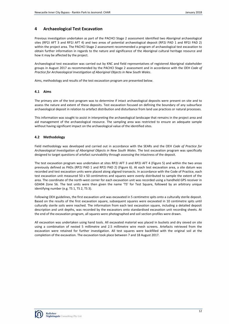
4 Archaeological Test Excavation
Previous investigation undertaken as part of the PACHCI Stage 2 assessment identified two Aboriginal archaeological sites (RP2J AFT 3 and RP2J AFT 4) and two areas of potential archaeological deposit (RP2J PAD 1 and RP2J PAD 2) within the project area. The PACHCI Stage 2 assessment recommended a program of archaeological test excavation to obtain further information in regards to the nature and significance of the Aboriginal cultural heritage resource and how it may be affected by the project. Archaeological test excavation was carried out by KNC and field representatives of registered Aboriginal stakeholder groups in August 2017 as recommended by the PACHCI Stage 2 assessment and in accordance with the OEH Code of Practice for Archaeological Investigation of Aboriginal Objects in New South Wales. Aims, methodology and results of the test excavation program are presented below.
4.1 Aims
The primary aim of the test program was to determine if intact archaeological deposits were present on site and to assess the nature and extent of these deposits. Test excavation focused on defining the boundary of any subsurface archaeological deposit in relation to artefact distribution and disturbance from land use practices or natural processes. This information was sought to assist in interpreting the archaeological landscape that remains in the project area and aid management of the archaeological resource. The sampling area was restricted to ensure an adequate sample without having significant impact on the archaeological value of the identified sites.
4.2 Methodology
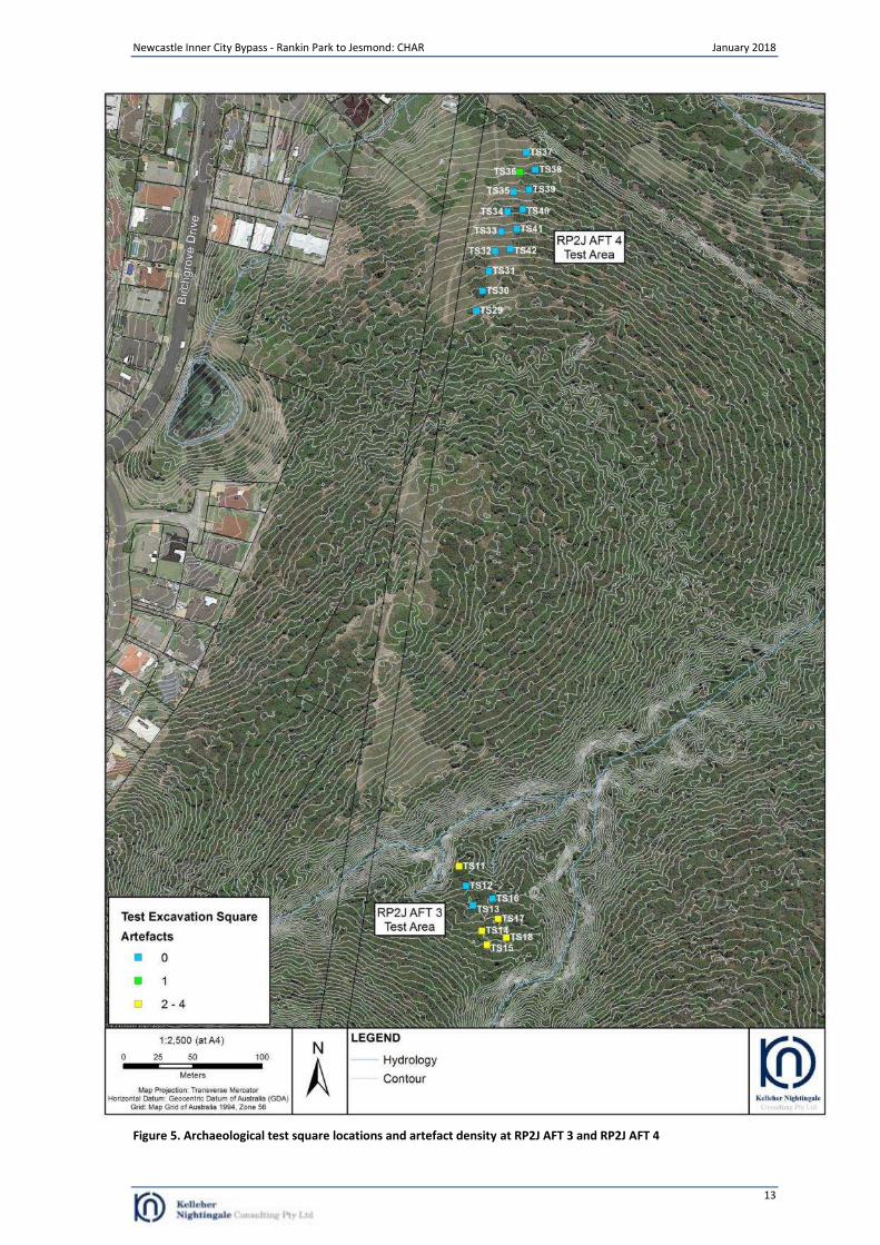
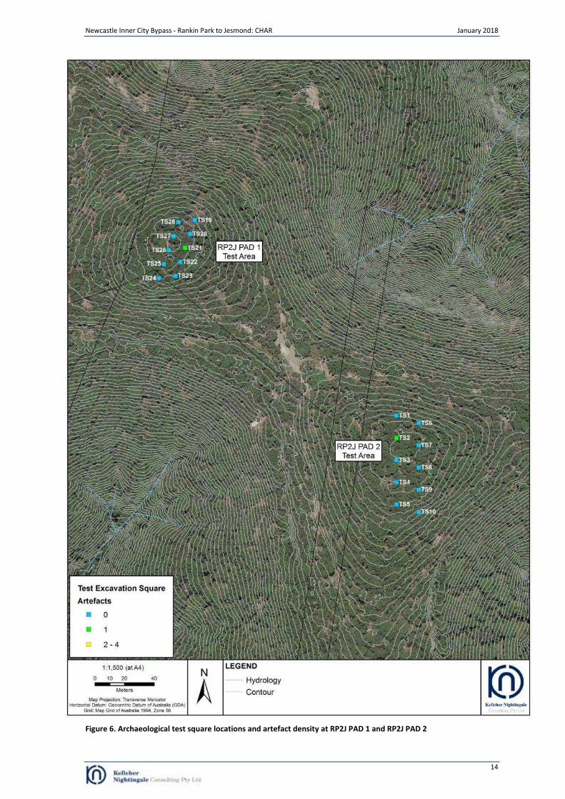
Field methodology was developed and carried out in accordance with the SEARs and the OEH Code of Practice for Archaeological Investigation of Aboriginal Objects in New South Wales. The test excavation program was specifically designed to target questions of artefact survivability through assessing the intactness of the deposit. The test excavation program was undertaken at sites RP2J AFT 3 and RP2J AFT 4 (Figure 5) and within the two areas previously defined as PADs (RP2J PAD 1 and RP2J PAD 2) (Figure 6). At each test excavation area, a site datum was recorded and test excavation units were placed along aligned transects. In accordance with the Code of Practice, each test excavation unit measured 50 x 50 centimetres and squares were evenly distributed to sample the extent of the area. The coordinate of the north-west corner for each excavation unit was recorded using a handheld GPS receiver in GDA94 Zone 56. The test units were then given the name ‘TS’ for Test Square, followed by an arbitrary unique identifying number (e.g. TS 1, TS 2, TS 3). Following OEH guidelines, the first excavation unit was excavated in 5 centimetre spits onto a culturally sterile deposit. Based on the results of the first excavation square, subsequent squares were excavated in 10 centimetre spits until culturally sterile soils were reached. The information from each test excavation square, including a detailed deposit description and unit depths, was recorded by the excavators onto standardised excavation unit recording sheets. At the end of the excavation program, all squares were photographed and soil section profiles were drawn. All excavation was undertaken using hand tools. All excavated material was placed in buckets and dry sieved on site using a combination of nested 5 millimetre and 2.5 millimetre wire mesh screens. Artefacts retrieved from the excavation were retained for further investigation. All test squares were backfilled with the original soil at the completion of the excavation. The excavation took place between 7 and 18 August 2017.
Newcastle Inner City Bypass - Rankin Park to Jesmond: CHAR January 2018
13
Figure 5. Archaeological test square locations and artefact density at RP2J AFT 3 and RP2J AFT 4
Newcastle Inner City Bypass - Rankin Park to Jesmond: CHAR January 2018
14
Figure 6. Archaeological test square locations and artefact density at RP2J PAD 1 and RP2J PAD 2
Newcastle Inner City Bypass - Rankin Park to Jesmond: CHAR January 2018
15
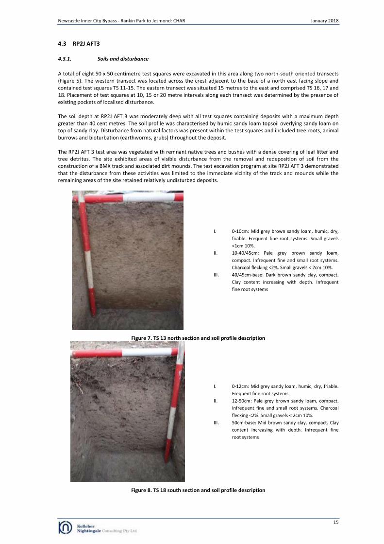
4.3 RP2J AFT3
4.3.1. Soils and disturbance
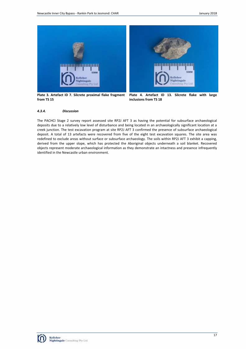
A total of eight 50 x 50 centimetre test squares were excavated in this area along two north-south oriented transects (Figure 5). The western transect was located across the crest adjacent to the base of a north east facing slope and contained test squares TS 11-15. The eastern transect was situated 15 metres to the east and comprised TS 16, 17 and 18. Placement of test squares at 10, 15 or 20 metre intervals along each transect was determined by the presence of existing pockets of localised disturbance. The soil depth at RP2J AFT 3 was moderately deep with all test squares containing deposits with a maximum depth greater than 40 centimetres. The soil profile was characterised by humic sandy loam topsoil overlying sandy loam on top of sandy clay. Disturbance from natural factors was present within the test squares and included tree roots, animal burrows and bioturbation (earthworms, grubs) throughout the deposit. The RP2J AFT 3 test area was vegetated with remnant native trees and bushes with a dense covering of leaf litter and tree detritus. The site exhibited areas of visible disturbance from the removal and redeposition of soil from the construction of a BMX track and associated dirt mounds. The test excavation program at site RP2J AFT 3 demonstrated that the disturbance from these activities was limited to the immediate vicinity of the track and mounds while the remaining areas of the site retained relatively undisturbed deposits.
I. 0-10cm: Mid grey brown sandy loam, humic, dry,
friable. Frequent fine root systems. Small gravels
<1cm 10%.
II. 10-40/45cm: Pale grey brown sandy loam,
compact. Infrequent fine and small root systems.
Charcoal flecking <2%. Small gravels < 2cm 10%.
III. 40/45cm-base: Dark brown sandy clay, compact.
Clay content increasing with depth. Infrequent
fine root systems
Figure 7. TS 13 north section and soil profile description
I. 0-12cm: Mid grey sandy loam, humic, dry, friable.
Frequent fine root systems.
II. 12-50cm: Pale grey brown sandy loam, compact.
Infrequent fine and small root systems. Charcoal
flecking <2%. Small gravels < 2cm 10%.
III. 50cm-base: Mid brown sandy clay, compact. Clay
content increasing with depth. Infrequent fine
root systems
Figure 8. TS 18 south section and soil profile description
Newcastle Inner City Bypass - Rankin Park to Jesmond: CHAR January 2018
16
4.3.2. Artefact distribution
A total of 13 artefacts were recovered from five of the eight test squares excavated at RP2J AFT 3. Artefact densities for the RP2J AFT 3 test squares are shown in Table 2 and Figure 4.
Table 2. Test excavation artefact densities at RP2J AFT 3
Test Square Total Artefacts Test Square Total Artefacts
11 4 17 3
14 2 18 2
15 2
Artefact distribution within the RP2J AFT 3 test excavation area was characterised by a low density deposit in the southern portion of the tested area and a localised low density concentration of heat affected fragments at TS 11. The artefacts were predominantly recovered from the top 10 centimetres of the deposit (n=7); however, artefacts were recovered to a depth of 60 centimetres.
4.3.3. Lithics
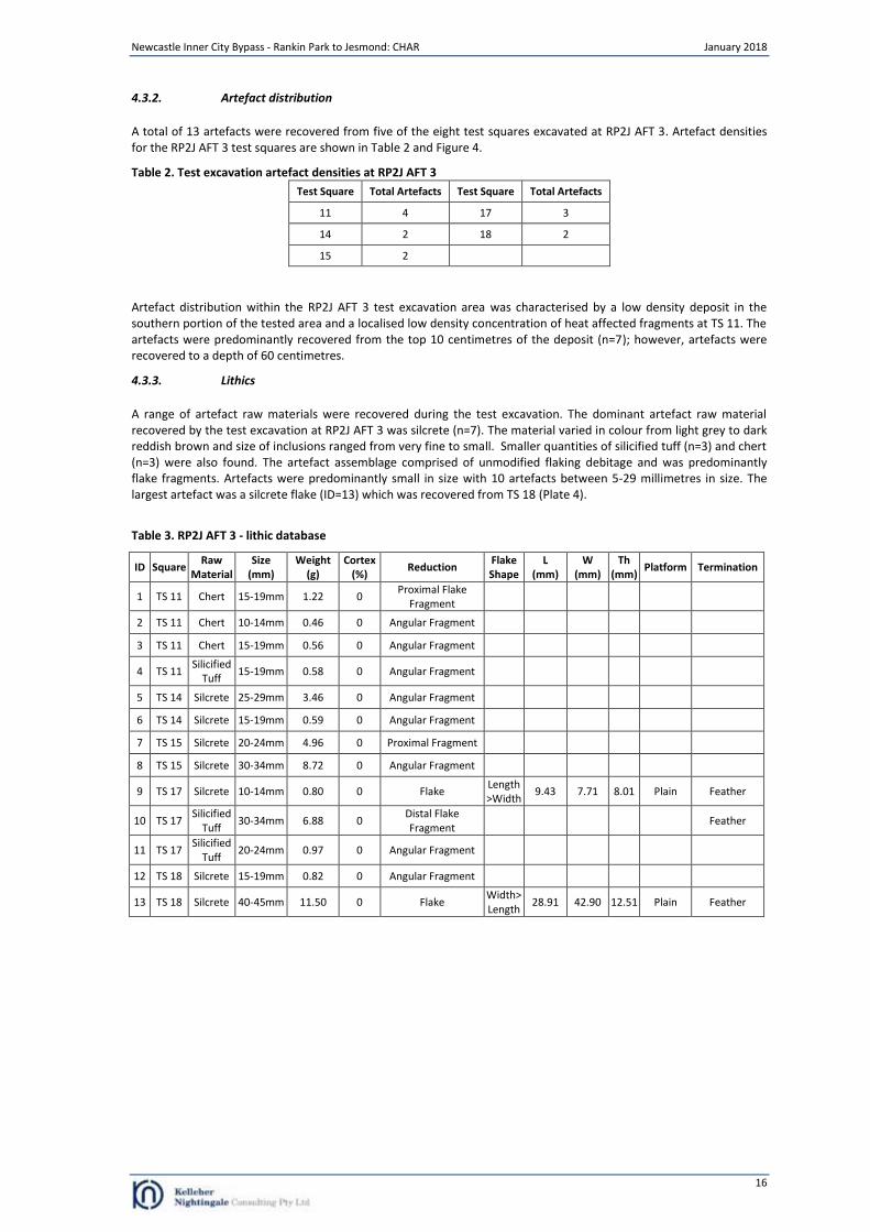
A range of artefact raw materials were recovered during the test excavation. The dominant artefact raw material recovered by the test excavation at RP2J AFT 3 was silcrete (n=7). The material varied in colour from light grey to dark reddish brown and size of inclusions ranged from very fine to small. Smaller quantities of silicified tuff (n=3) and chert (n=3) were also found. The artefact assemblage comprised of unmodified flaking debitage and was predominantly flake fragments. Artefacts were predominantly small in size with 10 artefacts between 5-29 millimetres in size. The largest artefact was a silcrete flake (ID=13) which was recovered from TS 18 (Plate 4).
Table 3. RP2J AFT 3 - lithic database
ID Square Raw
Material Size
(mm) Weight
(g) Cortex
(%) Reduction
Flake Shape
L (mm)
W (mm)
Th (mm)
Platform Termination
1 TS 11 Chert 15-19mm 1.22 0 Proximal Flake
Fragment
2 TS 11 Chert 10-14mm 0.46 0 Angular Fragment
3 TS 11 Chert 15-19mm 0.56 0 Angular Fragment
4 TS 11 Silicified
Tuff 15-19mm 0.58 0 Angular Fragment
5 TS 14 Silcrete 25-29mm 3.46 0 Angular Fragment
6 TS 14 Silcrete 15-19mm 0.59 0 Angular Fragment
7 TS 15 Silcrete 20-24mm 4.96 0 Proximal Fragment
8 TS 15 Silcrete 30-34mm 8.72 0 Angular Fragment
9 TS 17 Silcrete 10-14mm 0.80 0 Flake Length>Width
9.43 7.71 8.01 Plain Feather
10 TS 17 Silicified
Tuff 30-34mm 6.88 0
Distal Flake Fragment Feather
11 TS 17 Silicified
Tuff 20-24mm 0.97 0 Angular Fragment
12 TS 18 Silcrete 15-19mm 0.82 0 Angular Fragment
13 TS 18 Silcrete 40-45mm 11.50 0 Flake Width>Length
28.91 42.90 12.51 Plain Feather
Newcastle Inner City Bypass - Rankin Park to Jesmond: CHAR January 2018
17
Plate 3. Artefact ID 7. Silcrete proximal flake fragment from TS 15
Plate 4. Artefact ID 13. Silcrete flake with large inclusions from TS 18
4.3.4. Discussion
The PACHCI Stage 2 survey report assessed site RP2J AFT 3 as having the potential for subsurface archaeological deposits due to a relatively low level of disturbance and being located in an archaeologically significant location at a creek junction. The test excavation program at site RP2J AFT 3 confirmed the presence of subsurface archaeological deposit. A total of 13 artefacts were recovered from five of the eight test excavation squares. The site area was redefined to exclude areas without surface or subsurface archaeology. The soils within RP2J AFT 3 exhibit a capping, derived from the upper slope, which has protected the Aboriginal objects underneath a soil blanket. Recovered objects represent moderate archaeological information as they demonstrate an intactness and presence infrequently identified in the Newcastle urban environment.
Newcastle Inner City Bypass - Rankin Park to Jesmond: CHAR January 2018
18
4.4 RP2J AFT 4
4.4.1. Soils and disturbance
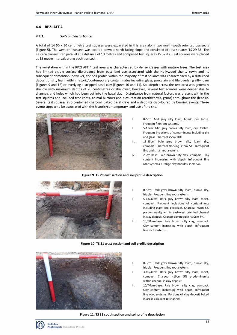
A total of 14 50 x 50 centimetre test squares were excavated in this area along two north-south oriented transects (Figure 5). The western transect was located down a north facing slope and consisted of test squares TS 29-36. The eastern transect ran parallel at a distance of 10 metres and comprised test squares TS 37-42. Test squares were placed at 15 metre intervals along each transect. The vegetation within the RP2J AFT 4 test area was characterised by dense grasses with mature trees. The test area had limited visible surface disturbance from past land use associated with the Hollywood shanty town and its subsequent demolition; however, the soil profile within the majority of test squares was characterised by a disturbed deposit of silty loam within historic/contemporary contaminates including glass, porcelain and tile overlying silty loam (Figures 9 and 12) or overlying a stripped basal clay (Figures 10 and 11). Soil depth across the test area was generally shallow with maximum depths of 20 centimetres or shallower; however, several test squares were deeper due to channels and holes which had been cut into the basal clay. Disturbance from natural factors was present within the test squares and included tree roots, animal burrows and bioturbation (earthworms, grubs) throughout the deposit. Several test squares also contained charcoal, baked basal clays and a deposits discoloured by burning events. These events appear to be associated with the historic/contemporary land use of the site.
I. 0-5cm: Mid grey silty loam, humic, dry, loose.
Frequent fine root systems.
II. 5-15cm: Mid grey brown silty loam, dry, friable.
Frequent inclusions of contaminants including tile
and glass. Charcoal <5cm 10%
III. 15-25cm: Pale grey brown silty loam, dry,
compact. Charcoal flecking <1cm 5%. Infrequent
fine and small root systems.
IV. 25cm-base: Pale brown silty clay, compact. Clay
content increasing with depth. Infrequent fine
root systems. Orange clay nodules <5cm 5%.
Figure 9. TS 29 east section and soil profile description
I. 0-5cm: Dark grey brown silty loam, humic, dry,
friable. Frequent fine root systems.
II. 5-13/30cm: Dark grey brown silty loam, moist,
compact. Frequent inclusions of contaminants
including glass and porcelain. Charcoal <5cm 5%
predominanlty within east-west oriented channel
in clay deposit. Orange clay nodules <10cm 5%.
III. 13/30cm-base: Pale brown silty clay, compact.
Clay content increasing with depth. Infrequent
fine root systems.
Figure 10. TS 31 west section and soil profile description
I. 0-3cm: Dark grey brown silty loam, humic, dry,
friable. Frequent fine root systems.
II. 3-10/40cm: Dark grey brown silty loam, moist,
compact. Charcoal <10cm 5% predominanlty
within channel in clay deposit.
III. 10/40cm-base: Pale brown silty clay, compact.
Clay content increasing with depth. Infrequent
fine root systems. Portions of clay deposit baked
in areas adjacent to channel.
Figure 11. TS 35 south section and soil profile description
Newcastle Inner City Bypass - Rankin Park to Jesmond: CHAR January 2018
19
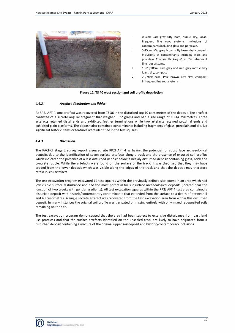
I. 0-5cm: Dark grey silty loam, humic, dry, loose.
Frequent fine root systems. Inclusions of
contaminants including glass and porcelain.
II. 5-15cm: Mid grey brown silty loam, dry, compact.
Inclusions of contaminants including glass and
porcelain. Charcoal flecking <1cm 5%. Infrequent
fine root systems.
III. 15-20/28cm: Pale grey and mid grey mottle silty
loam, dry, compact.
IV. 20/28cm-base: Pale brown silty clay, compact.
Infrequent fine root systems.
Figure 12. TS 40 west section and soil profile description
4.4.2. Artefact distribution and lithics
At RP2J AFT 4, one artefact was recovered from TS 36 in the disturbed top 10 centimetres of the deposit. The artefact consisted of a silcrete angular fragment that weighed 0.22 grams and had a size range of 10-14 millimetres. Three artefacts retained distal ends and exhibited feather terminations while two artefacts retained proximal ends and exhibited plain platforms. The deposit also contained contaminants including fragments of glass, porcelain and tile. No significant historic items or features were identified in the test squares.
4.4.3. Discussion
The PACHCI Stage 2 survey report assessed site RP2J AFT 4 as having the potential for subsurface archaeological deposits due to the identification of seven surface artefacts along a track and the presence of exposed soil profiles which indicated the presence of a less disturbed deposit below a heavily disturbed deposit containing glass, brick and concrete rubble. While the artefacts were found on the surface of the track, it was theorised that they may have eroded from the lower deposit which was visible along the edges of the track and that the deposit may therefore retain in situ artefacts. The test excavation program excavated 14 test squares within the previously defined site extent in an area which had low visible surface disturbance and had the most potential for subsurface archaeological deposits (located near the junction of two creeks with gentler gradients). All test excavation squares within the RP2J AFT 4 test area contained a disturbed deposit with historic/contemporary contaminants that extended from the surface to a depth of between 5 and 40 centimetres. A single silcrete artefact was recovered from the test excavation area from within this disturbed deposit. In many instances the original soil profile was truncated or missing entirely with only mixed redeposited soils remaining on the site. The test excavation program demonstrated that the area had been subject to extensive disturbance from past land use practices and that the surface artefacts identified on the unsealed track are likely to have originated from a disturbed deposit containing a mixture of the original upper soil deposit and historic/contemporary inclusions.
Newcastle Inner City Bypass - Rankin Park to Jesmond: CHAR January 2018
20
4.5 RP2J PAD 1 (RP2J IF 1)
4.5.1. Soils and disturbance
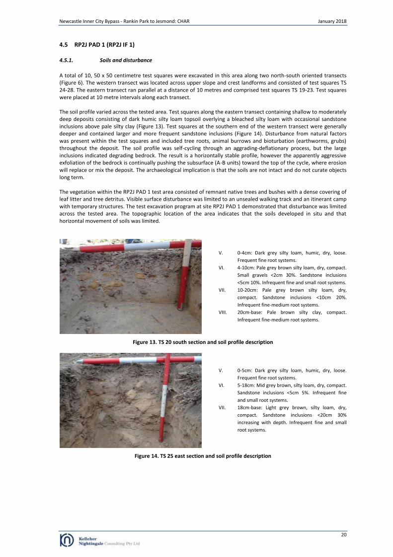
A total of 10, 50 x 50 centimetre test squares were excavated in this area along two north-south oriented transects (Figure 6). The western transect was located across upper slope and crest landforms and consisted of test squares TS 24-28. The eastern transect ran parallel at a distance of 10 metres and comprised test squares TS 19-23. Test squares were placed at 10 metre intervals along each transect. The soil profile varied across the tested area. Test squares along the eastern transect containing shallow to moderately deep deposits consisting of dark humic silty loam topsoil overlying a bleached silty loam with occasional sandstone inclusions above pale silty clay (Figure 13). Test squares at the southern end of the western transect were generally deeper and contained larger and more frequent sandstone inclusions (Figure 14). Disturbance from natural factors was present within the test squares and included tree roots, animal burrows and bioturbation (earthworms, grubs) throughout the deposit. The soil profile was self-cycling through an aggrading-deflationary process, but the large inclusions indicated degrading bedrock. The result is a horizontally stable profile, however the apparently aggressive exfoliation of the bedrock is continually pushing the subsurface (A-B units) toward the top of the cycle, where erosion will replace or mix the deposit. The archaeological implication is that the soils are not intact and do not curate objects long term. The vegetation within the RP2J PAD 1 test area consisted of remnant native trees and bushes with a dense covering of leaf litter and tree detritus. Visible surface disturbance was limited to an unsealed walking track and an itinerant camp with temporary structures. The test excavation program at site RP2J PAD 1 demonstrated that disturbance was limited across the tested area. The topographic location of the area indicates that the soils developed in situ and that horizontal movement of soils was limited.
V. 0-4cm: Dark grey silty loam, humic, dry, loose.
Frequent fine root systems.
VI. 4-10cm: Pale grey brown silty loam, dry, compact.
Small gravels <2cm 30%. Sandstone inclusions
<5cm 10%. Infrequent fine and small root systems.
VII. 10-20cm: Pale grey brown silty loam, dry,
compact. Sandstone inclusions <10cm 20%.
Infrequent fine-medium root systems.
VIII. 20cm-base: Pale brown silty clay, compact.
Infrequent fine-medium root systems.
Figure 13. TS 20 south section and soil profile description
V. 0-5cm: Dark grey silty loam, humic, dry, loose.
Frequent fine root systems.
VI. 5-18cm: Mid grey brown, silty loam, dry, compact.
Sandstone inclusions <5cm 5%. Infrequent fine
and small root systems.
VII. 18cm-base: Light grey brown, silty loam, dry,
compact. Sandstone inclusions <20cm 30%
increasing with depth. Infrequent fine and small
root systems.
Figure 14. TS 25 east section and soil profile description
Newcastle Inner City Bypass - Rankin Park to Jesmond: CHAR January 2018
21
4.5.2. Artefact distribution and lithics
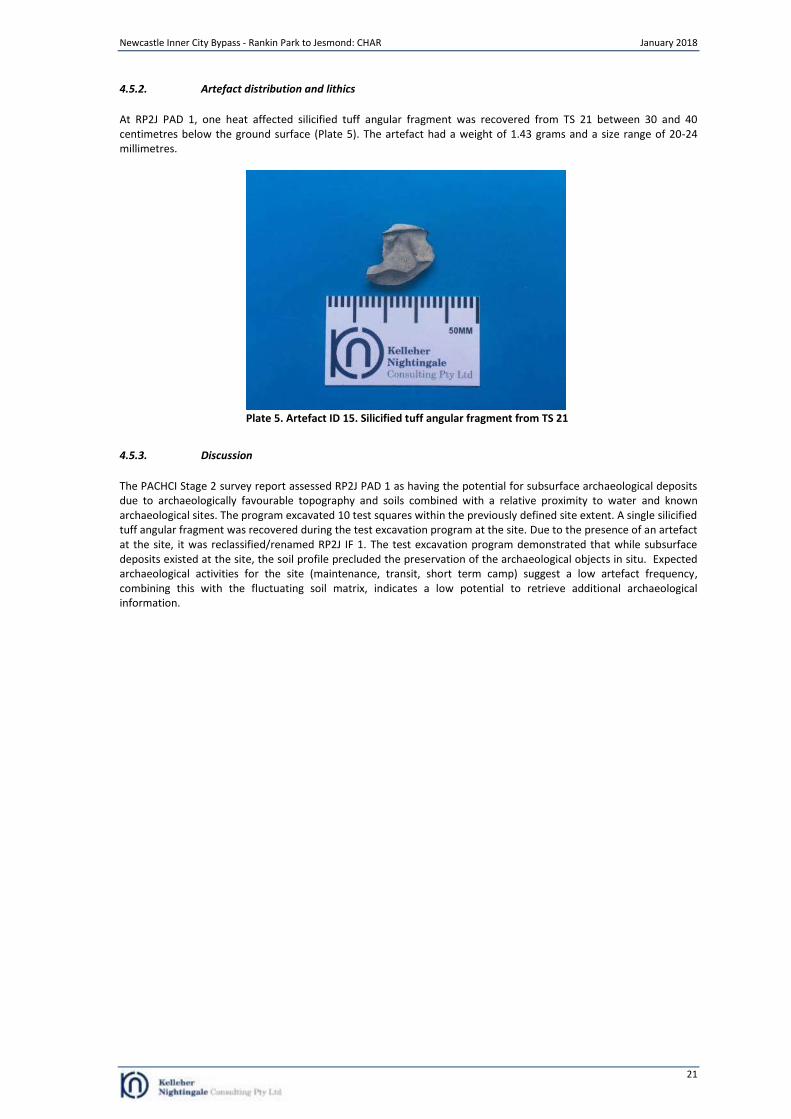
At RP2J PAD 1, one heat affected silicified tuff angular fragment was recovered from TS 21 between 30 and 40 centimetres below the ground surface (Plate 5). The artefact had a weight of 1.43 grams and a size range of 20-24 millimetres.
Plate 5. Artefact ID 15. Silicified tuff angular fragment from TS 21
4.5.3. Discussion
The PACHCI Stage 2 survey report assessed RP2J PAD 1 as having the potential for subsurface archaeological deposits due to archaeologically favourable topography and soils combined with a relative proximity to water and known archaeological sites. The program excavated 10 test squares within the previously defined site extent. A single silicified tuff angular fragment was recovered during the test excavation program at the site. Due to the presence of an artefact at the site, it was reclassified/renamed RP2J IF 1. The test excavation program demonstrated that while subsurface deposits existed at the site, the soil profile precluded the preservation of the archaeological objects in situ. Expected archaeological activities for the site (maintenance, transit, short term camp) suggest a low artefact frequency, combining this with the fluctuating soil matrix, indicates a low potential to retrieve additional archaeological information.
Newcastle Inner City Bypass - Rankin Park to Jesmond: CHAR January 2018
22
4.6 RP2J PAD 2 (RP2J IF 2)
4.6.1. Soils and disturbance
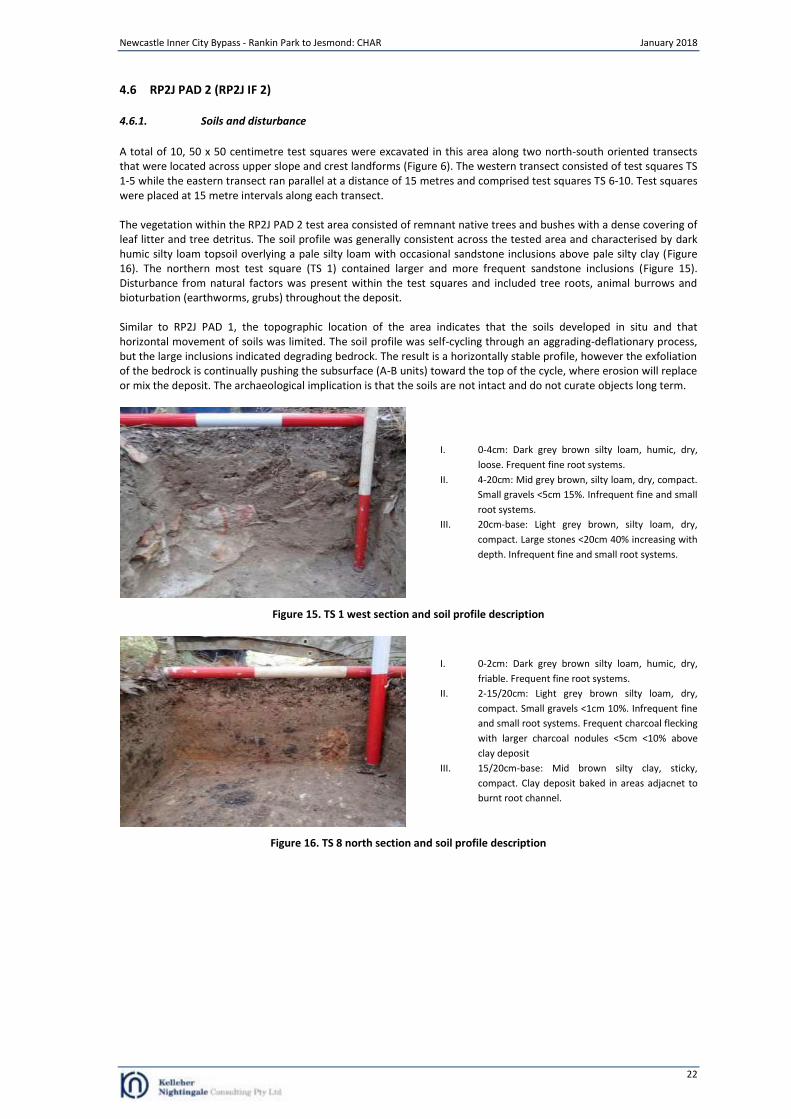
A total of 10, 50 x 50 centimetre test squares were excavated in this area along two north-south oriented transects that were located across upper slope and crest landforms (Figure 6). The western transect consisted of test squares TS 1-5 while the eastern transect ran parallel at a distance of 15 metres and comprised test squares TS 6-10. Test squares were placed at 15 metre intervals along each transect. The vegetation within the RP2J PAD 2 test area consisted of remnant native trees and bushes with a dense covering of leaf litter and tree detritus. The soil profile was generally consistent across the tested area and characterised by dark humic silty loam topsoil overlying a pale silty loam with occasional sandstone inclusions above pale silty clay (Figure 16). The northern most test square (TS 1) contained larger and more frequent sandstone inclusions (Figure 15). Disturbance from natural factors was present within the test squares and included tree roots, animal burrows and bioturbation (earthworms, grubs) throughout the deposit. Similar to RP2J PAD 1, the topographic location of the area indicates that the soils developed in situ and that horizontal movement of soils was limited. The soil profile was self-cycling through an aggrading-deflationary process, but the large inclusions indicated degrading bedrock. The result is a horizontally stable profile, however the exfoliation of the bedrock is continually pushing the subsurface (A-B units) toward the top of the cycle, where erosion will replace or mix the deposit. The archaeological implication is that the soils are not intact and do not curate objects long term.
I. 0-4cm: Dark grey brown silty loam, humic, dry,
loose. Frequent fine root systems.
II. 4-20cm: Mid grey brown, silty loam, dry, compact.
Small gravels <5cm 15%. Infrequent fine and small
root systems.
III. 20cm-base: Light grey brown, silty loam, dry,
compact. Large stones <20cm 40% increasing with
depth. Infrequent fine and small root systems.
Figure 15. TS 1 west section and soil profile description
I. 0-2cm: Dark grey brown silty loam, humic, dry,
friable. Frequent fine root systems.
II. 2-15/20cm: Light grey brown silty loam, dry,
compact. Small gravels <1cm 10%. Infrequent fine
and small root systems. Frequent charcoal flecking
with larger charcoal nodules <5cm <10% above
clay deposit
III. 15/20cm-base: Mid brown silty clay, sticky,
compact. Clay deposit baked in areas adjacnet to
burnt root channel.
Figure 16. TS 8 north section and soil profile description
Newcastle Inner City Bypass - Rankin Park to Jesmond: CHAR January 2018
23
4.6.2. Artefact distribution and lithics
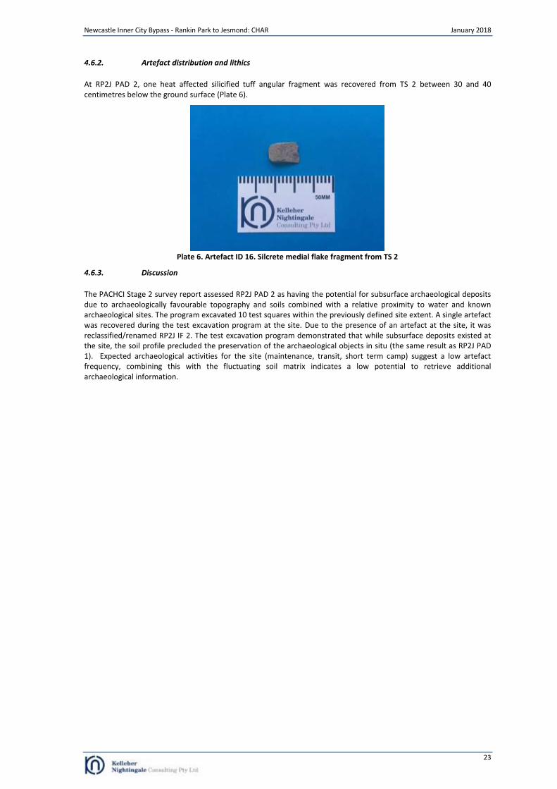
At RP2J PAD 2, one heat affected silicified tuff angular fragment was recovered from TS 2 between 30 and 40 centimetres below the ground surface (Plate 6).
Plate 6. Artefact ID 16. Silcrete medial flake fragment from TS 2
4.6.3. Discussion
The PACHCI Stage 2 survey report assessed RP2J PAD 2 as having the potential for subsurface archaeological deposits due to archaeologically favourable topography and soils combined with a relative proximity to water and known archaeological sites. The program excavated 10 test squares within the previously defined site extent. A single artefact was recovered during the test excavation program at the site. Due to the presence of an artefact at the site, it was reclassified/renamed RP2J IF 2. The test excavation program demonstrated that while subsurface deposits existed at the site, the soil profile precluded the preservation of the archaeological objects in situ (the same result as RP2J PAD 1). Expected archaeological activities for the site (maintenance, transit, short term camp) suggest a low artefact frequency, combining this with the fluctuating soil matrix indicates a low potential to retrieve additional archaeological information.
Newcastle Inner City Bypass - Rankin Park to Jesmond: CHAR January 2018
24
5 Aboriginal Community Consultation and Participation
5.1 Aboriginal stakeholder consultation
Roads and Maritime is committed to effective consultation with Aboriginal communities regarding Roads and Maritime activities and their potential for impact on Aboriginal cultural heritage. The Roads and Maritime PACHCI was developed to provide a consistent means of effective consultation with Aboriginal communities regarding activities which may impact on Aboriginal cultural heritage and a consistent assessment process for Roads and Maritime activities across NSW. The aim of consultation is to integrate cultural and archaeological knowledge and ensure registered stakeholders have information to make decisions on Aboriginal cultural heritage. For the preparation of this CHAR, consultation with Aboriginal people has been undertaken in accordance with the project SEARs, the OEH Aboriginal Cultural Heritage Consultation Requirements for Proponents 2010 (OEH 2010a) and the requirements of Clause 80C of the National Parks and Wildlife Regulation 2009. Roads and Maritime advertised (Appendix A) and contacted potential Aboriginal stakeholders identified from government agency notification responses. Roads and Maritime invited Aboriginal people who hold knowledge relevant to determining the cultural heritage significance of Aboriginal objects and Aboriginal places in the area in which the proposed activity was to occur to register an interest in a process of community consultation. Investigations for the Newcastle Inner City Bypass between Rankin Park and Jesmond have included consultation with 17 Aboriginal community groups and individuals as listed in Table 4.
Table 4. Registered Aboriginal stakeholders
Group Representative / Contact
A1 Indigenous Services Carolyn Hickey
Aboriginal and Native Title Corporation (Valley ELM Corp) Irene Ardler
Amanda Hickey Cultural Services Amanda Hickey
Awabakal Descendants Traditional Owners Peter Leven
Awabakal Local Aboriginal Land Council Rob Russell (CEO)
Awabakal Traditional Owners Aboriginal Corporation Kerrie Brauer
Didge Ngunawal Clan Paul Boyd & Lilly Carroll
Hunter Valley Cultural Surveying Luke Hickey
Kerrie Brauer & Ors on behalf of the Awabakal and Guringai People (Awabakal and Guringai People)
Kerrie Brauer
Kevin Duncan Kevin Duncan
Lower Hunter Aboriginal Incorporated David Ahoy
Murra Bidgee Mullangari Aboriginal Corporation Cultural Heritage Darleen Johnson (Carroll)
Wattaka Wonnarua Cultural Consultancy Services Des Hickey
Widescope Indigenous Group Steven Hickey
Wonn1(Entity of Kauwul Pty Ltd) Suzie Worth (for Arthur C Fletcher)
Wonnarua Elder LHWCS Tom Miller
Yinarr Cultural Services Kathie Steward Kinchela
The formal consultation process has included:
advertising for registered stakeholders in The Koori Mail (3/05/2017), National Indigenous Times (3/05/2017) and Newcastle Herald (3/05/2017) (refer Appendix A);
government agency notification letters;
notification of closing date for registration;
an Aboriginal Focus Group (AFG) meeting to discuss archaeological assessment methodology and cultural assessment (refer Appendix B);
provision of proposed archaeological assessment methodology (28 day review period) outlining the methodology to prepare the CHAR;
provision of draft CHAR for review (allowing a minimum 28 day review);
a second AFG meeting to discuss investigation results, draft CHAR and detailed mitigation strategies (refer Appendix B);
ongoing consultation with the local Aboriginal community.
Newcastle Inner City Bypass - Rankin Park to Jesmond: CHAR January 2018
25
5.2 PACHCI Stage 2: Survey and cultural assessment report
Subsequent to the field survey, Awabakal Local Aboriginal Land Council provided a survey and cultural assessment report for the Roads and Maritime in accordance with the PACHCI. The comments were incorporated into the assessment and included in the PACHCI Stage 2 survey report. Specific Awabakal Local Aboriginal Land Council comments stated that the identified archaeological sites were of “extremely high significance”:
Reason being, there has evidently been a lot of different disturbances in the study area but Artefacts are still present. We strongly believe all Artefacts & sites are of extremely high significance to the Aboriginal community.
The identified PAD areas were also culturally significant:
PAD’s are very significant cultural landscape features as well as places of spiritual and social value. and
Given the location of PAD areas with 360 degree views, it is highly likely that this area was used quite frequently by Aboriginal people for the purpose of regular stays/camping as well as being a regular travel route.
5.3 Aboriginal cultural values
As part of the cultural assessment, registered Aboriginal stakeholders were invited to identify individuals they regarded as knowledge holders for the area. To date no specific knowledge holders have been identified for the study area although the Aboriginal community has identified cultural heritage values for the study area (see CHAR review).
5.4 CHAR review
The draft CHAR was provided to registered Aboriginal stakeholders for review and comment. All registered Aboriginal stakeholders were provided a minimum 28 day period for review. Comments and information received from stakeholders during this period are attached in full in Appendix C and summarised below. Responses to the draft CHAR and proposed salvage excavation methodology were received from Awabakal Local Aboriginal Land Council, Awabakal Traditional Owners Aboriginal Corporation (Awabakal and Guringai Pty Ltd), Lower Hunter Aboriginal Incorporated, Wonnarua Elders LHWCS and Murra Bidgee Mullangari Aboriginal Corporation Cultural Heritage. Awabakal Local Aboriginal Land Council (email received 26/10/2017) expressed the necessity for Aboriginal stakeholders who have cultural knowledge relevant to determining the significance of Aboriginal objects and/or places as relevant to the proposed project area involved in the consultation process. In this regard, the registration of and consultation with Aboriginal people for the Rankin Park to Jesmond project has been undertaken in accordance with the SEARs, Roads and Maritime PACHCI, the OEH Aboriginal Cultural Heritage Consultation Requirements for Proponents 2010 and the requirements of Clause 80C of the National Parks and Wildlife Regulation 2009. The Awabakal Local Aboriginal Land Council participated in the PACHCI Stage 2 survey and provided comments on the significance of the Aboriginal archaeological sites identified within the project area as part of that process (see Section 5.2). No further information on the significance of Aboriginal objects and/or places as relevant to the proposed project area was provided in the CHAR review email received 26/10/2017. Awabakal Traditional Owners Aboriginal Corporation (letter dated 30/10/2017) noted the importance of cultural knowledge and connection to Country. In this regard, the registration of and consultation with Aboriginal people for the Rankin Park to Jesmond project has been undertaken in accordance with the SEARs, Roads and Maritime PACHCI, the OEH Aboriginal Cultural Heritage Consultation Requirements for Proponents 2010 and the requirements of Clause 80C of the National Parks and Wildlife Regulation 2009. Awabakal Traditional Owners Aboriginal Corporation expressed the need for significance assessments to include cultural values (and not just archaeological values). Awabakal Traditional Owners Aboriginal Corporation identified the cultural value and significance of the project area as high and holistic (letter dated 30/10/2017). Awabakal Traditional Owners Aboriginal Corporation stated that they “cannot separate sections of the project area to be more important than others; each site is connected to the other” (letter dated 30/10/2017). In response, comments provided by the Awabakal Traditional Owners Aboriginal Corporation regarding cultural (social) values of Aboriginal cultural and archaeological sites have been included in the CHAR (section 7). Awabakal Traditional Owners Aboriginal Corporation recommended that the collection of surface artefacts identified during the survey within the project area in addition to a collection of any visible surface artefacts within the project area should be undertaken (letter dated 30/10/2017). Following these comments, the CHAR was revised to
Newcastle Inner City Bypass - Rankin Park to Jesmond: CHAR January 2018
26
recommend salvage surface collection of Aboriginal cultural heritage objects at all sites (RP2J AFT 3, RP2J AFT 4, RP2J IF 1 and RP2J IF 2) in addition to the recommendation of salvage excavation for RP2J AFT 3. Awabakal Traditional Owners Aboriginal Corporation stated that salvage and collection of cultural heritage “is paramount, and needs to be included within the Project Approval by the Department of Planning” (letter dated 30/10/2017). Awabakal Traditional Owners Aboriginal Corporation stated their preference for salvaged Aboriginal objects to remain on country in a protected conservation area (letter dated 30/10/2017). In keeping with these comments Section 10 of the CHAR was revised and outlines a process to allow Aboriginal stakeholder to make an application for the care of recovered Aboriginal cultural objects. Awabakal Traditional Owners Aboriginal Corporation also commented on a range of management outcomes related to planning and impact assessments. Following these comments, Section 10 of the CHAR was updated to refine the recommended management process and clarify the impact assessment process. Lower Hunter Aboriginal Incorporated (email received 26/10/2017) stated that they approve the draft CHAR report. Wonnarua Elders LHWCS (email 29/9/2017) stated that all four archaeological sites are significant, regardless of disturbance levels, and all four sites should be salvaged. Following these comments, the CHAR was revised to recommend salvage collection of Aboriginal cultural heritage objects at all sites (RP2J AFT 3, RP2J AFT 4, RP2J IF 1 and RP2J IF 2) in addition to the recommendation of salvage excavation for RP2J AFT 3 Murra Bidgee Mullangari Aboriginal Corporation Cultural Heritage (letter dated 27/09/2017) expressed the need for registered Aboriginal parties to hold relevant cultural knowledge and to have the experience to determine the significance of Aboriginal objects and/or place(s) within the proposed project area. In this regard, the registration of and consultation with Aboriginal people for the Rankin Park to Jesmond project has been undertaken in accordance with the SEARs, Roads and Maritime PACHCI, the OEH Aboriginal Cultural Heritage Consultation Requirements for Proponents 2010 and the requirements of Clause 80C of the National Parks and Wildlife Regulation 2009.
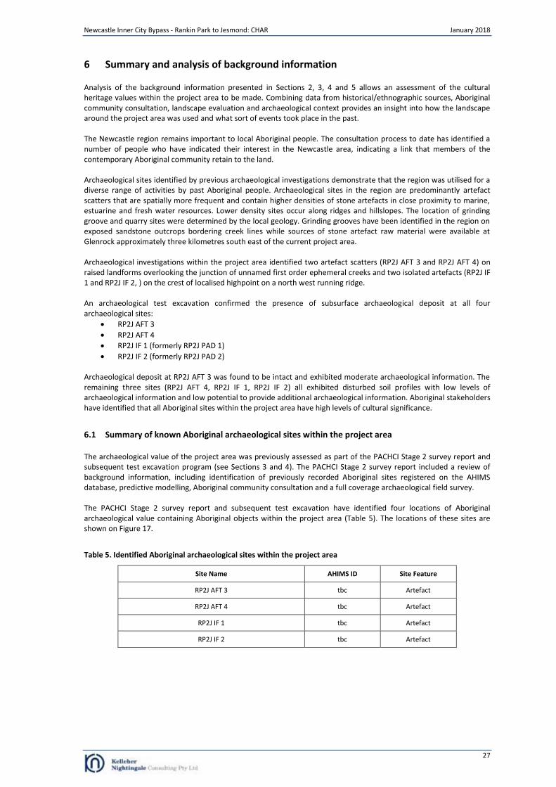
Newcastle Inner City Bypass - Rankin Park to Jesmond: CHAR January 2018
27
6 Summary and analysis of background information
Analysis of the background information presented in Sections 2, 3, 4 and 5 allows an assessment of the cultural heritage values within the project area to be made. Combining data from historical/ethnographic sources, Aboriginal community consultation, landscape evaluation and archaeological context provides an insight into how the landscape around the project area was used and what sort of events took place in the past. The Newcastle region remains important to local Aboriginal people. The consultation process to date has identified a number of people who have indicated their interest in the Newcastle area, indicating a link that members of the contemporary Aboriginal community retain to the land. Archaeological sites identified by previous archaeological investigations demonstrate that the region was utilised for a diverse range of activities by past Aboriginal people. Archaeological sites in the region are predominantly artefact scatters that are spatially more frequent and contain higher densities of stone artefacts in close proximity to marine, estuarine and fresh water resources. Lower density sites occur along ridges and hillslopes. The location of grinding groove and quarry sites were determined by the local geology. Grinding grooves have been identified in the region on exposed sandstone outcrops bordering creek lines while sources of stone artefact raw material were available at Glenrock approximately three kilometres south east of the current project area. Archaeological investigations within the project area identified two artefact scatters (RP2J AFT 3 and RP2J AFT 4) on raised landforms overlooking the junction of unnamed first order ephemeral creeks and two isolated artefacts (RP2J IF 1 and RP2J IF 2, ) on the crest of localised highpoint on a north west running ridge. An archaeological test excavation confirmed the presence of subsurface archaeological deposit at all four archaeological sites:
RP2J AFT 3
RP2J AFT 4
RP2J IF 1 (formerly RP2J PAD 1)
RP2J IF 2 (formerly RP2J PAD 2) Archaeological deposit at RP2J AFT 3 was found to be intact and exhibited moderate archaeological information. The remaining three sites (RP2J AFT 4, RP2J IF 1, RP2J IF 2) all exhibited disturbed soil profiles with low levels of archaeological information and low potential to provide additional archaeological information. Aboriginal stakeholders have identified that all Aboriginal sites within the project area have high levels of cultural significance.
6.1 Summary of known Aboriginal archaeological sites within the project area
The archaeological value of the project area was previously assessed as part of the PACHCI Stage 2 survey report and subsequent test excavation program (see Sections 3 and 4). The PACHCI Stage 2 survey report included a review of background information, including identification of previously recorded Aboriginal sites registered on the AHIMS database, predictive modelling, Aboriginal community consultation and a full coverage archaeological field survey. The PACHCI Stage 2 survey report and subsequent test excavation have identified four locations of Aboriginal archaeological value containing Aboriginal objects within the project area (Table 5). The locations of these sites are shown on Figure 17.
Table 5. Identified Aboriginal archaeological sites within the project area
Site Name AHIMS ID Site Feature
RP2J AFT 3 tbc Artefact
RP2J AFT 4 tbc Artefact
RP2J IF 1 tbc Artefact
RP2J IF 2 tbc Artefact

Newcastle Inner City Bypass - Rankin Park to Jesmond: CHAR January 2018
28
6.2 Aboriginal archaeological sites within the project area
Site name: RP2J AFT 3 AHIMS site ID: tbc Site RP2J AFT 3 was an artefact scatter situated on an elevated flat overlooking the junction of two unnamed north east flowing ephemeral creeks. The site was located in the south western portion of Lot 1 DP774078 approximately 300 metres south east of Minimbah Close. The PACHCI Stage 2 survey identified a surface artefact scatter at the site that comprised one tuff/mudstone flake and two pieces of a tuff/mudstone flake which were located on a BMX track. An archaeological test excavation was undertaken at the site by KNC in August 2017. The program excavated eight test squares within the previously defined site extent. A total of 13 artefacts were recovered from five of the eight test excavation squares. The test excavation program demonstrated that an intact archaeological deposit was present at the site within the proposed impact area. Site name: RP2J AFT 4 AHIMS site ID: tbc Site RP2J AFT 4 was an artefact scatter located on the crest and north facing slope of a ridge spur. The site overlooks the junction of Dark Creek and several unnamed tributaries approximately 120 metres to the north. The site is located approximately 120 metres south east of the junction of Victory Parade and Myall Street within Lot 1 DP341979 and Lot 1 DP774078. The PACHCI Stage 2 survey identified a surface artefact scatter at the site which comprised a single silcrete proximal flake fragment and a cluster of six artefacts comprising flakes and flake fragments of silcrete and tuff/mudstone that were identified within surface exposures on an unsealed track. An archaeological test excavation was undertaken at the site by KNC in August 2017. The program excavated 14 test squares within the previously defined site extent in an area which had low visible surface disturbance and had the most potential for subsurface archaeological deposits (located near the junction of two creeks and gentler gradients). All test excavation squares within the RP2J AFT 4 test area contained a disturbed deposit. Site soils were deeply truncated, completely stripped and or redeposited and sometimes mixed with non-significant historic fill. A single artefact was recovered from the test excavation area from within the disturbed deposit. The test excavation program demonstrated that the area had been subject to extensive disturbance from past land use practices and that the surface artefacts identified on the unsealed track are likely to have originated from a disturbed deposit containing a mixture of the original upper soil deposit and historic/contemporary disturbance. Site name: RP2J IF 1 (formerly RP2J PAD 1) AHIMS site ID: tbc Site RP2J IF 1 was an isolated artefact situated on the crest of localised highpoint on a north west running ridge that formed the watershed separating the catchments of Blue Wren Creek in the south and Dark Creek in the north. The site was located within remnant native vegetation approximately 240 metres east of Claymore Drive within Lot 10 DP826092. The site was initially identified as an area of archaeological potential (RP2J PAD 1) during the PACHCI Stage 2 survey. The extent of the PAD area was clearly defined by the contours of the natural crest and fire trails to the east and steep slopes to the north, south and west. An archaeological test excavation was undertaken by KNC in August 2017. The program excavated 10 test squares within the previously defined PAD extent. A single artefact was recovered during the test excavation program at the site. The test excavation program demonstrated that while subsurface deposits exist at the site, the low density of artefacts recovered and fluctuating soil profile indicated a low potential for further archaeological information. Site name: RP2J IF 2 (formerly RP2J PAD 2) AHIMS site ID: tbc Site RP2J IF 2 was an isolated artefact situated on the crest of localised highpoint on a north west running ridge which formed the watershed separating the catchments of Blue Wren Creek in the south and Dark Creek in the north. The site was located within an area of remnant native vegetation approximately 460 metres east of Claymore Drive within Lot 401 DP1197237. The site was initially identified as an area of archaeological potential (RP2J PAD 2) during the PACHCI Stage 2 survey. The extent of the PAD area was clearly defined by the contours of the natural crest and fire trails to the south and west and steep slopes to the north and east. An archaeological test excavation was undertaken by KNC in August 2017. The program excavated 10 test squares within the previously defined PAD extent. A single artefact was recovered during the test excavation program at the site. The test excavation program demonstrated that while subsurface deposits exist at the site, the low density of artefacts recovered and fluctuating soil profile indicated a low potential for further archaeological information.
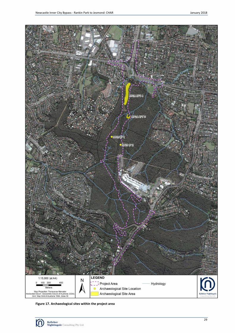
Newcastle Inner City Bypass - Rankin Park to Jesmond: CHAR January 2018
29
Figure 17. Archaeological sites within the project area
Newcastle Inner City Bypass - Rankin Park to Jesmond: CHAR January 2018
30
7 Cultural Heritage Values and Statement of Significance
7.1 Significance assessment criteria
One of the primary steps in the process of cultural heritage management is the assessment of significance. Not all sites are equally significant and not all are worthy of equal consideration and management (Sullivan and Bowdler 1984; Pearson and Sullivan 1995:7). The determination of significance can be a difficult process as the social and scientific context within which these decisions are made is subject to change (Sullivan and Bowdler 1984). This does not lessen the value of the heritage approach, but enriches both the process and the long term outcomes for future generations as the nature of what is conserved and why, also changes over time. The assessment of significance is a key step in the process of impact assessment for a proposed activity as the significance or value of an object, site or place will be reflected in resultant recommendations for conservation, management or mitigation. The Code of Practice for Archaeological Investigation of Aboriginal Objects in New South Wales (DECCW 2010) requires significance assessment according to criteria established in the Australia ICOMOS Burra Charter, 1999 (Australia ICOMOS 1999). The Burra Charter and its accompanying guidelines are considered best practice standard for cultural heritage management, specifically conservation, in Australia. Guidelines to the Burra Charter set out four criteria for the assessment of cultural significance:
Aesthetic value - relates to the sense of the beauty of a place, object, site or item;
Historic value - relates to the association of a place, object, site or item with historical events, people, activities or periods;
Scientific value - scientific (or research) value relates to the importance of the data available for a place, object, site or item, based on its rarity, quality or representativeness, as well as on the degree to which the place (object, site or item) may contribute further substantial information; and
Social value - relates to the qualities for which a place, object, site or item has become a focus of spiritual, political, national or other cultural sentiment to a group of people. In accordance with the OEH Guide to investigating, assessing and reporting on Aboriginal cultural heritage in NSW, the social or cultural value of a place (object, site or item) may be related to spiritual, traditional, historical or contemporary associations. “Social or cultural value can only be identified though consultation with Aboriginal people” (OEH 2011:8).
There are four locations of recorded Aboriginal cultural heritage values within the project area. The significance assessment for the identified archaeological sites has focussed on the social/cultural, historic, scientific and aesthetic significance of Aboriginal heritage values as identified in The Burra Charter. Social Values This area of assessment concerns the value/s of a place, feature or site to a particular community group, in this case the local Aboriginal community. Aspects of social significance are relevant to sites, objects and landscapes that are important or have become important to the local Aboriginal community. This importance involves both traditional links with specific areas as well as an overall concern by Aboriginal people for sites generally and their continued protection. Aboriginal cultural significance may include social, spiritual, historic and archaeological values. It has been identified during the consultation process that the local area has cultural heritage value (social value) to the local Aboriginal community. Awabakal Traditional Owners Aboriginal Corporation (letter dated 30/10/2017) noted that:
This area, as well as all of the rest of our Traditional Country, is of great significance and important to us as Awabakal, as it has been part of the greater area that has provided for and shaped the beliefs and cultural practices of our People for thousands of years. All of these areas have and still play a major role in the lives of our People for many and varied reasons that draw us to focus on what it is to be an Awabakal and Guringai people. This area has not just a physical presence within the Cultural Heritage of the Awabakal and Guringai People, but it is part of our oral history and a place of spiritual significance. The landforms and resources of this locale fulfilled not just the basic needs that underpinned our Peoples subsistence but also satisfied the many other aspects that made up what can be described here as being part of the Cultural foundations of our People. As already previously stated, this area is of high significance to our People and therefore it would be expected that after the many generations of our People that have walked the pathways of their Ancestors, it
Newcastle Inner City Bypass - Rankin Park to Jesmond: CHAR January 2018
31
is obvious that there would be many areas that contain evidence of this connection, resulting from occupation on varying levels. There are physical reminders left by our Ancestors which provide us as Descendants of the Awabakal and Guringai Peoples an opportunity to make a physical connection through time with our Ancestors. This connection is one of those avenues that produce in us the sense of perception, appreciation, familiarity and recognition of who we are and where we belong as Awabakal Guringai People, which is our birthright. Therefore the Cultural Value and Significance remains high, which is attributed to our Cultural Heritage understanding of the connectivity and aspects of the regions holistic perspectives, thus emphasizing the importance of the whole, instead of a Scientific/Archaeological Value aspect of the independence of its site specific parts.
Historic Values Historical research did not identify any information regarding specific historical significance of identified Aboriginal archaeological sites within the project area. No specific historical significance or continued use for the sites within the project area has been provided by the registered Aboriginal stakeholders to date. Scientific Values Scientific values have been assessed for the identified Aboriginal archaeological sites in the project area. These values have been developed based on significance criteria of research potential (including integrity/condition, complexity and archaeological potential), representativeness and rarity. Identified archaeological sites in the project area displayed both low and moderate scientific significance (Refer to Section 7.2). Sites of low archaeological significance are those that do not offer archaeological research potential and are unlikely to provide any further scientifically valuable information. Sites with moderate significance are those that offer the potential to yield information that will contribute to the growing holistic understanding of the Aboriginal cultural landscape of the project area. Archaeological investigation of moderately significant sites will contribute knowledge regarding site type interrelationships, cultural use of landscape features and occupation patterns. Aesthetic Values Aesthetic values are often closely related to the social values of a site or broader cultural landscape. Aspects may include scenic sights, smells and sounds, architectural fabric and creative aspects of a place. Regarding Aboriginal sites identified within the project area, no specific associated aesthetic values have been identified by registered Aboriginal community groups to date. Archaeologically, the project area does not contain these values.
Newcastle Inner City Bypass - Rankin Park to Jesmond: CHAR January 2018
32
7.2 Statement of significance
The project area contains four identified Aboriginal archaeological sites as defined under the National Parks and Wildlife Act 1974. Significance assessment has focussed on the intactness, representativeness and research potential of these sites within the landscape. RP2J AFT 3 Site RP2J AFT 3 represents a commonly occurring site type, consisting of an open artefact scatter of low density; however, the site itself is important as few recorded Aboriginal sites exist in the immediate urban area. In addition, the site displayed a relatively low level of disturbance and is located in an archaeologically significant location on raised landforms at a creek junction. The site demonstrates moderate scientific value and it is likely that further investigation could contribute to our understanding of past Aboriginal landscape use within the now urbanised area. Based on the intactness, representativeness, and research potential of the site, RP2J AFT 3 is assessed as displaying moderate archaeological significance. The cultural significance of site RP2J AFT 3, as part of the holistic and interconnected landscape has been assessed as displaying high cultural significance by Aboriginal stakeholders. RP2J AFT 4 Site RP2J AFT 4 represents a commonly occurring site type, consisting of an open artefact scatter of low density. The artefacts at the site are typical of the region in terms of type and raw material. The site has been subject to extensive disturbance from historic/contemporary land use practices and environmental factors. Artefacts identified at this site form part of a disturbed deposit. Low to nil potential exists at the site for intact deposit. The site demonstrates low scientific value and it is unlikely that further investigation could contribute to our understanding of Aboriginal landscape use in the region. Based on the intactness, representativeness and research potential of the site, RP2J AFT 4 is determined to have low archaeological significance. The cultural significance of site RP2J AFT 4, as part of the holistic and interconnected landscape has been assessed as displaying high cultural significance by Aboriginal stakeholders. RP2J IF 1 Site RP2J IF 1 represents a commonly occurring site type, consisting of an isolated artefact on a crest landform of a north west running ridge. The artefact at the site is typical of the region in terms of type and raw material. While the test excavation program demonstrated that the site retained subsurface archaeological deposit, the very low density of artefacts recovered at the site and fluctuating soil matrix make it unlikely that further investigation of the site would contribute to our understanding of Aboriginal landscape use in the region. In short, Aboriginal objects exist at RP2J IF 1, but they were found in a soil structure not capable of exhibiting contextual archaeological information. Based on the intactness, representativeness and research potential of the site, RP2J IF 1 is determined to have low archaeological significance. The cultural significance of site RP2J IF 1, as part of the holistic and interconnected landscape has been assessed as displaying high cultural significance by Aboriginal stakeholders. RP2J IF 2 Site RP2J IF 2 represents a commonly occurring site type, consisting of an isolated artefact on a crest landform of a north west running ridge. The artefact at the site is typical of the region in terms of type and raw material. While the test excavation program demonstrated that the site retained subsurface archaeological deposit, the very low density of artefacts recovered at the site and fluctuating soil matrix make it unlikely that further investigation of the site would contribute to our understanding of Aboriginal landscape use in the region. Based on the intactness, representativeness and research potential of the site, RP2J IF 2 is determined to have low archaeological significance. The cultural significance of site RP2J IF 2, as part of the holistic and interconnected landscape has been assessed as displaying high cultural significance by Aboriginal stakeholders.
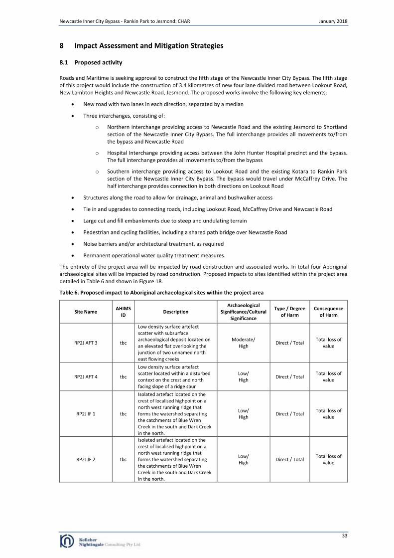
Newcastle Inner City Bypass - Rankin Park to Jesmond: CHAR January 2018
33
8 Impact Assessment and Mitigation Strategies
8.1 Proposed activity
Roads and Maritime is seeking approval to construct the fifth stage of the Newcastle Inner City Bypass. The fifth stage of this project would include the construction of 3.4 kilometres of new four lane divided road between Lookout Road, New Lambton Heights and Newcastle Road, Jesmond. The proposed works involve the following key elements:
New road with two lanes in each direction, separated by a median
Three interchanges, consisting of:
o Northern interchange providing access to Newcastle Road and the existing Jesmond to Shortland section of the Newcastle Inner City Bypass. The full interchange provides all movements to/from the bypass and Newcastle Road
o Hospital Interchange providing access between the John Hunter Hospital precinct and the bypass. The full interchange provides all movements to/from the bypass
o Southern interchange providing access to Lookout Road and the existing Kotara to Rankin Park section of the Newcastle Inner City Bypass. The bypass would travel under McCaffrey Drive. The half interchange provides connection in both directions on Lookout Road
Structures along the road to allow for drainage, animal and bushwalker access
Tie in and upgrades to connecting roads, including Lookout Road, McCaffrey Drive and Newcastle Road
Large cut and fill embankments due to steep and undulating terrain
Pedestrian and cycling facilities, including a shared path bridge over Newcastle Road
Noise barriers and/or architectural treatment, as required
Permanent operational water quality treatment measures.
The entirety of the project area will be impacted by road construction and associated works. In total four Aboriginal archaeological sites will be impacted by road construction. Proposed impacts to sites identified within the project area detailed in Table 6 and shown in Figure 18.
Table 6. Proposed impact to Aboriginal archaeological sites within the project area
Site Name AHIMS
ID Description
Archaeological Significance/Cultural
Significance
Type / Degree of Harm
Consequence of Harm
RP2J AFT 3 tbc
Low density surface artefact scatter with subsurface archaeological deposit located on an elevated flat overlooking the junction of two unnamed north east flowing creeks
Moderate/ High
Direct / Total Total loss of
value
RP2J AFT 4 tbc
Low density surface artefact scatter located within a disturbed context on the crest and north facing slope of a ridge spur
Low/ High
Direct / Total Total loss of
value
RP2J IF 1 tbc
Isolated artefact located on the crest of localised highpoint on a north west running ridge that forms the watershed separating the catchments of Blue Wren Creek in the south and Dark Creek in the north.
Low/ High
Direct / Total Total loss of
value
RP2J IF 2 tbc
Isolated artefact located on the crest of localised highpoint on a north west running ridge that forms the watershed separating the catchments of Blue Wren Creek in the south and Dark Creek in the north.
Low/ High
Direct / Total Total loss of
value
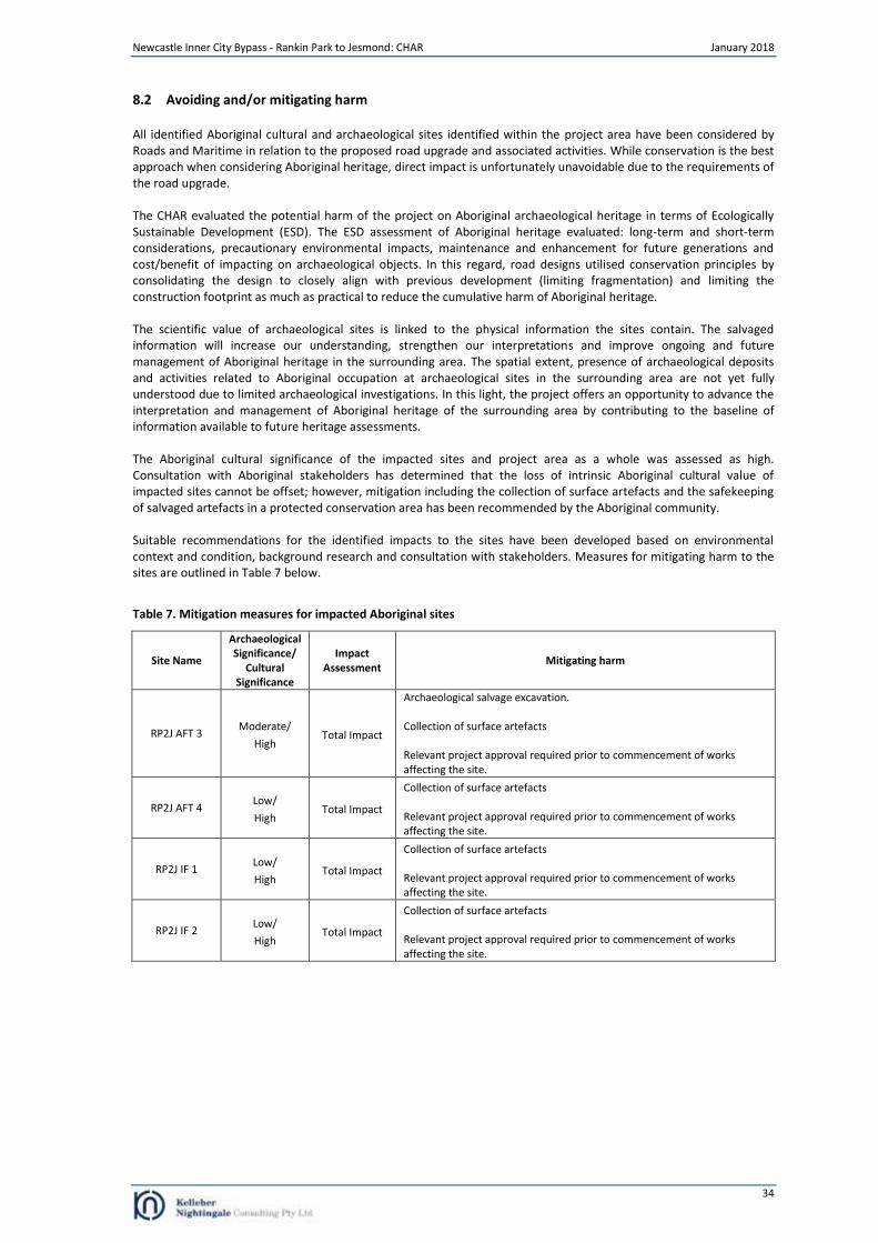
Newcastle Inner City Bypass - Rankin Park to Jesmond: CHAR January 2018
34
8.2 Avoiding and/or mitigating harm
All identified Aboriginal cultural and archaeological sites identified within the project area have been considered by Roads and Maritime in relation to the proposed road upgrade and associated activities. While conservation is the best approach when considering Aboriginal heritage, direct impact is unfortunately unavoidable due to the requirements of the road upgrade. The CHAR evaluated the potential harm of the project on Aboriginal archaeological heritage in terms of Ecologically Sustainable Development (ESD). The ESD assessment of Aboriginal heritage evaluated: long-term and short-term considerations, precautionary environmental impacts, maintenance and enhancement for future generations and cost/benefit of impacting on archaeological objects. In this regard, road designs utilised conservation principles by consolidating the design to closely align with previous development (limiting fragmentation) and limiting the construction footprint as much as practical to reduce the cumulative harm of Aboriginal heritage. The scientific value of archaeological sites is linked to the physical information the sites contain. The salvaged information will increase our understanding, strengthen our interpretations and improve ongoing and future management of Aboriginal heritage in the surrounding area. The spatial extent, presence of archaeological deposits and activities related to Aboriginal occupation at archaeological sites in the surrounding area are not yet fully understood due to limited archaeological investigations. In this light, the project offers an opportunity to advance the interpretation and management of Aboriginal heritage of the surrounding area by contributing to the baseline of information available to future heritage assessments. The Aboriginal cultural significance of the impacted sites and project area as a whole was assessed as high. Consultation with Aboriginal stakeholders has determined that the loss of intrinsic Aboriginal cultural value of impacted sites cannot be offset; however, mitigation including the collection of surface artefacts and the safekeeping of salvaged artefacts in a protected conservation area has been recommended by the Aboriginal community. Suitable recommendations for the identified impacts to the sites have been developed based on environmental context and condition, background research and consultation with stakeholders. Measures for mitigating harm to the sites are outlined in Table 7 below.
Table 7. Mitigation measures for impacted Aboriginal sites
Site Name
Archaeological Significance/
Cultural Significance
Impact Assessment
Mitigating harm
RP2J AFT 3 Moderate/
High Total Impact
Archaeological salvage excavation. Collection of surface artefacts Relevant project approval required prior to commencement of works affecting the site.
RP2J AFT 4 Low/
High Total Impact
Collection of surface artefacts Relevant project approval required prior to commencement of works affecting the site.
RP2J IF 1 Low/
High Total Impact
Collection of surface artefacts Relevant project approval required prior to commencement of works affecting the site.
RP2J IF 2 Low/
High Total Impact
Collection of surface artefacts Relevant project approval required prior to commencement of works affecting the site.
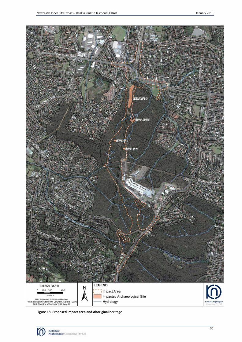
Newcastle Inner City Bypass - Rankin Park to Jesmond: CHAR January 2018
35
Figure 18. Proposed impact area and Aboriginal heritage
Newcastle Inner City Bypass - Rankin Park to Jesmond: CHAR January 2018
36
9 Management Outcomes
The following general management outcomes will be implemented in accordance with the mitigation strategy for the proposal as outlined in Chapter 10.
9.1 Mitigation through archaeological salvage excavation
The Aboriginal site in Table 8 is of moderate Aboriginal heritage significance and will be impacted by the project. The site will require archaeological salvage excavation to mitigate the impact. Salvage excavation can only occur after project approval is obtained. Salvage excavation must be completed prior to any activities which may harm Aboriginal objects at this site location. Salvage excavation activities would be undertaken in accordance with the methodology attached as Appendix D.
Table 8. Aboriginal cultural heritage sites requiring mitigation (salvage excavation)
Archaeological sites requiring mitigation (salvage excavation)
Archaeological Site (requiring salvage) RP2J AFT 3
9.2 Mitigation through the collection of surface artefacts
The Aboriginal sites in Table 9 are of high cultural significance and will be impacted by the project. The sites will require the collection of surface artefacts to mitigate the impact. Collection can only occur after project approval is obtained. The collection must be completed prior to any activities which may harm Aboriginal objects at these site locations. The collection of surface artefacts would be undertaken in accordance with the methodology attached as Appendix D.
Table 9. Aboriginal sites requiring mitigation (collection)
Archaeological sites requiring mitigation (collection)
Archaeological Sites (requiring the collection of surface artefacts) RP2J AFT 3, RP2J AFT 4, RP2J IF 1 and RP2J IF 2
Newcastle Inner City Bypass - Rankin Park to Jesmond: CHAR January 2018
37
10 Management Procedures
10.1 Management Policy for Aboriginal Cultural Heritage
The policy for the management and conservation of Aboriginal heritage in relation to cultural heritage salvage activities and construction activities (or fencing, geotechnical investigations, minor clearing, establishing site compounds, adjustment to services/utilities etc.) is described below: Responsibility for compliance with Management Policy
1. The Proponent must ensure all of its employees, contractors and subcontractors and agents are made aware of and comply with this management policy.
2. The Proponent must appoint a suitably qualified and experienced environmental manager who is responsible for overseeing the activities related to this management policy.
3. The Proponent must appoint a suitably qualified and experienced Archaeologist who is responsible for overseeing, for and on behalf of the Proponent, the archaeological activities relating to the project.
Operational constraints
4. Where archaeological salvage excavation or surface collection has been nominated for impacted sites, no construction activities (or fencing, geotechnical investigations, minor clearing, establishing site compounds, adjustment to services/utilities etc.) can occur on the lands to be investigated until the relevant archaeological excavation at the nominated site have been completed..
5. Prior to the commencement of early works activity (e.g. fencing, minor clearing, establishing site compounds etc.) a construction heritage site map identifying Aboriginal sites to be excavated and avoided (for all sites in proximity to the project boundary) must be prepared. The construction heritage site map should be prepared to the satisfaction of Roads and Maritime.
6. All employees, contractors, subcontractors and agents carrying out early works activities (e.g. fencing, minor clearing, geotechnical investigations, establishing site compounds etc) must undertake a Project induction (including the distribution of a construction heritage site map) to ensure that they have an understanding and are aware of the Aboriginal heritage issues affecting the activity.
Areas of Aboriginal archaeological sites and objects to be impacted
7. The areas of archaeological sites and objects identified as being impacted by construction activities are listed in Table 6 of this report and are in accordance with the Project Approval.
Human Remains
8. This management policy does not authorise any damage of human remains. 9. If potential human remains are disturbed the Proponent must follow the procedures outlined in section 10.2
below. Salvage Activities
10. Archaeological salvage excavation where appropriate must be carried out in accordance with the methodology specified in Appendix D and the Project Approval.
Involvement of Aboriginal groups and/or individuals
11. Opportunity may be provided to the registered Aboriginal stakeholders to be involved in the following activities:
a. assist with the collection of surface artefacts and salvage excavation. Conservation of salvaged Aboriginal objects
12. Department of Planning and Environment (DP&E), as the approval authority, will be consulted; 13. Aboriginal objects will be transferred in accordance with a Care Agreement or similar agreement to an
Aboriginal community; 14. In the event the Aboriginal community is unable to accept the objects, the objects will be transferred to the
Australian Museum in accordance with legislative requirements, Australian Museum Archaeological Collection Deposition Policy v1.0 January 2012;
15. In the event that neither the Australian Museum nor the Aboriginal community are able to accept the archaeological objects, KNC will work with RAPs and Roads and Maritime to identify a suitable location for reburial following consultation with RAPs and DP&E
Reporting requirements
16. A written archaeological salvage excavation report must be provided to Roads and Maritime within a reasonable time in accordance with the Project Approval following the completion of the archaeological program.
Notification and reporting about incidents that breach this management policy
17. Incident reporting requirements in accordance with the Project Approval is to include Aboriginal heritage.
Newcastle Inner City Bypass - Rankin Park to Jesmond: CHAR January 2018
38
Procedure for unexpected archaeological finds
18. Roads and Maritime Unexpected Archaeological Finds Procedure will be used in the event of uncovering an unexpected archaeological find during Roads and Maritime activities.
10.2 Procedures for Handling Human Remains
• Note that Project Approvals do not include the destruction of Aboriginal remains This section outlines the procedure for handling human remains in accordance with the Skeletal Remains – Guidelines for the Management of Human Skeletal Remains under the Heritage Act 1977 (NSW Heritage Office 1998) and the Aboriginal Cultural Heritage Standards and Guidelines Kit (NPWS 1997). In the event that construction activity reveals possible human skeletal material (remains), the following procedure is to be followed:
1. as soon as remains are exposed, all work is to halt at that location immediately and the Project environmental manager on site is to be immediately notified to allow assessment and management;
i. stop all activities; and ii. secure the site.
2. contact police, the discovery of human remains triggers a process which assumes that they are associated with a crime. The NSW Police retain carriage of the process until such time as the remains are confirmed to be Aboriginal or historic;
3. DP&E, as the approval authority, will be notified when human remains are found; 4. once the police process is complete and if remains are not associated with a contemporary crime contact
DP&E. DP&E will determine the process, in consultation with OEH and/or the Heritage Office as appropriate; i. if the remains are identified as Aboriginal, the site is to be secured and DP&E and all
Aboriginal stakeholders are to be notified in writing. DP&E will act in consultation with OEH as appropriate. OEH will be notified in writing according to DP&E instructions; or
ii. if the remains are identified as non-Aboriginal (historical) remains, the site is to be secured and the DP&E is to be contacted. DP&E will act in consultation with the Heritage Division as appropriate. The Heritage Division will be notified in writing according to DP&E instructions;
5. once the police process is complete and if the remains are identified as not being human work can recommence once the appropriate clearances have been given.
10.3 Procedure for proposed changes to Approved Projects
Roads and Maritime recognises that during the construction of the project design alterations or other changes to the Approved Project may be required. A proposed change to the Approved Project (such as an alteration of the current design, the location of ancillary facilities) within the project corridor may result in a:
Reduced impact to Aboriginal cultural heritage; or an
Increased impact to Aboriginal cultural heritage.
To ensure consistency with the Approved Project and this document any change in the overall impact on Aboriginal cultural heritage will need to be considered. The process to determine consistency is outlined in section 10.3.1 below. Where a proposed change to the Approved Project occurs outside of the project boundary considered for the EIS further heritage assessment will be required to determine if there would be an impact on Aboriginal cultural heritage and whether this represents a modification to the Approved Project (outlined below).
10.3.1. Changes in heritage impact
Where the Proponent seeks to make a change to the design and construction of the Approved Project which changes the assessed impact on Aboriginal cultural heritage the Proponent will need to prepare an assessment of the new impacts of this work in consultation with the appointed Archaeologist. The continued involvement of the Aboriginal stakeholders in this process is outlined in section 10.4.
New impacts consistent with previously identified impacts If a proposed change to the Approved Project is considered to have a neutral or lesser impact on Aboriginal cultural heritage than that identified in this document it would be considered a consistent impact. If the proposed change is considered to be consistent with the Approved Project Roads and Maritime may approve the change with no requirements to seek further approval. However, in certain circumstances, further consultation with Aboriginal stakeholders may still be required (see section 10.4 below).
Newcastle Inner City Bypass - Rankin Park to Jesmond: CHAR January 2018
39
New impacts inconsistent with previously identified impacts If a proposed change to the Approved Project is considered to have an increased impact on Aboriginal cultural heritage than that identified in the EIS it would be considered an inconsistent impact. If the proposed change is considered inconsistent with the assessed impact on Aboriginal cultural heritage, as detailed in the Project Approval, Roads and Maritime would require an amendment to the mitigation measures agreed in this report. If this proposed change is considered inconsistent with the Approved Project Roads and Maritime would require a modification of the Approved Project. Further consultation with Aboriginal stakeholders will be undertaken (see 10.4 below).
10.4 Process for continued consultation with Aboriginal stakeholders
The extent to which Roads and Maritime will continue to consult with Aboriginal stakeholders is dependent upon the level of impact and whether the area was assessed as part of the EIS. The types of potential impacts are identified as reduced impacts, increased impacts or unknown impacts. a) Reduced or neutral impact If as a result of alterations to the project design a previously identified impact to an Aboriginal heritage item is reduced or neutral then no further consultation is required. If as a result of alterations to the project design an impact to an Aboriginal heritage item is proposed that results in a reduced impact on the overall heritage significance of the project area (i.e. the cumulative impact is reduced), then further consultation with Aboriginal stakeholders will be undertaken. This consultation may entail a phone call and phone log of comments received or the provision of a report for comment (10 working days). b) Increased Impact Where as a result of alterations to the project design an impact on Aboriginal heritage is considered to be greater than identified by the Approved Project further consultation will be undertaken. This consultation will either entail a phone call and phone log of comments received or the provision of a report for comment (10 working days). c) Unknown impacts: Assessment process Where a proposed change is an area located outside of the project boundary assessed as part of the Approved Project the impact on Aboriginal cultural heritage is considered to be unknown. This area would require preliminary assessment to determine any impacts upon Aboriginal heritage. Should no impacts be identified then no consultation with Aboriginal stakeholders is required. Should potential impacts be identified consultation with Aboriginal stakeholders will be undertaken. This consultation will entail the provision of a report for stakeholder comment (10 working days) detailing the impacts and mitigation strategies proposed.
Newcastle Inner City Bypass - Rankin Park to Jesmond: CHAR January 2018
40
References
Australian Museum Business Services (AMBS), 2005. Aboriginal Heritage Study: Newcastle Local Government Area. Report prepared for Newcastle City Council.
Baker Archaeology, 2016. Newcastle Inner City Bypass – Rankin Park to Jesmond. Technical Paper 9 – Non-Aboriginal
Heritage Assessment. Report for Aurecon Australasia Pty Ltd on behalf of Roads and Maritime Services Brayshaw and Kerr, 1983. Archaeological Survey at Rankin Park Hospital, Newcastle, New South Wales. Brayshaw and Associates, 1984. State Highway No 23 – Archaeological Investigation at Lambton Heights, Newcastle
NSW. Report prepared for Cameron McNamara Pty Ltd. Brayshaw, H., 1987. Aborigines of the Hunter Valley: A study of Colonial Records. Scone & Upper Hunter Historical
Society. Dyall, L.K., 1971. Aboriginal Occupation of the Newcastle Coastline. Hunter Natural History, vol. 3, no. 3, pp. 154-168. Dean-Jones, P., 1989. Report of an Archaeological Survey at Glendale, NSW. Report prepared for Planning Workshop. Environmental Resources Management Australia (ERM), 2002. Intersection of Lookout Road and McCaffrey Drive, New
Lambton. Report prepared for Hyder Consulting. Fawcett, J. W. "NOTES ON THE CUSTOMS AND DIALECT OF THE WONNAH-RUÁH TRIBE." Science of man 1.7 (1898):
152-4. Grant, J. 1803, The Narrative of a Voyage of Discovery, Performed in His Majesty’s Vessel The Lady Nelson, of Sixty Tons
Burthen, with Sliding Keels, In the Years 1800, 1801, and 1802, to New South Wales. C. Roworth, Bell Yard, Fleet Street London
Gunson, N. (ed) 1974. Australian reminiscences & papers of L.E. Threlkeld, missionary to the Aborigines, 1824-1859.
Australian Institute of Aboriginal Studies. Canberra. Hawley, S.P. and Brunton, J.S., 1995. The Newcastle Coalfield, Notes to Accompany to the 1:100,000 Newcastle
Coalfield Regional Geology Map. Coal and Petroleum Branch, Department of Mineral Resources. Hiscock, P., 2002. Quantifying the size of artefact assemblages. Journal of Archaeological Science 29: 251–258.
Holdaway, S. and Stern, N., 2004. A Record In Stone: The Study of Australia's Flaked Stone Artefacts. Aboriginal Studies
Press, Canberra. Kelleher Nightingale Consulting (KNC), 2017, Newcastle Inner City Bypass – Rankin Park to Jesmond, Aboriginal
Archaeological Survey Report - Stage 2 PACHCI. Report prepared for Roads and Maritime Services Matthei, L. E, 1995. Soil Landscapes of the Newcastle 1:100 000 Sheet Report. Report prepared for Department of Land
and Water Conservation, Sydney. Maynard, J, 2015, Callaghan, The University of Newcastle: whose traditional land? The University of Newcastle.
Newcastle. Miller, R., 1886. No. 188 The Hunter River. The Wonnarua Tribe and Language. In Curr, E.M. The Australian Race: Its
Origin, Languages, Customs, Place of Landing in Australia, and the Routes by which it spread itself over that continent. Melbourne, John Ferres, Government Printer, 1886-1887, Vol. 3. pp. 352 - 357
Nishiizumi, K., Lal, D., Klein, J., Middleton, R. and Arnold J.R. 1986. Production of 10Be and 26Al by cosmic rays in
terrestrial quartz in situ and implications for erosion rates. Nature 319 (6049): 134-136. Nishiizumi, K. et al. 1993. Role of in situ cosmogenic nuclides 10Be and 26Al in the study of diverse geomorphic
processes. Earth Surface Processes and Landforms 18: 407-425. Office of Environment and Heritage (OEH) (formerly Department of Environment, Climate Change and Water), 2010a.
Code of Practice for Archaeological Investigation of Aboriginal Objects in New South Wales: Part 6 National Parks and Wildlife Act 1974. Department of Environment, Climate Change and Water NSW, Sydney.
OEH, 2010b. Aboriginal Cultural Heritage Consultation Requirements for Proponents 2010 (Part 6 National Parks and
Wildlife Act, 1974). Department of Environment, Climate Change and Water NSW.
Newcastle Inner City Bypass - Rankin Park to Jesmond: CHAR January 2018
41
OEH, April 2011. Guide to Investigating, Assessing and Reporting on Aboriginal Cultural Heritage in NSW. Office of
Environment and Heritage, Department of Premier and Cabinet, Sydney. Pearson, M. and Sullivan, S. 1995. Looking After Heritage Places: The Basics of Heritage Planning for Managers,
Landowners and Administrators Melbourne University Press. Pickett, J.W & Alder, J.D, 1997. Layers of time: the Blue Mountains and their geology. New South Wales Department of
Mineral Resources, Sydney.
Roads and Maritime Services (Roads and Maritime), November 2011. Procedure for Aboriginal cultural heritage
consultation and investigation. Roads and Maritime, July 2012. Standard Management Procedure: Unexpected Archaeological Finds. Environment
Branch. Roads and Maritime Services, North Sydney
Sullivan, S. and Bowdler, S. 1984. Site Survey and Significance Assessment in Australian Archaeology. Canberra: RSPacS, Australian National University.
Troedson A.L. & Deyssing L. 2016. Newcastle-Hunter Area 1:100 000 and 1:25 000, Coastal Quaternary Geology Map Series. Geological Survey of New South Wales, Maitland.
Umwelt (Australia) Pty Limited (Umwelt), 2002a. Archaeological Survey of Revised Route for the Proposed New Access
Road to John Hunter Hospital, Newcastle, NSW. Report prepared for Bovis Lend Lease. Umwelt, 2002b. Management of Aboriginal Heritage Values in the Blue Gum Vista Estate, Vol 1 & 2. Report prepared
for Landcom.
Umwelt, 2006. Aboriginal Archaeological Survey and Assessment of the Proposed State Highway 23 Realignment form Rankin Park to Jesmond, NSW: An Examination of Four Alternative Routes. Report for NSW Roads and Traffic Authority

Newcastle Inner City Bypass - Rankin Park to Jesmond: CHAR January 2018
42
Appendix A Advertisement for registration of interest
Appeared in: The Koori Mail (Wednesday 3 May 2017), National Indigenous Times (Wednesday 3 May 2017), and Newcastle Herald (Wednesday 3 May 2017)
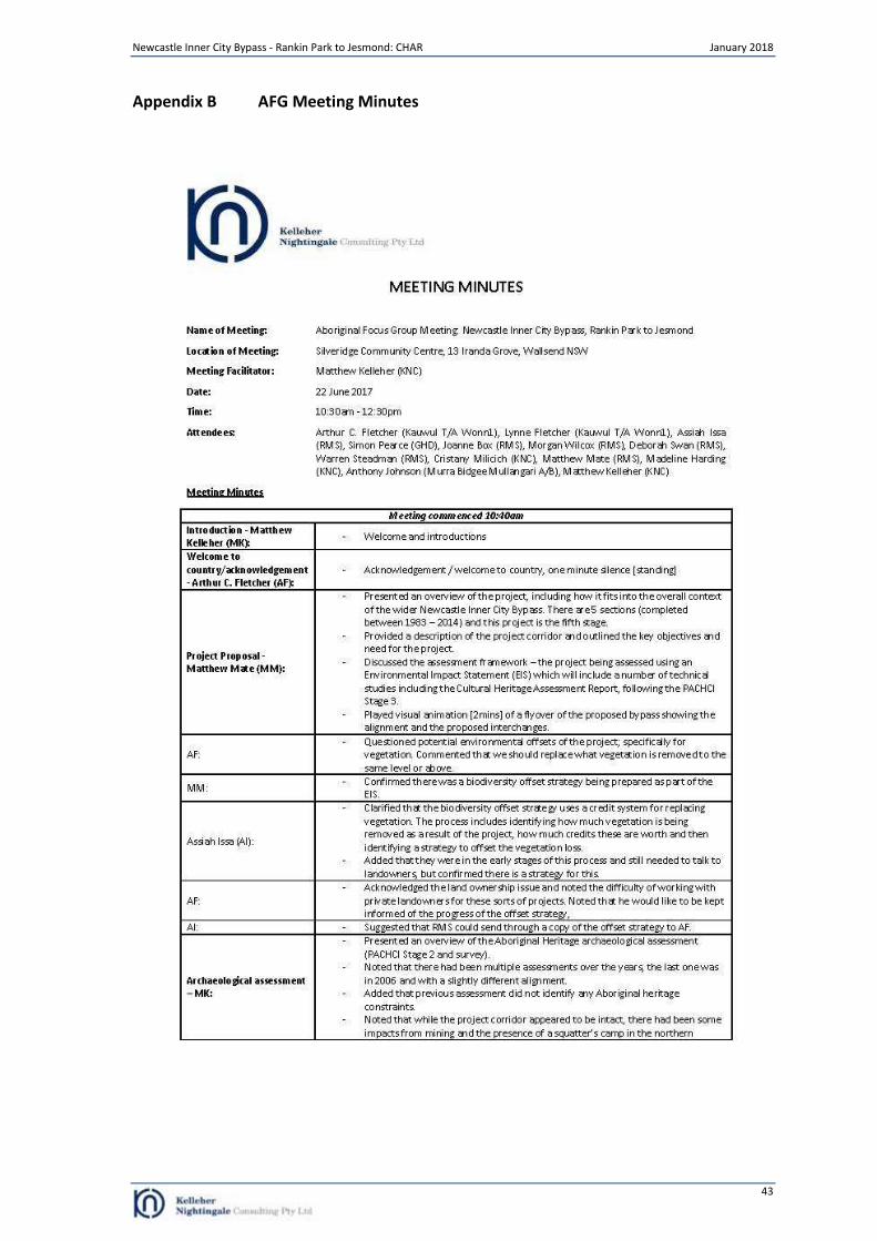
Newcastle Inner City Bypass - Rankin Park to Jesmond: CHAR January 2018
43
Appendix B AFG Meeting Minutes
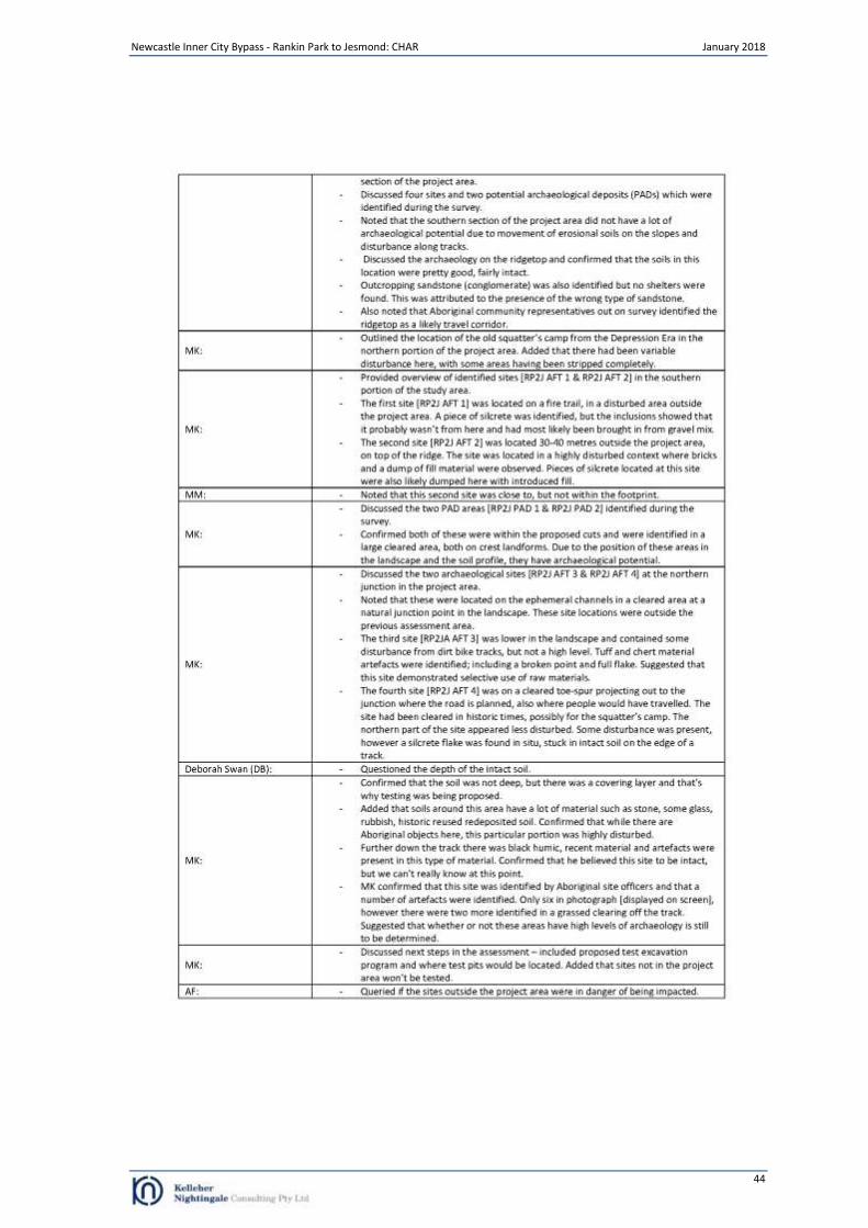
Newcastle Inner City Bypass - Rankin Park to Jesmond: CHAR January 2018
44
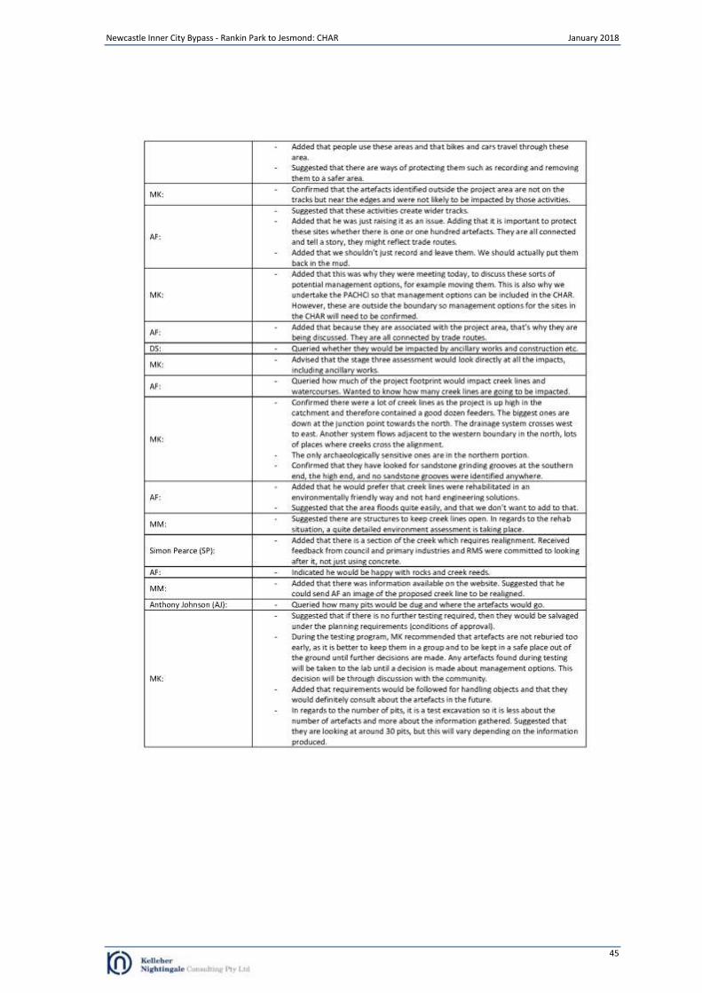
Newcastle Inner City Bypass - Rankin Park to Jesmond: CHAR January 2018
45
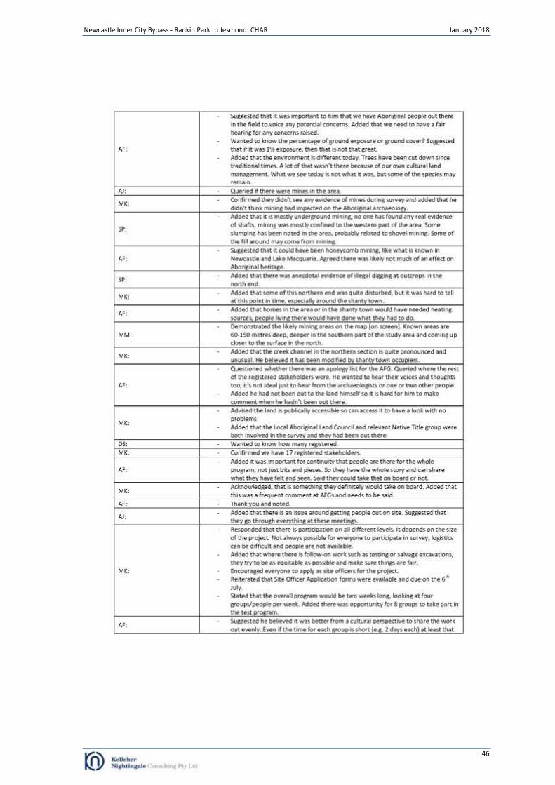
Newcastle Inner City Bypass - Rankin Park to Jesmond: CHAR January 2018
46

Newcastle Inner City Bypass - Rankin Park to Jesmond: CHAR January 2018
47
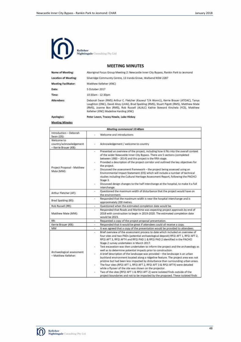
Newcastle Inner City Bypass - Rankin Park to Jesmond: CHAR January 2018
48
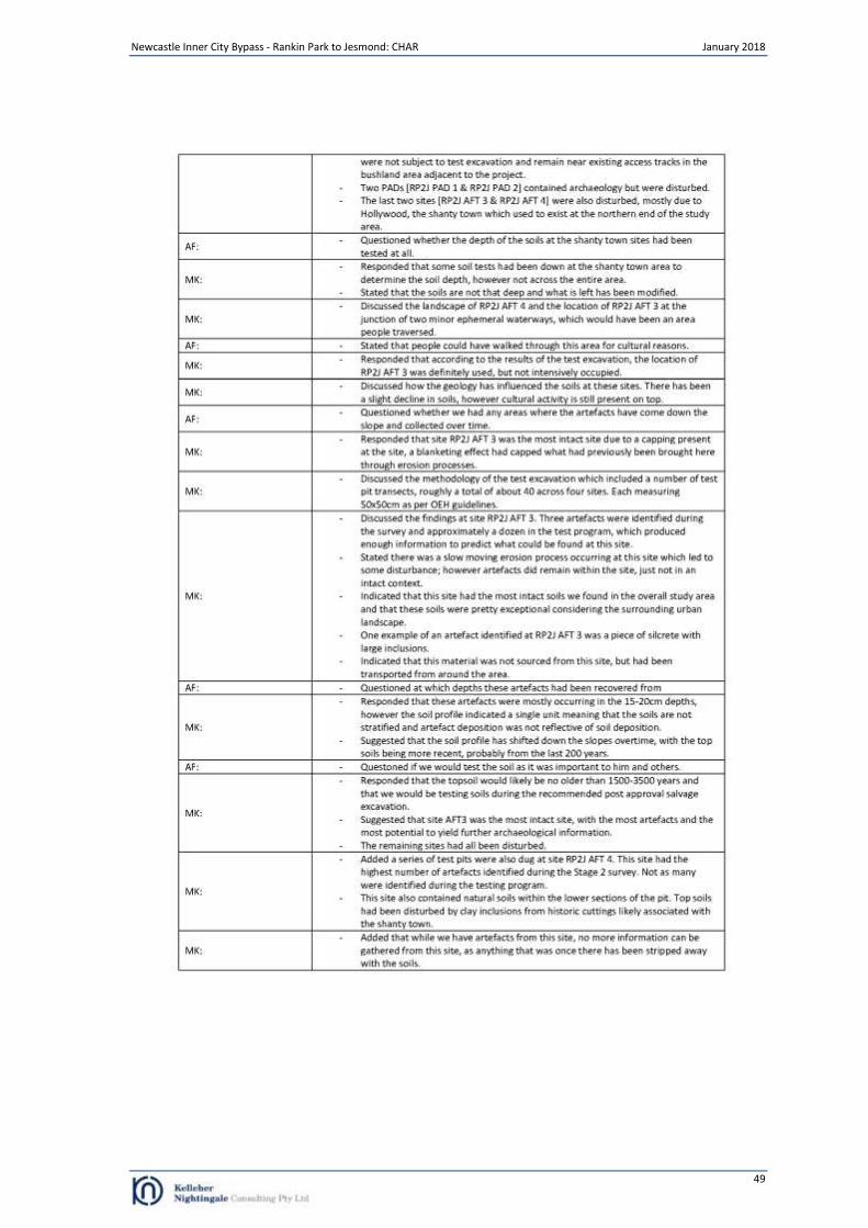
Newcastle Inner City Bypass - Rankin Park to Jesmond: CHAR January 2018
49
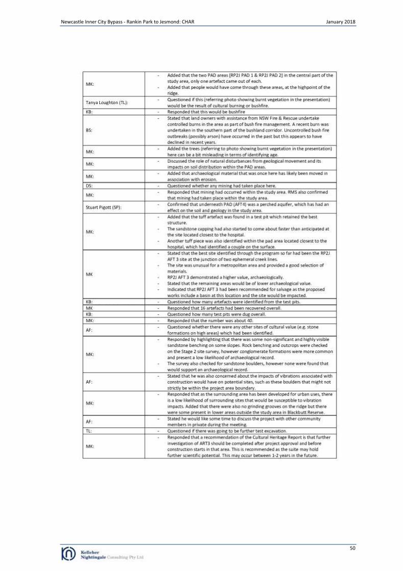
Newcastle Inner City Bypass - Rankin Park to Jesmond: CHAR January 2018
50
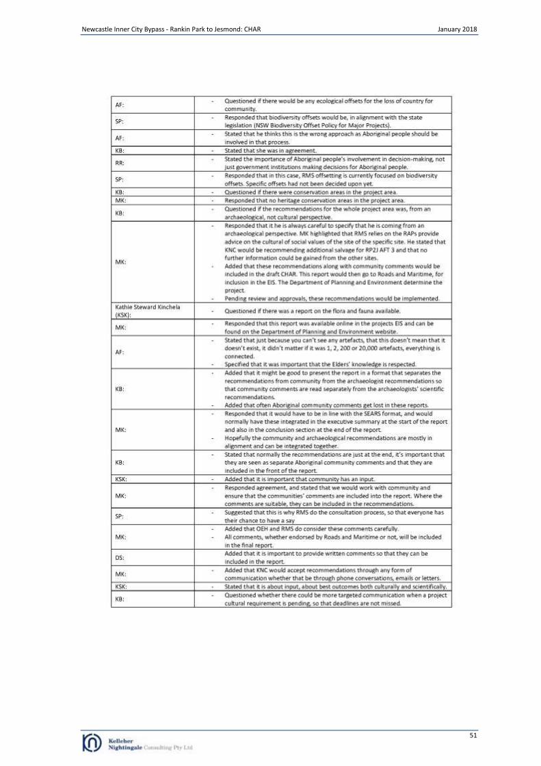
Newcastle Inner City Bypass - Rankin Park to Jesmond: CHAR January 2018
51
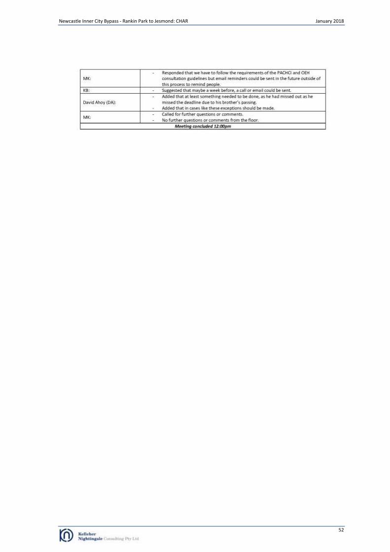
Newcastle Inner City Bypass - Rankin Park to Jesmond: CHAR January 2018
52
Newcastle Inner City Bypass - Rankin Park to Jesmond: CHAR January 2018
53
Appendix C Aboriginal Stakeholder Comments
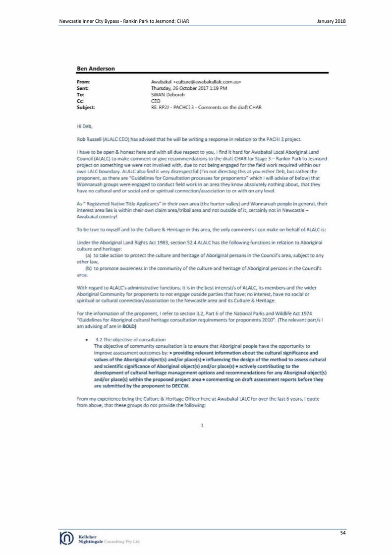
Newcastle Inner City Bypass - Rankin Park to Jesmond: CHAR January 2018
54
Newcastle Inner City Bypass - Rankin Park to Jesmond: CHAR January 2018
55
Newcastle Inner City Bypass - Rankin Park to Jesmond: CHAR January 2018
56

Newcastle Inner City Bypass - Rankin Park to Jesmond: CHAR January 2018
57
Newcastle Inner City Bypass - Rankin Park to Jesmond: CHAR January 2018
58
Newcastle Inner City Bypass - Rankin Park to Jesmond: CHAR January 2018
59
Newcastle Inner City Bypass - Rankin Park to Jesmond: CHAR January 2018
60

Newcastle Inner City Bypass - Rankin Park to Jesmond: CHAR January 2018
61
Newcastle Inner City Bypass - Rankin Park to Jesmond: CHAR January 2018
62
Newcastle Inner City Bypass - Rankin Park to Jesmond: CHAR January 2018
63
Newcastle Inner City Bypass - Rankin Park to Jesmond: CHAR January 2018
64
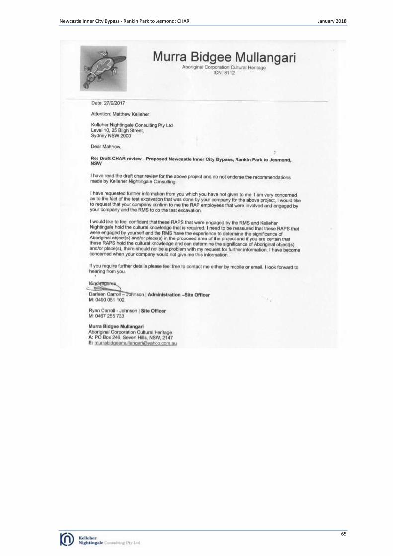
Newcastle Inner City Bypass - Rankin Park to Jesmond: CHAR January 2018
65
Newcastle Inner City Bypass - Rankin Park to Jesmond: CHAR January 2018
66
Appendix D Salvage Excavation Methodology
Methodology Research Aims The main aims of the proposed salvage excavation program are:
To salvage a representative sample of the identified archaeological site RP2J AFT 3 prior to construction impact.
To analyse the salvaged archaeological material to gain and conserve knowledge and understanding of the scientific and cultural information exhibited by the activities associated with landforms adjacent to a creek junction.
Analysis of the geomorphological history of the project area, specifically examining the impacts of erosional forces on the archaeological record (taphonomy and chronology).
The further scientific aim of the salvage excavation program would be to determine the subsurface integrity, extent, spatial distribution and nature of the cultural deposit and the specific types of associated archaeological/cultural activities.
Determining the integrity of the deposit involves assessing the degree of disturbance which is present.
Determining the statistical extent of the sites and/or activity areas involves identifying the boundaries associated with the identified archaeological deposit.
Assessing the spatial distribution involves identifying the presence/absence of archaeological material across the identified archaeological sites.
The nature of the sites refers to the type of activities indicated by the artefactual material (e.g. primary production, tool maintenance, domestic knapping, hunting camps). The goal would be to retrieve entire assemblages from specific activities if such activities were present.
Retrieved assemblages would be compared with the results from other relevant archaeological projects in order to assess significance.
Research Question The results of the proposed salvage excavation would increase our understanding of subsurface archaeology of the project area. In particular, research would focus on the archaeologically-identifiable cultural activities that took place on elevated landforms adjacent to a creek junction addressing questions about past activity events and survivability of the deposit.
Question 1: What cultural activities are archaeologically identifiable at site RP2J AFT 3 and how do these potentially differ from archaeological sites on other landforms in the Newcastle urban area or region? Question 2: What are the taphonomic features of archaeological site RP2J AFT 3? What does this indicate about site integrity and artefact survivability for sites on similar landforms especially within urban environments?
What can we expect? It is anticipated that differences in stone tool assemblages may be related to different cultural activities (e.g. primary reduction vs maintenance flaking). The science of archaeology is paramount to any research question and it is important to stress that the goal for the salvage program for all excavated sites is straight forward: to retrieve a viable sample for comparative analysis using established techniques (see Field Methods below). In this regard interpretation would not precede data collection. The proposed archaeological program would systematically sample the relevant areas using standard techniques with the outcome being a viable, robust and comparable sample. Analysis of the sample would follow and interpretations would be made distinctly separate from the results.
Newcastle Inner City Bypass - Rankin Park to Jesmond: CHAR January 2018
67
Archaeological Salvage Areas Salvage excavation would be undertaken on identified archaeological site RP2J AFT 3. Salvage excavation of the site would focus on the extraction of collections of artefacts related to activity areas and geomorphic information. FIELD METHODS The goal of the field excavation program is to recover significant assemblages of artefacts. Salvage Program In order to achieve the most robust and comparable result, KNC advocates an open area salvage excavation. The first phase in open area salvage is to establish the statistical boundaries of the previously identified archaeological deposit. In other words, recording the spread of activities across the site/landscape. This approach is designed to salvage the spatial properties of the site as shown in the lithic continuum. Phase 1 A series of 1 m
2 squares are excavated on a transect grid at about 15 metre intervals overlain on each site to mark the
spread of lithics and related geomorphic activity (Figure 19). This will build on previous test excavation results. GDA 94 coordinates would be recorded for each square to enable three dimensional modelling. Statistical salvage following this method is highly beneficial because it creates a robust inter-site sample, sufficiently random, critical for regional comparative analysis. No other method is as efficient or effective. It is anticipated that a maximum of 25m
2
would be excavated within site RP2J AFT 3 during Phase 1. Individual excavation squares measuring 1 m
2 would be hand excavated in stratigraphic units (Unit A, Unit B, etc.).
Squares would be excavated until the basal layer or culturally sterile deposit is reached (usually 25-35 cm). Test excavation of the area indicates no archaeological stratigraphy within units. As such the A1 and A2 soil layers are culturally one layer (suffering from cyclical soil transfer resulting in a mixed cultural profile within the soil) and can be salvaged as one unit where possible. All excavated deposit would be sieved using nested 5.0 mm and 2.5 mm sieves. Where potential micro-debitage is recovered 1.0mm sieves will be utilised. The location of each excavated square would be identified on a surveyed plan of the site. Stratigraphic sections detailing the stratigraphy and features within the excavated deposit would be drawn and all squares would be photographed. Soil samples as well as thin section profiles (where feasible) would also be collected. The stratigraphy of all excavated areas would be fully documented and appropriate records archived. Phase 2 Open area salvage of significant deposit follows the Phase 1 assessment. Additional 1 m
2 squares, constituting an open
area, will be excavated around information bearing deposits along the excavation grid. Information bearing deposits are identified by triggers such as: significant quantities of artefacts, variations in raw material, unusual artefacts, chronological material and/or taphonomic indicators. In this context chronologic material is anything that can be used to date artefacts or deposit: charcoal or charcoal bearing deposit (e.g. hearth ash), sandy deposit, gravels (e.g. aluminium feldspar). Phase 2 open area investigation would expand to encompass entire activity areas. The location of Phase 2 open area investigation would be based on Phase 1 results. It is anticipated that up to 50m
2 of Phase 2 open area salvage may be excavated within the site if Phase 1 results
warrant this approach. Total salvage area would be a maximum of 75m2 for the site (combining both Phase 1 and
Phase 2). Where possible, carbon samples will be collected and analysed for material relating to both the archaeology and geomorphology. Where appropriate cosmogenic and radiometric dating of soils and rock surfaces will be applied (Nishiizumi et al. 1986, 1993).
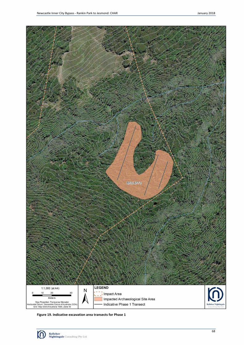
Newcastle Inner City Bypass - Rankin Park to Jesmond: CHAR January 2018
68
Figure 19. Indicative excavation area transects for Phase 1
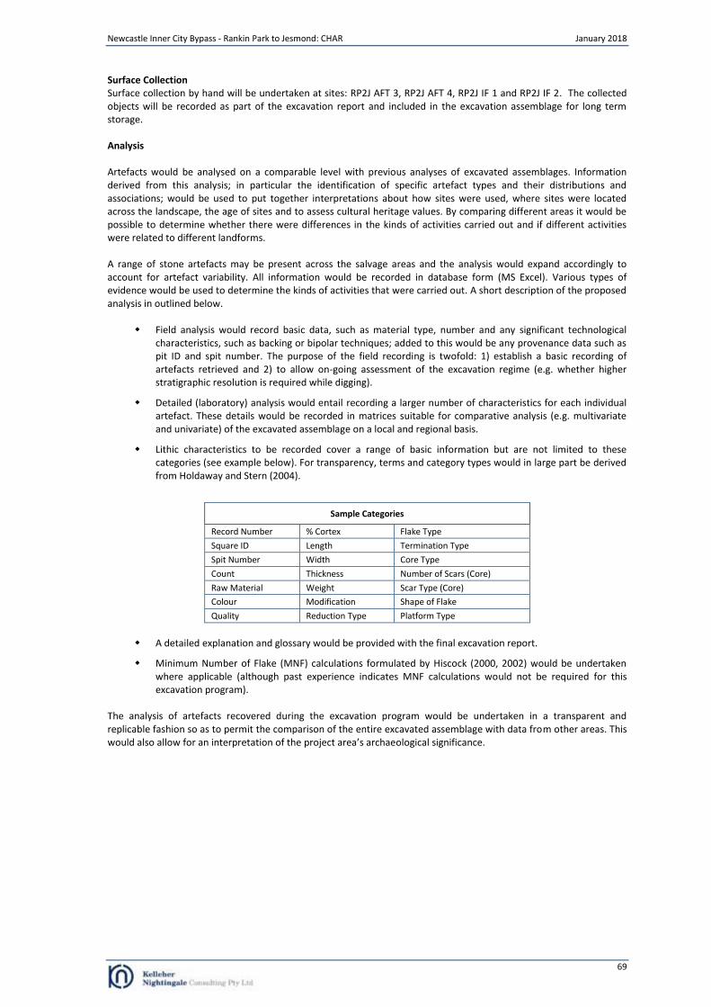
Newcastle Inner City Bypass - Rankin Park to Jesmond: CHAR January 2018
69
Surface Collection Surface collection by hand will be undertaken at sites: RP2J AFT 3, RP2J AFT 4, RP2J IF 1 and RP2J IF 2. The collected objects will be recorded as part of the excavation report and included in the excavation assemblage for long term storage. Analysis Artefacts would be analysed on a comparable level with previous analyses of excavated assemblages. Information derived from this analysis; in particular the identification of specific artefact types and their distributions and associations; would be used to put together interpretations about how sites were used, where sites were located across the landscape, the age of sites and to assess cultural heritage values. By comparing different areas it would be possible to determine whether there were differences in the kinds of activities carried out and if different activities were related to different landforms. A range of stone artefacts may be present across the salvage areas and the analysis would expand accordingly to account for artefact variability. All information would be recorded in database form (MS Excel). Various types of evidence would be used to determine the kinds of activities that were carried out. A short description of the proposed analysis in outlined below.
Field analysis would record basic data, such as material type, number and any significant technological characteristics, such as backing or bipolar techniques; added to this would be any provenance data such as pit ID and spit number. The purpose of the field recording is twofold: 1) establish a basic recording of artefacts retrieved and 2) to allow on-going assessment of the excavation regime (e.g. whether higher stratigraphic resolution is required while digging).
Detailed (laboratory) analysis would entail recording a larger number of characteristics for each individual artefact. These details would be recorded in matrices suitable for comparative analysis (e.g. multivariate and univariate) of the excavated assemblage on a local and regional basis.
Lithic characteristics to be recorded cover a range of basic information but are not limited to these categories (see example below). For transparency, terms and category types would in large part be derived from Holdaway and Stern (2004).
Sample Categories
Record Number % Cortex Flake Type
Square ID Length Termination Type
Spit Number Width Core Type
Count Thickness Number of Scars (Core)
Raw Material Weight Scar Type (Core)
Colour Modification Shape of Flake
Quality Reduction Type Platform Type
A detailed explanation and glossary would be provided with the final excavation report.
Minimum Number of Flake (MNF) calculations formulated by Hiscock (2000, 2002) would be undertaken where applicable (although past experience indicates MNF calculations would not be required for this excavation program).
The analysis of artefacts recovered during the excavation program would be undertaken in a transparent and replicable fashion so as to permit the comparison of the entire excavated assemblage with data from other areas. This would also allow for an interpretation of the project area’s archaeological significance.