Technical Manual for Solid Waste Transfer Station/Material
155
Technical Manual for Solid Waste Transfer Station/Material Recovery Facility Permits and Approvals Bureau of Hazardous Waste and Transfer Facilities Division of Solid and Hazardous Waste April 2000 CHRISTINE TODD WHITMAN, GOVERNOR STATE OF NEW JERSEY ROBERT C. SHINN, JR. COMMISSIONER NEW JERSEY DEPARTMENT OF ENVIRONMENTAL PROTECTION
Transcript of Technical Manual for Solid Waste Transfer Station/Material

Technical Manual
for
Solid WasteTransfer Station/Material Recovery Facility
Permits and Approvals
Bureau of Hazardous Waste and Transfer FacilitiesDivision of Solid and Hazardous Waste
April 2000
CHRISTINE TODD WHITMAN, GOVERNORSTATE OF NEW JERSEY
ROBERT C. SHINN, JR. COMMISSIONERNEW JERSEY DEPARTMENT OF ENVIRONMENTAL PROTECTION
i
MISSION STATEMENT
The mission of the New Jersey Department of Environmental Protection is to conserve, protect, enhance, restore and manage our environment for present and future generations. We strive to prevent pollution;
ensure the efficient use of safe, environmentally sound and reliable energy resources;provide opportunities for recreation and enjoyment of natural and historic resources; and promote a
healthy and sustainable ecosystem.
Bureau of Hazardous Waste and Transfer FacilitiesDivision of Solid and Hazardous Waste
NJDEP401 East State Street
P.O. Box 414Trenton, New Jersey 08625-0414
(609) 292-9880
ii
Prologue
This manual has been produced by the Department of Environmental Protection (DEP) to makethe permit process less complicated and time-consuming for you. This manual is one of a series oftechnical manuals produced by DEP under the requirements of the Environmental ManagementAccountability Plan (P. L. 1991, Chapter 422) with the goal of making the permit application processmore consistent and predictable. In each technical manual, you will find summaries and explanationsof policies that may not be fully described or explained in environmental laws or regulations. Inaddition, the manuals contain guidance on how the Department defines other standards, such as “state-of-the-art” control technologies or “best management practices.”
Unless otherwise required by federal or state law, the policies and procedures contained in atechnical manual on the date an application is filed will be binding on both the DEP and theapplicant. The technical manuals may be updated every six months or whenever a regulatorychange requires revisions. Any revision made to a technical manual will have no effect upon apermit application that was submitted to the Department prior to adoption of the revision. This is atechnical manual prepared pursuant to N.J.S.A. 13:1D-111 to 1D-113. Because it by necessitycondenses and summarizes statutes, regulations, and other documents, it may not always preciselyreflect all the requirements set forth in same. In the case of any inconsistency between thistechnical manual and any statutes, regulations, or policy determinations based upon same, therequirements of the statutes, regulations, or policy determinations shall prevail. Accordingly, thistechnical manual should not be used as a substitute for a thorough analysis of the law and the factsas they apply to any specific project or proposal. The State of New Jersey, including its Departmentof Environmental Protection and all agents and employees thereof, hereby disclaims any warranties(express or implied) and any legal liability for the accuracy, completeness, or usefulness of any ofthe information set forth in this technical manual.
DEP welcomes suggestions for improving its technical manuals. Please direct comments tothe Director, Office of Pollution Prevention and Permit Coordination, NJDEP, P. O. Box 423,Trenton, New Jersey 08625-0423.
You may request additional copies of this manual by sending a check or money order madepayable to the Treasurer, State of New Jersey for $8.00 (includes first class mailing by the U. S.Postal Service) to: Map Sales & Publication Office, Bureau of Revenue, NJDEP, P. O. Box 417,Trenton, New Jersey 08625-0417.
Also, for information about other technical manuals offered by the Department, contact thesales office by phone at (609) 777-1039.

iii
As stated previously, these manuals may be updated every six months or whenever aregulatory change requires it. Therefore, if the publication date of the manual is more than sixmonths old or if you are aware of a regulatory change, you should contact the Map Sales &Publication Office for a copy of the appropriate revision.
Notice: This manual contains forms and applications that are provided as a convenience to theapplicant. These forms are included for illustrative purposes only, are not subject to the limitationof N. J. S. A. 13:1D-112(b) and may be updated as often as necessary. Prior to submitting anyforms to the Department, an applicant should contact the appropriate bureau or make certain that heor she is using the most up-to-date version.

iv
TABLE OF CONTENTS
Item Page Number(s)
Mission Statement i
Prologue ii - iii
Table of Contents iv
I. Introduction 1
II. Application Submission 1
III. Application Review 1,2
IV. Interpretation of Regulations 2
V. Explanation of Policies 2
VI. Specific Sections Applicable to Each Permit or Approval
Section 1 - New Permits 3-10Section 2 - Major Permit Modifications 11-18Section 3 - Minor Permit Modifications 19-25Section 4 - Permit Renewals 26-34Section 5 - Transfers of Ownership 35-42Section 6 - Minor Technical Reviews 43-48Section 7 - Intermodal Container Facility Approvals 49-51Section 8 - Certificates of Authority to Operate 52-54Section 9 - Temporary Permit Modification Approvals 55-57
Appendix A - NJDEP - Solid Waste Transfer Station/Material Recovery Facility PermitApplication Review Checklist
Appendix B - NJDEP Geographic Information System Mapping and Digital Data Standards
Appendix C - NJDEP Solid Waste Facility Permit Application Form
Appendix D - New Jersey State Highway Access Management Code

1
I. Introduction
This document describes the procedural and substantive requirements for the completion of anapplication for each permit or approval related to Solid Waste Transfer Station/MaterialRecovery Facilities and administered by the Bureau of Hazardous Waste and TransferFacilities.
This manual, together with the New Jersey Solid Waste Regulations found at N.J.A.C. 7:26-1et seq. and the applicable Administrative Completeness Checklist, provides the applicant withthe technical guidance necessary to prepare a complete application. The manual includesinformation on how to submit the required information, how the Department will review thesubmittal, clarification of the Department's interpretation of applicable regulations, and adescription of pertinent Department policies that are not defined by the regulations. Thismanual was developed pursuant to N.J.S.A. 13:1D-111 to 113.
Questions concerning this technical manual or the applicable regulations should be directed tothe Bureau of Hazardous Waste and Transfer Facilities, Division of Solid and HazardousWaste, NJDEP, 401 East State Street, P.O. Box 414, Trenton, New Jersey 08625, telephone609-292-9880. Office hours are 8:00 a.m. thru 4:30 p.m. Monday thru Friday. Copies of theSolid Waste Regulations may be obtained by contacting West Group, 610 Opperman Drive,P.O. Box 64526, St. Paul, Minnesota 55164-0526, telephone 800-808-9378. A nonjudicialversion of the regulations may be viewed by visiting the Division’s web site atwww.state.nj.us/dep/dshw.
II. Application Submission
The application for each permit or approval should be submitted in accordance with theinstructions, guidance and Administrative Completeness Checklist for each permit or approval(detailed in each specific section of item VI. below), applicable sections of the Solid WasteTransfer Station/Material Recovery Facility Permit Application Review Checklist (AppendixA), the GIS Mapping and Digital Data Standards (Appendix B), the Solid Waste FacilityPermit Application Form, if applicable (Appendix C), the New Jersey State Highway AccessManagement Code, if applicable (Appendix D) and the regulations at N.J.A.C. 7:26-1 et seq.
III. Application Review
A Department staff engineer will perform an administrative review of the informationsubmitted using the applicable Administrative Completeness Checklist as a general guide and,within 30 days of receipt of the application, will determine whether the application isadministratively complete. If the application fails to meet the criteria for administrativecompleteness, the Department will so advise the applicant and will specify in writing whatadditional information is required. The applicant shall submit the requested additionalinformation within 30 days of receipt of the notice of incompleteness. Failure of the applicantto submit the requested additional information in a timely manner will result in termination ofreview of the application.
2
Once the application has been determined to be administratively complete, our engineer willperform a detailed technical review of the information submitted (including site visits to verifyfield conditions) using applicable portions of the attached Permit Application Review Checklistand the regulations as a general guide and, within 30 to 180 days of issuance of the letter ofadministrative completeness (depending upon the type of permit or approval and whethertechnical deficiencies are noted and addendums to the application are required), the Departmentwill either reject the application as technically incomplete, deny the application, or issue thefinal permit or approval.
IV. Interpretation of Regulations
The Department's interpretation of pertinent specific regulatory requirements for Solid WasteTransfer Station/Material Recovery Facility permits and approvals are detailed in Appendix Aand in each specific section of Item VI. of this manual.
V. Explanation Of Policies
The Department’s policies related to Solid Waste Transfer Station/Material Recovery Facilitypermits and approvals which are not directly addressed in the regulations are detailed inAppendix A and in each specific section of Item VI. of this manual.
VI. Specific Sections Applicable to Each Permit or Approval
The numbered sections below include specific instructions, technical guidance, and anAdministrative Completeness Checklist for each specific permit or approval related to SolidWaste Transfer Stations/Material Recovery Facilities.

3
Section 1
Solid Waste Facility Permits forNew Transfer Station/Material Recovery Facilities
I. Introduction
This section discusses application and design requirements for new transfer station/material recoveryfacility permits. The applicant is required to arrange a pre-application meeting with the Division of Solidand Hazardous Waste to obtain information on the components of an application, the application reviewprocess, design requirements and other critical issues. The Solid Waste Facility Permit Application Form isattached as Appendix C to this manual. A checklist highlighting the requirements for the submission of anew solid waste facility permit application is appended at the end of this section.
II. Applicable Regulations
Title 7, Chapter 26, the rules of the Division of Solid and Hazardous Waste, should be consulted inpreparing a permit application. Where applicable, these regulations will be discussed in greater detailbelow.
7:26-1.4 Definitions 7:26-2.4 Application procedures for a solid waste facility permit 7:26-2.5 Public hearing procedures 7:26-2.9 Environmental and Health Impact Statement requirements 7:26-2.10 General engineering design submission requirements 7:26-2.11 General operational requirements 7:26-2B.5 Additional engineering design submission requirements and design
requirements for transfer stations and materials recovery facilities
The applicant should be familiar with the regulations prior to preparing an application. A copy of theregulations found at N.J.A.C. Title 7, Chapter 26 can be obtained by contacting West Publishing, 610Opperman Dr., P.O. Box 64526, St. Paul, MN 55164-0526 or phone 1-800-808-WEST. A nonjudicialversion of the regulations may be viewed by visiting our web site at www.state.nj.us/dep/dshw
III. Application Procedures
The requirements set forth at N.J.A.C. 7:26-2.4 and 2.5 establish the Department's procedures andassociated time frames to review a complete application. Subchapters 2.4 and 2.5 describe the requirementsfor a complete application, the application review procedures, the public notice procedures, the publiccomment period procedures and the permit decision procedures.
As the lead agency for the review of a solid waste facility application, the Division will transmit copies ofthe application to other agencies for review and comment. During this review process, other State andFederal approvals and/or permits are identified. These may include, but are not limited to, the following:
* New Jersey Pollutant Discharge Elimination System (NJPDES) Permit* Waterfront Development Permit* Stream Encroachment Permit

4
* Air Quality Permit* Soil Erosion and Sediment Control Certification* Army Corps of Engineers 404 Permit* Tidelands Grant* Coastal Area Facility Review Act (CAFRA) Permit* Freshwater Wetlands Permit* Pinelands Commission Approval* Water Quality Management Plan Certification* Road Access (Department of Transportation)* A-901 Approval (for privately owned material recovery facilities and/or transfer stations)* Federal Aviation Administration
The number of copies of bound application documents and appurtenant drawings required for review isproject specific. The actual number will depend on factors such as the the location of the facility, thenumber of neighboring municipalities, and the number of other agencies involved (e.g. Army Corps ofEngineers, Pinelands Commission, Delaware River Basin Commission, etc.). Initially, three (3) copies ofthe complete application shall be submitted for administrative review. When the application has beendetermined to be administratively complete, the Department will advise the applicant of the number ofadditional copies required for technical review.
The application documents should be submitted to the following address:
Chief, Bureau of Hazardous Waste and Transfer FacilitiesDivision of Solid and Hazardous Waste
New Jersey Department of Environmental ProtectionP.O. Box 414
Trenton, New Jersey 08625-0414
Telephone No. (609) 292-9880
The Department assesses a fee for new solid waste facility permit applications in accordance with N.J.A.C.7:26-4.3. This fee is subject to change on an annual basis.
IV. Interpretation of Regulations
In addition to the regulatory interpretations detailed in Appendix A, the Department's interpretation ofpertinent specific regulatory requirements for new Solid Waste Transfer Station/Material Recovery Facilitypermits are as follows:
1. GIS Mapping Standards [N.J.A.C. 7:26-2.10(b)1]
The Department considers "All maps of the proposed facility" to mean any mapping containinggeographic data which must be submitted as part of an application for a new Solid Waste TransferStation/Material Recovery Facility permit.
The Department considers "in a manner and format consistent with N.J.A.C. 7:1, Appendix A" tomean in accordance with the NJDEP GIS Mapping and Digital Data Standards, attached asAppendix B to this manual. These standards require that (1) all maps meet or exceed National Map
5
Accuracy Standards or be of survey quality, (2) data shown on the maps is tied to the New JerseyState Plane Coordinate System, and (3) all maps are submitted in digital format.
2. Material Recovery Facility and Transfer Station Designation [N.J.A.C. 7:26-1.4]
During 1987, the Department amended the New Jersey Solid Waste regulations to includedefinitions of "transfer station" and "material recovery facility" to clarify the types of activitieswhich may be performed by each.
Transfer station is defined as a facility at which solid waste is transferred from one solid wastevehicle to another solid waste vehicle for transportation to a solid waste facility. This definition doesnot allow for any recovery of materials from the incoming waste stream, therefore a transfer stationmay not perform any material recovery operations.
Material recovery facility is defined as a solid waste facility, such as a transfer station, which isdesigned and operated to process non-hazardous waste by utilizing manual and/or mechanicalmethods to separate useful materials from the incoming waste stream for return to the economicmainstream for use as raw materials or products.
To achieve a greater degree of flexibility, applicants who intend to perform both of these types ofactivities should apply for a permit for a solid waste transfer station/ material recovery facility.Applicants should circle the letter I. in section II. on the Solid Waste Facility Permit ApplicationForm attached as Appendix C to this manual.
3. Required Certifications [N.J.A.C. 7:26-2.4(e)]
The Department considers "applicant" to mean all applicants for a Solid Waste TransferStation/Material Recovery Facility permit (including small scale facilitites) and their designatedrepresentatives. Certifications must be included with the application at the time of submittal of theapplication documents. Applicants are advised that applications received without the requiredcertifications will be rejected and returned to the applicant.
V. Explanation Of Policies
In addition to the policies detailed in Appendix A, the Department’s policies related to new Solid WasteTransfer Station/Material Recovery Facility permits which are not directly addressed in the regulations areas follows:
1. Pre-Application Conference
The Department strongly recommends that all applicants for a Solid Waste TransferStation/Material Recovery Facility permit schedule and complete a pre-application conference withthe Bureau of Hazardous Waste and Transfer Facilities. The purpose of the conference is to discussand clarify application requirements in order to eliminate confusion and submission of unecessaryinformation. Applicants should submit preliminary application information at least two weeks priorto the scheduled conference, as specified in Appendix A to this manual and in the regulations. Thepre-application conference will be held at the facility site wherever possible.

6
2. Applications For Small Scale Facilities
The Department will require that applications for small scale facilities (projected capacity less than100 tons per day) include an Environmental and Health Impact Statement (EHIS). The magnitudeand detail required for the EHIS will be determined at the pre-application conference.
The Department will also require that applications for small scale facilities include AdditionalEngineering Design Data specified in Appendix A to this manual and in the regulations at N.J.A.C.7:26-2B.5.
3. Noise Level Assessment
The Department will require that the applicant prepare a noise level assessment in accordance withItem 11. of the Permit Application Review Checklist (Appendix A to this manual) and thefollowing:
i. Recreate the activities that will take place at the facility, at a given instance, during peakhour operations for the proposed maximum capacity applied for. All noise sources shall beaccounted for and shall include (at a minimum):
(1) Trucks queuing and those at the scale (use the information provided in the trafficreport);
(2) Loading and unloading activities occurring inside and outside the building;(3) Loader(s) pushing waste;(4) Any yard activity, such as dropping off and picking up of containers, loading
recyclables, etc.;(5) Air pollution control equpment; and(6) Compactors, balers, grinders, and any other processing equipment, operating either
inside and/or outside the facility.
All noise sources shall be compounded, logarithmically added and projected to the nearestsensitive receptors. If the projections show exceedance of the noise level standards set forthat N.J.A.C. 7:29-1 et seq. for day time, then mitigation measures shall be proposed to ensurethat facility operations comply with noise level standards at all times.
ii. If the facility expects to conduct night time operations (any activity between 10:00 p.m. and7:00 a.m.), the assessment must demonstrate compliance with the night time noise levelstandards set forth at N.J.A.C. 7:29-1 et seq.
iii. When projecting noise to sensitive receptors, it is important to note that the noise regulationsat N.J.A.C. 7:29-1 et seq. depend on land use and not on the zoning of the property. Thismeans that non-conforming residential receivers in commercial or industrial zones areafforded protection equivalent to residential receivers in residential zones. Also, theregulations consider commercial facilities to be sensitive receptors, while industrial facilitiesare not considered sensitive.

7
4. Traffic Assessment and Evaluation
The Department will require that the applicant prepare a traffic assessment and evaluation inaccordance with Item 10. of the Permit Application Review Checklist (Appendix A to this manual),the New Jersey State Highway Access Management Code (Appendix D to this manual), and thefollowing:
i. Project an hourly daily waste delivery schedule for the anticipated maximum capacity ofsolid waste and recyclable material (if applicable). Provide the data base which supports theprofile projections. Existing operating facilities shall utilize existing data. This schedule willdetermine the facility's peak hours.
ii. Project an hourly daily transfer trailer/truck operational schedule which shows the amountsof waste and recyclable materials (if applicable) being hauled out of the facility. It isimportant to note that the ability to load waste out is restricted by waste delivery schedulesand not by equipment processing capacity.
iii. Identify off-site traffic routes for trucks accessing and exiting the facility. Criticalintersections utilized by the truck traffic must be analyzed.
iv. Hourly existing traffic counts (excluding the facility's truck traffic) shall be made (at aminimum) for each hour of facility operations. Roadway capacity shall be explicitly defined.This constitutes the baseline traffic assessment.
v. The evaluation shall analyze the following scenarios:
(1) The existing roadway peak hour (with and without facility truck traffic);(2) The hour of peak facility deliveries (with and without facility truck traffic); and(3) Additional peak hours, if the facility is proposing 24-hour operations.
vi. The evaluation shall account for traffic growth for the projected period of full-scaleoperations. Use the recommended NJDOT factor for the area.
5. Additional Application Requirements For Recycling Activities At Transfer Station/MaterialRecovery Facilities
The Department will require that applicants who wish to perform Class A and/or Class B Recyclingactivities at the facility submit the following additional information:
i. A narrative description of proposed recycling activities, including but not limited to:
(1) Activities performed within the building to separate recyclables from wastes;(2) Receipt within the building of any source separated recyclable materials;(3) Receipt outside the building of any source separated recyclable materials; and(4) Impact of added recycling activities upon the facility operation, including:
(A) General floor and yard space requirements;(B) Materials handling and large vehicle traffic requirements; and(C) Noise and other physical impacts (air emissions, waste water discharge, etc.).

8
ii. A revised site plan (including building floor plan)
(1) Submit per N.J.A.C. 7:26-2.10(b)2 and 3; and(2) Identify additional processing equipment.
iii. A revised O&M Manual
(1) Identify new equipment, provide specifications, add information to inspections,maintenance, spare parts and other sections;
(2) Identify additional personnel and job duties required; and(3) Describe any special training, safety or other additional requirements.
iv. An identification of recyclable materials and markets
(1) List materials to be separated from waste streams by types and amounts:(A) Identify materials designated as mandatory recyclable materials by the
County; and(B) For each designated material, verify that each generator has a waiver from
the municipality not to source-separate.(2) List source separated recyclable materials to be received; and(3) For each material listed in (1) and (2) above, identify markets:
(A) List material buyers (to be approved by the Office of Recycling).(B) Provide contracts or letters of intent.
v. A detailed description of storage activities for each recyclable material to be handled andstored
(1) Identify storage space on drawings;(2) Describe type of storage unit (e.g. pile, bin, roll-off);
(3) Identify storage capacity in volume and weight (expressed in tons);(4) Identify rate of storage (e.g. tons per day) and capacity expressed as "normal days";(5) Identify planned storage time; and(6) Describe any special storage requirements (fire monitoring/suppression, etc.).
vi. A description of recordkeeping requirements, including procedures to identify commingledwaste stream sources and credit municipalities with quantities recycled (for mandatoryrecyclable materials).
vii. A description of measures to be employed for quality control of recyclable materials (ifnecessary).
6. Acceptance of Sludge and Sludge-Related Waste Types
The Department will require the following for applicants who wish to accept sludges or sludge-related (liquid) wastes:
9
i. Documentation that the facility has been included in the respective District Solid WasteManagement Plan for the acceptance of this waste type must be submitted with theapplication.
ii. For existing facilities, this request will be classified as a major modification to the facility'scurrent permit.
7. Weekly Averaging
The Department recognizes that the facility may experience daily variability in solid wastedeliveries and will consider requests for authorization to exceed facility daily design capacity onpeak days, provided that the facility's weekly capacity (the number of operating days per week timesthe daily design capacity) is not exceeded.
The Department will, however, require that the applicant demonstrate that facility operations willmeet all requirements at the peak day capacity. Therefore, all information submitted for the facility'sEnvironmental and Health Impact Statement, Engineering Design, Traffic Assessment andEvaluation and Noise Level Assessment (Items 6, 7, 8, 10 and 11 of the Permit Application ReviewChecklist attached as Appendix A to this manual) shall be based upon the proposed peak daycapacity.
The Department will also require that applicants proposing a weekly averaging programdemonstrate consistency with the respective district solid waste management plan where the facilityis or will be located. The demonstration shall be in the form of a written determination from therespective district.

10
CHECKLIST FOR A NEW SOLID WASTE TRANSFER STATION/MATERIAL RECOVERY FACILITY PERMIT
1. Recommended Pre-Application Conference Information Per N.J.A.C. 7:26-2.4(a)
2. NJDEP Solid Waste Facility Permit Application Form Per N.J.A.C. 7:26-2.8(a)
3. Disclosure Statement Per N.J.A.C. 7:26-16.4 (This information shall be submitted to the Bureau of HazardousWaste Regulation)
4. Documentation of District Solid Waste Management Plan Inclusion Per N.J.A.C. 7:26-2.4(b)2
5. Environmental and Health Impact Statement Per N.J.A.C. 7:26-2.9
6. General Engineering Design Submittal Per N.J.A.C. 7:26-2.10
7. Additional Engineering Design Submittal Per N.J.A.C. 7:26-2B.5
8. Certifications and Signatures Per N.J.A.C. 7:26-2.4(e)
9. Traffic Assessment and Evaluation In Accordance With Technical Manual Section 1V.4
10. Noise Level Assessment In Accordance With Technical Manual Section 1V.3
11. Operations and Maintenance Manual Per N.J.A.C. 7:26-2.10(b)9
12. Information Regarding Acceptance of Sludges or Sludge-Related Wastes In Accordance With Technical Manual Section 1V.6
13. Application Fee Per N.J.A.C. 7:26-4.3
The applicant will be billed the appropriate fee once the application has been received. The completed application should be mailed to the followingaddress:
Chief, Bureau of Hazardous Waste and Transfer FacilitiesDivision of Solid and Hazardous WasteNew Jersey Department of Environmental ProtectionP.O. Box 414Trenton, New Jersey 08625-0414
Telephone Number: (609) 292-9880

11
Section 2
Major Permit Modifications
I. Introduction
This section presents the requirements for the preparation and submission of an application for a majormodification to a solid waste transfer station/material recovery facility permit.
II. Applicable Regulations
The regulations governing modifications can be found in the Division of Solid and Hazardous Waste rulesat New Jersey Administrative Code (N.J.A.C.) 7:26-2.6. In addition, the regulations concerning publichearing procedures can be found at N.J.A.C. 7:26-2.5.
A copy of N.J.A.C. Title 7, Chapter 26 can be obtained by contacting West Publishing, 610 Opperman Dr.,P.O. Box 64526, St. Paul, MN 55164-0526 or phone 1-800-808-WEST. A nonjudicial version of theregulations may be viewed by visiting our web site at www.state.nj.us/dep/dshw.
III. Application Procedures
The requirements set forth at N.J.A.C. 7:26-2.5 and 2.6 establish the Department's procedures and theassociated time frames involved for review of an application for a major permit modification.
The number of copies of bound application documents and appurtenant drawings required for review isproject specific. The actual number will depend on factors such as the the location of the facility, thenumber of neighboring municipalities, and the number of other agencies involved (e.g. Army Corps ofEngineers, Pinelands Commission, Delaware River Basin Commission, etc.). Initially, three (3) copies ofthe complete application shall be submitted for administrative review. When the application has beendetermined to be administratively complete, the Department will advise the applicant of the number ofadditional copies required for technical review.
The application documents should be submitted to the following address:
Chief, Bureau of Hazardous Waste and Transfer FacilitiesDivision of Solid and Hazardous Waste
New Jersey Department of Environmental ProtectionP.O. Box 414
Trenton, New Jersey 08625-0414
Telephone No. (609) 292-9880
The Department assesses a fee for the review of major permit modifications in accordance with N.J.A.C.7:26-4.3. This fee is subject to change on an annual basis. If the fee is not submitted with the application,please provide a name and address for the Department to send a bill for the fee.
12
IV. Submission Requirements
To achieve compliance with N.J.A.C. 7:26-2.6(e)1, the permittee shall submit sufficient engineering designinformation and an environmental impact assessment demonstrating that the proposed facility modificationsare consistent with the solid waste regulations and will not adversely impact the environment. Thesedocuments shall include the following information, where applicable:
1. A revised site plan, prepared and submitted as required at N.J.A.C. 7:26-2.10(b)2, 3, and 6 andN.J.A.C. 7:26-2B.5(c);
2. A written description of the proposed changes and the overall facility operation in accordance withN.J.A.C. 7:26-2.9(c)4vii and N.J.A.C. 7:26-2B.5(d)3 and 4;
3. Wastewater management per N.J.A.C. 7:26-2B.5(b)1;
4. Stormwater management per N.J.A.C. 7:26-2.9(c)3iv(3);
5. Odors and noise controls per N.J.A.C. 7:26-2B.5(b)6 and 7 and N.J.A.C. 7:26-8 et seq.;
6. On-site traffic flows per N.J.A.C. 7:26-2B.5(b)8;
7. Off-site traffic flows per N.J.A.C. 7:26-2.9(c)3iv(1) and N.J.A.C. 7:26-2B.5(b)9;
8. A revised O&M Manual per N.J.A.C. 7:26-2.10(b)9;
9. Identification of markets for recyclable materials per N.J.A.C. 7:26-2.9(c)4iii;
10. Descriptions and specifications for all equipment to be utilized at the facility per N.J.A.C. 7:26-2B.5(d)1 and 2;
11. A demonstration that the facility will be operated in compliance with the requirements set forth atN.J.A.C. 7:26-2.11 and N.J.A.C. 7:26-2B.5(b); and
12. A schedule for implementation of the proposed changes.
V. Interpretation of Regulations
In addition to the regulatory interpretations detailed in Appendix A, the Department's interpretation ofpertinent specific regulatory requirements for major modifications to Solid Waste Transfer Station/MaterialRecovery Facility permits are as follows:
1. GIS Mapping Standards [N.J.A.C. 7:26-2.10(b)1]
The Department considers "All maps of the proposed facility" to mean any mapping containinggeographic data which must be submitted as part of an application for a major modification to aSolid Waste Transfer Station/Material Recovery Facility permit.
The Department considers "in a manner and format consistent with N.J.A.C. 7:1, Appendix A" tomean in accordance with the NJDEP GIS Mapping and Digital Data Standards, attached as

13
Appendix B to this manual. These standards require that (1) all maps meet or exceed National MapAccuracy Standards or be of survey quality, (2) data shown on the maps is tied to the New JerseyState Plane Coordinate System, and (3) all maps are submitted in digital format.
2. Material Recovery Facility and Transfer Station Designation [N.J.A.C. 7:26-1.4]
During 1987, the Department amended the New Jersey Solid Waste regulations to includedefinitions of "transfer station" and "material recovery facility" to clarify the types of activitieswhich may be performed by each.
Transfer station is defined as a facility at which solid waste is transferred from one solid wastevehicle to another solid waste vehicle for transportation to a solid waste facility. This definition doesnot allow for any recovery of materials from the incoming waste stream, therefore a transfer stationmay not perform any material recovery operations.
Material recovery facility is defined as a solid waste facility, such as a transfer station, which isdesigned and operated to process non-hazardous waste by utilizing manual and/or mechanicalmethods to separate useful materials from the incoming waste stream for return to the economicmainstream for use as raw materials or products.
To achieve a greater degree of flexibility, applicants who intend to perform both of these types ofactivities should apply for a permit for a solid waste transfer station/ material recovery facility.Applicants should circle the letter I. in section II. on the Solid Waste Facility Permit ApplicationForm attached as Appendix C to this manual.
3. Required Certifications [N.J.A.C. 7:26-2.4(e)]
The Department considers "applicant" to mean all applicants for a major modification to a SolidWaste Transfer Station/Material Recovery Facility permit (including small scale facilitites) and theirdesignated representatives. Certifications must be included with the application at the time ofsubmittal of the application documents. Applicants are advised that applications received withoutthe required certifications will be rejected and returned to the applicant.
4. Capacity Changes [N.J.A.C. 7:26-2.7(a)2]
Requests for increases in facility capacity may not be included in a major permit modificationapplication. Any increase in the original approved permitted capacity is classified as an expansionin accordance with N.J.A.C. 7:26-2.7(a)2 and requires the issuance of a new permit pursuant toN.J.A.C. 7:26-2.4.
5. Permit Conditions Open For Public Comment [N.J.A.C. 7:26-2.6(e)4]
Under a major modification, only those permit conditions to be modified shall be opened for publiccomment in accordance with the procedures set forth at N.J.A.C. 7:26-2.4(g)17.
14
VI. Explanation Of Policies
In addition to the policies detailed in Appendix A, the Department’s policies related to major modificationsto Solid Waste Transfer Station/Material Recovery Facility permits which are not directly addressed in theregulations are as follows:
1. Definition of Major Modification
In general, any change to the physical plant or operational procedures of a permitted facility that donot meet the descripton of a minor modification shall require a major modification of the SolidWaste Transfer Station/Material Recovery Facility permit. Examples of major modificationsinclude the addition of waste types which are different in nature from the waste types currentlylisted in the facility’s permit (such as the inclusion of ID 10 household waste, or ID 23 vegetativewaste which includes grass when only non-putrescible wastes are currently listed in the permit) orthe upgrading of a Transfer Station/Material Recovery Facility which was permitted prior to thepromulgation of the Department’s current solid waste regulations.
2. Pre-Application Conference
The Department strongly recommends that all applicants for a major modification to a Solid WasteTransfer Station/Material Recovery Facility permit schedule and complete a pre-applicationconference with the Bureau of Hazardous Waste and Transfer Facilities. The purpose of theconference is to discuss and clarify application requirements in order to eliminate confusion andsubmission of unecessary information. Applicants should submit preliminary applicationinformation at least two weeks prior to the scheduled conference, as specified in Appendix A to thismanual and in the regulations. The pre-application conference will be held at the facility sitewherever possible.
3. Applications For Small Scale Facilities
The Department will require that applications for small scale facilities (projected capacity less than100 tons per day) include an Environmental and Health Impact Statement (EHIS). The magnitudeand detail required for the EHIS will be determined at the pre-application conference.
The Department will also require that applications for small scale facilities include AdditionalEngineering Design Data specified in Appendix A to this manual and in the regulations at N.J.A.C.7:26-2B.5.
4. Noise Level Assessment
The Department will require that the applicant prepare a noise level assessment in accordance withItem 11. of the Permit Application Review Checklist (Appendix A to this manual) and thefollowing:
i. Recreate the activities that will take place at the facility, at a given instance, during peakhour operations for the proposed maximum capacity applied for. All noise sources shall beaccounted for and shall include (at a minimum):

15
(1) Trucks queuing and those at the scale (use the information provided in the trafficreport);
(2) Loading and unloading activities occurring inside and outside the building;(3) Loader(s) pushing waste;(4) Any yard activity, such as dropping off and picking up of containers, loading
recyclables, etc.;(5) Air pollution control equpment; and(6) Compactors, balers, grinders, and any other processing equipment, operating either
inside and/or outside the facility.
All noise sources shall be compounded, logarithmically added and projected to the nearestsensitive receptors. If the projections show exceedance of the noise level standards set forthat N.J.A.C. 7:29-1 et seq. for day time, then mitigation measures shall be proposed to ensurethat facility operations comply with noise level standards at all times.
ii. If the facility expects to conduct night time operations (any activity between 10:00 p.m. and7:00 a.m.), the assessment must demonstrate compliance with the night time noise levelstandards set forth at N.J.A.C. 7:29-1 et seq.
iii. When projecting noise to sensitive receptors, it is important to note that the noise regulationsat N.J.A.C. 7:29-1 et seq. depend on land use and not on the zoning of the property. Thismeans that non-conforming residential receivers in commercial or industrial zones areafforded protection equivalent to residential receivers in residential zones. Also, theregulations consider commercial facilities to be sensitive receptors, while industrial facilitiesare not considered sensitive.
5. Traffic Assessment and Evaluation
The Department will require that the applicant prepare a traffic assessment and evaluation inaccordance with Item 10. of the Permit Application Review Checklist (Appendix A to this manual),the New Jersey State Highway Access Management Code (Appendix D to this manual), and thefollowing:
i. Project an hourly daily waste delivery schedule for the anticipated maximum capacity ofsolid waste and recyclable material (if applicable). Provide the data base which supports theprofile projections. Existing operating facilities shall utilize existing data. This schedule willdetermine the facility's peak hours.
ii. Project an hourly daily transfer trailer/truck operational schedule which shows the amountsof waste and recyclable materials (if applicable) being hauled out of the facility. It isimportant to note that the ability to load waste out is restricted by waste delivery schedulesand not by equipment processing capacity.
iii. Identify off-site traffic routes for trucks accessing and exiting the facility. Criticalintersections utilized by the truck traffic must be analyzed.
iv. Hourly existing traffic counts (excluding the facility's truck traffic) shall be made (at aminimum) for each hour of facility operations. Roadway capacity shall be explicitly defined.This constitutes the baseline traffic assessment.

16
v. The evaluation shall analyze the following scenarios:
(1) The existing roadway peak hour (with and without facility truck traffic);(2) The hour of peak facility deliveries (with and without facility truck traffic); and(3) Additional peak hours, if the facility is proposing 24-hour operations.
vi. The evaluation shall account for traffic growth for the projected period of full-scaleoperations. Use the recommended NJDOT factor for the area.
6. Additional Application Requirements For Recycling Activities At Transfer Station/MaterialRecovery Facilities
The Department will require that applicants who wish to perform Class A and/or Class B Recyclingactivities at the facility submit the following additional information:
i. A narrative description of proposed recycling activities, including but not limited to:
(1) Activities performed within the building to separate recyclables from wastes;(2) Receipt within the building of any source separated recyclable materials;(3) Receipt outside the building of any source separated recyclable materials; and(4) Impact of added recycling activities upon the facility operation, including:
(A) General floor and yard space requirements;(B) Materials handling and large vehicle traffic requirements; and(C) Noise and other physical impacts (air emissions, waste water discharge, etc.).
ii. A revised site plan (including building floor plan)
(1) Submit per N.J.A.C. 7:26-2.10(b)2 and 3; and(2) Identify additional processing equipment.
iii. A revised O&M Manual
(1) Identify new equipment, provide specifications, add information to inspections,maintenance, spare parts and other sections;
(2) Identify additional personnel and job duties required; and(3) Describe any special training, safety or other additional requirements.
iv. An identification of recyclable materials and markets
(1) List materials to be separated from waste streams by types and amounts:(A) Identify materials designated as mandatory recyclable materials by the
County; and(B) For each designated material, verify that each generator has a waiver from
the municipality not to source-separate.(2) List source separated recyclable materials to be received; and(3) For each material listed in (1) and (2) above, identify markets:
(A) List material buyers (to be approved by the Office of Recycling).(B) Provide contracts or letters of intent.
17
v. A detailed description of storage activities for each recyclable material to be handled andstored
(1) Identify storage space on drawings;(2) Describe type of storage unit (e.g. pile, bin, roll-off);
(3) Identify storage capacity in volume and weight (expressed in tons);(4) Identify rate of storage (e.g. tons per day) and capacity expressed as "normal days";(5) Identify planned storage time; and(6) Describe any special storage requirements (fire monitoring/suppression, etc.).
vi. A description of recordkeeping requirements, including procedures to identify commingledwaste stream sources and credit municipalities with quantities recycled (for mandatoryrecyclable materials).
vii. A description of measures to be employed for quality control of recyclable materials (ifnecessary).
7. Acceptance of Sludge and Sludge-Related Waste Types
The Department will require the following for applicants who wish to accept sludges or sludge-related (liquid) wastes:
i. Documentation that the facility has been included in the respective District Solid WasteManagement Plan for the acceptance of this waste type must be submitted with theapplication.
ii. For existing facilities, this request will be classified as a major modification to the facility'scurrent permit.
8. Weekly Averaging
The Department recognizes that the facility may experience daily variability in solid wastedeliveries and will consider requests for authorization to exceed facility daily design capacity onpeak days, provided that the facility's weekly capacity (the number of operating days per week timesthe daily design capacity) is not exceeded.
The Department will, however, require that the applicant demonstrate that facility operations willmeet all requirements at the peak day capacity. Therefore, all information submitted for the facility'sEnvironmental and Health Impact Statement, Engineering Design, Traffic Assessment andEvaluation and Noise Level Assessment (Items 6, 7, 8, 10 and 11 of the Permit Application ReviewChecklist attached as Appendix A to this manual) shall be based upon the proposed peak daycapacity.
The Department will also require that applicants proposing a weekly averaging programdemonstrate consistency with the respective district solid waste management plan where the facilityis or will be located. The demonstration shall be in the form of a written determination from therespective district.
18
1
CHECKLIST FOR MAJOR MODIFICATION TO A SOLID WASTE TRANSFER STATION/MATERIAL RECOVERY FACILITYPERMIT
1. Revised/Updated Solid Waste Facility Permit Application Form
2. Written description of the proposed change(s) containing relevant factors and rationale supporting the request
3. Environmental Impact Assessment demonstrating that the modification will not adversely impact the environment
4. Revised engineering drawings (if necessary), signed and sealed by a NJ licensed professional engineer
5. Revised O&M Manual
6. Schedule for implementation of the proposed change(s)
7. Application Fee Per N.J.A.C. 7:26-4.3
The applicant will be billed the appropriate fee once the application has been received. The completed application should be mailed to the followingaddress:
Chief, Bureau of Hazardous Waste and Transfer FacilitiesDivision of Solid and Hazardous WasteNew Jersey Department of Environmental ProtectionP.O. Box 414Trenton, New Jersey 08625-0414
Telephone Number: (609) 292-9880
19
Section 3
Minor Permit Modifications
I. Introduction
This section presents the requirements for the preparation and submission of an application for a minormodification to a solid waste transfer station/material recovery facility permit.
II. Applicable Regulations
The regulations governing minor modifications can be found in the Division of Solid and Hazardous Wasterules at New Jersey Administrative Code (N.J.A.C.) 7:26-2.6(d).
A copy of N.J.A.C. Title 7, Chapter 26 can be obtained by contacting West Publishing, 610 Opperman Dr.,P.O. Box 64526, St. Paul, MN 55164-0526 or phone 1-800-808-WEST. A nonjudicial version of theregulations may be viewed by visiting our web site at www.state.nj.us/dep/dshw.
III. Application Procedures
An administrative completeness checklist is included at the end of this section to assist the applicant insubmitting a complete application.
The number of copies of bound application documents and appurtenant drawings required for review isproject specific. The actual number will depend on factors such as the the location of the facility, thenumber of neighboring municipalities, and the number of other agencies involved (e.g. Army Corps ofEngineers, Pinelands Commission, Delaware River Basin Commission, etc.). Initially, three (3) copies ofthe complete application shall be submitted for administrative review. When the application has beendetermined to be administratively complete, the Department will advise the applicant of the number ofadditional copies required for technical review.
The application documents should be submitted to the following address:
Chief, Bureau of Hazardous Waste and Transfer FacilitiesDivision of Solid and Hazardous Waste
New Jersey Department of Environmental ProtectionP.O. Box 414
Trenton, New Jersey 08625-0414
Telephone No. (609) 292-9880
The Department assesses a fee for the review of minor modifications in accordance with N.J.A.C. 7:26-4.3.This fee is subject to change on an annual basis. If the fee is not submitted with the application, pleaseprovide a name and address for the Department to send a bill for the fee.
IV. Submission Requirements
To achieve compliance with N.J.A.C. 7:26-2.6(d), the permittee shall submit sufficient engineering designinformation and an environmental impact assessment demonstrating that the proposed facility modifications
20
are consistent with the solid waste regulations and will not adversely impact the environment. Thesedocuments shall include, but not be limited to the following information, where applicable:
1. A written description of the proposed modification, containing relevant factors and rationalesupporting the request and a discussion of how the proposed modification will comply with theregulations.
2. A revised site plan, prepared and submitted as required at N.J.A.C. 7:26-2.10(b)2, 3, and 6 andN.J.A.C. 7:26-2B.5(c);
3. A revised O&M Manual per N.J.A.C. 7:26-2.10(b)9; and
4. A schedule for implementation of the proposed changes.
V. Interpretation of Regulations
In addition to the regulatory interpretations detailed in Appendix A, the Department's interpretation ofpertinent specific regulatory requirements for minor modifications to Solid Waste Transfer Station/MaterialRecovery Facility permits are as follows:
1. GIS Mapping Standards [N.J.A.C. 7:26-2.10(b)1]
The Department considers "All maps of the proposed facility" to mean any mapping containinggeographic data which must be submitted as part of an application for a minor modification to aSolid Waste Transfer Station/Material Recovery Facility permit.
The Department considers "in a manner and format consistent with N.J.A.C. 7:1, Appendix A" tomean in accordance with the NJDEP GIS Mapping and Digital Data Standards, attached asAppendix B to this manual. These standards require that (1) all maps meet or exceed National MapAccuracy Standards or be of survey quality, (2) data shown on the maps is tied to the New JerseyState Plane Coordinate System, and (3) all maps are submitted in digital format.
2. Material Recovery Facility and Transfer Station Designation [N.J.A.C. 7:26-1.4]
During 1987, the Department amended the New Jersey Solid Waste regulations to includedefinitions of "transfer station" and "material recovery facility" to clarify the types of activitieswhich may be performed by each.
Transfer station is defined as a facility at which solid waste is transferred from one solid wastevehicle to another solid waste vehicle for transportation to a solid waste facility. This definition doesnot allow for any recovery of materials from the incoming waste stream, therefore a transfer stationmay not perform any material recovery operations.
Material recovery facility is defined as a solid waste facility, such as a transfer station, which isdesigned and operated to process non-hazardous waste by utilizing manual and/or mechanicalmethods to separate useful materials from the incoming waste stream for return to the economicmainstream for use as raw materials or products.

21
To achieve a greater degree of flexibility, applicants who intend to perform both of these types ofactivities should apply for a permit for a solid waste transfer station/ material recovery facility.Applicants should circle the letter I. in section II. on the Solid Waste Facility Permit ApplicationForm attached as Appendix C to this manual.
3. Required Certifications [N.J.A.C. 7:26-2.4(e)]
The Department considers "applicant" to mean all applicants for a Solid Waste TransferStation/Material Recovery Facility permits and approvals (including small scale facilitites) and theirdesignated representatives. Certifications must be included with the application at the time ofsubmittal of the application documents. Applicants are advised that applications received withoutthe required certifications will be rejected and returned to the applicant.
4. Form of Request [N.J.A.C. 7:26-2.6(e)]
For those minor modifications listed at N.J.A.C. 7:26-2.6(d)1i thru vi, the Department will normallyaccept the request for modification in the form of a letter containing a description of the proposedchanges.
5. Public Comment Requirements [N.J.A.C. 7:26-2.4(g)17]
Minor modifications are not subject to public comment requirements.
VI. Explanation Of Policies
In addition to the policies detailed in Appendix A, the Department’s policies related to minor modificationsto Solid Waste Transfer Station/Material Recovery Facility permits which are not directly addressed in theregulations are as follows:
1. Meaning of Minor Design Modification
In general, the Department considers minor design modifications to mean changes to the approveddesign of the facility which will result in an equivalent standard, an upgrade of the environmentalperformance of the facility, or a reduction in adverse environmental or human health impactswithout increasing the design capacity of the facility. Examples of minor design modificationsinclude the addition of a structure to an existing facility, adding materials recovery activities to atransfer station, the acceptance of source separated recyclable materials, and the replacement ofprocessing equipment in like kind.
2. Pre-Application Conference
The Department strongly recommends that all applicants for a minor modification to a Solid WasteTransfer Station/Material Recovery Facility permit schedule and complete a pre-applicationconference with the Bureau of Hazardous Waste and Transfer Facilities. The purpose of theconference is to discuss and clarify submission requirements and the differences between major andminor modifications, in order to eliminate confusion and the submission of unecessary information.The pre-application conference will be held at the facility site wherever possible.

22
3. Noise Level Assessment
The Department will require that the applicant prepare a noise level assessment (if applicable) inaccordance with Item 11. of the Permit Application Review Checklist (Appendix A to this manual)and the following:
i. Recreate the activities that will take place at the facility, at a given instance, during peakhour operations for the proposed maximum capacity applied for. All noise sources shall beaccounted for and shall include (at a minimum):
(1) Trucks queuing and those at the scale (use the information provided in the trafficreport);
(2) Loading and unloading activities occurring inside and outside the building;(3) Loader(s) pushing waste;(4) Any yard activity, such as dropping off and picking up of containers, loading
recyclables, etc.;(5) Air pollution control equpment; and(6) Compactors, balers, grinders, and any other processing equipment, operating either
inside and/or outside the facility.
All noise sources shall be compounded, logarithmically added and projected to the nearestsensitive receptors. If the projections show exceedance of the noise level standards set forthat N.J.A.C. 7:29-1 et seq. for day time, then mitigation measures shall be proposed to ensurethat facility operations comply with noise level standards at all times.
ii. If the facility expects to conduct night time operations (any activity between 10:00 p.m. and7:00 a.m.), the assessment must demonstrate compliance with the night time noise levelstandards set forth at N.J.A.C. 7:29-1 et seq.
iii. When projecting noise to sensitive receptors, it is important to note that the noise regulationsat N.J.A.C. 7:29-1 et seq. depend on land use and not on the zoning of the property. Thismeans that non-conforming residential receivers in commercial or industrial zones areafforded protection equivalent to residential receivers in residential zones. Also, theregulations consider commercial facilities to be sensitive receptors, while industrial facilitiesare not considered sensitive.
4. Traffic Assessment and Evaluation
The Department will require that the applicant prepare a traffic assessment and evaluation (ifapplicable) in accordance with Item 10. of the Permit Application Review Checklist (Appendix A tothis manual), the New Jersey State Highway Access Management Code (Appendix D to thismanual), and the following:
i. Project an hourly daily waste delivery schedule for the anticipated maximum capacity ofsolid waste and recyclable material (if applicable). Provide the data base which supports theprofile projections. Existing operating facilities shall utilize existing data. This schedule willdetermine the facility's peak hours.

23
ii. Project an hourly daily transfer trailer/truck operational schedule which shows the amountsof waste and recyclable materials (if applicable) being hauled out of the facility. It isimportant to note that the ability to load waste out is restricted by waste delivery schedulesand not by equipment processing capacity.
iii. Identify off-site traffic routes for trucks accessing and exiting the facility. Criticalintersections utilized by the truck traffic must be analyzed.
iv. Hourly existing traffic counts (excluding the facility's truck traffic) shall be made (at aminimum) for each hour of facility operations. Roadway capacity shall be explicitly defined.This constitutes the baseline traffic assessment.
v. The evaluation shall analyze the following scenarios:
(1) The existing roadway peak hour (with and without facility truck traffic);(2) The hour of peak facility deliveries (with and without facility truck traffic); and(3) Additional peak hours, if the facility is proposing 24-hour operations.
vi. The evaluation shall account for traffic growth for the projected period of full-scaleoperations. Use the recommended NJDOT factor for the area.
5. Additional Application Requirements For Recycling Activities At Transfer Station/MaterialRecovery Facilities
The Department will require that applicants who wish to perform Class A and/or Class B Recyclingactivities at the facility submit the following additional information:
i. A narrative description of proposed recycling activities, including but not limited to:
(1) Activities performed within the building to separate recyclables from wastes;(2) Receipt within the building of any source separated recyclable materials;(3) Receipt outside the building of any source separated recyclable materials; and(4) Impact of added recycling activities upon the facility operation, including:
(A) General floor and yard space requirements;(B) Materials handling and large vehicle traffic requirements; and(C) Noise and other physical impacts (air emissions, waste water discharge, etc.).
ii. A revised site plan (including building floor plan)
(1) Submit per N.J.A.C. 7:26-2.10(b)2 and 3; and(2) Identify additional processing equipment.
iii. A revised O&M Manual
(1) Identify new equipment, provide specifications, add information to inspections,maintenance, spare parts and other sections;
(2) Identify additional personnel and job duties required; and(3) Describe any special training, safety or other additional requirements.

24
iv. An identification of recyclable materials and markets
(1) List materials to be separated from waste streams by types and amounts:(A) Identify materials designated as mandatory recyclable materials by the
County; and(B) For each designated material, verify that each generator has a waiver from
the municipality not to source-separate.(2) List source separated recyclable materials to be received; and(3) For each material listed in (1) and (2) above, identify markets:
(A) List material buyers (to be approved by the Office of Recycling).(B) Provide contracts or letters of intent.
v. A detailed description of storage activities for each recyclable material to be handled andstored
(1) Identify storage space on drawings;(2) Describe type of storage unit (e.g. pile, bin, roll-off);
(3) Identify storage capacity in volume and weight (expressed in tons);(4) Identify rate of storage (e.g. tons per day) and capacity expressed as "normal days";(5) Identify planned storage time; and(6) Describe any special storage requirements (fire monitoring/suppression, etc.).
vi. A description of recordkeeping requirements, including procedures to identify commingledwaste stream sources and credit municipalities with quantities recycled (for mandatoryrecyclable materials).
vii. A description of measures to be employed for quality control of recyclable materials (ifnecessary).
6. Weekly Averaging
The Department recognizes that the facility may experience daily variability in solid wastedeliveries and will consider requests for authorization to exceed facility daily design capacity onpeak days, provided that the facility's weekly capacity (the number of operating days per week timesthe daily design capacity) is not exceeded.
The Department will, however, require that the applicant demonstrate that facility operations willmeet all requirements at the peak day capacity. Therefore, all information submitted for the facility'sEnvironmental and Health Impact Statement, Engineering Design, Traffic Assessment andEvaluation and Noise Level Assessment (Items 6, 7, 8, 10 and 11 of the Permit Application ReviewChecklist attached as Appendix A to this manual) shall be based upon the proposed peak daycapacity.
The Department will also require that applicants proposing a weekly averaging programdemonstrate consistency with the respective district solid waste management plan where the facilityis or will be located. The demonstration shall be in the form of a written determination from therespective district.

25
2
CHECKLIST FOR MINOR MODIFICATION TO A SOLID WASTE TRANSFER STATION/MATERIAL RECOVERY FACILITY PERMIT
1. Revised/Updated Solid Waste Facility Permit Application Form
2. Written description of the proposed change(s) containing relevant factors and rationale supporting the request
3. Environmental Impact Assessment demonstrating that the modification will not adversely impact the environment
4. Revised engineering drawings (if necessary), signed and sealed by a NJ licensed professional engineer
8. Revised O&M Manual
9. Schedule for implementation of the proposed change(s)
10. Application Fee Per N.J.A.C. 7:26-4.3
The applicant will be billed the appropriate fee once the application has been received. The completed application should be mailed to the followingaddress:
Chief, Bureau of Hazardous Waste and Transfer FacilitiesDivision of Solid and Hazardous WasteNew Jersey Department of Environmental ProtectionP.O. Box 414Trenton, New Jersey 08625-0414
Telephone Number: (609) 292-9880

26
Section 4
Permit Renewals
I. Introduction
This section presents the requirements for the preparation and submission of a permit renewal applicationfor an existing permitted solid waste transfer station/material recovery facility. The term of a solid wastefacility permit is five years. Upon the Department’s acceptance of a permit renewal application for technicalreview, the existing permit may be extended so that the conditions of the expired permit are continued inforce pursuant to the Administrative Procedure Act, N.J.S.A. 52:14B-11, until the effective date of anyrenewed permit. In this manner, the Department can ensure the environmentally sound operation of afacility by requiring amendments to the facility’s engineering design or operating procedures to upgrade theenvironmental performance of the solid waste transfer station/material recovery facility at the time ofrenewal.
II. Applicable Regulations
The regulations for a permit renewal can be found in the Division of Solid and Hazardous Waste rules atNew Jersey Administrative Code (N.J.A.C.) 7:26-2.7(b)1 through 8. The rules allow for the renewal of anexisting permit provided that existing capacity is available and the solid waste transfer station/materialrecovery facility is included in the approved District Solid Waste Management Plan.
As with an application for a new solid waste facility, public participation will be required during theDepartment's review of a permit renewal application per N.J.A.C. 7:26-2.7(b)3, 5, 6 and 7.
A copy of N.J.A.C. Title 7, Chapter 26 can be obtained by contacting West Publishing, 610 Opperman Dr.,P.O. Box 64526, St. Paul, MN 55164-0526 or phone 1-800-808-WEST. A nonjudicial version of theregulations may be viewed by visiting our web site at www.state.nj.us/dep/dshw.
III. Application Procedures
An administrative completeness checklist is included at the end of this section to assist the applicant insubmitting a complete permit renewal application. A Solid Waste Facility Permit Application Form must beupdated and included in the application. This form can be obtained by contacting the Bureau of HazardousWaste and Transfer Facilities at the address and phone number listed below.
The number of copies of bound application documents and appurtenant drawings required for review isproject specific. The actual number will depend on factors such as the the location of the facility, thenumber of neighboring municipalities, and the number of other agencies involved (e.g. Army Corps ofEngineers, Pinelands Commission, Delaware River Basin Commission, etc.). Initially, three (3) copies ofthe complete application shall be submitted for administrative review. When the application has beendetermined to be administratively complete, the Department will advise the applicant of the number ofadditional copies required for technical review.

27
The application documents should be submitted to the following address:
Chief, Bureau of Hazardous Waste and Transfer FacilitiesDivision of Solid and Hazardous Waste
New Jersey Department of Environmental ProtectionP.O. Box 414
Trenton, New Jersey 08625-0414
Telephone No. (609) 292-9880
The Department assesses a fee for the review of a permit renewal application in accordance with N.J.A.C.7:26-4.3. This fee is subject to change on an annual basis. If the fee is not submitted with the application,please provide a name and address for the Department to send a bill for the fee.
IV. Submission Requirements
To achieve compliance with N.J.A.C. 7:26-2.7(b), the permittee shall include the following information inthe permit renewal application, where applicable:
1. An updated Solid Waste Facility Permit Application Form.
2. An updated facility engineering design per N.J.A.C. 7:26-2.7(b)2ii, including all facilitymodifications or operational changes completed between the date of issuance of the expiring permitand the date of submittal of the renewal application. The updated design must also reflect the mostcurrent facility operations occurring at the facility site. Completed engineering designs for anyproposed facility modifications should also be included. In addition, engineering reports preparedfor the initial issuance of the permit must be updated to include all approved facility modificationsand narratives explaining the current facility operations. For any proposed modifications, the reportshould include a comprehensive narrative to address all engineering concerns. This narrative mustbe prepared in accordance with N.J.A.C. 7:26-2.9(c)4ii, N.J.A.C. 7:26-2.10 and 2.11, and N.J.A.C.7:26-2B.5.
3. A revised O&M Manual per N.J.A.C. 7:26-2.10(b)9, including all operational and personnelchanges which have occurred since the initial O&M Manual was approved by the Department.Some examples of items to include are changes to the inspection plan for equipment used at thefacility, changes in key personnel related to the facility’s emergency contingency plan, changes tothe operatonal hours of the facility, identification of any new equipment since the issuance of thecurrent permit, and any new requirements associated with the implementation of recyclingoperations at the facility.
4. An amended Disclosure Statement per N.J.A.C. 7:26-16.1 et seq. It is recommended that applicantscontact the A-901 Intake Unit of the New Jersey Division of Law at 609-292-6018 for furtherinformation on what is required to comply with this requirement.
5. An updated Environmental and Health Impact Statement per N.J.A.C. 7:26-2.7(b)2v to identify anychanges to the initial EHIS prepared for the facility. Previously identified environmental impactsmust be restated and any changes (negative or positive) which have resulted from the facility’soperation should be detailed. For negative changes, the permittee must identify mitigative measures
28
implemented to address and resolve the situation. The impact of any proposed expansion ormodification of the facility should also be included.
V. Interpretation of Regulations
In addition to the regulatory interpretations detailed in Appendix A, the Department's interpretation ofpertinent specific regulatory requirements for Solid Waste Transfer Station/Material Recovery Facilitypermit renewals are as follows:
1. GIS Mapping Standards [N.J.A.C. 7:26-2.10(b)1]
The Department considers "All maps of the proposed facility" to mean any mapping containinggeographic data which must be submitted as part of an application for a Solid Waste TransferStation/Material Recovery Facility permit renewal.
The Department considers "in a manner and format consistent with N.J.A.C. 7:1, Appendix A" tomean in accordance with the NJDEP GIS Mapping and Digital Data Standards, attached asAppendix B to this manual. These standards require that (1) all maps meet or exceed National MapAccuracy Standards or be of survey quality, (2) data shown on the maps is tied to the New JerseyState Plane Coordinate System, and (3) all maps are submitted in digital format.
2. Material Recovery Facility and Transfer Station Designation [N.J.A.C. 7:26-1.4]
During 1987, the Department amended the New Jersey Solid Waste regulations to includedefinitions of "transfer station" and "material recovery facility" to clarify the types of activitieswhich may be performed by each.
Transfer station is defined as a facility at which solid waste is transferred from one solid wastevehicle to another solid waste vehicle for transportation to a solid waste facility. This definition doesnot allow for any recovery of materials from the incoming waste stream, therefore a transfer stationmay not perform any material recovery operations.
Material recovery facility is defined as a solid waste facility, such as a transfer station, which isdesigned and operated to process non-hazardous waste by utilizing manual and/or mechanicalmethods to separate useful materials from the incoming waste stream for return to the economicmainstream for use as raw materials or products.
To achieve a greater degree of flexibility, applicants who intend to perform both of these types ofactivities should apply for a permit for a solid waste transfer station/ material recovery facility.Applicants should circle the letter I. in section II. on the Solid Waste Facility Permit ApplicationForm attached as Appendix C to this manual.
3. Required Certifications [N.J.A.C. 7:26-2.4(e)]
The Department considers "applicant" to mean all applicants for a Solid Waste TransferStation/Material Recovery Facility permit renewal (including small scale facilitites) and theirdesignated representatives. Certifications must be included with the application at the time ofsubmittal of the application documents. Applicants are advised that applications received withoutthe required certifications will be rejected and returned to the applicant.
29
3. Renewal Application Requirements [N.J.A.C. 7:26-2.7(b)]
Permittees are advised that the renewal application documents must be submitted at least 90 daysprior to the expiration date of the existing permit. This will allow sufficient time for the Departmentto perform an administrative review (30 days) and sufficient time for the permittee to revise andresubmit the application in the event that it is determined to be administratively incomplete.
4. Continuation of Expired Permit [N.J.A.C. 7:26-2.7(c)1]
The Department considers a “timely” application to mean a renewal application submitted at least90 days prior to the expiration date of the existing permit. The Department considers a “complete”application to mean a renewal application determined by the Department to be administrativelycomplete prior to the expiration date of the existing permit.
VI. Explanation Of Policies
In addition to the policies detailed in Appendix A, the Department’s policies related to Solid Waste TransferStation/Material Recovery Facility permit renewals which are not directly addressed in the regulations areas follows:
1. Pre-Application Conference
The Department strongly recommends that all applicants for a Solid Waste TransferStation/Material Recovery Facility permit renewal schedule and complete a pre-applicationconference with the Bureau of Hazardous Waste and Transfer Facilities. The purpose of theconference is to discuss and clarify application requirements in order to eliminate confusion andsubmission of unecessary information. Applicants should submit preliminary applicationinformation at least two weeks prior to the scheduled conference, as specified in Appendix A to thismanual and in the regulations. The pre-application conference will be held at the facility sitewherever possible.
2. Applications For Small Scale Facilities
The Department will require that applications for small scale facilities (projected capacity less than100 tons per day) include an Environmental and Health Impact Statement (EHIS). The magnitudeand detail required for the EHIS will be determined at the pre-application conference.
The Department will also require that applications for small scale facilities include AdditionalEngineering Design Data specified in Appendix A to this manual and in the regulations at N.J.A.C.7:26-2B.5.
3. Noise Level Assessment
The Department will require that the applicant prepare a noise level assessment in accordance withItem 11. of the Permit Application Review Checklist (Appendix A to this manual) and thefollowing:
30
i. Recreate the activities that will take place at the facility, at a given instance, during peakhour operations for the proposed maximum capacity applied for. All noise sources shall beaccounted for and shall include (at a minimum):
(1) Trucks queuing and those at the scale (use the information provided in the trafficreport);
(2) Loading and unloading activities occurring inside and outside the building;(3) Loader(s) pushing waste;(4) Any yard activity, such as dropping off and picking up of containers, loading
recyclables, etc.;(5) Air pollution control equpment; and(6) Compactors, balers, grinders, and any other processing equipment, operating either
inside and/or outside the facility.
All noise sources shall be compounded, logarithmically added and projected to the nearestsensitive receptors. If the projections show exceedance of the noise level standards set forthat N.J.A.C. 7:29-1 et seq. for day time, then mitigation measures shall be proposed to ensurethat facility operations comply with noise level standards at all times.
ii. If the facility expects to conduct night time operations (any activity between 10:00 p.m. and7:00 a.m.), the assessment must demonstrate compliance with the night time noise levelstandards set forth at N.J.A.C. 7:29-1 et seq.
iii. When projecting noise to sensitive receptors, it is important to note that the noise regulationsat N.J.A.C. 7:29-1 et seq. depend on land use and not on the zoning of the property. Thismeans that non-conforming residential receivers in commercial or industrial zones areafforded protection equivalent to residential receivers in residential zones. Also, theregulations consider commercial facilities to be sensitive receptors, while industrial facilitiesare not considered sensitive.
4. Traffic Assessment and Evaluation
The Department will require that the applicant prepare a traffic assessment and evaluation inaccordance with Item 10. of the Permit Application Review Checklist (Appendix A to this manual),the New Jersey State Highway Access Management Code (Appendix D to this manual), and thefollowing:
i. Project an hourly daily waste delivery schedule for the anticipated maximum capacity ofsolid waste and recyclable material (if applicable). Provide the data base which supports theprofile projections. Existing operating facilities shall utilize existing data. This schedule willdetermine the facility's peak hours.
ii. Project an hourly daily transfer trailer/truck operational schedule which shows the amountsof waste and recyclable materials (if applicable) being hauled out of the facility. It isimportant to note that the ability to load waste out is restricted by waste delivery schedulesand not by equipment processing capacity.
iii. Identify off-site traffic routes for trucks accessing and exiting the facility. Criticalintersections utilized by the truck traffic must be analyzed.
31
iv. Hourly existing traffic counts (excluding the facility's truck traffic) shall be made (at aminimum) for each hour of facility operations. Roadway capacity shall be explicitly defined.This constitutes the baseline traffic assessment.
v. The evaluation shall analyze the following scenarios:
(1) The existing roadway peak hour (with and without facility truck traffic);(2) The hour of peak facility deliveries (with and without facility truck traffic); and(3) Additional peak hours, if the facility is proposing 24-hour operations.
vi. The evaluation shall account for traffic growth for the projected period of full-scaleoperations. Use the recommended NJDOT factor for the area.
5. Additional Application Requirements For Recycling Activities At Transfer Station/MaterialRecovery Facilities
The Department will require that applicants who wish to perform Class A and/or Class B Recyclingactivities at the facility submit the following additional information:
i. A narrative description of proposed recycling activities, including but not limited to:
(1) Activities performed within the building to separate recyclables from wastes;(2) Receipt within the building of any source separated recyclable materials;(3) Receipt outside the building of any source separated recyclable materials; and(4) Impact of added recycling activities upon the facility operation, including:
(A) General floor and yard space requirements;(B) Materials handling and large vehicle traffic requirements; and(C) Noise and other physical impacts (air emissions, waste water discharge, etc.).
ii. A revised site plan (including building floor plan)
(1) Submit per N.J.A.C. 7:26-2.10(b)2 and 3; and(2) Identify additional processing equipment.
iii. A revised O&M Manual
(1) Identify new equipment, provide specifications, add information to inspections,maintenance, spare parts and other sections;
(2) Identify additional personnel and job duties required; and(3) Describe any special training, safety or other additional requirements.
iv. An identification of recyclable materials and markets
(1) List materials to be separated from waste streams by types and amounts:(A) Identify materials designated as mandatory recyclable materials by the
County; and

32
(B) For each designated material, verify that each generator has a waiver fromthe municipality not to source-separate.
(2) List source separated recyclable materials to be received; and(3) For each material listed in (1) and (2) above, identify markets:
(A) List material buyers (to be approved by the Office of Recycling).(B) Provide contracts or letters of intent.
v. A detailed description of storage activities for each recyclable material to be handled andstored
(1) Identify storage space on drawings;(2) Describe type of storage unit (e.g. pile, bin, roll-off);
(3) Identify storage capacity in volume and weight (expressed in tons);(4) Identify rate of storage (e.g. tons per day) and capacity expressed as "normal days";(5) Identify planned storage time; and(6) Describe any special storage requirements (fire monitoring/suppression, etc.).
vi. A description of recordkeeping requirements, including procedures to identify commingledwaste stream sources and credit municipalities with quantities recycled (for mandatoryrecyclable materials).
vii. A description of measures to be employed for quality control of recyclable materials (ifnecessary).
6. Acceptance of Sludge and Sludge-Related Waste Types
The Department will require the following for applicants who wish to accept sludges or sludge-related (liquid) wastes:
i. Documentation that the facility has been included in the respective District Solid WasteManagement Plan for the acceptance of this waste type must be submitted with theapplication.
ii. For existing facilities, this request will be classified as a major modification to the facility'scurrent permit.
7. Weekly Averaging
The Department recognizes that the facility may experience daily variability in solid wastedeliveries and will consider requests for authorization to exceed facility daily design capacity onpeak days, provided that the facility's weekly capacity (the number of operating days per week timesthe daily design capacity) is not exceeded.
The Department will, however, require that the applicant demonstrate that facility operations willmeet all requirements at the peak day capacity. Therefore, all information submitted for the facility'sEnvironmental and Health Impact Statement, Engineering Design, Traffic Assessment andEvaluation and Noise Level Assessment (Items 6, 7, 8, 10 and 11 of the Permit Application ReviewChecklist attached as Appendix A to this manual) shall be based upon the proposed peak daycapacity.

33
The Department will also require that applicants proposing a weekly averaging programdemonstrate consistency with the respective district solid waste management plan where the facilityis or will be located. The demonstration shall be in the form of a written determination from therespective district.
8. Timeframe For Submittal
The Department advises all permittees that should the submittal of a permit renewal applicationoccur with less than 30 days remaining on the existing permit, the Department can not ensure thatthe required administrative completeness review will be completed prior to the expiration date ofthe existing permit. Furthermore, all applicants are hereby forewarned that should the above notedsituation occur and the renewal application is determined to be administratively incomplete, thepermittee will be classified as an illegal solid waste facility, and will be required to file anapplication as a new solid waste facility.
9. Facilities Authorized Prior To June 1, 1987
Solid Waste Transfer Station/Material Recovery Facilities who were issued a Certificate ofApproved Registration and Engineering Design Approval (CAREDA) or a Solid Waste Facilitypermit prior to the adoption of amendments to N.J.A.C. 7:26-2.9, 2.10, 2.11 and 2B.5, whichbecame effective June 1, 1987 will be required to comply with the new regulatory requirementsupon renewal of the permit or approval, and are hereby forewarned that substantial upgrading orretrofit of the facility may be necessary to achieve compliance. The scope and magnitude of facilityimprovements that may be required will be discussed at the pre-application conference.
Note: Items 3 and/or 4 of paragraph VI above may not be required when the permittee is proposing nochanges to the design or operation of the facility. This determination will be made at the pre-application conference.

34
CHECKLIST FOR THE RENEWAL OF A SOLID WASTE TRANSFER STATION/MATERIAL RECOVERY FACILITY PERMIT
1. Revised/Updated Solid Waste Facility Permit Application Form
2. Updated engineering design
3. Updated Operations and Maintenance Manual
4. Amended disclosure statement (A-901) pursuant to NJAC 7:26-16.1 et seq.
5. List of changes in environmental impacts due to operation of facility
6. Application Fee Per N.J.A.C. 7:26-4.3
The applicant will be billed the appropriate fee once the application has been received. The completed application should be mailed to thefollowing address:
Chief, Bureau of Hazardous Waste and Transfer FacilitiesDivision of Solid and Hazardous WasteNew Jersey Department of Environmental ProtectionP.O. Box 414Trenton, New Jersey 08625-0414
Telephone Number: (609) 292-9880
35
Section 5
Transfers of Ownership
I. Introduction
This manual presents the requirements for the transfer of a solid waste transfer station/material recoveryfacility permit to a new owner or operator.
II. Applicable Regulations
The regulations for the transfer of a solid waste facility permit can be found in the Division of Solid andHazardous Waste rules at N.J.A.C. 7:26-2.7(e).
A copy of N.J.A.C. Title 7, Chapter 26 can be obtained by contacting West Publishing, 610 Opperman Dr.,P.O. Box 64526, St. Paul, MN 55164-0526 or phone 1-800-808-WEST. A nonjudicial version of theregulations may be viewed by visiting our web site at www.state.nj.us/dep/dshw.
III. Application Procedures
An administrative completeness checklist is included at the end of this section to assist the applicant insubmitting a complete application. Three copies of the completed application should be mailed to thefollowing address:
Chief, Bureau of Hazardous Waste and Transfer FacilitiesDivision of Solid and Hazardous Waste
New Jersey Department of Environmental ProtectionP.O. Box 414
Trenton, New Jersey 08625-0414
Telephone No. (609) 292-9880
The Department assesses a fee for the transfer of a solid waste transfer station/material recovery facilitypermit to a new owner or operator in accordance with N.J.A.C. 7:26-4.3. This fee is subject to change on anannual basis. If the fee is not submitted with the application, please provide a name and address for theDepartment to send a bill for the fee.
IV. Submission Requirements
To achieve compliance with N.J.A.C. 7:26-2.7(e), applicants for transfer of ownership shall include thefollowing information in the application, where applicable:
1. A copy of the written agreement negotiated between the existing permittee and the proposedpermittee. The agreement shall include the date of the proposed transfer and assumption ofownership.
2. An updated Environmental and Health Impact Statement (EHIS) per N.J.A.C. 7:26-2.7(b)2v maybe required. The need for this requirement will be discussed at the pre-application conference.

36
3. New or revised engineering designs and engineering design report information per N.J.A.C.7:26-2.10 and N.J.A.C. 7:26-2B.5 may be required. The need for this requirement will bediscussed at the pre-application conference.
4. A new O&M Manual prepared in accordance with N.J.A.C. 7:26-2.10(b)9. The manual shallreflect the operating policies and procedures of the proposed permittee.
5. An amended Disclosure Statement per N.J.A.C. 7:26-16.1 et seq. It is recommended that applicantscontact the A-901 Intake Unit of the New Jersey Division of Law at 609-292-6018 for furtherinformation on what is required to comply with this requirement.
6. A demonstration that the financial responsibility requirements of N.J.A.C. 7:26-2A.9 will be met bythe proposed permittee.
7. The Department may require environmental and/or operational improvements to the facility as acondition of the approval of the transfer of ownership. If so, a revised EHIS, engineeringdesigns, and engineering design report will also be required.
8. If the applicant for transfer of ownership also requests an increase in facility capacity orauthorization to conduct Class A or Class B recycling activities at the facility, a revised EHIS,engineering designs, and engineering design report must be submitted. These requirements willbe discussed at the pre-application conference.
V. Interpretation of Regulations
In addition to the regulatory interpretations detailed in Appendix A, the Department's interpretation ofpertinent specific regulatory requirements for transfer of ownership of Solid Waste TransferStation/Material Recovery Facilities are as follows:
1. GIS Mapping Standards [N.J.A.C. 7:26-2.10(b)1]
The Department considers "All maps of the proposed facility" to mean any mapping containinggeographic data which must be submitted as part of an application for the transfer of a Solid WasteTransfer Station/Material Recovery Facility permit.
The Department considers "in a manner and format consistent with N.J.A.C. 7:1, Appendix A" tomean in accordance with the NJDEP GIS Mapping and Digital Data Standards, attached asAppendix B to this manual. These standards require that (1) all maps meet or exceed National MapAccuracy Standards or be of survey quality, (2) data shown on the maps is tied to the New JerseyState Plane Coordinate System, and (3) all maps are submitted in digital format.
2. Material Recovery Facility and Transfer Station Designation [N.J.A.C. 7:26-1.4]
During 1987, the Department amended the New Jersey Solid Waste regulations to includedefinitions of "transfer station" and "material recovery facility" to clarify the types of activitieswhich may be performed by each.

37
Transfer station is defined as a facility at which solid waste is transferred from one solid wastevehicle to another solid waste vehicle for transportation to a solid waste facility. This definition doesnot allow for any recovery of materials from the incoming waste stream, therefore a transfer stationmay not perform any material recovery operations.
Material recovery facility is defined as a solid waste facility, such as a transfer station, which isdesigned and operated to process non-hazardous waste by utilizing manual and/or mechanicalmethods to separate useful materials from the incoming waste stream for return to the economicmainstream for use as raw materials or products.
To achieve a greater degree of flexibility, applicants who intend to perform both of these types ofactivities should apply for a permit for a solid waste transfer station/ material recovery facility.Applicants should circle the letter I. in section II. on the Solid Waste Facility Permit ApplicationForm attached as Appendix C to this manual.
3. Required Certifications [N.J.A.C. 7:26-2.4(e)]
The Department considers "applicant" to mean all applicants for a Solid Waste TransferStation/Material Recovery Facility permits and approvals (including small scale facilitites) and theirdesignated representatives. Certifications must be included with the application at the time ofsubmittal of the application documents. Applicants are advised that applications received withoutthe required certifications will be rejected and returned to the applicant.
4. Meaning Of Transfer Of Ownership [N.J. A.C. 7:26-2.7(e)]
The Department considers “transfer of ownership” to mean the transfer of a solid waste facilitypermit, asset purchase transaction, stock purchase agreement or any other stock purchase.
5. Required Notification [N.J.A.C. 7:26-2.7(e)1]
Any request for a transfer of a solid waste transfer station/material recovery facility permit must bepre-approved by the Department. Therefore, applicants must submit written notice to theDepartment at least 180 days prior to the date of the proposed transfer of ownership or assumptionof operational control. In addition, applicants must provide notice to all other agencies orgovernmental authorities as required by their respective regulations or statutes.
VI. Explanation Of Policies
In addition to the policies detailed in Appendix A, the Department’s policies related to the transfer ofownership or operational control of Solid Waste Transfer Station/Material Recovery Facilities which arenot directly addressed in the regulations are as follows:
1. Pre-Application Conference
The Department strongly recommends that all applicants for the transfer of a Solid Waste TransferStation/Material Recovery Facility permit schedule and complete a pre-application conference withthe Bureau of Hazardous Waste and Transfer Facilities. The purpose of the conference is to discussand clarify application requirements in order to eliminate confusion and submission of unecessaryinformation. Applicants should submit preliminary application information at least two weeks prior

38
to the scheduled conference, as specified in Appendix A to this manual and in the regulations. Thepre-application conference will be held at the facility site wherever possible.
2. Applications For Small Scale Facilities
The Department will require that applications for small scale facilities (projected capacity less than100 tons per day) include an Environmental and Health Impact Statement (EHIS). The magnitudeand detail required for the EHIS will be determined at the pre-application conference.
The Department will also require that applications for small scale facilities include AdditionalEngineering Design Data specified in Appendix A to this manual and in the regulations at N.J.A.C.7:26-2B.5.
3. Noise Level Assessment
The Department will require that the applicant prepare a noise level assessment in accordance withItem 11. of the Permit Application Review Checklist (Appendix A to this manual) and thefollowing:
i. Recreate the activities that will take place at the facility, at a given instance, during peakhour operations for the proposed maximum capacity applied for. All noise sources shall beaccounted for and shall include (at a minimum):
(1) Trucks queuing and those at the scale (use the information provided in the trafficreport);
(2) Loading and unloading activities occurring inside and outside the building;(3) Loader(s) pushing waste;(4) Any yard activity, such as dropping off and picking up of containers, loading
recyclables, etc.;(5) Air pollution control equpment; and(6) Compactors, balers, grinders, and any other processing equipment, operating either
inside and/or outside the facility.
All noise sources shall be compounded, logarithmically added and projected to the nearestsensitive receptors. If the projections show exceedance of the noise level standards set forthat N.J.A.C. 7:29-1 et seq. for day time, then mitigation measures shall be proposed to ensurethat facility operations comply with noise level standards at all times.
ii. If the facility expects to conduct night time operations (any activity between 10:00 p.m. and7:00 a.m.), the assessment must demonstrate compliance with the night time noise levelstandards set forth at N.J.A.C. 7:29-1 et seq.
iii. When projecting noise to sensitive receptors, it is important to note that the noise regulationsat N.J.A.C. 7:29-1 et seq. depend on land use and not on the zoning of the property. Thismeans that non-conforming residential receivers in commercial or industrial zones areafforded protection equivalent to residential receivers in residential zones. Also, theregulations consider commercial facilities to be sensitive receptors, while industrial facilitiesare not considered sensitive.
39
4. Traffic Assessment and Evaluation
The Department will require that the applicant prepare a traffic assessment and evaluation inaccordance with Item 10. of the Permit Application Review Checklist (Appendix A to this manual),the New Jersey State Highway Access Management Code (Appendix D to this manual), and thefollowing:
i. Project an hourly daily waste delivery schedule for the anticipated maximum capacity ofsolid waste and recyclable material (if applicable). Provide the data base which supports theprofile projections. Existing operating facilities shall utilize existing data. This schedule willdetermine the facility's peak hours.
ii. Project an hourly daily transfer trailer/truck operational schedule which shows the amountsof waste and recyclable materials (if applicable) being hauled out of the facility. It isimportant to note that the ability to load waste out is restricted by waste delivery schedulesand not by equipment processing capacity.
iii. Identify off-site traffic routes for trucks accessing and exiting the facility. Criticalintersections utilized by the truck traffic must be analyzed.
iv. Hourly existing traffic counts (excluding the facility's truck traffic) shall be made (at aminimum) for each hour of facility operations. Roadway capacity shall be explicitly defined.This constitutes the baseline traffic assessment.
v. The evaluation shall analyze the following scenarios:
(1) The existing roadway peak hour (with and without facility truck traffic);(2) The hour of peak facility deliveries (with and without facility truck traffic); and(3) Additional peak hours, if the facility is proposing 24-hour operations.
vi. The evaluation shall account for traffic growth for the projected period of full-scaleoperations. Use the recommended NJDOT factor for the area.
5. Additional Application Requirements For Recycling Activities At Transfer Station/MaterialRecovery Facilities
The Department will require that applicants who wish to perform Class A and/or Class B Recyclingactivities at the facility submit the following additional information:
i. A narrative description of proposed recycling activities, including but not limited to:
(1) Activities performed within the building to separate recyclables from wastes;(2) Receipt within the building of any source separated recyclable materials;(3) Receipt outside the building of any source separated recyclable materials; and(4) Impact of added recycling activities upon the facility operation, including:
(A) General floor and yard space requirements;(B) Materials handling and large vehicle traffic requirements; and(C) Noise and other physical impacts (air emissions, waste water discharge, etc.).

40
ii. A revised site plan (including building floor plan)
(1) Submit per N.J.A.C. 7:26-2.10(b)2 and 3; and(2) Identify additional processing equipment.
iii. A revised O&M Manual
(1) Identify new equipment, provide specifications, add information to inspections,maintenance, spare parts and other sections;
(2) Identify additional personnel and job duties required; and(3) Describe any special training, safety or other additional requirements.
iv. An identification of recyclable materials and markets
(1) List materials to be separated from waste streams by types and amounts:(A) Identify materials designated as mandatory recyclable materials by the
County; and(B) For each designated material, verify that each generator has a waiver from
the municipality not to source-separate.(2) List source separated recyclable materials to be received; and(3) For each material listed in (1) and (2) above, identify markets:
(A) List material buyers (to be approved by the Office of Recycling).(B) Provide contracts or letters of intent.
v. A detailed description of storage activities for each recyclable material to be handled andstored
(1) Identify storage space on drawings;(2) Describe type of storage unit (e.g. pile, bin, roll-off);
(3) Identify storage capacity in volume and weight (expressed in tons);(4) Identify rate of storage (e.g. tons per day) and capacity expressed as "normal days";(5) Identify planned storage time; and(6) Describe any special storage requirements (fire monitoring/suppression, etc.).
vi. A description of recordkeeping requirements, including procedures to identify commingledwaste stream sources and credit municipalities with quantities recycled (for mandatoryrecyclable materials).
vii. A description of measures to be employed for quality control of recyclable materials (ifnecessary).
6. Acceptance of Sludge and Sludge-Related Waste Types
The Department will require the following for applicants who wish to accept sludges or sludge-related (liquid) wastes:

41
i. Documentation that the facility has been included in the respective District Solid WasteManagement Plan for the acceptance of this waste type must be submitted with theapplication.
ii. For existing facilities, this request will be classified as a major modification to the facility'scurrent permit.
7. Weekly Averaging
The Department recognizes that the facility may experience daily variability in solid wastedeliveries and will consider requests for authorization to exceed facility daily design capacity onpeak days, provided that the facility's weekly capacity (the number of operating days per week timesthe daily design capacity) is not exceeded.
The Department will, however, require that the applicant demonstrate that facility operations willmeet all requirements at the peak day capacity. Therefore, all information submitted for the facility'sEnvironmental and Health Impact Statement, Engineering Design, Traffic Assessment andEvaluation and Noise Level Assessment (Items 6, 7, 8, 10 and 11 of the Permit Application ReviewChecklist attached as Appendix A to this manual) shall be based upon the proposed peak daycapacity.
The Department will also require that applicants proposing a weekly averaging programdemonstrate consistency with the respective district solid waste management plan where the facilityis or will be located. The demonstration shall be in the form of a written determination from therespective district.
42
3
CHECKLIST FOR A TRANSFER OF OWNERSHIP OF A SOLID WASTE TRANSFER STATION/MATERIAL RECOVERY FACILITY PERMIT
1. Solid Waste Facility Permit Application Form
2. Disclosure statement (A-901) pursuant to NJAC 7:26-16.1 et seq.
3. Demonstration that responsibility according to NJAC 7:26-2A.9 will be met by applicant (closure and post-closure plan)
4. Written agreement between existing and proposed permittee with date for transfer of ownership
5. Notice of transfer to others as required by all other regulations or statutes
6. Updated Operations and Maintenance Manual
7. Application Fee Per N.J.A.C. 7:26-4.3
The applicant will be billed the appropriate fee once the application has been received. The completed application should be mailed to the following address:
Chief, Bureau of Hazardous Waste and Transfer FacilitiesDivision of Solid and Hazardous WasteNew Jersey Department of Environmental ProtectionP.O. Box 414Trenton, New Jersey 08625-0414
Telephone Number: (609) 292-9880

43
Section 6
Minor Technical Reviews
I. Introduction
This section presents the requirements for the preparation and submission of an application for a minortechnical review.
II. Applicable Regulations
The regulations governing minor technical reviews are varied and can be found in the Division of Solid andHazardous Waste rules at New Jersey Administrative Code (N.J.A.C.) Title 7, Chapter 26.
A copy of N.J.A.C. Title 7, Chapter 26 can be obtained by contacting West Publishing, 610 Opperman Dr.,P.O. Box 64526, St. Paul, MN 55164-0526 or phone 1-800-808-WEST. A nonjudicial version of theregulations may be viewed by visiting our web site at www.state.nj.us/dep/dshw.
III. Application Procedures
An administrative completeness checklist is included at the end of this section to assist the applicant insubmitting a complete application for a minor technical review.
The number of copies of application documents required for review is dependent upon the nature of theminor technical review. Accordingly, the applicant should consult the Bureau of Hazardous Waste andTransfer Facilities for a determination on the exact number of copies required.
The application documents should be submitted to the following address:
Chief, Bureau of Hazardous Waste and Transfer FacilitiesDivision of Solid and Hazardous Waste
New Jersey Department of Environmental ProtectionP.O. Box 414
Trenton, New Jersey 08625-0414
Telephone No. (609) 292-9880
The Department assesses a fee for the review of a permit renewal application in accordance with N.J.A.C.7:26-4.3. This fee is subject to change on an annual basis. If the fee is not submitted with the application,please provide a name and address for the Department to send a bill for the fee.
IV. Submission Requirements
To achieve compliance with N.J.A.C. 7:26-1 et seq., the applicant should submit the following informationin the application, where applicable:
1. A written description of the proposed changes to the facility, facility operation, or the permit. Thesubmission should include all relevant factors and rationale supporting the requested change.

44
2. Revised engineering designs per N.J.A.C. 7:26-2.10 and N.J.A.C. 7:26-2B.5 may be required.The need for this requirement will be discussed at the pre-application conference.
3. A schedule for implementation of the proposed changes.
V. Interpretation of Regulations
In addition to the regulatory interpretations detailed in Appendix A, the Department's interpretation ofpertinent specific regulatory requirements for minor technical reviews are as follows:
1. GIS Mapping Standards [N.J.A.C. 7:26-2.10(b)1]
The Department considers "All maps of the proposed facility" to mean any mapping containinggeographic data which must be submitted as part of an application for a minor technical review.
The Department considers "in a manner and format consistent with N.J.A.C. 7:1, Appendix A" tomean in accordance with the NJDEP GIS Mapping and Digital Data Standards, attached asAppendix B to this manual. These standards require that (1) all maps meet or exceed National MapAccuracy Standards or be of survey quality, (2) data shown on the maps is tied to the New JerseyState Plane Coordinate System, and (3) all maps are submitted in digital format.
2. Material Recovery Facility and Transfer Station Designation [N.J.A.C. 7:26-1.4]
During 1987, the Department amended the New Jersey Solid Waste regulations to includedefinitions of "transfer station" and "material recovery facility" to clarify the types of activitieswhich may be performed by each.
Transfer station is defined as a facility at which solid waste is transferred from one solid wastevehicle to another solid waste vehicle for transportation to a solid waste facility. This definition doesnot allow for any recovery of materials from the incoming waste stream, therefore a transfer stationmay not perform any material recovery operations.
Material recovery facility is defined as a solid waste facility, such as a transfer station, which isdesigned and operated to process non-hazardous waste by utilizing manual and/or mechanicalmethods to separate useful materials from the incoming waste stream for return to the economicmainstream for use as raw materials or products.
To achieve a greater degree of flexibility, applicants who intend to perform both of these types ofactivities should apply for a permit for a solid waste transfer station/ material recovery facility.Applicants should circle the letter I. in section II. on the Solid Waste Facility Permit ApplicationForm attached as Appendix C to this manual.
3. Required Certifications [N.J.A.C. 7:26-2.4(e)]
The Department considers "applicant" to mean all applicants for a Solid Waste TransferStation/Material Recovery Facility permits and approvals (including small scale facilitites) and theirdesignated representatives. Certifications must be included with the application at the time ofsubmittal of the application documents. Applicants are advised that applications received withoutthe required certifications will be rejected and returned to the applicant.

45
VI. Explanation Of Policies
In addition to the policies detailed in Appendix A, the Department’s policies related to minor technicalreviews which are not directly addressed in the regulations are as follows:
1. Definition of Minor Technical Review
Minor technical reviews are those reviews that do not fall under the major permit and/or approvalreview activities. The Bureau of Hazardous Waste and Transfer Facilities defines minor technicalreviews as changes to the facility or the solid waste facility permit that require modifications whichare minor in nature. The following are examples of minor technical reviews:
a. Replacement of equipment used in solid waste operations;
b. Changes in approved compliance schedules;
c. Changes in facility operating procedures; and
d. Any other minor changes, additions, or modifications made to the facility of the facility’spermit.
2. Pre-Application Conference
The Department strongly recommends that all applicants for a minor technical review schedule andcomplete a pre-application conference with the Bureau of Hazardous Waste and Transfer Facilities.The purpose of the conference is to discuss and clarify application requirements in order toeliminate confusion and submission of unecessary information. Applicants should submitpreliminary application information at least two weeks prior to the scheduled conference, asspecified in Appendix A to this manual and in the regulations. The pre-application conference willbe held at the facility site wherever possible.
All applicants are advised that if a request for a minor technical review is submitted withoutscheduling a pre-application conference, the Bureau of Hazardous Waste and Transfer Facilities willdetermine if the request may be classified as a minor technical review.
3. Noise Level Assessment
The Department will require that the applicant prepare a noise level assessment (if applicable) inaccordance with Item 11. of the Permit Application Review Checklist (Appendix A to this manual)and the following:
i. Recreate the activities that will take place at the facility, at a given instance, during peakhour operations for the proposed maximum capacity applied for. All noise sources shall beaccounted for and shall include (at a minimum):
(1) Trucks queuing and those at the scale (use the information provided in the trafficreport);
(2) Loading and unloading activities occurring inside and outside the building;
46
(3) Loader(s) pushing waste;(4) Any yard activity, such as dropping off and picking up of containers, loading
recyclables, etc.;(5) Air pollution control equpment; and(6) Compactors, balers, grinders, and any other processing equipment, operating either
inside and/or outside the facility.
All noise sources shall be compounded, logarithmically added and projected to the nearestsensitive receptors. If the projections show exceedance of the noise level standards set forthat N.J.A.C. 7:29-1 et seq. for day time, then mitigation measures shall be proposed to ensurethat facility operations comply with noise level standards at all times.
ii. If the facility expects to conduct night time operations (any activity between 10:00 p.m. and7:00 a.m.), the assessment must demonstrate compliance with the night time noise levelstandards set forth at N.J.A.C. 7:29-1 et seq.
iii. When projecting noise to sensitive receptors, it is important to note that the noise regulationsat N.J.A.C. 7:29-1 et seq. depend on land use and not on the zoning of the property. Thismeans that non-conforming residential receivers in commercial or industrial zones areafforded protection equivalent to residential receivers in residential zones. Also, theregulations consider commercial facilities to be sensitive receptors, while industrial facilitiesare not considered sensitive.
4. Additional Application Requirements For Recycling Activities At Transfer Station/MaterialRecovery Facilities
The Department will require that applicants who wish to perform Class A and/or Class B Recyclingactivities at the facility submit the following additional information:
i. A narrative description of proposed recycling activities, including but not limited to:
(1) Activities performed within the building to separate recyclables from wastes;(2) Receipt within the building of any source separated recyclable materials;(3) Receipt outside the building of any source separated recyclable materials; and(4) Impact of added recycling activities upon the facility operation, including:
(A) General floor and yard space requirements;(B) Materials handling and large vehicle traffic requirements; and(C) Noise and other physical impacts (air emissions, waste water discharge, etc.).
ii. A revised site plan (including building floor plan)
(1) Submit per N.J.A.C. 7:26-2.10(b)2 and 3; and(2) Identify additional processing equipment.
iii. A revised O&M Manual
(1) Identify new equipment, provide specifications, add information to inspections,maintenance, spare parts and other sections;

47
(2) Identify additional personnel and job duties required; and(3) Describe any special training, safety or other additional requirements.
iv. An identification of recyclable materials and markets
(1) List materials to be separated from waste streams by types and amounts:(A) Identify materials designated as mandatory recyclable materials by the
County; and(B) For each designated material, verify that each generator has a waiver from
the municipality not to source-separate.(2) List source separated recyclable materials to be received; and(3) For each material listed in (1) and (2) above, identify markets:
(A) List material buyers (to be approved by the Office of Recycling).(B) Provide contracts or letters of intent.
v. A detailed description of storage activities for each recyclable material to be handled andstored
(1) Identify storage space on drawings;(2) Describe type of storage unit (e.g. pile, bin, roll-off);
(3) Identify storage capacity in volume and weight (expressed in tons);(4) Identify rate of storage (e.g. tons per day) and capacity expressed as "normal days";(5) Identify planned storage time; and(6) Describe any special storage requirements (fire monitoring/suppression, etc.).
vi. A description of recordkeeping requirements, including procedures to identify commingledwaste stream sources and credit municipalities with quantities recycled (for mandatoryrecyclable materials).
vii. A description of measures to be employed for quality control of recyclable materials (ifnecessary).
48
4
CHECKLIST FOR A MINOR TECHNICAL REVIEW
1. Written description of the proposed change(s) containing relevant factors and rationale supporting the request
2. Engineering drawings (if necessary) signed and sealed by a licensed NJ professional engineer
3. Schedule for implementation of proposed change(s)
4. Application Fee Per N.J.A.C. 7:26-4.3
The applicant will be billed the appropriate fee once the application has been received. The completed application should be mailed to the following address:
Chief, Bureau of Hazardous Waste and Transfer FacilitiesDivision of Solid and Hazardous WasteNew Jersey Department of Environmental ProtectionP.O. Box 414Trenton, New Jersey 08625-0414
Telephone Number: (609) 292-9880

49
Section 7
Intermodal Container Facility Approvals
I. Introduction
This manual presents the requirements for the preparation and submission of an application for anIntermodal Container Facility approval.
II. Applicable Regulations
The regulations governing Intermodal Container Facilities can be found in the Division of Solid andHazardous Waste rules at New Jersey Administrative Code (N.J.A.C.) 7:26-3.6.
A copy of N.J.A.C. Title 7, Chapter 26 can be obtained by contacting West Publishing, 610 Opperman Dr.,P.O. Box 64526, St. Paul, MN 55164-0526 or phone 1-800-808-WEST. A nonjudicial version of theregulations may be viewed by visiting our web site at www.state.nj.us/dep/dshw.
III. Application Procedures
An administrative completeness checklist is included at the end of this section to assist the applicant insubmitting a complete application.
The number of copies of bound application documents and appurtenant drawings required for review isproject specific. The actual number will depend on factors such as the the location of the facility, thenumber of neighboring municipalities, and the number of other agencies involved (e.g. Army Corps ofEngineers, Pinelands Commission, Delaware River Basin Commission, etc.). Initially, three (3) copies ofthe complete application shall be submitted for administrative review. When the application has beendetermined to be administratively complete, the Department will advise the applicant of the number ofadditional copies required for technical review.
The application documents should be submitted to the following address:
Chief, Bureau of Hazardous Waste and Transfer FacilitiesDivision of Solid and Hazardous Waste
New Jersey Department of Environmental ProtectionP.O. Box 414
Trenton, New Jersey 08625-0414
Telephone No. (609) 292-9880
The Department assesses a fee for the review of Intermodal Container Facility applications in accordancewith N.J.A.C. 7:26-4.7. This fee is subject to change on an annual basis. If the fee is not submitted with theapplication, please provide a name and address for the Department to send a bill for the fee.

50
IV. Explanation of Policies
The Department’s policies related to Intermodal Container Facility approvals which are not directlyaddressed in the regulations are as follows:
1. Pre-Application Conference
The Department strongly recommends that all applicants for an Intermodal Container Facilityapproval schedule and complete a pre-application conference with the Bureau of Hazardous Wasteand Transfer Facilities. The purpose of the conference is to discuss and clarify applicationrequirements in order to eliminate confusion and submission of unecessary information. Applicantsshould submit preliminary application information at least two weeks prior to the scheduledconference, as specified in this manual and in the regulations. The pre-application conference willbe held at the facility site wherever possible.
2. Solid Waste Facility Permit Application Form
The Department will require that a completed Solid Waste Facility Permit Application Form,attached as Appendix C to this manual, be submitted as part of an application for an IntermodalContainer Facility approval.
3. GIS Mapping Standards
The Department will require that any mapping containing geographic data which must be submittedas part of an application for an Intermodal Container Facility Approval be submitted in a mannerand format consistent with the most updated version of the NJDEP GIS Mapping and Digital DataStandards, attached as Appendix B to this manual. These standards require that (1) all maps meet orexceed National Map Accuracy Standards or be of survey quality, (2) data shown on the maps istied to the New Jersey State Plane Coordinate System, and (3) all maps are submitted in digitalformat.

51
5
CHECKLIST FOR AN INTERMODAL CONTAINER FACILITY APPROVAL
1. NJDEP Solid Waste Facility Permit Application Form
2. Documentation of registration and licensing as a solid waste transporter per N.J.A.C. 7:26-3.6(b)2
3. Evidence of other local, regional, State or Federal approvals per N.J.A.C. 7:26-3.6(b)3
4. Copy of Tax Map per N.J.A.C. 7:26-3.6(b)5
5. Description of current use of facility site and adjoining properties per N.J.A.C. 7:26-3.6(b)6
6. Documentation of consistency with the applicable District Solid Waste Management Plan per N.J.A.C. 7:26-3.6(b)7
7. List of all waste types to be managed at the facility per N.J.A.C. 7:26-3.6(b)8
8. Description of maximum amounts of wastes to be managed at the facility per N.J.A.C. 7:26-3.6(b)9
9. Description of sources and disposal locations for all wastes per N.J.A.C. 7:26-3.6(b)10
10. Description of types and numbers of containers and means of storage or staging per N.J.A.C. 7:26-3.6(b)11
11. Site Plan per N.J.A.C. 7:26-3.6(b)12
12. USGS Quandrangle map per N.J.A.C. 7:26-3.6(b)13
13. Copy of deed or legal agreement for ownership/use of property per N.J.A.C. 7:26-3.6(b)14
14. Description of facility design capacity per N.J.A.C. 7:26-3.6(b)15
15. Copies of all applicable air pollution control permit applications per N.J.A.C. 7:26-3.6(b)16
16. Narrative description of facility operations per N.J.A.C. 7:26-3.6(b)17
17. Application Fee per N.J.A.C. 7:26-4.7
The applicant will be billed the appropriate fee once the application has been received. The completed application should be mailed to the following address:
Chief, Bureau of Hazardous Waste and Transfer FacilitiesDivision of Solid and Hazardous WasteNew Jersey Department of Environmental ProtectionP.O. Box 414Trenton, New Jersey 08625-0414
Telephone Number: (609) 292-9880

52
Section 8
Certificates of Authority to Operate
I. Introduction
This manual presents the requirements for the preparation and submission of an application for a Certificateof Authority to Operate.
II. Applicable Regulations
The regulations governing Certificates of Authority to Operate can be found in the Division of Solid andHazardous Waste rules at New Jersey Administrative Code (N.J.A.C.) 7:26-1.7(e).
A copy of N.J.A.C. Title 7, Chapter 26 can be obtained by contacting West Publishing, 610 Opperman Dr.,P.O. Box 64526, St. Paul, MN 55164-0526 or phone 1-800-808-WEST. A nonjudicial version of theregulations may be viewed by visiting our web site at www.state.nj.us/dep/dshw.
III. Application Procedures
An administrative completeness checklist is included at the end of this section to assist the applicant insubmitting a complete application.
The number of copies of bound application documents and appurtenant drawings required for review isproject specific. The actual number will depend on factors such as the the location of the facility, thenumber of neighboring municipalities, and the number of other agencies involved (e.g. Army Corps ofEngineers, Pinelands Commission, Delaware River Basin Commission, etc.). Initially, three (3) copies ofthe complete application shall be submitted for administrative review. When the application has beendetermined to be administratively complete, the Department will advise the applicant of the number ofadditional copies required for technical review.
The application documents should be submitted to the following address:
Chief, Bureau of Hazardous Waste and Transfer FacilitiesDivision of Solid and Hazardous Waste
New Jersey Department of Environmental ProtectionP.O. Box 414
Trenton, New Jersey 08625-0414
Telephone No. (609) 292-9880
The Department will assess a fee for the review of applications for Certificates of Authority to Operate inaccordance with N.J.A.C. 7:26-4.3(f). The amount of the fee will be equal to the Department’s estimate ofthe number of person-hours required to perform the work, multiplied by the hourly rate of $84.17. If the feeis not submitted with the application, please provide a name and address for the Department to send a billfor the fee.
IV. Interpretation of Regulations

53
The Department’s interpretation of pertinent specific regulatory requirements for Certificates of Authorityto Operate are as follows:
1. Demonstration of Integrity, Expertise and Competence [N.J.A.C. 7:26-1.7(e)1i]
The Department considers “such information as the Department may require” to mean thatsufficient historical information or other documentation demonstrating the integrity, expertise andcompetence of the proposed owner or operator to operate a transfer station shall be submitted withthe application for a Certificate of Authority to Operate.
2. Demonstration of Need [N.J.A.C. 7:26-1.7(e)1ii]
The Department considers “provided that use of the facility prior to the time that a registration canbe issued pursuant to N.J.A.C. 7:26-2 is essential” to mean that sufficient documentationdemonstrating the need to operate the facility in order to avoid a disruption in solid waste serviceswhich would be inconsistent with the applicable District Solid Waste Management Plan shall besubmitted with the application for a Certificate of Authority to Operate.
V. Explanation of Policies
The Department’s policies related to Certificates of Authority to Operate which are not directly addressed inthe regulations are as follows:
1. Pre-Application Conference
The Department strongly recommends that all applicants for a Certificate of Authority to Operateschedule and complete a pre-application conference with the Bureau of Hazardous Waste andTransfer Facilities. The purpose of the conference is to discuss and clarify application requirementsin order to eliminate confusion and submission of unecessary information. Applicants should submitpreliminary application information at least two weeks prior to the scheduled conference, asspecified in this manual and in the regulations. The pre-application conference will be held at thefacility site wherever possible.
2. Solid Waste Facility Permit Application Form
The Department will require that a completed Solid Waste Facility Permit Application Form,attached as Appendix C to this manual, be submitted as part of an application for a Certificate ofAuthority to Operate.
3. GIS Mapping Standards
The Department will require that any mapping containing geographic data which must be submittedas part of an application for a Certificate of Authority to Operate be submitted in a manner andformat consistent with the most updated version of the NJDEP GIS Mapping and Digital DataStandards, attached as Appendix B to this manual. These standards require that (1) all maps meet orexceed National Map Accuracy Standards or be of survey quality, (2) data shown on the maps istied to the New Jersey State Plane Coordinate System, and (3) all maps are submitted in digitalformat.

54
6
CHECKLIST FOR A CERTIFICATE OF AUTHORITY TO OPERATE
1. NJDEP Solid Waste Facility Permit Application Form
2. Demonstration of Integrity, Expertise and Competence per N.J.A.C. 7:26-1.7(e)1i
3. Demonstration of Need per N.J.A.C. 7:26-1.7(e)1ii
4. Disclosure Statement per N.J.A.C. 7:26-1.7(e)2i
5. Emergency Environmental and Health Impactr Statement per N.J.A.C. 7:26-1.7(e)2ii and 3
6. Engineering Design and Operating Information per N.J.A.C. 7:26-1.7(e)2iii
7. Demonstration of Filing of Notifications and Publication of Public Notices per N.J.A.C. 7:26-1.7(e)4
8. Application Fee per N.J.A.C. 7:26-4.3(f)
The applicant will be billed the appropriate fee once the application has been received. The completed application should be mailed to the following address:
Chief, Bureau of Hazardous Waste and Transfer FacilitiesDivision of Solid and Hazardous WasteNew Jersey Department of Environmental ProtectionP.O. Box 414Trenton, New Jersey 08625-0414
Telephone Number: (609) 292-9880

55
Section 9
Temporary Permit Modification Approvals
I. Introduction
This manual presents the requirements for the preparation and submission of an application for aTemporary Permit Modification Approval.
II. Applicable Regulations
The regulations governing Temporary Permit Modification Approvals can be found in the Division of Solidand Hazardous Waste rules at New Jersey Administrative Code (N.J.A.C.) 7:26-1.9
A copy of N.J.A.C. Title 7, Chapter 26 can be obtained by contacting West Publishing, 610 Opperman Dr.,P.O. Box 64526, St. Paul, MN 55164-0526 or phone 1-800-808-WEST. A nonjudicial version of theregulations may be viewed by visiting our web site at www.state.nj.us/dep/dshw.
III. Application Procedures
An administrative completeness checklist is included at the end of this section to assist the applicant insubmitting a complete application.
The number of copies of bound application documents and appurtenant drawings required for review isproject specific. The actual number will depend on factors such as the the location of the facility, thenumber of neighboring municipalities, and the number of other agencies involved (e.g. Army Corps ofEngineers, Pinelands Commission, Delaware River Basin Commission, etc.). Initially, three (3) copies ofthe complete application shall be submitted for administrative review. When the application has beendetermined to be administratively complete, the Department will advise the applicant of the number ofadditional copies required for technical review.
The application documents should be submitted to the following address:
Chief, Bureau of Hazardous Waste and Transfer FacilitiesDivision of Solid and Hazardous Waste
New Jersey Department of Environmental ProtectionP.O. Box 414
Trenton, New Jersey 08625-0414
Telephone No. (609) 292-9880
The Department will assess a fee for the review of applications for Temporary Permit ModificationApprovals in accordance with N.J.A.C. 7:26-4.3(f). The amount of the fee will be equal to theDepartment’s estimate of the number of person-hours required to perform the work, multiplied by thehourly rate of $84.17. If the fee is not submitted with the application, please provide a name and address forthe Department to send a bill for the fee.

56
IV. Interpretation of Regulations
The Department’s interpretation of pertinent specific regulatory requirements for Temporary PermitModification Approvals are as follows:
1. Demonstration of Need [N.J.A.C. 7:26-1.9(b)1ii]
The Department considers “provided that issuance of a temporary permit modification approvalprior to the time that such modification to the solid waste facility permit can be issued pursuant toN.J.A.C. 7:26-2.6 is essential” to mean that sufficient documentation demonstrating the need tocontinue operation of the facility in order to avoid a disruption in solid waste services which wouldbe inconsistent with the applicable District Solid Waste Management Plan shall be submitted withthe application for a Temporary Permit Modification Approval.
V. Explanation of Policies
The Department’s policies related to Temporary Permit Modification Approvals which are not directlyaddressed in the regulations are as follows:
1. Pre-Application Conference
The Department strongly recommends that all applicants for a Temporary Permit ModificationApproval schedule and complete a pre-application conference with the Bureau of Hazardous Wasteand Transfer Facilities. The purpose of the conference is to discuss and clarify applicationrequirements in order to eliminate confusion and submission of unecessary information. Applicantsshould submit preliminary application information at least two weeks prior to the scheduledconference, as specified in this manual and in the regulations. The pre-application conference willbe held at the facility site wherever possible.
2. Solid Waste Facility Permit Application Form
The Department will require that a completed Solid Waste Facility Permit Application Form,attached as Appendix C to this manual, be submitted as part of an application for a TemporaryPermit Modification Approval.
3. GIS Mapping Standards
The Department will require that any mapping containing geographic data which must besubmitted as part of an application for a Temporary Permit Modification Approval be submitted ina manner and format consistent with the most updated version of the NJDEP GIS Mapping andDigital Data Standards, attached as Appendix B to this manual. These standards require that (1)all maps meet or exceed National Map Accuracy Standards or be of survey quality, (2) datashown on the maps is tied to the New Jersey State Plane Coordinate System, and (3) all maps aresubmitted in digital format.

57
7
CHECKLIST FOR A TEMPORARY PERMIT MODIFICATION APPROVAL
1. Revised/Updated Solid Waste Facility Permit Application Form
2. Demonstration of Need per N.J.A.C. 7:26-1.9(b)1ii
3. Amendments to the approved EHIS and a description of changes in environmental impacts per N.J.A.C. 7:26-1.9(b)2i
4. Description of changes in traffic impacts per N.J.A.C. 7:26-1.9(b)2i
5. Amendments to the approved O & M Manual per N.J.A.C. 7:26-1.9(b)2ii
6. Amended Engineering Design per N.J.A.C. 7:26-1.9(b)2iii
7. Application Fee per N.J.A.C. 7:26-4.3(f)
The applicant will be billed the appropriate fee once the application has been received. The completed application should be mailed to the following address:
Chief, Bureau of Hazardous Waste and Transfer FacilitiesDivision of Solid and Hazardous WasteNew Jersey Department of Environmental ProtectionP.O. Box 414Trenton, New Jersey 08625-0414
Telephone Number: (609) 292-9880

APPENDIX A

A-1
NJDEPSOLID WASTE TRANSFER STATION/MATERIAL RECOVERY FACILITY
PERMIT APPLICATION REVIEW CHECKLIST
TABLE OF CONTENTS
ITEM PAGE
1. PRE-APPLICATION CONFERENCE INFORMATION A-2
2. SOLID WASTE FACILITY PERMIT APPLICATION FORM A-2
3. (RESERVED) A-2
4. DISCLOSURE STATEMENT A-2
5. DISTRICT PLAN INCLUSION A-2
6. ENVIRONMENTAL AND HEALTH IMPACT STATEMENT A-3
7. GENERAL ENGINEERING DESIGN DATA A-30
8. ADDITIONAL ENGINEERING DESIGN DATA A-40
9. CERTIFICATIONS AND SIGNATURES A-43
10. TRAFFIC ASSESSMENT AND EVALUATION A-44
11. NOISE LEVEL ASSESSMENT A-45
12. ACCEPTANCE OF SLUDGES OR SLUDGE-RELATED WASTES A-46

A-2
COMPLETE
(Y/N)
TECHNICALLY
ADEQUATE
(Y/N)
NOT
APPLICABLE
COMMENTS N.J.A.C. 7:26
CITE
1. PRE-APPLICATION CONFERENCE INFORMATION(Recommended)
Provide the following information at least two weeks prior tothe scheduled pre-application conference.
2.4
1.1 Site Map
Facility site location plotted on the latest revision of the 7.5minute series USGS Topographic Quadrangle.
2.4(a)1
1.2 Facility Description
Provide a general description of the facility, including how thefacility will operate to accept, process and transfer solid waste.
2.4(a) 2
1.3 Estimate of Facility Design Capacity 2.4(a)3
1.4 Description of Waste Types 2.4(a)4
1.5 Construction Schedule
Provide a written plan establishing the tentative constructionschedule for the facility.
2.4(a)5
1.6 Scope of Work
Provide a written scope of work outlining how each of thefollowing requirements will be accomplished:
1.6.1 EHIS
1.6.2 Geotechnical Investigation
1.6.3 Engineering Design
2.4(a)6
1.7 Documentation of SWMP Inclusion
Provide a written documentation that the facility is included inthe solid waste management plan pursuant to N.J.S.A. 13:1E-23or that an application has been submitted to the appropriatepublic authority seeking inclusion in the solid wastemanagement plan.
2.4(a)7
2. APPLICATION FORM
Provide a completed NJDEP Solid Waste Facility PermitApplication Form.
None
3. (RESERVED)
4. DISCLOSURE STATEMENT
Note: The disclosure statement will be submitted to andreviewed by the Bureau of Hazardous Waste Regulation.
16.4
5. DISTRICT PLAN INCLUSION
Provide documentation establishing that the facility has beenincluded in the applicable district solid waste management plan.
2.4(b)2

A-3
COMPLETE
(Y/N)
TECHNICALLY
ADEQUATE
(Y/N)
NOT
APPLICABLE
COMMENTS N.J.A.C. 7:26
CITE
6. EHIS
Provide an Environmental and Health Impact Statement, which has been prepared using a systematic interdisciplinary approach in order to ensure the integrated assessment of technical,economic, environmental and social parameters potentially affected by the proposed facility.
The EHIS shall address each category listed in 6.3 below. The magnitude and detail of the environmental inventory, the environmental assessment, the health impact assessment and theoverall EHIS shall reflect the type, size and location of the proposed facility. Where the information addressing a requirement in the inventory is supplied in the engineering designs orreports, reference to such designs or reports may be noted in the inventory, provided that the appropriate section and page number of the design or report is cross-referenced and indexed.
If any category listed at 6.3 below presents no impact relative to the facility, a notation of non-applicability shall be entered in the environmental inventory for that category. Thesecategories shall be discussed with Department representatives at the Pre-Application Conference, prior to preparation of the EHIS.
The Department may allow variances to these requirements for any category, or to reduce the size of the general area to be described in the inventory relative to site-specific impacts, if theapplicant demonstrates during the pre-application conference that specific categories are not applicable or the area is not appropriately subject to EHIS requirements based on the type, sizeand location of the facility.
The EHIS shall include the following:
2.9
6.1 Executive Summary
An executive summary, including:
2.9(c)
6.1.1 Description of Proposed Facility
6.1.2 Positive Impacts
Briefly describe any significant associated positiveenvironmental impacts.
6.1.3 Negative Impacts
Briefly describe any significant associated negativeenvironmental impacts.
6.1.4 Mitigative Measures
Describe any mitigative measures which will be taken tominimize or eliminate any negative impacts listed at 6.1.3above
2.9(c)1
6.2 Site Description
Provide a description of the site location, including thefollowing:
6.2.1 Setting
Describe the municipal and neighborhood setting of theproposed facility.
6.2.2 Site Plans
Provide site maps as follows:
2.9(c)2

A-4
COMPLETE
(Y/N)
TECHNICALLY
ADEQUATE
(Y/N)
NOT
APPLICABLE
COMMENTS N.J.A.C. 7:26
CITE
6.2.2.1 Key Map
An 8 ½ x 11 inch copy of the key map prepared in accordancewith N.J.A.C. 7:26-2.10(b)4 and submitted as part of theengineering design per 7.4 below.
2.9(c)2i
6.2.2.2 Vicinity Map
An 8 ½ x 11 inch copy of the vicinity map prepared inaccordance with N.J.A.C. 7:26-2.10(b)5 and submitted as partof the engineering design per 7.5 below.
2.9(c)2ii
6.3 Environmental Inventory
Provide a detailed site-specific inventory and generaldescription of conditions within one mile of the proposedfacility for each of the following categories.
2.9(c)3
6.3.1 Category I (Physical/Chemical)
Describe the following parameters:
2.9(c)3i
6.3.1.1 Physical Geology
Describe the following:
6.3.1.1.1 Formations Present
Identify the major characteristics of the geologic formations,including:
6.3.1.1.1.1 Thickness
6.3.1.1.1.2 Lithology
6.3.1.1.1.3 Structural Features
6.3.1.1.1.4 Degree of Weathering
6.3.1.1.1.5 Amount of Overburden
6.3.1.1.1.6 Engineering Properties
6.3.1.1.1.7 Indexes
6.3.1.1.1.8 Subsurface Soils Quality
6.3.1.1.2 Geologic Map
Provide a copy of the geologic map prepared per N.J.A.C. 7:26-2.10(b)7ii.
2.9(c)3i(1)
6.3.1.2 Soils
Describe the soils present as follows:
Note: Information shall be based on U.S. Soil ConservationService surveys.
6.3.1.2.1 Identification
Identify the major soil types present.
2.9(c)3i(2)

A-5
COMPLETE
(Y/N)
TECHNICALLY
ADEQUATE
(Y/N)
NOT
APPLICABLE
COMMENTS N.J.A.C. 7:26
CITE
6.3.1.2.2 Characteristics
Describe the soil characteristics, including the following:
6.3.1.2.2.1 Drainage
6.3.1.2.2.2 Erosion Potential
6.3.1.2.2.3 Sedimentation Potential
6.3.1.2.2.4 Texture of Each Horizon
2.9(c)3i(2)
6.3.1.2.2.5 Thickness of Each Horizon
6.3.1.2.2.6 Mottling
6.3.1.2.2.7 Taxonomic Classification
6.3.1.2.2.8 Surface Soils Quality
6.3.1.2.3 Soils Map
Provide a copy of the soils map prepared in accordance withN.J.A.C. 7:26-2.10(b)7i.
6.3.1.3 Subsurface Hydrology
Describe the subsurface hydrology by presenting groundwaterquantity and quality data for aquifers located beneath the site,as follows:
6.3.1.3.1 Depth to Groundwater
Provide depth to water table during seasonal high and low flowconditions.
6.3.1.3.2 Groundwater Flow Direction
6.3.1.3.3 Existing Uses
6.3.1.3.4 Future Supply Capabilities
2.9(c)3i(3)
6.3.1.4 On-Site Water Bodies
For water bodies which abut the site, exist on the site, or draindirectly onto or off the site, provide water quantity and qualitydata as follows:
6.3.1.4.1 Flow Rates
6.3.1.4.2 Current Uses
6.3.1.4.3 Supply Capabilities
6.3.1.4.4. Dissolved Oxygen (DO)
6.3.1.4.5 Biochemical Oxygen Demand (BOD)
6.3.1.4.6 Total Organic Carbon (TOC) `
6.3.1.4.7 Total Suspended Solids (TSS)
6.3.1.4.8 Temperature Regime
2.9(c)3i(4)

A-6
COMPLETE
(Y/N)
TECHNICALLY
ADEQUATE
(Y/N)
NOT
APPLICABLE
COMMENTS N.J.A.C. 7:26
CITE
6.3.1.4.9 Classifications
All existing water classifications per N.J.A.C. 7:9B
6.3.1.4.10 Designated Uses
Designated uses per N.J.A.C. 7:9B.
6.3.1.4.11 Limitations
Limitations per N.J.A.C. 7:9B
2.9(c)3i(4)
6.3.1.5 Tributaries
For upstream or downstream tributaries of water bodies whichflow onto or from the site, provide the following:
2.9(c)3i(5)
6.3.1..5.1 Classifications
All existing water classifications per N.J.A.C. 7:9-4.
6.3.1.1.5.2 Designated Uses
Designated uses per N.J.A.C. 7:9-4.
6.3.1.5.3 Limitations
Limitations per N.J.A.C. 7:9-4
6.3.1.5.4 Water Quality Factors
A narrative description of factors influencing water quality,including but not limited to the following:
6.3.1.5.4.1 Major Permitted Discharges
6.3.1.5.4.2 Tributaries
6.3.1.5.4.3 Confluences with Other Water Bodies
6.3.1.5.5 One-Mile Radius
Information required by 6.3.1.5.1 through 6.3.1.5.4 above shallbe provided for a distance of one mile from the site boundary.
6.3.1.6 Other Water Bodies
For all water bodies not covered by 6.3.1.4 and 6.3.1.5 above,provide the following information:
6.3.1.6.1 Classifications
All existing water classifications per N.J.A.C. 7:9-4
6.3.1.6.2 Designated Uses
Designated uses per N.J.A.C. 7:9-4
6.3.1.6.3 Limitations
Limitations per N.J.A.C. 7:9-4
2.9(c)3i(6)
6.3.1.7 Consistency with Water Quality Planning Act
Document that the proposed facility will not be inconsistentwith any facility or area-wide Water Quality Management Plandeveloped per N.J.S.A. 58:11A-1 et seq.
2.9(c)3i(7)

A-7
COMPLETE
(Y/N)
TECHNICALLY
ADEQUATE
(Y/N)
NOT
APPLICABLE
COMMENTS N.J.A.C. 7:26
CITE
6.3.1.8 Topography
Provide topographic information as follows:
6.3.1.8.1 Contours
6.3.1.8.2 Drainage Patterns
6.3.1.8.3 Floodways
Delineation of any floodways developed pursuant to the FloodHazard Area Control Act (N.J.S.A. 58:16A-50) and/or shownon the current effective F.E.M.A. flood map.
2.9(c)3i(8)
6.3.1.8.4 Flood Hazard Areas
Delineation of any flood hazard areas (100-year flood)developed pursuant to the Flood Hazard Area Control Act(N.J.S.A. 58-16A-50) and/or shown on the current effectiveF.E.M.A. flood map.
6.3.1.9 Climate
Provide site-specific data as follows:
Note: Meteorological data may be obtained from the nearestNOAA-sanctioned weather station, unless otherwise requiredby the Department.
6.3.1.9.1 Wind Direction
6.3.1.9.2 Wind Velocity and Frequency
6.3.1.9.3 Average Annual Precipitation
6.3.1.9.4 Average Monthly Precipitation
6.3.1.9.5 Average Annual Temperature
6.3.1.9.6 Average Monthly Temperature
2.9(c)3i(9)
6.3.1.10 Ambient Air Quality
Provide the following information:
Note: Data may be obtained from the nearest State-operatedmonitoring station, unless otherwise required by theDepartment.
6.3.1.10.1 Pollutant Concentrations
Existing concentrations of the National Ambient Air QualityStandard pollutants as identified in 42 USC 7401 et seq.
6.3.1.10.2 Consistency with State Plan
A demonstration that the proposed facility will be consistentwith the New Jersey State Implementation Plan and related airquality requirements established by the Division ofEnvironmental Quality.
2.9(c)3i(10

A-8
COMPLETE
(Y/N)
TECHNICALLY
ADEQUATE
(Y/N)
NOT
APPLICABLE
COMMENTS N.J.A.C. 7:26
CITE
6.3.1.11 Acoustical Conditions
Describe ambient acoustical conditions by providing thefollowing:
6.3.1.11.1 Day and Night Noise Levels
Noise levels measured at the boundaries of the site.
6.3.1.11.2 Impulsive and Continuous Sources
Identify sources of impulsive and continuous noise.
2.9(c)3i(11)
6.3.2 Category II (Biological/Ecological)
Describe the following parameters:
2.9(c)3ii
6.3.2.1 Major Plants
Provide the following information:
` 2.9(c)3ii(1)
6.3.2.1.1 Delineation of Associations
Delineate the different major plant associations present in amapped format.
6.3.2.1.2 Major and Minor Species
Identify major dominant and minor species present in eachplant association.
6.3.2.1.3 Proportions
Estimate the proportions of each species identified in 6.3.2.1.2above.
6.3.2.1.4 One-Mile Radius
Information required by 6.3.2.1.1. through 6.3.2.1.3 above shallbe provided for a distance of one mile from the site boundary.
6.3.2.2 Game and Non-Game Mammals Utilization
Provide the following information:
6.3.2.2.1 Species
Identify species utilizing the site for year-round, breeding,wintering and migratory purposes.
6.3.2.2.2 Populations
Estimate populations utilizing the site for year-round, breeding,wintering and migratory purposes.
2.9(c)3ii(2)
6.3.2.2.3 Relation to Major Plants
Relate utilization of the site by mammals to the plantassociations described in 6.3.2.1 above.
6.3.2.2.4 One-Mile Radius
Information required by 6.3.2.2.1 through 6.3.2.2.3 above shallbe provided for a distance of one mile from the site boundary.
2.9(c)3ii(2)

A-9
COMPLETE
(Y/N)
TECHNICALLY
ADEQUATE
(Y/N)
NOT
APPLICABLE
COMMENTS N.J.A.C. 7:26
CITE
6.3.2.3 Game and Non-Game Birds Utilization
Provide the following information:
6.3.2.3.1 Species
Identify species utilizing the site for year-round, breeding,wintering and migratory purposes.
6.3.2.3.2 Populations
Estimate populations utilizing the site for year-round, breeding,wintering and migratory purposes.
6.3.2.3.3 Relation to Major Plants
Relate utilization of the site by birds to the plant associationsdescribed in 6.3.2.1 above.
6.3.2.3.4 One-Mile Radius
Information required by 6.3.2.3.1through 6.3.2.3.3 above shallbe provided for a distance of one mile from the site boundary.
2.9(c)3ii(3)
6.3.2.4 Reptiles and Amphibians Utilization
Provide the following information:
6.3.2.4.1 Species
Identify species utilizing the site for year-round, breeding,wintering and migratory purposes.
6.3.2.4.2 Populations
Estimate populations utilizing the site for year-round, breeding,wintering and migratory purposes.
6.3.2.4.3 Relation to Major Plants
Relate utilization of the site by reptiles and amphibians to theplant associations described in 6.3.2.1 above.
6.3.2.4.4 Quarter-Mile Radius
Information required by 6.3.2.4.1 through 6.3.2.4.3 above shallbe provided for a distance of one-quarter mile from the siteboundary.
6.3.2.4.5 Water Bodies
Information required by 6.3.2.4.1 through 6.3.2.4.3 above shallbe provided for those water bodies listed in 6.3.1.4 and 6.3.1.5above.
2.9(c)3ii(4)
6.3.2.5 Fish Utilization
Provide the following information:
3.9(c)3ii(5)

A-10
COMPLETE
(Y/N)
TECHNICALLY
ADEQUATE
(Y/N)
NOT
APPLICABLE
COMMENTS N.J.A.C. 7:26
CITE
6.3.2.5.1 Species
Identify species utilizing the site for year-round, breeding,wintering and migratory purposes.
6.3.2.5.2 Populations
Estimate populations utilizing the site for year-round, breeding,wintering and migratory purposes.
6.3.2.5.3 Quarter-Mile Radius
Information required by 6.3.2.5.1 and 6.3.2.5.2 above shall beprovided for a distance of one-quarter mile from the siteboundary.
6.3.2.5.4 Water Bodies
Information required by 6.3.2.5.1 and 6.3.2.5.2 above shall beprovided for those water bodies listed in 6.3.1.4 and 6.3.1.5above.
2.9(c)3ii(5)
6.3.2.6 Endangered Species
Describe plant or animal species on the Federal and Stateendangered, threatened or rare species lists as follows:
6.3.2.6.1 Species
Identify plant or animal species on the list(s)
2.9(c)3ii(6)
6.3.2.6.2 Utilization
Identify, in a mapped format, present species listed in 6.3.2.6.1above.
6.3.2.6.3 Habitat
Quantify the amount of habitat and corresponding carryingcapacity at the site for each species identified in 6.3.2.6.1above.
`
6.3.2.6.4 Patterns
Evaluate applicable breeding, wintering and migratory patterns.
6.3.2.7 Identification of Unique Habitat
Map any unique, critical or unusual habitats, including thefollowing:
6.3.2.7.1 Wetlands
6.3.2.7.2 Prime Agricultural Lands
6.3.2.7.3 Steep Slopes
Slopes greater than 15 percent.
6.3.2.7.4 Riparian Lands
2.9(c)3ii(7)

A-11
COMPLETE
(Y/N)
TECHNICALLY
ADEQUATE
(Y/N)
NOT
APPLICABLE
COMMENTS N.J.A.C. 7:26
CITE
6.3.2.7.5 Coastal Zones
6.3.2.7.6 Other Areas
Other unique, critical or unusual habitats as specified by theDepartment.
2.9(c)3ii(7)
6.3.2.8 Description of Site Visits
Provide a description of site visits undertaken to evaluate thesite ecosystem, including the following:
6.3.2.8.1 Date
6.3.2.8.2 Duration
6.3.2.8.3 Weather Conditions
6.3.2.8.4 Individuals Present
6.3.2.8.5 Study Parameters
6.3.2.8.6 Copy of Studies
Provide a copy of studies prepared in connection withpreparation of the environmental inventory.
2.9(c)3ii(8)
6.3.2.9 Description of Methodologies
Provide a description of the methodologies used to evaluate thebiotic community. The description shall meet the followingrequirements:
2.9(c)3ii(9)
6.3.2.9.1 Sufficiently Detailed
The description shall be sufficient to permit an independentexpert to form an opinion as to the scientific justification andintegrity of the selected methodology.
6.3.29.2 Bibliography
The description shall include a bibliography of all researchmaterials utilized in the preparation of the environmentalinventory.
6.3.3 Category III (Cultural)
Describe the following parameters:
2.9(c)3iii
6.3.3.1 Recreational Activities
Identify those areas used for or designated as the following:
6.3.3.1.1 Hunting
6.3.3.1.2 Fishing
6.3.3.1.3 Trapping
6.3.3.1.4 Boating
6.3.3.1.5 Swimming
6.3.3.1.6 Tourism
2.9(c)3iii(1)

A-12
COMPLETE
(Y/N)
TECHNICALLY
ADEQUATE
(Y/N)
NOT
APPLICABLE
COMMENTS N.J.A.C. 7:26
CITE
6.3.3.1.7 Camping
6.3.3.1.8 Nature Photography
6.3.3.1.9 Bird Watching
6.3.3.1.10 Parks
6.3.3.1.11 Forests
6.3.3.1.12 Wildlife Management Areas
6.3.3.1.13 Natural Areas
6.3.3.1.14 Other Recreational Lands
Other publicly or privately owned lands designated for openspace or recreational activities.
2.9(c)3iii(1)
6.3.3.2 Aesthetics
Identify and describe the following:
6.3.3.2.1 Surrounding Architecture
6.3.3.2.3 Open Space Areas
6.3.3.2.3 Scenic Areas
2.9(c)3iii(2)
6.3.3.3 Historical Areas
Describe areas of historical or archeological importance.
2.9(c)3iii(3)
6.3.4 Category IV (Socioeconomic)
Describe the following parameters:
2.9(c)3iv
6.3.4.1 Transportation Facilities
Identify the following:
6.3.4.1.1 Network
The transportation network which will service the facility.
2.9(c)3iv(1)
6.3.4.1.2 Site Access Capability
6.3.4.1.3 Traffic Flow
Existing traffic flow patterns, expressed as follows:
6.3.4.1.3.1 Daily Peak Hour Volumes
6.3.4.1.3.2 Off Peak Hour Volumes
6.3.4.1.3.3 Levels of Service
6.3.4.1.3.4 Average Daily Number of Trips
6.3.4.1.4 Future Plans
Any proposed local, county or NJDOT traffic engineering plansfor the network identified in 6.3.4.1.1 above.
`

A-13
COMPLETE
(Y/N)
TECHNICALLY
ADEQUATE
(Y/N)
NOT
APPLICABLE
COMMENTS N.J.A.C. 7:26
CITE
6.3.4.2 Sewage Facilities
Identify the following:
6.3.4.2.1 Treatment System Type
6.3.4.2.2 Treatment Capacity
6.3.4.2.3 Collection System Capacity
6.3.4.2.4 Average Flow Data
6.3.4.2.5 Peak Flow Data
6.3.4.2.6 Committed Capacity
Current committed capacity for the treatment and collectionsystem.
2.9(c)3iv(2)
6.3.4.3 Stormwater Management System
Identify the following:
6.3.4.3.1 System Type
6.3.4.3.2 System Capacity
Describe the system’s current collection and treatment capacityand utilization.
2.9(c)3iv(3)
6.3.4.4 Water Supply System,
Identify the following
6.3.4.4.1 System Type
6.3.4.4.2 Water Sources
6.3.4.4.3 Pre-Treatment
Describe the level and type of existing pre-treatment.
6.3.4.4.4 System Capacity
2.9(c)3iv(4)
6.3.4.4.5 Committed Capacity
6.3.4.4.6 Available Additional Supply
6.3.4.4.7 Peak Demand
6.3.4.4.8 Average Demand
6.3.4.5 Energy Supply System
Identify the following:
6.3.4.5.1 Existing Power or Pipelines
6.3.4.5.2 Committed Capacity
6.3.4.5.3 Supply Capability
6.3.4.5.4 Conveyance Capability
If applicable, capability of conveyance from the site of energygenerated by the facility.
2.9(c)3iv(5)
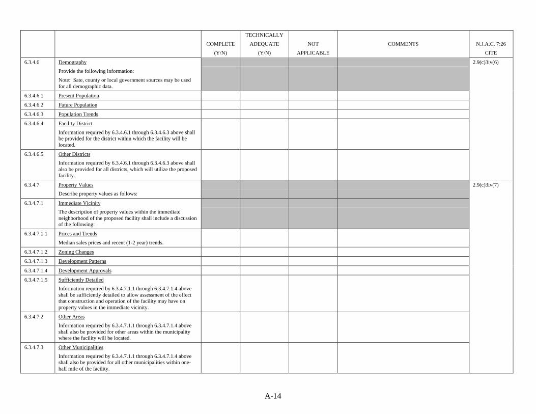
A-14
COMPLETE
(Y/N)
TECHNICALLY
ADEQUATE
(Y/N)
NOT
APPLICABLE
COMMENTS N.J.A.C. 7:26
CITE
6.3.4.6 Demography
Provide the following information:
Note: Sate, county or local government sources may be usedfor all demographic data.
6.3.4.6.1 Present Population
6.3.4.6.2 Future Population
6.3.4.6.3 Population Trends
6.3.4.6.4 Facility District
Information required by 6.3.4.6.1 through 6.3.4.6.3 above shallbe provided for the district within which the facility will belocated.
6.3.4.6.5 Other Districts
Information required by 6.3.4.6.1 through 6.3.4.6.3 above shallalso be provided for all districts, which will utilize the proposedfacility.
2.9(c)3iv(6)
6.3.4.7 Property Values
Describe property values as follows:
6.3.4.7.1 Immediate Vicinity
The description of property values within the immediateneighborhood of the proposed facility shall include a discussionof the following:
6.3.4.7.1.1 Prices and Trends
Median sales prices and recent (1-2 year) trends.
6.3.4.7.1.2 Zoning Changes
6.3.4.7.1.3 Development Patterns
6.3.4.7.1.4 Development Approvals
2.9(c)3iv(7)
6.3.4.7.1.5 Sufficiently Detailed
Information required by 6.3.4.7.1.1 through 6.3.4.7.1.4 aboveshall be sufficiently detailed to allow assessment of the effectthat construction and operation of the facility may have onproperty values in the immediate vicinity.
6.3.4.7.2 Other Areas
Information required by 6.3.4.7.1.1 through 6.3.4.7.1.4 aboveshall also be provided for other areas within the municipalitywhere the facility will be located.
6.3.4.7.3 Other Municipalities
Information required by 6.3.4.7.1.1 through 6.3.4.7.1.4 aboveshall also be provided for all other municipalities within one-half mile of the facility.

A-15
COMPLETE
(Y/N)
TECHNICALLY
ADEQUATE
(Y/N)
NOT
APPLICABLE
COMMENTS N.J.A.C. 7:26
CITE
6.3.4.8 Public Services
Describe public services available in the municipality in whichthe facility will be located by identifying the following:
6.3.4.8.1 Law Enforcement Services
6.3.4.8.2 Fire Protection Services
6.3.4.8.3 Health Protection Capabilities
2.9(c)3iv(8)
6.3.4.9 Community Facilities
Describe and map the location of community facilities,including but not limited to the following:
6.3.4.9.1 Hospitals
6.3.4.9.2 Nursing Homes
6.3.4.9.3 Food Processing Centers
6.3.4.9.4 Playgrounds
6.3.4.9.5 Parks
6.3.4.9.6 Schools
6.3.4.9.7 Residences
2.9(c)3iv(9)
6.4 Operations Description
Provide a detailed description of the proposed facilityoperations, including the following:
2.9(c)4
6.4.1 Project Sponsor
Identify the project sponsor by providing the followinginformation:
6.4.1.1 Name
6.4.1.2 Address
6.4.1.3 Telephone Number
2.9(c)4i
6.4.1.4 Associations with Other Waste Management Projects
If the sponsor is presently, or was previously, associated withany other waste disposal or collection project or operation,provide the following:
6.4.1.4.1 Project Name
Identify the project or operation.
6.4.1.4.2 Responsibilities
Describe the sponsor’s responsibilities during any projectidentified in 6.4.1.4.1 above.

A-16
COMPLETE
(Y/N)
TECHNICALLY
ADEQUATE
(Y/N)
NOT
APPLICABLE
COMMENTS N.J.A.C. 7:26
CITE
6.4.2 Purpose
Explain the purpose of the proposed facility by providing thefollowing:
6.4.2.1 Description of Services
Describe the products or services being provided.
6.4.2.2 List of Benefits
List the benefits to be realized by the owner, the community inwhich the facility is to be located, and the surroundingcommunities.
2.9(c)4ii
6.4.3 Existing or Potential Markets
Describe the existing or potential markets for each of theproducts to be recovered by the solid waste facility operationby providing the following:
6.4.3.1 Identification of Products
Describe the types, quality and daily quantities of products tobe recovered.
6.4.3.2 Quality Control
Provide the elements of a quality control plan for the recoveredproducts.
6.4.3.3 Contracts
Provide a copy of any long-term contracts for the sale of therecovered products, OR
6.4.3.4 Letter of Intent
If long-term contracts have not yet been finalized, provide adetailed letter of intent, describing the areas of agreement anddisagreement.
6.4.3.5 Description of End Use
Describe the purchaser’s end use of the recovered products.
2.9(c)4iii
6.4.4 Economic Analysis
Provide an economic analysis of the proposed facility,including:
2.9(c)4iv
6.4.4.1 Revenue Projection
Approximate and project any revenues to be realized from thesale of recovered products.

A-17
COMPLETE
(Y/N)
TECHNICALLY
ADEQUATE
(Y/N)
NOT
APPLICABLE
COMMENTS N.J.A.C. 7:26
CITE
6.4.4.2 Expenditures Projection
Approximate and project capital, operating and maintenanceexpenditures.
6.4.4.3 Waste Processing Charges
Project maximum and minimum charges to be assessed for thevarious waste types to be handled, including an estimate of theinitial tipping charges.
2.9(c)4iv
6.4.5 Waste Streams Identification and Guarantee
6.4.5.1 Identification
Describe the waste streams, which will be accepted by thefacility.
6.4.5.2 Guarantee
Provide copies of any agreements, which will guarantee asteady flow of the wastes identified in 6.4.5.1 above to thefacility.
2.9(c)4v
6.4.6 Time Schedule
Provide a time schedule for the development and startup of theproposed facility, including anticipated completion dates formajor phases of the construction.
2.9(c)4vi
6.4.7 Description of Processes
Provide a narrative description of the disposal processes to beused, including the following information:
2.9(c)4vii
6.4.7.1 Process Types
6.4.7.2 Number of Units
6.4.7.3 Process Capacities
2.9(c)4vii(1)
6.4.7.4 Daily Handling Capacity
6.4.7.5 Hourly Handling Capacity
6.4.7.6 Anticipated Operating Times
Provide anticipated operating times in hours per day and daysper week. Provide schedules of operating hours dedicated forwaste acceptance and waste processing.
Note: If weekly averaging is proposed, provide the number ofdays of operation per week, tons of waste to be accepted perweek and daily maximums.
2.9(c)4vii(2)
6.4.7.7 Process Control Measures
6.4.7.8 Process Monitoring Instrumentation
2.9(c)4vii

A-18
COMPLETE
(Y/N)
TECHNICALLY
ADEQUATE
(Y/N)
NOT
APPLICABLE
COMMENTS N.J.A.C. 7:26
CITE
6.4.8 Process Residues Management
Describe any process residues and side-stream wastes resultingfrom facility operations, including the following information:
6.4.8.1 Quantity
6.4.8.2 Physical/Chemical Characteristics
6.4.8.3 Methods of Disposal
Discuss appropriate methods of disposal of process residues,including the following information, where applicable:
6.4.8.3.1 Disposal Contracts
6.4.8.3.2 District Plan Inclusion
6.4.8.3.3 Primary Disposal Sites
6.4.8.3.4 Alternate Disposal Sites
6.4.8.3.5 Methods of Storage & Handling
6.4.8.3.6 Methods of Reuse or Recycling
2.9(c)4viii
6.5 Conformance with Plans, Policies and Regulations
Provide a discussion of the relationship of the proposed actionto federal, State, county and local land-use plans, policies,controls and environmental regulations, including thefollowing:
2.9(c)5
6.5.1 Present Land Use
Describe present land use as follows:
6.5.1.1 Facility Site
6.5.1.2 Adjacent Areas
Areas within 2 miles of the property line.
6.5.1.3 Zoning Maps
6.5.1.4 Use Restrictions Chart
6.5.1.5 Landfill Data
If any portion of the facility site or areas adjacent to the sitewas previously used for the landfilling of wastes, provide thefollowing information:
6.5.1.5.1 Depth
6.5.1.5.2 Area of Deposition
6.5.1.5.3 Waste Types
6.5.1.5.4 Gas Concentration
6.5.1.5.5 Gas Migration
6.5.1.5.6 Settlement
2.9(c)5i

A-19
COMPLETE
(Y/N)
TECHNICALLY
ADEQUATE
(Y/N)
NOT
APPLICABLE
COMMENTS N.J.A.C. 7:26
CITE
6.5.1.5.7 Other Factors
Discuss any other factors, which may affect construction oroperation of the proposed facility.
2.9(c)5i
6.5.2 Conformance with Requirements
Describe how the project will conform or conflict with theobjectives of any federal, state or local land use orenvironmental requirements, including:
2.9(c)5ii
6.5.2.1 Flood Hazard Requirements
Floodway, flood fringe or flood hazard areas identified by theNew Jersey Flood Hazard Area Control Act or by floodinsurance studies prepared by the Federal EmergencyManagement Agency.
2.9(c)5ii(1)
6.5.2.2 Wild & Scenic Areas
Areas designated as wild, scenic, recreational or developedrecreational rivers pursuant to the National Wild and ScenicRivers Act or the New Jersey Wild and Scenic River Act.
2.9(c)5ii(2)
6.5.2.3 Critical Habitat
Critical habitat of endangered or threatened species of plants,fish or wildlife as defined by the Federal Endangered SpeciesAct or the New Jersey Endangered and Non-Game SpeciesConservation Act.
2.9(c)5ii(3)
6.5.2.4 Wetlands, Tidelands & Coastal Zones
Wetlands, tidelands and coastal zone areas as identified by theDepartment pursuant to the Wetlands and Coastal Resource andDevelopment Policies and as identified on the U.S. Fish andWildlife Services National Wetlands Inventory Maps.
2.9(c)5ii(4)
6.5.2.5 Pinelands Area
Preservation and Protection Areas as established by the NewJersey Pinelands Protection Act.
2.9(c)5ii(5)
6.5.2.6 Nonattainment Areas
Nonattainment areas as defined in N.J.A.C. 7:27-18
2.9(c)5ii(6)
6.5.2.7 PSD Areas
Areas subject to the Prevention of Significant Deteriorationcriteria as defined at 40 CFR 52.21.
2.9(c)5ii(7)
6.5.2.8 Acoustical Impact Areas
Areas which may impact the acoustical quality of residentialand commercial properties pursuant to N.J.A.C. 7:29.
2.9(c)5ii(8)
6.5.2.9 Water Quality Impact Areas
Areas which may significantly impact water quality pursuant toN.J.A.C. 7:15.
2.9(c)5ii(9)
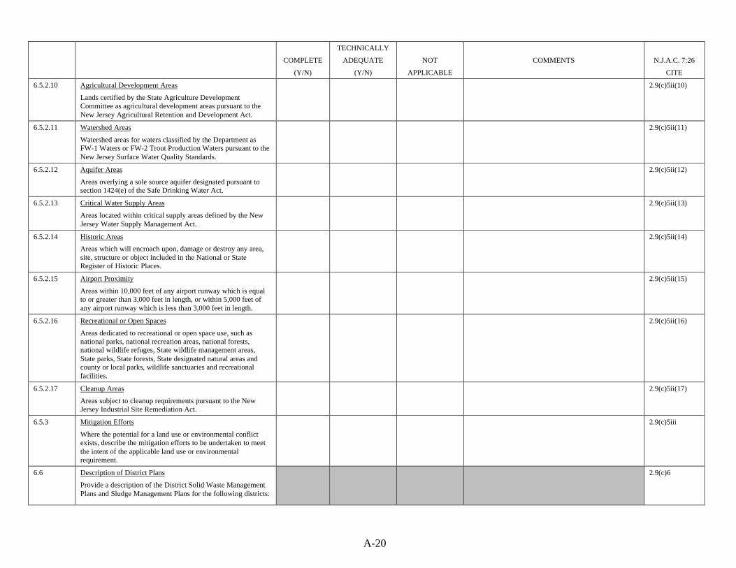
A-20
COMPLETE
(Y/N)
TECHNICALLY
ADEQUATE
(Y/N)
NOT
APPLICABLE
COMMENTS N.J.A.C. 7:26
CITE
6.5.2.10 Agricultural Development Areas
Lands certified by the State Agriculture DevelopmentCommittee as agricultural development areas pursuant to theNew Jersey Agricultural Retention and Development Act.
2.9(c)5ii(10)
6.5.2.11 Watershed Areas
Watershed areas for waters classified by the Department asFW-1 Waters or FW-2 Trout Production Waters pursuant to theNew Jersey Surface Water Quality Standards.
2.9(c)5ii(11)
6.5.2.12 Aquifer Areas
Areas overlying a sole source aquifer designated pursuant tosection 1424(e) of the Safe Drinking Water Act.
2.9(c)5ii(12)
6.5.2.13 Critical Water Supply Areas
Areas located within critical supply areas defined by the NewJersey Water Supply Management Act.
2.9(c)5ii(13)
6.5.2.14 Historic Areas
Areas which will encroach upon, damage or destroy any area,site, structure or object included in the National or StateRegister of Historic Places.
2.9(c)5ii(14)
6.5.2.15 Airport Proximity
Areas within 10,000 feet of any airport runway which is equalto or greater than 3,000 feet in length, or within 5,000 feet ofany airport runway which is less than 3,000 feet in length.
2.9(c)5ii(15)
6.5.2.16 Recreational or Open Spaces
Areas dedicated to recreational or open space use, such asnational parks, national recreation areas, national forests,national wildlife refuges, State wildlife management areas,State parks, State forests, State designated natural areas andcounty or local parks, wildlife sanctuaries and recreationalfacilities.
2.9(c)5ii(16)
6.5.2.17 Cleanup Areas
Areas subject to cleanup requirements pursuant to the NewJersey Industrial Site Remediation Act.
2.9(c)5ii(17)
6.5.3 Mitigation Efforts
Where the potential for a land use or environmental conflictexists, describe the mitigation efforts to be undertaken to meetthe intent of the applicable land use or environmentalrequirement.
2.9(c)5iii
6.6 Description of District Plans
Provide a description of the District Solid Waste ManagementPlans and Sludge Management Plans for the following districts:
2.9(c)6

A-21
COMPLETE
(Y/N)
TECHNICALLY
ADEQUATE
(Y/N)
NOT
APPLICABLE
COMMENTS N.J.A.C. 7:26
CITE
6.6.1 Facility District
For the district in which the facility will be located, describeeach plan as follows:
6.6.1.1 Solid Waste Management Plan
The description of the District Solid Waste Management Planshall contain the following:
2.9(c)6
6.6.1.1.1 Municipalities
Identify all municipalities within the district.
6.6.1.1.2 Plan Strategy
Describe the strategy of the plan as it pertains to the proposedfacility.
6.6.1.1.3 Waste Flow Agreements
Describe inter-district waste flow agreements.
`
6.6.1.1.4 Waste Flow Patterns
Describe intra-district waste flow patterns
6.6.1.1.5 Plan Duration
6.6.1.1.6 Recycling Goals
6.6.1.1.7 Waste Reduction Goals
6.6.1.1.8 Implementation Schedules
6.6.1.1.9 Plan Implementing Agencies
6.6.1.1.10 Plan Conformance
Describe how the proposed facility will conform with thecontent and strategy of the plan.
2.9(c)6i
6.6.1.1.11 Facility Need
Discuss the elements of the plan which indicate a need for thefacility.
6.6.1.1.12 Current Capacities
Discuss the facility’s relation to current solid waste disposalcapacities.
6.6.1.1.13 Guarantee Mechanisms
Describe the established mechanisms that will guarantee thenecessary waste flows to the proposed facility.
2.9(c)6ii
6.6.1.2 Sludge Management Plan
The description of the Sludge Management Plan shall containthe following:
2.9(c)6
6.6.1.2.1 Municipalities
Identify all municipalities within the district.
2.9(c)6i

A-22
COMPLETE
(Y/N)
TECHNICALLY
ADEQUATE
(Y/N)
NOT
APPLICABLE
COMMENTS N.J.A.C. 7:26
CITE
6.6.1.2.2 Plan Strategy
Describe the strategy of the plan as it pertains to the proposedfacility.
6.6.1.2.3 Waste Flow Agreements
Describe inter-district waste flow agreements.
6.6.1.2.4 Waste Flow Patterns
Describe intra-district waste flow patterns.
6.6.1.2.5 Plan Duration
6.6.1.2.6 Recycling Goals
6.6.1.2.7 Sludge Reduction Goals
6.6.1.2.8 Implementation Schedules
6.6.1.2.9 Plan Implementing Agencies
6.6.1.2.10 Plan Conformance
Describe how the proposed facility will conform with thecontent and strategy of the plan.
2.9(c)6i
6.6.1.2.11 Facility Need
Discuss the elements of the plan which indicate a need for thefacility.
6.6.1.2.12 Current Capacities
Discuss the facility’s relation to current sludge disposalcapacities.
6.6.1.2.13 Guarantee Mechanisms
Describe the established mechanisms that will guarantee thenecessary sludge flows to the proposed facility.
2.9(c)6ii
6.6.2 Sending Districts
For the districts from which the solid wastes will be received,describe each plan as follows:
6.2.1 Solid Waste Management Plan
The description of the District Solid Waste Management Planshall contain the following:
2.9(c)6
6.6.2.1.1 Municipalities
Identify all municipalities within the district.
6.6.2.1.2 Plan Strategy
Describe the strategy of the plan as it pertains to the proposedfacility.
6.6.2.1.3 Waste Flow Agreements
Describe inter-district waste flow agreements.
2.9(c)6i

A-23
COMPLETE
(Y/N)
TECHNICALLY
ADEQUATE
(Y/N)
NOT
APPLICABLE
COMMENTS N.J.A.C. 7:26
CITE
6.6.2.1.4 Waste Flow Patterns
Describe intra-district waste flow patterns.
6.6.2.1.5 Plan Duration
6.6.2.1.6 Recycling Goals
6.6.2.1.7 Waste Reduction Goals
6.6.2.1.8 Implementation Schedules
6.6.2.1.9 Plan Implementing Agencies
6.6.2.1.10 Plan Conformance
Describe how the proposed facility will conform with thecontent and strategy of the plan.
2.9(c)6i
6.6.2.1.11 Facility Need
Discuss the elements of the plan which indicate a need for thefacility.
6.6.2.1.12 Current Capabilities
Discuss the facility’s relation to current solid waste disposalcapacities.
6.6.2.1.13 Guarantee Mechanism
Describe established mechanisms that will guarantee thenecessary waste flows to the proposed facility.
2.9(c)6ii
6.6.2.2 Sludge Management Plan
The description of the Sludge Management Plan shall containthe following:
2.9(c)6
6.6.2.2.1 Municipalities
Identify all municipalities within the district.
6.6.2.2.2 Plan Strategy
Describe the strategy of the plan as it pertains to the proposedfacility.
6.6.2.2.3 Waste Flow Agreements
Describe inter-district waste flow agreements.
6.6.2.2.4 Waste Flow Patterns
Describe intra-district waste flow patterns
6.6.2.2.5 Plan Duration
6.6.2.2.6 Recycling Goals
6.6.2.2.7 Sludge Reduction Goals
6.6.2.2.8 Implementation Schedules
6.6.2.2.9 Plan Implementing Agencies
2.9(c)6i

A-24
COMPLETE
(Y/N)
TECHNICALLY
ADEQUATE
(Y/N)
NOT
APPLICABLE
COMMENTS N.J.A.C. 7:26
CITE
6.6.2.2.10 Plan Conformance
Describe how the proposed facility will conform with thecontent and strategy of the plan.
2.9(c)6i
6.6.2.2.11 Facility Need
Discuss the elements of the plan which indicate a need for thefacility.
6.6.2.2.12 Current Capacities
Discuss the facility’s relation to current sludge disposalcapacities.
6.6.2.2.13 Guarantee Mechanisms
Describe established mechanisms that will guarantee thenecessary sludge flows to the proposed facility.
2.9(c)6ii
6.6.3 Receiving Districts
For the districts where process residues from the proposedfacility are to be sent for disposal, describe each plan asfollows:
6.6.3.1 Solid Waste Management Plan
The description of the District Solid Waste Management Planshall contain the following:
2.9(c)6
6.6.3.1.1 Municipalities
Identify all municipalities within the district.
6.6.3.1.2 Plan Strategy
Describe the strategy of the plan as it pertains to the proposedfacility.
6.6.3.1.3 Waste Flow Agreements
Describe inter-district waste flow agreements.
6.6.3.1.4 Waste Flow Patterns
Describe intra-district waste flow patterns.
6.6.3.1.5 Plan Duration
6.6.3.1.6 Recycling Goals
6.6.3.1.7 Waste Reduction Goals
6.6.3.1.8 Implementation Schedules
6.6.3.1.9 Plan Implementing Agencies
6.6.3.1.10 Plan Conformance
Describe how the proposed facility will conform with thecontent and strategy of the plan.
2.9(c)6i

A-25
COMPLETE
(Y/N)
TECHNICALLY
ADEQUATE
(Y/N)
NOT
APPLICABLE
COMMENTS N.J.A.C. 7:26
CITE
6.6.3.1.11 Facility Need
Discuss the elements of the plan which indicate a need for thefacility.
2.9(c)6ii
6.6.3.1.12 Current Capacities
Discuss the facility’s relation to current solid waste disposalcapacities.
6.6.3.1.13 Guarantee Mechanism
Describe established mechanisms that will guarantee thenecessary waste flows to the proposed facility.
6.6.3.2 Sludge Management Plan
The description of the Sludge Management Plan shall containthe following:
2.9(c)6
6.6.3.2.1 Municipalities
Identify all municipalities within the district.
6.6.3.2.2 Plan Strategy
Describe the strategy of the plan as it pertains to the proposedfacility.
6.6.3.2.3 Waste Flow Agreements
Describe inter-district waste flow agreements.
6.6.3.2.4 Waste Flow Patterns
Describe intra-district waste flow patterns.
6.6.3.2.5 Plan Duration
6.6.3.2.6 Recycling Goals
6.6.3.2.7 Sludge Reduction Goals
6.6.3.2.8 Implementation Schedules
6.6.3.2.9 Plan Implementing Agencies
6.6.3.2.10 Plan Conformance
2.9(c)6i
6.6.3.2.11 Facility Need
Discuss the elements of the plan which indicate a need for thefacility.
6.6.3.2.12 Current Capacities
Discuss the facility’s relation to current sludge disposalcapacities.
6.6.3.2.13 Guarantee Mechanisms
Describe established mechanisms that will guarantee thenecessary sludge flows to the proposed facility.
2.9(c)6ii

A-26
COMPLETE
(Y/N)
TECHNICALLY
ADEQUATE
(Y/N)
NOT
APPLICABLE
COMMENTS N.J.A.C. 7:26
CITE
6.7 List of Permits
Provide a list and status report of all federal, state, county andlocal licenses, permits and certifications necessary for theproposed facility.
2.9(c)7
6.8 Environmental Assessment
Provide a detailed evaluation of the potential impacts of theproposed facility on the environment, including all parametersidentified in 6.3 above. The assessment shall include:
2.9(c)8
6.8.1 Impacts Evaluation
An evaluation of the impacts on each parameter, including thefollowing:
2.9(c)8i
6.8.1.1 Primary Impacts
Direct or immediate impacts, both positive and negative.
6.8.1.2 Secondary Impacts
Indirect or long range impacts, both positive and negative.
6.8.1.3 Maximum Usage
The evaluation shall assume conditions of maximum usage ofthe facility.
6.8.1.4 Site Usage Correlation
Correlate the impacts above with the various stages listedbelow:
6.8.1.4.1 Site Preparation
6.8.1.4.2 Facility Construction
6.8.1.4.3 Facility Operation
6.8.1.4.4 Closure
6.8.1.4.5 Post-Closure
6.8.1.5 All Parameters Evaluated
All parameters identified in the environmental inventory in 6.3above shall be evaluated for impacts.
2.9(c)8
6.8.2 Modeling Techniques
Describe the modeling techniques used to predict the impactsdiscussed in 6.8.1 above, as follows:
6.8.2.1 Identification of Techniques
Identify and describe the modeling techniques used.
6.8.2.2 Model Calibrated and Verified
2.9(c)8ii

A-27
COMPLETE
(Y/N)
TECHNICALLY
ADEQUATE
(Y/N)
NOT
APPLICABLE
COMMENTS N.J.A.C. 7:26
CITE
6.8.2.3 Copy Furnished
A copy of the model(s) shall be provided to the Department.
6.8.2.4 Best Judgment
Where accepted modeling technique is not available and bestprofessional judgment is used, provide a detailed description ofthe logical reasoning used and the assumptions made.
2.9(c)8ii
6.8.3 Mapping
Provide isopleths, grid maps or other maps to depict thefollowing:
6.8.3.1 Contaminant Migration
Potential zones of contaminant migration surrounding any andall sources of emissions or discharges.
6.8.3.2 Sources
Type and location of each source of contamination.
2.9(c)8iii
6.8.4 Quantification of Impacts
Provide a quantification of all impacts identified in 6.8.1 above.
Note: Where quantification is not included, provide anexplanation of the reason for the omission.
2.9(c)8iv
6.8.5 Qualitative Discussion of Impacts
Provide a qualitative discussion of all impacts identified in6.8.1 above.
2.9(c)8v
6.8.6 Mitigative Techniques
Provide a detailed description of the mitigative techniquesproposed to address any potential environmental impactsidentified in 6.8.1 above.
2.9(c)8vi
6.9 Summary Discussion
Provide a discussion of any potential adverse impacts identifiedin the environmental assessment in 6.8 above that cannot beavoided should the proposed facility be implemented. Thediscussion should include:
6.9.1 Impacts
A discussion of the implications of any impacts that cannot beavoided.
6.9.2 Reasons for Permitting
Discuss the reasons why the proposed facility should bepermitted.
6.9.3 Mitigative Measures
If mitigative measures are proposed to reduce the adverseimpacts, discuss the costs and effectiveness of these measures.
2.9(c)10

A-28
COMPLETE
(Y/N)
TECHNICALLY
ADEQUATE
(Y/N)
NOT
APPLICABLE
COMMENTS N.J.A.C. 7:26
CITE
6.10 Design Alternatives
Provide a comparison of reasonable design alternatives to theproposed facility in sufficient detail to permit independent andcomparative evaluation of the benefits, costs and environmentalimpacts of the design of the proposed facility and eachreasonable design alternative. The comparison shall include:
2.9(c)11
6.10.1 No Action
A discussion of the no action or no project alternative,addressing the major foreseeable consequences.
2.9(c)11i
6.10.2 Alternative Designs
A discussion of the feasibility of various alternative design orprocess changes, including those which could reduce or avoidsome or all of the adverse impacts identified in 6.9 above.
2.9(c)11ii
6.10.3 Economic Analyses
An economic analysis for both the chosen design and anydesign alternatives.
Note: Cost-effectiveness analysis, cost-revenue analysis orother techniques approved by the Department may beemployed.
2.9(c)11iii
6.10.4 Significant Differences
An identification of any significant differences inenvironmental impact, which would result from use of thedesign/process changes, identified in 6.10.2 above, as comparedto impacts resulting from the chosen alternative.
2.9(c)11iv
6.10.5 Comparison of Alternatives
A comparison, in matrix or other format, of the degree offeasibility and economic and environmental impacts of both thechosen alternative and the set of feasible alternatives identifiedin 6.10.2 above.
2.9(c)11v
6.10.6 Reasons for Selection
A discussion of the reasons why the proposed action wasselected over the alternatives.
2.9(c)11vi
6.11 Future Effects
Provide a discussion of the relationship between local, short-term (construction phase) uses of the environment and theeffect of the proposed facility on available options forsubsequent future uses. Describe the following:
2.9(c)12
6.11.1 Cumulative and Long-Term Effects
Cumulative and long-term effects of the proposed facilitywhich either negatively impact or enhance the environment forthe future.
2.9(c)12i

A-29
COMPLETE
(Y/N)
TECHNICALLY
ADEQUATE
(Y/N)
NOT
APPLICABLE
COMMENTS N.J.A.C. 7:26
CITE
6.11.2 Future Options
The extent to which the proposed facility prohibits futureoptions.
2.9(c)12ii
6.11.3 Protection During Construction
Plans which provide for the protection and maintenance of theenvironment during construction of the proposed facility,including the following:
2.9(c)12iii
6.11.3.1 Archeological Resources 2.9(c)12iii(1)
6.11.3.2 Erosion and Sediment Control 2.9(c)12iii(2)
6.11.3.3 Control of Dusts
6.11.3.4 Control of Odors
6.11.3.5 Control of Noise
6.11.3.6 Traffic Control
6.11.3.7 Control of Soil Tracking
2.9(c)12iii(3)
6.11.4 Protection After Termination
Plans which provide for the protection and maintenance of theenvironment after termination of facility operations.
2.9(c)12iv
6.12 Commitment of Resources
Provide a discussion of irreversible and irretrievablecommitments of resources resulting from the construction andoperation of the proposed facility. Include the following:
6.12.1 Use During Construction
An analysis of the use of renewable and nonrenewableresources during construction of the facility.
6.12.2 Use During Operation
An analysis of the use of renewable and nonrenewableresources throughout continued operation of the facility,including energy consumption.
6.12.3 Alternative Energy Sources
Compare alternative energy sources to the type selected andstate the rationale for selection.
2.9(c)13
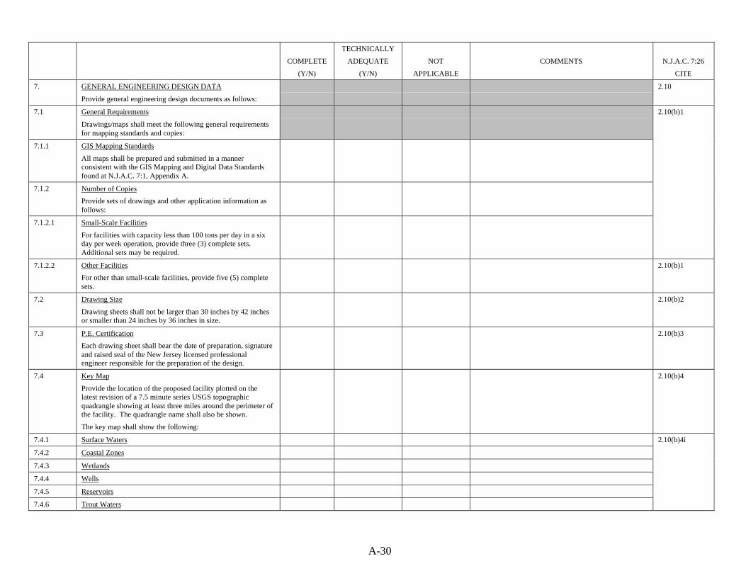
A-30
COMPLETE
(Y/N)
TECHNICALLY
ADEQUATE
(Y/N)
NOT
APPLICABLE
COMMENTS N.J.A.C. 7:26
CITE
7. GENERAL ENGINEERING DESIGN DATA
Provide general engineering design documents as follows:
2.10
7.1 General Requirements
Drawings/maps shall meet the following general requirementsfor mapping standards and copies:
7.1.1 GIS Mapping Standards
All maps shall be prepared and submitted in a mannerconsistent with the GIS Mapping and Digital Data Standardsfound at N.J.A.C. 7:1, Appendix A.
7.1.2 Number of Copies
Provide sets of drawings and other application information asfollows:
7.1.2.1 Small-Scale Facilities
For facilities with capacity less than 100 tons per day in a sixday per week operation, provide three (3) complete sets.Additional sets may be required.
2.10(b)1
7.1.2.2 Other Facilities
For other than small-scale facilities, provide five (5) completesets.
2.10(b)1
7.2 Drawing Size
Drawing sheets shall not be larger than 30 inches by 42 inchesor smaller than 24 inches by 36 inches in size.
2.10(b)2
7.3 P.E. Certification
Each drawing sheet shall bear the date of preparation, signatureand raised seal of the New Jersey licensed professionalengineer responsible for the preparation of the design.
2.10(b)3
7.4 Key Map
Provide the location of the proposed facility plotted on thelatest revision of a 7.5 minute series USGS topographicquadrangle showing at least three miles around the perimeter ofthe facility. The quadrangle name shall also be shown.
The key map shall show the following:
2.10(b)4
7.4.1 Surface Waters
7.4.2 Coastal Zones
7.4.3 Wetlands
7.4.4 Wells
7.4.5 Reservoirs
7.4.6 Trout Waters
2.10(b)4i
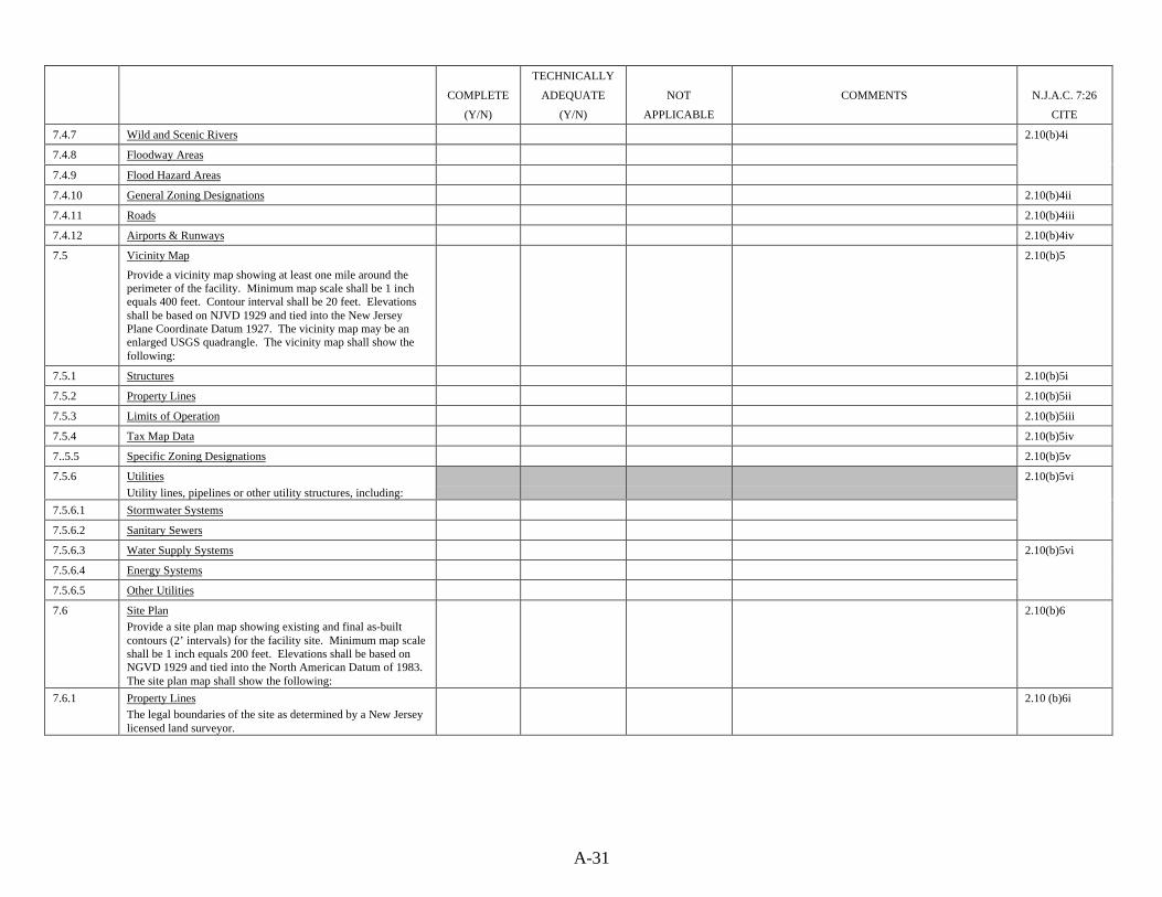
A-31
COMPLETE
(Y/N)
TECHNICALLY
ADEQUATE
(Y/N)
NOT
APPLICABLE
COMMENTS N.J.A.C. 7:26
CITE
7.4.7 Wild and Scenic Rivers
7.4.8 Floodway Areas
7.4.9 Flood Hazard Areas
2.10(b)4i
7.4.10 General Zoning Designations 2.10(b)4ii
7.4.11 Roads 2.10(b)4iii
7.4.12 Airports & Runways 2.10(b)4iv
7.5 Vicinity Map
Provide a vicinity map showing at least one mile around theperimeter of the facility. Minimum map scale shall be 1 inchequals 400 feet. Contour interval shall be 20 feet. Elevationsshall be based on NJVD 1929 and tied into the New JerseyPlane Coordinate Datum 1927. The vicinity map may be anenlarged USGS quadrangle. The vicinity map shall show thefollowing:
2.10(b)5
7.5.1 Structures 2.10(b)5i
7.5.2 Property Lines 2.10(b)5ii
7.5.3 Limits of Operation 2.10(b)5iii
7.5.4 Tax Map Data 2.10(b)5iv
7..5.5 Specific Zoning Designations 2.10(b)5v
7.5.6 Utilities
Utility lines, pipelines or other utility structures, including:
7.5.6.1 Stormwater Systems
7.5.6.2 Sanitary Sewers
2.10(b)5vi
7.5.6.3 Water Supply Systems
7.5.6.4 Energy Systems
7.5.6.5 Other Utilities
2.10(b)5vi
7.6 Site PlanProvide a site plan map showing existing and final as-builtcontours (2’ intervals) for the facility site. Minimum map scaleshall be 1 inch equals 200 feet. Elevations shall be based onNGVD 1929 and tied into the North American Datum of 1983.The site plan map shall show the following:
2.10(b)6
7.6.1 Property LinesThe legal boundaries of the site as determined by a New Jerseylicensed land surveyor.
2.10 (b)6i
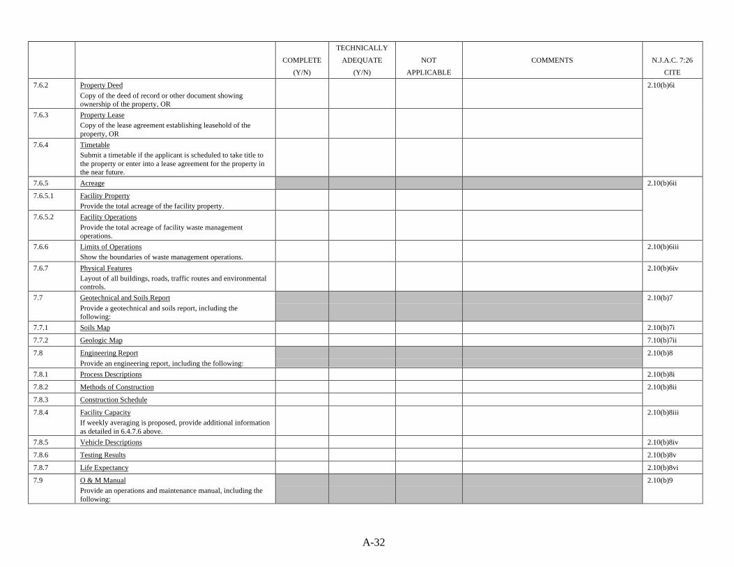
A-32
COMPLETE
(Y/N)
TECHNICALLY
ADEQUATE
(Y/N)
NOT
APPLICABLE
COMMENTS N.J.A.C. 7:26
CITE
7.6.2 Property Deed
Copy of the deed of record or other document showingownership of the property, OR
7.6.3 Property LeaseCopy of the lease agreement establishing leasehold of theproperty, OR
7.6.4 TimetableSubmit a timetable if the applicant is scheduled to take title tothe property or enter into a lease agreement for the property inthe near future.
2.10(b)6i
7.6.5 Acreage
7.6.5.1 Facility PropertyProvide the total acreage of the facility property.
7.6.5.2 Facility Operations
Provide the total acreage of facility waste managementoperations.
2.10(b)6ii
7.6.6 Limits of OperationsShow the boundaries of waste management operations.
2.10(b)6iii
7.6.7 Physical FeaturesLayout of all buildings, roads, traffic routes and environmentalcontrols.
2.10(b)6iv
7.7 Geotechnical and Soils Report
Provide a geotechnical and soils report, including thefollowing:
2.10(b)7
7.7.1 Soils Map 2.10(b)7i
7.7.2 Geologic Map 7.10(b)7ii
7.8 Engineering Report
Provide an engineering report, including the following:
2.10(b)8
7.8.1 Process Descriptions 2.10(b)8i
7.8.2 Methods of Construction
7.8.3 Construction Schedule
2.10(b)8ii
7.8.4 Facility CapacityIf weekly averaging is proposed, provide additional informationas detailed in 6.4.7.6 above.
2.10(b)8iii
7.8.5 Vehicle Descriptions 2.10(b)8iv
7.8.6 Testing Results 2.10(b)8v
7.8.7 Life Expectancy 2.10(b)8vi
7.9 O & M ManualProvide an operations and maintenance manual, including thefollowing:
2.10(b)9

A-33
COMPLETE
(Y/N)
TECHNICALLY
ADEQUATE
(Y/N)
NOT
APPLICABLE
COMMENTS N.J.A.C. 7:26
CITE
7.9.1 Operations Description
A description of proposed methods of facility operation,including:
2.10(b)9i
7.9.1.1 Hours of Operation
7.9.1.1.1 Waste Acceptance Hours
7.9.1.1.2 Waste Processing Hours
2.10(b)9i(1)
7.9.1.2 Equipment
Procedures for the operation of each major facility componentand equipment item.
2.10(b)9i(2)
7.9.1.3 Implementation Schedule 2.10(b)9i(3)
7.9.1.4 Monitoring
7.9.1.4.1 On-Site Traffic Control Plan
7.9.1.4.2 Noise Monitoring
Procedures to monitor truck noise and to exclude from thefacility trucks which produce excessive noise.
7.9.1.4.3 Staffing PlanProvide a facility staffing plan indicating the following:
7.9.1.4.3.1 Job Titles
7.9.1.4.3.2 Job DescriptionsJob descriptions for each position at the facility, including:
7.9.1.4.3.3 Duties
7.9.1.4.3.4 Performance Standards
7.9.1.4.3.5 Skills
7.9.1.4.3.6 Education
7.9.1.4.3.7 Other Qualifications
2.10(b)9i(4)
7.9.1.4.4 Incoming Waste Inspection Plan
A plan describing how incoming wastes will be inspected toidentify recyclable materials, prohibited waste types and theincidence of designated recyclables mandated to be sourceseparated by the County District Recycling Plan.
7.9.1.5 SecurityFacility security systems, including communications and alarmssystems.
2.10(b)9i(5)
7.9.1.6 Methods to Meet N.J.A.C. 7:26-2.11A description of methods which will be used to meet thegeneral operational requirements for solid waste facilities foundat N.J.A.C. 7:26-2.11(b), including the following:
2.10(b)9i(6)
7.9.1.6.1 CleaningEach area of the facility where waste has been deposited orstored shall be cleaned at least once each 24 hours.
2.11(b)1

A-34
COMPLETE
(Y/N)
TECHNICALLY
ADEQUATE
(Y/N)
NOT
APPLICABLE
COMMENTS N.J.A.C. 7:26
CITE
7.9.1.6.2 Odor Control
Treatment to prevent odors associated with putrefaction shallbe provided whenever wastes are stored overnight at thefacility.
2.11(b)2
7.9.1.6.3 Litter Control
Facility property shall be maintained free of litter, debris, andaccumulations of waste, process residues and effluents.Methods to control wind-blown papers and other lightweightmaterials shall be provided.
2.11(b)3
7.9.1.6.4 Dust ControlMethods to prevent off-site migration of dusts shall beprovided.
2.11(b)4
7.9.1.6.5 Off-Site OdorsFacility operations shall not result in the detection of off-siteodors in any area of human occupancy.
2.11(b)5
7.9.1.6.6 Systems Maintenance
Facility systems and appurtenances shall be maintained in amanner that minimizes system downtime and facilitates properoperation. The operator shall furnish (upon request) proof thatprovisions have been made for the repair or replacement ofinoperative equipment.
2.11(b)6
7.9.1.6.7 Fire ControlMethods and measures to control fires shall be provided asfollows:
7.9.1.6.7.1 Water SupplyA water supply adequate to extinguish any and all types of firesshall be maintained at the facility or be readily available.
7.9.1.6.7.2 Fire-Fighting EquipmentEquipment adequate to fight any and all types of fires shall bemaintained at the facility or be readily available.
2.11(b)7
7.9.1.6.7.3 Posting of Procedures
Fire-fighting procedures as delineated in the approved O&MManual, including telephone numbers of local police, fire,ambulance and hospital facilities shall be posted in and aroundthe facility at all times.
2.11(b)7
7.9.1.6.8 Pest ControlMethods and measures to control pests shall be provided asfollows:
7.9.1.6.8.1 Control Program
A program to effectively control insects, other arthropods androdents in compliance with the New Jersey Pesticide ControlCode at N.J.A.C. 7:30.
7.9.1.6.8.2 Certified Operator
Application of pesticides shall be performed by an operatorcertified in accordance with the New Jersey Pesticide ControlCode at N.J.A.C. 7:30.
2.11(b)8
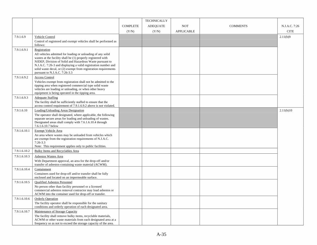
A-35
COMPLETE
(Y/N)
TECHNICALLY
ADEQUATE
(Y/N)
NOT
APPLICABLE
COMMENTS N.J.A.C. 7:26
CITE
7.9.1.6.9 Vehicle Control
Control of registered and exempt vehicles shall be performed asfollows:
7.9.1.6.9.1 RegistrationAll vehicles admitted for loading or unloading of any solidwastes at the facility shall be (1) properly registered withNJDEP, Division of Solid and Hazardous Waste pursuant toN.J.A.C. 7:26-3 and displaying a valid registration number andsolid waste decal, or (2) exempt from registration requirementspursuant to N.J.A.C. 7:26-3.3
7.9.1.6.9.2 Access Control
Vehicles exempt from registration shall not be admitted to thetipping area when registered commercial type solid wastevehicles are loading or unloading, or when other heavyequipment is being operated in the tipping area.
7.9.1.6.9.3 Adequate StaffingThe facility shall be sufficiently staffed to ensure that theaccess control requirement of 7.9.1.6.9.2 above is not violated.
2.11(b)9
7.9.1.6.10 Loading/Unloading Areas Designation
The operator shall designated, where applicable, the followingseparate secure areas for loading and unloading of wastes.Designated areas shall comply with 7.6.1.6.10.4 through7.6.1.6.10.7 below
7.9.1.6.10.1 Exempt Vehicle AreaAn area where wastes may be unloaded from vehicles whichare exempt from the registration requirements of N.J.A.C.7:26-3.3Note: This requirement applies only to public facilities.
7.9.1.6.10.2 Bulky Items and Recyclables Area
2.11(b)10
7.9.1.6.10.3 Asbestos Wastes Area
With Department approval, an area for the drop-off and/ortransfer of asbestos-containing waste material (ACWM).
7.9.1.6.10.4 ContainmentContainers used for drop-off and/or transfer shall be fullyenclosed and located on an impermeable surface.
7.9.1.6.10.5 Qualified Asbestos PersonnelNo person other than facility personnel or a licensedcommercial asbestos removal contractor may load asbestos orACWM into the container used for drop-off or transfer.
7.9.1.6.10.6 Orderly OperationThe facility operator shall be responsible for the sanitaryconditions and orderly operation of each designated area.
7.9.1.6.10.7 Maintenance of Storage Capacity
The facility shall remove bulky items, recyclable materials,ACWM or other waste materials from each designated area at afrequency so as not to exceed the storage capacity of the area.

A-36
COMPLETE
(Y/N)
TECHNICALLY
ADEQUATE
(Y/N)
NOT
APPLICABLE
COMMENTS N.J.A.C. 7:26
CITE
7.9.1.6.11 Compliance with Permit
The operator shall at all times comply with the conditions of thetransfer station/material recovery facility permit, as well as allother permits or other approvals issued by the Department orany other governmental agency. The operator shall not receive,store, handle, process or dispose of waste types not specificallyauthorized in the facility’s permit.
2.11(b)11
7.9.1.6.12 Designation of Unpermitted Waste Types Area
The operator shall designate a secure area under the facility’scontrol located a safe distance from the active disposal area,where unauthorized solid wastes, including suspectedhazardous wastes, may be held until the operator receivesinstruction from the Department as to the proper disposition ofthe unpermitted waste.
2.11(b)12
7.9.1.6.13 Record of Waste ReceiptsThe facility operator shall maintain a record of the quantity ofeach authorized waste type accepted at the facility, inaccordance with N.J.A.C. 7:26-2.13 and 3.2Note: If the facility is exempt from the requirement to usescales to weigh the waste, volume to weight conversions shallbe made using the formula found at N.J.A.C. 7:26-2B.
` 2.11(b)13
7.9.1.6.14 Right of Entry and InspectionDepartment inspectors have the right to enter and inspect anybuilding or other portion of the facility at any time. The rightto inspect includes, but is not limited to the following:
7.9.1.6.14.1 Sampling
7.9.1.6.14.2 Photographing
7.9.1.6.14.3 Investigating
2.11(b)14
7.9.1.6.14.4 Ascertaining ComplianceAscertaining compliance or non-compliance with Departmentstatutes, rules or regulations, including transfer station/materialrecovery facility permit conditions or conditions of otherpermits, certificates or approvals issued by the Department.
7.9.1.6.14.5 Reviewing Records
Reviewing and copying all applicable records, which shall befurnished upon request and made available at all reasonabletimes for inspection.

A-37
COMPLETE
(Y/N)
TECHNICALLY
ADEQUATE
(Y/N)
NOT
APPLICABLE
COMMENTS N.J.A.C. 7:26
CITE
7.9.1.6.15 Design Capacity
The quantity of waste received shall not exceed the facility’sdesigned storage, processing or disposal capacity as identifiedin the facility permit.Note: The designed processing capacity approved withinpermit conditions as a ton per day operational maximum shallbe inclusive of all solid wastes received at the facility as well astonnages of source separated recyclables received. However, aseparate approved capacity for Class A or Class B recyclablematerials may also be maintained (as part of an approval forClass A or Class B Recycling Center) in addition to the solidwaste facility design capacity.
2.11(b)15
7.9.1.6.16 Operating MethodsThe facility shall be operated in a manner that employs the useof those equipment and techniques that are specificallyauthorized by the facility’s permit for the receipt, storage,handling, processing or disposal of incoming wastes andprocess residues.
` 2.11(b)16
7.9.1.6.17 Tire CleaningThe operator shall provide a means of removing mud, solidwastes or other debris from the tires of all vehicles. Tires shallbe cleaned prior to the vehicles’ departure from the facility site.
2.11(b)17
7.9.1.6.18 Maintenance of O&M ManualThe approved final O&M Manual shall be maintained at thefacility. The operator shall submit any proposed changes to thefinal O&M Manual to the Department for review. Proposedchanges shall not be implemented until approved by theDepartment.
2.11(b)18
7.9.2 Inspection PlanProvide a plan for inspecting all major aspects of facilityoperations necessary to achieve compliance with N.J.A.C. 7:26-2 and 2B. The plan shall include the following:
7.9.2.1 ScheduleA schedule for inspecting the following items:
7.9.2.1.1 Monitoring Equipment
7.9.2.1.2 Safety Equipment
7.9.2.1.3 Emergency Equipment
7.9.2.1.4 Security Devices
2.10(b)9ii
7.9.2.1.5 Process Operating Equipment
7.9.2.1.6 Structural Equipment

A-38
COMPLETE
(Y/N)
TECHNICALLY
ADEQUATE
(Y/N)
NOT
APPLICABLE
COMMENTS N.J.A.C. 7:26
CITE
7.9.2.2 Frequency
The frequency of inspection shall be based on the rate ofpotential equipment deterioration or malfunction.Note: Areas subject to spills shall be inspected daily when inuse.
7.9.2.3 Types of ProblemsThe inspection plan shall identify the types of problems whichare to be looked for during inspection.
2.10(b)9ii
7.9.2.4 Hazardous Waste DetectionA program for detecting and preventing the disposal ofregulated hazardous wastes, PCB wastes or other unauthorizedwastes, including the following:
2.10(b)9ii(1)
7.9.2.4.1 Incoming Load InspectionsRandom inspections of incoming waste loads, unless theapplicant demonstrates that other steps are taken to ensure thatincoming shipments do not contain hazardous wastes or PCBwastes.
2.10(b)9ii(1)(A)
7.9.2.4.2 Records of Inspections 2.10(b)9ii(1)(B)
7.9.2.4.3 Personnel TrainingA staff training plan, describing the type and amount of bothinitial and follow-up training to be provided for the following:
7.9.2.4.3.1 Incoming Waste Inspections
7.9.2.4.3.2 Unauthorized WasteHow employees will be trained to identify and manageunauthorized wastes.
7.9.2.4.3.3 Fire Training
7.9.2.4.3.4 Noise Monitoring
2.10(b)9ii(1)(C)
7.9.2.4.4 Notification ProceduresProcedures to report to the Department any discovery ofregulated hazardous wastes or PCB wastes at the facility.
2.10(b)9ii(1)(D)
7.9.3 Maintenance PlanProvide a facility maintenance plan, which shall include thefollowing items:
7.9.3.1 Equipment Analysis
An analysis of all major aspects of the facility operation basedon established rates of equipment deterioration or malfunction.
7.9.3.2 Parts AnalysisAn analysis of spare parts inventory needs for the facility.
7.9.3.3 Repair Schedules
7.9.3.4 Maintenance Contracts
2.10(b)9iii
7.9.4 Safety PlanFacility safety considerations, including the following:
2.10(b)9iv

A-39
COMPLETE
(Y/N)
TECHNICALLY
ADEQUATE
(Y/N)
NOT
APPLICABLE
COMMENTS N.J.A.C. 7:26
CITE
7.9.4.1 Injury Protection
Procedures to protect personnel from injury.
7.9.4.2 Contingency PlanAn emergency contingency plan, including the following items:
7.9.4.2.1 Description of Actions
Describe actions and procedures for responding to fires,explosions or releases of harmful substances to air, soil orwaters.
7.9.4.2.2. Arrangements for Entry
Describe arrangements made with NJDEP and with local policeand fire officials to allow immediate entry into the facility torespond to emergencies.
7.9.4.2.3 List of Coordinators
A list of names, addresses and telephone numbers (office andhome) of persons qualified to act as emergency coordinator forthe facility. Where more than one person is listed, one personshall be named as primary emergency coordinator and theothers listed in the order in which they will assumeresponsibility as alternates.
7.9.4.2.4 Distribution of Copies
A demonstration that copies of the contingency plan have beensubmitted to local police, fire departments, local and countyhealth departments and other offices of emergencymanagement.
2.10(b)9iv
7.9.5 Peak Loading PlanProvide a description of proposed measures to handle unusualpeak loadings which may exceed design capacity.
2.10(b)9v
7.9.6 Shutdown PlanDescribe proposed methods to handle incoming waste flowduring periods of short-term and long-term shutdown,equipment breakdown or other emergencies.
2.10(b)9vi
7.9.7 Final O&M ManualProvide a final O&M annual addressing any deficiencies theDepartment has identified. The final O&M Manual shall besubmitted after completion of construction, but at least 60 daysprior to initiating full-scale operations.Note: The requirement for a final O&M Manual applies only tonewly-constructed facilities.
2.10(b)10
7.10 Landscaping PlanProvide a facility landscaping plan, including the following:
7.10.1 Vegetation DelineationIdentify vegetation type, location and purpose (buffer,screening or aesthetics)
7.10.2 Protection Methods
2.10(b)11
7.10.3 Planting Schedule
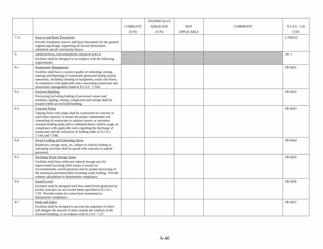
A-40
COMPLETE
(Y/N)
TECHNICALLY
ADEQUATE
(Y/N)
NOT
APPLICABLE
COMMENTS N.J.A.C. 7:26
CITE
7.11 Sources and Basis Documents
Provide foundation sources and basis documents for the generalengineering design, supporting all factual informationsubmitted and all conclusions drawn.
2.10(b)12
8. ADDITIONAL ENGINEERING DESIGN DATA
Facilities shall be designed in accordance with the followingrequirements:
2B..5
8.1 Wastewater Management
Facilities shall have a system capable of collecting, storing,treating and disposing of wastewater generated during normaloperations, including cleaning of equipment, trucks and floors,in compliance with applicable rules concerning wastewater andstormwater management found at N.J.A.C. 7:14A.
2B.5(b)1
8.2 Enclosed BuildingProcessing (including loading of processed wastes andresidues), tipping, sorting, compaction and storage shall belocated within an enclosed building.
2B.5(b)2
8.3 Concrete FloorsTipping floors and ramps shall be constructed of concrete orequivalent material, to ensure the proper containment andchanneling of wastewater to sanitary sewers or corrosion-resistant holding tanks and to withstand heavy vehicle usage, incompliance with applicable rules regarding the discharge ofwastewater and the utilization of holding tanks at N.J.A.C.7:14A and 7:14B.
2B.5(b)3
8.4 Paved Loading and Unloading Areas
Roadways, storage areas, etc. subject to vehicle loading orunloading activities shall be paved with concrete or asphaltpavement.
2B.5(b)4
8.5 Incoming Waste Storage Areas
Facilities shall have sufficient internal storage area forunprocessed incoming solid wastes to ensure anenvironmentally sound operation and for proper processing ofthe maximum permitted daily incoming waste loading. Providevolume calculations to demonstrate compliance.
2B.5(b)5
8.6 Sound Levels
Facilities shall be designed such that sound levels generated byfacility activities do not exceed limits specified in N.J.A.C.7:29. Provide results of a noise level assessment todemonstrate compliance.
2B.5(b)6
8.7 Dusts and OdorsFacilities shall be designed to prevent the migration of odorsand mitigate the amount of dusts outside the confines of theenclosed building, in accordance with N.J.A.C. 7:27.
2B.5(b)7

A-41
COMPLETE
(Y/N)
TECHNICALLY
ADEQUATE
(Y/N)
NOT
APPLICABLE
COMMENTS N.J.A.C. 7:26
CITE
8.8 Vehicular Movement
Onsite vehicular movement shall be fluid, in accordance withthe approved on-site queuing plan. Traffic backups and relatedtraffic hazards on access roads servicing the facility shall beprevented. Provide the on-site queuing and staging plan todemonstrate compliance.
2B.5(b)8
8.9 Offsite Truck RoutesOffsite truck routes shall be designed to minimize impacts onsurrounding residential areas or similar receptors. Truck trafficto and from the facility shall not result in an unacceptabledecrease in the level of service, as defined in the NJDOTHighway Access Management Code found at N.J.A.C. 16:47, atmajor intersections located along the designated truck routes.Provide a traffic assessment and evaluation in accordance withthe Technical Manual policy statement and item 10 below.
2B.5(b)9
8.10 Setback AreasAll main building enclosures shall be located at least 50 feetfrom the facility property line.Note: The setback limit may be reduced if the applicantdemonstrates that the reduced setback will not have an adverseimpact on adjacent properties.
2B.5(b)10
8.11 Fire ProtectionFacilities shall be equipped with fire protection and alarmsystems designed to comply with N.J.A.C. 5:23-3.17 and NFPAStandards and capable of detecting, controlling andextinguishing any and all fires that may occur.
2B.5(b)11
8.12 SafetyThe installation, maintenance, operation and repair of allsystems within the interior layout of the facility shall complywith OSHA and the New Jersey Worker and Community Rightto Know Act.
2B.5(b)12
8.13 Construction Code
Facilities shall be designed and constructed in full conformancewith the requirements and specifications of the UniformConstruction Code at N.J.A.C. 5:23
2B.5(b)13
8.14 Utilities Demand
Facilities shall be designed so as not to place a demandexceeding the remaining use capability of existing physicalutilities (e.g. water supply, wastewater and stormwatercollection, energy supply, transportation systems, etc.)
2B.5(b)14
8.15 Ultimate Disposal FacilityThe name and location of all proposed ultimate disposalfacilities shall be identified for all wastes processed by thefacility.
2B.5(b)15
8.16 Site PlanThe site plan map identified in 7.6 above shall also show thefollowing:
2B.5(c)

A-42
COMPLETE
(Y/N)
TECHNICALLY
ADEQUATE
(Y/N)
NOT
APPLICABLE
COMMENTS N.J.A.C. 7:26
CITE
8.16.1 Layout
A layout of all buildings, structures and roadways indicatingconstruction materials.
2B.5(c)1
8.16.2 Plan ViewsShow building setback, side and rear distances betweenproposed structures and other existing structures, siteboundaries, roadways or parking areas.
8.16.3 Profile Views
Show profile views (including dimensions) of all structures andenclosures.
2B.5(c)2
8.16.4 Interior Floor PlanShow the layout, profile view and dimensions of processinglines, interior unloading, sorting, storage and loading areas.
2B.5(c)3
8.16.5 Transportation SystemDescription and detailed specifications of the proposed onsiteand offsite transportation system identifying constructionmaterials.
2B.5(c)4
8.16.6 Utilities PlanIdentify, locate and describe all utilities (including, but notlimited to stormwater systems, sanitary sewer systems, watersupply systems and energy systems) which will service thefacility, including a statement of carrying capacities of existingsystems and remaining capacities for future needs. Provideflow calculations to demonstrate compliance.
2B.5(c)5
8.17 Engineering ReportThe engineering report identified in 7.8 above shall include thefollowing:
2B.5(d)
8.17.1 Equipment DescriptionSchematic diagrams and detailed descriptions of all processequipment to be used, including rated and design capacity.
2B.5(d)1
8.17.2 Equipment Specifications
Equipment specifications, including make, model,manufacturer, reliability and efficiency.
2B.5(d)2
8.17.3 Storage TimeMaximum length of storage time for wastes and recyclablematerials.Note: Wastes may not be stored overnight on the tipping floor.Tipping floors must be cleaned at the end of each operatingday.
2B.5(d)3
8.17.4 Recycling ActivitiesDescription of any materials recycling or reclamation activitiesto be performed at the facility.
2B.5(d)4
8.18 Protection of WatersMethods of monitoring and protection of groundwaters andnearby surface waters, if the facility is to handle liquid waste orliquid-solid waste mixtures.
2B.5(e)

A-43
COMPLETE
(Y/N)
TECHNICALLY
ADEQUATE
(Y/N)
NOT
APPLICABLE
COMMENTS N.J.A.C. 7:26
CITE
8.19 Explosion Suppression
Design data for an explosion suppression system, if the facilityis equipped with mechanical size reduction equipment.
2B.5(f)
9. CERTIFICATION AND SIGNATURESApplications shall be signed and/or certified as follows:
2.4(e)
9.1 Registration StatementThe Registration Statement identified in 3. above shall besigned by:
2.4(e)1
9.1.1 Corporation
For a corporation, by a principal executive officer of at least thelevel of vice president, OR
2.4(e)1i
9.1.2 PartnershipFor a partnership or sole proprietorship, by a general partner orthe proprietor, OR
2.4(e)1ii
9.1.3 Public AgencyFor a municipality, state, federal or other public agency, byeither a principal executive officer or ranking elected official.
2.4(e)1iii
9.2 Other Application DocumentsThe EHIS identified in 6. above, the engineering designsidentified in 7. and 8. above, the engineering report identified in7.8 above and any addenda required by N.J.A.C. 7:26-2.4(f) or(g)4 shall be signed by:
2.4(e)2
9.2.1 CorporationFor a corporation, by a principal executive officer of at least thelevel of vice president (or duly authorized representative), OR
2.4(e)1i
9.2.2 PartnershipFor a partnership or sole proprietorship, by a general partner orthe proprietor, OR
2.4(e)1ii
9.2.3 Public Agency
For a municipality, state, federal or other public agency, byeither a principal executive officer or ranking elected official.Note: If a duly authorized representative signs, a writtenauthorization by one of the persons specified in 9.2.1, 9.2.2 or9.2.3 above specifying that representative shall be submitted tothe department.
2.4(e)1iii
9.3 Certification
Any person (applicant) signing the registration statement, EHIS, engineering designs, engineering reports or addenda identified in 9.1 or 9.2 above shall make the following certification:
“I certify under penalty of law that I have personally examined and am familiar with the information submitted in this document and all attachments and that, based on my inquiry of thoseindividuals immediately responsible for obtaining the information, I believe the information is true, accurate and complete. I am aware that there are significant penalties for submittingfalse information, including the possiblity of fine and imprisonment. I understand that, in addition to criminal penalties, I may be liable for a civil administrative penalty pursuant toN.J.A.C. 7:26-5 and that submitting false information may be grounds for denial, revocation or termination of any solid waste facility permit or vehicle registration for which I may beseeking approval or now hold.”
2.4(e)3

A-44
COMPLETE
(Y/N)
TECHNICALLY
ADEQUATE
(Y/N)
NOT
APPLICABLE
COMMENTS N.J.A.C. 7:26
CITE
10. TRAFFIC ASSESSMENT AND EVALUATION
Provide a traffic assessment and evaluation in accordance withthe Technical Manual policy statement and the following:Note: All calculations and analyses must be performed inaccordance with the NJ State Highway Access ManagementCode (N.J.A.C. 16:47) and the Transportation Research BoardHighway Capacity Manual.
2.B5(b)9&14
2.9(c)3iv(1)
2.10(b)8iv
10.1 Waste Delivery Schedule
A projection of the hourly daily trailer/truck schedule for thedelivery of the maximum anticipated solid waste and recyclablematerials into the facility. Provide the data base which supportsthis projection. This schedule will determine the facility’s peakhours.
Same as above.
10.2 Waste Shipment Schedule
A projection of the anticipated hourly daily trailer/truckschedule for shipment of solid waste and recyclable materialsout of the facility.Note: Ability to load waste out is restricted by waste deliveryschedules, traffic impact assessment and queuing and staging oftransfer vehicles, not by equipment processing capacity.
Same as above.
10.3 Off-Site Routes
Identify off-site traffic routes used by trucks to access and exitthe facility.
Same as above.
10.4 Intersections AnalysesAnalysis of critical intersections used by facility truck traffic.
Same as above.
10.5 Baseline Traffic Counts
Existing hourly traffic counts to include, at a minimum, thehours of facility operation. Roadway capacity shall also beincluded.
Same as above.
10.6 Traffic Analysis
The assessment and evaluation shall analyze the followingscenarios:
Same as above.
10.6.1 Roadway Peak Hour
Existing roadway peak hour, with and without facility trucktraffic.
Same as above.
10.6.2 Delivery Peak HourThe hour of peak waste deliveries, with and without facilitytruck traffic.
Same as above.
10.6.3 Other Peak HoursIdentify other peak hours, if the facility will operate 24 hoursper day.
Same as above.
10.7 Traffic Growth
Account for traffic growth for the projected period of full scalefacility operations, using the recommended NJDOT factor forthe area.
Same as above.

A-45
COMPLETE
(Y/N)
TECHNICALLY
ADEQUATE
(Y/N)
NOT
APPLICABLE
COMMENTS N.J.A.C. 7:26
CITE
11. NOISE LEVEL ASSESSMENT
Provide a noise level assessment in accordance with theTechnical Manual policy statement and the following:Note: The analysis shall include a baseline noise assessmentper 6.3.1.11 above in addition to the following:
2B.5(b)6
2.9(c)5ii(8)
2.9(c)3i(11)
11.1 Estimate Maximum LevelsEstimate peak hour noise levels for proposed maximum facilitycapacity for all noise sources, including:
Same as above.
11.1.1 Queuing Trucks Same as above.
11.1.2 Loading/UnloadingTruck loading/unloading activities, inside and outside thebuilding.
Same as above.
11.1.3 Pushing of Waste Same as above.
11.1.4 Yard Activities
Dropping or picking up containers, loading recyclables, etc.
Same as above.
11.1.5 Air Pollution Control Equipment Same as above.
11.1.6 Processing EquipmentCompactors, balers, grinders and any other processingequipment, inside and outside the facility.
Same as above.
11.2 Noise ProjectionNoise sources identified in 11.1 above shall be compounded,logarithmically added and projected to the nearest sensitivereceptors.Note: Noise regulations are land use based, not zoning based.Therefore, residential receivers in commercial or industrialzones are protected by the same standards as residentialreceivers in residential zones.Noise regulations consider commercial facilities to be sensitivereceptors. Industrial facilities are not considered sensitive.
Same as above.
11.3 Comparison with StandardsCompare the projected noise levels from 11.2 above with thenoise level standards found at N.J.A.C. 7:29 et seq. for day time(and for night time, if the facility will operate between thehours of 10:00 p.m. and 7:00 a.m.).
Same as above.
11.4 Mitigation MeasuresDescribe any necessary proposed mitigative measures to ensurecompliance with the standards, if the noise levels projected in11.2 above exceed any of the standards identified in 11.3above.
Same as above.

A-46
COMPLETE
(Y/N)
TECHNICALLY
ADEQUATE
(Y/N)
NOT
APPLICABLE
COMMENTS N.J.A.C. 7:26
CITE
12. ACCEPTANCE OF SLUDGES OR SLUDGE-RELATEDWASTESFacilities proposing to accept sludge or sludge-related wastetypes (liquid waste) shall provide the following:
None
12.1 District Plan Inclusion
Documentation that the facility has been included in therespective District Solid Waste Management Plan for theacceptance of the waste.
2.4(b)2

APPENDIX B

New Jersey Department of EnvironmentalProtection
Geographic Information System
Mapping the Present to ProtectNew Jersey's Future
Mapping and Digital Data
Standards
Prepared by:
New Jersey Department of Environmental ProtectionOffice of Information Resources ManagementBureau of Geographic Information AnalysisP.O. Box 428Trenton, NJ 08625-0428
November 1998

B-1
Index
Summary
1.0 Introduction
2.0 State Standard Map Resources and Mapping Criteria2.1 National Map Accuracy Standards2.2 New Jersey Basemaps that Meet NMAS
2.2.1 Hardcopy (mylar) Basemaps2.2.2 Hardcopy Basemap Resources
2.3 Digital Imagery2.4 Projections and Datums
2.4.1 Projection and Coordinate Systems2.4.2 Horizontal and Vertical Datums
2.5 Other Resources: Aerial Photography
3.0 Map Production Specifications3.1 Photo Interpretation3.2 Recompilation3.3 Data Automation
4.0 Global Positioning Systems
5.0 Remote Sensing
6.0 Data Transfer Standards6.1 Arc/INFO and ArcView Digital Exchange Standards
7.0 Metadata7.1 Metadata Template
Appendix A: Metadata ExampleAppendix B: Scale Horizontal Accuracy for NMAS
Appendix C: Quarterquad Template

B-2
SUMMARY
The New Jersey Department of Environmental Protection (DEP) hasdeveloped a Geographic Information System (GIS) for use by the Department forthe storage and analysis of cartographic (mapped) and related environmentalscientific and regulatory database information. A GIS is a computer mappingsystem used in the analysis of geographic data and databases. By AdministrativeOrder, Commissioner Shinn has required that mapped information be submitted tothe DEP according to the standards of this document such that the data can be inputto the DEP/GIS. This document details three important GIS concepts regarding thecreation, capture and delivery of mapped information. There are three basicstandard concepts that must be followed.
First, all mapping regardless of scale must meet or reference a publishedstandard, such as the United States National Map Accuracy Standard (NMAS), aGPS standard (state or federal), or a defined survey standard. This will guaranteetrue positional accuracy of the geographic data and, therefore, compatibility ofdigital information. GIS data must also be documented using the FederalGeographic Data Committee (FGDC) Metadata Standards or be FGDC metadatacompliant.
Second, it is required that for all mapping, geographic data be mapped in NewJersey state plane coordinates (SPC) in North American Datum 1983 (NAD83).SPC means a geographic reference system in the horizontal plane describing theposition of points or features with respect to other points in New Jersey. The officialsurvey base of the state is known as the New Jersey State Plane Coordinate Systemwhose geodetic positions have been adjusted on the NAD83 as per Chapter 218,Laws of New Jersey 1989.
Third, geographic data must be delivered according to standard media anddigital formats. Accepted formats and media are presented in the body of thispaper.
Resources: 1997 New Jersey GIS Resource Guide, NJDEP Maps and Publications, CD-ROM Series 2, #1, GIS Toolsfor Decision Making (609) 777-1039.
Mapping and Digital Data Standards, 1997, NJDEP, P.O. Box 428, Trenton, NJ 08625(609) 777- 0672.

B-3
MAPPING AND DIGITAL DATA STANDARDSNEW JERSEY DEPARTMENT OF ENVIRONMENTAL
PROTECTIONGEOGRAPHIC INFORMATION SYSTEM
1.0 INTRODUCTION
Geographic Information System (GIS) technology has become a state-of-the-arttool for innovative efforts nationally and within the State of New Jersey to protectthe natural environment and protect the public health of citizens. To adequatelyaddress these and other issues, the NJDEP must make decisions based on sound,accurate spatial data. This document provides guidance for the basic standards forcreating and distributing spatial data on a GIS. Basic standards will ensureconsistent data quality and documentation, provide for compatibility between datasets, and facilitate interactive analysis and ensure the quality of results derived fromthe GIS.
2.0 STATE STANDARD MAP RESOURCES and MAPPINGCRITERIA
2.1 National Map Accuracy Standards
The most common statement for accuracy for mapped information atcommon mapping scales for mapping is National Map Accuracy Standards(NMAS). These standards were established in 1947 and have formed the basis formapping accuracy by the United States Geological Survey (USGS) for the past 50years. Simply stated, NMAS requires that for horizontal accuracy, 90% of the well-defined points on a map must be within +/- 33.3 feet of their true position at 1:12000(1/30th of an inch where an inch = 1000ft.); +/- 40 feet at 1:24000 (1/50th of an inchwhere 1 inch = 2000ft.). Refer to Appendix B for a table on scale horizontalaccuracy. The NMAS then relies on a statement of accuracy based on the scale ofthe published map (data). Maps which are digital must be evaluated at the scale ofproduction. The New Jersey Department of Environmental Protection (NJDEP) hascreated several source basemaps that are available for mapping initiatives that meetor exceed NMAS. The NMAS is reprinted below.

B-4
NATIONAL MAP ACCURACY STANDARDS
United States National Map Accuracy StandardsU.S. Bureau of the Budget, Revised June 17, 1947
With a view to the utmost economy and expedition in producing maps which fulfill not onlythe broad needs for standard or principal maps, but also the reasonable particular needs ofindividual agencies, standards of accuracy for published maps are defined as follows.
1. Horizontal accuracy. For maps on publication scales larger than 1:20,000, not more than10% of the points tested shall be in error by more than 1/30 inch, measured on thepublication scale; for maps on publication scales of 1:20,000 or smaller, 1/50th of an inch.These limits of accuracy shall apply in all cases to positions of well-defined points only. Well-defined points are those that are easily visible or recoverable on the ground, such as thefollowing: monuments or markers, such as bench marks, property boundary monuments;intersections of roads, railroads, etc.; corners of large buildings or structures (or centerpoints of small buildings); etc. In general what is well-defined will also be determined bywhat is plottable on the scale of the map within 1/100 inch. Thus, while the intersection oftwo road or property lines meeting at right angles would come within a sensibleinterpretation, identification of the intersection of such lines meeting at an acute angle wouldobviously not be practicable within 1/100 inch. Similarly, features not identifiable upon theground within close limits are not to be considered as test points within the limits quoted,even though their positions may be scaled closely upon the map. In this class would cometimber lines, soil boundaries, etc.
2. Vertical Accuracy, as applied to contour maps on all publication scales, shall be such thatnot more than 10 percent of the elevations tested shall be in error more than one-half thecontour interval. In checking elevations taken from the map, the apparent vertical error maybe decreased by assuming a horizontal displacement within the permissible horizontal errorfor a map of that scale.
3. The accuracy of any map may be tested by comparing the positions of points whoselocations or elevations are shown upon it with corresponding positions as determined bysurveys of a higher accuracy. Tests shall be made by the producing agency, which shall alsodetermine which of its maps are to be tested, and the extent of such testing.
4. Published maps meeting these accuracy requirements shall note this fact on their legends,as follows: "This map complies with National Map Accuracy Standards."
5. Published maps whose errors exceed those aforestated shall omit from their legends allmention of standard accuracy.
6. When a published map is a considerable enlargement of a map drawing (manuscript) or ofa published map, that fact shall be stated in the legend. For example, "This map is anenlargement of a 1:20000-scale map drawing," or "This map is an enlargement of a 1:24000-scale published map."
7. To facilitate ready interchange and use of basic information for map construction amongall Federal mapmaking agencies, feasible and consistent with the uses to which the map is tobe put, shall conform to latitude and longitude boundaries, being 15 minutes of latitude andlongitude, or 7.5 minutes, or 3-3/4 minutes in size. (from Thompson, 1987).

B-5
2.2 New Jersey Basemaps That Meet NMAS
Basemaps provide the foundation for many mapping projects and for thedisplay of mapped information. As such, basemaps must meet uniform, rigorousstandards for positional accuracy and cartographic integrity. Over the years,several series of quality basemaps that meet or exceed NMAS have been produced.Basemaps can be either hardcopy (mylar or acetate) or digital (softcopy). Astatewide synoptic set of hardcopy basemaps for New Jersey were made from aerialoverflights sponsored by the NJDEP in 1991 and 1986. In both cases, bothquadrangle (1:24000) and quarter quadrangle (1:12000) hardcopy mylar basemapswere produced. Other basemaps cover specific areas only, such as the 1977-78Tidelands photo basemaps. Two series of digital (softcopy) basemaps have also beenproduced, from the 1991 and 1995/97 overflights. The digital images were producedat quarterquad scale (1:12000).
2.2.1 Hardcopy (mylar) Basemaps
Listed below in order of general overall quality are available New Jerseybasemap series that were produced on stable base mylar and meet a definablemapping standard (NMAS). The first four series listed are photo basemaps, derivedfrom aerial photography. The 1991/92 and the 1986 wetlands series are bothorthophoto basemaps compiled from a sophisticated aero-triangulation process.They should be used whenever possible to generate GIS compatible data and/or touse as a recompilation base.
All the hardcopy basemaps described herein with the exception of the 1991/92products are referenced in NAD27. For this reason, the 1991/92 mylar basemapquads (1:24000) and quarterquads (1:12000) series, referenced in NAD83 are highlyrecommended by the NJDEP over all other sources listed for mapping at thesescales. Stable base site maps of large scale meeting NMAS, produced by surveying,mapping or photogrammetric firms may qualify as GIS compatible if they contain aminimum of four registration tics in the New Jersey State Plane Coordinate System,North American Datum 1983 (NAD83), the official survey base of New Jersey. TheUSGS topoquad series are not recommended as a delineation source because theyare generally available only on paper and are not synoptic data sources. Rather,they represent variable data sources and dates.
1991/92 Orthophoto Basemaps (Quadrangles and Quarter quadrangles)
The most recent statewide set of hardcopy chronoflex quarterquad (1:12000)and photoquad (1:24000) photo basemaps were produced from the 1991/92 aerialoverflight of the state. These basemaps meet or exceed NMAS. This series of maps isreferenced in SPC feet in NAD83, but also has NAD27 tics in the margin. This seriesis the most current, highest quality basemaps of their scale available statewide, thatare referenced in the new datum, NAD83. This basemap series is highlyrecommended by the NJDEP for mapping efforts at these scales.

B-6
1986 Freshwater Wetlands Orthophoto Quarterquad Basemaps (1:12000)
The passage of the Freshwater Wetlands Act of 1987 required the state toproduce a composite map of the freshwater wetlands (FWW) for the state.Subsequently, a set of 635 chronoflex photo quarterquads for the entire state fromthe March 1986 overflight was produced. The maps represent an excellent sourcefor both photo-interpretation and recompilation at a county, municipal or site level.However, these maps are dated and are referenced in the old datum (NAD27). The1991/92 series now supercedes these maps. There is also a set of composite hardcopyFWW maps with the delineation superimposed on the image.
1986 Photoquad Basemaps (1:24000)
A statewide overflight in March 1986 produced a complete set of stable basephotoquads at 1:24000. The control for the production of these basemaps was themylar USGS 7.5-Minute topoquads. The photoquads have been widely used both tocreate data layers and to recompile other data sources from paper or non-planimetric sources. These basemaps did not follow rigorous orthophoto techniquesand are referenced in the old datum. The 1991/92 basemaps supercedes these maps.
1977/78 Tidelands Basemaps (1:2400)
The tidelands maps are a series of 1:2400 base maps for the coastal zone thatinclude all tidal areas in the state to delineate the State's claim to all tide-flowedlands. The series consists of 1628 photo basemaps. These maps are rectifiedproducts that meet NMAS below the ten foot contour. The photo-image is latesummer of 1977 and 1978. These maps cover the entire coastal zone up to the head-of-tide.
USGS 7.5-Minute Series Topoquad Basemaps (1:24000)
The USGS has published an entire series of 172 topographic maps for the stateat a scale of 1:24000. The base information ranged from the late 1940's to the 1980'swith photo-updates into the mid 1990's. Because these maps vary in source date,and because more accurate and current basemaps (1991/92) are available, the USGStopoquads series is not recommended by the NJDEP as a mapping base. Thetopoquads do represent an excellent reference source, particularly for named placesand features.

B-7
2.2.2 Hardcopy Basemap Resources
Mylar photo basemaps from 1991, 1986 and 1977/78 and the digital imagery from1991 may be obtained from MARKHURD, Minneapolis, MN (1-800-MAP-HURD).There are several sets of the 1986 and 1991 chronoflex (mylar) basemaps in theDepartment. The GIS Unit has a set of each for reference.
Paper prints of 1986 and 1991 orthophoto basemap series, as well as paperprints of USGS topoquads, may be obtained from NJDEP Maps and Publications;(609) 777-1039. Paper prints from the 1977/78 series are available from theTidelands Element; (609) 292-2573.
Topoquads and other USGS federal maps (and aerial photos) may be orderedfrom (1-800-USA-MAPS or (703) 648-5931.
2.3 Digital Imagery that Meets NMAS
The State Mapping Advisory Committee, Aerial Photo Subcommittee, hasproduced a 1995/97 statewide digital imagery in partnership with the USGS,National Mapping Division. The imagery conforms with the standards of USGS“standard product” for digital orthophoto quarterquads (DOQQs). The imagery iscolor infrared (CIR), has 3 bands, 1 meter resolution, and is NAD83 in UTM(meters). The standard product is available through the USGS EROS Data Center.The NJDEP has made the data available on the GIS server and on a set of CD-ROMs in SPC feet, NAD83. The CDROMs are available through Maps andPublications.
USGS Resource: http://edcwww.cd.usgs.gov/webglis http://mapping.usgs.gov
USGS, (703) 648-5931
NJDEP Resource: GIS ServerMaps and Publications (609) 777-1038
1991/92 digital imagery is available at 5 ft (quarter quad) resolution or 10 ft(quad) grayscale (1 band) digital files, NAD83. These images meet NMAS at theproduction scale (1:12000) and are the manuscript images from which the 1991/92mylar basemaps were made. The files are .gis (ERDAS) files and are 16mb each.These digital images are available on the GIS server but may not be distributedoutside the DEP. Others must contact MARKHURD.
NJDEP Resource: GIS Server
Contractor Resource: MARKHURD, Minneapolis, MN (1-800-MAP-HURD).
B-8
2.4 Projection and Datums
2.4.1 Projection and Coordinate System
Based on the Chapter 218, Laws of New Jersey 1989, New Jersey StatePlane is required in either meters (or feet), North American Datum 1983.The State of New Jersey is entirely contained within one state plane zone.Special situations may require other projection systems for small scale mapsof regional (interstate) or national interest.
2.4.2 Horizontal and Vertical Datums
The North American Datum of 1983 is required for mapping in thehorizontal (NAD83). The North American Vertical Datum of 1988 (NAVD88) should be used when possible rather than the older National GeodeticVertical Datum of 1929 (NGVD29).
2.5 Other Resources: Aerial Photographs
Historic aerial photography is available for inspection at the NJDEP Tidelands Management Program (TMP) by scheduledappointment. The 1986, 1991/92 and 1995/97 photo color infrared frames are also available for inspection at the TMP. Appointments arerequired. The 1991/92 and 1995/97 photos may also be purchased from the USGS EROS Data Center.
USGS Resource: http://mapping.usgs.govUSGS, (703) 648-5931
NJDEP Resource: Tidelands Management Program, (609) 633-7369
1997 New Jersey GIS Resource Guide,NJDEP Maps and Publications, CD-ROMSeries 2, #1, GIS Tools for Decision Making(609) 777-1039.
3.0 Map Production Specifications (Data Capture)
Mapped information comes from a variety of sources that are not always GIScompatible. Consequently, each source must be evaluated to determine whetherredrafting is necessary to prepare the data for entry into the GIS. Much of the datarequired for the GIS can be derived directly from the photo-interpretation of aerialphotos to rectified photo basemaps.

B-9
3.1 PHOTO -INTERPRETATION
Today's GIS data development efforts rely to a large degree on the derivationof themes from the stereoscopic interpretation of aerial photos. The DEP has usedthis technique in conjunction with various photo basemaps to produce land use/landcover and freshwater wetland coverages, for instance. The TMP of DEP maintainsan extensive library of current and historical color infrared, color andpanchromatic photographs from the 1930's to the present. The TMP offers lighttables, photo basemaps and stereoscopes as well as some instruction on set up toassist DEP employees as well as the public and regulated community. This service isavailable at a modest fee (for outside agencies) and is well worth the effort,particularly if the data are to be captured in the GIS.
Delineators should be intimately familiar with the classification system beingemployed prior to producing data for input into the GIS. Care should be taken inchoosing an appropriate standard classification system. If non-standardclassification systems are used, the contractor shall fully describe the system.
3.2 RECOMPILATION
Recompilation involves the redrafting of features from one source to a moreaccurate, planimetric source based on identifiable features. This method iscommonly used to give more accuracy to data that have been delineated on sourcesof unknown or unspecified quality or paper manuscripts. It is also commonly usedto transfer data delineated on or to unrectified photography to a rectified ororthophoto basemap based on a series of local fits of common photo-identifiablefeatures, such as roads.
Other data sources without photo-images may be recompiled to planimetricsources by using other coincident features. For instance, grids on source data maybe generated and plotted to planimetric basemaps and used as a guide for theredrafting of information that would otherwise not be usable in a digital form. Thishas been used to draft historical purveyor boundaries from old atlas sheets to thephotoquads, for instance. Whatever the technique, a data dictionary form must becompleted describing the recompilation techniques employed.
Resource: Photobase Map Compilation (USDA, 1984).
3.3 DATA AUTOMATION
The conversion of analog data to digital data is a critical step in the creation ofa digital database in the GIS. Tablet digitizing was the most common method,however, scanning, GPS and heads-up digitizing have all gained popularity. Fortablet digitizing, a manuscript’s lines should be clear and complete with no gaps orshortfalls. Operators should not interpret and digitize at the same time. Thedigitizer should concentrate solely on capturing the exact nature of the features. Allmaps shall be edge matched prior to digitization to eliminate cartographic errors
B-10
and reduce digital problems. Digital accuracy shall be evaluated by proof plottingthe digital data to the base at the same scale as the manuscript and overlaying thedata to the original map. The linework should be digitized in such a way as tocreate a digital copy that is within +/- one line width of the original. Edits can beflagged and corrected such that the standard is met.
Heads up digitizing is a new digitizing technique that is useful for capturingdata or updates from digital imagery. High resolution digital imagery now allowsGIS users to capture edits and delineate features directly on the screen usingdesktop GIS software. The user must document procedures when using thistechnique. Users should maintain clear definitions or classifications of features thatare being interpreted and delineated. Scales used for data capture should belogged. Detailed classification systems and resolution of imagery may require thatfeatures be photo-interpreted from aerial photography to the digital image andthen captured on the screen. Ground truth (field verification) remains animportant step in establishing the quality of heads-up digitizing, particularly forland cover delineations. Photo-interpreting and heads-up digitizing at the sametime can be extremely difficult even for experienced users. Make sure appropriateentries concerning the quality of the data are documented in the metadata files.
The requirements for GPS derived features are discussed in Section 4.0.
The coding of features should follow an approved classification system asadopted by state and federal agencies. These codes follow specifications oforganizations responsible for deriving and maintaining the data. For example, theDEP uses the Cowardin et al. (1979) system for the Classification of Wetland andSubaqueous Lands in the United States as adopted by the National WetlandsInventory of the U.S. Fish and Wildlife Service. In addition the Departmentsupports a modified version of Anderson et al. (1976), USGS, for classifying landuse/land cover. For prototype classification schemes, clear concise documentationdescribing the classes is required.
All attribute coding shall be 100% correctly coded. A full description of eachcode should be provided as part of the metadata. All documentation shall bedelivered in hard copy and on diskette.
NJDEP Resource: GIS Training Courses (3-2169)
4.0 GLOBAL POSITIONING SYSTEM
The NAVSTAR Global Positioning System (GPS) has become a mainstreamtechnology for data collection for GIS. In New Jersey, the technology is being used forGIS related activities by state, county, and municipal government agencies, academicinstitutions, public utilities, non-profit organizations, and private firms. This satellitebased radio-navigation system, developed by the US Department of Defense (DoD), iscomprised of a constellation of orbiting satellites (between 24-26) that transmit signals

B-11
that can be received by anyone with a GPS receiver. From the signals, a GPS receiveris able to determine its 3D position (latitude, longitude, and elevation) on the surface ofthe earth. Users can store these locations to represent mapped features in a GIS. Userscan not only capture a feature’s location, but also enter descriptive attribute data thatsignificantly adds to the final data layer’s value in GIS.
Depending on the design of the GPS receiver, and the data collection/dataprocessing techniques used, the horizontal range of accuracy can be 100 meters to sub-centimeter. GPS is most effective when the GPS receiver’s antenna has anunobstructed view of the sky. Buildings in urban areas and dense tree cover can createreception problems making GPS collection work difficult in these types ofenvironments. The GPS receiver must be able to receive relatively clear signals from atleast four satellites simultaneously to determine a 3D position or fix.
The US DoD maintains the system, and although civilians are allowed to use GPS,the military has imposed a policy called selective availability (SA), which intentionallydegrades the accuracy of the system for non-military users. There are GPS datacollection/processing techniques non-military users can employ that can result in veryhigh accuracy despite the presence of SA.
The most commonly used GPS receivers for GIS applications are the mapping orresource grade, code based receivers. These are specifically designed for storingmappable features (coordinates and attributes). Positions determined by thesereceivers are generally in the 1 to 5 meter accuracy range after differential correction.
Positional data collected with GPS must, at a minimum, meet within a 5 meter, 95%confidence standard. This requires all GPS data to be differentially corrected. Ifaccuracy requirements call for higher accuracy, parameter settings have to be adjustedaccordingly in order to meet the higher standard. For detailed information onrecommended GPS receiver settings, see NJDEP’s Standards for Using Code-BasedGlobal Positioning Systems (GPS) for the Development of Accurate Location Data for Usewith Arc/Info and ArcView Geographic Information Systems.
NJDEP Resource: Lou Jacoby, (609) 633-1203Contractor Resource: www.state.nj.us/dep/gis
5.0 REMOTE SENSING STANDARDS
Satellite remote sensing imagery is a valuable resource of information that aids inthe analysis of the Earth's environment. There are many types of satellite vehicles thatorbit the Earth, each with various characteristics and capabilities. One example is theLandsat Thematic Mapper (TM). This satellite collects data at an orbit of 705kilometers above the Earth. Its on-board sensor measures the amount of surfacefeatures light absorbtion andreflectance across various wavelengths in the electromagnetic spectrum from the"visible", which is what the human eye perceives, to the "infrared". The spatialresolution (cell size) is 30 meters, meaning one cell represents an area of 30 by 30

B-12
meters on the ground. The resultant 7-band digital image reveals a picture of the Earthspanning an area of 185 by 185 kilometers; therefore, only two image "scenes" arenecessary to encompass the entire State of New Jersey. These characteristics make theLandsat TM particularly suitable for the environmental analysis of this region.
The Grant F. Walton Center for Remote Sensing and Spatial Analysis (CRSSA) atRutgers University uses Landsat TM imagery, as well as other satellite vehicles such asSPOT, IRS-C, and AVHRR. Their sensors (primarily Landsat TM), allow CRSSAextensive mapping capabilities for a variety of landscape mapping/monitoring projectsthroughout New Jersey and neighboring lands containing natural resources that affectthis state.
The power and wide usage of remote sensing data merits the existence of standardsfor content and accuracy. Unfortunately, there are no current remote sensingstandards (i.e. positional accuracy) mandated by the Federal Geographic DataCommittee (FGDC) at the time of this report. However, there are several federalagency mapping projects which provide useful guidelines for remote sensing data. Forexample, the Coastal Change Analysis Program(C-CAP), maps and monitors land cover and submerged aquatic vegetation change incoastal zones throughout the United States. C-CAP, administered by the NationalOceanic and Atmospheric Administration (NOAA), effectively and thoroughly outlinesvarious remote sensing guidelines related to positional accuracy, land cover/habitatclassifications, etc. These protocols were instrumental for CRSSA's mapping ofSouthern New Jersey for the NOAA C-CAP project.
The remote sensing user community can purchase geo-referenced, terrain-correctedimagery such as Landsat TM from a variety of sources, whether governmental, such asthe USGS EROS Data Center, or private enterprises including Space Imaging. Whenusing these data, it is important to understand the "in-house" accuracy standards usedby each facility when processing the data.
Overall, there are resources available to guide satellite image analysts in their use ofremote sensing data. Until the federal government mandates standards through theFGDC, users must rely on the existing unregulated guidelines provided by individualsources. Many are quite reputable, but for those projects without remote sensingguidelines, it is more challenging to establish appropriate protocol for remote sensingprocessing and applications.
FGDC Resources: http://www.fgdc.gov/Standards/Standards.html
http://www.fgdc.gov/Standards/Documents/Proposals/swathpr3.html"Content Standard for Remote Sensing Swath Data" is in the draft stagesubmitted by NASA to the FGDC Standards Working Group.
USGS Resource: (EROS) Data Center http://edcwww.cr.usgs.gov
ASPRS Resource: http://www.asprs.org/asprs/resources/standards.html

B-13
NOAA Resource: Coastal Change Analysis Program (C-CAP): "Guidance for RegionalImplementation"
http://www.csc.noaa.gov/ccap/protocol/protocoltxt.html
Private Sector Resource: http://www.spaceimaging.comContains Landsat TM ortho-corrected processing procedures.
OPERATING SYSTEM UNIX DOS
FORMAT ARC/INFO Import Export
ARCVIEW3.x shapefiles
DXF
FLAT ASCII (SDF)ARC INFO Import ExportARCVIEW3.x shapefilesDWG (AutoCad)DGN (Microstation)DXF
SOFTWARE TAR
CPIO
VARIOUS
B-14
MEDIA 150 MB TAPE
3 1/2" HD 1.44MB
CD-ROM (CD-R)
EXABYTE
3 1/2" HD 1.44MB
CD-ROM (CD-R)
120/250MB QIC12O COLORADO MAYNARD
7.0 METADATA
Metadata, that is, data about the digital data are required for all digital datalayers produced. Metadata is the information that describes the digital data layerbased on the parameters that are included in the layer. The Federal Geographic DataCommittee has defined the federal metadata standard which all federal agencies arerequired to produce for each digital data layer. Metadata describes how the data wascreated, who created the data and who maintains it, when the data was created and/orupdated, item (attribute) descriptions, transfer standards, and more. The NJDEPrequires that metadata be provided with each digital data layer and that the metadatabe FGDC compliant. Standard FGDC compliant metadata is a critical component toinformation mangement systems (clearinghouses) on the World Wide Web (WWW)and for any interactive mapping applications provided across the WWW.
The following is a statement from the FGDC on the metadata standard.
The objectives of the standard are to provide a common set of terminology anddefinitions for the documentation of digital geospatial data. The standard establishesthe names of data elements and compound elements (groups of data elements) to beused for these purposes, the definitions of these compound elements and data elements,and information about the values that are to be provided for the data elements.
This standard is the data documentation standard referenced in the executive order(Executive Order 12906, “Coordinating Geographic Data Acquisition and Access: theNational Spatial Data Infrastructure).” The standard was developed from theperspective of defining the information required by a prospective user to determine theavailability of a set of geospatial data, to determine the fitness the set of geospatial datafor an intended use, to determine the means of accessing the set of geospatial data, andto successfully transfer the set of geospatial data. As such, the standard establishes the

B-15
names of data elements and compounds elements to be used for these purposes, thedefinitions of these data elements and compound elements, and information aboutvalues that are to be provided for the data elements. (Source: FGDC homepage).
Resources: http://geochange.er.usgs.gov http://www.fgdc.gov
7.1 Metadata Template
An example of an FGDC compliant metadata form with about 40 fields for feature based(point, line polygon) digital data is presented below. Appendix A contains a completed sampleform.
NJDEP FGDC Compliant Metadata
1.0 IDENTIFICATION INFORMATION
1.1 Citation -- information to reference data set.
1.13 Native Data Set Environment -- a description data sets in the producer's processingenvironment.
1.14 Cross Reference -- information about other, related data sets that are likely to be of interest.
1.2 Description -- a characterization of the data set.
1.2.1 Abstract -- a brief narrative of the data set.
1.2.2 Purpose -- a summary of intentions with what the data set was developed.
1.2.3 Supplemental Information -- other descriptive info about data set.
1.3.1 Currentness Reference -- time period(s) for which the data set corresponds to the ground.
1.6 Key Words -- words or phrases summarizing an aspect of the data set.
1.6.2 Place -- geographic locations characterized by the data set.
1.8 Use Constraints -- restrictions and legal prerequisites for using data sets.
1.13 Native Data Set Environment -- a description data sets in the producer's processingenvironment.
1.15 Cross Reference -- information about other, related data sets that are likely to be of interest.

B-16
2.0 DATA QUALITY INFORMATION
2.1.1 Attribute Accuracy Report – an explanation of the attributes in the data set.
2.1.2 Quantitative Attribute Accuracy Assessment
2.3 Completeness Report -- Information about the completeness of the data set.
2.4.1.1 Horizontal Positional Accuracy -- an explanation of the horizontal coordinate measurements.
2.5 Lineage -- information about the events and parameters in which the data set was constructed.
2.5.1 Source Information -- list of sources for the data set.
2.5.1.2 Source Scale Denominator -- the denominator of the representative fraction.
2.5.1.3 Type of Source Media -- the medium of the source data set.
2.5.1.4.1 Source Currentness Reference -- source time period of content information of the source dataset.
2.5.2.3 Process Date -- the date when the event was completed.
3.0 SPATIAL DATA ORGANIZATION
3.2 Direct Spatial Reference Method -- the system objects used to represent space in the data set.
4.0 SPATIAL REFERENCE
4.1.2.1.1 Map Projection Name -- name of the map projection.
4.1.2.2.1 Grid Coordinate System -- name of the grid coordinate system.
4.1.4.1 Horizontal Datum Name -- the identification given to the reference system used for defining thecoordinates of points.
5.0 ENTITY AND ATTRIBUTE INFORMATION
5.1.2.1 Attribute Label -- the name of the attribute.
5.1.2.2 Attribute Definition -- the description of the attribute(s).
5.1.2.4 Attribute Definition Values -- the valid values that can be assigned for an attribute.

B-17
6.0 DATA DISTRIBUTION
6.4 Standard Order Process -- the common ways in which the data set can be obtained.
6.4.2.1 Name -- the name of the data transfer format.
6.4.2.2.2.1 Offline Media
7.0 METADATA REFERENCE INFORMATION
7.1 Meta Data Date -- the date the meta data were create or updated.
7.4 Meta Data Contact -- the party responsible for creating the meta data.
8.0 CITATION INFORMATION
8.1 Originator -- Name of the parties that developed the data set.
8.4 Title -- name by which the data set is known.
8.5 Edition -- the version of the title.
9.0 TIME PERIOD INFORMATION
9.1.1 Calendar Date -- the year
10.0 CONTACT INFORMATION
10.1.1 Primary Contact Person
10.1.2 Contact Organization
10.4 Contact Address
10.5 Contact Voice Telephone Number

B-18
Appendix A: Metadata Example
1.0 IDENTIFICATION INFORMATION
1.1 CitationMercer County Integrated Terrain UnitBureau of Geographic Information & AnalysisTrenton, New Jersey 08625
1.13 Native Data Set Environment/Database:ARC/INFO Info
1.14 Cross ReferenceLookup tables for land use/land cover, soils, geology and flood prone areas. Lu.class text file describes Anderson et al.
Lookup Table Descriptions:
MERBDRK.LUT Bedrock geology (primary, secondary).MERSOILS.LUT Soils (consult the Soil Survey).MERFLOOD.LUT Flood prone areas.MERSOILINC.LUT Soil inclusions.MERLU.LUT Land use/land cover.MERSURF.LUT Surficial geology.
1.2 DescriptionLand use/land cover mapped using modified Anderson et al. (1976) classification system. Minimum mapping unit = 2.5 areas.Other sources re-scaled to 1:24000 and recompiled to 1986 photo quads based on coincident features. Data Description &Definition; Integrated terrain unit for Mercer County. This information is important to public agencies and private citizens concernedwith land developments.
1.2.1 AbstractA compilation of 4 data layers, geology, soils, flood prone, land use/land cover which were based upon 1986 aerial photography.
1.2.2 Purpose/Brief DescriptionSoilsFlood proneGeologyLand use/land coverFlood areas have been identified for: (1) urban areas where the upstream drainage basin exceeds 25 square miles, (2) rural areasin humid regions where the upstream drainage basin exceeds 100 square miles, (3) rural areas where in semiarid regions where theupstream drainage basin exceeds 250 square miles, and (4) smaller drainage basins, depending on topography and potential use ofthe flood plains.
1.2.3 Supplemental InformationMeritu.e00 - export file for the data distribution. Flood-prone Documentation Taken Directly from USGS Flood-prone Maps.Approximate boundaries of flood-prone areas are shown on this map. There is on the average about 1 chance in 100 that thedesignated areas will be inundated in any year. The flood-prone areas have been delineated through the use of readily availableinformation on past floods rather than from detailed surveys and inspections. In general, the delineated areas are for naturalconditions and do not take into consideration the possible effects of existing or proposed flood control structures except where thoseeffects could be evaluated. The 89th Congress, in House Document 465, recommended the preparation of flood-prone area maps toassist in minimizing flood losses by quickly identifying the areas of potential flood hazards. More detailed flood information may berequired for other purposes such as structural designs, economic studies, or formulation of land-use regulations. Such detailedinformation may be obtained from the U.S. Geological Survey, other Federal agencies, or state, local, and private agencies.
1.3.1 Currentness ReferenceLand use/land cover interpreted from 1986 JSS CIR (1:58000) photos. Geology recompiled from 1906 (1:63360) Atlas Sheet. Soilsrecompiled from 1971 SCS Soil Survey. Flood prone areas recompiled from paper USGS flood maps (polys closed by contractor &coded as such).
1.6 KeywordsLand use, soils, mercer, geology, flood prone

B-19
1.6.2 Geographic Extent/placeGeographic Area; Mercer County
1.8 Use ConstraintsData Distribution Agreement
2.0 DATA QUALITY INFORMATION
2.1.1 Attribute Accuracy ReportFrequencies run to check for valid attribute. Land use codes containing #9 values require field verification.
2.1.2 Quantitative Attribute Accuracy AssessmentBasemap (photo quad) feature position are good to about +/- 60 feet or better. Delineated lines good to about +/- feet fromlocations on manuscript. Freshwater wetlands and geology are general, more detail in FWW and Cogo map coverages. MapAccuracy; National Map Accuracy Standard (NMAS)Cartographic Quality; Data has not been systematically plotted on mylar and checked to basemap. Nodeerrors, labelerrors andslivers resolved.
2.3 Completeness ReportPhoto-Quad. Automation Status; Complete.
2.4.1.1 Horizontal Positional AccuracyMeets National Map Accuracy at the scale created
2.5 LineageScan Data was derived/delineated from 1986 photo-quad.
2.5.1 Source Information
2.5.1.2. Source Scale Denominator24000
2.5.1.3 Type of Source MediaMylar
2.5.1.4.1 Source Currentness Reference1986
2.5.2.3 Process DateJune 1989
3.0 SPATIAL DATA ORGANIZATION
3.2 Direct Spatial ReferencePolygon
4.0 SPATIAL REFERENCE
4.1.2.1.1 Map Projection Name
Polyconic
4.1.2.2.1 Grid Coordinate SystemNJ State Plane Feet
4.1.4.1 Horizontal Datum NameNAD27, Projected in NAD83

B-20
5.0 ENTITY AND ATTRIBUTE INFORMATION
5.1.2.1 Attribute Label
Item Name & Description;
LAND-USE Land use/land cover code (four digit)PRIM-GEOL Primary geologySEC-GEOL Secondary geologySURFICIAL-GEOL Surficial geologyFLOOD PRONE Flood prone areas
SOIL-INCLUSIONS Soil inclusions for polygons that had soil polygons of less than 2.5 areas.SOIL-LABEL SCS soil labelSOIL-CAPS SCS soil labels in capitals for reselects.
BEDROCK GEOLOGY CODES:
"BGN""BGN""BYRAM GNEISS"
"EH""EH""HARDYSTON QUARTZITE"
"GB""GB""GABRO"
"GN""GN""AMPHIBOLITES AND GNEISSES"
"KET""KET""ENGLISHTOWN SAND"
"KM""KM""MAGOTHY FORMATION"
"KML""KML""MOUNT LAUREL SAND"
"KMR""KMR""MAGOTHY AND RARITAN FORMATIONS"
"KMT""KMT""MARSHALLTOWN FORMATION"
"KMV""KMV""MERCHANTVILLE CLAY"
"KNS""KNS""NAVESINK MARL"
"KRGB""KRGB""RED BANK (GLAUCONITE SAND UNIT)"
B-21
"KW""WENONAH SAND"
"KWB""KWB""WOODBURY CLAY"
"TBH""TBH""BEACON HILL GRAVEL"
"TCH""TCH""COHANSEY SAND"
"THT""THT""HORNERSTOWN MARL"
"TKW""TKW""KIRKWOOD SAND"
"TMQ""TMQ""MANASQUAN MARL"
"TRB""TRB""BRUNSWICK FORMATION"
"TRBA""TRBA""BEDS SIMILAR TO LOCKATONG FORMATION"
"TRBD""TRBD""DIABASE"
"TRL""TRL""LOCKATONG FORMATION"
"TRS""TRS""STOCKTON FORMATION"
"TVT""TVT""VINCENTOWN SAND"
"WGN""WGN""WISSAHICKON SCHIST"
FLOOD PRONE AREAS CODES:
1 - "USGS Documented Flood prone Area"2 - "Undocumented Flood prone Area"8 - "Water"9 - "Not a Flood prone Area"
SOIL INCLUSION CODES0 - "NO INCLUSIONS"1 - "SOIL POLYGONS < 2.5 ACRES OMITTED"

B-22
SOILS CODES:
"Ad" - "Alluvial land, wet""Ae" - "Alluvial land, very wet""AfB" - "Aura sandy loam, moderately firm, 0 to 5 percent slopes""AfC" - "Aura sndy loam, moderately firm, 5 to 10 percent slopes""BbB" - "Birdsboro loam, 0 to 6 percent slopes""BbB2" - "Birdsboro loam, 2 to 6 percent, eroded""BbC2" - "Birdsboro loam, 6 to 12 percent slopes, eroded""BdA" - "Birdsboro silt loam, 0 to 2 percent slopes""BdB" - "Birdsboro silt loam, 2 to 6 percent slopes""BnA" - "Birdsboro soils, sandy subsoil variants, 0 to 2 percent slopes""BnB" - "Birdsboro soils, sandy subsoil variants, 2 to 6 percent slopes""BnC" - Birdsboro soils, sandy subsoil variants, 6 to 12 percent slopes""BoB" - "Birdsboro soils, gravelly solum variants, 0 to 5 percent slopes""Bt" - "Brownansville silt loam""BuA" - "Bucks silt loam, 0 to 2 percent slopes""BuB" - "Bucks lilt loam, 2 to 6 percent slopes""BuB2" - "Bucks lilt loam, 2 to 6 percent slopes, eroded""BuC" - "Bucks silt loam, 6 to 12 percent slopes""BuC2" - "Bucks silt loam, 6 to 12 percent slopes, eroded""CdA" - "Chalfont silt loam, 0 to 2 percent slopes""CdB" - "Chalfont silt loam, 2 to 6 percent slopes""CdB2" - "Chalfont silt loam, 2 to 6 percent slopes, eroded""CdC2" - "Chalfont silt loam, 6 to 12 percent slopes, eroded""CeB" - "Chalfont very stony silt loam, 0 to 6 percent slopes""Cf" - "Cut and fill land, clayey substratum""Cg" - "Cut and fill land, gravelly material""Ct" - "Cut and fill land, rock substratum""Cu" - "Cut and fill land, stratified substratum""Df" - "Downer fine sandy loam, gravelly clay loam substratum""DgA" - "Doylestown silt loam and Reaville silt loam, wet varient, 0 to 2 percent sl""DgB" - "Doylestown silt loam and reaville silt loam, wet varient 2 to 6 percent slo""DgB2" - "Doylestown silt loam and Reaville silt loam, wet varient, 2 to 6 percent sl""DgC" - "Doyestown silt loam and Reaville silt loam, wet varient 6 to 12 percent slo""DgC2" - "Doylestown silt loam and Reaville silt loam, wet varient, 6 to 12 percent s""DwB" - "Dragston and Woodstown sandy loams, 0 to 4 percent slopes""Ek" - "Elkton silt loam""EvB" - "Evesboro loamy sand, 0 to 5 percent slopes""EwB" - "Evesboro soils, sandy loam subsoil variants, 0 to 5 percent slopes""Fd" - "fallsington sandy loam""Fm" - "Fresh water marsh""FrB" - "Fort Mott loamy sand, 0 to 5 percent slopes""FrC" - "Fort Mott loamy sand, 5 to 10 percent slopes""GaB" - "Galestown loamy sand, 0 to 5 percent slopes""GeB" - "Galestown sandy loam, 0 to 6 percent slopes""Km" - "Klej soils, sandy loam subsoil variants""KsC" - "Klinesville shaly loam 6 to 12 percent slopes""KsE" - "Klinesville shaly loam, 12 to 30 percent slopes""LaB" - "Lansdale sandy loam, 2 to 6 percent slopes""LcC2" - "Lansdale channery loam, 6 to 12 percent slopes""LcD2" - "Lansdale channery loam, 12 to 18 percent slopes, eroded""LdC" - "Lansdale very stony loam, 0 to 12 percent slopes""LdE" - "Lansdale very stony loam, 12 to 30 percent slopes""LeA" - "Lawrenceville and Mount Lucas silt loams, 0 to 2 percent slopes""LeB" - "Lawrenceville and Mount Lucas silt loams, 2 to 6 percent slopes""LeB2" - "Lawrenceville and Mount Lucas silt loams, 2 to 6 percent slopes""LeC2" - "Lawrenceville and Mount Lucas silt loams, 6 to 12 percent slopes, eroded""LgC" - "Legore gravelly loam, 6 to 12 percent slopes""LgD" - "Legore gravelly loam, 12 to 18 percent slopes""LgE" - "Legore gravelly loam, 18 to 30 percent slopes""LhB" - "Lehigh silt loam, 0 to 6 percent slopes""LhB2" - "Lehigh silt loam, 2 to 6 percent slopes, eroded""LhC2" - "Lehigh silt loam, 6 to 6 percent slopes, eroded""Lk" - "Lenor-Keyport silt loams""Mf" - "Made land, dredged river materials"
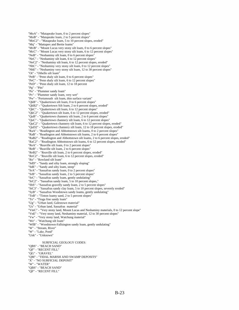
B-23
"MoA" - "Matapeake loam, 0 to 2 percent slopes""MoB" - "Matapeake loam, 2 to 5 percent slopes""MoC2" - "Matapeake loam, 5 to 10 percent slopes, eroded""Mq" - "Mattapex and Bertie loams""MvB" - "Mount Lucas very stony silt loam, 0 to 6 percent slopes""McC" - "Mount Lucas very stony silt loam, 6 to 12 percent slopes""NeB" - "Neshaminy silt loam, 0 to 6 percent slopes""NeC" - "Neshaminy silt loam, 6 to 12 percent slopes""NeC2" - "Neshaminy silt loam, 6 to 12 percent slopes, eroded""NhC" - "Neshaminy very stony silt loam, 0 to 12 percent slopes""NhE" - "Neshaminy very stony silt loam, 12 to 30 percent slopes""Ot" - "Othello silt loam""PeB" - "Penn shaly silt loam, 0 to 6 percent slopes""PeC" - "Penn shaly silt loam, 6 to 12 percent slopes""PeD" - "Penn shaly silt loam, 12 to 18 percent"Pg" - "Pits""Pu" - "Plummer sandy loam""Pv" - "Plummer sandy loam, very wet""Pw" - "Portsmouth silt loam, thin surface variant""QkB" - "Quakertown silt loam, 0 to 6 percent slopes""QkB2" - "Quakertown Silt loam, 2 to 6 percent slopes, eroded""QkC" - "Quakertown silt loam, 6 to 12 percent slopes""QkC2" - "Quakertown silt loam, 6 to 12 percent slopes, eroded""QuB" - "Quakertown channery silt loam, 2 to 6 percent slopes""QuC" - "Quakertown channery silt loam, 6 to 12 percent slopes""QuC2" - "Quakertown channery silt loam, 6 to 12 percent slopes, eroded""QuD2" - "Quakertown channery silt loam, 12 to 18 percent slopes, eroded""RaA" - "Readington and Abbottstown silt loams, 0 to 2 percent slopes""RaB" - "Readington and Abbottstown silt loams, 2 to 6 percent slopes""RaB2" - "Readington and Abbottstown silt loams, 2 to 6 percent slopes, eroded""RaC2" - "Readington Abbottstown silt loams, 6 to 12 percent slopes, eroded""ReA" - "Reaville silt loam, 0 to 2 percent slopes""ReB" - "Reaville silt loam, 2 to 6 percent slopes""ReB2" - "Reaville silt loam, 2 to 6 percent slopes, eroded""ReC2" - "Reaville silt loam, 6 to 12 percent slopes, eroded""Ro" - "Rowland silt loam""SdD" - "Sandy and silty loam, strongly sloping""SdE" - "Sandy and silty loam, steep""SrA" - "Sassafras sandy loam, 0 to 2 percent slopes""SrB" - "Sassafras sandy loam, 2 to 5 percent slopes""SrC" - "Sassafras sandy loam, gently undulating""SrC2" - "Sassafras sandy loam, 5 to 10 percent slopes,""SbS" - "Sassafras gravelly sandy loam, 2 to 5 percent slopes""StC3" - "Sassafras sandy clay loam, 5 to 10 percent slopes, severely eroded""SyB" - "Sassafras Woodstown sandy loams, gently undulating""TnB" - "Tinton loamy sand, 2 to 5 percent slopes""To" - "Tioga fine sandy loam""Ug" - "Urban land, Galestown material""Us" - "Urban land, Sassafras material""VmC" - "Very stony land, Mount Lucas and Neshaminy materials, 0 to 12 percent slope""VnE" - "Very stony land, Neshaminy material, 12 to 30 percent slopes""Vw" - "Very stony land, Watchung material""We" - "Watchung silt loam""WfB" - "Woodstown-Fallsington sandy loam, gently undulating""W" - "Stream, River""W" - "Lake, Pond""Unk" - "Unknown"
SURFICIAL GEOLOGY CODES:"QBS" - "BEACH SAND""QF" - "RECENT FILL""QG" - "GRAVEL""QM" - "TIDAL MARSH AND SWAMP DEPOSITS""X" - "NO SURFICIAL DEPOSIT""W" - "WATER""QBS" - "BEACH SAND""QF" - "RECENT FILL"

B-24
"QG" - "GRAVEL""QM" - "TIDAL MARSH AND SWAMP DEPOSITS""X" - "NO SURFICIAL DEPOSIT""W" - "WATER"
LAND USE/LAND COVER CODES:
1000 - "Urban Land"1100 - "Residential"1200 - "Commercial and Services"1211 - "Military Reservations"1300 - "Industrial"1400 - "Transportation/Communication/Utilities"1500 - "Industrial and Commercial Complexes"1600 - "Mixed Urban or Built-up Land"1700 - "Other Urban or Built-up Land"1800 - "Recreational Land"1804 - "Athletic Fields (Schools)"2000 - "Agriculture"2100 - "Cropland and Pastureland"2200 - "Orchards, Vineyards, Nurseries, Horticultural Areas"2260 - "Cranberry Bogs"2300 - "Confined Feeding Operations"2400 - "Other Agriculture"4000 - "Forest"4100 - "Deciduous Forest"4200 - "Coniferous Forest"4210 - "Pitch-Pine Lowland Forest"4300 - "Mixed Forest"4310 - "Coniferous/Deciduous Forest"4320 - "Deciduous/Coniferous Forest"4400 - "Brushland/Shrubland"5000 - "Water"5100 - "River Channel"5200 - "Lake or Pond"5300 - "Reservoir"5400 - "Bay, Estuary"5410 - "Bay, Estuary"5420 - "Dregded Lagoon"6000 - "Wetlands"6100 - "Coastal Wetlands"6110 - "Saline Marshes"6120 - "Freshwater Tidal Marshes"6130 - "Vegetated Dune Communities"6200 - "Interior Wetlands"6210 - "Deciduous Wooded Wetlands"6220 - "Coniferous Wooded Wetlands"6221 - "Cedar Swamp"6230 - "Brush-Dominant and Bog Wetlands"6240 - "Non-Tidal Marshes"7000 - "Barren Land"7100 - "Beaches"7200 - "Bare Exposed Rock, Rock Slides, etc."7300 - "Extractive Mining"7400 - "Altered Lands"7500 - "Transitional Areas"7600 - "Undifferentiated Barren Lands"
5.1.2.2 Attribute Definitionsee above
5.1.2.4 Attribute Definition Valuessee above

B-25
6.0 DATA DISTRIBUTION
6.4 Standard Order ProcessAll data is available through map sales on the Central, South and North Jersey. CD-ROM $30.00 per CD.NJ Department of Environmental Protection Maps and PublicationsP.O. Box 438428 E. State StreetTrenton, NJ 08625(609) 777-1039Make a check payable to: Treasurer, State Of New Jersey.
6.4.2.1 Digital Transfer InformationData is available in the following format Arc/Info, export.
6.4.2.2.2.1 Offline MediaData Distribution Agreement (NJDEP)Agrees to abide by the terms and conditions of the following:
I. Description of Data to be ProvidedThe data provided herein are distributed subject to the following conditions and restrictions.
Subject Data Layers
For all data contained herein, (NJDEP) makes no representations of any kind, including, but not limited to, the warranties ofmerchantability or fitness for a particular use, nor are any such warranties to be implied with respect to the digital data layersfurnished hereunder. NJDEP assumes no responsibility to maintain them in anymanner or form.
II. Terms of Agreement
1. Digital data received from the NJDEP are to be used solely for internal purposes in the conduct of daily affairs.2. The data are provided, as is, without warranty of any kind and the user is responsible for understanding the accuracy limitationsof all digital data layers provided herein, as documented in the accompanying Data Dictionary and Readmefiles. Any reproduction or manipulation of the above data must ensure that the coordinate reference system remains intact.3. Digital data received from the NJDEP may not be reproduced or redistributed for use by anyone without first obtaining writtenpermission from the NJDEP. This clause is not intended to restrict the distribution of printed mapped information produced from thedigital data.4. Any maps, publications, reports, or other documents produced as a result of this project that utilize NJDEP digital data will creditthe NJDEP's Geographic Information System (GIS) as the source of the data with the followingcredit/disclaimer:
"This (map/publication/report) was developed using New Jersey Department of Environmental Protection GeographicInformation System digital data, but this secondary product has not been verified by NJDEP and is not state-authorized."
5. Users shall require any independent contractor, hired to undertake work that will utilize digital data obtained from the NJDEP, toagree not to use, reproduce, or redistribute NJDEP GIS data for any purpose other than the specified contractual work. All copies ofNJDEP GIS data utilized by an independent contractor will be required to be returned to the original user at the close of suchcontractual work.
Users hereby agree to abide by the use and reproduction conditions specified above and agree to hold any independent contractorto the same terms. By using data provided herein, the user acknowledges that terms and conditions have been read and that theuser is bound by these criteria.
7.0 METADATA REFERENCE INFORMATION
7.1 Metadata DateMay 1, 1996
7.4 Metadata ContactJohn Fleming or Lenora Ross
8.0 CITATION INFORMATION
8.1 OriginatorNJ Department of Environmental Protection

B-26
8.4 TitleMeritum
8. 5 Edition#1
9.0 TIME PERIOD INFORMATION9.1.1 Calendar DateYEAR 1996
10.0 CONTACT INFORMATION
10.1.1 Contact Person(s) PrimaryLarry Thornton/John Tyrawski, NJDEPProduction Staff; ESRI & AIS, Redlands, CA
10.1.2 Contact OrganizationBureau of Geographic Information & Analysis
10.4 Contact AddressNJDEP/OIRM/BGIA401 E. State St.P.O. Box 428Trenton, NJ 08625
10.5 Contact Voice Telephone 609-984-2243
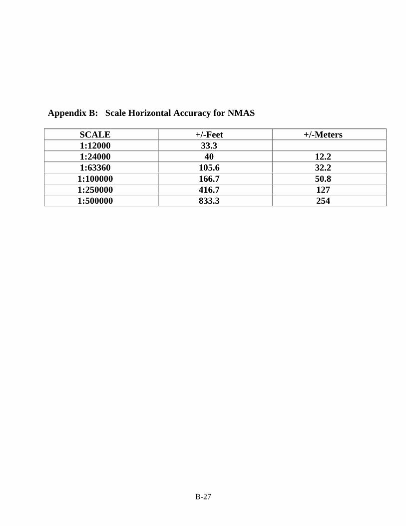
B-27
Appendix B: Scale Horizontal Accuracy for NMAS
SCALE +/-Feet +/-Meters1:12000 33.31:24000 40 12.21:63360 105.6 32.2
1:100000 166.7 50.81:250000 416.7 1271:500000 833.3 254

B-28
Appendix C: Quarterquad Template for New Jersey
5 6 7 98
1 2 3 4
93 94 95 9996 9897
9286 9187 908988
8376 77 8278 818079
66 7467 68 737269 70 71
55 56 57 58 636259 6160
44 45 46 535247 5148 49 50
33 34 4335 424136 4037 38 39
22 3223 3124 3025 2926 27 28
2112 13 2014 191815 1716
1110
177 178
174 175 176
169 170 171 172 173
160 161 162 163 164 165 166 167 168
149 150 151 152 153 154 155 159156 158157
137 138 139 140 141 142 148143 147144 145 146
124 125 126 127 128 129 136135130 131 134133132
112 113 114 115 123116 122117 121118 119 120
102 103 111104 105 110109106 107 108
101100
992
983
974
9173
Figure 1: Photoquad Index
N

B-29
Table 1: Photoquad Number &
1 MILFORD PA-NJ 2 PT. JERVIS S. NJ-NYPA 3 UNIONVILLE NY-NJ 4 PINE ISLAND NY-NJ 5 LAKE MASKENOZHA PA-NJ 6 CULVERS GAP NJ-PA 7 BRANCHVILLE NJ 8 HAMBURG NJ 9 WAWAYANDA NJ-NY10 GREENWOOD LAKE NY-NJ11 SLOATSBURG NY-NJ12 BUSHKILL PA-NJ13 FLATBROOKVILLE NJ-PA14 NEWTON WEST NJ15 NEWTON EAST NJ16 FRANKLIN NJ17 NEWFOUNDLAND NJ18 WANAQUE NJ19 RAMSEY NJ-NY20 PARK RIDGE NJ-NY21 NYACK NY-NJ22 STROUDSBURG PA-NJ23 PORTLAND NJ-PA24 BLAIRSTOWN NJ25 TRANQUILITY NJ26 STANHOPE NJ27 DOVER NJ28 BOONTON NJ29 POMPTON PLAINS NJ30 PATERSON NJ31 HACKENSACK NJ32 YONKERS NJ-NY33 BANGOR PA-NJ34 BELVIDERE NJ-PA35 WASHINGTON NJ36 HACKETTSTOWN NJ37 CHESTER NJ38 MENDHAM NJ39 MORRISTOWN40 CALDWELL NJ41 ORANGE NJ42 WEEHAWKEN NJ-NY43 CENTRAL PARK NY-NJ44 EASTON NJ-PA45 BLOOMSBURY NJ
Name
46 HIGH BRIDGE NJ 47 CALIFON NJ 48 GLADSTONE NJ 49 BERNARDSVILLE NJ 50 CHATHAM NJ 51 ROSELLE NJ 52 ELIZABETH NJ-NY 53 JERSEY CITY NJ-NY 55 RIEGELSVILLE PA-NJ 56 FRENCHTOWN NJ-PA 57 PITTSTOWN NJ 58 FLEMINGTON NJ 59 RARITAN NJ 60 BOUND BROOK NJ 61 PLAINFIELD NJ 62 PERTH AMBOY NJ-NY 63 ARTHUR KILL NY-NJ 66 LUMBERVILLE PA-NJ 67 STOCKTON NJ-PA 68 HOPEWELL NJ 69 ROCKY HILL NJ 70 MONMOUTH JUNCTION NJ 71 NEW BRUNSWICK NJ 72 SOUTH AMBOY NJ-NY 73 KEYPORT NJ-NY 74 SANDY HOOK NJ-NY 76 LAMBERTVILLE PA-NJ 77 PENNINGTON NJ-PA 78 PRINCETON NJ 79 HIGHTSTOWN NJ 80 JAMESBURG NJ 81 FREEHOLD NJ 82 MARLBORO NJ 83 LONG BRANCH NJ 86 TRENTON WEST PA-NJ 87 TRENTON EAST NJ-PA 88 ALLENTOWN NJ 89 ROOSEVELT NJ 90 ADELPHIA NJ
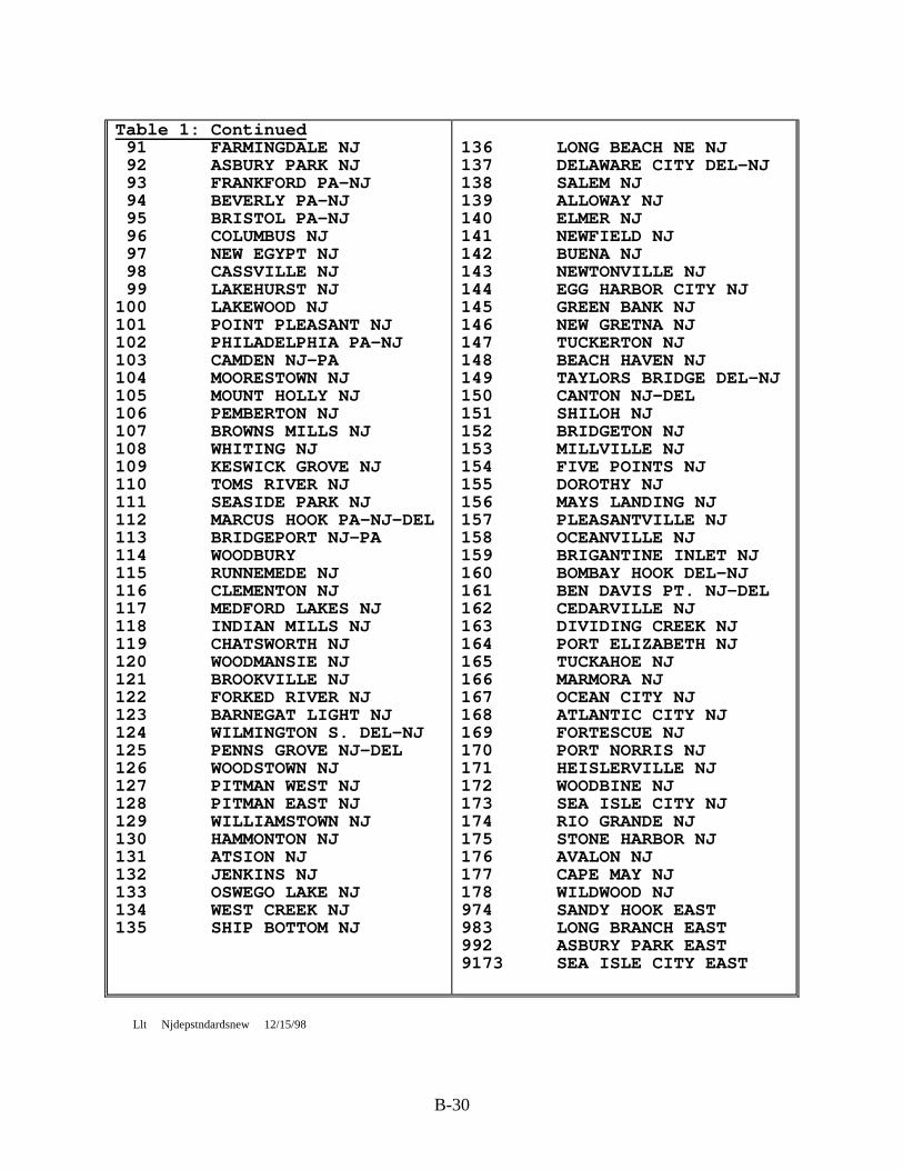
B-30
Table 1: Continued 91 FARMINGDALE NJ 92 ASBURY PARK NJ 93 FRANKFORD PA-NJ 94 BEVERLY PA-NJ 95 BRISTOL PA-NJ 96 COLUMBUS NJ 97 NEW EGYPT NJ 98 CASSVILLE NJ 99 LAKEHURST NJ100 LAKEWOOD NJ101 POINT PLEASANT NJ102 PHILADELPHIA PA-NJ103 CAMDEN NJ-PA104 MOORESTOWN NJ105 MOUNT HOLLY NJ106 PEMBERTON NJ107 BROWNS MILLS NJ108 WHITING NJ109 KESWICK GROVE NJ110 TOMS RIVER NJ111 SEASIDE PARK NJ112 MARCUS HOOK PA-NJ-DEL113 BRIDGEPORT NJ-PA114 WOODBURY115 RUNNEMEDE NJ116 CLEMENTON NJ117 MEDFORD LAKES NJ118 INDIAN MILLS NJ119 CHATSWORTH NJ120 WOODMANSIE NJ121 BROOKVILLE NJ122 FORKED RIVER NJ123 BARNEGAT LIGHT NJ124 WILMINGTON S. DEL-NJ125 PENNS GROVE NJ-DEL126 WOODSTOWN NJ127 PITMAN WEST NJ128 PITMAN EAST NJ129 WILLIAMSTOWN NJ130 HAMMONTON NJ131 ATSION NJ132 JENKINS NJ133 OSWEGO LAKE NJ134 WEST CREEK NJ135 SHIP BOTTOM NJ
136 LONG BEACH NE NJ137 DELAWARE CITY DEL-NJ138 SALEM NJ139 ALLOWAY NJ140 ELMER NJ141 NEWFIELD NJ142 BUENA NJ143 NEWTONVILLE NJ144 EGG HARBOR CITY NJ145 GREEN BANK NJ146 NEW GRETNA NJ147 TUCKERTON NJ148 BEACH HAVEN NJ149 TAYLORS BRIDGE DEL-NJ150 CANTON NJ-DEL151 SHILOH NJ152 BRIDGETON NJ153 MILLVILLE NJ154 FIVE POINTS NJ155 DOROTHY NJ156 MAYS LANDING NJ157 PLEASANTVILLE NJ158 OCEANVILLE NJ159 BRIGANTINE INLET NJ160 BOMBAY HOOK DEL-NJ161 BEN DAVIS PT. NJ-DEL162 CEDARVILLE NJ163 DIVIDING CREEK NJ164 PORT ELIZABETH NJ165 TUCKAHOE NJ166 MARMORA NJ167 OCEAN CITY NJ168 ATLANTIC CITY NJ169 FORTESCUE NJ170 PORT NORRIS NJ171 HEISLERVILLE NJ172 WOODBINE NJ173 SEA ISLE CITY NJ174 RIO GRANDE NJ175 STONE HARBOR NJ176 AVALON NJ177 CAPE MAY NJ178 WILDWOOD NJ974 SANDY HOOK EAST983 LONG BRANCH EAST992 ASBURY PARK EAST9173 SEA ISLE CITY EAST
Llt Njdepstndardsnew 12/15/98

APPENDIX C

C-1
4/96
State of New Jersey
Department of Environmental Protection
SOLID WASTE FACILITY PERMIT APPLICATION FORM
READ REQUIREMENTS - FOLLOW INSTRUCTIONS CAREFULLY - PLEASE PRINT OR TYPE
1a. Applicant/Owner* Telephone ( )______________
Permanent Legal Address________________________________________________
City or Town State Zip Code__________
Federal Tax I.D. or S.S. #_____________________________________________
1b. Applicant/Operator Telephone ( )_____________
Permanent Legal Address________________________________________________
City or Town State Zip Code_________
1c. Co-Permittee** Telephone ( )______________
Permanent Legal Address________________________________________________
City or Town State Zip Code__________
____________________________________________________________________________FOR OFFICIAL USE
FILE NO. DATE RECEIVED________________________
PROJECT MANAGER PROJECT ENGINEER_____________________
PERMIT TYPE TELEPHONE ( )______________________
FEES BILLED DATE DATE DATE___________
RECEIVED DATE DATE DATE___________

C-2
2. Location of Work_______________________________________________________
Name of Facility, if applicable________________________________________
Address (Street/Road)__________________________________________________
Lot No.________________________________________________________________
Block No.______________________________________________________________
E.P.A. # ______________________________________________________________
Municipality County__________________________
3. Give name of: Engineer
Name N.J. License No.____________________
Name of Firm___________________________________________________________
Address (Street/Road)__________________________________________________
City or Town State Zip Code________
Municipality County_____________________________
Telephone ( )____________________
4. This is an application for Permit(Name of permit, certification, approval, jurisdictional determination or exemption.)
I. Application for: (Circle A. or B.)
A. New FacilityB. Existing Facility - Indicate (Expansion/Closure/Disruption
).

C-3
II. Facility Type:(Circle appropriate letters.) (Separate application for each)
A. Sanitary Landfill F. ShredderB. Incinerator G. BalerC. Compost H. DisruptionD. Chemical Processing & I. Transfer Station/
Treatment Facility Material Recovery FacilityE. Transfer Station X. Other
III. Waste Type: (Circle all types of waste requested for acceptance at this facility by numbers.)
10. Municipal Waste (household, 72. Bulk Liquid and Semi-Liquidcommercial and institutional) 73. Septic Tank Clean-Out Wastes
12. Dry Sewage Sludge 74. Liquid Sewage Sludge13. Bulky Waste23. Vegetative Waste25. Animal and Food Processing Wastes27. Dry Industrial
IV. Facility Life and Capacity: YEARS TONS CUBIC YARDS
A. Proposed Facility Estimate ________ ________ _______________
B. Facility Expansion Estimate ________ ________ _______________
V. Identification Numbers:
A. Facility Registration # __________________________________________
B. Federal Employer ID # ____________________________________________
C. Social Security # ________________________________________________
D. Certificate of Public Convenience & Necessity (CPCN) # ___________
__________________________________________________________________
Is (Will) this facility (be) under BPU regulation? Yes No

C-4
USE ADDITIONAL PAPER, IF REQUIRED, IN ORDER TO GIVE FULL AND COMPLETE DISCLOSURESTO THE FOLLOWING ITEMS.
VI. Type of Organization: (Circle appropriate letter.)
A. Proprietorship D. Municipal Government G. AuthorityB. Partnership E. County Government H. Federal GovernmentC. Corporation F. State Government X. Other
VII. PARTNERSHIP DATA
A. State the name and address of each partner, including silent or limited,and their interest:
NAME ADDRESS PROPORTION OF INTEREST
____________________ ____________________________________ _______________
____________________ ____________________________________ _______________ ____________________ ____________________________________ _______________ ____________________ ____________________________________ _______________
____________________ ____________________________________ _______________ ____________________ ____________________________________ _______________ ____________________ ____________________________________ _______________
B. Registered in State of: County of:_____________________
C. Date of Filing:________________________________________________________
D. Agent's Name __________________________________________________________
Street Address Telephone ( )__________________
City State Zip Code _________________
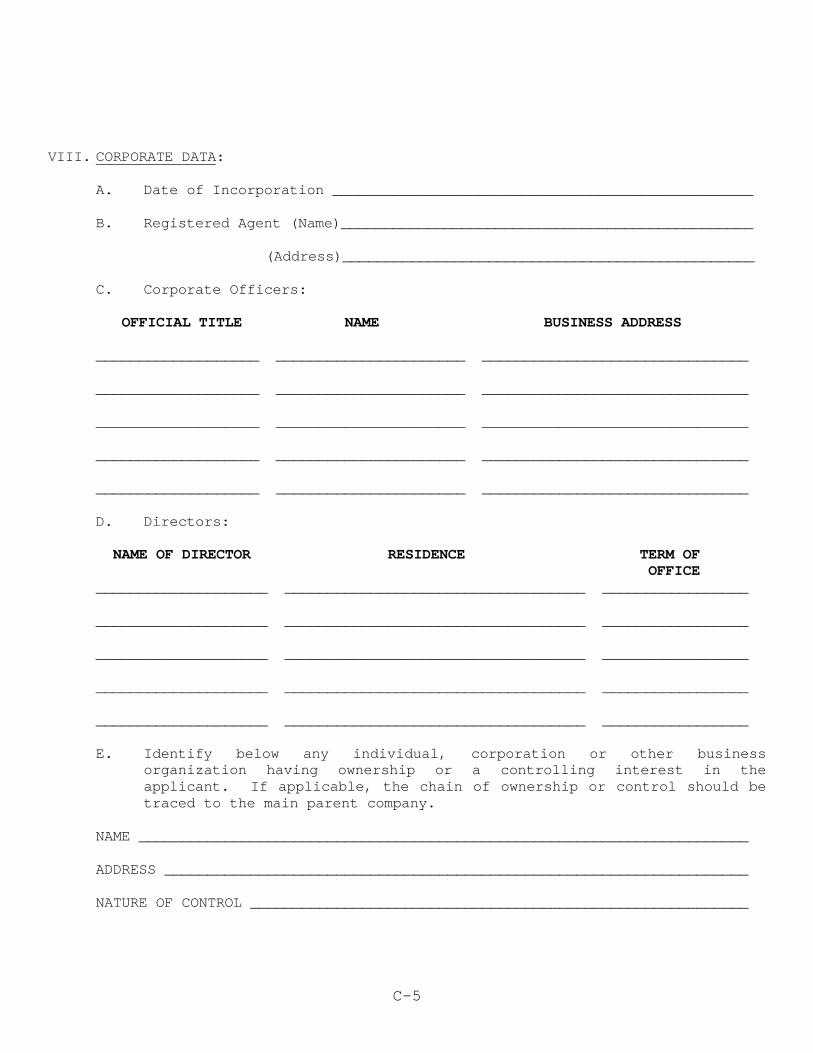
C-5
VIII. CORPORATE DATA:
A. Date of Incorporation _________________________________________________
B. Registered Agent (Name)________________________________________________
(Address)________________________________________________
C. Corporate Officers:
OFFICIAL TITLE NAME BUSINESS ADDRESS
___________________ ______________________ _______________________________
___________________ ______________________ _______________________________
___________________ ______________________ _______________________________
___________________ ______________________ _______________________________
___________________ ______________________ _______________________________
D. Directors:
NAME OF DIRECTOR RESIDENCE TERM OF OFFICE
____________________ ___________________________________ _________________
____________________ ___________________________________ _________________
____________________ ___________________________________ _________________
____________________ ___________________________________ _________________
____________________ ___________________________________ _________________
E. Identify below any individual, corporation or other businessorganization having ownership or a controlling interest in theapplicant. If applicable, the chain of ownership or control should betraced to the main parent company.
NAME _______________________________________________________________________
ADDRESS ____________________________________________________________________
NATURE OF CONTROL __________________________________________________________

C-6
F. Principal Security Holders and Voting Power. Identify owner(s) of allsecurities in the applicant corporation having more than ten (10)percent of value.
NAME ADDRESS TYPE OF NUMBER SECURITIES* OF VOTES
_________________ ______________________________ ______________ ____________
_________________ ______________________________ ______________ ____________
_________________ ______________________________ ______________ ____________
_________________ ______________________________ ______________ ____________
_________________ ______________________________ ______________ ____________
*(Common stock, Preferred stock, etc.)
5. Other Permits Applied For Or Obtained
APPLICATION STATUS Date Applied ForPERMIT TYPE N.A. Pending Approved or Project Number(Use additional sheetsif necessary)
5.1 CAFRA................... _______ _________ _________ _________________ 5.2 Waterfront
Development............ _______ _________ _________ _________________ 5.3 Tidal or Coastal
Wetlands............... _______ _________ _________ _________________ 5.4 Freshwater Wetlands
Permit................. _______ _________ _________ _________________ 5.5 Freshwater Wetlands
Transitional AreaWaiver (after July 1,1989).................. _______ _________ _________ _________________
5.6 Stream Encroachment.... _______ _________ _________ _________________
5.7 Water QualityCertificate (Section401)................... _______ _________ _________ _________________
5.8 Open Water Fill........ _______ _________ _________ _________________

C-7
APPLICATION STATUS Date Applied ForPERMIT TYPE N.A. Pending Approved or Project Number(Use additional sheetsif necessary)
5.9 Tidelands (Riparian)Grant, Lease orLicense................ _______ _________ _________ _________________
5.10 Divert Surface Watersfor Private Use........ _______ _________ _________ _________________
5.11 Temporary WaterLowering............... _______ _________ _________ _________________
5.12 Sewer Systems:Collectors, PumpStation, etc........... _______ _________ _________ _________________
5.13 Underground StorageTanks.................. _______ _________ _________ _________________
5.14 Hazardous WastePermits (Specify)...... _______ _________ _________ _________________
5.15 Air Quality Permits.... _______ _________ _________ _________________
5.16 Delaware and RaritanCanal Review Zone"Certificate ofApproval".............. _______ _________ _________ _________________
5.17 PinelandsCertificate............ _______ _________ _________ _________________
5.18 Green Acres ProgramReview................. _______ _________ _________ _________________
5.19 Other StateAgencies' Permits...... _______ _________ _________ _________________
5.20 Federal Permits........ _______ _________ _________ _________________

C-8
Brief Description of the Proposed Project and Intended Use:
__________________________________________________________________________
__________________________________________________________________________
__________________________________________________________________________
__________________________________________________________________________
__________________________________________________________________________
6. Certification
I certify under penalty of law that I have personally examined and am familiarwith the information submitted. in this document and all attachments and that,based on my inquiry of those individuals immediately responsible for obtainingthe information, I believe that the information is true, accurate, andcomplete. I am aware that there are significant penalties for submittingfalse information, including the possibility of fine and imprisonment.
____________________________ ______________________________________________Type: Name and Date Signature of Applicant/Owner
____________________________ ______________________________________________Type: Position Date
____________________________ ______________________________________________Type: Name and Date Signature of Applicant/Operator
____________________________ ______________________________________________Type: Position Date
____________________________ ______________________________________________Type: Name and Date Signature of Co-permittee*
____________________________ ______________________________________________Type: Position Date

C-9
A. PROPERTY OWNER'S CERTIFICATION
I hereby certify that ________________________________________________________Property Owner's Name
is the owner of the property upon which the proposed work is to be done. Thisendorsement is certification that the owner grants permission for the conductof the proposed activity and authorizes that staff of DEP may conduct on-siteinspections as necessary for the review of this application.
In addition, the aforementioned property owner shall certify:
1. Whether any work is to be done within an easement -
Yes No _____________(Initial) (Initial)
2. Whether any part of the entire project will be located within propertybelonging to the State of New Jersey -
Yes No _____________(Initial) (Initial)
If "Yes", reviewing agency must notify the Department of Treasury,Office of Property Management, CN 226, Trenton, N.J. 08625-0226.
3. Whether any part of the entire project will be located within propertybelonging to a municipality or county -
Yes No _____________(Initial) (Initial)
__________________________________________________
__________________________________________________
__________________________________________________ Type or Print Name and Address of Owner
if different from Item 1 on Page 1
__________________________________________________ Date Signature of Owner

C-10
B. APPLICANT'S AGENT
I, the Applicant/Owner ______________ or
Applicant/Operator (when the owner of the facility and the operator of the
facility are distinct parties) ____ or
Co-permittee (when the Co-permittee is a local governmental unit)_________
______________________________ authorize to act as my agent/representative
in all matters pertaining to my application the following person:
Name Phone_____________________________________
Address County____________________________________
City or Town State Zip Code_________________
Occupation/Profession________________________________________________________
____________________________________ (Signature of Applicant/Owner)
____________________________________ (Signature of Applicant/Operator)
____________________________________ (Signature of Co-permittee)*
AGENT'S CERTIFICATION
Sworn before methis day of 20 I agree to serve as agent for the above-
mentioned applicant
__________________________________________Notary Public (Signature of Agent)

C-11
C. STATEMENT OF PREPARER OF PLANS, SPECIFICATIONS, SURVEYOR'S OR ENGINEER'SREPORT
I hereby certify that the engineering plans, specifications and engineer'sreports applicable to this project comply with the current rules andregulations of the State Department of Environmental Protection with theexceptions as noted.
_________________________________________________ (Signature of Engineer/Architect)
_________________________________________________ Type: Name and Date
_________________________________________________ Position, Name of Firm
PROFESSIONAL ENGINEER'S/ARCHITECT'SEMBOSSED SEAL

APPENDIX D

NEW JERSEYSTATE HIGHWAY ACCESS
MANAGEMENT CODE
(New Jersey Administrative Code Title 16 Chapter 47)
Electronic copies of this document are not yet available for download. To obtain a hard copy of thepublished version, please contact the following office:
New Jersey Department of TransportationBureau of Major Access Permits
P.O. Box 600Trenton, New Jersey 08625-0600
609-530-2875