TECHNICAL DOCUMENT - NOPSEMA DOCUMENT ... Related Documents ... cement may also be discharged into...
26
Title: Montara Production Drilling Environment Plan Summary TechnicaiiD: MV-HSE-D41-850436 TECHNICAL DOCUMENT Approval Status{ APPROVED ) Title: Montara Production Drilling Environment Plan Summary Revision No: 0 Technical ID: MV-HSE-D41-850436 Belongs To: Montara Venture System: Drilling Technical Discipline HSE Class: Sub-Class: Function: Develop and Service Well Process: Related Documents Hard Copy Location Volume 1 Book 55f 6 Approver: Technical Authority: Legal Review: Drilling &Well Services MBO.llraer-... Approver Nominates General Counsel Signatur Date: Date: Revision Revision Date Revision Remarks Number 0 24/10/2013 Environment Plan Summary Technical#850436 Rev 0 Construct Service or Abandon Well SSHE Review: Originator: Safety Manager GLEN NICHOLSON Originator GLEN NICHOLSON Page 1 of 26
Transcript of TECHNICAL DOCUMENT - NOPSEMA DOCUMENT ... Related Documents ... cement may also be discharged into...
Title: Montara Production Drilling Environment Plan Summary TechnicaiiD: MV-HSE-D41-850436
TECHNICAL DOCUMENT Approval Status{ APPROVED )
Title: Montara Production Drilling Environment Plan Summary
Revision No: 0 Technical ID: MV-HSE-D41-850436
Belongs To: Montara Venture System: Drilling
Technical Discipline HSE
Class: Sub-Class:
Function: Develop and Service Well Process:
Related Documents
Hard Copy Location Volume 1 Book55f 6
Approver: Technical Authority: Legal Review: Drilling &Well Services MBO.llraer-...
Approver Nominates General Counsel
Signatur
Date: Date:
Revision Revision Date Revision Remarks Number 0 24/10/2013 Environment Plan Summary
Technical#850436 Rev 0
Construct Service or Abandon Well
SSHE Review: Originator: Safety Manager GLEN NICHOLSON
Originator
GLEN NICHOLSON
Page 1 of 26
campbers
Text Box
5

Title: Montara Production Drilling Environment Plan Summary Technical ID: MV-HSE-D41-850436
Technical#850436 Rev 0 Page 2 of 26
TABLE OF CONTENTS 1 INTRODUCTION ..................................................................................................... 3 2 LOCATION OF ACTIVITY ...................................................................................... 3 3 DESCRIPTION OF ACTIVITY ................................................................................ 5 4 DESCRIPTION OF RECEIVING ENVIRONMENT .................................................. 7 4.1 PHYSICAL AND BIOLOGICAL ENVIRONMENT .............................................................. 7 4.2 SOCIAL ENVIRONMENT ................................................................................................ 11 5 ENVIRONMENTAL RISK ASSESSMENT ............................................................ 14 6 MANAGEMENT APPROACH ............................................................................... 14 7 STAKEHOLDER CONSULTATION ..................................................................... 14 8 CONTACT DETAILS ............................................................................................ 15 9 REFERENCES ...................................................................................................... 16 APPENDIX A: ENVIRONMENTAL RISK ASSESSMENT SUMMARY ............................. 18
TABLE OF FIGURES
Figure 1 – Site Location of the Montara Field.......................................................................................... 4
TABLE OF TABLES
Table 1 – Montara Development Infrastructure Coordinates (Surface) (GDA 94, Zone 51) ................... 4
Table 2: Summary of Drilling Activity ....................................................................................................... 5

Title: Montara Production Drilling Environment Plan Summary Technical ID: MV-HSE-D41-850436
Technical#850436 Rev 0 Page 3 of 26
1 INTRODUCTION PTTEP Australasia (Ashmore Cartier) Pty Ltd (PTTEP AA), a part of the PTTEP Australasia Group, is the operator of the production licences AC/L7 and AC/L8. PTTEP AA undertakes periodic production drilling and well workover (PDW) activities at the Montara, Swift, Swallow and Skua fields (collectively referred to as the Montara Development Project (MDP)).
An Environment Plan for this activity was accepted by the delegate of the Designated Authority, the former Northern Territory Department of Resources (NTDoR), on behalf of the Commonwealth Government, with responsibility for acceptance of the Plan in accordance with the OPGGS(E)R on the 23rd of August 2011.
On 1 January 2012, the National Offshore Petroleum Safety and Environmental Management Authority (NOPSEMA) assumed the regulatory role for acceptance of OPGGS Environment Plans in Commonwealth waters. NOPSEMA has provided Guidance on Environment Plan Content Requirements, most recently updated as at January 2013, which supersede the earlier guidelines provided by the Commonwealth Department of Resources, Energy and Tourism (DRET), now Department of Industry (DoI).
On 11 February 2013 NOPSEMA requested PTTEP AA to submit a revised Plan in accordance with Regulation 18(8) of the OPGGS(E)R and the revised Plan was accepted on the 16th of October 2013.
This EP summary document has been prepared to comply with the requirements of Regulation 11(7) and (8) of the Offshore Petroleum and Greenhouse Gas Storage (Environment) Regulations 2009.
2 LOCATION OF ACTIVITY The MDP area is located in Commonwealth waters within Production Licences AC/L7 and AC/L8 in the Timor Sea, between Australia and the island of Timor approximately 690 km (373 nm) east of Darwin in a water depth of approximately 77 m (LAT) (refer to Figure 1).
The MDP consists of the following infrastructure, with the key location coordinates listed in Table 1 below:
• An unmanned wellhead platform (WHP) at the Montara field with five (5) wells, three (3) 14 inch Production Risers, two (2) 6 inch Gas Lift Risers and one (1) 12 inch J-Tube;
• Five (5) subsea wells for development of the Skua, Swift and Swallow fields;
• Production flowline system consisting of two (2) 6- inch, one (1) 10 inch and three (3) 14 inch flowlines and associated tie-in spools;
• Gas lift flowline system consisting of one (1) 6 inch and three (3) 4 inch flowlines and associated tie-in spools;
• Three (3) infield control umbilicals and associated flying leads;
• A subsea manifold in the Swift field for comingling the production fluids and distributing the compressed gas and electro-hydraulic services to the subsea wells; and
• A FPSO facility and its associated mooring system located approximately 1.5 km northeast of the WHP. Two (2) 10 inch Flexible Production Risers and associated riser bases. One (1) 6 inch Flexible Gas Lift Riser and associated riser base. Two (2) control umbilicals and associated riser bases. One (1) gas compressor for the gas lift system.

Title: Montara Production Drilling Environment Plan Summary Technical ID: MV-HSE-D41-850436
Technical#850436 Rev 0 Page 4 of 26
Figure 1 – Site Location of the Montara Field
Table 1 – Montara Development Infrastructure Coordinates (Surface) (GDA 94, Zone 51)
Well and Infrastructure Locations Latitude (South) Longitude (East)
Montara Venture FPSO (Turret centre) 12° 39' 35.3” 124° 32' 41.1”
Wellhead Platform 12° 40' 20.5” 124° 32' 22.2”
Swallow 1 Subsea well 12° 32' 29.5” 124° 26' 36.8”
Swift North 1 Subsea well 12° 31' 29.9” 124° 27' 33.7”
Swift-2 Subsea well 12° 32' 3.6” 124° 27' 6.0”
Skua 10 Subsea well 12° 30' 4.6” 124° 25' 5.4”
Skua 11 Subsea well 12° 30' 4.6” 124° 25' 5.6”
Montara GI ST-1 (to be renamed H5) well 12° 40’ 20.466” 124° 32’ 22.320”
Montara H4 well 12° 40’ 20.547” 124° 32’ 22.321”
Montara H3 ST-1 well 12° 40’ 20.548” 124° 32’ 22.162”
Montara H2 well 12° 40’ 20.548” 124° 32’ 22.241”
Montara G2 well 12° 40’ 20.466” 124° 32’ 22.320”

Title: Montara Production Drilling Environment Plan Summary Technical ID: MV-HSE-D41-850436
Technical#850436 Rev 0 Page 5 of 26
3 DESCRIPTION OF ACTIVITY The MDP involves the development of the Montara, Swift, Skua and Swallow fields and operation of the developed facilities for commercial production of the oil reserves. Oil is extracted from production wells in each of the fields and transported in flow lines to the Montara Venture Floating Production, Storage and Offloading (FPSO) facility, via the Montara Well Head Platform (WHP).
To achieve the Montara field development objectives, the currently suspended GI ST-1 well is required to be re-entered and abandoned downhole before re-claiming the slot and drilling the Montara H5 development well.
Current PDW activities within the MDP area commenced in September 2013 and are likely to last for a period of approximately 90 days, subject to weather and operational efficiency. Any future well workover operations are estimated to be of an indicative frequency of five years per well and typically last for approximately 30 days per well. A summary of the drilling activity is provided in Table 2 below.
Table 2: Summary of Drilling Activity
MODU The drilling contractor selected to execute the drilling programme is ENSCO Asia & Pacific Rim, a company based in Singapore and hereafter referred to as ENSCO. The jack-up rig, ENSCO 109 (formerly named Ocean Shield) is being used for the current operations and if required, a similar jack up rig shall be used for any unforeseen future workover operations.
Drilling Re-enter and abandon Montara GI ST-1 downhole
Move rig onto platform, establish services and safety systems;
Installation of a custom wellhead system at the boat landing deck level;
Tie-back the 20” conductor, installation of drilling BOPs;
Rig up a snubbing unit with snubbing BOPs above the rig floor;
Re-entry of the well, removing temporary surface barriers and progressively isolating annuli;
Evaluate the 9 ⅝” production casing cement;
Rig down snubbing unit and snubbing BOPs;
Perform downhole abandonment on Montara GI ST-1;
Cut and recover well slot by removing the 9 ⅝” casing as deep as possible; and
Suspend well and re-configure 20” conductor and wellhead equipment for Montara H5.
Sidetrack, drill and complete Montara H5
If required the well may be recovered higher up in the hole depending on complexity of the GI ST-1 abandonment operations; if this is the case, a diverter will be installed to drill the 17 ½” hole and then the 13 ⅜” surface casing run and cemented;
Installation of the unitised wellhead and drilling BOPs;
Drill 12 ¼” hole then run and cement the 9 ⅝” production casing;
Drill 8 ½” horizontal hole section;
Run the lower 5 ½” sand-screen completion and subsequently the upper completion;
Suspend the well and install the Xmas Tree;
Flow the well to a rig based clean-up package before shutting in the well and
Title: Montara Production Drilling Environment Plan Summary Technical ID: MV-HSE-D41-850436
Technical#850436 Rev 0 Page 6 of 26
handing it over to production for flow-line tie-in; and
Move rig off location.
Well Intervention
Over the life cycle of the field, estimated to be 12 years, it is feasible that wells may be worked over as required as a result of unforeseen well integrity or production issues. Any future well workover operations are estimated to be of an indicative frequency of five years per well and typically last for approximately 30 days per well, depending on the nature of the intervention required.
Typically, the work over of a well may require the use of a MODU and may include re-entering the relevant well, retrieving the upper completion before re-running a new upper completion. Throughout workover procedures no drilling is undertaken therefore no cuttings are produced or discharged and the only fluids used during operations are brine and possibly calcium carbonate of which small quantities may be discharged into the marine environment.
Drilling Method
A drilling fluid programme has been developed for each hole section of the H5 well in accordance with the PTTEP AA Drilling Management System. Drilling fluids have a range of physical and chemical properties which must be maintained to ensure that the fluid system can function adequately.
The wells will be drilled with WBM i.e. no synthetic based muds (SBMs) will be used. All cuttings will be disposed overboard with the total volume of cuttings to be discharged equating to approximately 442.6m3 for the drilling campaign.
Mud-logging will be undertaken during drilling operations to evaluate the formation. This will involve the collection and processing of cuttings samples, analysis of mud gas, monitoring and recording of all drilling parameters, pressure detection and full evaluation of the formation. No vertical seismic profiling (VSP) will be undertaken during the course of the proposed operations.
Cement is used to secure the steel casing in the well bore and cementing chemicals are used to modify the technical properties of the cement slurry. During cementing operations, there may be some volumes of cement (<1m3) that will be excess to requirements and may be discharged to sea. Some minor quantities of cement may also be discharged into the sea during clean-up of the cementing unit after each job is finished.
Rather than traditional casing that is run and cemented after each well section, 5 ½” sand screens will be ran in the 8 ½” holes and not cemented in place but secured via a liner hanger.
The hydrocarbons flowed during well clean-up will be flared on the drilling rig.
Support
Operations
Support is provided by anchor handling tug/supply vessels, which will operate out of Darwin. Supply vessels will supply bulk chemicals, liquid drilling fluids and diesel fuels to the drilling rig.
Helicopter support is based at Mungalalu – Truscott air base to undertake personnel transfers between Mungalalu-Truscott and the rig for crew changes; down-manning of the rig for tropical cyclone response; and emergency response, including medivac, evacuation of the rig, and search and rescue.
Routine helicopter operations are limited to daylight hours with approximately 5 – 7 flights per week anticipated. Helicopter refuelling will use the permanent helicopter refuelling facilities on the ENSCO 109.
Title: Montara Production Drilling Environment Plan Summary Technical ID: MV-HSE-D41-850436
Technical#850436 Rev 0 Page 7 of 26
4 DESCRIPTION OF RECEIVING ENVIRONMENT
4.1 PHYSICAL AND BIOLOGICAL ENVIRONMENT The MDP area is located on Australian continental shelf in the Timor Sea. In general, the continental shelf is a flat featureless submarine plain that dips gently northward toward the edge of the shelf, but scattered throughout the region are sea mounts, shoals and occasional islands that support a diverse flora and fauna. The Timor Trough, with water depths up to 9,000 m, marks the northern boundary of the continental shelf.
Regionally, the MDP area is located in the Timor Province Bioregion of the Northwest Shelf Transition Bioregion and within the larger Northwest Marine Region (NWMR) Planning Area. The variety of geomorphic features in the Timor Province results in several distinct habitats and biological communities, many of which are in close proximity to each other. The reefs and islands of the bioregion are regarded as particular hotspots for biodiversity and support a range of important pelagic and benthic ecological communities. A high level of endemism has been identified in demersal fish communities of the continental slope in the Timor Province, with two distinct communities identified (upper slope and mid slope).
The Timor Province Bioregion includes the marine protected areas of Ashmore Reef, Cartier Island, Hibernia Reef, Seringapatam Reef and Scott Reef. These reefs are recognised as having high richness and diversity of coral species with the nearest being Cartier Island which is approximately 106 km to the east of the MDP area.
The nearest shoals to the Montara Operations are Goeree and Vulcan Shoals (located 33 km and 34 km to the southwest respectively), Eugene McDermott Shoal (46 km to the south) and Barracouta Shoal (57 km northwest), known to support diverse biological communities across their shallow plateau areas.
The seabed local to the Montara field site slopes from the east (76.0 m) to west (86.5 m) and is characterised by a north-south trending gentle scarp.
The benthic environments of the NWMR are generally dominated by soft sediments, sand and mud, with occasional patches of coarser sediments (Woodside 2011). The extensive soft sediment habitat, in combination with little topographic relief, has very large expanses of monotonous benthos as there are limited different habitats or niches for animals to occupy.
In the MDP area, at approximately a 77 m depth, there is little evidence of epibenthic communities. It has been noted by Heyward et al. (1997) that where there is little seafloor topography, such as in the MDP area, there is minimal habitat diversity or niches for marine fauna to occupy. Species commonly found in these areas of soft sediment include sponges, gorgonians such as sea whips and sea fans, ascidians such as sea squirts, echinoderms, crustaceans, bryozoans such as lace corals, and soft corals. The absence of hard substrate is considered a limiting factor for recruitment of epibenthic organisms (Heyward et al 1997).
Protected Fauna An EPBC Act Protected Matters Database search for endangered and vulnerable marine species was undertaken based on the location of the Montara WHP by PTTEP AA and identified nine threatened species that may occur or have habitat in the Montara field. The nine listed threatened species are:
• Blue whale (Balaenoptera musculus);
• Humpback whale (Megaptera novaeangliae);
• Green turtle (Chelonia mydas);
• Loggerhead turtle (Caretta caretta);
• Leatherback turtle (Dermochelys coriacea);
• Hawksbill turtle (Eretmochelys imbricata);
• Olive ridley turtle (Lepidochelys olivacea);
Title: Montara Production Drilling Environment Plan Summary Technical ID: MV-HSE-D41-850436
Technical#850436 Rev 0 Page 8 of 26
• Flatback turtle (Natator depressus); and
• Whale shark (Rhincodon typus).
The search also identified 18 listed migratory species that may be encountered within the Montara field. The listed marine species are described below.
Fish The EPBC Act Protected Matters search identified three fish species (listed Marine species) that may occur in or have habitat in the Montara field. None of these species are considered threatened or are migratory species. These species are ray-finned fishes and are either pipefish or seahorses (family Syngnathidae). These species will most likely be confined to the shallow waters of shoals and reefs.
Sharks The EPBC Act Protected Matters search identified 31 migratory shark species that may occur in or have habitat in the Montara field.
Whale sharks (Rhincodon typus) are listed as Vulnerable and Migratory under the EPBC Act and Vulnerable under the World Conservation Union’s ‘Red List’ of Threatened Species (IUCN 2012). They are generally found in areas where the surface temperature is 21–25 °C, preferably with cold water of 17 °C or less upwelling into it, and salinity of 34.0 to 34.5 parts per thousand (ppt) (Pogonoski et al. 2002). Whale sharks have a broad distribution in tropical and warm temperate seas. In Australian waters, they are known to aggregate at Ningaloo Reef approximately 1,500 km south-west of Montara WHP between May and June and in the Queensland Coral Sea approximately 2,400 km east of the Licence Area between November and December. The Whale shark is a highly migratory fish and only visits Australian waters seasonally (DSEWPaC 2013). Whale sharks are not known to feed or breed in the MDP area; however whale sharks may occur in the MDP area due to their widespread distribution and highly migratory nature, albeit in very low numbers.
The shortfin mako (Isurus oxyrinchus) and the longfin mako (Isurus paucus) are offshore epipelagic species found in tropical and warm-temperate waters. Both species occur in Australia in coastal waters off WA, NT, QLD and NSW at depths ranging from shallow coastal waters to at least 500 m. These species may migrate through the MDP area.
Cetaceans The DSEWPaC Protected Matters database did not identify known foraging, feeding, breeding or aggregation areas for cetaceans within 20 km of the MDP area. However, transient marine species have the potential to traverse the MDP area; therefore descriptions on the known distribution and occurrence of potential transient species within the MDP area are provided below.
Two species are listed as threatened under the EPBC Act and may occur in or around the MDP area.
• Blue Whale (endangered/migratory).
• Humpback Whale (vulnerable/migratory).
Blue Whale (Endangered/Migratory) Blue whales (Balaenoptera musculus) are widely distributed throughout the worlds’ oceans. There are two subspecies in the Southern Hemisphere: the southern blue whale (Balaenoptera musculus intermedia) and the pygmy blue whale (Balaenoptera musculus brevicauda) (DEWHA 2008). In general, the southern blue whale is found south of 60° S and pygmy blue whales are found north of 55° S (DEWHA 2008), making it highly likely that any blue whales frequenting the waters surrounding MDP area would be pygmy blue whales.
Blue whale migration is thought to follow deep oceanic routes, although little is known about their precise migration routes (DSEWPaC 2013). Sea noise loggers set at various locations along the coast of Western Australia have detected a seasonal presence indicating a pattern of annual

Title: Montara Production Drilling Environment Plan Summary Technical ID: MV-HSE-D41-850436
Technical#850436 Rev 0 Page 9 of 26
northbound and southbound migration of pygmy blue whales past Exmouth and the Montebello Islands and locations to the north (McCauley and Jenner 2010). Pygmy Blue whales appear to migrate south from Indonesian waters passing Exmouth through November to late December each year. Observations suggest most Pygmy Blue whales pass along the shelf edge out to water depths of 1,000m but centred near the 500 m depth contour. The northern migration passes Exmouth over an extended period ranging from April to August (McCauley and Jenner 2010).
The Perth Canyon is the only area so far identified off the Western Australia coast where pygmy blue whales aggregate with some predictability. The area represents a significant feeding ground for pygmy blue whales between January and April (McCauley and Jenner 2010). Blue whales are believed to calve in tropical waters in winter and births peak in May to June, however the exact breeding grounds of this species are unknown (Bannister et al. 1996).
The MDP area does not include any recognised blue whale migratory routes or known feeding, breeding or resting areas. However, insignificant numbers of blue whales migrating south from Indonesian waters may occasionally pass through the operations.
Humpback Whale (Vulnerable/Migratory) Humpback whales (Megaptera novaeangliae) also have a wide distribution and have been recorded from the coastal areas off all Australian states except the Northern Territory (Bannister et al. 1996). Humpback whales migrate north and south along the eastern and western coasts of Australia from calving grounds in the tropical north to feeding grounds in the Southern Ocean (DSEWPaC 2013). Peak migration off the north-western coast of Australia occurs from late July to early September. From June to mid-September the inshore waters (landward of the 100 m isobath) between the Lacepede Islands and Camden Sound (400 km south-west of the MDP area) are used as a calving area for this species (Jenner et al. 2001).
EPBC Act Protected Matters search indicates that the Montara WHP and a 20 km buffer is located outside of the recognised Humpback whale migratory routes which are usually within 30 kilometres of the coastline.
Other Migratory Cetaceans In addition to the humpback whale and blue whale, five other migratory cetacean species have the potential to occur within the MDP area:
• Antarctic minke whale;
• Bryde’s whale;
• Killer whale;
• Sperm whale; and
• Spotted dolphin.
Surveys conducted in response to the Montara incident recorded a total of 462 individual cetaceans. Four different species were positively identified: false killer whale, common bottlenose dolphin, pantropical spotted dolphin and long-snouted spinner dolphin (Watson et al. 2009). Twenty-four individuals could not be identified.
Due to the open oceanic conditions of MDP area, there are no features such as feeding or breeding grounds that will cause cetaceans to concentrate. The MDP area is not located near any known migration route (Jenner et al. 2001). There is potential for cetaceans to travel through the area however, most of these species tend to move individually or in small pods and do not aggregate.
Dugongs Dugongs (Dugong dugon) are protected under the Wildlife Conservation Act 1950 WA and are listed as migratory and protected species under the EPBC Act. Dugongs feed exclusively on seagrass and are found in shallow, protected waters in tropical and sub-tropical regions. The distribution of dugongs in Australia ranges from Shark Bay in WA extending around the Northern Territory coastline to Moreton Bay in Queensland (Marsh and Lefebvre 1994). A recent survey of
Title: Montara Production Drilling Environment Plan Summary Technical ID: MV-HSE-D41-850436
Technical#850436 Rev 0 Page 10 of 26
Vulcan Shoal observed an extensive area of seagrass (Heyward et al. 2010) and, while not observed, it is possible that dugongs frequent the shoal.
Dugongs are known to frequent Ashmore Reef, with estimates of between 10 to 60 individuals (Whiting and Guinea 2005), and are likely to extend to Cartier Island as critical seagrass habitat is available (Commonwealth of Australia 2002). A dugong has also been recorded 130 km east of Ashmore Reef, indicating that dugongs may also use other shallow shoals on the Sahul Banks (Whiting and Guinea 2005).
Although there is limited information on the presence of dugongs in deeper offshore waters, the absence of food suggests that this is unlikely.
Turtles The EPBC search recorded six species of marine turtle that may occur in the Montara field (loggerhead, green, leatherback, hawksbill, olive ridley and flatback turtle). Marine turtles undertake extensive migrations and low numbers of individuals may transit through the MDP area and are most likely to occur near the shallower seamount habitats, which may provide occasional feeding habitat.
While sea turtles are expected to pass through the Montara field during their migration, the open oceanic conditions of the Montara field means there are no features, such as emergent land, shallow sub-tidal features or other habitats, to support feeding or breeding grounds that will result in concentrations of these species directly adjacent to the MDP area. Ashmore Reef, Cartier Island and Hibernia Reef, all more than 100 km from the Montara WHP, are important feeding grounds and/or nesting sites for Green, Loggerhead and Hawksbill Turtles.
Sea Snakes All sea snakes in Australia are listed as protected species under the EPBC Act. The Kimberley region is noted as supporting some of the highest abundance of sea snakes anywhere off the Australian coast (Guinea and Whiting 2005).
Twenty species of sea snakes occur in the NWMR, and three are species endemic to the North West Shelf area (SEWPaC 2013). Sea snakes are air-breathing reptiles which feed in shallow, benthic areas and are typically found in shallow inshore regions and islands however, they also occur at nearby islands and further offshore at atolls such as Scott Reef, Ashmore Reef, Cartier Island and Hibernia Reef (Guinea 2006). Only a few species of sea snake are known to inhabit deep pelagic environments, with observations indicating that most sea snakes are rarely found in depths exceeding 30 m (Cogger 1975).
A search of the EPBC Act Protected Matters database identified 13 species of sea snake that may occur in, or have habitat in, the MDP area. Surveys conducted in response to the Montara incident recorded a total of 62 individual sea snakes in open water. Four species were confidently identified: olive sea snake, horned sea snake, spotted sea snake and the olive-headed sea snake (Watson et al. 2009). The most commonly encountered species was the spotted sea snake.
Marine Birds Numerous species of birds frequent the Timor Sea area or over fly it on annual migrations. Seabird feeding grounds, roosting and nesting areas are found on the offshore atolls, particularly Ashmore Reef. Many species are listed under the Japan-Australia Migratory Bird Agreement (JAMBA), China-Australia Migratory Bird Agreement (CAMBA) or Republic of Korea-Australia Migratory Bird Agreement (ROKAMBA). Most seabirds breed at offshore sites, such as Ashmore Reef, Cartier Island and Browse Island, between mid-April to mid-May (Clarke 2010). Peak migration time of migratory shorebirds is between October to December (Clarke 2010).
It is expected that some individuals of these species would pass through the MDP area during their annual migrations and may form temporary feeding aggregations, subject to the availability of food
One migratory seabird, the streaked shearwater (Calonectris leucomelas), may occur in the MDP area, as identified in the EPBC search. The streaked shearwater is also protected under the Japan-Australia Migratory Bird Agreement (JAMBA) and China-Australia Migratory Bird Agreement
Title: Montara Production Drilling Environment Plan Summary Technical ID: MV-HSE-D41-850436
Technical#850436 Rev 0 Page 11 of 26
(CAMBA). While the species does not breed in Australia, it is recorded regularly over pelagic and inshore waters in northern Australia from October to March, with some records as early as August and as late as May. The streaked shearwater has been recorded off the Northern Territory coast and is noted as being common in the Arafura Sea during summer. The species forages (mainly fish and squid) in the North Marine Region and nest on nearby islands and coastlines. Given the lack of suitable habitat areas within the MDP area it is unlikely streaked shearwaters will be encountered in significant numbers during the activity.
4.2 SOCIAL ENVIRONMENT
Fisheries The North Coast bioregion of Western Australia (Pilbara/Kimberley) supports a number of commercial fisheries (Department of Agriculture, Fisheries and Forestry (DAFF 2013). The MDP area overlaps or occurs in the vicinity of five commercial, Commonwealth managed fisheries: Northwest Slope Trawl Fishery, Western Tuna and Billfish Fishery, Western Skipjack Tuna Fishery, Southern Bluefin Tuna Fishery and Northern Prawn Fishery, and three State managed fisheries: Northern Demersal Scalefish Fishery, Northern Shark Fishery and Kimberley Prawn Managed Fishery.
Northwest Slope Trawl Fishery Fishing effort is restricted in the North West Slope Trawl Fishery by a limit on the number of vessel permits. As of June 2010, there were seven permits in the fishery (DAFF 2013). The main fishing area is more than 400 km south-east of the Montara WHP in the waters surrounding the Rowley Shoals and Mermaid Reef. Due to the low number of active vessels, low levels of fishing activity are anticipated within the MDP area and surrounds.
Western Tuna and Billfish Fishery Recently published data from DAFF (2013) indicates that this long-line fishery has been in decline since 2001 with only four active vessels in 2009. While the WTBF management area encompasses the MDP, fisheries data indicates that fishing operations are concentrated south west of the North West Cape. As a result, no active fishing from the Western Tuna and Billfish Fishery is anticipated within the MDP area and surrounds.
Western Skipjack Tuna Fishery While fishing season in the NWMR for the Western Skipjack Fishery is between November to June, no active fishing was undertaken by Australian vessels in 2009-10 (DAFF 2013). As a result, no active fishing from the Western Skipjack Tuna Fishery is anticipated within the MDP area and surrounds.
Southern Bluefin Tuna Fishery Although the MDP area is located within the limits of the Southern Bluefin Tuna Fishery, it is outside of key catch areas, which included waters off South Australia, New South Wales and Queensland in 2012. As a result, no active fishing from the Southern Bluefin Tuna Fishery is anticipated within the MDP area and surrounds.
Northern Prawn Fishery The majority of the fishing effort within the Northern Prawn Fishery occurs in the area of the Gulf of Carpentaria, with the remainder occurring off Arnhem Land and in the Joseph Bonaparte Gulf. As a result, no active fishing from the Northern Prawn Fishery is anticipated within the MDP area and surrounds.
Northern Demersal Scalefish Fishery The Northern Demersal Scalefish Fishery has a total of 11 licences issued for the fishery and it is actively fished by five vessels based out of Broome, Pilbara and Darwin. Fish traps and lines are used to principally target high-value scalefish species such as red emperor, gold-band snapper and
Title: Montara Production Drilling Environment Plan Summary Technical ID: MV-HSE-D41-850436
Technical#850436 Rev 0 Page 12 of 26
cod. The MDP area operations are not expected to impact upon this fishery. As a result of the Montara incident a 500 m safety exclusion zone exists around the Montara WHP, therefore no active fishing from the Northern Demersal Scalefish Fishery can occur within the immediate surrounds of the Montara WHP.
Northern Shark Fishery The Northern Shark Fishery has seven licences issued for the fishery and only three to four vessels are working in the entire fishery, based on AFMA returns. There is little or no shark fishing in the immediate area of the proposed activities. A 500 m safety exclusion zone exists around the Montara WHP; therefore no active fishing from the Northern Shark Fishery can occur within the immediate surrounds of the Montara WHP.
Kimberley Prawn Managed Fishery The Kimberley Prawn Managed Fishery operates off the north of the state between Koolan Island and Cape Londonderry. In 2010, the areas trawled were all within 100 km of the Australian mainland coastline. As a result, no active fishing is anticipated within the MDP area and surrounds. The MDP area is near the Australian Indonesian MoU Box and thus may co-incide with some traditional Indonesian fishing activities (allowed under the 1974 MOU with Indonesia).
Oil Industry There are a number of oil and gas companies holding petroleum permits in the vicinity of the MDP area. The closest current activity is the Puffin gas field (Exploration Permit Area AC/22 and Production Licence AC/L6) which is operated by Sinopec in Joint Venture with AED Oil. Other proponents in the Timor Sea are at various stages of appraisal, planning and approval in advance of Final Investment Decision.
Shipping The majority of the major commercial shipping through the Timor Sea passes well to the north of the MDP area. The majority of vessels utilising this route are bauxite carriers servicing terminals at Gove in the Northern Territory and Weipa on the Cape York Peninsula, and coal carriers and container vessels departing Queensland ports for destinations in the Middle East, Europe and South Africa (LeProvost Dames and Moore 1997).
Areas of Conservation Significance
Ashmore Reef Ashmore Reef, approximately 168 km to the northwest of the Montara WHP, is protected by the Commonwealth managed Ashmore Reef National Nature Reserve and is also a designated RAMSAR wetland of international significance (Clarke 2010). Ashmore Reef is a large platform reef characterised by an atoll-like structure with three low, vegetated (shrubs and herbs) islands, numerous shifting sand banks and two large lagoon areas. The surrounding reef consists of a well developed reef crest most prominent on the south and east sides and a broad reef flat. The edge of the reef flat has large areas of sand which become exposed at low tide. The islands located within the lagoon are mostly flat, being composed of coarse sand with a few areas of exposed beachrock and limestone outcrops. Ashmore Reef is internationally recognised as a significant breeding area for green turtles and for its abundance and diversity of sea snakes (Guinea 2007). Ashmore Reef also has a high coverage of seagrass which supports a small dugong population.
Cartier Island Cartier Island, approximately 106 km northwest of the Montara WHP, and surrounding reefs are protected by the Cartier Island Marine Reserve. Cartier Island is characterised by an un-vegetated sand cay which is stabilised by patches of beach rock and surrounding mature reef flats. The effects of wind, tides and rain periodically expose and remove areas of shifting sandbank. The island supports a large population of nesting marine turtles.
Title: Montara Production Drilling Environment Plan Summary Technical ID: MV-HSE-D41-850436
Technical#850436 Rev 0 Page 13 of 26
Hibernia Reef Hibernia Reef is part of the same group as Ashmore Reef and Cartier Island and does not form part of the Ashmore Reef and Cartier Island External Territory of Australia. Hibernia Reef is located 42 km northeast from Ashmore Reef and 62 km northwest of Cartier Island and is an oval-shaped reef that tapers to a point on the western side. While the reef has no permanent land, large areas can become exposed at low tide. Hibernia Reef is also characterised by a deep central lagoon and drying sand flats.
Scott Reef Scott Reef (North Scott Reef and South Scott Reef) and Surrounds is listed as a Commonwealth Heritage Place and is also listed on the Register of National Estate.
North Scott Reef is an annular reef enclosing a deep lagoon that is connected to the ocean by passages in the northeast and southwest. South Scott Reef is a crescent shaped reef which subtends North Scott Reef and partially encloses another deep lagoon. South and North and Scott Reef are separated by a deep (400 m to 700 m) channel.
Corals communities at Scott Reef occur across shallow (<30 m) and deep (>30 m) habitats, with 306 species from 60 genera and 14 families having been identified (Gilmour et al. 2009).
Shallow water environments supported a higher diversity of corals (295 species) than deeper waters (51 species). Of the corals recorded, none were endemic to Scott Reef (Gilmour et al. 2009) and all predominantly widespread Indo–Pacific species. Coral species diversity at Scott Reef has been found to be comparable to other reefs in the region, such as Ashmore, Seringapatam and Mermaid Reef also known as Rowley Shoals, with clear affinities to coral assemblages at Ashmore Reef and the Indonesian provinces.
Seringapatam Reef Seringapatam Reef and surrounds is listed as a Commonwealth Heritage Place and is also listed on the Register of National Estate. Seringapatam Reef covers an area of approximately 55 km² and encloses a lagoon of relatively consistent depth of 20 m with a maximum depth of 30 m. The lagoon is connected to the ocean by a narrow passage in the northeast part of the reef (DSEWPaC 2012).
The reef is a regionally important scleractinian coral reef as it has a high biodiversity. A 2010 survey by Heyward et al. (2010) on the condition of shallow reef communities at Seringapatam Reef (in response to the Montara oil spill) noted that the coral cover on slopes (20-25%) and reef flats (<10%) to be similar to Ashmore Reef and Cartier Island surveyed in the same study. Mean coral abundance at 6 m depth sites across the whole reef however was significantly higher at Seringapatam than at either Ashmore Reef or Cartier Island.
Browse Island Browse Island, approximately 191 km southwest of the Montara WHP, and the waters surrounding it for a distance of three nautical miles are in WA State Territorial Waters. Browse Island is a Nature Reserve and managed by the DEC. The island is a sand (up to 10 m above sea level) and limestone cay situated on a limestone and coral reef. Browse Island is vegetated with herbs and low shrubs (Clarke 2010). The island represents an important marine turtle nesting site in the region for the Green turtle (Chelonia mydas). No seagrass communities have been observed surrounding Browse Island.

Title: Montara Production Drilling Environment Plan Summary Technical ID: MV-HSE-D41-850436
Technical#850436 Rev 0 Page 14 of 26
5 ENVIRONMENTAL RISK ASSESSMENT An environmental hazard identification and risk assessment was undertaken using methods consistent with AS/NZS ISO 31000:2009 (AS/NZS 2009) and the PTTEP AA SSHE Risk Management Standard (SSHE-106-STD-400, Rev 3).
The key environmental hazards and control measures for the activity are presented in Appendix A. All control measures detailed in the EP will be implemented to ensure risk is managed to ALARP and will be of an acceptable level.
6 MANAGEMENT APPROACH PTTEP AA is committed to proactive management of its environmental responsibilities in all its activities. The elements of the management approach include the specific systems, procedures and practices which are used to ensure that the environmental impacts and risks of the activity are reduced to ALARP and that the environmental performance objectives are met. The implementation strategy include roles and responsibilities of personnel, training and awareness of personnel, reporting framework, mitigation and emergency response arrangements, and compliance monitoring and auditing procedures.
PTTEP AA, as the operator of the activity, is responsible for ensuring the activity is managed in accordance with the accepted Environment Plan.
Environmental performance objectives, standards and criteria have been defined in the accepted EP and are monitored and reviewed to ensure effective implementation of the environmental requirements and continual improvement in achieving environmental outcomes.
All incidents that have the potential to cause significant effects on the environment will be reported and investigated according to legislative requirements, vessel procedures and the procedures laid down in the EP.
NOPSEMA will be notified of all reportable incidents within two hours of the incident first occurring (or the operator becomes aware of the incident), according to the requirements of Regulation 26 of the Offshore Petroleum and Greenhouse Gas Storage (Environment) Regulations 2009.
A written report will be provided to NOPSEMA within three days of the initial notification of a reportable incident. Reportable incidents for the activity are:
• An uncontrolled release of hydrocarbons or hazardous chemicals >80L to the environment;
• An uncontrolled gaseous release to atmosphere of >300kg; and
• Disturbance to a particular sensitivity associated with an activity e.g. injury or death of a species of conservation value or damage to habitat of importance to those species.
• Loss of well control incident.
• Diesel spill due to vessel collision.
7 STAKEHOLDER CONSULTATION The following relevant stakeholders have been consulted via email and letter in regards to the activity during preparation of the EP with details on the location, timing and activity provided along with a request for any feedback on potential issues or concerns:
Commonwealth Government Australian Fisheries Management Authority (AFMA); Australian Hydrographic Service, Department of Defence; Australian Maritime Safety Authority (AMSA); Border Protection Command; Department of Agriculture, Fisheries and Forestry (DAFF); DRET, now DoI; Department of Sustainability, Environment, Water, Population and Communities (DSEWPaC), now Department of Environment (DoE); Department of Foreign Affairs and Trade (DFAT).
Title: Montara Production Drilling Environment Plan Summary Technical ID: MV-HSE-D41-850436
Technical#850436 Rev 0 Page 15 of 26
State/Territory Government Department of Primary Industry and Fisheries, NT; Department of Mines and Energy, NT; Department of Transport, Marine Branch (DLP Marine), NT; Department of Transport, WA; Department of Fisheries, WA.
Responsible State/Territory Minister NT Office of the Chief Minister
Organisation(s) whose functions, interests or activities may be affected Commonwealth Fisheries Association (CFA); NT Seafood Council; Northern Prawn Fishery; Pearl Producers Association; WA Fishing Industry Council; Western Australian Northern Trawl Owners Association (WANTOA); Australian Southern Bluefin Tuna Industry Association; commercial fishing operators within relevant identified fisheries; adjacent Oil & Gas operators
Organisation also considered relevant Darwin Port Authority; Australian Marine Oil Spill Centre (AMOSC); and Recfishwest.
Indigenous stakeholders are not likely to be affected by the proposed action due to the distance offshore and absence of any Indigenous sites of significance Therefore, consultation has not, and is unlikely to, be undertaken with Indigenous stakeholders.
PTTEP AA will continue to consult with above listed organisations in response to any issues that may be raised. Consultation with all of the stakeholders listed above, plus additional others identified during the consultation process, will continue prior to and during the activity if necessary.
8 CONTACT DETAILS Further details on the activity can be obtained from:
Contact: Glen Nicholson
Position: Senior Environmental Advisor
Organisation: PTTEP Australasia (Ashmore Cartier) Pty Ltd
Postal Address: PO Box 7311, Cloisters Square, Perth WA 6850
Phone: (08) 9483 9483
Email: [email protected]
Title: Montara Production Drilling Environment Plan Summary Technical ID: MV-HSE-D41-850436
Technical#850436 Rev 0 Page 16 of 26
9 REFERENCES Bannister, J.L., Kemper, C.M. and Warneke, R.M. (1996). The Action Plan for Australian Cetaceans, Australian Nature Conservation Agency, Perth, Australia.
Clarke, R.H. (2010). The Status of Seabirds and Shorebirds at Ashmore Reef and Cartier and Browse Islands: Monitoring Program for the Montara Well Release – Pre-Impact Assessment and First Post-Impact Field Survey. Prepared on behalf of PTTEP Australasia and the Department of the Environment, Water, Heritage and the Arts, Australia.
Cogger, H.G. (1975). Sea Snakes of Australia and New Guinea. In: Dunson, W.A., ed. The Biology of Sea Snakes. University Park Press, Baltimore.
Commonwealth of Australia (2002). Ashmore Reef National Nature Reserve and Cartier Island Marine Reserve (Commonwealth Waters) Management Plans. Environment Australia, Canberra.
Cooper T.F., Dandan S.S., Heyward A., Kühl M., McKinney D.W., Moore C., O’Leary R., Ulstrup K.E., Underwood J.N., van Oppen M.J.H., Ziersen B. (2010a). Characterising the Genetic Connectivity and Photobiology of Deep Water Reef Building Corals at South Scott Reef, Western Australia. Report produced for Woodside Energy Ltd. Australian Institute of Marine Science, Perth, Australia. 50 pp.
DAFF (2013) http://www.afma.gov.au/managing-our-fisheries/fisheries-a-to-z-index accessed 05/04/2013.
Department of Sustainability, Environment, Water, Population and Communities (2013). Species Profile and Threats Database, Department of Sustainability, Environment, Water, Population and Communities, Canberra. Available from: http://www.environment.gov.au/sprat. Accessed Wed, 3 Apr 2013
Department of Sustainability, Environment, Water, Populations and Community (SEWPaC) (2012). Marine bioregional plan for the North west Marine Region. hwww.environment.gov.au%2Fcoasts%2Fmarineplans%2Fnorthwest%2Fpubs%2Fnorth-wes-marineplan.pdf&ei=iYdbUZTYOKyeiAeP54DYAw&usg=AFQjCNF27FyP1HLq18UlP051QfQAFzVr1A Accessed Wed 3 Apr 2013
Department of the Environment, Water, Heritage and the Arts (DEWHA) (2008). The North-West Marine Bioregional Plan: Bioregional Profile: A Description of the Ecosystems, Conservation Values and Uses of the South-West Marine Region. [Online]. Department of the Environment, Water, Heritage and the Arts, Canberra, Australian Capital Territory. Available from: http://www.environment.gov.au/coasts/mbp/north-west/index.html
Gilmour JP, Travers MJ, Underwood JN, McKinney DW, Meekan MG, Gates EN, Fitzgerald KL 2009. Long-term Monitoring of Shallow-water Coral and Fish Communities at Scott Reef. AIMS SRRP Annual Report September 2009, Project 1. Report produced for Woodside Energy Ltd. Australian Institute of Marine Science, Townsville, Australia. 224pp.
Guinea, M.L. 1993. Reptilia, Aves and Mammalia. In: in Russell, B.C. & J.R. Hanley, eds. Survey of Marine Biological and Heritage Resources of Cartier and Hibernia Reefs, Timor Sea. Page(s) 74 - 83. Darwin: Northern Territory Museum of Arts and Sciences.
Guinea M.L, 2006. Sea turtles, Sea Snakes and Dugongs of Scott Reef, Seringapatam Reef and Browse Island with notes on West Lacepede Island. Report to URS. Charles Darwin University, Australia.
Guinea, M. 2007. Marine Snakes: Species Profile for the North-west Planning Area. Report for the National Oceans Office, Hobart.
Heyward, A., Pinceratto, E. and Smith, L.(eds.) 1997. Big Bank Shoals of the Timor Sea: An Environmental Resource Atlas. Prepared by Australian Institute of Marine Science and BHP Billiton Pty Ltd., Perth, Western Australia.
Heyward, A., Moore, C., Radford, B. and Colquhoun, J. 2010. Monitoring Program for the Montara Well Release Timor Sea: Final Report on the Nature of Barracouta and Vulcan Shoals. Report prepared by the Australian Institute of Marine Science for PTTEP AA, Perth, Western Australia.
Title: Montara Production Drilling Environment Plan Summary Technical ID: MV-HSE-D41-850436
Technical#850436 Rev 0 Page 17 of 26
INPEX 2010. Ichthys Gas Field Development Project: Draft Environmental Impact Statement. Available at: http://www.inpex.com.au/media/20857/ichthys_eis_complete.pdf.
IUCN—see International Union for Conservation of Nature and Natural Resources IUCN (2012). IUCN Red List of Threatened Species. Version 2012.2. Available at: www.iucnredlist.org (accessed 14/12/12).
Jenner, K.C.S., M.N.Jenner & K.A.McCabe (2001). Geographical and temporal movements of humpback whales in Western Australian waters. APPEA journal. Page(s) 749-765.
Le Provost, Dames and Moore 1997. Bayu-Undan Field Development Preliminary Environmental Report. Prepared for Phillips Petroleum Company and BHP Petroleum.
Marsh, H. and L.W. Lefebvre 1994. Sirenian Status and Conservation efforts. Aquatic Mammals. 20:767-788.
McCauley, R.D. and Jenner, C. (2010). Migratory patterns and estimated population size of pygmy blue whales (Balaenoptera musculus brevicauda) traversing the Western Australian coast based on passive acoustics. Report for the International Whaling Commission, SC/62/SH26. 9pp.
Pogonoski, J.J., Pollard, D.A. and Paxton, J.R., 2002, Conservation Overview and Action Plan for Australian Threatened and Potentially Threatened Marine and Estuarine Fishes, Environment Australia, Canberra.
Watson, J.E.M., Joseph, L.N. and Watson, A.W.T. (2009). A Rapid Assessment of the Impacts of the Montara Field Oil Leak on Birds, Cetaceans and Marine Reptiles. Prepared on behalf of the Department of the Environment, Water, Heritage and the Arts by the Spatial Ecology Laboratory, University of Queensland, Brisbane.
Whiting S.D. and Guinea M.L. (2005). Dugongs of Ashmore Reef and the Sahul banks: A review of Current Knowledge and a Distribution of Sightings. The Beagle - Records of the Museums and Art Galleries of the Northern Territory. Supplement 1, pp. 207-210.
Woodside Energy Ltd (2011). Browse LNG Development, Draft Upstream Environmental Impact Statement, EPBC Referral 2008/4111, November 2011.

Title: Montara Production Drilling Environment Plan Summary Technical ID: MV-HSE-D41-850436
Technical#850436 Rev 0 Page 18 of 26
APPENDIX A: ENVIRONMENTAL RISK ASSESSMENT SUMMARY
ROUTINE/ PLANNED ACTIVITIES
Hazard Potential Impacts Control and Mitigation Measures Residual Risk
Socio-Economic
Presence of the jack up drilling rig safety exclusion zone. Interference with commercial fisheries
Potential for obstruction to fishing operations due to presence of exclusion zone around the rig (loss of access to fishing ground). Economic costs to fisheries.
Consultation with the Commonwealth and State management authorities, and with specific fisheries and operators as identified through consultation;
All mariners alerted to exclusion zone/rig presence via Notice to Mariners;
Drilling rig and support vessels are equipped with navigation aids and required lighting specification.
Low
Presence of the jack up drilling rig safety exclusion zone. Interference with shipping activities
Potential for obstruction to shipping routes due to presence of exclusion zone around the rig. Potential to impact on shipping activities resulting in disruption to shipping industry.
Consultation with the Commonwealth and State management authorities, and with specific shipping operators as identified through consultation ;
All mariners alerted to exclusion zone/rig presence via Notice to Mariners;
Drilling rig and support vessels are equipped with navigation aids and required lighting specification.
Low
Disturbance to Marine Environment
Potential for the physical presence of the jack up drilling rig and associated support vessels interacting with marine fauna
Potential changes in faunal behavior and/or physiology due to rig presence and vessel activity, such as avoidance behaviour, increased dive times, stress behaviour.
Support vessels adherence to EPBC Regulations 2000 – Part 8 Division 8.1 Interacting with cetaceans:
(i) Support vessels will not travel greater than 6 knots within 300 m of a whale and approach no closer than 100 m from a whale.
Low
Introduction of invasive marine species via biofouling and/or ballast water from drilling rig and
Invasive marine species taking hold and altering local ecosystem.
IMS can impact on native
MODU and support vessels will have AQIS clearance to enter Australian waters
MODU and support vessels will be in possession of current antifouling
Low
Title: Montara Production Drilling Environment Plan Summary Technical ID: MV-HSE-D41-850436
Technical#850436 Rev 0 Page 19 of 26
ROUTINE/ PLANNED ACTIVITIES
Hazard Potential Impacts Control and Mitigation Measures Residual Risk
support vessels populations/fauna populations – increase competition for resources and habitat; predation of native/endemic species/food sources and can impact on human uses/resources (e.g. biofouling).
certificates to verify compliance with the International Convention on the Control of Harmful Anti-fouling systems on Ships
MODU and support vessels will adhere to AQIS Australian Ballast Water Management Requirements including ballast water exchanges conducted more than 12nm from land and in water depths greater than 200m.
Disturbance to marine fauna from light emissions from drilling rig, support vessels and during flaring
Light spill on to ocean attracting fish, turtles and other sea life - causes disruption to natural behaviour (e.g. foraging) leading to decline of local population.
Lighting is minimum required for navigation and safety requirements
Compliance with ‘Drilling Management System’ PTTEP AA, Standard ID D41-502432-FACCOM namely Basis of Well Test Design & Well Cleanup Program procedures that ensures the minimum flaring undertaken to adequately test the well.
Low
Seabed disturbance from lowering of the legs of the jack up drilling rig
Seabed impacts from the lowering of legs to seabed - Disturbance to seabed or epifauna causing damage or loss of habitat, Localised loss, disturbance and/or smothering of seabed features and benthic habitat. Reduction in water quality (i.e. Total Suspended Solids)
ROV GVI survey undertaken at well locations to confirm seabed features/debris prior to positioning and demobilization of the rig to confirm adherence to rig move procedures and no debris left on seabed;
Adherence to rig move procedures to minimise potential impacts on the seabed
Low
Noise from drilling rig
Disturbance to marine fauna, mammals and fish; possible physical damage to immobile plankton such as fish eggs and larvae in immediate proximity to drilling rig.
Potential behavioural changes in fish and marine mammals due to increase in background marine noise levels. Possible localised avoidance/ attraction.
Operational and maintenance procedures on the drilling rig will optimise the efficiency of equipment as per manufacturers’ specifications to reduce excess noise generation.
Low
Noise from support vessels Potential behavioural changes in fish and marine mammals due to increase in
Support vessels adherence to EPBC Regulations 2000 – Part 8 Division 8.1 Interacting with cetaceans: Low
Title: Montara Production Drilling Environment Plan Summary Technical ID: MV-HSE-D41-850436
Technical#850436 Rev 0 Page 20 of 26
ROUTINE/ PLANNED ACTIVITIES
Hazard Potential Impacts Control and Mitigation Measures Residual Risk
background marine noise levels. Possible localised avoidance/ attraction.
(i) Support vessels will not travel greater than 6 knots within 300 m of a whale and approach no closer than 100 m from a whale.
Noise from helicopters
Potential behavioural changes in fish and marine mammals due to increase in background marine noise levels. Possible localised avoidance/ attraction.
Support vessels adherence to EPBC Regulations 2000 – Part 8 Division 8.1 Interacting with cetaceans:
(ii) Helicopters shall not operate lower than 1,650 ft (500 m) or within the horizontal radius of 500 m of a whale known to be present in the area.
Low
Discharges to Atmosphere
Power generation from drilling rig and support vessels producing atmospheric emissions: Increase in greenhouse effect.
Release of combustion products to the atmosphere.
May contribute to global warming (CH4, CO2), acid effects (SOx, NOx). Potential for localised smog formation.
Main power generation equipment will be well maintained and operated in compliance with rig specific preventative maintenance system;
Low sulphur diesel will be used wherever possible and daily fuel consumption reported to PTTEP AA; and
MODU and Vessel to have International Air Pollution Prevention Certificate.
Low
Flaring during well bore clean up
Release of combustion products to the atmosphere.
May contribute to global warming (CH4, CO2), acid effects (SOx, NOx). Potential for localised smog formation.
Compliance with ‘Drilling Management System’ PTTEP AA, Standard ID D41-502432-FACCOM namely Basis of Well Test Design & Well Cleanup Program procedures that ensures the minimum flaring undertaken to adequately test the well.
Low
Wastes Management
Disposal of waste to shore (non-hazardous)
The effects of disposal of non-hazardous wastes associated with onshore disposal are dependent on the nature of the disposal site or process. This may produce limitations on future land use; potential for small scale land and air contamination.
Waste Management Plan (PTTEP AA Waste Management Plan Std ID D30-500469-FACCOM) will be in place to ensure:
Minimisation of the amounts of non-hazardous wastes generated at source;
Segregation of waste by type;
Low
Title: Montara Production Drilling Environment Plan Summary Technical ID: MV-HSE-D41-850436
Technical#850436 Rev 0 Page 21 of 26
ROUTINE/ PLANNED ACTIVITIES
Hazard Potential Impacts Control and Mitigation Measures Residual Risk
Storage in covered skips to prevent emissions and leaks;
Recycling or re-use prioritised where possible, in particular for scrap metal, waste oil and surplus chemicals; and
Use of licensed waste contractors and disposal facilities.
Disposal of waste to shore (hazardous)
The effects of disposal of controlled hazardous wastes associated with onshore disposal are dependent on the nature of the disposal site or process. This may produce limitations on future land use; potential for land and air contamination.
Waste Management Plan (PTTEP AA Waste Management Plan Standard ID D30-500469-FACCOM) will be in place to ensure:
Minimisation of the amounts of hazardous waste generated at source;
MSDS available onboard;
Segregation of waste by type;
Storage in covered skips to prevent emissions and leaks;
Recycling or re-use prioritised where possible, in particular for scrap metal, waste oil and surplus chemicals; and
Use of licensed waste contractors and disposal facilities.
Any NORM waste generated during work over operations managed in accordance with the PTTEP AA Radiation Protection Plan Std ENV-144940-104 to ensure appropriate storage and onshore disposal
Low
Discharges to the Marine Environment
Discharge of putrescible wastes and grey water to marine environment.
Fish and other sea life attracted to food source. Impacts on water quality and changes in fauna behaviour leading to short term impacts on local populations. Plastic waste can cause harm/injury to marine fauna.
All waste treatment systems comply with MARPOL requirements (Annex V – Regulation 3; all food scraps and putrescible wastes comminuted to <25 mm prior to discharge); and
Offshore discharge will be released at least 12 nm from land and putrescible waste will be macerated to less than 25 mm prior to discharge, or transported back to shore for disposal at approved waste management facilities.
Low

Title: Montara Production Drilling Environment Plan Summary Technical ID: MV-HSE-D41-850436
Technical#850436 Rev 0 Page 22 of 26
ROUTINE/ PLANNED ACTIVITIES
Hazard Potential Impacts Control and Mitigation Measures Residual Risk
Discharge to marine environment – sewage Degradation of water quality
Compliance with MARPOL Annex IV – Regulations 8 & 11, any discharges to be made through an IMO type-approved sewage treatment plant; and no sewage discharged within 12 nautical miles of land.
Low
Discharge to marine environment – deck drainage and bilge water
Potential for contamination or degradation of marine environment (if uncontrolled/untreated)
Water quality may be reduced if chemicals and/or hydrocarbons contaminate the drainage water.
Contaminated deposits could cause fatality / disturbance to benthic dwelling species
Oily water from machinery space bilges will be captured and directed to a bilge holding tank which is sent to the OWS;
This discharge will be monitored for oil in water (OIW) content, using an in-line meter with a limit of 15mg/L oil in water, in accordance with MARPOL Annex 1;
Process and utility equipment connected to a closed drainage system to allow draining and appropriate treatment of fluids prior to appropriate disposal or re-use.
Low
Discharge to marine environment – cooling water
Temporary and localised increases in sea water temperatures resulting in physical effects (e.g. injury or death) to marine biota
Cooling water system maintained to ensure efficient operation. Low
Discharge to marine environment –brine
Temporary and localised increases in salinity resulting in potential toxic effects on marine biota from hyper salinity
Desalination system to be operated in accordance with the manufacturer’s specification to ensure brine is diluted in cooling water system prior to discharge.
Low
Discharge to marine environment - drill cuttings
Low levels of chemicals released; increased localised turbidity; potential depletion of oxygen in surface sediments; possible loss of seafloor habitat. Potential cumulative increase to background contaminant levels and loss of biodiversity.
Cuttings disposed from rig into the water column only once processed by mud cleaning equipment (shakers). Low
Discharge to marine environment - drilling fluids
Low levels of chemicals released; increased localised turbidity; potential depletion of oxygen in surface
Compliance with the PTTEP AA Drilling & Well Services Policies (DWSP) D40-505403-FACCOM for selection/risk assessment of chemicals to be used where use of CHARM Gold or Silver or OCNS
Low
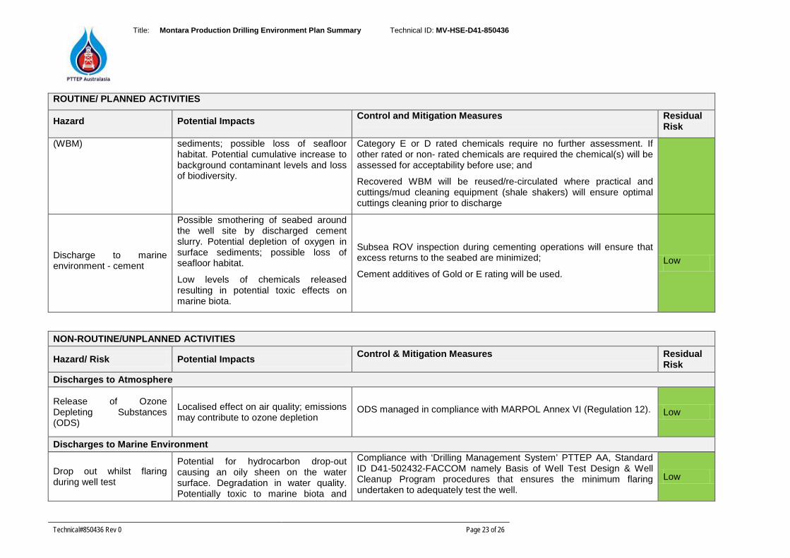
Title: Montara Production Drilling Environment Plan Summary Technical ID: MV-HSE-D41-850436
Technical#850436 Rev 0 Page 23 of 26
ROUTINE/ PLANNED ACTIVITIES
Hazard Potential Impacts Control and Mitigation Measures Residual Risk
(WBM) sediments; possible loss of seafloor habitat. Potential cumulative increase to background contaminant levels and loss of biodiversity.
Category E or D rated chemicals require no further assessment. If other rated or non- rated chemicals are required the chemical(s) will be assessed for acceptability before use; and
Recovered WBM will be reused/re-circulated where practical and cuttings/mud cleaning equipment (shale shakers) will ensure optimal cuttings cleaning prior to discharge
Discharge to marine environment - cement
Possible smothering of seabed around the well site by discharged cement slurry. Potential depletion of oxygen in surface sediments; possible loss of seafloor habitat.
Low levels of chemicals released resulting in potential toxic effects on marine biota.
Subsea ROV inspection during cementing operations will ensure that excess returns to the seabed are minimized;
Cement additives of Gold or E rating will be used. Low
NON-ROUTINE/UNPLANNED ACTIVITIES
Hazard/ Risk Potential Impacts Control & Mitigation Measures Residual Risk
Discharges to Atmosphere
Release of Ozone Depleting Substances (ODS)
Localised effect on air quality; emissions may contribute to ozone depletion
ODS managed in compliance with MARPOL Annex VI (Regulation 12).
Low
Discharges to Marine Environment
Drop out whilst flaring during well test
Potential for hydrocarbon drop-out causing an oily sheen on the water surface. Degradation in water quality. Potentially toxic to marine biota and
Compliance with ‘Drilling Management System’ PTTEP AA, Standard ID D41-502432-FACCOM namely Basis of Well Test Design & Well Cleanup Program procedures that ensures the minimum flaring undertaken to adequately test the well.
Low
Title: Montara Production Drilling Environment Plan Summary Technical ID: MV-HSE-D41-850436
Technical#850436 Rev 0 Page 24 of 26
NON-ROUTINE/UNPLANNED ACTIVITIES
Hazard/ Risk Potential Impacts Control & Mitigation Measures Residual Risk
rafting seabirds.
Accidental release of chemicals or non-hazardous/hazardous waste discharge from MODU and vessels during general operations and bulk transfers (spills/leaks)
Pollution from waste products leading to deterioration in water quality. Potential for impacts to fauna due to ingestion or entanglement of plastics etc. Pollution from hazardous waste products and potential for spills and leaks of SBM, oils or hydraulic fluids which may cause localised toxicity effects on marine life and deterioration in water quality.
Implementation of Waste Management Plan (PTTEP AA Waste Management Plan Standard ID D30-500469-FACCOM) including compliance with MARPOL requirements, waste log maintained, secure storage and correct segregation of solid and hazardous wastes in all areas on the MODU and support vessels;
Implementation of MODU hazardous substances procedures to ensure:
Vessels maintain a file containing the Material Safety Data Sheets (MSDS) for all hazardous chemicals carried aboard;
Copies of the relevant MSDS are also kept in the spaces where these chemicals are stored or handled;
All chemicals are in appropriate containers and clearly marked;
Designated containment areas onboard for oil, grease and chemical storage;
Clean up materials will be available on the MODU and vessels to manage small deck spills;
Minimal amounts of hazardous wastes and only operationally required amounts of hazardous materials to be stored onboard
Transfer operations undertaken in accordance with rig-specific procedures including surveillance.
Equipment to be regularly maintained and operated in compliance with contractors scheduled maintenance program to detect spills or leaks from fittings and connections;
Low
Title: Montara Production Drilling Environment Plan Summary Technical ID: MV-HSE-D41-850436
Technical#850436 Rev 0 Page 25 of 26
NON-ROUTINE/UNPLANNED ACTIVITIES
Hazard/ Risk Potential Impacts Control & Mitigation Measures Residual Risk
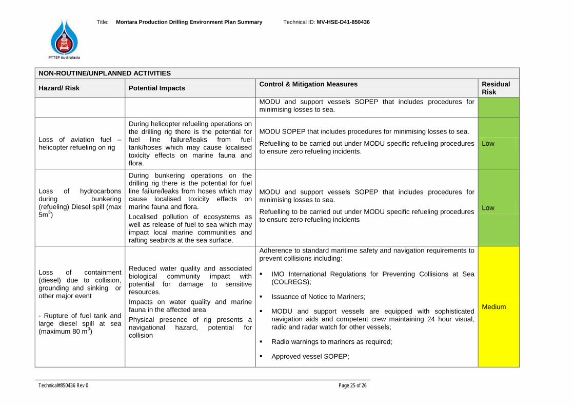
MODU and support vessels SOPEP that includes procedures for minimising losses to sea.
Loss of aviation fuel – helicopter refueling on rig
During helicopter refueling operations on the drilling rig there is the potential for fuel line failure/leaks from fuel tank/hoses which may cause localised toxicity effects on marine fauna and flora.
MODU SOPEP that includes procedures for minimising losses to sea.
Refuelling to be carried out under MODU specific refueling procedures to ensure zero refueling incidents.
Low
Loss of hydrocarbons during bunkering (refueling) Diesel spill (max 5m3)
During bunkering operations on the drilling rig there is the potential for fuel line failure/leaks from hoses which may cause localised toxicity effects on marine fauna and flora. Localised pollution of ecosystems as well as release of fuel to sea which may impact local marine communities and rafting seabirds at the sea surface.
MODU and support vessels SOPEP that includes procedures for minimising losses to sea.
Refuelling to be carried out under MODU specific refueling procedures to ensure zero refueling incidents
Low
Loss of containment (diesel) due to collision, grounding and sinking or other major event - Rupture of fuel tank and large diesel spill at sea (maximum 80 m3)
Reduced water quality and associated biological community impact with potential for damage to sensitive resources. Impacts on water quality and marine fauna in the affected area Physical presence of rig presents a navigational hazard, potential for collision
Adherence to standard maritime safety and navigation requirements to prevent collisions including: IMO International Regulations for Preventing Collisions at Sea
(COLREGS);
Issuance of Notice to Mariners;
MODU and support vessels are equipped with sophisticated navigation aids and competent crew maintaining 24 hour visual, radio and radar watch for other vessels;
Radio warnings to mariners as required;
Approved vessel SOPEP;
Medium
Title: Montara Production Drilling Environment Plan Summary Technical ID: MV-HSE-D41-850436
Technical#850436 Rev 0 Page 26 of 26
NON-ROUTINE/UNPLANNED ACTIVITIES
Hazard/ Risk Potential Impacts Control & Mitigation Measures Residual Risk
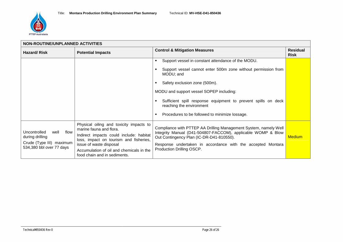
Support vessel in constant attendance of the MODU.
Support vessel cannot enter 500m zone without permission from MODU; and
Safety exclusion zone (500m).
MODU and support vessel SOPEP including: Sufficient spill response equipment to prevent spills on deck
reaching the environment
Procedures to be followed to minimize lossage.
Uncontrolled well flow during drilling Crude (Type III) maximum 534,380 bbl over 77 days
Physical oiling and toxicity impacts to marine fauna and flora. Indirect impacts could include: habitat loss, impact on tourism and fisheries, issue of waste disposal Accumulation of oil and chemicals in the food chain and in sediments.
Compliance with PTTEP AA Drilling Management System, namely Well Integrity Manual (D41-504807-FACCOM), applicable WOMP & Blow Out Contingency Plan (IC-DR-D41-810550).
Response undertaken in accordance with the accepted Montara Production Drilling OSCP.
Medium