TECHNICAL COMMITTEES - IEEE · TECHNICAL COMMITTEES MICHAEL SPENCER ANd FAWWAZ ULABY T he...
6
0274-6638/16©2016IEEE IEEE GEOSCIENCE AND REMOTE SENSING MAGAZINE MARCH 2016 40 TECHNICAL COMMITTEES MICHAEL SPENCER AND FAWWAZ ULABY T he scientific users of radio frequencies must con- tend with the fact that the spectrum is becoming increasingly crowded, which is in large measure due to the advent of advanced affordable electronics and mobile wireless technology. The growing demand for bandwidth has sparked increased discussions in the microwave remote sensing community of how to re- spond to this crowded spectrum environment and how to deal with the consequent issues of radio frequency interference (RFI). The National Research Council (NRC) published a study in 2010, “Spectrum Manage- ment for Science in the 21st Century” [1], that exam- ined the increasing difficulties encountered by pas- sive microwave measurements in the presence of the expanding worldwide commercial and governmen- tal occupancy of the radio spectrum. The challenges faced by passive sensors also have been summarized in a 2014 IEEE Geoscience and Remote Sensing Magazine article [2]. Recognizing that active microwave sensors also face spectrum-related issues, NASA later commis- sioned the NRC to perform a similar study, “A Strategy for Active Remote Sensing Amid Increased Demand for Radio Spectrum,” which was recently published in July 2015 [3]. (In this article, the report will be abbre- viated as the NRC Active Sensing Report.) This report addresses the spectrum issues faced by active science sensors, primarily radars, and makes recommenda- tions to government, industry, and the remote sensing community going forward. The report considers mul- tiple types of active sensors including ground-based operational weather radars, ionospheric sensing radar, and radar astronomy. This article focuses on spectrum topics related primarily to Earth remote sensing from aircraft and spacecraft. THE USE OF THE RADIO SPECTRUM BY ACTIVE SENSORS Active remote sensing—with its unique ability to in- vestigate geophysical phenomena by exploiting the amplitude, range delay, Doppler shift, and phase changes in the reflected signal—is employed in a va- riety of earth science disciplines by a growing num- ber of nations. These disciplines include atmospheric science, weather prediction, oceanography, climate studies, cryospheric monitoring, terrestrial ecology, hydrology, seismology, as well as disaster assessment applications. The choice of frequency for a given me- dium to be sensed (i.e., land, water, or atmosphere) is dictated by the nature of the wave-medium interac- tion associated with the target as well as the transmis- sion properties of any intervening medium, such as the atmosphere for land remote sensing. Active Earth remote sensing is currently employed at frequencies as low as a few megahertz and as high as hundreds of gigahertz and at many frequencies in between. For example, low RF frequencies (i.e., long wavelengths) Spectrum Issues Faced by Active Remote Sensing Radio frequency interference and operational restrictions Digital Object Identifier 10.1109/MGRS.2016.2517410 Date of publication: 15 April 2016 Message from FARS Technical Committee Chairs Sidharth Misra and Paolo de Matthaeis One of the main objectives of the Frequency Allocations in Remote Sensing (FARS) Technical Committee (TC) has been to inform IEEE Geoscience and Remote Sensing Society members of the increasing spectrum challenges faced by the remote sensing community. In the June 2014 issue of IEEE Geoscience and Remote Sensing Magazine, we presented an overview of spec- trum allocations and radio frequency interference management techniques for passive remote sensing. This article, prepared by FARS-TC members, summarizes the impact of interference on active remote sensing systems. If you are interested in contribut- ing or learning about issues such as these, please contact the chairs of the FARS-TC.
Transcript of TECHNICAL COMMITTEES - IEEE · TECHNICAL COMMITTEES MICHAEL SPENCER ANd FAWWAZ ULABY T he...
0274-6638/16©2016IEEE ieee Geoscience and remote sensinG maGazine march 201640
Technical commiTTees
MICHAEL SPENCER ANd FAWWAZ ULABY
T he scientific users of radio frequencies must con-tend with the fact that the spectrum is becoming
increasingly crowded, which is in large measure due to the advent of advanced affordable electronics and mobile wireless technology. The growing demand for bandwidth has sparked increased discussions in the microwave remote sensing community of how to re-spond to this crowded spectrum environment and how to deal with the consequent issues of radio frequency interference (RFI). The National Research Council (NRC) published a study in 2010, “Spectrum Manage-ment for Science in the 21st Century” [1], that exam-ined the increasing difficulties encountered by pas-sive microwave measurements in the presence of the expanding worldwide commercial and governmen-tal occupancy of the radio spectrum. The challenges faced by passive sensors also have been summarized in a 2014 IEEE Geoscience and Remote Sensing Magazine
article [2]. Recognizing that active microwave sensors also face spectrum-related issues, NASA later commis-sioned the NRC to perform a similar study, “A Strategy for Active Remote Sensing Amid Increased Demand for Radio Spectrum,” which was recently published in July 2015 [3]. (In this article, the report will be abbre-viated as the NRC Active Sensing Report.) This report addresses the spectrum issues faced by active science sensors, primarily radars, and makes recommenda-tions to government, industry, and the remote sensing community going forward. The report considers mul-tiple types of active sensors including ground-based operational weather radars, ionospheric sensing radar, and radar astronomy. This article focuses on spectrum topics related primarily to Earth remote sensing from aircraft and spacecraft.
THE USE OF THE RADIO SPECTRUM BY ACTIVE SENSORSActive remote sensing—with its unique ability to in-vestigate geophysical phenomena by exploiting the amplitude, range delay, Doppler shift, and phase changes in the reflected signal—is employed in a va-riety of earth science disciplines by a growing num-ber of nations. These disciplines include atmospheric science, weather prediction, oceanography, climate studies, cryospheric monitoring, terrestrial ecology, hydrology, seismology, as well as disaster assessment applications. The choice of frequency for a given me-dium to be sensed (i.e., land, water, or atmosphere) is dictated by the nature of the wave-medium interac-tion associated with the target as well as the transmis-sion properties of any intervening medium, such as the atmosphere for land remote sensing. Active Earth remote sensing is currently employed at frequencies as low as a few megahertz and as high as hundreds of gigahertz and at many frequencies in between. For example, low RF frequencies (i.e., long wavelengths)
Spectrum Issues Faced by Active Remote Sensing Radio frequency interference and operational restrictions
Digital Object Identifier 10.1109/MGRS.2016.2517410 Date of publication: 15 April 2016
Message from FARS Technical Committee Chairs Sidharth Misra and Paolo de MatthaeisOne of the main objectives of the Frequency Allocations in
Remote Sensing (FARS) Technical Committee (TC) has been to
inform IEEE Geoscience and Remote Sensing Society members of
the increasing spectrum challenges faced by the remote sensing
community. In the June 2014 issue of IEEE Geoscience and
Remote Sensing Magazine, we presented an overview of spec-
trum allocations and radio frequency interference management
techniques for passive remote sensing. This article, prepared
by FARS-TC members, summarizes the impact of interference on
active remote sensing systems. If you are interested in contribut-
ing or learning about issues such as these, please contact the
chairs of the FARS-TC.

march 2016 ieee Geoscience and remote sensinG maGazine 41
are best suited for applications that require good penetra-tion through ice or vegetation. In contrast, high frequen-cies (i.e., short wavelengths) are needed for the detection of small microscopic cloud particles (Figure 1).
FREQUENCY ALLOCATIONSThe radio spectrum is used by many types of services, from radio and television broadcasting to wireless phone com-munication; weather, military, and remote sensing radars; and radio and radar astronomy, among many others. Ra-dio regulations and frequency allocations are developed at both national and international levels. At the interna-tional level, regulations are formulated by the Radiocom-munication Sector of the International Telecommunica-tions Union (ITU-R). Spectrum allocations for specific uses are established at the World Radiocommunication Conference, which is held every three to four years. Space-based radar remote sensing operates under the Earth Ex-ploration-Satellite Service (EESS/active), and the associat-ed spectrum allocations are shown in Table 1. Within the United States, spectrum oversight of governmental users [such as NASA, the National Oceanic and Atmospheric Ad-ministration (NOAA), and the U.S. Department of Defense (DoD)] is the responsibility of the National Telecommuni-cations and Information Administration (NTIA), whereas oversight of private sector users is provided by the U.S. Federal Communications Commission (FCC). It is impor-tant to note that active sensors typically share allocations with other services, such as communication systems and
radiolocation radars. For active systems, it is also impor-tant to differentiate between a spectrum allocation, which is basically the divvying up of the spectrum for different uses, and a spectrum assignment, which is the actual permission to radiate at a specific transmit power in a giv-en band over a particular region of the earth. For active sensors, having a spectrum allocation may not entitle a sensor to ra-diate if that sensor is thought to create harmful interference to other primary users of that spectral band.
The following two constraints that active sensors often encoun-ter are associated with the spectrum allocation and assign-ment process that governs active sensors: 1) The shared nature of the allocations can produce RFI
that can degrade the performance of science sensors. 2) Active science sensors may be denied an assignment or,
otherwise, restricted in their ability to transmit as desired.
RADIO FREQUENCY INTERFERENCE RFI refers to the unintended reception of a signal transmit-ted by an unrelated source. When an active sensor receives such a signal, the intended science measurement may be corrupted. An active sensor may also act as the source of in-terference to a communication system, a passive sensing sys-tem, or another radar system, which is discussed in the next
FIGURE 1. The choice of frequencies for satellite active sensing is dictated by the physics of the relevant scattering mechanism. Representa-tive, but certainly not exhaustive, examples of the types of measurements used at each frequency are shown. [Figure used with permission from “A Strategy for Active Remote Sensing Amid Increased Demand for Radio Spectrum,” courtesy of the European Space Agency (ESA).]
ForestMonitoring,
Ice Sounding ...0.435 GHz
Geology, Oceans,Sea Ice, Land Use,
Topography, Waves,Swells, Solid Earth, ...
5 GHz
Ocean,Wind, Ice, ...
13.5 GHz
PrecipitationRadars, ...
24 GHz
Cloud Profiling94, 134, 238 GHz
Vegetation, Snow,Rain, Wind
17 GHz
Wave Structure,Geology, Soil
Moisture...
1.2, 3.2 GHz
Ice, Wind, OceanAltimetry,
Rain Radars,...
36 GHz
Altimetry (Land andIce at High Resolution)
78 GHz
HiRes SAR (Dual-Use),Topography, Land Use,
Surface Motion,Snow/Ice,
...8.5, 9.3–10 GHz
0.3 mm3 mm3 cm30 cm
1 GHz 10 GHz 100 GHz 1,000 GHz
P Band L Band S Band C Band X Band Ku/K/Ka Band Millimeter Submillimeter
RFI REFERS TO THE
UNINTENDED RECEPTION
OF A SIGNAL TRANSMIT-
TED BY AN UNRELATED
SOURCE.

ieee Geoscience and remote sensinG maGazine march 201642
TABLE 1. THE EESS (ACTIVE) FREQUENCY ALLOCATIONS AND SOME SAMPLES OF CURRENT UTILIZATION BY RADAR SENSORS. (FROM “A STRATEGY FOR ACTIVE REMOTE SENSING AMID INCREASED DEMAND FOR RADIO SPECTRUM.”)
BANd dESIGNATION
FREQUENCY BANd AS ALLOCATEd IN ARTICLE 5 OF THE RAdIO REGULATIONS
APPLICATION BANdWIdTHS
SCATTEROMETER ALTIMETER IMAGERPRECIPITATION RAdAR
CLOUd PROFILE RAdAR
P band 432–438 MHz 6 MHz
L band 1,215–1,300 MHz 5–500 kHz 20–85 MHz
S band 3,100–3,300 MHz 200 MHz 20–200 MHz
C band 5,250–5,570 MHz 5–500 kHz 320 MHz 20–320 MHz
X band 8,550–8,650 MHz 5–500 kHz 100 MHz 20–100 MHz
X band 9,300–9,900 MHz 5–500 kHz 300 MHz 20–600 MHz
Ku band 13.25–13.75 GHz 5–500 kHz 500 MHz 0.6–14 MHz
Ku band 17.2–17.3 GHz 5–500 kHz 0.6–14 MHz
K band 24.05–24.25 GHz 0.6–14 MHz
Ka band 35.5–36 GHz 5–500 kHz 500 MHz 0.6–14 MHz
W band 78–79 GHz 0.3–10 MHz
W band 94–94.1 GHz 0.3–10 MHz
mm band 133.5–134 GHz 0.3–10 MHz
mm band 237.9–238 GHz 0.3–10 MHz
section. As part of the NRC active sensing study, an assess-ment of RFI experienced by radar remote sensing receivers was conducted for the bands shown in Table 1. The overall conclusions for the current environment are as follows:
◗◗ The lower frequency bands, such as ultrahigh frequency (UHF), P band, and L band, were found to contain sig-nificant global interference that has been observed to
grow over time. Examples cited in the report include the ground-based European Incoherent Scatter Radar, which ceased operations at 900 MHz after many years of ionospheric studies due to interference from recently deployed telecom services; the interference observed by UHF airborne radars (e.g., the Furgro GeoSAR and NASA AirMOSS) due to the plethora of land-mobile systems; and the steady increase of global L-band inter-ference observed by Japan’s series of L-band synthetic aperture radars (SARs) over the past two decades (the JERS-1 mission from 1992 to 1998, ALOS/PALSAR from 2006 to 2011, and the recently launched ALOS-2). A typical time spectrogram manifesting RFI at the L band is shown in Figure 2.
◗◗ Users of midfrequency bands, such as the C band and X band, report some interference that may be increasing with time, but the number of incidences has been small to date and limited in geographic location (although, as discussed below, there are significant future threats to these bands). There is an extensive spaceborne data set at the C band beginning in 1991 provided by the ESA’s ERS-1, ERS-2, ENVISAT, MetOP, and Sentinel satellites as well as Canada’s Radarsat series.
◗◗ Active sensing observations at high frequencies (i.e., Ku band and above) appear to be relatively unaf-fected by RFI. Systems utilizing these frequencies in-clude wind scatterometers, ocean and ice altimeters, and rain/cloud radars flown by a number of space agencies.The prevalence of RFI at lower radar frequencies has given
rise to a variety of RFI detection and mitigation techniques
FIGURE 2. A time spectrogram of observed RFI taken from the L-band ALOS/PALSAR mission. The detected power is shown. The horizontal axis is in megahertz from the center frequency, and the vertical axis is the range line number, which corresponds to pulses in time. (Figure used with permission from “A Strategy for Active Remote Sensing Amid Increased Demand for Radio Spectrum,” courtesy of NASA/JPL-Caltech and JAXA.)
700
600
500
400
300
200
100
–13.
5–1
0.5
–7.5
–4.5
–1.5 1.
54.
57.
510
.513
.5
Line
Sec
tor
3433323130292827262524
Frequency (MHz)
march 2016 ieee Geoscience and remote sensinG maGazine 43
that were developed to correct the data and alleviate the impact on the desired science. There are many tech-niques that have been developed with the specific strategy function of wheth-er the radar is ground based, airborne, or spaceborne and as a function of the radar center frequency, bandwidth, and application (see [4]–[6] and as-sociated references from IEEE Transac-tions on Geoscience and Remote Sensing special issue on RFI in October 2013). Simply put, RFI is typically detected by identifying the presence of signals different from the expected echo re-turn by their spectral, temporal, or statistical signatures. For example, the presence of a narrowband interferer will appear as a conspicuous spike in the Fourier transform domain, and a pulsed RFI source can be identi-fied by statistically significant jumps in the time domain. Note how both types of interference appear in Figure 2. Also, since radar returns from the surface have Gaussian statistics due to speckle, the presence of RFI may be detected by signal statistics exhibiting non-Gaussian behavior. Once detected, RFI can be removed by filters designed to excise the offending signal while mini-mizing impact to the desired radar echo. Mitigation tech-niques work best when the interference has sparse occupancy of the frequency/time domain utilized by the sensor. As more and more frequencies and/or times are impacted by RFI from either a single source or multiple sources, the interfering sig-nals may become more difficult to detect, and mitigation be-comes more deleterious to the measurement because more of the desired echo is removed when filtering is applied. In the extreme, a broadband continuous noiselike signal may be impossible to appropriately detect or remove.
Although the current RFI environment, as of 2015, is mostly tolerable due to the application of mitigation techniques when RFI exists, the spectral landscape is con-tinuously evolving. There is growing concern that spec-trum pressure for new systems could severely impact re-mote sensing systems. A high-stakes example is the push by the broadband wireless industry for the addition of the 5,350–5,470-MHz band for radio local area network (RLAN) use. The ESA has studied this issue and has shown that the proposed RLAN deployment will create harmful interference to Sentinel-1 satellites as well as Canada’s Ra-darsat-2 and Radarsat Constellation Mission (three satel-lites). A major concern is that such an extension of mobile services to the 5,350–5,470-MHz band would eventually be applied worldwide. Studies by the ESA and the Cana-dian Space Agency suggest that no mitigation would be
possible because the aggregated effect of the RLAN RFI is entirely different from that of classical (i.e., pulsed or nar-rowband) RFI experienced with SAR in that it appears as continuous broadband noiselike interference and, conse-quently, is distinctively nonsparse in both the frequency and the time domains.
TRANSMIT RESTRICTIONS ON ACTIVE SENSORSAs discussed, a unique aspect of active sensors relative to pas-sive sensors is that they may be denied a frequency assignment (or, more commonly, have sig-nificant operational restric-tions placed on them) if they are perceived as causing inter-ference to existing services. Examples of recently imposed transmit restrictions include the following:
◗◗ UHF radars, such as the airborne Fugro GeoSAR inter-ferometric SAR, are required to notch their transmit spectrum to avoid transmitting in specific bands. Over some areas of the United States, the required notching and associated removed bandwidth is so severe as to de-grade science performance.
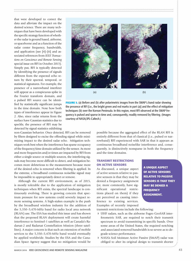
◗◗ NASA’s Soil Moisture Active Passive (SMAP) radar was obliged to alter its original design to transmit shorter
FIGURE 3. (a) Before and (b) after polarimetric images from the SMAP L-band radar showing the presence of RFI [i.e., the bright green and red marks in part (a)] and the effect of mitigation techniques (b) over the Korean Peninsula. In this region, most RFI observed at the SMAP fre-quency is pulsed and sparse in time and, consequently, readily removed by filtering. (Images courtesy of NASA/JPL-Caltech.)
(a) (b)
A UNIQUE ASPECT
OF ACTIVE SENSORS
RELATIVE TO PASSIVE
SENSORS IS THAT THEY
MAY BE DENIED A
FREQUENCY
ASSIGNMENT.

ieee Geoscience and remote sensinG maGazine march 201644
higher power pulses to minimize the potential interfer-ence into long-range air surveillance radars operating at the L band (see Figure 3). The necessary change came late in the development process and at some significant expense to the SMAP project.
◗◗ The P-band European BIOMASS mission has been de-nied permission to transmit within the line of sight of space object-tracking radars located in North America
and Europe. Even though the primary mission objectives will still be met with this outage, this will, nevertheless, deprive the community of valuable science data over a significant portion of the globe (see Figure 4). Fur-thermore, this precedent may negatively impact other poten-tial P-band missions that could target geophysical processes that are important in the Northern
Hemisphere, such as root zone soil moisture and ice sheet sounding.An important finding reported by the NRC Active
Sensing Committee is that there are no reported cas-es where a science sensor has interfered with a non-science service. The committee also found a distinct sentiment in the radar remote sensing community that, in light of such a track record, some of the crite-ria applied by government spectrum managers in mak-ing assignments to science instruments are extremely
conservative and that perhaps less stringent allowances should be considered given the societal importance of such measurements. Furthermore, spectrum managers should allow experimental tests to develop new guide-lines for conditions under which multiple users can operate without interfering with one another.
RECOMMENDATIONS FOR THE PROTECTION AND EFFECTIVE USE OF THE SPECTRUM REQUIRED FOR ACTIVE REMOTE SENSINGKey recommendations from the NRC Active Sensing Report concerning how to protect and effectively use the spectrum required for remote sensing fall into the following categories: actions by the science community, actions by federal agencies, and possible actions by the telecommunications industry.
Actions by the science communityMerit alone will not ensure that the spectrum required is available for the scientific community. Scientific interests must be actively represented in the spectrum allocation and assignment process to ensure that science needs are met. This will require ongoing efforts to ensure that ac-tive remote sensing is balanced with competing interests in the regulatory processes and to make more informa-tion available about the value of active remote sensing.
◗◗ The science community should increase its participation in the ITU, NTIA, and FCC spectrum management pro-cesses. This includes close monitoring of all spectrum management issues to provide early warning for areas of concern. It also requires regular filings in regulatory
FIGURE 4. The regions of the world to be covered by the P-band European BIOMASS mission are shown in red with the regions of the Northern Hemisphere that will be denied coverage, due to transmit restrictions, are shaded and delineated by green borders. The area of coverage denial is so large because it includes not only the main beam of the BIOMASS antenna but also periods when side lobes of the antenna pattern are in view. (Image courtesy of ESA.)
MERIT ALONE wILL
NOT ENSURE THAT THE
SPECTRUM REQUIRED
IS AVAILABLE FOR THE
SCIENTIFIC COMMUNITY.

45
proceedings and meetings with decision makers. This will build credibility for the science community to en-sure a seat at the table for spectrum-related decision making that impacts the science community.
◗◗ For the spectrum management process to be effective, the science community, NASA, NOAA, the National Science Foundation, and the DoD should also articu-late the value of the science-based uses of the radio frequency spectrum. Such values will include both economic values, through enabling commerce or re-ducing the adverse economic impacts of natural phe-nomena, and noneconomic values that come from sci-entific research.
Actions by FederAl AgenciesThe actions of federal agencies responsible for supporting scientific uses of active remote sensing and for overseeing spectrum allocations include the following:
◗◗ NASA should lead an effort to significantly improve charac-terization of the radio frequency interference environment that affects active science measurements. This effort should include the use of modeling, dedicated ground-based and airborne characterization campaigns, and data mining of currently operating scientific sensors. To the extent pos-sible, this effort should be a collaborative one with other space and science agencies of the world.
◗◗ NASA should lead a community effort to construct a set of metrics that relates to the various radio fre-quency interference environments encountered and the associated degradation in science performance for each major class of instruments employed in active remote sensing.
◗◗ Radar systems meeting specific criteria for pulse repeti-tion rate, maximum pulse width, and duty cycle should be permitted by the FCC or the NTIA to operate as sec-ondary users in communication bands where minimal interference to the communications operations would be expected to occur.
◗◗ NASA should facilitate the possibility of time and fre-quency sharing between the ESA BIOMASS and the DoD’s Space Object Tracking Radar system.
Possible Actions by the telecommunicAtions industry
◗◗ The 50–60-GHz millimeter-wave frequency band in-cludes several subbands already allocated to mobile communications. The use of millimeter-wave frequencies for short-wave femtocell-sized communications would significantly increase network capacity by an order of
magnitude, thereby reducing pressure on the spectrum and, therefore, on the active remote sensing users as well.
◗◗ The wireless industry should consider pursuing the fem-tocell approach by developing towers, networks, and the like to add the use of millimeter-wave frequencies for communications in 5G and up.
For a complete set of findings and recommendations of the NRC study, the reader is directed to the full NRC Active Sensing Report.
In conclusion, it is important to point out that com-mittees and institutions, such as the NRC Committee on Radio Frequencies, the Space Frequency Coordination Group, and the IEEE GRSS Frequency Allocations in Re-mote Sensing Committee, have been advocating for the spectrum needs of the scientific community. With in-creasing pressure on available spectra, it is crucial for the remote sensing community to support these efforts to ad-dress this challenge.
AUTHOR INFORMATIONMichael Spencer is with the Jet Propulsion Laboratory, Cal-ifornia Institute of Technology, in Pasadena, California.
Fawwaz Ulaby is with the University of Michigan, Ann Arbor.
REFERENCES[1] National Academies of Sciences, Engineering, and Medicine,
Spectrum Management for Science in the 21st Century. Washington, DC: National Academies Press, 2010.
[2] S. Misra and P. de Matthaeis, “Passive remote sensing and radio frequency interference (RFI): An overview of spectrum allocations and RFI management algorithms,” IEEE Trans. Geosci. Remote Sens-ing, vol. 2, no. 2, pp. 68–73, June 2014.
[3] National Academies of Sciences, Engineering, and Medicine, A Strategy for Active Remote Sensing Amid Increased Demand for Radio Spectrum. Washington, DC: National Academies Press, 2015.
[4] F. Zhou, M. Tao, X. Bai, and J. Liu, “Narrow-band interference suppression for SAR based on independent component analysis,” IEEE Trans. Geosci. Remote Sensing, vol. 51, no. 10, pp. 4952–4960, Oct. 2013.
[5] F. J. Meyer, J. B. Nicoll, and A. P. Doulgeris, “Correction and characterization of radio frequency interference signatures in L-band synthetic aperture radar data,” IEEE Trans. Geosci. Remote Sensing, vol. 51, no. 10, pp. 4961–4972, Oct. 2013.
[6] M. W. Spencer, C. W. Chen, H. Ghaemi, S. F. Chan, and J. E. Belz, “RFI characterization and mitigation for the SMAP radar,” IEEE Trans. Geosci. Remote Sensing, vol. 51, no. 10, pp. 4973–4982, Oct. 2013.
MARCH 2016 ieee GeoSCienCe and reMote SenSinG MaGazine