Technical Appendix A: Supporting Documents
26
Technical Appendix A: Supporting Documents Page A-1 Creating a Resilient Transportation Network in Skagit County January 2015 Technical Appendix A: Supporting Documents 1. Interviews with WSDOT Partners 2. Letter to the Corps 3. Sample Workshop Agendas
Transcript of Technical Appendix A: Supporting Documents

Technical Appendix A: Supporting Documents Page A-1 Creating a Resilient Transportation Network in Skagit County January 2015
Technical Appendix A: Supporting Documents
1. Interviews with WSDOT Partners
2. Letter to the Corps
3. Sample Workshop Agendas

Page A-2 Technical Appendix A: Supporting Documents January 2015 Creating a Resilient Transportation Network in Skagit County
1 Interviews with WSDOT Partners
A-1 Identifying Initial Areas of Concern As part of the data collection effort for this project, we wanted to understand where problems have occurred in the past on state facilities and infrastructure. The project team identified several sources to consider when defining initial “areas of concern,” including the following:
• Partner interviews • Historical flood data • GIS to assist in analyzing other factors that intersect with the identified areas.
We used several steps to identify initial areas of concern in the project area.
a. Project team identified partners in the project area
The table below shows the local jurisdictions, dike districts, utilities, and facility managers identified for interviews.
Facility Contact City of Anacortes City Engineer
City of Burlington Public Works Director Planning Director
Town of Concrete Planner Town of Lyman Consultant Planner Town of Hamilton Consultant Planner City of Mount Vernon City Engineer
City of Sedro-Woolley Public Works Director Planning Director
Skagit County
EMS/Homeland Security Program Coordinator Public Works County Engineer Engineering Technician Watershed Planner
Swinomish Tribe Tribal Planning Director Upper Skagit Indian Tribe Public Works Director Dike District 1 Commissioners Dike District 12 Manager Dike District 17 Manager Puget Sound Energy Senior Engineering Specialist WSDOT Maintenance WSDOT Ferries
Maintenance Superintendent Director Vessel & Terminal Engineering

Technical Appendix A: Supporting Documents Page A-3 Creating a Resilient Transportation Network in Skagit County January 2015
b. We identified the purpose and objectives for the interviews
We wanted to understand the user needs, facility challenges, potential impacts, and shared vision for how to move forward. We went to our partners and asked them what they had encountered on the state system and within their communities.
c. We then identified interview questions and support materials
We posed the following questions to each partner:
1. What issues concern you about hazard mitigation preparation in your community? 2. What areas are you most concerned with?
Have you done any work recently that improved this condition? Do you have any improvement plans you are working on?
3. Are there state highway concerns you have? 4. How do you think these issues should be handled? 5. What concerns do you have when it comes to emergency evacuation coordination? 6. Follow-up questions based on dialogue with community.
d. We developed data table with characteristics
From the information gathered during the interviews, we started to develop areas of concern that each jurisdiction felt warranted further review and mitigation efforts to help safeguard the system. We also utilized information provided in the Skagit County Natural Hazard Mitigation plan.
This was then added to GIS and analysis was run to determine which 31 factors and features would intersect these areas. The 31 data sets included summaries of the concerns; facilities and areas that need protections like hospitals and schools; firehouse and cultural sites; flood and stormwater features like discharge, fish passage, BMPs, FEMA q3 data and tsunami data; climate vulnerability results; existing WSDOT facilities; traffic data sets; landslips; and unstable slopes, to name a few.
Table A-1 is an example of a table we created after the interview results were incorporated into GIS and the additional factors were considered. This information was incorporated and further refined as the process moved into more in-depth GIS analysis of the GI study alternatives.

Page A-4 Technical Appendix A: Supporting Documents January 2015 Creating a Resilient Transportation Network in Skagit County
Table A-1 GIS Metadata
Skagit Climate Pilot- vulnerability information mapped by milepost as collected from past experience in this area
SR/Road Jurisdiction BMP EMP Flood SLRLand
MovementWinter storms Comments
5 WSDOT 219 226 X Low area/ dike failure/High volume5 Dike Dist. 12 220 225 X Low area5 WSDOT 226 232.85 X Low area/dike failure/high volume5 WSDOT 231 234 X Sterling issue/ pond on I-59 WSDOT 41 43 X 10 feet of water- Nookachamps9 WSDOT 49.82 49.88 X Bridge9 Skagit Co. 51 54 X Clear Lake9 WSDOT 54.38 54.56 X Bridge over Skagit9 WSDOT 63.7 66.5 X Water over roadway often9 WSDOT 70 71 X Water over roadway often
11 WSDOT 0 11 X X X Water over road/ landslide20 Skagit Co. 44 47 X Water over road20 WSDOT 51.56 52 X Bridge20 Dike Dist. 12 53 54 X Culvert issue20 WSDOT 60 67 X Sterling issue impacts20 Hospital Dist. 63.32 X Hospital20 Everyone 61 64 X Sterling20 WSDOT 71.57 71.84 X Very unstable20 WSDOT 75 87 X Unstable Slope20 Skagit Co 74 74.5 X Sedimentation /Water over road20 Town of Lyman 72 72.7 X Landslide20 WSDOT 89 92 X Landslide20 WSDOT 92.7 93.6 X Unstable Slope20 WSDOT 98 100 X Unstable Slope20 WSDOT 101.5 101.7 X CED/ Channel migration20 WSDOT 109 116.5 X Landslide20 WSDOT 48 X Sharpes Corner
20 Spur City of Anacortes 49 51 X landslide20 Spur City of Anacortes 49 X Ponds during heavy rain20 Spur WSDOT FERRY 55 X Sea Level Rise
530 WSDOT 55 56 X Channel migration530 Skagit Co. 56 56 X Bridge530 WSDOT 62 63 X X Erosion530 Skagit Co. 66 68 X Water over road536 City of Mount Vernon 4.5 5.3 X Downtown538 City of Mount Vernon 0 3 X Dike Overtop538 City of Mount Vernon 2.5 2.86 X Nookachamps538 City of Mount Vernon 3.47 3.53 X Stormwater detention534 WSDOT 2 X Stormwater inundation
Assumptions- Area - Skagit River basin in Skagit CountyAnecdotal information from local jurisdictions/ WSDOT Maintenance/ Dike Districts

Technical Appendix A: Supporting Documents Page A-5 Creating a Resilient Transportation Network in Skagit County January 2015
A-2 Partner Interview Results Following are the summaries of the 16 interviews we conducted during our investigation of initial areas of concerns. For this report, we focused on sharing the anecdotal information provided by each partner that represents existing hazards and concerns in their area of the county and their expertise.
Partner Interview #1: City of Anacortes
Hazards/concerns in the city:
• It ponds when it rains hard in the fast lane of SR 20; it often accumulates and becomes pretty deep. • The city's source of potable water is the Skagit River; the water treatment plant is located adjacent to
the Skagit River near the City of Mount Vernon.
Interviewed: City Engineer Population 16,080 Elevation 23 feet Geographical Size 15.53 sq. miles Principal Economic Base Industrial/Manufacturing Highway SR 20, SR 20 Spur

Page A-6 Technical Appendix A: Supporting Documents January 2015 Creating a Resilient Transportation Network in Skagit County
Partner Interview #2: City of Burlington
Hazards/concerns in the city:
• All areas in Burlington and the surrounding area are subject to flooding, with the exception of Burlington Hill.
• Levee protection is at approximately the 50-year storm event, with a 25-year profile. • The 100-year elevation for protecting structures is 27 feet at I-5 and 40 feet at Gardner Road. • The danger of flooding in Burlington is imminent when the river reaches the stage 38.1 feet. Maximum
flood fighting using expedient floodworks is employed and evacuation is necessary, according to Skagit County’s Emergency Management Department. Upstream of the Burlington Northern Railroad Bridge, the water is 3 to 4 feet higher because of debris and logjams and the effect of the bridge structure itself. In 2014, Burlington Northern Santa Fe (BNSF) started the discussion about seeking funding to replace the bridge or, at a minimum, remove the central piers of the bridge structure utilizing current construction technology.
Interviewed: Public Works and Planning Directors Population 8,500 Elevation 30 feet Geographical Size 4.42 sq. miles State Highways SR 20, I-5 Principal Economic Base Commercial

Technical Appendix A: Supporting Documents Page A-7 Creating a Resilient Transportation Network in Skagit County January 2015
• Debris collection under the BNSF Bridge is crucial to transportation connections. Commodities crossing this bridge have exponentially increased, including currently one train a day to Shell/refineries; however, four a day are predicted in the future.
• Whitmarsh Road is blocked at 23.5 feet. • Hospital is vulnerable to events; contemplated having SR 20 elevated to act as dike to protect the
hospital. A ring dike might be a solution. • Evacuation of nursing home during an event and having a shelter in place is needed. The school district
assists in this process. • Collins Road might need a quick repair to help people get north of SR 20 to Cook road. Dam and rail line
keep the road dry now at Sterling area, but has need of sandbags. • Historical overtopping of the dike has occurred along SR 20 east of District Line Road. Path is across the
railroad tracks and down SR 20 into town unless diverted to Gages Slough. If water is diverted to Gages Slough, the area along the slough is subject to inundation. If not diverted, it will go down the road and inundate the Northeast and North/Central Sectors, at a minimum. If extent of flooding has water going north of Burlington Hill, the Burlington Hill Industrial Park will be inundated (North/ Central Sector).
• Overtopping can also be expected at Whitmarsh Road at the cross dike, at the point east of Burlington Boulevard where the underpass takes off, and at points east along the dike (Natagani estate property).
• There is potential levee failure: o Near the Wastewater Treatment Plant at the bend in the river. At this location, the Northeast and
South Evacuation Sectors will be inundated. o Between the railroad bridge and Burlington Boulevard or between Burlington Boulevard/I-5. At
this location, inundation will occur in the South Sector, a major commercial and industrial area. o West of I-5 near I-5 Auto World. At this location, there are few residences, primary use is auto
dealership; the Southwest Sector west of I-5 will be inundated. It is not likely that this will extend north of SR 20.
o At or near Avon—Not in City Limits. This is west of the Urban Growth Area; however, numerous residences are located adjacent to the levee.
Partner Interview #3: Town of Concrete
Interviewed: Contract Planner Population 750 Elevation 276 feet Geographical size 1.2 sq. miles
Neighborhood Characteristics The Town of Concrete is a modest community consisting of 515 structures with and average value of $85,000
Principal Economic Base Institutional Economic Characteristic Economically Disadvantaged State Highway SR 20
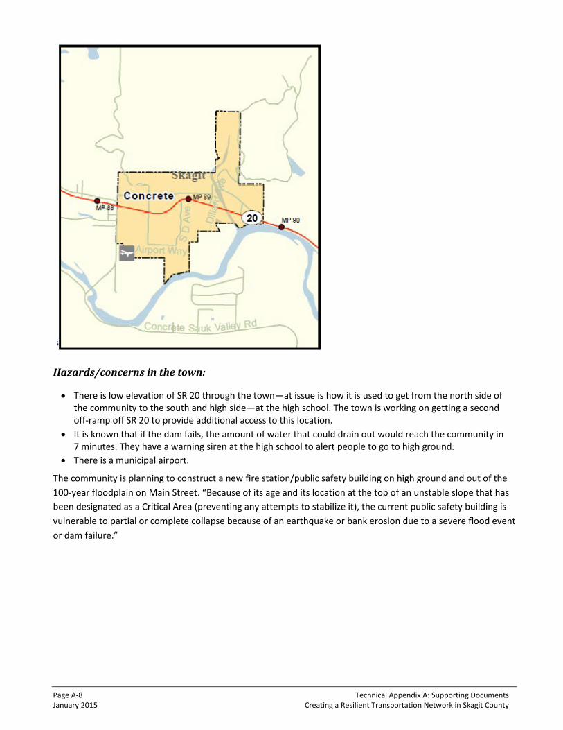
Page A-8 Technical Appendix A: Supporting Documents January 2015 Creating a Resilient Transportation Network in Skagit County
Hazards/concerns in the town:
• There is low elevation of SR 20 through the town—at issue is how it is used to get from the north side of the community to the south and high side—at the high school. The town is working on getting a second off-ramp off SR 20 to provide additional access to this location.
• It is known that if the dam fails, the amount of water that could drain out would reach the community in 7 minutes. They have a warning siren at the high school to alert people to go to high ground.
• There is a municipal airport.
The community is planning to construct a new fire station/public safety building on high ground and out of the 100-year floodplain on Main Street. “Because of its age and its location at the top of an unstable slope that has been designated as a Critical Area (preventing any attempts to stabilize it), the current public safety building is vulnerable to partial or complete collapse because of an earthquake or bank erosion due to a severe flood event or dam failure.”

Technical Appendix A: Supporting Documents Page A-9 Creating a Resilient Transportation Network in Skagit County January 2015
Partner Interview #4: Town of Lyman
Hazards/concerns in the town:
• SR 20 stays dry through town. Lyman is high and dry—no floods, but landslides farther to the west cause road to be closed.
• Areas within the Town of Lyman and adjacent to the Skagit River are protected by a small rip-rap levee. This levee was damaged during the floods of 1990; repairs were made by the US Army Corps of Engineers.
• During November 2–11, 2006, flooding of the Skagit River caused erosion of the rock revetment (levee) protecting the town.
• In the Town of Lyman, 60.6% of the incorporated land is in the Skagit River floodway, extending south to include the old Lyman Ferry Road across the Skagit River.
Interviewed: Contract Planner Population 442 Elevation 95 feet Geographical Size .76 sq. miles (over 60.6% located in Floodway) Principal Economic Base Some Business and Industrial; Primarily Residential Homes in City Limits 165 Single Family, 1 Multifamily Highway SR 20

Page A-10 Technical Appendix A: Supporting Documents January 2015 Creating a Resilient Transportation Network in Skagit County
Partner Interview #5: Town of Hamilton
Hazards/concerns in the town:
• 50% of town is located in the floodway and 100-year floodplain. • Hamilton faces significant flooding every few years. The flooding is so frequent that many residents
have a routine: move the furniture to the second floor of their home and then move to a local church until the flood subsides.
• Support has been building for a plan to move the entire town to a nearby hill. The Hamilton Public Development Authority was established in 2004 to purchase the land necessary for moving the town.
Interviewed: Contract Planner Population 301 (2010 Census) Elevation 95 feet Geographical Size .95 sq. miles (over 50% located in Floodway) Principal Economic Base Business and Industrial; 315 acres in use Homes in City Limits 103 Single Family, 2 Multifamily Highway SR 20

Technical Appendix A: Supporting Documents Page A-11 Creating a Resilient Transportation Network in Skagit County January 2015
Partner Interview #6: City of Mount Vernon
Interviewed: Assistant Public Works Director Population 31,743 Elevation 10 feet to 200 feet above sea level Geographical Size 12 sq. miles, 8,034 acres Highways I-5, SR 536, SR 538 Principal Economic Base Commercial, Government, Residential, Industrial
Hazards/concerns in the town:
• A significant portion of Mount Vernon is located within the 100-year floodplain. • Portions of the city are located within a designated floodway. • Portions of Mount Vernon are prone to landslides due to steep slopes, soil erosion, fractured rock faces,
etc. Landslides occur with some frequency during winter storms, resulting in temporary road closures. • Landslides east of town are an issue. • If the rail line prevents trains from moving, it causes a blocking of emergency access to the majority
of the community. • A major impact to I-5 can cause havoc for the area in terms of access and congestion. • If breached, the Skagit Highlands detention pond—earthen dam—will wash out to SR 538. • On SR 538, water washes over the roadway at field past nursery. This is the route out of town. • At 18 feet of water, there are rail bridge issues—debris collects and scours pier. Last time it scoured
90 feet of dike and almost took it out.

Page A-12 Technical Appendix A: Supporting Documents January 2015 Creating a Resilient Transportation Network in Skagit County
• If the dike broke between I-5 and the rail bridge, there would be little time to evacuate the area before 6-7 feet of water came over. Critical facilities that could be impacted: city police station, elderly residents, County Public Works, commercial center, and rail line.
• River bend is hard, with large flows that want to take a shorter, more direct path. There are no plans for dike setbacks.
• I-5 floods south of College Way by Blade Chevy dealership adjacent to I-5 by Lions Park at 100-year event.
• SR 536—floodwall underway—need only $5 million to finish up south end/Phase 3. It will protect SR 536 as well as county offices/sheriff, jail, courthouse, and sewer treatment facility.
• SR 538 is an emergency route—the emergency management center is located on the north side after the Community College.
• Currently, if the levee breaches to the south of downtown past the floodwall during 100-year event, the firehouse and city hall will flood from backwater.
Partner Interview #7: City of Sedro-Woolley
Hazards/concerns in the city:
• A small portion of the City of Sedro-Woolley is located within the 100-year floodplain.
Interviewed: Planning and Public Works Directors Population 10,610 Elevation 56 feet Geographical Size 4.16 sq. miles Principal Economic Base Retail and Commercial Repetitive Loss Properties Southern-most border next to Skagit River—no structures Highways SR 20, SR 9

Technical Appendix A: Supporting Documents Page A-13 Creating a Resilient Transportation Network in Skagit County January 2015
• Fruitdale Road (between Lotto and Portobello) going north needs to be fixed—it was washed out. It is an important alternative route north; it parallels SR 9.
• Access to the hospital is an issue during flood events when SR 20 floods. • Sewer treatment protection is needed—it was almost lost in a 2006 flood. It is located within the
100-year floodplain. • SR 9 is covered with water in the low-lying areas during a flood south of town. • Portions of the City of Sedro-Woolley are prone to landslides due to steep slopes, soil erosion, fractured
rock faces, etc. • The Street Department shop and offices are located in the floodplain. This should be mitigated in place
or moved out of the floodplain. • Riverfront Park landfill, located at the very southern end of the city limits, is an old abandoned landfill.
When flooded, this site has been known to have garbage enter the floodwaters. • Brickyard Creek has had a significant amount of its floodwater storage capacity eliminated due to
development. Any discharges into the stream system immediately surge downstream. Increasing this storage capacity would help to attenuate stream discharges. The WA State Fisheries Department has identified a potential site for additional flood storage on property south of Jones Road and west of the railroad, known as the Belles property. Transforming this site would help minimize local flooding.
Partner Interview #8: Skagit County
Interviewed: Public Works County Engineer; Watershed Planner; Engineering Technician; and EMS/Homeland Security Program Coordinator Population 48,117 (2010 Census) Countywide 118,837 Elevation 56 feet Geographical Size 1,735 sq. miles, 67 sq/miles Highways I-5, SR 9, SR 20, SR 20 Spur, SR 536, SR 530, SR 538, SR 534, SR 11
Page A-14 Technical Appendix A: Supporting Documents January 2015 Creating a Resilient Transportation Network in Skagit County
Hazards/concerns in Skagit County:
• A significant portion of Skagit County is located within the 100-year floodplain. • Portions of the county are located within a designated floodway or in a coastal high-hazard V zone. • Portions of the county are prone to landslides due to steep slopes, soil erosion, fractured rock faces, etc. • Landslides occur with some frequency during winter storms, resulting in temporary road closures. • With the exception of the George Hopper Road interchange (Exit 229), the entire I-5 corridor is within
the 100-year floodplain. • I-5 MP 219-226
o County Maintenance facility in south Mount Vernon is at the 7-foot elevation—it would be flooded at a tide of 8 feet. Dikes have failed in the past.
o Cook Road to South of Hwy 11 is the lowest elevation of I-5 at MP 223 and the most vulnerable location near Allen Elementary and High School in Burlington. Water moves around both sides of Burlington Hill and SR 20 at Gages Slough (south side of the Mall). If there is a levee failure, this is a point of impact, including ramps at SR 536.
• I-5 MP 231-234 o Between the Bridge and Bucannan Hill starts to back up in minor events. By Babcock Road, Drainage,
District 21, county would like to see floodgates under east fork of Nookachamps River Bridge. Clearlake area has gone under water on several occasions.
• SR 9 o Some areas south of Sedro-Woolley are landslide prone. o Most of SR 9 above Sedro-Woolley is flood prone. Water flows over SR 9 often. o F&S Rd is prone to flooding from SW to I-5. o South Skagit Hwy has a history of flooding around bridge on SR 9. This is a County Alternative Route.
• SR 9 MP 49.82-49.88 o In 1995, a flood caused the dikes to blow, and an area north of SR 538 was flooded by 10-foot flows.
• SR 9 in Clear Lake MP 52-54 o This area has been made into an island—from water that surrounds it. This worries the EMS
department because access would be by air. • SR 9 MP 63.7 to 66.5
o There is localized flooding over the roadway. • SR 11
o After a flood event, water can leave the system in low tide. • SR 20 MP 48
o The flood hazard map shows areas currently impacted by these tidal flows. o Pumps at Swinomish golf course worry the county; a 4-foot sea level rise will challenge the system. o When there are high tides, and winds blow from the north, a lane of SR 20 will be covered with
standing water. • SE 20 MP 50.85 Berentson Bridge
o There are footing issues on some piers (more seismic issue). o There are eastside water issues.
• SR 20 MP 51.56-59 o This road has not flooded in the last 27 years during 25-year events. o There is a flood concern at the bridge touchdown at Padilla Bay. o This area is vulnerable to levee failure.
• SR 20 MP 60-67 o It gets inundated to the east at Hart Slough oxbow next to SR 20.
Technical Appendix A: Supporting Documents Page A-15 Creating a Resilient Transportation Network in Skagit County January 2015
o Historically, the railroad south of SR 20 has acted as a dike to prevent water from coming into contact with the roadway. The trail is used to place sandbags to MP 62.5 Hospital Access at MP 63.06 and MP 63.34.
o This is still an active BNSF rail line. o SR 20 is coincident with SR 9 in town until SR 9 resumes its north/south trajectory.
• SR 20 MP 67-74 o This area has had some high-water events that have threatened the roadway. o In the last 27 years—during 25-year events—the road has been passable. o There is a risk that this low-elevation area could be blocked due to flood. o The pipeline creek is a concern—high-water events could fill cross culverts. Sedimentation is a growing
issue in all high-precipitation events.
• SR 20 MP 74-97 o The dam almost overtopped in 1996. In a 100-year event, dams will release water. o SR 20 is the evacuation route. o Cape Horn is flooded before flood event; slides on either side of Cape Horn; undersized culverts. o Rockslides cause erosion and mudslides at MP 90. o There are unstable slopes at Mud Hill. o Sauk Mountain Road at Rockport State Park is closed due to tree fall, old growth.
• SR 20 MP 97 o When the river is running high, it eats at the riverbank and has threatened to wash out the road. o On several occasions in recent years, the riverbank has needed to be lined with large rocks to protect
the highway from the barrage of water. o At MP 109, 110 goes under water. o There are slides on the alternate route.
• SR 530 o Martin Road after the bridge in Rockport goes under. o Sauk River could eventually move closer to 530.
• SR 536 o County has not seen any flooding resulting from the river cresting during 25-year events. There's
a pump in that area. o The area used to flood in the 1900s. A 1951 event shows flooding. The City of Mt Vernon has worked
to expand the floodway on the west side of the city, to allow the holding of extra flows—it removed several houses to accommodate this storage area on the north and south side of the SR 536 bridge.
Partner Interview #9: Swinomish Tribal Community
Hazards/concerns in the area:
• There are no floodplains or frequently flooded areas identified, delineated, or mapped within the Swinomish Indian Reservation.
• There are critical facilities in the area: social services/police station, medical center, dental clinic/ senior center, tribal administration office, planning department, housing department, gymnasium/ daycare/ community center, fisheries office, public works department, sewage treatment system, casino, gas station, fish plant, and water system.
Interviewed: Tribal Planning Director Population 3,300 Geographical Size 7,450 acres of upland Tidelands 2,900 acres of tribally owned tidelands

Page A-16 Technical Appendix A: Supporting Documents January 2015 Creating a Resilient Transportation Network in Skagit County
Partner Interview #10: Upper Skagit Indian Tribe
Hazards/concerns in the area:
• There are no floodplains or frequently flooded areas identified, delineated, or mapped within the Helmick Road Reservation or the Bow Hill Complex.
• The critical facilities in the area include sewer, water, roads, community facilities, and residential housing.
Partner Interview #11: Dike District #1
Hazards/concerns affecting Dike District #1:
• Upstream, the BNSF Bridge is a critical component that has impacts on downstream Dike and Drainage Districts, including Dike District No. 1.
Partner Interview #12: Dike District #12
Hazards/concerns affecting Dike District #12:
• SR 20 has a possible culvert issue on Telegraph Slough west of weigh station. • Padilla Bay access off dikes is needed for oil response situations. • United General becomes an island when high flows hit.
Interviewed: Public Works Director Population 504/450 on reservation Highway SR 20, I-5
Interviewed: Commissioners Land Area Owned 20 +/- acres Miles of Dike/Levee 9 miles Value of Dike/Levee @ $3,500/linear ft $166,320,000 Number of Pumps 0 Value of Pumps 0 Number of Tide Gates 0 Value of Tide Gates 0 Value of Equipment Owned $135,000 Value of Area Served $214,995,550 Critical Facilities (owned) – Dike District Building $114,700
Interviewed: Manager Land Area Owned 160 + acres Miles of Dike – Padilla Bay (value @$3,000/ft) 9.5 ($150,480,000) Miles of Levee – Skagit River (value @$3,000/ft) 10 ($158,400,000) Number of Pumps (value) 3 ($170,000) Number of Tide Gates (value) 11 ($225,000) Value of Equipment Owned $2,000,000 Value of Area Served $1,650,637,750 Highways SR 20, SR 536, SR 11, I-5

Technical Appendix A: Supporting Documents Page A-17 Creating a Resilient Transportation Network in Skagit County January 2015
• The debris load on RR bridge in Sedro-Woolley area is trash rack that backs up water and helps minimize flow down the channel. Complications occur when it breaks up; it backs up the system. Other back door issues hit Clear Lake before the Skagit River Nookachamps system hits it.
Partner Interview #13: Dike District #17
Interviewed: Manager Land Area Owned 15 acres Miles of Dike/Levee 5.5 miles Value of Dike/Levee @ $3,500/linear ft $87,120,000 Number of Tide Gates 1 Value of Tide Gates $50,000 Value of Equipment Owned $150,000 Value of Area Served $370,238,800 Highways I-5, SR 538
Hazards/concerns affecting Dike District #17:
• There is a concern with the Wal-Mart/Blade Chevy levee. • Vulnerable areas are: I-5 and College Way/538, the rail line, and the police and county public works
building. • In the Sterling area, the concern is that it will have more flow toward SR 9 Clear Lake once the
Comprehensive Urban Levee Improvement project is complete.
Partner Interview #14: Puget Sound Energy (PSE)
Hazards/concerns affecting PSE:
• PSE does not have any issues with the state system hindering its facilities in ways that keep employees from doing their jobs.
Partner Interview #15: WSDOT Maintenance
Hazards/concerns affecting WSDOT Maintenance:
• I-5 o I-5 has not flooded. o South of Skagit County at MP 215 undercrossing had high water but did not crest. o In Skagit County, there are high-water challenges at: Fish, Carpenter, Maddox, and Martha
Washington creeks. o The WSDOT Maintenance office in south Mount Vernon is at 7 feet above sea level, but has never
been under water. o In 1995, an event blew out the levy at Fir Island area west of I-5.
Interviewed: Senior Engineering Specialist
Interviewed: Maintenance Superintendent Highways I-5, SR 536, SR 538, SR 534, SR 11, SR 9, SR 20

Page A-18 Technical Appendix A: Supporting Documents January 2015 Creating a Resilient Transportation Network in Skagit County
• SR 9 o This area flooded when a dike blew out in 1995. o North of SR 538 was flooded at MP 52-54 by a 10-foot flow. o A challenge exists north of SR 534 at MP 41-43 where rocky hillsides blow out. o Flooding regularly occurs north of Sedro-Woolley on SR 9 at MP 70. o SR 9 has challenges with the Samish River at MP 64.
• SR 20 o East of I-5, multiple flood points have occurred at: Bacon, Coal, Wiseman, and Corkindale creeks.
Sometimes these events are the result of the river, and sometimes they occur due to saturation of the hillsides, which are unstable and create severe slides of debris onto the highway.
o Due to a severe storm with winds, hundreds of heavily-leaved alder trees were snapped, causing debris to hit the highway at about MP 77.
o In1996, Baker Lake Dam at Concrete almost overtopped at MP 89. o At MP 91, Mud Hill has a tendency to cause huge slides of debris about every 6 years. Also, 40 feet
from the pavement, water overtops the hill toward the Jersey barrier. o Just before MP 63, water gets high often but has not yet crossed the road. o At MP 113, water flows over the highway during summer surges in the drainage next to the highway. o SR 20, west of I-5, has not flooded. o At Sharpes Corner (MP 47), during high tides and a southerly wind, water will cover most of the
northern westbound lane.
• SR 530 o The WSDOT facility at MP 39 has unstable slopes and creates severe slides, with large-scale debris on
the highway. o Moose and Fink creeks have been known to recreate their channels of migration and cover the
highway. o Government Bridge at MP 56 Suiattle confluence has scour issues, and vertical hillsides continually
create slides at MP 60-61.
Partner Interview #16: WSDOT Ferries Division
Hazards/concerns affecting WSDOT Ferries Division:
• At the Anacortes Ferry Terminal, sea level rise is a concern. The Ferries Division hopes to develop a new facility to accommodate the expected rise. No funding is available for development at this time.
• Storm surge and tidal change are operational issues that they are planning for. • They will plan as conditions change, if they do not have a new facility that accommodates their needs. • Ferry access is on SR 20 Spur/SR 20. Ridership is over 1.9 million a year, providing the only access to the
islands. This service is expected to increase by 33% in 2030.
Interviewed: Director, Vessel & Terminal Engineering

Technical Appendix A: Supporting Documents Page A-19 Creating a Resilient Transportation Network in Skagit County January 2015
2 Letter to the Corps

Page A-20 Technical Appendix A: Supporting Documents January 2015 Creating a Resilient Transportation Network in Skagit County

Technical Appendix A: Supporting Documents Page A-21 Creating a Resilient Transportation Network in Skagit County January 2015
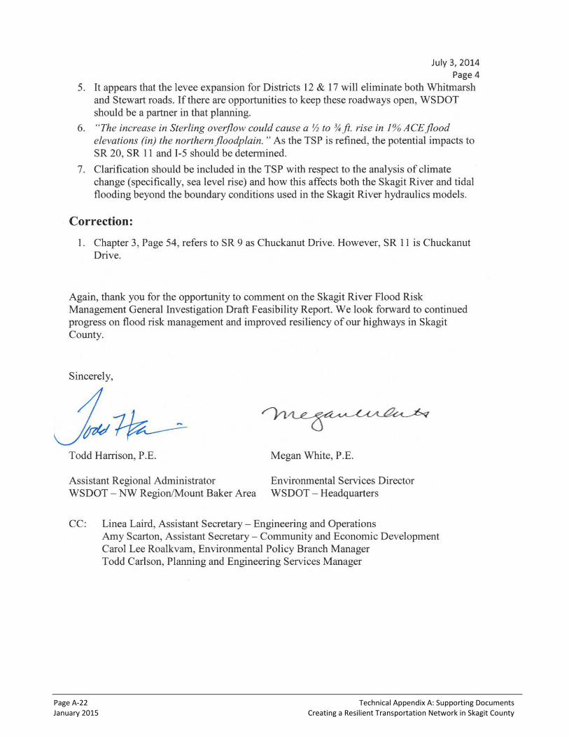
Page A-22 Technical Appendix A: Supporting Documents January 2015 Creating a Resilient Transportation Network in Skagit County

Technical Appendix A: Supporting Documents Page A-23 Creating a Resilient Transportation Network in Skagit County January 2015
3 Sample Workshop Agendas
AGENDA
FHWA Pilot Project: Climate Adaptation Strategies for the Skagit River Basin Vulnerability Assessment Mini Workshop February 21, 2014 – 9:00 am to 11:30 am WSDOT Mt. Baker Headquarters Office
Objective: Information sharing. Review of initial road segments – update together.
No. Task Time Facilitator Approach
1. Welcome 9:00 – 9:05 Team Leaders Safety briefing & housekeeping
2. Introductions 9:05 – 9:10 Group Around the room
3. Workshop Purpose & Overview of Initial Road Segments Locations
• Objective of the workshop • Process Overview
Asking the climate question
Climate impacts
9:10 – 9:20 Team Members Use map as visual
4. Information Sharing from County
• Corps process and timeline • Planned public outreach (GI)
9:20 – 9:30 Team Members Brief discussion
5. Identify Transportation Assets and Criticality
Get specific information: Detours, current problems, problems during extreme events from County Staff
9:30 – 10:30 Team Leader
All County Staff
Sandy will record details for the highway
segments from the expertise and
perspective of the county
6. Discussion of Asset Vulnerability to Climate Impacts
10:30 – 10:45 Team Leader Notes to record ratings – agreement from team
7. Meeting Wrap-Up & Next Steps
• Communication Plan
10:55 – 11:00 Team Leaders

Page A-24 Technical Appendix A: Supporting Documents January 2015 Creating a Resilient Transportation Network in Skagit County
AGENDA
FHWA Pilot Project: Climate Adaptation Strategies for the Skagit River Basin ”Hands-On-Data” Workshop
September 17, 2014 – 9:00 am to 12:15 pm WSDOT HQ – Rm 2A
Purpose: The purpose of this Pilot Team Workshop is to review available data (results of recent GIS and other technical info); brainstorm and document our initial observations; and reaffirm our approach (next steps, methods, tools, products).
Welcome and Roles – 5 mins (Team Leader)
Overview of All Data Products – 30 mins (Team Members)
• Project Boundary Map • Flood Maps (10-yr, 25-yr, 50-yr, 100-yr) • Areas of Concern Map • Areas of Concern Tables • Other
“Hand’s-On-Data” Workshop – 120 mins (Team Member)
Facilitate and capture key points and observations.
Key Questions:
• What does the data tell us? o Existing conditions now and into the future (no action) o Future conditions (with Corps project)
• Where does all this information take us? o Does this refine our “approach”? o Are there substantive changes needed in our tasks or work plan?
• What information do we need for the next meeting?
Next Meeting Agenda – 5 mins (Team Leader)
• Proposed Purpose: Review menu of adaptation options from other adaptation planning efforts; develop list of likely options (for No Action Alternative and for Corps’ CULI).
• Review work plan together to see if adjustments are needed.
Action Items – 5 mins (Team Member)
Technical Appendix A: Supporting Documents Page A-25 Creating a Resilient Transportation Network in Skagit County January 2015
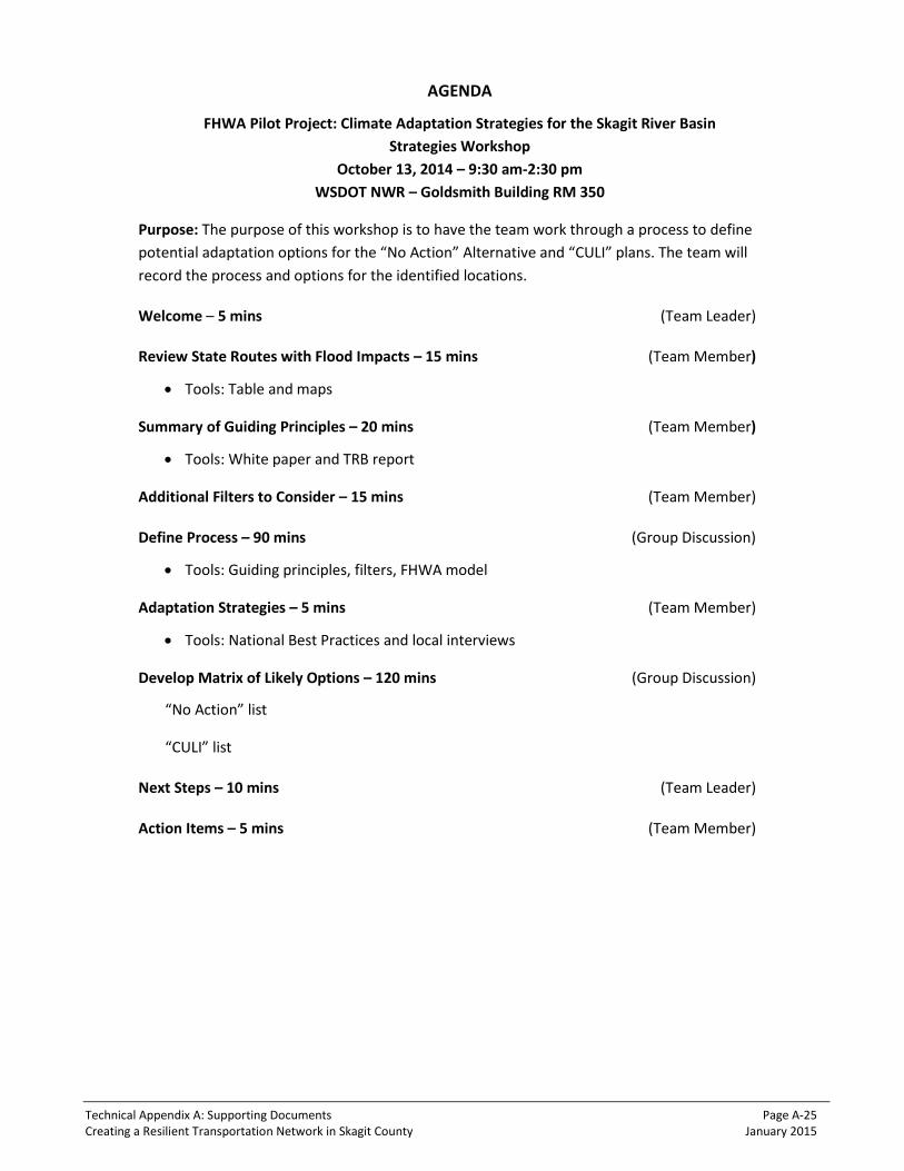
AGENDA
FHWA Pilot Project: Climate Adaptation Strategies for the Skagit River Basin Strategies Workshop
October 13, 2014 – 9:30 am-2:30 pm WSDOT NWR – Goldsmith Building RM 350
Purpose: The purpose of this workshop is to have the team work through a process to define potential adaptation options for the “No Action” Alternative and “CULI” plans. The team will record the process and options for the identified locations.
Welcome – 5 mins (Team Leader)
Review State Routes with Flood Impacts – 15 mins (Team Member)
• Tools: Table and maps
Summary of Guiding Principles – 20 mins (Team Member)
• Tools: White paper and TRB report
Additional Filters to Consider – 15 mins (Team Member)
Define Process – 90 mins (Group Discussion)
• Tools: Guiding principles, filters, FHWA model
Adaptation Strategies – 5 mins (Team Member)
• Tools: National Best Practices and local interviews
Develop Matrix of Likely Options – 120 mins (Group Discussion)
“No Action” list
“CULI” list
Next Steps – 10 mins (Team Leader)
Action Items – 5 mins (Team Member)

Page A-26 Technical Appendix A: Supporting Documents January 2015 Creating a Resilient Transportation Network in Skagit County
AGENDA
FHWA Pilot Project: Climate Adaptation Strategies for the Skagit River Basin October 31, 2014 – 1:00 pm to 2:00 pm
Briefing (Team Leader)
Provide briefing to technical team on Corps of Engineers Meeting
Reviews (Team Members)
• Review schedule and key milestones for the draft report and work plan
• Review Report Outline o Agree on format o Agree on process
• Review Strategies Matrix
• Review Work Assignments o Segment profile characteristics o Strategy matrix o Methodology & approach o Climate o Draft briefing presentation o List of graphics, charts and figures o Other based on report outline
Next Steps (Team Member)
• Set expectations for next meeting