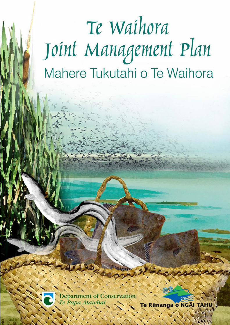
Te Waihora Joint Management Plan - Department of Conservation
237
Transcript of Te Waihora Joint Management Plan - Department of Conservation

TAUPARAPARA
Hoki mai koe ki te pä Orariki e
Tü ana ki te taha o te kahu tai pöuri
O Te Waihora moana
E rere ana ki a tätou e
Let us return to the village of Orariki
That stands beside the darkened waters
of Te Waihora
That flows to us all
Te köhaka tuna
Whäriki o te piharau
Repo o te ïnaka
Moeka o te mohoao
Gathering place of the eel
Floormat of the lamprey
Spawning swamps of the whitebait
Sleeping ground of the black flounder
Tai timu tai pari
Kä wai o Mahaanui
Te taki haruru ki te pikao mumura
O Kaitörete whenua
E rere ana ki a tätou e
The tides of Mahaanui
Rise and fall
Crashing against the blazing sand sedge
Lands of Kaitorete
That flows to us all
Ka rere te manu kähu
I kä hau äwhio
Te kaimatakana ki te mära kümara
O Taumutu te käinga
E rere ana ki a tätou e
The hawk flys overhead
Circling on the air currents
As guardian of the kumara gardens
of Taumutu
That flows to us all
Tïhei mauri ora. Behold this is life.
Published by
Te Rünanga o Ngäi Tahu PO Box 13046 Christchurch New Zealand
Department of Conservation Te Papa AtawhaiPrivate Bag 4715 Christchurch New Zealand
10 December 2005
ISBN: 0-478-14059-2

PREFACE KUPU WHAKATAKIThis is the first statutory joint land management plan between the Crown and Iwi. It results from the settlement of Ngäi Tahu claims against the Crown and in particular the loss of access to places where the tribe produced or procured food and other resources.
This joint management plan has been prepared by Te Rünanga o Ngäi Tahu with advice from the Te Waihora Management Board (local Papatipu Rünanga representatives) and the Canterbury Conservancy of the Department of Conservation in accordance with the provisions set out in sections 167 to 182 and schedule 12 of the Ngäi Tahu Claims Settlement Act 1998. This is a statutory document and provides for the management of the Joint Management Plan Area in accordance with the Conservation General Policy (2005), the Canterbury Conservation Management Strategy (2000) and the relevant iwi management plans approved by Te Rünanga o Ngäi Tahu, including Te Whakatau Kaupapa - Canterbury (1990), Ngäi Tahu Freshwater Policy (1999), Ngäi Tahu 2025 (2001), and Te Taumutu Runanga Natural Resource Management Plan (2003), but does not override the provisions of the primary legislation.
The joint management plan contains long-term objectives and detailed policies and methods for effective integrated management of the Joint Management Plan Area and the natural and historic resources within the area. The plan represents a coming together of the rangatiratanga of Ngäi Tahu and the Käwanatanga of the Crown for the enhancement and protection of this taonga. It is a significant point for the continuing development of co-operative management between Te Rünanga and the Department and provides a platform for joint advocacy to other agencies with management responsibilities within the Te Waihora environment.
Notification of intention to prepare the plan was given in November 1999 and statutory bodies were invited to make written suggestions on the content of the plan. Subsequent consultation occurred through the development of a Draft Te Waihora Joint Management Plan (October 2004) with input from the Canterbury Aoraki Conservation Board, local Papatipu Rünanga, the North Canterbury Fish and Game Council, relevant territorial local authorities and other interested groups and individuals. Public submissions were sought on the draft plan, hearings held and the draft plan amended.
With our approval, the plan will be effective for 10 years, or for an extended period as agreed by Te Rünanga o Ngäi Tahu and the Minister of Conservation but may be reviewed at any time as a result of increased knowledge, or changes in circumstance.
Te Waihora is an important site to Ngäi Tahu as a mahinga kai and nationally and internationally important to New Zealand for its wildlife and conservation values. We therefore will ensure the full use of this plan by our two organisations and encourage other organisations and the general public to participation in the management of Te Waihora.
Mark Solomon Kaiwhakahaere Te Rünanga o Ngäi Tahu
Hon Mahara Okeroa Associate Minister of ConservationOn behalf of Hon. Chris Carter Minister of Conservation


Te Waihora Joint Management Plan
Table of Contents i
TABLE OF CONTENTS RÄRANGI ÜPOKOHow to read this Plan Me pëhea te pänui tika i te mahere nei......... vii
PART 1: INTRODUCTION HE KUPU WHAKATAKI .......................11 Purposes of the Plan Ngä take o te mahere.................................... 1
2 Vision Te wawata ........................................................................... 3
2.1 Development of the vision Te whanaketanga o te wawata .............. 3
2.2 Components of the vision Ngä wähanga o te wawata ..................... 3
3 Area of the Plan Te türanga o te mahere ....................................... 7
3.1 Regional, national and international settings Ngä türanga-ä-rohe, ä-motu, ä-ao hoki .............................................. 7
3.2 Area descriptions Te ähua o ngä wähanga ...................................... 7
4 Roles and responsibilities Ngä tünga me ngä kawenga ............... 13
4.1 Ngäi Tahu ..................................................................................... 13
4.2 Department of Conservation Te Papa Atawhai .............................. 14
4.3 Other Agencies Ngä umanga kë .................................................... 15
4.4 Relevant statutory and other documents Tuhinga-ä-ture me ëtahi atu tuhinga e pä ana ki Te Waihora ........... 19
5 Timeframe for the Joint Management Plan Te roanga o te mahere 22
PART 2: VALUES OF TE WAIHORA NGÄ UARA........................231 Summary of values Te whakaräpopotanga o ngä uara................. 25
2 Te Kete Ika.................................................................................... 27
2.1 Whakapapa................................................................................... 27
2.2 Mauri and wairua.......................................................................... 28
2.3 Rangatiratanga ............................................................................. 29
2.4 Kaitiaki ......................................................................................... 29
2.5 Ngä wai ......................................................................................... 31
2.6 Mahinga kai and customary use.................................................... 32
3 Landforms and landscapes Te matawhenua .................................. 35
3.1 Physical description Te ähua o te whenua ..................................... 35
3.2 Landscape Te mata o te whenua ................................................... 39
3.3 Natural features and landforms Ngä tohu whenua ....................... 40
3.4 Place names Ngä ingoa o ngä wähi ............................................... 40
4 Wildlife habitat and biodiversity Ngä toi whenua me ngä tümomo koiora ........................................ 42
4.1 Ecosystem Assessment Aromatawai o te taiao ............................... 43
Te Waihora Joint Management Plan
Table of Contents ii
4.2 Water Ngä wai ..............................................................................53
4.3 Taonga species and other species of importance to Ngäi Tahu Ngä tü taonga me ëtahi atu momo e nui ake ki a Ngäi Tahu .............57
4.4 Plants Ngä otaota..........................................................................57
4.5 Animals Ngä kararehe...................................................................61
4.6 Te Waihora significance - within the takiwä, nationally and internationally Te hiranga o Te Waihora ke te takiwä o Ngäi Tahu, Aoteroa me te ao ............................................................................69
5 Historic resources Taonga puri mahara...................................... 72
5.1 Mäori history Ki tä te tangata whenua ...........................................72
5.2 European history Ki tä te päkehä ..................................................76
6 Recreational use and public accessMahi-ä-täkaro hoki me te whai wähi o te häpori .......................... 79
6.1 Recreational use Ngä mahi täkaro .................................................79
6.2 Public access Te whai wähi o te hapori ..........................................83
7 Commercial and other activitiesNgä mahi arumoni me ëtahi atu mahi .......................................... 84
7.1 Commercial activities Ngä mahi arumoni .......................................84
7.2 Utilities, huts and other activities Ngä whaipainga, ngä momo whare me ngä mahi kë ........................86
7.3 Research Rangahau ......................................................................87
8 Joint Management Plan Objectives Ngä paetae o te mahere ......... 88
8.1 Te kete ika .....................................................................................88
8.2 Landforms and landscapes Te matawhenua ..................................88
8.3 Wildlife habitat and biodiversity Ngä toi whenua me ngä tümomo koiora ...........................................88
8.4 Historic resources Taonga puri mahara .........................................89
8.5 Recreational use and public accessibility Mahi-ä-täkaro me te whai wähi o te hapori......................................89
8.6 Commercial and other activities Ngä mahi arumoni me ëtahi atu mahi..............................................89
PART 3: MANAGEMENT KIA ARORAKI....................................91 1 Interpretation of policies and methods
Ngä whakamäramatanga o ngä kaupapa me te ritenga ............... 93
1.1 Integrated management Te whakahaere ngatahi............................93
1.2 Policy and method conventions Ngä kawa-ä-kaupapa, ä-ritenga hoki ..............................................93
1.3 Non derogation Kaua e takahi te ture.............................................94

Te Waihora Joint Management Plan
Table of Contents iii
1.4 Bylaws and regulations for the Joint Management Plan Area Ngä ture e hängai ana ki te Mahere .................................................... 94
1.5 Policies Ngä kaupapa ................................................................... 95
2 Te Kete Ika.................................................................................... 96
2.1 Whakapapa and rangatiratanga..................................................... 96
2.2 Mauri, wairua, and kaitiaki ........................................................... 99
2.3 Ngä wai ........................................................................................102
2.4 Mahinga kai and customary use...................................................104
3 Landforms and landscapes Te matawhenua............................... 108
4 Wildlife habitat and biodiversity Ngä toi whenua me ngä tümomo koiora ...................................... 112
4.1 Ecosystems Te taiao ....................................................................113
4.2 Water Ngä wai..............................................................................118
4.3 Plants and animals Ngä otaota me ngä kararehe .........................121
4.4 Pests, exotic species, domestic animals and biosecurity Ngä orotä, ngä momo räwaho, ngä kararehe rarata, me te maru koiora ...........126
4.5 Te Waihora significance – within the takiwä, nationally and internationally Te hiranga o Te Waihora ke te takiwä o Ngäi Tahu, Aoteroa me te ao...........................................................................130
5 Historic resources Taonga puri mahara .................................... 132
6 Recreational use and public access Mahi-ä-täkaro me te whai wähi o te hapori................................. 136
6.1 Recreational use Ngä mahi täkaro................................................137
6.2 Public access Te whai wähi o te hapori.........................................141
7 Commercial and other activities Ngä mahi arumoni me ëtahi atu mahi ........................................ 149
7.1 Commercial activities Ngä mahi arumoni......................................149
7.2 Other activities Ngä mahi kë ........................................................153
7.3 Research and Monitoring Rangahau me te aroturuki ..................155
8 Community Relations Ngä rarata-ä-häpori................................. 158
9 Statutory Land Management Whakamana-ä-ture i te whenua me te whakaere mahere............ 161
PART 4: IMPLEMENTATION AND REVIEWTE WHAKATINANATANGA ME TE AROMATAWAI........165
1 How will the Joint Management Plan be implemented? Me pëhea te whakatinana i te mahere? ...................................... 167
1.1 The Department will… Mä Te Papa Atawhai e… ..........................168
1.2 Te Rünanga will… Mä Te Rünanga o Ngäi Tahu e… .....................169
Te Waihora Joint Management Plan
Table of Contents iv
1.3 Working together we will… Me mahitahi ki te… ........................... 169
1.4 Dispute resolution Körerorero-ä-whare ......................................... 170
2 Plan Monitoring and reportingTe aroturuki me te whakatakotoranga ....................................... 171
3 Review Te arotake...................................................................... 172
APPENDICES .......................................................................... 173Appendix 1: Areas Subject To The Plan .................................................. 175
Appendix 2: Crown Riverbeds, Other Crown Lands and Council Lands Adjoining the JMP Area................................................................ 177
Appendix 3: Principles guiding approaches to honouring the Treaty of Waitangi ...................................................................................... 178
Appendix 4: Maimai Agreement.............................................................. 180
Appendix 5: Taonga Species present at Te Waihora ................................ 188
Appendix 6: Protocols on the Department of Conservation’s Interaction with Ngäi Tahu on specified Issues (1997)............................................ 190
Appendix 7: Water Conservation (Lake Ellesmere) Order 1990................ 200
Appendix 8: Rünanga Takiwä................................................................. 202
Appendix 9: Origin of Quotes used throughout the Joint Management Plan….. ....................................................................................... 203
Appendix 10: Bird Species recorded at Te Waihora ................................. 206
GLOSSARY PAPAKUPU........................................................... 211
REFERENCES TOHUTORO ..................................................... 217
Te Waihora Joint Management Plan
Table of Contents v
FIGURESFigure 1: Structure - Draft Te Waihora Joint Management Plan .............. viii
Figure 2: Te Waihora location ....................................................................4
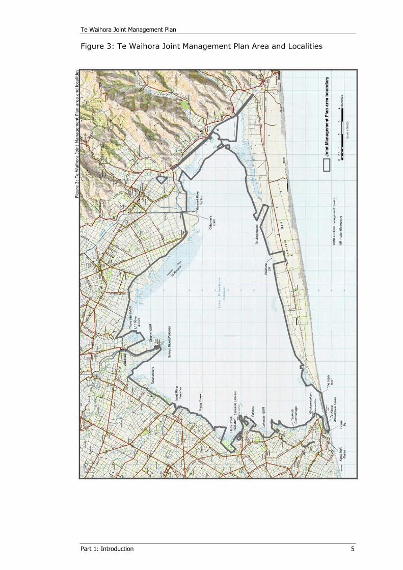
Figure 3: Te Waihora Joint Management Plan Area and Localities ..............5
Figure 4: Areas subject to the Te Waihora Joint Management Plan and other public and council lands ................................................................11
Figure 5: Timeframe for the Te Waihora Joint Management Plan ..............22
Figure 6: Successive shoreline positions during the development of Kaitorete Spit ..........................................................................................37
Figure 7: Historic extent of Te Waihora adjoining Banks Peninsula/Horomaka ..............................................................................38
Figure 8: Vegetation zones.......................................................................44
Figure 9: Te Waihora wetland vegetation types.........................................47
Figure 10: Wildlife values around Te Waihora ..........................................51
Figure 11: Mäori place names of Te Waihora............................................75
Figure 12: Te Waihora public access......................................................147
Figure 13: Customary and recreational use areas / köhanga .................157
TABLESTable 1: Mahinga kai resources of Te Waihora ......................................... 34
Table 2: Te Waihora wetland vegetation types and areas .......................... 49
Table 3: Te Waihora lake opening levels 1901-1960 ................................. 56
Table 4: Significant indigenous plants within the Joint Management Plan Area ........................................................................................... 58
Table 5: Major phytoplankton species of Te Waihora................................ 60
Table 6: Commonly occurring introduced and plant pest species within the Te Waihora environment ............................................................... 61
Table 7: Significant bird species of Te Waihora ........................................ 63
Table 8: Fish species of Te Waihora and tributaries ................................. 65


Te Waihora Joint Management Plan
How to Read this Plan Me pehea te pänui tika i te mahere nei vii
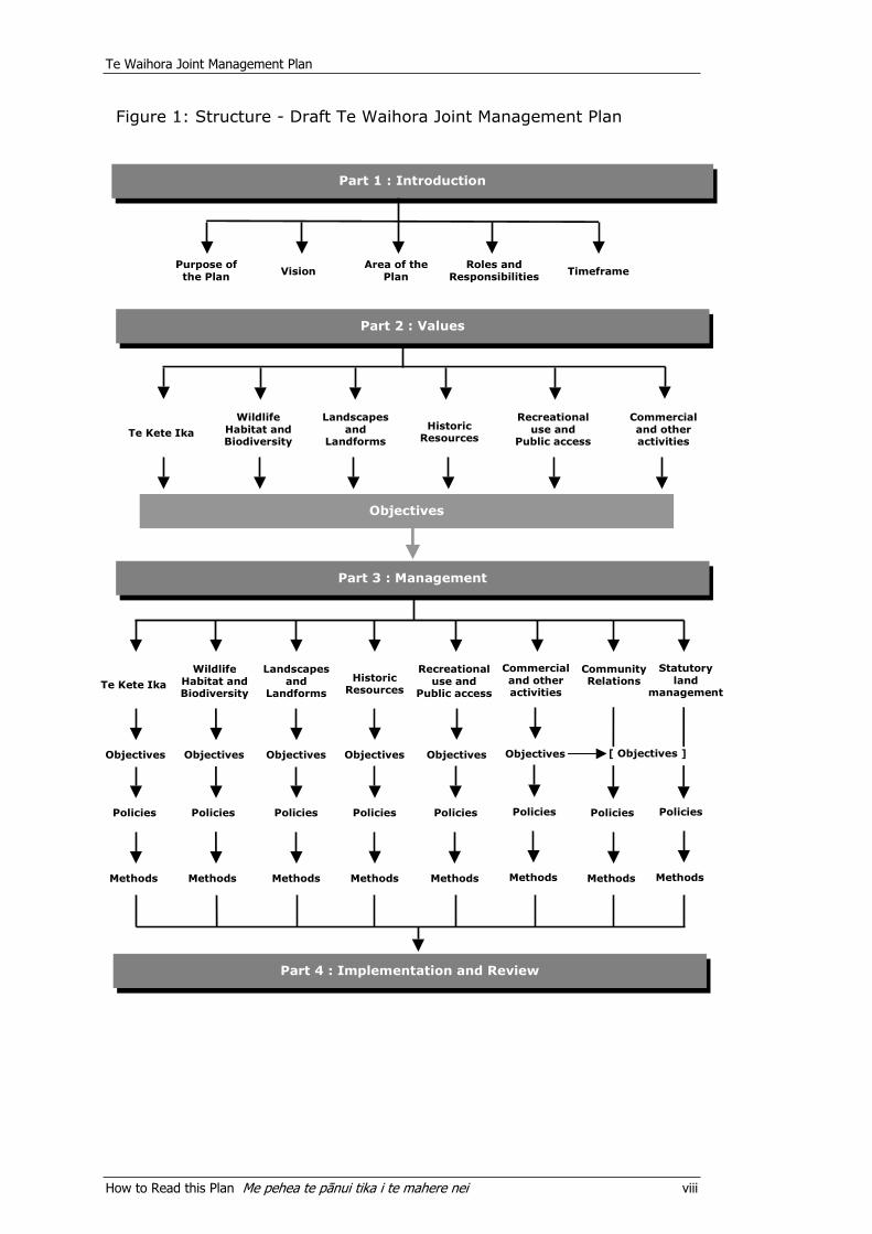
HOW TO READ THIS PLAN ME PËHEA TE PÄNUI TIKA I TE MAHERE NEIThis Joint Management Plan is divided into four parts:
Part 1: Introduction Part 2: Values Part 3: Management Part 4: Plan Implementation and Review.
Part 1: Introduction covers the purposes of the Joint Management Plan, its vision, and the roles and responsibilities of the various agencies involved in the management of Te Waihora and the Te Waihora environment.
Part 2: Values is a descriptive section giving background information on the values of Te Waihora. This is to give an understanding of the associations Ngäi Tahu and other New Zealanders have with Te Waihora and the Te Waihora environment. These associations are encapsulated in highlighted statements at the beginning of each section. This part of the Plan provides a context for management and establishes the objectives from which the policies and methods in the remaining parts of the Plan are derived.
Part 3: Management Sets out the policies and methods for the future management of the Joint Management Plan Area, and for advocacy in the Te Waihora environment, and outside of the land management responsibilities of Te Rünanga and the Department. Each section starts by repeating the relevant objectives from Part 2.
Part 4: Plan Implementation and Review outlines the actions that will be carried out by Te Rünanga and the Department, both individually and together, to implement this Joint Management Plan and undertake monitoring and review.
The main headings within Part 2: Values and Part 3: Management, namely Te kete ika, Landforms and landscapes, Wildlife habitat and biodiversity, Historic resources, Recreational use and public access, and Commercial and other activities - were developed from an initial scoping report (2001) and consultation with key interest and user groups. These headings have been used in both Parts 2 and 3 of this Plan to provide for easy cross-referencing (see Figure 1).
Te Waihora Joint Management Plan
How to Read this Plan Me pehea te pänui tika i te mahere nei viii
Figure 1: Structure - Draft Te Waihora Joint Management Plan
Te Kete Ika
Policies
Methods
Objectives
Part 1 : Introduction
Part 2 : Values
Te Kete Ika
Wildlife Habitat and Biodiversity
Landscapes and
Landforms
Historic Resources
Recreational use and
Public access
Commercial and other activities
Purpose of the Plan Vision
Area of the Plan
Roles and Responsibilities Timeframe
Objectives
Part 3 : Management
Wildlife Habitat and Biodiversity
Landscapes and
Landforms
Historic Resources
Recreational use and
Public access
Commercial and other activities
PoliciesPoliciesPoliciesPolicies Policies
MethodsMethodsMethodsMethods Methods
Part 4 : Implementation and Review
ObjectivesObjectivesObjectivesObjectives Objectives
Community Relations
Policies
Methods
Statutory land
management
Policies
Methods
[ Objectives ]
Te Waihora Joint Management Plan
How to Read this Plan Me pehea te pänui tika i te mahere nei ix
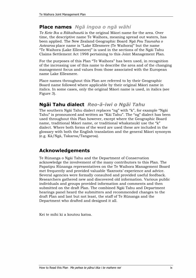
Place names Ngä ingoa o ngä wähiTe Kete Ika a Räkaihautü is the original Mäori name for the area. Over time, the descriptive name Te Waihora, meaning spread out waters, has been applied. The New Zealand Geographic Board Ngä Pou Taunaha o Aotearoa place name is “Lake Ellesmere (Te Waihora)” but the name “Te Waihora (Lake Ellesmere)” is used in the sections of the Ngäi Tahu Claims Settlement Act 1998 pertaining to this Joint Management Plan.
For the purposes of this Plan “Te Waihora” has been used, in recognition of the increasing use of this name to describe the area and of the changing management focus and values from those associated with the European name Lake Ellesmere.
Place names throughout this Plan are referred to by their Geographic Board name followed where applicable by their original Mäori name in italics. In some cases, only the original Mäori name is used, in italics (see Figure 3).
Ngäi Tahu dialect Reo-ä-iwi o Ngäi TahuThe southern Ngäi Tahu dialect replaces “ng” with “k”, for example “Ngäi Tahu” is pronounced and written as “Käi Tahu”. The “ng” dialect has been used throughout this Plan however, except where the Geographic Board name, traditional Mäori name, or traditional whakataukï use the “k” dialect. Where both forms of the word are used these are included in the glossary with both the English translation and the general Mäori synonym (e.g. Kä/Ngä, Takaroa/Tangaroa).
Acknowledgements
Te R nanga o Ng i Tahu and the Department of Conservation acknowledge the involvement of the many contributors to this Plan. The Papatipu R nanga representatives on the Te Waihora Management Board met frequently and provided valuable ‘flaxroots’ experience and advice. Several agencies were formally consulted and provided useful feedback. Researchers gathered new and discovered old information. Various public individuals and groups provided information and comments and then submitted on the draft Plan. The combined Ng i Tahu and Department hearings panel heard the submitters and recommended changes to the draft Plan and last but not least, the staff of Te R nanga and the Department who drafted and designed it all.
Kei te mihi ki a koutou katoa.

PART 1: INTRODUCTIONHE KUPU WHAKATAKI
Artwork by Cath Brown

Te Waihora Joint Management Plan
Part 1: Introduction 1
1 PURPOSES OF THE PLANNGÄ TAKE O TE MAHERETe Waihora is an area of cultural, natural, historic, recreational and commercial importance to many people. To Ngäi Tahu, Te Waihora represents a major mahinga kai1 and an important source of mana. The loss of this precious tribal taonga was part of the grievance outlined in the Ngäi Tahu claim to the Waitangi Tribunal. The Tribunal strongly recommended the return of Te Waihora to Ngäi Tahu, and commented that this needed to be accompanied by significant and committed Crown action to restore Te Waihora as a tribal food resource (Chapter 17, Waitangi Tribunal 1991).
This Plan is the resultant statutory Joint Management Plan between Te Rünanga and the Minister arising from the Ngäi Tahu Claims Settlement Act, 1998.
This Joint Management Plan is prepared “for the integrated management of those areas [set out in Part 1, section 3], and the natural and historic resources within those areas” (section 177, NTSCA).
The purposes of the Joint Management Plan are defined in Schedule 12, Clause 11.6.19 (a) of the Ngäi Tahu Claims Settlement Act 1998 as:
“…to establish detailed objectives:
(i) for the integrated management of natural and historic resources within the areas covered by the plan for Mahinga Kai and conservation purposes and for the purposes for which the [lands administered by the Department] are held, including recreation purposes (where appropriate) to the extent, with respect to the [lands administered by the Department], that Mahinga Kai purposes are consistent with the purposes for which that land is held;
(ii) where this can be accommodated consistent with clause 11.6.19 (a) (i), for the management of the areas covered by the plan for tourism purposes;
(iii) where this can be accommodated consistent with clause 11.6.19 (a) (i), to recognise the national and international significance of Te Waihora; and
(iv) to identify any adverse effects of public access or recreational use and enjoyment upon the Mahinga Kai and conservation values of the bed of Te Waihora and to recommend to the Minister of Conservation the making of bylaws to prohibit or regulate such public access or recreational use and enjoyment;”
These purposes are referred to collectively throughout the Plan as “mahinga kai, conservation and other purposes”.
1““Mahinga kai” means, for the purposes of a joint management plan, the customary
gathering of food and natural materials and the places where those resources are gathered.” (Section 167, NTCSA).
Te Waihora Joint Management Plan
Part 1: Introduction 2
In fulfilling the statutory purposes of the Joint Management Plan, the intention is to restore Te Waihora as a tribal food resource, to protect the conservation values of the area, and to restore and protect Te Waihora for the use and enjoyment of all New Zealanders, now and in the future - Mö tätou, ä, mö kä uri ä muri ake nei - for us and our children after us2. The Plan seeks to establish the desired mix of use and protection of land and to set in place policy guided by the values for Te Waihora (set out in Part 2) and the purposes of the Plan as set out in the Ngäi Tahu Claims Settlement Act 1998.
Management through the Plan aims to sustain the vitality of Ngäi Tahu culture by restoring resource-centred relationships, and recognising the relationships of Ngäi Tahu and their culture and traditions with the ancestral lands and taonga of Te Waihora through enabling the gathering of healthy mahinga kai.
The Plan will assist the implementation of the Ngäi Tahu Claims Settlement Act 1998 in relation to Te Waihora and represents a coming together of Te Rünanga and the Department for the enhancement and protection of this taonga. It is a significant point for the continuing development of co-operative management between Te Rünanga and the Department. It also provides a platform for joint advocacy and informed management with other agencies for the Te Waihora environment.
The Plan also provides information on the Te Waihora environment, to highlight the cultural, natural, historic, recreational and commercial values of the area.
2 Ngäi Tahu tribal whakataukï.
Te Waihora Joint Management Plan
Part 1: Introduction 3
2 VISION TE WAWATA
“Ngäi Tahu cultural identity is restored through the rejuvenation of the mauri and life-supporting capacity of Te Waihora.
The Joint Management Plan Area is managed in an integrated manner for “mahinga kai, conservation and other purposes”, in a
way that enhances the enjoyment of the wetland for all New Zealanders.
Management of the Joint Management Plan Area provides an example that can be encouraged for the management of the entire
lake margin and the adjoining inflowing tributaries and their wetlands.”
2.1 Development of the vision Te whanaketanga o te wawataThe above vision statement was developed by a joint working party of Te Rünanga and the Department at the outset of the drafting of the Joint Management Plan. The aim was to establish a common approach for the management of the Joint Management Plan Area and for advocacy about the Te Waihora environment, that could be shared by all the key parties and individuals involved in the Te Waihora environment and in the development of the Joint Management Plan. The vision was used as a starting point for Plan development and consultation and was further refined and confirmed as the values of Te Waihora and the policy directions were established.
2.2 Components of the vision Ngä wähanga o te wawataThe vision is comprised of the following components:
Enhancing mana Enhancing mauri and therefore the natural and spiritual values of the area Supporting indigenous biodiversity Enabling the gathering and use of mahinga kai Providing for compatible recreational use and enjoyment Providing for compatible commercial opportunities (including tourism opportunities) Recognising the national and international significance of Te Waihora Developing awareness of other management tools and agency processes while supporting holistic management.

Te Waihora Joint Management Plan
Part 1: Introduction 4
Figure 2: Te Waihora location
Te Waihora Joint Management Plan
Part 1: Introduction 5
Figure 3: Te Waihora Joint Management Plan Area and Localities

Te Waihora Joint Management Plan
Part 1: Introduction 7
3 AREA OF THE PLANTE TÜRANGA O TE MAHERE
3.1 Regional, national and international settingsNgä türanga-ä-rohe, ä-motu, ä-ao hokiSituated just west of Banks Peninsula/Horomaka, Te Waihora is the largest lake in Canterbury and is an important link in the chain of coastal lagoons and estuaries along the east coast of the South Island/Te Wai Pounamu of New Zealand.
Te Waihora is situated within the Canterbury Conservancy of the Department of Conservation and lies wholly within Ngäi Tahu takiwä. It sits within the Canterbury Region and the Christchurch City and Selwyn Districts. The districts’ boundary transects Te Waihora from the Halswell River/Huritini mouth to the southwest corner of the lake near where it is opened to the sea.
Te Waihora is a tribal taonga representing a major mahinga kai and an important source of mana. It is of national importance for the protection of wildlife habitats and ecological functioning and has been described as the most important wetland habitat of its type in New Zealand.3
Internationally, Te Waihora is important for many migratory wader bird species which visit the wetland, as well as for threatened indigenous species, the diversity and high proportionate population of the bird species it supports and for the many indigenous fish species it supports.
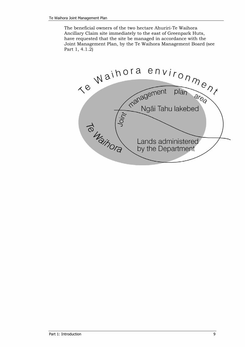
3.2 Area descriptions Te ähua o ngä wähangaThe area for which the Joint Management Plan has been prepared is set out in Appendix 1 and shown on Figure 3 and Figure 4 and includes:
Lands administered by the Department on the margins of and near Te Waihora. The Ngäi Tahu lakebed being the “bed of Te Waihora”, and Te Waiomäkua on Kaitorete Spit.
The Plan could also have been prepared for any other surrounding lands with the agreement of the landowners, but this has not been sought for this first Joint Management Plan.
3.2.1 Lands administered by the Department of ConservationWithin the Joint Management Plan Area the Department administers approximately 35 percent of the margin of Te Waihora. It also administers other lands in the Te Waihora environment, the largest of which is McQueen’s Lagoon on the Halswell River/Huritini.
3 Canterbury CMS, section 4.6.2 Te Waihora/Lake Ellesmere pp 71.
Te Waihora Joint Management Plan
Part 1: Introduction 8
The Department also administers other areas in the Te Waihora environment that are not part of the Joint Management Plan Area, including coastal lands on Kaitorete Spit and lands in Kaituna Valley and near Coopers Lagoon/Muriwai.
Additional information on some of the areas listed in Appendix 1 is available in Volume 2 (Schedule 2) of the Canterbury Conservation Management Strategy (2002).
3.2.2 Ngäi Tahu lakebed The Ngäi Tahu land subject to this Joint Management Plan is the “bed of Te Waihora” and Te Waiomäkua on Kaitorete Spit, referred to jointly throughout the Joint Management Plan as the “Ngäi Tahu lakebed”.
The “bed of Te Waihora” was vested in Te Rünanga o Ngäi Tahu as fee-simple estate as part of the Ngäi Tahu Settlement, pursuant to section 168 of the NTCSA. Title extends to the bed of Te Waihora only and does not include the water above it nor the aquatic life within the water, but it does however include plants attached to the bed of Te Waihora (section 171, NTCSA). Te Waiomäkua was vested in Te Rünanga o Ngäi Tahu as fee-simple estate pursuant to section 124 of the NTCSA. The Ngäi Tahu lakebed area is shown on Figure 3 and Figure 4.
The Ngäi Tahu lakebed includes the width of Kaitorete Spit to the line of mean high water springs at the south-western corner of the lake, from ‘the black hut’ in the east to near Taumutu Mäori Road in the west (see Figure 3). This includes an area subject to an easement to Environment Canterbury to enable the opening of Te Waihora to the sea.
The Ngäi Tahu lakebed does not fully correlate with the physical lakebed, i.e. the area of land covered by the waters of Te Waihora at all lake levels. It is that piece of land that was generally beneath lake waters and that was in Crown ownership before Settlement. Consequently, there are substantial stretches of other lands around the lake margin which lie beneath the waters of Te Waihora at various lake levels, including private freehold land, council endowment land, legal roads, Mäori owned land (other than Ngäi Tahu lakebed) and lands administered by the Department.
3.2.3 Other areas relevant to the Joint Management PlanNgäi Tahu owns other areas in the Te Waihora environment including Fishermans Point/Whakamätakiuru and Greenpark Huts, and has long term leases of Waikirikiri on the Selwyn Delta and Paköau at Lakeside pursuant to section 201 of the NTCSA.
There are a number of other areas in the Te Waihora environment that are currently protectively managed, or are likely to be in the future, including land administered by Territorial Local Authorities (Environment Canterbury, Christchurch City and Selwyn District Councils) and land owned by the North Canterbury Fish and Game Council. These areas are shown on Figure 4 and are listed in Appendix 2.
Te Waihora Joint Management Plan
Part 1: Introduction 9
The beneficial owners of the two hectare Ahuriri-Te Waihora Ancillary Claim site immediately to the east of Greenpark Huts, have requested that the site be managed in accordance with the Joint Management Plan, by the Te Waihora Management Board (see Part 1, 4.1.2)


Te Waihora Joint Management Plan
Part 1: Introduction 11
Figure 4: Areas subject to the Te Waihora Joint Management Plan and other public and council lands

Te Waihora Joint Management Plan
Part 1: Introduction 13
4 ROLES AND RESPONSIBILITIES NGÄ TÜNGA ME NGÄ KAWENGA
4.1 Ngäi Tahu Ngäi Tahu Whänui, represented by Papatipu Rünanga and Te Rünanga o Ngäi Tahu, comprise people of Ngäi Tahu, Ngäti Mämoe and Waitaha descent, who hold manawhenua over an area that includes Te Waihora.
The takiwä or tribal area of Ngäi Tahu Whänui includes all the lands, islands and coasts of the South Island/Te Waipounamu south of White Bluffs/Te Parinui o Whiti on the east coast and Kahurangi Point/Te Rae o Kahurangi on the west coast as described in section 5 of the Te Rünanga o Ngäi Tahu Act 1996.
4.1.1 Te Rünanga o Ngäi Tahu Te Rünanga o Ngäi Tahu (Te Rünanga) was established by the Te Rünanga o Ngäi Tahu Act 1996 to give a legal identity to the tribe and to represent the tribal collective of Ngäi Tahu Whänui.
As well as working jointly with the Department of Conservation on the development of this Joint Management Plan, Te Rünanga acts as an advisory committee to provide advice to the Minister of Conservation on all matters concerning the management and conservation of freshwater fisheries within the Ngäi Tahu takiwä, pursuant to section 56 of the Conservation Act 1987. Similarly, Te Rünanga may also act as an advisory committee to provide advice to the Minister of Fisheries on all matters concerning the management and conservation of fisheries under the Fisheries Act 1983 and Fisheries Act 1996, within the Ngäi Tahu takiwä, pursuant to section 21 of the Ministry of Agriculture and Fisheries (Restructuring) Act 1995.
Te Rünanga o Ngäi Tahu also acts as a Statutory Advisor to Fish and Game Councils within the takiwä to provide advice in relation to native gamebirds (sections 277-279, NTCSA).
Aspects of this Joint Management Plan also help to achieve the ki uta ki tai management planning aspirations of Te Rünanga4,especially in terms of the importance of wetlands as a link between land and water and for the large number of mahinga kai species present. This Joint Management Plan is thought of by Ngäi Tahu as one ‘chapter’ of it’s ki uta ki tai aspirations. A ki uta ki tai – mountains to the sea management approach is based on a traditional Ngäi Tahu concept of resource management that recognises the interconnectivity of all resources, including people. The framework requires a holistic approach and requires co-ordination by all agencies responsible for environmental management.
4 Ngäi Tahu 2025 tribal vision.
Te Waihora Joint Management Plan
Part 1: Introduction 14
4.1.2 Te Waihora Management Board
“As t h e Te Waih o r a Manag emen t Boa r d m emb e r s c ame t o u nd e r s t a nd t h e o p p o r t u n i t i e s
a v a i l a b l e t o u s w e e n d e a v o u r e d t o ma x im i s e t h e s e t h r o u gh o u t t h i s P la n . Ou r a im wa s t o
s u p p o r t t h o s e i n i t i a t i v e s wh i c h w i l l r e i n s t a t e t h e Waih o r a e n v i r o nmen t s o t h a t t h e d e s c r i p t i v e
n ame Te Ke t e Ika a Räka i hau t ü a nd i t s a s s o c i a t ed whaka t auk i h a v e r e l e v a n c e t o t h e
f u l l . ”
Dona l d B rown
The Te Waihora Management Board, an advisory body for the development of the Joint Management Plan, comprises representatives of the six Papatipu Rünanga of mid Canterbury who have interests in Te Waihora. The Board’s composition is in recognition of whakapapa, kaitiaki roles and the flax-roots local knowledge of the Te Waihora environment held by the Board members and their respective Papatipu Rünanga.
The Board is made up of eight members, three appointed by Te Taumutu Rünanga and one member each from Te Ngäi Tüähuriri, Wairewa, Koukourarata, Önuku Rünanga and Te Hapü o Ngäti Wheke. Te Taumutu Rünanga appoints the Chair of the Board in recognition of their ahi kä status.
The takiwä areas around which each of the Papatipu Rünanga represented on the Te Waihora Management Board are centred, and described in Appendix 8. Papatipu Rünanga Marae locations are shown on Figure 2.
4.2 Department of Conservation Te Papa AtawhaiThe Department of Conservation (the Department) is responsible under the Conservation Act 1987 for the management of protected species and ecosystems, providing for public enjoyment of public conservation lands, conserving historic resources in protected areas and promoting the conservation of natural and historic resources generally.
For the purposes of this Plan, and as in the Conservation Act 1987, conservation means5 “…the preservation and protection of natural and historic resources for the purpose of maintaining their intrinsic values, providing for their appreciation and recreational enjoyment by the public, and safeguarding the options of future generations.” The Department’s functions include to preserve, as far as practicable, all indigenous freshwater fisheries and to protect recreational freshwater fisheries and freshwater fish habitats.
For the areas administered by the Department subject to this Joint Management Plan, and for the purposes of section 17A(b) (re management in accordance with strategies and plans) and 17W(7) and 17W(8) (re concessionaire activities in accordance with strategies and plans) of the Conservation Act, this Joint Management Plan is to be considered as a conservation management plan (section 178, NTCSA). This Joint Management
5 Section 8, NTCSA.
Te Waihora Joint Management Plan
Part 1: Introduction 15
Plan is guided by the objectives and implementation priorities of the Canterbury Conservation Management Strategy (2000).
Other legislation administered by the Department that affects Te Waihora is set out in the First Schedule of the Conservation Act and includes the Wildlife Act 1953 and the Reserves Act 1977. The Minister of Conservation may make bylaws prohibiting or regulating public access or use of the bed of Te Waihora where such bylaws are recommended through this Joint Management Plan (section 182, NTCSA).
Treaty of Waitangi (Te Tiriti o Waitangi) obligations Section 4 of the Conservation Act 1987 requires the Department to give effect to the principles of the Treaty of Waitangi, at least to the extent that the provisions of the Acts listed in the First Schedule of the Conservation Act are not clearly inconsistent with the principles (Ngäi Tahu Mäori Trust Board v Director-General of Conservation [1995] 3NZLR 553, 558, Lines 33-35). Appendix 3 sets out the principles which guide the Department and Te Rünanga respectively in their organisational approaches to honouring the Treaty of Waitangi.
The Deed of Settlement (1997) and the Ngäi Tahu Claims Settlement Act 1998 also provide specific obligations for the Department, including the joint preparation of this Plan. These specific obligations are noted, where relevant, in policies, explanations and methods throughout this Joint Management Plan. These obligations mean that the Department has a joint role in management for “mahinga kai, conservation and other purposes” within the Joint Management Plan Area.
4.3 Other Agencies Ngä umanga këAs well as the kaitiaki role of Ngäi Tahu and the management roles and responsibilities of the Department, several other agencies are also involved in the management of resources and resource users in and around Te Waihora.
4.3.1 North Canterbury Fish and Game Council Fish and Game Council functions, as set out in section 26P of the Conservation Act 1987, are to manage, maintain and enhance the sports fish and game resources in the recreational interests of anglers and hunters. The North Canterbury Fish and Game Council has this statutory responsibility at Te Waihora, and undertakes it in accordance with its North Canterbury Fish and Game Management Plan (1999). Game species at Te Waihora include Canada goose, black swan and various duck species. The sports fish, brown trout, are also present (see Part 2, section 4). The Council manages maimai within the JMP Area in accordance with the Maimai Agreement 1997(see Appendix 4). The Council also owns and manages a ‘reserve’ at Boggy Creek on the western shore of Te Waihora.
The Maimai Agreement Agreed to as part of the Deed of Settlement (1997), this Agreement between the North Canterbury Fish and Game Council, the
Te Waihora Joint Management Plan
Part 1: Introduction 16
Department and Te Rünanga recognises the occupation and use of the JMP Area for recreational hunter maimai.
The intent of the Agreement is to secure the rights of hunters to the continued use of maimai for recreational hunting while recognising the freehold land rights of Te Rünanga and the permitting requirements of the Conservation and Reserves Acts. In exchange for the continued use, control and management of maimai within the JMP Area, half of the gamebird hunting licence fee from maimai users goes into a joint fund for enhancement projects and/or to give effect to objectives of this Joint Management Plan, or any other projects mutually agreed by all parties (Clauses 6.1 and 6.5 of the Agreement).
The Agreement is also a means to establishing a long-term relationship between the parties for the integrated management of Te Waihora and identifies the Council as a key stakeholder in the development of this Joint Management Plan and the on-going integrated management of Te Waihora.
To date, all maimai within the JMP Area have been located and registered and the Council is removing derelict maimai. Other abandoned or stranded material such as stakes, tree stumps, tyres and car bodies have also been removed to ‘clean up’ the JMP Area and provide safer access. The register of maimai will be updated on an annual basis.
A full copy of the Agreement is included as Appendix 4.
4.3.2 Local Authorities The Resource Management Act 1991 and the Local Government Act 2002 are the main Acts that affect the management of Te Waihora by local authorities.
Environment Canterbury Environment Canterbury (the Canterbury Regional Council) is responsible for the integrated management of the natural and physical resources of the Canterbury region, which includes monitoring and control of Te Waihora lake levels, issuing and monitoring water and discharge permits and monitoring water quality and other aspects of the use of the bed of the lake and inflowing rivers. The Council is also responsible for proposing regional pest management strategies under the Biosecurity Act 1993 and is enabled under the ‘general competency’ provisions of the Local Government Act 2002 to maintain a system of drains within the Halswell Drainage District. This maintenance includes weed cutting (hand and mechanical), mechanical excavation, spraying of weeds and banks, removing blockages such as wind-blown trees and slips and the operation of floodgates.
The Council must “take into account” the Joint Management Plan as a relevant planning document recognised by an iwi authority when preparing or changing a regional plan, as well as “have regard to”the Joint Management Plan as a plan prepared under another Act in the preparation of their plans and policy statements under sections 61(2)(a) and 66(2)(c) of the Resource Management Act.
Section 4 of the Local Government Act 2002 states “In order to recognise and respect the Crown's responsibility to take appropriate
Te Waihora Joint Management Plan
Part 1: Introduction 17
account of the principles of the Treaty of Waitangi and to maintain and improve opportunities for Mäori to contribute to local government decision-making processes, Parts 2 and 6 provide principles and requirements for local authorities that are intended to facilitate participation by Mäori in local authority decision-making processes.” Under the Act local authorities must, at section 77(c), “take into account the relationship of Mäori and their culture and traditions with their ancestral land, water, sites, wähi tapu, valued flora and fauna and other taonga.”
Council consideration of the relationship of Ngäi Tahu with Te Waihora is in part covered by the matters of national importance under section 6(e) of the Resource Management Act, in providing for “the relationship of Mäori and their culture and traditions with their ancestral lands, water, sites, wähi tapu, and other taonga.” This relationship is also pertinent to achieving the purposes of the Resource Management Act, particularly through sections 7(a) Kaitiakitanga and 8 Treaty of Waitangi.
Environment Canterbury holds and manages endowment lands (Along much of the lake-side of Kaitorete Spit) are leased for grazing to help fund Te Waihora lake openings. A management plan has been prepared for the wetlands on the Kaitorete Spit recommending that management of this area should be consistent with the aims of the JMP in terms of grazing, pest control and conservation management.
From an initial proposal for a Lake Ellesmere regional plan Environment Canterbury assisted in the establishment of the Waihora Ellesmere Trust formed to prepare the non-statutory Community Strategy for the Future Management of Lake Ellesmere/ Te Waihora and its Tributaries (2004).
The National Water Conservation (Lake Ellesmere) Order 1990The National Water Conservation (Lake Ellesmere) Order 1990 (WCO) affects the management of Te Waihora by Environment Canterbury. The WCO allows for the application of resource consents to open/close the lake within certain times and lake levels and prevents any further damming, stopbanking, or drainage of any part of Te Waihora below the level of 1.13m amsl. The WCO provides for existing drains and stopbanks and their maintenance. See Appendix 7.
Selwyn District and Christchurch City Councils District and city councils are responsible under the Resource Management Act for the management of the effects of the use, development, or protection of land and associated natural and physical resources of their districts (sections 12 to15, RMA). District and city councils are also responsible under the Local Government Act 2002 for the provision and maintenance of some land drainage schemes that flow through the Te Waihora environment.
The Selwyn District Council maintains an extensive network of drains and streams in the area. Christchurch City Council maintains a further system of streams and drains, including some in the Kaituna Valley, which discharge to Te Waihora. The
Te Waihora Joint Management Plan
Part 1: Introduction 18
Christchurch City Council is also involved in drainage in the upper catchment of the Halswell River/Huritini.
Selwyn District Council administers Lakeside Domain (Recreation Reserve) on the western shore of Te Waihora. This is a popular recreation area, especially as a base for water sports and for camping and picnicking. The Council administers other areas of the lakebed and lake shore (see Figure 4 and Appendix 2).
Christchurch City Council administers endowment land on the eastern lake-side of Kaitorete Spit, which it leases for grazing to help fund Lake Forsyth (Wairewa) lake openings. Council administers several small reserves in the vicinity of Kaituna Lagoon (see Figure 4 and Appendix 2).
As local authorities, district councils are also bound by the Treaty provisions, the Local Government Act 2002 and provisions for Mäori participation in decision making. They must also provide for the relationship of Ngäi Tahu with Te Waihora as a matter of national importance under section 6(e) of the Resource Management Act 1991. In achieving the purposes of the Act, they must “take into account” the Joint Management Plan as a relevant planning document recognised by an iwi authority when preparing or changing a district plan, as well as “have regard to” the Joint Management Plan as a plan prepared under another Act, under sections 74(2A) and 74(2)(b)(i) of the Resource Management Act respectively.
Ministry of Fisheries The Ministry of Fisheries is the Government agency whose primary focus is the sustainable management of fisheries. The Ministry's primary purpose under section 8 of the Fisheries Act 1996 is “to provide for the utilisation of fisheries resources while ensuring sustainability.” Utilisation means conserving, using, enhancing, and developing fisheries resources to provide for the social, economic, and cultural wellbeing of people. Fisheries management has to be conducted in a manner consistent with the Treaty of Waitangi (Fisheries Claims) Settlement Act 1992.
The main fisheries associated with Te Waihora include those for freshwater eel, flounder and yellow-eyed mullet.
The New Zealand Historic Places Trust Pouhere TaongaThe purpose of the Historic Places Act 1993 (section 4(1)) is “to promote the identification, protection, preservation, and conservation of the historical and cultural heritage of New Zealand.”
The general functions of the New Zealand Historic Places Trust Pouhere Taonga under section 39 of the Historic Places Act 1993 are:
“(a) To identify, record, investigate, assess, register, protect, and conserve wähi tapu areas, historic places, and historic areas or to assist in doing any of those things, and to keep permanent records of such work:
(b) To advocate the conservation and protection of wähi tapu areas, historic places, and historic areas:
Te Waihora Joint Management Plan
Part 1: Introduction 19
(c) To foster public interest and involvement in historic places and historic areas and in the identification, recording, investigation, assessment, registration, protection, and conservation of them:
(d) To furnish information, advice, and assistance in relation to the identification, recording, investigation, assessment, registration, protection, and conservation of wähi tapu areas, historic places, and historic areas:
(e) To manage, administer, and control all historic places, buildings, and other property owned or controlled by the Trust or vested in it, to ensure the protection, preservation, and conservation of such historic places, buildings, and other property.”
While the Department of Conservation is responsible for the maintenance and management of historic resources on land that it administers, all archaeological sites6 are protected under the Historic Places Act 1993. Permission to destroy, damage, or modify the whole or any part of an archaeological site is required from the Trust.
4.4 Relevant statutory and other documents Tuhinga-ä-ture me ëtahi atu tuhinga e pä ana ki Te WaihoraThe following statutory and other policy documents relevant to Te Waihora were studied during the preparation of this Joint Management Plan. They have a variety of legislative or policy relationships to the JMP, as set out under the organisation sub-headings. The documents were also studied for their resource information and to assist in understanding their parent organisation’s attitudes towards Te Waihora, during the preparation of policies and methods, including those for advocacy directed towards the various organisations.
Ngäi Tahu (The documents below are “non-derogation” (i.e. nothing in the JMP derogates from them) iwi management plans in terms of section 179(b) NTCSA, for the Ngai Tahu lakebed.)
Te Whakatau Kaupapa - Canterbury (1990) Note: While this document is a planning document recognised by an iwi authority for the purposes of the Resource Management Act, the provisions of subsequent legislation including the Resource Management Act, the Ngäi Tahu Claims Settlement Act, the Local Government Act 2002 and the documents below developed by Te Rünanga o Ngäi Tahu and Papatipu Rünanga have superseded many of the policies in this document.
Ngäi Tahu Freshwater Policy (1999) Ngäi Tahu 2025 (2001)
6“Archaeological site” means any place in New Zealand that— (a) Either— (i) Was
associated with human activity that occurred before 1900; or (ii) Is the site of the wreck of any vessel where that wreck occurred before 1900; and (b) Is or may be able through investigation by archaeological methods to provide evidence relating to the history of New Zealand:” (section 2, Historic Places Act 1993).
Te Waihora Joint Management Plan
Part 1: Introduction 20
Te Taumutu Rünanga Natural Resource Management Plan (2003)
Department of Conservation (These documents are “non-derogation” (i.e. nothing in the JMP derogates from them) documents in terms of section179(a) NTCSA, for the land administered by the Department.)
Conservation General Policy (2005) Canterbury Conservation Management Strategy (2000)
Fish and Game Council (These documents are “non-derogation” (i.e. nothing in the JMP derogates from them) documents in terms of section179(a) NTCSA, for the land administered by the Department.)
North Canterbury Fish and Game Management Plan (1999) Canada Goose Management Plan (1995)
Regional and district councils (Some provisions within these documents are binding on the Minister and/or Te Rünanga in terms of the Resource Management Act 1991 or the Biosecurity Act 1993. “Proposed” plans will become operative and “transitional” plans expire, during the life of this first Joint Management Plan.)
Canterbury Regional Policy Statement (1998) Canterbury Regional Council Transitional Regional Plan (1991) Canterbury Regional Coastal Environment Plan (2005) Canterbury Regional Pest Management Strategy 2005 – 2015 (2005)Proposed Canterbury Natural Resources Regional Plan (2002),Chapters 1 to 3 Proposed Canterbury Natural Resources Regional Plan (2004),Chapters 4 to 8 Transitional Banks Peninsula District Plan, Wairewa Section (1974) Proposed Banks Peninsula District Plan (2002) Transitional Selwyn District Plan, Ellesmere Section (1982) Proposed Selwyn District Plan, Volume 2 – Rural Areas (2001)
Te Waihora Joint Management Plan
Part 1: Introduction 21
Ministry of Fisheries (These are non-statutory policy documents.)
South Island Eel Management Plan (1996) Te Waihora Eel Management Plan (1999)
National Policy (These documents are expressions of Government policy and as such the Department needs to have regard to them in as far as they are consistent with the Conservation Act and the Acts listed in the First Schedule to that Act. The Coastal Policy Statement relates to the coastal environment, which includes Te Waihora and is primarily given effect through the above regional and district plans under the Resource Management Act.)
New Zealand Coastal Policy Statement (1994) Environment 2010 (1994) The NZ Biodiversity Strategy 2000.
Te Waihora Joint Management Plan
Part 1: Introduction 22
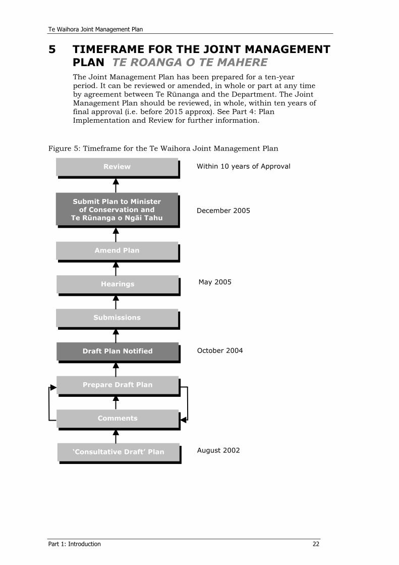
5 TIMEFRAME FOR THE JOINT MANAGEMENT PLAN TE ROANGA O TE MAHEREThe Joint Management Plan has been prepared for a ten-year period. It can be reviewed or amended, in whole or part at any time by agreement between Te Rünanga and the Department. The Joint Management Plan should be reviewed, in whole, within ten years of final approval (i.e. before 2015 approx). See Part 4: Plan Implementation and Review for further information.
Figure 5: Timeframe for the Te Waihora Joint Management Plan
Review
Submit Plan to Minister of Conservation and
Te Rünanga o Ngäi Tahu
Amend Plan
Hearings
Submissions
Draft Plan Notified
Prepare Draft Plan
Comments
‘Consultative Draft’ Plan
Within 10 years of Approval
December 2005
October 2004
August 2002
May 2005
PART 2:VALUES OF TE WAIHORA
NGÄ UARA

Te Waihora Joint Management Plan
Part 2: Values 25
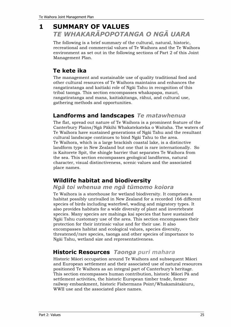
1 SUMMARY OF VALUES TE WHAKARÄPOPOTANGA O NGÄ UARAThe following is a brief summary of the cultural, natural, historic, recreational and commercial values of Te Waihora and the Te Waihora environment as set out in the following sections of Part 2 of this Joint Management Plan.
Te kete ika The management and sustainable use of quality traditional food and other cultural resources of Te Waihora maintains and enhances the rangatiratanga and kaitiaki role of Ngäi Tahu in recognition of this tribal taonga. This section encompasses whakapapa, mauri, rangatiratanga and mana, kaitiakitanga, rähui, and cultural use, gathering methods and opportunities.
Landforms and landscapes Te matawhenuaThe flat, spread out nature of Te Waihora is a prominent feature of the Canterbury Plains/Ngä Päkihi Whakatekateka o Waitaha. The waters of Te Waihora have sustained generations of Ngäi Tahu and the resultant cultural landscape continues to bind Ngäi Tahu to the area. Te Waihora, which is a large brackish coastal lake, is a distinctive landform type in New Zealand but one that is rare internationally. So is Kaitorete Spit, the shingle barrier that separates Te Waihora from the sea. This section encompasses geological landforms, natural character, visual distinctiveness, scenic values and the associated place names.
Wildlife habitat and biodiversityNgä toi whenua me ngä tümomo koioraTe Waihora is a storehouse for wetland biodiversity. It comprises a habitat possibly unrivalled in New Zealand for a recorded 166 different species of birds including waterfowl, wading and migratory types. It also provides habitats for a wide diversity of plant and invertebrate species. Many species are mahinga kai species that have sustained Ngäi Tahu customary use of the area. This section encompasses their protection for their intrinsic value and for their use. It also encompasses habitat and ecological values, species diversity, threatened/rare species, taonga and other species of importance to Ngäi Tahu, wetland size and representativeness.
Historic Resources Taonga puri maharaHistoric Mäori occupation around Te Waihora and subsequent Mäori and European settlement and their associated use of natural resources positioned Te Waihora as an integral part of Canterbury’s heritage. This section encompasses human contribution, historic Mäori Pä and settlement activities, the historic European timber trade, former railway embankment, historic Fishermans Point/Whakamätakiuru, WWII use and the associated place names.
Te Waihora Joint Management Plan
Part 2: Values 26
Recreational use and public accessMahi-ä-täkaro hoki me te whai wähi o te häporiTe Waihora provides a high quality recreational area for many user groups including fishers, game bird hunters, water based recreationalists, bird watchers and those enjoying the wide-open spaces. This section encompasses recreational fishing and game bird hunting, some of which involves customary use, as well as water sports, recreational hut settlements and other public use of land administered by the Department and of the Ngäi Tahu lakebed.
Commercial and other activities Ngä mahi arumoni me ëtahi atu mahiCommercial uses occur within Te Waihora, such as fishing and stock grazing along with other, generally public activities and other agency activity. The lake community values these commercial activities which are based on the natural and ecological values of Te Waihora. This section encompasses commercial fishing of freshwater eels, mullet and flounder, grazing, accommodation, eco-tourism activities, utilities and research.
Te Waihora Joint Management Plan
Part 2: Values 27
2 TE KETE IKA
“Waihora, Te Kete Ika o Räkaihautü and also Te Kete Ika o
Tutekawa sometimes i t i s called. I have seen i t recorded somewhere as
Tutekawa but mostly i t ’ s more popularly known as Räkaihautü.
Tutekawa was of course at Waikäkahi. That’s where he was kil led.” Rik i El l i s on
Te Kete Ika means the fish basket and exemplifies the once rich and bountiful resources of Te Waihora - the flat spread-out waters. The names Te Kete Ika o Räkaihautü and Te Kete Ika o Tutekawa
denote the whakapapa of the area as various ancestors laid claim to Te Waihora and its resources. These resources, their on-going
sustainable management and use and the spiritual connection to Te Waihora are taonga to Ngäi Tahu.
The Conservation Act recognises and allows for such taonga as above.
2.1 WhakapapaIn a traditional Mäori sense, whakapapa is the backbone that determines who is allowed to interact and manage natural resources. In its most basic meaning, “whakapapa is the principle from which order and chaos may be understood. It places order upon space and time. It is the binding agent between opposite fields and connects the living with the dead, atua with humankind, and the intangible with the tangible.” (Tau, 1999).
Whakapapa lies at the core of Mäori knowledge and understanding, involving both mätauranga and wänanga knowledge. As whakapapa derives from atua, it provides an unbroken link and chain of descent between the spiritual and the material, the inanimate and the animate. When understood in its fullest sense, it incorporates and describes the entire fabric of the universe from the beginnings of time through to the present. In scientific terms, it provides a grand, unifying theory of the cosmos because it is derived from and under the protection of atua. To interfere with whakapapa is to interfere with things sacred or tapu.
In a more general context, the meaning of whakapapa is, "to lay one thing upon another” (Barlow, 1991), for example, to lay one generation upon another. Everything has a whakapapa: birds, fish, animals, trees and every other living thing; soil and rocks and mountains also have a whakapapa. It is this sense of connectedness between spirit, humans and nature that forms the basis for managing environmental resources, “as it emphasises the links to others rather than the individuality of members of a group. Whakapapa is used as a political, cultural and economic tool in practices such as betrothal. It helps resolve disputes
Te Waihora Joint Management Plan
Part 2: Values 28
between groups, determines standing in society, and is the ultimate test of heritage.” (Gibbs, 1996). Early tïpuna, “imposed whakapapa upon the Southern landscape” and “virtually consecrated the land by ritual with their whakapapa” (Tau, 1999, p.138). This was a means of ordering the landscape in the minds of the Polynesian colonists, which, among other things, provided for a utilitarian management framework for managing mahinga kai resources (Tau, 1999).
From a traditional Ngäi Tahu perspective, following the wreckage of Te Waka o Aoraki (the canoe of Aoraki) that became the South Island/Te Wai Pounamu, Rakinui (Sky Father) sent a number of his mokopuna (grandchildren) from the heavens to transform the waka into land that would sustain human life. One of these demi-gods was Tüterakihaunoa whose job was to carve the keel of the upturned waka into mountains and valleys and who remains the atua tiaki of Te Waihora. Two others were Kahukura who forested the bare landscape and filled it with animals, and Marokura who carved bays, inlets and estuaries, and populated them with fish of many varieties.
The first people to arrive in the central Canterbury area were those on the Uruao waka under the captaincy of Te Rakihouia. Te Rakihouia had been instructed by his father Räkaihautü to seek out the rich resources of the coastal area (ki tai) while he traversed the mountain regions identifying the resources of land (ki uta). During these journeys, Te Rakihouia discovered the wetland of Te Waihora teeming with fish and birds. Upon reuniting with his father, Te Rakihouia took him to the lake where Räkaihautü proclaimed Te Waihora as Te Kete Ika a Räkaihautü – The Fish Basket of Räkaihautü.
Subsequent to this, waves of other iwi and hapü inhabited the Te Waihora area. Two prominent ancestors that held mana to the area were Tutekawa, a Ngäti Mämoe Chief, and Te Ruahikihiki, the eponymous ancestor of the hapü Ngäi te Ruahikihiki who inhabited the Orariki Pä at Taumutu. Te Ruahikihiki was a close relation to all the prominent chiefs of the Banks Peninsula/Horomaka and the North Canterbury region which therefore gave rights to those chiefs and their hapü having whakapapa that links them to Te Waihora.
In today’s management terms for Te Waihora, the resultant kaitiaki roles and responsibilities of all hapü with areas surrounding Te Waihora have been recognised through the establishment of the Te Waihora Management Board (see Part 1, section 4.1.2).
2.2 Mauri and wairuaAll things are considered to have the qualities of wairua (spiritual dimension) and mauri (life force), to be living and have a genealogical relationship with one another. For Ngäi Tahu, mauri is the life force that flows from wairua - the spirit or source of existence and all life. Mauri is the life force in the physical world as perceived and interpreted by the tängata whenua.
As a life principle mauri implies health and spirit. In the environment, mauri can be used to describe the intrinsic values of all resources and the total ecosystem. It is of paramount importance to the well-being of the people. The protection of mauri is enhanced by the use of mahinga kai and the resultant knowledge of the natural resources and their interactions with the wider environment. The preservation of the mauri of all natural resources is essential to Ngäi Tahu to ensure that natural
Te Waihora Joint Management Plan
Part 2: Values 29
and physical resources may be used sustainably by present and future generations.
For Te Waihora, mauri can be tangibly represented in terms of elements of the physical health of the ecosystem. While there are also many intangible qualities associated with the spiritual presence of Te Waihora, tangible elements, such as the presence of indigenous flora and fauna, life-supporting capacity, fitness for cultural usage, ecosystem robustness and productive capacity, can be used to reflect the status of mauri.7
Mauri should not be desecrated. Although Te Waihora continues to be a productive environment, its mauri has been degraded since human settlement by introduced species, substantially reduced water inflows, increased sediment and nutrient inflows from the catchment and a decreasing availability of mahinga kai resources. Further degradation of the mauri of Te Waihora would remove its capacity to support traditional practices and values.
2.3 RangatiratangaRangatiratanga is customary tribal authority. The Crown “acknowledges Ngäi Tahu rangatiratanga and mana over the South Island lands within its boundaries, and, in fulfilment of its Treaty obligations, the Crown recognises Ngäi Tahu as the tangata whenua of, and as holding rangatiratanga within, the Takiwä of Ngäi Tahu Whänui.” (Section 6, NTSCA 1998). For Ngäi Tahu, rangatiratanga incorporates the right to make, alter and enforce decisions pertaining to how their resources and taonga are used and managed, and by whom. Rangatiratanga is carried out in accordance with kawa and tikanga and is about Ngäi Tahu continuing to exercise their mana or authority to affect the relationship between themselves, their culture and traditions, and the natural world. Rangatiratanga is traditionally embodied within the concept of mana.
Manaaki Effective rangatiratanga enables Ngäi Tahu to manaaki (welcome) manuhiri and mataawaka (visitors) to the area with the provision of local foods. Kai hau kai, the exchange of local food and resources, similarly asserts an authority over those resources as well as enabling manaakitanga and the provision of koha. The use and trade of mahinga kai resources helps transfer knowledge and values about natural resources while providing for personal needs and the needs of hapü and whänau.
Rangatiratanga and manaaki are closely linked to kaitiakitanga.
2.4 KaitiakiWhakapapa and the link between all living things is reflected in traditional attitudes towards the natural world and resource management. Ngäi Tahu were dependent on their immediate environment for survival, on their knowledge of mahinga kai and their ability to sustainably gather resources from Te Waihora for their endurance in this area. This, coupled with a long history of settlement,
7 The Ngäi Tahu Freshwater Policy (1999) identifies factors and activities that affect the mauri of
waterbodies.
Te Waihora Joint Management Plan
Part 2: Values 30
occupation, travel and resource use, results in the diverse mätauranga accumulated about Te Waihora and its natural resources.
Traditionally kawa and tikanga were established to govern the use of natural resources and ensure that mauri was protected from human actions. These systems of traditional management, or kaitiakitanga, were the means by which Ngäi Tahu sought the sustainable management of Te Waihora.
Kaitiaki is derived from the verb tiaki (to guard, to protect, to keep, to watch for, to wait for). Kaitiakitanga is the act of guardianship. To be kaitiaki is an important responsibility. The kaitiaki system is based on whakapapa lineage and is an inherited responsibility that is traditional and strongly held. Ngäi Tahu preserves the mana of kaitiaki to ensure that the mauri or life force of their taonga is healthy and strong.
Kaitiakitanga entails an active exercise of power in a manner beneficial to the resource. In today’s management terms for Te Waihora this is carried out by kaitiaki rünanga, including their representation on the Te Waihora Management Board (see Part 1, section 4.1.2).
At times, rähui were used to safeguard the well-being of people and for the purposes of conservation, restricting use and assuring sustainability. Wakawaka, or family gathering sites, also regulated access and assisted resource management and sustainability. These systems ensured that the needs of present generations were met while protecting the overall health and availability of the resource to meet the needs of future generations.
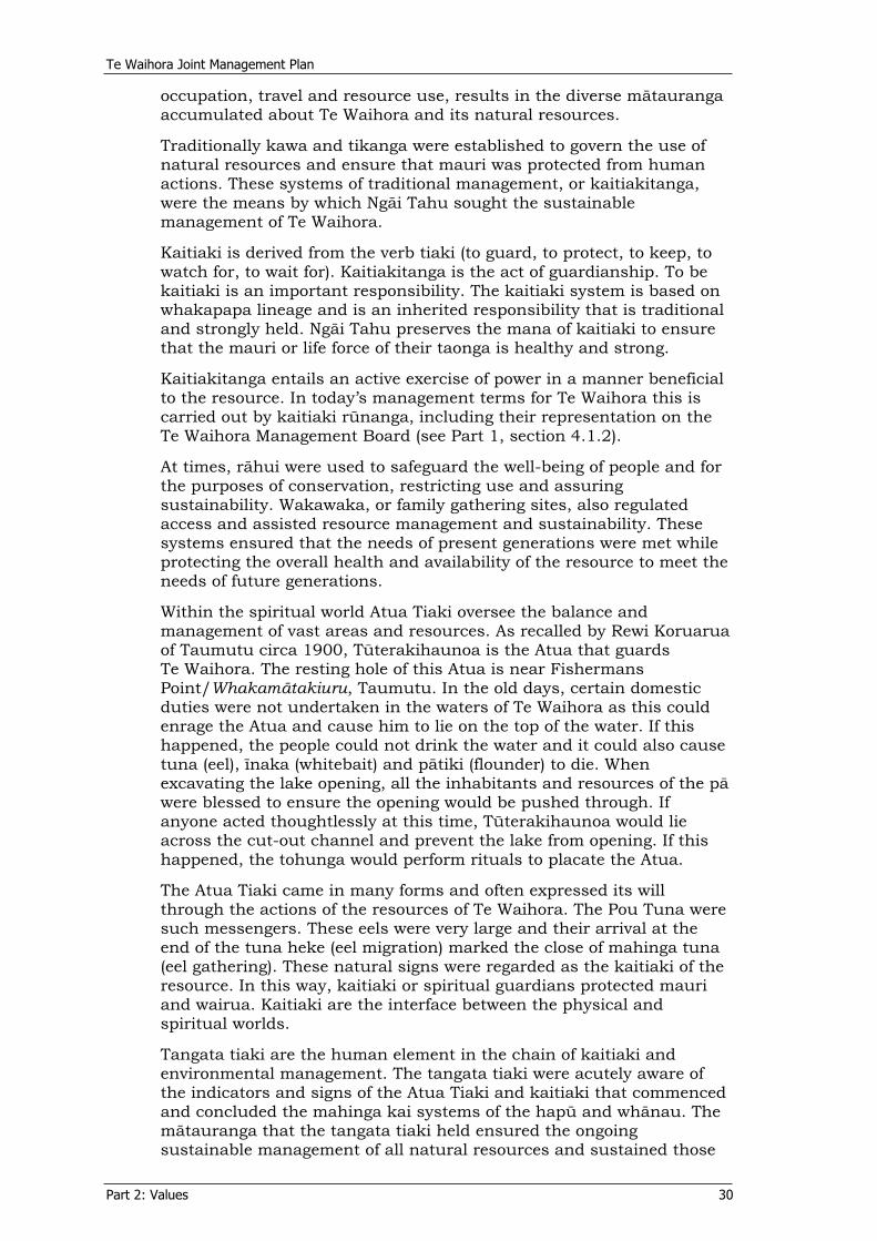
Within the spiritual world Atua Tiaki oversee the balance and management of vast areas and resources. As recalled by Rewi Koruarua of Taumutu circa 1900, Tüterakihaunoa is the Atua that guards Te Waihora. The resting hole of this Atua is near Fishermans Point/Whakamätakiuru, Taumutu. In the old days, certain domestic duties were not undertaken in the waters of Te Waihora as this could enrage the Atua and cause him to lie on the top of the water. If this happened, the people could not drink the water and it could also cause tuna (eel), ïnaka (whitebait) and pätiki (flounder) to die. When excavating the lake opening, all the inhabitants and resources of the pä were blessed to ensure the opening would be pushed through. If anyone acted thoughtlessly at this time, Tüterakihaunoa would lie across the cut-out channel and prevent the lake from opening. If this happened, the tohunga would perform rituals to placate the Atua.
The Atua Tiaki came in many forms and often expressed its will through the actions of the resources of Te Waihora. The Pou Tuna were such messengers. These eels were very large and their arrival at the end of the tuna heke (eel migration) marked the close of mahinga tuna (eel gathering). These natural signs were regarded as the kaitiaki of the resource. In this way, kaitiaki or spiritual guardians protected mauri and wairua. Kaitiaki are the interface between the physical and spiritual worlds.
Tangata tiaki are the human element in the chain of kaitiaki and environmental management. The tangata tiaki were acutely aware of the indicators and signs of the Atua Tiaki and kaitiaki that commenced and concluded the mahinga kai systems of the hapü and whänau. The mätauranga that the tangata tiaki held ensured the ongoing sustainable management of all natural resources and sustained those
Te Waihora Joint Management Plan
Part 2: Values 31
who had a right to access and use them. The system of kaitiaki at Te Waihora can be summarised as follows:
Many customary practices have been maintained today through the continued preference for traditional food and customs. Many of these practices however, are in jeopardy of being lost due to unsustainable practices in other sectors of the community and through actions that have resulted in a degraded environment. This impacts on the health and well-being of the waterways and natural resources and the ability of Ngäi Tahu to access the life sustaining resources.
2.5 Ngä wai In the management of any natural resource, it is important to understand the significance of water to Ngäi Tahu. Water is the essence of all life, akin to the blood of Papatüänuku (Mother Earth) who supports all people, flora and fauna. Without water, no living thing, plant, fish, or animal can survive.
Wai, or water, is the medium in which the dead travel to and from this world. This is illustrated by the practice of waiwhakaheketüpäpaku (water burials). Wai is the lifeblood of Papatüänuku that falls upon her from the heavens of Ranginui the Sky Father. In death our spirit returns to our earth mother. Thus water maintains two specific roles within Ngäi Tahu culture; firstly to provide the sustenance of life and secondly the medium in which the spirit moves freely from one world to the next.
Water is also central to the Ngäi Tahu resource management philosophy “ki uta ki tai - from the mountains to the sea.” As water flows from the mountains to the sea so too should resource management. For Ngäi Tahu this requires an holistic view of the world and integration and co-operation between agencies, legislation and management frameworks. For Te Waihora this is particularly important as this Joint Management Plan deals with specific land parcels around Te Waihora, including the lakebed itself, but does not include the water overlying the lakebed nor the waters feeding Te Waihora from the surrounding catchment and mountains (see Part 1).
Atua tiakiTuterakihaunoa
KaitiakiEnvironmental indicators - Pou Tuna
Tangata tiakiThe resource managers
Te Waihora Joint Management Plan
Part 2: Values 32
Water is a taonga. Ensuring the health and well-being of water is a prerequisite for ensuring the continued health and well-being of mahinga kai resources and ultimately the people. It is those things that threaten the health of the resources of Te Waihora that are of the greatest concern to Ngäi Tahu. Part 2, section 4.2, outlines how this affects water management for Te Waihora.
2.6 Mahinga kai and customary use As proclaimed by Räkaihautü, Te Waihora was the greatest inland fish basket found on the Te Waipounamu landscape. The enormity of the resource has led to Ngäi Tahu considering it to be one of their most precious taonga. In its own right Te Waihora was a major limb of the nine tall trees of the Ngäi Tahu Claim.8
The ability of Te Waihora to sustain people as a mahinga kai is upheld in the whakataukï (tribal proverb) from Taumutu:
Ko ngä hau ki ëtahi wähi, ko ngä kai ki Orariki No matter which way the wind blows you will always eat at the pä of
Orariki, Taumutu
Simply stated, this whakataukï proclaims that no matter the season, you could always procure food from the Te Waihora environment.
Te Waihora is a tribal taonga, a resource traditionally used by the whole of Ngäi Tahu Whänui. The rights to these resources were shared by many different hapü, each with access to the shore of the lake closest to their takiwä, through wakawaka (family gathering sites) and the traditional practices of manaaki, kai hau kai and networks of whakapapa. Resource use was (and continues to be) regulated through the protocols of tikanga and kawa, in accordance with the lifecycles of the mahinga kai species and encouraging sustainable resource use.
As a mahinga kai, Te Waihora provided fish and shellfish, was a birding ground for many species and was the gathering place for numerous plant and other natural materials. The swamps provided raupö and harakeke and Kaitorete Spit provided fish, pingao and other plant species. Mahinga kai resources include trees for whare and waka (buildings and canoes); plants and animals used as tohu (signs) for fishing and planting times; rongoä species (medicines) and kai (food); feathers and plant fibre for weaving; mud and soils, tree bark and berries for dyes; and plant seeds for oil. Materials such as bone, shells, wood and stone were also used to produce taonga and other everyday tools. The resources are taonga because they enabled and sustained life in the harsh southern environment and constituted a major food source of the area. Of all the resources gathered at Te Waihora, the plentiful fish, particularly tuna and pätiki, were most valued.
Mahinga kai encompasses the social and educational elements of food gathering. It includes customs practised in accordance with rangatiratanga, kaitiaki and whakapapa. Particularly with regard to kaitiaki, tangata tiaki have a role to implement and pass down customs and associated sustainable management methods, including the use of animal and plant species as tohu. In this way, mahinga kai ensures the continuation of traditional practices and the passing down of values to children and grandchildren, ensuring the survival of the practices
8 See Chapter 17, The Ngäi Tahu report, 1991 (Wai 27).

Te Waihora Joint Management Plan
Part 2: Values 33
through the generations. Mahinga kai includes the way resources are gathered, the places they are gathered from and the actual resources themselves.
The principal mahinga kai species of Te Waihora are outlined in Table 1. Many of these species are recorded in an 1880 document (Taiaroa, 1880) that identifies the food and natural materials gathered at that time and those that were used as tohu. The special relationship Ngäi Tahu has with some of these species is recognised through the NTCSA and the recognition of Taonga Species (see Part 2, section 4.3).
Te Waihora remains a mahinga kai of great importance to Ngäi Tahu. Participation in mahinga kai activities maintains the same importance today as in the past. This encourages the provision of continued availability and use of resources and customary areas to maintain the traditional associations of Ngäi Tahu with Te Waihora. Availability involves both physical access to Te Waihora and to healthy resources within it, as well as legal access to those resources and sites. Many mahinga kai species are less able to be gathered today for a number of reasons including: • their populations are no longer able to sustain being gathered • they are considered by some to be culturally unfit for consumption • the species has been lost from the area • legislative constraints
• limited access to areas where mahinga kai is successful.
Customary use by Ngäi Tahu has changed in response to issues of scarcity, sustainability and cultural developments, such as technological advances and changed catch methods. It will continue to evolve with culture and the environment. A commitment to customary use implies sustainable use and the need to manage, protect and restore species, habitats and ecosystems to enable such use to occur. As far as threatened species are concerned, Ngäi Tahu now focus their relationship on protection and enhancement of those species to the point that they can again, or continue to support, Ngäi Tahu use.
Ngäi Tahu understanding is that Article 2 of the Treaty of Waitangi recognised the customary right to engage in mahinga kai activity subject to the Crown's right to govern and expressions of that right, including the Conservation Act 1987 and the relevant Acts listed in the First Schedule to that Act, as well as fisheries legislation.
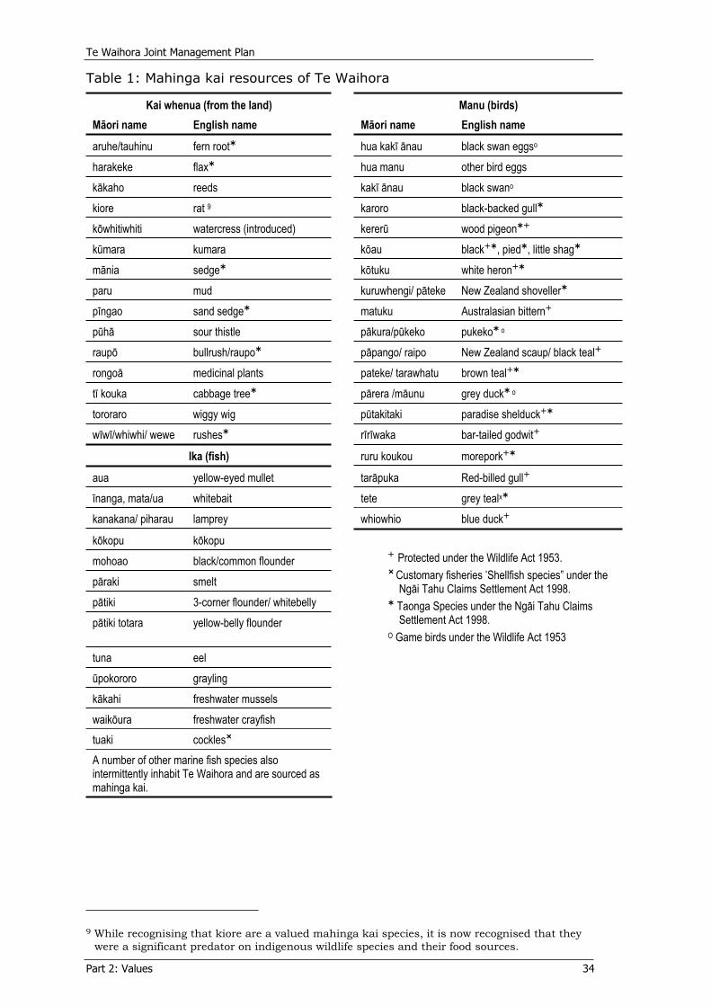
Te Waihora Joint Management Plan
Part 2: Values 34
Table 1: Mahinga kai resources of Te Waihora
Kai whenua (from the land) Manu (birds) Mäori name English name Mäori name English name
aruhe/tauhinu fern root hua kakï änau black swan eggso
harakeke flax hua manu other bird eggs käkaho reeds kakï änau black swano
kiore rat 9 karoro black-backed gullköwhitiwhiti watercress (introduced) kererü wood pigeonkümara kumara köau black , pied , little shagmänia sedge kötuku white heronparu mud kuruwhengi/ päteke New Zealand shovellerpïngao sand sedge matuku Australasian bitternpühä sour thistle päkura/pükeko pukeko o
raupö bullrush/raupo päpango/ raipo New Zealand scaup/ black tealrongoä medicinal plants pateke/ tarawhatu brown tealtï kouka cabbage tree pärera /mäunu grey duck o
tororaro wiggy wig pütakitaki paradise shelduckwïwï/whiwhi/ wewe rushes rïrïwaka bar-tailed godwit
Ika (fish) ruru koukou morepork
aua yellow-eyed mullet taräpuka Red-billed gullïnanga, mata/ua whitebait tete grey tealx
kanakana/ piharau lamprey whiowhio blue duck
kökopu kökopu mohoao black/common flounder päraki smelt pätiki 3-corner flounder/ whitebelly pätiki totara yellow-belly flounder
Protected under the Wildlife Act 1953. Customary fisheries “Shellfish species” under the Ngäi Tahu Claims Settlement Act 1998.
Taonga Species under the Ngäi Tahu Claims Settlement Act 1998.
O Game birds under the Wildlife Act 1953 tuna eel üpokororo grayling käkahi freshwater mussels waiköura freshwater crayfish tuaki cockles A number of other marine fish species also intermittently inhabit Te Waihora and are sourced as mahinga kai.
9 While recognising that kiore are a valued mahinga kai species, it is now recognised that they
were a significant predator on indigenous wildlife species and their food sources.
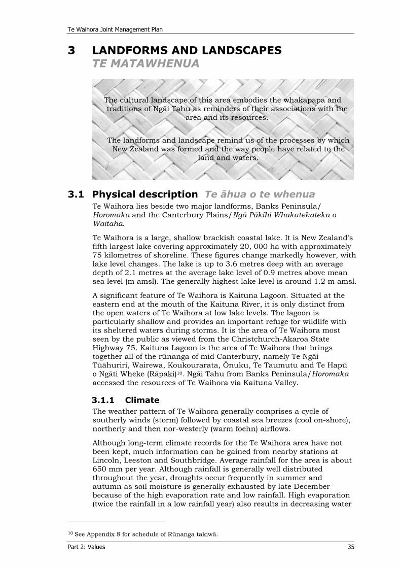
Te Waihora Joint Management Plan
Part 2: Values 35
3 LANDFORMS AND LANDSCAPESTE MATAWHENUA
The cultural landscape of this area embodies the whakapapa and traditions of Ngäi Tahu as reminders of their associations with the
area and its resources.
The landforms and landscape remind us of the processes by which New Zealand was formed and the way people have related to the
land and waters.
3.1 Physical description Te ähua o te whenuaTe Waihora lies beside two major landforms, Banks Peninsula/ Horomaka and the Canterbury Plains/Ngä Päkihi Whakatekateka o Waitaha.
Te Waihora is a large, shallow brackish coastal lake. It is New Zealand’s fifth largest lake covering approximately 20, 000 ha with approximately 75 kilometres of shoreline. These figures change markedly however, with lake level changes. The lake is up to 3.6 metres deep with an average depth of 2.1 metres at the average lake level of 0.9 metres above mean sea level (m amsl). The generally highest lake level is around 1.2 m amsl.
A significant feature of Te Waihora is Kaituna Lagoon. Situated at the eastern end at the mouth of the Kaituna River, it is only distinct from the open waters of Te Waihora at low lake levels. The lagoon is particularly shallow and provides an important refuge for wildlife with its sheltered waters during storms. It is the area of Te Waihora most seen by the public as viewed from the Christchurch-Akaroa State Highway 75. Kaituna Lagoon is the area of Te Waihora that brings together all of the rünanga of mid Canterbury, namely Te Ngäi Tüähuriri, Wairewa, Koukourarata, Önuku, Te Taumutu and Te Hapü o Ngäti Wheke (Räpaki)10. Ngäi Tahu from Banks Peninsula/Horomakaaccessed the resources of Te Waihora via Kaituna Valley.
3.1.1 ClimateThe weather pattern of Te Waihora generally comprises a cycle of southerly winds (storm) followed by coastal sea breezes (cool on-shore), northerly and then nor-westerly (warm foehn) airflows.
Although long-term climate records for the Te Waihora area have not been kept, much information can be gained from nearby stations at Lincoln, Leeston and Southbridge. Average rainfall for the area is about 650 mm per year. Although rainfall is generally well distributed throughout the year, droughts occur frequently in summer and autumn as soil moisture is generally exhausted by late December because of the high evaporation rate and low rainfall. High evaporation (twice the rainfall in a low rainfall year) also results in decreasing water
10 See Appendix 8 for schedule of Rünanga takiwä.
Te Waihora Joint Management Plan
Part 2: Values 36
levels during much of the summer months, as evaporation exceeds total inflows.
Winters at Te Waihora are cool with some frosts, despite the proximity to the sea. Snowfalls are infrequent. Summers are warm and sunshine hours average 2000 per year. Mean air temperatures range from 6ºC in July to 16.7ºC in January.
3.1.2 Hydrology Te Waihora has a catchment of 276, 000 ha, including hill and high country, downs and plains. It receives inflows from surface runoff, groundwater-fed tributaries, groundwater percolation, seawater inflows, and artesian springs. The groundwater hydrology of the area is complex and poorly understood, as is the connection between groundwater, spring flow and lake levels.
Approximately 40 rivers, streams and artificial drains feed Te Waihora from the surrounding catchment. Major waterways are the Selwyn River/Waikirikiri, flowing directly from the foothills, the Irwell River/Waiwhio, LII/Ararira, Halswell River/Huritini and Harts Creek/Waitatari, all originating within 19 km of Te Waihora and the Kaituna River from Banks Peninsula/Horomaka.
Maintaining natural flows in the rivers and springs that feed Te Waihora and the quantity and quality of these waters is important for maintaining and improving the mauri/health of Te Waihora. Te Waihora has no permanent outlet to the sea. Historically, the lake would naturally breach Kaitorete Spit at a lake level of about 4 m amsl. At this level, the lake would stretch inland to Taitapu/Tai Tapu and into Kaituna and Gebbies Valleys. The lake is now mechanically opened to the sea at a lake level of about 1.1m amsl (see Part 2, section 4.2.2).
3.1.3 Geology and geomorphologyGeologically, Te Waihora is a very recent feature. The physical origins of Te Waihora include the changing interaction of rivers and the sea, as climate and sea level altered over the past several thousand years.
Initially, Te Waihora was part of an interfan depression on the Canterbury Plains/Ngä Päkihi Whakatekateka o Waitaha. It then became a bay as sea level rose. Erosion along the coastline south of Te Waihora, in conjunction with the drift of sediment from the southern rivers, transported large quantities of sediment northward across the face of the bay, resulting in the formation of a barrier system (Kaitorete Spit), which eventually enclosed the bay. Subsequent breaches of the barrier then resulted in the development of a lagoon environment which is part-way between an estuary and a freshwater lake.
The geological history of the area, the ages of the surface layers and the material that they are composed of, determine the soil types and ultimately the nature of the habitat. The many geological landforms and landscapes created by these processes are visible today and contribute to the natural character and landscape values of the area.
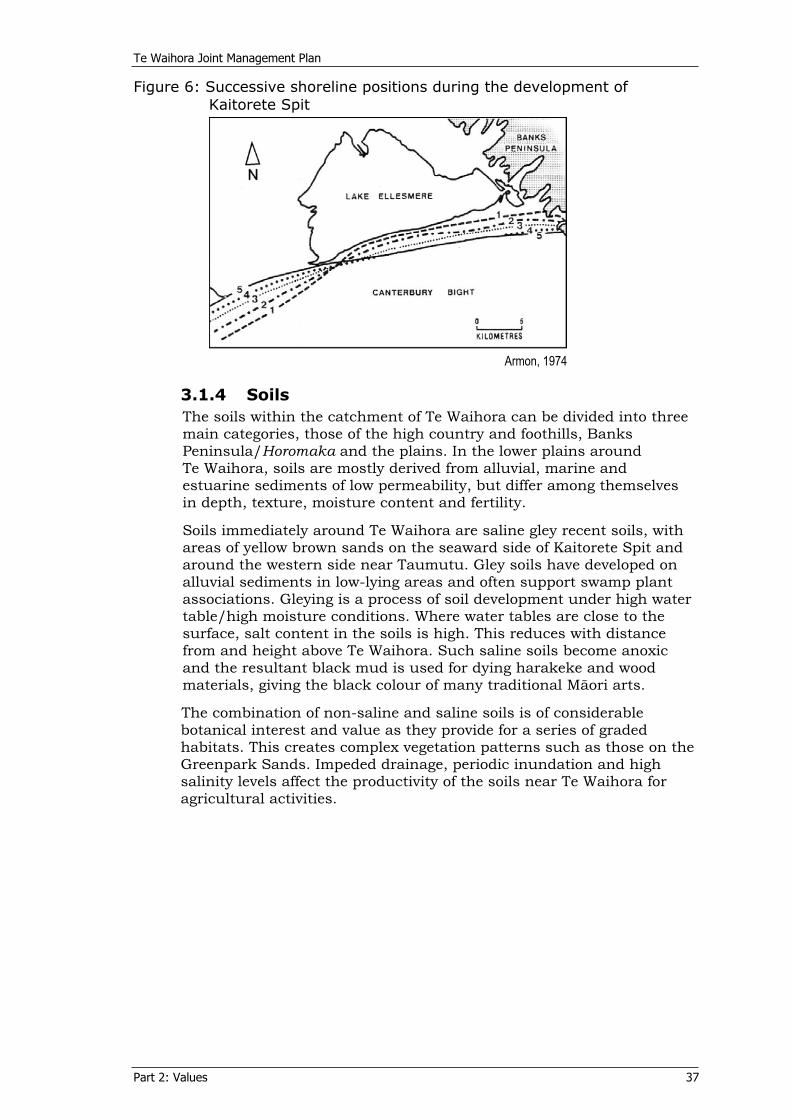
Te Waihora Joint Management Plan
Part 2: Values 37
Figure 6: Successive shoreline positions during the development of Kaitorete Spit
Armon, 1974
3.1.4 SoilsThe soils within the catchment of Te Waihora can be divided into three main categories, those of the high country and foothills, Banks Peninsula/Horomaka and the plains. In the lower plains around Te Waihora, soils are mostly derived from alluvial, marine and estuarine sediments of low permeability, but differ among themselves in depth, texture, moisture content and fertility.
Soils immediately around Te Waihora are saline gley recent soils, with areas of yellow brown sands on the seaward side of Kaitorete Spit and around the western side near Taumutu. Gley soils have developed on alluvial sediments in low-lying areas and often support swamp plant associations. Gleying is a process of soil development under high water table/high moisture conditions. Where water tables are close to the surface, salt content in the soils is high. This reduces with distance from and height above Te Waihora. Such saline soils become anoxic and the resultant black mud is used for dying harakeke and wood materials, giving the black colour of many traditional Mäori arts.
The combination of non-saline and saline soils is of considerable botanical interest and value as they provide for a series of graded habitats. This creates complex vegetation patterns such as those on the Greenpark Sands. Impeded drainage, periodic inundation and high salinity levels affect the productivity of the soils near Te Waihora for agricultural activities.
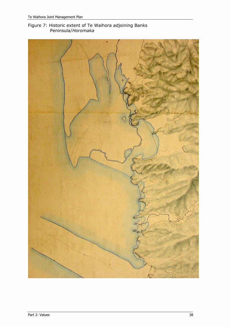
Te Waihora Joint Management Plan
Part 2: Values 38
Figure 7: Historic extent of Te Waihora adjoining Banks Peninsula/Horomaka
Te Waihora Joint Management Plan
Part 2: Values 39
3.2 Landscape Te mata o te whenuaA landscape is generally a broad area that has a unique combination of natural, physical and cultural elements, which combine together in a coherent way to create a whole. Landforms, waterways, wildlife, vegetation and the human interaction with the place combine to form a variety of landscapes. Landscapes can be interpreted as expressions of the evolving relationships between land and people, and as expressions of the values, beliefs and visions of the cultures that inhabit them.
Cultural landscapes embody our evolving relationship with the natural world. The natural resources of Te Waihora have sustained generations of people who have lived on the land and who have maintained a strong affinity with this unique landscape. For Ngäi Tahu their association and activities have resulted in many stories and traditions tied to the landforms and resources of the area. These traditions reveal the Ngäi Tahu understanding as to the origins of these features and the way in which the landforms and resources were developed and used for day to day life.
Management of landscape and landscape values, acknowledges the wider context in which natural and historic resources sit. It is an holistic approach where resources cannot be separated from one another but rather, are considered as a whole. This is akin to ecological approaches to management and the Ngäi Tahu philosophy ‘ki uta ki tai – from the mountains to the sea’. These approaches account for changes beyond an immediate site, across time, as well as taking into account the quality of our relationship with the landscape and the mauri of the resources or an area.
Te Waihora has been identified as a regionally outstanding landscape (Boffa Miskell Limited and Lucas Associates, 1993); it is also identified as an outstanding natural feature in the Proposed Selwyn District Plan2001. The wide-open spaces, open skies and a sense of place are often identified as the important landscape values of Te Waihora. Its location within the Canterbury Plains/ Ngä Päkihi Whakatekateka o Waitahaand at the base of Banks Peninsula/Horomaka, both distinctive landscape themselves, creates a visually distinctive area of scenic value and natural character. This is added to by the presence of significant geological landforms and the rich cultural/human history of the area.
The landscape values of Te Waihora are situated within the existing rural landscape and historic built features contribute to the landscape values. For example, the Motukarara to Birdlings Flat section of the Christchurch to Little River Railway embankment, which skirts the open waters of Te Waihora at the Kaituna end, provides both a visual and historic feature in itself, as well as a viewing platform from which to view Te Waihora to the west and the foothills towards the Southern Alps/Kä Tiritiri o te Moana beyond. Maimai are another built feature contributing to the landscape values of Te Waihora.
While Te Waihora can only occasionally be viewed from distant places on the plains, it forms an important part of the experience of contrasting landscapes in the journey from Akaroa to Christchurch, or from higher routes on the Port Hills and Banks Peninsula/Horomaka.From State Highway 75, Te Waihora forms a vast and visually uncomplicated foreground to the open views of the foothills and to changing weather patterns and cloud formations over both the
Te Waihora Joint Management Plan
Part 2: Values 40
Canterbury Plains/Ngä Päkihi Whakatekateka o Waitaha and the Pacific Ocean/Te Moananui a kiwa.
Views from Te Waihora across the wide expanse of the spread out water and views across Te Waihora towards Banks Peninsula/Horomaka, as well as ‘view shafts’ from distinct places surrounding Te Waihora, are significant features contributing to the landscape values of the area.
3.3 Natural features and landformsNgä tohu whenuaNatural features are the natural components of the environment that occur within the wider landscape. Natural features are important for reasons of rarity or representativeness of their landscape. They are also tied to natural and cultural processes and historic occupation.
Te Waihora itself, as a landscape feature and unusual landform, is important in both the New Zealand and international context. The Te Waihora area has attracted considerable scientific interest because of its geomorphic processes and the clear visual evidence of them. There are a variety of geomorphic features around Te Waihora.
Kaitorete Spit is considered of national importance from an earth science perspective as the largest landform of its type in New Zealand.
The “birds-foot delta” formed by the Selwyn River/Waikirikiri into Te Waihora since its enclosure is also an impressive landform in the area. This delta is a consequence of a sediment-laden river discharging into a comparatively quiet waterbody.
The Motukarara sea stack, now covered with loess, periodically formed an island within Te Waihora, as indicated by its name (see Part 2, section 3.4). This area provided high ground and shelter for people and wildlife when the lake waters rose. The spurs of Banks Peninsula/Horomaka that run into Te Waihora are prominent features on the eastern shores. These spurs reveal wave cut platforms, sea stacks and boulder fields, with stranded beach ridges between the spurs. They provided high ground for early Ngäi Tahu and others, as is evidenced by several pä and other occupation sites.
3.4 Place names Ngä ingoa o ngä wähiLandscapes include place names which link people and their language and concepts to the land.
Place names reflect the preferred places for abundant or traditional foods, describe a natural feature or an activity, or recall a person who claimed the area, or had an historic association with an area. Places and their names form vast oral maps that are an integral part of culture. Their continued use helps to form and maintain mätauranga/knowledge and associations of an area and its resources. Although European names predominate in the Te Waihora area, a wealth of Mäori names also exists (see Figure 11, Part 2, section 5.1.1).
Te Waihora Joint Management Plan
Part 2: Values 41
Te Waihora area names include:
Te Kete Ika a Räkaihautü the fish basket of Räkaihautü, a Waitaha ancestor. Te Kete Ika a Tutekawa - the fish basket of Tutekawa, a Ngäi Tahu/Ngäti Mämoe ancestor. Birdlings Flat - named after the prominent local land family who settled the area. Lake Ellesmere – named after Lord Ellesmere, a prominent member of the Canterbury Association that encouraged early European settlement.Kaituna – a place where eels were plentiful/eaten. Waikäkahi (Pä of Tutekawa) - place of the freshwater mussel. Orariki - the place of life-giving creatures/a reference to biodiversity. Motukarara - the ‘island of lizards’ later called Rabbit Island for similar reasons during European land subdivision. Te Waihora – spread-out waters. Te Koraha - open area of shallow water covering extensive mud flats. Taumutu - the high ridge of land. Ellesmere Arm Hotel – an old name for the Tai Tapu Hotel reflecting the historic extent of the Halswell River ‘arm’ of Te Waihora. Whakamätakiuru - the lookout/ to look outwards; later received the European name Fishermans Point as a name for the fishing settlement.Taitapu/Tai Tapu - impenetrable place, or sacred tide. Ahuriri – A prominent eel fishing lagoon; the name of a funnel-shaped fishing net of great size, used like a hïnaki in tidal rivers (Williams, 1991).

Te Waihora Joint Management Plan
Part 2: Values 42
4 WILDLIFE HABITAT AND BIODIVERSITY NGÄ TOI WHENUA ME NGÄ TÜMOMO KOIORA
Te Waihora has always been a primary source of mahinga kai for Ngäi Tahu. The rich diversity of wildlife habitats and species
supports mahinga kai of the tangata whenua and historically this has sustained occupation in all seasons with a variety of food and
other natural resources.
Te Waihora reveals an ecosystem of great diversity that is important for its intrinsic values, its role in national and international ecological linkages and for people’s study and appreciation.
The Te Waihora ecosystem includes all the vegetation, plants and animals of the lake and its margins and their interactions. For Ngäi Tahu, wildlife habitat and biodiversity are explained through whakapapa, which accounts for the way in which the earth, the sky, oceans, rivers, elements, minerals, plants, animals and people have been created (see Part 2, section 2.1). The creation of tuna (eel), one of the most important aspects of the biodiversity of Te Waihora, is outlined below, an example of how traditional püräkau (stories) created an ‘oral map’ and an explanation of the biodiversity of an area. It demonstrates the connection between the atua and natural resources.
Creation of Tuna Tuna was a person from the heavens. The heaven in which he lived was close to the sun and very dry, so he came to this world. His name was Tuna o Runga i te Raki.
When he arrived here he went straight into the water. The name of that lake was Muriwai o Whata. He dwelt there for many years. One day Hine Te Kaere went out to fetch water from the lake. As she gathered her water, Tuna swam between her thighs making her rush ashore in fright. She returned to the pä to tell her husband Maui Tikitiki a Te Raka and the other people of the marae that there was a tipua in the lake waters. Hine Te Kaere went back with the people of the pä to the lake so they could see this tipua.
When they arrived, Hine Te Kaere went to the place where she had felt the tipua. Tuna saw her and came towards her. The people on the shore then saw Tuna. The people said, “It looks human but lives in the water”. They then decided that they had to devise a way to kill this tipua so they could continue to fish and gather water from the lake.
They gathered a tororaro vine that was seen growing on the bare land of Nuku Tawhatawhata. Hine Te Kaere’s people prepared the vine, drying it and weaving it into a hïnaki (eel basket) to catch Tuna. The name of this hïnaki was Te Papa a Kura o Takaroa. When it was finished it was taken to the lake where Tuna had first appeared. The
Te Waihora Joint Management Plan
Part 2: Values 43
people looked for the best place to put the hïnaki; a place where the water was fast flowing. A deep drain was dug to put the hïnaki in and this was called Te Ahuhu. The hïnaki was put in the middle of the drain and when the water was flowing fast and the current was strong, Tuna appeared.
Tuna was caught in the hïnaki and the people pulled it ashore. Tuna was then killed by the people and he was cut into pieces. Tuna’s head was thrown out to sea and this became the koiro or conger eel. Tuna’s tail was also thrown out to sea and this became the kanakana and the tuere or the lamprey and the blind eel. The body of Tuna was thrown inland to the lakes and rivers and became tuna and his children (long-finned and short-finned eels).
At the time of the Hinapöuri, Tuna and his children migrate, to the sea to be one with their parent Kukuru Tai Moana (the rumbling sea waters), that is Takaroa (God of the Oceans).
4.1 Ecosystem Assessment Aromatawai o te taiaoThe habitats, species and natural processes present in an area determine its ecological character. Te Waihora is a wetland of predominantly open water, with swampland, saltmarsh and other lake-margin habitats influenced by fluctuating lake levels and wind-induced water movement. Agricultural plant and animal species and processes dominate the environment surrounding the wetland margins.
Wetlands occupy an ecological transition zone between terrestrial and aquatic ecosystems and have specialised plants and animals associated with them. Te Waihora is a complex system, not fully understood. It is sufficiently distinctive to have its own “Ellesmere” ecological district, as part of the Canterbury Plains ecological region (McEwen, 1987).
Historically, the lake and its wetland margins were much more extensive than they are today, with a mosaic of swampland and forest extending to present-day Christchurch. Dominant forest species included kahikatea, red beech, mataï and tötara. Charred logs, pollen and other plant fragments preserved in peat indicate that fire destroyed much of the early vegetation by about 500 years ago. This was replaced by harakeke dominant swamp. Drier lands were tussock dominated, with scattered trees and shrubs including tï köuka, köwhai, matagouri/tümatakuru and mänuka.
Te Waihora (Lake Ellesmere), while a lake by its European name, differs from most other New Zealand lakes because it is a bar type lake, technically a lagoon, separated from the sea by a barrier of deposited sediment, Kaitorete Spit. As this barrier is intermittently breached, seawater is able to enter, making Te Waihora neither entirely freshwater nor estuarine in character. Marine life enters the lake and contributes to the diversity of plants and animals making up the ecosystem.
Most indigenous wildlife habitat at Te Waihora is located below the 2 metre amsl contour around the open lake waters. It is very low-lying and vulnerable to long-term sea level rise. This area provides an extremely rich biological environment supporting a large assemblage of native and introduced species of plants and animals. The principal factors controlling the abundance and diversity of wildlife habitats and biodiversity in and around Te Waihora are the lake water levels, water
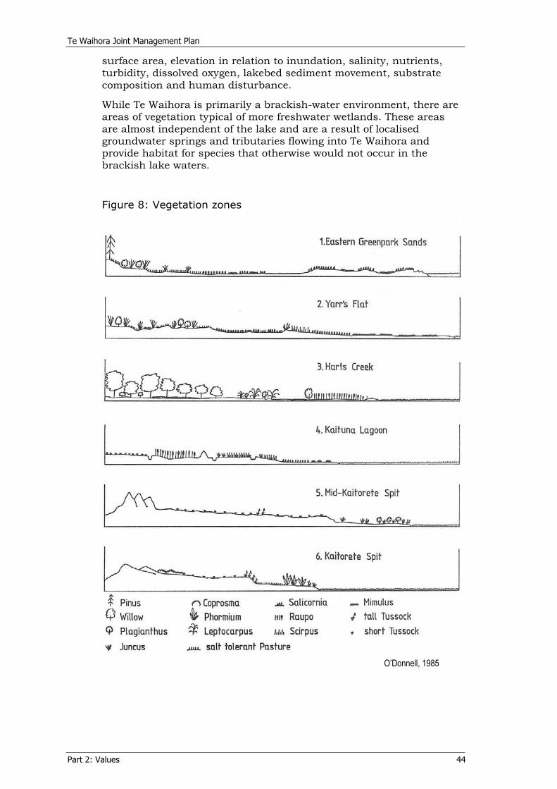
Te Waihora Joint Management Plan
Part 2: Values 44
surface area, elevation in relation to inundation, salinity, nutrients, turbidity, dissolved oxygen, lakebed sediment movement, substrate composition and human disturbance.
While Te Waihora is primarily a brackish-water environment, there are areas of vegetation typical of more freshwater wetlands. These areas are almost independent of the lake and are a result of localised groundwater springs and tributaries flowing into Te Waihora and provide habitat for species that otherwise would not occur in the brackish lake waters.
Figure 8: Vegetation zones
O’Donnell, 1985

Te Waihora Joint Management Plan
Part 2: Values 45
Clark and Partridge (1984) undertook a comprehensive vegetation survey of the lake margin, including detailed mapping of the lakeshore vegetation and a description of the vegetation patterns. Fifty-four vegetation types were identified and mapped (extending from the lakeshore (at low lake level) to an upper boundary between the 1.0 and 2.0 metre contours). Wetland areas of botanical importance were identified.
The large number of vegetation types and the many more combinations of these reflects the great diversity of habitat around the shoreline of Te Waihora. These vegetation types were revised down to 30 types by Partridge et al. (1999) to match a national standardised wetland classification system. These are recorded in the Department’s GIS database, allowing comparisons with land ownership and the assessment of vegetation type representativeness within the JMP Area and other protectively managed lands. These wetland vegetation types are shown on Figure 9.

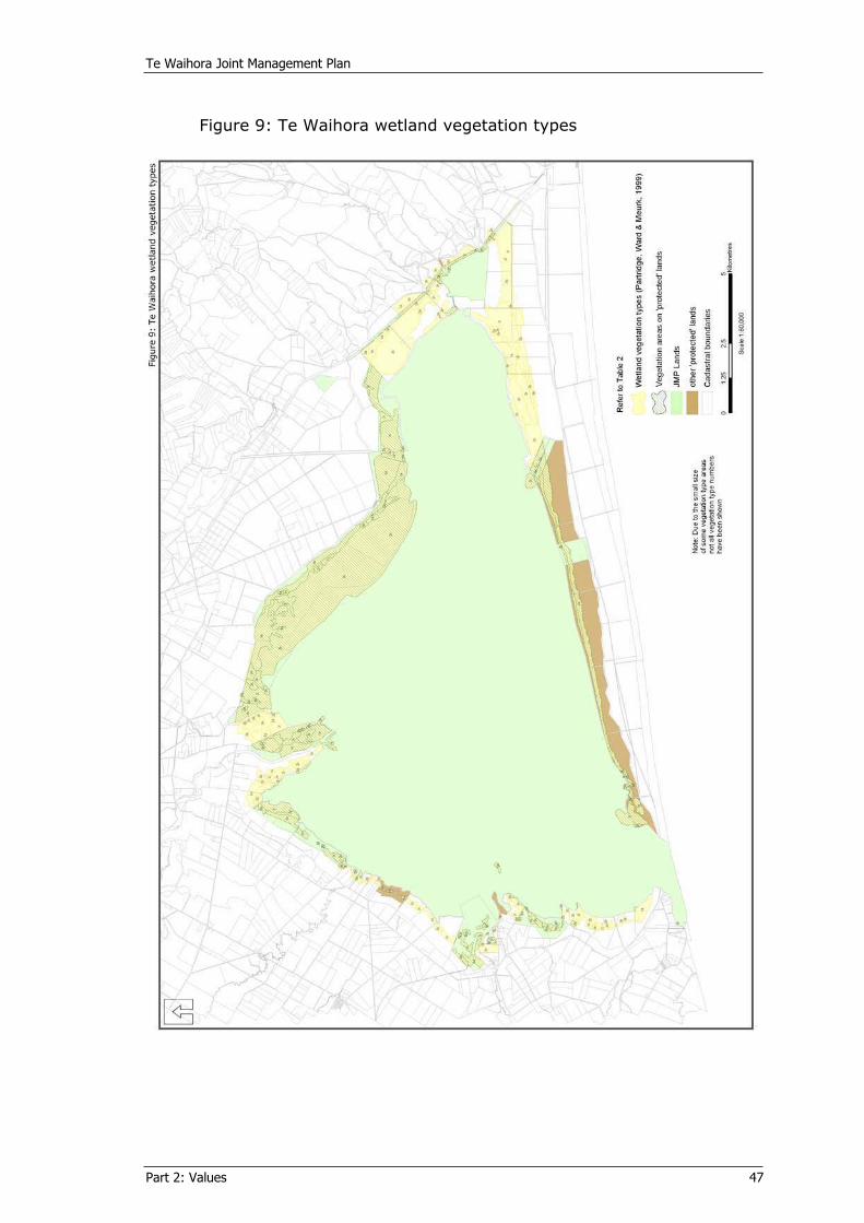
Te Waihora Joint Management Plan
Part 2: Values 47
Figure 9: Te Waihora wetland vegetation types

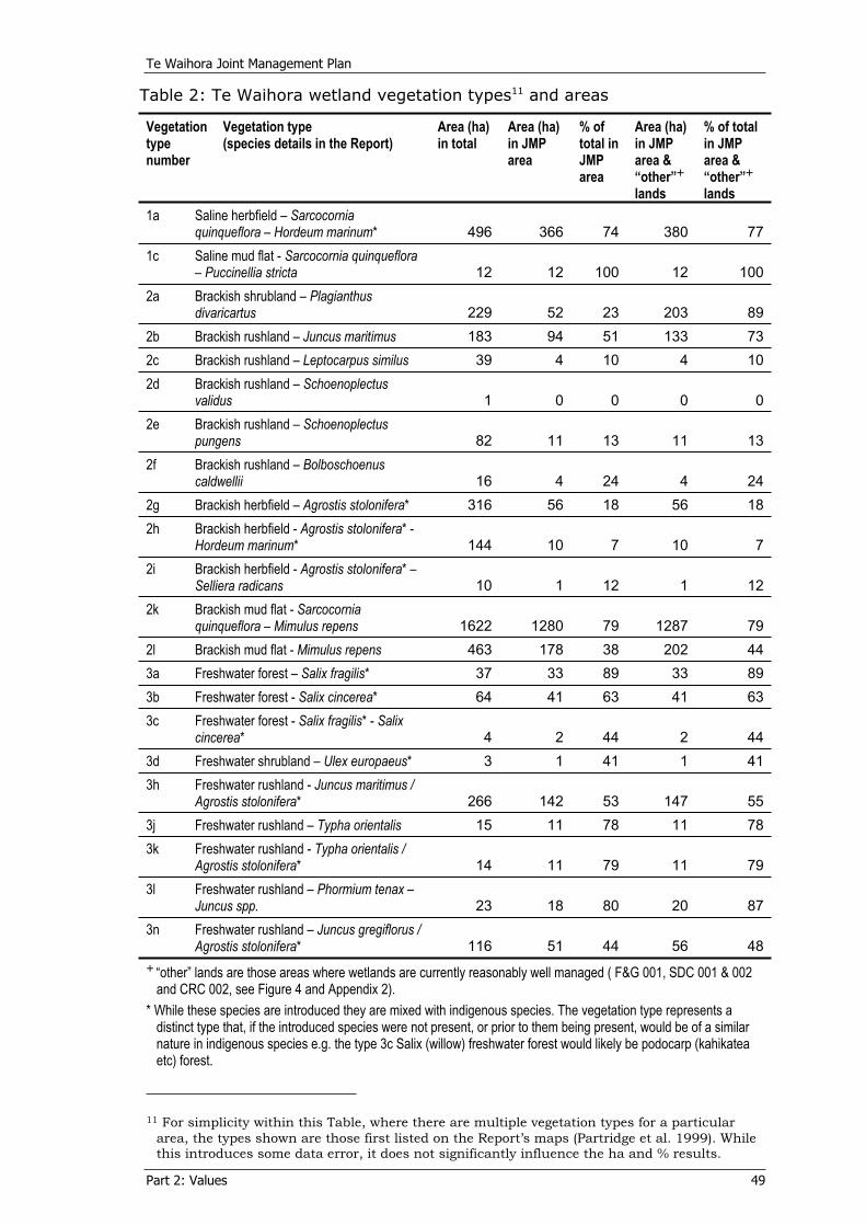
Te Waihora Joint Management Plan
Part 2: Values 49
Table 2: Te Waihora wetland vegetation types11 and areas
Vegetation typenumber
Vegetation type (species details in the Report)
Area (ha) in total
Area (ha) in JMP area
% of total in JMParea
Area (ha) in JMP area & “other”lands
% of total in JMP area & “other”lands
1a Saline herbfield – Sarcocorniaquinqueflora – Hordeum marinum* 496 366 74 380 77
1c Saline mud flat - Sarcocornia quinqueflora – Puccinellia stricta 12 12 100 12 100
2a Brackish shrubland – Plagianthusdivaricartus 229 52 23 203 89
2b Brackish rushland – Juncus maritimus 183 94 51 133 732c Brackish rushland – Leptocarpus similus 39 4 10 4 102d Brackish rushland – Schoenoplectus
validus 1 0 0 0 02e Brackish rushland – Schoenoplectus
pungens 82 11 13 11 132f Brackish rushland – Bolboschoenus
caldwellii 16 4 24 4 242g Brackish herbfield – Agrostis stolonifera* 316 56 18 56 182h Brackish herbfield - Agrostis stolonifera* -
Hordeum marinum* 144 10 7 10 72i Brackish herbfield - Agrostis stolonifera* –
Selliera radicans 10 1 12 1 122k Brackish mud flat - Sarcocornia
quinqueflora – Mimulus repens 1622 1280 79 1287 792l Brackish mud flat - Mimulus repens 463 178 38 202 443a Freshwater forest – Salix fragilis* 37 33 89 33 893b Freshwater forest - Salix cincerea* 64 41 63 41 633c Freshwater forest - Salix fragilis* - Salix
cincerea* 4 2 44 2 443d Freshwater shrubland – Ulex europaeus* 3 1 41 1 413h Freshwater rushland - Juncus maritimus /
Agrostis stolonifera* 266 142 53 147 553j Freshwater rushland – Typha orientalis 15 11 78 11 783k Freshwater rushland - Typha orientalis /
Agrostis stolonifera* 14 11 79 11 793l Freshwater rushland – Phormium tenax –
Juncus spp. 23 18 80 20 873n Freshwater rushland – Juncus gregiflorus /
Agrostis stolonifera* 116 51 44 56 48
“other” lands are those areas where wetlands are currently reasonably well managed ( F&G 001, SDC 001 & 002 and CRC 002, see Figure 4 and Appendix 2).
* While these species are introduced they are mixed with indigenous species. The vegetation type represents a distinct type that, if the introduced species were not present, or prior to them being present, would be of a similar nature in indigenous species e.g. the type 3c Salix (willow) freshwater forest would likely be podocarp (kahikatea etc) forest.
11 For simplicity within this Table, where there are multiple vegetation types for a particular
area, the types shown are those first listed on the Report’s maps (Partridge et al. 1999). While this introduces some data error, it does not significantly influence the ha and % results.

Te Waihora Joint Management Plan
Part 2: Values 50
Analysis of Table 2 reveals: Brackish shrubland/herbfield (types 2a & 2b) are not well represented within the JMP area, although they are significantly better represented when including the “other” lands as a result of Environment Canterbury’s Kaitorete Spit endowment lands. Brackish shrublands and herbfields (types 2c to 2i) are not well represented within the JMP Area, or the JMP Area & “other” lands. Brackish mud flat (type 2l) is not well represented within the JMP Area, or the JMP Area & “other” lands.
Some freshwater rushlands (types 3h and 3n) are not well represented within the JMP Area, or the JMP Area & “other” lands.
O’Donnell (1985) assessed the wildlife values of “foreshore” (sic) study areas for Te Waihora during 1981-1982 and mapped these areas for wader, waterfowl and swamp bird species. Non-bird wildlife was also assessed. Value ratings were given to identified areas, using the then New Zealand Wildlife Service rating system under which “outstanding” signifies very high national and international values and “high” signifies national importance for native species and high numbers of introduced species (black swan was listed as an introduced species12). “Moderate-high”, “moderate” and “potential” rankings indicate regional to local importance. O’Donnell (ibid) also notes that at a national level “Lake Ellesmere” as a whole was rated as outstanding.
While there has been some change, both positive and negative, in the condition of the vegetation zones and wildlife areas since these surveys, the survey data still remains the best current, overall information on the importance of the various areas within the Te Waihora ecosystem/ecological district. While the whole of Te Waihora is part of a nationally threatened ecosystem it is possible by combining the above vegetation zones and wildlife values data to describe the most important areas within it.
For the adjoining Kaitorete Spit the Department has prepared a Kaitorete Spit Biodiversity Action Plan for Coastal Conservation Land(2003) setting out restoration and other management aims for the coastal lands administered by the Department and methods for working with other landowners, to protect the area's indigenous flora, fauna and habitats.
Specific plants and animals within Te Waihora are identified in more detail in Part 2, sections 4.4 and 4.5.
12 Black Swan are considered an indigenous species within this Plan, see Part 2, section 4.5.2.
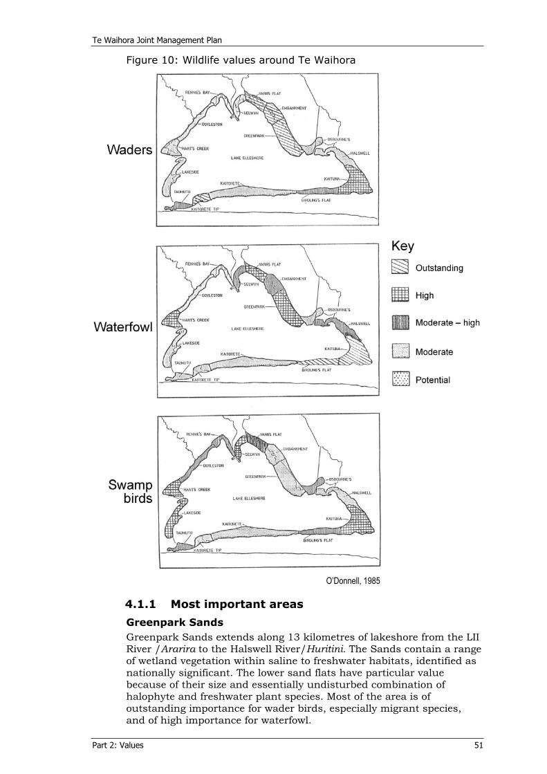
Te Waihora Joint Management Plan
Part 2: Values 51
Figure 10: Wildlife values around Te Waihora
O’Donnell, 1985
4.1.1 Most important areas
Greenpark Sands Greenpark Sands extends along 13 kilometres of lakeshore from the LII River /Ararira to the Halswell River/Huritini. The Sands contain a range of wetland vegetation within saline to freshwater habitats, identified as nationally significant. The lower sand flats have particular value because of their size and essentially undisturbed combination of halophyte and freshwater plant species. Most of the area is of outstanding importance for wader birds, especially migrant species, and of high importance for waterfowl.
Te Waihora Joint Management Plan
Part 2: Values 52
Vegetation patterns on the Greenpark Sands in 2002 remain more or less as described by Clark and Partridge (1984) with the abundance of the native shrub, saltmarsh ribbonwood, having increased within the searush-creeping bent community that occupies the upper zone of Greenpark Sands. Overall, Greenpark Sands retains the range of indigenous wetland vegetation that gave rise to the “outstanding” rating in the 1980s.
The area is held as the Greenpark Sands Conservation Area, Yarrs Flat Wildlife Management Reserve and Ngäi Tahu lakebed.
Kaituna Lagoon Kaituna Lagoon, at the extreme east of Te Waihora, has permanent shallow water even during low lake levels, with small islands, sand spits, mudflats, raupö and rushes. It provides sheltered waters for wildlife during storms. The areas of mud-flats, rushes and raupö are of botanical interest. The Lagoon is of “outstanding” importance for waterfowl, and of high value for wader and swamp birds.
The Lagoon has changed little since the 1980s. The central part is Ngäi Tahu lakebed, with an adjoining Conservation Area along and beside the historic railway embankment, some unformed legal roads, and the substantial balance is freehold land.
Lake side of Kaitorete Spit This large area of low salinity lagoon-edge native vegetation is more continuous than elsewhere around Te Waihora. The extent of sea rush and saltmarsh ribbonwood present makes this area one of regional botanical importance. The area is of “outstanding” importance for waterfowl at the eastern end and for waders at the western end.
Since the 1980s the eastern end has lost quality, but the balance is of similar or better quality.
The area is predominantly held by by Environment Canterbury in accordance with a management plan for the wetlands (Grove, 2004). Christchurch City Council administers the eastern end, along with some lands within the Joint Management Plan Area and the unformed legal roads.
Taumutu Commonage and Lakeside This is an area of mudflats, saltmarsh and localised freshwater swamp areas, with small offshore islands. The area is of “high” value for swampbirds.
Of the total area since the 1980s, the Commonage part (Mäori freehold land under long-term lease) has lost quality, but the balance retains its value as the Lakeside Wildlife Management Reserve, with some unformed legal road.
Harts Creek/WaitatariAlthough this area has been largely invaded by willow species over recent years, there are remaining areas of botanical interest, especially the understory species to the willow canopy. Extensive raupö beds fringe the lake-edge. The area is of “high” value for waterfowl and swampbirds.
Te Waihora Joint Management Plan
Part 2: Values 53
Despite the spread of willow the area has retained its values and is the Harts Creek Wildlife Management Reserve with an overlying wildlife refuge status.
Area north of Lake Road South, Irwell River/WaiwhioThis is a narrow area of undisturbed native freshwater vegetation that is of regional botanical importance.
The area has retained its values in some parts but has suffered from grazing pressure in others, and is held within Wildlife Management Reserve, with some unformed legal road.
Selwyn River/Waikirikiri to west bank of LII/Ararira River This area contains extensive stands of native freshwater vegetation including taller raupö and tall sedge. It is of regional botanical importance and of “high” importance for swampbirds.
The area is partly the Selwyn Wildlife Management Reserve, and partly freehold land and unformed legal road.
4.2 Water Ngä wai
4.2.1 Water quality and sedimentation In its life Te Waihora has experienced a progression from a higher-flushed, lower nutrient and sediment inflow, higher water quality system to a lesser-flushed, higher nutrient and sediment inflow, lower water quality system. In part this is a natural ecological process for a coastal lagoon, leading to greater sediment infilling and the gradual replacement of open water by vegetated wetlands. Human-induced change in the catchment, more so since European settlement, has hastened this process, particularly the decline of water quality.
As a coastal lake and wetland Te Waihora has several natural characteristics. At the ‘bottom’ of the catchment it is in part a nutrient and sediment trap. Its wetland vegetation edge acts as a nutrient and sediment filter, a role of wetlands in maintaining water quality that is well recognised as important within the natural environment. When the lake-edge weed beds were in place (see Part 2, section 4.4.1) the lake-edge waters had less wave-induced sediment disturbance and were generally clear, unlike the sediment discoloured lake-centre waters.
Te Waihora has exhibited some of the features of a highly eutrophic lake since at least the 1970s. However, many of the expected features of a eutrophic condition, such as deoxygenation of bottom waters and sediments, regular blooms of toxic phytoplankton and the absence of salmonid fish, do not appear in Te Waihora. The lake’s shallowness and wind exposure combine to minimise these eutrophic features by keeping the waters mixed and oxygenated.
In pre-European settlement times the lack of land development and the huge network of surrounding swamp and rush lands provided much greater protection for the lake waters, although some impact would have resulted from the pre-European fire clearance of catchment forests. Land development has since taken its toll and 80% of these swamp and rushlands have now been lost through drainage and surrounding drain systems that fast-track water from the plains to Te Waihora and to the sea. The lake’s own drainage has also altered the

Te Waihora Joint Management Plan
Part 2: Values 54
nature and extent of lake-edge habitats, vital links in the Te Waihora ecosystem.
Deposition and erosion of sediment from the lake margins during lake level movements can be an important ecological process affecting lake margin vegetation, as plants are covered and re-emerge from the fine sediments. Induced sedimentation through the loss of lake edge vegetation, aquatic vegetation and the resultant accelerated erosion, can affect these species as well as fish survival. It can also impact on water clarity as sediments are suspended in the water column, and water quality as nutrients contained within the sediments are released into the lake waters. Riparian management along tributaries and lake margins is therefore important to reduce these adverse affects.
The Te Waihora user community, including tangata whenua, have observed a decline in lake water quality over time, especially since the early 1970s, although in part this may be an observation of lake-edge water clarity changes rather than nutrient changes. The community has also known of the discharge of contaminants to the tributaries of Te Waihora, the discharge of human sewage effluent being of particular concern to Ngäi Tahu. These matters affect Ngäi Tahu as they impact on the mauri of Te Waihora and the fisheries, and some mahinga kai species are considered unfit for consumption. Water quality also affects recreational activity as people’s use of Te Waihora and their sense of connection to its waters can decline with an observed or perceived decline in water quality.
Water quality, especially the parameters of water colour and clarity, has affected the growth and productivity of aquatic plants and algae. The limited regeneration of the ‘weed beds’ in Te Waihora since the Wahine storm of 1968 is partly attributed to a decline in water quality.
Current catchment aspects and land management practices affecting Te Waihora water quality and sedimentation include:
‘Natural’ sediment and nutrient inputs from soils within the Selwyn River/Waikirikiri catchment, primarily during times of flood. Contamination of inflowing streams by urban point and non-point sources, such as sewerage systems and stormwater run-off from hard surfaces. Contamination of inflowing streams by rural point and non-point sources, such as animal effluent from dairy sheds and other stock-holding facilities, stock water races and stormwater run-off from farmland. Increased sediment input from housing developments in the Halswell River/Huritini and other catchment activities. Stock access to waterways, including the lake-edge, causing bank collapse or ground disturbance and releasing sediment, soil nutrients and stock effluent to the water body. Drain location, design, edge-use and maintenance methods. Surface water and groundwater abstractions reducing spring and tributary inflows to Te Waihora. Soil erosion within the Kaituna and Selwyn River /Waikirikiri. catchments hill country and banks of Te Waihora tributaries. Riparian land-use and vegetation types.
Te Waihora Joint Management Plan
Part 2: Values 55
For Ngäi Tahu, ensuring the health and well being of water is a prerequisite for ensuring the same for mahinga kai and the people. It is for the present generation, as tangata tiaki, to do their best to ensure that the taonga of Te Waihora is in better condition than it is today, for the future generations.
Ngäi Tahu is also concerned about the unnatural mixing of waters and oppose the discharge of waters with the mauri of a river such as the Rakaia into a river with a different mauri such as the Selwyn/Waikirikiri. Situations of the mixing of waters in Te Waihora tributaries however, have existed in some cases for over 100 years, e.g. the Selwyn stock-water race which flows from the Kowai River (a Waimakariri River tributary) to the Selwyn River/Waikirikiri. Whilst Ngäi Tahu do not condone this water mixing, they do recognise that parts of these systems now support a diverse range of aquatic life that is a valued part of the Te Waihora ecosystem.
Lake salinity Salinity is determined by the duration and frequency of lake openings hence by seawater inflows, other seawater inflows through and over Kaitorete Spit and by the relative inflows from surface water and groundwater, which are in turn affected by water abstraction rates and hydrological factors, including evaporation, in the catchment. Records of salinity in the lake range from just below 3 ppt (parts per thousand) to over 27 ppt, pure seawater being 35 ppt. Most readings however, are between 5 and 10 ppt.
Salinity affects both wildlife habitat and water quality. It is a critical factor in the distribution and pattern of lake margin plant species as well as the growth of potentially toxic blue-green algae. Salinity also affects the growth and establishment of aquatic macrophytes. Variations in salinity gradients are a major factor in determining the wide range of habitats that Te Waihora provides for its biological communities and hence the diversity of flora and fauna and mahinga kai.
4.2.2 Lake opening and lake level management Lake openings and the resultant lake level fluctuations are major influences on the wildlife habitat and biodiversity values of Te Waihora. Lake opening levels and the duration of openings with the resultant changes in salinity and water level influence the composition and abundance of plant communities present in and around Te Waihora. They also affect fish migration into and out of the lake, animal species diversity and abundance and mahinga kai. Water levels also influence water temperature and thus habitat, as well as wave fetch and the temporary wind-induced submergence of lake margins.
Lake level management has resulted in progressively lower lake levels from historic times to today. Table 3 shows, from documented lake opening levels in Harris (1947), the lowering of average lake-opening levels since the early 1900s from changing opening methods.
In the early 1900s the lake was opened by horse drawn scoops. In 1904, engineer Arthur Dudley Dobson designed an outlet culvert, which, with modifications by Pannett circa 1910, operated relatively successfully maintaining the lake at an average level of 1.53 metres amsl until 1925 when the culvert was destroyed in a storm. The Ellesmere Land Drainage Board then again opened the lake with horse
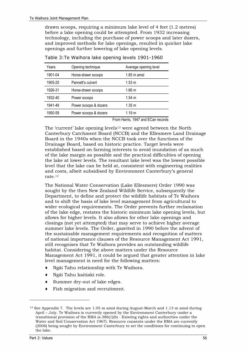
Te Waihora Joint Management Plan
Part 2: Values 56
drawn scoops, requiring a minimum lake level of 4 feet (1.2 metres) before a lake opening could be attempted. From 1932 increasing technology, including the purchase of power scoops and later dozers, and improved methods for lake openings, resulted in quicker lake openings and further lowering of lake opening levels.
Table 3:Te Waihora lake opening levels 1901-1960
Years Opening technique Average opening level
1901-04 Horse-drawn scoops 1.85 m amsl
1905-25 Pannett’s culvert 1.53 m
1926-31 Horse-drawn scoops 1.66 m
1932-40 Power scoops 1.54 m
1941-49 Power scoops & dozers 1.35 m
1950-59 Power scoops & dozers 1.19 m From Harris, 1947 and ECan records
The ‘current’ lake opening levels13 were agreed between the North Canterbury Catchment Board (NCCB) and the Ellesmere Land Drainage Board in the 1940s when the NCCB took over the functions of the Drainage Board, based on historic practice. Target levels were established based on farming interests to avoid inundation of as much of the lake margin as possible and the practical difficulties of opening the lake at lower levels. The resultant lake level was the lowest possible level that the lake can be held at, consistent with engineering realities and costs, albeit subsidised by Environment Canterbury’s general rate.13
The National Water Conservation (Lake Ellesmere) Order 1990 was sought by the then New Zealand Wildlife Service, subsequently the Department, to define and protect the wildlife habitats of Te Waihora and to shift the basis of lake level management from agricultural to wider ecological requirements. The Order prevents further reclamation of the lake edge, restates the historic minimum lake opening levels, but allows for higher levels. It also allows for other lake openings and closings (not yet attempted) that may serve to achieve higher average summer lake levels. The Order, gazetted in 1990 before the advent of the sustainable management requirements and recognition of matters of national importance clauses of the Resource Management Act 1991, still recognises that Te Waihora provides an outstanding wildlife habitat. Considering the above matters under the Resource Management Act 1991, it could be argued that greater attention in lake level management is need for the following matters:
Ngäi Tahu relationship with Te Waihora. Ngäi Tahu kaitiaki role. Summer dry-out of lake edges. Fish migration and recruitment.
13 See Appendix 7. The levels are 1.05 m amsl during August-March and 1.13 m amsl during
April – July. Te Waihora is currently opened by the Environment Canterbury under a transitional provision of the RMA (s.386(1)(b) - Existing rights and authorities under the Water and Soil Conservation Act 1967). Resource consents under the RMA are currently (2006) being sought by Environment Canterbury to set the conditions for continuing to open the lake.

Te Waihora Joint Management Plan
Part 2: Values 57
Recognition of dynamic coastal processes including rising sea levels. Adverse impacts on the coastal environment. Adverse algal growth. Landscape values. Natural landform processes. Facilitation of indigenous macrophytic vegetation regeneration. Habitat requirements of migratory bird species. Natural cycles and fluctuations over long time frames and multiple lake openings. Allowing lake level fluctuations that would give greater flexibility to achieve openings at times to optimise all values.
4.3 Taonga species and other species of importance to Ngäi Tahu Ngä tü taonga me ëtahi atu momo e nui ake ki a Ngäi Tahu Taonga species are culturally significant species of animals and plants that are treasured by Ngäi Tahu. Although all natural resources are considered taonga by Ngäi Tahu, specific species are identified as “taonga species” or “taonga fish species” in the Ngäi Tahu Claims Settlement Act 1998. The Crown acknowledged the cultural, spiritual, historic and traditional association of Ngäi Tahu with these taonga species and made provisions to enable Ngäi Tahu to participate in their management. These include species of birds, plants, marine mammals and fish (see Appendix 5).
In addition to these taonga species there are other species of importance to Ngäi Tahu, as identified in Tables 1,4, 7 and 8. Many of these taonga species and the other species of importance are found in and around Te Waihora (see Part 2, sections 4.4, 4.5 and Appendix 5).
4.4 Plants Ngä otaotaAs identified in Part 2, section 4.1, the remnant vegetation of Te Waihora remains significant from both a regional and national perspective. Within this vegetation reeds and sedges are the dominant indigenous plant species found within the Joint Management Plan Area. These include a number of regionally rare species and species found at their distribution limits.
The shoreline plants fall into four natural groupings based largely on the degree of lake water inundation and salinity, soil substrate composition and the effects of human disturbance: 1. Submergent species e.g. Mimulus repens (native musk), as in
brackish mudflats vegetation14.2. Halophytes (salt tolerant species) e.g Sarcocornia quinqueflora
(glasswort), as in saline herbfields and mudflats14.3. Freshwater wetland species, e.g. Typha orientalis (raupö), as
freshwater rushlands14.4. Agricultural species, e.g. Argostis stolonifera (creeping bent), as in
brackish herbfields and freshwater rushlands14. 14 See Part 2, section 4.1, Table 2.
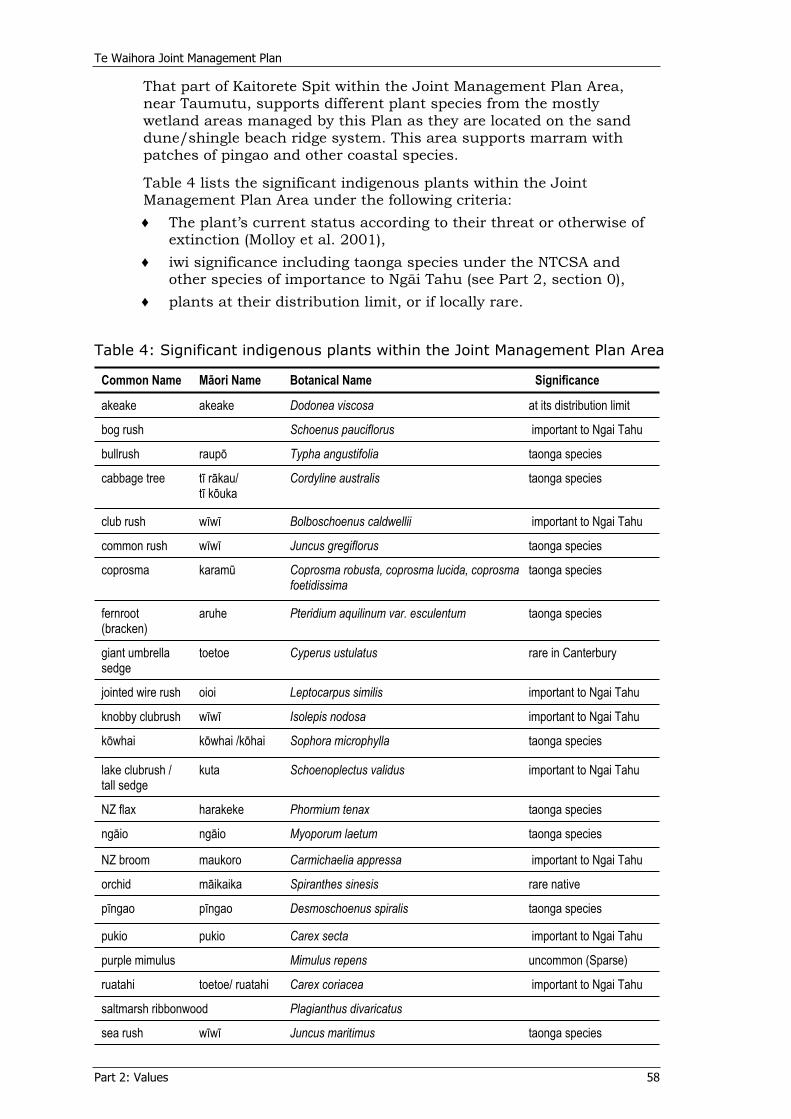
Te Waihora Joint Management Plan
Part 2: Values 58
That part of Kaitorete Spit within the Joint Management Plan Area, near Taumutu, supports different plant species from the mostly wetland areas managed by this Plan as they are located on the sand dune/shingle beach ridge system. This area supports marram with patches of pingao and other coastal species.
Table 4 lists the significant indigenous plants within the Joint Management Plan Area under the following criteria:
The plant’s current status according to their threat or otherwise of extinction (Molloy et al. 2001), iwi significance including taonga species under the NTCSA and other species of importance to Ngäi Tahu (see Part 2, section 0), plants at their distribution limit, or if locally rare.
Table 4: Significant indigenous plants within the Joint Management Plan Area
Common Name Mäori Name Botanical Name Significance
akeake akeake Dodonea viscosa at its distribution limit
bog rush Schoenus pauciflorus important to Ngai Tahu
bullrush raupö Typha angustifolia taonga species
cabbage tree tï räkau/ tï köuka
Cordyline australis taonga species
club rush wïwï Bolboschoenus caldwellii important to Ngai Tahu
common rush wïwï Juncus gregiflorus taonga species
coprosma karamü Coprosma robusta, coprosma lucida, coprosma foetidissima
taonga species
fernroot(bracken)
aruhe Pteridium aquilinum var. esculentum taonga species
giant umbrella sedge
toetoe Cyperus ustulatus rare in Canterbury
jointed wire rush oioi Leptocarpus similis important to Ngai Tahu
knobby clubrush wïwï Isolepis nodosa important to Ngai Tahu
köwhai köwhai /köhai Sophora microphylla taonga species
lake clubrush / tall sedge
kuta Schoenoplectus validus important to Ngai Tahu
NZ flax harakeke Phormium tenax taonga species
ngäio ngäio Myoporum laetum taonga species
NZ broom maukoro Carmichaelia appressa important to Ngai Tahu
orchid mäikaika Spiranthes sinesis rare native
pïngao pïngao Desmoschoenus spiralis taonga species
pukio pukio Carex secta important to Ngai Tahu
purple mimulus Mimulus repens uncommon (Sparse)
ruatahi toetoe/ ruatahi Carex coriacea important to Ngai Tahu
saltmarsh ribbonwood Plagianthus divaricatus
sea rush wïwï Juncus maritimus taonga species
Te Waihora Joint Management Plan
Part 2: Values 59
Common Name Mäori Name Botanical Name Significance
sedges mänia Carex flagellifera taonga species
silver tussock wï Poa cita taonga species
sundew wahu Drosera binata
swamp nettle Urtica linearifolia nationally threatened (gradual decline)
toetoe toetoe Cortaderia richardii taonga species
4.4.1 Aquatic plants Te Waihora once had extensive beds of Ruppia megacarpa and Potamogeton pectinatus, commonly referred to as ‘weed beds’. These were an important food source for some bird species and provided food and shelter for many fish species. They also reduced the effect of wave action on the shores and stabilised the mud substrate, reducing lakeshore erosion and water turbidity, resulting in increased water clarity. Aquatic plants play a role in nutrient recycling within ecosystems as they take up and release dissolved nutrients from both water and the sediments.
Decline in the weed beds was reported in the 1920s and the beds disappeared in the 1940s. There was a significant recovery in the 1950s that continued until the “Wahine Storm” of 1968 when most of the beds were destroyed. Scattered patches of the plants remained through to the 1970s and early 80s, but the beds have never regained their earlier extent. Today, some natural regeneration is occurring and small beds exist within Te Waihora, particularly in the more freshwater areas around the mouths of various tributaries such as Boggy Creek on the western side of the lake. Many factors have been attributed to limiting the re-establishment of the weed beds in Te Waihora, specifically water clarity, water temperature and salinity.
Gerbeaux (1989) demonstrated that re-establishment of these aquatic plants is possible in Te Waihora with the selection of favourable sites coupled with favourable lake conditions. This however, is likely to be at a substantial cost and the possible short and medium term effects on the health of Te Waihora are not well known.
A number of aquatic plant species (both indigenous and introduced) are present in the tributaries of Te Waihora. The plants are regularly cut and the majority removed as part of drainage maintenance. Because they are freshwater species they do not spread into the brackish waters of Te Waihora.
4.4.2 AlgaeAlgae are an important part of the food chain at Te Waihora and a vital indicator of water quality. The presence of green and blue-green algae in the water gives the lake its greenish colour, which is more intense at times of increased algae. There have been 38 species of algae recorded in Te Waihora; 10 blue-green and 28 green algae. Microcystis minutissima is the most abundant species.
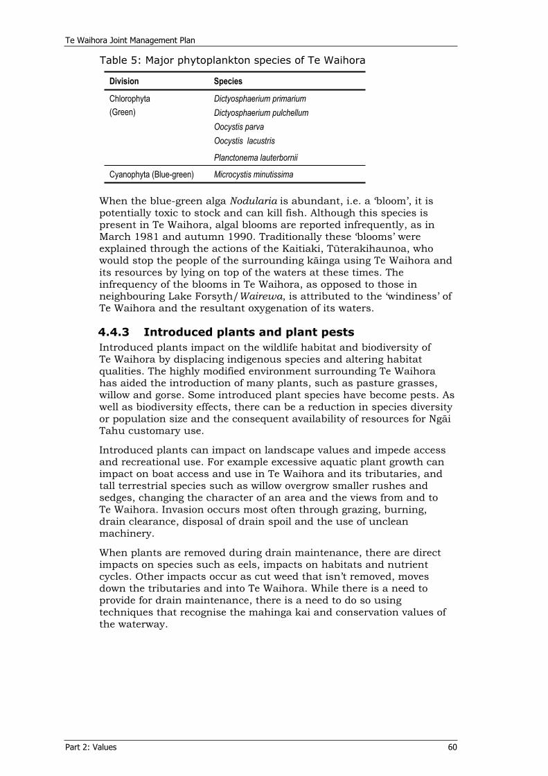
Te Waihora Joint Management Plan
Part 2: Values 60
Table 5: Major phytoplankton species of Te Waihora
Division Species
Dictyosphaerium primarium Dictyosphaerium pulchellum Oocystis parva Oocystis lacustris
Chlorophyta(Green)
Planctonema lauterbornii
Cyanophyta (Blue-green) Microcystis minutissima
When the blue-green alga Nodularia is abundant, i.e. a ‘bloom’, it is potentially toxic to stock and can kill fish. Although this species is present in Te Waihora, algal blooms are reported infrequently, as in March 1981 and autumn 1990. Traditionally these ‘blooms’ were explained through the actions of the Kaitiaki, Tüterakihaunoa, who would stop the people of the surrounding käinga using Te Waihora and its resources by lying on top of the waters at these times. The infrequency of the blooms in Te Waihora, as opposed to those in neighbouring Lake Forsyth/Wairewa, is attributed to the ‘windiness’ of Te Waihora and the resultant oxygenation of its waters.
4.4.3 Introduced plants and plant pests Introduced plants impact on the wildlife habitat and biodiversity of Te Waihora by displacing indigenous species and altering habitat qualities. The highly modified environment surrounding Te Waihora has aided the introduction of many plants, such as pasture grasses, willow and gorse. Some introduced plant species have become pests. As well as biodiversity effects, there can be a reduction in species diversity or population size and the consequent availability of resources for Ngäi Tahu customary use.
Introduced plants can impact on landscape values and impede access and recreational use. For example excessive aquatic plant growth can impact on boat access and use in Te Waihora and its tributaries, and tall terrestrial species such as willow overgrow smaller rushes and sedges, changing the character of an area and the views from and to Te Waihora. Invasion occurs most often through grazing, burning, drain clearance, disposal of drain spoil and the use of unclean machinery.
When plants are removed during drain maintenance, there are direct impacts on species such as eels, impacts on habitats and nutrient cycles. Other impacts occur as cut weed that isn’t removed, moves down the tributaries and into Te Waihora. While there is a need to provide for drain maintenance, there is a need to do so using techniques that recognise the mahinga kai and conservation values of the waterway.
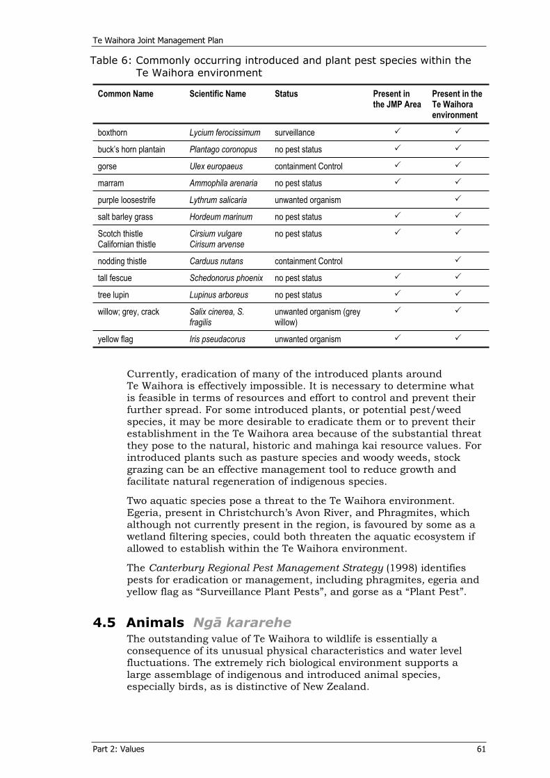
Te Waihora Joint Management Plan
Part 2: Values 61
Table 6: Commonly occurring introduced and plant pest species within the Te Waihora environment
Common Name Scientific Name Status Present in the JMP Area
Present in the Te Waihora environment
boxthorn Lycium ferocissimum surveillance
buck’s horn plantain Plantago coronopus no pest status
gorse Ulex europaeus containment Control
marram Ammophila arenaria no pest status
purple loosestrife Lythrum salicaria unwanted organism
salt barley grass Hordeum marinum no pest status
Scotch thistle Californian thistle
Cirsium vulgare Cirisum arvense
no pest status
nodding thistle Carduus nutans containment Control
tall fescue Schedonorus phoenix no pest status
tree lupin Lupinus arboreus no pest status
willow; grey, crack Salix cinerea, S. fragilis
unwanted organism (grey willow)
yellow flag Iris pseudacorus unwanted organism
Currently, eradication of many of the introduced plants around Te Waihora is effectively impossible. It is necessary to determine what is feasible in terms of resources and effort to control and prevent their further spread. For some introduced plants, or potential pest/weed species, it may be more desirable to eradicate them or to prevent their establishment in the Te Waihora area because of the substantial threat they pose to the natural, historic and mahinga kai resource values. For introduced plants such as pasture species and woody weeds, stock grazing can be an effective management tool to reduce growth and facilitate natural regeneration of indigenous species.
Two aquatic species pose a threat to the Te Waihora environment. Egeria, present in Christchurch’s Avon River, and Phragmites, which although not currently present in the region, is favoured by some as a wetland filtering species, could both threaten the aquatic ecosystem if allowed to establish within the Te Waihora environment.
The Canterbury Regional Pest Management Strategy (1998) identifies pests for eradication or management, including phragmites, egeria and yellow flag as “Surveillance Plant Pests”, and gorse as a “Plant Pest”.
4.5 Animals Ngä karareheThe outstanding value of Te Waihora to wildlife is essentially a consequence of its unusual physical characteristics and water level fluctuations. The extremely rich biological environment supports a large assemblage of indigenous and introduced animal species, especially birds, as is distinctive of New Zealand.
Te Waihora Joint Management Plan
Part 2: Values 62
4.5.1 LizardsThere are four species of lizard present around Te Waihora: the common gecko (Hoplodactylus maculates), two species of common skinks (Leiolopisma maccanni and Leiolopisma nigriplantare polychroma)which are widely distributed in the South Island and the far rarer spotted skink (Leiolopisma lineoocellatum). Although none of these species is considered threatened, they comprise an important part of the natural heritage of Te Waihora.
4.5.2 Birds
“There are more than 158 species of birds recorded at the lake and bird
watchers have added eight more to that, so there are 166 species on
record now.”Col i n Hil l
The bird life is one of the most distinctive natural features of Te Waihora. Its lake and wetland habitat is possibly unrivalled in New Zealand for the numerous kinds of waterfowl, wading and migratory bird species. Up to 98, 000 birds may be at Te Waihora at one time.
A 1981 review (O’Donnell, 1985) recorded 158 species of birds at Te Waihora, including 133 indigenous species. Te Waihora has the most diverse bird population of any locality in New Zealand representing over half of the total number of bird species recorded in New Zealand. Te Waihora supports significant proportions of New Zealand populations of at least 20 bird species, either all year round or in some seasons. Around 80 species are regular inhabitants of Te Waihora (i.e. recorded at least once a year).
Table 7 lists the significant bird species of Te Waihora under the following criteria:
migrant species subject to the Convention on the Conservation of Migratory Species of Wild Animals (1979) (see Part 2, section 4.6.3), species’ current status according to their threat or otherwise of extinction (Molloy et al. 2001), iwi significance, including taonga species under the NTCSA and other species of importance to Ngäi Tahu (see Part 2, section 0), gamebird species (First and Third schedules, Wildlife Act 1953).
A full list of bird species observed at Te Waihora is included in Appendix 10.
The Canterbury Branch of the New Zealand Ornithological Society is involved in monitoring and bird counts at Te Waihora, including annual winter and summer counts of the wading birds.
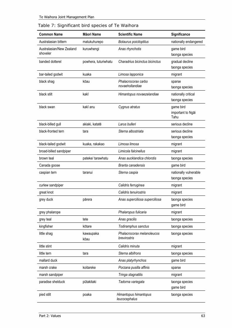
Te Waihora Joint Management Plan
Part 2: Values 63
Table 7: Significant bird species of Te Waihora
Common Name Mäori Name Scientific Name Significance
Australasian bittern matukuhurepo Botaurus poiciloptilus nationally endangered
Australasian/New Zealand shoveler
kuruwhengi Anas rhynchotis game bird taonga species
banded dotterel powhera, tuturiwhatu Charadrius bicinctus bicinctus gradual decline taonga species
bar-tailed godwit kuaka Limosa lapponica migrant
black shag köau Phalacrocorax carbo novaehollandiae
sparsetaonga species
black stilt kakï Himantopus novaezelandiae nationally critical taonga species
black swan kakï anu Cygnus atratus game bird important to Ngäi Tahu
black-billed gull akiaki, katatë Larus bulleri serious decline
black-fronted tern tara Sterna albostriata serious decline taonga species
black-tailed godwit kuaka, rakakao Limosa limosa migrant
broad-billed sandpiper Limicola falcinellus migrant
brown teal pateke/ tarawhatu Anas aucklandica chlorotis taonga species
Canada goose Branta canadensis game bird
caspian tern taranui Sterna caspia nationally vulnerable taonga species
curlew sandpiper Calidris ferruginea migrant
great knot Calidris tenuirostris migrant
grey duck pärera Anas superciliosa superciliosa taonga species game bird
grey phalarope Phalaropus fulicaria migrant
grey teal tete Anas gracilis taonga species
kingfisher kötare Todiramphus sanctus taonga species
little shag kawaupaka köau
Phalacrocorax melanoleucos brevirostris
taonga species
little stint Calidris minuta migrant
little tern tara Sterna albifrons taonga species
mallard duck Anas platyrhynchos game bird
marsh crake koitareke Porzana pusilla affinis sparse
marsh sandpiper Tringa stagnatilis migrant
paradise shelduck pütakitaki Tadorna variegata taonga species game bird
pied stilt poaka Himantopus himantopus leucocephalus
taonga species
Te Waihora Joint Management Plan
Part 2: Values 64
Common Name Mäori Name Scientific Name Significance
pukeko pükeko päkura
Porphyrio melanotus game birdtaonga species
red-necked phalarope Phalaropus lobatus migrant
sanderling Sterna albifrons migrant
Southern black-backed gull karoro Larus dominicanus dominicanus taonga species
spotless crake pütoto Porzana tabuensis plumbea sparse
turnstone Arenaria interpres migrant
white heron kötuku Egretta alba modesta nationally critical taonga species
white-fronted tern takitaki, tara Sterna striata striata gradual decline
wrybill ngutu-parore Anarhynchus frontalis nationally vulnerable
4.5.3 GamebirdsCertain bird species are declared to be game under section 4 of the Wildlife Act 1953. Those species present at Te Waihora are identified in Table 7 and include Canada goose, paradise shelduck/pütakitaki, pükeko, black swan, grey duck, Mallard duck (including any cross of those duck species with any other species, variety, or kind of duck), New Zealand shoveler and paradise duck. Canada goose and mallard duck are introduced. Black swan, once considered an introduced species, is now generally accepted as an indigenous species whose population was enhanced by Acclimatisation Society introductions from Australian populations (Holdaway, Worthy & Tennyson, 2001).
4.5.4 FishTe Waihora is rich in both abundance and species of fish life. Many of the fish are migratory and spend only part of their life in Te Waihora and its tributaries and the rest at sea. Consequently, access to the sea and river tributaries and timings and duration of lake openings, play an important role in fish species diversity in Te Waihora.
In species numbers and probably also in biomass, fish in Te Waihora are dominated by indigenous species. There are 15 indigenous and five exotic species of fish recorded in Te Waihora. Additional species are occasionally present or transitory and others are found in the near tributaries. Coarse fish such as perch, tench and goldfish are also present. Significant fish species within Te Waihora for cultural, ecological, recreational and commercial purposes are listed in Table 8, including threat extinction rankings from Molloy, J. et al. (2001). Visiting marine species are occasionally present and include basking shark, elephant fish, red cod, sunfish and seahorses. Marine mammals such as elephant seals have also been seen in the lake. Two pest fish species are also present (see Part 1, section 4.5.6).
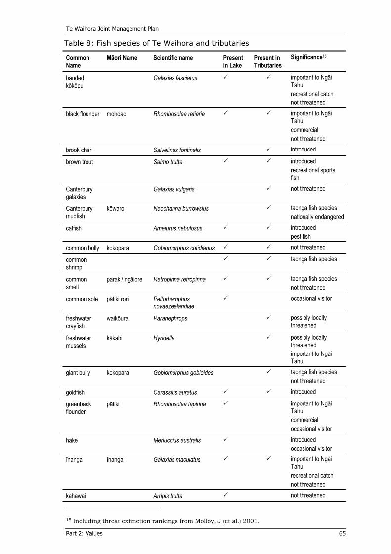
Te Waihora Joint Management Plan
Part 2: Values 65
Table 8: Fish species of Te Waihora and tributaries
Common Name
Mäori Name Scientific name Present in Lake
Present in Tributaries
Significance15
bandedkököpu
Galaxias fasciatus important to Ngäi Tahurecreational catch not threatened
black flounder mohoao Rhombosolea retiaria important to Ngäi Tahucommercialnot threatened
brook char Salvelinus fontinalis introduced
brown trout Salmo trutta introducedrecreational sports fish
Canterburygalaxies
Galaxias vulgaris not threatened
Canterburymudfish
köwaro Neochanna burrowsius taonga fish speciesnationally endangered
catfish Ameiurus nebulosus introducedpest fish
common bully kokopara Gobiomorphus cotidianus not threatened
commonshrimp
taonga fish species
commonsmelt
paraki/ ngäiore Retropinna retropinna taonga fish speciesnot threatened
common sole pätiki rori Peltorhamphusnovaezeelandiae
occasional visitor
freshwatercrayfish
waiköura Paranephrops possibly locally threatened
freshwatermussels
käkahi Hyridella possibly locally threatenedimportant to Ngäi Tahu
giant bully kokopara Gobiomorphus gobioides taonga fish speciesnot threatened
goldfish Carassius auratus introduced
greenbackflounder
pätiki Rhombosolea tapirina important to Ngäi Tahucommercialoccasional visitor
hake Merluccius australis introducedoccasional visitor
ïnanga ïnanga Galaxias maculatus important to Ngäi Tahurecreational catch not threatened
kahawai Arripis trutta not threatened
15 Including threat extinction rankings from Molloy, J (et al.) 2001.
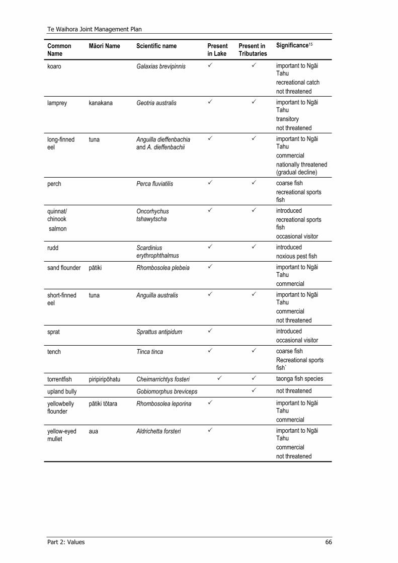
Te Waihora Joint Management Plan
Part 2: Values 66
Common Name
Mäori Name Scientific name Present in Lake
Present in Tributaries
Significance15
koaro Galaxias brevipinnis important to Ngäi Tahurecreational catch not threatened
lamprey kanakana Geotria australis important to Ngäi Tahutransitorynot threatened
long-finnedeel
tuna Anguilla dieffenbachia and A. dieffenbachii
important to Ngäi Tahucommercialnationally threatened (gradual decline)
perch Perca fluviatilis coarse fish recreational sports fish
quinnat/chinook salmon
Oncorhychus tshawytscha
introducedrecreational sports fishoccasional visitor
rudd Scardiniuserythrophthalmus
introducednoxious pest fish
sand flounder pätiki Rhombosolea plebeia important to Ngäi Tahucommercial
short-finnedeel
tuna Anguilla australis important to Ngäi Tahucommercialnot threatened
sprat Sprattus antipidum introducedoccasional visitor
tench Tinca tinca coarse fish Recreational sports fish`
torrentfish piripiripöhatu Cheimarrichtys fosteri taonga fish species
upland bully Gobiomorphus breviceps not threatened
yellowbelly flounder
pätiki tötara Rhombosolea leporina important to Ngäi Tahucommercial
yellow-eyedmullet
aua Aldrichetta forsteri important to Ngäi Tahucommercialnot threatened
Te Waihora Joint Management Plan
Part 2: Values 67
Tuna : Eels There are two species of freshwater eel in Te Waihora: the long-finned eel and the short-finned eel. Both species are indigenous and while the short-finned eel is also found in Australia, the long-finned eel is endemic to New Zealand. Eels prefer water with plentiful cover such as raupö, weedbeds, overhanging grasses and other vegetation, as well as undercut banks and submerged debris. Eels feed on invertebrates, bullies and other small fish. There has been a shift in diet as small eels now feed predominantly on midge fly larvae as opposed to the snails that were present on the weedbeds (see 4.4.1). Of all the fish species in Te Waihora, eels are the most valued by Ngäi Tahu (see page 42 for the creation story of Tuna).
Although it is likely that short-finned eels would have always dominated Te Waihora, the proportion of long-finned eels has substantially reduced over the years16. This is a concern for biodiversity, mahinga kai and other cultural values, and is a reflection of the health of the fishery. The Department has recently identified the species as being “nationally threatened (gradual decline)”17 because there is a predicted national decline of five to thirty percent in the total population in the next ten years.
Decline is thought to be due to fishing-related impacts nationwide, leading to higher mortality and reducted numbers of large females. Other factors influencing the predicted continued decline include national recruitment decline, fish passage blockages reducing available habitat and sex ratio biases (increasing abundance of male eels). This is a significant concern to Ngäi Tahu as long-finned eels are an important customary species and a kaitiaki (see Part 2, section 2.4).
Pätiki : FlounderPätiki belong to the flatfish family, of which five species are recorded in Te Waihora. The three species commonly found are the black flounder/mohoao (most common), yellow-belly flounder/pätiki tötaraand the sand flounder/pätiki. These species form an important customary fishery for Ngäi Tahu (see Part 2, section 2.6) and are also commercially fished (see Part 2, section 7.1.1).
Recruitment of flounder into Te Waihora and the relative abundance of each species is dependent on lake opening times and durations coinciding with periods of fish immigration.
Ïnanga : Whitebait Whitebait enter Te Waihora when or if the lake is open to the sea during spring and early summer. There are five species of endemic fish that make up what is commonly known as whitebait in New Zealand: ïnanga, koaro, banded kököpu, giant kököpu and shortjaw kököpu. Ïnanga is the most common species in whitebait catches in Canterbury. Koaro and banded kököpu are the next most common. Giant kököpu and shortjaw kököpu are rarely caught in Canterbury and no adults of shortjaw kököpu have been found in Canterbury.
Most ïnanga spawn in autumn when adults migrate downstream to estuarine areas during the highest spring tides. It is possible that within Te Waihora the variations in lake level that occur as a result of
16 Jellyman, Chisnall and Todd (1995). 17 Molloy et al (2001).
Te Waihora Joint Management Plan
Part 2: Values 68
wind replace the spring tides that usually initiate the spawning. Eggs are laid among submerged rushes and grasses. The only known spawning site in the Te Waihora catchment is in the lower reach of Waikekewai Creek.
The whitebait fishery is of importance to Ngäi Tahu as mahinga kai. Whitebait is an important recreational fishery and some are caught and sold commercially. Its abundance made it part of the staple diet and features prominently in many stories and traditions regarding fishing. The effects of drainage, lack of co-ordinated management, fishing pressure and limited knowledge of the fishery have led to serious decline in the whitebait fishery.
TroutBrown trout were introduced to the catchment in the 1870s by the North Canterbury Acclimatisation Society as a sport fish. The fishery quickly flourished in the Selwyn River/Waikirikiri to become one of the finest trout fisheries in New Zealand. Although they have co-existed with indigenous freshwater fish species for many years now, trout do compete with the indigenous species, such as the kököpu (and once with the now extinct grayling), and feed commonly on smaller fish species. Both trout and indigenous fish however, have been adversely affected by deteriorating environmental conditions; trout more so.
4.5.5 Invertebrates A fairly simple aquatic community of invertebrates exists in Te Waihora. The dominant species are the larvae and pupae of the large chironomid Chloronomus zelandicus and the larvae of the damselfly. There is a super-abundance of adult midges during the spring and summer after they emerge. They are then available as food for fish and birds and also contribute to the landscape values of the area (see Part 2, section 2.6).
Also present, living on the bottom of the lake or attached to the stems and leaves of larger plants, are amphipods, snails (primarily Potamopyrgus antipodarum), isopods, ostracods, Trichoptera, Coleopectra, Lepidoptera and Odonata. Little is known about the invertebrate fauna of Te Waihora, or the terrestrial invertebrate fauna, apart from insects that have aquatic larvae, such as midges. The role these invertebrates play in the food supply for other species present at Te Waihora, such as eels, other fish and bird species requires further research.
4.5.6 Introduced animals and animal pestsIntroduced animals within the Joint Management Plan Area include rabbits and hares, hedgehogs, ferrets, weasels, stoats, cats, rats and possums. These species impact on indigenous plants and animals through predation and disturbance. Rabbits are identified as an “animal pest” in the Canterbury Regional Pest Management Strategy(1998).
Domestic animals, primarily sheep and cattle, are also present. Domestic animals can impact on indigenous plants and animals, especially lake margin vegetation through grazing and trampling. They can cause lake and stream bank instability, increasing erosion and reducing biodiversity.
Te Waihora Joint Management Plan
Part 2: Values 69
Good land management removes or reduces domestic stock impacts on sensitive areas and their indigenous flora and fauna. Grazing sheep can play a role in managing introduced plant species, such as pasture grasses, by preventing their invasion and displacement of indigenous plant species, or by allowing indigenous species to recover sufficiently to dominate the introduced species.
Pest fish species such as rudd, koi carp, gambusia and catfish are an increasing concern for waterways in New Zealand. Rudd are present in Te Waihora and surveys are needed to confirm the likely presence of catfish. Although koi carp and gambusia have not yet been detected in Te Waihora, they remain a significant potential threat.
4.6 Te Waihora significance - within the takiwä, nationally and internationally Te hiranga o Te Waihora ke te takiwä o Ngäi Tahu, Aotearoa me te ao
4.6.1 Ngäi Tahu takiwä Within the Ngäi Tahu takiwä, Te Waihora is a mahinga kai of great tribal importance. This is highlighted through the Ngäi Tahu Claim, the recommendations of the Waitangi Tribunal and the resultant Settlement legislation. Te Waihora is important for its historic abundance of food and other resources. These resources have sustained Ngäi Tahu for generations (see Part 2, section 2.6).
To recognise the importance of sites such as Te Waihora, Te Rünanga o Ngäi Tahu has proposed in its tribal vision Ngäi Tahu 2025 the creation of mahinga kai cultural parks. This concept is based on Papatipu Rünanga taking a lead in producing natural resource management plans, undertaking their own monitoring of the environment, protecting and restoring their connection with significant sites and managing and/or owning such areas.
4.6.2 National significanceRecognition of the national significance of Te Waihora has occurred through several processes.
O’Donnell (1985) identified Te Waihora as being nationally important for many reasons, including:
The total number of birds at any one time. The number of bird species. The presence of significant proportions of New Zealand’s populations of some 20 bird species. Habitat provision for endemic bird species that have restricted distributions. Habitat provision for other indigenous species that are migratory within New Zealand.
In 1990 the National Water Conservation (Lake Ellesmere) Order was made in recognition of the outstanding wildlife habitats provided by Te Waihora.
Te Waihora Joint Management Plan
Part 2: Values 70
The New Zealand Biodiversity Strategy 2000 says “our indigenous biodiversity - our native species, their genetic diversity and the habitats and ecosystems that support them - is of huge value to New Zealand and its citizens; to our economy, our quality of life and our sense of identity as a nation”. The Strategy also reflects New Zealand’s commitment to help stem the loss of biodiversity worldwide. The Strategy recognises that the most threatened ecosystems at a national level are those in lowland areas. Remnants include lowland wetlands such as Te Waihora.
Based on this previous work, the Canterbury Conservation Management Strategy (2000) recognises Te Waihora as the most important wetland habitat of its type in New Zealand. Te Waihora has long featured in unpublished government department lists of nationally important waterbodies, dating back to the introduction of Water Conservation Order legislation through the Water and Soil Conservation Amendment Act 1981. It remains on the Department’s list of nationally important water bodies.
4.6.3 International significance The international significance of Te Waihora is highlighted by its relevance within New Zealand in respect of a number of international conventions:
Ramsar Convention on Wetlands of International Importance The Ramsar Convention on Wetlands is an intergovernmental treaty that provides a framework for national action and international co-operation for the conservation and wise use of wetlands and their resources. The Convention was signed at Ramsar, Iran, in 1971 and was ratified by the New Zealand Government in December 1976.
The purpose of the Ramsar Convention is "The wise use of wetlands and their sustainable utilization for the benefit of humankind in a way compatible with the maintenance of the natural properties of the ecosystem", as measured according to established criteria.
Compliance with any one of the criteria justifies designation as a “Wetland of International Importance” under the Ramsar Convention. Although Te Waihora meets all of the Convention’s criteria it is not a designated wetland. Especially relevant criteria for Te Waihora relate to:
Waterfowl and other bird life. Indigenous lakeshore wetland vegetation, including the diversity of species permanently or frequently resident. The variety of available micro-habitats. The importance of Te Waihora as a staging ground for transient visitors.The large numbers of endemic species for which Te Waihora provides habitat.
The Convention on Migratory Species of Wild Animals
This Convention promotes co-operation between signatory parties to identify, understand and conserve endangered migratory species and their habitats, and to take action to prevent other migratory species becoming endangered. The Government signed the Convention in
Te Waihora Joint Management Plan
Part 2: Values 71
September 1999 and it came into effect for New Zealand on 01 October 2000.
There are a number of migratory bird species present at Te Waihora that are subject to this convention (see Table 7).
Convention on Biological Diversity New Zealand ratified the Convention on Biological Diversity in 1994. In response to the convention the Government produced The New Zealand Biodiversity Strategy 2000 (see 4.6.2 above).
The Convention has three main aims:
The conservation of biological diversity. The sustainable use of its components. The fair and equitable sharing of benefits arising from the use of genetic resources.
Te Waihora Joint Management Plan
Part 2: Values 72
5 HISTORIC RESOURCESTAONGA PURI MAHARA
The Ngäi Tahu association with Te Waihora extends for over 48 generations. This length of occupation combined with the plentiful
mahinga kai of Te Waihora gave rise to and established the customary use of numerous historic sites and resources.
People have related to Te Waihora in many ways through the various stages of New Zealand settlement, as shown by the remaining
historic resources.
Historic resources include both the physical reminders of our history such as archaeological sites, buildings and structures and the stories and place names associated with that history. The historic area of Te Waihora includes both the Joint Management Plan Area and other areas connected to those lands and their resources in some way.
5.1 Mäori history Ki tä te tangata whenuaThe date of the first settlement of New Zealand has been widely debated, although it is now acknowledged that first settlement from central Polynesia is unlikely to have occurred before about A.D 1200 (State of New Zealand’s Environment, 1997).
The story of Te Waihora starts with that of the habitation of Te Wai Pounamu, the South Island, and begins with the arrival of the Waitaha people on the Uruao waka. Ngäi Tahu oral traditions tell of Räkaihautü, the captain of this waka, who beached his canoe at Whakatü (Nelson) and divided the new arrivals in two, with his son Te Rakihouia taking one party to explore the east coastline and Räkaihautü taking another southwards by an inland route over the Southern Alps/Kä Tiritiri o te Moana. On his inland journey southward, Räkaihautü used his famous kö (digging stick) to dig the principal lakes of Te Wai Pounamu. Te Rakihouia discovered the coastal lake (now Te Waihora) on his coastal journey south and in doing so claimed the abundant resources of the area for his father and hence named the lake Te Kete Ika a Räkaihautü - the fish basket of Räkaihautü.
Te Rakihouia set about building eel weirs in the lake and thus named the barrier (Kaitorete Spit) that divided the lake from the sea, Kä Poupou o Te Rakihouia, its narrowing shape from Horomaka channelling eels towards Taumutu where they crossed the barrier to migrate to sea. Subsequent eel weirs around the lake and their associated settlements became occupation sites.
Te Waihora Joint Management Plan
Part 2: Values 73
Generations later, the Ngäti Mämoe people arrived from Te Ika a Maui(the North Island), settling among the Waitaha. A prominent man of this tribe was Tutekawa, who in establishing his home at Waikäkahi(Birdlings Flat), pronounced Te Waihora as his own hence the lake’s second name, Te Kete Ika a Tutekawa - the fish basket of Tutekawa.
After Tutekawa killed two senior Ngäi Tahu women, Ngäi Tahu came from the north in pursuit of Tutekawa and his people. It was during these migrations that Te Ruahikihiki at his pä, Ömihi, in Goose Bay Kaiköura, came to hear of the large lake in the south and its plentiful resources and mahinga kai. He proclaimed Orariki, Taumutu his home and thus the resources of the lake as his own.
The site of Te Ruahikihiki’s Orariki pä is the Hone Wetere Church at Taumutu and its associated urupä. Kaikanohi, a fishing camp and settlement on Kaitorete Spit provided a place to reside when travelling down the Spit if the lake was open. Evidence of tool making, pounamu working and bird and fish preservation have been found at the site, which is now subject to erosion from the sea. Te Pä o Moki, was established as an outpost for the son of Te Ruahikihiki and the current whare, Ngäti Moki, was built on native reserve at Taumutu as a rünanga hall in 1893. The earth mound defences at both Orariki and Ngäti Moki Marae remain clearly visible today.
These historic travels symbolise the links between the cosmological world of the gods and present generations, reinforce tribal identity, solidarity and continuity between generations, and document the events that shaped the environment of Te Wai Pounamu and Ngäi Tahu as an iwi.
5.1.1 Wähi taonga With this history of settlement, occupation and resource use, places of importance to the tribe, local hapü and whänau were shaped. For Ngäi Tahu, the term wähi taonga refers to places that hold the respect of the people in accordance with kawa and tikanga. Some sites are of tribal significance while others are important to the hapü and whänau who visited, lived at, or had special affiliations to that area. Prominent hills, landforms, springs, remaining areas of indigenous vegetation and archaeological sites are examples of physical taonga. Recorded Mäori archaeological sites around Te Waihora include pä sites (fortified settlements), käinga (undefended settlements), urupä (burial grounds and single burial sites), borrow pits (small quarries from which sand or gravel was removed and added to gardens to improve the soil for kumara growing), shell middens, cooking ovens, storage pits and isolated artefact findspots.
Other taonga can include wähi tapu (sacred sites), püräkau (stories), wähi ingoa (place names) or other associations that those living today have with the tüpuna (ancestors) who have gone before. Places and their names formed vast oral ‘maps’ that were an integral part of the culture of Ngäi Tahu. Figure 11 shows the wealth of Ngäi Tahu place names as recorded by Riki Ellison, a Ngäi Tahu elder, in 1979.Knowledge of traditions, whakapapa and histories associated with places and their names helped to guide Ngäi Tahu in their travels throughout the takiwä. Wähi ingoa continue to tie Ngäi Tahu to the land and reinforce tribal identity and associated histories (see Part 2, section 3.4).

Te Waihora Joint Management Plan
Part 2: Values 74
Wähi tapu is a term applied to all sacred sites associated with tapu (sacredness), or areas held in reverence according to tribal custom and history. Of all wähi tapu, urupä (burial sites) are the most significant. Wähi tapu areas may also be associated with the creation stories of tangata whenua or a particular event such as a battle or ceremony. It may also be a place where whenua (placenta) is buried or a place where a certain valued resource is found.
Kaituna Lagoon is an area of importance for many Ngäi Tahu as this area provided access to the vast resources of Te Waihora from Banks Peninsula/Horomaka. Similarly, Kaitorete Spit provided an important access way between Banks Peninsula/Horomaka and the Canterbury Plains/Ngä Päkihi Whakatekateka o Waitaha.

Te Waihora Joint Management Plan
Part 2: Values 75
Figure 11: Mäori place names of Te Waihora
Drawn and named by Mr Riki Ellison, Käi Tahu elder 1979, Digital reconstruction by John Thyne, Department of Geography, University of Canterbury
Te Waihora Joint Management Plan
Part 2: Values 76
5.2 European history Ki tä te päkehä
5.2.1 Settlement and agriculture The name “Ellesmere,” the European name given to both Te Waihora and formally the county within which it is situated, comes from the Earl of Ellesmere. He was a member of the Canterbury Association who promoted the early settlement of Canterbury, but he never came to New Zealand. Sealers and whalers were probably the first European visitors to see Te Waihora, with William Gilbert, an Englishman from an American whaler, being in 1838 the first recorded European visitor to Taumutu. An Australian party of eight with stores and stock, led by Herriot and McGillivray and accompanied by surveyors, passed through Taumutu in 1840 enroute from Goashore (Oashore Bay, Banks Peninsula) to settle on the plains. Bishop Selwyn in 1844 also passed through as he made his well-recorded walk from Peraki to Otago.
Prominent Mäori settlements of the time were used to mark the land purchases in the area. For example, although long debated, the area of Kemps purchase was defined by a straight line from Mount Grey/ Maungatere to Kaiapoi to Otumatua (a spur on the Port Hills) and then to Taumutu. Although this line transects Te Waihora, the whole of Te Waihora was taken to be part of the purchase in 1848 and the swamp and tussock lands surrounding Te Waihora were taken up in large farming runs.
The wetlands surrounding Te Waihora (Lake Ellesmere) were gradually drained for agriculture and the vast tracts of forest that still covered much of Banks Peninsula/Horomaka were felled for timber and to provide land for sheep grazing, dairying and cocksfoot growing. Variations in lake level have been a concern to adjacent landusers since early Mäori occupation when the lake was first artificially opened to the sea, using digging sticks (kö) and scoops (täkoko), to prevent the flooding of the adjacent pä at Taumutu and other lake edge settlements. By the 1860s, lake-shore landowners wanted lake level control and a number of parties were involved in opening the lake to the sea, initially using shovels and horse drawn scoops near where Ngäi Tahu had traditionally opened the lake, albeit at higher lake levels, for defence and protection of the surrounding land. European settlers proposed a permanent lake opening as early as 1867. However, as this was unattainable, the Selwyn County Council first let tenders in 1877 to artificially open the lake using horse drawn scoops and a subsequent lake opening/lake levels’ regime was established by the Ellesmere Lands Drainage Board in 1903 (see Part 2, section 4.2.2).
Drainage of the surrounding area became a focus with the building of the Halswell Canal in 1889 and the straightening and stopbanking of the Selwyn River/Waikirikiri from the late 1940s. From the 1860s the large runs around Te Waihora were subdivided and in 1894 further Crown Land was balloted for farming.
The 1930s saw the establishment of the Lake Settlers’ Association to give a united voice on lake edge farming issues. The Association was (and is today) made up of farmers whose properties are rated to fund the lake opening. During this period, various schemes to prevent flooding and improve drainage were also developed by individuals and
Te Waihora Joint Management Plan
Part 2: Values 77
agencies, including Nutt’s stopbanking and Osborne’s pumping schemes hence Nutt’s and Osborne’s drains.
Transport networks slowly developed to link the area and its new industries to the Christchurch urban area.
5.2.2 Transport and the timber industry The extensive wetlands of Te Waihora, hard against Banks Peninsula/Horomaka, were a barrier to early land transport. Consequently a main travel route for Mäori and Europeans was Kaitorete Spit and the river flats to the west and north of Te Waihora.
Boat transport became important on the lake waters and rivers. Farmers William Birdling and Joseph Price used boats in the 1850s to travel between their farm lands beside the lake. In 1864, White & Co established a sawmill at Little River for Christchurch and the nearby timber markets. The sawn timber was punted along Lake Forsyth/Wairewa and, depending on the lake level of Te Waihora, taken by tramline to Birdlings Point or Stony Point. At very low lake levels, drays were used to transport the timber down to a wharf at the Timber Depot and Landing Reserve (see Figure 4, unit M36 486). From the lakeshore, shallow-draught paddle steamers carried and rafted the timber to Taumutu, Harts Creek/Waitatari and the Selwyn River/Waikirikiri - a major timber yard developed at Harts Creek (Timber Yard Point). Although there is no remaining physical evidence at the site, the name reflects this historic use. Historically lake depth facilitated the use and enjoyment of sailing boats within the lake, particularly around the lake opening site.
An early conflict regarding Te Waihora occurred between farmers wanting low lake levels and the saw millers favouring high lake levels for shipping.
In conjunction with Coop’s sawmill, William White was authorised18 to construct a tramline from Little River to Prices Long Point and from Christchurch to Ahuriri Point. A linking tramway was required should water transport not suffice, but it never eventuated. Development of other Little River area sawmills prompted the construction of the Little River branch railway.
The Ellesmere and Forsyth Reclamation and Railway Trust Act 1876 was introduced to provide for the survey of Lakes Ellesmere and Forsyth and the constitution of a corporation body for the purposes of draining and reclaiming the lakes and constructing the railway (opened in 1882). The “Ellesmere and Forsyth and Akaroa Trust” was formed so that half of the proceeds from the sale of the first 50, 000 acres of Crown “wastelands” (Te Waihora/Lake Ellesmere and Lake Forsyth/Wairewa) sold after the passing of the Act would be paid to the Trust for the construction and maintenance of the line.
As a result of the development of better roads (the roadway from Christchurch to Little River was opened for traffic about 1870) and the relaxation of restrictions on road transport, the use of the line declined and passenger services ceased on 12 April 1951. The line was finally closed to traffic on 30 June 1962. The Little River Railway embankment remains today as a reminder of this history.
18 White’s Little River Tramway Ordinance, 1866
Te Waihora Joint Management Plan
Part 2: Values 78
The significance of this built landscape feature and the changes that the associated land reclamation and railway construction brought to the Te Waihora/Lake Ellesmere area are worthy of emphasis in the history of the area.
5.2.3 FishingHapü at Te Waihora were undertaking extensive trade in fish before European settlement. This continued with the supply of various fish to the early Christchurch market. In 1864, European fishing of flounder began and in 1865, Thomas Robelli, an Italian, settled at Te Waihora as a commercial fisherman. At one time, as many as 250 men and 20 boats were fishing from Taumutu.
Brown trout, after their introduction by the then North Canterbury Acclimatisation Society, were also commercially harvested from Te Waihora and its tributaries, particularly Selwyn River/Waikirikiri, for sale in the Christchurch markets in the late 1880s.
Commercial flounder and freshwater eel fisheries later flourished. In 1979, flounder from Te Waihora provided around 5 percent of the total New Zealand flounder catch. The peak catch in 1978 was 216 tonnes. The commercial eel fishery grew rapidly in the 1970s in response to overseas demand. During this time, Te Waihora was the most important commercial eel fishery in the country. The commercial catch of eel peaked in 1976 at 846 tonnes. Yellow-eyed mullet also formed a locally important fishery.
This strong presence of fishing activity at Te Waihora can be seen through the presence of Fishermans Point/Whakamätakiuru as a lookout and fishing nohoanga for Ngäi Tahu and later as a more permanent settlement and base for European fishing activity on the lake.
Te Waihora Joint Management Plan
Part 2: Values 79
6 RECREATIONAL USE AND PUBLIC ACCESSMAHI-Ä-TÄKARO HOKI ME TE WHAI WÄHI O TE HÄPORI
Ngäi Tahu supports recreational use and public access but uphold that any adverse effects of that use or access should be managed
to not detract from the customary use of and access to Te Waihora and its resources. Ngäi Tahu customary use of Te Waihora is long established and maintains the same importance today as in the
past for current and future generations.
Many New Zealanders recognise Te Waihora as a special place for their enjoyment through a variety of active and less active
recreational pursuits.
6.1 Recreational use Ngä mahi täkaroTe Waihora is appreciated as a high quality recreational area by many of the people who use it. It is an ecosystem type not usually favoured for high levels of recreational activity. With a growing national recognition of wetland values however, and the provision of facilities and information to help enjoy them, the levels of use of such wetland areas will likely increase.
Te Waihora has some strong recreational features, such as the opportunities to observe rare migratory wader bird species, extensive game bird shooting and fishing. While it is easily accessible from Christchurch the regional community’s knowledge of the area seems to be limited. Accessibility of the lake margin is good in terms of legal provisions but variable on the ground and there are few visitor facilities, such as signage.
A large part of the recreational attraction of Te Waihora is the undeveloped, semi-remote experience it offers, similar to that on the hill top areas of the Port Hills and Banks Peninsula/Horomaka, in close proximity to Christchurch. In part this is aided by the wide, open landscape of Te Waihora. In terms of the approach in The Recreation Opportunity Spectrum Guidelines for Users (1993) used by the Department in recreation planning, Te Waihora is clearly a “front country” area, but it also exhibits characteristics seen in “backcountry” areas. Recreation management by the Department involves the retention where appropriate of the range of recreation opportunities of an area.
Recreational activity also encompasses some customary use, especially extractive uses such as game bird hunting and recreational fishing. While these activities are considered as recreation, and in certain circumstances require a permit, Ngäi Tahu regard them as customary use. This is particularly the case where a Fish and Game hunting permit is obtained for the gathering of native gamebirds. Section 2.6 outlines mahinga kai activities in more detail.
Te Waihora Joint Management Plan
Part 2: Values 80
6.1.1 Recreational activities
Game bird shootingTe Waihora is the most popular single area in the region and in New Zealand for game bird hunting. It regularly supports in excess of 30 000 waterfowl. Mallard ducks are the most hunted game bird during the hunting season months of May and June. Canada goose, black swan and shoveler duck are also present and hunted from July to November. There is a special Canada goose season in February and March, with Te Waihora providing the best goose hunting in New Zealand at this time.
Shooters’ maimai have become a feature of the Te Waihora landscape (see Part 2, section 3.2). This high use and importance for gamebird shooting in part resulted in the Maimai Agreement (see Part 1, section 4.3.1).
Recreational fishing Recreational fishing encompasses a range of different motivations, including sport and sustenance. Recreational fishing also encompasses some customary fishing. Where customary catches are within recreational bag limits or regulations and therefore do not require a customary permit19, they continue to be managed as recreation. While these activities are considered as recreation, Ngäi Tahu regard them as customary use.
Recreational fishing in Te Waihora and its tributaries includes fishing of brown trout, flounder, eel, coarse fish species such as perch, and seasonal whitebaiting when the lake is open to the sea. Good numbers of sea-run trout are present when the lake is open to the sea and brown trout fishing in the lower reaches and at the mouths of inflowing streams can be excellent. These rivers are known to contain very large fish.
Bird watching/ ornithology Te Waihora provides an internationally important area for bird watching because of the potential to view relatively rare, mostly migratory, bird species. The only New Zealand sighting of a number of species has been at Te Waihora. Although there are low numbers of people who use the area for bird watching, it is internationally recognised and visited. Popular areas include the Greenpark Sands, Kaituna Lagoon and Harts Creek/Waitatari.
Water based recreation Parts of Te Waihora are used for water sports, including water skiing, power boating, jet skiing (personal water craft), windsurfing, kitesurfing and kayaking, although these activities are at considerably lower levels than in past years. This is probably because of the availability of alternative waterbodies. The Ellesmere Aquatic Club is based at Lakeside Domain.
Other recreational activity Other recreational activity at Te Waihora includes low environmental impact activities such as walking, photography, enjoying the wide-open spaces and picnicking.
19 Under the Kaimoana (Mäori Customary Non-Commercial Fishing) Regulations 1998.
Te Waihora Joint Management Plan
Part 2: Values 81
6.1.2 Recreational areas
Game bird hunting Game bird shooting occurs right around the lake, with mai mais generally in water less than 600 millimetres deep at high lake levels, primary areas are:
Adjoining Lower Selwyn Huts, within the Joint Management Plan Area. Greenpark Sands, within the Joint Management Plan Area. Yarrs Flat Wildlife Management Reserve and adjoining Joint Management Plan Areas. ‘Wards’ and ‘Williams’ Wildlife Management Reserves, within the Joint Management Plan Area. Irwell River/Waiwhio mouth, within the Joint Management Plan Area. The Boggy Creek area, on North Canterbury Fish and Game Council land, Selwyn District Council lakebed and within the Joint Management Plan Area. Lakeside Wildlife Management Reserve, within the Joint Management Plan Area. Adjoining Harts Creek Wildlife Refuge, within the Joint Management Plan Area and on adjoining freehold lands. Kaitorete Spit shoreline, within the Joint Management Plan Area and on council endowment leasehold land. Kaituna Lagoon and adjoining areas within the Joint Management Plan Area, legal roads and freehold lands accessed from Rocky Point and Willow Point off SH75.
Recreational fishing Primary areas currently used for recreational fishing are:
The Selwyn River/Waikirikiri lower reaches, adjacent to Selwyn Wildlife Management Reserve. The LII River/Ararira, adjacent to Yarrs Flat Wildlife Management Reserve.The mouth of Harts Creek/Waitatari, Harts Creek Wildlife Management Reserve. Halswell River/Huritini and canal mouth, bordered by conservation area.Irwell River/Waiwhio mouth, bordered by conservation area. Lake opening area, Ngäi Tahu lakebed. The Kaituna River lower reaches and mouth. Various lake areas for eel, flounder, mullet and whitebait.
Bird watching/ornithology Primary areas currently used for bird watching are:
Greenpark Sands off Embankment Road and Jarvis Road. Yarrs Flat Wildlife Management Reserve. Harts Creek Wildlife Refuge. Kaituna Lagoon. The western end of Kaitorete Spit.
Te Waihora Joint Management Plan
Part 2: Values 82
November to February is the preferred time for bird watching on the lake, although it also occurs in March/April and September/October. These times mostly relate to the presence of migratory wading birds. Bird watching by the general public is likely to occur throughout the year from a few vantage points, especially those along State Highway 75.
Other recreational activities Other recreational activities, such as picnicking, photography and generally enjoying the wide-open spaces, also occur around Te Waihora at various places. The Harts Creek walkway provides access to part of the western shore of Te Waihora and the bird hide. Areas commonly used include the Selwyn delta, Kaituna Lagoon from the State Highway, Lakeside Domain, Fishermans Point/Whakamätakiuru, Kaitorete Spit and Greenpark Sands, especially from the end of Embankment Road.
A walking/cycling “Railtrail” is being developed between Christchurch and Little River. The Railtrail will follow the historic railway embankment between Motukarara and Little River, will improve access and could significantly increase recreational use of this part of the Joint Management Plan Area.
Water based recreation Most water sports on Te Waihora take place around Timber Yard Point/ Lakeside Domain, a recreation reserve administered by the Selwyn District Council. The Ellesmere Aquatic Club is situated here. Waterski, personal watercraft and yachting areas are specified under Environment Canterbury’s navigational safety bylaws for inland waters. Windsurfing and kitesurfing also occur from the Domain. A low level of kayaking, canoeing and rowing occurs on and near the lower reaches of the Selwyn/Waikirikiri, LII/Ararira and Halswell/Huritini Rivers. Boats are also used by some gamebird shooters and fishers.
HutsRecreational huts around Te Waihora provide bases for people mainly involved in fishing and gamebird shooting. While there are a few individual huts within the Joint Management Plan Area and adjoining freehold and other lands, most huts are in settlements located at:
Selwyn Huts (98 huts) on Selwyn District Council administered Recreation Reserve. Lower Selwyn Huts (58 huts) within the Joint Management Plan Area. Greenpark Huts (32 huts) on Ngäi Tahu freehold land. A few are permanent dwellings. Fishermans Point/Whakamätakiuru near Taumutu (17 huts) on Ngäi Tahu freehold land. Most are permanent dwellings. Kaituna huts (6 huts) on Christchurch City Council administered reserve.
Potential conflicts between recreational activities on and around Te Waihora are avoided or minimised at present as different activities are focused in different areas and/or are seasonal in nature. The various recreational activities have the potential to impact on management for mahinga kai and conservation.
Te Waihora Joint Management Plan
Part 2: Values 83
6.1.3 Recreational facilities and information The few recreational facilities, or facilities able to be used by recreationalists, within the Joint Management Plan Area include:
Defined watercraft activity areas by Lakeside Domain. The Lower Selwyn Huts, as above. Harts Creek Walkway and bird hide. Boat ramp and ‘wharf’ on lower Halswell Riverbank. Vehicle access track and boat launching site at Irwell River mouth. The walking/cycling Railtrail along the Motukarara to Birdlings Flat historic railway embankment (operational 2006).
Facilities adjoining the Joint Management Plan Area include: The Selwyn Huts, Greenpark Huts and Fishermans Point/Whakamätakiuru huts. Springston South Domain; toilets, camping. Lakeside Domain; camping, toilets, boat ramp. Vehicle/boat access at Fishermans Point/Whakamätakiuru.Boat ramp to lower Selwyn River/Waikirikiri by Lower Selwyn Huts. Various roads and vehicle tracks to the edge of the Joint Management Plan Area.
Ngäti Moki Marae at Taumutu hosts many visitors for educational and cultural purposes and provides information and instils respect for many of the values of Te Waihora. The Department has published information pamphlets relating to the Harts Creek Walkway/bird hide and Kaitorete Spit. They have also produced education resources about Te Waihora and Kaitorete Spit for school children. Education institutions such as local universities and schools use Te Waihora for field trips and studies.
6.2 Public access Te whai wähi o te haporiPublic access to and around Te Waihora is used for customary, recreational and commercial purposes. Different user groups tend to have different access sites and means of access, e.g. access to favoured fishing, bird watching, or walking areas and/or access through the Joint Management Plan Area by boat, foot, motor vehicle, bicycle or horse. Existing (lawful) public access to, and recreational use and enjoyment of the bed of Te Waihora remains unaffected by the change in ownership and is provided for by section 173 of the Ngäi Tahu Claims Settlement Act 1998.
Existing public access to Te Waihora is mostly by way of formed and unformed roads and over lands within the Joint Management Plan Area. Unformed legal roads are sometimes difficult to identify or navigate. Key access points are related to the various recreational activities, as well as to landscapes and the various wildlife habitats around Te Waihora. See Figure 12.
Te Waihora Joint Management Plan
Part 2: Values 84
7 COMMERCIAL AND OTHER ACTIVITIESNGÄ MAHI ARUMONI ME ËTAHI ATU MAHI
It is the Ngäi Tahu intent that commercial and other activities do not detract from the long-established and still important customary
access to and use of Te Waihora and its resources.
Commercial and other activities are an integral part of Te Waihora but they need to respect the wide-ranging conservation values of
this important wetland.
7.1 Commercial activities Ngä mahi arumoni
7.1.1 FishingFishing commercially, in the sense of trading fish for other goods, has been a feature of Te Waihora since pre-European times. Large scale commercial fishing, mainly for flounders, commenced at an early stage of European settlement, while commercial eel fishing grew in popularity in the early 1970s. Today there are three main commercial fisheries in Te Waihora – freshwater eel, flounder and yellow-eyed mullet. These fisheries are all managed under the Quota Management System (QMS) by the Ministry of Fisheries, under a mandate to ensure that the fisheries are used sustainably within healthy aquatic ecosystems.
The commercial fishery is economically and socially important to the area, giving employment in fishing, fish processing and related service industries.
Customary fishing also encompasses a development right to participate in commercial activity. These customary rights were recognised in the Sealords Settlement and Ngäi Tahu have re-established their position in the Te Waihora commercial fishery. While these activities are considered as commercial, Ngäi Tahu regard them as customary use.
EelThe Te Waihora freshwater eel fishery has been managed under the Quota Management System (QMS) since 2000. The management area “Anguilla 13” encompasses all of the catchments north of the Rakaia River to Te Waihora, although almost all of the fishing pressure is concentrated at Te Waihora. There are 12 permit holders authorised to fish the area, with a total allowable commercial catch (TACC) of 122 tonnes per year. As a result of the ‘Sealord Settlement’20 Te Rünanga holds 20% of this quota, which it on-leases to fishers.
Eels are caught in fyke nets held in place by stakes driven into the bed of Te Waihora. The nets sometimes have ‘wings’ either side to direct fish
20 Treaty of Waitangi (Fisheries Claims) Settlement Act 1992.
Te Waihora Joint Management Plan
Part 2: Values 85
into them. Nets vary in dimensions and size according to fishers’ preferences and can extend some twenty metres in width.
A non-statutory Te Waihora Eel Management Plan (1999) was developed by the Te Waihora Eel Management Committee, to encourage the introduction of freshwater eels into the QMS. The Committee comprised representatives from tangata whenua and commercial fishers.
Flat fish Three of the five flat fish species present in Te Waihora are caught commercially: black, yellow-bellied and sand flounder. The Quota Management Area (QMA) for flounder, “FLA 3”, extends from north of the Clarence River in North Canterbury around the south of the South Island and along the West Coast. Te Waihora is only a small part of this QMA although black flounder, the main commercial flat fish sourced from Te Waihora, are caught almost exclusively within Te Waihora.
Flounder are caught either in set nets anchored to the bed of Te Waihora or in drag nets dragged along the bottom. There are relationships between the duration and timing of lake openings, catch and flatfish species composition within Te Waihora.
MulletMost of the east coast South Island fishery for yellow-eyed mullet is caught within Te Waihora, although the QMA is the same as that for flat fish. The TACC is set at 8 tonnes. Yellow-eyed mullet, commonly called “herring”, provides a supplementary fishery to the commercial eel fishery in Te Waihora.
WhitebaitWhitebait, while primarily a recreational fishery, are also caught and sold commercially, especially when the lake is open to the sea.
AquacultureInterest has been expressed by fishers in developing commercial aquaculture in Te Waihora, specifically for whitebait, flounder and eels.
7.1.2 Grazing and farming Some lands administered by the Department around Te Waihora are licenced for grazing in accordance with the Conservation Act 1987 and the Reserves Act 1977. A small part of the Ngäi Tahu lakebed is also leased.
Some grazing, primarily by sheep, is allowed for introduced plant species control. Grazing is also permitted of higher previously developed lands acquired or being retained as buffer zones for lake level rises caused by long-term, sea level rises. Through 2003/05 the Department is reviewing all grazing licences to introduce best management practices. Some grazing will be progressively reduced as indigenous vegetation re-establishes itself, for example in the brackish shrubland and rushland areas.
Drainage, stopbanking and irrigation Since early European settlement parts of the Te Waihora landscape have been reclaimed, primarily for farming, through stopbanking, drainage, pumping and irrigation. Some of this activity has occurred on or has affected the Joint Management Plan Area. Drains and embankments remain to the east of Greenpark Huts.
Te Waihora Joint Management Plan
Part 2: Values 86
Stopbanking on the eastern fringes of Te Waihora has been used to protect lake edge farmland from the effects of wind-lashed and high lake levels. While this improves agricultural production, it can modify the lake edge environment to the detriment of indigenous vegetation and wildlife. Some of the historic drainage works have resulted in modified but still ecologically valuable wetland habitats.
On the dry Canterbury Plains abstraction of groundwater and surface water for irrigation has steadily increased to supply agricultural desires. Water abstraction for residential and industrial uses is also increasing. Irrigation water use in the Te Waihora catchment has increased five-fold since 1985. Such abstraction reduces fresh water inflows to Te Waihora, affects salinity levels and the provision of freshwater habitats, and reduces water availability for flushing the lake. Coupled with increased leaching of nutrients from the soil it increases nutrient concentrations in the lake. Abstraction has also meant that, additional to the effects of seasonal rainfall and drainage, some tributary streams and springs no longer flow or are ephemeral.
7.1.3 Gravel and Sand extraction There has been interest shown in extracting sand and gravel resources from the lake opening area on Kaitorete Spit. Sand from this area is valued for sandblasting and other uses because of its even grain size and angular nature.
7.1.4 Tourism opportunitiesThere is a small amount of tourism associated with Te Waihora, such as small-scale ecotourism (primarily bird-related), gamebird shooting and passive viewing from State Highway 75. The activities are mostly linked to the natural environment and the recreational uses and opportunities identified in Part 2, section 5.
7.2 Utilities, huts and other activitiesNgä whaipainga, ngä momo whare me ngä mahi këThere are additional activities occurring within the Joint Management Plan Area, not included in the commercial activities above, which are not directly associated with management for “mahinga kai, conservation and other purposes”.
7.2.1 UtilitiesThese activities include environmental monitoring structures used by Environment Canterbury for lake level and coastal erosion monitoring, an underground telephone cable running the length of the historic railway embankment and Ministry of Fisheries signs and marker poles.
7.2.2 Huts and hut settlements The Lower Selwyn Huts settlement was established as a recreational fishing and game bird shooting base in the late 1880s with the advent of the successful brown trout fishery in the Selwyn River/Waikirikiri. The hut settlement, which is within the Joint Management Plan Area, is administered by the Department and leased to the hut owners. The leases were reviewed (2004) with lease conditions put in place to avoid any adverse effects from the settlement on the adjoining Joint
Te Waihora Joint Management Plan
Part 2: Values 87
Management Plan Area and the Te Waihora environment and to ensure its use for recreational purposes only.
Other small settlements and individual huts around Te Waihora provide private accommodation for Te Waihora visitors, but have the potential to impact on mahinga kai and conservation through effects such as sewage disposal and localised pressures for vehicle use within the Joint Management Plan Area. The management responsibility of these huts varies (see Part 2, section 6.1.2).
7.2.3 OtherThere are a few private jetties and moorings within the Joint Management Plan Area. These are currently unauthorised.
Because of the importance of Te Waihora to some people, they request that after their death they have their ashes spread over the lake or within some part of the Joint Management Plan Area. This practice can be offensive to Ngäi Tahu and may affect the cultural availability of mahinga kai species for consumption.
7.3 Research RangahauScientific use of the area is high because of its proximity to Lincoln and Christchurch and their research and educational institutions, including Lincoln University and the University of Canterbury. Research, including co-operative or joint research ventures with Ngäi Tahu and/or the Department, can benefit mahinga kai and conservation management within the Joint Management Plan Area.
Te Waihora Joint Management Plan
Part 2: Values 88
8 JOINT MANAGEMENT PLAN OBJECTIVESNGÄ PAETAE O TE MAHEREThe following objectives have been developed by Te Rünanga and the Department. They are statements of a future situation that is sought through the management of the Joint Management Plan Area and through advocacy to other agencies and individuals with roles and responsibilities in the management of the Te Waihora environment. The objectives evolved from the values of Te Waihora, as described throughout Part 2 of this Joint Management Plan. Many of them are long-term in their focus and will not be achieved in the ten-year timeframe of this first Te Waihora Joint Management Plan.
The details of how the objectives can be achieved and which agencies, groups or individuals are involved in achieving them, are outlined in the policies and methods that follow.
The relevant objectives are repeated at the start of each section in Part 3: Management.
8.1 Te kete ika(1) The rangatiratanga and kaitiaki of Ngäi Tahu are upheld by Ngäi
Tahu and respected by the Department within the management of Te Waihora.
(2) Ngäi Tahu management within Te Waihora is in accordance with tikanga and kawa.
(3) Te Waihora is recognised and supported as a mahinga kai.
(4) Ngäi Tahu have access to and use of a plentiful supply of high quality mahinga kai from Te Waihora.
8.2 Landforms and landscapes Te matawhenua(1) Operations within the Joint Management Plan Area conform to
high standards of environmental design and are managed to conserve landscape integrity.
(2) The landscapes of Te Waihora, including their scenic, landform and other natural features, are protected and enhanced.
(3) The particular cultural landscape that reflects the long association of Ngäi Tahu resource use within the area is maintained.
8.3 Wildlife habitat and biodiversityNgä toi whenua me ngä tümomo koiora (1) Indigenous plant and animal communities of Te Waihora and the
ecological processes that ensure their survival, are restored and protected to maintain and improve indigenous wetland biodiversity.
(2) Indigenous biodiversity, mahinga kai and taonga species are protected through the identification and management of significant plant and animal pests.
Te Waihora Joint Management Plan
Part 2: Values 89
(3) The habitats and wider needs of threatened species, taonga species and other species of importance to Ngäi Tahu are protected.
(4) The national and international significance of Te Waihora is recognised.
(5) The cultural, spiritual, historic and traditional associations of Ngäi Tahu are recognised when managing indigenous plants and animals within the Joint Management Plan Area.
(6) Public and community awareness and participation in protecting Te Waihora indigenous wetland biodiversity, natural systems, values and processes are increased.
(7) The mauri of Te Waihora is improved and the natural balance required to safeguard the life-supporting capacity of the water and associated ecosystems is achieved through Ngäi Tahu and the Department working together and with other agencies.
8.4 Historic resources Taonga puri mahara(1) The historic values of Te Waihora are recognised and protected
within the Joint Management Plan Area.
(2) Historic resources associated with Te Waihora, but outside of the Joint Management Plan Area, are recognised and protected.
(3) Ngäi Tahu are able to exercise their role as kaitiaki over their historic taonga according to tikanga.
8.5 Recreational use and public accessMahi-ä-täkaro me te whai wähi o te hapori(1) Public access opportunities and recreational use and enjoyment
of the Joint Management Plan Area are identified and provided for where there are no likely adverse effects on mahinga kai, other cultural values, or conservation values.
(2) Recreational opportunities at Te Waihora are enhanced through information provision and working with other agencies and recreational groups.
8.6 Commercial and other activities Ngä mahi arumoni me ëtahi atu mahi(1) The mahinga kai status of Te Waihora and the Ngäi Tahu
ownership of the Ngäi Tahu lakebed are recognised in evaluating activities that require a concession or permit within the Joint Management Plan Area.
(2) All activities that require a concession or permit within the Joint Management Plan Area are compatible with the other objectives and policies of this Plan.

PART 3: MANAGEMENTKIA ARORAKI


Te Waihora Joint Management Plan
Part 3: Management 93
1 INTERPRETATION OF POLICIES AND METHODS NGÄ WHAKAMÄRAMATANGA O NGÄ KAUPAPA ME TE RITENGA
1.1 Integrated management Te whakahaere ngatahiThe policies and methods of this Plan recognise that the Joint Management Plan Area includes various lands administered by the Department under the Conservation and Reserves Acts, as well as the Ngäi Tahu lakebed. While recognising the different legislative purposes for which the various lands are held this Joint Management Plan is prepared “for the integrated management of natural and historic resources within the areas covered by the planfor…”(Clause 11.6.19(a)(i), Schedule 12 NTCSA) “mahinga kai, conservation and other purposes”.
This integrated management of natural and historic resources within the JMP Area has resulted in policies and methods that recognise the need to:
Where appropriate, address all lands covered by the plan, with any legislative differences emerging from the purposes for which the lands are held being addressed at the method level. Ensure that the outcome of individual concession, permit or other decisions is not pre-judged by restricting the possibilities provided for in the legislation. Recognise the roles of the Crown (through the Director General of Conservation) and Te Rünanga o Ngäi Tahu as signatories to the agreement to prepare this Joint Management Plan and their respective roles for the integrated management of those areas and resources subject to the Plan. Ensure that the interpretation and application of particular policies and methods are consistent with other policies in this Plan, other policies of Te Rünanga or any approved iwi management plan which relate to the Ngäi Tahu lakebed, and other policies of the Crown with a bearing on the management of land administered by the Department.
Achieve the outcomes sought by both Te Rünanga and the Department as set out in the Protocols on the Department of Conservation’s interaction with Ngäi Tahu on Specified Issues(1997) and included in Appendix 6.
1.2 Policy and method conventionsNgä kawa-ä-kaupapa, ä-ritenga hokiWith these needs in mind, the following conventions, with respect to the Department and/or Te Rünanga implementing policies or methods, have been used in this Joint Management Plan:
Where legislation provides no discretion for the Minister’s decision-making, or Te Rünanga o Ngäi Tahu wishes to restrict its discretion for decision making, policies and methods state that a particular action or actions ‘will’ be undertaken;
Te Waihora Joint Management Plan
Part 3: Management 94
Policies and methods that provide for strong guidance on decision-making, without diminishing the roles of the Minister or Te Rünanga, state that a particular action or actions ‘should’ be undertaken; and Policies and methods specifically intended to allow flexibility in decision-making state that a particular action or actions ‘may’ be undertaken, or are written to allow for either or both parties to advocate for a particular action or actions to other parties or decision makers. Where action will/should/may be undertaken by either the Minister or Te Rünanga, that party is specified. Where no party is specified, action will/should/may be undertaken jointly by Te Rünanga and the Department.
1.2.1 Cross referencing
With these conventions in mind and recognising the large number of policies and methods within this Plan, cross references have been inserted in square italic brackets in the left hand margin of Part 3. These reference other policies with particular relevance to the policy alongside which it is noted, or methods with particular relevance to the method alongside which it is noted.
1.3 Non derogation Kaua e takahi te tureThe policies and methods in Part 3 of this Joint Management Plan are required to be consistent with section 179 Non-derogation from legislation and other matters (NTCSA). See Part 1, section 4.4.
1.4 Bylaws and regulations for the Joint Management Plan AreaNgä ture e hängai ana ki te MahereReferences within the methods of Part 3 of this Plan to seeking bylaws and regulations are references to bylaws under section 106 Reserves Act 1977 and section 182 Ngäi Tahu Claims Settlement Act 1998 and to regulations under section 48 Conservation Act 1987. Because the activities that the bylaws/regulations will seek to control could occur on either reserves, the “bed of Te Waihora” or conservation areas (the boundaries between which are not easily discernible on the ground) there is a need to have uniform bylaw/regulation coverage across all such lands and consistent development of them.
Bylaws and regulations will be sought collectively if they are considered to be required after a period of monitoring of public use activity from the time the Plan is approved.
1.4.1 Bylaws for the “bed of Te Waihora” All methods in Part 3 of this Joint Management Plan seeking bylaws constitute a recommendation of Te Rünanga o Ngäi Tahu in terms of section 182(2) NTCSA. After this Plan has come into effect specific wording for any proposed bylaws will be jointly developed and agreed to by Te Rünanga and the Department for approval by the Minister.

Te Waihora Joint Management Plan
Part 3: Management 95
1.4.2 Bylaws and regulations for lands administered by the Department
After this Plan has come into effect specific wording for any proposed bylaws and regulations will be developed by the Department in consultation with Te Rünanga for approval by the Minister under section 108 Reserves Act for the bylaws and by the Governor-General by Order in Council under section 48 Conservation Act for the regulations.
1.5 Policies Ngä kaupapa1 To interpret and apply all objectives, policies and
methods in this Joint Management Plan consistently with all other objectives, policies and methods in the Plan.
2 To consider and apply, where appropriate, all statutory and non-statutory policies with a bearing on the management of lands administered by the Department or of the Ngäi Tahu lakebed.
3 To read all objectives, policies and methods as being subject to their applicable legislation.
Te Waihora Joint Management Plan
Part 3: Management 96
2 TE KETE IKA
“The l a k e wa s k n own a s t h e f i s h b a s k e t o f Räka i hau t ü… Räka i hau t ü c l a im ed t h e l a k e
b e c au s e i t wa s s o f u l l o f f i s h t h a t h e c l a im ed i t a s a f o o d s o u r c e f o r a l l h i s h apü . I t r e a l l y
b e c ame a n imp o r t a n t f o o d s o u r c e , n o t o n l y f o r t h e ha pü o f Ruah i k i h i k i bu t f o r t h e t r i b e o f
Ngä i Tahu . ”
Ca t h B rown
Relevant Objectives Ngä Paetae
(Repeated from Part 2, 8.1)
(1) The rangatiratanga and kaitiaki of Ngäi Tahu are
upheld by Ngäi Tahu and respected by the
Department within the management of Te Waihora.
(2) Ngäi Tahu management within Te Waihora is in
accordance with tikanga and kawa.
(3) Te Waihora is recognised and supported as a
mahinga kai.
(4) Ngäi Tahu have access to and use of a plentiful
supply of high quality mahinga kai from Te Waihora.
2.1 Whakapapa and rangatiratanga
Policies Ngä kaupapa
2.1.1 To recognise the rangatiratanga of Ngäi Tahu, and the roles and responsibilities of the Department, both of which are initially given effect to by the preparation of this Plan, and the co-operative management of Te Waihora and its resources.
[5.2 and 7.3.4] 2.1.2 To maintain and respect the whakapapa and mätauranga of Te Waihora.
2.1.3 To maintain Te Waihora as a tribal taonga in perpetuity through ownership of the Ngäi Tahu lakebed being held by Te Rünanga on behalf of Ngäi Tahu Whänui.
2.1.4 To recognise and support the roles of Te Taumutu and the surrounding Ngäi Tahu käinga with kaitiaki interests in Te Waihora.
[2.4.1 - 2.4.5] 2.1.5 To ensure that Te Waihora can provide the resources required to manaaki.
Te Waihora Joint Management Plan
Part 3: Management 97
2.1.6 To recognise the accompanying rights and obligations resulting from Ngäi Tahu fee simple ownership of the bed of Te Waihora.
Explanatory note Te kupu whakamähukihuki
Whakapapa , “ t h a t ’ s t h e o n l y wa y y o u c a n ma i n t a i n l i n k s . We ’ v e g o t o u r whakapapa , t h e y
c a n n e v e r t a k e i t away f r om y ou , …we ’ r e h e r e f o r e v e r a nd w e ’ v e a lway s b e e n t h e r e a nd a lwa y s
w i l l b e t h e r e . ”
Ranga t i r a t a n ga , “ ha s t o b e e x p r e s s e d b y u s , … a l e ad e r s h i p r o l e i n l o o k i n g a t h ow w e c a n
u s e t h e l a k e , wha t w e c a n d o o n i t , wha t s o r t o f r o l e w e c a n p l a y… t ha t w e k n ow t h e
e x p e c t a t i o n s , a nd t h a t w e n e e d t o b e r e c o g n i s e d t h a t w e d o ha v e t h e k n ow l e d g e a nd t ha t ’ s t h e
imp o r t a n c e o f r a n ga t i r a t a n ga . ”
Ca t h B rown
Whakapapa connects people to each other, to their ancestors, to the land and natural resources. Ngäi Tahu history and whakapapa is embedded in the landscape and resources of Te Waihora. Traditions represent the values and beliefs of the land, of the tribe, and of the hapü and whänau, who by whakapapa retain the customary rights and responsibilities associated with ngä taonga tuku iho a ngä tüpuna (treasures handed down from the ancestors, including flora, fauna, and natural resources). These rights and responsibilities include rangatiratanga and kaitiakitanga (see Part 2, section 2).
A tangata tiaki system has been established by Te Rünanga and the Ministry of Fisheries for the management of those customary fisheries that come under the Fisheries Act 1996. Representatives (tangata tiaki) are appointed by the tangata whenua to manage the customary fishery in their area of authority. Tangata tiaki authorise tangata whenua to undertake customary fishing, keep records of authorisations and fish taken, and maintain the knowledge and information about the health of the fisheries. A tangata tiaki system can be applied to natural resources under other legislation to enable Ngäi Tahu to practise their roles and responsibilities derived from their whakapapa right to, and ongoing rangatiratanga of, Te Waihora.
Ownership of the “bed of Te Waihora” is vested in Te Rünanga o Ngäi Tahu under the NTCSA, this ownership subject to section 171 (see Part 1, section 3.2.2).
Methods Ngä ritenga
2.1a The Department will give effect, where possible, to the Crown’s duty of active protection through the relationship between Ngäi Tahu and the Department in the implementation, monitoring and review of this Plan.
2.1b The Department should recognise and promote Ngäi Tahu tikanga and kawa in their management, where appropriate.
Te Waihora Joint Management Plan
Part 3: Management 98
[2.4f, 5a, 7.3a -7.3c]
2.1c Ngäi Tahu will maintain, record and disseminate where appropriate, mätauranga Mäori as it relates to Te Waihora, and: (a) Investigate the feasibility of establishing a
Te Waihora database of mätauranga. (b) Hold wananga. (c) Encourage rünanga involvement in the area. (d) Conduct research, including the gathering of oral
histories.(e) Develop educational material for Ngäi Tahu
Whänui, for example on traditional management mechanisms and köhanga areas.
[6.1b] 2.1d Retain and promote traditional place names and their connections to the landscape by encouraging their use in all publications, signage and educational material.
2.1e The Department will provide for and support an on-going forum between Ngäi Tahu and the Department for the implementation of the Joint Management Plan and other catchment and operational issues.
2.1f Te Rünanga will support the ongoing role of the Te Waihora Management Board as an advisory body to Te Rünanga for the management of Te Waihora and implementation of the Joint Management Plan.
2.1g Maintain the existing relationships between the Department and the respective Papatipu Rünanga with kaitiaki interests in Te Waihora.
[8a] 2.1h Make visible Ngäi Tahu mana and kaitiaki through continued involvement in community events, education, interpretation and active management within the JMP Area.
[4.3h, 2.4e, 2.4n, 2.4s]
2.1i Support the development and implementation of a complementary system of tangata tiaki to enable Ngäi Tahu to assist in the expression of rangatiratanga over Te Waihora in the gathering of food and other natural materials.
[2.2g, 2.4o] 2.1j Ngäi Tahu will advocate to, and educate the district, city and regional councils about the relationship between whakapapa, rangatiratanga, and environmental quality.
Te Waihora Joint Management Plan
Part 3: Management 99
2.1k As the fee simple owner of the bed of Te Waihora, Ngäi Tahu will: (a) Consider themselves an affected party for
applications for resource consent within the Te Waihora catchment.
(b) In the management of this tribal taonga, assert ownership rights that do not conflict with section 171 of the NTCSA.
(c) Oppose any discharge of cut, or otherwise removed, aquatic weed to Te Waihora and its tributaries where it may settle on Ngäi Tahu lakebed.
2.1l Promote the formalisation of Mäori place names to the New Zealand Geographic Board.
2.1m Ngäi Tahu will consult with adjoining landowners to seek agreement for Ngäi Tahu vehicular or other access to the Ngäi Tahu lakebed for management purposes where required.
2.2 Mauri, wairua and kaitiaki
Policies Ngä kaupapa
2.2.1 To seek an end to the desecration of, and to improve the wairua and mauri of Te Waihora.
[2.4.6, 7.3.4] 2.2.2 To recognise and foster the Ngäi Tahu kaitiaki role and responsibilities in the management of Te Waihora and its resources.
[2.3.1, 2.3.2, 3.1, 5.1, 5.3, 7.3.3]
2.2.3 To recognise and promote the importance of wähi tapu, wähi taonga, and their connection to Te Waihora.
[2.3.3, 4.1.7] 2.2.4 To encourage “ki uta ki tai” management of Te Waihora, its catchment, and its resources.
2.2.5 To discourage the spreading of human ashes within the JMP Area.
2.2.6 To improve the mana of Ngäi Tahu and the health of the community by improving the quality of the Te Waihora environment.
Te Waihora Joint Management Plan
Part 3: Management 100
Explanatory note Te kupu whakamähukihuki
“Taumu t u a r e t h e k a i t i a k i o f Te Waih o r a . The r o l e r e a l l y m ean s t h a t w e s h o u l d b e l o o k i n g
a f t e r i t . We s h ou l d b e l o o k i n g a f t e r i t s o t ha t i t i s a b l e t o ma i n t a i n i t s r o l e t h a t i t h ad a s a
f o o d s o u r c e f o r a l l o f u s . . . a nd i t i s a c t u a l l y l o o k i n g a f t e r t h e l a k e a nd ma i n t a i n i n g i t a s a
f o o d s o u r c e a ga i n a nd mak i n g i t p l e n t i f u l a ga i n f o r e v e r y b o d y t o mak e u s e o f i t a nd ha v i n g i t
s o t ha t w e c a n e a t f r om i t w i t h o u t f e e l i n g t h a t w e c a n c a t c h bu t w e c a n ’ t e a t i t ” .
Ca t h B rown
Mauri may be described as the life force, present in all objects living and inanimate, a force that stems from the beginnings and a value that is distinguished by the qualities of health, abundance, vitality, the pristine and unpolluted. The maintenance of the mauri of natural resources is important for the health and well-being of the people, to maintain the vitality of culture, practices, values and beliefs. This is a responsibility enshrined in whakapapa, through kaitiakitanga, an obligation to safeguard the well-being and mauri of ancestral land, water, sites, wähi tapu, valued flora and fauna and other taonga for future generations – mö tätou, ä, mö kä uri a muri ake nei, for us and our children after us.
The mauri of Te Waihora is currently perceived as ‘desecrated’ because the area no longer holds the qualities of health, abundance or vitality. It is no longer pristine and is perceived to be polluted; it no longer supports many of the valued flora and fauna or associated traditions of mahinga kai at levels expected of this great fish basket – Te Kete Ika a Räkaihautü.
Kaitiakitanga is the exercise of guardianship by the tangata whenua of an area in accordance with tikanga Mäori. Part of this responsibility is the integrated management of all natural resources, recognising that through whakapapa relationships all things are connected and interdependent. This management philosophy has been adopted by Ngäi Tahu as ki uta ki tai - from the mountains to the sea.
In order to recognise these kaitiaki roles and responsibilities, there is a need to work with other agencies with management responsibilities within the Te Waihora environment and with adjoining lake-edge landowners to advise and encourage management actions to improve the mauri and health of Te Waihora.
The spreading of human ashes instils a tapu status. This status then restricts the type of activities that can take place from a tangata whenua perspective, for example food gathering and swimming. As a mahinga kai, it is undesirable to spread human ashes within Te Waihora without the knowledge and/or approval of the tangata whenua.
At times, rähui may be put in place by the tangata whenua as kaitiaki, in accordance with tikanga to close an area, or restrict certain activities, to safeguard the well being of people and/or for the purposes of conservation and the sustainability of a resource or an area. For example, mahinga kai activities may be inappropriate where a death has occurred, where there has been contamination of water/food resources, or where fish stocks are limited or depleted in a specific area. Rähui may also be put in place in support of Community and Public Health actions and restrictions on public use.
A rähui primarily relates to Ngäi Tahu Whänui and voluntary compliance by the public can be sought and is usually respected. Ngäi Tahu and the
Te Waihora Joint Management Plan
Part 3: Management 101
Department can seek this public respect for rähui through public education and information provision. Permitted commercial activities can be required to observe any such restrictions as a condition of their permit. The Department in giving effect to the Treaty will also respect such rähui.
Methods Ngä ritenga
[2.1b, 2.2d, 2.4, 2.2g]
2.2a Ensure that Ngäi Tahu protocols are established for activities and management action within the JMP Area, and implement such protocols for activities concerning Te Waihora in general, including, but not limited to: (a) The introduction of new species. (b) The placement of rähui. (c) Cultural use. (d) The improvement of mauri.
[7.1.1, 7.1b] 2.2b Seek bylaws and regulation control, if necessary, for the spreading of human ashes within the JMP Area, the control being that there is no spreading of ashes without site approval from Papatipu Rünanga or the Department, for Ngäi Tahu lakebed and lands administered by the Department respectively.
[4.1g, 4.1i] 2.2c The Department will recognise associations with Te Waihora of the lands it administers on Kaitorete Spit, in Kaituna Valley and adjoining Coopers Lagoon/Muriwai.
[6.1b, 2.2e, 7.1l]
2.2d Ngäi Tahu may put in place rähui on the Ngäi Tahu lakebed and seek public and Department respect for the rähui.
2.2e Ngäi Tahu permits authorising commercial activities will contain a requirement that rähui be observed and respected.
[6.2d, 6.2g] 2.2f Support Community and Public Health in the communication of risks to the public for water recreation at Te Waihora through the use of rähui and advocate for joint signage.
[8c] 2.2g Support the Waihora Ellesmere Trust, Environment Canterbury and Resource Care landowner groups whose work assists in improving mauri and wairua consistent with the philosophy of kaitiakitanga.

Te Waihora Joint Management Plan
Part 3: Management 102
[2.3f] 2.2h Work with other agencies, to improve the environmental health and mauri of Te Waihora through the following processes: (a) Regional, city and district council annual planning
processes. (b) Statutory advocacy through the RMA processes. (c) Joint Department/Ngäi Tahu action. (d) Joint action with other agencies/community groups
with common goals and desired outcomes. (e) Community involvement and education, and (f) Encouraging “ki uta ki tai” management of
Te Waihora and its resources.
2.3 Ngä wai
Policies Ngä kaupapa
(see also 4.2)
[2.2.3, 5.3] 2.3.1 To seek effective water management that provides for the relationship of Ngäi Tahu with their ancestral lands, water, sites, wähi tapu, wähi taonga, and other taonga of Te Waihora.
[2.2.3, 5.1, 5.3, 5.4]
2.3.2 To protect important sites such as waiwhakaheketüpäpaku and Te Waihora tributary waterways.
[4.1.7] 2.3.3 To recognise the link between land and water and in particular the link between the JMP Area and the wider catchment.
Explanatory note Te kupu whakamähukihuki
“I t ’ s l i f e . You c a n ’ t h a v e l i f e w i t h o u t wa t e r ” .
Ca t h B rown
Water is taonga. Ensuring the health and well-being of water and important sites such as waiwhakaheketüpäpaku is a prerequisite for ensuring the continued health and well-being of mahinga kai resources and the people.
This Joint Management Plan is essentially a land management plan and therefore does not apply to the water. Water quality and quantity however, are key issues in the health of the Te Waihora environment and Ngäi Tahu and the Department will work together and with other agencies and landowners to both educate and advocate for water management that recognises the importance of water to Ngäi Tahu and the connection between land and water.
Section 4.2 includes policies and methods relating to the desired management of water quality and quantity of Te Waihora and its catchment.
Te Waihora Joint Management Plan
Part 3: Management 103
Methods Ngä ritenga
2.3a Ngäi Tahu will develop cultural water quality standards for Te Waihora and its tributaries and advocate these to Environment Canterbury.
2.3b Ngäi Tahu will work with Environment Canterbury to develop and carry out cultural monitoring of Te Waihora waterways.
2.3c Be kept informed of the results of water quality and quantity monitoring undertaken by Environment Canterbury. Te Rünanga will disseminate this information to the Te Waihora Management Board, and/or as requested by Papatipu Rünanga.
[2.1j] 2.3d Ngäi Tahu will advise other agencies and landowners of the cultural offensiveness of the discharge of contaminants to water, the diversion of waterways and the unnatural mixing of waters sourced from different waterbodies, all consistent with the Ngäi Tahu policy across the whole Ngäi Tahu takiwä.
2.3e Encourage Environment Canterbury to have particular regard to water sites of significance associated with Te Waihora and keep information up to date, and to reflect this in planning policy and processes.
2.3f Advocate: a) The restoration of wetlands and riparian margins
in recognition of their purification role and for the improvement and protection of mauri.
b) The retention and restoration of water flows in Te Waihora tributaries and springs for the maintenance of water quality and freshwater habitats.
c) That minimum flows are set in Te Waihora tributaries to maintain the natural character and appearance of the waterway as well as to maintain the suitability of the waterways and Te Waihora for cultural purposes, including wähi tapu, wähi taonga, and the habitat requirements of taonga and other important species.
d) No discharge of contaminant into water, or onto land in circumstances which may result in that contaminant (or any other contaminant emanating as a result of natural processes from that contaminant) entering water.
e) That there be no drainage of, or discharge of contaminants to, water burial sites, and
f) Restriction on the unnatural mixing of waters sourced from different waterbodies.
Te Waihora Joint Management Plan
Part 3: Management 104
2.3g Work with Councils, landowners and water users,, in respect to activities that may affect the waters of and flowing to Te Waihora through the following processes:(a) Regional, city and district council annual planning. (b) Statutory advocacy through the RMA. (c) Joint Department/Ngai Tahu action, (d) Joint action with other agencies/community groups
with common goals and desired outcomes, and (e) Community involvement and education.
2.4 Mahinga kai and customary use
Policies Ngä kaupapa
[4.1.3, 4.1.5, 4.2.1,4.2.5, 4.3.6, 4.3.4, 2.4.6]
2.4.1 To improve mahinga kai resources at Te Waihora to enable successful customary use.
[4.3.3] 2.4.2 To recognise Ngäi Tahu associations with taonga and other species of importance within the Te Waihora environment.
[2.3.1] 2.4.3 To seek that all mahinga kai species sourced from Te Waihora are culturally fit for human consumption.
2.4.4 To provide for the use of käinga nohoanga around Te Waihora.
[6.2.4, 6.2.1, 4.3]
2.4.5 To provide access to and the customary taking or use of indigenous plants and animals and other natural materials from Te Waihora, subject to the consent of the Minister where required.
[9.3] 2.4.6 Ngäi Tahu will implement a Mahinga Kai Cultural Park status for the Ngäi Tahu lakebed and other Ngäi Tahu lands, in accordance with Ngäi Tahu 2025 and consistent with the other policies and methods of this Plan.
Explanatory note Te kupu whakamähukihuki
“We w e r e a l l p r e t t y f a s c i n a t ed w i t h t h e ma t e r i a l s t ha t t h e l a k e p r o v i d ed u s w i t h , a s w e l l a s
t h e t r ad i t i o na l f o o d s – t h e f i s h , t h e f l o u nd e r , t h e e e l , t h e h e r r i n g , t h e r e w ou l d b e a l l s o r t s
o f o t h e r f i s h t h a t i t p r o v i d e d . I t p r o v i d e d s h e l l f i s h a s w e l l . ”
Ca t h B rown
Mahinga kai underpins Ngäi Tahu culture. It is central to the relationships with places, species and resources, to the cultural, spiritual, social and economic well-being of Ngäi Tahu. Mahinga kai is the customary gathering of food and natural materials, which includes the practices and customs involved in such gathering and the places where those resources are gathered. It is a vehicle for the transfer of traditional knowledge from
Te Waihora Joint Management Plan
Part 3: Management 105
generation to generation and is the cornerstone of manaakitanga, the tikanga of providing hospitality to manuhiri.
Nohoanga21 traditionally referred to areas used by Ngäi Tahu in pursuit of food and other natural resources. They provide areas to camp or sit, process resources and share knowledge. Over time, however, the availability of such areas for use and the availability and quality of resources to be gathered has declined, particularly as a direct consequence of the drainage of the Te Waihora wetland systems that continue to be artificially managed today.
Improved availability and use of mahinga kai resources by Ngäi Tahu Whänui can be achieved by identifying sites and species for enhanced cultural use, increasing the awareness of the resources of Te Waihora through education and dissemination of information and facilitating access to and use of those resources, as well as by working with other agencies for improved environmental quality. Ngäi Tahu can apply a tangata tiaki system for the gathering of mahinga kai resources and to authorise and establish systems for recording and monitoring the health of those resources (see explanatory 2.1).
There are provisions in the Wildlife Act 1953, Reserves Act 1977 and the Conservation Act 1987 that allow for the consideration of the gathering and use of freshwater fish, plants and some animals for customary use by Mäori.
The Department and Te Rünanga are working together with the Te Waihora Management Board on the implementation of Protocols on the Department of Conservation’s interaction with Ngäi Tahu on Specified Issues(1997), see Appendix 6. The methods below build on this work in respect of cultural materials. The management of customary freshwater fisheries under the Freshwater Fisheries Protocol, and the culling of species under the Culling of Species of Importance to Ngäi Tahu Protocol is dealt with in Part 3, section 0.
Access to identified mahinga kai places and resources is necessary to enable customary use for kaumätua and other Ngäi Tahu Whänui to facilitate the passing down of tikanga and mätauranga (the knowledge of natural resources and traditional practices) as it relates to Te Waihora. Many of the access requirements will be provided by the public access provisions as set out in Part 3, 6.2 Public Access, but in other cases access may be desired to or through parts of Te Waihora not within the JMP Area. In some cases, vehicle access will be desired to enable easier kaumätua access and to carry fishing or other equipment and gathered customary resources.
For the Ngäi Tahu lakebed and other mahinga kai areas on lands owned or administered by Ngäi Tahu within the Te Waihora environment, Ngäi Tahu can consider the application of a “Mahinga Kai Cultural Park” status as identified in Ngäi Tahu 2025. This concept is currently being developed in conjunction with Papatipu Rünanga for potential application to Ngäi Tahu owned or managed areas within the takiwä of Ngäi Tahu. Any application of the status to Te Waihora and the Joint Management Plan Area must be in a manner consistent with the NTCSA and this Joint Management Plan.
21 Refer to glossary definition.
Te Waihora Joint Management Plan
Part 3: Management 106
Because of the all encompassing nature of mahinga kai to Ngäi Tahu, many of the policies and methods throughout this Joint Management Plan will also impact on mahinga kai and help to achieve the objectives above.
Methods Ngä ritenga
[7.1h] 2.4a Ngäi Tahu will set aside areas of the Ngäi Tahu lakebed for improved customary use.
[6.2h, 6.1d] 2.4b Identify nohoanga, including those for camping sites, within the JMP Area.
2.4c Identify mahinga kai places and species for protection, improvement or restoration. When areas are being secured through method 4.1a then consideration should also be given to mahinga kai values.
2.4d Seek bylaw and regulation provisions for the control of public access and use, consistent with methods 2.2b, 4.1g, 4.4j, 6.1n, 6.1o, 6.2e, 6.2f and 6.2n.
[2.1i, 4.3j] 2.4e Seek to establish systems between Papatipu Rünanga, the Department, and North Canterbury Fish and Game Council to enable the consideration of cultural use of identified resources through collection permits to Papatipu Rünanga. These permits will preferably be administered using a tangata tiaki system and will be sought for: (a) Game species including eggs and juveniles. (b) Plant materials such as raupö, harakeke and
pingao. (c) Protected species on a case by case basis.
2.4f Te Rünanga may distribute information to Ngäi Tahu Whänui on mahinga kai species present at Te Waihora, mahinga kai places, and the legislative requirements for customary use within the JMP Area.
[2.3b, 4.3b, 4.3h]
2.4g Ngäi Tahu should monitor the health of established mahinga kai places and species.
[4.3k] 2.4h Ngäi Tahu will promote the research and monitoring of the success of customary catch methods and harvest.
2.4i Recognising the importance of the Te Waihora fishery in the Ngäi Tahu takiwä, any committee of Te Rünanga, appointed to provide advice to the Minister of Fisheries, consistent with the Deed of Settlement Clause 12.14.7 & 8 on all matters concerning the management and conservation of fisheries, under the Fisheries Act 1983 and Fisheries Act 1996, should include member(s) of the Te Waihora Management Board.
2.4j Recognise the Te Waihora Eel Management Plan (1999) to the extent that it is consistent with the policies and other methods of this Plan.
Te Waihora Joint Management Plan
Part 3: Management 107
2.4k Ngäi Tahu will continue to advise North Canterbury Fish and Game Council on native gamebird regulations as provided for in section 278 of the NTCSA.
2.4l Advise and encourage Ngäi Tahu Whänui to access gamebirds through systems established with North Canterbury Fish and Game Council.
2.4m Advise users of Te Waihora that indigenous birds found dead, and marine mammal parts, should be placed in a cultural materials bank to be distributed to those requiring materials for cultural use, in accordance with protocols established between Ngäi Tahu and the Department.
[2.1i, 6.1o] 2.4n The Department will recognise, and Ngäi Tahu will facilitate the customary gathering of whitebait within the JMP Area through a tangata tiaki system.
2.4o Work with other agencies, to improve environmental health and associated mahinga kai activities at Te Waihora through the following processes: (a) Regional, city and district council annual planning.. (b) Statutory advocacy through the RMA. (c) Joint Ngäi Tahu/Department action, and (d) Community involvement and education.
[6.2a, 6.2b] 2.4p The Minister or Ngäi Tahu, depending on the land involved, may allow on a case by case basis, vehicular access for customary use within the JMP Area by Ngäi Tahu Whänui, where this is consistent with the policies and other methods of this Plan.
[6.2b] 2.4q Where necessary, Ngäi Tahu will approach landowners to seek access to cultural sites and resources, additional to any public access provisions.
2.4r Where applicable, Ngäi Tahu will seek advice and/or support from Federated Farmers of NZ (Inc) in approaching landowners to arrange access to cultural sites and resources.
[2.1i] 2.4s Ensure access and appropriate information is available to Ngäi Tahu Whänui to access mahinga kai places around Te Waihora.
[2.1i] 2.4t Where access provisions are specifically provided for Ngäi Tahu Whänui to access mahinga kai a tangata tiaki system should specifically address the means and route for access.
[9d, 9e] 2.4u Where additional lands are being sought for incorporation within the JMP Area (see Part 3, section 9) Papatipu Rünanga will be consulted regarding access for Ngäi Tahu Whänui.
Te Waihora Joint Management Plan
Part 3: Management 108
3 LANDFORMS AND LANDSCAPESTE MATAWHENUA
“Some o f t h e f i n e s t p e r s p e c t i v e s i n Can t e r b u r y a r e o b t a i n e d f r om e i t h e r Kai t o r e t e Sp i t
l o o k i n g o u t i n t o t h e Alp s i n t h e e v e n i n g o r f r om Taumu t u o r d own t h e c o a s t p e r hap s a t t h e
Raka i a R i v e r mou t h l o o k i n g b a c k t o t h e p e n i n s u l a o v e r t h e l a k e i n t h e e a r l y mo r n i n g . I t i s
j u s t a mag i c a l e n v i r o nme n t . ”
Mar t i n C l emen t s
Relevant Objectives Ngä Paetae
(repeated from Part 2, 8.2)
(1) Operations within the Joint Management Plan Area
conform to high standards of environmental design
and are managed to conserve landscape integrity.
(2) The landscapes of Te Waihora, including their scenic,
landform and other natural features, are protected
and enhanced.
(3) The particular cultural landscape that reflects the long
association of Ngäi Tahu resource use within the area
is maintained.
Policies Ngä kaupapa
3.1 To maintain the values and the range of natural and cultural landscapes of the JMP Area by: (a) Maintaining the wide open vistas as well as the
intimate spaces. (b) Encouraging the maintenance of the distinct
distant views of Te Waihora from the surrounding area.
(c) Avoiding the intrusion of structures with unnatural lines and shapes.
Te Waihora Joint Management Plan
Part 3: Management 109
3.2 To retain the natural landscapes of the JMP Area and its wider environment as far as possible, including by:(a) Recognising and allowing that some natural
features may migrate inland as the result of dynamic coastal processes, including sea level rise.
(b) Recognising and allowing the ‘natural’ daily and seasonal movements and changes in the waters and vegetation of Te Waihora.
(c) Avoiding induced lake edge erosion. (d) Seeking controls on landuses that negatively
impact on significant landform features, including Kaitorete Spit, the Selwyn River/Waikirikiri delta, Banks Peninsula/Horomaka spurs and the Kaituna embayment.
3.3 To maintain and promote the use of names that are connected to and/or describe the landscape.
3.4 To recognise and protect the landscape values of the historic built features of the JMP Area.
3.5 To maintain and protect soil diversity.
3.6 To recognise the role of wildlife habitat and biodiversity in the landscape values of Te Waihora.
3.7 To protect natural features that reveal the natural history of the area.
3.8 To retain the natural quietness and natural night-time darkness of Te Waihora and seek its maintenance.
Explanatory note Te kupu whakamähukihuki
“Lak e E l l e sm e r e i s q u i t e a u n i qu e p l a c e b e c au s e i t ’ s a l a k e t h a t i s v e r y s h a l l ow . So t h e
w i nd b l ow s i t b a c k a nd f o r t h . The r e ’ r e n o t ma ny l a k e s t h a t d o t h a t . I ’ v e s e e n t h a t l a k e
mo v e f o r h a l f a m i l e u p w i t h t h e w i n d a nd wh e n i t b l ow s b a ck t h e r e ’ s a l l t h e s e mud f l a t s a nd
t h a t ’ s wha t t h e b i r d s f e e d o n . I t b r i n g s t h e f o o d u p i n t h e mud f l a t s . So t ha t ’ s wh y i t ’ s s o
s p e c i a l . I t ’ s b e c au s e o f t h e mo v emen t o f t h e wa t e r wh e r e a s i n mo s t mud f l a t s i t ’ s e i t h e r t h e
t i d e t h a t mo v e s i t o r t h e r e a r e n ’ t mud f l a t s b e c au s e t h e wa t e r s t a y s wh e r e i t i s . ”
She i l a Pe t ch
Landscape is made up of natural, cultural and physical elements. Place names link people and history to the land. Wildlife also make a contribution, for example, large flocks of birds and the columns of midge flies seen in various formations above Te Waihora and surrounding areas. The view of Te Waihora from the Christchurch to Akaroa State Highway 75 is an important part of the Te Waihora landscape.
Outside of the JMP Area landowners, community groups and district councils all have a role in the management of landscape. Te Rünanga and the Department can work with these groups to promote the consideration of landscape values in the Te Waihora environment.

Te Waihora Joint Management Plan
Part 3: Management 110
Areas of common concern between the Department and Te Rünanga in respect of the effects of activities controlled and managed under the Resource Management Act are outlined in the Protocol for Resource Management Act 1991 as included in Appendix 6. The methods below build on the Protocol issues.
Nationally, the values of natural night-time darkness and natural quietness are under increasing threat. There is an increasing awareness of the need to protect and maintain these values. At Te Waihora, natural darkness is important for the mahinga kai practices that rely on night-time activities and/or moon cycles. Natural darkness at Te Waihora is increasingly threatened by the south-west urban spread of Christchurch City and off-shore fishing boat lights.
Methods Ngä ritenga
[7.2a] 3a Ensure that any adverse effects on landscape values of existing structures within the JMP Area are avoided, mitigated or remedied, including by structure removal.
3b Discourage or mitigate fence lines running into Te Waihora in favour of ‘ring fences’.
[7.2a] 3c Ensure that any new structures within the JMP Area are necessary, and if so, are designed and built in sympathy with the landscape values of Te Waihora.
[7.2b] 3d The Lower Selwyn Huts lease agreement should be maintained with building standards that ensure that any adverse effects on the landscape of Te Waihora by the settlement are avoided, remedied or mitigated.
[6.1e] 3e Ensure the placement and design of new maimai, in association with North Canterbury Fish and Game Council, are sympathetic as far as reasonable, given the purposes of maimai, with the landscape values of Te Waihora (see Appendix 4 for Maimai Agreement).
[4.1k] 3f Pay particular attention to landscape values when undertaking habitat restoration work.
3g Work with lease and licence holders within the JMP Area to ensure that landscape values and natural features are protected.
3h Advocate: (a) The maintenance of wide open vistas of
Te Waihora. (b) The maintenance of ‘view shafts’ from the
surrounding area to Te Waihora. (c) The maintenance of natural landscape and
landform features of Te Waihora by ensuring that subdivision and use do not adversely affect the existing landscape and landform values.
(d) That landuse management recognises and allows for natural coastal and lake level changes.
Te Waihora Joint Management Plan
Part 3: Management 111
3i Work with other agencies, to recognise and protect the landscape and landform values of Te Waihora through the following processes: (a) Regional, city and district council annual planning (b) Statutory advocacy through RMA (c) Joint Department/Ngäi Tahu action. (d) Joint action with other agencies/community
groups with common goals and desired outcomes. (e) Community involvement and education. (f) Ongoing contact with adjoining landowners, and (g) Continuing the implementation of the Maimai
Agreement with North Canterbury Fish and Game Council.
[6.1e] 3j Continue to work with North Canterbury Fish and Game Council to remove derelict maimai and rubbish, and to undertake other mutually agreed projects for, amongst other things, landscape protection through the Maimai Agreement.
Te Waihora Joint Management Plan
Part 3: Management 112
4 WILDLIFE HABITAT AND BIODIVERSITY NGÄ TOI WHENUA ME NGÄ TÜMOMO KOIORA
Te Waih o r a “ r e a l l y s t a nd s o u t a s h a v i n g t h e v a l u e s o f v e g e t a t i o n a nd a l l o t h e r v a l u e s a s
w e l l , p r e d om i nan t l y b i r d l i f e . ”
Tr e v o r Pa r t r i d g e
“Lak e El l e sm e r e i s v e r y s p e c i a l . I t ’ s p r o bab l y t h e b e s t p l a c e i n New Zea land f o r
m i g r a t o r y wad e r s . Mig r a t o r y wad e r s a r e b i r d s t h a t c ome f r om t h e h i gh Arc t i c a nd t h e y
b r e e d i n t h e h i g h Arc t i c… We g e t a s e l e c t i o n , a g o o d s e l e c t i o n o f b i r d s . The r e ’ s n o t o n e
s p e c i e s ; w e p r o bab l y g e t a b ou t t e n s p e c i e s a nd w e g e t r a r i t i e s t h a t n o b od y ’ s e v e r s e e n b e f o r e
i n New Zea l a nd . ”
She i l a Pe t ch
Relevant Objectives Ngä Paetae
(repeated from Part 2, 8.3)
(1) Indigenous plant and animal communities of
Te Waihora and the ecological processes that ensure
their survival, are restored and protected to maintain
and improve indigenous wetland biodiversity.
(2) Indigenous biodiversity, mahinga kai and taonga
species are protected through the identification and
management of significant plant and animal pests.
(3) The habitats and wider needs of threatened species,
taonga species and other species of importance to
Ngäi Tahu are protected.
(4) The national and international significance of
Te Waihora is recognised.
(5) The cultural, spiritual, historic and traditional
associations of Ngäi Tahu are recognised when
managing indigenous plants and animals within the
Joint Management Plan Area.
Te Waihora Joint Management Plan
Part 3: Management 113
(6) Public and community awareness and participation in
protecting Te Waihora indigenous wetland
biodiversity, natural systems, values and processes
are increased.
(7) The mauri of Te Waihora is improved and the natural
balance required to safeguard the life-supporting
capacity of the water and associated ecosystems is
achieved through Ngäi Tahu and the Department
working together and with other agencies.
4.1 Ecosystems Te taiao
Policies Ngä kaupapa
4.1.1 To maintain the full range of indigenous vegetation and habitat diversity of Te Waihora while recognising natural change.
4.1.2 To recognise that, irrespective of likely natural change happening in the future, Te Waihora will remain a significant wetland.
[5.6] 4.1.3 To restore habitats and indigenous vegetation through threat removal, natural regeneration, and the re-establishment of indigenous vegetation and species.
4.1.4 Genetically modified organisms should not be released or, if self-established, not be allowed to remain within the JMP Area.
[4.4.1 – 4.4.5]
4.1.5 To identify, assess and where necessary or required, control unwanted plants and animals that threaten the ecological values and processes of Te Waihora.
4.1.6 To prevent or extinguish, where possible, all fires within or threatening the JMP Area, other than those permitted by any JMP bylaws and regulations and that are not a fire hazard.
Te Waihora Joint Management Plan
Part 3: Management 114
4.1.7 To recognise and promote the integrated management of Te Waihora through: (a) Promoting the importance of integrated areas
and corridors of indigenous vegetation and habitats from the mountains to the sea.
(b) Recognising the associations of other Te Rünanga and Department owned and administered areas in the vicinity with the JMP Area.
(c) Acknowledging and encouraging sustainable management of wetlands within Te Waihora outside of the JMP Area.
(d) Enhancing the physical and cultural linkages between Banks Peninsula/Horomaka, Kaituna Valley and the Kaituna lagoon, and between Waikekewai stream and Te Korua.
(e) Promoting a ki uta ki tai philosophy and ecosystems approach to management.
(f) Advocating integrated catchment management. (g) Recognising the indigenous biodiversity role of
Te Waihora in the chain of coastal lagoons and wetlands throughout New Zealand and their importance for international migratory bird species.
Explanatory note Te kupu whakamähukihuki
“You can ’ t s e pa ra t e on e pa r t f r om ano the r , and t ha t ’ s whe r e p e op l e g o a s t r ay . They
t r y t o t h i nk we can l o ok a f t e r o n e b i t and we can ’ t . It ’ s l o ok i ng a f t e r a l l t h e b i t s , and
a l l b i t s a r e i n t e r l i nk ed . ”
Ca th Brown
Te Rünanga and the Department can protect and improve the extent and diversity of habitats and species. While using a range of methods for restoration and protection it is recognised that the nature of wetlands, especially saline environments, habitats and species is to naturally regenerate once pressures and threats are removed. Management efforts can therefore focus on identifying existing vegetation patterns and threats and removing pressures and threats on the wetland environments. This can include the removal of exotic vegetation, inappropriate boundary lines and fencing, and vehicle use and stock grazing in sensitive areas. Key areas for restoration and active management can be identified and restored.
The Te Rünanga o Ngäi Tahu policy on genetically modified organisms (GMOs) (1999) states: “Te Rünanga o Ngäi Tahu opposes the release of any genetically modified organism into the environment. Te Rünanga o Ngäi Tahu opposes the granting of any application for the development of genetically modified organisms. This opposition will continue until Te Rünanga has concluded the impact such genetic modifications will have upon critical social and cultural concerns related to Whakapapa, Kaitiakitanga and Rangatiratanga are addressed to its satisfaction.” This policy can be applied to the Ngäi Tahu lakebed and the release of GMOs and the removal of any self established GMOs from the land. The
Te Waihora Joint Management Plan
Part 3: Management 115
Department can, in recognising its relationship with Ngäi Tahu through the JMP, recognise and acknowledge this stance by Ngäi Tahu.
Outside of the Joint Management Plan Area landowners, district and regional councils and other agencies all have a role in the management of natural resources on their lands.
Fires, especially during warm dry weather, are a hazard not just for the JMP Area, but also for adjoining land. All fires, whether lit naturally, accidentally or deliberately, can seriously damage the Te Waihora environments, especially the rushlands and shrublands.
The overall responsibility for the control and extinguishing of outdoor fires on lands administered by the Department, or other state-owned areas or within 1km of their boundaries, lies with the Department as a Fire Authority under the Forest and Rural Fires Act 1977. Permits for fires in these areas are required and restricted or prohibited fire seasons can be declared. Outside of the Department controlled area the district councils are the fire authorities and they can also declare restricted and prohibited fire seasons. In addition, the lighting of fires within the JMP Area can be subject to controls set out in by-laws and regulations. These controls may allow for the appropriate use of fireplaces and approved cooking equipment.
As can be seen in Figure 12 there are numerous unformed legal roads that are physically part of the Te Waihora wetlands. Vehicle use on these roads can be inappropriate in terms of protecting mahinga kai and conservation values. The removal of the legal road status (by “stopping” the road under the Local Government Act 1974) and the merging of their areas within the JMP Area can allow for better management of the land and simplify or remove any boundary management issues. By becoming part of the JMP Area public access can still be assured.
Methods Ngä ritenga
[2.4c, 9e] 4.1a Secure a margin of protected wetland for Te Waihora by: (a) Identifying areas that if protected, would add to the
ecological values of Te Waihora. (b) Continuing, where opportunities exist, the
Department programme of exchanging conservation lands of low conservation value, or grazing rights over such lands, for freehold lands or for covenant protection of lands of high conservation value.
(c) Negotiating land purchases, covenants, or other protective agreements with landowners.
(d) Seeking legal road stopping where the land involved is physically part of the Te Waihora wetland and adjoining natural habitat system (see method 4.1k).
[8b] 4.1b Remove fences within the JMP Area that restrict the natural transitions between indigenous vegetation types/zones, and seek integrated management with adjoining landowners and the removal of boundary fences where appropriate.
4.1c Adopt land management methods to reduce/avoid induced lake edge erosion within the JMP Area.
Te Waihora Joint Management Plan
Part 3: Management 116
[4.2a & b] 4.1d Trial and monitor different grazing regimes, subject to concession or permit approval, to determine effective weed control methods to protect ecological values.
4.1e Identify areas for natural or assisted restoration of indigenous vegetation and habitats and undertake or assist restoration projects.
4.1f Seeds and plants for restoration projects within the JMP Area should be sourced from Te Waihora, subject to collection approval being obtained as necessary.
4.1g Encourage the use of appropriately sourced plants for restoration and beautification purposes adjacent to or surrounding the JMP Area through the provision of advice.
4.1h Seek bylaw and regulation provisions for fire enforcement within the JMP Area, in addition to the Department’s restricted and prohibited fire seasons and its response to all smoke reports in its rural fire authority area. The bylaw and regulation provisions should include: (a) The types of fire allowed and not allowed in types of
locations; use of constructed fireplaces and/or surrounding clear ground requirements.
(b) Not lighting fires in circumstances where it is likely to present a fire hazard.
(c) Keeping fires under continuous supervision until completely extinguished.
(d) Not discarding materials that may start a fire. (e) The non-exemption from any requirement to obtain
permission to light a fire in the open air in accordance with the Forest and Rural Fires Act 1977.
[2.2c] 4.1i Work in conjunction with the Kaitorete Spit Biodiversity Action Plan for Coastal Conservation Land (2003) to achieve a lake to the sea biodiversity management corridor.
[8a, 8c] 4.1j Protect and enhance habitats important to individual species, or for a range of species, through covenants, advocacy, education, and other appropriate mechanisms.
Te Waihora Joint Management Plan
Part 3: Management 117
[2.2c]4.1k The management of the following lands should recognise
the ecological linkages to Te Waihora in respect of water flows, fisheries, wildlife movement and genetic diversity: (a) Kaituna Valley and Mt Herbert Scenic Reserves. (b) Kaitorete Spit coastal lands administered by the
Department. (c) Appropriate future lands acquired by Te Rünanga
or the Department. (d) Te Rünanga o Ngäi Tahu freehold and leasehold
properties including Waikirikiri, Paköau, and Greenpark Huts.
(e) Coopers Lagoon/Muriwai and the connected spring Te Awapunapuna.
[9e(vi)]
4.1l Seek the stopping of legal roads and the subsequent transfer of the land to Te Rünanga or the Department as appropriate, to be included in the JMP Area where the land transfer will enhance the mahinga kai and conservation values of Te Waihora, or aid in the management of the existing JMP Area and its values. Where legal road stopping is sought, it will be in accordance with the following criteria: (a) Consultation with interested parties is undertaken, (b) Public access along the legal road route is
maintained, and (c) The legal road is currently unformed, and (d) The road stopping legal and survey process is
cost/benefit efficient, and (e) Either
i. the legal road lies between lands administered by the Department and Ngäi Tahu lakebed, or runs through or is surrounded by lands administered by the Department, or
ii. the legal road lies between lands administered by the Department and Crown riverbed, or
iii.the legal road is physically part of the lakebed and lies between the JMP Area and other lands being managed for wetland habitat protection, or
iv. a significant adverse effect within Te Waihora is being caused by activities that are legal on legal road and other remedies are not sufficient to avoid the adverse effect, or
v. the legal road is part of the physical lakebed in the Kaituna Lagoon area and the road stopping would allow for better management of the area as a köhanga.
4.1m Enable community groups to partake in ecological restoration activities within the JMP Area with approval and advice from Ngäi Tahu and the Department.
4.1n Encourage the use of locally sourced plants for restoration projects outside of the JMP Area.
Te Waihora Joint Management Plan
Part 3: Management 118
4.1o Advocate, : (a) Riparian protection and management of indigenous
riparian vegetation around Te Waihora and within the catchment to reduce sediment discharge and introduced aquatic weed growth.
(b) The importance of existing areas of indigenous vegetation around Te Waihora and within the catchment.
(c) The management of unformed legal roads around Te Waihora and alongside its tributaries in recognition of their conservation and mahinga kai values, including access.
(d) The removal of boundary fences and lines that restrict the natural transitions between indigenous vegetation types and areas.
(e) The adoption of land management methods to reduce or avoid lake edge erosion.
(f) The use of locally sourced plants for restoration and planting activities.
(g) Ki uta ki tai management.
4.1p Work with Councils and landowners to recognise and protect the ecosystem values of Te Waihora through the following processes:
(a) Support for community Landcare Trust, Resource Care and other like group action for riparian and indigenous vegetation protection.
(b) Regional, city and district council annual planning.
(c) Statutory advocacy through the RMA.
(d) Joint Department/Ngai Tahu action.
(e) Joint action with other agencies/community groups with common goals and desired outcomes.
(f) Community involvement and education.
(g) Promotion of the Department’s Motukarara Nursery and other appropriate nurseries.
(h) Encouraging “ki uta ki tai” management of Te Waihora and its resources.
4.2 Water Ngä wai
Policies Ngä kaupapa
4.2.1 To protect and improve the freshwater ecosystem and habitats of Te Waihora.
4.2.2 To prevent further wetland reclamation and promote wetland creation and improvement.

Te Waihora Joint Management Plan
Part 3: Management 119
4.2.3 To recognise the link between water quantity and water quality, and the maintenance of surface water and spring flows to protect mahinga kai and conservation values, particularly wildlife habitat, biodiversity and mauri.
4.2.4 To improve water quality in waterways (including streams, rivers, springs and drains) and lake-edge habitats.
[2.4.1]
4.2.5 To achieve lake level management that: (a) Minimises summer dry-out of lake edges. (b) Avoids adverse algal growth. (c) Provides for fish migration to and from
Te Waihora, especially during September and October.
(d) Enables continued authorised maimai use. (e) Allows for lake level fluctuations that give
greater flexibility to achieve openings at times to optimise mahinga kai and conservation values.
(f) Recognises landscape values and natural landform processes.
(g) Facilitates indigenous macrophytic vegetation regeneration.
(h) Recognises dynamic coastal processes including rising sea level.
(i) Minimises adverse impacts on the coastal environment.
(j) Recognises natural cycles and fluctuations over long time frames and multiple lake openings.
(k) Recognise habitat requirements of migratory bird species.
It is recognised that not all of (a) to (k) above may necessarily be optimised at every lake opening event or at the same time.
Explanatory note Te kupu whakamähukihuki
“I t s h e a l t h i s n ’ t a l l t h a t b ad . If y o u w e r e t o g o o u t a nd j u s t l o o k a t t h e n u t r i e n t l e v e l s i n
t h e wa t e r a nd ma t c h t h em w i t h o t h e r p l a c e s a r o u nd t h e w o r l d , y o u w ou l d c ome t o t h e
c o n c l u s i o n t h a t i t wa s h i g h l y nu t r i f i e d a nd v i r t u a l l y d e ad . The r e a s o n t ha t t h i s h a s manag ed
t o s u r v i v e i s b e c au s e i t ’ s s h a l l ow , b e c au s e i t ’ s e x t r em e l y w i n dy , a nd b e c au s e i t ’ s s h a l l ow i t ’ s
g o t a h i g h s u r fa c e a r e a t o v o l ume r a t i o , s o i t ’ s c o n s t a n t l y b e i n g s t i r r e d . So , a l t h o u gh i t may
l o o k muddy , t ha t ’ s j u s t a c o n s e qu e n c e o f t h e s t i r r i n g a nd a l s o t h a t s t i r r i n g r a i s e s t h e o x y g e n
l e v e l s . ”
Tr e v o r Pa r t r i d g e
“The h ea l t h o f t h e l a k e i s n o t a s g o o d a s i t wa s b a c k i n t h e 1960s b e c au s e t h e wa t e r wa s a
l o t p u r e r a nd c l e a n e r t h a n wha t i t i s n ow…”
Mur r a y St e ph e n s
Te Waihora Joint Management Plan
Part 3: Management 120
Although this Joint Management Plan has no statutory control over water management, it is important to recognise the link between water, land and ecosystems. For example, there are many freshwater springs on the western shores of Te Waihora whose flows maintain freshwater ecosystems in an otherwise brackish environment. These areas present important biodiversity values for Te Waihora. Water, the quality of water and related water quantity, are of immense importance to Ngäi Tahu.
Te Rünanga and the Department can work with Environment Canterbury, other agencies and landowners to advocate the importance of water quality and quantity in the management of mahinga kai and conservation values of Te Waihora.
Te Waihora lake levels are artificially managed by Environment Canterbury in accordance with the Water Conservation (Lake Ellesmere) Order 1990, the Resource Management Act 1991 and the appropriate resource consents. Lake levels however, are managed to the same ‘trigger’ levels as they have been since the 1940s, pre-dating the Part II requirements of the Resource Management Act 1991. Lake levels and lake openings should be managed in recognition of the natural system, each lake opening considered within longer timeframes and the natural cycles of indigenous species and habitats within Te Waihora. Optimal times for each lake opening need to be considered in terms of the impact on the values of Te Waihora, including mahinga kai and conservation values.
Many drains from the Te Waihora environment cross the higher land of the JMP Area to discharge into the lake and at lower lake-levels some of these discharge directly onto the land. During the Lake Ellesmere National Water Conservation Order application process the issue of authorisations for these drains was raised and has not since been addressed. There may be a need for easements and permissions to discharge onto land in some cases. There is scope through these processes to seek improvements to the way drain maintenance is managed and to the quality of discharged waters.
Section 2.3 includes policies and methods relating to the desired management of water quality and quantity in order to protect the cultural values of water.
Methods Ngä ritenga
4.2a Advocate for improved water quality in all waterways and lake edge habitat through: (a) No point source discharges of contaminants to
Te Waihora or its tributaries. (b) All discharges of contaminants to go through land. (c) Lake-edge land and stock management to improve
localised water quality. (d) Riparian management, including fencing to exclude
stock from waterways. (e) Controlled use of agricultural and chemical
spraying where it may adversely affect indigenous flora and fauna, including fish.
(f) Best practice effluent disposal systems from both community sewerage systems and dairy farms.
Te Waihora Joint Management Plan
Part 3: Management 121
[7.1d, 7.1e] 4.2b Work with grazing concession and permit holders within the JMP Area to encourage best management practices in respect of method 4.2a (a) to (f).
[73f] 4.2c Encourage research to better understand the natural Te Waihora water and lake level cycles and the changes that have occurred though lake level management.
4.2d Advocate for: (a) Maintenance of spring flows around Te Waihora. (b) Minimum flows to be established on Te Waihora
tributaries, including recognition of cultural values. (c) No further drainage of wetlands. (d) Wetland improvement and creation. (e) Efficient water application systems.
4.2e Work with councils and drainage district committees to:
a) Ensure that drains crossing and/or discharging onto lands within the JMP Area are fully authorised and
b) Encourage best practice methodologies for drain maintenance to ensure beneficial effects on the ecology and mauri of waterways.
4.2f Work with councils and landowners, through the following processes: (a) Regional, city and district council annual planning
processes. (b) Statutory advocacy through the RMA. (c) Joint Department/Ngäi Tahu action. (d) Joint action with other agencies/community groups
with common goals and desired outcomes. (e) Community involvement and education. (f) Ongoing contact with adjoining landowners.
4.3 Plants and animals Ngä otaota me ngä kararehe
“You ’ v e g o t e v e r y t h i n g t h r o u gh f r om pu r e f r e s h wa t e r t o h y p e r - s a l i n e . Wi t h t h a t c omb i na t i o n
o f s i t ua t i o n s t h e n a t u r a l v e g e t a t i o n p a t t e r n s a r e g o i n g t o b e e x t r eme l y d i v e r s e . Non e o f t h e
o t h e r l a g o o n s ma t c h u p t o t ha t . ”
Tr e v o r Pa r t r i d g e
“Ove r t h e y ea r s I ha v e n o t i c ed a v a s t d i f f e r e n c e i n t h e qua l i t y a nd quan t i t y o f a l l s p e c i e s
o f f i s h i n Lak e Waih o r a a nd h o p e t ha t t h e Rünanga t h a t a r e p a r t o f t h i s a r e a w i l l t r y t o
d o s om e t h i n g a bou t i t , a v e r y b i g w i s h f r om s ome o n e wh o ha s v e r y b e au t i f u l m emo r i e s a nd
happ y day s o f a o n c e b e au t i f u l Lak e Waiho r a . ”
Mar ea John s o n
Te Waihora Joint Management Plan
Part 3: Management 122
“Ee l s a r e a f i n i t e r e s o u r c e b e c au s e n o b od y c a n b r e e d t h em and t h e y ’ r e g e t t i n g l e s s a nd l e s s
a l l t h e t im e . So w e n e e d t o b e c a r e f u l t h a t w e l o o k a f t e r t h em and t h e i r h a b i t a t r e a l l y w e l l .
The y ’ r e s p e c i a l . ”
Tr e v o r Gou l d
Policies Ngä kaupapa
4.3.1 To identify and protect areas of existing indigenous vegetation.
[7.3.6] 4.3.2 To monitor changes in the type and extent of areas of indigenous vegetation.
4.3.3 To acknowledge the cultural, spiritual, historic, and traditional association of Ngäi Tahu with taonga species and other species of importance when managing indigenous plants and animals within the JMP Area.
[2.4.2] 4.3.4 To take special measures to protect threatened plant and animal species, and to protect taonga species and other species of importance to Ngäi Tahu, and ensure that the habitats and wider needs of all of these species are protected within the JMP Area.
4.3.5 To consider the introduction and re-establishment of threatened species, taonga species, or other species of importance to Ngäi Tahu if the following criteria are met: (a) They will survive, and (b) Suitable habitat is available, and (c) They will not adversely affect existing
indigenous species.
[2.4.1] 4.3.6 Ngäi Tahu will seek the sustainable management of all indigenous Te Waihora fish species through and subject to: (a) Ministry of Fisheries sustainable utilisation
actions under the Fisheries Act 1996; and (b) Department preservation actions under the
Conservation Act 1987; and (c) Ngäi Tahu actions under the Fisheries (South
Island Customary Fishing) Regulations 1999.
4.3.7 To give effect to section 4 of the Conservation Act as it applies to the work of the North Canterbury Fish and Game Council.
Te Waihora Joint Management Plan
Part 3: Management 123
[2.4.5] 4.3.8 To support and facilitate cultural use as a method of managing gamebird numbers to protect the indigenous flora, fauna, soils, and water quality of Te Waihora.
[4.5.1 - 4.5.3] 4.3.9 To recognise the importance of bird species, species diversity, and population numbers that contribute to the national and international significance of Te Waihora.
4.3.10 To protect bird species diversity through providing and maintaining habitat diversity and managing and where possible preventing habitat disturbance and bird disturbance during nesting and other critical lifecycle times (e.g. for migrant species).
Explanatory note Te kupu whakamähukihuki
“The s i z e o f f i s h ha v e g o n e d own . I t ha s t o b e t h e amoun t o f f i s h i n g , o v e r f i s h i n g t h a t ’ s
h app e n i n g a nd t h e amoun t o f f o o d f o r t h e f i s h i n t h e l a k e b e c au s e y o u c a n ’ t k e e p o n g e t t i n g
b i g f i s h i f t h e r e i s n o f o o d t h e r e f o r t h e f i s h t o e a t . ”
Ca t h B rown
“I t h i n k t h e we e d b e d , t h e l o s s o f i t , h ad a r e a l l y ma j o r impa c t o n t h e l a k e . I do n ’ t k n ow
i f t h a t ’ s t o d o s o mu ch w i t h i t , b e c au s e t h e y we r e k n o c k e d d own a nd wa s h e d o u t a nd c o u l d n ’ t
r e c o v e r a ga i n s t t h e wa v e a c t i o n s , o r i t ’ s t o d o w i t h wa t e r q ua l i t y . ”
Tr e v o r Gou ld
Te Waihora supports a high diversity of plant and animal species, including a number of rare or threatened species, as well as taonga species and other species of importance to Ngäi Tahu. For the majority of species at Te Waihora, it is not practical to address their needs directly through individual species management. Rather the maintenance and restoration of the full range of natural ecosystems is the principal means of conserving biodiversity (see Part 3, section 4.1). In some cases, individual species management, including recording and monitoring of species distribution may be necessary to ensure the protection of threatened or taonga species. This can be done consistent with the Department’s national priorities for species management while also recognising Ngäi Tahu priorities.
Ngäi Tahu cultural, spiritual, historic and traditional association with indigenous plants and animals is recognised in part through the identification of “taonga species” and “taonga fish species” in the Ngäi Tahu Claims Settlement Act 1998 (see Appendix 5). In addition there are other species of importance to Ngäi Tahu that are not included as taonga species. The Department should, in accordance with section 4 of the Conservation Act 1987, where appropriate and to the fullest extent practicable, take action to protect Ngäi Tahu interests in these other species.
Protocols between the Department and Ngäi Tahu deal with the management of freshwater fisheries, the culling of species of interest to
Te Waihora Joint Management Plan
Part 3: Management 124
Ngäi Tahu and various matters under the Resource Management Act 1991 that are likely to be relevant when managing indigenous plants and animals. These Protocols are given effect to through the policies and methods of this Plan.
Under the Conservation Act 1987 the Department has a responsibility for the protection of freshwater fish habitat and recreational freshwater fisheries. It is also responsible for the protection and management of indigenous fish species, including the protection of spawning grounds of freshwater fish and safeguarding migratory access. The North Canterbury Fish and Game Council manages introduced sports fisheries (brown trout, salmon and coarse fish species) and gamebird resources. Under the Fisheries Act 1996 the Ministry of Fisheries is responsible for providing for the utilisation of fisheries resources managed under the Quota Management System, including eel, flounder and yellow-eyed mullet within Te Waihora, while ensuring sustainability.
Te Rünanga can act as an Advisory Committee to the Ministry of Fisheries (Deed of Settlement, Clause 12.14.7 & 8) to provide advice to the Minister of Fisheries on all matters concerning the management and conservation of fisheries within the Ngäi Tahu takiwä managed under the Fisheries Act 1983 and Fisheries Act 1996.
The Minister of Fisheries establishes Quota Management Areas (QMA) for individual fish species when they are introduced into the Quota Management System under the Fisheries Act 1996. Total Allowable Commercial Catches and Annual Catch Entitlements are then established for these areas. There would be benefit from managing Te Waihora as a distinct QMA with its own species quotas to better enable management of the in-lake fisheries (see Part 2 section 7.1.1 for an explanation of QMAs for commercial fisheries within Te Waihora).
Ngäi Tahu has a role in the management of native gamebird species at Te Waihora as a statutory advisor to the North Canterbury Fish and Game Council (sections 278-280, NTCSA), providing advice in relation to any decision to formulate and recommend to the New Zealand Fish and Game Council conditions for hunting seasons for native gamebirds and the preparation of game management plans which relate to native gamebirds. Te Rünanga and the Department are working with North Canterbury Fish and Game Council in their management of sports fish and all gamebird species, including establishing cultural use as a method of population control. The control of black swan, although an indigenous species, is required because habitat and natural population control mechanisms have been substantially modified and/or removed. The North Canterbury Fish and Game Council also manages Canada goose in accordance with the South Island Canada Goose Management Plan (1995).
Scientific research and mätauranga Mäori can improve understanding of natural processes and patterns and enhance management of the Joint Management Plan Area. Research and information gathering can focus on current information gaps, such as invertebrate populations and the role they play in the Te Waihora ecosystem, or address specific problems or management issues.
Te Rünanga and the Department can continue to work with research bodies, including supporting the Canterbury branch of the New Zealand Ornithological Society in the ongoing monitoring and recording of bird species at Te Waihora. The customary use of plants and animals is addressed in Part 3 section 2.4.
Te Waihora Joint Management Plan
Part 3: Management 125
Methods Ngä ritenga
[2.2a] 4.3a Continue to undertake surveys to establish and reconfirm the status of indigenous plants and animals and to identify management requirements for their long term protection.
4.3b Record and monitor the distribution of threatened species, and taonga species and other species of importance to Ngäi Tahu.
4.3c Support and work with Ornithological Society (OSNZ) and North Canterbury Fish and Game Council in the recording and monitoring of bird populations.
[2.1a] 4.3d Work within the Department’s national priorities for species management while also recognising Ngäi Tahu priorities for species management at Te Waihora.
4.3e Encourage or undertake the re-generation of indigenous macrophytic vegetation within Te Waihora.
4.3f Encourage further investigation and research of the invertebrates of Te Waihora.
[6.1p] 4.3g Encourage further investigation and research into whitebait/ïnanga spawning areas within the Te Waihora environment.
[2.1i] 4.3h Ngäi Tahu will use a tangata tiaki system to monitor its customary use of plant and animal species, and will periodically report on the monitoring results.
4.3i Support the North Canterbury Fish and Game Council in the control of Canada goose numbers through the implementation and review of the South Island Canada Goose Management Plan (1995).
[6.1e, 2.4e]
[4.4h & I]
4.3j Work with the North Canterbury Fish and Game Council in relation to the application of Section 4 of the Conservation Act 1987 and the Protocol on the culling of species of interest to Ngäi Tahu, with respect to the Council’s roles at Te Waihora including: (a) The cultural use of some gamebird species and their
eggs.(b) Providing advice consistent with the Ngäi Tahu
Statutory Advisor role as set out in sections 277 to 280 of the NTCSA.
(c) The illegal release and possible eradication of noxious fish species.
(d) The illegal release of coarse fish species and management of existing species.
(e) Improving the state of the indigenous species by reducing the impacts of introduced species on indigenous species at Waikekewai Stream.
(f) The culling of game birds.
Te Waihora Joint Management Plan
Part 3: Management 126
[7.3d] 4.3k Promote collaborative research between the Te Rünanga, the Department, Papatipu Rünanga, the Ministry of Fisheries and research institutions to establish and monitor populations of long-finned eel at Te Waihora.
4.3l Promote the consideration of the Te Waihora freshwater eel fishery in any Ministry of Fisheries’ strategy for managing environmental effects of fishing.
4.3m Advocate to the Ministry of Fisheries for ongoing investigations and monitoring programmes of Te Waihora fisheries, including the impact of commercial fisheries on customary fishing methods and success, and the monitoring and recording of all bycatch fish species from Te Waihora.
[6.1k] 4.3n Support Ministry of Fisheries policy on the securing of in-lake nets to prevent their drift to sea and endangering Hectors dolphins and other marine species.
[7.3c] 4.3o Promote Ministry of Fisheries research into the sustainability of the commercial fisheries of Te Waihora, including associated or dependent species and biodiversity.
4.3p Investigate, in conjunction with commercial fishers and the Ministry of Fisheries the establishment of a new Quota Management Area for flounder covering the same area as ANG13.
[6.1o and 6.1p] 4.3q To enhance whitebait/ïnanga populations at Te Waihora through co-ordinated management between Ngäi Tahu and the Department, including habitat protection and restoration and advocacy to other agencies.
4.4 Pests, exotic species, domestic animals and biosecurity Ngä orotä, ngä momo räwaho, ngä kararehe rarata, me te maru koiora
Policies Ngä kaupapa
4.4.1 To control existing pest species, and strongly resist the invasion of new pest species, that have the potential to have an adverse effect on the following: (a) Species diversity and diversity of habitat type. (b) Mahinga kai and cultural values. (c) Landscape values. (d) Recreational use and enjoyment (both in and out
of the water).
4.4.2 To promote the compatible management of pest and weed species on adjoining lands.
Te Waihora Joint Management Plan
Part 3: Management 127
4.4.3 To control and eradicate where possible exotic plant species within the JMP Area where they have the potential to have an adverse effect on mahinga kai and conservation values, in so far as this is consistent with the objectives and policies of this Plan.
4.4.4 Minimise biosecurity risks that would affect biodiversity and mahinga kai values.
[7.1.1] 4.4.5 To manage domestic animals within the JMP Area consistent with management for “mahinga kai, conservation and other purposes”.
Explanatory note Te kupu whakamähukihuki
It is not practical to eradicate all unwanted plant and animal species from the JMP Area, including pest and exotic species, because of its size and the large range of many of the species. Management of unwanted plants and animals therefore needs to focus on identifying key sites of biological, mahinga kai and cultural importance, and those infestations of certain species that have the greatest potential to threaten these values of Te Waihora. Pest inventories and control plans can be developed for identified areas of high mahinga kai and/or conservation value.
The Department’s Strategic Plan for Managing Invasive Weeds (Owen, 1998) describes from a national perspective, the long term approach to protecting indigenous species and natural communities from threats posed by invasive weeds. Within this context, an introduced plant at Te Waihora may not gain priority for extermination or control over plants on other lands administered by the Department. The Department has prepared an operational weed control plan for Harts Creek Wildlife Management Reserve.
As landowners and/or managers, Te Rünanga and the Department may have obligations under the Biosecurity Act 1993 for the control of plant and animal pests identified in the relevant regional pest management strategy. Pest management within the JMP Area can be carried out in accordance with these strategies by agreement of the Crown for lands administered by the Department and by Te Rünanga as owner and occupier of the Ngäi Tahu lakebed. Te Rünanga and the Department can also control additional pest and exotic species through voluntary programmes in association with other agencies and landowners, such as yellow flag and purple loosestrife, to protect mahinga kai and conservation values and to facilitate public use and enjoyment of the JMP Area.
Introduced fauna include a variety of species with different agencies responsible for control under several statutes. The Department is responsible for the control on lands it administers, of animals such as cats, rodents, hedgehogs and mustelids (stoats, ferrets and weasels). The Department has the overall responsibility for the control of possums on lands it administers by virtue of the Wild Animal Control Act 1977. Environment Canterbury has management responsibilities for the control of possums, rabbits, rooks and mustelids on private land, and on Crown land with the Crown’s agreement, in accordance with the Regional Pest Management Strategy objectives developed under the Biosecurity Act 1993. Hare, rabbit, cat, mice, possum and mustelid populations are variable and need to be monitored as they can increase rapidly. There is no current
Te Waihora Joint Management Plan
Part 3: Management 128
management of these pest animals within the JMP Area. For predator species with large ranges (e.g. cats and stoats) and where control may be needed to protect threatened species (e.g. invertebrates and lizards on Kaitorete Spit), then integrated pest management would be needed over the Spit, in the JMP Area and on adjoining lands. The North Canterbury Fish and Game Council is responsible for introduced fish, and the Department can manage pest fish species through the protection and management of indigenous fish species under the Conservation Act 1987.
Domestic animals (including pets) have the potential to adversely affect indigenous plants and animals and to conflict with other uses. It is necessary that any animals be controlled. If stray domestic animals (including stock) are found within the JMP Area, attempts can be made to identify the owner and have the animals removed. If animals are found persistently within the JMP Area, then after due warning to the owners if known, the animals may be dealt with as trespassing animals in accordance with section 36 Conservation Act 1987, section 96 Reserves Act, the Impounding Act 1955 and the Dog Control Act 1996 as appropriate.
Dogs for gamebird hunting purposes can be authorised by hunting permits, or provided for and/or controlled by the provisions of Part Vc Conservation Act 1987 for lands administered by the Department, or provided for or controlled by Ngäi Tahu for Ngäi Tahu lakebed. Dogs can be permitted for other purposes as appropriate.
Grazing has been identified as a suitable method for controlling exotic plants within the JMP Area and concessions and permits can be granted (see section 7.1). Monitoring and continual review of the effectiveness of grazing as a management tool can be carried out to identify any impacts of grazing on indigenous plant and animal communities and mahinga kai and conservation values generally.
Methods Ngä ritenga
4.4a Prepare pest inventories and control plans for priority pest species or sites within the JMP Area.
4.4b Regularly inspect areas for new infestations of pest or exotic species that may colonise the Te Waihora wetland and take necessary actions if they are considered a risk to mahinga kai or conservation values.
[8b] 4.4c Fulfil responsibilities for pest control and maintain good neighbour relationships with adjoining landholders by co-operatively undertaking boundary pest control responsibilities.
[7.1d & e] 4.4d Stringently enforce pest plant control conditions with grazing licences and permits within the JMP Area.
4.4e Control pests and other identified organisms within the JMP Area, as identified in approved Canterbury Regional Pest Management Strategies.
[8c] 4.4f Work with Environment Canterbury, adjacent landowners, fishers and recreational users to reduce the threat of exotic weed invasion.
Te Waihora Joint Management Plan
Part 3: Management 129
4.4g Have a precautionary approach to the use of herbicides, pesticides and biological control organisms, and allow their use within the JMP Area where there are no effective or efficient alternatives available, subject to strict controls for the protection of indigenous flora and fauna, and for the safety of people.
4.4h Monitor the effects of pest control operations on indigenous species and ecosystems, and if necessary cease or alter the operations to avoid, remedy or mitigate adverse effects on indigenous species.
[4.3j] 4.4i New species of exotic fish should not be introduced to Te Waihora.
[4.3j] 4.4j Monitor, search, and report any occurrence of pest fish species in Te Waihora or its tributaries, and eradicate where feasible.
[7.1d & e] 4.4k Seek bylaws and regulations, if required, to prohibit domestic animals within the JMP Area, except as authorised for: (a) Grazing.(b) Game bird or other authorised bird recovery, or the
gathering of food or other natural materials, using dogs.
(c) Farm work. (d) Other situations where any adverse effects that
animals may have are avoided, remedied, or mitigated.
[7.1d & e] 4.4l Manage sheep grazing within the JMP Area as a tool for the control of introduced plants.
4.4m Continue to work with Environment Canterbury, city and district councils, landowners, and lake users to eradicate purple loosestrife from the greater Te Waihora environment.
[8a, 8c] 4.4n Participate in education programmes to raise awareness of plant and animal pest threats - in particular, the spread of environmentally damaging plant and fish pests, the passive movement of plant pests on clothing, cars, boats, nets and stock, and through maimai building.
Te Waihora Joint Management Plan
Part 3: Management 130
4.5 Te Waihora significance – within the takiwä, nationally and internationally Te hiranga o Te Waihora ke te takiwä o Ngäi Tahu, Aotearoa me te ao
Policies Ngä kaupapa
4.5.1 To maintain the significance of Te Waihora within the Ngäi Tahu Takiwä and its national and international significance through the implementation of the other policies of this Plan.
4.5.2 To see Te Waihora managed consistent with the objectives and other policies of this Plan, to the extent considered acceptable by both Te Rünanga and the Department, before Wetland of International Importance status is sought.
4.5.3 To promote public awareness of the significance of Te Waihora within the Ngäi Tahu takiwä and the national and international significance of Te Waihora.
Explanatory note Te kupu whakamähukihuki
“The na t i o n a l a nd i n t e r n a t i o na l s i g n i f i c a n c e o f t h e l a k e l i e s i n i t s imp o r t a n c e a s a hab i t a t
f o r b i r d s . The l a k e c a n ha v e u p t o 100 r e d n e c k s t i n t s wh i l e o t h e r p l a c e s i n New Zea l and
o n l y g e t a h and fu l . The Li t t l e St i n t a nd t h e Long - t o e d ha v e o n l y b e e n s e e n h e r e . I t ’ s a
g o o d a r e a f o r t h e sma l l e r t y p e o f wad i n g b i r d . The y e a r b e f o r e l a s t [ 2001 ] I s aw f o u r
s p e c i e s I hadn ’ t s e e n b e f o r e . ”
Co l i n Hi l l
Te Waihora is an area of national and international significance. It is recognised by the Department as a wetland and water body of national importance, and has long been recognised as meeting all of the criteria for a Wetland of International Importance. As a significant mahinga kai to Ngäi Tahu, it is also nationally important, based on the size of the Ngäi Tahu takiwä and the significance of Te Waihora within it. Te Rünanga can recognise this through the establishment of a “Mahinga Kai Cultural Park” for Te Waihora (see Part 3 section 2.4).
Although Te Waihora currently meets the criteria for nomination as a Wetland of International Importance under the Ramsar Convention on Wetlands (1971), Ngäi Tahu is reluctant to have it nominated for formal recognition until there is clear action on the management of Te Waihora through the implementation of this Joint Management Plan, Resource Management Act planning processes and fisheries management, as acceptable to both Te Rünanga and the Department.
The international significance of Te Waihora can be recognised through ongoing management in line with the International Convention on Migratory Species of Wild Animals (1999) to which New Zealand is a signatory, in recognition of the international migrant species that visit Te Waihora.
Te Waihora Joint Management Plan
Part 3: Management 131
Methods Ngä ritenga
[8c] 4.5a Work with councils, other agencies, and adjoining landowners to encourage better management of Te Waihora in recognition of its Ngäi Tahu takiwä, national, and international significance.
[6.1a & b, 6.2d] 4.5b Provide information within the JMP Area highlighting the Ngäi Tahu takiwä, national, and international significance of Te Waihora.
[6.1a & b, 4.1h] 4.5c Include the Ngäi Tahu takiwä, national, and international significance of Te Waihora in on-site interpretation and published material.
4.5d Review in the year 2010 and at first Plan review in 2015, the seeking of “Wetland of International Importance” status for Te Waihora.
[4.1h, 4.3b] 4.5e Recognise the international Convention on Migratory Species of Wild Animals and the role of the JMP in conserving migratory species and their habitats, and take action appropriate to the Convention to avoid migratory species becoming endangered.
Te Waihora Joint Management Plan
Part 3: Management 132
5 HISTORIC RESOURCESTAONGA PURI MAHARA
“The h i s t o r y o f t h e l a k e i s imp o r t a n t . I t ’ s p l a y e d a b i g p a r t i n h i s t o r y , pa r t i c u l a r l y t h e
e a r l y h i s t o r y o f t h e a r e a… It d e f i n e d t h e b o unda r i e s i n s ome way s , p a r t i c u l a r l y f o r a c c e s s
a nd t r a n s p o r t f o r t h e e a r l y Eu r o p e an s e t t l e r s , wh e n a c c e s s a l o n g t h e n o r t h e r n s i d e o f t h e l a k e
wa s a lmo s t imp o s s i b l e b e c au s e o f t h e swampy a r e a s . Kai t o r e t e Sp i t a l l ow ed a c c e s s f r om
Bank s Pen i n s u l a t o t h e s o u t h . The t imb e r t r ad e a c r o s s t h e l a k e had qu i t e a n e f f e c t . Onc e
t h e r a i lwa y c ame t o Sou t h b r i d g e i t s t o p p e d t h e t imb e r t r a d e… . I t ’ s a lway s b e e n imp o r t a n t
a s t h e r e c i p i e n t o f n a t u r a l d r a i nag e a nd d r a i na g e s c h eme s a r o u nd t h e l a k e . To me i t h a s
a lway s b e e n p a r t o f t h e d i s t r i c t a nd my a pp r e c i a t i o n o f i t s imp o r t a n c e ha s b e c ome mo r e
a p pa r e n t a s my k n ow l e d g e o f t h e l a k e a nd i t s h i s t o r y ha s i n c r e a s e d . ”
Rog e r G i l b e r t
“Pe o p l e wh o c u t t imb e r i n t h e Li t t l e R i v e r Va l l e y a nd e l s ewh e r e o n Bank s Pen i n s u l a
b r o u gh t i t d own t o Waih o ra a nd t h e y e i t h e r a s s emb l e d i t i n t o r a f t s o f t imb e r o r t h e y t ow ed i t
b y b a r g e a nd t h e y t o o k i t t o T imb e r y a r d Po i n t… I u s e d t o l o o k a t t h a t p l a c e a nd t h i n k why
t h e h e l l d i d t h e y c a l l i t T imb e r y a r d Po i n t f o r ? Tha t ’ s b e c au s e t h a t wa s wh e r e t h e y t o o k
t imb e r t o . ”
Daphn e Jame s o n
Relevant Objectives Ngä Paetae
(repeated from Part 2, 8.4)
(1) The historic values of Te Waihora are recognised and
protected within the Joint Management Plan Area.
(2) Historic resources associated with Te Waihora, but
outside of the JMP Area, are recognised and
protected.
(3) Ngäi Tahu are able to exercise their role as kaitiaki
over their historic taonga according to tikanga.
Policies Ngä kaupapa
[2.2.3, 7.3.5] 5.1 To acknowledge the cultural, spiritual, historic, and traditional association of Ngäi Tahu with Te Waihora and its associated wähi tapu, wähi taonga, and other places of historic significance, and give effect to the Department’s Protocols with Ngäi Tahu for historic resources.
[2.2.1] 5.2 To identify, record, protect, manage and promote historic places and resources within and associated with Te Waihora and the heritage of Te Waihora, in conjunction with other agencies and community groups.
Te Waihora Joint Management Plan
Part 3: Management 133
[2.2.2] 5.3 To recognise and respect Ngäi Tahu tikanga and kawa in the protection and maintenance of wähi tapu and other places of historic significance.
5.4 To preserve archaeological and historic resources within the JMP Area, including wähi tapu and other sites or places of significance to Ngäi Tahu, and taonga artefacts or antiquities.
5.5 To give effect to the Ngäi Tahu Köiwi Tangata Policy.
5.6 To prioritise the management of historic resources over natural resources or recreational management, in areas where historic values and/or threats to those values necessitate this.
5.7 To acknowledge persons, sites or events of exceptional importance in New Zealand history or conservation, or people of importance to Ngäi Tahu on Ngäi Tahu land, by means of monuments, plaques, or pou whenua, sited where historically and culturally justifiable.
[8.1] 5.8 To work with the New Zealand Historic Places Trust, museums, historical societies, universities, the Christchurch Little River Railtrail Trust and other agencies to promote, manage, identify, and protect historic places and resources within and associated with the JMP Area.
[6.1.2, 6.1.4] 5.9 To raise public awareness of the historic resources and associated values of Te Waihora.
Explanatory note Te kupu whakamähukihuki
Trad i t i o na l n ame s a r e s o imp o r t a n t “ b e c au s e i t t e l l s y o u s o mu ch a b ou t t h e pa r t i c u l a r p l a c e
a nd a b ou t wha t i t wa s l i k e a nd i t t e l l s y o u a bou t t h e k i nd o f f o o d w e had a nd I gu e s s , h ow
p e o p l e l i v e d , b e c au s e i f y o u ’ v e g o t t h o s e o r i g i na l n ame s t h e y t e l l y o u s om e o f i t s s t o r i e s . ”
Ca t h B rown
“When y o u g e t b a c k t o t h e ha r d f a c t s , I t h i n k i t ’ s imp o r t a n t t o mak e s u r e t h a t t h e y ’ r e a s
t r u e a s w e c a n g e t t h em . The r e ’ s b e e n mo r e a nd mo r e i n f o rma t i o n t ha t ’ s b e c om i n g mo r e
r e ad i l y a va i l a b l e - t r a n s c r i b i n g ha s b e e n d o n e r e c e n t l y . In a l o t o f wa y s t h e a c t u a l h i s t o r y
b e c ome s mo r e r e ad i l y a v a i l a b l e . Tha t ’ s o n e o f o u r a im s a s a h i s t o r i c a l s o c i e t y , t o mak e t h a t
h i s t o r y mo r e a va i l a b l e . ”
Rog e r G i l b e r t
Historic resources within the JMP Area are protected under the Historic Places Act 1993, the Antiquities Act 1975, the Reserves Act 1977 and the Conservation Act 1987. The Protocol for historic resources (included as Appendix 6) acknowledges the importance to Ngäi Tahu of their wähi tapu, wähi taonga and other places of historic significance. The methods below build on the Historic Resources Protocol, specifically the identification and
Te Waihora Joint Management Plan
Part 3: Management 134
management of historic resources and use of Ngäi Tahu knowledge of those resources.
The Department has a role in managing historic resources on land it administers, while the New Zealand Historic Places Trust has the broader role “to promote the identification, protection, preservation and conservation of the historical and cultural heritage of New Zealand” under the Historic Places Act 1993. While there are known historic sites within the JMP Area, there are likely to be numerous additional sites both within and surrounding the JMP Area that can be identified and further protected. Management of Mäori sites needs to be done in conjunction with the appropriate Papatipu Rünanga.
Interpretation and education can help to raise awareness of the history of Te Waihora and the associated historic resources and recognise the importance to Ngäi Tahu of their cultural spiritual, traditional and historic values. The methods below build on the Protocol for Visitor and Public Information (see Appendix 6). See Part 3, section 6.1 for policies and methods relating to visitor information.
Methods Ngä ritenga
[2.1c] 5a Carry out surveys in areas where there are gaps in historic information, including the gathering of oral histories.
5b Establish and utilise appropriate recording methodologies, in consultation with Papatipu Rünanga, for recording Ngäi Tahu historic sites and values.
5c Ngäi Tahu will encourage, in conjunction with district councils, the Historic Places Trust and landowners, the protection by covenant or other methods of historic areas associated with Te Waihora, but not within the JMP Area.
5d In the event of the discovery of any historic features, taonga/artefacts, or archaeological sites within the JMP Area, then ensure that: (a) Any taonga/artefacts of significance found are
reported in accordance with procedures under the Antiquities Act.
(b) Procedures requiring notification of the Historic Places Trust are followed.
(c) Papatipu Rünanga are notified of the discovery of taonga/Mäori artefacts and Mäori archaeological sites, and are provided with the opportunity to participate in the recovery operations when they occur.
(d) Papatipu Rünanga, wishes for the safe-keeping of any found taonga/artefacts are respected.
(e) Interpretation of taonga/Mäori artefacts and Mäori archaeological sites reflects the views and knowledge of Ngäi Tahu.
Te Waihora Joint Management Plan
Part 3: Management 135
5e Encourage 5d(a) to (d) above in the event of discoveries of any historic features, artefacts, or archaeological sites outside of, but associated with the JMP Area.
5f Seek the involvement of Papatipu Rünanga when undertaking work that may affect Mäori archaeological sites or other sites of significance to Ngäi Tahu.
[6.1a & b] 5g Acknowledge historic resources and values through interpretation and publications to raise public awareness, where appropriate, while recognising the matters set out in the Protocols between the Department and Ngäi Tahu, in particular the dissemination of information.
5h Ngäi Tahu and the Department with Ngäi Tahu advice, may choose to not disclose or to disclose to a “silent file” system, the location of wähi tapu sites in order to preserve the sacredness of these sites and aid in their protection.
5i Maintain an awareness of potential archaeological sites during the carrying out of management activities within the JMP Area.
5j Proposals for monuments, plaques or pou whenua will be considered consistent with legislation and Ngäi Tahu tikanga as appropriate.
5k Any written report produced as a requirement of archaeological work within the JMP Area should be reviewed by Ngäi Tahu and/or the Department prior to publication. Which agency reviews the report will depend on the land and archaeological resources involved.
5l Work with New Zealand Historic Places Trust, councils, museums, historical societies, universities, the Christchurch Little River Railtrail Trust, landowners and other agencies, to recognise and protect the historic resources of Te Waihora through the following processes:
c) Involvement in Historic Places Trust statutory action.
d) Historical society, university and museum research projects.
e) Christchurch Little River Railtrail Trust liaison and the Department’s approval role for Trust proposals.
f) District and city council annual planning.
g) District council property management systems, i.e. LIM Reports.
h) Statutory advocacy through the RMA.
i) Joint Department/Ng i Tahu action.
j) Joint action with other agencies/community goups with common goals and desired outcomes and
k) Community involvement and education.
Te Waihora Joint Management Plan
Part 3: Management 136
6 RECREATIONAL USE AND PUBLIC ACCESS MAHI-Ä-TÄKARO ME TE WHAI WÄHI O TE HAPORI
“I t h i n k i t ’ s imp o r t a n t f o r t h e p u b l i c t o b e ab l e t o a c c e s s t h e l a k e . Be cau s e I t h i n k , a nd
t h i s i s a p e r s o n a l v i ew , i f t h e p u b l i c o f Ch r i s t c h u r c h u nd e r s t o o d b o t h t h e b e au t y a nd t h e
mag i c o f t h e l a k e t h e n I t h i n k t h e r e w ou l d b e a mu ch g r e a t e r m omen t um t o e n s u r e t ha t t h e
l a k e i s r e s t o r e d t o i t s f o rm e r s t a t e… n o t many Ch r i s t c hu r c h p e o p l e k n ow t h e l a k e e x i s t s . I t ’ s
j u s t s om e t h i n g t h e y d r i v e p a s t . The y ’ v e g o t n o i d e a o f t h e b i o d i v e r s i t y t ha t ’ s o u t t h e r e , t h e
b i r d l i f e t h a t ’ s o u t t h e r e . Whe t h e r b e c au s e p e o p l e t o d a y a r e t o o b u s y o r d o n ’ t wan t t o I
d o n ’ t k n ow . Fo r t h o s e o f u s wh o ha v e t a k e n t h e t im e t o l o o k i t ’ s a mag i c p l a c e . ”
Mar t i n C l emen t s
“The l a k e e d g e i s n o t o n l y impo r t a n t f o r b i r d s . I t i s a n imp o r t a n t r e c r e a t i o n a l a r e a ,
e s p e c i a l l y f o r d u c k s h o o t i n g , f i s h i n g ( h o b b y a nd c omme r c i a l ) a nd f o r wa t e r s p o r t s . ”
Co l i n Hi l l
Relevant Objectives Ngä Paetae
(repeated from Part 2, 8.5)
(1) Public access opportunities and recreational use and
enjoyment of the Joint Management Plan Area are
identified and provided for where there are no likely
adverse effects on mahinga kai, other cultural values,
or conservation values.
(2) Recreational opportunities at Te Waihora are
enhanced through information provision and working
with other agencies and recreational groups.
Te Waihora Joint Management Plan
Part 3: Management 137
6.1 Recreational use Ngä mahi täkaro
Policies Ngä kaupapa
[5.6] 6.1.1 To foster recreational use and enjoyment, in conjunction with recreational user groups, which acknowledges the special qualities and the range of recreational opportunities of Te Waihora, and which is consistent with the mahinga kai and conservation values of the Joint Management Plan Area, including the following activities: (a) Game bird hunting. (b) Fishing. (c) Passive enjoyment. (d) Appreciation from roadsides and State Highway
75.(e) Art and craft. (f) Water sports. (g) Ornithology/ bird watching. (h) Use of the Motukarara to Birdlings Flat Railtrail.
6.1.2 To ensure all signage is of a consistent nature and recognises Ngäi Tahu and Department roles, and where applicable those of the North Canterbury Fish and Game Council and other agencies.
[8.3] 6.1.3 To recognise and actively support the Maimai Agreement (see Appendix 4) and the relationship with North Canterbury Fish and Game Council.
[5.9] 6.1.4 To identify in public information the values set out in Part 2 of this Plan, with a focus on key themes.
Explanatory note Te kupu whakamähukihuki
“… t o s e e a l l t h e u s e r s o f t h i s b o d y o f wa t e r r e l a t i v e l y s a t i s f i e d b u t r e a l i s e t h a t t h e r e a r e
o t h e r s a s w e l l a nd t h e y c a n ’ t a l l h a v e i t t h e i r own way . If w e d o t h a t w e w i l l g e t t h e
g r e a t e s t a p p r e c i a t i o n o f i t a nd w e ’ l l g e t t h e g r e a t e s t c o n s e r v a t i o n o f v a l u e s t h a t a r e t h e r e ” .
Tr e v o r Pa r t r i d g e
The Aqua t i c C lub ha s p r o bab l y b e e n g o i n g f o r 60 y e a r s . Migh t e v e n b e l o n g e r b e c au s e i t
u s e d t o b e c a l l e d t h e E l l e sm e r e Mo t o r c r o s s , t h e y u s e d t o h a v e b i k e r a c i n g d own a t t h e
d oma i n…Nowaday s i t i s wa t e r - s k i i n g , j e t - s k i i n g , w i n d s u r f i n g a nd ba s i c a l l y p e o p l e j u s t
wan t i n g t o g o d own t h e r e a nd wan t i n g t o p add l e a r o u nd i n a c a n o e . Fam i l i e s g o d own t h e r e
a nd u s e i t . I t ’ s a s o u r c e o f f am i l y e n t e r t a i nmen t o n a Sunday a f t e r n o o n . Sch o o l s a c t ua l l y
u s e i t a b i t f o r t r a i n i n g , p e o p l e u s e t h e y a ch t s .
Mur r a y St e ph e n s
Further recreational use and enjoyment of Te Waihora can be encouraged, especially for the more passive pursuits, to increase and raise the awareness and understanding of the Te Waihora environment and to enhance the recreational use and enjoyment of the area.
Te Waihora Joint Management Plan
Part 3: Management 138
It is important to consider the potential impacts of recreational use when providing recreational facilities in the area, especially activities that can disturb and fragment wildlife habitat and sites and activities of cultural importance to Ngäi Tahu.
Ngäi Tahu and the Department can monitor recreational activities and any effects on mahinga kai and conservation values. Some bylaw or regulation control may be needed to control high impact activities or those likely to disturb other visitors within the JMP Area. District and regional councils can regulate water-surface recreational activities through the Resource Management Act 1991 and the navigational safety provisions under the Local Government Act 2002.
The use of nets for recreational fishing is restricted in some areas of Te Waihora under the Fisheries (South East Area Amateur Fishing) Regulations 1986, including in any river or stream that flows into Te Waihora; areas of Te Waihora within a 1.2 kilometre radius of the mouths of the Irwell River/Waiwhio, Selwyn River/Waikirikiri, Halswell River/Huritini, Harts Creek/Waitatari, LII River/Ararira and within the waters of Te Korua, near Taumutu. These regulations however, do not apply to customary fishing authorised by a Tangata Tiaki/Kaitiaki under the Fisheries (South Island Customary Fishing) Regulations 1999.
The Canterbury Conservation Management Strategy (2000) encourages the formation of a trust to help develop a trail along the old Little River – Motukarara railway line. The railway embankment is recognised as a key public access point in method 6.2a of this Plan.
The Department recognises the importance to Ngäi Tahu of their cultural, spiritual, traditional and historic values in the provision of public information and interpretation services and facilities for visitors on the land it administers. The Department and Te Rünanga can work together to raise public awareness of positive conservation partnerships and consult on the provision of interpretation facilities consistent with the Protocol on Visitor and Public Information (see Appendix 6).
In the provision of signage within the JMP Area it may be necessary for a distinction to be drawn between interpretation and operational signs. For interpretation, both the Department and Ngäi Tahu logos (and that of the North Canterbury Fish and Game Council, where appropriate) can be shown. On operational signs, such as those giving visitor access guidance, including vehicle use conditions, Department and/or Ngäi Tahu logos (and that of the North Canterbury Fish and Game Council and other agencies, where appropriate) can be used, depending on the land involved and the activities being managed.
For policies and methods on structures for recreational and other purposes and organised sporting events, see Part 3, section 7.2.
Te Waihora Joint Management Plan
Part 3: Management 139
Methods Ngä ritenga
6.1a The following themes will be emphasised in visitor information:(a) The outstanding natural resources of Te Waihora. (b) Ngäi Tahu relationships with the area. (c) Customary use of natural resources. (d) Historic transport connections in the landscape. (e) Fish and Game Council involvement in the area. (f) The changing emphasis of wetland management.
6.1b Visitor information and interpretation will be developed to increase visitor enjoyment, safety, appreciation, knowledge, and understanding of Te Waihora and its values.
[3j, 4.3j, 3e] 6.1c Visitor facilities and services will be managed to: (a) Protect and have minimal impact on the mahinga
kai and conservation values of Te Waihora. (b) Implement the Protocol on Visitor and Public
Information. (c) Meet all legislative requirements and standards
regarding visitor safety. (d) Harmonise with the landscape. (e) Be compatible with the objectives and policies of
this Plan.
[2.4b] 6.1d Identify camping sites for public recreational use within the JMP Area.
[6.2e(f)]
6.1e Continue to work with the North Canterbury Fish and Game Council in the management of Te Waihora including:(a) The ongoing implementation of the Maimai
Agreement, including through the development of processes, conditions, and standards for the siting, construction, use, maintenance and removal of Maimai.
(b) Determining conditions on hunting licences, particularly in respect of vehicle access and ground disturbances.
(c) Providing advice to the Council on the management of gamebird species, from the role of Ngäi Tahu Statutory Advisor.
(d) The development of public access, including signage.
6.1f Keep under regular review all recreational activities and any effects they may have on the mahinga kai, conservation, and other cultural values of Te Waihora, and put in place a formal monitoring programme, if necessary.
6.1g Retain the existing no-boating restriction for Harts Creek Wildlife Refuge.
Te Waihora Joint Management Plan
Part 3: Management 140
6.1h Advocate to district councils for surface water activity controls under their district plans, and to Environment Canterbury for navigational safety bylaws, if necessary to achieve the objectives and policies of this Plan.
[4.3j, 6.2e & d] 6.1i Work with recreational users, groups and agencies including the North Canterbury Fish and Game Council, where appropriate, to identify recreational opportunities and to resolve any conflicting uses or impacts on mahinga kai, conservation and other cultural values.
6.1j Undertake periodic re-evaluations of recreational opportunities within the JMP Area and appropriate visitor facilities and services.
6.1k Support Ministry of Fisheries policy on the securing of recreational fishing nets, to prevent drift to sea when the lake is open and endangering Hectors dolphins and other marine species.
6.1l Support the development of a cycling/walking Railtrail along the Motukarara to Birdlings Flat former railway embankment and land within the JMP Area, consistent with the policies and methods of this Plan.
6.1m Establish, in consultation with North Canterbury Fish and Game Council, a suitable safety margin within the JMP Area alongside the Motukarara to Birdlings Flat Railtrail, including alongside the former Kaituna railway quarry (M36 163 on Figure 4), within which gamebird shooting or maimai should not be permitted.
6.1n Seek bylaw and/or regulation provisions, if required, for controlling the placement of moorings and marker buoys within the Joint Management Plan Area, and allowing the following: (a) Markers, including buoys, for waterbased sporting
or recreational events, provided they are removed within twenty four hours of the completion of the events.
(b) Markers or buoys to identify boating activity areas under Canterbury Regional Council’s Inland Waters Navigation Safety Bylaws (2000).
(c) Markers or buoys for fishing nets as required under Fisheries Regulations.
(d) Markers or buoys as erected by or on behalf of Te Rünanga or the Department for land management purposes.
[4.3q, 2.4n] 6.1o Ngäi Tahu will seek bylaw provisions, if required, for the control of public whitebaiting on the Ngäi Tahu lakebed, including the mouth of Te Waihora, in order to protect whitebait populations.
Te Waihora Joint Management Plan
Part 3: Management 141
[4.3g, 4.3q] 6.1p The Department may seek closed areas or restrictions on fishing under the Conservation Act for the protection of whitebait populations, including spawning areas and fish passage, within the Te Waihora environment.
6.2 Public access Te whai wähi o te hapori
Policies Ngä kaupapa
(see Figure 12)
[2.4.5, 8.1] 6.2.1 To provide, enhance and maintain key access points for pedestrian, vehicle and boat access to and within the JMP Area for customary, recreational and commercial users, in conjunction with councils, Transit New Zealand, and other agencies and interested groups.
6.2.2 To provide information about public access to and within the JMP Area in consultation with the relevant road controlling authority.
6.2.3 To allow public vehicular access within the JMP Area, subject to policies 6.2.4 and 6.2.5 below, only where: (a) There is an existing formed all-weather vehicle
track, or one subsequently formed by Te Rünanga and the Department, or
(b) Authorised access along a defined route to a defined end-point can occur without adverse effects on mahinga kai and conservation values.
6.2.4 To allow vehicular access on the Ngäi Tahu lakebed (that extends to mhws on the coastline) at the Taumutu end of Kaitorete Spit only where access is: (a) For mahinga kai activities undertaken by Ngäi
Tahu Whänui, or (b) Provided for in the Canterbury Regional Council
easement (Deed of Settlement Clause 11.6.5), or (c) By vehicles keeping to the formed 4WD track
running along this section of the Spit, only where such access can occur without adverse effects on mahinga kai and conservation values, or
(d) As otherwise approved by Te Rünanga/ Te Taumutu Rünanga.
6.2.5 To allow access over Te Waiomäkua by written agreement where there are no likely adverse effects on mahinga kai or other cultural values.
6.2.6 To require aircraft landing and taking off in the JMP Area to have a concession or permit, but to note that aircraft landing and taking off is generally inconsistent with management for “mahinga kai, conservation and other purposes”.
Te Waihora Joint Management Plan
Part 3: Management 142
[8.1] 6.2.7 To identify and seek to provide any desired access additional to that which currently exists, in conjunction with councils, Transit New Zealand, other agencies, landowners and interested groups.
Explanatory note Te kupu whakamähukihuki
“You ’ v e g o t t o a s k y o u r s e l f wh e r e d o y o u a c t ua l l y wan t t o g e t t o , h ow f a r d own d o y o u wan t
t o g o . Do y o u wan t t o s t a nd a t t h e ed g e a nd l o o k o u t ? In wh i c h c a s e , d e f i n i n g t h e e d g e i s
t h e p r o b l em b e c au s e o f t h e wa t e r f l ow . So , wha t m i gh t b e t h e e d g e o n e da y i s m i l e s f r om i t a
n umb e r o f w e e k s l a t e r . “
Tr e v o r Pa r t r i d g e
“The ma i n t h i n g i s t h a t p e o p l e d o n ’ t a p p r e c i a t e wha t i t i s a nd wha t i s t h e r e . Tha t ’ s t h e
ma i n f a c t o r why i t ’ s n o t u s e d . ”
Mur r a y St e ph e n s o n
Public recreational access to lands administered by the Department within the JMP Area is allowed by the Conservation and Reserves Acts, subject to provisions for the conservation and protection of natural and historic resources. All lawful rights of public access to the “bed of Te Waihora” existing on 21 November 1997 continue to be provided for by section 173 Ngäi Tahu Claims Settlement Act 1998. There is significant existing legal public access to the JMP Area by way of legal roads.
Together, lands within the JMP Area, other reserves and legal roads provide considerable public access opportunities to and within Te Waihora, although many of the legal roads are unformed and physical access on the ground can be difficult to determine and navigate.
While there is no right of public access to Te Waiomäkua on Kaitorete Spit, Ngäi Tahu can allow access over the area by written or other agreement. The dry land part of Te Waiomäkua can be recorded and managed by Ngäi Tahu as a nohoanga or campsite in accordance with this Plan, either for their exclusive use or use by others with permission.
Legal roads are administered by the Selwyn District and Christchurch City Councils and Transit New Zealand who provide, maintain, or approve formed vehicle or other access and associated facilities according to their policies. Te Rünanga and the Department are able to work with the councils, Transit New Zealand and interested user groups to determine desired access points and appropriate facilities for public use and enjoyment of Te Waihora.
Ngäi Tahu and the Department can provide consistent site information and interpretation, in association with the angler and shooter access programme run by the North Canterbury Fish and Game Council, to increase public awareness of access to and use of Te Waihora.
Vehicle use within wetlands is generally not consistent with their conservation and can be an offence under the Conservation and Reserves Acts where damage is caused to natural and historic features. However, it can be appropriate to allow for vehicle use within the JMP Area in certain areas and during certain times where adverse effects on conservation values or mahinga kai are avoided. A “vehicle” is as defined in the Conservation Act 1987, which in turn comes from the Land Transport Act 1998 – see Glossary.

Te Waihora Joint Management Plan
Part 3: Management 143
Vehicle use can be monitored to observe compliance with any conditions set to avoid adverse effects on mahinga kai or conservation values. If adverse effects are observed then more restrictive mechanisms can be instigated to regulate or prohibit vehicle use within the JMP Area.
Vehicle use for management purposes within the JMP Area can be authorised by Te Rünanga and the Department but, in all cases, such vehicle use should only occur with discretion and should not adversely affect mahinga kai or conservation values. If it does cause adverse effects then remedying action should be undertaken.
Aircraft have been occasionally used at low levels at Te Waihora during gamebird counts and culls and maimai surveys. Their noise disturbance and the risk of bird-strike make other use undesirable and unlikely. Control can occur on a case-by-case basis, with bylaws/regulation support, including through advocacy to district councils and the Civil Aviation Authority for any proposed amphibious aircraft landings.
Methods Ngä ritenga
(see Figure 12)
[6.1b, 6.1h,7.1g]
6.2a Key points recognised for approaching the JMP Area by pedestrians and/or vehicles and at which signage and interpretation will be provided are: (a) Fishermans Point/Whakamätakiuru.(b) Timber Yard Point (Lakeside Recreation Reserve) and
the Harts Creek wildlife observation hide. (c) Selwyn River/Waikirikiri delta (true left of river). (d) Greenpark Sands (adjoining Greenpark Huts and at
Embankment Road). (e) Kaituna ‘Railtrail’ (Motukarara to Birdlings Flat) from
Seabridge and Jones Roads and from State Highway 75 at Ataahua, and Kaituna quarry site from State Highway 75.
(f) Kaitorete Spit at Reserve 682. (g) Any additional areas identified through Policy 6.2.7.
Te Waihora Joint Management Plan
Part 3: Management 144
6.2b Key points recognised for boat access, including for vehicles with boat trailers, but not necessarily providing a launching ramp and at which signage and interpretation will be provided are: (a) Fishermans Point/Whakamätakiuru from the legal
road. (b) Johnstons Road end. (c) Timber Yard Point (Lakeside Recreation Reserve). (d) Irwell River/Waiwhio mouth. (e) Selwyn River/Waikirikiri by Lower Selwyn Huts. (f) LII River/Ararira accessed from both Days Road and
Wolfes Road. (g) Halswell River/Huritini at the Halswell Cut/River
junction (Greenpark Huts side). (h) Kaituna River just upstream of State Highway 75 (this
access point involves unformed legal road and Crown riverbed just outside the JMP Area).
(i) Any additional areas identified through Policy 6.2.7.
6.2c District and city council action and/or support will be sought to provide practical vehicle and/or pedestrian access along legal roads to and along the edge of the JMP Area, by the methods and at the localities shown on Figure 12 or at any additional areas identified through Policy 6.2.7.
6.2d Signage, interpretation material, fences and gates of a consistent nature will be provided within the JMP Area to identify public access and recreational opportunities, and to encourage appropriate visitor behaviour to avoid adverse effects on mahinga kai, other cultural values, conservation values, and on other visitors.
6.2e Seek bylaws and regulation provisions, if required, for the control of activities arising from public access and where adverse effects are occurring on mahinga kai or conservation values, or on other visitors. The bylaw and regulation provisions may include: (a) Not spilling any petrol, oil, or similar substance in the
JMP Area. (b) Not leaving or burying any refuse in the JMP Area. (c) Complying with camping directions regarding locations,
tidiness and maximum time periods for camping. (d) The use of firearms other than in accordance with a
hunting permit. (e) Controls on the use of a spotlight for hunting, not
including fishing. (f) Controls on ground disturbance or natural material
removal without authorisation, while allowing for eel weirs, köumu and the use of paru.
6.2f Seek bylaws and regulation provisions, if required, to control or prohibit vehicle use within the JMP Area, in accordance with Policies 6.2.3 and 6.2.4 (and Methods 6.2g, 6.2h and 6.2i) and Method 2.4p and consistent with Method 6.2j.
Te Waihora Joint Management Plan
Part 3: Management 145
6.2g Existing formed all-weather vehicle tracks in terms of Policy 6.2.3(a) are: (a) Within the unnamed conservation area (M36 500), from
the northern end of Aitkens Road to the mouth of the Irwell River/Waiwhio
(b) Within the Greenpark Sands Conservation Area, from the western end of Jarvis Road, 350 metres lake-ward.
6.2h Defined managed vehicle use routes and end points allowed in terms of policy 6.2.3(b), to be clearly marked on the ground and as marked on Figure 12 are: (a) Within Lakeside Wildlife Management Reserve, from
Johnstons Road, approximately 550 metres along the western boundary of the reserve.
(b) Within Yarrs Flat Wildlife Management Reserve, to the lake-edge from Wolfes Road.
(c) Within Greenpark Sands Conservation Area: (i) To the lake-edge south-east from Greenpark Huts (ii) To the lake-edge south from Greenpark Huts (iii) To the lake-edge south-west from Greenpark Huts.
(d) To the wetland edge from Clarks Road. (e) To the lake-edge from Jarvis Road (2 routes) (f) To the lake-edge from the legal road running west from
Embankment Road. (g) Or as additionally determined from time to time by Ngäi
Tahu and the Department.
6.2i Any vehicle use under Method 6.2h should occur in accordance with the following conditions: (a) Vehicles remaining on the prescribed routes. (b) Vehicle speeds not exceeding a walking pace (i.e. less
than 10 km/h). (c) Only when ground conditions on the vehicle use routes
are dry and firm, and (d) No chains or other means be used to enhance traction.
6.2j Should monitoring of vehicle use within the JMP Area identify that significant adverse effects are occurring, then review the vehicle use controls. If required, consider and implement additional controls including, but not limited to: (a) Seasonal use restrictions to protect migrant bird
species (b) Access by permit only or other restricted entry (c) Fewer vehicle use routes (d) No vehicle use within vulnerable areas.
6.2k Develop signage and interpretation materials consistent with method 6.2d above to enhance public access and promote the key access points in methods 6.2a and 6.2b.
6.2l In implementing policy 6.2.5 Te Rünanga will consider all requests for access over Te Waiomäkua on a case by case basis.
Te Waihora Joint Management Plan
Part 3: Management 146
6.2m Work with other agencies to provide a co-ordinated approach to vehicle use and access along Kaitorete Spit.
6.2n Seek bylaws and regulation provisions for the control of aircraft within the JMP Area by requiring any aircraft landing, taking off or hovering to have specific authorisation.
6.2o Work with councils, Transit New Zealand, North Canterbury Fish and Game Council, Christchurch Little River Railtrail Trust, other agencies, landowners and interested groups, on the provision and control of public access to and within the JMP Area through the following processes:
a) Roading authority liaison.
b) Ongoing liaison and continuing the implementation of the Maimai Agreement with North Canterbury Fish and Game Council.
c) Christchurch Little River Railtrail Trust liaison and the Department’s approval role for Trust proposals.
d) District, city and regional council annual planning.
e) Statutory advocacy through the RMA.
f) Joint Department/Ngai Tahu action.
g) Joint action with other agencies and community groups with common goals and desired outcomes.
h) Community involvement and education.
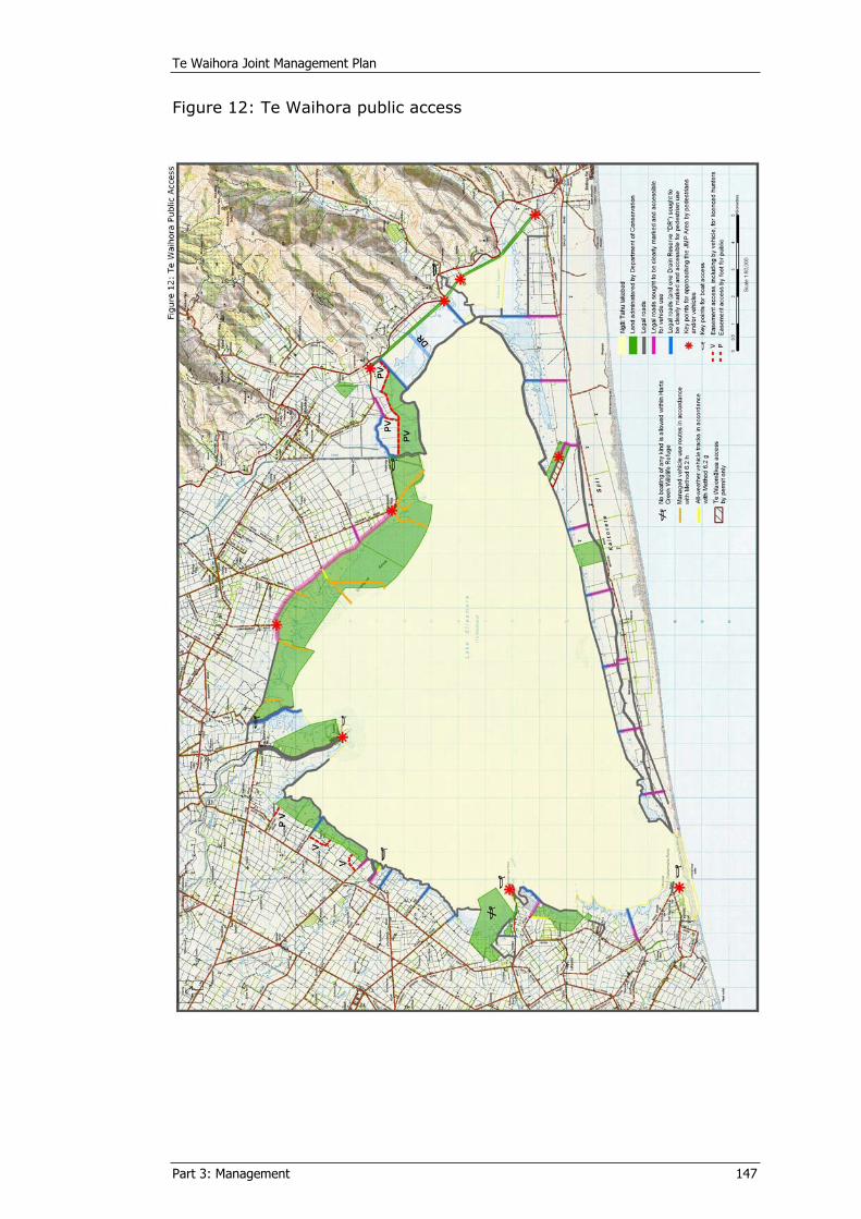
Te Waihora Joint Management Plan
Part 3: Management 147
Figure 12: Te Waihora public access

Te Waihora Joint Management Plan
Part 3: Management 149
7 COMMERCIAL AND OTHER ACTIVITIES NGÄ MAHI ARUMONI ME ËTAHI ATU MAHI
Relevant Objectives Ngä Paetae
(Repeated from Part 2, 8.6)
(1) The mahinga kai status of Te Waihora and the Ngäi
Tahu ownership of the Ngäi Tahu lakebed are
recognised in evaluating activities that require a
concession or permit within the Joint Management
Plan Area.
(2) All activities that require a concession or permit
within the Joint Management Plan Area are
compatible with the other objectives and policies of
this Plan.
7.1 Commercial activities Ngä mahi arumoni
Policies Ngä kaupapa
[4.4.5, 7.2.1] 7.1.1 To require where necessary, a permit from Te Rünanga, or a concession from the Minister of Conservation, for any structure or use associated with commercial activity within the JMP Area.
7.1.2 To consider all applications for a permit or concession, and manage permits and concessions, in accordance with the relevant legislation and the objectives and other policies of this Plan, and any other relevant policy documents of Ngäi Tahu and the Department as it relates to either the Ngäi Tahu lakebed or the lands administered by the Department respectively, and aim for consistency between these processes where possible.
7.1.3 Within the JMP Area, all existing drains and stopbanks should be managed to best be consistent with management for “mahinga kai, conservation and other purposes”, and any new drains should be consistent with management for “mahinga kai, conservation and other purposes”.
7.1.4 To avoid any adverse effects of agricultural landuse within the JMP Area on mahinga kai and conservation values.
Te Waihora Joint Management Plan
Part 3: Management 150
7.1.5 To encourage the sustainable management of commercial fisheries within Te Waihora in recognition of the importance of the mahinga kai and conservation values.
7.1.6 Extraction of shingle, sand or soil from lands administered by the Department within the JMP Area should not be permitted.
7.1.7 To not allow the commercial extraction of shingle, sand, or other minerals from the Ngäi Tahu lakebed.
7.1.8 To ensure tourism activities within the JMP Area are consistent with the objectives and other policies of this plan and: (a) serve to increase awareness of the area through
interpretation and sensitive use, and/or (b) are consistent with mahinga kai and
conservation values of Te Waihora.
7.1.9 Ngäi Tahu will further their involvement in commercial activities at Te Waihora based on environmental, cultural and commercial best practice.
7.1.10 The Department will support Ngäi Tahu in the identification of concession opportunities that will help achieve conservation outcomes at Te Waihora
7.1.11 To manage any aircraft use in accordance with policy 6.3.6.
Explanatory note Te kupu whakamähukihuki
“As f a r a s t h e e e l f i s h e r y g o e s , I ’ v e a lway s s e e n o t h e r o p t i o n s a pa r t f r om j u s t a w i l d
f i s h e r y . We ’ v e a lway s b e e n i n t e r e s t e d i n aqua cu l t u r e . . . I t h i n k i t ’ s a v e r y imp o r t a n t
i n du s t r y . Th e r e s h o u ld b e a l l owan c e s mad e f o r i t , f o r l o c a l w o r k a nd f o r t h e g o o d o f t h e
f i s h e r y a nd e v e r y t h i n g e l s e . ”
Tr e v o r Gou ld
“The numb e r s o f e e l i n t h e l a k e ha v e f a l l e n . The r e wa s n o c omme r c i a l f i s h e r y b a c k i n t h o s e
d a y s s o i f y o u d i d n ’ t t a k e a l o t f r om t h e l a k e y o u d i d n ’ t h a rm t h e l a k e . ”
Mal c o lm Ward s
It is anticipated that only a low level of commercial activity will occur within the Joint Management Plan Area during the life of this Plan. This will primarily be fishing, limited grazing and to a lesser extent ecotourism and filming.
People use various lands administered by the Department to undertake commercial activities. Similarly the Ngäi Tahu lakebed is also currently used for commercial purposes, including grazing and fishing. There are also potential future commercial uses within the Joint Management Plan Area including aquaculture, filming and tourism ventures.
Amongst the lands administered by the Department, some are suitable for grazing for exotic vegetation control. Other lands are being retained as buffer zones for long-term, sea level induced lake level rise. These
Te Waihora Joint Management Plan
Part 3: Management 151
developed pasture lands may be grazed by stock, including cattle, in the medium term.
The Conservation and Reserves Acts provide for commercial use where it is compatible with the conservation and protection of natural and historic resources and enjoyment by other people. The Ngäi Tahu Claims Settlement Act 1998 recognises Te Rünanga as the owner and occupier of the “bed of Te Waihora” and confers the right to control any use of the bed for commercial activity, subject to the provisions of sections 171 and 174 of the NTCSA.
Commercial activity on the Ngäi Tahu lakebed is to be controlled through a permit system akin to the Department’s concessions process. The Ngäi Tahu permit can apply to all current and potential commercial activities. Every permit application will be assessed on the merits and potential effects of the proposed activity. Similarly, all concession applications to the Department are considered on their merits, potential effects, the relevant statutory framework and this Joint Management Plan. Consultation with Ngäi Tahu on each concession application is undertaken by the Department. Conditions can be imposed and enforced to avoid, remedy, or mitigate any adverse effects of the activity, structure, or facility within the JMP Area or on visitors to the area. Monitoring of concessions and permits will become more important if visitor use increases. Te Rünanga and the Department need to be fully aware of any adverse effects of commercial activities, including cumulative effects, if they are to manage them effectively. For this reason any new concessions and permits granted for the JMP Area should include monitoring provisions which enable the terms and conditions of the concession or permit to be reviewed as necessary to ensure that any adverse effects can be avoided, remedied, or mitigated. Approved monitoring programmes can then be established to specifically address the issues of concern and provide a consistency of approach and to enable comparisons to be made with future monitoring.
Some areas can be managed as köhanga or recreational and customary use areas only, by controlling the placement of fishing nets or associated stakes and anchors where they would be in contact with the Ngäi Tahu lakebed. Some areas of Te Waihora are already closed to commercial fishing under the Fisheries (South East Area Commercial Fishing) Regulations 1986, including in any river or stream that flows into Te Waihora; areas of Te Waihora within a 1.2 kilometre radius of the mouths of the Irwell River/Waiwhio, Selwyn River/Waikirikiri, Halswell River/Huritini, Harts Creek/Waitatari, LII River/Ararira and within the waters of Te Korua, near Taumutu.22
Methods Ngä ritenga
7.1a Ensure that all commercial activities within the JMP Area are authorised.
7.1b Ngäi Tahu will implement a permitting system, akin to the Department’s concessions process, so that all commercial activities within the JMP Area are managed in an integrated manner, consistent with the objectives and policies of this Plan.
22 Te Waihora Eel Management Plan (1999) page 34.
Te Waihora Joint Management Plan
Part 3: Management 152
7.1c Ensure all drainage and stopbank activities within the JMP Area, and seek that those outside of the area: (a) Avoid, remedy or mitigate adverse effects on
mahinga kai and conservation values. (b) Avoid the introduction or spread of exotic species. (c) Adhere to best practice drain maintenance methods
that are consistent with management for “mahinga kai, conservation and other purposes”, as far as practical.
7.1d For areas that are not fenced, developed pasture, then licences or permits where appropriate may be granted to graze sheep.
7.1e For areas that are fenced, developed pasture away from the wetland edge and held by the Department for long-term lake level or wetland boundary change, then licences where appropriate may be granted to graze sheep or other stock.
7.1f Require as a condition of grazing concessions/permits, the erection and maintenance of fences to exclude stock from areas of significant mahinga kai, conservation, or other cultural value.
7.1g Any grazing licences or leases granted by Te Rünanga/the Department respectively, should permit non-vehicular public access, except that where such licences include part of the Christchurch Little River Railtrail then bicycles should also be permitted.
7.1h Ngäi Tahu and the Department, the latter to the extent that land administered by the Department is involved, will manage the two areas identified on Error! Reference source not found. as customary and recreational use areas and/or köhanga by controlling the placement of fishing nets, associated stakes and anchors, or other commercial activities where they would be in contact with the Ngäi Tahu lakebed.
7.1i Support Ministry of Fisheries gazetted areas closed for commercial fishing, including the rivers and streams flowing into Te Waihora and the waters of Te Korua.
7.1j Commercial fishing on lands administered by the Department, except within Harts Creek Wildlife Management Reserve and Waihora Scientific Reserve and on those areas shown on Error! Reference source not found., may be allowed where the commercial fisher holds a permit from Ngai Tahu for fishing on the adjoining Ng i Tahu lakebed.
7.1k Te Rünanga o Ngäi Tahu will request that the Ministry of Fisheries seeks its approval for any new fishing methods that may impact on the bed of Te Waihora.
Te Waihora Joint Management Plan
Part 3: Management 153
7.1l For activities affecting the Ngäi Tahu lakebed the issuing of a permit is at the discretion of Te Rünanga and if approving a permit, appropriate conditions should be imposed to avoid, remedy, or mitigate any potential effects that the permited activity may have on the Ngäi Tahu lakebed and on mahinga kai, other cultural uses, or conservation values.
7.1m Ngäi Tahu will require the appropriate marking of commercial fishing stakes on Ngäi Tahu lakebed, and advocate to the Ministry of Fisheries enforcement of this under fisheries legislation.
7.2 Other activities Ngä mahi kë
Policies Ngä kaupapa
[7.1.1] 7.2.1 To consider all applications for utilities, structures and easements within the JMP Area in accordance with the relevant legislation and the objectives and policies of this Plan where: (a) Their purposes are essential for the public good
and cannot reasonably be achieved outside of the JMP Area.
(b) Their adverse effects can be avoided, remedied or mitigated.
7.2.2 The Minister should not permit any buildings for exclusive private use on lands administered by the Department, except as provided for at the Lower Selwyn Huts.
[4.2.5] 7.2.3 To ensure that allowing the Lower Selwyn Huts settlement to remain on site does not constrict or restrain Te Waihora lake levels or management for “mahinga kai, conservation and other purposes” within the JMP Area.
7.2.4 Ngäi Tahu will consider any applications for buildings and structures on Ngäi Tahu lakebed consistent with the other policies and methods of this Plan, where applicable.
7.2.5 To permit organised sporting and other competitive events within the JMP Area where they are consistent with: (a) The ability of Ngäi Tahu to undertake mahinga
kai(b) The protection of indigenous plants and animals
and their habitats (c) Other use of the JMP Area (d) The legislative purposes for which the land is
held.
Te Waihora Joint Management Plan
Part 3: Management 154
Explanatory note Te kupu whakamähukihuki
Along with the use of the Joint Management Plan Area for commercial purposes, use can occur for other purposes not necessarily associated with the conservation of natural and historic resources or management for mahinga kai purposes. Other activities currently occurring within the Joint Management Plan Area are outlined in Part 2, 7.2.
The erection of structures on reserves or conservation land requires the approval of the Minister under the Reserves or the Conservation Acts. The erection of structures on Ngäi Tahu land within the JMP Area requires the authority of Te Rünanga as the landowner.
Section 174 of the NTCSA provides that “rights of ownership, use and occupation of the structures in or upon the bed of Te Waihora, existing on 21 November 1997… continue in effect for as long as, and to the extent that, such rights otherwise remain lawful.” Such existing structures are listed in Schedule 10 of the NTCSA. The lawful nature of some of these structures is uncertain and some are regarded as essential for good management of Te Waihora by other agencies.
Methods Ngä ritenga
[6.1d] 7.2a Ensure that all structures within the JMP Area are authorised and develop a G.I.S mapping record of all such structures, markers and buoys allowed in accordance with method 6.1n
[3d] 7.2b Manage the Lower Selwyn Huts in accordance with the objectives and policies of this Plan.
7.2c Consider all applications to conduct or engage in any competitive sporting event within the JMP Area in accordance with relevant legislation and the policies and other methods of this Plan.
7.2d Allow for the continued use of existing ECan lake-level gauges and coastal erosion monitoring poles, Ministry of Fisheries commercial fishing restriction markers, Community and Public Health signage and monitoring activity of those agencies within the JMP Area.
7.2e Recognise the easements in favour of Environment Canterbury to enable the opening and closing of Te Waihora to the sea, and the maintenance of the Selwyn River/Waikirikiri delta spoil banks and channel.
Te Waihora Joint Management Plan
Part 3: Management 155
7.3 Research and MonitoringRangahau me te aroturuki
Policies Ngä kaupapa
7.3.1 To encourage and undertake research, in accordance with relevant legislation, for the benefit of the management of the JMP Area and/or mahinga kai and conservation knowledge in general about Te Waihora, provided that such research does not detract from management for “mahinga kai, conservation and other purposes” within the JMP Area and is consistent with the objectives and other policies of this Plan.
7.3.2 Ngäi Tahu may develop contractual arrangements with researchers where the research, either in whole or in part, is commercially oriented.
7.3.3 To acknowledge the cultural, spiritual, historic and traditional association of Ngäi Tahu with taonga species and cultural materials, and have particular regard to the Protocol for cultural materials.
7.3.4 To recognise and respect the Ngäi Tahu whakapapa and kaitiaki relationship with natural resources when considering research and scientific use within the JMP Area and take a cautious approach to scientific use of the area.
[5.1] 7.3.5 Ngäi Tahu will protect the intellectual property rights of Ngäi Tahu Whänui and the Department will acknowledge and take account of these where Ngäi Tahu has advised the Department of them.
7.3.6 To monitor the JMP Area to improve management for “mahinga kai, conservation and other purposes”.
7.3.7 Recognise and respect the use of cultural monitoring practices and traditional Ngäi Tahu knowledge when designing and implementing research and monitoring programmes.
Explanatory note Te kupu whakamähukihuki
Research can fill gaps in knowledge of the natural and historic resources of Te Waihora, natural processes at work and use of the area by visitors. Where this research has little or no impact on the environment, it may be carried out in accordance with the objectives and policies of this Joint Management Plan. This can assist management, public safety and interpretation of the features of the Te Waihora environment to visitors.
Researchers require prior approval where impacts on JMP Area values are likely, such as through collecting samples or erecting structures within the JMP Area. The taking of samples for scientific purposes could have adverse effects on the values of Te Waihora. Applications for collecting purposes are best assessed through the permit or concession process as this allows for an assessment to be made of possible adverse effects. It also
Te Waihora Joint Management Plan
Part 3: Management 156
allows conditions to be placed on the activity to avoid, remedy, or mitigate any potential adverse effects. If the effects of collecting samples become unacceptable in specific areas, further requests to collect samples from these areas can be declined.
The Protocol for managing cultural materials includes provisions requiring consultation in respect of any competing request for plant and animal cultural materials, such as for research (see Appendix 6, clause 4.3(d)).
Applications to undertake research should be lodged with Te Rünanga and the Department at least two months before the proposed research commences. This enables the proposal to be assessed to ensure that it can be undertaken within the Joint Management Plan Area without causing an adverse effect on the natural, historic, or cultural values, or on visitors to the area. Where a permit or a concession is required, the applicant should check about processing requirements with Te Rünanga and/or the Department as appropriate, depending on the lands involved. Te Rünanga and/or the Department may wish to receive copies of all reports on research undertaken within the Joint Management Plan Area.
Methods Ngä ritenga
7.3a Ngäi Tahu will request that they are consulted on all research undertaken at Te Waihora.
7.3b Require permits or concessions from Te Rünanga or the Minister respectively, for research within the JMP Area, where impacts on JMP Area values are likely.
7.3c Require applications to undertake research to be lodged with Te Rünanga and/or the Department as appropriate, for the lands involved, at least two months before the proposed research commences.
[4.3k] 7.3d Ngäi Tahu will seek involvement in collaborative research relationships where appropriate.
7.3e As a condition of approval for research undertaken within the JMP Area a copy of the research report should be provided to Te Rünanga and/or the Department as the respective approving authorities or authority.
7.3f Develop relationships with education providers and encourage educational research in the area where such research improves understanding of Te Waihora.
7.3g If any cultural materials are subject to a research application the Department will consult with Te Rünanga in accordance with the Protocol for cultural materials.
7.3h Encourage researchers to consider using cultural monitoring practices, and to include traditional Ngai Tahu knowledge in their research programmes.
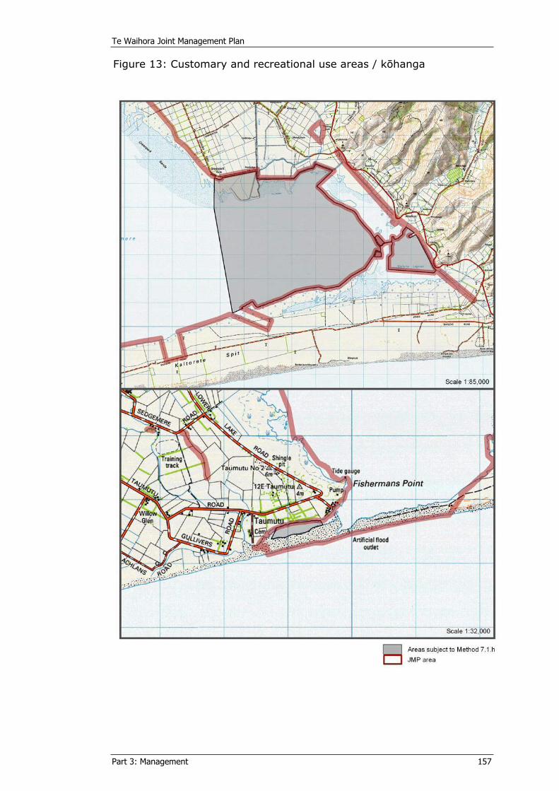
Te Waihora Joint Management Plan
Part 3: Management 157
Figure 13: Customary and recreational use areas / köhanga
Te Waihora Joint Management Plan
Part 3: Management 158
8 COMMUNITY RELATIONSNGÄ RARATA-Ä-HAPORIIn carrying out the objectives and policies outlined in sections 1 to 7 of this part of the Joint Management Plan, there is a need for on-going work with the community.
Policies Ngä kaupapa
8.1 To establish and maintain effective working relationships with those communities, individuals, and organisations that have statutory roles or who are interested in: (a) the preservation and protection of natural,
historic, and landscape values within the JMP Area, and/or
(b) the protection and enhancement of mahinga kai and Ngäi Tahu cultural values, and/or
(c) compatible recreational use and enjoyment of Te Waihora, and/or
(d) the sustainable management of natural and physical resources on land not within the JMP Area but adjoining the JMP Area.
8.2 Provide advice in the development of education material about Te Waihora and its mahinga kai and conservation values.
8.3 Work with North Canterbury Fish and Game Council, the Waihora Ellesmere Trust, community groups, recreational groups and adjoining landowners to achieve shared objectives and promote the mahinga kai and conservation values of Te Waihora.
Explanatory note Te kupu whakamähukihuki
This Joint Management Plan is primarily a land management plan. The primary community relations focus is therefore with communities using the lands. Although Te Rünanga and the Department can appropriately manage the Joint Management Plan Area, it is recognised that the area does not exist in isolation from the waters of Te Waihora, or from the surrounding catchment, tributaries and the sea. In acknowledging the integrated nature of management through the Ngäi Tahu ki uta ki tai philosophy and the ecological approach adopted by the Department, it is important to work with the community and other agencies involved in the management of these wider resources.
The Maimai Agreement and the process in the NTCSA for developing this Joint Management Plan recognise the North Canterbury Fish and Game Council as a key party.
Te Waihora Joint Management Plan
Part 3: Management 159
The Department has a Conservation with Communities Strategy (2002) that promotes policies and methods such as those included in this section as an effective way of achieving good conservation outcomes. Ngäi Tahu similarly works with the community to aid better understanding of Ngäi Tahu values and to promote environmental outcomes that recognise and support these values.
Through establishing and maintaining effective working relationships with adjoining landowners, managers and key interest groups, Ngäi Tahu and the Department may learn new management practices and be able to advocate for practices that will avoid, remedy, or mitigate adverse effects on the Joint Management Plan Area. Mutual benefits may be found with groups such as the Waihora Ellesmere Trust, Lake Settlers Association, Lake Ellesmere Fishers Association, Ornithological Society of New Zealand, Lincoln and Canterbury Universities, Landcare Trust and Resource Care landowner groups, and the Christchurch Little River Railtrail Trust.
The Waihora Ellesmere Trust was established in 2003 from the Lake Ellesmere/Te Waihora Issues Group, a group representing a wide range of interests, including many of those mentioned above. The group initially formed to prepare a Community Strategy24 for Te Waihora and its lower catchment, assisted by Environment Canterbury and is now implementing that strategy.
It is important to keep interested parties informed of any activities or works that may affect their interests within the JMP Area. Such activity would include, for example, public access provisions affecting gamebird hunting. It is also important to be available to the community to assist in the provision of advice and education on mahinga kai, conservation, and other cultural values of Te Waihora.
Methods Ngä ritenga
8a Use a variety of community relations methods, including direct consultation, electronic and other newsletters, public notices and field days, to enable interested parties to be kept informed about the management of the JMP Area, and to promote understanding of Te Waihora and its values generally.
[4.4c]
[4.1b]
[6.2c]
8b Maintain good neighbour relations with adjoining landowners, including by: (a) Undertaking boundary control plant pest
responsibilities in accordance with regional pest management strategies.
(b) Meeting boundary fencing responsibilities. (c) Identifying access routes along unformed legal
roads.
8c Work with community groups, including those representing landowner, commercial, recreational and environmental interests, as well as universities and other organisations where their work would assist in the protection and enhancement of the mahinga kai and conservation values of Te Waihora.
Te Waihora Joint Management Plan
Part 3: Management 160
8d Work with the Lake Ellesmere Fishermen’s Association and Ministry of Fisheries in regard to the Te Waihora Eel Management Plan (1999), the permit system and other fisheries matters.
Te Waihora Joint Management Plan
Part 3: Management 161
9 STATUTORY LAND MANAGEMENTWHAKAMANA-Ä-TURE I TE WHENUA ME TE WHAKAHAERE MAHEREIn carrying out the objectives and policies outlined in sections 1 to 8 of this part of the Joint Management Plan, there is a need for on-going land administrative actions.
Policies Ngä kaupapa
9.1 To seek protected area categorisations or re-categorisations that best reflect the purposes for which the lands administered by the Department will be managed under this Plan.
9.2 To investigate conservation park status as a collective categorisation for the lands administered by the Department within the Te Waihora environment.
[2.4.6] 9.3 To devise and use a collective name for the Joint Management Plan Area, while still recognising the distinct legal entities and land management within the Area.
9.4 To seek the management of adjoining Crown riverbeds and other Crown lands consistently with the management of Te Waihora for “mahinga kai, conservation and other purposes”, or the transfer of those lands or their land management to Te Rünanga and/or the Department.
9.5 To include within the area to which this Joint Management Plan applies, where appropriate, all future land acquired by Te Rünanga or the Department within 500 metres of the bed of Te Waihora (or as otherwise agreed by Te Rünanga and the Department).
9.6 To seek, by agreement with the owners, that additional areas associated with the JMP Area be managed to the extent accepted by the owner(s) in accordance with this Joint Management Plan.
Explanatory note Te kupu whakamähukihuki
The area for which this Joint Management Plan has been prepared (the JMP Area) involves lands administered by the Department under the Reserves and Conservation Acts, as well as Te Rünanga freehold land (see Part 1, section 3 and Appendix 1). Additional lands can be added to the JMP Area by agreement of the Minister and Te Rünanga or other landowners under sections 177(2)(c) and (d) of the NTCSA.
Te Waihora Joint Management Plan
Part 3: Management 162
The lands administered by the Department have a variety of protected area categories i.e. reserve classifications or conservation area status. This variety in part reflects earlier management aims that may or may not apply today and largely does not reflect an integrated view for the management of all the lands. Both these matters need consideration in view of the objectives of this Plan. The Department has a formal procedure for the categorisation or re-categorisation of protected areas and this needs to be followed. However, in considering the categorisation of new lands administered by the Department or when looking at reserve classification changes, preference can be given to using a uniform "conservation area" status, unless there is a particular value for the land that is clearly best protected through a specific reserve classification or other categorisation.
There can be merit in having a collective categorisation for all or most of the Te Waihora protected areas. Conservation park status under section 19 of the Conservation Act is one means of doing this, but would require that reserves be re-categorised to conservation area status. Alternatively a collective name for the protected areas may suffice.
In addition, for the Ngäi Tahu lakebed and other mahinga kai areas on lands owned or administered by Ngäi Tahu within the Te Waihora environment, Ngäi Tahu can consider the application of a “Mahinga Kai Cultural Park” as outlined in Part 3 section 2.4. The establishment of both a conservation park and a Mahinga Kai Cultural Park, with a combined name, could help reflect the integrated management of the JMP Area.
Five Crown riverbed areas (Kaituna, Halswell/Huritini, LII/Ararira,Selwyn/Waikirikiri, Irwell/Waiwhio) and two drain reserves adjoin the Joint Management Plan Area (see Figure 4 and Appendix 2). Little active management occurs within these areas other than for local authority drainage works and weed and pest control by the Department and Environment Canterbury for biodiversity protection reasons. There is considerable potential to better manage these areas for mahinga kai and conservation purposes while still recognising their drainage functions, in conjunction with their adjoining unformed legal roads, by working with the district councils that administer the legal roads and with landowners who adjoin and generally utilise the unformed legal roads. A management plan (Grove, 2004) has been prepared for the wetlands on the Kaitorete Spit which recommends that management of this area should be consistent with the aims of the Joint Management Plan in terms of grazing and pest control and conservation management.
Ecosystems method 4.1k also provides for road stopping actions and the land being added to the JMP Area.
Procedures for reviewing and amending this Joint Management Plan are set out in Part 4 of this Plan. It is not considered that it would be necessary to review the Plan should re-categorisations of lands administered by the Department occur, as their purposes for management would still be consistent with the objectives of the Plan.
Te Waihora Joint Management Plan
Part 3: Management 163
Methods Ngä ritenga
9a Review the categorisations of the lands administered by the Department within the JMP Area.
9b The Department will investigate and seek submissions under section 18 of the Conservation Act, and if supported, request the Minister of Conservation to gazette the conservation areas within the JMP Area as a conservation park.
[2.4.6] 9c To consider using the name "Te Waihora Mahinga Kai and Conservation Park" should a “Mahinga Kai Cultural Park” and a conservation park be approved.
[Figure 4]
9d Seek the transfer of the lands, or the transfer of management responsibility, for those lands marked “CR” in Appendix 2, from Land Information New Zealand to Te Rünanga or the Department.
9e Work with district, city and regional councils, landowners and interested parties, to: (a) incorporate additional lands into the JMP Area with
ownership passing to the Crown and/or Te Rünanga, or
(b) incorporate additional land into the JMP Area with ownership staying as at present, or
(c) seek that additional lands are managed, whether by covenant agreement, management agreement, or informally, consistent with the objectives of the JMP,
with attention being given to the following specific areas (see Figure 4 and Appendix 2): (i) Selwyn District Council Esplanade Reserve near
Te Waihora (SDC 002). (ii) Christchurch City Council reserve near Te Waihora
(CCC 001).(iii) Christchurch City Council endowment land on
Kaitorete Spit (CCC 002).(iv) ECan endowment land on Kaitorete Spit (CRC 001).(v) North Canterbury Fish and Game Council freehold
Boggy Creek ‘reserve’ (F&G 001).(vi) Any stopped legal roads in accordance with method
4.1k.


PART 4: IMPLEMENTATION
AND REVIEW TE WHAKATINANATANGA
ME TE AROMATAWAI

Te Waihora Joint Management Plan
Part 4: Implementation and Review 167
1 HOW WILL THE JOINT MANAGEMENT PLAN BE IMPLEMENTED? ME PËHEA TE WHAKATINANA I TE MAHERE?This Part of the Joint Management Plan outlines how Te Rünanga and the Department will work, both together and individually, to realise the stated objectives and implement the policies and methods outlined in Part 3 of this Plan.
Implementation will be dependent on the legislative and other functions of the two bodies and, within any given timeframe, dependent on the available funding and stated priorities of the two organisations.
Implementation will require action from both Te Rünanga and the Department, as well as other agencies and landowners.
The methods within Part 3 are of three types:
1. Land management methods within the Joint Management Plan Area including:
a. Te Rünanga o Ngäi Tahu management on Ngäi Tahu lakebed.
b. Department of Conservation management on land administered by the Department.
c. Joint management on either land where agreed.
2. Natural and historic resource management methods withinor beyond the JMP Area, including:
a. Department management of protected species.
b. Department management within its Rural Fire Authority Area.
3. Advocacy and working with methods within or beyond the JMP Area, but which lie outside of the land or other natural and historic resource management functions of Te Rünanga and/or the Department, including:
a. Encouraging other landowners to carry out particular management actions on their own lands.
b. Advocating for particular environmental outcomes
c. Working with other agencies with management roles and responsibilities within the Te Waihora environment, such as for water and fisheries management, to seek particular management action.
d. Working with other agencies and community groups to support their initiatives and policies where these will further the objectives of this Plan.

Te Waihora Joint Management Plan
Part 4: Implementation and Review 168
1.1 The Department will…Mä Te Papa Atawhai e…
Ensure the national and international significance of Te Waihora is considered when establishing national priorities. Work within established national priorities. Prepare annual business plans in consultation with Ngäi Tahu, with regard to the provisions of this Joint Management Plan. Notify Te Rünanga and Papatipu Rünanga/Te Waihora Management Board when undertaking works within the Joint Management Plan Area.
Values of Te Waihora
Policies
Objectives
Land management methods
Within the JMP Area:
• Ngäi Tahu lakebed.
• Land administered by the Department.
Outcomes
Plan Monitoring
Review/Amend
Natural and Historic Resource management
methods
• Within the JMP Area
• Outside of the JMP Area
Advocacy methods to other agencies and
functions:
• Within the JMP Area
• Outside of the JMP Area
Te Waihora Joint Management Plan
Part 4: Implementation and Review 169
1.2 Te Rünanga will…Mä Te Rünanga o Ngäi Tahu e…
Fund implementation methods to directly benefit Ngäi Tahu Whänui and/or the wider Te Waihora environment. Prepare an implementation strategy for Te Rünanga o Ngäi Tahu specific to the management of the tribal property. Prepare annual business plans with regard to the provisions of this Joint Management Plan. Maintain the Te Waihora Management Board as a forum for ongoing advice to Te Rünanga for the management of the Ngäi Tahu lakebed. Nominate Ngäi Tahu representatives to the Canterbury Aoraki Conservation Board in recognition of the Board’s role in the ongoing operation of the Plan. Apply any income from permits granted for the Ngäi Tahu lakebed to the Ngäi Tahu implementation of this Plan and to enhance Ngäi Tahu values of Te Waihora.
1.3 Working together we will…Me mahitahi ki te…
Provide for and support an ongoing forum between the Te Waihora Management Board, Te Rünanga and the Department for the implementation of this Plan and other relevant catchment and operational issues. Develop and prepare joint operational plans, business plans, memoranda of understanding, or protocols as mutually agreed to implement this plan Develop and jointly administer any bylaws and regulations subsequently approved for the JMP Area. Keep each other informed of all requests for permits/concessions within the JMP Area, unless otherwise agreed.Use the resources generated by the Maimai Agreement to assist in the implementation of this Plan and any other mutually agreed projects between North Canterbury Fish and Game Council, the Department and Te Rünanga. Request comment from the Canterbury Aoraki Conservation Board on the implementation of this Plan and on any proposed change in status or classification of any of the lands administered by the Department within the JMP Area. Undertake co-operative biodiversity actions, such as the purple loosestrife campaign with Environment Canterbury and the Christchurch City Council. Promote joint and co-operative research. Co-ordinate on RMA advocacy where appropriate. Work with the Waihora Ellesmere Trust, Christchurch Little River Railtrail Trust, Landcare and Streamcare Groups and if necessary, develop a memorandum of understanding and/or protocols for working together.
Te Waihora Joint Management Plan
Part 4: Implementation and Review 170
Work with district and regional councils to coordinate on permit, concession and resource consent application requirements where multiple requirements occur for proposed activities within the Joint Management Plan Area.
1.4 Dispute resolution Körerorero-ä-whareShould there be any dispute between Te Rünanga and the Crown arising out of the implementation of the Joint Management Plan then Clause 11.6.23, Schedule 12, of the NTCSA provides formal provisions for resolving such a dispute, if it cannot be dealt with through the day-by-day working arrangements between Te Rünanga and the Department.
Te Waihora Joint Management Plan
Part 4: Implementation and Review 171
2 PLAN MONITORING AND REPORTINGTE AROTURUKI ME TE WHAKATAKOTORANGA
2.1 Plan Monitoring Te aroturuki The Plan will be monitored against the 21 objectives listed at the end of Part 2 and repeated at the beginning of each section of Part 3 of this Joint Management Plan.
Many of the objectives are long-term in their focus and will not be fully achieved in the ten-year timeframe of this first Te Waihora Joint Management Plan. Plan monitoring will measure the extent to which these objectives are being achieved and the degree to which effective relationships have developed with other agencies, groups or individuals similarly involved in achieving them.
The gathering of information through the monitoring of permit and concession conditions, environmental monitoring programmes and research ventures can help identify new information for Plan review or amendment.
2.2 Reporting WhakatakotorangaReporting on the plan objectives will assist in plan implementation and review and will include:
Annual reporting to each other (Te Rünanga and the Department). Annual reporting to the Canterbury Aoraki Conservation Board. Reporting, as requested, to the Office of Treaty Settlements. Reporting to the IUCN in accordance with New Zealand’s requirements under the Ramsar Convention on Wetlands should Te Waihora be formally recognised as a Wetland of International Importance.
Te Waihora Joint Management Plan
Part 4: Implementation and Review 172
3 REVIEW TE AROTAKEProcedures for reviewing and amending this Joint Management Plan are provided for in Clause 11.6.20, Schedule 12, of the Ngäi Tahu Claims Settlement Act. These procedures state:
The Secretary of Te Rünanga and the Director-General may at any time agree to initiate a review and/or amendment, in whole or in part, of the Joint Management Plan. The Joint Management Plan must be reviewed as a whole within 10 years after approval, although this can be extended by agreement of both parties. If the proposed amendment will not materially affect the objectives or policies expressed in the Joint Management Plan then it need not be publicly notified.
The Joint Management Plan will be reviewed at ten-yearly intervals from its date of first approval or as mutually agreed by Te Rünanga and the Department.
APPENDICES
ÄPITIHANGA

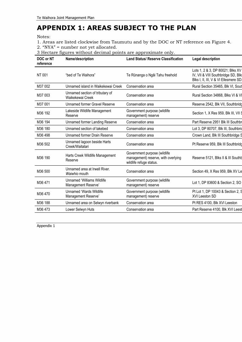
Te Waihora Joint Management Plan
Appendix 1
APPENDIX 1: AREAS SUBJECT TO THE PLAN Notes: 1. Areas are listed clockwise from Taumutu and by the DOC or NT reference on Figure 4. 2. “NYA” = number not yet allocated. 3 Hectare figures without decimal points are approximate only. DOC or NT reference
Name/description Land Status/ Reserve Classification Legal description
NT 001 “bed of Te Waihora” Te Rünanga o Ngäi Tahu freehold Lots 1, 2 & 3, DP 80021; Blks XV IV, VII & VIII Southbridge SD, BlksBlks I, II, III, V & VI Ellesmere SD.
M37 002 Unnamed island in Waikekewai Creek Conservation area Rural Section 35465, Blk VI, South
M37 003 Unnamed section of tributary of Waikekewai Creek Conservation area Rural Section 34868, Blks VI & VI
M37 001 Unnamed former Gravel Reserve Conservation area Reserve 2542, Blk VII, Southbridg
M36 192 Lakeside Wildlife Management Reserve
Government purpose (wildlife management) reserve Section 1, X Res 959, Blk III, VII S
M36 194 Unnamed former Landing Reserve Conservation area Part Reserve 2951 Blk III SouthbrM36 180 Unnamed section of lakebed Conservation area Lot 3, DP 80707, Blk III, SouthbridM36 498 Unnamed former Drain Reserve Conservation area Crown Land, Blk III Southbridge S
M36 502 Unnamed lagoon beside Harts Creek/Waitatari Conservation area Pt Reserve 959, Blk III Southbridg
M36 190 Harts Creek Wildlife Management Reserve
Government purpose (wildlife management) reserve, with overlying wildlife refuge status.
Reserve 5121, Blks II & III Southb
M36 500 Unnamed area at Irwell River.Waiwhio mouth Conservation area Section 49, X Res 959, Blk XV Le
M36 471 Unnamed ‘Williams Wildlife Management Reserve’
Government purpose (wildlife management) reserve Lot 1, DP 83600 & Section 2, SO
M36 470 Unnamed ‘Wards Wildlife Management Reserve’
Government purpose (wildlife management) reserve
Pt Lot 1, DP 10043 & Section 2, SXVI Leeston SD
M36 188 Unnamed area on Selwyn riverbank Conservation area Pt RES 4100, Blk XVI Leeston M36 473 Lower Selwyn Huts Conservation area Part Reserve 4100, Blk XVI Leest
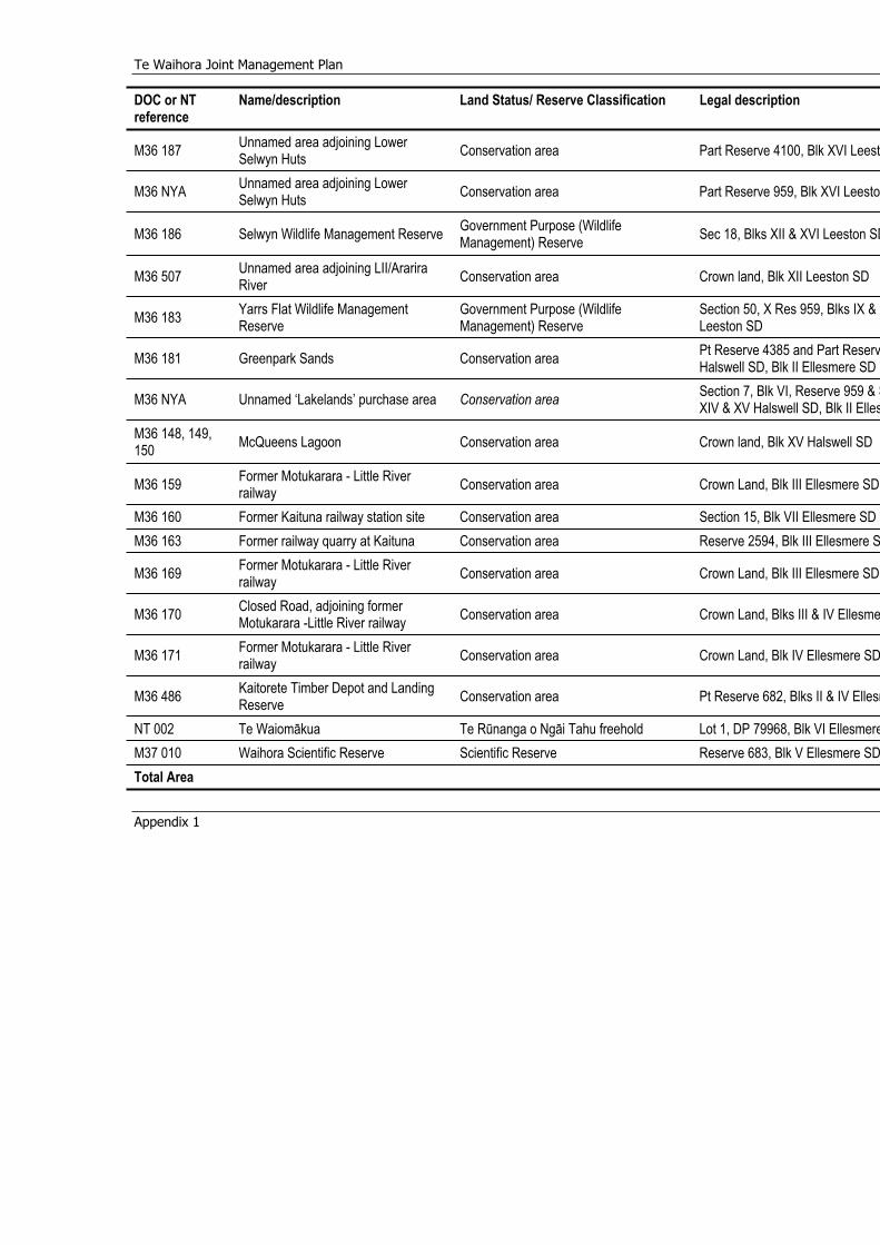
Te Waihora Joint Management Plan
Appendix 1
DOC or NT reference
Name/description Land Status/ Reserve Classification Legal description
M36 187 Unnamed area adjoining Lower Selwyn Huts Conservation area Part Reserve 4100, Blk XVI Leest
M36 NYA Unnamed area adjoining Lower Selwyn Huts Conservation area Part Reserve 959, Blk XVI Leesto
M36 186 Selwyn Wildlife Management Reserve Government Purpose (Wildlife Management) Reserve Sec 18, Blks XII & XVI Leeston SD
M36 507 Unnamed area adjoining LII/Ararira River Conservation area Crown land, Blk XII Leeston SD
M36 183 Yarrs Flat Wildlife Management Reserve
Government Purpose (Wildlife Management) Reserve
Section 50, X Res 959, Blks IX & XLeeston SD
M36 181 Greenpark Sands Conservation area Pt Reserve 4385 and Part ReservHalswell SD, Blk II Ellesmere SD
M36 NYA Unnamed ‘Lakelands’ purchase area Conservation area Section 7, Blk VI, Reserve 959 & SXIV & XV Halswell SD, Blk II Elles
M36 148, 149, 150 McQueens Lagoon Conservation area Crown land, Blk XV Halswell SD
M36 159 Former Motukarara - Little River railway Conservation area Crown Land, Blk III Ellesmere SD
M36 160 Former Kaituna railway station site Conservation area Section 15, Blk VII Ellesmere SD M36 163 Former railway quarry at Kaituna Conservation area Reserve 2594, Blk III Ellesmere S
M36 169 Former Motukarara - Little River railway Conservation area Crown Land, Blk III Ellesmere SD
M36 170 Closed Road, adjoining former Motukarara -Little River railway Conservation area Crown Land, Blks III & IV Ellesme
M36 171 Former Motukarara - Little River railway Conservation area Crown Land, Blk IV Ellesmere SD
M36 486 Kaitorete Timber Depot and Landing Reserve Conservation area Pt Reserve 682, Blks II & IV Ellesm
NT 002 Te Waiomäkua Te Rünanga o Ngäi Tahu freehold Lot 1, DP 79968, Blk VI EllesmereM37 010 Waihora Scientific Reserve Scientific Reserve Reserve 683, Blk V Ellesmere SDTotal Area
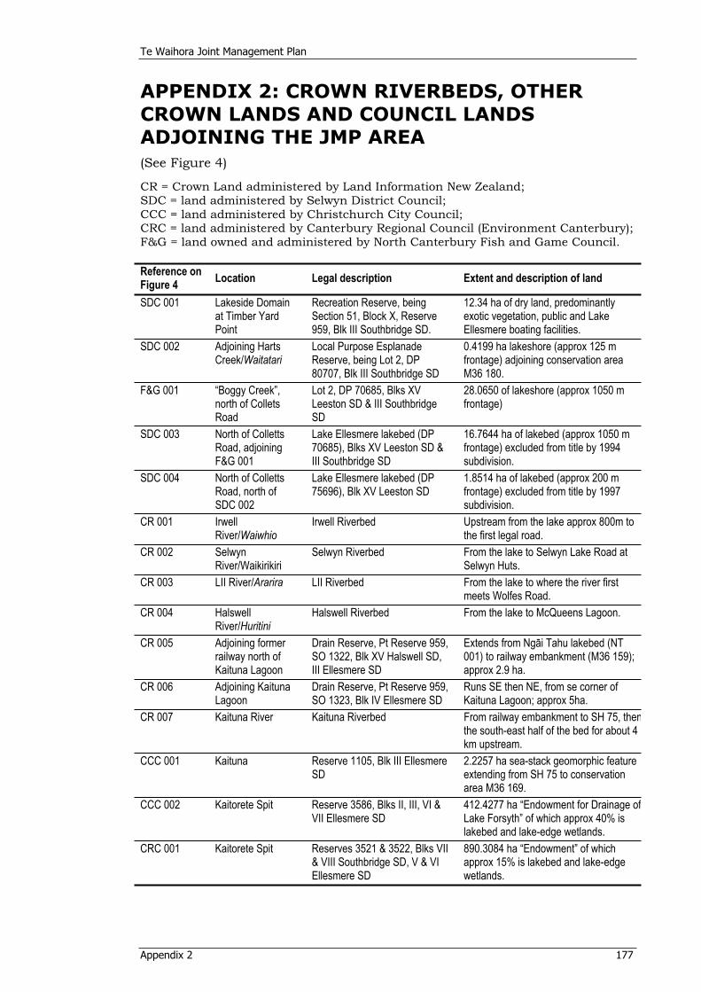
Te Waihora Joint Management Plan
Appendix 2 177
APPENDIX 2: CROWN RIVERBEDS, OTHER CROWN LANDS AND COUNCIL LANDS ADJOINING THE JMP AREA(See Figure 4)
CR = Crown Land administered by Land Information New Zealand; SDC = land administered by Selwyn District Council; CCC = land administered by Christchurch City Council; CRC = land administered by Canterbury Regional Council (Environment Canterbury); F&G = land owned and administered by North Canterbury Fish and Game Council.
Reference on Figure 4 Location Legal description Extent and description of land
SDC 001 Lakeside Domain at Timber Yard Point
Recreation Reserve, being Section 51, Block X, Reserve 959, Blk III Southbridge SD.
12.34 ha of dry land, predominantly exotic vegetation, public and Lake Ellesmere boating facilities.
SDC 002 Adjoining Harts Creek/Waitatari
Local Purpose Esplanade Reserve, being Lot 2, DP 80707, Blk III Southbridge SD
0.4199 ha lakeshore (approx 125 m frontage) adjoining conservation area M36 180.
F&G 001 “Boggy Creek”, north of Collets Road
Lot 2, DP 70685, Blks XV Leeston SD & III Southbridge SD
28.0650 of lakeshore (approx 1050 m frontage)
SDC 003 North of Colletts Road, adjoining F&G 001
Lake Ellesmere lakebed (DP 70685), Blks XV Leeston SD & III Southbridge SD
16.7644 ha of lakebed (approx 1050 m frontage) excluded from title by 1994 subdivision.
SDC 004 North of Colletts Road, north of SDC 002
Lake Ellesmere lakebed (DP 75696), Blk XV Leeston SD
1.8514 ha of lakebed (approx 200 m frontage) excluded from title by 1997 subdivision.
CR 001 Irwell River/Waiwhio
Irwell Riverbed Upstream from the lake approx 800m to the first legal road.
CR 002 Selwyn River/Waikirikiri
Selwyn Riverbed From the lake to Selwyn Lake Road at Selwyn Huts.
CR 003 LII River/Ararira LII Riverbed From the lake to where the river first meets Wolfes Road.
CR 004 Halswell River/Huritini
Halswell Riverbed From the lake to McQueens Lagoon.
CR 005 Adjoining former railway north of Kaituna Lagoon
Drain Reserve, Pt Reserve 959, SO 1322, Blk XV Halswell SD, III Ellesmere SD
Extends from Ngäi Tahu lakebed (NT 001) to railway embankment (M36 159); approx 2.9 ha.
CR 006 Adjoining Kaituna Lagoon
Drain Reserve, Pt Reserve 959, SO 1323, Blk IV Ellesmere SD
Runs SE then NE, from se corner of Kaituna Lagoon; approx 5ha.
CR 007 Kaituna River Kaituna Riverbed From railway embankment to SH 75, thenthe south-east half of the bed for about 4 km upstream.
CCC 001 Kaituna Reserve 1105, Blk III Ellesmere SD
2.2257 ha sea-stack geomorphic feature extending from SH 75 to conservation area M36 169.
CCC 002 Kaitorete Spit Reserve 3586, Blks II, III, VI & VII Ellesmere SD
412.4277 ha “Endowment for Drainage ofLake Forsyth” of which approx 40% is lakebed and lake-edge wetlands.
CRC 001 Kaitorete Spit Reserves 3521 & 3522, Blks VII & VIII Southbridge SD, V & VI Ellesmere SD
890.3084 ha “Endowment” of which approx 15% is lakebed and lake-edge wetlands.
Te Waihora Joint Management Plan
Appendix 3 178
APPENDIX 3: PRINCIPLES GUIDING APPROACHES TO HONOURING THE TREATY OF WAITANGIThe principles set out below are those of the Department and Te Rünanga respectively to guide their organisational approaches to honouring the Treaty of Waitangi.
3A: Department of Conservation Principles In 1989 the Government published “Principles for Crown Action on the Treaty of Waitangi”. The principles are:
The principle of government The principle of self management The principle of equality The principle of reasonable cooperation The principle of redress.
The way these principles are applied will depend on the particular circumstances of each case, including the statutory conservation framework and the significance to tangata whenua of the land, resource or taonga in question.
In the Conservation General Policy (2005) policies are set out that are developed from these principles. These policies are given effect throughout this Joint Management Plan.
Te Waihora Joint Management Plan
Appendix 3 179
3B: Te Rünanga O Ngäi Tahu PrinciplesPrinciples of a Te Rünanga o Ngäi Tahu Treaty framework, as approved January 2002:
1. The Treaty of Waitangi was signed between Ngäi Tahu Whänui and the Crown in 1840 at Akaroa (May 30), Ruapuke Island (June 9,10) and Ötäkou (June 13). Ngäi Tahu Whänui is, and was at the time of the signing of the Treaty, the Tangata whenua within the boundaries as confirmed in Te Rünanga o Ngäi Tahu Act 1996. (Ngäi Tahu Claims Settlement Act 1998).
2. Te Rünanga o Ngäi Tahu recognises the Crown’s right and responsibility to provide good government and to make law on behalf of all citizens of New Zealand and to protect all customary rights, aboriginal title and other rights inherent in the rangitiratanga of Ngäi Tahu Whänui (Article I & II Treaty of Waitangi).
3. The Crown exercises Käwanatanga in a manner which actively protects Ngäi Tahu rangitiratanga and mana over the land within its boundaries, as confirmed in Te Rünanga o Ngäi Tahu Act 1996, and further recognises Ngäi Tahu Whänui as tangata whenua within the takiwä of Ngäi Tahu Whänui. (Article II Treaty of Waitangi, Ngäi Tahu Claims Settlement Act 1998).
4. The Crown recognises Ngäi Tahu as the sole Treaty partner within the takiwä of Ngäi Tahu Whänui.
5. The Crown recognises Te Rünanga o Ngäi Tahu as the representative of Ngäi Tahu Whänui on all matters where any enactment requires consultation with respect to matters affecting Ngäi Tahu Whänui that consultation shall be held with Te Rünanga o Ngäi Tahu. (Te Rünanga o Ngäi Tahu Act 1996).
6. Te Rünanga o Ngäi Tahu acknowledges that they are bound by section 15.3 (a) of the Te Rünanga o Ngäi Tahu Act 1996 to consult with Papatipu Rünanga.
7. Individual members of Ngäi Tahu Whänui have a right to expect equitable access to the benefits and services provided to all New Zealand citizens by the Government of New Zealand via social and public policy. (Article I & III of the Treaty of Waitangi).
8. Te Rünanga o Ngäi Tahu seeks to hold the Crown/Government to exemplary standards of administration and leadership.
9. It is expected that the Crown/Government will also hold Te Rünanga o Ngäi Tahu to its obligations as the Treaty partner.
Te Waihora Joint Management Plan
Appendix 4 180
APPENDIX 4: MAIMAI AGREEMENT (Attachment 11.36, Deed of Settlement (1997))
THE USE AND MANAGEMENT OF MAIMAI
AN AGREEMENT made on September 23, 1997
BETWEEN:
(1) TE RÜNANGA O NGÄI TAHU INCORPORATED pursuant to Te Rünanga o Ngäi Tahu Act 1996 (“Te Rünanga”);
(2) THE MINISTER OF CONSERVATION at Wellington (“DoC”); and (3) NORTH CANTERBURY FISH & GAME COUNCIL established pursuant to
the Conservation Act 1987 (the “Council”).
RECITALS:
A The Crown and Te Rünanga are negotiating a Deed of Settlement whereby, inter alia, the fee simple title to the Bed of Te Waihora and certain sites adjacent to it will vest in Te Rünanga.
B Pursuant to the Deed of Settlement, Settlement Legislation will be enacted so as to give effect to the matters the subject of the Deed of Settlement.
C The Settlement Legislation will provide that all existing lawful rights of public access to, and of recreational use and enjoyment affecting, the Bed of Te Waihora (not including the use of Maimai) shall remain unaffected by the vesting of title to the Bed of Te Waihora in Te Rünanga, for as long as such rights otherwise remain lawful.
D The Settlement Legislation will provide that use of Maimai on the Bed of Te Waihora shall be at Te Rünanga's discretion and will record that in the exercise of that discretion, Te Rünanga has entered into this Agreement.
E This Agreement reflects the wish of the parties to establish a durable long-term relationship so as to achieve integrated management of Te Waihora.
F The Council wishes to secure the rights of Hunters to the continued use of Maimai for recreational hunting purposes and has agreed to undertake the management and control of all Maimai on the Land.
G The Settlement Legislation will provide that the use of Maimai on specified areas of land administered by the Department of Conservation will be exempt from the concession requirements of the Conservation Act and the statutes specified in the Schedule 1 to that Act.
H The Settlement Legislation will provide for the preparation by Te Rünanga and the Director-General of Conservation, within 6 years from the Vesting Date, of a Joint Management Plan for the integrated management of the Land and the natural and historic resources within that Land. The Council will be involved at all relevant stages of the Joint Management Planning process as a key stakeholder.
I The Deed of Settlement and the resulting Settlement Legislation will provide that when preparing the Joint Management Plan the Secretary of Te Rünanga and the Director-General of Conservation are to have regard to the terms of this Agreement as far as they relate to the management of Maimai, and in turn this Agreement will be subject to the objectives of the Joint Management Plan.
Te Waihora Joint Management Plan
Appendix 4 181
J DoC and Te Rünanga separately reserve their respective rights, solely at their discretion, to add additional areas of land that they may acquire from time to time to the area covered by the Joint Management Plan. If any lands are so added, the parties may by agreement extend the coverage of this Agreement to cover those areas.
IT IS AGREED: Definitions 1.1In this Agreement terms defined in the Deed of Settlement shall bear the
same meaning when used in this Agreement and the following terms shall have the following meanings:
“Agreement” means this Agreement and the Schedule; “Bed” means the Bed of Te Waihora as defined in the Deed of Settlement; “Commencement Date” means the Settlement Date, being the date upon which title to the Bed of Te Waihora vests in Te Rünanga; “Hunters” means game-bird hunting licence holders; “Land” means the land more particularly described in the Schedule; “Maimai” means, for the purpose of this Agreement, any hide or shelter constructed on the Land for the purpose of game-bird hunting, and any wheeled mobile hide or shelter that is parked temporarily on the Land for this same purpose, but does not include portable hides or shelters that are built and removed on the same day. Interpretation 1.2 In this Agreement, unless the context otherwise requires: (a) words importing the singular shall include the plural and vice-versa; (b) words importing a gender shall each include each other gender; (c) any reference to a statute or statutory provision shall be to a New
Zealand statute or statutory provision and shall be deemed to include any statute or statutory provision which amends, extends, consolidates or replaces the same or which has been amended, extended, consolidated or replaced by the same and any orders, regulations, instruments or other subordinate legislation made thereunder;
(d) headings are for reference only and shall not affect the interpretation of this Agreement; and
(e) all references to clauses, recitals and schedules are to clauses, schedules and recitals to this Agreement.
Conditions Precedent 2.1 Entry into and performance of the terms and conditions of this Agreement
are conditional upon the enactment and coming into force of the Settlement Legislation and the subsequent vesting of the fee simple title of the Bed of Te Waihora in Te Rünanga.
Term and Right of Renewal 3.1Subject to clauses 2, 3.2 and 8, this Agreement shall commence on the
Vesting Date and shall have a term of 5 years. 3.2Provided that the Council has complied with its duties as set out in
clauses 5 and 6 of this Agreement the Council shall have the right to renew this Agreement for additional 5 year terms (by the Council giving to Te Rünanga and DoC at least 3 months written notice prior to the end of each 5 year term). The terms and conditions for any renewal period shall be agreed between the parties (provided that, in the event that the parties fail to agree on terms and conditions, the terms and conditions applying
Te Waihora Joint Management Plan
Appendix 4 182
for the preceding contract period shall apply for the subsequent renewal period and clause 10.1 will not apply) and shall include a right of renewal for a further 5 year period exercised in the same manner and on the same basis as set out in this clause. If the Council fails to give notice by the specified time or before the expiry of any further period granted by Te Rünanga and DoC this Agreement shall expire at the end of its term.
Rights of Fish & Game Council 4.1 During the term of this Agreement the Council shall have the right to use
Maimai located from time to time on the Land. The Council shall also have the right to permit Hunters to use Maimai located on the Land.
4.2 During the term of this Agreement the Council shall have access to the Land for the purpose of carrying out its duties under this Agreement, and for the purposes of carrying out its statutory duties in relation to the management of game-birds, provided that the Council has given Te Rünanga and DoC copies of its current Annual Operational Workplan outlining these activities once adopted. Otherwise, at least 25 Business days notice will be given by the Council before it takes such action.
Duties of Fish & Game Council 5.1 In consideration of the right to use Maimai the Council shall assume
responsibility for the management, use and control of all Maimai located on the Land and the Council shall act in a manner consistent with the Joint Management Plan from time to time in draft or approved form. Without limiting the generality of the foregoing the Council shall:
(a) develop, in consultation with Te Rünanga and DoC, conditions and standards for the siting, construction, use, maintenance and removal of Maimai. The conditions and standards shall also address such matters as the size, location, materials to be used, separation distances and removal of derelict Maimai;
(b) within 12 months of the date of this Agreement, create and then keep updated on an annual basis a register of Maimai from time to time on the Land by recording the approximate location of each fixed Maimai on a map, copies of which are to be provided to Te Rünanga and/or DoC upon request, and using its best endeavours to register any mobile Maimai used that year;
(c) within an initial period of 15 months from the date of this Agreement, and in each calendar year thereafter, remove any Maimai the Council does not register (as provided in (b) above) or within 3 months of being advised in writing by Te Rünanga and/or DoC to remove any derelict Maimai. The requirements of this clause are subject to weather and lake conditions allowing such removal;
(d) at all times take steps to ensure that it and hunters using the Maimai observe and comply with the reasonable requests of Te Rünanga and/or DoC in relation to access across the Land to Maimai;
(e) control the siting, construction, use, maintenance and removal of Maimai through the enforcement of conditions and standards agreed pursuant to clause 5.1(a).
5.2 The Council agrees that management and control of Maimai by it will, in addition to the provisions of this Agreement, be subject to and consistent with the Joint Management Plan. It is not intended by either Te Rünanga or DoC that the Joint Management Plan will have the effect of frustrating the general objectives of this Agreement.
5.3 For the avoidance of doubt, and without limiting clause 5.2, the Council agrees that where the Joint Management Plan designates from time to
Te Waihora Joint Management Plan
Appendix 4 183
time that Maimai should be removed from or not erected in any discrete area on the basis that the erection or use of Maimai would threaten the conservation and/or mahinga kai values of that area, and Te Rünanga and/or DoC direct the Council to remove or not to erect Maimai in such areas of the Land, the Council will comply with such direction.
Contributions 6.1 In consideration of the rights given to the Council and Hunters under this
Agreement, the Council agrees to contribute to the objectives of the Joint Management Plan where these are consistent with the purposes and objectives of the Council. The extent of the Council's obligation in this regard will be calculated by multiplying the number of registered Maimai, pursuant to clause 5.1(b), by a sum equalling 50% of the annual game-bird hunting licence fee (not including GST) as set by the Council from time to time. In addition, the Council will pay GST (if any) on the sum payable to Te Rünanga under this clause.
6.2 The Council may discharge its obligations pursuant to clause 6.1 by the carrying out of annual projects agreed with Te Rünanga and DoC that give effect to the purpose of the Joint Management Plan and the objectives identified within it, and are consistent with the purposes and objectives of the Council.
6.3 In the event that the parties cannot agree on projects to be carried out pursuant to clause 6.2, or that such projects do not fully discharge the Council's obligations under this Agreement, the Council will make good any shortfall by providing to Te Rünanga and DOC either:
(a) resources, by way of donation of materials, equivalent to the amount of the agreed shortfall;
(b) cash; or (c) any combination of (a) and (b). 6.4 Any monetary contributions paid by the Council pursuant to this clause
shall be paid to the bank account operated by Te Rünanga for the purpose, or in any other manner directed by Te Rünanga and DoC from time to time. Such contributions will, in respect of the period between the date of this Agreement and the end of the Council's financial year, be paid within 20 business days of the end of that financial year. Thereafter, any monetary contributions payable in respect of each subsequent 12 month period shall be paid within 20 business days of the expiration of such 12 month period.
6.5 Te Rünanga and DoC agree that any contribution by the Council as provided for in this clause shall be devoted to projects relating to the Land and to give effect to the purposes of the Joint Management Plan and objectives identified within it or such other projects as may be agreed by the parties, consistent with the purposes and objectives of the Council.
6.6 In consideration of the contribution by the Council provided for in this clause Te Rünanga and DoC undertake that they will not impose any fees on Hunters using Maimai on the Land, during the currency of this Agreement.
Accounting for Contributions 7.1 Te Rünanga and DoC agree to account to the Council for any
contributions paid pursuant to clause 6 and to provide the Council with an annual report detailing how the proceeds of those contributions have been applied.
Te Waihora Joint Management Plan
Appendix 4 184
7.2 The Council will report to Te Rünanga and DoC on any projects carried out under clause 6, including details of the Council's contributions of time and materials.
7.3 Te Rünanga will also account on an annual basis to DoC for any funds held by it pursuant to clause 6. That report will include the location of the funds, the amount held, and details of all deposits and withdrawals during the preceding year.
Termination 8.1 Te Rünanga and DoC, following consultation and agreement between
themselves shall have the right at any time by giving notice in writing to the Council to terminate this Agreement forthwith if the Council commits a material breach of any of the terms and conditions of this Agreement which breach if remediable is not remedied within 60 business days from receipt of notice in writing from Te Rünanga and DoC jointly requesting its remedy. Notwithstanding the foregoing Te Rünanga and DoC shall not be obliged to give such notice in the case of persistent and material breach, but may terminate the Agreement immediately.
8.2 Any waiver by Te Rünanga and DoC of a breach of any provision of this Agreement shall not be considered as a waiver of any subsequent breach of the same or any other provision thereof.
8.3 The rights to terminate this Agreement given by this clause shall be without prejudice to any other right or remedy of either Te Rünanga or DoC in respect of the breach concerned (if any) or any other breach.
Consequences of Termination 9.1 Upon the termination of this Agreement for any reason: (a) any monies held by Te Rünanga pursuant to clause 6 above will be used
for the purposes for which they were collected. Full reports will be made to all the parties to this Agreement showing the detail of that expenditure.
(b) the Council shall have no claim against either Te Rünanga or DoC for compensation for loss attributable to the termination of this Agreement;
(c) subject as otherwise provided herein and to any rights or obligations which have accrued prior to termination, no party shall have any further obligation to the other under this Agreement; and
(d) Te Rünanga and DoC will resume complete discretion in relation to the management and use of Maimai on the Land, subject to existing legislation.
Dispute Resolution 10.1 In the event of any dispute arising from or in connection with this
Agreement, the parties shall use their best endeavours to settle such dispute or difference in an amicable manner. If the parties are unable to resolve the dispute or difference in such a manner, the matter shall be referred to mediation. If the parties are unable to resolve the dispute or difference at mediation the matter shall be referred to arbitration pursuant to the provisions of the Arbitration Act 1996.
General11.1 Non-Assignment: The Council shall not mortgage, charge or assign any
rights or transfer, delegate or sub-contract the performance of any obligation under this Agreement without Te Rünanga's and DoC's prior written consent, such consent not to be unreasonably withheld.
11.2 Delegation: All rights, powers, authorities and duties vested in or to be exercised by DoC under this Agreement and any notice required to be
Te Waihora Joint Management Plan
Appendix 4 185
given by DoC may be exercised and given by the Director-General of Conservation or the Regional Conservator, Canterbury Conservancy or any duly authorised officer, employee or agent of the Department of Conservation.
11.3 Notices: All notices and other communications provided for or permitted hereunder shall be sent by airmail with postage prepaid, by hand delivery or by facsimile as follows:
If to Te Rünanga o Ngäi Tahu:
Attention: The Secretary Te Rünanga o Ngäi Tahu PO Box 13-046 Christchurch Telephone No: 064 03 366 4344 Facsimile No: 064 03 365 4424
If to the Minister of Conservation:
Attention: Conservator Canterbury Conservancy Department of Conservation Private Bag 4715 133 Victoria Street Christchurch Telephone No: 064 03 379 9758 Facsimile No: 064 03 371 3770
If to the Fish and Game Council:
Attention: Manager Fish and Game New Zealand North Canterbury Region 3 Horatio Street Christchurch Telephone No: 064 03 366 9191 Facsimile No: 064 03 365 0612
or such other address or person as any party may specify by notice in writing to the others. All such notices or communications shall be deemed to have been duly given or made: (i) 2 days after being deposited in the mail with postage prepaid; (ii) when delivered by hand; or (iii) if sent by facsimile, when receipt is confirmed by dispatching facsimile. 11.4 Non-Waiver: No waiver of any rights arising under this Agreement shall
be effective unless in writing and signed by a duly authorised signatory of the party against whom the waiver is to be enforced. No failure or delay by either party in exercising any right, power or remedy under this Agreement (except as expressly provided herein) shall operate as a waiver of any such right, power or remedy.
11.5 Non-Derogation: Except as expressly provided in this Agreement nothing in this Agreement is to derogate from any rights or powers of the parties under common law, statute or the Treaty of Waitangi.
11.6 Reconstruction: If any provision of this Agreement should become illegal or void for any reason, the validity of the remaining provisions shall not be affected and the parties shall enter into negotiations in good

Te Waihora Joint Management Plan
Appendix 4 186
faith to find a replacement for the provision which is of similar effect without illegality or being void.
11.7 Modifications: No addition to or modification of any provision of this Agreement shall be binding upon the parties unless made by a written instrument signed by a duly authorised signatory of each of the parties.
11.8 Entire Agreement: This Agreement sets out the entire agreement and understanding between the parties with respect to the subject matter hereof. This Agreement supersedes all previous agreements, arrangements and understandings between the parties with respect to the subject of this Agreement, which shall cease to have any further force or effect.
11.9 Counterpart Execution: This Agreement may be executed in counterpart each of which will be deemed an original but all of which together shall constitute one and the same instrument.
11.10 Governing Law: This Agreement shall be construed and interpreted and its performance shall be governed by New Zealand Law.
EXECUTED as an Agreement by the duly authorised representatives of each of the parties.
SIGNED by THE MINISTER OF CONSERVATION Nick Smith
In the presence of:
Signature: Nick Smith Name of Witness: H.F.M. Logan Address: Department of Conservation Occupation: Director-General
THE COMMON SEAL of the NORTH CANTERBURY FISH AND GAME COUNCIL was affixed in the presence of:
in the presence of:
Signature: B F Webb Manager Name of Witness: J N Curtis Councillor
THE SEAL of TE RÜNANGA O NGÄI TAHU was affixed in the presence of:
E. Ellison, Te Rünanga Representative [S. B. Ashton], Secretary in the presence of: Signature: CS Crofts Name of Witness: CS Crofts Address: c/- 127 Armagh Street, Christchurch Occupation: Kaiwhakahaere Te Rünanga o Ngäi Tahu
SCHEDULE:
1. The Bed of Te Waihora as described in Section 11 (Mahinga Kai Properties) of the Deed of Settlement.
2. The areas described in Attachment 11.32 of the Deed of Settlement as long as they are held, managed or administered under the Conservation Act 1987 or the statutes listed in the First Schedule to the Conservation Act 1987.
3. Any areas within 500 metres of the Bed of Te Waihora or as otherwise agreed by the Minister of Conservation and Te Rünanga which may
Te Waihora Joint Management Plan
Appendix 4 187
subsequently be acquired, managed or administered under the Conservation Act 1987 or the statutes specified in the First Schedule to the Conservation Act 1987 (excluding any such areas held and managed under those Acts by Fish & Game Councils) for so long as they are so held, managed or administered.
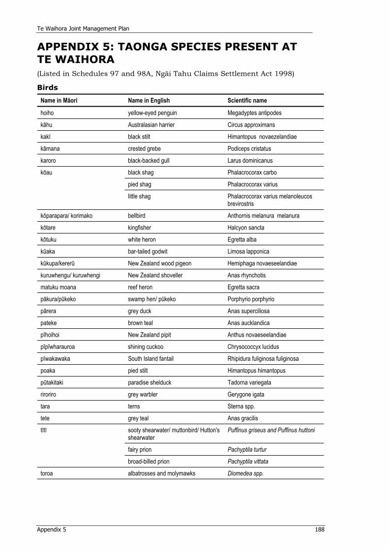
Te Waihora Joint Management Plan
Appendix 5 188
APPENDIX 5: TAONGA SPECIES PRESENT AT TE WAIHORA(Listed in Schedules 97 and 98A, Ngäi Tahu Claims Settlement Act 1998)
Birds
Name in Mäori Name in English Scientific name
hoiho yellow-eyed penguin Megadyptes antipodes
kähu Australasian harrier Circus approximans
kakï black stilt Himantopus novaezelandiae
kämana crested grebe Podiceps cristatus
karoro black-backed gull Larus dominicanus
black shag Phalacrocorax carbo
pied shag Phalacrocorax varius
köau
little shag Phalacrocorax varius melanoleucos brevirostris
köparapara/ korimako bellbird Anthornis melanura melanura
kötare kingfisher Halcyon sancta
kötuku white heron Egretta alba
küaka bar-tailed godwit Limosa lapponica
kükupa/kererü New Zealand wood pigeon Hemiphaga novaeseelandiae
kuruwhengu/ kuruwhengi New Zealand shoveller Anas rhynchotis
matuku moana reef heron Egretta sacra
päkura/pükeko swamp hen/ pükeko Porphyrio porphyrio
pärera grey duck Anas superciliosa
pateke brown teal Anas aucklandica
pïhoihoi New Zealand pipit Anthus novaeseelandiae
pïpïwharauroa shining cuckoo Chrysococcyx lucidus
pïwakawaka South Island fantail Rhipidura fuliginosa fuliginosa
poaka pied stilt Himantopus himantopus
pütakitaki paradise shelduck Tadorna variegata
riroriro grey warbler Gerygone igata
tara terns Sterna spp.
tete grey teal Anas gracilis
sooty shearwater/ muttonbird/ Hutton's shearwater
Puffinus griseus and Puffinus huttoni
fairy prion Pachyptila turtur
tïtï
broad-billed prion Pachyptila vittata
toroa albatrosses and molymawks Diomedea spp.
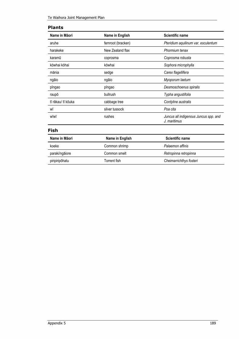
Te Waihora Joint Management Plan
Appendix 5 189
Plants
Name in Mäori Name in English Scientific name
aruhe fernroot (bracken) Pteridium aquilinum var. esculentum
harakeke New Zealand flax Phormium tenax
karamü coprosma Coprosma robusta
köwhai köhai köwhai Sophora microphylla
mänia sedge Carex flagellifera
ngäio ngäio Myoporum laetum
pïngao pïngao Desmoschoenus spiralis
raupö bullrush Typha angustifolia
tï räkau/ tï köuka cabbage tree Cordyline australis
wï silver tussock Poa cita
wïwï rushes Juncus all indigenous Juncus spp. and J. maritimus
Fish
Name in Mäori Name in English Scientific name
koeke Common shrimp Palaemon affinis
paraki/ngäiore Common smelt Retropinna retropinna
piripiripöhatu Torrent fish Cheimarrichthys fosteri
Te Waihora Joint Management Plan
Appendix 6 190
APPENDIX 6: PROTOCOLS ON THE DEPARTMENT OF CONSERVATION’S INTERACTION WITH NGÄI TAHU ON SPECIFIED ISSUES (1997) (Clause 12.12, Deed of Settlement (1997))
NOTIFICATION OF THE ISSUE OF PROTOCOLS
Under Section 282 (4) of the Ngäi Tahu Claims Settlement Act 1998 the Minister of Conservation hereby notifies that she has issued Protocols on behalf of the Crown regarding the Department of Conservation’s interaction with Ngäi Tahu on specified issues, and that the Protocols as set out in the Schedule hereto were issued on 22 October 1998.
Schedule
1 INTRODUCTION
1.1 The purpose of the Conservation Act 1987 is to manage natural and historic resources under that Act and the Acts in the First Schedule of the Conservation Act. Section 4 of the Conservation Act requires that the Act be so interpreted and administered as to give effect to the principles of the Treaty of Waitangi.
1.2 The Director-General has certain management responsibilities in terms of legislation and can only delegate or share responsibility for decisions s/he makes within the limits of his/her legislation. However, in making such decisions, the Director-General will provide Te Rünanga the opportunity for input, consistent with section 4, in its policy, planning and decision-making processes on the matters set out in these Protocols.
1.3 These Protocols apply across the Ngäi Tahu Takiwä, which spans five conservancies, and the Southern and Central Regional Offices of the Department.
1.4 Both the Department and Te Rünanga are seeking a relationship consistent with the Treaty principle of partnership that achieves, over time, the conservation policies, actions and outcomes sought by both Te Rünanga and the Department, as set out in this document.
2 PURPOSE OF PROTOCOLS
2.1 These Protocols are issued pursuant to section 282 of the Ngäi Tahu Claims Settlement Act 1998 and clause 12.12 of the 1997 Deed of Settlement between the Crown and Ngäi Tahu, which specifies the following:
2.1.1 Definitions
Protocol means a statement in writing, issued by the Crown through the Minister of Conservation to Te Rünanga, which sets out:
(a) how the Department of Conservation will exercise its functions, powers, and duties in relation to specified matters within the Ngäi Tahu Claim Area; and
Te Waihora Joint Management Plan
Appendix 6 191
(b) how the Department of Conservation will, on a continuing basis, interact with Te Rünanga and provide for Te Rünanga’s input into its decision-making process.
2.1.2 Authority to Issue, Amend or Cancel Protocols
Pursuant to section 282 of the Ngäi Tahu Claims Settlement Act 1998, the Minister of Conservation may, from time to time issue, amend, and cancel Protocols.
2.1.3 Issue of Protocols
On the Settlement Date (as defined in section 8 of the Ngäi Tahu Claims Settlement Act 1998) the Crown has agreed through the Minister of Conservation to issue Protocols in this form on the following matters:
(a) cultural materials;
(b) freshwater fisheries;
(c) culling of species of interest to Ngäi Tahu;
(d) historic resources;
(e) Resource Management Act 1991 involvement; and (f) visitor and public information.
2.1.4 Protocols subject to Crown Obligations
Pursuant to section 283 of the Ngäi Tahu Claims Settlement Act 1998, the Protocols are issued and amended, subject to, and without restriction upon:
(a) the obligations of the Minister of Conservation and the Department of Conservation to discharge their respective functions, powers, and duties in accordance with existing law and Government policy from time to time; and
(b) the Crown’s powers to amend policy, and introduce legislation amending existing law.
This clause is not intended to indicate, and should not be interpreted as indicating, any agreement by Te Rünanga to any amendment to policy which would adversely affect the redress provided by the Crown pursuant to the Settlement Deed or the ability of either party to fulfil its obligations expressed in the Settlement Deed.
2.1.5 Noting of Protocols on CMS
Pursuant to section 284 of the Ngäi Tahu Claims Settlement Act 1998: (a) The existence of Protocols, once issued, and as amended from
time to time, including a definition of Protocols as set out in section 281 of the Ngäi Tahu Claims Settlement Act 1998 and a summary of the terms of issue of Protocols, must be noted in conservation management strategies, conservation management plans and national park management plans affecting the Ngäi Tahu Claim Area; and
(b) Noting of Protocols pursuant to section 284(1) of the Ngäi Tahu Claims Settlement Act 1998 is for the purpose of public notice only and is not an amendment to the relevant strategies or
Te Waihora Joint Management Plan
Appendix 6 192
plans for the purposes of section 17I of the Conservation Act 1987 or section 46 of the National Parks Act 1980.
2.1.6 Enforceability of Protocols
Pursuant to section 285 of the Ngäi Tahu Claims Settlement Act 1998: (a) The Minister of Conservation must comply with a Protocol as
long as it remains in force; (b) If the Minister of Conservation fails unreasonably to comply
with a Protocol, Te Rünanga may, subject to the Crown Proceedings Act 1950, enforce the Protocol by way of public law action against the Minister of Conservation;
(c) Notwithstanding paragraph (b), damages are not available as a remedy for a failure to comply with a Protocol; and
(d) This clause does not apply to any guidelines which are developed pursuant to a Protocol.
2.1.7 Limitation of Rights
Pursuant to section 286 of the Ngäi Tahu Claims Settlement Act 1998, except as expressly provided in the Deed of Settlement, the Ngäi Tahu Claims Settlement Act 1998, or in a Protocol, a Protocol does not, of itself, have the effect of granting, creating, or providing evidence of any estate or interest in, or any rights of any kind whatsoever relating to, land held, managed, or administered under the Conservation Act 1987 or a statute listed in the First Schedule of that Act.
3 IMPLEMENTATION AND COMMUNICATION
3.1 The Department will seek to establish and maintain communication with Te Rünanga and its Papatipu Rünanga on a continuing basis by:
(a) maintaining at the conservancy level, with the assistance of Te Rünanga, information provided on Papatipu Rünanga, their office holders and addresses; and
(b) providing reasonable opportunities for Te Rünanga and Papatipu Rünanga to meet with Department managers and staff.
3.2 The Protocols provide for ongoing implementation of a range of matters, as well as Specific Projects which will require resourcing. It is not intended that all of the Specific Projects listed in these Protocols will be implemented in any one year. Implementation will be over time. Where these Protocols refer to Specific Projects that require resourcing, their implementation will be subject to provision being made in the relevant conservancy business plan. The process for the Department implementing any particular Specific Project in a business year will be as follows: (a) The Department will meet with Te Rünanga in each conservancy
and at Regional level annually to identify priorities for undertaking Specific Projects as listed in these protocols for the upcoming business year;
(b) The identified priorities will be taken forward by the Department into its business planning process at the conservancy and regional levels and considered along with other priorities;
(c) The decision on whether any Specific Projects will be funded in any business year will be made by the Conservator and the Regional General Manager;
Te Waihora Joint Management Plan
Appendix 6 193
(d) The Department will advise Te Rünanga of the outcome of this process; and
(e) Te Rünanga and the Department will then meet again, if required, to finalise a work plan for implementation of the Specific Projects in that business year, in accordance with the resources which have been allocated in the business plan. The Department will apply the allocated resources to give effect to that work plan, subject to unforeseen management requirements which may arise from time to time, such as emergencies, adverse weather, staff shortages or reallocation of resources directed by the Minister.
3.3 The Department will: (a) Meet with Te Rünanga to review implementation of these Protocols
and to deal with the matters in clause 3.2; four times per annum, unless otherwise agreed, in each conservancy, twice per annum at regional level, and at least once per annum at Chief Executive level;
(b) As far as reasonably practicable, train relevant staff on these Protocols and provide ongoing training as required; and
(c) As far as reasonably practicable, brief Conservation Board and NZCA members on these Protocols and the Ngäi Tahu Settlement, and provide ongoing information as required.
4 CULTURAL MATERIALS
4.1 For the purpose of these Protocols, cultural materials are defined as: (i) plants, plant materials; and (ii) materials derived from animals, marine mammals or birds, to the extent to which the Department holds and is responsible for them, and which are important to Ngäi Tahu in maintaining their culture.
4.2 Current legislation means that generally some form of concession or permit is required for any gathering of cultural materials.
4.3 The Department will: (a) Have particular regard to Te Rünanga’s cultural use policy (Kawa
Hua Taiao) as it relates to the Department’s activities, and other relevant Te Rünanga statements of policy produced from time to time.
(b) Consider requests from members of Ngäi Tahu Whänui for the customary use of cultural materials in accordance with the appropriate legislation.
(c) Agree, where reasonably practicable, for Ngäi Tahu to have access to cultural materials which become available as a result of departmental operations such as track maintenance or clearance or culling of species.
(d) Consult with Te Rünanga in circumstances where there are competing requests from non-Ngäi Tahu persons or entities for the use of cultural materials, for example for scientific research purposes, to see if the cultural and scientific or other needs can be reconciled before the Department makes a decision in respect of those requests.
Te Waihora Joint Management Plan
Appendix 6 194
4.4 Specific projects
The Department will, subject to clause 3.2, work with Te Rünanga to: (a) Develop and implement guidelines for each conservancy within the
Ngäi Tahu Takiwä that help define levels of customary use of cultural materials, and set conditions, after consideration of tikanga, to be met for gathering;
(b) Identify local sources of plants and provide advice to Te Rünanga with respect to the establishment by Te Rünanga of cultivation sites; and
(c) Establish Departmental cultural materials banks for cultural materials which have come into the Department’s possession, and guidelines for their use.
5 FRESHWATER FISHERIES
5.1 The Department has a statutory role in advocating the conservation of aquatic life and freshwater fisheries generally. Its advocacy for freshwater biota, aquatic habitats and fish passage in all areas is primarily taken via statutory planning processes provided by the Resource Management Act 1991.
5.2 Section 48B of the Conservation Act 1987 (inserted by section 305 of the Ngäi Tahu Claims Settlement Act 1998) provides the power to promulgate regulations providing for customary Mäori fishing rights with respect to freshwater fisheries within South Island Fisheries Waters. Pursuant to clause 12.14.11(e) of the Deed of Settlement such regulations are to be promulgated as soon as practicable, and in any event no later than two years after Settlement Date. Besides generally consulting with Te Rünanga and providing for its participation in the conservation and management of customary freshwater fisheries and freshwater fish habitats, the Department will consult with, and have particular regard to the advice of, Te Rünanga in its capacity as an Advisory Committee appointed under section 56 of the Conservation Act in all matters concerning the management and conservation by the Department of Conservation of Taonga Fish Species (as defined in section 297 of the Ngäi Tahu Claims Settlement Act 1998) within the Ngäi Tahu Claim Area. This obligation does not derogate from the obligations of the Department under section 4 of the Conservation Act 1998 to give effect to the Treaty of Waitangi.
5.3 Advisory Committee
The Department will, in relation to the Taonga Fish Species and as far as reasonably practicable, provide the Advisory Committee with all relevant information to enable it to give informed advice, and will meet with the Advisory Committee at conservancy level as necessary to give effect to the Deed of Settlement and the Ngäi Tahu Claims Settlement Act 1998.
5.4 Customary freshwater fisheries regulations
The Department will work with Te Rünanga at Regional and conservancy levels to: (a) Provide for Te Rünanga participation in the development and
promulgation of customary freshwater fishing regulations by:
(i) Establishing a joint working group;
Te Waihora Joint Management Plan
Appendix 6 195
(ii) Setting terms of reference for that working group; (iii) Setting timelines for progress; and (iv) Providing information to Te Rünanga in a timely manner and
allowing Te Rünanga an opportunity to comment.
5.5 Specific Projects
The Department will, subject to clause 3.2, work with Te Rünanga to: (a) Develop and implement guidelines for the Department with respect to
the promotion of compliance with customary freshwater fisheries regulations;
(b) Develop and implement guidelines for the Department with respect to monitoring the efficacy of the customary freshwater fisheries regulations at regular intervals; and
(c) Develop and implement guidelines for the Department with respect to sharing accumulated management information and research data on customary freshwater fisheries with Te Rünanga.
5.6 Other matters
The Department will work with Te Rünanga at Regional and conservancy levels to provide for active participation by Te Rünanga in the conservation, management and research of customary freshwater fisheries and freshwater fish habitats by: (a) Seeking to identify areas for cooperation in advocacy, consistent with
clause 9, focusing on fish passage, minimum flows, protection of riparian vegetation and habitats, water quality improvement and in the restoration, rehabilitation or enhancement of customary freshwater fisheries and their freshwater habitats; and
(b) Consulting with Te Rünanga in developing or contributing to research programmes that aim to improve the understanding of the biology of customary freshwater fisheries and their environmental and habitat requirements. The Department confirms that it regards Te Rünanga as a possible science provider or collaborator for research projects funded or promoted by the Department in the same manner as other potential providers or collaborators.
5.7 Specific Projects
The Department will, subject to clause 3.2, work with Te Rünanga to: (a) Conduct research to establish and address ecosystem threats to
specified customary freshwater fisheries including barriers to migration, habitat loss and exotic species interaction;
(b) Contribute to the resolution of eel management issues, in particular, the administration of the fish passage regulations in the Freshwater Fisheries Regulations, the promotion of the installation of effective fish passes where necessary and monitoring of their effects, by participating in discussions with Te Rünanga and Te Waka a Mäui me öna Toka Mahi Tuna; and
(c) Identify the need for, and where necessary prepare, management plans for freshwater fisheries management.
6 CULLING OF SPECIES OF INTEREST TO NGÄI TAHU
6.1 As part of an integrated management regime, or because a species population has risen to become an ecological pest, it may from time to time be necessary for the Department to carry out a cull of a
Te Waihora Joint Management Plan
Appendix 6 196
protected species under the Wildlife Act 1953. The Department recognises that Te Rünanga is interested in such operations in the following ways:
(a) the carrying out of such a cull where the species to be culled is causing or is likely to cause ecological damage to species or habitats of particular significance to Ngäi Tahu;
(b) the methods to be used in such culls; and (c) cultural materials arising from the cull.
6.2 The Department will: (a) Have regard to any requests initiated by Te Rünanga for the carrying
out of culling operations; (b) Consult with, and have particular regard to the views of, Te Rünanga
before deciding to carry out a cull of protected species on land administered by the Department, in respect of the reasons for the cull and the method proposed to be used; and
(c) In situations where either a Fish and Game Council or a Regional Council intend to carry out a cull of protected species or game bird and the Department has a statutory role in the process, request the relevant body to consult with Te Rünanga before carrying out any such cull.
7 HISTORIC RESOURCES
7.1 The Minister acknowledges the importance to Ngäi Tahu of their wähi tapu, wähi taonga and other places of historic significance to them. Liaison with Te Rünanga is important in the management of those places containing sites of historic and cultural significance to Ngäi Tahu, including places of settlement, horticulture, natural resource harvesting, warfare, communication, and places of cultural and spiritual connection.
7.2 The Department notes that non-disclosure of locations of places known to Ngäi Tahu is a practice used by Ngäi Tahu to preserve the sanctity of a place. Respecting the principle of confidentiality brings management difficulties of a particular kind. Where information is not available, management practices which (unintentionally) contravene the cultural value associated with a specific site, may be put in place. Where reasonably practicable, the Department will respect the principle of confidentiality that applies to wähi tapu, wähi taonga and places of historic significance to Ngäi Tahu. The primary responsibility for identifying and assessing Ngäi Tahu heritage values rests with Te Rünanga.
7.3 The Department will work with Te Rünanga at Regional and conservancy levels to:
(a) Ensure, as far as reasonably practicable, that Ngäi Tahu values attaching to identified wähi tapu, wähi taonga and places of historic significance to Ngäi Tahu managed by the Department are respected by the Department, for example, by the Department giving consideration to impacts from visitor numbers, facilities and services;
(b) Manage, as far as reasonably practicable, wähi tapu, wähi taonga and places of historic significance to Ngäi Tahu according to the standards of conservation practice outlined in the ICOMOS New Zealand Charter 1993;
Te Waihora Joint Management Plan
Appendix 6 197
(c) Ensure, as far as reasonably practicable, that when issuing concessions giving authority for other parties to manage land administered by the Department, those parties manage the land according to the standards of conservation practice outlined in the ICOMOS New Zealand Charter 1993;
(d) Have particular regard to relevant Te Rünanga policies, including those relating to Köiwi Tangata (unidentified human remains) and Archaeological and Rock Art Sites;
(e) Ensure, as far as reasonably practicable, that it uses Ngäi Tahu’s cultural information only with the consent of Te Rünanga; and
(f) When issuing concessions to carry out activities on the land administered by the Department, request that the concessionaire consult with Te Rünanga before using Ngäi Tahu’s cultural information.
7.4 Specific Projects
The Department will, subject to clause 3.2, work with Te Rünanga at Regional and conservancy levels to: (a) Develop and implement guidelines for the identification, inventory
and management by the Department of wähi tapu, wähi taonga and other places of historic significance to Ngäi Tahu that take into consideration the traditional uses and practices of Ngäi Tahu and are, where reasonably practicable, consistent with Ngäi Tahu tikanga;
(b) Identify and actively protect specified wähi tapu, wähi taonga or other places of historic significance to Ngäi Tahu on land administered by the Department;
(c) Develop and implement guidelines for the active protection of wähi tapu, wähi taonga and other places of historic significance to Ngäi Tahu;
(d) Identify cooperative projects covering a range of options for the protection and management of wähi tapu, wähi taonga and other places of historic significance to Ngäi Tahu;
(e) Develop and implement guidelines relating to the use of Ngäi Tahu’s knowledge of wähi tapu, wähi taonga and other places of historic significance of Ngäi Tahu, including the use of this information by the Department; and
(f) Consult with and seek participation from Te Rünanga with respect to research, survey or inventory projects that relate specifically to wähi tapu, wähi taonga and other places of historic significance to them.
8 VISITOR AND PUBLIC INFORMATION
8.1 In providing public information and interpretation services and facilities for visitors on the land it manages, the Department recognises the importance to Ngäi Tahu of their cultural, spiritual, traditional and historic values.
8.2 The Department will work with Te Rünanga at Regional and conservancy levels to encourage respect for Ngäi Tahu values by:
(a) As far as reasonably practicable, seeking to raise public awareness of positive conservation partnerships developed between Te Rünanga, the Department and other stakeholders, for example, by way of publications, presentations and seminars;
Te Waihora Joint Management Plan
Appendix 6 198
(b) Consulting on the provision of interpretation and visitor facilities (if any) at wähi tapu, wähi taonga and other places of historic or cultural significance to Ngäi Tahu;
(c) Ensuring, as far as reasonably practicable, that Department information on new panels, signs, and visitor publications includes Te Rünanga perspectives and references to the significance of the sites to Ngäi Tahu, where appropriate, including the use of traditional Ngäi Tahu place names; and
(d) Encouraging Te Rünanga participation in the Department’s volunteer and conservation events programmes.
8.3 Specific Projects
The Department will, subject to clause 3.2, work with Te Rünanga at Regional and conservancy levels to: (a) Develop and implement guidelines on the provision of information
and interpretation facilities and services for visitors, so as to identify and consider issues of concern to Te Rünanga;
(b) Consider possibilities for Te Rünanga to contribute to visitor appreciation of the cultural value of sites of cultural and historic significance to Ngäi Tahu managed by the Department; and
(c) Provide information to education providers, including kohanga reo and kura kaupapa Mäori, for the development of educational resources on conservation issues and associated Ngäi Tahu values.
9 RESOURCE MANAGEMENT ACT
9.1 Te Rünanga and the Department both have concerns with the effects of activities controlled and managed under the Resource Management Act. These include effects on:
(a) wetlands;
(b) riparian management;
(c) effects on freshwater fish habitat;
(d) water quality management; (e) protection of historic resources; and (f) protection of indigenous vegetation and habitats.
9.2 From time to time, Te Rünanga and the Department will seek to identify further issues of mutual interest for discussion. It is recognised that their concerns in relation to any particular resource management issue may diverge and that each of them will continue to make separate submissions.
9.3 The Department will work with Te Rünanga at Regional and conservancy levels to discuss the general approach that will be taken by each of Te Rünanga and the Department in respect of advocacy under the Resource Management Act, and seek to identify their respective priorities and issues of mutual concern.
9.4 The Department will: (a) Have regard to the priorities and issues of mutual concern identified
in clause 9.3(a) in making decisions in respect of advocacy under the Resource Management Act.
Te Waihora Joint Management Plan
Appendix 6 199
(b) Make non-confidential resource information available to Te Rünanga to assist in improving the effectiveness of Resource Management Act advocacy work at the Papatipu Rünanga level.
10 AMENDMENT AND REVIEW PROVISIONS FROM THE DEED
10.1 Amendment and Cancellation of Protocols
Pursuant to section 282 of the Ngäi Tahu Claims Settlement Act 1998:
(a) Protocols may be amended or cancelled by the Minister of Conservation, from time to time at the initiative of either the Crown or Te Rünanga;
(b) The Minister of Conservation may amend or cancel Protocols only after consulting Te Rünanga and having regard to its views; and
(c) As soon as reasonably practicable after the amendment, or cancellation of a Protocol, the Minister of Conservation must notify such amendment, or cancellation in the Gazette.
Dated at Wellington this 26 day of July 2001.
MATT ROBSON, for SANDRA LEE, Minister of Conservation.
(NZ Gazette 2001, page 2171)

Te Waihora Joint Management Plan
Appendix 7 200
APPENDIX 7: WATER CONSERVATION (LAKE ELLESMERE) ORDER 1990
The National Water Conservation (Lake Ellesmere) Order 1990 Paul Reeves, Governor-General
Order in Council At Wellington this 2nd day of July 1990
Present:His Excellency the Governor-General in Council
PURSUANT to section 20D of the Water and Soil Conservation Act 1967, His Excellency the Governor-General acting by and with the advice and consent of the Executive Council, hereby make s the following order.
ORDER1. Title and commencement –(1) This order may be cited as the national water Conservation (Lake
Ellesmere) Order 1990.
(2) This order shall come into force on the 28th day after the date of this notification in the Gazette.
2. Interpretation – In this order, unless the context otherwise requires, “Act” means the Water and Soil Conservation Act 1967;
“Lake Ellesmere” means that variable body of water commonly known as Lake Ellesmere, otherwise known as Waihora, located at and about map reference NZMS 262 13:468714, and having an areas f about 20 000 hectares;
“Lake level” means the water level measured in calm conditions by the recorder at Taumutu (map reference NZMS 260 M37:599064) maintained by the Canterbury Regional Council; provided that the Canterbury Regional Council may, at its discretion and when necessary due to windy conditions, estimate the reading which would have been obtained in calm conditions;
“m.a.s.l.” means the elevation in metres above 1988 mean sea level at the Port of Lyttelton.
3. Outstanding features – it is hereby declared that Lake Ellesmere provides an outstanding wildlife habitat.
4. Restriction on lake openings and closings – (1) Subject to subclause (2) of this clause, because of the outstanding
features specified in clause 3 of this order, a water right shall not be granted under section 21 of the Act allowing lake Ellesmere to be artificially opened to the sea or artificially closed from the sea.
(2) A water right may be so granted –
(a) To allow the lake to be artificially opened to the sea whenever the lake level-(i) Exceeds 1.05 m.a.s.l. during any period commencing on the 1st
day of August and ending with the 31st day of March next following; or
(ii) Exceeds 1.13 m.a.s.l. during any period commencing on the 1st
day of April and ending with the 31st day of July next following;
Te Waihora Joint Management Plan
Appendix 7 201
(b) To allow the lake to be artificially opened to the sea at any time during any period commencing on the 15th day of September and ending with the 15th day of October next following;
(c) To allow the lake to be artificially closed to the sea whenever the lake is level 0.6 m.a.s.l. during any period commencing on the 1st day of October and ending with the 31st day of March next following.
5. Right to dam or to drain land not to be granted - (1) Subjected to subclauses (2) to (4) of this clause, because of the
outstanding features specified in clause (3) of this order, a water right shall not be granted under section 21 of the Act and a general authorisation shall not be made under section 22 of the Act allowing the damming, stopbanking, polderisation, or drainage of any part of Lake Ellesmere where the lake bed is below 1.13 m.a.s.l. in elevation.
(2) A water right to polderise for fish farming of for research into fisheries may be so granted if there is no significant impact on the outstanding features of Lake Ellesmere specified in clause 3 of this order.
(3) A water right may be so granted for any stopbanks, drains, and other uses of water which existed on the 27th day of June 1986.
(4) A water right may be so granted for works associated with the maintenance of those outlets of rivers, streams, and drains, and those stopbanks, which existed on the 27th day of June 1986.
6. Restriction on grant of water rights - (1) A water right shall not be granted under section 21 of the Act and a
general authorisation shall not be made under section 22 of the Act in respect of the waters of Lake Ellesmere if the effect of such a right or authorisation would not be that the provisions of this order could not be observed without those provisions being changed or varied.
(2) Notwithstanding anything in this order, it shall be lawful for a water right to be so granted for research into, and enhancement of, wildlife habitats.
7. Scope of this order - Nothing in this order shall be construed as limiting the effect of the second proviso to section 21 (1) of the Act relating to the use of water for domestic needs, for the needs of animals, and for or in connection with fire-fighting purposes.
EXPLANATORY NOTE
This note is not part of the order, but is intended to indicate its general effect.
This order declares that Lake Ellesmere provides an outstanding wildlife habitat.
This order also includes various provisions to preserve and protect the wildlife habitat.
Issued under the authority of the Acts and Regulations Publication Act 1989.
Date of notification in Gazette: 5 July 1990. This order is administrated in the Ministry for the Environment.
Te Waihora Joint Management Plan
Appendix 8 202
APPENDIX 8: RÜNANGA TAKIWÄ Descriptions of Rünanga Takiwä for Papatipu Rünanga represented in the Te Waihora Management Board, from the Te Rünanga o Ngäi Tahu Act (1996), Schedule 1:
Te Ngäi Tüähuriri Rünanga The takiwä of Te Ngäi Tüähuriri Rünanga centres on Tuahiwi and extends from the Hurunui to Hakatere, sharing an interest with Arowhenua Rünanga northwards to Rakaia, and thence inland to the Main Divide.
Räpaki Rünanga (Te Hapü o Ngäti Wheke) The takiwä of Räpaki Rünanga centres on Räpaki and includes the catchment of Whakaraupö and Te Kaituna.
Te Rünanga o Koukourarata The takiwä of Te Rünanga o Koukourarata centres on Koukourarata and extends from Pöhatu Pä to the shores of Te Waihora including Te Kaituna.
Wairewa Rünanga The takiwä of Wairewa Rünanga centres on Wairewa and the catchment of the lake Te Wairewa and the hills and coast to the adjoining takiwä of Koukourarata, Önuku Rünanga, and Taumutu Rünanga.
Te Rünanga o Önuku The takiwä of Te Rünanga o Önuku centres on Önuku and the hills and coasts of Akaroa to the adjoining takiwä of Te Rünanga o Koukourarata and Wairewa Rünanga.
Te Taumutu Rünanga The takiwä of Taumutu Rünanga centres on Taumutu and the waters of Te Waihora and adjoining lands and shares a common interest with Te Ngäi Tüähuriri Rünanga and Te Rünanga o Arowhenua in the area south to Hakatere.
Te Waihora Joint Management Plan
Appendix 9 203
APPENDIX 9: ORIGIN OF QUOTES USED THROUGHOUT THE JOINT MANAGEMENT PLANTwelve people were interviewed to generate quotes or ‘stories’ in order to personalise the Te Waihora Joint Management Plan. In addition to these interviews, a search was conducted for already recorded material relating to Te Waihora. Quotes are included from a number of these sources throughout Part 3 of this Plan. A brief background of those people interviewed is outlined below:
Daphne Jameson has had an interest in Te Waihora since childhood and consolidated this interest with a geography degree, completed at the University of Canterbury in the 1940s. After completing her university training, Daphne maintained her interest in Te Waihora through conservation activities. In particular, her contact with Te Waihora has been maintained through the Forest and Bird Society. Daphne’s knowledge about Te Waihora reflects her lifetime interest in the district and her practical, academic and conservationist activities in the area. Daphne was interviewed on 14 December 2002 at her home. Due to illness the interview was brief, lasting approximately 40 minutes.
Roger Gilbert’s family has farmed in the Ellesmere area for generations and Roger carried on this tradition until his recent retirement. However, he maintains his interest in farming through Federated Farmers in conjunction with a lifetime interest in local history. Roger is President of the Ellesmere Historical Society, evidence of his interest in the history of the Ellesmere district. He is also a member of the Canterbury History Foundation and is on the committee of the Canterbury Historical Association. Moreover, Roger is involved in a new group established recently – the Ellesmere Issues Group. Roger was interviewed on 18 December 2002 at his home. The interview was recorded and was of 50 minutes duration.
Murray Stephens is a third generation farmer in the Irwell district. He and his wife, Marilyn, have transformed the family farm into a horticulture venture and business. Named ‘Waipuna’, Murray and Marilyn now produce blackcurrants and were recently named Lincoln Horticulturalists of the Year, winning a travel grant to Europe. Murray’s link with Te Waihora has been not only as a farmer, but also as a recreationalist since the 1960s. Murray and his family have been members of the Aquatic Club for a number of decades and maintain their use of Te Waihora as a recreational area to this day, although on a more limited basis. Murray and Marilyn were interviewed at their home on 21 December 2002. The interview was recorded and was of 30 minutes duration.
Cath Brown was a Ngäi Tahu artist, weaver, teacher, former Head of Art at Christchurch College of Education, a JP and former Chair of Te Taumutu Rünanga. Cath’s family has had a long interest in Te Waihora. For generations the Brown family has lived and fished at Taumutu. Indeed, both her Ngäi Tahu and Pakeha grandfathers fished the lake and her father and brother maintained their links with Te Waihora as fishermen. Cath was linked to the lake through her membership of numerous committees relevant to Te Waihora, including the local historic society. She was also the Taumutu Rünanga Te Rünanga o Ngäi Tahu representative, a member of the Selwyn District Creative Communities Board and the Manaaki Whenua Animal Ethics Committee. Cath was
Te Waihora Joint Management Plan
Appendix 9 204
interviewed at her home on 21 December 2002. The interview was recorded, and because of illness, was restricted to 40 minutes in length. Sadly Cath passed away on 7th August 2004.
Francis Eggleston has lived in Greenpark since 1934. The Eggleston family were formerly residents of Motukarara where Francis’s father was a farm labourer. One of four brothers, Francis has farmed at Greenpark his whole life and is now retired. He was formerly a councillor for the Greenpark area on the Selwyn District Council and remains heavily involved in community and farming concerns. Francis was interviewed on 11 of January 2003 at his home. The interview was of 80 minutes duration.
Colin Hill is English by birth, arriving in Christchurch in 1958. With his wife Cherry, a language teacher at Lincoln High School, Colin has lived and farmed at Greenpark for over thirty years. For about 20 of those years, Colin has had an interest in ornithology, with specialised knowledge of the bird life at Te Waihora and a particular focus on the migratory wading birds. In conjunction with ornithology, Colin has an interest in photography and would like to publish a book about the birds of Lake Ellesmere (Te Waihora). He is also active in a number of local committees, evidence of his passionate interest in Te Waihora, its habitat and the bird life it supports. Colin, with his wife Cherry also present, was interviewed on 12 January 2003, over a period of two hours. By request, the interview was not recorded. Instead, notes were taken and a reconstructed narrative based on those notes further edited by Colin.
Trevor Gould is a commercial fisherman at Lakeside, specialising in eel, flounder and mullet. Trevor does not have a family background in fishing, moving to Lakeside to become a commercial fisherman in 1969 from South Canterbury. His first season was a disaster, but 30 years later he now runs a very successful fishing business, employing up to 24 staff in a good year. Gould’s Aquafarm exports eel to China and Japan, and markets this product nationwide. Trevor is very interested in seeing Te Waihora’s commercial value in aquaculture investigated in the future, believing the potential of the area as a commercial resource is currently under-utilised. Trevor was interviewed at his home on 20 January 2003. The interview was recorded and was of 45 minutes duration.
Marea Johnson is of Ngäi Tahu and Greek descent. Marea was born at Taumutu in 1924 and she and her four sisters were raised by her parents, Hohepa Teihoka and Moana Sermous, along the shores of Te Waihora. Marea is currently involved in a number of community organisations as a volunteer and strongly believes in the need for rünanga participation if Te Waihora is to be preserved for future generations. Indeed it is this approach to life, one centred on community and participation that has been the catalyst behind her involvement with the Taumutu Rünanga, coupled with her strong family links with Te Waihora. Marea passed on a written statement for the project, believing that this statement best summed up her views about Te Waihora.
Trevor Partridge completed his postgraduate research on salt marshes at the University of Otago. It is from this research that he has developed an interest in the ecology and vegetation of Te Waihora. In 1981, Trevor moved to Christchurch to work for Landcare Research/Te Manaaki Whenua at Lincoln and has worked for this institution for over 20 years. In that time he has published a number of reports on vegetation and developed relationships with local users of Te Waihora, giving him a
Te Waihora Joint Management Plan
Appendix 9 205
unique understanding of the Te Waihora environment and the people who interact with it. Trevor was interviewed on 13 February 2003 in the History Department, University of Canterbury. The interview was of 40 minutes duration.
Malcolm Wards is of Ngäi Tahu descent. Through his mother Jane Wards nee Martin, Malcolm has ancestral links to Taumutu and Ötäkou. One of 13 children, Malcolm was born at Taumutu and was raised by the lake. Leaving the area in the late 1960s for the city and the Mäori Affairs Trade Training Scheme, Malcolm trained and worked in the engineering sector until 4 years ago. It was at that time that he entered the commercial fishing sector at Te Waihora, fishing ACE quota leased from Ngäi Tahu Seafoods. Malcolm was interviewed at Taumutu 12 February 2003. The interview was conducted over two hours. Malcolm preferred not to be recorded; instead notes were taken.
Martin Clements is the current Chairman of the North Canterbury Fish and Game Council. Martin has had a long association with Te Waihora. Since childhood he has engaged with the Te Waihora environment and the lake margins when visiting his family who farmed in Little River. Martin also has a long association with the region through recreational fishing. His involvement with Fish and Game was instigated by seeing the degradation of Te Waihora over the past decade. It is through participation in such an organisation that Martin believes Te Waihora can be restored and enhanced for future users. Martin was interviewed at his home on 20 February 2003. Due to time constraints and other commitments the interview was brief and was of only 20 minutes duration.
Sheila Petch arrived in New Zealand 37 years ago from Yorkshire, England. For over 20 years she has had a strong interest in ornithology. As a member of the Canterbury Ornithological Society for the past 15 years she has been involved in birding at Te Waihora. A keen birder, she goes out to Te Waihora at least once a week and at other times takes groups of overseas visitors. Sheila was interviewed at her home on 21 February 2003. The interview was recorded and was of approximately 25 minutes duration.
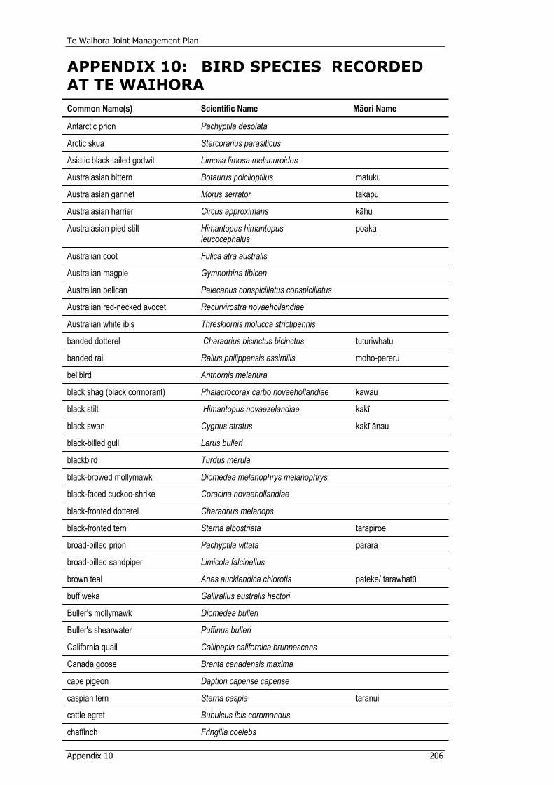
Te Waihora Joint Management Plan
Appendix 10 206
APPENDIX 10: BIRD SPECIES RECORDED AT TE WAIHORACommon Name(s) Scientific Name Mäori Name
Antarctic prion Pachyptila desolata
Arctic skua Stercorarius parasiticus
Asiatic black-tailed godwit Limosa limosa melanuroides
Australasian bittern Botaurus poiciloptilus matuku
Australasian gannet Morus serrator takapu
Australasian harrier Circus approximans kähu
Australasian pied stilt Himantopus himantopus leucocephalus
poaka
Australian coot Fulica atra australis
Australian magpie Gymnorhina tibicen
Australian pelican Pelecanus conspicillatus conspicillatus
Australian red-necked avocet Recurvirostra novaehollandiae
Australian white ibis Threskiornis molucca strictipennis
banded dotterel Charadrius bicinctus bicinctus tuturiwhatu
banded rail Rallus philippensis assimilis moho-pereru
bellbird Anthornis melanura
black shag (black cormorant) Phalacrocorax carbo novaehollandiae kawau
black stilt Himantopus novaezelandiae kakï
black swan Cygnus atratus kakï änau
black-billed gull Larus bulleri
blackbird Turdus merula
black-browed mollymawk Diomedea melanophrys melanophrys
black-faced cuckoo-shrike Coracina novaehollandiae
black-fronted dotterel Charadrius melanops
black-fronted tern Sterna albostriata tarapiroe
broad-billed prion Pachyptila vittata parara
broad-billed sandpiper Limicola falcinellus
brown teal Anas aucklandica chlorotis pateke/ tarawhatü
buff weka Gallirallus australis hectori
Buller’s mollymawk Diomedea bulleri
Buller's shearwater Puffinus bulleri
California quail Callipepla californica brunnescens
Canada goose Branta canadensis maxima
cape pigeon Daption capense capense
caspian tern Sterna caspia taranui
cattle egret Bubulcus ibis coromandus
chaffinch Fringilla coelebs

Te Waihora Joint Management Plan
Appendix 10 207
Common Name(s) Scientific Name Mäori Name
chestnut-breasted shelduck(Australian shelduck)
Tadorna tadornoides
cirl bunting Emberiza cirlus
curlew sandpiper Calidris ferruginea
eastern bar-tailed godwit Limosa lapponica baueri kuaka
eastern curlew Numenius madagascariensis
eastern golden plover (pacific golden plover)
Pluvialis fulva
erect-crested penguin Eudyptes sclateri
fairy prion Pachyptila turtur titi wainui
feral goose Anser anser
flesh-footed shearwater Puffinus carneipes
fluttering shearwater Puffinus gavia pakaha
glossy ibis Plegadis falcinellus
goldfinch Carduelis cardueli
great knot Calidris tenuirostris
greenfinch Carduelis chloris
greenshank Tringa nebularia
grey (red) phalarope Phalaropus fulicarius
grey duck Anas superciliosa superciliosa pärera
grey partridge Perdix perdix perdix
grey petrel Procellaria cinerea
grey teal Anas gracilis tete
grey warbler Gerygone igata riroriro
grey-faced petrel Pterodroma macroptera gouldi oi
grey-headed mollymawk Diomedea chrysostoma
hedge sparrow (dunnock) Prunella modularis
house sparrow Passer domesticus
Hudsonian godwit Limosa haemastica
Hutton's shearwater Puffinus huttoni
intermediate egret (plumed egret) Egretta intermedia
Japanese snipe Gallinago hardwickii
large sand dotterel Charadrius leschenaultii
lesser knot Calidris canutus canutus huahou
lesser yellowlegs Tringa flavipes
light-mantled sooty albatross Phoebetria palpebrata
little black shag (little black cormorant)
Phalacrocorax sulcirostris
little egret Egretta garzetta nigripes
little owl Athene noctua
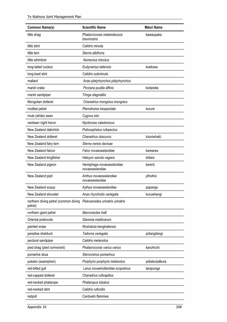
Te Waihora Joint Management Plan
Appendix 10 208
Common Name(s) Scientific Name Mäori Name
little shag Phalacrocorax melanoleucos brevirostris
kawaupaka
little stint Calidris minuta
little tern Sterna albifrons
little whimbrel Numenius minutus
long-tailed cuckoo Eudynamys taitensis koekoea
long-toed stint Calidris subminuta
mallard Anas platyrhynchos platyrhynchos
marsh crake Porzana pusilla affinis koitareke
marsh sandpiper Tringa stagnatilis
Mongolian dotterel Charadrius mongolus mongolus
mottled petrel Pterodroma inexpectata korure
mute (white) swan Cygnus olor
nankeen night heron Nycticorax caledonicus
New Zealand dabchick Poliocephalus rufopectus
New Zealand dotterel Charadrius obscurus tuturiwhatü
New Zealand fairy tern Sterna nereis davisae
New Zealand falcon Falco novaeseelandiae karearea
New Zealand kingfisher Halcyon sancta vagans kötare
New Zealand pigeon Hemiphaga novaeseelandiae novaeseelandiae
kererü
New Zealand pipit Anthus novaeseelandiae novaeseelandiae
pïhoihoi
New Zealand scaup Aythya novaeseelandiae papango
New Zealand shoveler Anas rhynchotis variegata kuruwhengi
northern diving petrel (common divingpetrel)
Pelecanoides urinatrix urinatrix
northern giant petrel Macronectes halli
Oriental pratincole Glareola maldivarum
painted snipe Rostratula benghalensis
paradise shelduck Tadorna variegata pütangitangi
pectoral sandpiper Calidris melanotos
pied shag (pied cormorant) Phalacrocorax varius varius karuhiruhi
pomarine skua Stercorarius pomarinus
pukeko (swamphen) Porphyrio porphyrio melanotus pükeko/päkura
red-billed gull Larus novaehollandiae scopulinus tarapunga
red-capped dotterel Charadrius ruficapillus
red-necked phalarope Phalaropus lobatus
red-necked stint Calidris ruficollis
redpoll Carduelis flammea
Te Waihora Joint Management Plan
Appendix 10 209
Common Name(s) Scientific Name Mäori Name
reef heron (blue heron) Egretta sacra sacra matuku-moana
ring-necked pheasant Phasianus colchicus
rock pigeon Columba livia
rockhopper penguin Eudyptes chrysocome
royal spoonbill Platalea regia kötuku-ngutupapa
ruff Philomachus pugnax
Salvin's mollymawk Diomedea cauta salvini
Salvin’s prion (lesser broad-billed prion)
Pachyptila salvini
sanderling Calidris alba
sharp-tailed sandpiper Calidris acuminata
shining cuckoo Chrysococcyx lucidus lucidus pipiwharauroa
short-tailed shearwater (Tasmanian muttonbird)
Puffinus tenuirostris
siberian (grey-tailed) tattler Tringa brevipes
silvereye Zosterops lateralis lateralis
skylark Alauda arvensis
song thrush Turdus philomelos
sooty shearwater (muttonbird) Puffinus griseus tïtï
south island fantail Rhipidura fulginosa fuliginosa pïwakawaka
south island fernbird Bowdleria punctata punctata matata
south island pied oystercatcher Haematopus ostralegus finschi törea
southern black-backed gull Larus dominicanus dominicanus Lichtenstein
karoro
southern giant petrel Macronectes giganteus
southern great skua (brown skua) Catharacta skua lonnbergi
spotless crake Porzana tabuensis plumbea püweto
spotted shag Stictocarbo punctatus punctatus parekareka
spur-winged plover Vanellus miles novaehollandiae
starling Sturnus vulgaris
stilt sandpiper Micropalama himantopus
sulphur-crested cockatoo Cacatua galerita
terek sandpiper Tringa terek
turnstone Arenaria interpres
variable oystercatcher Haematopus unicolor törea; dark phase, toreapango
wandering albatross Diomedea exulans
welcome swallow Hirundo tahitica neoxena
white heron (white egret) Egretta alba modesta kötuku
white-capped (shy) mollymawk Diomedea cauta cauta
Te Waihora Joint Management Plan
Appendix 10 210
Common Name(s) Scientific Name Mäori Name
white-chinned petrel Procellaria aequinoctialis aequinoctialis
white-eyed duck (hardhead) Aythya australis
white-faced heron Ardea novaehollandiae novaehollandiae
white-flippered penguin,southern blue penguin
Eudyptula minor
white-fronted tern Sterna striata tara
white-rumped sandpiper Calidris fusicollis
white-winged black tern Chlidonias leucopterus
Wilson's phalarope Phalaropus tricolor
wrybill Anarhynchus frontalis ngutuparore
yellow-eyed penguin Megadyptes antipodes hoiho
yellowhammer Emberiza citrinella
Te Waihora Joint Management Plan
Glossary 211
GLOSSARY PAPAKUPUBed of Te Waihora “means the land described in schedule 10” of the
Ngäi Tahu Claims Settlement Act (section 167).
CMS Canterbury Conservation Management Strategy(2000).
Community and Public Health
Means the division of the Canterbury District Health Board that delivers public health services or any of its predecessors.
Concession A lease, licence, permit, or easement granted under Part IIIB of the Conservation Act 1987; and includes any activity authorised by a concession document. (Conservation Act 1987).
Conservation “means the preservation and protection of natural and historic resources for the purpose of maintaining their intrinsic values, providing for their appreciation and recreational enjoyment by the public, and safeguarding the options of future generations:” (Conservation Act 1987).
Eel weir A structure used in conjunction with hïnaki to catch tuna/eels.
Environment Canterbury (ECan)
The Canterbury Regional Council.
Freshwater eel “means the species Anguilla australis, Anguilla dieffenbachii, and Anguilla reinhardtii, in all areas in New Zealand fisheries waters” (section 2 Fisheries Act 1983). Also referred to as “eel” or “tuna” in this Plan.
Game birds All game species specified in the First Schedule of the Wildlife Act 1953.
GIS Geographical Information System.
Hapü Sub-tribe.
Heke Migration (generally of eels in the context of Te Waihora).
Hïnaki Eel pot.
Historic resource Means a historic place within the meaning of the Historic Places Act 1993; and includes any interest in a historic resource. (Conservation Act 1987).
JMP Te Waihora Joint Management Plan.
Joint Management Plan Area (JMP Area)
That part of the Te Waihora environment administered by the Department or owned by Te Rünanga o Ngäi Tahu (Ngäi Tahu lakebed) as described in Part 1, section 3.2 and Appendix 1.
Te Waihora Joint Management Plan
Glossary 212
Kai hau kai The ritual exchange of food resources generally as part of a joint hapü ceremony. These semi-competitive rituals are also an indication of mana. (Ngäi Tahu 2025).
Kawa Rules or protocol/procedure.
Ki uta ki tai A description of environmental policy and planning that takes a holistic ‘from the mountains to the sea’ approach and encapsulates rangatiratanga and kaitiakitanga. (Ngäi Tahu 2025).
Köhanga Breeding ground, seeding ground, nursery.
Köiwi Tangata Policy
Te Rünanga o Ngäi Tahu tribal policy (1993) on the accidental discovery and management of human remains.
Köumu Trenches constructed from the edge of the lake towards the sea to enable the customary take of migrating eels.
Landsadministered by the Department
Those lands administered by the Department of Conservation within the Joint Management Plan Area.
m amsl Metres above mean sea level.
Mahinga kai For the purposes of the Joint Management Plan means, “…the customary gathering of food and natural materials and places where those resources are gathered.” (Section 167, Ngäi Tahu Claims Settlement Act, 1998).
Mahinga Kai Cultural Park
“A concept used to refer to a natural area (either land or marine based) that is managed and/or owned by Ngäi Tahu (either at a tribal level by Te Rünanga o Ngäi Tahu or by Papatipu Rünanga or jointly) for mahinga kai. This area can be likened to a “national park” but managed for and by Ngäi Tahu.” (Ngäi Tahu 2025). For Te Waihora the concept would vary slightly and have to be applied consistent with the NTCSA to recognise the purposes set out in Part 1, section 1 of this Plan.
Mahinga kai, conservation and other purposes
Means the purposes of the Plan as set out in Schedule 12, Clause 11.6.19(a)(i) of the NTCSA.
Mahinga tuna Eel fishing/gathering.
Maimai “Any hide or shelter constructed for the purpose of game-bird hunting, and any wheeled mobile hide or shelter that is parked temporarily for this same purpose, but does not include portable hides or shelters that are built and removed on the same day.”(Attachment 11.36, Deed of Settlement 1996).
Te Waihora Joint Management Plan
Glossary 213
Maimai Agreement
An agreement between North Canterbury Fish and Game Council, the Department of Conservation and Te Rünanga o Ngäi Tahu as part of the Deed of Settlement (1997), for the occupation, use and management of maimai within the JMP Area. (See Appendix 4).
Mana Integrity, status, prestige, power. (Pounamu Resource Management Plan, 2002).
Manaaki To show respect or kindness to; to entertain. (Williams, 1991).
Manawhenua Integrity, status, prestige, power relating to, and over, the whenua (land). (Pounamu Resource Management Plan, 2002).
Manuhiri Visitors and guests.
Mätauranga Knowledge, to understand.
Mauri Essential life force or principle; a metaphysical quality inherent in all things, both animate and inanimate. (Ngäi Tahu Freshwater Policy, 1999).
mhws Mean high water springs.
Minister The Minister of Conservation.
Natural character The qualities of an area that taken together give it a particular, recognisable character. These qualities may be ecological, physical, spiritual or aesthetic in nature. (CMS).
Natural night-time darkness
The absence of night-time light created by humans.
Natural quiet The absence of noise created by humans. (CMS).
Natural resources “means – (a) Plants and animals of all kinds; and (b) The air, water and soil in or on which any plant or
animal lives or may live; and (c) Landscape and landform; and (d) Geological features; and (e) systems of interacting living organisms, and their
environment; and includes any interest in a natural resource:”
(Conservation Act 1987).
Ngäi Tahu The term is used throughout this Plan to refer to all Ngäi Tahu individual persons, Ngäi Tahu whänau, Ngäi Tahu hapü, Te Rünanga o Ngäi Tahu and Papatipu Rünanga.
Ngäi Tahu lakebed Those lands owned by Te Rünanga o Ngäi Tahu within the Joint Management Plan Area.
Te Waihora Joint Management Plan
Glossary 214
Ngäi Tahu Whänui “the collective of the individuals who descend from the primary hapü of Waitaha, Ngäi Tahu and Ngäti Mämoe, namely Käti Kurï, Käti Irakehu, Käti Huirapa, Ngäi Tüähuriri, and Käi Te Ruahikihiki.” (Section 2, Te Rünanga o Ngäi Tahu Act 1996).
Nohoanga An area or place where food is gathered and/or processed and knowledge is transferred through social interation and activity. (Note these are not Nohoanga entitlements in terms of section 255 of the NTCSA).
NTCSA Ngäi Tahu Claims Settlement Act 1998.
Pä Fortified place, stockade (Williams, 1991).
Papatipu Rünanga Marae-based councils administering the affairs of the hapü. The Papatipu Rünanga of Ngäi Tahu Whänui as referred to in section 9 of the Te Rünanga o Ngäi Tahu Act 1996.
Paru Mud used for the dying of fibres.
Permit A permit issued by Te Rünanga o Ngäi Tahu to access and occupy the Ngäi Tahu lakebed.
Pou whenua/ whakairo
A marker, sign or post (carved or uncarved) to commemorate a person, place, or an event.
Protocol See reference: Protocols on the Department of Conservation’s Interaction with Ngäi Tahu on specified Issues (1997).
Püräkau Stories, legend, a method of passing knowledge.
Rähui A restriction or control of specified activities put in place by the tangata whenua as kaitiaki to manage an area in accordance with tikanga.
Restoration Means returning a place as nearly as possible to a known earlier state by reassembly, reinstatement and/or the removal of extraneous additions. (ICOSMOS New Zealand Charter, 1993)
RMA Resource Management Act 1991.
Takaroa/Tangaroa God of the sea.
Takiwä Tribal or hapü district or area.
Tangata tiaki system
A system for Ngäi Tahu to manage natural resources and activities according to tikanga and under the various legislative requirements. Akin to the system established by Te Rünanga and the Ministry of Fisheries for the management of those customary fisheries that come under the Fisheries Act 1996.
Taonga Valued resources, treasures and possessions, both tangible and intangible.
Taonga fish species
“means the species listed in Part A of Schedule 98” of the NTCSA (section 297).
Te Waihora Joint Management Plan
Glossary 215
Taonga species “means the species of birds, plants, and animals described in Schedule 97 found within the Ngäi Tahu claim area”. (Section 287, NTCSA).
Te Rünanga o Ngäi Tahu
The body corporate, established under section 6 of the Te Rünanga o Ngäi Tahu Act 1996, as the representative of Ngäi Tahu Whänui.
Te Waihora The full physical extent of Lake Ellesmere (Te Waihora) and its wetlands, the “spread out waters”.
Te Waihora Environment
Te Waihora and the surrounding area that has a natural, physical or cultural relationship to Te Waihora.
Threatened (species)
A term used loosely to include rare, vulnerable, endangered and indeterminate species.
Tikanga Custom, obligations and conditions. (Pounamu Management Plan, 2002).
Tipua Revered being often associated with creation and discovery traditions. (Pounamu Management Plan,2002).
Tïpuna/Tupuna Ancestor.
Tohu Species used as signs, or environmental indicators of planting and gathering times or methods.
Tuna heke Eel migration.
Vehicle “(a) Means a contrivance equipped with wheels, tracks, or revolving runners on which it moves or is moved;
(b) Includes a hovercraft, a skateboard, in-line skates, and roller skates;
(c) Does not include (ii) A perambulator or pushchair: (iii) A shopping or sporting trundler not propelled
by mechanical power: (iv) A wheelbarrow or hand-trolley: (v) A child's toy, including a tricycle and a
bicycle, provided, in either case, no road wheel (including a tyre) has a diameter exceeding 355 mm:
(vi) A pedestrian-controlled lawnmower: (vii) A pedestrian-controlled agricultural machine
not propelled by mechanical power: (viii) An article of furniture: (ix) An invalid wheel-chair not propelled by
mechanical power: (x) Any other contrivance specified by the rules
not to be a vehicle for the purposes of this definition.”
(Land Transport Act 1998, as referenced in the Conservation Act 1987).
Te Waihora Joint Management Plan
Glossary 216
Wähi tapu “places sacred to Mäori in the traditional, spiritual, religious, ritual or mythological sense.” (Historic Places Act 1993).
Wairua Spirit, spiritual essence. (Pounamu Management Plan, 2002).
Wetland “includes permanently or intermittently wet areas, shallow water, and land water margins that support a natural ecosystem of plants and animals that are adapted to wet conditions”. (Resource Management Act 1991).
Wetland of International Importance
A wetland designated under the Convention on Wetlands (Ramsar, Iran, 1971) by reference to the Criteria for the Identification of Wetlands of International Importance as adopted by the 4th, 6th and 7th Meetings of the Conference of the Contracting Parties to the Convention on Wetlands.
Whakapapa Genealogy, tribal ancestry and the interrelationship between of all things.
Te Waihora Joint Management Plan
References 217
REFERENCES TOHUTOROArmon, J.W. 1974. Late Quaternary Shorelines Near Lake Ellesmere, Canterbury, New Zealand. NZ J1. Geo and Geo. 17(1) : 63-73.
Barlow, C. 1991. Tikanga Whakaaro - Key concepts in Mäori culture. Oxford University Press, Auckland.
Boffa Miskell Limited and Lucas Associates. 1993. Canterbury Regional Landscape Study. Canterbury Regional Council, Christchurch.
Canterbury Conservation Management Strategy. 2000. Department of Conservation, Christchurch.
Canterbury Regional Pest Management Strategy. 2005 – 2015. 2005. Environment Canterbury, Christchurch.
Clark, D. and Partridge, T. 1984. The Shoreline Vegetation of Lake Ellesmere, Canterbury, New Zealand. North Canterbury Catchment Board and Regional Water Board, Christchurch.
Community Strategy for the Future Management of Lake Ellesmere/Te Waihora and its Tributaries. 2004. Waihora Ellesmere Trust, Christchurch
Conservation General Policy. 2005. Department of Conservation, Wellington
Conservation with Communities Strategy. 2002. Department of Conservation, Wellington.
Deed of Settlement: parties: Te Rünanga o Ngäi Tahu and Her Majesty the Queen in right of New Zealand 1997. Office of Treaty Settlements, Wellington.
Freshwater Policy. 1999. Te Rünanga o Ngäi Tahu, Christchurch.
Gerbeaux, P. 1989. Aquatic Plant decline in Lake Ellesmere: A case for macrophyte management in a shallow New Zealand lake. Ph.D Thesis, University of Canterbury, Christchurch.
Gibbs N. 1996. Genetically modified organisms and Mäori cultural and ethical issues. Report for Ministry for the Environment, Wellington.
Grove P. 2004. Management Plan for Wetlands on Council Endowment Land at Kaitorete Spit and Ahuriri Reserves. Environment Canterbury Report No. U04/38.
Harris W.H., 1947. Report on Lake Ellesmere. Internal Engineering Report to the North Canterbury Catchment Board. Christchurch.
Holdaway, R.N., Worthy, T.H. & Tennyson, A.J.D. 2001. A working list of breeding bird species of the New Zealand region at first human contact. New Zealand Journal of Zoology, 2001, Vol.28: 119-187
ICOSMOS New Zealand Charter for the Conservation of Places of Cultural Heritage Value. 1993. Te mana o Ngä Pouwhenua o te Ao – The New Zealand National Committee of the International Council on Monuments and Sites, Auckland.
Jellyman, D., Chisnall, B. and Todd, P. 1995. The Status of the eel stocks of Lake Ellesmere. NIWA Science and Technology Series No. 26. National Institute of Water and Atmospheric Research Ltd, Christchurch.
Te Waihora Joint Management Plan
References 218
Kaitorete Spit Biodiversity Action Plan for Coastal Conservation Land. 2003. Department of Conservation, Christchurch.
McEwen, M.W. (ed). 1987. Ecological Regions and Districts of New Zealand.Department of Conservation, Wellington.
Molloy J., Bell, B., Clout, M., de Lange, P., Gibbs, G., Given, D., Norton, D., Smith, N., Stephens, T. 2002. Classifying Species According to Threat of Extinction. A System for New Zealand. Threatened Species Occasional Publication 22. Department of Conservation, Wellington.
Ngäi Tahu 2025. 2001. Te Rünanga o Ngäi Tahu, Christchurch.
North Canterbury Fish and Game Management Plan. 1999. North Canterbury Fish & Game Council, Christchurch
O’Donnell, C. 1985. Lake Ellesmere: A Wildlife Habitat of International Importance. Fauna Survey Unit Report No. 40. New Zealand Wildlife Service, Department of Internal Affairs, Christchurch.
Owen, S. 1998. Strategic Plan for Managing Invasive Weeds. Department of Conservation.
Partridge, T.R., Ward J. & Meurk, C.D. 1999. Te Waihora (Lake Ellesmere) Wetland. Landcare Research Contract Report: LC9900/19. Ministry for the Environment, Wellington.
Ramsar Convention Bureau. 1987. Convention on Wetlands of International Importance especially as Waterfowl Habitat. (Ramsar, Iran, 1971). [As amended by the Protocol of 3.12.1982, and the Amendments of 28.5.1987]. IUCN Gland, Switzerland.
Scoping Report –Values of Te Waihora and Management Issues. 2001.Unpublished report of Te Rünanga o Ngäi Tahu and the Department of Conservation, Christchurch.
Selwyn District Council. (2001). Proposed District Plan - Volume 2: Rural Areas.
State of New Zealand’s Environment 1997. Ministry for the Environment, Wellington.
Taiaroa, H. K. 1880. Ngäi Tahu 1880: List of mahinga kai species present in the Kemp purchase area 1880. Unpublished record held by Ngäi Tahu.
Tau, Te Maire, 1999. Environmental indicators. Proceedings of the Environmental Indicators Symposium, University of Otago, Dunedin, 23-24 March 1999. University of Otago, Dunedin.
Taylor, P.C. 1993. The Recreation Opportunity Spectrum: Guidelines for Users. Department of Conservation, Wellington.
Te Rünanga o Ngäi Tahu Koiwi Tangata Policy.1993. Te Rünanga o Ngäi Tahu, Christchurch.
Te Rünanga o Ngäi Tahu Pounamu Resource Management Plan. 2002. Te Rünanga o Ngäi Tahu, Christchurch.
Te Taumutu Natural Resource Management Plan. 2003. Te Taumutu Rünanga, Christchurch.
Te Waihora Eel Management Plan. 1999. Ministry of Fisheries, Nelson.
Te Waihora Joint Management Plan
References 219
The New Zealand Biodiversity Strategy 2000. Department of Conservation and Ministry for the Environment, Wellington.
UNEP/CMS Secretariat. 1979. Convention on the Conservation of Migratory Species of Wild Animals. Bonn, Germany.
Waitangi Tribunal. 1991. The Ngäi Tahu Report 1991 (Wai 27). Brooker and Friend, Wellington.
Williams, H.W. 1991. Dictionary of the Mäori Language. Legislation Direct, Wellington.