TASMANIAN QUALIFICATIONS AUTHORITY and … Exam... · Geography Page 4 SECTION A Answer ALL...
19
Pages: 12 Questions: 11 Attachments: Answer Sheet – Question 1(a) Data Sheet: World Population Information Sheet Topographic map extract (A4) World map outline (political) World map outline (non-political) © Copyright for part(s) of this examination may be held by individuals and/or organisations other than the Tasmanian Qualifications Authority. Tasmanian Certificate of Education GEOGRAPHY Senior Secondary Subject Code: GGY315110 External Assessment 2013 Time: Three Hours On the basis of your performance in this examination, the examiners will provide results on each of the following criteria taken from the course statement: Criterion 2 Communicate ideas and information. Criterion 6 Analyse and evaluate issues and information. Criterion 8 Select and justify relevant geographical examples. Criterion 9 Apply problem solving skills. Criterion 10 Demonstrate knowledge and understanding of geographical concepts and processes. TASMANIAN QUALIFICATIONS AUTHORITY PLACE LABEL HERE
Transcript of TASMANIAN QUALIFICATIONS AUTHORITY and … Exam... · Geography Page 4 SECTION A Answer ALL...
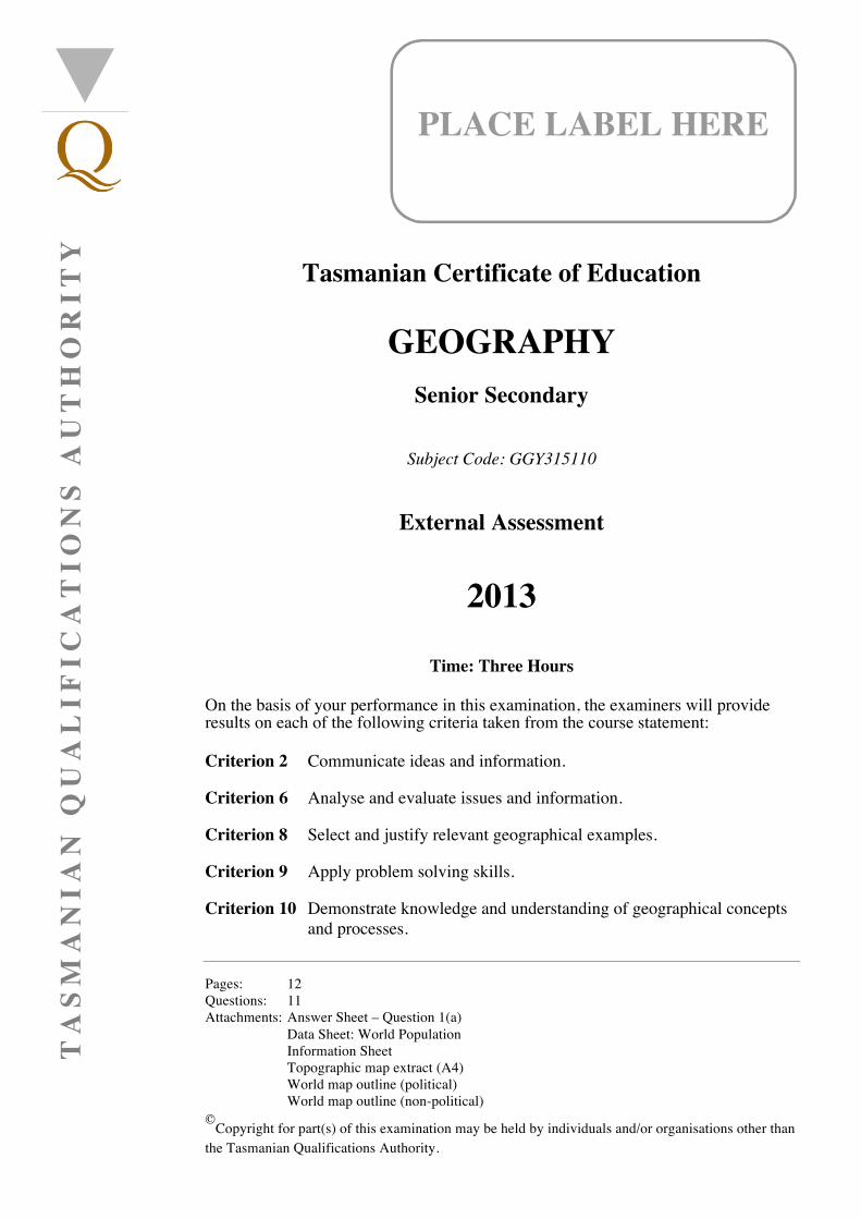
Pages: 12 Questions: 11 Attachments: Answer Sheet – Question 1(a) Data Sheet: World Population Information Sheet Topographic map extract (A4) World map outline (political) World map outline (non-political)
©Copyright for part(s) of this examination may be held by individuals and/or organisations other than the Tasmanian Qualifications Authority.
Tasmanian Certificate of Education
GEOGRAPHY
Senior Secondary
Subject Code: GGY315110
External Assessment
2013
Time: Three Hours
On the basis of your performance in this examination, the examiners will provide results on each of the following criteria taken from the course statement: Criterion 2 Communicate ideas and information. Criterion 6 Analyse and evaluate issues and information. Criterion 8 Select and justify relevant geographical examples. Criterion 9 Apply problem solving skills. Criterion 10 Demonstrate knowledge and understanding of geographical concepts
and processes.
TA
SM
AN
IAN
QU
AL
IFIC
AT
ION
S A
UT
HO
RIT
Y
PLACE LABEL HERE

Geography
Page 2
BLANK PAGE
Geography
Page 3
CANDIDATE INSTRUCTIONS You MUST ensure that you have addressed ALL of the externally assessed criteria on this examination paper. ANSWER EACH QUESTION IN A SEPARATE ANSWER BOOKLET. It is strongly recommended that you note the time allocations given for each question. This paper is divided into FOUR sections. You must answer FIVE questions in total. Answer ALL questions in Sections A and B. Choose ONE question from Section C and ONE question from Section D. Use the planning grid to ensure that you answer from TWO different options in Sections C and D. Planning Grid:
World Map outlines are provided for you to make use of wherever you can. You must place your candidate label on any map(s) and answer sheets used, and then place the labelled maps and answer sheets inside the relevant answer booklet. All written responses must be in English.
Tick a different option for each
section
Natural Hazards of the
Earth’s Crust The Atmosphere
Mountains, Coasts or River
Basins Urbanisation
Section C (essay)
Section D (structured
answer)
Geography
Page 4
SECTION A
Answer ALL questions from this section. You MUST refer to and use the accompanying Information Sheet and World Population Data Sheet when answering both questions. Use a separate answer booklet for EACH QUESTION. It is recommended that you spend approximately 1 hour on this section. This section assesses Criteria 6, 9 and 10. Question 1 (40 minutes) This question assesses Criteria 9 and 10. Refer to the Information Sheet and the World Population Data Sheet. (a) On the answer sheet provided, name one country in each of Stage 2, Stage 3, Stage 4 and
Stage 5 of the Demographic Transition Model and quickly sketch the shape of its population pyramid. Give reasons for classifying the countries you have chosen in those stages.
(b) Suggest actions that could help a country to move from Stage 2 to Stage 4 of the Demographic
Transition Model. Question 2 (20 minutes) This question assesses Criterion 6. Refer to the Information Sheet and the World Population Data Sheet. Explain how the Infant Mortality Rate (IMR), the Total Fertility Rate (TFR) and Life Expectancy (LE) are connected. Refer to examples of Less Developed Countries (LDCs) and More Developed Countries (MDCs) in your answer.
Geography
Page 5
SECTION B
Answer ALL PARTS of the question in this section. Use a separate answer booklet for this section. It is recommended that you spend approximately 40 minutes on the question. This section assesses Criteria 6 and 8. Question 3 Refer to the Grampians (Victoria) Topographic Map Extract and use your topographic mapping skills to: (a) describe the main physical features of the area
(b) describe the human features (c) explain how the natural environment has influenced people’s use of the land. Use specific
examples to support your answer.

Geography
Page 6
SECTION C
Answer ONE question in essay form from this section. You MUST select a different option from the one you answer in Section D (refer to the planning sheet on page 3). All questions are of equal value. Credit will be given for using appropriate maps and diagrams in your answer. Use a separate answer booklet for this section. It is recommended that you spend approximately 40 minutes on the question. This section assesses Criteria 2, 8 and 10. OPTION A – NATURAL HAZARDS OF THE EARTH’S CRUST Question 4 Choose ONE of the following natural hazards: either earthquakes or volcanoes or mass movement. Discuss the causes of, the impacts of and human responses to this natural hazard. Use specific examples from both Less Developed Countries (LDCs) and More Developed Countries (MDCs). OPTION B – THE ATMOSPHERE Question 5 Choose ONE of the following: either enhanced greenhouse effect or El Niño/La Niña or ozone depletion or acid rain. Discuss its causes, its impacts and human responses to it. Use specific examples from both Less Developed Countries (LDCs) and More Developed Countries (MDCs).
Section C continues opposite.
Geography
Page 7
Section C (continued) OPTION C – MOUNTAINS, COASTS OR RIVER BASINS Question 6 Choose ONE of the following landscapes: either mountains or coasts or river basins. Describe the processes of erosion and deposition that are responsible for any two landforms in this landscape. Discuss the impact of human activity on this landscape and explain how people have responded to these impacts, using specific examples from both Less Developed Countries (LDCs) and More Developed Countries (MDCs). OPTION D – URBANISATION Question 7 Discuss the causes of, impacts of and human responses to urbanisation. Use specific examples from both Less Developed Countries (LDCs) and More Developed Countries (MDCs).
Geography
Page 8
SECTION D
Answer ONE question from this section. You MUST select a different option from the one you answer in Section C (refer to the planning sheet on page 3). All questions are of equal value. Credit will be given for using appropriate maps and diagrams in your answer. Use a separate answer booklet for this section. It is recommended that you spend approximately 40 minutes on the question. This section assesses Criteria 2, 8 and 9. OPTION A – NATURAL HAZARDS OF THE EARTH’S CRUST Question 8 Choose ONE of the following natural hazards: either earthquakes or volcanoes or mass movement. (a) Describe the distribution of this natural hazard. (b) Discuss the impacts of this natural hazard, using specific examples from both Less Developed
Countries (LDCs) and More Developed Countries (MDCs).
(c) What have been the human responses to the impacts in your examples? Evaluate the level of success of these responses.
Section D continues opposite.
Geography
Page 9
Section D (continued) OPTION B – THE ATMOSPHERE Question 9 Choose ONE of the following: either enhanced greenhouse effect or El Niño/La Niña or ozone depletion or acid rain. (a) Briefly outline its causes. (b) Discuss its impacts, using specific examples from both Less Developed Countries (LDCs) and
More Developed Countries (MDCs). (c) What have been the human responses to the impacts in your examples? Evaluate the level of
success of these responses. OPTION C – MOUNTAINS, COASTS OR RIVER BASINS Question 10 Choose ONE of the following landscapes: either mountains or coasts or river basins. (a) Briefly outline the processes of erosion and deposition that produce any two landforms in this
landscape. (b) Discuss the impacts of human activities in this landscape, using specific examples from both
Less Developed Countries (LDCs) and More Developed Countries (MDCs). (c) What have been the human responses to the impacts in your examples? Evaluate the level of
success of these responses. OPTION D – URBANISATION Question 11 (a) Briefly outline how and why urbanisation occurs. (b) Discuss the impacts of urbanisation, using specific examples from both Less Developed
Countries (LDCs) and More Developed Countries (MDCs).
(c) What have been the human responses to the impacts in your examples? Evaluate the level of success of these responses.

Geography
Page 10
BLANK PAGE

Geography
Page 11
BLANK PAGE

Geography
Page 12
This question paper and any materials associated with this examination (including answer booklets, cover sheets, rough note paper, or information sheets) remain the property of the Tasmanian Qualifications Authority.

T
A S
M
A
N I A
N Q
U
A L I F I C
A T I O
N S A
U T H
O
R I T Y
PLAC
E LABEL H
ERE
Place this sheet inside your answer booklet.
Tasmanian C
ertificate of Education
GEO
GR
APH
Y
Senior Secondary
Subject Code: G
GY315110
External A
ssessment
2013
ASN
WER
SHEET – Q
uestion 1(a)
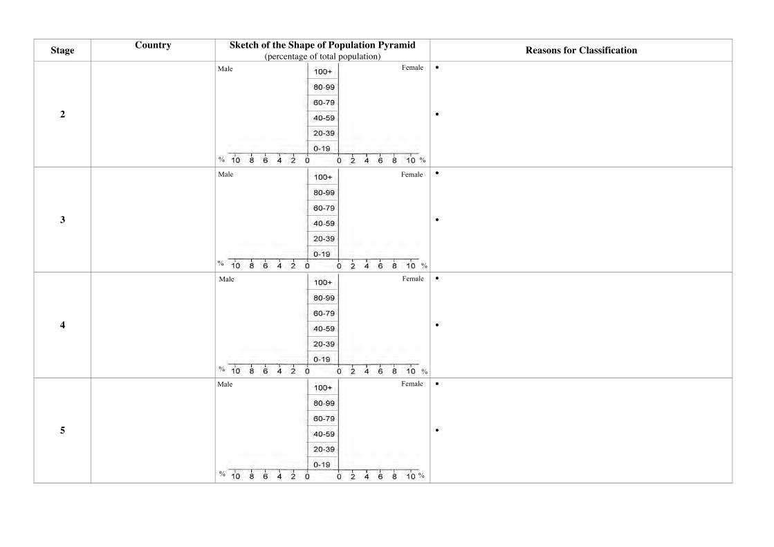
Stage Country Sketch of the Shape of Population Pyramid (percentage of total population) Reasons for Classification
2
• •
3
• •
4
• •
5
• •
Male
Male
Male
Male
Female
Female
Female
Female
% %
%
%
% %
%
%
GEOGRAPHY
Senior Secondary
Subject Code: GGY315110
External Assessment
2013
Information Sheet
Pages: 3 ©Copyright for part(s) of this examination may be held by individuals and/or organisations other than the Tasmanian Qualifications Authority.
TA
SM
AN
IAN
QU
AL
IFIC
AT
ION
S A
UT
HO
RIT
Y
Geography – Information Sheet
Page 2
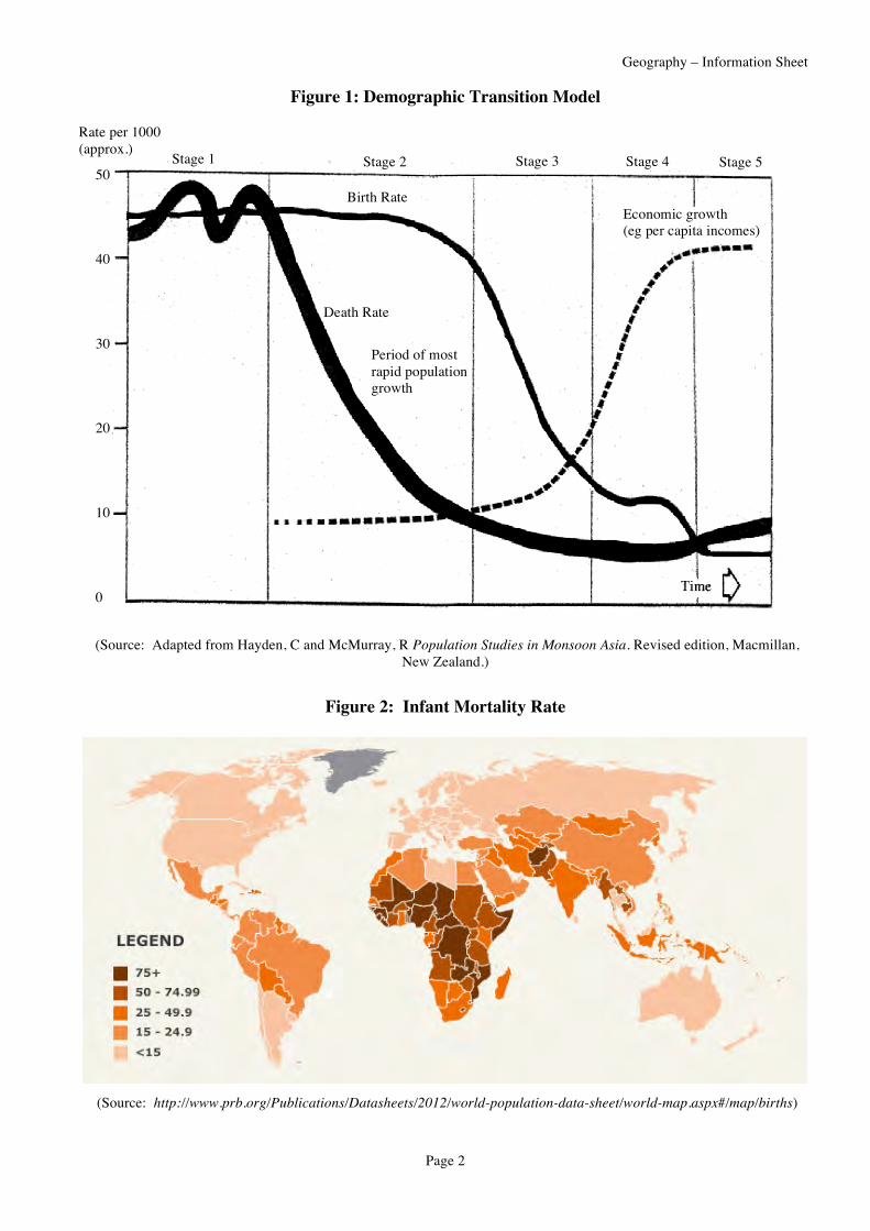
Figure 1: Demographic Transition Model
(Source: Adapted from Hayden, C and McMurray, R Population Studies in Monsoon Asia. Revised edition, Macmillan, New Zealand.)
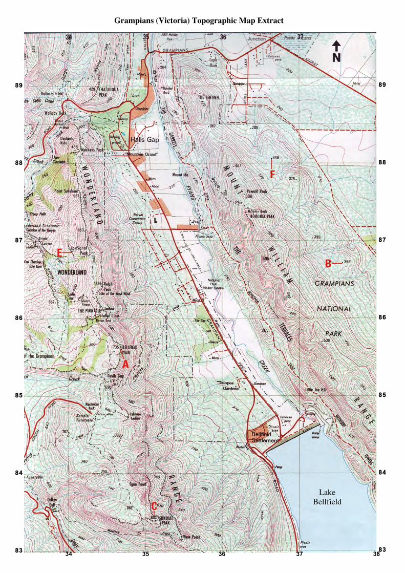
Figure 2: Infant Mortality Rate
(Source: http://www.prb.org/Publications/Datasheets/2012/world-population-data-sheet/world-map.aspx#/map/births)
Rate per 1000 (approx.)
50 40 30 20 10 0
Stage 5 Stage 4 Stage 3 Stage 2 Stage 1
Birth Rate
Death Rate
Economic growth (eg per capita incomes)
Period of most rapid population growth

Geography – Information Sheet
Page 3
Figure 3: Total Fertility Rate
(Source: http://www.prb.org/Publications/Datasheets/2012/world-population-data-sheet/world-map.aspx#/map/births)
Figure 4: Life Expectancy
(Source: http://www.prb.org/Publications/Datasheets/2012/world-population-data-sheet/world-map.aspx#/map/lifeexp)
34 35 36 37 38
89 88 87 86 85 84 83
Grampians (Victoria) Topographic Map Extract
89 88 87 86 85 84 83
Lake Bellfield
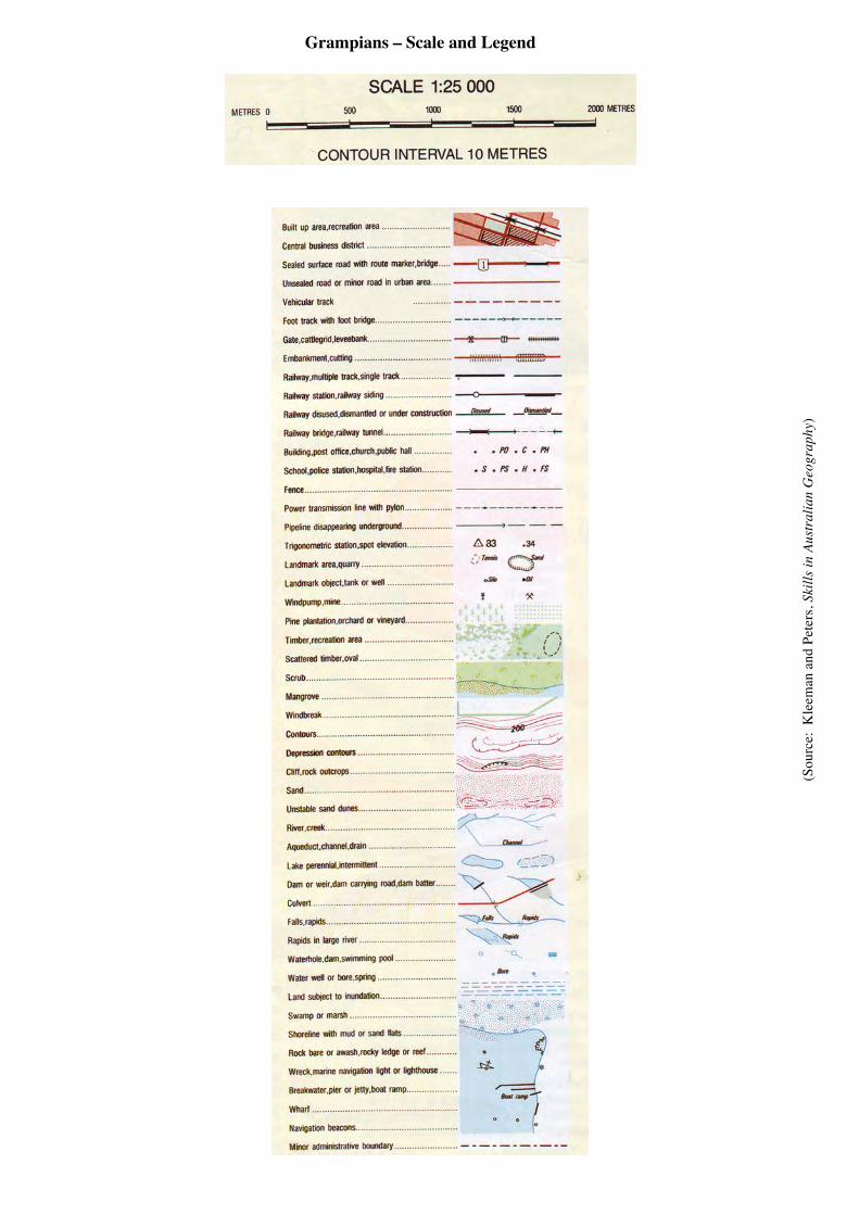
Grampians – Scale and Legend
(Sou
rce:
Kle
eman
and
Pet
ers,
Skill
s in
Aust
ralia
n G
eogr
aphy
)