Task 0 Work Plan - Holistic Watershed Management for ...
20
HOLISTIC WATERSHED MANAGEMENT FOR EXISTING AND FUTURE LAND USE DEVELOPMENT ACTIVITIES: OPPORTUNITIES FOR ACTION FOR LOCAL DECISION MAKERS: PHASE 1 – MODELING AND DEVELOPMENT OF FLOW DURATION CURVES (FDC 1 PROJECT) SUPPORT FOR SOUTHEAST NEW ENGLAND PROGRAM (SNEP) COMMUNICATIONS STRATEGY AND TECHNICAL ASSISTANCE TASK 0 WORK PLAN 1 ST DRAFT NOVEMBER 4, 2020 Prepared for: U.S. EPA Region 1 Prepared by: Paradigm Environmental Great Lakes Environmental Center Blanket Purchase Agreement: BPA-68HE0118A0001-0003 Requisition Number: PR-R1-20-00322 Order: 68HE0121F0001
Transcript of Task 0 Work Plan - Holistic Watershed Management for ...

HOLISTIC WATERSHED MANAGEMENT FOR EXISTING AND FUTURE LAND
USE DEVELOPMENT ACTIVITIES: OPPORTUNITIES FOR ACTION FOR LOCAL
DECISION MAKERS: PHASE 1 – MODELING AND DEVELOPMENT OF FLOW
DURATION CURVES (FDC 1 PROJECT)
SUPPORT FOR SOUTHEAST NEW ENGLAND PROGRAM (SNEP)
COMMUNICATIONS STRATEGY AND TECHNICAL ASSISTANCE
TASK 0 WORK PLAN 1ST
DRAFT NOVEMBER 4, 2020
Prepared for:
U.S. EPA Region 1
Prepared by:
Paradigm Environmental Great Lakes Environmental Center
Blanket Purchase Agreement: BPA-68HE0118A0001-0003
Requisition Number: PR-R1-20-00322
Order: 68HE0121F0001

Support for Southeast New England Program (SNEP) Draft Work Plan
Communications Strategy & Tech. Assistance - FDC 1 Project November 4, 2020
i
Table of Contents 1 Project Understanding ........................................................................................................................ 1
2 Draft Work Plan ................................................................................................................................ 1
Task 0: Work Plan, Budget, and Schedule ............................................................................................ 1
Task 1: Prepare Quality Assurance Project Plan (QAPP) ...................................................................... 2
Task 2: Project Management and Administration ................................................................................. 2
Subtask 2A. Kickoff Meeting ............................................................................................................ 2
Subtask 2B. Conference Calls, Meetings, Project Team Support, and Post-Project Webinar ............... 2
Task 3: Technical Steering Committee Meetings ................................................................................... 3
Task 4: Coordinate with TSC to Finalize Phase 1 Project Approach ...................................................... 3
Subtask 4A. Draft Technical Scope Outline ....................................................................................... 3
Subtask 4B. Final Technical Scope .................................................................................................... 3
Task 5: Compile Available Data/Information for Taunton River Watershed Modeling Analysis .......... 4
Subtask 5A. Data/Information Assessment ....................................................................................... 4
Subtask 5B. Past, Current, and Future Climate Data Analysis ........................................................... 4
Subtask 5C. Baseline Unit-Area Modeling Analysis .......................................................................... 5
Subtask 5D. Develop Hydrologic/Streamflow and Water Management Modeling Approach for
Taunton River Sub-watershed Analyses ............................................................................. 6
Task 6. Phase 1 Hydrologic Streamflow Modeling Analyses ................................................................. 9
Subtask 6A. Adapt Models for Flow Duration Curve Analyses for Pilot Sub-watersheds ................... 9
Subtask 6B. Adapt EPA R1 Opti-Tool for Stormwater and FDC Management Analyses ................. 10
Task 7. Phase 1 Stormwater/Hydrologic Management Optimization Analyses ................................... 11
Task 8. Phase 1 Project Webinar to SNEP Region .............................................................................. 13
Schedule and Level of Effort ............................................................................................................... 14
3 Staffing ............................................................................................................................................ 15

Support for Southeast New England Program (SNEP) Draft Work Plan
Communications Strategy & Tech. Assistance - FDC 1 Project November 4, 2020
1
1 PROJECT UNDERSTANDING
The project will be conducted in two phases over two years. For its duration, the project will be guided by a
technical steering committee consisting of ecologists, hydrogeologists, fluvial geomorphologists, green
infrastructure and stormwater specialists, climate resilience professionals, landscape architects, municipal
officials, land-use planners, conservation managers, and real estate developers. The project is proposed for
the Taunton River Watershed. To realize cost savings, the work will utilize and advance previous work in
this system, including the calibrated continuous simulation hydrologic and watershed management models
developed for this system (United States Geological Survey [USGS] - calibrated Hydrological Simulation
Program – FORTRAN (HSPF) model, the EPA Watershed Management Optimization Support Tool
(WMOST), EPA Region 1’s Opti-tool (EPA 2016), and System for Urban Stormwater Treatment and
Analysis IntegratioN [SUSTAIN] models).
The goal of Phase 1 of this project is to develop and implement a proof-of-concept demonstration that the
Region 1 Opti-Tool and associated models can be applied for the development and analysis of flow duration
curves. The FDCs will be used to investigate the impacts of next-generation new development and/or
redevelopment (nD/rD) practices, or Conservation Development (CD) practices, on watershed hydrology
and stream health. Phase 1 results will quantify and qualify the impacts and benefits of changes in land cover
and CD practices based on an analysis of changes to the frequency and distribution of long-term stream
flows. Discharge thresholds associated with flooding, streambed mobilization, and baseflows will be
identified and evaluated relative to pre-development, historic land-use (if available), existing conditions, and
managed conditions with the implementation of CD practices/stormwater control measures (SCM).
Phase 1 will build upon existing calibrated continuous simulation hydrologic and watershed management
models for a portion of the Taunton River watershed. The existing HSPF models are proposed to be
converted into Loading Simulation Program in C++ (LSPC), which is based on HSPF algorithms but has
expanded functionality to provide seamless linkage to the EPA SUSTAIN model. The LSPC models will be
used in conjunction with the Opti-Tool, which uses the EPA SUSTAIN model for GI SCM process
simulation and optimization, to develop flow duration curves (FDCs) of stream flows that are representative
of pre-development and existing development conditions to demonstrate impacts and develop optimized
stormwater retrofit management strategies for improving conditions for the key watershed processes. Phase
2 will evaluate impacts on watershed processes associated with various future development patterns,
stormwater management solutions, population scenarios and future climate conditions using the FDCs
developed from Phase 1. This analysis will be used to develop generalized flow duration guidelines for the
Southeast New England Program (SNEP) region and New England, model regulations for next-generation
bylaw review and training materials.
The following sections provide our team’s approach to completing the tasks outlined in the Performance
Work Statement (PWS) and the key staff proposed to provide project management and technical leadership.
2 DRAFT WORK PLAN
The following draft Work Plan and methodology will serve as the starting point for discussion related to task
expectations, deliverables, staffing, and schedule.
Task 0: Work Plan, Budget, and Schedule
This document serves as our draft work plan and it outlines our approach and staffing for each task included
in the PWS. Our proposed level of effort and schedule for key milestones and deliverables are provided at
the end of this section.

Support for Southeast New England Program (SNEP) Draft Work Plan
Communications Strategy & Tech. Assistance - FDC 1 Project November 4, 2020
2
Task Lead: Khalid Alvi and Mick DeGraeve
Key Support Staff: John Riverson and David Rosa
Schedule: The final work plan will be delivered to EPA within 1 week of receiving comments from EPA.
Deliverable(s): Draft work plan (this deliverable); Final work plan, including the level of effort, final
schedule, and deliverables
Task 1: Prepare Quality Assurance Project Plan (QAPP)
Our team will develop a draft QAPP that addresses all aspects of this project no later than November 6,
2020. The QAPP will be based on the QAPPs available for the Tisbury ISD and the Phase 2 Mystic River
Watershed Eutrophication Analysis, with updates and additions as appropriate. A final QAPP will be
delivered within 1 week of receiving EPA comments on the draft. Any QAPP revisions that become
necessary as the project progresses will also be developed and delivered to EPA for review and approval.
Task Lead: Mick DeGraeve and Khalid Alvi
Key Support Staff: John Riverson, Dave Rosa, and Dale White
Schedule: The draft QAPP will be delivered to EPA no later than November 6, 2020, and a final QAPP
will be delivered within 5 days of receiving EPA comments on the draft.
Deliverable: Draft and final QAPP’s
Task 2: Project Management and Administration
The following highlights our approach to completing the subtasks identified in the PWS.
Subtask 2A. Kickoff Meeting The GLEC team will initiate the planning for the kickoff meeting. We will work with EPA to determine the
attendees and we will make every attempt to schedule the kickoff meeting within 30 days of notice to
proceed. The kickoff meeting will provide a critical opportunity for coordination and information sharing
with the EPA Project Team. Before the meeting, we will deliver the Task 0 work plan draft (this document)
and the Task 1 draft QAPP for EPA’s review. Our team will have compiled additional information and will
come to the meeting prepared to actively participate in project-related details. Attendees from our team will
include the Mick DeGraeve, Khalid Alvi, John Riverson, and David Rosa. We will take notes for the
duration of the meeting and will develop a meeting summary for distribution to the meeting attendees and
any others as directed by EPA.
Due to COVID-19, it is anticipated that a Zoom video conference meeting will be held tentatively on Nov
9, 2020. The GLEC team will provide teleconferencing details in advance of the kickoff call.
Subtask Lead: Mick DeGraeve, Khalid Alvi
Key Support Staff: John Riverson and David Rosa
Schedule: A kickoff meeting will be scheduled to occur (key attendee schedules permitting) within 30 days
of NTP.
Deliverable: Kickoff meeting summary will be provided within 1 week of the meeting.
Subtask 2B. Conference Calls, Meetings, Project Team Support, and Post-Project Webinar We will schedule and participate in monthly progress calls to keep the EPA Project Team apprised on the
progress of all tasks as well as planned activities during the next month. We will coordinate with EPA on
the best approach to scheduling and notifying attendees of call details in advance of the call. Working with
EPA, we will develop an agenda for each call but will also leave time on each call to discuss topics of interest
to the EPA Project Team. Each call will be attended, at a minimum, by Khalid Alvi and Mick DeGraeve.
Call notes, with action items, will be distributed via email to project team members within 3 days of the call.
Support for Southeast New England Program (SNEP) Draft Work Plan
Communications Strategy & Tech. Assistance - FDC 1 Project November 4, 2020
3
Subtask Lead: Mick DeGraeve and Khalid Alvi
Key Support Staff: David Rosa and Ryan Murphy
Schedule: Monthly progress calls and calls summary notes
Deliverable(s): Monthly calls; monthly call notes (distributed via email)
Task 3: Technical Steering Committee Meetings
An important component of this project will be the formation and management of a Technical Steering
Committee (TSC) that will provide guidance and feedback that coincide with key project milestones. Our
goal will be to communicate the project details and solicit guidance and feedback from the TSC for
consideration by EPA. We will work with EPA to schedule up to 5 meetings—it is possible that an in-person
kickoff meeting will be included.
Task Lead: Khalid Alvi
Key Support Staff: John Riverson and David Rosa
Schedule: Discuss with EPA during project kickoff call and align meetings with key deliverables
Deliverable(s): Attendance and support for up to five TSC meetings, assuming one in person and four
virtual; summary of responses to TSC comments.
Task 4: Coordinate with TSC to Finalize Phase 1 Project Approach
The following highlights our approach to completing the Task 4 subtasks identified in the PWS.
Subtask 4A. Draft Technical Scope Outline Under this subtask, a draft project scope outline will be developed. The annotated outline will describe the
technical tasks to be accomplished and will provide EPA and the TSC with sufficient information to
understand the objectives of Phase 1, as well as how the products will feed into Phase 2 of the project. The
scope outline will introduce key topics and will include brief descriptions to ensure a comprehensive vision
for the project is understandable to EPA and the TSC. Specific concepts to be addressed will be discussed
with EPA and may include, but not be limited, to the following:
• While stormwater management is often focused on addressing nutrient over-enrichment and
mitigating peak flows, less attention is paid to the geomorphic and ecological degradation resulting
from changes in the frequency, magnitude, and duration of hydrologically induced disturbances.
• Flow duration curves provide valuable insight into how land use and climate impact the frequency
and duration of stream flows. Changes in the FDC can lead to geomorphic and ecological
degradation. This work will help make the connection between the science of urban stream ecology
and management strategies that are accessible to watershed managers, engineers, and developers.
• The project should provide a body of technical documentation that can support communities,
especially in the Southeast New England Program (SNEP) region who may consider the adoption
of ordinances that build resiliency and promote the restoration/protection of local and regional water
resources. Additionally, the FDCs and optimization results highlighting cost-effective solutions will
help support decision making as well as public outreach and education efforts.
Subtask Lead: Khalid Alvi
Key Support Staff: John Riverson and David Rosa
Schedule: Prepare Draft Technical Scope outline within two months of Task Order notice to proceed
Deliverable(s): Draft technical scope outline
Subtask 4B. Final Technical Scope The draft Technical Scope Outline developed under Task 4A will be shared with the TSC for their review
and comment. A virtual meeting will be scheduled to discuss their comments. We will develop responses
Support for Southeast New England Program (SNEP) Draft Work Plan
Communications Strategy & Tech. Assistance - FDC 1 Project November 4, 2020
4
and share them with EPA for consideration before the finalization of the approach. In particular, we will
solicit input from EPA in cases where TSC reviewers have dissenting opinions. We will defer to EPA on all
decisions related to the final scope. A call with EPA may be beneficial to efficiently address decisions and
to streamline discussions on comments from the TSC and how they impact the approach.
Subtask Lead: Khalid Alvi
Key Support Staff: John Riverson and David Rosa
Schedule: The TSC meeting date is to be determined. The final Technical Scope will be delivered after the
TSC virtual meeting and within one week of receiving EPA comments
Deliverable(s): Final Technical Scope of Work/Project Approach
Task 5: Compile Available Data/Information for Taunton River Watershed Modeling
Analysis The following highlights our approach to completing the Task 5 subtasks identified in the PWS.
Subtask 5A. Data/Information Assessment Under this subtask, we will collect, review and assess all readily available data, and information including
previous hydrologic modeling analyses related to the Taunton River Watershed, as well as related
scientific/technical information that is pertinent to achieving the project’s objectives. The collection of
available data will include coordinating with EPA, EPA ORD, and USGS experts to ascertain the
availability and extent of data/information and gather such data. Local and state agencies will also be
engaged during these conversations as Massachusetts has a rich repository or data including geospatial
information. These groups will be engaged most likely via conference or videoconference calls to assist with
such coordination. Efforts will include, but not be limited to, the following:
• Land-used and Land Cover
• Identifying Candidate Sub-watershed Drainage Areas
• Identifying Useful Streamflow Gauging Station Data
• Subwatershed Prioritization
• Literature Reviews
• Monitoring Data
Subtask 5B. Past, Current, and Future Climate Data Analysis Under this subtask, we will:
• Evaluate approximately 40 years of meteorological data (1980-2019).
o Perform trend analysis for precipitation and temperature
o Perform interdecadal comparisons of storm distribution, rainfall intensity, and daily
maximum temperatures.
• Develop meteorological boundary conditions based on projected future climate change.
We will compile and review meteorological datasets including two observed climate data products from the
National Climatic Dataset Center: Global Historical Climatology Network (GHNC)-Daily and Local
Climatic Data (LCD). GHCN includes both daily precipitation and minimum/maximum temperature. Both
data sets will be inventoried for the full period of record at regional gages within and surrounding the
Taunton River watershed to ensure the analysis period is viable for approximately 40 years (e.g., 1980 to
2019).
The LCD dataset includes hourly precipitation and temperature. Secondary meteorological data, which are
derived or interpolated from primary sources, will also be leveraged. For example, the Parameter-elevation
Regressions on Independent Slopes Model (PRISM) dataset includes monthly precipitation totals and daily
temperature from 1980 to the present. The North American Land Data Assimilation System (NLDAS) will

Support for Southeast New England Program (SNEP) Draft Work Plan
Communications Strategy & Tech. Assistance - FDC 1 Project November 4, 2020
5
also be reviewed for use in this analysis. NLDAS includes additional climate parameters (e.g., hourly
temperature, wind speed, etc.) that may be beneficial for evaluating potential evapotranspiration. Potential
evapotranspiration is a critical component of the hydrologic budget and will be included in this analysis. The
Opti-Tool also uses the daily minimum and maximum temperature to estimate potential evapotranspiration
for modeling. Both the PRISM and NLDAS data sets are well documented, consistently derived across the
continental United States, and undergo extensive peer-review making them an excellent resource for
performing long-term trends analysis to complement locally observed data.
The available GHCN and LCD gage rainfall and temperature time series will be evaluated for completeness
through graphical and tabular summaries. Time series plots at each gage will be produced at daily, monthly,
and annual time scales as appropriate for each parameter. These plots will be reviewed for gaps and outliers
and will be included in the final report as appendices. These types of plots are useful for evaluating visual
patterns and checking for anomalies in the data sets which will need to be addressed before performing
further analyses.
Once the climate input data sets have been thoroughly reviewed and normalized, these data will be evaluated
for shifting trends in precipitation, temperature, and potential evapotranspiration patterns. The evaluation
methods will include but are not limited to, comparisons of the frequency of occurrence of daily precipitation
event depths, hourly precipitation intensities, daily maximum temperatures, and monthly potential
evapotranspiration. Multiple averaging periods may be introduced into the analysis to view year-over-year
trends, multi-year moving averages, and decadal trends cover the past 40 years.
We will review available future climate projections for the region and propose regionally representative time
series of future climatic conditions. Potential approaches include: (1) directly using disaggregated
downscaled future climate time-series, (2) statistically derived storm return intervals from future climate
time-series, or (3) projecting ranges of temperature and precipitation changes onto the historical record.
There is a regional precedent for the last approach, which was applied to the HSPF model of the Taunton
River Watershed. We will propose an approach to EPA that will include an ensemble of climate futures that
are a mix of approaches described above. The proposed hybrid approach will consider both temporal changes
in return intervals of different size storms (e.g., 2-yr, 5-yr, 10-yr, 25-yr, 50-yr, 100-yr, and 200-yr) and
projected scalar changes in temperature and precipitation.
Subtask 5C. Baseline Unit-Area Modeling Analysis Under this subtask, the GLEC Team will:
• Establish a baseline and future climate conditions
• Configure the LSPC model for unit-area time-series
o Reclassify land uses into 9 major land uses used in Opti-Tool
o Reclassify soil info into hydrological soil groups (HSGs)
o Reclassify slope into low, medium, and high categories
o Develop HRU categories to be consistent with the Opti-Tool
o Estimate effective impervious areas (EIA) using Sutherland’s equations (Southerland, 2000).
o Develop an HRU spatial raster layer showing modeled EIA footprint using the peppering
technique in the GIS platform.
• Evaluate changes in annual water/mass balance (runoff, recharge, ET, pollutant export)
• Evaluate changes in heat exchange and carbon sequestration
• Develop fact sheets with figures and tables to highlight results
We will develop unit-area HRU time-series for the baseline and the future climate conditions using the most
recent 20-year period of observed meteorological boundary conditions. We will estimate the changes in
average annual volumes of runoff, recharge, ET, and pollutant load export. Each HRU represents areas of
similar physical characteristics attributable to core processes identified through GIS overlays. The HRU

Support for Southeast New England Program (SNEP) Draft Work Plan
Communications Strategy & Tech. Assistance - FDC 1 Project November 4, 2020
6
layer combines spatial information such as land-use, slope, soils, imperviousness, and buildings layers into
a single layer with unique categories.
The continuous simulation will use meteorological data compiled during the Subtask 5B and LSPC model
updated with calibrated SWMM buildup/washoff parameters available as part of the Opti-Tool. The
calibrated SWMM parameters are available for HRUs representative of Region 1 specific land use. Available
land cover/use, soil, and slope data for the Taunton River watershed may need to be reclassified into those
specific HRU categories to facilitate the Opti-Tool application. Tables and figures will be created to identify
how available information was reclassified into the equivalent Opti-Tool categories. The resulting hourly
time-series for each HRU will allow for a detailed evaluation of long-term, cumulative alterations, and
impacts to watershed functions associated with land-use change/IC conversion. Heat maps will be generated
to present the variation of annual runoff (in/yr) and pollutant loading (lb./ac/yr) at the HRU and model
sub-watershed scale.
Additionally, methods to quantify average annual unit-area-based changes in heat exchange and carbon
sequestration resulting from land-use change/IC conversion will be investigated. Changes to land use and
land cover can affect energy portioning between latent and sensible heat flux. Latent heat is exchanged due
to phase changes of water but does not result in a temperature change. Evaporation or condensation are
examples of latent heat exchange. Sensible heat is exchanged due to conduction and convection and directly
affects the temperature of the atmosphere, such as a warm parking lot radiating heat into a cool night. The
ET rate (mm day-1) can be converted to latent heat flux (MJ m-2 day-1) using a conversion factor of 2.45 and
an assumed temperature of 20°C. We will consult with committee members to determine a satisfactory
approach to estimating heat exchange and carbon sequestration by leveraging model estimates of ET and
data embedded within the HRUs such as land cover and soil type.
The GLEC Team has developed a ‘peppering’ approach to developing rasters based on historic or projected
land-use changes. The approach uses a probabilistic raster reclassification algorithm to modify an existing
HRU raster and replace individual HRUs with new ones. The result of the probabilistic reclassification is a
raster that has reclassified pixels scattered throughout it. As a way of maintaining the resolution of the 2016
land use data, the raster peppering approach may be used to convert the 2016 raster to pre-development and
historical land-use distributions. A GIS analysis will summarize MassGIS 1971 land-use distributions at the
model subwatershed scale. Those distributions will then be applied to the 2016 land-use to convert existing
land-use pixels to those representing historical land-use. The changes are based on rules that can be applied
at the model sub-watershed scale. When applied at the model subwatershed scale, the result is a raster that
has pixels representing the pervious surfaces ‘peppered’ throughout the impervious ones. The approach
could also be applied in Phase 2 to reclassify 2016 land-use distributions to projected future land-use
scenarios. The peppering approach would therefore be a consistent and defensible methodology to spatially
represent changes from the existing condition raster to both historical and future conditions.
An important aspect of any modeling study is the presentation of modeling results clearly and concisely and
in a format that is understandable by a variety of technical and non-technical audiences. For this project, we
will develop fact sheets that highlight and discusses, through figures and tables, the impacts to watershed
functions and the potential magnitude of cumulative watershed-wide impacts associated with land-use
changes and associated IC conversion. Our Team will work closely with EPA to develop an outline for the
fact sheets and discuss options for various approaches and formats for disseminating the information.
Subtask 5D. Develop Hydrologic/Streamflow and Water Management Modeling Approach for Taunton River Sub-watershed Analyses Our proposed modeling approach follows a top-down weight-of-evidence-based methodology. The approach
leverages high-resolution HRU and meteorological data for model configuration. Figure 1 provides a
schematic of the adaptive model development approach for assessing and integrating the required datasets
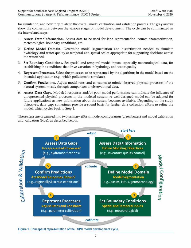
Support for Southeast New England Program (SNEP) Draft Work Plan
Communications Strategy & Tech. Assistance - FDC 1 Project November 4, 2020
7
for simulation, and how they relate to the overall model calibration and validation process. The gray arrows
show the connections between the various stages of model development. The cycle can be summarized in
six interrelated steps:
1. Assess Data/Information. Assess data to be used for land representation, source characterization,
meteorological boundary conditions, etc.
2. Define Model Domain. Determine model segmentation and discretization needed to simulate
hydrology and water quality at temporal and spatial scales appropriate for supporting decisions across
the watershed.
3. Set Boundary Conditions. Set spatial and temporal model inputs, especially meteorological data, for
establishing the conditions that drive variation in hydrology and water quality.
4. Represent Processes. Select the processes to be represented by the algorithms in the model based on the
intended application (e.g., which pollutants to simulate).
5. Confirm Predictions. Adjust model rates and constants to mimic observed physical processes of the
natural system, mostly through comparison to observational data.
6. Assess Data Gaps. Modeled responses and/or poor model performance can indicate the influence of
unrepresented physical processes in the modeled system. A well-designed model can be adapted for
future applications as new information about the system becomes available. Depending on the study
objectives, data gaps sometimes provide a sound basis for further data collection efforts to refine the
model, which cycles back to Step 1.
These steps are organized into two primary efforts: model configuration (green boxes) and model calibration
and validation (blue), as described below.
Figure 1. Conceptual representation of the LSPC model development cycle.

Support for Southeast New England Program (SNEP) Draft Work Plan
Communications Strategy & Tech. Assistance - FDC 1 Project November 4, 2020
8
The proposed platform for model configuration is LSPC. LSPC model is an open-source, process-based
watershed modeling system developed by the EPA for simulating watershed hydrology, sediment erosion
and transport, and water quality processes from both upland contributing areas and receiving streams (EPA
2009b). The LSPC model simulates flow accumulation in stream networks and the transport of pollutants,
which may be deposited or scoured from the stream bed, sorbed or transformed due to various chemical and
biological processes. LSPC is capable of dynamically simulating flow, sediments, nutrients, metals, dissolved
oxygen, temperature, and other pollutants for pervious and impervious lands and water bodies of varying
order.
LSPC algorithms were developed from a subset of those in HSPF, but were designed to overcome some of
the structural attributes that limit the size, resolution, and complexity associated with HSPF model
configuration. The hydrologic portion of HSPF is based on the Stanford Watershed Model, one of the
pioneering watershed models. LSPC is built upon a relational database platform, enabling the collation of
diverse datasets to produce robust representations of natural systems. LSPC integrates GIS outputs,
comprehensive data storage, and management capabilities, the original HSPF algorithms, and a data
analysis/post-processing system into a PC-based Windows environment.
A coupled watershed-SCM modeling framework provides an integrated platform for representing the impact
of stormwater management on watershed-scale hydrology and water quality. LSPC is designed for direct
linkage to the Opti-Tool. Conversely, Opti-Tool outflow time-series can be exported as a linkage file that in
turn becomes an input to LSPC. Figure 2 shows how the two models will be linked. The baseline watershed
model routes surface, interflow, and groundwater outflow directly to the stream network. When LSPC is
linked to Opti-Tool, overland flow (SURO) from managed areas is intercepted and routed to SCMs, where
it is either treated, bypassed, or overflows when inflow exceeds treatment capacity. Infiltrated water from
SCMs is stored in an aquifer segment for attenuated routing back to the LSPC reach-network. For the
Figure 2. LSPC and Opti-Tool linkage schematic for integrated watershed-SCM hydrology modeling.
managed areas, the stormwater outflow from Opti-Tool replaces the baseline SURO from LSPC, while other
components of the water balance, along with unmanaged areas, are routed directly to the reach network.
Unless they are part of the modeled management strategy (e.g., channel modifications, stream restoration,

Support for Southeast New England Program (SNEP) Draft Work Plan
Communications Strategy & Tech. Assistance - FDC 1 Project November 4, 2020
9
and the like), all hydromodifications and special features within the LSPC network are unchanged between
baseline and managed scenarios.
Task 5 Lead: Khalid Alvi
Key Support Staff: John Riverson, Ryan Murphy, David Rosa, and Dale White
Schedule: Task 5C Fact Sheet and Technical Memo detailing the methodology and results of subtasks 5A,
5B, 5C, and 5D to be completed within six (6) months of NTP
Deliverable(s): Facts Sheets discussing watershed alterations and impacts based on unit-area modeling
results. Figures and tables to be included in Task 5C Factsheet. Draft and Final Technical Memorandum.
Task 6. Phase 1 Hydrologic Streamflow Modeling Analyses
The following highlights our approach to completing the Task 6 subtasks identified in the PWS.
Subtask 6A. Adapt Models for Flow Duration Curve Analyses for Pilot Sub-watersheds Under this subtask, we will:
• Conduct a GIS-based Watershed Characterization
• Conduct Model Refinement
o Review existing HSPF models for the study area.
▪ Map HSPF land segments to Opti-Tool HRU classification.
▪ Review land/stream parameters
▪ Review point source representation in the model
▪ Identify data gaps
o Develop LSPC models for the selected sub-watersheds
▪ Configure the delineated sub-watersheds with land (HRUs) and stream segments
▪ Assign existing HSPF land/stream parameters to LSPC model
▪ Assign Opti-Tool’s SWMM-HRU water quality parameters to LSPC model
▪ Assign weather boundary condition
• Calibrate hydrology to proposed observed gage (e.g., USGS 01109000 flow gage)
• Develop FDCs
o Pre-develop, historical (if possible), and existing land use
o Baseline and Future climate condition
• Present Results
GIS-based Watershed Characterization. We will conduct a GIS-based watershed characterization for the three selected sub-watershed areas and any
additional areas identified as necessary to inform the development, refinement, and testing of the hydrologic
model for stream FDC development. We will identify key watershed and stream characteristics for
predevelopment, historic (e.g. circa the 1970s), and current conditions. While the task is expected to be
primarily GIS-based, it is acknowledged that GIS data is likely best suited to characterizing the current
watershed conditions. The characterization of pre-development and historic watershed conditions, as well
as predevelopment, historic, and current stream geomorphic conditions may require other sources of
information such as previous studies as well as professional judgment.
Watershed: The majority of current-condition watershed characteristics will be readily derived through GIS analysis.
The 1971 statewide historic land-use layer available from MassGIS can provide historic land classifications.
Pre-development conditions will likely reflect a combination of forest, grass, and wetlands distributed across
the watershed, with proportions based on professional judgment, literature review, and consultation with
the TSC.

Support for Southeast New England Program (SNEP) Draft Work Plan
Communications Strategy & Tech. Assistance - FDC 1 Project November 4, 2020
10
Stream: Some extent of stream characterization can be achieved through GIS analysis, including estimating current
condition lengths, widths, sinuosity, and riparian cover. Current and historical bed elevations may be
available from the 2015 Federal Emergency Management Agency (FEMA) Bristol County, MA Flood
Insurance Study. Bankfull geometry may be estimated using USGS regression equations developed for
Massachusetts. Additional data may be obtained through literature review and consultation with the TSC.
Model Refinement. We will convert the existing HSPF models for the study area to LSPC. The algorithms of LSPC were
developed from a subset of those in the HSPF. LSPC integrates GIS outputs, comprehensive data storage,
and management capabilities, the original HSPF algorithms, and a data analysis/post-processing system
into a convenient PC-based Windows environment. Additionally, the inputs/outputs for both Opti-Tool and
LSPC can be seamlessly linked with no additional data formatting required. Based on the existing HSPF
models and GIS analysis, refined LSPC models for the three sub-watersheds will be developed to represent
hydrologic processes and streamflow routing for predevelopment, historic, and existing conditions for the
selected baseline climatic period. For historical and existing conditions in which observed data is available,
model performance will be evaluated using both visual and statistical approaches.
Model refinement will include the development of HRUs representative of applicable conditions (e.g.
historic, current), and may also include adjustments to model parameters such as those for stream geometry,
sub-watershed routing, and those governing groundwater and evapotranspiration processes.
Develop FDCs. The refined hydrologic models will be used to develop FDCs for the selected sub-watersheds for pre-
development, historic development (if available), and existing development conditions for baseline and
future climatic conditions. Resulting FDCs will be used to assess how changes in land use and climate
impact the outcomes such as the magnitude and frequency of flooding, habitat health and suitability, and
channel stability. The results will help improve the understanding and communication of how watershed
development impacts water resources and provide a foundation for developing next-generation ordinances
aimed at improving or maintaining flow regimes and stream health.
Present Results. Results of the FDC analyses will be summarized in tables and figures presenting, where appropriate:
• Quantitative estimates of long-term cumulative impacts for the identified critical streamflow
regimes/metrics (e.g., flooding, channel scouring, baseflow depletion, etc.),
• Surface water runoff pollutant load export,
• Groundwater recharge,
• Evapotranspiration,
• Carbon sequestration and
• Heat loss exchange that is associated with the different development conditions.
Results from the three sub-watersheds will be compared, with an emphasis on examining the relationships
between watershed development/IC conversion to the condition and health of the applicable streams.
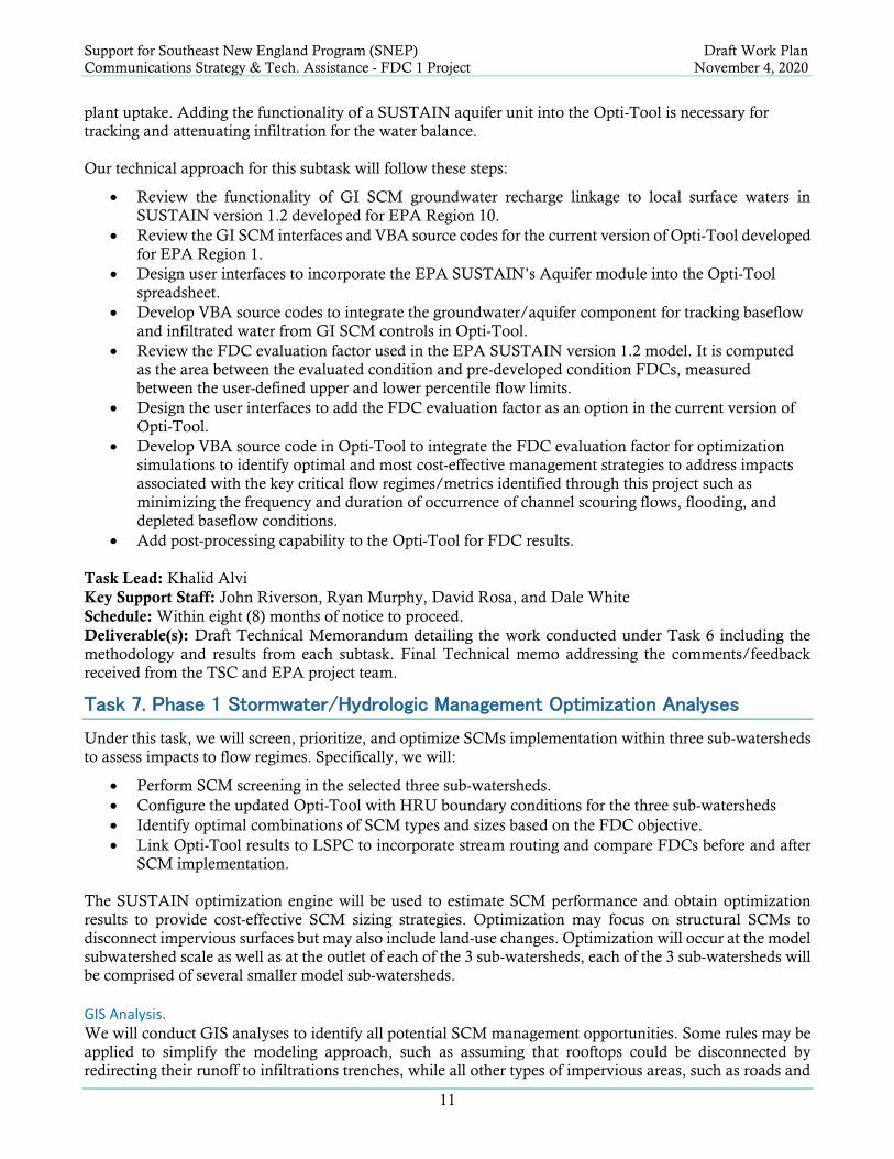
Subtask 6B. Adapt EPA R1 Opti-Tool for Stormwater and FDC Management Analyses This subtask involves updating the user-interfaces and developing VBA source codes for the Opti-Tool to
adopt the functionality of groundwater/aquifer and FDC evaluation factor for the optimization from the
EPA SUSTAIN version 1.2 model needed to meet the project goals. Currently, Opti-Tool is designed to
optimize the treatment of overland flow, it does not include groundwater components comparable to those
found in the EPA SUSTAIN model. Water that infiltrates to ‘active groundwater storage’ can move
laterally and contribute to baseflow, percolate to the deeper groundwater or leave the groundwater through
Support for Southeast New England Program (SNEP) Draft Work Plan
Communications Strategy & Tech. Assistance - FDC 1 Project November 4, 2020
11
plant uptake. Adding the functionality of a SUSTAIN aquifer unit into the Opti-Tool is necessary for
tracking and attenuating infiltration for the water balance.
Our technical approach for this subtask will follow these steps:
• Review the functionality of GI SCM groundwater recharge linkage to local surface waters in
SUSTAIN version 1.2 developed for EPA Region 10.
• Review the GI SCM interfaces and VBA source codes for the current version of Opti-Tool developed
for EPA Region 1.
• Design user interfaces to incorporate the EPA SUSTAIN’s Aquifer module into the Opti-Tool
spreadsheet.
• Develop VBA source codes to integrate the groundwater/aquifer component for tracking baseflow
and infiltrated water from GI SCM controls in Opti-Tool.
• Review the FDC evaluation factor used in the EPA SUSTAIN version 1.2 model. It is computed
as the area between the evaluated condition and pre-developed condition FDCs, measured
between the user-defined upper and lower percentile flow limits.
• Design the user interfaces to add the FDC evaluation factor as an option in the current version of
Opti-Tool.
• Develop VBA source code in Opti-Tool to integrate the FDC evaluation factor for optimization
simulations to identify optimal and most cost-effective management strategies to address impacts
associated with the key critical flow regimes/metrics identified through this project such as
minimizing the frequency and duration of occurrence of channel scouring flows, flooding, and
depleted baseflow conditions.
• Add post-processing capability to the Opti-Tool for FDC results.
Task Lead: Khalid Alvi
Key Support Staff: John Riverson, Ryan Murphy, David Rosa, and Dale White
Schedule: Within eight (8) months of notice to proceed.
Deliverable(s): Draft Technical Memorandum detailing the work conducted under Task 6 including the
methodology and results from each subtask. Final Technical memo addressing the comments/feedback
received from the TSC and EPA project team.
Task 7. Phase 1 Stormwater/Hydrologic Management Optimization Analyses
Under this task, we will screen, prioritize, and optimize SCMs implementation within three sub-watersheds
to assess impacts to flow regimes. Specifically, we will:
• Perform SCM screening in the selected three sub-watersheds.
• Configure the updated Opti-Tool with HRU boundary conditions for the three sub-watersheds
• Identify optimal combinations of SCM types and sizes based on the FDC objective.
• Link Opti-Tool results to LSPC to incorporate stream routing and compare FDCs before and after
SCM implementation.
The SUSTAIN optimization engine will be used to estimate SCM performance and obtain optimization
results to provide cost-effective SCM sizing strategies. Optimization may focus on structural SCMs to
disconnect impervious surfaces but may also include land-use changes. Optimization will occur at the model
subwatershed scale as well as at the outlet of each of the 3 sub-watersheds, each of the 3 sub-watersheds will
be comprised of several smaller model sub-watersheds.
GIS Analysis. We will conduct GIS analyses to identify all potential SCM management opportunities. Some rules may be
applied to simplify the modeling approach, such as assuming that rooftops could be disconnected by
redirecting their runoff to infiltrations trenches, while all other types of impervious areas, such as roads and
Support for Southeast New England Program (SNEP) Draft Work Plan
Communications Strategy & Tech. Assistance - FDC 1 Project November 4, 2020
12
driveways, could be disconnected by diverting their runoff to infiltration basins. Both public and private
property may be assumed to be available for SCM implementation. The GIS analyses will include the
development of jurisheds. Jurisheds are model sub-watersheds that have been intersected with municipal, or
jurisdictional, boundaries. If a model subwatershed spans across two separate jurisdictions, two jurisheds
are created, each with a unique numerical identifier. SCM management opportunities will be summarized
at the jurished scale. While optimization will occur at the watershed outlet, the use of jurisheds allows for
optimized SCM costs and capacities to be attributed to individual municipalities.
Optimize SCM Opportunities. The SUSTAIN GI simulation engine (EPA 2009a) (through the Opti-Tool) will be used to identify optimal
SCM types and sizes to achieve the FDC objective. Optimization will produce cost-effectiveness curves
based on hundreds of thousands of possible SCM type and size combinations. For the FDC objective, the y-
axis would reflect a metric suited to evaluating how close a simulated flow regime agrees with an objective
flow regime based on evaluating the frequency and duration of specific flows across the FDC.
Quantify Pollutant Load Export Reductions. Selected solutions from the cost-effectiveness curves will be used to assess the expected reductions in
pollutant load export that can be achieved based on an FDC objective. Mr. Alvi and Dr. Rosa provided
similar analysis for EPA R1 and the town of Tisbury MA. The study included a cost-benefit optimization
for reducing flow volume to address flooding issues. One result of the study was that capturing 0.4 inches of
runoff resulted in a 78% reduction in annual storm flow volume, an 81% reduction in annual TN loading,
and a 66.5% to 80% reduction in indicator bacteria loading.
Present Results. Results will be presented in a tabular and graphical format to facilitate understanding, education, and
outreach. A primary set of graphics will compare FDCs for pre-development, historical, and existing land
use as well as existing land-use with optimized SCM implementation. The graphics will display the
thresholds and metrics identified in the literature review under task 5A. Additional graphics will include cost
and capacity charts for SCM types by the municipality.
Identify Management Strategies. Management strategies will be identified for local communities to use and pursue. The management
strategies may include both structural controls and non-structural practices as a suite of innovative GI SCMs
for disconnecting impervious cover. The strategies may also include adopting the floodplain management
approach of No Adverse Impact (NAI) to FDCs. Several communities have adopted NAI-based floodplain
ordinances in which rD/nD must demonstrate that the development will not adversely impact other property
owners. This is typically done by demonstrating that the development will not obstruct or increase
floodwaters. A similar approach may be developed in which rD/nD would demonstrate NAI to the existing
FDC.
Final Project Report. We will compile all technical memorandums developed under each subtask and will prepare a draft written
project report that documents all work performed during Phase 1 of this project. We will address the
comments received on the draft report from the TSC and the EPA Project Team. The final project report
shall also describe how the work conducted under Phase 1 will be applied to accomplish the objectives of
Phase 2 work to develop wise water resource management strategies for future watershed development
activities.
Outreach Materials. We will prepare outreach materials that provide brief project information summaries (not to exceed three)
for efficiently conveying key messages, lessons learned, and valuable water resource management
information to watershed management practitioners including local, state, and federal government

Support for Southeast New England Program (SNEP) Draft Work Plan
Communications Strategy & Tech. Assistance - FDC 1 Project November 4, 2020
13
representatives. Outreach materials will be developed to effectively communicate key findings including
discussion of relationships between watershed function, land use development and water resource impacts
in low-order stream systems, and larger down-gradient waters resources (e.g., lakes, coastal waters, aquifers,
etc.). The information summaries will be designed with accompanying graphics and tables to convey water
resource impacts associated with inadequately managed IC conversion and the potential quantitative
benefits of feasible watershed restoration activities/strategies identified in this study.
Task Lead: Khalid Alvi
Key Support Staff: John Riverson, Ryan Murphy, David Rosa, and Dale White
Schedule: Drafts within eleven (11) months of NTP, final report, and materials before TO expiration
Deliverable(s): Final Project Report, Outreach Materials
Task 8. Phase 1 Project Webinar to SNEP Region
We will prepare for and participate in a webinar to present the Phase 1 study results and findings. Mr. Alvi
and Mr. Rosa previously presented to the SNEP Region on work applying the Opti-Tool to Tisbury, MA.
The GLEC Team assumes the webinar logistics will be provided by the SNEP and EPA project team.
Task Lead: Khalid Alvi
Key Support Staff: John Riverson and David Rosa
Schedule: Before TO expiration
Deliverable(s): Webinar presentation

Support for Southeast New England Program (SNEP) Draft Work Plan
Communications Strategy & Tech. Assistance - FDC 1 Project November 4, 2020
14
Schedule and Level of Effort
Table 1 presents the proposed schedule key activities and deliverables for this project. We will revise this
schedule as appropriate after receiving comments from EPA on this draft work plan, as well as any
information obtained during the kickoff meeting.
Table 1. Proposed Task and Deliverable Schedule
Task 0: Work Plan, Budget, and Schedule
Draft work plan, budget, and schedule 11/6/2020
Final work plan, budget, and schedule 11/20/2020
Task 1: Prepare Quality Assurance Project Plan
Prepare draft QAPP 11/6/2020
Final QAPP 12/31/2020
Task 2: Project Management and Administration
Kickoff call 11/9/2020*
Kickoff meeting and summary 11/13/2020
Monthly progress calls and summaries Monthly
Task 3: Technical Steering Committee Meetings
Kickoff call TBD
TSC Meeting 1: Completion of Subtask 4A - Draft Technical Scope Outline 12/17/2020*
TSC Meeting 2: Completion of draft Task 5 technical memorandum 4/22/2021*
TSC Meeting 3: Completion of draft Task 6 technical memorandum 6/24/2021*
TSC Meeting 4: Completion of draft Task 7 technical memorandum 9/23/2021*
Task 4. Coordinate with TSC to Finalize Phase 1 Project Approach
4A: Draft Technical Scope Outline
Draft technical approach outline 12/11/2020
4B: Final Technical Scope
Final technical approach memo 12/31/2020
Task 5. Compile Available Data/Information for Taunton River Watershed Modeling Analyses
5A: Data/Information Assessment
5B: Past, Current, and Future Climate Data Analysis
5C: Baseline Unit-Area Modeling Analysis
5D: Develop Hydrologic/Streamflow and Water Management Modeling Approach for Taunton River Sub-
watershed Analyses
Draft technical memo and fact sheets 4/16/2021
Final technical memo and fact sheets 4/30/2021
Task 6. Phase 1 Hydrologic Streamflow Modeling Analyses
6A: Adapt Models for Flow Duration Curve Analyses for Pilot Sub-watersheds
6B: Adapt R1 Opti-Tool for Stormwater and FDC Management Analyses
Draft technical memo 6/18/2021
Final technical memo 6/30/2021
Task 7. Phase 1 Stormwater/Hydrologic Management Optimization Analyses
Draft project report and outreach materials 9/17/2021
Final project report and outreach materials 9/30/2021
Task 8. Phase 1 Project Webinar to SNEP Region
Draft presentation slides 9/27/2021
Webinar presentation 9/30/2021*
*=tentative, to be finalized in consultation with EPA
TBD=to be decided
As needed, 1 call each month
Project Elements/Sub-Tasks Deliverables

Support for Southeast New England Program (SNEP) Draft Work Plan
Communications Strategy & Tech. Assistance - FDC 1 Project November 4, 2020
15
3 STAFFING
The GLEC team is pleased to provide EPA Region 1 with an impressive group of scientists and engineers
to support this challenging project. The following table provides the details for key consultant team staff and
their contact information. Bios for these and other key personnel follow the table.
Key Personnel/Role Contact Information
Mick DeGraeve, Program Manager Great Lakes Environmental Center; 739 Hastings Street, Traverse City, MI 49686; 231-941-2230; [email protected]
Khalid Alvi, Project Manager/Modeling Lead
Paradigm Environmental, Inc.; 3911 Old Lee Highway, Suite 41E, Fairfax, VA 22030; 703-957-1908; [email protected]
David Rosa, GIS/Modeling Support (alternate POC for Alvi)
Paradigm Environmental, Inc.; 3911 Old Lee Highway, Suite 41E, Fairfax, VA 22030; 703-957-1908; [email protected]
John Riverson Paradigm Environmental, Inc.; 3911 Old Lee Highway, Suite 41E, Fairfax, VA 22030; 703-957-1908; [email protected]
Ryan Murphy Paradigm Environmental, Inc.; 3911 Old Lee Highway, Suite 41E, Fairfax, VA 22030; 703-957-1908; [email protected]
Dale White Great Lakes Environmental Center; 1295 King Ave Columbus OH 43212; (614) 487-1040; [email protected]
Jennifer Hansen Great Lakes Environmental Center; 739 Hastings Street, Traverse City, MI 49686; 231-941-2230; [email protected]
Mick DeGraeve (Ph.D.), P4 - Program Manager Ph.D., Aquatic Biology, 1979, University of Wyoming, Laramie, Wyoming Master of Science, Biology, 1970, Eastern Michigan University, Ypsilanti, Michigan Bachelor of Science, Biology, 1968, Eastern Michigan University, Ypsilanti, Michigan
Dr. DeGraeve will manage the GLEC Team at the contract level and assure that OEP’s needs and
expectations are met for this procurement. He is the founder of GLEC, and for the past 45 years has
interacted regularly with professionals in a wide range of disciplines, and with representatives of industry,
government, and academia. Mick's technical aquatic biology/ toxicology professional experience has
included managing EPA Office of Water level of effort contracts for GLEC for 20+ years. Over that period,
he has had responsibility for the technical and financial oversight of 11 EPA Office of Water contracts; five
for the Health and Ecological Criteria Division (HECD), three for the Standards and Health Protection
Division (SHPD), one for the Permits Division of the Office of Wastewater Management (OWM), and two
for the Office of Ground Water and Drinking Water’s (OGWDW) Technical Support Center.
Mr. Khalid Alvi (PE), P4 – Project Manager/Senior Project Engineer
Master of Science, Civil and Environmental Engineering, 1999, Asian Institute of Technology, Thailand Bachelor of Science, Civil Engineering, 1993, University of Engineering and Technology Lahore, Pakistan Professional Engineer, Virginia No. 0402046509 (since 2010)
Mr. Khalid Alvi will be the Project Manager and modeling technical lead for this project. Mr. Alvi is a
Professional Engineer and an experienced TMDL, stormwater, watershed, and water quality modeler, and
data and GIS application developer with more than 15 years of experience in the development of TMDLs
and watershed and BMP modeling systems. He has extensive experience in developing practical solutions
for a variety of management objectives (e.g., flow volume reduction or pollutant load reduction target) by
identifying the best mix of cost-effective stormwater controls using state-of-art optimization algorithms at a
watershed scale. Alvi was the project manager and technical lead for the development of Opti-Tool, a
spreadsheet-based stormwater best management practices optimization tool. The Opti-Tool is designed for
use by municipal SW managers and their consultants to assist in developing technically sound and optimized
cost-effective SW management plans. The Opti-Tool uses EPA’s System for Urban Stormwater Treatment
and Analysis Integration (SUSTAIN) optimization module as a back-end computational engine to identify
the best mix of cost-effective stormwater controls. He co-led (with Paradigm’s John Riverson) the

Support for Southeast New England Program (SNEP) Draft Work Plan
Communications Strategy & Tech. Assistance - FDC 1 Project November 4, 2020
16
development of EPAs Loading Simulation Program C++ (LSPC) to modernize the watershed model HSPF
and EPA’s SUSTAIN - a decision support system for the EPA’s Office of Research and Development to
develop, evaluate, optimize, select and place BMPs based on cost and effectiveness. Mr. Alvi, as a primary
developer of EPAs LSPC, SUSTAIN, and Opti-Tool, has an unmatched understanding of the underlying
modeling algorithms used in the tool. He has demonstrated the application of the Opti-Tool through several
projects, including for the Town of Tisbury, MA, Buzzard Bay watershed located in the Town of Fairhaven,
MA, and Mystic River watershed located in the city of Medford, MA. For the recently completed work for
the Town of Tisbury and EPA R1, he was the modeling lead for applying the Opti-Tool for two selected
outfall catchments to optimize the cost-effective GI SCM opportunities that minimize the frequency and
duration of the flooding events within the urbanized drainage area to those outfalls pour points. He expanded
the Opti-Tool analysis to the entire town of Tisbury to explore the benefits of GI SCM opportunities in terms
of stormwater volume captured and nutrient (total nitrogen) load removed at the zoning district level for
planning purposes. Alvi was the key developer in SUSTAIN code updates for US EPA Region 10 to add the
functionality of groundwater/aquifer components to track the baseflow and groundwater recharge through
the infiltration process of GI SCM controls. He also enhanced SUSTAIN optimization codes to implement
the FDC as an evaluation factor to identify the optimal sizing and strategic locations of GI SCM that can
restore the existing condition to pre-development conditions. He managed the two-year technical support
contract with EPA Region 10 to enhance the SUSTAIN version 1.2 and to provide guidance and technical
support in applying the enhanced modeling features to the case studies in the State of Washington. There
are no other modelers with the experience and understanding of the Opti-Tool, HSPF/LSPC, and
SUSTAIN models that will be necessary to complete and incorporate innovation into the Taunton River
modeling effort.
David Rosa, P3 - Senior Water Resource Scientist
Ph.D., Natural Resources: Land, Water, Air, 2017, University of Connecticut Master of Science, Natural Resources: Land, Water, Air, 2013, University of Connecticut Bachelor of Science, Natural Resources, 2006, University of Vermont
Dr. Rosa will provide modeling support as well as scientific and technical analysis for the duration of this
project. He has extensive experience in watershed hydrology, watershed modeling, and BMP
implementation. David has experience with surface-water, watershed, water quality, and stormwater
modeling systems including the Storm Water Management Model (SWMM), Opti-Tool, the Hydrologic
Engineering Center’s River Analysis System (HEC-RAS), Soil and Water Assessment Tool (SWAT),
Loading Simulation Program - C++ (LSPC) and System for Urban Stormwater Treatment and Analysis
Integration (SUSTAIN). His experience includes calibrating and validating continuous simulation models
for watersheds, installing and monitoring LID practices, riparian buffers restoration, and applying
hydrologic and hydraulic models to quantify the water quality benefits of reconnected floodplains. David
has led modeling workshops for state officials and has expertise with a range of pollutants including
phosphorus, nitrogen, chloride, suspended solids, and pathogens. David is a certified floodplain manager,
and in his previous employment at the state of Vermont, Dr. Rosa worked at the state and local level to
develop and implement municipal floodplain and river corridor ordinances to enhance and improve stream
health and protect life and property based on fluvial geomorphic principals and the natural and beneficial
functions of floodplains. David’s work at Paradigm has included an Opti-Tool-based project for the town of
Tisbury, MA, and EPA to explore innovative and cost-effective techniques for mitigating flooding issues
related to the poor transmission of stormwater runoff from directly connected impervious cover. David
supported the modeling of two selected outfall catchments as well as a town-wide assessment. During this
work, David leveraged FDCs as an analysis and communication tool to investigate the effectiveness of GI
SCM opportunities to reduce the percent of the time that specific discharges, including those that likely result
in flooding events, were equaled or exceeded.
Ryan Murphy, P4 - Senior Environmental Scientist
Environmental & Water Resources Engineering, 2008-2010, Tufts University, Medford, MA
Support for Southeast New England Program (SNEP) Draft Work Plan
Communications Strategy & Tech. Assistance - FDC 1 Project November 4, 2020
17
Bachelor of Science, Environmental Policy & Planning, 2005, Virginia Tech, Blacksburg, VA
Mr. Murphy combines an interdisciplinary background in water resources engineering, ecological planning,
public policy, and computer science. He has extensive hands-on experience applying advanced computer
systems to solve complex water resource and environmental challenges. Mr. Murphy’s primary experience
is with surface-water, watershed, water quality, and stormwater modeling system including the Hydrologic
Simulation Program Fortran (HSPF), Loading Simulation Program - C++ (LSPC), Storm Water
Management Model (SWMM), and System for Urban Stormwater Treatment and Analysis Integration
(SUSTAIN). He honed this expertise through a combination of project-specific applications, active software
development, and facilitation of hands-on training workshops as part of several landmark water quality
modeling studies and stormwater management plans. Through the application of these modeling systems,
Mr. Murphy has become adept at leveraging both the Python and R scripting languages for extraction,
transformation, and analysis of large datasets often distributed across multiple platforms (e.g.,
desktop/server, Windows/Unix). Mr. Murphy has experience recoding some existing USGS software tools
and methods (e.g., HySEP) into contemporary scripting languages like Python for customized applications.
He has actively contributed to significant, publicly funded software projects in which some of his runtime
and post-processing utilities are incorporated into releases (e.g., SUSTAIN), and he continues to participate
in public open-source initiatives (e.g., QGIS web client). Mr. Murphy champions leveraging open-source
frameworks, including the QGIS and Python, for both scientifically focused and publicly funded initiatives,
as well as the standard for day-to-day workflow application within Paradigm.
John Riverson, P4 – Senior Modeler
Master of Science, Civil and Environmental Engineering, 1999, University of Virginia Bachelor of Science, Civil and Environmental Engineering, 1997, University of Virginia
Mr. Riverson has 21 years of experience developing and applying hydrologic models and conducting
supporting data analyses services, with a focus on public-domain models typically used to support water
resources management and regulations and subject to peer review (e.g., HSPF, LSPC, SWMM, SWAT, TR-
55, CE-QUAL-W2, QUAL2E/2K, SUSTAIN). He has an in-depth understanding of meteorological and
hydrological processes and interactions, climate change assessment, watershed and stormwater management,
water quality, and pollutant source characterization. With Mr. Alvi, John led the development of EPA’s
LSPC from 2003 and was responsible for designing system architecture and developing algorithms for most
of the core LSPC modules including (1) high-resolution meteorological data (2) crop-associated irrigation,
(3) hydraulic withdrawals and diversions and (4) the time-variable land-use module. He was also a co-
developer (with Mr. Alvi) of EPA’s SUSTAIN, a decision support model for selection, placement, and cost-
benefit optimization of stormwater management practices. He is proficient at engineering highly effective
graphical and tabular displays for journal/report- and web-based publication media and has published his
work in high-impact peer-reviewed journals (e.g. Water Resources Research, Water Research, Climatic
Change). John is regularly sought by different agencies to provide a third-party review and QA/QC of
modeling applications. He is highly regarded for his ability to present highly technical content to a wide
variety of audiences through an in-person presentation, webinars, and on-site training workshops. Mr.
Riverson and Mr. Alvi have collaborated on model development and application for more than 15 years and
have are each nationally recognized modeling experts with a reputation for delivering high quality,
defensible and innovative products.
Dale White (Ph.D.), P4 – Senior Aquatic Toxicologist
Master of Science, Environmental Engineering, 2009, Ohio State University Ph.D., Physical Geography, 1988 Penn State University Master of Science, M.S., Physical Geography, 1986, Penn State University Bachelor of Science, B.S., Environmental Studies, 1983, Slippery Rock University of Pennsylvania

Support for Southeast New England Program (SNEP) Draft Work Plan
Communications Strategy & Tech. Assistance - FDC 1 Project November 4, 2020
18
As an environmental engineer and physical geographer with over thirty years of experience, Dr. White has
focused his career on using stressor-response frameworks and mechanistic and statistical environmental
process models, inherently spatially varying, to solve environmental resource problems. He has contributed
to developing and communicating advances in understanding water quality issues and watershed
management solutions working for both regulatory agencies and academic institutions. He is an expert in
applying advanced GIS, modeling, and statistical methods in water quality research. Dale is both a licensed
professional engineer (Ohio) and a Certified GIS Professional (GISP).
Jennifer Hansen, P3 – GLEC Quality Assurance Officer
M.S., Biology/Conservation Biology, 2002, Central Michigan University, Mt. Pleasant, MI B.S., Biotechnology, 1990, Ferris State University, Big Rapids, MI
Jennifer is the proposed Quality Assurance Officer and has a diverse background in the biological and
biochemical sciences. She has extensive professional experience as a Quality Assurance Specialist,
including development and implementation of Quality Assurance Systems, data review and approval,
laboratory auditing and approval, and non-compliance investigations. She has extensive professional
experience in laboratory and field operations including water quality sampling, testing, and reporting.