Tarmoola early exploration returns grades of up to 24g/t ...
12
ASX Announcement 19 September, 2017 Tarmoola early exploration returns grades of up to 24g/t gold on key structures In light of these outstanding results, Great Boulder will proceed immediately with an extensive soil sampling program followed by maiden RC drilling Great Boulder Resources (ASX: GBR) is pleased to announce extremely promising results from its first surface sampling and mapping program at the Tarmoola project, located 40km north-west of Leonora in WA. The program returned a series of high-grade results from surface samples. It also identified the regionally significant Ursus Fault, which is considered a key gold bearing structure at the +2Moz King of the Hills gold mine. The Ursus fault was mapped extending over 3km within the Tarmoola project, and the high-grade gold results were coincident with the Marionette shear zone, interpreted as a splay off the Ursus Fault. The Tarmoola Project is located in the heart of the West Australian Eastern Goldfields, with the +9Moz Gwalia mine located 40km south, +2Moz King of the Hills mine located 10km to the east and +3Moz Thunderbox mine located 40km north. Over 80 surface samples were collected along the eastern outcropping margin of the Tarmoola project. The surface samples were collected from outcropping rock and quartz veins as well as historical workings. A significant zone of high grade mineralisation has been delineated over a 2km strike length, predominantly in quartz veins within the historical Marionette workings. The mineralisation sits along a northwest splay of the Ursus Fault (Marionette shear zone) and intersects a series of north striking dolerite sills and dykes within the host basalt. Significant rock chip results include: • 23.9g/t Au: Quartz vein in historical workings • 17.3g/t Au: Quartz vein in historical workings • 12.7g/t Au: Mafic schist and quartz veining in a small working • 9.1g/t Au: Hematitic shaft spoil and quartz veining Gold mineralisation appears restricted to within 500m of the Ursus Fault and along the northwest trending Marionette shear zone (Figure 1). Wide-spaced aircore has previously been drilled along the Ursus fault, however this has been largely ineffective as the holes were not orientated to test the fault and were shallow due to bedrock cropping out at surface. Great Boulder will now undertake detailed soil sampling to define the extent of mineralisation ahead of a maiden RC drill program to test the key structures around the Ursus and Marionette shear zones. A list of significant assay results and sample locations are provided in Table 1.
Transcript of Tarmoola early exploration returns grades of up to 24g/t ...

ASX Announcement 19 September, 2017
Tarmoola early exploration returns grades of up to 24g/t gold on key structures
In light of these outstanding results, Great Boulder will proceed immediately with an extensive soil sampling program followed by maiden RC drilling
Great Boulder Resources (ASX: GBR) is pleased to announce extremely promising results from its first surface sampling and mapping program at the Tarmoola project, located 40km north-west of Leonora in WA.
The program returned a series of high-grade results from surface samples. It also identified the regionally significant Ursus Fault, which is considered a key gold bearing structure at the +2Moz King of the Hills gold mine. The Ursus fault was mapped extending over 3km within the Tarmoola project, and the high-grade gold results were coincident with the Marionette shear zone, interpreted as a splay off the Ursus Fault.
The Tarmoola Project is located in the heart of the West Australian Eastern Goldfields, with the +9Moz Gwalia mine located 40km south, +2Moz King of the Hills mine located 10km to the east and +3Moz Thunderbox mine located 40km north.
Over 80 surface samples were collected along the eastern outcropping margin of the Tarmoola project. The surface samples were collected from outcropping rock and quartz veins as well as historical workings.
A significant zone of high grade mineralisation has been delineated over a 2km strike length, predominantly in quartz veins within the historical Marionette workings. The mineralisation sits along a northwest splay of the Ursus Fault (Marionette shear zone) and intersects a series of north striking dolerite sills and dykes within the host basalt.
Significant rock chip results include:
• 23.9g/t Au: Quartz vein in historical workings
• 17.3g/t Au: Quartz vein in historical workings
• 12.7g/t Au: Mafic schist and quartz veining in a small working
• 9.1g/t Au: Hematitic shaft spoil and quartz veining
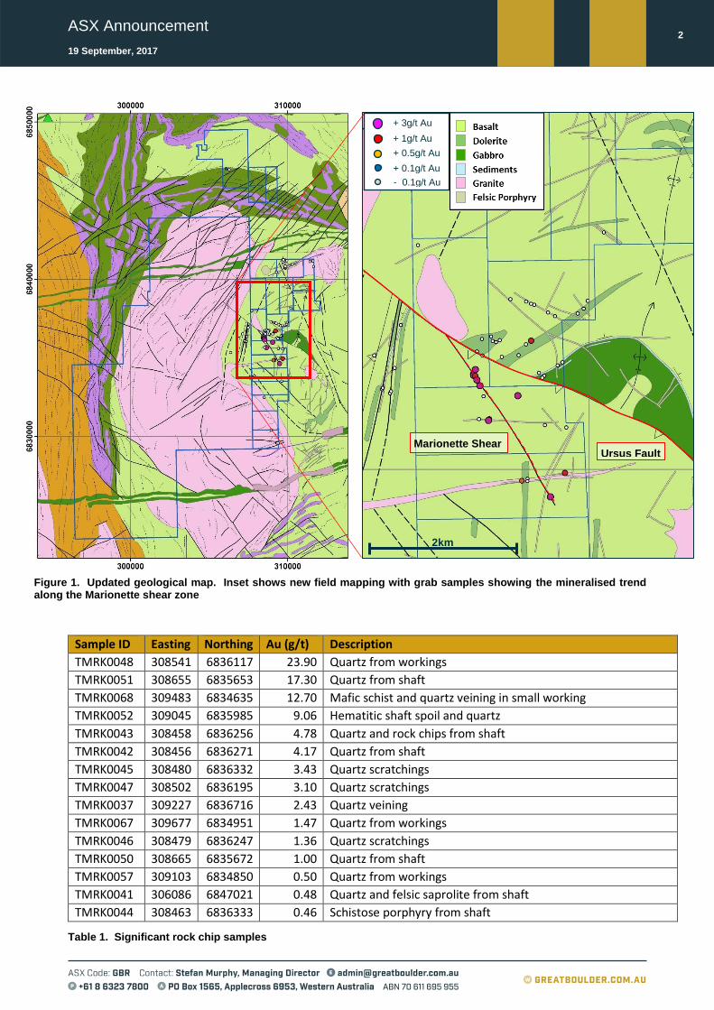
Gold mineralisation appears restricted to within 500m of the Ursus Fault and along the northwest trending Marionette shear zone (Figure 1). Wide-spaced aircore has previously been drilled along the Ursus fault, however this has been largely ineffective as the holes were not orientated to test the fault and were shallow due to bedrock cropping out at surface.
Great Boulder will now undertake detailed soil sampling to define the extent of mineralisation ahead of a maiden RC drill program to test the key structures around the Ursus and Marionette shear zones. A list of significant assay results and sample locations are provided in Table 1.
ASX Announcement
19 September, 2017
2
Figure 1. Updated geological map. Inset shows new field mapping with grab samples showing the mineralised trend along the Marionette shear zone
Sample ID Easting Northing Au (g/t) Description
TMRK0048 308541 6836117 23.90 Quartz from workings
TMRK0051 308655 6835653 17.30 Quartz from shaft
TMRK0068 309483 6834635 12.70 Mafic schist and quartz veining in small working
TMRK0052 309045 6835985 9.06 Hematitic shaft spoil and quartz
TMRK0043 308458 6836256 4.78 Quartz and rock chips from shaft
TMRK0042 308456 6836271 4.17 Quartz from shaft
TMRK0045 308480 6836332 3.43 Quartz scratchings
TMRK0047 308502 6836195 3.10 Quartz scratchings
TMRK0037 309227 6836716 2.43 Quartz veining
TMRK0067 309677 6834951 1.47 Quartz from workings
TMRK0046 308479 6836247 1.36 Quartz scratchings
TMRK0050 308665 6835672 1.00 Quartz from shaft
TMRK0057 309103 6834850 0.50 Quartz from workings
TMRK0041 306086 6847021 0.48 Quartz and felsic saprolite from shaft
TMRK0044 308463 6836333 0.46 Schistose porphyry from shaft
Table 1. Significant rock chip samples
+ 1g/t Au + 0.5g/t Au + 0.1g/t Au - 0.1g/t Au
2km
Ursus Fault Marionette Shear
+ 3g/t Au + 1g/t Au + 0.5g/t Au + 0.1g/t Au - 0.1g/t Au
ASX Announcement
19 September, 2017
3
Great Boulder Managing Director Stefan Murphy said: “These results are outstanding and highlight the significant potential of Tarmoola.
“While surface grab samples are only indicative, the identified trend along a structural corridor, with high gold grades and close proximity to a major gold-bearing structure is very encouraging.
“Limited previous exploration appears to have been largely ineffective due to shallow aircore drilling into outcropping bedrock. The Marionette shear zone has no modern drilling and is effectively untested. Our exploration effort at Tarmoola will now focus on the Ursus -Marionette shear zones and surrounding area, initially with a detailed soil sampling program to pin point the mineralised trends, then with follow-up RC drilling. We hope to have the soil sampling completed by early October and drilling by November.”
Mineralisation and Targeting
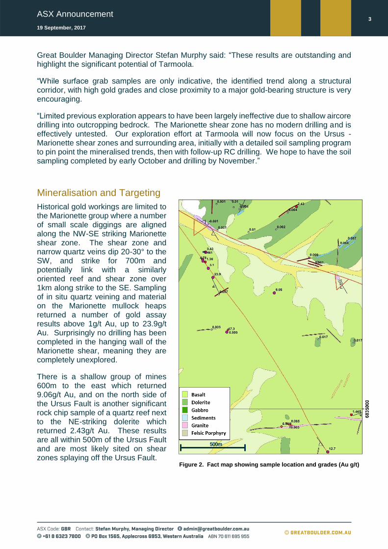
Historical gold workings are limited to the Marionette group where a number of small scale diggings are aligned along the NW-SE striking Marionette shear zone. The shear zone and narrow quartz veins dip 20-30° to the SW, and strike for 700m and potentially link with a similarly oriented reef and shear zone over 1km along strike to the SE. Sampling of in situ quartz veining and material on the Marionette mullock heaps returned a number of gold assay results above 1g/t Au, up to 23.9g/t Au. Surprisingly no drilling has been completed in the hanging wall of the Marionette shear, meaning they are completely unexplored.
There is a shallow group of mines 600m to the east which returned 9.06g/t Au, and on the north side of the Ursus Fault is another significant rock chip sample of a quartz reef next to the NE-striking dolerite which returned 2.43g/t Au. These results are all within 500m of the Ursus Fault and are most likely sited on shear zones splaying off the Ursus Fault.
Figure 2. Fact map showing sample location and grades (Au g/t)
500m
ASX Announcement
19 September, 2017
4
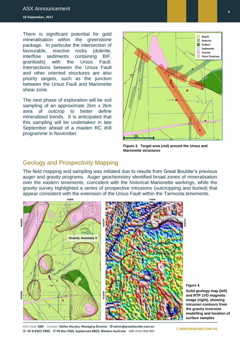
There is significant potential for gold mineralisation within the greenstone package. In particular the intersection of favourable, reactive rocks (dolerite, interflow sediments containing BIF, granitoids) with the Ursus Fault. Intersections between the Ursus Fault and other oriented structures are also priority targets, such as the junction between the Ursus Fault and Marionette shear zone.
The next phase of exploration will be soil sampling of an approximate 2km x 2km area of outcrop to better define mineralised trends. It is anticipated that this sampling will be undertaken in late September ahead of a maiden RC drill programme in November.
Geology and Prospectivity Mapping
The field mapping and sampling was initiated due to results from Great Boulder’s previous auger and gravity programs. Auger geochemistry identified broad zones of mineralisation over the eastern tenements, coincident with the historical Marionette workings, while the gravity survey highlighted a series of prospective intrusions (outcropping and buried) that appear consistent with the extension of the Ursus Fault within the Tarmoola tenements.
Gravity Anomaly 3
1km
Figure 3. Target area (red) around the Ursus and
Marionette structures
Figure 4.
Solid geology map (left)
and RTP 1VD magnetic
image (right), showing
intrusion contours from
the gravity inversion
modelling and location of
surface samples

ASX Announcement
19 September, 2017
5
Figure 5. Regional Geology showing Ursus Fault
Extensive outcrop along the eastern Tarmoola tenements makes the area amenable to field
mapping and targeted sampling. During 2011 Saint Barbara Mines completed wide spaced
aircore drilling along the interpreted Ursus Fault. However, most holes intersected a
stripped regolith profile and were very shallow (most less than 10m) and not orientated to
intersect the key structures.
Mapping has shown the western granite-mafic contact is intrusive, low strain and with no
observed outcropping alteration or mineralisation. East of the contact the greenstones are
dominated by fresh pillowed basalt with infrequent ponded dolerite sills as well as dolerite
dykes. Interflow sediments of chert and iron formation are rare and tend to be restricted to
the east.
Dolerite and gabbro sills intrude the interflow sediments. A variety of felsic to intermediate
dykes and stocks intrude the mafic volcanics. The two largest stocks are the Victory Corner
Well granodiorite and Mt Stirling granite intrusions.
The largest structure in the project is the
western continuation of the Ursus Fault,
which trends WNW-ESE across the belt.
The Ursus marks a significant change in
orientation of geology and structures.
North of the fault they trend NE-SW,
where in the south they trend N-S to NNE-
SSW. In addition, a large antiform, cored
by gabbro and interflow sediments, is
present on the north side and missing
from the south side.
The Ursus Fault is a 100m wide zone of
shear foliated mafic rocks (dolerite,
gabbro, basalt and felsic intrusions) as
well as quartz veining. Outcrops show
evidence for both sinistral and dextral
strike-slip movement, however much of
the fault is covered by an active alluvial
channel. There is no offset of the western
granite-mafic contact suggesting the
granite intruded after the bulk of the
movement had occurred.
Figure 4 (previous page) also shows the location of gravity anomalies interpreted as buried
felsic intrusions. Two of these anomalies coincide with, or are adjacent to, the Ursus Fault
suggesting there may be felsic intrusions interacting with the fault.
The third anomaly is located away from the Ursus Fault and coincides with a large area of
siliceous and pale altered basalts. The alteration is of similar dimension to the gravity
anomaly. This area is sited in the hinge region of a major NNE-plunging antiform, is
sandwiched between two NW-SE striking inferred faults and has a small outcrop of felsic
porphyry in the centre of the anomaly.

ASX Announcement
19 September, 2017
6
Competent Person’s Statement- Exploration Results
Exploration information in this Announcement is based upon work undertaken by Stefan Murphy whom is a Member of the Australasian Institute of Geoscientists (AIG). Mr Stefan Murphy has sufficient experience that is relevant to the style of mineralisation and type of deposit under consideration and to the activity which he is undertaking to qualify as a ‘Competent Person’ as defined in the 2012 Edition of the ‘Australasian Code for Reporting of Exploration Results, Mineral Resources and Ore Reserves’ (JORC Code). Mr Stefan Murphy is Managing Director of Great Boulder and consents to the inclusion in the report of the matters based on their information in the form and context in which it appears.
Forward Looking Statements
This Announcement is provided on the basis that neither the Company nor its representatives make any warranty (express or implied) as to the accuracy, reliability, relevance or completeness of the material contained in the Announcement and nothing contained in the Announcement is, or may be relied upon as a promise, representation or warranty, whether as to the past or the future. The Company hereby excludes all warranties that can be excluded by law. The Announcement contains material which is predictive in nature and may be affected by inaccurate assumptions or by known and unknown risks and uncertainties, and may differ materially from results ultimately achieved.
The Announcement contains “forward-looking statements”. All statements other than those of historical facts included in the Announcement are forward-looking statements including estimates of Mineral Resources. However, forward-looking statements are subject to risks, uncertainties and other factors, which could cause actual results to differ materially from future results expressed, projected or implied by such forward-looking statements. Such risks include, but are not limited to, copper, nickel, cobalt, gold and other metals price volatility, currency fluctuations, increased production costs and variances in ore grade recovery rates from those assumed in mining plans, as well as political and operational risks and governmental regulation and judicial outcomes. The Company does not undertake any obligation to release publicly any revisions to any “forward-looking statement” to reflect events or circumstances after the date of the Announcement, or to reflect the occurrence of unanticipated events, except as may be required under applicable securities laws. All persons should consider seeking appropriate professional advice in reviewing the Announcement and all other information with respect to the Company and evaluating the business, financial performance and operations of the Company. Neither the provision of the Announcement nor any information contained in the Announcement or subsequently communicated to any person in connection with the Announcement is, or should be taken as, constituting the giving of investment advice to any person.
ASX Announcement
19 September, 2017
7
Appendix- JORC Code, 2012 Edition Table 1
The following table relates to activities undertaken at Great Boulder’s Tarmoola projects.
Section 1 Sampling Techniques and Data
(Criteria in this section apply to all succeeding sections.)
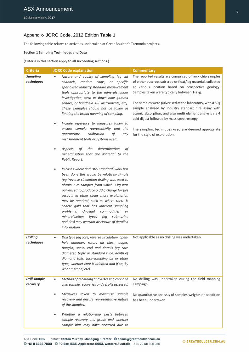
Criteria JORC Code explanation Commentary
Sampling
techniques
• Nature and quality of sampling (eg cut
channels, random chips, or specific
specialised industry standard measurement
tools appropriate to the minerals under
investigation, such as down hole gamma
sondes, or handheld XRF instruments, etc).
These examples should not be taken as
limiting the broad meaning of sampling.
• Include reference to measures taken to
ensure sample representivity and the
appropriate calibration of any
measurement tools or systems used.
• Aspects of the determination of
mineralisation that are Material to the
Public Report.
• In cases where ‘industry standard’ work has
been done this would be relatively simple
(eg ‘reverse circulation drilling was used to
obtain 1 m samples from which 3 kg was
pulverised to produce a 30 g charge for fire
assay’). In other cases more explanation
may be required, such as where there is
coarse gold that has inherent sampling
problems. Unusual commodities or
mineralisation types (eg submarine
nodules) may warrant disclosure of detailed
information.
The reported results are comprised of rock chip samples
of either outcrop, sub crop or float/lag material, collected
at various location based on prospective geology.
Samples taken were typically between 1-2kg.
The samples were pulverised at the laboratory, with a 50g
sample analysed by industry standard fire assay with
atomic absorption, and also multi element analysis via 4
acid digest followed by mass spectroscopy.
The sampling techniques used are deemed appropriate
for the style of exploration.
Drilling
techniques
• Drill type (eg core, reverse circulation, open-
hole hammer, rotary air blast, auger,
Bangka, sonic, etc) and details (eg core
diameter, triple or standard tube, depth of
diamond tails, face-sampling bit or other
type, whether core is oriented and if so, by
what method, etc).
Not applicable as no drilling was undertaken.
Drill sample
recovery
• Method of recording and assessing core and
chip sample recoveries and results assessed.
• Measures taken to maximise sample
recovery and ensure representative nature
of the samples.
• Whether a relationship exists between
sample recovery and grade and whether
sample bias may have occurred due to
No drilling was undertaken during the field mapping
campaign.
No quantitative analysis of samples weights or condition
has been undertaken.

ASX Announcement
19 September, 2017
8
preferential loss/gain of fine/coarse
material.
Logging • Whether core and chip samples have been
geologically and geotechnically logged to a
level of detail to support appropriate
Mineral Resource estimation, mining
studies and metallurgical studies.
• Whether logging is qualitative or
quantitative in nature. Core (or costean,
channel, etc) photography.
• The total length and percentage of the
relevant intersections logged.
Qualitative geological data was recorded for the rock chip
sample.
Sub-sampling
techniques
and sample
preparation
• If core, whether cut or sawn and whether
quarter, half or all core taken.
• If non-core, whether riffled, tube sampled,
rotary split, etc and whether sampled wet or
dry.
• For all sample types, the nature, quality and
appropriateness of the sample preparation
technique.
• Quality control procedures adopted for all
sub-sampling stages to maximise
representivity of samples.
• Measures taken to ensure that the sampling
is representative of the in situ material
collected, including for instance results for
field duplicate/second-half sampling.
• Whether sample sizes are appropriate to
the grain size of the material being sampled.
No drilling was undertaken during the field mapping
campaign.
Rock chip samples were collected from outcrop, sub crop
or float/lag.
All samples were dry.
No field duplicates were taken. Samples taken were
typically between 1-2kg rock chip samples and the entire
samples pulverised.
All samples were submitted to ALS Minerals (Kalgoorlie)
for analyses. The sample preparation included:
Samples were weighed and pulverised such that
a minimum of 85% passed 75um (as per ALS
standards).
Analysis was undertaken for gold using, 50g
charge for fire assay and ICP-AES (ALS method;
Au-ICP22), and fire assay and AAS (ALS method;
Au-AA26) for ore grade analysis (>10ppm Au).
A 4 acid digest and ICP-MS (ALS method; MS-
ME61) was used for the multi elements.
Sample collection, size and analytical methods are
deemed appropriate for the style of exploration.
Quality of
assay data
and
laboratory
tests
• The nature, quality and appropriateness of
the assaying and laboratory procedures
used and whether the technique is
considered partial or total.
• For geophysical tools, spectrometers,
handheld XRF instruments, etc, the
parameters used in determining the
analysis including instrument make and
model, reading times, calibrations factors
applied and their derivation, etc.
• Nature of quality control procedures
adopted (eg standards, blanks, duplicates,
external laboratory checks) and whether
• All samples were assayed by industry standard methods
through commercial laboratories in Australia (ALS
Minerals, Kalgoorlie).
• Typical analysis methods used;
Analysis was undertaken for gold using, 50g
charge for fire assay and ICP-AES (ALS method;
Au-ICP22), and fire assay and AAS (ALS method;
Au-AA26) for ore grade analysis (>10ppm Au).
A 4 acid digest and ICP-MS (ALS method; MS-
ME61) was used for the multi elements.
•

ASX Announcement
19 September, 2017
9
acceptable levels of accuracy (ie lack of bias)
and precision have been established.
• The analytical laboratories provided their own routine
quality controls within their own practices. No
significant issues were noted.
• Great Boulder did not submit any additional standards,
blanks or duplicates due to the preliminary nature of the
exploration method.
Verification of
sampling and
assaying
• The verification of significant intersections
by either independent or alternative
company personnel.
• The use of twinned holes.
• Documentation of primary data, data entry
procedures, data verification, data storage
(physical and electronic) protocols.
• Discuss any adjustment to assay data.
• No verification of sampling and assaying has been
undertaken in this field sampling programme.
• Great Boulder has strict procedures for data capture,
flow and data storage, and validation.
• Limited adjustments were made to returned assay data;
values returned lower than detection level were set to
the methodology’s detection level, and this was flagged
by code in the database.
Location of
data points
• Accuracy and quality of surveys used to
locate drill holes (collar and down-hole
surveys), trenches, mine workings and other
locations used in Mineral Resource
estimation.
• Specification of the grid system used.
• Quality and adequacy of topographic
control.
• Sample locations were collected using a hand held GPS
as was deemed acceptable for the nature of this
programme.
• The MGA94 UTM zone 51 coordinate system was used
for all undertakings.
Data spacing
and
distribution
• Data spacing for reporting of Exploration
Results.
• Whether the data spacing and distribution
is sufficient to establish the degree of
geological and grade continuity appropriate
for the Mineral Resource and Ore Reserve
estimation procedure(s) and classifications
applied.
• Whether sample compositing has been
applied.
• As detailed in Table 1 of this report, reported results are
comprised of rock chip samples of either outcrop, sub
crop or float/lag material, collected at various locations
based on prospective geology and is considered
reconnaissance in nature.
• The spacing and location of data is currently only being
considered for exploration purposes.
• No composite sampling has been applied.
Orientation of
data in
relation to
geological
structure
• Whether the orientation of sampling
achieves unbiased sampling of possible
structures and the extent to which this is
known, considering the deposit type.
• If the relationship between the drilling
orientation and the orientation of key
mineralised structures is considered to have
introduced a sampling bias, this should be
assessed and reported if material.
The orientation and relationship of sampling to
underlying structures or mineralisation is unknown and
is considered reconnaissance in nature.
No drilling was undertaken during the field mapping
campaign.
Sample
security
• The measures taken to ensure sample
security.
Field samples were collected by Great Boulder in labelled
and secure poly weave bags with the ID number clearly

ASX Announcement
19 September, 2017
10
visible. The sample bag is secured such that no sample
material can spill out.
Audits or
reviews
• The results of any audits or reviews of
sampling techniques and data.
None completed.
Section 2 Reporting of Exploration Results
(Criteria listed in the preceding section also apply to this section.)
Criteria JORC Code explanation Commentary
Mineral
tenement and
land tenure
status
• Type, reference name/number, location
and ownership including agreements or
material issues with third parties such as
joint ventures, partnerships, overriding
royalties, native title interests, historical
sites, wilderness or national park and
environmental settings.
• The security of the tenure held at the
time of reporting along with any known
impediments to obtaining a license to
operate in the area.
Great Boulder Resource Ltd (GBR) is comprised of
several projects with associated tenements;
Tarmoola Project tenements and details;
Exploration licences E37/1241, E37/1242, and
prospecting licences P37/8667, P37/8668, P37/8669,
P37/8670, P37/8671, P37/8672, P37/7673,
P37/8674, P37/8675, P37/8676, P37/8677,
P37/8678, P37/8679, P37/8680, P37/8681,
P37/8682, P37/8683, P37/8684, P37/8685 where,
GBR has executed a JV agreement to earn 75%
interest through exploration expenditure of
$1,400,000 AUD over five years. Following
satisfaction of the minimum expenditure
commitment by GBR, EGMC (current tenement
owner) will have the right to contribute to
expenditure in the project at its 25% interest level or
choose to convert to a 2% Net Smelter Royalty (NSR).
Should EGMC choose to convert its remaining interest
into a 2% NSR, then GBR will have a 100% interest in
the project.
Exploration
done by other
parties
• Acknowledgment and appraisal of
exploration by other parties.
Previous explorers included:
1990’s - 2000’s. Saracen Metals Pty Ltd
compiled results from previous explorers
drilling on the northern ELs near Randle’s
Find.
2000’s. Jubilee Mines NL conducted soil
sampling on the western side of the
Robbie’s Well Pluton. Agnew Gold Mining
Company Pty Ltd (Goldfield) undertook
limited drilling on the northern portions of
project, as well as soil sampling.
2010-2011 T.E Johnston & Associated Pty
Ltd conducted limited soil along the
eastern margin of Robbie’s Well Pluton.
2011. St Barbara Ltd conducted a small,
focused aircore drilling along the eastern
margin of the Robbie’s Well Pluton.
Regional soil sampling has been
undertaken by the Geological Survey of
WA.

ASX Announcement
19 September, 2017
11
Geology • Deposit type, geological setting and style
of mineralisation.
Greenstone sequences with a km-scale internal
granitoid and a number of discrete dioritic to tonalitic
stocks known to be associates with regional gold
mineralisation (e.g. Tarmoola/King of the Hills)
The project contains the northern extension to the
regional granite-greenstone terrain contact with a
similar geological setting as Tarmoola/King of the Hills
and Gwalia.
Drill hole
Information
• A summary of all information material to
the understanding of the exploration
results including a tabulation of the
following information for all Material drill
holes:
o easting and northing of the drill hole
collar
o elevation or RL (Reduced Level – elevation
above sea level in metres) of the drill hole
collar
o dip and azimuth of the hole
o down hole length and interception depth
o hole length.
• If the exclusion of this information is
justified on the basis that the information
is not Material and this exclusion does not
detract from the understanding of the
report, the Competent Person should
clearly explain why this is the case.
The location and context of the rock chip sampling is
provided in grid images in the main report body.
No drilling results are reported.
Data
aggregation
methods
• In reporting Exploration Results,
weighting averaging techniques,
maximum and/or minimum grade
truncations (eg cutting of high grades)
and cut-off grades are usually Material
and should be stated.
• Where aggregate intercepts incorporate
short lengths of high grade results and
longer lengths of low grade results, the
procedure used for such aggregation
should be stated and some typical
examples of such aggregations should be
shown in detail.
• The assumptions used for any reporting
of metal equivalent values should be
clearly stated.
No weight averaging techniques, aggregation
methods or grade truncations were applied to these
exploration results.
No metal equivalents are used.

ASX Announcement
19 September, 2017
12
Relationship
between
mineralisation
widths and
intercept
lengths
• These relationships are particularly
important in the reporting of Exploration
Results.
• If the geometry of the mineralisation with
respect to the drill hole angle is known, its
nature should be reported.
• If it is not known and only the down hole
lengths are reported, there should be a
clear statement to this effect (eg ‘down
hole length, true width not known’).
No mineralisation widths are reported.
Diagrams • Appropriate maps and sections (with
scales) and tabulations of intercepts
should be included for any significant
discovery being reported These should
include, but not be limited to a plan view
of drill hole collar locations and
appropriate sectional views.
Refer to figures in announcement.
Balanced
reporting
• Where comprehensive reporting of all
Exploration Results is not practicable,
representative reporting of both low and
high grades and/or widths should be
practiced to avoid misleading reporting of
Exploration Results.
Any contours in diagrams are provided to define areas
of relative “moderate” and “high” anomalous
element areas.
Other
substantive
exploration
data
• Other exploration data, if meaningful and
material, should be reported including
(but not limited to): geological
observations; geophysical survey results;
geochemical survey results; bulk samples
– size and method of treatment;
metallurgical test results; bulk density,
groundwater, geotechnical and rock
characteristics; potential deleterious or
contaminating substances.
Great Boulder recently undertook surface mapping of
select portions of the project. This was also
supported by recent re-proceeding of open source
magnetic data, and also recently acquired (surface)
gravity data. These were used to assist the
reinterpretation of the underlying project geology.
Refer to document for images and context.
Further work • The nature and scale of planned further
work (eg tests for lateral extensions or
depth extensions or large-scale step-out
drilling).
• Diagrams clearly highlighting the areas of
possible extensions, including the main
geological interpretations and future
drilling areas, provided this information is
not commercially sensitive.
Potential work across the project may include
detailed additional geological mapping and surface
sampling ahead of potential confirmatory or
exploratory drilling.