Take a Closer Look at the West End Neighborhood Study
34
A PLAN for the WEST END NEIGHBORHOOD CITY OF BRISTOL, CONNECTICUT Adopted on June 29, 2011, by the Bristol Planning Commission as Amendment #1 to the City’s 2000 Plan of Conservation and Development
Transcript of Take a Closer Look at the West End Neighborhood Study
A PLAN for the WEST END NEIGHBORHOODCITY OF BRISTOL, CONNECTICUT
Adopted on June 29, 2011, by the Bristol Planning Commission as Amendment #1 to the City’s 2000 Plan of Conservation and Development

‐ i ‐
ACKNOWLEDGEMENTS BRISTOL PLANNING COMMISSION William Veits, Chairman John Soares, Vice Chairman Marie Keeton, Secretary Brian Ewings Anthony Dell'Aera Joseph Kelaita, Jr., Alternate Angelo Cannici, Alternate John Reek, Jr., Alternate PLANNING STAFF Alan L. Weiner, AICP, City Planner Christopher Beachemin, AICP, Assistant City Planner Kacie Costello, Assistant City Planner (until July 2008) MAYOR Arthur J. Ward BRISTOL CITY COUNCIL Clifford Block Kevin C. McCauley Kenneth Cockayne Terry Parker Kevin Fuller David Mills PLANNING CONSULTANTS The Capstan Group, LLC New Haven, Connecticut Yale Urban Design Workshop New Haven, Connecticut
ACKNOWLEDGEMENT AND THANKS The Bristol Planning Commission would like to thank all of the residents, property owners, merchants, and other interested citizens who actively participated in this study and gave voice to the concerns and aspirations of the West End neighborhood. Their commitment to the betterment of the West End is reflected throughout this study. These individuals, businesses, and organizations include: Melanie Adamski, Beacon Pharmacy, Jan Bevivino, Ryan Bessette, Nancy Bonin, Thomas Borden, Boys & Girls Club and Family Center of Bristol, Bristol Community Organization, Bristol Real Estate LLC, Audra Camben, Castaneda’s, Daria Cesario, Gerald Chamberland, Chase Enterprises, Jonna Chokas, Alfred Cianchetti, Ron Ciarcia, Gerard Couture, John Cswercko, Leslie Czerwinski, Jan Deveau, Steve Deveau, Andre Dorval, Greater Bristol Chamber of Commerce, Greater Bristol Property Owners Association, Hamelin & Sons, Kara Jones, Mark Jones, Robert Kelly, Tammy Kelly, Leonard Lamothe, Clark Michaud, Sara Morocco, Joe Naples, David Ferraro, Robin Ferraro, Jesse Jablon, Elliot Nelson, Andrew Nigro, Janet Nigro, Jim Nocera, James Orr, Ruth Orr, Karen Paparello‐Piotrowski, Patrick Napolitano Welding, Jay Pax, Sandie Pelletier, Pequabuck River Watershed Association, Karen Pio, John Piotrowski, Nick Piotrowski, Jerry Rafaniello, Thomas Ragaini, Sylvia Roy, Diana Silvestri, South Side Market, St. Ann’s Church, St. Anthony Church, St. Vincent de Paul Mission of Bristol, Joan Vallee, Vitrano, Preleski & Wynne, West End Pizza, and Lawrence Zahnke. Special thanks to Robyn L. Bugbee, the City’s Grants Administrator, for her invaluable assistance with the editing of this plan.

‐ ii ‐
TABLE of CONTENTS I. Introduction...................................................................................................1 II. A Brief History of the West End.....................................................................4 III. The West End as a “Great Neighborhood”..................................................10 IV. Challenges and Opportunities .....................................................................14 V. A Vision for the West End............................................................................19 VI. A Blueprint for Change: Recommended Actions and Their Implementation .................................................................................20 VII. Appendix In‐Depth: Former Supermarket Site, 350 Divinity Street In‐Depth: Former Chic Miller Auto Dealership, 40 West Street
LIST of MAPS and FIGURES
Map 1: West End Neighborhood Boundaries.....................................................3 Map 2: Age of Building Stock in the West End Neighborhood...........................8 Map 3: Land Uses in the West End Neighborhood ............................................9 Map 4: Green Space in the West End Neighborhood ......................................13 Map 5: Social Hubs in the West End Neighborhood ........................................18 Figure 1: Population Growth...............................................................................7 Figure 2: Growth of Hispanic Population ............................................................7 Figure 3: Median Income Trends ........................................................................7 Figure 4: Growth in Owner‐Occupied & Vacant Units ......................................17 Figure 5: Condition of West End Properties......................................................17 Figure 6: Age of West End Properties ...............................................................17
A Plan for the West End Neighborhood/Page 1
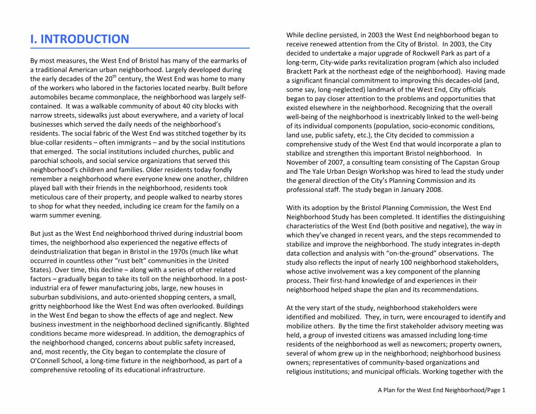
I. INTRODUCTION By most measures, the West End of Bristol has many of the earmarks of a traditional American urban neighborhood. Largely developed during the early decades of the 20th century, the West End was home to many of the workers who labored in the factories located nearby. Built before automobiles became commonplace, the neighborhood was largely self‐contained. It was a walkable community of about 40 city blocks with narrow streets, sidewalks just about everywhere, and a variety of local businesses which served the daily needs of the neighborhood’s residents. The social fabric of the West End was stitched together by its blue‐collar residents – often immigrants – and by the social institutions that emerged. The social institutions included churches, public and parochial schools, and social service organizations that served this neighborhood’s children and families. Older residents today fondly remember a neighborhood where everyone knew one another, children played ball with their friends in the neighborhood, residents took meticulous care of their property, and people walked to nearby stores to shop for what they needed, including ice cream for the family on a warm summer evening. But just as the West End neighborhood thrived during industrial boom times, the neighborhood also experienced the negative effects of deindustrialization that began in Bristol in the 1970s (much like what occurred in countless other “rust belt” communities in the United States). Over time, this decline – along with a series of other related factors – gradually began to take its toll on the neighborhood. In a post‐industrial era of fewer manufacturing jobs, large, new houses in suburban subdivisions, and auto‐oriented shopping centers, a small, gritty neighborhood like the West End was often overlooked. Buildings in the West End began to show the effects of age and neglect. New business investment in the neighborhood declined significantly. Blighted conditions became more widespread. In addition, the demographics of the neighborhood changed, concerns about public safety increased, and, most recently, the City began to contemplate the closure of O’Connell School, a long‐time fixture in the neighborhood, as part of a comprehensive retooling of its educational infrastructure.
While decline persisted, in 2003 the West End neighborhood began to receive renewed attention from the City of Bristol. In 2003, the City decided to undertake a major upgrade of Rockwell Park as part of a long‐term, City‐wide parks revitalization program (which also included Brackett Park at the northeast edge of the neighborhood). Having made a significant financial commitment to improving this decades‐old (and, some say, long‐neglected) landmark of the West End, City officials began to pay closer attention to the problems and opportunities that existed elsewhere in the neighborhood. Recognizing that the overall well‐being of the neighborhood is inextricably linked to the well‐being of its individual components (population, socio‐economic conditions, land use, public safety, etc.), the City decided to commission a comprehensive study of the West End that would incorporate a plan to stabilize and strengthen this important Bristol neighborhood. In November of 2007, a consulting team consisting of The Capstan Group and The Yale Urban Design Workshop was hired to lead the study under the general direction of the City’s Planning Commission and its professional staff. The study began in January 2008. With its adoption by the Bristol Planning Commission, the West End Neighborhood Study has been completed. It identifies the distinguishing characteristics of the West End (both positive and negative), the way in which they’ve changed in recent years, and the steps recommended to stabilize and improve the neighborhood. The study integrates in‐depth data collection and analysis with “on‐the‐ground” observations. The study also reflects the input of nearly 100 neighborhood stakeholders, whose active involvement was a key component of the planning process. Their first‐hand knowledge of and experiences in their neighborhood helped shape the plan and its recommendations. At the very start of the study, neighborhood stakeholders were identified and mobilized. They, in turn, were encouraged to identify and mobilize others. By the time the first stakeholder advisory meeting was held, a group of invested citizens was amassed including long‐time residents of the neighborhood as well as newcomers; property owners, several of whom grew up in the neighborhood; neighborhood business owners; representatives of community‐based organizations and religious institutions; and municipal officials. Working together with the
A Plan for the West End Neighborhood/Page 2
THE WEST END NEIGHBORHOOD AT A GLANCE (2008) Location: West of downtown Bristol Size of study area: Approximately 4/10 of a square mile Major roads: West Street (Route 69), Park Street (Route 72), Divinity Street Major features: Pequabuck River, Rockwell Park, Muzzy Field, O’Connell School Number of residents: 5,000 (2008 est.) Number of households: 2,000 (2008 est.) Number of dwelling units: 1,875 Number of buildings: 759
Residential: 699 Commercial or Commercial/Residential (Mixed): 53 Public and Semi‐Public (Institutional): 7
Percent of buildings built before 1940: 74% Number of single‐family residences: 218 Percent of housing units that are owner‐occupied: 28%
study team throughout the study, this advisory group offered ideas, provided feedback, voiced concerns, and expressed their hopes for the future of the West End. The group gave the neighborhood a public voice, and all who participated demonstrated a commitment to the betterment of the West End. While it’s certainly not too late to halt and reverse the decline that the West End neighborhood has experienced, there is an acute sense of urgency that underlies this plan and its recommendations. Despite its rich past, despite its many contributions to the history of Bristol, and despite its many positive attributes, the West End shows many signs of a distressed neighborhood. Most of its buildings are more than 70 years old. Too many high‐visibility properties are vacant and boarded up. Traffic congestion and parking shortages hamper business activity. And the public‐at‐large has a generally unfavorable perception of the neighborhood. Even as this study seeks to lay the groundwork for the West End neighborhood’s revitalization, the City must not lose forward momentum due to inactivity. The study’s overarching recommendation is to focus attention on the West End neighborhood. Nobel Prize‐winning chemist William N. Lipscomb, Jr. once observed, “If your position is everywhere, your momentum is zero.” Though he was talking about chemistry, the concept easily applies to urban revitalization, too. If two small changes are made in two different corners of a city, they will likely generate little, if any, momentum. But if those same two changes are made on the same city block, they are likely to become magnified, as the collective improvement is more noticeable, generates more interest, and creates impetus for other improvements. In order to make a marked difference and produce meaningful change in the West End, the City must focus its attention on the neighborhood, devote significant efforts and resources to it, and hold steadfast to its commitment to implement the recommendations contained in this plan.
The City’s commitment to the revitalization of the West End will need to be matched – if not exceeded – by the commitment of the neighborhood itself. To that end, neighborhood leaders must emerge who can help bring its citizens together to revive the sense of
community pride and caring that once existed so strongly in the West End. One potential source of that leadership may well be the neighborhood stakeholders’ group that worked with the study team throughout the study. With this plan, the City can begin to write the next chapter in the story of the West End. This next chapter focuses on preserving those aspects of the neighborhood that are beloved – longstanding institutions, parks and recreation areas, distinctive buildings, and stakeholders who care – while at the same time helping the neighborhood to adapt to a changing environment, rebuild its sense of community, and use its significant assets to strengthen itself.

A Plan for the West End Neighborhood/Page 3
MAP 1: WEST END NEIGHBORHOOD BOUNDARIES For the purposes of the study, the boundaries of the West End neighborhood were generally defined as Rockwell Park and Jacobs Street on the north, Divinity Street on the southwest, Gridley Street on the southeast, and West Street on the east.

A Plan for the West End Neighborhood/Page 4
“The West End has always been a neighborhood that
welcomed immigrants.”
II. A BRIEF HISTORY OF THE WEST END
The West End is one of Bristol’s oldest neighborhoods. Located west of – and immediately adjacent to – downtown Bristol, the West End encompasses about 40 city blocks and covers approximately four‐tenths of a square mile (See Map 1). Though City records indicate that houses dotted the neighborhood as early as the mid‐1800s, the West End experienced its greatest period of growth from the late 1800s through the early 1900s. Development first occurred along the major thoroughfares of West Street, Park Street, and Divinity Street, as well as on streets that connected the neighborhood to the downtown, such as School Street, Pleasant Street, and Orchard Street. Constrained by the topography of the area and the presence of the Pequabuck River, the street system that developed as new subdivisions were laid out took on the form of a modified grid. The West End emerged as a working‐class neighborhood, comprised of immigrants and first‐generation Americans whose diverse ancestral backgrounds included Italians, Irish, Greeks, Germans, and French‐Canadians. Many of the neighborhood’s residents worked in one of the nearby factories that populated downtown Bristol – manufacturing companies like C.J. Root, Horton Manufacturing, Wallace‐Barnes, New Departure, and E. Ingraham. To accommodate the different housing needs of newcomers and existing residents alike, residential buildings in the neighborhood took on a variety of forms, ranging from modest single‐family residences to two‐ and three‐family houses (“double‐deckers” and “triple‐deckers”) and small apartment buildings (“tenements”). Though often simple in design, these buildings exhibited a broad array of architectural styles, including Italianate, Greek and Gothic Revival, and Queen Anne.
Because much of the West End developed before automobiles became the primary means of personal transportation and before zoning was first adopted by the City (in 1931), builders were largely unconstrained by the need to accommodate large numbers of motor vehicles or to comply with the strictures of zoning setbacks or minimum lot sizes. As such, building lots in the neighborhood were generally small (5,000‐6,000 square feet) and narrow (50‐60 feet wide). Buildings were built relatively close to the street and to one another, and residential and commercial uses were mixed together (occasionally within the same building). The result was a compact, walkable urban neighborhood. The West End’s blocks were short; its streets were just two lanes wide; and there were sidewalks on both sides of each street. In order to satisfy the daily consumer needs of a growing residential population, merchants began to establish businesses in the West End. The earliest commercial buildings in the West End were built primarily at and adjacent to the intersection of West Street, Divinity Street, and School Street, a major crossroads where the neighborhood’s two primary thoroughfares intersected. These buildings typically contained commercial

A Plan for the West End Neighborhood/Page 5
space on the first floor (at street level) and apartments above. The commercial space was occupied by small, local businesses that supplied the goods and services regularly needed by the neighborhood’s residents. For example, a set of 1921 Sanborn insurance maps of Bristol shows a remarkable number and variety of businesses located at or near this intersection, including two drug stores, three grocery stores, two cobblers, a hardware store, two barbershops, a meat market, an undertaker, a tailor, and a fruit store! During this same period of growth, the neighborhood saw the founding of several educational, religious, and social institutions, as well as the development of two important recreational facilities. By 1920, the West End neighborhood was home to a public elementary school (Park Street School, later re‐named O’Connell School), three churches (St. Anthony Church, on School Street; St. Ann’s French Roman Catholic Church, on West Street; and Immanuel German Lutheran Church, also on West Street); and two parochial schools (St. Ann’s School, on West Street; and Immanuel German Lutheran School, on School Street). Rockwell Park was built along the northern edge of the West End neighborhood on 95 acres of wooded land given to the City by industrialist Albert Rockwell and his wife Nettie in 1914 and 1920. Designed by Boston‐based landscape architect Sheffield A. Arnold, the park contained athletic fields, playgrounds, a small lake, a swimming pool, tennis courts, and walking paths and trails. Next to Rockwell Park, Muzzy Field was built on land donated in 1912 by Bristol businessman Adrian Muzzy in memory of his two sons. The field was originally used primarily for baseball but also hosted boxing matches, track‐and‐field meets, and football games. By the end of the 1920s, nearly 75% of the present‐day housing stock in the West End had been constructed. Two‐ and three‐family residences predominated the neighborhood, accounting for nearly three‐quarters of its dwelling units, while single‐family residences accounted for less than seven percent. With the onset of the Great Depression, the pace of new development in the West End slowed considerably. During the period between 1930 and the end of World War II in 1945, only two commercial buildings and 76 residential buildings (containing a total of 122 dwelling units) were constructed in the neighborhood.
After World War II, the residential and commercial development that occurred in the West End was significantly different in type, form, and character from that which initially defined the neighborhood in the early 1900s. Instead of two‐ and three‐family dwellings, the predominant housing type now being built was the single‐family residence. Between 1946 and 2000, 94 single‐family homes were constructed in the West End, as compared with only 26 two‐family dwellings and 13 three‐family dwellings. Three large multi‐family housing projects were built in the late 1960s and early 1970s, all on Gaylord Street at the north end of the neighborhood: the 80‐unit John F. Kennedy Apartments and the 120‐unit Gaylord Towers Apartments (both high‐rise buildings of public housing), and a privately developed 42‐unit apartment complex (at the west end of Gaylord Street). In the 1980s, four condominium complexes (containing a total of 45 dwelling units) were created, either through new construction or the conversion of existing buildings. During this same post‐war period, the style of commercial development that took place in the West End no longer resembled the multi‐story, mixed commercial/residential buildings that characterized the neighborhood in the pre‐automobile, pre‐zoning era of the early 1900s. Single‐purpose, automobile‐oriented uses became the favored development style. Gas stations, repair garages, and auto body shops emerged along parts of West Street and Park Street. A sizeable (for its time) automobile dealership was built on nearly two acres of land on the east side of West Street in about 1970, occupying the entire frontage between Upson Street and South Street. Other commercial uses, though not specifically intended to meet the needs of auto owners, were nevertheless designed to accommodate automobiles rather than pedestrians. The most prominent example in the West End was a single‐story, 20,600‐square‐foot supermarket built in the early 1960s (and added onto in 1978) on the north side of Divinity Street at the western end of the neighborhood. The differences between pre‐ and post‐war development in the West End neighborhood can be attributed to a variety of contributing factors. While some factors were primarily local (e.g., the Flood of 1955, which caused significant damage to parts of the neighborhood), the vast majority were more global in scope, reflective of changes taking place in American
A Plan for the West End Neighborhood/Page 6
society at large over many years. Such factors included a greater dependence on the automobile as the primary means of personal transportation; the decline of manufacturing as a major component of the community’s economic and employment base; changing consumer demands and retail trends; the development and adoption of modern building and fire codes; and the implementation of single‐purpose (so‐called “Euclidian”) zoning, which typically separated residential, commercial, and industrial uses into separate and distinct zoning districts. By the late 1990s and into the 2000s, new residential development in the West End had slowed to a trickle. Only seven new houses were built between 2000 and 2008, new commercial development was non‐existent, and the neighborhood was beginning to show telltale signs of age, deterioration, and disinvestment. The demographics of the neighborhood began to shift as well. Most noticeable was an increasing Hispanic population, which in 1990 comprised just 2.8% of the neighborhood population, but by 2008 comprised an estimated 10% of the neighborhood population. The public’s perception of the West End was also beginning to change, and not favorably: what for decades had been perceived as a solid, stable, and well‐kept working‐class neighborhood was now too often viewed as an unsafe, unkempt, and undesirable place in which to live or even spend much time.
The City itself appeared to be of two minds with regard to the West End neighborhood. On the one hand, beginning in 2003, the City made a significant public investment to undertake major renovations first to Brackett Park (at the juncture of the West End neighborhood and downtown Bristol) and then to Rockwell Park. Furthermore, in pursuit of its goal to create a more formal entrance to Muzzy Field from Park Street, the City also continued to acquire abutting residential properties as they became available. However, during this same period of time, in response to changing educational objectives and after an evaluation of a variety of alternative scenarios, the City made the controversial decision to close the O’Connell School (grades K‐5) – a longstanding fixture in the West End – and replace it with a new, more modern K‐8 school located outside of the neighborhood This confluence of events and circumstances, along with increasingly widespread concerns about the present condition and, perhaps more importantly, the future state of the West End, led to the City’s recognition of the need – and subsequent decision – to undertake a comprehensive study of the neighborhood and develop an action plan to stabilize and strengthen it. Funding for the West End neighborhood study was allocated in July 2007; a consultant was hired in December 2007; and the study began in January 2008.
A Plan for the West End Neighborhood/Page 7
Figure 1: Population Growth Sources: Census 1970‐2000 & DemographicsNow 2008
West End
Bris tol
0
10,000
20,000
30,000
40,000
50,000
60,000
70,000
1970 1980 1990 2000 2008
Population
3%
5%
7%8%
3%
8%
10%11%
0%
2%
4%
6%
8%
10%
12%
1990 2000 2008 2012(proj)
% of To
tal P
opulation
Bri s tol West End
West End, $41,486 West End,
$34,246 West End, $27,357
Bristol , $38,302
Bristol , $47,453
Bris tol , $58,300
$‐
$10,000
$20,000
$30,000
$40,000
$50,000
$60,000
$70,000
1990 2000 2008
Median Household Income
Figure 2: Growth of Hispanic Population Sources: Census 1970‐2000 & DemographicsNow 2008
Figure 3: Median Income TrendsSources: Census 1990 & 2000, DemographicsNow 2008
IN‐DEPTH: NOTEWORTHY POPULATION TRENDS IN THE WEST END NEIGHBORHOOD
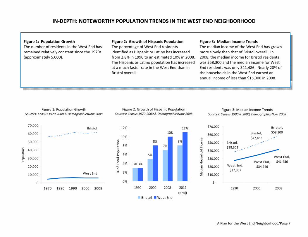
Figure 1: Population Growth The number of residents in the West End has remained relatively constant since the 1970s (approximately 5,000).
Figure 2: Growth of Hispanic Population The percentage of West End residents identified as Hispanic or Latino has increased from 2.8% in 1990 to an estimated 10% in 2008. The Hispanic or Latino population has increased at a much faster rate in the West End than in Bristol overall.
Figure 3: Median Income Trends The median income of the West End has grown more slowly than that of Bristol overall. In 2008, the median income for Bristol residents was $58,300 and the median income for West End residents was only $41,486. Nearly 20% of the households in the West End earned an annual income of less than $15,000 in 2008.

A Plan for the West End Neighborhood/Page 8
MAP 2: AGE OF BUILDING STOCK IN THE WEST END NEIGHBORHOOD
A Plan for the West End Neighborhood/Page 9
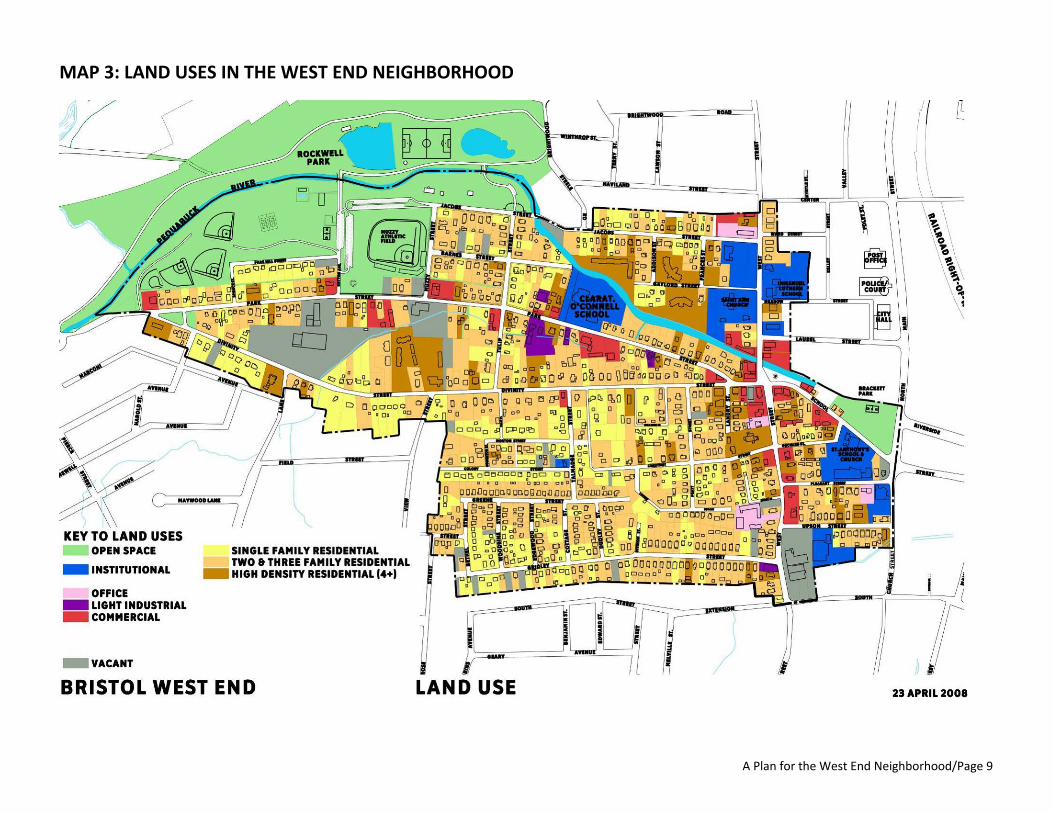
MAP 3: LAND USES IN THE WEST END NEIGHBORHOOD
A Plan for the West End Neighborhood/Page 10
When we think of the West End neighborhood, what comes to mind? What makes it a great urban neighborhood? What makes it home for nearly 5,000 people?
III. THE WEST END AS A “GREAT NEIGHBORHOOD”
Defining a “Great Neighborhood” In recent years, cities across the country have begun to place increasing importance on the neighborhoods that compose them. As the non‐profit Local Government Commission noted in 2003: “People are beginning to realize that nodes of more intense development can help achieve local economic development goals, provide housing options, create walkable neighborhoods, and protect their air, water and open space. This balance helps create a sense of place – a place to walk, a place to talk to neighbors, a place to know the children are safe to walk to school.” (from Creating Great Neighborhoods: Density in Your Community) Many local governments – both on their own and with the assistance of advocacy organizations such as the American Planning Association and the Project for Public Spaces – have renewed their commitment to revitalizing the neighborhoods in their community and to creating what have come to be known as “great neighborhoods.” Although the details can differ, there is general agreement among those involved in the “great neighborhoods” movement as to the features that define a “great neighborhood.” As defining features, great neighborhoods: • contain a variety of land uses and building types; • have an identifiable center and edge; • contain design and architectural features that are visually interesting; • have well‐maintained public and private spaces and buildings; • offer a variety of housing choices; • give people transportation choices; • connect people and places both within and outside the neighborhood; • encourage human contact and social interaction; • have a diverse population; • promote community involvement; • are safe and secure; and • are economically vibrant.
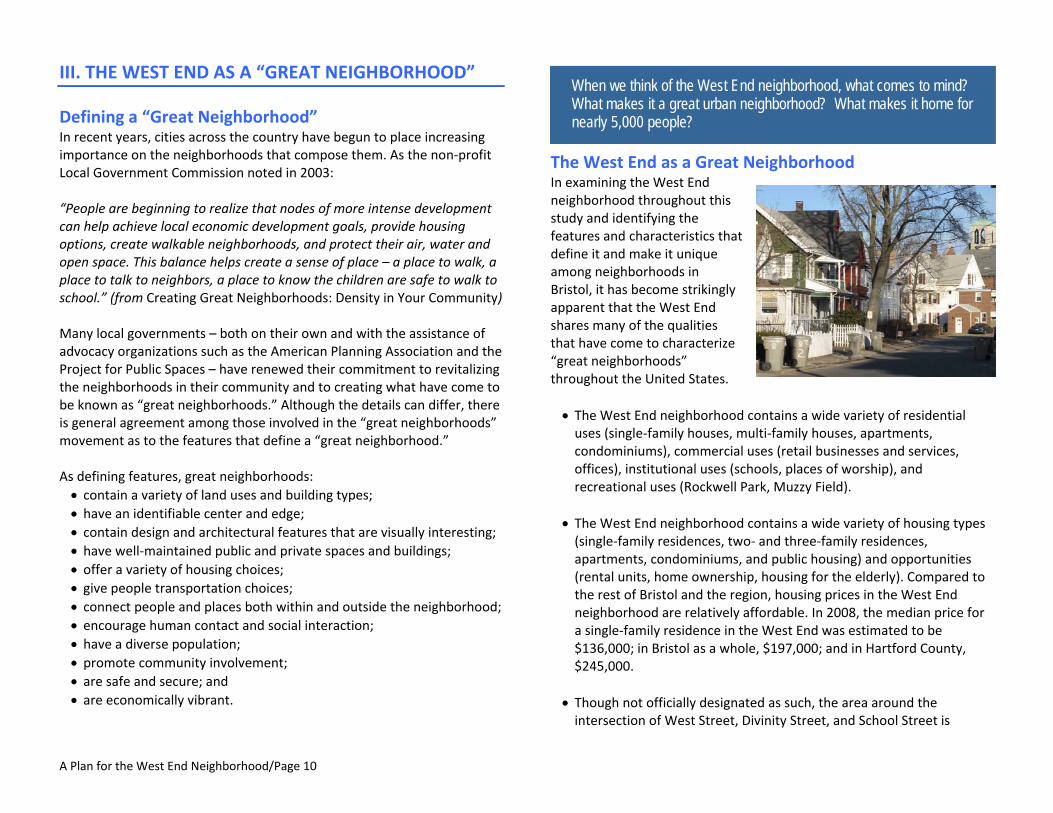
The West End as a Great Neighborhood In examining the West End neighborhood throughout this study and identifying the features and characteristics that define it and make it unique among neighborhoods in Bristol, it has become strikingly apparent that the West End shares many of the qualities that have come to characterize “great neighborhoods” throughout the United States. • The West End neighborhood contains a wide variety of residential uses (single‐family houses, multi‐family houses, apartments, condominiums), commercial uses (retail businesses and services, offices), institutional uses (schools, places of worship), and recreational uses (Rockwell Park, Muzzy Field).
• The West End neighborhood contains a wide variety of housing types (single‐family residences, two‐ and three‐family residences, apartments, condominiums, and public housing) and opportunities (rental units, home ownership, housing for the elderly). Compared to the rest of Bristol and the region, housing prices in the West End neighborhood are relatively affordable. In 2008, the median price for a single‐family residence in the West End was estimated to be $136,000; in Bristol as a whole, $197,000; and in Hartford County, $245,000.
• Though not officially designated as such, the area around the intersection of West Street, Divinity Street, and School Street is
A Plan for the West End Neighborhood/Page 11
generally recognized as the commercial center of the West End neighborhood. It contains the greatest concentration of commercial buildings and the highest volumes of vehicular traffic in the neighborhood.
• The West End is a highly walkable neighborhood. This is due in large part to the pattern, scale, density, and compactness of its development and to its extensive – and nearly complete – network of sidewalks. As previously noted, streets in the West End are laid out in a modified grid pattern and are generally two lanes wide. With a couple of notable exceptions, street blocks tend to be short. Buildings in the West End are typically one to three stories in height, at or close to the sidewalk (creating a “pedestrian scale”), and relatively close together. In much of the neighborhood, there are few gaps in the street “wall” formed by the buildings along each side of the street.
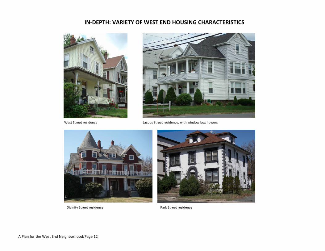
• Buildings in the West End represent an impressive array of architectural styles including Italianate, Greek Revival, Gothic Revival, and Queen Anne. The neighborhood also contains 73 properties identified in the City’s inventory of historic and architecturally significant resources.
• The West End neighborhood contains a diverse population. The neighborhood has always been ethnically diverse – with over 25 different ancestries represented in its population. The median age in the neighborhood is 37 years – which reflects both the significant
senior and youth populations. Further, the breadth of education levels indicates strong diversity in the neighborhood. In 2008, one‐fifth (21%) of West End adults had not finished high school and yet 12% had a college or graduate degree.
• While very much a neighborhood with its own identify, the West End also exists in a larger geographical context. Its connections to its immediate surroundings and beyond include: the Pequabuck River, one of the City’s most prominent (though often ignored) natural features, which flows through the West End as it makes its way from Harwinton to Farmington; two state roads, Route 69 and Route 72, which provide transportation connections between the West End and neighboring communities; and several short local streets at the eastern end of the neighborhood – School Street, Orchard Street, Pleasant Street, and Upson Street – which provide vehicular and pedestrian links between the West End and downtown Bristol.
• In general, residents of the West End exhibit a strong sense of neighborhood pride, as do local merchants and business owners. Residents are proud of their “blue collar” roots and work ethic. Many have lived in the neighborhood for much (if not all) of their lives and contribute to the overall stability of the West End’s population.
• The West End is home to a variety of faith‐based institutions, social service agencies, and non‐profit organizations that actively serve the needs of both the neighborhood itself and the community at large.
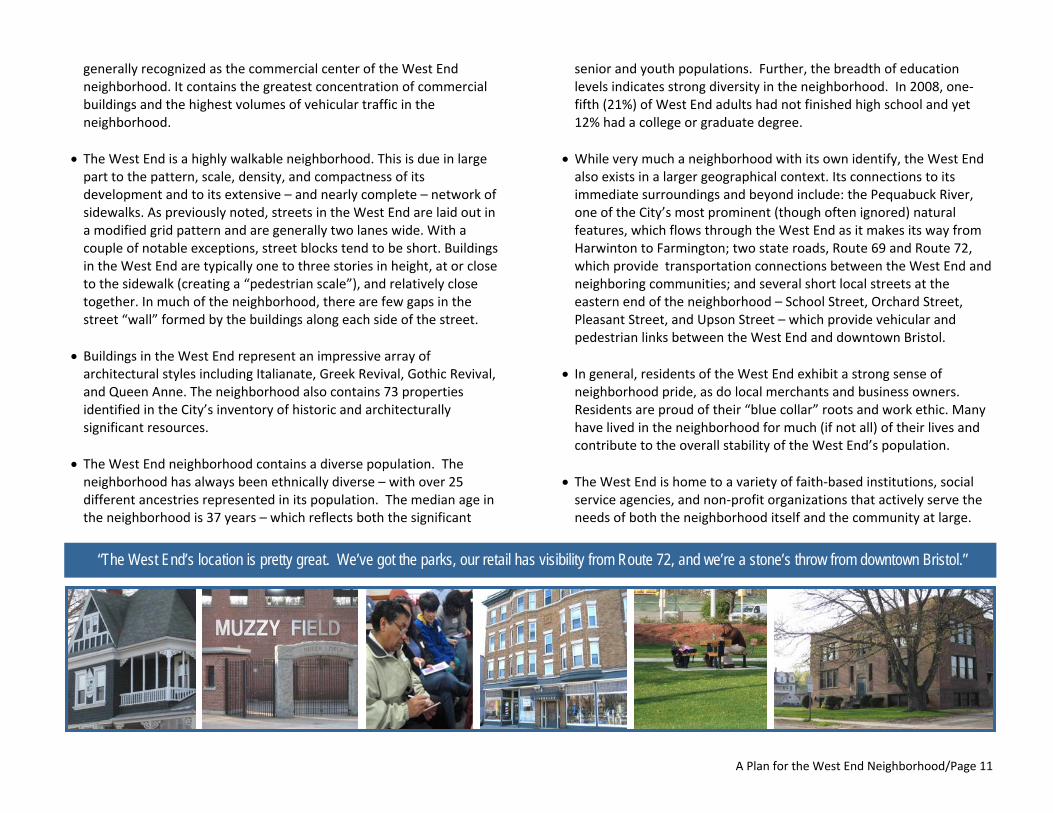
“The West End’s location is pretty great. We’ve got the parks, our retail has visibility from Route 72, and we’re a stone’s throw from downtown Bristol.”
A Plan for the West End Neighborhood/Page 12
IN‐DEPTH: VARIETY OF WEST END HOUSING CHARACTERISTICS
Jacobs Street residence, with window box flowersWest Street residence
Divinity Street residence Park Street residence

A Plan for the West End Neighborhood/Page 13
MAP 4: GREEN SPACE IN THE WEST END NEIGHBORHOOD
Divinity Street residence Park Street residence
A Plan for the West End Neighborhood/Page 14
“We have a couple of businesses that are solid as a rock, but for the rest, it seems
like there’s a high turnover rate”
IV. CHALLENGES AND OPPORTUNITIES For all of its positive attributes, the West End also faces many of the same challenges that confront other aging urban neighborhoods in cities throughout the United States. These conditions pose a serious threat to the long‐term stability of the West End and, if ignored or left unresolved, will make future efforts to strengthen and improve the neighborhood that much more difficult and costly. • While homeownership is a strong component of stabilizing a neighborhood, the West End remains predominantly a rental market. Not counting public housing or condos, only 28% of the dwelling units in the West End are owner‐occupied; the rest are occupied by renters or tenants. This strong tendency toward renters makes the neighborhood vulnerable, because renters are more transient in nature and because renters typically do not make investments into the properties in which they reside.
• Just over half of the dwelling units in the West End (50.4%) are under the control of owners who live elsewhere (so‐called "absentee landlords"). The majority of these landlords reside locally: more than half (56%) live either in the West End itself or elsewhere in Bristol. A third (33%) live elsewhere in Connecticut, while the remainder (11%) live outside the state. Although many absentee landlords are very diligent about keeping their properties in good order, a high percentage of absentee landlords does not foster a sense of community‐based ownership in the neighborhood.
• Buildings in the West End are showing increasing evidence of deterioration and neglect, due in part to their age as well as lack of ongoing maintenance by some property owners. (As previously noted, nearly three‐quarters of the buildings in the neighborhood were built prior to 1940.) The perception exists both within the neighborhood and throughout the City that many of the most neglected, most unkempt properties are owned by absentee landlords.
• Commercial vacancies, evidenced by the number of empty storefronts, continue to vex the West End. In addition, two high‐profile commercial properties – the former supermarket site on Divinity Street and the former Chic Miller auto dealership site on West Street – have been vacant for several years and remain a blighting influence on the neighborhood. However, each site has significant potential to be redeveloped in a manner more consistent with the scale, character, density, and style of the rest of the neighborhood. (See Appendix.)
• Prospective, new, and long‐time business owners in the West End appear to have, at best, limited awareness of business assistance opportunities available to them such as the Community Economic Development Fund (CEDF), the federal Small Business Administration (SBA), and the non‐profit Senior Core of Retired Executives (SCORE). In addition, West End businesses lack any sort of formal support structure such as a business association to represent and promote their interests.
• Despite a strong neighborhood identity, the West End contains few physical or visual cues that let people know they have actually arrived in the neighborhood (e.g., “gateway” and “wayfinding” signage, street banners).
• Public transit opportunities are virtually non‐existent in the West End neighborhood. At present, the New Britain Transportation Company, under contract to Connecticut Transit (a ConnDOT‐owned bus service), operates two bus routes in Bristol. Both routes have stops along lower North Main Street near Bristol City Hall, a 5‐to‐10‐minute walk from the easternmost portion of the neighborhood, while one route (the “Bristol Local”) includes a stop at the Gaylord Towers apartments on Gaylord Street at the northernmost end of the neighborhood. Otherwise, no bus service exists through the heart of the West End along any of its major thoroughfares (Park Street, Divinity Street, or West Street). In a neighborhood where an
A Plan for the West End Neighborhood/Page 15
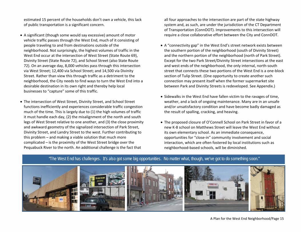
“The West End has challenges. It’s also got some big opportunities. No matter what, though, we’ve got to do something soon.”
estimated 15 percent of the households don’t own a vehicle, this lack of public transportation is a significant concern.
• A significant (though some would say excessive) amount of motor vehicle traffic passes through the West End, much of it consisting of people traveling to and from destinations outside of the neighborhood. Not surprisingly, the highest volumes of traffic in the West End occur at the intersection of West Street (State Route 69), Divinity Street (State Route 72), and School Street (also State Route 72). On an average day, 8,000 vehicles pass through this intersection via West Street; 12,400 via School Street; and 14,500 via Divinity Street. Rather than view this through traffic as a detriment to the neighborhood, the City needs to find ways to turn the West End into a desirable destination in its own right and thereby help local businesses to “capture” some of this traffic.
• The intersection of West Street, Divinity Street, and School Street functions inefficiently and experiences considerable traffic congestion much of the time. This is largely due to (1) the high volumes of traffic it must handle each day, (2) the misalignment of the north and south legs of West Street relative to one another, and (3) the close proximity and awkward geometry of the signalized intersection of Park Street, Divinity Street, and Landry Street to the west. Further contributing to this problem – and making a viable solution that much more complicated – is the proximity of the West Street bridge over the Pequabuck River to the north. An additional challenge is the fact that
all four approaches to the intersection are part of the state highway system and, as such, are under the jurisdiction of the CT Department of Transportation (ConnDOT). Improvements to this intersection will require a close collaborative effort between the City and ConnDOT.
• A “connectivity gap” in the West End’s street network exists between the southern portion of the neighborhood (south of Divinity Street) and the northern portion of the neighborhood (north of Park Street). Except for the two Park Street/Divinity Street intersections at the east and west ends of the neighborhood, the only internal, north‐south street that connects these two portions of the West End is a one‐block section of Tulip Street. (One opportunity to create another such connection may present itself when the former supermarket site between Park and Divinity Streets is redeveloped. See Appendix.)
• Sidewalks in the West End have fallen victim to the ravages of time, weather, and a lack of ongoing maintenance. Many are in an unsafe and/or unsatisfactory condition and have become badly damaged as the result of spalling, cracking, and heaving.
• The proposed closure of O’Connell School on Park Street in favor of a new K‐8 school on Matthews Street will leave the West End without its own elementary school. As an immediate consequence, opportunities for “close‐in” community involvement and social interaction, which are often fostered by local institutions such as neighborhood‐based schools, will be diminished.
A Plan for the West End Neighborhood/Page 16
“There are a lot of people who don’t know that there’s a river running through
our neighborhood.”
• There is a shortage of both on‐street and off‐street parking in the West End, which, in an era of auto dependence, has negative consequences for the long‐term economic health of the neighborhood. Current residents and business owners alike overwhelmingly cited this shortage as an ongoing (and largely unresolved) problem in the West End. If the West End is to successfully attract and retain new residents, businesses, and business patrons, efforts must be made to provide an adequate supply of clearly identified, readily available on‐ and off‐street parking, even while attention is paid to maintaining the West End’s status as a walkable neighborhood.
• In recent years, a public perception has developed that the West End (including parts of Rockwell Park) is an unsafe, crime‐plagued neighborhood and should be avoided whenever possible. True or not, this perception stubbornly persists and poses a serious obstacle to efforts to stabilize and strengthen the neighborhood.
• Among the most significant detractors from the West End neighborhood’s quality of life are so‐called “visual de‐stabilizers” such as blighted properties, trash and litter, illegal dumping, graffiti, broken sidewalks, and damaged or missing street signs. Collectively, they create the impression that little effort is being made to combat these blighting influences.
• In a similar manner, visual “clutter” in the West End (e.g., overhead utility wires, a hodgepodge of advertising signs, utility poles) detracts from the overall appearance of the neighborhood and makes it difficult to appreciate the neighborhood’s interesting buildings and diverse architecture. This condition is most conspicuous in the commercial center of the West End, at and around the intersection of West Street, Divinity Street, and School Street.
• Public access to the Pequabuck River from within the West End neighborhood is, except
in Rockwell Park, practically non‐existent. Its visibility is similarly limited; outside of Rockwell Park, the river is perhaps best viewed from the West Street bridge north of the intersection of West Street, Divinity Street, and School Street.
• Beyond the center of the West End, a scattering of business properties are located along the neighborhood’s two commercial corridors of Park Street and West Street. Unfortunately, a number of undistinguished buildings, large expanses of pavement, the absence of landscaping, and uses that, in some instances, are out of scale and character with their surroundings do not leave the observer with an overall favorable impression of these areas.
• Though many of the West End’s residents and merchants are justifiably proud of their neighborhood and have demonstrated an enthusiasm and willingness to work hard to improve it, there has yet to emerge a readily identifiable group of neighborhood leaders. While there are many individuals in the West End who demonstrate a commitment to the neighborhood on a daily basis ‐ serving on the City Council, organizing clean‐up days, purchasing and rehabilitating old buildings, operating small businesses, and maintaining their properties ‐ there is no formal group that represents the West End and advocates for its interests.
A Plan for the West End Neighborhood/Page 17
IN‐DEPTH: PARTICULAR CHALLENGES IN THE WEST END NEIGHBORHOOD
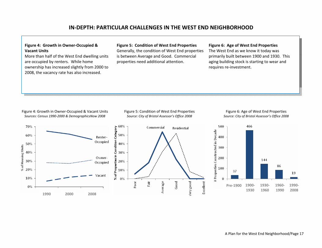
Figure 4: Growth in Owner‐Occupied & Vacant Units More than half of the West End dwelling units are occupied by renters. While home ownership has increased slightly from 2000 to 2008, the vacancy rate has also increased.
Figure 5: Condition of West End Properties Generally, the condition of West End properties is between Average and Good. Commercial properties need additional attention.
Figure 6: Age of West End Properties The West End as we know it today was primarily built between 1900 and 1930. This aging building stock is starting to wear and requires re‐investment.
Figure 5: Condition of West End Properties Source: City of Bristol Assessor’s Office 2008
Figure 4: Growth in Owner‐Occupied & Vacant UnitsSources: Census 1990‐2000 & DemographicsNow 2008
1990 2000 2008
Figure 6: Age of West End PropertiesSource: City of Bristol Assessor’s Office 2008
Pre‐1900 1900‐1930
1930‐1960
1960‐1990
1990‐2008

A Plan for the West End Neighborhood/Page 18
MAP 5: SOCIAL HUBS IN THE WEST END NEIGHBORHOOD The West End neighborhood’s shape and transportation corridors create two separate social hubs. The primary social hub is located at the intersection of Route 69 and Route 72. These transportation corridors create a de facto neighborhood center. However, there is a second social hub that is focused around Muzzy Field in the western portion of the West End. This plan recognizes that both social hubs have significant distressed property and prime opportunities for revitalization.
A Plan for the West End Neighborhood/Page 19
Vision Statement
The West End is a long‐established Bristol neighborhood with an important place in the City’s history and a lively local identity. The neighborhood is a welcoming and supportive place in which residents, merchants, property owners, and civic leaders alike take great pride. Located on the west side of downtown along Routes 72 and 69, the neighborhood is a gateway to the heart of Bristol as well as a desirable destination in its own right. The West End is defined by a unique blend of assets that include a diverse population, a variety of housing types and local businesses, distinctive architecture, and three of Bristol’s finest recreation locations – Rockwell Park, Muzzy Field, and Brackett Park. The West End enjoys access to the Pequabuck River and is home to many places of worship, schools, and social organizations. All of these assets strengthen the neighborhood community and at the same time connect the neighborhood with the nearby downtown district. We envision that the West End will be a safe, friendly, and family‐oriented neighborhood through the positive efforts put forth by many individuals and organizations. We envision the West End with thriving businesses, convenient transportation options, and attractive amenities and activities, all within easy walking distance. We envision that people in the neighborhood will demonstrate their pride by taking responsibility for the ongoing care of their homes and properties, their businesses, the parks and river, and one another.
V. A VISION FOR THE WEST END In order for a neighborhood to begin to rebound, its stakeholders must first have a collective vision of what they would like their neighborhood to be. This “vision statement” has several purposes: • it paints a picture of what the community foresees its neighborhood looking and feeling like anywhere from ten to twenty years into the future;
• it answers the questions “Where do we want to go?” and “What does success look like?”;
• it describes realistic, yet ambitious, aspects of the neighborhood once the plan is implemented; and
• it provides an easily understood and communicated statement that can be shared and used as a guide for planning.
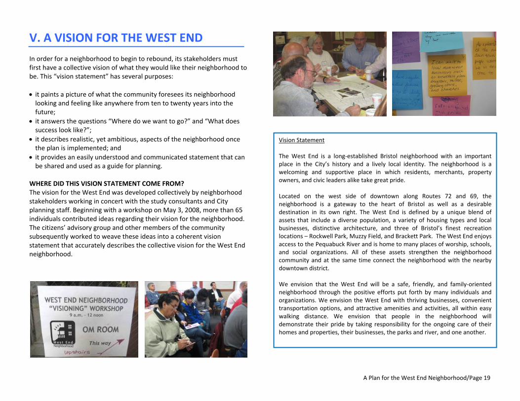
WHERE DID THIS VISION STATEMENT COME FROM? The vision for the West End was developed collectively by neighborhood stakeholders working in concert with the study consultants and City planning staff. Beginning with a workshop on May 3, 2008, more than 65 individuals contributed ideas regarding their vision for the neighborhood. The citizens’ advisory group and other members of the community subsequently worked to weave these ideas into a coherent vision statement that accurately describes the collective vision for the West End neighborhood.
A Plan for the West End Neighborhood/Page 20
VI. A BLUEPRINT FOR CHANGE: Recommended Actions and Their Implementation
The Challenge In a very real sense, this study seeks to answer some difficult questions about the West End neighborhood: Why should anyone care about it? Why should anyone care about its future? Why should anyone commit the resources necessary to improve it, to try to solve its problems, to address the issues which continue to plague it? Like most urban neighborhoods in America, the West End is a complex place. As described earlier, the West End has a rich history that reflects both the growth and subsequent decline of Bristol’s industrial heritage. It contains a diverse population of residents who live, work, and socialize amongst the neighborhood’s mix of houses, businesses, parks, churches, schools, and community organizations. It remains a largely compact, walkable, “human scale” neighborhood. It’s home to the City’s largest and most prominent park and an iconic sports field. The City’s major river – the Pequabuck – flows through the neighborhood. At the same time – and despite its many strengths and assets – the West End in 2011 is, in many respects, a neighborhood in crisis. Several of its defining features are decades old, have been sorely neglected, and remain in substandard condition. The West End is further burdened by an unflattering reputation as a place plagued by crime and drugs, and populated by low‐income renters living in rundown buildings owned by out‐of‐town landlords who have little or no regard for the properties they own or for the neighborhood itself. The longer that this reputation persists, the more difficult it will be for a visible and long‐lasting transformation of the neighborhood to take place. The challenge now is to stem and reverse the decline which has gripped the West End neighborhood and which, if not attended to decisively, threatens its very future.
The current situation in which the West End neighborhood finds itself is the result of an interrelated set of conditions and circumstances, some of which evolved over a long period of time, while others of which have manifested themselves only recently. The neighborhood’s weaknesses and problems are multi‐dimensional, affecting its social fabric (e.g., public safety) as well as its physical components (e.g., housing). Though these weaknesses and problems all have a negative impact on the neighborhood, some are more serious and widespread than others. (For example, though limited public access to the Pequabuck River has been identified as a neighborhood weakness, the blighting influence caused by unkempt or deteriorated properties is obviously of more immediate and greater concern.)
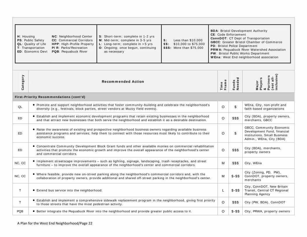
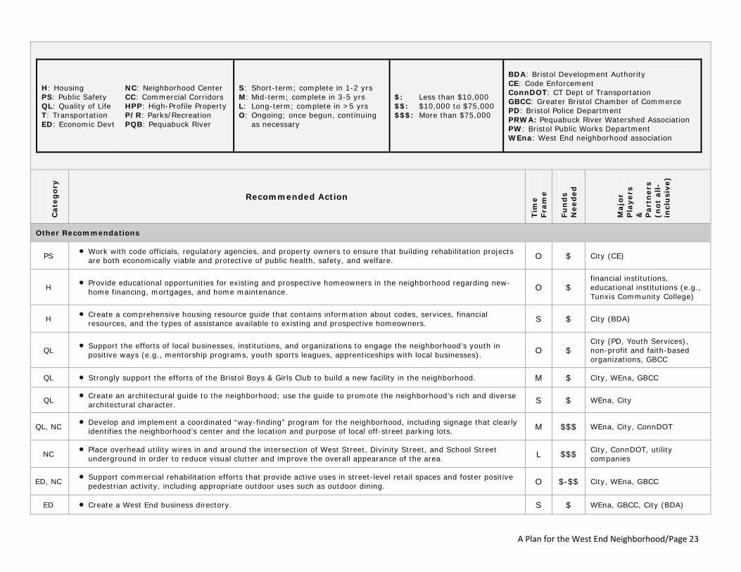
A Call to Action From this understanding of the issues, a series of recommended actions designed to help combat the West End’s most severe problems, address its weaknesses, seize upon opportunities for improvement as they occur, and build upon the neighborhood’s assets and strengths has been developed. These recommendations have been organized and prioritized into an “action table,” which can be found on the following pages. For each recommendation, the table identifies the primary area of concern intended to be addressed by the action; indicates the (relative) amount of time it will take for each recommended action to be accomplished; estimates the (relative) cost of implementing each recommended action, and identifies the key players and partners necessary to implement each recommended action. In addition, fifteen of the 43 recommendations have been designated – and grouped together – as “first priority” recommendations, because they warrant immediate attention to address the most serious and widespread problems in the West End.

A Plan for the West End Neighborhood/Page 21
H: Housing PS: Public Safety QL: Quality of Life T: Transportation ED: Economic Devt
NC: Neighborhood Center CC: Commercial Corridors HPP: High-Profile Property P/R: Parks/Recreation PQB: Pequabuck River
S: Short-term; complete in 1-2 yrs M: Mid-term; complete in 3-5 yrs L: Long-term; complete in >5 yrs O: Ongoing; once begun, continuing
as necessary
$: Less than $10,000 $$: $10,000 to $75,000 $$$: More than $75,000
BDA: Bristol Development Authority CE: Code Enforcement ConnDOT: CT Dept of Transportation GBCC: Greater Bristol Chamber of Commerce PD: Bristol Police Department PRWA: Pequabuck River Watershed Association PW: Bristol Public Works Department WEna: West End neighborhood association
Cate
go
ry
Recommended Action
Tim
e
Fra
me
Fu
nd
s
Need
ed
Majo
r P
layers
&
P
art
ners
(n
ot
all-
incl
usi
ve)
First-Priority Recommendations
PS
• Improve public safety – and the public’s perception of safety - in the neighborhood. a. Work with residents and business owners to form active block watches. b. Increase police patrols in the neighborhood to heighten police presence. c. Establish a West End police beat to improve relationships and communications between the police and
neighborhood residents, business owners, and youth. d. Establish a police substation in the neighborhood. e. Target the neighborhood for comprehensive drug enforcement efforts. f. Starting with Park Street, install pedestrian and street lighting that improves the safety and security of
people in the area and creates a uniform lighting system within the neighborhood.
O $$$
City (PD, PW), residents, property owners, merchants, WEna, ConnDOT [Item f.], CT Light & Power [Item f.]
H
• Establish and implement housing assistance programs that: a. facilitate first-time homeownership in the neighborhood; b. increase owner-occupancy of two- and three-family dwellings in the neighborhood; c. support the timely acquisition and re-occupancy of foreclosed properties in the neighborhood; and d. create opportunities for homeowners in the neighborhood to maintain ownership of their residences.
O $$$
City, State and federal agencies, financial institutions, non-profit organizations
H, QL • Target blighted properties in the neighborhood for comprehensive code enforcement efforts. O $$$ City (CE), property owners
H, QL • Organize and implement neighborhood cleanup and beautification programs and a residential paint program. S/O $ property owners, residents, merchants, WEna, community service groups, City (PW)
QL • Establish a West End Neighborhood Association - comprised of business owners, property owners, homeowners,
residents, and other stakeholders - which can take a leadership role on behalf of the neighborhood in the implementation of this plan and neighborhood revitalization efforts.
S $ merchants, property owners, residents, non-profit and faith-based organizations
QL • Publicize the neighborhood and promote its assets and amenities. O $ City, WEna, GBCC
A Plan for the West End Neighborhood/Page 22
H: Housing PS: Public Safety QL: Quality of Life T: Transportation ED: Economic Devt
NC: Neighborhood Center CC: Commercial Corridors HPP: High-Profile Property P/R: Parks/Recreation PQB: Pequabuck River
S: Short-term; complete in 1-2 yrs M: Mid-term; complete in 3-5 yrs L: Long-term; complete in >5 yrs O: Ongoing; once begun, continuing
as necessary
$: Less than $10,000 $$: $10,000 to $75,000 $$$: More than $75,000
BDA: Bristol Development Authority CE: Code Enforcement ConnDOT: CT Dept of Transportation GBCC: Greater Bristol Chamber of Commerce PD: Bristol Police Department PRWA: Pequabuck River Watershed Association PW: Bristol Public Works Department WEna: West End neighborhood association
Cate
go
ry
Recommended Action
Tim
e
Fra
me
Fu
nd
s
Need
ed
Majo
r P
layers
&
P
art
ners
(n
ot
all-
incl
usi
ve)
First-Priority Recommendations (cont’d)
QL • Promote and support neighborhood activities that foster community-building and celebrate the neighborhood’s
diversity (e.g., festivals, block parties, street vendors at Muzzy Field events). O $ WEna, City, non-profit and faith-based organizations
ED • Establish and implement economic development programs that retain existing businesses in the neighborhood
and that attract new businesses that both serve the neighborhood and establish it as a desirable destination. O $$$ City (BDA), property owners, merchants, GBCC
ED • Raise the awareness of existing and prospective neighborhood business owners regarding available business
assistance programs and services; help them to connect with those resources most likely to contribute to their economic success.
O $
GBCC, Community Economic Development Fund, financial institutions, Small Business Admin., WEna, City (BDA)
ED • Concentrate Community Development Block Grant funds and other available monies on commercial rehabilitation
activities that promote the economic growth and improve the overall appearance of the neighborhood’s center and commercial corridors.
O $$$ City (BDA), merchants, property owners
NC, CC • Implement streetscape improvements – such as lighting, signage, landscaping, trash receptacles, and street
furniture – to improve the overall appearance of the neighborhood’s center and commercial corridors. M $$$ City, WEna
NC, CC • Where feasible, provide new on-street parking along the neighborhood’s commercial corridors and, with the
collaboration of property owners, provide additional and shared off-street parking in the neighborhood’s center. M $-$$ City (Zoning, PD, PW), ConnDOT, property owners, merchants
T • Extend bus service into the neighborhood. L $-$$ City, ConnDOT, New Britain Transit, Central CT Regional Planning Agency
T • Establish and implement a comprehensive sidewalk replacement program in the neighborhood, giving first priority
to those streets that have the most pedestrian activity. O $$$ City (PW, BDA), ConnDOT
PQB • Better integrate the Pequabuck River into the neighborhood and provide greater public access to it. O $-$$ City, PRWA, property owners
A Plan for the West End Neighborhood/Page 23
H: Housing PS: Public Safety QL: Quality of Life T: Transportation ED: Economic Devt
NC: Neighborhood Center CC: Commercial Corridors HPP: High-Profile Property P/R: Parks/Recreation PQB: Pequabuck River
S: Short-term; complete in 1-2 yrs M: Mid-term; complete in 3-5 yrs L: Long-term; complete in >5 yrs O: Ongoing; once begun, continuing
as necessary
$: Less than $10,000 $$: $10,000 to $75,000 $$$: More than $75,000
BDA: Bristol Development Authority CE: Code Enforcement ConnDOT: CT Dept of Transportation GBCC: Greater Bristol Chamber of Commerce PD: Bristol Police Department PRWA: Pequabuck River Watershed Association PW: Bristol Public Works Department WEna: West End neighborhood association
Cate
go
ry
Recommended Action
Tim
e
Fra
me
Fu
nd
s
Need
ed
Majo
r P
layers
&
P
art
ners
(n
ot
all-
incl
usi
ve)
Other Recommendations
PS • Work with code officials, regulatory agencies, and property owners to ensure that building rehabilitation projects
are both economically viable and protective of public health, safety, and welfare. O $ City (CE)
H • Provide educational opportunities for existing and prospective homeowners in the neighborhood regarding new-
home financing, mortgages, and home maintenance. O $ financial institutions, educational institutions (e.g., Tunxis Community College)
H • Create a comprehensive housing resource guide that contains information about codes, services, financial
resources, and the types of assistance available to existing and prospective homeowners. S $ City (BDA)
QL • Support the efforts of local businesses, institutions, and organizations to engage the neighborhood’s youth in
positive ways (e.g., mentorship programs, youth sports leagues, apprenticeships with local businesses). O $ City (PD, Youth Services), non-profit and faith-based organizations, GBCC
QL • Strongly support the efforts of the Bristol Boys & Girls Club to build a new facility in the neighborhood. M $ City, WEna, GBCC
QL • Create an architectural guide to the neighborhood; use the guide to promote the neighborhood’s rich and diverse
architectural character. S $ WEna, City
QL, NC • Develop and implement a coordinated “way-finding” program for the neighborhood, including signage that clearly
identifies the neighborhood’s center and the location and purpose of local off-street parking lots. M $$$ WEna, City, ConnDOT
NC • Place overhead utility wires in and around the intersection of West Street, Divinity Street, and School Street
underground in order to reduce visual clutter and improve the overall appearance of the area. L $$$ City, ConnDOT, utility companies
ED, NC • Support commercial rehabilitation efforts that provide active uses in street-level retail spaces and foster positive
pedestrian activity, including appropriate outdoor uses such as outdoor dining. O $-$$ City, WEna, GBCC
ED • Create a West End business directory. S $ WEna, GBCC, City (BDA)
A Plan for the West End Neighborhood/Page 24
H: Housing PS: Public Safety QL: Quality of Life T: Transportation ED: Economic Devt
NC: Neighborhood Center CC: Commercial Corridors HPP: High-Profile Property P/R: Parks/Recreation PQB: Pequabuck River
S: Short-term; complete in 1-2 yrs M: Mid-term; complete in 3-5 yrs L: Long-term; complete in >5 yrs O: Ongoing; once begun, continuing
as necessary
$: Less than $10,000 $$: $10,000 to $75,000 $$$: More than $75,000
BDA: Bristol Development Authority CE: Code Enforcement ConnDOT: CT Dept of Transportation GBCC: Greater Bristol Chamber of Commerce PD: Bristol Police Department PRWA: Pequabuck River Watershed Association PW: Bristol Public Works Department WEna: West End neighborhood association
Cate
go
ry
Recommended Action
Tim
e
Fra
me
Fu
nd
s
Need
ed
Majo
r P
layers
&
P
art
ners
(n
ot
all-
incl
usi
ve)
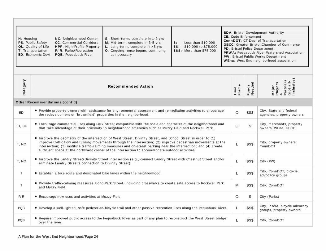
Other Recommendations (cont’d)
ED • Provide property owners with assistance for environmental assessment and remediation activities to encourage
the redevelopment of “brownfield” properties in the neighborhood. O $$$ City, State and federal agencies, property owners
ED, CC • Encourage commercial uses along Park Street compatible with the scale and character of the neighborhood and
that take advantage of their proximity to neighborhood amenities such as Muzzy Field and Rockwell Park. O $ City, merchants, property owners, WEna, GBCC
T, NC
• Improve the geometry of the intersection of West Street, Divinity Street, and School Street in order to (1) improve traffic flow and turning movements through the intersection; (2) improve pedestrian movements at the intersection; (3) institute traffic-calming measures and on-street parking near the intersection; and (4) create sufficient space at the northwest corner of the intersection to accommodate outdoor activities.
L $$$ City, property owners, ConnDOT
T, NC • Improve the Landry Street/Divinity Street intersection (e.g., connect Landry Street with Chestnut Street and/or
eliminate Landry Street’s connection to Divinity Street). L $$$ City (PW)
T • Establish a bike route and designated bike lanes within the neighborhood. L $$$ City, ConnDOT, bicycle advocacy groups
T • Provide traffic-calming measures along Park Street, including crosswalks to create safe access to Rockwell Park
and Muzzy Field. M $$$ City, ConnDOT
P/R • Encourage new uses and activities at Muzzy Field. O $ City (Parks)
PQB • Develop a well-lighted, safe pedestrian/bicycle trail and other passive recreation uses along the Pequabuck River. L $$$ City, PRWA, bicycle advocacy groups, property owners
PQB • Require improved public access to the Pequabuck River as part of any plan to reconstruct the West Street bridge
over the river. L $$$ City, ConnDOT

A Plan for the West End Neighborhood/Page 25
H: Housing PS: Public Safety QL: Quality of Life T: Transportation ED: Economic Devt
NC: Neighborhood Center CC: Commercial Corridors HPP: High-Profile Property P/R: Parks/Recreation PQB: Pequabuck River
S: Short-term; complete in 1-2 yrs M: Mid-term; complete in 3-5 yrs L: Long-term; complete in >5 yrs O: Ongoing; once begun, continuing
as necessary
$: Less than $10,000 $$: $10,000 to $75,000 $$$: More than $75,000
BDA: Bristol Development Authority CE: Code Enforcement ConnDOT: CT Dept of Transportation GBCC: Greater Bristol Chamber of Commerce PD: Bristol Police Department PRWA: Pequabuck River Watershed Association PW: Bristol Public Works Department WEna: West End neighborhood association
Cate
go
ry
Recommended Action
Tim
e
Fra
me
Fu
nd
s
Need
ed
Majo
r P
layers
&
P
art
ners
(n
ot
all-
incl
usi
ve)
Other Recommendations (cont’d)
HPP Former Chic Miller auto dealership site, West Street
• Assist the owner(s) of the property with environmental assessment and remediation efforts to facilitate the most desirable redevelopment of the site. $$$ City, State and federal
agencies, property owner
• Encourage and support the redevelopment of the property with a mixed-use (residential/commercial) development project that accomplishes the following:
a. orients its residential component towards Upson Street; b. locates the primary vehicular access into/out of the site on either South Street or West Street rather than
on Upson Street; c. aligns any vehicular access provided on West Street with Gridley Street, to the greatest extent possible; d. provides active, pedestrian-oriented uses along the property’s street frontage; e. places on-site parking behind buildings and/or screens it with landscaping in order to minimize its visibility
to passersby; and f. integrates sustainable development practices into the project’s design.
Indet
erm
inat
e
$$ property owner, City, State, private developer
HPP O’Connell School property, Park Street
• Redevelop the property in a manner that accomplishes the following: a. re-uses the building for residential and/or community-based purposes; b. retains at least the main portion of the building (including the original school itself); c. takes advantage of the site’s proximity to the Pequabuck River and connects the river with the
neighborhood; d. utilizes a portion of the property to provide public access to the Pequabuck River; e. provides a well-lighted, safe pedestrian/bicycle trail and other passive recreation uses along the property’s
Pequabuck River frontage; and f. integrates sustainable development practices into the project’s design.
M $-$$ City, private developer, PRWA
• Nominate the building for inclusion on the State Register of Historic Places. S $ City
A Plan for the West End Neighborhood/Page 26
H: Housing PS: Public Safety QL: Quality of Life T: Transportation ED: Economic Devt
NC: Neighborhood Center CC: Commercial Corridors HPP: High-Profile Property P/R: Parks/Recreation PQB: Pequabuck River
S: Short-term; complete in 1-2 yrs M: Mid-term; complete in 3-5 yrs L: Long-term; complete in >5 yrs O: Ongoing; once begun, continuing
as necessary
$: Less than $10,000 $$: $10,000 to $75,000 $$$: More than $75,000
BDA: Bristol Development Authority CE: Code Enforcement ConnDOT: CT Dept of Transportation GBCC: Greater Bristol Chamber of Commerce PD: Bristol Police Department PRWA: Pequabuck River Watershed Association PW: Bristol Public Works Department WEna: West End neighborhood association
Cate
go
ry
Recommended Action
Tim
e
Fra
me
Fu
nd
s
Need
ed
Majo
r P
layers
&
P
art
ners
(n
ot
all-
incl
usi
ve)
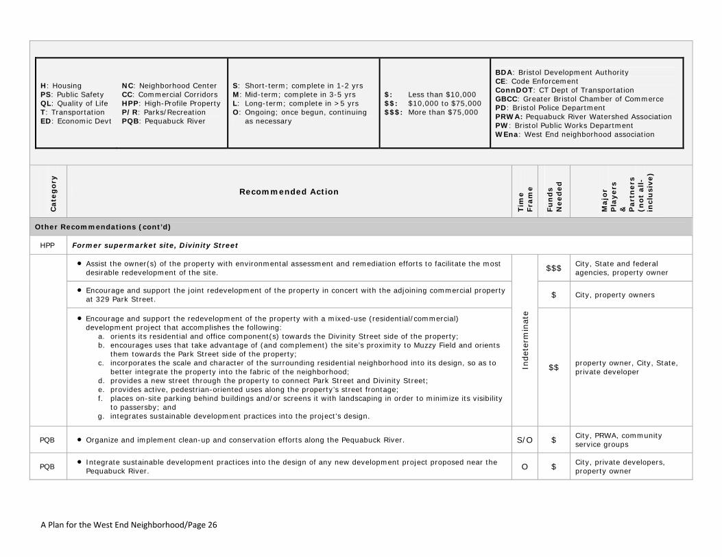
Other Recommendations (cont’d)
HPP Former supermarket site, Divinity Street
• Assist the owner(s) of the property with environmental assessment and remediation efforts to facilitate the most desirable redevelopment of the site. $$$ City, State and federal
agencies, property owner
• Encourage and support the joint redevelopment of the property in concert with the adjoining commercial property at 329 Park Street. $ City, property owners
• Encourage and support the redevelopment of the property with a mixed-use (residential/commercial) development project that accomplishes the following:
a. orients its residential and office component(s) towards the Divinity Street side of the property; b. encourages uses that take advantage of (and complement) the site’s proximity to Muzzy Field and orients
them towards the Park Street side of the property; c. incorporates the scale and character of the surrounding residential neighborhood into its design, so as to
better integrate the property into the fabric of the neighborhood; d. provides a new street through the property to connect Park Street and Divinity Street; e. provides active, pedestrian-oriented uses along the property’s street frontage; f. places on-site parking behind buildings and/or screens it with landscaping in order to minimize its visibility
to passersby; and g. integrates sustainable development practices into the project’s design.
Indet
erm
inat
e
$$ property owner, City, State, private developer
PQB • Organize and implement clean-up and conservation efforts along the Pequabuck River. S/O $ City, PRWA, community service groups
PQB • Integrate sustainable development practices into the design of any new development project proposed near the
Pequabuck River. O $ City, private developers, property owner

A Plan for the West End Neighborhood/Page 27
The Plan’s Stakeholders So who is it exactly that has a stake in the future of the West End neighborhood? And what role(s) will they play? While the work of many individuals and groups will be necessary in order to successfully implement the plan’s various components, there are three primary groups of stakeholders whose engagement in and commitment to this endeavor will be especially critical. • The local government (as represented formally by the mayor, City
Council, Board of Finance, and other elected and appointed officials). Like so many other cities across the country, the City of Bristol has limited fiscal resources at its disposal and must attend to the varied needs and demands of a community that is significantly larger than just a single neighborhood. At the same time, the City must be prepared and willing to proactively focus its attention on the needs of the West End before existing problems worsen and as new opportunities arise. The nature and extent of local government’s involvement in the pursuit of the neighborhood’s vision will largely depend upon the specific project, action, or activity being undertaken. Throughout the implementation process , the City will likely play multiple roles, including those of facilitator, partner, collaborator, provider of municipal services, and enforcement agent.
• The community‐at‐large. Just as, as the axiom goes, a chain is only as
strong as its weakest link, so too is the overall economic and social health of a city only as robust as that of its most distressed neighborhood. For residents outside of the West End to suggest that what happens there is “not our problem” or that the best way to address the neighborhood’s woes is with a bulldozer is, at best, short‐sighted and simplistic and, at worst, a perilous recipe for further decline of the neighborhood. The likelihood that the West End can be successfully transformed once again into a vital, vibrant neighborhood will be significantly increased if it gains (and maintains) the understanding, support, and encouragement of the entire community.
• The West End Neighborhood. Perhaps most importantly, the primary
responsibility for implementing this plan rests with the neighborhood
itself: the array of property owners; residents; merchants; social, business, and faith‐based organizations; and others who need to “buy into” the plan and its recommended actions. It is imperative that these stakeholders – those most directly impacted by the future success (or further decline) of the West End – take a leadership role in this process, as both vocal advocates for the plan and active participants in its implementation. To that end, the recommendation that a formal association be established to represent the interests of the West End neighborhood – much like the Forestville Village Association does on behalf of the Forestville neighborhood in the southeastern section of Bristol – cannot be emphasized enough.
The Implementation Process Just as the issues which vex the West End today are multi‐dimensional, so too must the actions necessary to address them be multi‐dimensional. While all of these recommended actions are intended to contribute to the transformation of the West End, it is important to keep in mind that: • just as the current conditions in the neighborhood did not develop
suddenly, neither will positive change take place suddenly; improvements to the West End neighborhood will occur gradually and incrementally;
• some recommendations need to be implemented much sooner than others;
• some recommendations can be accomplished relatively quickly and will have an immediate impact; others, once initiated, will take longer to accomplish and may not produce visible, long‐lasting results until well after their completion; and
• the activities associated with several of these recommendations – even those that can be completed quickly – are intended to be long‐term and ongoing.

A Plan for the West End Neighborhood/Page 28
Perhaps most importantly, implementing this plan’s recommendations will require an unwavering commitment of time, attention, effort, and resources (both human and financial). This commitment: • must be long‐term and sustained; • must be comprehensive and multi‐faceted; • must utilize both “carrots” (e.g., business incentives, housing
rehabilitation assistance) and “sticks” (e.g., code enforcement, crackdown on crime); and
• must engage and involve a diverse group of players: the public and private sectors, government and citizens, the neighborhood and the community‐at‐large, and institutions and individuals.
This plan seeks to provide a workable blueprint for positive, long‐term change in the West End neighborhood. If serious attention is paid to the vision and recommendations articulated in the plan, it can help to generate and sustain the momentum necessary to revitalize and reinvigorate a neighborhood that, although it has seen better times, still has a meaningful and important place in the history, geography, and community life of the City of Bristol.

A Plan for the West End Neighborhood
APPENDIX
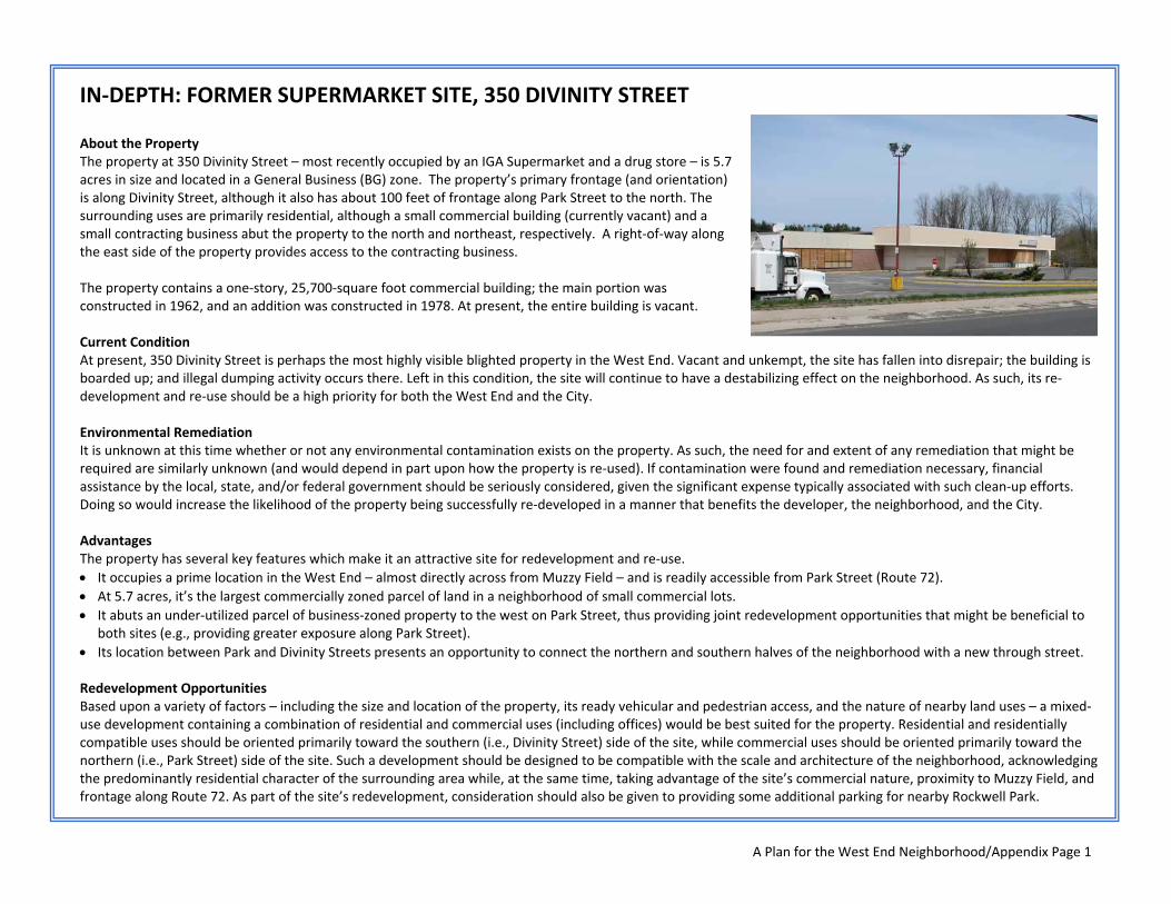
A Plan for the West End Neighborhood/Appendix Page 1
IN‐DEPTH: FORMER SUPERMARKET SITE, 350 DIVINITY STREET About the Property The property at 350 Divinity Street – most recently occupied by an IGA Supermarket and a drug store – is 5.7 acres in size and located in a General Business (BG) zone. The property’s primary frontage (and orientation) is along Divinity Street, although it also has about 100 feet of frontage along Park Street to the north. The surrounding uses are primarily residential, although a small commercial building (currently vacant) and a small contracting business abut the property to the north and northeast, respectively. A right‐of‐way along the east side of the property provides access to the contracting business. The property contains a one‐story, 25,700‐square foot commercial building; the main portion was constructed in 1962, and an addition was constructed in 1978. At present, the entire building is vacant. Current Condition At present, 350 Divinity Street is perhaps the most highly visible blighted property in the West End. Vacant and unkempt, the site has fallen into disrepair; the building is boarded up; and illegal dumping activity occurs there. Left in this condition, the site will continue to have a destabilizing effect on the neighborhood. As such, its re‐development and re‐use should be a high priority for both the West End and the City. Environmental Remediation It is unknown at this time whether or not any environmental contamination exists on the property. As such, the need for and extent of any remediation that might be required are similarly unknown (and would depend in part upon how the property is re‐used). If contamination were found and remediation necessary, financial assistance by the local, state, and/or federal government should be seriously considered, given the significant expense typically associated with such clean‐up efforts. Doing so would increase the likelihood of the property being successfully re‐developed in a manner that benefits the developer, the neighborhood, and the City. Advantages The property has several key features which make it an attractive site for redevelopment and re‐use. • It occupies a prime location in the West End – almost directly across from Muzzy Field – and is readily accessible from Park Street (Route 72). • At 5.7 acres, it’s the largest commercially zoned parcel of land in a neighborhood of small commercial lots. • It abuts an under‐utilized parcel of business‐zoned property to the west on Park Street, thus providing joint redevelopment opportunities that might be beneficial to
both sites (e.g., providing greater exposure along Park Street). • Its location between Park and Divinity Streets presents an opportunity to connect the northern and southern halves of the neighborhood with a new through street. Redevelopment Opportunities Based upon a variety of factors – including the size and location of the property, its ready vehicular and pedestrian access, and the nature of nearby land uses – a mixed‐use development containing a combination of residential and commercial uses (including offices) would be best suited for the property. Residential and residentially compatible uses should be oriented primarily toward the southern (i.e., Divinity Street) side of the site, while commercial uses should be oriented primarily toward the northern (i.e., Park Street) side of the site. Such a development should be designed to be compatible with the scale and architecture of the neighborhood, acknowledging the predominantly residential character of the surrounding area while, at the same time, taking advantage of the site’s commercial nature, proximity to Muzzy Field, and frontage along Route 72. As part of the site’s redevelopment, consideration should also be given to providing some additional parking for nearby Rockwell Park.

A Plan for the West End Neighborhood/Appendix Page 2
IN‐DEPTH: FORMER CHIC MILLER AUTO DEALERSHIP, 40 WEST STREET About the Property Between 1967 and 2003, the property at 40 West Street was home to a Chevrolet auto dealership owned and operated by Chapin “Chic” Miller. The site is 1.9 acres in size and located in an R‐15/BT (Residential/Downtown‐Neighborhood Transition) zone. It is bounded by Upson Street on the north, South Street on the south, and West Street on the west. Its eastern boundary adjoins both The Bristol Family Center (part of the Bristol Boys & Girls Club) located at 47 Upson Street, and a two‐family residence located at 19‐21 South Street. The property contains a one‐story commercial building approximately 31,905 square feet in size, which housed the dealership’s showroom, offices, and service center. The building is surrounded by pavement, which extends to the property lines. At present, the entire premises is vacant. Current Condition In June of 2007, Bristol Real Estate, LLC acquired the property. Though the current owner has cleaned up the site and continues to work with local officials and neighborhood residents to find an appropriate re‐use for the site, it remains one of the most highly visible, blighted properties in the West End. Environmental Remediation Because the property was used for automotive purposes – including auto body and repair work – some environmental clean‐up may be necessary before the site can be re‐developed. If contamination were found and remediation necessary, financial assistance by the local, state, and/or federal government should be seriously considered, given the significant expense typically associated with such clean‐up efforts. Doing so would increase the likelihood of the property being successfully re‐developed in a manner that benefits the developer, the neighborhood, and the City. Advantages The property has several key features which make it an attractive site for redevelopment and re‐use. • The site is relatively flat, regularly shaped and, at nearly two acres in size, significantly larger than most other commercial properties in the neighborhood. • The site has frontage on three streets, including a prominent, highly visible location along Route 69 (West Street), less than half a mile from Brackett Park and
downtown Bristol, and less than a mile from Muzzy Field. • A mix of land uses is located nearby, including residences, businesses (less than three blocks away), and a non‐profit organization (Bristol Family Center). Redevelopment Opportunities Based upon the site’s size, shape, location, and access, a mixed‐use development containing a combination of residential and commercial uses (including offices) would be best suited for the property. Such a development should take advantage of the site’s frontage along three streets – including Route 69 – and should be designed to be compatible with the scale and architecture of the neighborhood. Residential uses in the development should be oriented primarily toward the northern (Upson Street) side of the site, while commercial uses should be located toward the southern (South Street) side of the site. Vehicular access into/out of the site should be encouraged on South Street and West Street (opposite Gridley Street, if possible) rather than on Upson Street, a one‐way residential street. (NOTE: During the course of this study, the Bristol Boys & Girls Club considered this site as a potential location for a new facility, due in part to its proximity to the Bristol Family Center next door on Upson Street. However, the Club ultimately chose to pursue other sites instead and has since expressed its intention to build a new facility on the west side of West Street north of Gaylord Street on property currently occupied by a large parking lot owned and utilized by St. Ann’s Church.