Table of Contents - دانشگاه تهران...Shafagh Rastgar, Zeinab Najafpour, Zeinab Jafarian,...
34
Table of Contents Title Page Application of polymerized graphene oxide for optimization of o-xylene removal from aqueous solutions through response surface methodology 1 Avideh Azizi 1 , Elham Moniri, Amir Hessam Hassani, Homayon Ahmad Panahi, Fateme Kahi Evaluation of Performance of Interpolation Methods in Mapping of Heavy Metals in Soil (Case Study: Harris Town, North-Western Iran) 4 Seyed Reza Sadeghikhoo, Rahim Ali Abbaspour Non-carcinogenic quantitative risk assessment of heavy metals in 8 fish species of Iranian international wetlands by EPA/WHO instructions 7 Ghasem Zolfaghari, Omid Safari, Azadeh Atabati Investigating the effect of industrialization on environment quality in Iran emphasizing the moderating role of social capital (Kalman filter approach) 10 Abolghsem Mahdavi, Hamid Azizmohammadlou Estimating the preservation value of environmental resources of Abar area of Shahrood by using individual’s willingness to pay 12 Hasan Yeganeh, Mohammadreza Shariati, Adel Sepehry Estimation the Shadow Price of Pollution in Iran's Wheat Production and Distribution Chain 15 Hamed Najafi Alamdarlo, Katayoon Shemshadi Yazdi Investigation of factors affecting on land use change in Khorasan Razavi 17 Alireza Karbasi, Banafshe Yazdankhah, Seyed Hossein Mohammadzadeh Economic valuation of air and noise pollutions abatement performance 19 Amir Hossein Montazer-Hojat, Behzad Mansouri, Parjak Zoofan, Hana Saeid Investigation and Comparison of the Economic Value of Carbon Sequestration Function of Vegetation Cover in Biological Operations (Case study: Sarbishe Rangelands-South Khorasan Province) 21 Shafagh Rastgar, Zeinab Najafpour, Zeinab Jafarian, Jamshid Ghorbani Evaluation and determination of urban land use resilience based on sustainable development approach (Case study: district one of Tehran municipality)) 24 Yaser Moarrab, Mohammad Javad Amiri The affecting factors on forming and development of Tehran with an emphasis on relationship between city and nature 27 Homa Irani Behbahani, Marzie Kazemzade, Sara Tahersima Analysis of the Effect of Land Cover Spatial Configuration and Physical Characteristics of Buildings on the Surface Urban Cool Island Phenomenon 30 Abolghasem Azhdari, Ali Akbar Taghvaee
Transcript of Table of Contents - دانشگاه تهران...Shafagh Rastgar, Zeinab Najafpour, Zeinab Jafarian,...
Table of Contents Title Page
Application of polymerized graphene oxide for optimization of o-xylene removal from aqueous solutions through
response surface methodology 1 Avideh Azizi1, Elham Moniri, Amir Hessam Hassani, Homayon Ahmad Panahi, Fateme Kahi
Evaluation of Performance of Interpolation Methods in Mapping of Heavy Metals in Soil (Case Study: Harris
Town, North-Western Iran) 4 Seyed Reza Sadeghikhoo, Rahim Ali Abbaspour
Non-carcinogenic quantitative risk assessment of heavy metals in 8 fish species of Iranian international wetlands
by EPA/WHO instructions 7 Ghasem Zolfaghari, Omid Safari, Azadeh Atabati
Investigating the effect of industrialization on environment quality in Iran emphasizing the moderating role of
social capital (Kalman filter approach) 10 Abolghsem Mahdavi, Hamid Azizmohammadlou
Estimating the preservation value of environmental resources of Abar area of Shahrood by using individual’s willingness
to pay 12 Hasan Yeganeh, Mohammadreza Shariati, Adel Sepehry
Estimation the Shadow Price of Pollution in Iran's Wheat Production and Distribution Chain 15 Hamed Najafi Alamdarlo, Katayoon Shemshadi Yazdi
Investigation of factors affecting on land use change in Khorasan Razavi 17 Alireza Karbasi, Banafshe Yazdankhah, Seyed Hossein Mohammadzadeh
Economic valuation of air and noise pollutions abatement performance 19 Amir Hossein Montazer-Hojat, Behzad Mansouri, Parjak Zoofan, Hana Saeid
Investigation and Comparison of the Economic Value of Carbon Sequestration Function of Vegetation Cover in Biological
Operations (Case study: Sarbishe Rangelands-South Khorasan Province) 21 Shafagh Rastgar, Zeinab Najafpour, Zeinab Jafarian, Jamshid Ghorbani
Evaluation and determination of urban land use resilience based on sustainable development approach (Case
study: district one of Tehran municipality)) 24 Yaser Moarrab, Mohammad Javad Amiri
The affecting factors on forming and development of Tehran with an emphasis on relationship between city and
nature 27 Homa Irani Behbahani, Marzie Kazemzade, Sara Tahersima
Analysis of the Effect of Land Cover Spatial Configuration and Physical Characteristics of Buildings on the
Surface Urban Cool Island Phenomenon 30 Abolghasem Azhdari, Ali Akbar Taghvaee


Journal of Environmental Studies
Vol. 44, No. 1, Spring 2018 1
Application of polymerized graphene oxide for optimization of o-xylene
removal from aqueous solutions through response surface methodology
Avideh Azizi1, Elham Moniri
2, Amir Hessam Hassani
3, Homayon Ahmad Panahi
4, Fateme Kahi
5
1. Ph.D in Environmental Engineering, Department of Environmental Engineering, Faculty of Environment and Energy, Science and Research Branch, Islamic Azad University, Tehran, Iran ([email protected])
2. Associate Professor, Department of Chemistry, Varamin (Pishva) Branch, Islamic Azad University, Pishva, Tehran, Iran
3. Associate Professor, Department of Environmental Engineering, Faculty of Environment and Energy, Science and Research Branch, Islamic Azad University, Tehran, Iran ( [email protected])
4. Professor, Department of Chemistry, Central Tehran Branch, Islamic Azad University, Tehran, Iran ([email protected])
5. BS in Chemical Engineering, Head of Public Relations, National Iranian Oil Products Distribution Company, Tehran, Iran ([email protected])
Received: August 01, 2017 Accepted: May 31, 2018
Expanded Abstract
1. Introduction
Following an accidental oil spill, the removal of surface oil is usually the important concern for decreasing
energy loss and damage to the environment. O-xylene is one of the common compounds which exist in the
effluent of oil and petroleum industries. Consequently, the removal of o-xylene from groundwater and surface
waters is essential. One of main techniques that are useful for cleaning up the soluble oil is adsorption.
Adsorption methods are simple and economical and the removal of toxic chemicals using porous adsorbents has
aroused attention. Graphene as a new synthetic 2D allotrope of carbon has advantages as an adsorbent due to its
flexible structure. Graphene has a very fine potential as adsorbent material due to its low cost and
environmentally friendly product and by the fact that graphene can be reused without any significant change in
its adsorption capacity.
2. Materials and Methods
2.1. Preparation of graphene oxide (GO)
GO was prepared from graphite powder by Hummers and Offeman method.
2.2. Polymerization of GO
2 g of GO powder were dissolved in 20 ml of dimethylformamide with stirring. Then, allylamine (10 ml) was
added to the solution by continuous stirring at 160 rpm for 2 days. Later, the mixture was washed via
dimethylformamide and filtered, the product was dried at room temperature. The grafting of GO with allylamine (GO-AA) was transferred into the flask and was dissolved in 30 ml of
methanol. Next, APS (0.75 g) and MVK (30 ml) were rapidly poured to the solution. The mixture was heated at
60°C in a nitrogen atmosphere for 5 h under stirring. The solution was washed with methanol and filtered. At the
end, the product was dried at room temperature.
2.3. Modification of polymerized GO with methyl vinyl ketone (GO-MVK)
At first, GO-MVK was mixed with ethanol (150 ml) and aniline (50 ml) and added into the flask. The mixture
was fitted under atmosphere of nitrogen at 40°C for 6 h, with agitation speed of 180 rpm. After filtering, the final
product was washed with ethanol and further dried in vacuum oven at 40°C for 3 days.
ــــــــــــــــــــــــــــــــــــــــــــــــــــــــــــــــــــــــــــــــــــــــــــــــــــــــــــــــــــــــــــــــــــــــــــــــ Corresponding Author: E-mail: [email protected]

Application of polymerized graphene …
Avideh Azizi, et al. 2
2.4. Batch adsorption experiments
For batch adsorption experiment, the desired dosage of graphene oxide grafted with poly methyl vinyl ketone
and aniline (GO-MVK-ANI) was mixed with 50 ml of aqueous o-xylene solution (20 mg/l) in a 100 ml flask
which was shaken using a rotary shaker at 150 rpm at 25±2ºC. Then, the solution was filtered with syringe filter.
The concentration of o-xylene was quantified using GC-FID.
2.5. RSM design
RSM is the statistical and mathematical method for designing experiments, building models, and estimating the
effects of several factors for desirable responses. This technique is suitable for optimizing the effective
parameters with a minimum number of experiments. Herein, the effects of 3 variables in adsorption process
including contact time, initial pH and adsorbent dose were investigated with a standard central composite design
(CCD). The number of experiments is selected 20 basing on a 23 full factorial CCD for the 3 factors. Five levels
of factors were investigated according to the obtained experimental data using MINITAB 16 which are presented
in Table 1.
Table 1. Experimental range and levels of independent variables
Variable Factor Unit Range and level
-α -1 0 1 +α
Contact time X1 min 10.91 45 95 145 179.09
Initial pH X2 - 4.31 5 6 7 7.68
Adsorbent dose X3 g/L 0.05 0.8 1.9 3 3.75
Finally, the optimum value of parameters has been earned for the selected target (o-xylene removal efficiency) in
optimization process of RSM program.
3. Results and Discussion
The synthesized product was characterized via fourier transform-infrared resonance (FTIR) spectroscopy,
scanning electron microscopy (SEM), energy-dispersive X-ray (EDX) spectroscopy and Brunauer-Emmett-
Teller (BET) analysis. The total pore volume and average pore diameter of the GO are enlarged by
polymerization and modification. The effect of three different parameters including the contact time, initial pH
and adsorbent dose on adsorption process of o-xylene using GO-MVK-ANI were investigated. The o-xylene
adsorption behavior at different contact time was carried out (Fig. 1a). As can be seen, the maximum o-xylene
removal was observed in the initial 10 min of adsorption process. Then, the adsorption capacity became constant,
approximately. The effects of pH on adsorption capacity are shown in Figure 1b. There was no significant
change in removal efficiency during the increasing of the pH range. According to Figure 1c, when adsorbent
dose increased, the o-xylene removal efficiency improved. The reasons of this enhancement are that the surface
area of the adsorbent, available adsorption sites and also active functional groups are improved with increasing
of adsorbent dose. Basing on RSM results, the R2-value is found very high for o-xylene removal (R
2= 99.27%)
which is a good confirmation between the experimental and the predicted results. Finally, the optimization of
adsorption process was applied for the removal of o-xylene. The experimental checking under optimum
conditions (the contact time of 11 min, pH of 4.35 and adsorbent dose of 2.43 g/L) was obtained 74.5% for o-
xylene removal efficiency which is close to the model result (75%).

Journal of Environmental Studies
Vol. 44, No. 1, Spring 2018 3
Fig. 1. Main effects of (a) contact time, (b) initial pH and (c) adsorbent dose on o-xylene removal efficiency using GO-
MVK-ANI
4. Conclusions
The aim of this research was to investigate GO-MVK-ANI to adsorb o-xylene from aqueous solutions. The total
pore volume and average pore diameter of GO were improved from 0.016 cm3/g, 4.853 nm to 0.022 cm3/g,
23.187 nm by polymerization and modification. Based on the results acquired, adsorption contact time was 11
min. It confirms that this adsorbent has high efficiency in the removal of o-xylene for conditions that need rapid
treatment. Moreover, GO-MVK-ANI has high stability in the different ranges of solutions pH. According to the
ANOVA results, the model presents high R2-value of 99.27% for o-xylene removal and indicates that the
accuracy of the polynomial model was successful. The o-xylene removal efficiency under experimental optimum
conditions was obtained 74.5% which confirms close to the RSM results.
Keywords: adsorption, graphene oxide, o-xylene, polymerization, response surface methodology.

Evaluation of Performance of Interpolation...
Seyed Reza Sadeghikhoo and Rahim Ali Abbaspour 4
Evaluation of Performance of Interpolation Methods in Mapping of Heavy
Metals in Soil (Case Study: Harris Town, North-Western Iran)
Seyed Reza Sadeghikhoo1, Rahim Ali Abbaspour
2
1. M.Sc. Student, School of Surveying and Geospatial Engineering, College of Engineering, University of Tehran,
Tehran, Iran ([email protected])
2. Assistant Professor, School of Surveying and Geospatial Engineering, College of Engineering, University of
Tehran, Tehran, Iran
Received: September 30, 2017 Accepted: May 31, 2018
Expanded Abstract
1. Introduction
It is inevitable to analyze the existing contaminant elements in soil as the most important source of nutrition for
human. Heavy metals are considered and referred among these elements. The contaminated soils of urbanized
regions are directly related to human, while these elements are absorbed by plants, through which they enter the
human food cycle. The excessive increase of these elements results in the growing incidence of diseases such as
cancer. Moreover, the irresolvability of these materials may have dangerous impacts on the human digestion as
well as nervous systems. Contamination, due to heavy metals in soil, has even resulted in some animals’ death. There are various factors involved in soil contamination. One of main factors is the incorrect use and
increasingly irregular exploitation of nature by human beings. In Iran, inappropriate economic exploitation of
agricultural fields and aberrant use of chemicals have led to the higher concentration of heavy metals in soil,
turning to a crucial problem in certain areas. The most significant cause of soil contamination is the wrong use of
chemical fertilizers, resulting in the agglomeration of heavy metals in soil. Therefore, it is inevitable to identify
the spatial distribution of these elements. The geo-statistical instruments have facilitated the quantification of soil
spatial characteristics, whereby leading to the probability of spatial interpolation.
Objectives of the study are: (i) to prepare zoning maps of elements including Zinc, Copper, Iron, Manganese and
Potassium using mathematics and geo-statistics methods as well as choosing the most optimum technique of
spatial interpolation by comparing RMSE, MAE and MBE; (ii) to analyze the probable spatial correlation
between the concentration of these elements in agricultural soils; (iii) to distinguish the regions affected by the
excessive contamination higher than the threshold limit of general index and WHO standard and also Iran’s Soil
and Water Research Institute’s standard.
2. Materials and Methods
2.1. Statistical analyses
In this research, first of all, 370 samples of soil were randomly selected from this region and the concentrations
of abovementioned elements were measured. Then, the accuracy of the measured data was examined by applying
3 Sigma Validation Test. At the next stage, the spatial distribution of the elements of Zinc, Iron, Copper,
Manganese, and Potassium was examined using mathematics and geo-statistics interpolation models. These
methods which are based on the first principle of geography include certain mathematical methods such as the
Inverse Distance Weighting, Local Polynomial, and Radial Basis Functions and geo-statistics methods such as
Ordinary Kriging (OK), Simple Kriging (SK), and Universal Kriging (UK) with Circular, Globular, Gaussian,
and Exponential Variogram Models.
2.2. Kriging
Kriging is a method based on Weighted Moving Average. One of the features distinguishing it from other
interpolation methods is that it is regarded as the Best Linear Unbiased Estimator. The first stage in statistical
analyses is the computation and drawing of variogram. In fact, variogram represents the variability of samples
ــــــــــــــــــــــــــــــــــــــــــــــــــــــــــــــــــــــــــــــــــــــــــــــــــــــــــــــــــــــــــــــــــــــــــــــــ Corresponding author: E-mail: [email protected]

Journal of Environmental Studies
Vol. 44, No. 1, Spring 2018 5
based on their distance. The next stage is the selection of the best theoretical model for fitting to experimental
variogram. The modeled variogram shows the spatial self-correlation of data, and describes range, sill and
nugget. The Kriging interpolator is divided into different methods. The models being tested in this research are
Ordinary, Universal and Simple Kriging.
2.3. Inverse Distance Weighting
The Inverse Distance Weighting is a radix point method which acts based on the first principle of geography. In
this interpolation method, the weighting parameter operates according to the criterion that an increase in the
distance from the sampled points to the passive point leads a decrease in its effect in the expected value.
2.4. Local Polynomial Method
Polynomial interpolation is a method for finding a formula, the figure of which passes through the data. The
Universal Polynomials identify the fitted surface to data by considering all existing data in the analysis, while
local polynomials perform this action for a limited number of points within a considered oval. This method
allocates the least proportional squares among the identified points in the oval shape area as the point weight.
Thus, interpolation is performed based on the allocated weight of the relations of the first, second and/or third
grades among the variables in the neighboring points of X, Y, and Z along with the minimization of estimated
errors.
2.5. Radial Basis Functions
This method is a manner of artificial neural networks in which the predicted values are higher than the maximum
observed and lower than the existing minimum observed. Indeed, the surface fitting by these functions acts like a
plastic membrane so as to minimize the total surface curvature. The RBF performs interpolation based on five
principal functions. The main core of these functions is the sum of squares values. In this method, a function is
considered for each location, where the linear combination of these functions is used for predicting the amount
of function in the passive location as the final function. In this study, functions including Spline Function, Quite
Regular, Spline with tension, Multi-Quadric function, Reverse Multi-Quadric Function and Spline Function with
thin surface were used.
2.6. Validation Criterion of Interpolation Methods
In this research, the observed data were divided in two groups of experimental and control, with the proportion
of 80 to 20. At the beginning, by applying the experimental data, a surface was fitted for the data using each
interpolation method. Jackknife Cross-Validation Method was used to determine errors vector. The basis of this
method is that when fitting the surface, one of the data is omitted each time, fitting is performed by using other
data and the data deviation from the predicted value is recorded. Then, the control data is inserted in the fitted
model and the amount of data deviation from the fitted model is being reported.
In order to examine the accuracy and validation of each method in the zoning of the aforementioned heavy
metals, Root Mean Square Error (RMSE), Mean Absolute Error (MAE), and Mean Basin Error (MBE) were
applied. The closer the values of (RMSE), (MAE), and (MBE) to zero, the more efficient (effective) the
performance of the fitted model.
3. Results and Discussion
All obtained numbers for the spatial correlation between the elements are of positive value, and this represents a
direct relation in the reciprocal transformations of elements. Among the results obtained, the spatial correlation
between two metals of Zinc and Copper is more intense, as with 46%, includes the most intense relation as
compared to each pair of other elements. Meanwhile, the correlation between the two elements of Manganese
and Potassium has the least value with 1%.
By using the QQ chart, it was found the data of Potassium, Zinc, Iron and Manganese having a relatively high
skewedness and far from normal distribution. As it was previously indicated, variogram explains the relation
between sample variability as well as their interaction. In order to choose the best model of experimental
variogram, the proportion of nugget to sill was used, in which the least value represents the best model (Fig. 3).
By using Arc GIS Software, the most optimum model for the preparation of zoning maps was examined. Among
the various models, deviation vectors were drawn from the measured value for the fitted surface. These vectors
were drawn for both sets of data. By comparing the measured data and the global index of soil contamination
and WHO standard, it was found that the highest volume of elements of Iron, Copper, and Manganese is not

Evaluation of Performance of Interpolation...
Seyed Reza Sadeghikhoo and Rahim Ali Abbaspour 6
located in the permissible range, while the amount of this element is located in the impermissible range in the
whole region under study (Figs. 4 to 8).
4. Conclusion
According to the experiments of the study, it was concluded that interpolation methods have totally accuracies
close to each other in the interpolation of a surface. In selecting a nominated model for interpolation of points for
potassium, the Inverse Distance Weighting (IDW), for Zinc and Manganese, the Kriging, and for Iron and
Copper, the Radial Basis Function (RBF) were selected as the best method. This condition represents the relative
priority of Radial Basis Function and Kriging models in contrast to Inverse Distance Weighting and Local
Polynomial methods. Regarding the zoning maps for the elements, it was determined that Potassium is located in
the contamination range based on WHO global standard. The cause of this pollution is the excessive usage of
potassium-based chemical fertilizers. Other elements were placed at the secure range according to global
standards. At the next stage, these elements were categorized for low-consumption elements by Iranian
standards. In which the results showed that Copper is exposed to contamination in the abundant range in more
regions, while Manganese is placed in the adequate range, and Zinc and Iron in the defect range.
Keywords: GIS, heavy metals, interpolation methods, kriging, soil pollution.
Journal of Environmental Studies
Vol. 44, No. 1, Spring 2018 7
Non-carcinogenic quantitative risk assessment of heavy metals in 8 fish
species of Iranian international wetlands by EPA/WHO instructions
Ghasem Zolfaghari1
, Omid Safari2, Azadeh Atabati
3
1. Department of Environmental Sciences and Engineering, Faculty of Environmental Sciences, Hakim Sabzevari University, Sabzevar, Khorasan Razavi, Iran
2. Department of Fishery, Faculty of Natural Resources and Environment, Ferdowsi University of Mashhad, Mashhad, Khorasan Razavi, Iran ([email protected])
3. Department of Environmental Sciences and Engineering, Faculty of Environmental Sciences, Hakim Sabzevari University, Sabzevar, Khorasan Razavi, Iran ([email protected])
Received: Aguste 2, 2016 Accepted: May 31, 2018
Extended Abstract
1. Introduction
In aquatic ecosystems, wetlands and rivers have a great ecological importance. Heavy metals from geological
and anthropogenic sources are increasingly being released into natural waters. Contamination of aquatic
ecosystems with heavy metals has seriously increased worldwide attention, and a lot of studies have been
published on the heavy metals in the aquatic environment. Under certain environmental conditions, heavy metals
may accumulate to toxic concentrations and cause ecological damage. Mercury is a special concern in marine
ecosystems, where methylation occurs during the process of biotransformation and accumulates in biota.
Mercury is a toxin to the central nervous system and it can readily cross the placental barrier. Lead is attracting
wide attention of environmentalists as one of the most toxic heavy metals. The sources of lead release into the
environment by waste streams are battery manufacturing, acid metal plating and finishing, ammunition,
tetraethyl lead manufacturing, ceramic and glass industries printing, painting, dying, and other industries. Lead
has been well recognized for its negative effect on the environment where it accumulates readily in living
systems. Lead poisoning in human causes severe damage to the kidney, nervous system, reproductive system,
liver and brain.
The aim of this study is determination of mercury concentration in the muscle, intestine, gonad and kidney of
Rutilus rutilus, Hemiculter Leucisculus (Anzali wetland), and Alosa Caspia Caspia (Caspian Sea), and mercury
and lead concentrations in the muscle of Ctenopharyngodon idella, Cyprinus carpio, Hypophthalmichthys
molitrix, Hypophthalmichthys nobilis, Schizocypris altidorsalis, and Schizothorax zardunyi (Hamun wetland).
The results of this study were compared with global standards. As well as in this multispecies monitoring, health
risk assessment of consumers by EPA/WHO instructions has been done. The main objective was to evaluate the
potential health risks associated with heavy metals via consumption of fish from the wetlands using the Average
Daily Dose for Intake Process ( ) and Hazard Quotient (HQ) from heavy metals.
2. Materials and Methods
2.1. Case study
The Caspian Sea (Fig. 1), which is located in the northern I.R. Iran, is the largest lake in the world and is
connected to the distant Baltic through canals and the River Volga. It is unique closed water basin playing the
important role in the establishment of the climate. The Anzali Wetland (193 km2; Fig. 1), located in the southern
coast of the Caspian Sea, is internationally known as an important wetland for migratory birds, and was
registered as a Ramsar site in June 1975 in according to the Ramsar Convention. Hamun wetland, the largest
freshwater expanse of the Iranian plateau, is listed in the Convention on Wetlands, Ramsar.
ــــــــــــــــــــــــــــــــــــــــــــــــــــــــــــــــــــــــــــــــــــــــــــــــــــــــــــــــــــــــــــــــــــــــــــــــ Corresponding author: E-mail: [email protected]

Non-carcinogenic quantitative ...
Ghasem Zolfaghari, et al. 8
2.2. Sampling
The fish species including Rutilus rutilus, Hemiculter Leucisculus (from Anzali wetland), and Alosa Caspia
Caspia (from Caspian Sea), Ctenopharyngodon idella, Cyprinus carpio, Hypophthalmichthys molitrix,
Hypophthalmichthys nobilis, Schizocypris altidorsalis, and Schizothorax zardunyi (Hamun wetland) randomly
were collected.
Fish samples (20 samples from each species) were transferred to the laboratory and stored in refrigerator.
Afterwards, the tissues were separated and dried.
2.3. Mercury and lead analysis
The dried samples were ground and changed into a homogenous powder and then the mercury concentration rate
has been determined by advanced mercury analyzer, model 254. Lead concentration rate has been determined by
Atomic Absorption Spectroscopy (AAS), Perkin Elmer 4100.
2.4. Health risk assessment by EPA/WHO method
2.4.1. Hazard identification
Hazard identification involves gathering and evaluating toxicity data on the types of health injury or disease that
may be produced by a chemical and the conditions of exposure under which injury or disease is produced. The
subset of chemicals selected for the study is termed “chemicals of potential concern”. Data from acute,
subchronic, and chronic dose-response studies are used.
2.4.2. Dose-response assessment
The dose-response assessment involves describing the quantitative relationship between the amount of exposure
to a chemical and the extent of toxic injury or disease. The US EPA established the Reference Dose (RfD) as
below:
RfD =
NOAEL: No Observed Adverse Effect Level
LOAEL: Low Observed Adverse Effect Level
UF: Uncertainly Factor
MF: Modifying Factor
2.4.3. Exposure assessment
A generalized dose-response relationship is applied to specific conditions for some population. The sources of an
environmental hazard, concentration levels at that point, pathways, and any sensitivities are characterizes.
Exposure assessment involves describing the nature and size of various populations exposed to a chemical agent,
and the magnitude and duration of their exposures. The exposure pathway of heavy metals to human through
ingestion of contaminated food has been studied by many researchers. Average Daily Dose for Intake Process
is calculated as:
C: Concentration of toxic material
IR: Ingestion Rate
ED: Exposure Duration
BW: Body Weight
AT: Averaging Time
2.4.4. Risk characterization/ risk calculation
The Average Daily Dose for Intake Process ( ) (total intake) is compared to the RfD. If < RfD,
then no problem. Hazard Quotient (HQ) is calculated as:
3. Results and Discussion
The concentrations of Hg in tissues of Rutilus rutilus, Hemiculter Leucisculus, and Alosa Caspia Caspia were
measured (Table 1). There was no significant difference between the independent variables of gender, age and
weight of the dependent variable. It is the amount of mercury in the tissues of the Rutilus rutilus. But between

Journal of Environmental Studies
Vol. 44, No. 1, Spring 2018 9
the length and the amount of mercury in the kidney of Rutilus rutilus, there was significant difference at 95%
(p=0.015; Figs. 2 and 3).
Mean concentrations of Hg in muscle of Ctenopharyngodon idella, Cyprinus carpio, Hypophthalmichthys
molitrix, Hypophthalmichthys nobilis, Schizocypris altidorsalis, and Schizothorax zardunyi were 0.14, 0.28,
0.15, 0.15, 0.34 and 0.36 mg/kg, respectively (Table 1). The results of laboratory analysis showed that there are
significant difference between the concentration of mercury in the muscle between species (p<0.001).
Mean concentrations of Pb in muscle of Ctenopharyngodon idella, Cyprinus carpio, Hypophthalmichthys
molitrix, Schizocypris altidorsalis, and Schizothorax zardunyi were 0.32, 0.39, 0.35, 0.72 and 0.81 mg/kg,
respectively (Table 1). There was no significant difference between lead concentrations of these species
(p>0.05).
Table 1 shows ADDpot and HQ of heavy metals in muscles of fish samples from the wetlands. Among the fish
species examined in this study, Hemiculter Leucisculus with a HQ value of 0.009 has the lowest potential health
risk to mercury and Schizothorax zardunyi with a HQ value of 1.2 has the highest potential health risk to
mercury. The HQ through the consumption of Schizocypris altidorsalis and Schizothorax zardunyi was higher
than 1 (for mercury), indicating that there is potential health risk associated with the consumption of these fish
from the hamun wetland. The results for lead concentration indicate that there is no HQ value > 1, indicating that
humans would not experience any significant health risk if they only consume metals from these species of fish
from the hamun wetland. The concentrations of mercury in all species were below the limits for fish proposed by
United Nations Food and Agriculture Organization (FAO), World Health Organization (WHO), US Food and
Drug Administration (FDA) and US Environmental Protection Agency (EPA), and European Union (EU) (Table
2). Lead concentrations in Ctenopharyngodon idella, Cyprinus carpio, Hypophthalmichthys molitrix were under
the scope proposed by FAO, WHO, FDA, Turkish Acceptable Limits (TAL), United Kingdom Ministry of
Agriculture Fisheries and Food (UK MAFF) and National Health and Medical Research Council (NHMRS), but
lead concentration in Schizocypris altidorsalis, and Schizothorax zardunyi were higher than WHO and TAL
(Table 2). It should be noted that maximum consumption of 0.020 kg/day of Schizocypris altidorsalis and 0.019 kg/day of
Schizothorax zardunyi, there is no potential health risk (CRlim).
4. Conclusion
The results of the present study aimed to provide data from Caspian Sea, Anzali wetland, and Hamun wetland as
indicators of natural and anthropogenic impacts on aquatic ecosystem as well as to evaluate the human hazard
index associated with fish consumption. The human health hazard Quotient (index) showed that the cumulative
risk greatly increases with increasing fish consumption rate, thus yielding an alarming concern for consumer
health.
Keywords: Anzali wetland, Caspian Sea, Hamun wetland, heavy metals, risk assessment..

Investigating the effect of industrialization...
Abolghsem Mahdavi and Hamid Azizmohammadlou 10
Investigating the effect of industrialization on environment quality in Iran
emphasizing the moderating role of social capital (Kalman filter approach)
Abolghsem Mahdavi1, Hamid Azizmohammadlou
2
1. Associate Professor, Department of Economics, University of Tehran, Tehran, Iran 2. Assistant Professor, Department of Economics, Imam Khomeini International University (IKIU),
Gazvin, Iran
Received: November 7, 2017 Accepted: May 31, 2018
Expanded Abstract
1. Introduction
One of the main concerns of industrialization is the corresponding environmental effects. Industrialization has
affected the entire environment with its severe downside problems. The formation of massive pollution made by
industries is the result of the constant need and greed of the human being. These industries, including
transportation and manufacturing, are exhausting the earth’s resources and are causing tremendous stress on the
environment and the ecological system. Water, soil and air pollution are defined as the negative results of
industrial development and industrialization. Global warming and greenhouse effects are the result, which is a
massive impact of industrialization on the environment. The degradation of the entire environment and
ecological system is inclined to become permanent and tends to cause several negative effects on the economy,
by causing human losses, ill health of the employee’s at large costs to governments, manufacturing and society.
Therefore, it is very important to find necessary solutions to control such effects to facilitate the conditions for
achieving sustainable industrial growth. This requires to identify the exact effects of industrialization on
environment and the factors and solution which can mitigate this kind of bad effects of industrialization.
According to the literature, there are a wide variety of variables that can help policymakers to control the side
effects of industrialization. Social capital is one of these factors. This paper is to investigate the contribution of
social capital in moderating the environmental effects of industrialization.
2. Materials and Methods
Data for variables in the estimated econometric models of this paper are per capita carbon dioxide emission (as
environment quality index), per capita income, per capita industrial value added (as industrialization index),
energy use intensity, urban population, human capital and social capital- being gathered from Iran central bank
data center during the period 1967-2015. Augmented dickey fuller test is used to investigate the stationary of
variables included in the econometrics models of the study. In order to analysis the moderating role of social
capital as well as human capital in the reaction of environment quality to industrialization in Iran, two steps were
taken as follows: at the first step, the effect of industrialization on environment quality was estimated using
Kalman filtering approach during the period 1967-2015. At the second step, the moderating role of social capital
is tested using Johnson co-integration approach. Sohwarz and Quinn criteria were used to determine the optimal
lag numbers in vector autoregressive model. The number of co-integration vectors was determined using
maximum eigenvalue and trace tests. Vector error correction model is used to test and analyze the partial short-
run adjustments.
3. Results and Discussion
Augmented dickey fuller test shows that the order of integration of all variables is one and so these variables are
not stationary series at level. This result leads the research team to use co-integration test to analysis the
relationship between variables. Estimation of the environment quality function, by Kalman filter approach
estimation, shows that per capita carbon dioxide emission (environment quality index) is positively influenced
by first power of per capita income, per capita industrial value added (industrialization index), energy use
intensity and urban population. This finding is in line with the theoretical expectation and many other empirical
researches in this field. The coefficient of the first power of per capita income in estimated model is 0.1659 and
ــــــــــــــــــــــــــــــــــــــــــــــــــــــــــــــــــــــــــــــــــــــــــــــــــــــــــــــــــــــــــــــــــــــــــــــــ Corresponding Author: E-mail: [email protected]

Journal of Environmental Studies
Vol. 44, No. 1, Spring 2018 11
indicates that if the first power of per capita income increases one unit, per capita carbon dioxide emission
increase 0.1659 unit. The coefficient of the energy use intensity in estimated model is 0.0005 and indicates that if
energy use intensity increases one unit, per capita carbon dioxide emission increases 0.0005 unit. The coefficient
of the urban population in estimated model is 0.0027 and indicates that if urban population increases one unit,
per capita carbon dioxide emission increases 0.0027 unit. The coefficient of per capita industrial value added
(industrialization index) in estimated model is 0.8176 and indicates that if industrialization index increases one
unit, per capita carbon dioxide emission increases 0.8176 unit. There is a positive and statistically significant
relationship between per capita industrial value added and per capita carbon dioxide emission. Estimation of
industrialization coefficient in environment quality function using Kalman filtering reveals that this coefficient
has experienced an increasing trend during the period 1982-2015. This finding shows that the degree of
industrialization side effects on environmental quality has been intensified during the period. Co- integration test
based on eigenvalue and trace statistics in this paper confirm the presence of almost one co-integration vectors
between the model variables. According to the estimated coefficients of restricted vectors, there is a long term
negative relationship between social capital and the coefficient of industrialization in environment quality
function. The coefficient of social capital in restricted vector is estimated around -12.1956. This shows that, in
long term, as social capital improves or increases around one unit, the coefficient of industrialization in
environment quality function decreases and mitigates around 12.19 units. According to the estimated vector error
correction model, social capital and human capital does not significantly affect the degree of industrialization
effects on environment quality.
4. Conclusion
Based on the negative and significant coefficient of social capital in environment quality function estimated in
this paper, it is inferred that the fraying trend of social capital has intensified the negative environmental side
effects of industrialization in Iran during last decades. At the same time, improving the people’s awareness of
environmental supportive activities has mitigated the harmful effects of industrialization.
Keywords: environment, industrialization, Kalman filter, social capital.

Estimating the preservation value of ...
Hasan Yeganeh, et al. 12
Estimating the preservation value of environmental resources of Abar area
of Shahrood by using individual’s willingness to pay
Hasan Yeganeh1
, Mohammadreza Shariati2, Adel Sepehry
3
1. Assistant Professor, Gorgan University of Agricultural Sciences and Natural Resources, Gorgan, Iran
2. M.Sc. in Range Management, Gorgan University of Agricultural Sciences and Natural Resources, Gorgan,
Iran ([email protected])
3. Professor, Gorgan University of Agricultural Sciences and Natural Resources, Gorgan, Iran
Received: June 2, 2017 Accepted: May 31, 2018
Expanded Abstract
1. Introduction
Valuation of non-market functions and services of the natural resources and the environment is important due to
some reasons including understanding the environmental and ecological benefits by humans, feedback of the
importance of environmental issues to the planners, creating the relation among economic policies and incomes
from natural resources, measuring the role and importance of the environmental resources in improving the
welfare of society and sustainable development, adjusting and reforming the national accounts such as gross
national product (GNP), and preventing the uncontrolled destruction and exploitation of natural resources. The
maximum willingness to pay (MWTP) by the users for non-market goods such as improving the quality of the
environment, wildlife, and forests represents the economic value of the resources (Kealy & Turner, 1993). In
recent years, economists and policy makers have used CVM to estimate this value and the other economic
values.
The Contingent Valuation Method (CVM) is applied as a standard and flexible tool to measure the use and non-
use values of the environment for which there is no market (Amigues et al., 2002). This method was firstly
introduced by Ciriacy and Wantrup in 1947 and also it was for the first time used by Davis in 1963. This method
specifies the individual’s willingness to pay (WTP) in the form of hypothetical tools (Han & Lee, 2002). The
evaluator in this method refers to the people in order to determine the economic value of the goods and
environmental services of the environment such as wetlands and then measures their preferences based on the
offered prices. That’s why CVM is often called as the preferred method, too (Venkatachalam, 2003).
The objective of this research is evaluation WTP of the individuals who were categorized into two different
groups of consequentialists and deontologists to estimate the conservation value of the Abar watershed of
Shahrood that located in the Semnan Province. Also, it was determined the factors affecting on the WTP to
estimate the conservation value of the study area.
2. Matherials and Methods
Contingent Valuation Method (CVM) was used in this research to determine the conservation value. The WTP is
determined under the certain hypothetical market scenarios. Dichotomous Choice (DC) methods are more
consistent than the other methods of extracting the WTP due to motivating the respondents (Lee & Han, 2002).
In this research Double –bounded Dichotomous Choice (Hanemann, 1994; Carson, 1985) questionnaire was
designed to do the interview and to extract the respondents WTP to determine the conservation value of the
region in order to make aware the respondents completely from the condition of hypothetical market. The
questions of questionnaire were about the socio-economic characteristics affecting individual preference (such as
the age, gender, education, the number of family members and so on) and the WTP for each member of the
family. Finally, the individual WTP was questioned using a Double –bounded Dichotomous Choice. The simple
random sampling method was used as for sampling in population
To determine the offered prices in the Double –bounded Dichotomous Choice Method, 35 open-end
questionnaires were completed and the respondents were asked about the maximum WTP. Finally, the offered
prices were calculated. The WTP amount (middle, minimum and maximum) was obtained through asking the
ــــــــــــــــــــــــــــــــــــــــــــــــــــــــــــــــــــــــــــــــــــــــــــــــــــــــــــــــــــــــــــــــــــــــــــــــ Corresponding Author: Email: [email protected]

Journal of Environmental Studies
Vol. 44, No. 1, Spring 2018 13
basic questions. In accordance with the statistical procedures, 20,000, 10,000, 20,000 Rials have been stated
respectively as the middle, minimum and maximum offered prices to protect the Abar watershed of Shahrood.
The Logit model parameters were estimated using maximum likelihood by Shazam software.
3. Results and Discussion
The results have been presented 60% of the respondents were male and 80% of the respondents were married.
The average age of the respondents was 37.4 years. The average of the variable of cost was 16.44 billion Rials
per month. The average household size of the visitors of the region was 3.7 persons. Almost 1% of the
respondents were members of the environmental organizations. The average number of the times that the region
was visited was estimated to be 3.4. 18 % of the respondents declared their willingness to participate in the
conservation of the region. Based on the results, most of the respondents stated that they are willing to pay to
protect the vegetation cover in the region due to the regulatory functions of vegetation cover including climate
regulation, carbon dioxide absorption, reducing soil erosion and so on. According to the results, the questions of
the WTP are asked in this way that the middle option is firstly asked. If the respondents give a negative answer
to the question, then the lowest offered price will be asked of the respondents and if the respondents give a
positive answer, then the highest offered prices will be asked. Based on result, 63 individuals of the respondents
(18%) are willing to pay for the conservation of Abar watershed.
Based on the logit model results, the coefficient of the variables of age and income are significant at the level of
1% and the variables of the financial affordability, gender, married, cost, visit number and bid are significant at
the level of 5% and effect on the willingness to pay. Based on the theory, the sign of the estimated coefficient of
the bid is negative which indicates that if the offered price for protecting the area increases the probability of the
acceptance for paying a given amount will decrease. LR test statistic was used in the Logit model to assess the
significance of the whole model and goodness of fit. The amount of this statistic was 62.68. Being significant of
this statistic indicates that the estimated model is significant in general. The results reveal that almost 91% of the
respondents were correctly allocated to predicted WTP either ‘yes’ or ‘no’ in the model, indicating a relatively
good fit to the data. Based on the results of the study, mean of willingness to pay for preserving was estimated
about 10574 Rials and preservation value of family was about 126889 Rial in year. Also, annually preservation
value of watershed was about 27353.6 million Rial in year.
Based on the results, the expected value of the WTP for the individuals was obtained 10574 RLs/month (126889
RLs/year). Molaei et al. (2010) in their study about the conservation value of Arasbaran forestes estimated the
WTP per household per year to be 112,520 RLs (2.813 US$). The difference of two studies is related to the time
of the study. Amirnejad (2007) also estimated the monthly average of the WTP for per family for the
conservation value of Golestan national park to be 14,400 RLs (0.36 US$). Daneshvar et al. (2007) studied the
Existence Value of the countryside village of Zoshk in Khorasan (Western north of Iran) and found that the
monthly average of the WTP for the Existence Value of the region is 11,300 RLs (0.28 US$). Nakhaee et al.
(2010) estimated the average of the WTP to be 12646 RLs (0.316 US$) per month for per household for the
conservation value of the Protected Forest Park of Nour. Fatahi and Fathizadeh (2011) were estimated the
average WTP of people to protect the Gomishan wetland in Golestan province to be 72,850 RLs and the
conservation value for each family (with 5.4 members) was estimated to be 393390 RLs/year (9.83 US$/year).
Carrying out this study in the current situation is an important step to protect the protected areas and the natural
resources and to move towards the sustainable development. The economic, political, and social planners and
decision-makers always emphasize on the cost-benefit analysis in their decisions. Such analyses are based on the
quantity and the monetary units. Therefore, the economic valuation of the protected areas is important and as
long as the fans of the nature and its conservation cannot determine the value of the services based on the
monetary units, the important services and functions of the protected areas and natural resources which are
largely out of the market will be ignored. In terms of the management, results of this research are very hopeful
especially because the results indicate that the natural resources and specially the Abar watershed are important
for people. The results can justify planners, authorities, and policy makers to protect the quantity and quality of
the natural resources and to prevent of putting aside the natural resources and the environment due to the lack of
supporting by the governments.
4. Conclusion
The estimated economic conservation value does not represent the value of the entire ecosystem of the region. In
the other words, the ecosystem of the study area has many other values that can be demonstrated. Some of them
consist of the biological control of pests, pollination, water and soil conservation, medicinal plants and
byproducts, capture and storage of carbon dioxide and producing the oxygen, biological diversity, preventing
soil erosion, combating with the air pollution, reducing the noise, adjusting and softening the climate, creating

Estimating the preservation value of ...
Hasan Yeganeh, et al. 14
green space and landscape and natural scenery, increasing the groundwater resources and flowingly the springs
and rivers, and so on that their values should be estimated.
Keywords: contingent valuation method, preservation value, Semnan province, willingness to pay.

Journal of Environmental Studies
Vol. 44, No. 1, Spring 2018 15
Estimation the Shadow Price of Pollution in Iran's Wheat Production and
Distribution Chain
Hamed Najafi Alamdarlo1
, Katayoon Shemshadi Yazdi2
1 Assisstant Professore, Agricultural Economic Department, Tarbiat Modares University, Tehran, Iran 2. Assisstant Professore, Agricultural Palnning, Economic and Rural Development Research Institute,
Tehran, Iran ([email protected])
Received: June 2, 2017 Accepted: May 31, 2018
Expended Abstract
1. Introduction
The use of energy input in addition to physical inputs causes pollution and greenhouse gas emissions such as
carbon dioxide. Therefore, the energy consumption in the process of production of agricultural products will be
accompanied by the release of carbon dioxide. Energy consumption at all stages of the supply chain of a product
is most important and its use is associated with externalities. These effects can also occur in the product
distribution. Internalizing these external effects involves estimating the environmental damages caused by
economic activities, so product prices are more transparent and can also cover social preferences after
internalization. On the other hand, the lack of equality between supply and demand of food products in each
region and the distance between production areas and consumption areas, trade, and its distribution become
inevitable among different regions. Road transport causes side effects. Greenhouse gas emissions are one of its
varieties.
Wheat as the main product in the Iranians food basket devoted 51.2% of the acreage to crops. This acreage in the
2013-2014 crop years produced 10.58 million tons. Although that energy consumption in the transport sector in
the period 2000 to 2014 has increased by 1.86 times, carbon dioxide emissions has been at a rate of 2.04 times.
Accordingly, emissions increased according to per unit fuel consumption. As a result, taking environmental
control policies in this sector become inevitable. The calculation of environmental impacts arising as a result of
wheat movement can play an important role in managing green supply chain.
2. Materials and Methods
The aim of this study was to estimate the value of the shade of environmental emissions in the production and
distribution chain of the wheat in Iran. So, the amount of energy consumed in the production of wheat and
distribution in the country is estimated for the years 2000 to 2014. Then, using a distance function based
approach to estimate carbon dioxide emissions shadow price of wheat has been manufacturing and distribution
sectors. A unique feature of this study was to evaluate and compare the importance of each part of the supply
chain on environmental emissions.
3. Result
Shadow price of emissions should be achieved in order to internalize the externalities. One way to obtain this
shade value is to estimate the distance at which communication between desirable and undesirable outputs is
determined. According to what was presented in the research method, the carbon dioxide emission in the
production process is less than the distribution process. According to research findings, 1.4 tons of carbon
dioxide emissions occur for per hectare wheat production in the country, but in exchange for the distribution of
this amount of wheat the emissions will reach to 2.03 tons. Total emissions in total production and distribution
will be equal to 3.43 tons per hectare. These results can show the more importance of the distribution sector in
the environmental damages.
ــــــــــــــــــــــــــــــــــــــــــــــــــــــــــــــــــــــــــــــــــــــــــــــــــــــــــــــــــــــــــــــــــــــــــــــــ Corresponding Author: E-mail: [email protected]

Estimation the Shadow Price of ...
Hamed Najafi Alamdarlo and Katayoon Shemshadi Yazdi 16
According to the calculations of the current research, the ratio of CO2 shadow price in production sector is 1.4%
of the cost of production per hectare at average, but this number reaches 15.3% in the process of distribution
indicating a much higher importance of the distribution process in CO2 emissions. The control policies in the
distribution process of products will be more efficient and more effective in the distribution process. On average
in the years 2000 to 2014, it had a value of 852,400 Rials. This value in the production sector was equivalent to
76,300 Rials. Hence, the importance of distribution segment in carbon dioxide emissions is 11.2 times the
production of wheat. The shadow value in the distribution sector of the real prices was higher than the value of
shadow prices in the production sector. The shadow price of CO2 emission in production and distribution sectors
has been ascending, but since 2010 and the release of energy prices, has been an incremental process. Another
interesting point is that this increasing process is also shown once again on the implementation of the second
phase of the release of energy prices.
As it is known, the production and distribution of wheat is accompanied by social losses imposed on the
community. These environmental damages are not included in the economic calculations. The total amount of
damages is 16.7% of the wheat production cost. The consideration of this damages can change the comparative
advantage of wheat production in Iran.
4. Conclusion
Green supply chain management requires that environmental impacts be taken into account in the production,
distribution and consumption of goods. The first step is to calculate the quantity amount of environmental
impacts in the supply chain. The carbon dioxide emission, as a result of energy consumption, is one of the major
released pollutions in the environment. On the other hand, wheat as a strategic commodity plays a major role in
Iran’s food security. Therefore, the purpose of this study is to estimate the shadow price of carbon dioxide
emissions in Iran's wheat production and distribution sector by using the Input Distance Function. The shadow
value of the CO2 emission can be considered a green tax. The results of the research showed that the shadow
price of CO2 emissions in the production sector is much lower than in the distribution sector. Also, the ratio of
income to the cost of wheat production in Iran during the study period was 1.55. If the amount of environmental
damage is taken into account during this period, this will be reduced to 1.33. Therefore, environmental
considerations must be taken into account in the production and distribution of wheat.
Keywords: input distance function, pollution shadow price, production and distribution chain, wheat.

Journal of Environmental Studies
Vol. 44, No. 1, Spring 2018 17
Investigation of factors affecting on land use change in Khorasan Razavi
Alireza Karbasi1
, Banafshe Yazdankhah2, Seyed Hossein Mohammadzadeh
3
1. Professor, Department of Agricultural Economics, Ferdowsi University of Mashhad, Mashhad, Iran 2. M.Sc. in Agricultural Economics, Torbat Heydarieh University, Iran
([email protected]) 3. Ph.D. Student in Agricultural Economics, Ferdowsi University of Mashhad, Mashhad, Iran
Received: December 25, 2017 Accepted: May 31, 2018
Expanded Abstract
1. Introduction
The soil is the bedrock of all human productive activities and the foundations of many of the great and ancient
civilizations that have maintained soil conservation. Population growth and shortage of new land for agriculture,
large areas of forests have become degraded and transformed into agricultural land and, consequently,
agricultural land has become industrial and urban. The major impact of land use change on the physical and
social environment is an incentive for research in relation to the reasons for land use change and its effects.
Modeling and analyzing these factors can help to plan and plan agricultural land. One of the issues have faced
many problems in developing countries over the last few decades is that the growing urbanization and
urbanization have led to the emergence of huge immigration trends in urban areas around the world. Immigration
to cities in these countries has caused such problems as incompatibility in utilization, urban environs, and the
lack of urban services to immigrants, the creation of marginalization, the destruction of agricultural lands around
urban development, and the modification of its use to industrial and urban uses. In Iran, as in other developing
countries, this trend has existed.
On the other hand, the lack of serious attention to rural areas and agriculture, as well as the reduction of the share
of villages and rural areas in the strategies of economic development and industrial development has caused the
productive forces of these points to be able to provide livelihoods and to cities and areas around cities.
Investigating the changes in land cover and land use from distant lands on the surface of the earth, which is
usually made in two ways the first type is the changes that are made by natural factors such as erosion and flood
occurrence, and the second type is the changes that occur by humans. Recently, in most parts of the world,
human activities have been one of the main factors influencing land use change.
2. Materials and Methods
The data required for this study was completed by collecting 70 questionnaires in 2017. In the two-stage
Hackman model, factors that can affect farmers' decision to change land management practices in agriculture, in
the form of independent variables in the probit pattern and the factors that can affect the amount of change in
use, in the set of independent variables in the linear regression model.
The second pattern is added by adding a new variable called MRI (IMR), which is constructed using the
parameters, met the first pattern. The set of independent variables will be linked to the first stage. The dependent
variable in the probity pattern consists of a binary variable with values 1 and 0. Accordingly, the dependent
variable is the vector of the values 0 and 1 in which the number 1 is the decision to carry out the activity and 0
means the decision does not perform that activity. This variable is based on the dependent variable in the Tobit
model. Hence, for Yi whose value is greater than 0, the number 1 is set to 0, and for Yi whose value is 0, it
remains 0. In this way, the independent variable of the probit pattern is constructed for all observations. In the above models, β coefficients of pattern parameters, IMR Reverse Mills Ratio, V and Ei are error
sentences. In the first step, the Hackman method, the probit pattern is estimated using the maximum exponential
method. In the second step, the Hackman method, the linear regression model is estimated for observations whose Yi is
greater than 0. At this stage, the inverse of the Mills ratio is added to the set of independent variables in the
regression model. The coefficient of this variable expresses the error caused by the sample selection. If the
ــــــــــــــــــــــــــــــــــــــــــــــــــــــــــــــــــــــــــــــــــــــــــــــــــــــــــــــــــــــــــــــــــــــــــــــــ Corresponding Author: E-mail: [email protected]

Investigation of factors affecting on …
Alireza Karbasi, et al. 18
coefficient of this variable is statistically larger than 0, deleting the zero views from the set of views will cause
the skew of the estimated parameters of the template and if the coefficient of this variable is not meaningful,
deleting zero observations, although not leading to the error of the estimated parameters, but it will lead to the
loss of performance of the estimator. The presence of the inverse of the Mills ratio in the linear regression model
eliminates the existence of the heterogeneity of the primary model variance and allows the use of OLS. Therefore, it is possible to differentiate factors affecting agricultural land use change from the impact of factors
on agricultural land use change. Static software has been used to estimate the two-stage Heckman model in this
study.
3. Discussion of Results and Conclusion
The first phase of the Hackman's two-stage method is the decision stage to make land use change. In other
words, this is the stage of the intention. Based final effects of significant variables with positive effect, with an
increase in the number of farmers in the family, assuming that other factors are constant. The probability of a
decision to change the use of agricultural land increases by 0.18 units. For the variable number of agricultural
land plots, one increase in the number of land shares, the willingness to decide to change the use of agricultural
land is increased by 0.53 units. Also, the level of education and literacy level of a farmer increases by one unit
(for example, one section) in his education, his desire to increase the change of user by as much as 0.23 unit's
increases. In general, for the variables mentioned, we can say that the population of the farmer's family, the
number of land plots and farmer education levels has a direct relationship with the farmer's willingness and
decision to change their utilities. That is, with the increase, the change in agricultural land use is also increasing. On the other hand, regarding meaningful variables with negative effect and their final effect, it can be concluded
that farmers' income has a negative effect on agricultural land use change so that by increasing one unit in
farmer's income, assuming that other factors are constant. The person's desire to change the use of agricultural
land is reduced by 0.8 units. In other words, in summary, one can say that income. The price of a major
agricultural product and the amount of rainfall has a negative relationship with the change in agricultural land
use. Namely, as these three factors are strengthened, the willingness of the farmer to change the use of
agricultural land will be less. According to the results obtained from the probit model, the coefficient of determination of the Mac-Faden model is 0.48 and false R
2 is equal to 0.61, which shows good fit of the model.
Therefore, these variables in the second stage of the model are estimated to The OLS method. The number of
altered agricultural land lots in the second stage is considered as a dependent variable. In the second Hackman stage, the presence of the Mills Image Ratio (IMR) in linear regression eliminates the
model's heterogeneity and makes use of the linear pattern and serves as a variable in the model. According to the findings of this research, in order to solve the problem of agricultural land use change, proper
control and planning in relation to urban migration and urban areas create more incentives for the farmer through
appropriate policies in the price of products, encouraging the farmer to use high-yielding inputs to earn more
money, provide water resources management policies for farmers to better access and use water resources and
adopt policies to reduce farmer's costs of production in all areas, shipping costs and initial charges are offered.
Keywords: change, Heckman Tobit Model, land, Torbat Hydarieh.

Journal of Environmental Studies
Vol. 44, No. 1, Spring 2018 19
Economic valuation of air and noise pollutions abatement performance
Amir Hossein Montazer-Hojat1
, Behzad Mansouri2, Parjak Zoofan
3, Hana Saeid
4
1. Assistant Professor, Department of Economics, Shahid Chamran University of Ahvaz, Ahvaz, Iran 2. Assistant Professor, Department of Statistics, Shahid Chamran University of Ahvaz, Ahvaz, Iran
([email protected]) 3. Assistant Professor, Department of Biology, Shahid Chamran University of Ahvaz, Ahvaz, Iran
([email protected]) 4. Master of Economics, Shahid Chamran University of Ahvaz, Ahvaz, Iran ([email protected])
Received: July 12, 2017 Accepted: May 31, 2018
Extended abstract
1. Introduction
Green plans are among natural blessings which have many functions toward air quality improvement. On the one
hand, plants moderate the air pollutants by photosynthesis and beautify the cities. Many other functions have
been found for the trees, of course, including the absorption of sound, water and soil pollutions. For this reason,
in many nations, the creation of a green belt for inside and outside the cities has been set forth as a serious
requirement but in the implementation of such projects, the species to be planted must been selected. The
authors’ studies indicate that so far, no investigation has been done toward the selection of tree species across the
city of Ahwaz [Iran]. This is a city with a hot, arid climate where the temperature rises to 57°C in the summer;
and suffers from many environmental problems such as particulates and industrial pollutions. But the landscape
planners in the city of Ahwaz are confused and occasionally, the expenses for planting trees are made with little
efficiency. The selection of the best air pollution-reducing tree species may help policy makers toward optimal
allocation of their limited resources. On the other hand, the budget allocated to the Organization for Landscapes
and Parks of Ahwaz City Hall is not proportional to the economic benefits of the real interests of urban
landscape. Achieving economic benefits of the best pollution-absorbing tree species may be used as a scientific
criterion for optimal allocation of funds to this organization. Also, using the results of this study, the citizens’
awareness of the importance of trees is improved which could result in a more friendly treatment of landscape on
their part and prevent the cutting of trees for banal reasons.
So far, many studies have been performed in various nations toward valuation and appreciation of natural and
environmental resources such as parks, forests, lagoons, etc. (Juutien et al., 2011; Jenkins et al., 2010;
Westerberg et al., 2010; Setlhogile et al., 2011; Cui et al., 2012; Newell & Swallow, 2013). However, to the
authors’ experience, no studies have been done so far appreciating a tree species which might have the most
attractive ability in absorbing air pollutants concerning the city of Ahwaz. Additionally, in most studies, the
figures obtained for the tendency toward final payment have not been generalized to the overall community
benefitting from the advantages; and therefore, the value of natural resources has not been calculated as a natural
capital. Moreover, the contribution of natural resource functions value in the provincial, regional, or national
gross production has not been considered which is a very important factor in funds allocation and also in the
movement toward national green accounting and environmental evaluation of projects.
2. Materials and Methods
The methods applied in this study is the choice modeling method, which assumes the individuals to have a
rational behavior so that by choice, they would maximize their desirability considering the budget constraint.
Therefore, it is assumed that any respondent has a random desirability function (Ben-Akiva, 1985). A random
desirability function consists of a specific, observable component and a random one (Montazer-hojjat &
Mansoori, 2016). A random parameter logit model would be suitable to explain such conditions:
mjikiim sociAApu 10
ــــــــــــــــــــــــــــــــــــــــــــــــــــــــــــــــــــــــــــــــــــــــــــــــــــــــــــــــــــــــــــــــــــــــــــــــ Corresponding Author: E-mail: [email protected]

Economic valuation of air and …
Amir Hossein Montazer-Hojat, et al. 20
where um is the desirability of the nth individual, a binary variable; p the protection cost for tree species or their
improvement across the city; Ai selected quality features of the tree such as air and sound pollution absorption,
providing a delightful natural landscape, and educational services; Aisocij an action variable of socio-economic
characteristics of respondents and quality features of the intended tree species. Obviously, the socioeconomic
characteristics of individuals are fixed at the time of their selection among the options and therefore, they appear
in the model in action form with the features of tree species. After estimating the above model, the tendency
toward final payment is obtained through dividing the estimated coefficient for each feature (i) by the estimated
price coefficient (1):
1
iTP
However, an important stage of this study has been the selection method for the best air-and-sound pollution-
absorbent tree species as well as the field survey method applied in this section. For this purpose, three species
with the highest frequency across the city of Ahwaz, Concarpus Erectus, Albiza Lebbeck, and Eucalyptus
Globulus were selected based on the data provided by the Parks and Landscapes Organization. To select the
superior species in terms of air and sound pollution absorption, the Air Pollution Tolerance Index (APTI) was
applied. This index is calculated using four parameters, namely, total chlorophyll, leaf extract pH, relative water
content, and acid ascorbic concentration) (Pathak et al., 2011). To perform laboratory process and calculate the
APTI, the sampling process from the leaves of selected trees was performed in five highly trafficked areas,
namely, north (Kianpars), south (Golestan), east (Zeytoon Kargari), west (Kamploo), and downtown Ahwaz
(Amaniyeh), randomly.
Leaves from three selected species were collected in three different time frames during June 2015; and for each
species in each area, three plants were sampled randomly as replicas. Coevality of the trees, given the
commensuteness in diameter and length of their trunks was also taken into account. Leaves collected in frozen
environment (zero degrees Celsius) were directly transported to the laboratory.
Later, relative moisture and pH of leaf extract were measured. In order to measure other parameters, collected
leaves were stored in 0 °C, so that their properties would not change. Ultimately, the figures obtained from the
experiments were fed into SPSS 21 software for analysis.
3. Discussion of Results and Conclusion
The results obtained from the measurement of five parameters, i.e. pH, RWC, ASC, CHL, and APTI, for three
selected tree species, led to the selection of Albiza Lebbeck as the superior species in terms of air and sound
pollution tolerance/absorption. The benefits of these species were also calculated for city residents. Tendency to
final payment for four functions of these species was obtained dividing estimated coefficient for each feature by
the price coefficient. They include tendency to final payment for natural landscape (1,418,128.4 Rials); reduced
air pollution (1,692,708.9 Rials); reduced sound pollution (1,770,981 Rials); and educational performance
(1,653,938.4 Rials). Additionally, the annual value of benefits and capital value of this species were calculated to
be 1,167 Rials and 1,852 B, respectively.
Using the figures obtained for annual value of social benefits of Albiza Lebbbeck species, the municipality of
Ahwaz will be able to direct the budget of the Parks and Landscapes Organization toward higher efficiency; and
to determine its budget based on every citizen’s landscape quota and the figures obtained by this study.
Additionally, the municipality may use those numbers to determine the tendency of residents to pay renovation
and building license charges; and to update previous numbers.
Given the results of this study and the enormous capability of Albiza Lebbeck in absorbing and metabolizing the
pollutants, it is recommended that planting these species included in agenda in highly trafficked areas of the city
of Ahwaz such as the downtown, along city roads, industrial zones, factories, and other areas where there is a
possibility of air pollution. Also, by using the results of this study and the obtained figures, it is possible to
improve social awareness on real value of this species’ functions, enhancing their sense of responsibility to
protect it, and to prevent their unnecessary cutting. Also, the results of this study can be used as a basis to fine
the breaching citizens for cutting the trees. Another use for the results of this study is in the field of economic-
environmental evaluation of urban projects. The figures obtained by this study can be used to evaluate the
projects which might require cutting the trees. Thereby, environmental costs will be included in calculations; and
the justification for some projects might even be questioned.
Keywords: choices modeling, environmental capital value APTI, marginal willingness to pay.

Journal of Environmental Studies
Vol. 44, No. 1, Spring 2018 21
Investigation and Comparison of the Economic Value of Carbon
Sequestration Function of Vegetation Cover in Biological Operations (Case
study: Sarbishe Rangelands-South Khorasan Province)
Shafagh Rastgar1
, Zeinab Najafpour2, Zeinab Jafarian
3, Jamshid Ghorbani
4
1. Assistant Professor, Rangeland Management, Faculty of Natural Resources, Sari University of
Agricultural Sciences and Natural Resources, Iran 2. M.Sc. in Rangeland Management, Faculty of Natural resources, Sari University of Agricultural
Sciences and Natural Resources, Iran ([email protected]) 3. Associate Professor, Rangeland Management, Faculty of Natural Resources, Sari University of
Agricultural Sciences and Natural Resources, Iran ([email protected]) 4. Associate Professor, Rangeland Management, Faculty of Natural Resources, Sari University of
Agricultural Sciences and Natural Resources, Iran ([email protected])
Received: September 24, 2017 Accepted: May 31, 2018
Extended abstract
1. Introduction
Rangeland ecosystems have high capability in carbon sequestration, because they have taken half of the surface
of the earth and their carbon storage accounts for 10% of the total carbon stock of biomass in ecosystems and
30% of total soil carbon stock. However, carbon sequestration capacity in rangelands is less than forests, but due
to the large extent of these ecosystems, management of these areas plays an important role in the carbon cycle.
For this reason carbon sequestration in addition to the protective value has an economic value and it can be as an
additional benefit of destruction operation of destroyed lands. Destruction operations such as restoration and
protection of vegetation of pastures to increase carbon sequestration in soil and plant has other benefits such as
ecosystem services. To increase carbon sequestration in arid and semi-arid regions planting methods are usually
used. Using bush plants by deep root can absorb water from deep soil which normally is not available by existing
plants in this areas. Su-Yong and Zao (2003), Hill et al. (2003), Schuman and Derner (2007) stated management
factors have an important role in soil carbon sequestration and the result of their research showed that under
managed range management systems, total soil carbon sequestration has increased significantly in biomass, litter
and soil. So, increasing carbon sequestration through vegetation regeneration is equivalent to increasing plant
biomass, increasing production and improving land fertility. For this reason, basic and protective values have
also economically values. Considering the growing importance of greenhouse gases in the world and the
importance issue of global warming and increasing CO2 is not applicable to a particular country, there are a lot
of ambiguous issues related to the ability of the types and different range plants in soil carbon sequestration and
their economic value. Responding to these issues depends on extensive researches. Therefore, the present study
aims to estimate and comparison the economic value of succeeded aboveground biomass of range plants.
2. Materials and Methods
Hossein-Abad basin is located 40 km away from Sarbishe city, in the south khorasan province adjacent to the
Afghanistan border. In order to compare destruction operation, three sites were selected. The sites located at
Hossein-Abad in 79° 90' - 80° 55' E and 36° 01' and 36° 04' N, Abbas-Abad in 78° 65' - 78° 79' E and 36° 08'-
36° 11 N', Janat Abad in 78° 20'-78° 50' E and 36° 07'- 36° 09' N. The average elevation of the area is 1830 m.
Hossein-Abad rangelands receives an annual precipitation of 188 mm and its average annual temperature
approximate 14.5 °C. To measure carbon sequestration in plant, three transect 200 m at a distance of 30 m from
each other were established. 10 (3m2) were established in each transect. Specified herbaceous species and their
density were measured. To determine the coefficient of carbon sequestration of species into organic carbon, the
combustion method was used. The ash of the samples was weighed after cooling in the desiccators. By
determining the weight of the ash and with the weight of the original and the ratio of organic carbon to organic
matter the amount of organic carbon in each of the plant organs was calculated separately. For valuing carbon
ــــــــــــــــــــــــــــــــــــــــــــــــــــــــــــــــــــــــــــــــــــــــــــــــــــــــــــــــــــــــــــــــــــــــــــــــ Corresponding Author: E-mail: [email protected]

Investigation and Comparison of...
Shafagh Rastgar, et al. 22
sequestration function, carbon tax policy and the cost of emissions was used as a shadow value for carbon
sequestration.
3. Results and Discussion
There was a significant difference in comparison of the mean of destruction operations with control area in terms
of percentage of vegetation, forage production and litter indicators Table 1, 2 and 3.
Table 1. t test results for shrub destruction operations and control area
Feature Degrees of freedom
t
Plant vegetation cover 58 17.1**
Forage production 58 10.8**
Litter percentage 58 19**
Table 2. t test results for crescent waterfall destruction operations and control area
Feature Degrees of freedom
t
Plant vegetation cover 58 13.9**
Forage production 58 11.3**
Litter percentage 58 9.3**
Table 3. t test results for seeding operations and control area
Feature Degrees of freedom
t
Plant vegetation cover 58 13.6**
Forage production 58 7.3**
Litter percentage 58 13.1**
The results of the variance analysis between destruction operations and control sites forage production showed
that there was significant difference between the sites of carbon sequestration project and the control site.
Table 4. Analysis of variance of site type and destruction operations on organic carbon
Feature Degrees of freedom Mean squares F
Site 1 7670.1 **
378.5 Kinds of destruction operations 2 172.5 8.5
*
error 176 20.2
- SOC sequestration in plant
Results of carbon sequestration in plant has shown in Table 5. In organic carbon construction operation,
dominant plants in shrub planting operation were Atriplex canescen, Haloxylon persicum, Artemisia sieberi,
Zygophyllum atripoides.

Journal of Environmental Studies
Vol. 44, No. 1, Spring 2018 23
Table 5. The amount of SOC sequestrated in dominant plant species in Sarbishe rangelands
Sites Kind of
operation
Area
(ha)
Dominant
plant
Density
(ha)
Average
carbon
in
plants
(gr)
Total
organic
carbon
in
plant
(ha)
Organic
carbon
(kg/ha)
Carbon
sequestration
($/ton)
Total
organic
carbon
(ton)
Destruction
operation
site
Shrub
planting 1472
A.Canesces 209 133.61 27.92
343 8.67 504.8 P. Haloxylon 213 254.81 54.27
A.sieberi 10520 21.2 223
z. atripoides 268 141.1 37.81
Crescent
waterfall 1311
A.Canesces 155 129.6 20.08
220 5.56 288.4 P. Haloxylon 218 238.3 51.94
A.sieberi 7150 20.7 148
Seeding 370 P. Haloxylon 280 240.6 67.3
171 4.32 63.2 A.sieberi 6030 17.2 103.7
Sum 856.4
Control
site
Shrub
planting 1472
A.sieberi 1653 9.4 15.53 41.75 10.5 61.4
A.camelorum 2081 12.6 26.22
Crescent
waterfall 1311
A.sieberi 652 6.5 4.23 12.64 3.18 16.57
A.camelorum 956 8.8 8.41
Seeding 370 A.sieberi 709 7.2 5.1
11.79 2.9 4.36 A.camelorum 1015 6.6 6.69
sum 82.33
- Valuing SOC in plant
Table 6. Comparison of carbon sequestration levels and its economic value
Sites Total organic
carbon (ton)
Total Economic
value of C ($/ton/yr)
Total Economic value
of C (Rial/ton/yr)
Economic value of C
sequestration (Rial/ha/yr)
Destruction
operation site 856.4 60547.48 211916180 67210.96
Control site 82.33 5820.73 203725550 64613.24
Carbon
sequestrated
weigh
774 5421.8 191526300 60744.15
4. Conclusions
In this study, to estimate the amount of carbon sequestrated in the plant, considering the cost of measurement,
only the dominant species of rangelands of the region were measured. So, it is recommended to measure a whole
plant species c sequestration in the region. Also, in selecting suitable species for destruction operations, the
ability of species in carbon sequestration is one of the indices for selecting the appropriate species. Considering
different valuation methods, it is suggested that the economic value of carbon sequestration in the study area
compare with other methods of economic valuation and their results with each other.
Keywords: carbon sequestration, economic value, recovery, steppe rangelands, vegetation.

Evaluation and determination of...
Yaser Moarrab and, Mohammad Javad Amiri 24
Evaluation and determination of urban land use resilience based on
sustainable development approach (Case study: district one of Tehran
municipality)
Yaser Moarrab1,
Mohammad Javad Amiri2
1. PhD Student, Department of Environmental Planning, Faculty of Environment, University of Tehran, Iran
([email protected]) 2. Assistant Professor, Department of Environmental planning and Management, Faculty of Environment, University of
Tehran, Iran
Received: September 21, 2016 Accepted: May 31, 2018
Extended abstract
1. Introduction
Land-use planning plays a vital role in achieving a proper level of risk assessment and risk management in urban
development processes. Assessing the literature and experiences regarding the improvement of land use planning
procedures is an effective approach to mitigate the risks of hazard in urban environments because of any land use
planning that is based on risk assessment and prospective and preventive measures focuses on addressing the
urban vulnerabilities and thus contributes to prevention or reduction of disaster impact. Therefore, the land use
planning is considered as one of the most important urban planning principles and the main responsibility of city
planners is to make prospective decisions regarding to the urban land-use and then monitor the proper
implementation of these decisions. The last decade has seen a growing interest to the topic of hazard resilience. Researchers often define the resilience as the ability of a system, community or society to withstand the effects
of a natural or social hazard. So, for a system to be flexible, it must first have the ability to absorb or deflect the
impact of adverse event. By this definition, vulnerability and resilience can be considered as two opposite
concepts: a system with greater vulnerability has less resilience, and a system with more resilience is less
vulnerable. The land use planning can be used as an effective tool to improve the urban resilience. There is an
extensive literature devoted to the topic of urban resilience and the assessment of this concept with respect to
various deferent factors, and studies is conducted by Colton et al. (2008), Allen and Bryant (2010), Taylor et al.
(2011), Ajiad et al. (2013) and Leon and March (2014). But the literature lacks a study on the topic of land use
resilience specifically based on sustainable development approach. Therefore, this paper is an attempt to
evaluate, organize and prioritize the urban land use factors with respect to their effect on resilience and with an
emphasis on sustainable development approach.
Tehran’s district 1 has a high concentration of population and is a house to several administrative and economic
centers, but its geological and geographical characteristics make it highly exposed to natural and man-made
hazards, which overall makes this district an ideal subject for a case study.
So, the present study aims to determine and clarify the dimensions and criteria of urban land use resilience, and
to measure and evaluate these dimensions and criteria for Tehran’s district 1, in order to takes effective steps
toward reducing the vulnerability and improving the resilience of the study area.
2. Theoretical principles of research
Numerous studies have been carried out to determine the relation of resilience dimensions and components with
the urban land use. In the end, several dimensions and criteria considered more prominent by the experts
(specializing in the field of environmental planning, urban planning and geography) have been proposed for the
concept of land use resilience. The dimensions of urban land use resilience are listed in Table 1.
Table 1. The dimensions of urban land use resilience
Dimensions Structural-natural Structural-physical
Socio-cultural Economic
ــــــــــــــــــــــــــــــــــــــــــــــــــــــــــــــــــــــــــــــــــــــــــــــــــــــــــــــــــــــــــــــــــــــــــــــــ Corresponding Author: E-mail: [email protected]

Journal of Environmental Studies
Vol. 44, No. 1, Spring 2018 25
Structural-natural dimension is among the main measures of a resilient community, and describes the various
structural-natural capacities of a city or a district affecting its ability to prevent and withstand the crisis and its
quick return to normal status after the crisis. Any city or district lacking structural–natural resilience will have a
very low environmental quality and will be very vulnerable in the face of a disaster. The structural-physical
dimension is another main aspect of urban land use resilience. Improving the resilience of cities in this aspect is
an appropriate and effective way to strengthen the city to deal with crises and natural and unnatural hazards.
Paying proper attention to this aspect increases the quality of normal city life before the crisis, reduces the
damage and casualties in the event of crisis, and accelerates the return to normal conditions after the crisis by
speeding up the relief and aid efforts. Another important aspect of urban land use resilience is its socio-cultural
dimension. Paying proper attention to the socio-cultural aspects of urban land use resilience increases the
environmental quality and improves the lives of citizens. Another advantage of socio-cultural dimension of
resilience is its ability to increase the mental, psychological, and spiritual readiness of citizens against the events
that happens before, during and after the crisis. The economic dimension is another key aspect of urban land use
resilience. Economic resilience describes the economic capacity of a region to prevent and withstand the crisis
and to make a quick return to normal status after the crisis. Any city lacking the economic resilience will be
highly vulnerable to natural and unnatural disasters and will not be able to quickly return to equilibrium after the
crisis.
3. Materials and Methods
The study area is the first district of Tehran municipality. Given the current Tehran northern borders approved by
Tehran City Council, the area of this district is 4574.24 hec. This district is bounded by 1800 m contour line of
the southern slopes of the Alborz Mountains in the north, by the Chamran highway (between Hotel Azadi and
Sadr bridge) in the south, by Darakeh river basin in the west, and by the Artesh highway, cement factory, and
Tehran’s northeast oil depot in the east.
At the first step of this research, the theoretical framework was determined by collecting data from library and
electronic resources and related articles. Then the important criteria and sub-criteria for assessing the urban land
use resilience were determined by incorporating the expert opinions and reviewing the previous research. Then
the FAHP method, which incorporated the opinions of 15 experts and faculty members in the field of
environmental planning, urban planning, rural planning and urban development, were used to make pairwise
comparison between important dimensions and criteria. At this stage, all valuations were based on experiences
and studies of those experts. After making pairwise comparisons, the maps of district resilience factors were
standardized in Idrisi environment, and then the weight of each resilience factor was applied to the layers in the
GIS environment. The maps were then merged to determine the resilience of the district, and finally the TOPSIS
technique was used to prioritize the resilience of each zone within the district.
3.1. Results and Discution
The following steps were taken to assess and determine the urban land use resilience in Tehran’s district 1.
• Step 1. Obtaining the weight of each land use resilience criterion
After the determination of criteria affecting the land use resilience with respect to sustainable development
approach, the fuzzy numbers listed in Table 5 and the FAHP method, which incorporated the opinions of 15
experts and faculty members in the field of environmental planning, urban planning, rural planning and urban
development were used to make a series of pairwise comparisons between these criteria, and ultimately the
weight of each criterion was extracted.
• Step 2. Development of the fuzzy maps with respect to land use resilience criteria
The map related to each criterion was standardized in IDRISI environment.
• Step 3. Development of urban land resilience maps with respect to sustainable development approach
At this stage, the maps corresponding to different criteria were overlaid on each other (in GIS environment) to
obtain the resilience of each urban land use resilience dimension.
• Step 4. Development of urban land resiliency map
After applying the weights of criteria on their layers and merging them in GIS environment, Tehran’s district 1
urban land use resiliency map was developed.
• Step 5. Classification of urban land use resiliency
Five levels of resilience were defined to classify the district 1 urban land use resiliency. These levels include
fully resilient, resilient, moderately resilient (moderately vulnerable), vulnerable, and fully vulnerable.
• Step 6. Classification of resilience of different zones in district 1 by the use of TOPSIS method
At this stage of study, TOPSIS method was used to classify the resilience of different zones in district 1 with
respect to structural-natural, structural-physical, socio-cultural and economic dimensions.

Evaluation and determination of...
Yaser Moarrab and, Mohammad Javad Amiri 26
• Step 7. SWOT strategic analysis on Tehran’s district 1 resilience
At this stage of study, a SWOT analysis was performed to determine the strengths, weaknesses, opportunities
and threats related to the subject of district 1 resilience and therefore achieve a broader and more precise
understanding about the research findings.
4. Conclusion
In this study, first the factors affecting the resilience of land use were examined, and then these factors were
evaluated for Tehran’s district 1. The results of these evaluations showed that average resilience of this area is
approximately 0.61 which indicates that this district is moderately resilient (moderately vulnerable). Therefore,
according to the research findings, the following results can be concluded:
1- According to experts’ opinions, the structural-physical dimension plays the most important role in
enhancing the urban resilience. In this dimension, the criteria of buildings condition, access routes,
high-risk land uses, public safety land uses, green open spaces, and quality of residential centers were
evaluated. Ultimately, district 1 gained an average resiliency score of 0.53 in this dimension, which
indicates a medium resilience (or medium vulnerability) with respect to this dimension.
2- According to experts’ opinions, the socio-cultural dimension also plays an important role in enhancing
the urban resilience. This dimension consisted of 8 criteria including population density, and land uses
related to healthcare, education, culture, tourism, sports, law enforcement, and religion. After
overlaying all layers corresponding to criteria, district 1 gained an average resiliency score of 0.69,
which indicates the resilience of this district with respect to this dimension.
3- The structural-natural dimension was placed third in terms of importance in enhancing the urban
resilience. The criteria of this dimension included natural hazards, composition and distribution,
vegetation, and physiography. District 1 gained an average resiliency score of 0.78 in this dimension,
which indicates the resilience of this district with respect to this dimension.
4- The economic dimension included the criteria of commercial land uses, economic activity, employment
and unemployment. Assessments in relation to this dimension revealed that District 1 has an average
resiliency score of 0.47, which indicates the medium resilience (or medium vulnerability) of this district
with respect to this dimension.
Keywords: metropolises, resilience, sustainable development, urban land use.

Journal of Environmental Studies
Vol. 44, No. 1, Spring 2018 27
The affecting factors on forming and development of Tehran with an
emphasis on relationship between city and nature
Homa Irani Behbahani1, Marzie Kazemzade
2, Sara Tahersima
3
1. Professor, Department of Engineering Design Environment, Collage of Environment, University of
Tehran, Tehran, Iran ([email protected]) 2. Assistant Professor, Department of Architecture, Faculty of Engineering, Rasht Branch, Islamic
Azad University, Rasht, Iran 3. Assistant Professor, Department of Architecture, East Tehran Branch, Islamic Azad University,
Tehran, Iran ([email protected])
Received: June 2, 2017 Accepted: May 31, 2018
Extended abstract
1. Introduction
According to historical documents, up to the middle of the period of Nasir al-Din Shah, the growth of Tehran
City has been along the eastern-western axis and within the fence of Tahmasebi. At the end of this period, with
the demolition of the fence, the city's growth occurred from Darvazeh Dowlat towards the north and the Alborz
slopes. But so far, the interaction between the Golestan Garden and Tehran City and the impact on the growth
and development of the city has not been investigated. In other words, by studying the history of researches on
the formation and development of Tehran, it became clear that no probe is yet carried out to find out the main
reason of the formation and growth of Tehran with this perspective that the garden can be the main reason for the
birth and development of the city as a part of the natural environment. Considering that in the architectural
perspective of Iran, the architecture is born from the garden and comes from it, this important factor can be
investigated for Tehran City and the effect of existence of the historical garden of this city which was not
initially more than a theorem can be investigated.
Based on studies from historical maps, the garden (Golestan) is identified as the primary core for the formation
of the city and has affected its development and growth.
Therefore, this article seeks to show that the main factor for the creation and growth of Tehran is the existence of
the garden (Golestan) and there is a mutual relationship between the natural context and the garden, and the city
and the architecture.
To achieve this, we need to identify the following basic questions:
- Is it possible to state that the existence of Tehran is originated from the garden?
- Has the development of the city been based on the garden element?
- How is the role of Golestan Garden in this regard?
As it is clear from the nature of the problem, expressing the hypothesis about the physical and spatial changes of
Tehran and examining the main cause of these changes, is done taking into account a motive factor called the
garden. And finding out the effect is based on the two-way natural context, and the city and the architecture on
each other. Therefore, the main hypothesis can be expressed as follows:
- There is a direct relationship between the growth of a city, especially Tehran and the garden (Golestan
Garden) as the primary core and natural context.
- With regard to the process, when the city is seen and the places where disjunctions and conjunctions are
created in the city, then the interaction between the natural context and natural factors and its formation
is found.
2. Materials and Methods
Considering that based on the context approach, access to natural and historical layers of the city and the natural
context is a reasonable and scientific method to study how cities grow and develop. Therefore, this method is
used to evaluate and document the relationship of Tehran and natural factors in this study.
ــــــــــــــــــــــــــــــــــــــــــــــــــــــــــــــــــــــــــــــــــــــــــــــــــــــــــــــــــــــــــــــــــــــــــــــــ Corresponding Author: E-mail: [email protected]

The affecting factors on forming and...
Homa Irani Behbahani, et al. 28
In order to achieve the goals of the research, the process of city changes related to the garden, the garden related
to the architecture, and the architecture related to the decorations should be first achieved from historical texts.
According to this method, by collecting and studying the documents, historical documents, travel logs, and
images, the data related to the above items is collected and then by analyzing these studies, layers of required
information is provided in order to analyze the growth process and orientation of Tehran and its level of
relationship with natural factors and natural context. Thus, after data collection, the analysis of the relationships
between the garden and the city, and the architecture and the natural context from this information is dealt with,
and ultimately, information analysis is qualitatively dealt with, in a hermeneutical approach.
3. Results and Discussion
In general, by comparing historical maps and images, and overlapping the aforementioned maps and analyzing
the documents, the following points can be deduced:
3.1. On the macro scale
According to written maps and documents, it was revealed that:
- The first engineering map of Tehran was produced before 1844 by the Russian orientalist, Elyanikovich
Barazin, which reflects the state of Tehran after the period of Fathali Shah. As it is seen, at that time,
wide fields of east and west of Tehran, connected to the fence, was covered by gardens and farms.
- "The Darul Khalafeh Teheran Map" was depicted in 1858 by August Kreshish, the Austrian teacher of
the Dar Al Fonon. Comparing this map with the Barazinmap shows that over almost 20 years, all of
Tehran's vacant landshad gone under construction, leaving scattered pieces from among city gardens;
the largest of them on the southwest of the fence was connected to the Davazeh Qazvin.
- "The map of the city of Dar al-Khalifa Naseriof Tehran" has been drawn by Abdul Ghafar Hamedani in
1849. Green-marked parts are gardens and farms within the city limits (Naseri's moat). These gardens
were formed in the Nasseraddin Shah period, mainly in the north and west of the city.
- By overlapping the maps, it’s seen that there is a balanced relationship between the natural and
historical context of Golestan Garden and this relationship has led to the early development of the city
at the primary settlements of Golestan Garden. This relationship between the garden's structure and the
city's growth continues until the Pahlavi period in 1950s.
- Generally, the development of the city began from the east and west of the Golestan Garden, then
continued to the north and northeast. These changes first appeared in the map of Abdul Ghafar in 1890,
and then in the map drawn in 1944, which shows the most orientation towards the north.
- The part size of gardens, especially the Golestan Garden, has changed within the fence by develping
city and political-social changes, and gradually diminished. It is clear that the amount of gardens within
the city decreases with the passing of years and increases the density of the city. This growth and
density has led to the destruction of gardens.
3.2. On a middle scale:
- Garden changes (Tables 2 and 3) not only affected the city's growth, but also affected the architecture,
especially on the geometry and orientation of the buildings within Golestan Garden. In such a way that
the construction priority has been with garden geometry and buildings are prioritized the second and the
possibility of changing the orientation and the lack of specific geometry for buildings is often seen. This
effect has continued until the fence remained around the garden.
- The geometry of the garden, which is mostly square or rectangular, not only affects the formation of the
buildings within the garden, but also affects outside the garden and the direction of the streets and the
city's gardens as well.
- In the Qajar period, contrary to its previous periods, the visual relationship between the garden and the
distant landscapes, such as urban prominent elements, cultivation and mountain landscape, replace the
visual relationship of the garden's inner landscape along the axis between the building and the gate.
- It can be said that Golestan Garden and the citadel and structures within, is actually a city in another
city, based on the system of changes and its effect on the growth of Tehran.
3.3. On the micro scale, interaction of the garden with decorations
The images used in the Golestan Palace are vegetarian, animal, geometric, human, landscape and inscription
where vegetarian designs had the most application. Based on this, it can be said that the decorations of the
Golestan Palace are also formed in the interaction with the garden.

Journal of Environmental Studies
Vol. 44, No. 1, Spring 2018 29
4. Conclusion
The primary core of the Tehran is the garden and vegetation and the route of the water network (Qanats) in the
Alborz mountain range. One of the most effective gardens on this formation is Golestan Garden. As the city
grows, the number of these gardens decreases and goes up towards outside Tehran to the north. In general, it can
be said that the primary Tehran, as a city, had a direct relationship to natural elements, and this relationship has
continued until Pahlavi period. The interaction between the city and the garden and the natural context can be
divided into three parts according to the research: the relationship between nature and the city on a large scale,
nature and architecture on the middle scale, decorations and nature on the micro scale.
On the macro scale, the garden led to the construction of the city and the creation of urban changes and its
orientation. In the middle scale, the Golestan Garden and the set of buildings within is itself as a city inside
another. Its primary core is the garden and its growth is northward. The priority of the construction and
modification within, it is the preservation of the geometry of the garden in the form of square and rectangle (the
principles of Iranian gardening); and by preserving the priority of its construction, it has affected the
architectural spaces. On the other hand, the change in the landscape of the gardens within the city towards the
slopes of the Alborz mountains and the remote landscapes during the Qajar period led to the orientation of the
growth of the buildings within the garden, and in turn, the orientation of the growth of the city towards north and
the hillside. On the micro scale, the importance of nature and natural elements such as tree, plant, and water can
be seen in such a way that for the entire royal space, tiles and painting decoration with the image of these
landscapes can be seen.
Keywords: Golestan Garden, the Royal Palace, Tehran, urban development.

Analysis of the Effect of Land Cover...
Abolghasem Azhdari and Ali Akbar Taghvaee
30
Analysis of the Effect of Land Cover Spatial Configuration and Physical
Characteristics of Buildings on the Surface Urban Cool Island Phenomenon
Abolghasem Azhdari1
, Ali Akbar Taghvaee2
1. M.Sc. in Urban Planning, Faculty of Art and Architecture, Tarbiat Modares University, Tehran,
Iran 2. Associate Professor, Department of Urban Planning, Faculty of Art and Architecture, Tarbiat
Modares University, Tehran, Iran ([email protected])
Received: October 25, 2017 Accepted: May 31, 2018
Extended abstract
1. Introduction
The expansion of metropolitan areas has led to several physical, socioeconomic and environmental issues. One
of the negative consequences is the intensification of urban heat islands (UHI) phenomenon in urban areas with
more moderate climate. Studies on surface UHI have shown that in more arid environments there is a possibility
for urban areas to have a lower temperature than the surroundings; a phenomenon that is called surface urban
cool islands (SUCI) or surface urban heat sink. Studies on the SUHI have shown that in addition to spatial composition and abundance of land covers, the shape
of a land cover and its relative placement to other land covers (spatial configuration) is also important. These
studies have pointed out that the land surface temperature (LST) decreases, as the complexity of urban patches in
more moderate areas increase. However, studies on SUCI have mainly focused their attention on analyzing the
effect of time of data acquisition and also the influence of the composition of land covers on the land surface
temperature. Another matter that has been somehow forgotten is the effect of building density and plot size on LST. Previous
studies have noted the positive impact of the increase in building density on LST. However, the effect of plot
size on the SUCI phenomenon has been significantly neglected.
Therefore, the purpose of this study is twofold. First, it tries to investigate the role of spatial configuration of
land covers in the formation of SUCI in Shiraz urban area and then to assess the effect of urban density and plot
size on the intensification of SUCI.
2. Materials and Methods
The process of the study involved three stages. First, the SUCI intensity for four different seasons was studied to
determine if the SUCI phenomenon can be seen in Shiraz. Then, by conducting linear regression and with the
use of landscape metrics, the relationship between the mean LST and the shape complexity and fragmentation of
land covers was examined. Afterwards the effect of building density and plot size of the mean LST was studied. Shiraz, the fifth largest city of Iran in terms of population with 1.869 million, has a hot semi-arid climate
according to the Köppen climate classification.
2.1. Retrieval of LST
The methodology proposed by Sobrino et al. (2004) and Sobrino et al. (2008) was used to retrive LST for each
year from the thermal bands of the images (band 6 of Landsat TM). It should be noted that the land surface
emissivity was calculated for the thermal band with the simplified of Normalized Difference Vegetation Index
(NDVI) Thresholds Method (NDVITHM
).
2.2. SUCI intensity
A 10-km rural buffer around the core urban area which does not include water bodies was selected to compute
the SUCI intensity.
ــــــــــــــــــــــــــــــــــــــــــــــــــــــــــــــــــــــــــــــــــــــــــــــــــــــــــــــــــــــــــــــــــــــــــــــــ Corresponding Author: E-mail: [email protected]
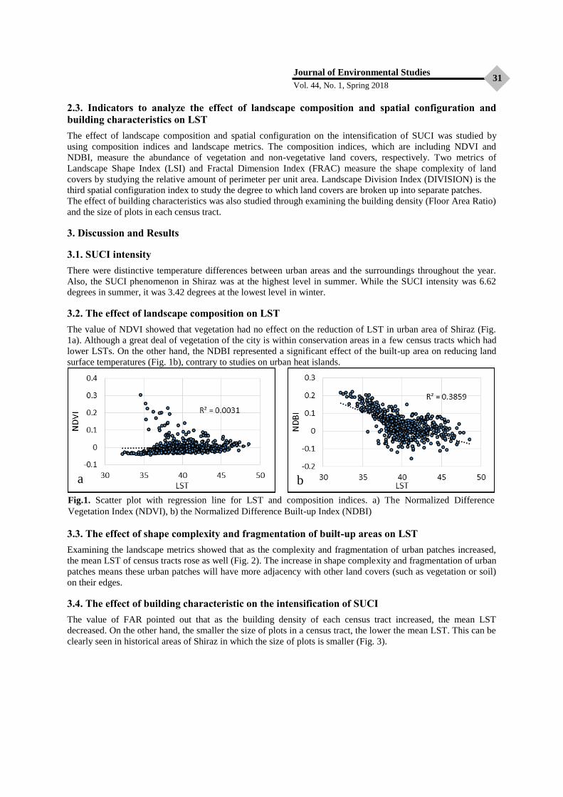
Journal of Environmental Studies
Vol. 44, No. 1, Spring 2018 31
2.3. Indicators to analyze the effect of landscape composition and spatial configuration and
building characteristics on LST
The effect of landscape composition and spatial configuration on the intensification of SUCI was studied by
using composition indices and landscape metrics. The composition indices, which are including NDVI and
NDBI, measure the abundance of vegetation and non-vegetative land covers, respectively. Two metrics of
Landscape Shape Index (LSI) and Fractal Dimension Index (FRAC) measure the shape complexity of land
covers by studying the relative amount of perimeter per unit area. Landscape Division Index (DIVISION) is the
third spatial configuration index to study the degree to which land covers are broken up into separate patches.
The effect of building characteristics was also studied through examining the building density (Floor Area Ratio)
and the size of plots in each census tract.
3. Discussion and Results
3.1. SUCI intensity
There were distinctive temperature differences between urban areas and the surroundings throughout the year.
Also, the SUCI phenomenon in Shiraz was at the highest level in summer. While the SUCI intensity was 6.62
degrees in summer, it was 3.42 degrees at the lowest level in winter.
3.2. The effect of landscape composition on LST
The value of NDVI showed that vegetation had no effect on the reduction of LST in urban area of Shiraz (Fig.
1a). Although a great deal of vegetation of the city is within conservation areas in a few census tracts which had
lower LSTs. On the other hand, the NDBI represented a significant effect of the built-up area on reducing land
surface temperatures (Fig. 1b), contrary to studies on urban heat islands.
3.3. The effect of shape complexity and fragmentation of built-up areas on LST
Examining the landscape metrics showed that as the complexity and fragmentation of urban patches increased,
the mean LST of census tracts rose as well (Fig. 2). The increase in shape complexity and fragmentation of urban
patches means these urban patches will have more adjacency with other land covers (such as vegetation or soil)
on their edges.
3.4. The effect of building characteristic on the intensification of SUCI The value of FAR pointed out that as the building density of each census tract increased, the mean LST
decreased. On the other hand, the smaller the size of plots in a census tract, the lower the mean LST. This can be
clearly seen in historical areas of Shiraz in which the size of plots is smaller (Fig. 3).
a b
Fig.1. Scatter plot with regression line for LST and composition indices. a) The Normalized Difference
Vegetation Index (NDVI), b) the Normalized Difference Built-up Index (NDBI)

Analysis of the Effect of Land Cover...
Abolghasem Azhdari and Ali Akbar Taghvaee
32
4. Conclusion
The results of this study revealed that the surface urban cool islands in Shiraz was significantly affected by the
expansion of built-up areas. The analysis of landscape metrics showed as the built-up areas grew more
irregularly, LST decreased. In other word, the shape complexity and fragmentation of urban patches led to an
increase in LST. The shape complexity and fragmentation of urban patches means they have more adjacencies
with other land covers such as vegetation. The analysis of building density and size of plots also showed the
height of buildings and the size of plots affected the land surface temperature. In fact, the increase in building
density and the decline in the size of plots led to the mitigation of LST and the intensification of SUCI. To sum
up, while the expansion of built-up areas has a distinctive impact on mitigating LST, the SUCI phenomenon
intensifies as this expansion occurs with higher density and in a smaller area.
Keywords: building density, landscape metrics, land surface temperature, plot size, surface urban cool islands.
a b
c
Fig. 2. Scatter plot with regression line for LST and spatial configuration indices. a) Landscape Shape Index
(LSI), b) Fractal Dimension Index (FRAC), c) Landscape Division Index (DIVISION).
a b
Fig. 3. Scatter plot with regression line for LST and building characteristics. a) Plot size (PS), b) Floor area ratio
(FAR)