Table 22.Description of wells and measured water levels … L-23 401501 0751811 North Penn Water...
22
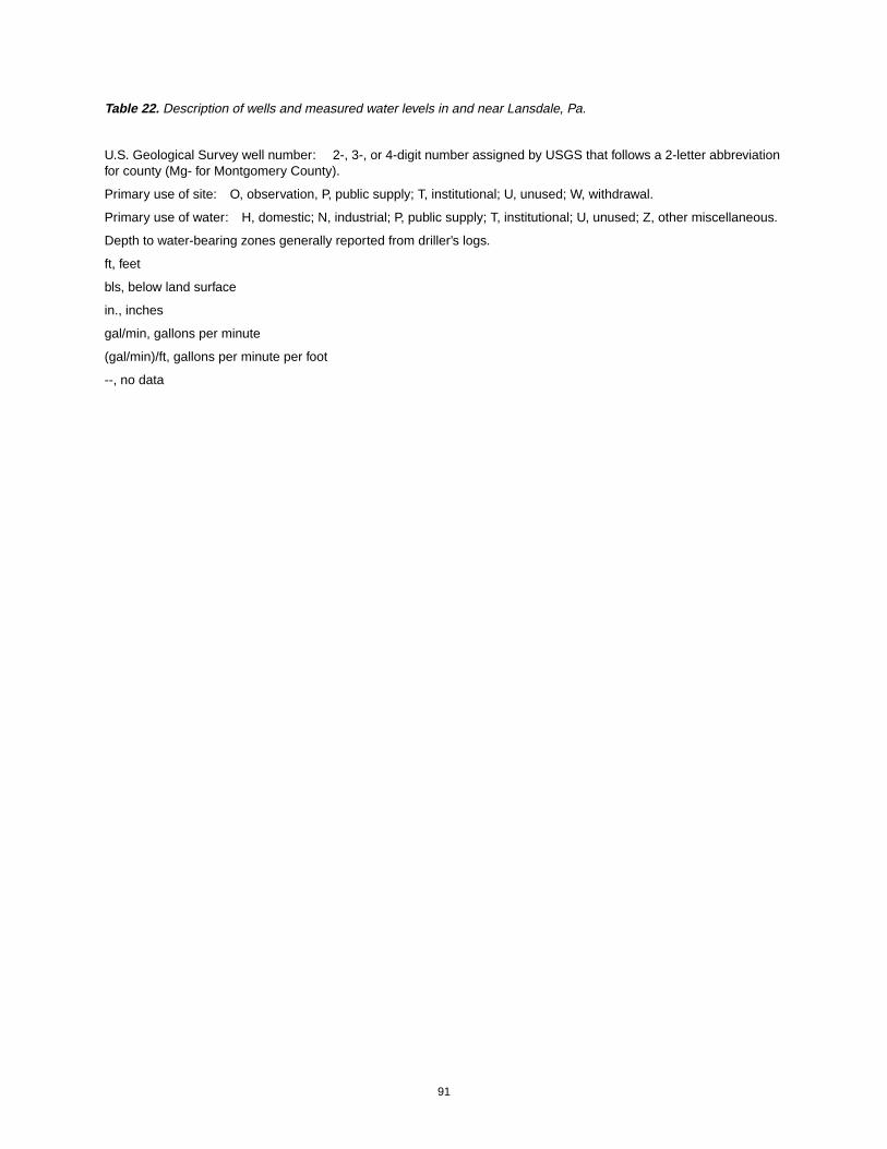
91 Table 22. Description of wells and measured water levels in and near Lansdale, Pa. U.S. Geological Survey well number: 2-, 3-, or 4-digit number assigned by USGS that follows a 2-letter abbreviation for county (Mg- for Montgomery County). Primary use of site: O, observation, P, public supply; T, institutional; U, unused; W, withdrawal. Primary use of water: H, domestic; N, industrial; P, public supply; T, institutional; U, unused; Z, other miscellaneous. Depth to water-bearing zones generally reported from driller’s logs. ft, feet bls, below land surface in., inches gal/min, gallons per minute (gal/min)/ft, gallons per minute per foot --, no data
Transcript of Table 22.Description of wells and measured water levels … L-23 401501 0751811 North Penn Water...
91
Table 22. Description of wells and measured water levels in and near Lansdale, Pa.
U.S. Geological Survey well number: 2-, 3-, or 4-digit number assigned by USGS that follows a 2-letter abbreviationfor county (Mg- for Montgomery County).
Primary use of site: O, observation, P, public supply; T, institutional; U, unused; W, withdrawal.
Primary use of water: H, domestic; N, industrial; P, public supply; T, institutional; U, unused; Z, other miscellaneous.
Depth to water-bearing zones generally reported from driller’s logs.
ft, feet
bls, below land surface
in., inches
gal/min, gallons per minute
(gal/min)/ft, gallons per minute per foot
--, no data
92
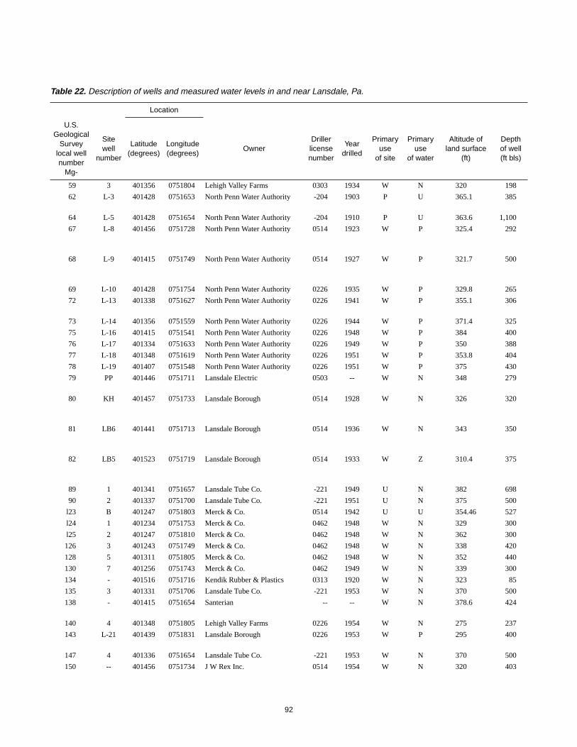
Table 22. Description of wells and measured water levels in and near Lansdale, Pa.
Location
U.S.Geological
Surveylocal wellnumber
Mg-
Sitewell
number
Latitude(degrees)
Longitude(degrees)
OwnerDrillerlicensenumber
Yeardrilled
Primaryuse
of site
Primaryuse
of water
Altitude ofland surface
(ft)
Depthof well(ft bls)
59 3 401356 0751804 Lehigh Valley Farms 0303 1934 W N 320 198
62 L-3 401428 0751653 North Penn Water Authority -204 1903 P U 365.1 385
64 L-5 401428 0751654 North Penn Water Authority -204 1910 P U 363.6 1,100
67 L-8 401456 0751728 North Penn Water Authority 0514 1923 W P 325.4 292
68 L-9 401415 0751749 North Penn Water Authority 0514 1927 W P 321.7 500
69 L-10 401428 0751754 North Penn Water Authority 0226 1935 W P 329.8 265
72 L-13 401338 0751627 North Penn Water Authority 0226 1941 W P 355.1 306
73 L-14 401356 0751559 North Penn Water Authority 0226 1944 W P 371.4 325
75 L-16 401415 0751541 North Penn Water Authority 0226 1948 W P 384 400
76 L-17 401334 0751633 North Penn Water Authority 0226 1949 W P 350 388
77 L-18 401348 0751619 North Penn Water Authority 0226 1951 W P 353.8 404
78 L-19 401407 0751548 North Penn Water Authority 0226 1951 W P 375 430
79 PP 401446 0751711 Lansdale Electric 0503 -- W N 348 279
80 KH 401457 0751733 Lansdale Borough 0514 1928 W N 326 320
81 LB6 401441 0751713 Lansdale Borough 0514 1936 W N 343 350
82 LB5 401523 0751719 Lansdale Borough 0514 1933 W Z 310.4 375
89 1 401341 0751657 Lansdale Tube Co. -221 1949 U N 382 698
90 2 401337 0751700 Lansdale Tube Co. -221 1951 U N 375 500
l23 B 401247 0751803 Merck & Co. 0514 1942 U U 354.46 527
l24 1 401234 0751753 Merck & Co. 0462 1948 W N 329 300
l25 2 401247 0751810 Merck & Co. 0462 1948 W N 362 300
126 3 401243 0751749 Merck & Co. 0462 1948 W N 338 420
128 5 401311 0751805 Merck & Co. 0462 1948 W N 352 440
130 7 401256 0751743 Merck & Co. 0462 1949 W N 339 300
134 - 401516 0751716 Kendik Rubber & Plastics 0313 1920 W N 323 85
135 3 401331 0751706 Lansdale Tube Co. -221 1953 W N 370 500
138 - 401415 0751654 Santerian -- -- W N 378.6 424
140 4 401348 0751805 Lehigh Valley Farms 0226 1954 W N 275 237
143 L-21 401439 0751831 Lansdale Borough 0226 1953 W P 295 400
147 4 401336 0751654 Lansdale Tube Co. -221 1953 W N 370 500
150 -- 401456 0751734 J W Rex Inc. 0514 1954 W N 320 403

93
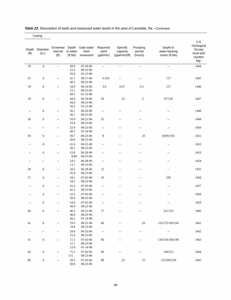
Table 22. Description of wells and measured water levels in the area of Lansdale, Pa.—Continued
Casing
Depth(ft)
Diameter(in.)
Screenedinterval
(ft)
Depthto water(ft bls)
Date waterlevel
measured
Reportedyield
(gal/min)
Specificcapacity
[(gal/min)/ft]
Pumpingperiod(hours)
Depth towater-bearingzones (ft bls)
U.S.Geological
Surveylocal wellnumber
Mg-
30 8 -- 53.0 06-25-46 53 3.8 22.5 -- 59
30 6 -- 76.043.2
08-06-5401-13-98
8 -- -- -- 62
6 8 -- 83.0 11-04-54 8 -- -- -- 64
19 8 -- 13212.114.2
03-01-4708-23-9601-13-98
57 -- -- -- 67
9 14 -- 83.039.744.2
01-31-4708-23-9601-13-98
79 -- -- -- 68
40 8 -- 73.0 01-31-47 39 -- -- -- 69
44 12 -- 42.035.4
03-01-4708-23-96
128 -- -- 240/248/260 72
45 10 -- 46.0 03-01-47 300 3.3 70 276/295 73
40 12 -- 57.0 09-17-48 175 1.4 24 -- 75
37 12 -- 23.0 07-18-49 355 3.8 49.5 - 76
40 10 -- 30.0 07-03-51 328 2.7 51.5 -- 77
41 12 -- 122 09-27-51 173 -- 48 -- 78
7 6 -- 10950.2
01-14-5401-13-98
20 -- 1 -- 79
138 8 -- 6013.315.2
194608-23-9601-13-98
80 7.5 -- -- 80
33 8 -- 45.039.246.0
194608-23-9601-13-98
80 11 -- -- 81
18 8 -- 20.012.312.1
194708-23-9601-13-98
-- -- -- -- 82
40 8 -- 50.0 09-20-49 96 .65 48.0 -- 89
46 8 -- 57.0 01-17-51 165 1.3 49 -- 90
32 10 -- 34 05-14-51 15 -- -- -- 123
-- 12 -- 22.5 03-22-48 357 2.7 50 -- 124
12 12 -- 30 06-07-48 142 .92 48 -- 125
-- 12 -- 167 05-14-51 290 1.8 50 -- 126
-- 12 -- 58 11-03-53 395 2.7 48 -- 128
16 12 -- 66 11-03-53 289 1.7 46 -- 130
-- 6 -- -- -- -- -- -- -- 134
-- 6 -- 85.0 08-17-53 150 1.6 -- -- 135
22 10 -- 43.248.8
08-23-9601-13-98
-- -- -- -- 138
30 8 -- 17.2 02-25-59 200 1.5 -- -- 140
30 12 -- 8.005.68
06-09-5408-23-96
250 -- -- -- 143
-- 8 -- 85.0 08-26-54 150 1.9 -- -- 147
43 8 -- 70.0 08-05-54 58 .72 42 -- 150

94
151 5 401332 0751652 Lansdale Tube Co. -221 1954 W N 365 500
152 AO1 401501 0751646 American Olean Tile Co. -- 1929 W N 354.1 203
153 AO2 401508 0751637 American Olean Tile Co. -- 1953 W N 358 400
154 -- 401447 0751702 Arcadia Hosiery -410 1934 W N 355.5 193
157 WV1 401508 0751726 Lewis Fabrication Co. 0514 1950 W N 318.9 285
161 -- 401451 0751741 Rybond Inc. 0514 -- U N 340 201
162 -- 401451 0751744 Rybond Inc. 0514 1935 U N 340 761
163 -- 401453 0751744 Rybond Inc. 0514 1947 U N 339.2 318
164 RY4 401448 0751740 Rybond Inc. 0514 1947 W N 340.1 405
169 3 401252 0751721 Leeds & Northrup Co. 0249 1954 U U 336 175
171 1 401328 0751701 Precision Tube Co. -221 1952 W N 366 500
202 L-22 401329 0751640 North Penn Water Authority 0226 1955 W P 352 647
204 2 401328 0751704 Precision Tube Co. -221 1955 W N 365 500
223 2 401304 0751710 Leeds & Northrup Co. 0249 1955 W N 332 350
498 L-23 401501 0751811 North Penn Water Authority 0226 1957 W P 342.6 587
566 LVPW5 401349 0751815 Lehigh Valley Farms 0514 1960 W N 280 330
593 L-25 401449 0751814 North Penn Water Authority 0561 1958 W P 322.4 492
618 Pit Well 401507 0751634 Glenn Rigley, North Penn PetFoodSupply
0708 1958 O U 364.77 343
620 AO3 401517 0751626 American Olean Tile Co. 0226 1955 W N 360 400
621 AO4 401522 0751651 American Olean Tile Co. 0226 1957 W N 327.3 400
623 L-24 401536 0751744 North Penn Water Authority 0226 1957 U P 328 507
624 2D 401528 0751724 J W Rex Inc. 0514 1958 U N 312.1 633
625 1 401525 0751725 J W Rex Inc. 0514 1955 W N 317.7 400
626 3 401607 0751923 Hatfield Packing Co. 0514 1981 W N 300 550
630 -- 401516 0752011 Christopher Dock MennoniteSchool
0121 1959 W T 290 130
704 L-26 401530 0751709 North Penn Water Authority 0514 1961 W P 316.4 400
875 17 401525 0751540 North Wales Water Authority 0512 1964 W P 330 500
Table 22. Description of wells and measured water levels in and near Lansdale, Pa.—Continued
Location
U.S.Geological
Surveylocal wellnumber
Mg-
Sitewell
number
Latitude(degrees)
Longitude(degrees)
OwnerDrillerlicensenumber
Yeardrilled
Primaryuse
of site
Primaryuse
of water
Altitude ofland surface
(ft)
Depthof well(ft bls)

95
78 8 -- 100 11-06-54 185 2.3 30 -- 151
22 12 -- 9848.755.1
05-__-5408-23-9601-13-98
60 1.0 1 -- 152
-- 10 -- 101 01-__-54 125 5.0 .3 -- 153
30 6 -- 85.050.057.0
193408-23-9601-13-98
20 -- -- -- 154
47 8 -- 506.728.16
06-__-5008-23-9601-13-98
115 5.8 48 -- 157
30 6 -- 125 02-22-54 21 2.1 1.5 -- 161
30 10 -- -- -- 30 .15 1.5 -- 162
22 8 -- 38.725.828.2
06-13-8908-23-9601-13-98
15 .75 1.5 -- 163
23 8 -- 29.029.030.2
08-23-9608-23-9601-13-98
18 -- -- -- 164
9 4 -- -- -- -- -- -- -- 169
68 8 -- 11727.1
10-12-5408-23-96
-- -- -- -- 171
-- 12 -- 54.0 01-19-54 282 -- -- -- 202
66 8 -- 52.0 05-19-55 190 8.6 50 -- 204
-- 10 -- 49.0 08-__-55 316 3.9 48 -- 223
97 12 -- 7722.2
09-18-5708-23-96
90 -- -- -- 498
45 10 -- 15.0 03-17-60 226 1.5 21 -- 566
76 8 -- 111 09-__-59 200 1.1 48 68/80/100/167/193/300/425/471 593
47 6 -- 65.055.7
06-20-9108-23-96
30 -- -- -- 618
116 10 -- 93.8 03-28-58 100 -- -- -- 620
63 10 -- 5117.518.9
07-06-5708-23-9601-13-98
106 3.7 -- -- 621
97 10 -- 4122.223.4
12-18-6208-23-9601-13-98
200 -- -- -- 623
52 8 -- 10511.78.93
195808-23-9601-13-98
9 -- -- -- 624
44 8 -- 54 06-__-60 186 -- -- -- 625
40 -- -- 67 06-24-81 30 -- -- -- 626
-- -- -- 5258.2
08-10-5908-23-96
60 -- -- -- 630
83 10 -- 25.018.217.6
12-07-6108-23-9601-13-98
136 1.0 40 -- 704
60 12 -- -- -- 750 13 168 -- 875
Table 22. Description of wells and measured water levels in the area of Lansdale, Pa.—Continued
Casing
Depth(ft)
Diameter(in.)
Screenedinterval
(ft)
Depthto water(ft bls)
Date waterlevel
measured
Reportedyield
(gal/min)
Specificcapacity
[(gal/min)/ft]
Pumpingperiod(hours)
Depth towater-bearingzones (ft bls)
U.S.Geological
Surveylocal wellnumber
Mg-

96
876 1 401612 0751442 AEL Industries Inc. -- 1961 W N 314 300
884 4 401310 0751817 Merck & Co. 0509 1965 O U 353.55 600
914 NP-12c 401612 0751518 North Penn Water Authority 0514 1969 W P 304 620
924 NP-21 401607 0751503 North Penn Water Authority 0413 1968 W P 280 500
930 NP-25b 401339 0751906 Multicon Corp. 0514 -- U U 238 --
991 8 401243 0751824 Merck & Co. 0248 1978 W N 360 610
1014 10 401625 0751708 Hatfield Borough 0514 1979 W P 300 305
1045 5 401518 0751634 American Olean Tile Co. 0226 1964 W N 345.9 337
1051 22 401541 0751520 North Wales Water Authority 0514 1969 W P 310 500
1124 NP-58 401456 0751619 North Penn Water Authority 0514 1980 O P 339.15 385
1125 NP-61 401503 0751617 North Penn Water Authority 0514 1980 W P 331.03 400
l126 NP-62 401508 0751610 North Penn Water Authority 0514 1980 O P 327.38 310
1128 NP-70 401508 0751846 North Penn Water Authority 0330 1987 W P 284.3 500
1169 -- 401345 0751701 Zenith -- -- O U 370 69
1179 R-2 401623 0751829 Rosenbergers Dairies 0121 1977 W N 367 572
1198 9 401304 0751824 Merck & Co. 0904 1985 W N 342 300
1199 11 401248 0751836 Merck & Co. 1253 1988 W N 355 303
1270 -- 401501 0751605 North Penn Hospital 0514 1991 O U 340.5 320
1284 NP-68 401659 0751624 North Penn Water Authority 0330 1986 W P 307 448
1418 1 401517 0751613 M H Zeigler & Sons -- 1948 W N 327 160
1423 12 401256 0751815 Merck & Co. 1862 1994 W N 358 450
1424 13 401241 0751758 Merck & Co. 1862 1993 W N 342 450
1440 -- 401511 0751709 Crystal Soap -- -- U U 333.8 207
1441 LV3 401355 0751757 Lehigh Valley Farms 0188 1988 O U 313 179
1442 LB3 401443 0751710 Lansdale Borough 0188 1989 O U 346.8 84.8
1443 -- 401459 0751649 Philadelphia Toboggan Co. -- 1996 U N 351.1 239
Table 22. Description of wells and measured water levels in and near Lansdale, Pa.—Continued
Location
U.S.Geological
Surveylocal wellnumber
Mg-
Sitewell
number
Latitude(degrees)
Longitude(degrees)
OwnerDrillerlicensenumber
Yeardrilled
Primaryuse
of site
Primaryuse
of water
Altitude ofland surface
(ft)
Depthof well(ft bls)

97
-- 10 -- 20.0 1961 300 7.1 18 -- 876
-- 10 -- 92.7 02-22-66 130 -- -- -- 884
43 8 -- 23.0 07-__-69 27 1.9 -- 55/100/155/210/275/300/370 914
50 12 -- 7.3 02-11-68 602 5.4 75 -- 924
-- -- -- -1.0-.84
06-20-9608-23-96
-- -- -- -- 930
33 12 -- -- -- 200 1.0 -- -- 991
58 8 -- 9 11-20-79 200 -- -- -- 1014
60 10 -- 7441.146.0
04-07-6408-23-9601-13-98
80 .50 72 __ 1045
-- 8 -- 27 1969 400 -- -- -- 1051
25 6 -- 6.9211.619.1
02-15-9108-23-9601-13-98
107 2.9 .25 168/179/275 1124
58 10 -- 16.8 06-14-91 200 4.9 5 55/105/207/308/335/370 1125
19 6 4.8812.35.68
02-15-9108-23-9601-13-98
157 9.4 .25 70/135/225/290/302 1126
12 8 -- 19.819.619.5
05-01-8708-23-9601-14-98
92 -- -- 78/95/125/140/295/405 1128
-- 6 -- 45.937.338.7
06-12-8908-23-9601-14-98
-- -- -- -- 1169
46 8 -- 117117
08-01-9608-23-96
-- -- -- -- 1179
31 6 -- 30 09-19-88 77 .38 216 61/89/158/278/285 1198
30 8 -- 87 10-01-97 184 2.9 48 75/95/114/135/148/207/215 1199
19 6 -- 31.519.111.011.6
07-15-9108-23-9601-13-9801-17-98
-- -- -- -- 1270
82 10 -- 9.37 07-29-91 68 1.2 48 13/70/90/190/230/260/365 1284
20 -- -- -- -- -- -- -- -- 1418
80 8 -- 66 02-15-94 72 2.0 54 114/193/201 1423
80 8 -- 89.7 02-08-94 125 1.9 54 82/100/121/191/216 1424
3.5 6 -- 26.422.227.2
06-21-9508-23-9601-13-98
-- -- -- 50/73/102/127 1440
19.8 6 -- 41.950.045.8
06-27-9508-22-9601-14-98
25 .19 .5 153/161 1441
-- 2 ?-85 55.741.749.3
08-30-9508-23-9601-13-98
.5 .02 .5 69 1442
10 8 -- 42.643.048.7
05-22-9608-23-9601-13-98
-- -- -- -- 1443
Table 22. Description of wells and measured water levels in the area of Lansdale, Pa.—Continued
Casing
Depth(ft)
Diameter(in.)
Screenedinterval
(ft)
Depthto water(ft bls)
Date waterlevel
measured
Reportedyield
(gal/min)
Specificcapacity
[(gal/min)/ft]
Pumpingperiod(hours)
Depth towater-bearingzones (ft bls)
U.S.Geological
Surveylocal wellnumber
Mg-

98
1444 -- 401407 0751708 Rogers Mechanical -- 1996 T U 367 294
1445 MW-3 401514 0751639 American Olean Tile 0188 1989 T U 346.3 204
1446 MW-1 401506 0751639 American Olean Tile 0188 1989 T U 357.9 144
1447 MW-2 401511 0751642 American Olean Tile 0188 1989 T U 349.6 145
1448 -- 401317 0751812 AMOCO 0512 1990 O U 333 72
1449 -- 401446 0751937 Hopwood, Ann 0121 1971 U H 265 115
1450 RW-24 401405 0751753 Martin, Marion -- -- W H 338 --
1451 -- 401329 0751901 Usic, Rudy 0121 1985 W H 290 125
1452 -- 401412 0751826 Kiely, Robert -- -- W H 330 410
1453 -- 401504 0751905 Weiss, Terry -- -- W H 275 217
1454 -- 401517 0751902 Stark, Russell -- -- U H 298 23.8
1455 -- 401337 0751802 Tryson, Richard 0512 1977 W H 336 223
1456 -- 401445 0752003 Trongone, Art 0512 1975 W H 311 305
1457 -- 401358 0751946 Thompson, Ray 0512 1964 W H 281 --
1458 -- 401346 0752001 Walton, Ray -- -- W H 269 87.6
1459 -- 401418 0751946 Caserta, Richard -- 1927 W H 275 100
1460 -- 401526 0751620 Stuart, Richard 0512 1976 W H 342.7 243
1461 -- 401557 0751549 Kreider, Earl 0121 1984 W H 309 260
1462 -- 401440 0751527 Folger, Peter -- -- U H 434 --
1463 -- 401603 0751653 Lund Brothers 0512 1985 W H 297.2 202
1464 -- 401612 0751847 Dyer, Fred 0514 1992 W H 330 276
1465 -- 401628 0751746 George Didden Greenhouses 0982 1991 W I 331 400
Table 22. Description of wells and measured water levels in and near Lansdale, Pa.—Continued
Location
U.S.Geological
Surveylocal wellnumber
Mg-
Sitewell
number
Latitude(degrees)
Longitude(degrees)
OwnerDrillerlicensenumber
Yeardrilled
Primaryuse
of site
Primaryuse
of water
Altitude ofland surface
(ft)
Depthof well(ft bls)
99
18 6 -- 49.853.356.9
05-30-9608-23-9601-13-98
-- -- -- -- 1444
21 6 -- 41.140.5
06-17-9608-23-96
0.250 -- -- 117 1445
19 6 -- 54.953.160.2
06-14-9608-23-9601-13-98
3.0 0.07 0.5 127 1446
19 6 -- 44.944.450.2
06-18-9608-23-9601-13-98
20 .23 .5 87/130 1447
-- 6 -- 36.136.7
06-20-9608-23-96
-- -- -- -- 1448
30 6 -- 10.910.9
06-21-9608-23-96
55 -- -- -- 1449
-- -- -- 52.960.5
06-21-9601-14-98
-- -- -- -- 1450
30 6 -- 39.739.0
06-25-9608-23-98
8 -- .25 60/95/105 1451
-- 6 -- 41.630.1
06-25-9608-23-96
-- -- -- -- 1452
-- 6 -- 12.88.89
06-28-9608-23-96
-- -- -- -- 1453
-- -- -- 14.213.7
06-28-9608-23-96
-- -- -- -- 1454
30 6 -- 34.535.0
06-28-9608-23-96
15 -- -- -- 1455
71 6 -- 18.118.2
07-02-9608-23-96
10 -- -- 295 1456
-- 6 -- 41.641.2
07-05-9608-23-96
-- -- -- -- 1457
-- 6 -- 53.250.9
07-05-9608-23-96
-- -- -- -- 1458
-- 6 -- 54.449.0
07-05-9608-23-96
-- -- -- -- 1459
40 6 -- 40.340.044.1
06-21-9608-23-9601-14-98
17 -- -- 221/232 1460
41 6 -- 19.519.9
06-21-9608-23-96
40 -- .33 155/175/185/245 1461
-- -- -- 29.831.0
06-25-9608-23-96
-- -- -- -- 1462
51 6 -- 11.112.112.8
07-02-9608-23-9601-14-98
60 -- -- 130/150/180/190 1463
42 6 -- 75.1115
07-02-9608-23-96
40 -- -- 160/215 1464
80 6 -- 29.530.8
07-02-9608-23-96
80 .22 .75 135/200/330 1465
Table 22. Description of wells and measured water levels in the area of Lansdale, Pa.—Continued
Casing
Depth(ft)
Diameter(in.)
Screenedinterval
(ft)
Depthto water(ft bls)
Date waterlevel
measured
Reportedyield
(gal/min)
Specificcapacity
[(gal/min)/ft]
Pumpingperiod(hours)
Depth towater-bearingzones (ft bls)
U.S.Geological
Surveylocal wellnumber
Mg-

100
1466 -- 401610 0751702 Steinmetz, Paul 0121 1974 W H 315 120
1467 -- 401546 0751715 Todorow, Stephen -- 1948 W H 304.6 43
1468 -- 401552 0751630 Ammendola, Frank 0512 1973 W H 318 138
1469 -- 401532 0751654 Fifield, Robert 0313 1950 W H 325 100
1470 -- 401456 0751925 Trumpp, Andrew -- -- U I 286 20.6
1471 -- 401314 0751923 Slater, John 0121 1982 W H 291 240
1472 -- 401337 0751947 Gilbert, G. 0121 -- W H 268 --
1473 -- 401247 0751949 Taggart, Howard 0512 1986 W H 320 --
1474 -- 401523 0751914 Detweiler, Earl 0121 1973 W H 322 140
1475 -- 401316 0751849 Cunningham, Ralph -- 1965 W H 303 105
1476 -- 401325 0751917 Doorley, James 0982 1957 W H 263 85
1477 -- 401342 0751754 Martin, Tom -- 1950 W H 325 160
1478 -- 401418 0751808 Minucci, Neil 0121 1988 W H 318 220
1479 -- 401344 0751928 Kibblehouse, Janet -- 1967 W H 283 --
1480 -- 401457 0751530 Matchett, Carol -- -- W H 402 --
1481 -- 401354 0751846 Calvary Baptist Church -- 1960 U T 297 300
1482 -- 401309 0751909 Gehman, Robert 0313 1957 W H 322 114
1483 -- 401525 0751759 Hutkowski, Kim -- 1954 W H 348.1 --
1484 2 401537 0751727 Trotter Soft Pretzels 0121 1987 W N 307.9 420
1485 -- 401455 0751856 Santoro, Benny -- -- W H 287 --
1486 -- 401552 0751848 Baum Meat Packing -- -- W S 342 --
1487 -- 401507 0751809 Rossi, Joseph 0121 -- W H 340 --
1488 -- 401457 0752056 Towamencin Mennonite Church 0121 1977 W T 254 300
1489 -- 401437 0751931 Rittenhouse, Ronald 0188 1979 W H 260 120
1490 -- 401432 0751851 Terchek, Bob -- 1958 W H 313 130
Table 22. Description of wells and measured water levels in and near Lansdale, Pa.—Continued
Location
U.S.Geological
Surveylocal wellnumber
Mg-
Sitewell
number
Latitude(degrees)
Longitude(degrees)
OwnerDrillerlicensenumber
Yeardrilled
Primaryuse
of site
Primaryuse
of water
Altitude ofland surface
(ft)
Depthof well(ft bls)

101
43 6 -- 33.233.332.8
07-02-9608-23-9601-14-98
11 -- -- 75/110 1466
-- 6 -- 15.815.816.0
07-09-9608-23-9601-14-98
-- -- -- -- 1467
41 6 -- 44.143.344.4
07-09-9608-23-9601-14-98
25 -- -- 135 1468
20 6 -- 18.9 07-09-96 15 -- -- 60 1469
-- -- -- 6.547.86
07-05-9608-23-96
-- -- -- -- 1470
67 6 -- 31.031.3
07-08-9608-23-96
11 -- -- 115/221 1471
-- 6 -- 31.032.6
07-09-9608-23-96
-- -- -- -- 1472
-- 6 -- 10.811.9
07-09-9608-23-96
-- -- -- -- 1473
34 6 -- 35.034.5
07-09-9608-23-96
11 -- 2 95/128 1474
25 6 -- 18.118.4 08-23-96
30 -- -- -- 1475
40 6 -- 19.519.3
07-11-9608-23-96
-- -- -- -- 1476
-- 6 -- 21.521.724.1
07-12-9608-23-9601-14-98
-- -- -- -- 1477
-- 6 -- 38.9 07-12-96 8 -- -- -- 1478
-- 6 -- 35.1 07-15-96 -- -- -- -- 1479
-- -- -- 21.521.6
07-12-9608-23-96
-- -- -- -- 1480
-- 6 -- 26.726.5
07-16-9608-23-96
-- -- -- -- 1481
-- 6 -- 49.449.1
07-19-9608-23-96
-- -- -- -- 1482
-- 6 -- 40.040.047.3
07-23-9608-23-9601-14-98
-- -- -- -- 1483
70 6 -- 46.733.69.299.60
07-23-9608-23-9601-13-9801-14-98
12 -- .25 180/230/367 1484
-- 6 -- 30.1 07-15-96 -- -- -- -- 1485
-- 6 -- 83.383.3
06-08-9608-23-96
-- -- -- -- 1486
-- 6 -- 37.7 07-17-96 -- -- -- -- 1487
36 6 -- 52.1 07-17-96 17 -- 2 145/230/285 1488
21.4 6 -- 37.7 07-17-96 30 .36 .50 80/85/110 1489
-- 6 -- 32.7 07-19-96 -- -- -- -- 1490
Table 22. Description of wells and measured water levels in the area of Lansdale, Pa.—Continued
Casing
Depth(ft)
Diameter(in.)
Screenedinterval
(ft)
Depthto water(ft bls)
Date waterlevel
measured
Reportedyield
(gal/min)
Specificcapacity
[(gal/min)/ft]
Pumpingperiod(hours)
Depth towater-bearingzones (ft bls)
U.S.Geological
Surveylocal wellnumber
Mg-
102
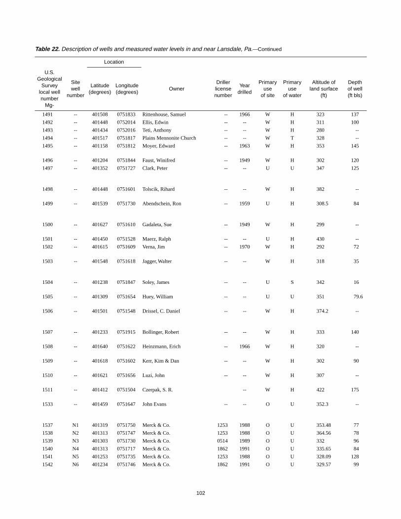
1491 -- 401508 0751833 Rittenhouse, Samuel -- 1966 W H 323 137
1492 -- 401448 0752014 Ellis, Edwin -- -- W H 311 100
1493 -- 401434 0752016 Teti, Anthony -- -- W H 280 --
1494 -- 401517 0751817 Plains Mennonite Church -- -- W T 328 --
1495 -- 401158 0751812 Moyer, Edward -- 1963 W H 353 145
1496 -- 401204 0751844 Faust, Winifred -- 1949 W H 302 120
1497 -- 401352 0751727 Clark, Peter -- -- U U 347 125
1498 -- 401448 0751601 Tolscik, Rihard -- -- W H 382 --
1499 -- 401539 0751730 Abendschein, Ron -- 1959 U H 308.5 84
1500 -- 401627 0751610 Gadaleta, Sue -- 1949 W H 299 --
1501 -- 401450 0751528 Maerz, Ralph -- -- U H 430 --
1502 -- 401615 0751609 Verna, Jim -- 1970 W H 292 72
1503 -- 401548 0751618 Jagger,Walter -- -- W H 318 35
1504 -- 401238 0751847 Soley, James -- -- U S 342 16
1505 -- 401309 0751654 Huey, William -- -- U U 351 79.6
1506 -- 401501 0751548 Drissel, C. Daniel -- -- W H 374.2 --
1507 -- 401233 0751915 Bollinger, Robert -- -- W H 333 140
1508 -- 401640 0751622 Heinzmann, Erich -- 1966 W H 320 --
1509 -- 401618 0751602 Kerr, Kim & Dan -- -- W H 302 90
1510 -- 401621 0751656 Luzi, John -- -- W H 307 --
1511 -- 401412 0751504 Czerpak, S. R. -- W H 422 175
1533 -- 401459 0751647 John Evans -- -- O U 352.3 --
1537 N1 401319 0751750 Merck & Co. 1253 1988 O U 353.48 77
1538 N2 401313 0751747 Merck & Co. 1253 1988 O U 364.56 78
1539 N3 401303 0751730 Merck & Co. 0514 1989 O U 332 96
1540 N4 401313 0751717 Merck & Co. 1862 1991 O U 335.65 84
1541 N5 401253 0751735 Merck & Co. 1253 1988 O U 328.09 128
1542 N6 401234 0751746 Merck & Co. 1862 1991 O U 329.57 99
Table 22. Description of wells and measured water levels in and near Lansdale, Pa.—Continued
Location
U.S.Geological
Surveylocal wellnumber
Mg-
Sitewell
number
Latitude(degrees)
Longitude(degrees)
OwnerDrillerlicensenumber
Yeardrilled
Primaryuse
of site
Primaryuse
of water
Altitude ofland surface
(ft)
Depthof well(ft bls)

103
130 6 -- 30.1 07-19-96 -- -- -- -- 1491
-- 6 -- 29.9 07-23-96 -- -- -- -- 1492
-- -- -- 7.92 07-23-96 -- -- -- -- 1493
-- -- -- 27.5 07-25-96 -- -- -- -- 1494
-- 6 -- 38.939.4
07-30-9608-23-96
-- -- -- -- 1495
-- -- -- 6.89 07-30-96 -- -- -- -- 1496
-- 6 -- 36.136.439.9
08-09-9608-23-9601-14-98
-- -- -- -- 1497
-- 6 -- 17.421.3
07-24-9608-23-96
-- -- -- -- 1498
40 6 -- 7.297.565.85
07-24-9608-23-9601-17-98
22 -- -- -- 1499
-- 6 -- 15.616.1
07-24-9608-23-96
-- -- -- -- 1500
-- -- -- 19.8 07-24-96 -- -- -- -- 1501
-- 6 -- 15.515.7
07-25-9608-23-96
-- -- -- -- 1502
-- -- -- 5.345.365.42
07-25-9608-23-9601-14-98
-- -- -- -- 1503
-- 48 -- 1.221.52
07-26-9608-23-96
-- -- -- -- 1504
-- 6 -- 22.123.5
07-26-9608-23-96
-- -- -- -- 1595
-- -- -- 7.489.448.10
07-30-9608-23-9601-14-98
-- -- -- -- 1506
-- 6 -- 28.831.3
07-31-9608-23-96
-- -- -- -- 1507
-- 6 -- 28.728.4
08-01-9608-23-96
-- -- -- -- 1508
-- 6 -- 13.014.0
08-01-9608-23-96
-- -- -- -- 1509
-- -- -- 24.625.8
08-01-9608-23-96
-- -- -- -- 1510
-- -- -- 11.812.3
08-02-9608-23-96
-- -- -- -- 1511
-- -- -- 46.546.552.9
08-23-9608-23-9601-13-98
-- -- -- -- 1533
67 2 67-77 50.6 09-10-96 10 -- -- 73 1537
68 2 68-78 46.8 08-22-96 3.5 -- -- 71 1538
86 2 86-96 23 09-10-96 45 -- -- 56/85 1539
74 2 74-84 17.8 08-22-96 20 -- 1 77 1540
118 2 118-128 69.6 09-11-96 -- -- -- 104/122 1541
89 2 89-99 29.6 08-22-96 60 -- -- 55/67/75/90 1542
Table 22. Description of wells and measured water levels in the area of Lansdale, Pa.—Continued
Casing
Depth(ft)
Diameter(in.)
Screenedinterval
(ft)
Depthto water(ft bls)
Date waterlevel
measured
Reportedyield
(gal/min)
Specificcapacity
[(gal/min)/ft]
Pumpingperiod(hours)
Depth towater-bearingzones (ft bls)
U.S.Geological
Surveylocal wellnumber
Mg-
104
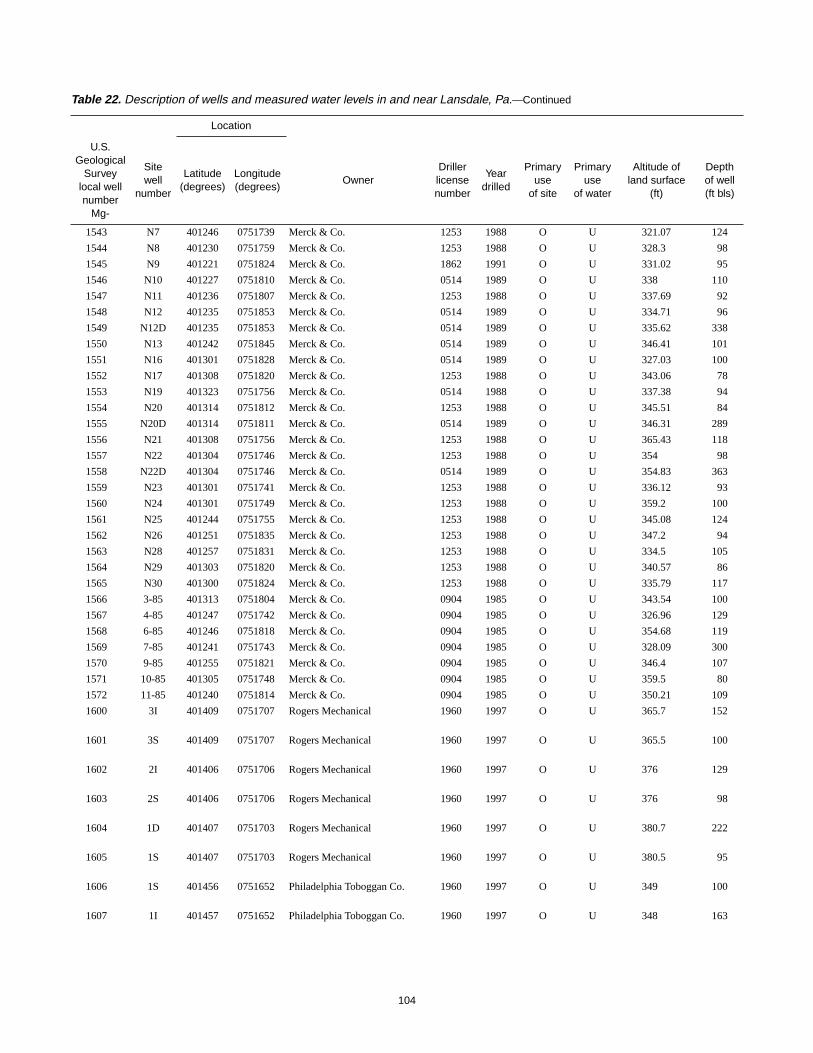
1543 N7 401246 0751739 Merck & Co. 1253 1988 O U 321.07 124
1544 N8 401230 0751759 Merck & Co. 1253 1988 O U 328.3 98
1545 N9 401221 0751824 Merck & Co. 1862 1991 O U 331.02 95
1546 N10 401227 0751810 Merck & Co. 0514 1989 O U 338 110
1547 N11 401236 0751807 Merck & Co. 1253 1988 O U 337.69 92
1548 N12 401235 0751853 Merck & Co. 0514 1989 O U 334.71 96
1549 N12D 401235 0751853 Merck & Co. 0514 1989 O U 335.62 338
1550 N13 401242 0751845 Merck & Co. 0514 1989 O U 346.41 101
1551 N16 401301 0751828 Merck & Co. 0514 1989 O U 327.03 100
1552 N17 401308 0751820 Merck & Co. 1253 1988 O U 343.06 78
1553 N19 401323 0751756 Merck & Co. 0514 1988 O U 337.38 94
1554 N20 401314 0751812 Merck & Co. 1253 1988 O U 345.51 84
1555 N20D 401314 0751811 Merck & Co. 0514 1989 O U 346.31 289
1556 N21 401308 0751756 Merck & Co. 1253 1988 O U 365.43 118
1557 N22 401304 0751746 Merck & Co. 1253 1988 O U 354 98
1558 N22D 401304 0751746 Merck & Co. 0514 1989 O U 354.83 363
1559 N23 401301 0751741 Merck & Co. 1253 1988 O U 336.12 93
1560 N24 401301 0751749 Merck & Co. 1253 1988 O U 359.2 100
1561 N25 401244 0751755 Merck & Co. 1253 1988 O U 345.08 124
1562 N26 401251 0751835 Merck & Co. 1253 1988 O U 347.2 94
1563 N28 401257 0751831 Merck & Co. 1253 1988 O U 334.5 105
1564 N29 401303 0751820 Merck & Co. 1253 1988 O U 340.57 86
1565 N30 401300 0751824 Merck & Co. 1253 1988 O U 335.79 117
1566 3-85 401313 0751804 Merck & Co. 0904 1985 O U 343.54 100
1567 4-85 401247 0751742 Merck & Co. 0904 1985 O U 326.96 129
1568 6-85 401246 0751818 Merck & Co. 0904 1985 O U 354.68 119
1569 7-85 401241 0751743 Merck & Co. 0904 1985 O U 328.09 300
1570 9-85 401255 0751821 Merck & Co. 0904 1985 O U 346.4 107
1571 10-85 401305 0751748 Merck & Co. 0904 1985 O U 359.5 80
1572 11-85 401240 0751814 Merck & Co. 0904 1985 O U 350.21 109
1600 3I 401409 0751707 Rogers Mechanical 1960 1997 O U 365.7 152
1601 3S 401409 0751707 Rogers Mechanical 1960 1997 O U 365.5 100
1602 2I 401406 0751706 Rogers Mechanical 1960 1997 O U 376 129
1603 2S 401406 0751706 Rogers Mechanical 1960 1997 O U 376 98
1604 1D 401407 0751703 Rogers Mechanical 1960 1997 O U 380.7 222
1605 1S 401407 0751703 Rogers Mechanical 1960 1997 O U 380.5 95
1606 1S 401456 0751652 Philadelphia Toboggan Co. 1960 1997 O U 349 100
1607 1I 401457 0751652 Philadelphia Toboggan Co. 1960 1997 O U 348 163
Table 22. Description of wells and measured water levels in and near Lansdale, Pa.—Continued
Location
U.S.Geological
Surveylocal wellnumber
Mg-
Sitewell
number
Latitude(degrees)
Longitude(degrees)
OwnerDrillerlicensenumber
Yeardrilled
Primaryuse
of site
Primaryuse
of water
Altitude ofland surface
(ft)
Depthof well(ft bls)

105
114 2 114-124 53.8 08-22-96 -- -- -- 50/63/80/85/90/98/110 1543
88 2 88-98 25.4 08-22-96 6 -- -- 96 1544
75 2 75-95 41.2 08-22-96 1 -- -- 55 1545
100 2 100-110 53 09-09-96 1 -- -- 70 1546
82 2 82-92 56.7 08-22-96 -- -- -- -- 1547
86 2 86-96 58.5 08-22-96 1 -- -- 51/96 1548
308 2 308-338 67.9 08-22-96 1 -- -- 50/95/140/195/295/318/313 1549
91 2 91-101 73.8 08-22-96 1 -- -- 90 1550
90 2 90-100 39.8 08-22-96 1 -- -- 76 1551
68 2 68-78 45.9 08-22-96 1 -- -- 73/81 1552
84 2 84-94 33.8 08-22-96 2 -- -- 79/90 1553
64 2 64-84 45.3 08-22-96 20 -- -- 80 1554
289 2 269-289 50.6 08-22-96 80 -- -- 70/115/270 1555
108 2 108-118 65.9 08-22-96 1 -- -- -- 1556
88 2 88-98 49.1 08-22-96 3 -- -- 64/98 1557
323 2 323-363 61.7 08-22-96 2.5 -- -- 10/19/62/75/260/330/356 1558
83 2 83-93 29.4 08-22-96 1.5 -- -- -- 1559
90 2 90-100 58.1 08-22-96 3 -- -- 95 1560
114 2 114-124 57.8 08-22-96 1 -- -- 73 1561
84 2 84-94 71.5 08-22-96 -- -- -- -- 1562
95 2 95-105 54.9 08-22-96 2 -- -- 98 1563
76 2 76-86 46.8 09-11-96 15 -- -- 82 1564
107 2 107-117 46.3 08-22-96 19 -- -- 108/116 1565
90 2 90-100 48.7 08-22-96 60 -- -- 94/181/203/207/230 1566
119 2 119-129 66.8 09-11-96 73 -- -- 130/150/233/240 1567
47 6 -- 106 09-11-96 3 -- -- 99/112 1568
28 6 -- 53.6 08-22-96 15 -- -- 58/87 1569
97 2 97-107 89.6 08-22-96 36 -- -- 105/208/245/252 1570
70 2 70-80 58.8 09-11-96 10 -- -- 70/115/178 1571
99 2 99-109 75.9 08-22-96 65 -- -- 40/50/70/130/180/195/201/220 1572
132 6 132-152 50.049.0
04-23-9701-13-98
-- -- -- -- 1600
18 6 -- 55.463.1
05-12-9701-13-98
-- -- -- -- 1601
109 6 119-129 56.259.9
04-23-9701-13-98
10 -- -- -- 1602
15 6 -- 64.773.0
05-12-9701-13-98
-- -- -- -- 1603
212 6 212-222 56.565.4
04-24-9701-13-98
-- -- -- -- 1604
15 6 -- 62.466.0
05-12-9701-13-98
-- -- -- -- 1605
15 6 -- 43.149.7
05-21-9701-13-98
-- -- -- -- 1606
153 6 153-163 43.248.9
05-13-9701-13-98
-- -- -- -- 1607
Table 22. Description of wells and measured water levels in the area of Lansdale, Pa.—Continued
Casing
Depth(ft)
Diameter(in.)
Screenedinterval
(ft)
Depthto water(ft bls)
Date waterlevel
measured
Reportedyield
(gal/min)
Specificcapacity
[(gal/min)/ft]
Pumpingperiod(hours)
Depth towater-bearingzones (ft bls)
U.S.Geological
Surveylocal wellnumber
Mg-
106
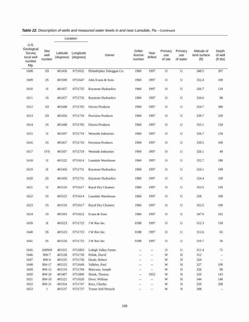
1608 1D 401456 0751652 Philadelphia Toboggan Co. 1960 1997 O U 348.5 307
1609 2S 401500 0751647 John Evans & Sons 1960 1997 O U 352.4 100
1610 1I 401457 0751735 Keystone Hydraulics 1960 1997 O U 326.7 120
1611 1S 401457 0751735 Keystone Hydraulics 1960 1997 O U 326.6 88
1612 1D 401448 0751705 Electra Products 1960 1997 O U 354.7 386
1613 1D 401456 0751710 Precision Products 1960 1997 O U 339.7 320
1614 1S 401448 0751705 Electra Products 1960 1997 O U 355.1 120
1615 1I 401507 0751719 Westside Industries 1960 1997 O U 326.7 150
1616 1S 401457 0751710 Precision Products 1960 1997 O U 339.5 100
1617 1VS 401507 0751719 Westside Industries 1960 1997 O U 326.1 49
1618 1I 401522 0751614 Lansdale Warehouse 1960 1997 O U 352.7 180
1619 2I 401456 0751731 Keystone Hydraulics 1960 1997 O U 324.1 190
1620 2S 401456 0751731 Keystone Hydraulics 1960 1997 O U 324.4 100
1621 1I 401510 0751617 Royal Dry Cleaners 1960 1997 O U 353.5 150
1622 1S 401522 0751614 Lansdale Warehouse 1960 1997 O U 328 100
1623 1S 401510 0751617 Royal Dry Cleaners 1960 1997 O U 352.5 100
1624 1S 401503 0751652 Evans & Sons 1960 1997 O U 347.9 102
1639 3I 401523 0751722 J W Rex Inc. 0188 1997 O U 312.3 150
1640 3S 401523 0751723 J W Rex Inc. 0188 1997 O U 312.6 65
1641 2S 401526 0751725 J W Rex Inc. 0188 1997 O U 310.7 50
1645 AMW8 401355 0751803 Lehigh Valley Farms -- -- O U 311.4 71
1646 RW-7 401538 0751730 Pellak, David -- -- W H 312 --
1647 RW-4 401535 0751736 Darde, Robert -- -- W H 324 --
1648 RW-17 401532 0751649 Valleley, Paul -- -- W H 327 100
1649 RW-12 401516 0751704 Mancuso, Joseph -- -- W H 326 90
1650 RW-20 401407 0751800 Shank, Thomas -- 1952 W H 320 143
1651 RW-10 401521 0751620 Diver, William -- -- W H 344 140
1652 RW-21 401354 0751747 Kurz, Charles -- -- W H 320 200
1653 1 401537 0751727 Trotter Soft Pretzels -- -- W N 308 --
Table 22. Description of wells and measured water levels in and near Lansdale, Pa.—Continued
Location
U.S.Geological
Surveylocal wellnumber
Mg-
Sitewell
number
Latitude(degrees)
Longitude(degrees)
OwnerDrillerlicensenumber
Yeardrilled
Primaryuse
of site
Primaryuse
of water
Altitude ofland surface
(ft)
Depthof well(ft bls)

107
220 6 -- 39.747.1
05-13-9701-13-98
-- -- -- -- 1608
23.5 10 -- 46.453.2
05-16-9701-13-98
-- -- -- -- 1609
100 6 100-120 14.715.3
05-21-9701-13-98
-- -- -- -- 1610
15 6 -- 13.515.2
05-27-9701-13-98
-- -- -- -- 1611
306 6 306-386 50.653.3
05-29-9701-13-98
-- -- -- -- 1612
182 6 -- 38.642.9
06-24-9701-13-98
-- -- -- -- 1613
20 6 -- 50.656.6
06-10-9701-13-98
-- -- -- -- 1614
110 6 110-150 16.414.7
06-24-9701-13-98
-- -- -- -- 1615
20 6 -- 26.627.9
06-26-9701-13-98
-- -- -- -- 1616
20 6 -- 13.514.3
06-26-9701-13-98
-- -- -- -- 1617
160 6 160-180 53.055.8
07-10-9701-13-98
-- -- -- -- 1618
150 6 150-190 12.912.9
06-30-9701-13-98
-- -- -- -- 1619
20 6 -- 12.113.1
07-10-9701-13-98
-- -- -- -- 1620
130 6 130-150 51.653.4
07-17-9701-13-98
-- -- -- -- 1621
20 6 -- 50.454.3
07-17-9701-13-98
-- -- -- -- 1622
20 6 -- 49.054.8
08-01-9701-13-98
-- -- -- -- 1623
18.5 6 -- 38.743.2
08-29-9701-13-98
10 -- -- -- 1624
80 6 80-150 24.729.5
08-25-9701-13-98
30 0.24 -- -- 1639
23 6 -- 23.322.8
08-25-9701-13-98
3 07 -- 26/42/57 1640
18 6 -- 22.513.6
08-25-9701-13-98
20 .65 -- 28/31/38 1641
-- -- -- 37.0 03-20-95 -- -- -- -- 1645
-- 6 -- -- -- -- -- -- -- 1646
-- 6 -- -- -- -- -- -- -- 1647
-- 6 -- -- -- -- -- -- -- 1648
-- 6 -- -- -- -- -- -- -- 1649
127 6 -- 75 01-02-82 -- -- -- -- 1650
-- 4 -- -- -- -- -- -- -- 1651
-- 8 -- -- -- -- -- -- -- 1652
-- -- -- -- -- -- -- -- -- 1653
Table 22. Description of wells and measured water levels in the area of Lansdale, Pa.—Continued
Casing
Depth(ft)
Diameter(in.)
Screenedinterval
(ft)
Depthto water(ft bls)
Date waterlevel
measured
Reportedyield
(gal/min)
Specificcapacity
[(gal/min)/ft]
Pumpingperiod(hours)
Depth towater-bearingzones (ft bls)
U.S.Geological
Surveylocal wellnumber
Mg-

108
1654 N34D 401259 0751829 Merck & Co. 0514 1989 O U 328.61 288
1655 PZS2 401256 0751813 Merck & Co. -- 1988 O U 360 --
1656 N32S 401245 0751750 Merck & Co. 0514 1989 O U 340.54 338
1657 RW-25 401543 0751734 Eyre, Howard -- -- U H 317.5 --
1658 1-85 401237 0751807 Merck & Co. 0904 1985 O U 341.34 53
1659 PW-10 401245 0751752 Merck & Co. 0904 1985 O U 337.1 300
1660 N14 401248 0751843 Merck & Co. 1253 1988 O U 346.3 79
1661 13 401607 0751503 AEL Inc. -- 1980 O U 288.8 46
1662 16 401602 0751437 AEL Inc. -- 1980 O U 319.8 52
1663 LB2 401438 0751709 Lansdale Borough 0188 1989 O U 347.6 31
1664 LB1 401441 0751704 Lansdale Borough 0188 1989 O U 352.6 153
1665 1S 401507 0751720 Westside Industries 1960 1997 O U 326.1 80
1666 1I 401503 0751653 Evans & Sons 1960 1997 O U 348.3 150
1667 RC 401514 0751616 Royal Dry Cleaners -- -- W N 353 240
1668 RD 401515 0751614 Debarth, Robert -- -- W H 318 400
1670 RW-27 401526 0751626 Debarth, Robert -- -- W H 340 --
1671 RW-26 401541 0751613 Elker, Robert -- -- W H 320 --
1701 14 401237 0751807 Merck & Co. 0198 1997 W N 338 269
1702 15 401246 0751739 Merck & Co. 0198 1997 W N 321 300
Table 22. Description of wells and measured water levels in and near Lansdale, Pa.—Continued
Location
U.S.Geological
Surveylocal wellnumber
Mg-
Sitewell
number
Latitude(degrees)
Longitude(degrees)
OwnerDrillerlicensenumber
Yeardrilled
Primaryuse
of site
Primaryuse
of water
Altitude ofland surface
(ft)
Depthof well(ft bls)

109
259 2 259-288 50 11-14-89 -- -- -- 260/280 1654
-- -- -- -- -- -- -- -- -- 1655
318 2 318-338 132 11-29-89 152 -- -- 320 1656
-- 6 -- -- -- -- -- -- -- 1657
34 6 -- 55.2 09-13-85 9 -- -- 74/92/108/254/287 1658
24 6 -- 54.9 09-28-88 60 2.2 6.5 80/130/150/217/240/270 1659
69 2 69-79 -- -- -- -- -- 52/63/75 1660
10 2 -- 2.42 04-08-80 -- -- -- -- 1661
9 2 -- 13.4 04-08-80 -- -- -- -- 1662
11 2 11-31 43.62
199501-13-98
5 .19 .5 14 1663
20 2 20-153 52.654.6
199501-13-98
1 .01 .5 136 1664
60 6 60-80 14.3 01-13-98 10 1.4 1 40/57 1665
110 6 110-150 48.8 01-13-98 30 -- -- 75/90/125/130 1666
-- -- -- -- -- -- -- -- -- 1667
-- -- -- -- -- -- -- -- -- 1668
-- -- -- -- -- -- -- -- -- 1670
-- -- -- -- -- -- -- -- -- 1671
30 8 -- 77 10-02-97 28 .38 48 77/97/117/202/270 1701
35 8 -- 82 10-10-97 110 1.2 48 65/73/84/93/189/208/260 1702
Table 22. Description of wells and measured water levels in the area of Lansdale, Pa.—Continued
Casing
Depth(ft)
Diameter(in.)
Screenedinterval
(ft)
Depthto water(ft bls)
Date waterlevel
measured
Reportedyield
(gal/min)
Specificcapacity
[(gal/min)/ft]
Pumpingperiod(hours)
Depth towater-bearingzones (ft bls)
U.S.Geological
Surveylocal wellnumber
Mg-

110
Table 23. Physical and chemical constituents measured in the field for water samples from wells in and nearLansdale, Pa.
[°C, degree Celsius; µS/cm, microsiemens per centimeter; mg/L, milligrams per liter; --, missing data]
U.S. GeologicalSurvey well
numberMg-
DateTemperature
(°C)
SpecificConductance
(µS/cm)
pH(units)
Dissolved oxygen(mg/L)
Alkalinity(mg/L as CaCO3)
59 09-17-97 17.1 593 7.77 7.4 170
62 09-08-97 15.7 684 6.93 4.0 249
64 09-10-97 15.4 624 7.19 1.6 224
67 10-08-97 14.0 680 7.00 .6 197
68 09-29-97 14.0 684 7.02 2.2 210
72 09-02-97 14.3 560 7.35 4.6 --
76 10-28-97 13.0 548 7.31 1.6 --
77 10-28-97 13.0 533 7.03 2.0 --
79 10-02-97 14.5 505 7.61 5.0 192
80 09-30-97 15.0 669 6.73 .0 191
81 09-19-97 15.4 504 7.60 1.0 180
82 09-18-97 15.2 984 7.38 4.2 226
89 04-09-53 10.6 -- -- -- --
134 10-29-97 13.7 629 7.55 -- 204
138 09-04-97 16.3 534 -- 2.0 --
140 09-17-97 14.5 544 7.62 5.2 168
152 09-24-97 15.2 806 6.84 5.5 229
153 09-24-97 13.7 589 7.08 3.1 246
157 09-15-97 16.0 696 7.37 .2 230
163 09-12-97 16.5 713 7.21 3.2 192
164 09-17-97 16.0 691 7.42 2.4 192
202 10-28-97 12.5 563 7.60 1.8 --
223 08-__-55 -- 380 8.10 -- --
498 10-28-97 13.0 550 7.13 4.9 196
566 09-17-97 13.7 619 7.68 2.4 168
593 10-28-97 13.0 537 7.19 5.1 148
618 09-05-97 15.3 564 7.24 6.2 204
620 09-24-97 13.4 613 7.24 -- 186
621 09-24-97 13.1 625 7.18 .8 153
623 09-03-97 -- 390 7.38 2.5 186
624 10-21-97 13.5 416 7.43 .7 166
630 03-31-59 13.0 360 -- -- --
704 09-09-97 13.9 834 7.22 2.0 196
875 10-31-97 14.0 513 7.64 .3 152
1014 10-28-97 12.5 552 7.17 .8 --
1124 02-22-97 11.4 523 -- -- --
1125 10-28-97 12.5 428 7.57 4.0 152
1126 02-22-97 11.1 473 -- -- --
1418 10-29-97 14.3 602 7.57 <.1 188
1440 09-11-97 14.5 691 7.27 .2 192
1441 06-16-97 14.6 627 7.75 2.2 176
1442 09-22-97 12.0 563 7.58 3.4 222
1443 10-23-97 14.6 451 7.51 1.7 156
1444 10-01-97 14.0 586 7.26 1.2 182
1450 10-14-97 12.5 625 7.13 2.0 184
1460 10-22-97 12.8 542 7.61 3.8 200
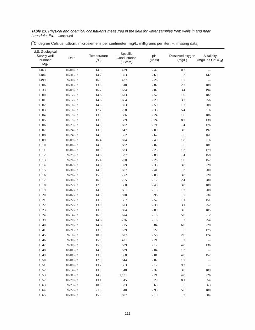
111
1463 10-08-97 14.5 429 7.42 0.2 --
1484 10-31-97 14.2 393 7.60 .3 142
1499 09-30-97 16.0 437 7.26 1.7 --
1506 10-31-97 13.8 518 7.82 2.2 188
1533 10-09-97 16.7 634 7.07 3.4 194
1600 10-17-97 14.6 623 7.52 1.0 182
1601 10-17-97 14.6 664 7.29 3.2 256
1602 10-16-97 14.8 593 7.50 1.2 208
1603 10-16-97 17.2 758 7.35 5.4 316
1604 10-15-97 13.0 586 7.24 1.6 186
1605 10-15-97 13.0 389 8.24 8.7 138
1606 10-23-97 14.8 602 7.71 .4 176
1607 10-24-97 13.5 647 7.00 3.0 197
1608 10-24-97 14.0 352 7.67 .5 161
1609 10-09-97 16.4 694 7.40 1.8 216
1610 10-06-97 14.0 682 7.02 .5 181
1611 10-06-97 18.8 633 7.23 1.3 179
1612 09-25-97 14.6 337 7.88 .4 158
1613 09-26-97 15.4 700 7.26 1.0 157
1614 10-02-97 14.6 599 7.35 3.8 228
1615 10-30-97 14.5 607 7.41 .3 200
1616 09-26-97 15.3 772 7.08 3.8 220
1617 10-30-97 16.0 755 7.12 2.4 280
1618 10-22-97 12.9 560 7.48 3.8 188
1619 10-07-97 14.0 661 7.13 1.2 208
1620 10-07-97 14.5 828 6.96 .7 234
1621 10-27-97 13.5 567 7.57 1.1 151
1622 10-22-97 13.8 623 7.38 3.1 252
1623 10-27-97 13.5 804 7.00 3.6 185
1624 10-14-97 16.0 674 7.16 5.0 212
1639 10-20-97 14.6 1236 7.16 .2 254
1640 10-20-97 14.6 725 6.84 6.0 228
1641 10-21-97 13.0 539 6.22 .5 175
1645 09-16-97 18.5 627 7.56 2.0 174
1646 09-30-97 15.0 421 7.21 .7 --
1647 09-30-97 15.5 639 7.17 4.8 136
1648 10-01-97 14.0 639 7.04 1.3 --
1649 10-01-97 13.0 558 7.01 4.0 157
1650 10-01-97 12.5 644 7.07 1.7 --
1651 10-08-97 13.7 563 7.17 9.2 --
1652 10-14-97 13.0 548 7.32 3.0 189
1653 10-31-97 14.9 1,131 7.21 4.8 226
1657 10-29-97 13.1 345 6.29 8.1 54
1663 09-23-97 18.0 333 5.63 .5 63
1664 09-22-97 21.8 540 7.95 5.6 180
1665 10-30-97 15.9 697 7.10 .2 304
Table 23. Physical and chemical constituents measured in the field for water samples from wells in and nearLansdale, Pa.—Continued
[°C, degree Celsius; µS/cm, microsiemens per centimeter; mg/L, milligrams per liter; --, missing data]
U.S. GeologicalSurvey well
numberMg-
DateTemperature
(°C)
SpecificConductance
(µS/cm)
pH(units)
Dissolved oxygen(mg/L)
Alkalinity(mg/L as CaCO3)

112
1666 10-14-97 15.0 650 7.00 0.7 187
1667 10-27-97 15.0 576 7.29 8.2 164
1668 10-27-97 15.5 749 7.10 2.0 168
1670 10-22-97 14.2 616 7.51 2.0 186
1671 10-29-97 14.8 421 7.75 6.1 144
Table 23. Physical and chemical constituents measured in the field for water samples from wells in and nearLansdale, Pa.—Continued
[°C, degree Celsius; µS/cm, microsiemens per centimeter; mg/L, milligrams per liter; --, missing data]
U.S. GeologicalSurvey well
numberMg-
DateTemperature
(°C)
SpecificConductance
(µS/cm)
pH(units)
Dissolved oxygen(mg/L)
Alkalinity(mg/L as CaCO3)


![[2019] UKUT 0226 (TCC) Appeal number: UT/2017/0150 UT/2017 ... · [2019] UKUT 0226 (TCC) Appeal number: UT/2017/0150 UT/2017/0151 UT/2017/0151 INCOME TAX AND CORPORATION TAX ––](https://static.fdocuments.us/doc/165x107/5e16c1abedd96c200604b92c/2019-ukut-0226-tcc-appeal-number-ut20170150-ut2017-2019-ukut-0226.jpg)