SYLLABUS M. SC IN METEOROLOGY 2019-2020)
20
1 SYLLABUS M. SC. IN METEOROLOGY (SESSION 2019-2020) DEPARTMENT OF METEOROLOGY UNIVERSITY OF DHAKA
Transcript of SYLLABUS M. SC IN METEOROLOGY 2019-2020)

1
SYLLABUS
M. SC. IN METEOROLOGY (SESSION 2019-2020)
DEPARTMENT OF METEOROLOGY UNIVERSITY OF DHAKA

2
Table of contents
1. Basic Information .................................................................................................................................. 3
1.1 Eligibility for admission ......................................................................................................................... 3
1.2 Total Credit of the program…………………………………………………………………………………………………………… 3
2. Learning outcomes ................................................................................................................................ 4
3. Mark distribution against grades: ......................................................................................................... 5
4. Semester / term wise distribution of Modules………………………………………………………………………….6
5. Module content .................................................................................................................................... 8
5.1 Theory modules .............................................................................................................................. 8
5.2 Practical/Laboratory modules ....................................................................................................... 18
5.3 Met 515-Met 516: Dissertation /Project (Departmental or through an internship) (9 Credit)…..20

3
1. Basic Information
The Master of Science (M.Sc.) degree in Meteorology is a brand new program designed to provide an up-to-date, comprehensive, graduate level qualification for those who wish to pursue a career in the subject or allied disciplines. The course duration is 18 months.
1.1Eligibility for admission
Applicants must be a graduate of any recognized university of Bangladesh. Their first degree should
include a selection from Physics, Mathematics, Applied Mathematics, Engineering, Geology,
Aeronautics, Geography and Environment, Environmental Science, Disaster Science and Management,
Chemistry, Agriculture Science, Soil Science, Hydrology, Water Resources, Oceanography. The candidate
must have secured a CGPA of at least 3.0 for applying for admission to the program. The selection will
be made based on written test and interview.
1.2 Total Credit of the Program
The total credit of M.Sc. in Meteorology program is 53.The program provides a 44 credit (33 credit
theory, 9credit practical and 2 credit oral), wide-ranging scientific view of both weather and climate that
forms the basis for the following 9 credit dissertation (henceforth called Dissertation Group)or 6 credit
project (to designated as Project Group) during 6 months. There is an additional laboratory (Practical)
course of 3 credits for the Project Group.
Students of both Dissertation Group and Project Group will undertake internship in any professional
institution of the country, such as Bangladesh Meteorological Department (BMD). The internship is a
non-credit activity and the student will be awarded after having completion certificate by internship
institute. The duration of the internship will vary from 1 to 2 months depending on internship institute.
The selection of students for dissertation will be made on the basis of the qualifying marks determined
by the department.
1.3 Detail Syllabus of Master of Science (M.Sc.) Meteorology
The credit total for the M. Sc. is 53 and is composed of 12 theory modules with Modules Met-Th 510 and
Met-Th 511 as optional. All theory modules are weighted as 3 credits each. There are 5 Laboratory /
practical modules: Met-Lab501 has 3 credits; Met-Lab502, Met-Lab503, Met-Lab504 have 2 credit each.
Met-Lab 505 has 3 credits, which will be taken by the students of Project Group only. Met-5013 is Viva.
Module-14 dissertation module has 9 credits and Module-15 is project has 6 credits. The credit
distribution among the dissertation report and viva is 60% and 40% respectively. The similar distribution
is also applicable for Project.

4
Each theory module will incorporate a tutorial including experience of verbal presentation. The students
will usually take 11 theory modules and 4 laboratory modules. All students will take Met-Th 501 - Met-
Th505 in the first term plus 6 theory modules out of the rest 7 modules (Met-Th506 to Met-Th512) in
the second term. They have the option to take either Met-Th510 or Met-Th511 in the second term
(identified with asterisk (*) in Table-2). Viva examination (Met513) will be taken at the end of Term-2.
Students will take Module Met-514 (Dissertation) or alternately Met-515 (Project) in the 3rd semester.
The internship of 2 months duration will be taken by all students in a national meteorology related
institute (e.g. Bangladesh Meteorological Department (BMD). The student of project group will
additionally take Met-Lab 505 module in Term-3.
2. Learning outcomes
The graduates will be given theory courses, tutorials and practical (laboratory) courses. Graduates will
understand the physical basis and dynamical principles that govern a wide range of atmospheric
phenomena and be able to express their knowledge and understanding clearly. They will be able to
describe and explain the origin and evolution of tropical and extra-tropical weather systems across a
range of scales; will have exposure on agro-meteorology, hydro-meteorological disasters and aviation
meteorology; know the basic physics and mathematics of application to understanding the atmospheric
processes; understand the application of statistical techniques in meteorology, and weather and climate
prediction techniques including Numerical Weather Prediction (NWP) models and their limitations; be
able to produce well-written scientific papers; will be able to independently produce reports including
the dissertation; be able to produce quality weather analysis charts and interpret forecast products
accurately and in a timely way, including verbally summarizing their details; be able to work effectively
as a member of a team; understand the importance of early warning systems, how they are set up and
their critical information relayed to users; know the relationship between agriculture and weather and
climate; provide early warning and advisory to agriculture services for crop management; will be able to
analyze the causes of climate change and impacts, adaptation and mitigation techniques and strategies.
The students will learn to work using advanced techniques including understanding the mechanism of
data acquisition through satellite and radar technology and interpret the imagery for meteorological
application.

5
3. Mark distribution against grades
Each 3 credit course has a weight of 100 marks. The distribution grades will be in accordance to
the Table below.
Table-1: Grade point distribution including letter grade with Numerical Grade
Numerical Grade Letter Grade Grade Point
80% and above A + 4.00
75% to less than 80% A 3.75
70% to less than 75% A- 3.50
65% to less than 70% B+ 3.25
60% to less than 65% B 3.00
55% to less than 60% B- 2.75
50% to less than 55% C+ 2.50
45% to less than 50% C 2.25
40% to less than 45% D 2.00
Less than 40% F 0.00
6
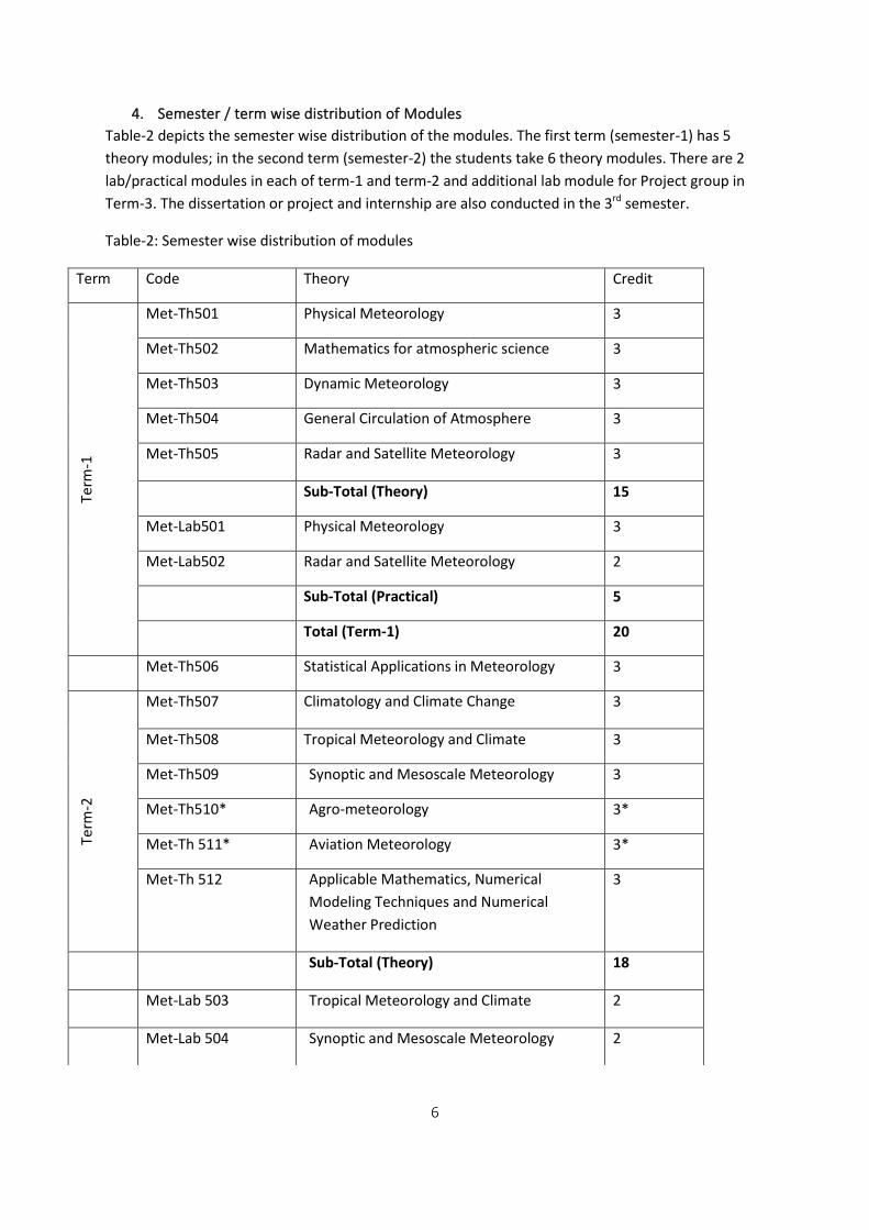
4. Semester / term wise distribution of Modules
Table-2 depicts the semester wise distribution of the modules. The first term (semester-1) has 5
theory modules; in the second term (semester-2) the students take 6 theory modules. There are 2
lab/practical modules in each of term-1 and term-2 and additional lab module for Project group in
Term-3. The dissertation or project and internship are also conducted in the 3rd semester.
Table-2: Semester wise distribution of modules
Term Code Theory Credit
Term
-1
Met-Th501 Physical Meteorology 3
Met-Th502 Mathematics for atmospheric science 3
Met-Th503 Dynamic Meteorology 3
Met-Th504 General Circulation of Atmosphere 3
Met-Th505 Radar and Satellite Meteorology 3
Sub-Total (Theory) 15
Met-Lab501 Physical Meteorology 3
Met-Lab502 Radar and Satellite Meteorology 2
Sub-Total (Practical) 5
Total (Term-1) 20
Met-Th506 Statistical Applications in Meteorology 3
Term
-2
Met-Th507 Climatology and Climate Change 3
Met-Th508 Tropical Meteorology and Climate 3
Met-Th509 Synoptic and Mesoscale Meteorology 3
Met-Th510* Agro-meteorology 3*
Met-Th 511* Aviation Meteorology 3*
Met-Th 512 Applicable Mathematics, Numerical
Modeling Techniques and Numerical
Weather Prediction
3
Sub-Total (Theory) 18
Met-Lab 503 Tropical Meteorology and Climate 2
Met-Lab 504 Synoptic and Mesoscale Meteorology 2
7
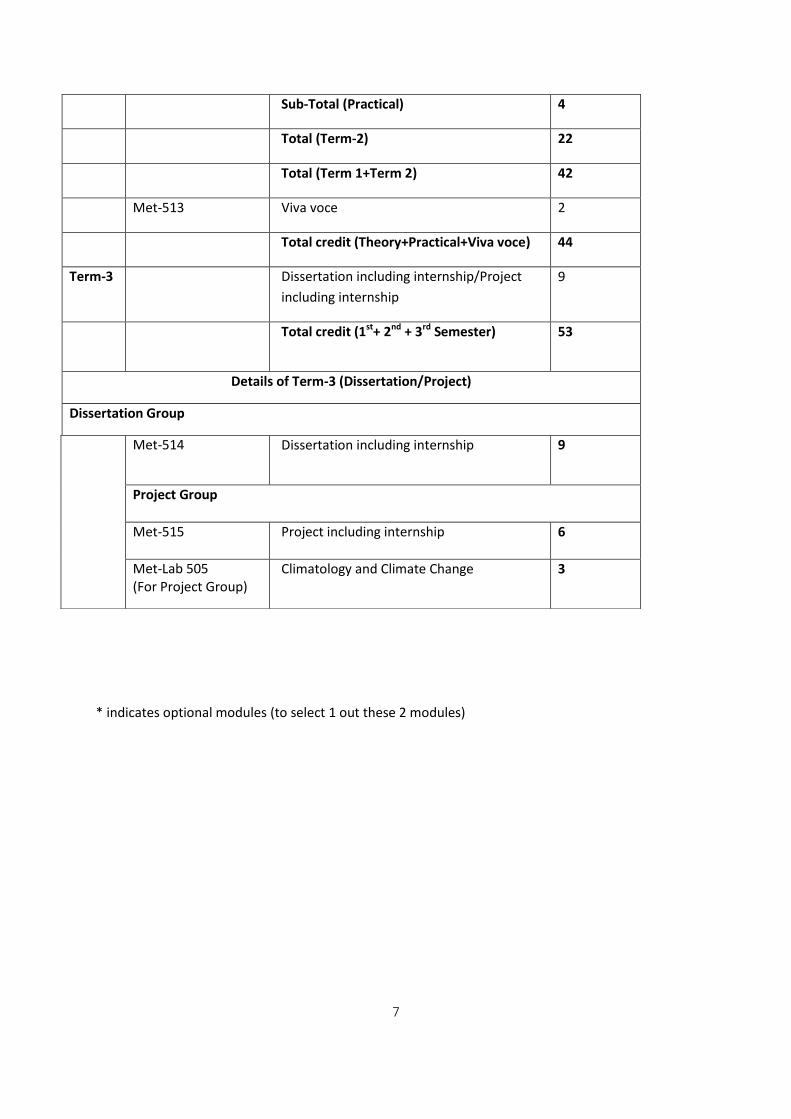
* indicates optional modules (to select 1 out these 2 modules)
Sub-Total (Practical) 4
Total (Term-2) 22
Total (Term 1+Term 2) 42
Met-513 Viva voce 2
Total credit (Theory+Practical+Viva voce) 44
Term-3 Dissertation including internship/Project
including internship
9
Total credit (1st+ 2nd + 3rd Semester) 53
Details of Term-3 (Dissertation/Project)
Dissertation Group
Met-514
Dissertation including internship 9
Project Group
Met-515 Project including internship 6
Met-Lab 505 (For Project Group)
Climatology and Climate Change 3

8
5. Module content
5.1 Theory modules
Met-Th501: Physical Meteorology (3 credit)
An overview on Earth system-geographical coordinate system, topography, oceans and continents. Vertical structure of the atmosphere- distribution of vertical temperature and atmospheric layers. Composition of the atmosphere – major and trace gases, particulate matters. Introduction to Radiation – short and longwave, albedo of different surfaces, radiation balance. Equation of state- for dry and moist air, relation between atmospheric pressure and temperature. Atmospheric moisture - relative humidity, absolute & specific humidity, mixing ratio, relation of vapor pressure with moisture content. Temperature – drybulb, wetbulb, dewpoint, potential and equivalent. Heat transfer – convection, conduction, evaporation and condensation. Atmospheric stability – adiabatic lapse rates and convective cloud formation, thermodynamiccharts (Skew T diagram etc). Cloud types and precipitation- Cumulus, Stratus, Cirrus clouds and genesis of clouds and precipitation formation. Meteorological instruments – different types of instruments for surface and upper-air observation.
Books:
Shaw, Sir Napier. Manual of Meteorology, Vol. I. Cambridge University Pr, Cambridge, 1942.Google
Scholar.
Andrea V. Jackson, Handbook of Atmospheric Science by C. Nick Hewitt; Wiley 2008.
Harrison. Meteorological measurements & instrumentation, Wiley.
Peter Hobbs. Clouds Their Formation, Optical Properties, and Effects, Elsevier Science 2012.
Craig F. Bohren; Eugene E. Clothiaux, Fundamentals of Atmospheric Radiation, Wiley 2006.
Liou, An Introduction to Atmospheric Radiation. Elsevier Science 1981.
Fred V. Brock; Scott J. Richardson, Meteorological Measurement Systems Oxford University Press 2001.
Dwayne Heard. Analytical Techniques for Atmospheric Measurement Wiley 2008.
Giles Harrison, Meteorological Measurements and Instrumentation (Wiley) ISBN: 978-1-118-
74580-9; 280 pages, November 2014, Wiley-Blackwell.
Maarten H. P. Ambaum, 2010: Thermal Physics of the Atmosphere (Wily). ISBN: 978-0-470-74515-1; 252
pages.
Fred V. Brock; Scott J. Richardson, Meteorological Measurement Systems, Oxford University Press 2001.
Ian Strangeways, Precipitation, Cambridge University Press 2006.
R. M. Goody; Y. L. Yung, Atmospheric Radiation, Oxford University Press 1995.
Craig F. Bohren; Eugene E. Clothiaux, Fundamentals of Atmospheric Radiation, Wiley 2006.

9
Met-Th 502: Mathematics for atmospheric science (3 credit)
Basic functions: Indices, exponential functions, logarithms, trigonometric functions, linear functions (straight lines), square, parabolic and polynomial functions.
Vector Analysis- definition of scalar and vector. Graphical representation of vectors in Cartesian coordinate system; projection of vector quantity in x, y and z axes. Addition and multiplication of vectors. Matrix: Matrix Algebra, Determinant of Matrix, Transposition, inversion and Diagonalization of Matrices, Unitary Matrix, Solution of simultaneous linear equations using Matrix. Differential and Integral Calculus- concept of differentiation, differentiation of different functions, integration, definite integrals. Ordinary Differential Equations: Degree and order of ordinary differential equations; solution of differential equations: Solution of first order differential equations; Init ial and Boundary value problems: Differential operators, gradient, divergence and curl of a vector, Gauss’s and Stokes’ Theorem, Partial differential equations; Solution of differential equations (simple examples). The application of Mathematics in Meteorology: Newton’s force law, derivatives of atmospheric
variables, time derivatives, advection of physical quantities, acceleration due to gravity, pressure
gradient force, simplest form of meteorological prognostic equations.
Basics of Numerical Solutions: overview of finite difference techniques in numerical solutions in
time and space, stability of numerical solutions.
Tutorial
I. Using the surface pressure charts, derive the derivative in x- and y- directions at selected points and calculate the pressure gradient force and geostrophic winds.
II. Solve selected problems on Vector analysis. III. Solve a few exercises on solving of differential equations. IV. Estimate spatial derivatives of temperature distributed in rectangular grids and estimate the
advection of temperature at given wind speed. V. Other exercises as provided by the course teacher.
Books:
Luther Pfahler Eisenhart, Coordinate Geometry, Dover Publishing Inc.
M. R. Spiegel. Vector Analysis, Schaum’s Outline Series.
James Ward Brown and Ruel V. Churchil, Complex Variables and Applications, 7th Edition, Schaum’s
Outline Series.
Anton. Elementary Linear Algebra, 8th edition.
George F. Simmons, Differential Equations, McGraw-Hill.
10
R. Kent Nagle, Edward B. Saff and Arthur David Snider, Fundamentals of Differential Equations, Addison-
Wesley.
Howard Anton, Irl Bivens and Stephen Devis, Calculus, John Wiley and Sons.
M. R. Spiegel. Calculus and Analysis, Schaums’s outline series.
J. Holton. Introduction to dynamical meteorology, Academic Press.
Met-Th503: Dynamic Meteorology (3 Credit)
Fundamental and apparent forces- Pressure gradient, gravitational, frictional and Carioles forces.
Geostrophic and gradient winds, Thermal wind, straight & curved flows.
Hydrodynamic Equations- Momentum, hydrostatic, continuity and heat and energy equations in
different vertical coordinatesystems.
Scale analysis- Simplify the equations the Scale analysis of the equations, quasi-geostrophic and
ageostrophic concepts.
Vorticity- Realative and absolute Vorticity and divergence, vertical motion, vorticity equation, stream
function and velocity potential.
Wave motion- Atmospheric wave motions, Rossby Waves, Acoustic Waves, Kelvin Waves, Gravity
Waves; Atmospheric turbulence, barotropic and baroclinic instabilities.
Local wind systems – sea/land breezes, katabatic flow.
Tutorial:
I. Perform analysis of the data of pressure, temperature and humidity for selected hours and days for dry and rainy weather and link the weather with observations for the areas around the Bay of Bengal.
II. Using the spatial plots of surface pressure for the areasin and around the Bay of Bengal and using the charts obtained from BMD and/ or other sources, assess the x and y components of the pressure gradient and geostrophic winds at 850 mb.
III. Prepare spatial plots of U and V and estimate the divergence and vorticity at selected points using U and V at the surface level at 850 mb.
IV. Solve problems of dynamic meteorology as assigned by the course teacher. V. The students will be given lessons on using computer programs for plotting the meteorological fields
and derived parameters, such as vorticity, divergence, vertical velocity.
Books:
J. Holton. Introduction to dynamical meteorology Academic Press.
Ambaum, Thermal physics of the atmosphere, Wiley.
Hoskins & James, Fluid dynamics of the mid-latitude atmosphere, Wiley.
Hastenrath, Climate dynamics of the tropics. Kluwer.
George J. Haltiner and Frank. L. Martin, Dynamic and Physical Meteorology.
11
Maarten H. P. Ambaum, 2010: Thermal Physics of the Atmosphere (Wily). ISBN: 978-0-470-74515-1; 252
pages.
Dynamic and Physical Meteorology by George J Haltiner and Frank. L. Martin.
Met-Th504: General Circulation of Atmosphere (3 Credit)
Understanding of north-south vertical circulation- Hadley, Ferrel and polar cells.
Global radiation-seasonal distribution of annual and seasonal radiation fields – solar and terrestrial
radiation, Outgoing long wave radiation and radiation balance.
Large scale fluxes: Large-scale annual and seasonal fluxes of heat and moisture, and transport
mechanisms.
Climate Induces-Climate variability indices including tele-connections e.g. ENSO, IOD, NAO, MJO, The
Quasi- Biennial Oscillation (QBO).Large Scale Circulation-Large-scale mean circulation features including
the Hadley and Walker Circulations.
Ozone layer-Ozone layer depletion and high latitude stratospheric circulation.
Tutorial:
Tools: Computer analysis
I. Plot the Seasonal heat fluxes and OLR data and analyze the seasonal-spatial variations. II. Plot and analyze the heat and moisture fluxes, the transfer mechanism.
III. Analyzing the global wind fields in lower and upper troposphere identify the major areas of ascent and descent in the tropics and explain the association of these features with vertical Hadley and Walker circulations. .
IV. Investigate the basic features of Tele-connection process with available data in the NOAA and other sites.
V. The students will perform any other exercise assigned by the course teacher. Books
James, Introduction to circulating atmospheres, Cambridge University Press. Hoskins & James, Fluid dynamics of the mid-latitude atmosphere, Wiley. E. Palmén and C. W. Newton, Circulation Systems. Their Structural and Physical Interpretation. Academic Press, New York. Ochanan Kushnir (2000). The Climate System: General Circulation and Climate Zones. Satoh, Masaki. Atmospheric Circulation Dynamics and General Circulation Models, Springer. David Randall. An Introduction to the Global Circulation of the Atmosphere, Princeton University Press. Global Atmospheric Circulations, by R. Grotjahn, Oxford Univ. Press. I. N. James. Introduction to Circulating Atmospheres (Cambridge Atmospheric and Space Science Series). Atmospheric and Oceanic Fluid Dynamics: Fundamentals and Large-scale Circulation Hardcover– 6 Nov 2006, by Geoffrey K. Vall.

12
Met-Th505: Radar and Satellite Meteorology (3 credit)
RS and GIS: Introduction to RS and GIS, Geo-referencing and overlaying the satellite data on existing data layers, manipulation of calibration of radar and satellite data. Weather Radar- Principles of weather Radar, types of weather Radar, calibration of Radar return, estimation of precipitation, estimation of wind velocity using Doppler Radar. History of satellite technology – instrumentation and orbits. Rationale of satellite observations – visible, infrared and multispectral sensing. Derived parameters – albedo and temperature of cloud-free surfaces and cloud tops, vertical profiles of temperature and humidity, cloud drift winds, water vapor fields and motion vectors, precipitation. Application in Tropical Cyclone analysis-Tropical cyclone monitoring and assessment using the advanced Dvorak method and AMSU observations. Satellite born SAR (Synthetic Aperture Radar)- application of SAR in Meteorology, Radar Scatterometer
and radar precipitation sensors onboard satellites and their applications.
Integration with NWP- Interpretation of satellite imagery, uses and impact of data in NWP modeling
systems.
Books
Richard J. Doviak, Dusan S. Zrnic (Author). Doppler Radar and Weather Observations: Second Edition (Dover Books on Engineering) Paperbac, 2006. Meischner, Peter (Ed.). Weather Radar: Princuples and Advanced Applications. Frédéric Fabry. Radar Meteorology: Principles and Practice. Stanley Q. Kidder, Thomas H. Vonder Haar, Satellite Meteorology: An Introduction 1st Edition. R R Kelkar, Satellite Meteorology, Second Edition. Mölders, Nicole, Kramm, Gerhard, Lectures in Meteorology, Springer. Su-Yin Tan, Meteorological Satellite Systems. Springer. Remote Sensing Applications in Meteorology and Climatology, Vaughan, R. A. (Ed) (1987). Deepak, A., Inversion Methods in Atmospheric Remote Sounding, Elsevier Science 2012.
Met-Th 506: Statistical Applications in Meteorology (3 Credit)
Statistical moments- Statistical moments of atmospheric data, generating climatology of atmospheric parameters, statistical probability distribution (normal, binomial, gamma and Bayesian distribution). Time series analysis- Variability of atmospheric parameters using autocorrelation analysis, Fourier Transform, Spectral analysis and wavelet analysis and application in weather and climate study. Correlation and regression analysis-Cross correlation, multiple correlations, linear and non-linear regression analyses, analysis of variance, step wise regression analysis, Factor analysis. Statistical Tests- F-test, t-test and other tests of significance.
Tutorial
Tools: Computer: software-statistical package. MATLAB Mathematical Package, R statistical Package,
Programming in Fortran, C++
I. Compute mean, median and mode and standard deviation using weather observation data.

13
II. Cross correlation: correlation of ENSO index with pre-monsoon and monsoon rainfall (for Bangladesh).
III. Correlation of thunderstorm with rainfall and temperature (for Bangladesh). IV. Study the climate variability using time series analysis: Auto correlation analysis. V. Examples of estimation coefficients of Fourier Transform and calculation of periodogram.
VI. Examples of Power Spectrum Analysis and Wavelet analysis. VII. Linear and polynomial regression for developing weather-crop yield relations.
Books EPSTEIN, E. S. (ED) (1985) STATISTICAL INFERENCE AND PREDICTION IN CLIMATOLOGY. TIME SERIES ANALYSIS IN METEOROLOGY & CLIMATE. DUCHON & HALES, WILEY. DANIEL S. WILKS. STATISTICAL METHODS IN THE ATMOSPHERIC SCIENCES. EPSTEIN, E. S. (ED) (1985). STATISTICAL INFERENCE AND PREDICTION IN CLIMATOLOGY. CLAUDE DUCHON; ROBERT HALE. TIME SERIES ANALYSIS IN METEOROLOGY AND CLIMATOLOGY, AN INTRODUCTION.
Met-Th507: Climatology and Climate Change (3 Credit)
Concept- Concept of climate, classifications of climate, global, annual and seasonal distribution of
surface climatic variables – MSL pressure, Sea SurfaceTemperature (SST), wind, air temperature,
humidity and precipitation.
Air-masses- Land and ocean air-masses – source regions and large-scale circulation.
Climatology of natural disasters – tropical cyclones, norwesters, tornadoes, lightning, floods, droughts
and their impacts.
Climate models: Nature and applications of climate models.
Global warming and its causes-emission of enhanced Greenhouse Gases(GHGs) and sources and sinks of
these emissions.
Past and future climate change- global, regional & sub-regional.
Climate Change Impacts-Potential impacts of global, regional and sub-regional climate change.
Physical/dynamical reasoning to explain variability and change in climate.
Climate information: products and services specific to application.
Tutorial:
I. Exercise with the daily data of temperature and pressure of Dhaka, Chittagong, Ishurdi and Sylhet for the period of 1948-2015 or as available to prepare month wise long term climatology (Tools: Microsoft Excel program). Plot the data and interpret the results.
II. Short and long term variations using the temporal plots of monthly, seasonal and annual data. Draw visual inferences and discuss the results.
III. Derive monthly mean climatology of rainfall, humidity and wind in Cox’s Bazar, Dhaka and Rajshahi. IV. Temporal variation of rainfall and humidity. V. Analyze the spatial climatology of pressure, temperature, wind vectors and u, v components at
different levels of atmosphere over the tropics and subtropics and analyze the major climatic features.
VI. Students will solve any other problems as designed by the course teacher.

14
Books
HASTENRATH, CLIMATE DYNAMICS OF THE TROPICS. KLUWER.
IPCC, 2013, AR5 REPORT: CLIMATE CHANGE. PHYSICAL SCIENCE BASIS.
IPCC 2013, AR5 report: Climate Change, Impacts, Adaptation and vunerability.
IPCC 2013, AR5 report: Mitigation of climate change.
Hartmann, Global physical climatology. Academic Press.
Helmis, C., Nastos, P. T. Ed (2013) Advances in Meteorology, Climatology and Atmospheric Physics.
John Marshall; R. Alan Plumb, Atmosphere, Ocean and Climate Dynamics by Elsevier Science 1979.
David D. Houghton. Introduction to climate change: Lecture notes for Meteorologist.
Met-Th508: Tropical Meteorology and Climate (3 Credit)
Mean features of the tropical atmosphere – subtropical anticyclones, trade winds, equatorial trough/ ITCZ, subtropical jet, Tropical easterly jet and African easterly jet. The South Asian Monsoon – Tibetan High and associated winds, seasonal & inter-annual variability, role of Heat Low, Monsoon Trough, Mascarene High, Somali Jet and the Himalayas, onset and withdrawal of monsoon, strong and break monsoons, monsoon low and depressions. West African monsoon and African Easterly waves. Tropical disturbances –Tropical cyclones (hurricanes, and typhoons), geographical and seasonal
incidence, North Indian Ocean cyclone double maximum.
Location and origin of hot deserts.
Books
J. F. P. Galvin. An Introduction to the Meteorology and Climate of the Tropics.
T.N. Krishnamurti, Lydia Stefanova,Vasubandhu Misra. Tropical Meteorology: An Introduction (Springer
Atmospheric Sciences), 2013 Edition.
Forecasters' Guide to Tropical Meteorology: Gary D. Atkinson.
Introduction to Tropical Meteorlogy by Dr. Arlene Laing, Dr. Jenni-Louise Evans.
Introduction to climate change - WMO Library.
David D. Houghton. Introduction to Climate Change.
Geoffrey K. Valli. Atmospheric and Oceanic Fluid Dynamics: Fundamentals and Large-scale
Circulation 1st Kindle Edition
Met-Th509: Synoptic and Mesoscale Meteorology (3 Credit)
Observation systems – GTS system, surface and upper air observations, radar and satellite observations,
ocean buoy observations. Plotting station data, data quality control, data assimilation, analysis of MSL
pressure, temperature, humidity and wind.

15
Monitor and observe current weather – produce analysis charts and interpret forecast charts.
Incorporate radar and satellite observations.
Overview of synoptic-scale weather features including high pressure and low pressure systems,
monsoon depressions, extra-tropical and tropical cyclones, troughs and ridges, frontal systems, air
masses, western disturbances and tropical easterly waves.
Conceptual models-Conceptual models of significant synoptic and mesoscale systems (such as cumulus
convective systems, thunder storms/hail storms, tornadoes, squall lines) including their formation,
evolution and associated weather including severe weather.
Upper air mapping- Use an upper air station array to produce maps of derived parameters such as
vorticity, divergence and inferred vertical velocity.
Techniques of weather forecasting and early warnings- process and application.
Books
Inness & Dorling. Operational forecasting, Wiley. McIlveen, Robin. Fundamentals of weather and climate, Chapman and Hall. Thompson, Philip D. Numerical Weather Analysis and Prediction. Macmillan, New York, 1961. Google Scholar. Richardson, Lewis F. Weather Prediction by Numerical Process. Cambridge University Pr, Cambridge, 1922. MATH Google Scholar. Ducan Thompson, Philip D., A history of numerical weather prediction in the United States. In History of Meteorology in the United States: 1776–1976. American Meteorology Society, 1978. Peter Michael Inness, Steve Dorling. Operational WeatherForecasting, January 2013, Wiley-Blackwell. Toby Carlson, Paul Knight, Celia Wyckoff, 2014, An Observer's Guide to Clouds and Weather (A Northeastern Primer on Prediction). C. Nick Hewitt; Andrea V. Jackson, Handbook of Atmospheric Science, Wiley 2008. Gerald R. North; Tatiana L. Erukhimova, Atmospheric Thermodynamics, Cambridge University Press 2009.
Met-Th510:Agro-meteorology (3 Credit)
Global relationship of agriculture with climate. Impact of weather on tropical crops. Estimation of evaporation/evapo-transpiration, soil moisture, solar radiation and their relationshipwith agriculture. The water balance calculation for tropical regime: Drought monitoring. Satellite application in crop monitoring. Impact of weather in agricultural value chain. Weather forecast and issuing of agro-meteorological advisory bulletins for crop risk management. Assessment of rainfall over river catchments from satellite. Mapping and monitoring of floods using satellites andassessment of associated damage. Warning vulnerable communities of impending floods, heat waves and cold waves. Impact of climate change on water and agriculture.

16
Understanding of Agro-meteorological/Agroecological zone and crop calendar in relation to seasonal climatic patterns.
Tutorial:
Tools: Computer and analysis tools.
I. Mapping of rainfall using satellite data. II. Assessment of soil moisture using satellite observation.
III. Yield-climate relation: rice yield against Temperature (minimum, maximum), rainfall and humidity analysis using graphical method.
IV. Yield-climate relation: wheat yield against Temperature (minimum and maximum), rainfall and humidity analysis using graphical method.
V. Assessment of drought indices Pre-kharif and kharif seasons. VI. Estimation of evapotranspiration and water balance calculation for individual months.
VII. Using multi-spectral satellite data analyze the spectral sensitivity of crop, soil and water. VIII. Mapping of green vegetation / agricultural crops using satellite data.
IX. Agro-ecological zones of Bangladesh, crop calendar and land types.
Books
J. Fuhrer, Agroscope Research Station, Zurich, Switzerland, P Gregory. Climate Change Impact and
Adaptation in Agricultural Systems — Last modified July 22, 2014, University of Reading, UK.
Heidelberg et al. 2010. Applied Agro-meteorology”, Kees Stigter (Ed.) (Springer, 2010).
Drought assessment using SPI, remote sensing and modeling. New book on drought assessment using
SPI, remote sensing and modeling.
Agro-meteorology and Plant Diseases — The special issue of Scientia Agricola about "Agrometeorology
and Plant Diseases" is now available on the web.
Edited by Ariel Dinar and Jose Albiac, et al. Policy and Strategic Behaviour in Water Resource
Management Policy and Strategic Behaviour in Water Resource Management.
Met-Th511: Aviation Meteorology (3 Credit)
The atmosphere and aviation – historical perspective, Meteorological organizations. Effect of pressure, density and temperature on flying– change of pressure, air density and temperature with altitude - altimetry terminology - ICAO standard atmosphere - QNH, QFE, QFF standard setting - transition altitude. Impact of wind in aviation – Wind shear, cross wind, effect of wind gradient and wind shear on take-off and landing, turbulence and gustiness - mountain and valley winds. Upper air observation, thermodynamic charts and stability analysis. Atmospheric turbulence eddies and CAT. Flying with Cloud- cloud types and flying conditions with special emphasis on thunderstorm flying. Significance of fog, mist and haze- reduction of visibility due to mist, snow, smoke, dust and sand. Impact of Air mass and front on flying–Types and formation of air mass and associated weather.

17
Ice accretion - conditions conducive to ice formation - effects of icing on aero-plane performance - precautions and avoidance. Meteorological forecasts for aviation –TAF, METAR, ATIS, SIGMET and VOLMET.
Tutorial:
i. Reading of pressure from barometer, barograph and aneroid barometer; pressure corrected to
standard condition; calculation of different parameters like QNH, QFE, QFF, etc.
ii. Observation and reading of wind direction and speed from wind vane, wind sock, Beaufort scale,
and anemometer; reporting of wind direction and speed.
iii. Observation of clouds (amount, height & types), reporting criteria.
iv. Observation of visibility with the help of visibility landmark, variation of visibility in different
atmospheric obscurity like fog, mist, haze, dust, etc. Reporting criteria of poor visibility.
v. Understanding of different WMO Meteorological codes like TAFOR, METAR, ATIS, SIGMET, VOLMET.
Books
Handbook of Aviation Meteorology: By Meteorological Office (UK) – amazon.co.uk. Terry T. Lankford. Aviation Weather Handbook by K.H. Hack. Aviation Meteorology.
Met-Th 512: Applicable mathematics, Numerical Modeling Techniques and Numerical Weather Prediction (Computer Based) (3 Credit)
Basics-Differential and integral calculus, matrix algebra, solution of ordinary differential equations, solution of second order differential equations. Numerical modeling techniques – Taylor series expansion, finite difference formulation of atmospheric equations, finite element methods and spectral modeling techniques, time integration techniques, instability criteria, parameterization of physical parameters. Numerical Weather Prediction (NWP) – the process and the products. Tutorial Tools: Analytical tools, Numerical Techniques (Fortran and C++ programming), NWP-models.
I. Solve mathematical problems as assigned by the course teacher. II. For a given field at a rectangular grid with an interval of 10 m in X and Y directions between the
grids, calculate the first order and second order special derivatives using Taylor’s expansion.
III. Solve the equation x
uu
t
u
using forward integration technique from time t=0 to t=25,
given that time step = 5 sec. Is the solution stable? IV. Perform a case study using an existing NWP model in the lab.

18
Books
Steyn.Introduction to atmospheric modeling. Cambridge University Press.
Holton. Introduction to dynamical meteorology, Academic Press.
General Circulation Models of the Atmosphere by Julius Chang, Elsevier Science.
Thompson, Philip D. Numerical Weather Analysis and Prediction. Macmillan, New York, 1961. Google
Scholar.
Thompson, Philip D. Numerical Weather Analysis and Prediction. Macmillan, New York, 1961.Google
Scholar.
Richardson, Lewis F. Weather Prediction by Numerical Process. Cambridge University Pr, Cambridge,
1922.
Ducan Thompson, Philip D. A history of numerical weather prediction in the United States. In History of
Meteorology in the United States: 1776–1976. American Meteorology Society, 1978.
George J. Haltiner and Roger T. Williams. Numerical Prediction and Dynamic Meteorology,
Haltiner/dp/0471059714. Numerical-Prediction-Dynamic-Meteorology-on Amazon.com.
George J Haltiner and Frank. L. Martin. Dynamic and Physical Meteorology.
5.2. Practical/Laboratory modules
Met-Lab501: Physical Meteorology (3 Credit)
I. Acquaintance with the meteorological instruments in the laboratory and in the Meteorological Observatory.
II. Measurements of air temperature, dew point temperature, air pressure and relative humidity and then derive the equivalent temperature, mixing ratio, vapor pressure.
III. Data of pressure, temperature, humidity and wind (magnitude and direction) from AWS are used to investigate the diurnal variability of these parameters.
IV. Measure the soil temperature at different depth for different time of the day and estimate the coefficient of conductivity of heat in the soil.
V. Measure the incident and reflected solar radiation using Pyranometer and calculate the albedo of bare soil, vegetated area (crops), sandy soil and wet soil.
VI. Measure the incoming and outgoing long-wave radiation and estimate the radiance. temperature of the surface during 7:00 to 10:00 am at 10 minutes interval.
VII. Monitor radiation balance and increase of temperature from 7.00 am to 10.00 am for selected surfaces.
Met-Lab502: Radar and Satellite Meteorology (2 Credit)
I. Interpretation of Radar imagery for analyzing depressions, tropical cyclones and mesoscale systems.
II. Visual interpretation of satellite imagery in reflective, thermal infrared (window channels) and water vapor absorption bands for meteorological interpretation: use Local as well as Global Imagery from Geostationary Satellites.

19
III. Use imagery of full resolution for local details of surface characteristics from multispectral polar orbiting satellites.
IV. Study the convective clouds using digital imagery- cloud top temperature at different stages of evolution of the convective clouds, thunderstorm systems and tornado system.
V. Use the hardcopy and digital images of satellite imagery for tropical cyclone interpretation (Dvorak techniques).
VI. Draw vertical temperature and humidity profiles for tropical convective systems, depressions and tropical cyclones using the retrievals of the ATOVS and AMSU data.
VII. Interpretation ofScatterometer data for the assessment of wind speed of tropical cyclone.
Met-Lab503: Tropical Meteorology and Climate (2 Credit)
I. Plot the 1000 mb pressure and geopotential height at different tropospheric levels for winter and summer.
II. Then identify the high pressure, low pressure systems, troughs and ridges, trade winds in the lower levels, Inter Torical Convergent Zone (ITCZ).
III. Identify the upper atmospheric features: westerly troughs, Tibetan High pressure, Subtropical and tropical Jet streams.
IV. Identify subtropical fronts and take an east-west vertical section and show the horizontal variation of the temperature and moisture fields.
V. Analyze the cases of strong and break monsoons using pressure, temperature and cloud fields and derive the basic features differentiating the weak and strong monsoons.
VI. Analyze the annual and seasonal variations of tropical cyclone frequency over the Bay of Bengal using the data archives in IMD, BMD and JTWC.
VII. The course teacher may assign any other assignment to the student to solve as practical work.
Met-Lab504:Synoptic and Mesoscale Meteorology (2 Credit)
Tools: Manual and computer systems
I. Plotting GTS data for the South Asian and adjacent regions including the Arabean Sea and the Bay of Bengal, quality check and plotting the data using standard meteorological symbols.
II. Analysis of charts of Pressure, geopotential height and Temperature data for lower and upper troposphere. Identify the low pressure, high pressure zones, jet streams etc.
III. Prepare the vertical thermodynamic charts based on radiosonde observation and calculate Convective Available Potential Energy (CAPE).
IV. Identify the pressure and temperature tendency in the charts, and analyze advection of the parameters by the winds; prepare prediction for mesoscale and synoptic scale weather based on all past (1-2 days before) and present information.
V. Incorporate satellite and RADAR imagery for preparing now-casting future prediction. VI. Prepare text for predictions of weather and make presentations.
Met-Lab 505: Climatology and Climate Change (3 Credit)
i. Monitoring rainfall in the flash flood and river flood risk areas (Sylhet, Chittagong and Cox’s Bazar) and interpret for local level flood prediction.

20
ii. Use satellite imagery to analyze the meteorological hazards: Floods, Flash floods, landslides, river erosion.
iii. The analysis and interpretation of hourly Tide Gauge data at Cos’s Bazar, Chittagong, Hiron point and Khepupara
iv. Analyze Remote Sensing data for flood area delineation v. Use a suitable drought index to analyze droughts at a drought prone station and compare
with the same at Dhaka. vi. Linking rainfall with floods, flash floods in Bangladesh and elsewhere in the region.
5.3. Met513: VIVA
5.4. Met514: Dissertation (9 CREDIT)
Met 515: Project (6 Credits)
The dissertation / Project topics are to be determined by the team of supervisors. These are independent,
guided research involving a comprehensive literature review and some contents related to original work
based on e.g. data analysis, lab work, case studies.