Sydney Harbour and Botany Bay (La Perouse … · Fire Management Plan Sydney Harbour & Botany Bay...
28
Fire Management Plan Sydney Harbour & Botany Bay (La Perouse Precinct) National Parks 136 Sydney Harbour and Botany Bay (La Perouse Precinct) Fire Management Plan Management Area Profiles Management Area: Reserve: BBN 1 - Bare Island Botany Bay (La Perouse Precinct) National Park Management Area Boundaries: Bare Island Bridge approach road Botany Bay Bushfire behaviour potential (% area) Higher; 0 Medium; 0 Lower; 0 Negligible; 100 Objectives and strategies: Asset Protection Zone Objective: To protect the historic resources and heritage values of Bare Island fort. Strategies: No burning to be undertaken. All fires to be extinguished immediately. Grassed areas to be mown monthly. Fire History: Date: Fire Type: Fire Intensity: Size: Location: 1997 Arson Low 1 sqm On the bridge Size (in hectares) and biodiversity threshold type of each vegetation community Vegetation Class (ha in Reserve) Type (Table 4.2) APZ SFMZ HAMZ Comments Isolepis nodosa, Westringia fruticosa, Carpobrotus A 0.1 n.a. n.a. Small remnant populations on cliff face - unlikely to be affected by fire.
Transcript of Sydney Harbour and Botany Bay (La Perouse … · Fire Management Plan Sydney Harbour & Botany Bay...

Fire Management Plan Sydney Harbour & Botany Bay (La Perouse Precinct) National Parks 136
Sydney Harbour and Botany Bay (La Perouse Precinct) FireManagement Plan
Management Area Profiles
Management Area: Reserve:
BBN 1 - Bare Island Botany Bay (La Perouse Precinct) National Park
Management Area Boundaries:
Bare Island Bridge approach roadBotany Bay
Bushfire behaviour potential (% area)
Higher; 0 Medium; 0 Lower; 0 Negligible; 100
Objectives and strategies:
Asset Protection ZoneObjective: To protect the historic resources and heritage values of Bare Island fort.Strategies: No burning to be undertaken. All fires to be extinguished immediately. Grassed areas to be mown monthly.
Fire History:Date: Fire Type: Fire Intensity: Size: Location:
1997 Arson Low 1 sqm On the bridge
Size (in hectares) and biodiversity threshold type of each vegetation communityVegetation Class(ha in Reserve)
Type(Table
4.2)
APZ SFMZ HAMZ Comments
Isolepis nodosa,Westringia fruticosa,Carpobrotus
A 0.1 n.a. n.a. Small remnant populations on cliff face -unlikely to be affected by fire.

Fire Management Plan Sydney Harbour & Botany Bay (La Perouse Precinct) National Parks 137
glaucescens. (0.1)
Fauna:
NIL
Private Property: Infrastructure:
NIL Wooden bridgeGatesSignsPower and sewage linesSpotlights
Cultural Assets: Comments
Historic fortBatteries Command postBarbettesCasementsBarracks
All buildings are constructed of concrete or brick and areof low flammability
Incident Information:
Control lines: Foreshore, pathways.Safety considerations: Access bridge has a 5 tonne weight limit, cliffs.Evacuation points: Bare Island BridgeAccess: Bare Island Bridge (Island entry gate has an A key padlock)Water: Mains water on siteHelipads: La Perouse headlandHazardous substances: Paint, solvents stored on island.Utilities: Electricity.Council Area: City of Randwick CouncilLocal Fire Brigade: NSW FB Matraville
Resident Caretaker (NPWS Senior Field Officer) Public tours conducted on Sat & Sun at 12.45, 1.30, 2.30, 3.30. (other times on request)

Fire Management Plan Sydney Harbour & Botany Bay (La Perouse Precinct) National Parks 138
Sydney Harbour and Botany Bay (La Perouse Precinct) FireManagement Plan
Management Area Profiles
Management Area: Reserve:
BBN 2 – The Cable Station, Museum & Visitor Centre, La Perouse
Botany Bay (La Perouse Precinct) National Park
Management Area Boundaries:
Northern section of Anzac Parade loop road.Botany BayBare Island Bridge approach roadBotany Bay
Bushfire behaviour potential (% area)
Higher; 0 Medium; 0 Lower; 0 Negligible; 100
Objectives and strategies:
Asset Protection ZoneObjective: To protect and maintain the historic resources and cultural assets of the Cable Station and the associated structures.Strategies: No burning to be undertaken. All fires to be extinguished immediately Grass to be mown regularly.
Fire History:Date: Fire Type: Fire Intensity: Size: Location:
1997 electrical Toilet block
Size (in hectares) and biodiversity threshold type of each vegetation communityVegetation Type APZ SFMZ HAMZ Comments
n.a. n.a. n.a. n.a. n.a. Vegetation is scattered plantings amongstexotic grass lawns
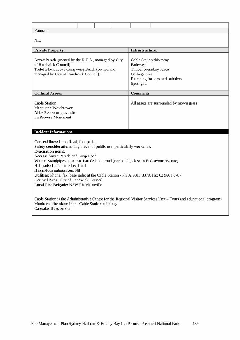
Fire Management Plan Sydney Harbour & Botany Bay (La Perouse Precinct) National Parks 139
Fauna:
NIL
Private Property: Infrastructure:
Anzac Parade (owned by the R.T.A., managed by Cityof Randwick Council)Toilet Block above Congwong Beach (owned andmanaged by City of Randwick Council).
Cable Station drivewayPathwaysTimber boundary fenceGarbage binsPlumbing for taps and bubblersSpotlights
Cultural Assets: Comments
Cable StationMacquarie WatchtowerAbbe Receveur grave siteLa Perouse Monument
All assets are surrounded by mown grass.
Incident Information:
Control lines: Loop Road, foot paths.Safety considerations: High level of public use, particularly weekends.Evacuation point: Access: Anzac Parade and Loop RoadWater: Standpipes on Anzac Parade Loop road (north side, close to Endeavour Avenue)Helipads: La Perouse headlandHazardous substances: NilUtilities: Phone, fax, base radio at the Cable Station - Ph 02 9311 3379, Fax 02 9661 6787Council Area: City of Randwick CouncilLocal Fire Brigade: NSW FB Matraville
Cable Station is the Administrative Centre for the Regional Visitor Services Unit – Tours and educational programs.Monitored fire alarm in the Cable Station building.Caretaker lives on site.
Fire Management Plan Sydney Harbour & Botany Bay (La Perouse Precinct) National Parks 140
Sydney Harbour and Botany Bay (La Perouse Precinct) FireManagement Plan
Management Area Profiles
Management Area: Reserve:
BBN 3 - Happy Valley Botany Bay (La Perouse Precinct) National Park
Management Area Boundaries:
Anzac ParadeCape Banks Road (also known as Golf Course Road)Congwong Beach management trailCongwong BeachFence line from north side of toilet block on Anzac Parade to Congwong Beach
Bushfire behaviour potential (% area)
Higher; 1.6 Medium; 62 Lower; 36.4 Negligible; 0
Objectives and strategies:
Asset Protection ZoneObjective: To protect private property on the west side of Anzac Parade.Strategies: Assess fuel loads prior to fire season each year by Visual Assessment method Fuel loads not to exceed 5 t/ha, maintained by slashing & mowing along road edge, with selective scrub clearing and prescribed pile burning. Extinguish all wildfires
Heritage Area Management ZoneObjective: to maintain natural & cultural assetsStrategies: Extinguish all wildfires. No burning to be undertaken other than pile burns Monitoring of cultural resources to be undertaken after any fire event. Fire History:
Date: Fire Type: Fire Intensity: Size: Location:9/19899/199112/19915/19939/199310/19935/19949/19967/1997
ArsonArson x 2ArsonArsonArsonHazard RedHazard RedPile BurnsPile Burns
HighLowMediumLowLowHighHighHighHigh
1.5ha0.1ha0.5ha0.4ha0.2ha6ha4ha0.2ha0.1ha
Anzac PdeCongwong BeachUpper ValleyUpper ValleyUpper ValleyWhole of areaEast ValleyMid ValleyLower Valley
Size (in hectares) and biodiversity threshold type of each vegetation communityVegetation Class(ha in Reserve)
Type(Table
4.2)
APZ SFMZ HAMZ Comments
Banksia integrifolia &Leptospermumlaevigatum (8.2)
A
0.06 n.a. 3.26 There has been major disturbance in thisarea including numerous fires and thebiodiversity thresholds have been

Fire Management Plan Sydney Harbour & Botany Bay (La Perouse Precinct) National Parks 141
Heath - Acacia sophorae& Pteridium esculentum(51.3)
A 0.36 n.a. 3.83 exceeded. Vegetation is re-establishing andis currently Low Heath.
Fauna:
NIL
Private Property: Infrastructure:
NIL Footbridge and stairsSydney Water Mains pipe (to NSW Golf Club) crossesvalleyStaircase to Congwong Beach SignsFire trail from Cape Banks Road to Congwong Beach
Cultural Assets: Comments
Site of 1930s Depression era camp.Artefacts remain scattered in soil substrate.Some engravings and graffiti on rocks from the sameperiod. 45-6-0561, 1145, 1146, 1403
Frequent fires in the past have caused minor damage to therock faces.Fire events have uncovered artefacts.Cultural Heritage Division should be contacted after fireevents to survey the site.
Incident Information:
Control lines: Anzac Pde, Congwong Beach, Congwong Beach Maintenance Trail.Safety considerations: Sharp debris in soil throughout the valleyEvacuation point: Congwong Beach, Anzac Parade.Access: Anzac Pde, Congwong Beach Maintenance Trail, Cape Banks Rd. (CapeBanks Rd is closed by a gate close tothe junction with Anzac Pde between 7pm and 6.30am. Land Managers, Matraville F.B. and Police hold keys) .Water: Toilet Block at Loop Rd., hydrants along Anzac Parade.Helipad: Scout CampHazardous substances: NilUtilities: NilCouncil Area: City of Randwick CouncilLocal Fire Brigade: NSW FB Matraville

Fire Management Plan Sydney Harbour & Botany Bay (La Perouse Precinct) National Parks 142
Sydney Harbour and Botany Bay (La Perouse Precinct) FireManagement Plan
Management Area Profiles
Management Area: Reserve:
BBN 4 - Grose Street Botany Bay (La Perouse Precinct) National Park
Management Area Boundaries:Grose StreetAnzac ParadeCape Banks RoadTelstra Telecommunications StationBushfire behaviour potential (% area)
Higher; 4 Medium; 96 Lower; 0 Negligible; 0
Objectives and strategies:Asset Protection ZoneObjective: minimise risk of bushfire damage to life & property along Grose St. & the Telstra site.Strategies: Assess fuel loads prior to fire season each year by Visual Assessment method Maintain Zone of 20 metres along Grose St, fuel <5 t/ha, by manual clearing. Extinguish all wildfires
Strategic Fire Management ZoneObjective: To protect the Heritage Zone on the rock platform to the north.Strategies: Extinguish all wildfires Maintain Zone of 20m to north of Cape Banks Rd at <15t/ha by manual clearing Maintain walking tracks at <2T/ha by manual clearing
Heritage Area Management ZoneObjective: To protect the closed forest and Eastern Suburbs Banksia Scrub remnantsStrategies: Extinguish any fires in or around the closed forest Exclude fire, other than pile burns, for at least 10 years in Type A vegetation that has burnt within the last 5 years. Biodiversity may decline in the next 5 years in areas that have not burnt for 10 or more years. Maintain walking tracks at <2T/ha by manual clearing Fire History:Pre 1990 - Frequent fires of varying size, with much of the area burning every 7-8 years.
Date: Fire Type: Fire Intensity: Size: Location:1/199112/19912/199211/19934/19955/19958/19963/19989/1998
ArsonArsonArsonArsonHazard Red.Pile burnsEco. burnArsonPile burns
HighHighHighLowLowLowHighHighMedium
0.3ha0.2ha0.2ha5ha2ha0.1ha1ha4ha0.5ha
Top of Happy ValleyTop of Happy ValleyTop of Happy ValleyTop of Happy ValleyAbove Cape Banks Rd Below Grose St, top of Happy ValleyAbove Cape Banks RdNorth from Cape Banks Rd. South of west end of Grose St
Size (in hectares) and biodiversity threshold type of each vegetation communityVegetation Class (ha in Reserve)
Type(Table
4.2)
APZ SFMZ HAMZ Comments
Closed forest (0.5) -Glochidion fernandi &Acmena smithii.Open Forest (3.7) - B.
C
A
0.15
0.02
0.06
0.06
0.35
0.23
In gully below Grose St. This area shouldhave fire excluded for 15+ years.

Fire Management Plan Sydney Harbour & Botany Bay (La Perouse Precinct) National Parks 143
integrifolia & Corymbiagummifera Scrub (2.7) - B. aemula& Xanthosia resiniferaHeath (47.5) - B. ericifolia
Rulingia hermanniifolia
Platysace stephensonii
A
A
A
A
0.01
0.49
0
2.2
0.39
6.54
Eastern Suburbs Banksia Scrub - ProtectedCommunity under the Threatened SpeciesCons. Act.
Threatened species - both occur on theeast edge of the south facing gully in thecentral part of this area. That section hasnot burnt for 10+ years.
Fauna:
Private Property: Infrastructure:Cape Banks Road (owned and managed by Dept. ofLand & Water Conservation) Telstra Boundary fence(plastic coated).
Walking track Signs
Cultural Assets: Comments
NIL
Incident Information:
Control line: Cape Banks Rd, Grose St, Henry Head walking track.Access: Cape Banks Rd, Grose St, Henry Head walking track. Telstra site - Access via Jennifer St. Gate has bilock. Local NPWS staff hold keys. - Site is only staffed on Tuesdays. - Some of the towers emit high energy microwaves and have marked exclusion zones.Safety: some steep areas. Evacuation points: Cape Banks Rd, Grose St.Water: Hydrants on Grose St at Abbe Receveur Place, mains at N.P.W.S. workshop.Helipad: Scout Camp.Hazardous substances: NilUtilities: Nil Council Area: City of Randwick CouncilLocal Fire Brigade: NSW FB MatravilleLand owned by DLWC between Grose St & Marconi Place may be affected by fire in this area

Fire Management Plan Sydney Harbour & Botany Bay (La Perouse Precinct) National Parks 144
Sydney Harbour and Botany Bay ( North) Fire Management Plan
Management Area Profiles
Management Area: Reserve:
BBN 5 - Jennifer Street Lands Botany Bay (La Perouse Precinct) National Park
Management Area Boundaries:
Jennifer StTelstra fenceCape Banks RoadGolf Club Driving Range (leased Crown land)Cobblestone road.Land owned by La Perouse Land Council
Bushfire behaviour potential (% area)
Higher; 0 Medium; 15 Lower; 84 Negligible; 1
Objectives and strategies:
Asset Protection ZoneObjective: To protect private property along Jennifer St.Strategies: Assess fuel loads prior to fire season each year by Visual Assessment method Maintain zone at 20 metres along Jennifer St by slashing & manual clearing, fuel <5t/ha Extinguish all wildfires
Heritage Area Management ZoneObjective: to protect the natural heritage assets and visitor facilities Strategies: Extinguish all wildfires Boardwalk is to be given priority in a wildfire and protected during ecological burns. Fire is to be excluded from the woodland area and from the Eastern Suburbs Banksia Scrub unless indicated by the Recovery Plan. Biodiversity may decline in the Kunzea Scrub if there is no fire within 10 years
Fire History:This area has been highly disturbed for 30 years, with many small fires related to car theft & arson.
Date: Fire Type: Fire Intensity: Size: Location:
19832/1994
ArsonArson
HighHigh
4 - 5ha0.5ha
UpperCentral area to east of boardwalk
Size (in hectares) and biodiversity threshold type of each vegetation communityVegetation Class(ha in Reserve)
Type(Table
4.2)
APZ SFMZ HAMZ Comments
Woodland - (6.1)Angophora costataScrub - Kunzea ambigua& Melaleuca nodosa (3.1)Heath - Banksia aemula &Xanthosia resinifera (2.7)
C
A
A
0
0.23
0
n.a.
n.a.
n.a.
2.01
0.89
2.29
Continuous with woodland on the Telstraland. Burnt 20+ years ago?Much of this has not burnt for 15+years & may have exceededbiodiversity thresholds.Eastern Suburbs Banksia Scrub.

Fire Management Plan Sydney Harbour & Botany Bay (La Perouse Precinct) National Parks 145
Two sedge swamps (0.46)
Gonocarpus salsoloides. D
A
0 n.a. 0.27
Endangered Community under theT.S.C. Act. Recovering from weedinfestation and erosion problems.Areas with locally rare flora Darwinialepthantha, Melaleuca squamea &Boronia parvifloraThreatened species. Not recorded in thisarea since 1989. Previously found aroundthe sedge swamps.
Fauna:
Private Property: Infrastructure:
Land Council Land.Telstra fence. (Bushlandthrough these areas is continuous)
Boardwalk - Steel frame and wooden top.Concrete paths at either end of boardwalk.Park seatsInterpretation shelterFencingWooden bollard fences
Cultural Assets: Comments
NIL
Incident Information:Control lines: Jennifer St, boardwalk, Cape Banks Rd, Evacuation points: Jennifer St and Cape Banks Road via boardwalk Access: Jennifer St, Cape Banks Rd, Cobblestone Rd (via St Michaels Golf Course Access Rd), Driving Rangeboundary (via track at Driving Range office off St Michaels G. C. Access Rd). Telstra site - Access via Jennifer St. Gate has bi-lock. Local NPWS staff hold keys. - Site is only staffed on Tuesdays. - Some of the towers emit high energy microwaves and have exclusion zones marked.Water: Hydrant at end of Jennifer St., stand pipes on Telstra land, dam at N.E. corner on Driving Range boundary. Helipad: At Scout CampHazardous substances: NilUtilities: NilCouncil Area: City of Randwick CouncilLocal Fire Brigade: NSW FB Matraville

Fire Management Plan Sydney Harbour & Botany Bay (La Perouse Precinct) National Parks 146
Sydney Harbour and Botany Bay (La Perouse Precinct) FireManagement Plan
Management Area Profiles
Management Area: Reserve:
BBN 6 - Henry Hill Botany Bay (La Perouse Precinct) National Park
Management Area Boundaries:
Botany BayNSW Golf Club and Loop RoadCongwong Beach management trailHenry Head management trail
Bushfire behaviour potential (% area)
Higher; 39 Medium; 61 Lower; 0 Negligible; 0
Objectives and strategies:Asset Protection ZoneObjective: To minimise risk of bushfire damage to the NPWS workshopStrategies: A 2 metre mown buffer will be maintained around the NPWS workshop compound. Fuel loads in the surrounding 20 metres will not exceed 5 t/ha, to be achieved by slashing and manual clearing. Extinguish all wildfires
Strategic Fire Management ZoneObjective: To protect to protect the Golf Course and workshop.Strategies: Assess fuel loads prior to fire season each year by Visual Assessment method, maintain fuel level at <15T/ha by manual clearing or prescribed burning, extinguish all wildfires.
Heritage Area Management ZoneObjective: to maintain natural assetsStrategies: Exclude all fire from the Heath/Scrub areas for at least 10 years Maintain walking tracks at <2T/ha by manual clearing A buffer of 10 metres with fuel loads kept below 5 t/ha by slashing and selective clearing is to be maintained around the forts and Henry Hill Observation Post. Fire History:
Date: Fire Type: Fire Intensity: Size: Location:8/19891/19919/199111/19937/19938/199519969/199810/19982000
ArsonArsonArsonArsonArsonArsonArsonPile BurnsArson?Arson
HighHighMediumHighLowMediumLowLowHighMedium
0.2ha40ha0.5ha1ha0.01ha 3ha0.1ha0.1ha30ha0.1ha
Henry HeadAll of area except north tipAbove Congwong BeachNorth tip, into area 4Gate near Golf Club workshopAbove Congwong BeachNPWS WorkshopWest side of Henry Head Rd.East from Little Congwong to Browns RockEast side of Congwong Beach Mgt. Trail
Size (in hectares) and biodiversity threshold type of each vegetation communityVegetation Class(ha in Reserve)
Type(Table
4.2)
APZ SFMZ HAMZ Comments
Heath/Scrub - Banksiaserrata & integrifolia(47.5)
Open forest - Angophora
A
C
0.23
0
1.74
0.9
19.33
3.84
Most of this vegetation has burnt twice inthe last 9 years. Biodiversity thresholdswill be exceeded if there is further fire. Occurs south of Cape Banks Rd down tothe gully & SE of Little Congwong Beach.

Fire Management Plan Sydney Harbour & Botany Bay (La Perouse Precinct) National Parks 147
costata (6.1) Hasn’t burnt for 20+ years.
Fauna:
Colony of Miniopterus australis (Bent Wing Bats) - overwinter (May to October) in Henry Head Powder Magazine.
Private Property: Infrastructure:
Endeavour Light (Sydney Ports Corporation)Overhead power lines to Endeavour Light on timberpoles (to be put underground in 1999?).
Browns Rock Walking TrackWalking track with two timber boardwalksHenry Head Fire TrailHenry Head Management TrailWater Main along roadNPWS La Perouse workshopGates - Henry Head Rd, H.H. Fire Trail & Beach Trail.
Cultural Assets: CommentsHenry Head fortificationsHenry Hill Observation PostCobblestone RoadTwo Aboriginal shell middens 45-6-0556 Shell middens are on foreshore and are unlikely to be
affected by fire. One is fenced.Incident Information:Control lines: Cape Banks Rd, Henry Head Rd, Henry Head Fire Trail, Henry Hd. walking track.Safety: Radio reception is poor in area of Little Congwong BeachEvacuation points: Anzac Parade, NSW Golf Club.Access: Cape Banks Road, (CapeBanks Rd is closed by a gate close to the junction with Anzac Pde between 7pm and
6.30am. Land Managers, Matraville F.B. and Police hold keys) .Main gate to NSW Golf Club closed between 8pm & 6am (Keys held by local NPWS staff, police, FireBrigade).Gate at Park Boundary on Henry Head Rd has an A key padlock.No vehicle access is possible to little Congwong Beach.
Water: La Perouse NPWS workshop, NSW Golf Club workshop.Helipad: At Scout Camp Hazardous substances: Fuel, paints, herbicide at NPWS workshop kept in external secure shed Utilities: NilCouncil Area: City of Randwick CouncilLocal Fire Brigade: NSW FB MatravilleHenry Hill Observation Post provides 360 degree view of the area.

Fire Management Plan Sydney Harbour & Botany Bay (La Perouse Precinct) National Parks 148
Sydney Harbour and Botany Bay (La Perouse Precinct) FireManagement Plan
Management Area Profiles
Management Area: Reserve:
BBN 7 - Cruwee (a.k.a. Pussy Cat) Botany Bay (La Perouse Precinct) National Park
Management Area Boundaries:
Henry Head Management TrailNSW Golf ClubBotany Bay
Bushfire behaviour potential (% area)
Higher; 17 Medium; 80 Lower; 3 Negligible; 0
Objectives and strategies:
Strategic Fire Management ZoneObjective: To prevent the spread of fire through the park; to protect natural assets; to protect the Golf Club land.Strategies: Assess fuel loads prior to fire season each year by Visual Assessment method Maintain the Strategic Zone of 10 metres along Henry Head Road below 15 t/ha by manual clearing or prescribed burning. Extinguish all wildfires
Heritage Area Management ZoneObjective: to maintain natural & cultural assetsStrategies: Biodiversity may decline if there is any fire event within 8 years. Maintain walking tracks at <2T/ha by manual clearing Avoid disturbance to the Aboriginal sites.
Fire History:Date: Fire Type: Fire Intensity: Size: Location:
1/1991199310/1998
ArsonArsonArson?
HighHighHigh
10ha1ha8ha
Henry Head areaBlue Cod GullyFrom eastern edge of Blue Cod Gully to eastend of Cruwee Cove (including Golf Club land)
Size (in hectares) and biodiversity threshold type of each vegetation communityVegetation Class(ha in Reserves)
Type(Table
4.2)
APZ SFMZ HAMZ Comments
Heath/Scrub - Aotusericoides, Baeckiaimbricata & Banksia spp (9.7)
A n.a. 0.65 9.06 Most of this vegetation burnt 10/1998.Biodiversity thresholds will be exceededif it burns again within 8 years.

Fire Management Plan Sydney Harbour & Botany Bay (La Perouse Precinct) National Parks 149
Ephemeral sedge swamp(0.46)
Rulingia hermanniifolia
D
A
n.a. 0.09 0Around lake in N.W. of area
Threatened Species. Regenerating aboveCruwee Cove after fire of 10/98.
Fauna:
Private Property: Infrastructure:
Nil Walking track
Cultural Assets: Comments
Aboriginal shell midden45-6-0648
In a foreshore area that is unlikely to burn.
Incident Information:
Control lines: Walking track, Henry Head road, NSW Golf Club boundary.Safety: Cliff line with slippery rocks.Evacuation points: Access: Via Henry Head Road - access to Golf Club is restricted by the need to minimise damage to Golf Courseproperty.Water: Golf Club workshopHelipad: At Scout CampHazardous substances: NilUtilities: NilCouncil Area: City of Randwick CouncilLocal Fire Brigade: NSW FB Matraville
Radio reception is poor throughout this area.

Fire Management Plan Sydney Harbour & Botany Bay (La Perouse Precinct) National Parks 150
Sydney Harbour and Botany Bay (La Perouse Precinct) FireManagement Plan
Management Area Profiles
Management Area: Reserve:
BBN 8 - Cape Banks Botany Bay (La Perouse Precinct) National Park
Management Area Boundaries:
Botany BayPedestrian bridge
Bushfire behaviour potential (% area)
Higher; 10 Medium; 61 Lower; 29 Negligible; 0
Objectives and strategies:
Heritage Area Management ZoneObjective: to maintain natural & cultural assetsStrategies: Maintain walking track at <2 t/ha by manual clearing An area of 5 metres around the Golf Club tee will be maintained with a fuel load below 5 t/ha by mowing. Extinguish all wildfires Avoid disturbance to the Aboriginal site.
Fire History:Date: Fire Type: Fire Intensity: Size: Location:
NIL
Size (in hectares) and biodiversity threshold type of each vegetation communityVegetation Class(ha in Reserve)
Type(Table
4.2)
APZ SFMZ HAMZ Comments
Heath - Baeckiaimbricata, Correa alba& Westringiafruticosa (4.5)
A n.a. n.a. 4.5 All vegetation is severely wind pruned andon skeletal soil. A fire event may lead to lossof soil and vegetation.

Fire Management Plan Sydney Harbour & Botany Bay (La Perouse Precinct) National Parks 151
Fauna:
Private Property: Infrastructure:
Footbridge (steel and timber) Golf Club tee (6th) leased to NSW Golf CourseSeat Signs
Cultural Assets: Comments
Aboriginal midden46-6-1062
One shell midden has been recorded in an area that isunlikely to be affected by fire.
Incident Information:
Control lines: Neck of peninsula at foot bridge. Safety: Cliff line with slippery rocks, high wind area.Evacuation points: Foot bridge. Access: Only foot access is possible. Water: OceanHelipad: At Scout CampHazardous substances: NilUtilities: NilCouncil Area: City of Randwick CouncilLocal Fire Brigade: NSW FB Matraville

Fire Management Plan Sydney Harbour & Botany Bay (La Perouse Precinct) National Parks 152
Sydney Harbour and Botany Bay (La Perouse Precinct) FireManagement Plan
Management Area Profiles
Management Area: Reserve:
BBN 9 - Scout Camp Botany Bay (La Perouse Precinct) National Park
Management Area Boundaries:
Cape Banks bridgePacific OceanNSW Golf ClubTrail from Scout Camp toilet block to sea cliff.
Bushfire behaviour potential (% area)
Higher; 0 Medium; 45 Lower; 55 Negligible; 0
Objectives and strategies:
Strategic Fire Management ZonesObjective: To protect Cape Banks RoadStrategies: Assess fuel loads prior to fire season each year by Visual Assessment method Maintain fuel load on the cliff edge below 15 t/ha by slashing, prescribed burning and herbicide use. Maintain the fire breaks around the historic remains and Scout Camp at <5 t/ha by slashing and mowing. Extinguish all wildfire
Heritage Area Management ZoneObjective: To protect the historic heritage resources of Cape Banks fortificationsStrategies: Extinguish all wildfires Fire may be used for pest management ie pile burns for Bitou control. Maintain Cape Banks road and walking track at <2 t/ha by manual clearing.
Fire History:Date: Fire Type: Fire Intensity: Size: Location:
9/19944/1997
ArsonArson
LowLow
1ha0.1ha (car)
Scout CampScout Camp
Size (in hectares) and biodiversity threshold type of each vegetation communityVegetation Class (ha in Reserve)
Type(Table
4.2)
APZ SFMZ HAMZ Comments
Small areas of remnantvegetation on sea cliffs
A n.a. 3.5 6.4 Vegetation in this area is mainly weeds, withmonocultures of Bitou Bush on highlydisturbed soils and some turfed areas aroundthe historic gun emplacements.

Fire Management Plan Sydney Harbour & Botany Bay (La Perouse Precinct) National Parks 153
The biological control programs for Bitouhave increased fuel loads. Burns in this areaare planned as part of pest management andrevegetation programs.
Fauna:
Private Property: Infrastructure:
“The Scout Camp” (leased to NSW Scout Association) Toilet blockCape Banks Management Trail - Bitumen/Gravel roadGateSigns Mains water
Cultural Assets: Comments
Cape Banks fortifications, First Aid bunker, Oil storeand underground support facilities.
Historic remains - no fuel stored there
Incident Information:
Control lines: Cape Banks Management Trail, walking tracks, Golf Course boundary, Safety: Steep cliffs, Evacuation points: Pistol ClubAccess: Cape Banks Road & Cape Banks Management Trail. Water: Mains water at Toilet block & Pistol ClubHelipad: Scout Camp (designated helipad for Botany Bay NP)Hazardous substances: NilUtilities: WaterCouncil Area: City of Randwick CouncilLocal Fire Brigade: NSW FB Matraville
Good staging area.

Fire Management Plan Sydney Harbour & Botany Bay (La Perouse Precinct) National Parks 154
Sydney Harbour and Botany Bay (La Perouse Precinct) FireManagement Plan
Management Area Profiles
Management Area: Reserve:
BBN 10 - Coast Cemetery Botany Bay (La Perouse Precinct) National Park
Management Area Boundaries:
Pacific OceanCoast Cemetery Management trailSt Michaels Golf CourseCape Banks RoadTrail from Scout Camp toilet block to sea cliff.
Bushfire behaviour potential (% area)
Higher; 0 Medium; 20 Lower; 66 Negligible; 14
Objectives and strategies:
Asset Protection ZoneObjective: To protect The Pistol Club & St Michaels Golf Course propertyStrategies: Assess fuel loads prior to fire season each year by Visual Assessment method Maintain fuel at <2 t/ha by manual clearing The open areas within the Coast Cemetery will be mown monthly Extinguish all wildfires
Heritage Area Management ZoneObjective: to maintain natural assetsStrategies: The Coastal Cemetery and it’s perimeter fence will be protected by maintaining a 5 metre slashed boundary around it. Maintain Management Trails and walking track at <2 t/ha by manual clearing. Exclude all fire from areas affected by soil movement problems (east edge) Biodiversity may decline in the Heath if there is no fire within the next 10 years
Fire History:This area is a recent addition to the Park. Prior fire history is not known. It is at least 10 years since the Heath lastburnt, probably much longer. The cemetery has had no fire for 100+ years.
Date: Fire Type: Fire Intensity: Size: Location:
Size (in hectares) and biodiversity threshold type of each vegetation communityVegetation Class(ha in Reserve)
Type(Table
4.2)
APZ SFMZ HAMZ Comments
Heath -Melaleuca nodosa & B.ericifolia (47.5)
A 0 n.a. 13.62
The eastern part is affected by major soilmovement problems.This vegetation has probably not burnt for10+ years & some parts, 20+ years.Biodiversity thresholds may have been

Fire Management Plan Sydney Harbour & Botany Bay (La Perouse Precinct) National Parks 155
Wet heath / sedgeland(0.46)Swamp -Melaleucaquinquenervia (0.1)
D
D
0
0
n.a.
n.a.
0.1
0.1
exceeded.
Remnant adjacent to Coastal Cemetery.Fire should be excluded.
Fauna:
Private Property: Infrastructure:
NIL Septic tanks at NW edge of cemeteryCemetery perimeter timber post & rail fenceCoast Management TrailCoast Cemetery management Trail
Cultural Assets: Comments
Coastal cemeteryAboriginal shell midden In an area that is unlikely to burn.
Incident Information:
Control lines: Coast Cemetery Management Trail, Coast Management Trail, Cape Banks road, Golf Courseboundaries, Safety: Avoid Coast Cemetery Management Trail during a going fire as it is in poor condition. Evacuation points: Coast Trail gate.Access:. Coast Management Trail.Water: Mains water at septic tank & Pistol Club, ponds on Golf Club at north end of Park.Helipad: Scout CampHazardous substances: NilUtilities: WaterCouncil Area: City of Randwick CouncilLocal Fire Brigade: NSW FB Matraville

Fire Management Plan Sydney Harbour & Botany Bay (La Perouse Precinct) National Parks 156
Sydney Harbour and Botany Bay (La Perouse Precinct) FireManagement Plan
Management Area Profiles
Management Area: Reserve:
BBN 11 - Military Village Botany Bay (La Perouse Precinct) National Park
Management Area Boundaries:
Cape Banks RoadNSW Golf Club
Bushfire behaviour potential (% area)
Higher; 0 Medium; 10 Lower; 47.5 Negligible; 42.5
Objectives and strategies:
Asset Protection ZoneObjective: to protect the NSW Golf Course property & the occupied heritage buildings.Strategies: Assess fuel loads prior to fire season each year by Visual Assessment method The houses will be protected by maintaining a 5 metre slashed/mown boundary around them with fuel loads in the next 10 metres to be kept <5 t/ha by mowing, slashing or prescribed burns Maintain the roads at <2 t/ha by manual clearing. Extinguish all wildfires
Heritage Area Management ZoneObjective: to maintain natural assetsStrategies: Extinguish all wildfires Exclude all fire other than pile burns for at least 5 years. Exclude all fire from the Eastern Suburbs Banksia Scrub for 5 years An R.E.F. valid until late 1999 has been determined for this area and pile burning may be used until then. Fire History:
Date: Fire Type: Fire Intensity: Size: Location:
6/19956/19965/19977/2000
Pile BurnPile BurnsPile BurnArson
LowLowLowMedium
0.1ha1ha0.5ha1.0ha
All piles were on and below the slope betweenthe Officers Mess (“the Big House”) and theother houses.Vegetated area to the east of cemetery.
Size (in hectares) and biodiversity threshold type of each vegetation communityVegetation Class(ha in Reserve)
Type(Table
4.2)
APZ SFMZ HAMZ Comments
Much of this area was occupied by Army buildings. The vegetation was largely cleared and the soil highly disturbed.The current vegetation is regrowth with some plantings.
Heath - Banksia serrata& Monotoca elliptica(14.6)Heath (2.7)
A
A
0.95
0
n.a.
n.a.
0.93
0.9
Fauna:

Fire Management Plan Sydney Harbour & Botany Bay (La Perouse Precinct) National Parks 157
Private Property: Infrastructure:
NIL Cape Banks RoadVillage Access RoadTelephonesPower polesSignsWater MainsTransformerStreet LightsSix houses with garagesFences (wooden and wire)
Cultural Assets: Comments
Bunkers - underground plotting room (including aboveground structures).Cape Banks Observation PostFoundations of buildings from Army occupation era.
All are of low flammability
Incident Information:
Control lines: Cape Banks Road, Golf Course boundary. Safety: Overhead power linesEvacuation points: Coast Trail gate.Access:. Cape Banks Road.Water: Mains water in houses, hydrants at Officers Mess (“The Big House”) and along Village Road. NSW GolfClub Dam is suitable for helicopter water bucketing. Helipad: Scout CampHazardous substances: Household products, vehicles etc in houses.Utilities: Water, power.Council Area: City of Randwick CouncilLocal Fire Brigade: NSW FB Matraville

Fire Management Plan Sydney Harbour & Botany Bay (La Perouse Precinct) National Parks 158

Fire Management Plan Sydney Harbour & Botany Bay (La Perouse Precinct) National Parks 159

Fire Management Plan Sydney Harbour & Botany Bay (La Perouse Precinct) National Parks 160

Fire Management Plan Sydney Harbour & Botany Bay (La Perouse Precinct) National Parks 161

Fire Management Plan Sydney Harbour & Botany Bay (La Perouse Precinct) National Parks 162

Fire Management Plan Sydney Harbour & Botany Bay (La Perouse Precinct) National Parks 163