Swan Creek Watershed Sediment TMDL … for public review and comment draft implementation plan for...
43
Swan Creek Watershed Sediment TMDL Implementation Plan PUBLIC REVIEW DRAFT August 25, 2017
Transcript of Swan Creek Watershed Sediment TMDL … for public review and comment draft implementation plan for...

Swan Creek Watershed Sediment
TMDL Implementation Plan
PUBLIC REVIEW DRAFT August 25, 2017


OPPORTUNITY FOR PUBLIC REVIEW AND COMMENT DRAFT IMPLEMENTATION PLAN FOR THE
TOTAL MAXIMUM DAILY LOAD (TMDL) OF SEDIMENT IN THE
SWAN CREEK WATERSHED, HARFORD COUNTY, MARYLAND
The Maryland Department of Transportation State Highway Administration (MDOT SHA) was issued a National Pollutant Discharge Elimination System
Municipal Separate Storm Sewer System (MS4) Permit, (Permit No. 11-DP-3313), by the Maryland Department of the Environment (MDE) on October 9,
2015. This permit covers stormwater discharges from the storm drain system owned or operated by MDOT SHA within Anne Arundel, Baltimore, Carroll,
Cecil, Charles, Fredrick, Harford, Howard, Montgomery, Prince George’s, and Washington Counties. The permit requires MDOT SHA to submit an
implementation plan to MDE that addresses Environmental Protection Agency (EPA)-approved stormwater waste load allocations (WLAs) within one year
of EPA approval.
EPA approved the Total Maximum Daily Load of Sediment in the Swan Creek Watershed, Harford County, Maryland on September 30, 2016. The
MDOT SHA Office of Environmental Design (OED) is soliciting comments on its draft Implementation Plan to meet this WLA as required under the MS4
Permit. A 30-day public comment period will take place from August 25, 2017 to September 25, 2017. The draft Implementation Plan is available on
MDOT SHA’s website at http://www.roads.maryland.gov/Index.aspx?PageId=362.
Comments should be submitted to MDOT SHA on or before September 25, 2017 by emailing to [email protected], faxing to (410) 209-5003, or
mailing to:
Maryland Department of Transportation
State Highway Administration
Office of Environmental Design, C-303
707 N. Calvert Street
Baltimore, MD 21202
Please note that comments should include the name and address of the person submitting the comments. Responses to comments will not be provided
directly, but material comments received during the comment period will be considered and the draft Implementation Plan will be revised as appropriate
prior to submittal to MDE. A summary of comments received will be included in the MDOT SHA MS4 annual report submitted to MDE annually on
October 9 and posted to this website: http://www.roads.maryland.gov/Index.aspx?pageid=336.


MARYLAND DEPARTMENT OF TRANSPORTATION DRAFT SWAN CREEK WATERSHED STATE HIGHWAY ADMINISTRATION SEDIMENT IMPLEMENTATION PLAN
8/25/2017 Page i
TABLE OF CONTENTS
Table of Contents ............................................................................... i
Swan Creek Watershed Sediment TMDL Implementation Plan ...... 1
A. Water Quality Standards and Designated Uses ....................... 1
B. Watershed Assessment Coordination ...................................... 3
C. Visual Inspections Targeting MDOT SHA ROW ....................... 4
D. Benchmarks and Detailed Costs .............................................. 5
E. Pollution Reduction Strategies ................................................. 7
E.1. MDOT SHA TMDL Responsibilities .............................. 7
E.2. Sediment Pollution Reduction Strategy....................... 10
E.2.a. Sediment TMDLs Affecting MDOT SHA .......... 10
E.2.b. Sediment Sources ........................................... 10
E.2.c. MDOT SHA Sediment Modeling Methods ....... 11
E.2.d. Sediment Reduction Strategies ....................... 14
F. Swan Creek Watershed Implementation Plan ........................ 17
F.1. Watershed Description ............................................... 17
F.2. MDOT SHA TMDLs within Swan Creek Watershed .... 17
F.3. MDOT SHA Visual Inventory of ROW ......................... 17
F.4. Summary of County Assessment Review ................... 20
F.5. MDOT SHA Pollutant Reduction Strategies ............... 21
Abbreviations ................................................................................ A-1
References ..................................................................................... R-1
MARYLAND DEPARTMENT OF TRANSPORTATION DRAFT SWAN CREEK WATERSHED STATE HIGHWAY ADMINISTRATION SEDIMENT IMPLEMENTATION PLAN
8/25/2017 Page ii
PAGE INTENTIONALLY LEFT BLANK

MARYLAND DEPARTMENT OF TRANSPORTATION DRAFT SWAN CREEK WATERSHED STATE HIGHWAY ADMINISTRATION SEDIMENT IMPLEMENTATION PLAN
08/25/2017 Page 1
SWAN CREEK WATERSHED SEDIMENT TMDL IMPLEMENTATION PLAN
A. WATER QUALITY STANDARDS AND DESIGNATED USES
TMDLs focus on offsetting the impacts of pollutants to waterway designated uses. The Federal Clean Water Act (CWA) established requirements for each State to develop programs to address water pollution including:
Establishment of water quality standards (WQSs);
Implementation of water quality monitoring programs;
Identification and reporting of impaired waters; and
Development of maximum allowable pollutant loads that when met and not exceeded will restore WQSs to impaired waters, called TMDL documents.
WQSs are based on the concept of designating and maintaining specifically defined uses for each waterbody. Table 1 lists the designated uses for waterways in Maryland. TMDLs are based on these uses.
One means for the EPA to enforce these standards is through the NPDES program, which regulates discharges from point sources. MDE is the delegated authority to issue NPDES discharge permits within Maryland and to develop WQSs for Maryland including the water quality criteria that define the parameters to ensure designated uses are met.
Table 1: Designated Uses in Maryland
Use Classes
Designated Uses I I-P II II-P III III-P IV IV-P Growth and Propagation of Fish (not trout), other aquatic life and wildlife
Water Contact Sports Leisure activities involving direct contact with surface water
Fishing Agricultural Water Supply
Industrial Water Supply Propagation and Harvesting of Shellfish
Seasonal Migratory Fish Spawning and Nursery Use
Seasonal Shallow-water Submerged Aquatic Vegetation Use
Open-Water Fish and Shellfish Use
Seasonal Deep-Water Fish and Shellfish Use
Seasonal Deep-Channel Refuge Use
Growth and Propagation of Trout
Capable of Supporting Adult Trout for a Put and Take Fishery
Public Water Supply Source:
http://www.mde.maryland.gov/programs/water/TMDL/WaterQualitySt
andards/Pages/wqs_designated_uses.aspx

MARYLAND DEPARTMENT OF TRANSPORTATION DRAFT SWAN CREEK WATERSHED STATE HIGHWAY ADMINISTRATION SEDIMENT IMPLEMENTATION PLAN
08/25/2017 Page 2
MS4 Permit Requirements
The MDOT SHA MS4 Permit requires coordination with county MS4 jurisdictions concerning watershed assessments and development of a coordinated TMDL implementation plan for each watershed that SHA has a WLA. Requirements from the MDOT SHA MS4 Permit specific to watershed assessments and coordinated TMDL implementation plans include Part IV.E.1. and Part IV.E.2.b., copied below.
Watershed Assessments (Permit Part IV.E.1.)
SHA shall coordinate watershed assessments with surrounding jurisdictions, which shall include, but not be limited to the evaluation of available State and county watershed assessments, SHA data, visual watershed inspections targeting SHA rights-of-way and facilities, and approved stormwater WLAs to:
Determine current water quality conditions;
Include the results of visual inspections targeting SHA rights-of-way and facilities conducted in areas identified as priority for restoration;
Identify and rank water quality problems for restoration associated with SHA rights-of-way and facilities;
Using the watershed assessments established under section a. above to achieve water quality goals by identifying all structural and nonstructural water quality improvement projects to be implemented; and
Specify pollutant load reduction benchmarks and deadlines that demonstrate progress toward meeting all applicable stormwater WLAs.
Coordinated TMDL Implementation Plans (Permit Part IV.E.2.b.)
Within one year of permit issuance, a coordinated TMDL implementation plan shall be submitted to MDE for approval that addresses all EPA approved stormwater WLAs (prior to the effective date of the permit) and requirements of Part VI.A., Chesapeake Bay Restoration by 2025 for SHA's storm sewer system. Both specific WLAs and aggregate WLAs which SHA is a part of shall be addressed in the TMDL implementation plans. Any subsequent stormwater WLAs for SHA's storm sewer system shall be addressed by the coordinated TMDL implementation plan within one year of EPA approval. Upon approval by MDE, this implementation plan will be enforceable under this permit. As part of the coordinated TMDL implementation plan, SHA shall:
Include the final date for meeting applicable WLAs and a detailed schedule for implementing all structural and nonstructural water quality improvement projects, enhanced stormwater management programs, and alternative stormwater control initiatives necessary for meeting applicable WLAs;
Provide detailed cost estimates for individual projects, programs, controls, and plan implementation;
Evaluate and track the implementation of the coordinated implementation plan through monitoring or modeling to document the progress toward meeting established benchmarks, deadlines, and stormwater WLAs; and
Develop an ongoing, iterative process that continuously implements structural and nonstructural restoration projects, program enhancements, new and additional programs, and alternative BMPs where EPA approved TMDL stormwater WLAs are not being met according to the benchmarks and

MARYLAND DEPARTMENT OF TRANSPORTATION DRAFT SWAN CREEK WATERSHED STATE HIGHWAY ADMINISTRATION SEDIMENT IMPLEMENTATION PLAN
08/25/2017 Page 3
deadlines established as part of the SHA's watershed assessments.
B. WATERSHED ASSESSMENT COORDINATION
According to the USGS (2016):
A watershed is an area of land where all water that falls on it and drains off it flows to a common outlet. A watershed is an area of land that drains all the streams and rainfall to a common outlet such as the outflow of a reservoir, mouth of a bay, or any point along a stream channel. The word watershed is sometimes used interchangeably with drainage basin or catchment. The watershed consists of surface water--lakes, streams, reservoirs, and wetlands--and all the underlying ground water. Larger watersheds contain many smaller watersheds. Watersheds are important because the streamflow and the water quality of a river are affected by things, human-induced or not, happening in the land area "above" the river-outflow point.
The 8-digit scale is the most common management scale for watersheds across the state, and therefore is the scale at which most of Maryland’s local TMDLs are developed.
County Watershed Assessments
Each MS4 county is required to perform detailed assessments of local watersheds as a part of its MS4 permit requirements. These assessments determine current water quality conditions and include visual inspections; the identification and ranking of water quality problems for restoration; the prioritization and ranking of structural and non-structural improvement projects; and the setting of pollutant reduction benchmarks and deadlines that demonstrate progress toward meeting applicable WQSs. MDOT SHA is not required to
duplicate this effort, but is required to coordinate with the MS4 jurisdictions to obtain and review watershed assessments. Relying on assessments performed by other jurisdictions avoids redundant analysis and places the responsibility for developing the assessments with the jurisdictions that have close connection to local communities and watershed groups.
Watershed assessment evaluations conducted by MDOT SHA focus on issues that MDOT SHA can improve through practices targeting MDOT SHA right-of-way (ROW) or infrastructure. This information is used to determine priority areas for BMP implementation and to identify potential project sites or partnership project opportunities. Summaries of these evaluations are included in this Plan under Section F. MDOT SHA watershed assessment evaluations focus on the following:
Impacts to MDOT SHA infrastructure such as failing outfalls and downstream channels;
Older developed areas with little SWM and available opportunities to install retrofits;
Degraded streams;
Priority watershed issues such as improvements within a drinking water reservoir, special protection areas or Tier II catchments;
Identification of areas most in need of restoration;
Description of preferred structural and non-structural BMPs to use within the watershed;
Potential project sites for BMPs; and
In watersheds with PCB TMDLs, identifying locations of any known PCB sources.
In addition to using information from the county watershed assessments, MDOT SHA also undertakes other activities to identify potential project sites and prioritize BMP implementation including:
MARYLAND DEPARTMENT OF TRANSPORTATION DRAFT SWAN CREEK WATERSHED STATE HIGHWAY ADMINISTRATION SEDIMENT IMPLEMENTATION PLAN
08/25/2017 Page 4
On-going coordination meetings with each of the MS4 counties to discuss potential partnerships with the mutual goal of improving water quality;
Perform visual watershed inspections as described below;
Model MDOT SHA load reductions within the watershed based on MDOT SHA land uses and ROW; and
Maximize existing impervious treatment within new roadway projects (practical design initiative).
C. VISUAL INSPECTIONS TARGETING MDOT SHA ROW
MDOT SHA has recently developed a process to methodically review each watershed for potential restoration projects within MDOT SHA ROW to meet the load reductions for current pollutant WLAs. Although these watersheds have previously been reviewed for all practice types, this new process adds a grid system to coordinate and track efforts of many teams systematically to ensure each watershed is thoroughly assessed. This method is used to search for new stormwater control structure sites and tree sites. The watershed review process includes two phases to visually inspect each watershed and identify all structural and non-structural water quality improvement projects to be implemented.
Desktop Evaluation
Phase one is a desktop evaluation of the watershed using available county watershed assessments and MDOT SHA data. MDOT SHA has created a grid system of 1.5 mile square cells to track the progress of the visual watershed inspections, allowing prioritized areas to be targeted first. With this grid system, many spatial data sets are reviewed to determine the most effective use of each potential restoration site. The sites are documented geographically and stored in GIS. Viable sites are prioritized and those located within watersheds
with the most pollutant reduction needs move forward to the second phase, which is to perform field investigations. Data reviewed includes:
Aerial imagery;
Street view mapping;
Environmental features delineations such as critical area boundary, wetlands buffers, floodplain limits;
County data such as utilities, storm drain systems, contour and topographic mapping;
MDOT SHA ROW boundaries;
Current MDOT SHA stormwater control and restoration practice locations; and
Drainage area boundaries.
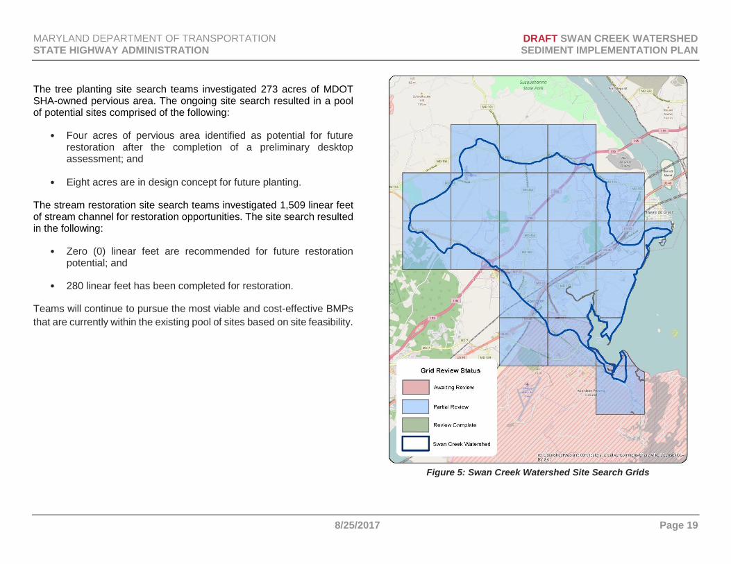
Figure 5 illustrates the 1.5 mile grid system for the Swan Creek watershed.
Field Investigations
Phase two is a field investigation of each viable site resulting from the watershed desktop evaluation. MDOT SHA inspects and assesses each site in the field to identify and document existing site conditions, water quality problems, and constraints. This information is used to determine potential restoration BMP types as well as estimated restoration credit quantities.
MDOT SHA will continue to prioritize visual inspections in the highest need watersheds. Figure 1 is an example field investigation summary map that documents observations from the field analysis. A standardized field inspection form is used.

MARYLAND DEPARTMENT OF TRANSPORTATION DRAFT SWAN CREEK WATERSHED STATE HIGHWAY ADMINISTRATION SEDIMENT IMPLEMENTATION PLAN
08/25/2017 Page 5
D. BENCHMARKS AND DETAILED COSTS
Benchmarks and deadlines demonstrating progress toward meeting all applicable stormwater WLAs are provided in the watershed discussion in Section F. It contains generalized cost information that includes an
overall estimated cost to implement the proposed practices. Detailed costs for specific construction projects are available on SHA’s website (www.roads.maryland.gov) under the Contractors Information Center.

MARYLAND DEPARTMENT OF TRANSPORTATION DRAFT SWAN CREEK WATERSHED STATE HIGHWAY ADMINISTRATION SEDIMENT IMPLEMENTATION PLAN
08/25/2017 Page 6
Figure 1: Example Field Investigation Summary Map

MARYLAND DEPARTMENT OF TRANSPORTATION DRAFT SWAN CREEK WATERSHED STATE HIGHWAY ADMINISTRATION SEDIMENT IMPLEMENTATION PLAN
8/25/2017 Page 7
E. POLLUTION REDUCTION STRATEGIES
E.1. MDOT SHA TMDL Responsibilities
TMDLs define the maximum pollutant loading that can be discharged to a waterbody and still meet water quality criteria for maintaining designated uses. Figure 2 illustrates the concept of maximum loading. The green area on the bar depicts the maximum load that maintains a healthy water environment for the pollutant under consideration. When this load is exceeded, the waterway is considered impaired as illustrated by the red portion of the bar. The example waterway needs restoration through implementation of practices to reduce the pollutant loading to or below the TMDL.
Generally, the formula for a TMDL is:
TMDL = ∑WLA + ∑LA + MOS
Where:
TMDL = total maximum daily load WLA = wasteload allocation for point sources; LA = load allocation for non-point sources; and MOS = margin of safety.
Figure 2: Example TMDL and Reduction Requirement
Pollutants for MDOT SHA Focus
Upon issuance of the MS4 Permit, MDOT SHA was named in TMDLs for five different pollutants within the MS4 coverage area including
Bacteria,
PCBs,
Phosphorus,
Sediment, and
Trash.
The MDOT SHA MS4 Permit covers eleven Maryland counties that cross 84 8-digit watersheds representing larger rivers or streams. There are 43 EPA-approved TMDL documents that assign MDOT SHA to either an individual WLA or an aggregate WLA. Each watershed may be covered by one or more TMDL documents, so there is not a direct correlation between the number of TMDL documents and the number of watersheds affected.

MARYLAND DEPARTMENT OF TRANSPORTATION DRAFT SWAN CREEK WATERSHED STATE HIGHWAY ADMINISTRATION SEDIMENT IMPLEMENTATION PLAN
8/25/2017 Page 8
Figure 3 shows a map of MDOT SHA TMDL responsibilities by watershed. Table 2 on the following page summarizes MDOT SHA’s sediment reduction requirement and projected progress in meeting the pollution reduction wasteload target within Swan Creek watershed by the listed end date. There are instances where the projected modeled percent reduction does not equal the target percent reduction by the end date listed. In these cases, discussion is added to the reduction strategy Section E to analyze the conditions that preclude MDOT SHA from meeting the target reductions with currently available modeling methods, loading, reduction efficiencies, or practices.
Lists of proposed practices and costs to achieve the required reductions are included in Section F.
Modeling Parameters
MDE requires that pollutant modeling follow the guidance in MDE 2014a and if other methods are employed, they must be approved by MDE. MDOT SHA developed a restoration modeling protocol that describes the methods used for modeling pollutant load reductions for local TMDLs with MDOT SHA responsibility. This protocol was submitted to MDE as an appendix with the MDOT SHA MS4 2016 Annual Report. Once approved, this protocol will be available on the MDOT SHA website.
Different modeling methods are used depending upon the pollutants and current reduction practices in use. Brief descriptions of modeling
methods are included in the following section, but the MDOT SHA restoration modeling protocol should be consulted for a more detailed explanation.
Aggregated Loads
WLAs may be assigned to each MS4 jurisdiction separately or as an aggregated WLA for all urban stormwater MS4 permittees that combines them into one required allocation and reduction target. The modeling approach developed by MDOT SHA uses MDOT SHA data (both impervious and pervious land as well as BMPs built before the TMDL baseline year, also known as baseline BMPs) to calculate baseline loads and calibrated reduction targets. Following this approach, disaggregation is done for each TMDL.
Available Reduction Practices
MDOT SHA reserves the right to implement new BMPs, activities, and other practices that are not currently available to achieve local TMDL load reduction requirements. In the future, expert panels may be convened to study the effectiveness of new or modified BMPs on pollutants. MDOT SHA will modify reduction strategies as necessary based on new, approved treatment guidance, and will include revised strategies in updates to this implementation plan.

MARYLAND DEPARTMENT OF TRANSPORTATION DRAFT SWAN CREEK WATERSHED STATE HIGHWAY ADMINISTRATION SEDIMENT IMPLEMENTATION PLAN
8/25/2017 Page 9
Figure 3: MDOT SHA TMDL Responsibilities in Local Watersheds

MARYLAND DEPARTMENT OF TRANSPORTATION DRAFT SWAN CREEK WATERSHED STATE HIGHWAY ADMINISTRATION SEDIMENT IMPLEMENTATION PLAN
8/25/2017 Page 10
Table 2: MDOT SHA Swan Creek Watershed Sediment Modeling Results
Watershed Name Watershed Number County Pollutant EPA
Approval Date
WLA Type Baseline
Year Unit
MDOT SHA
Baseline Load
MDOT SHA %
Reduction Target
MDOT SHA
Reduction Target
MDOT SHA WLA
Projected Reduction
to be Achieved
Projected Reduction
to be Achieved as a % of Baseline
Load
Target Year
Swan Creek 02130706 HA Sediment 09/30/2016 Aggregate by County
2010 Lbs./yr. 60,575 13.0% 7,875 52,701 6,785.0 11.2 2030
E.2 Sediment Pollution Reduction Strategy
E.2.a. Sediment TMDLs Affecting MDOT SHA
There are 17 EPA-approved sediment TMDLs with MDOT SHA responsibility that MDOT SHA has already addressed in previous implementation plans. The following is a list of TMDL documents for sediment with MDOT SHA responsibility that are addressed with this plan:
Total Maximum Daily Load of Sediment in the Swan Creek Watershed, Harford County, Maryland, approved by EPA September 30, 2016
In Table 2, the MDOT SHA reduction target for the Swan Creek
sediment TMDL is 13 percent, or 7,875 lbs./yr. The watershed can safely receive 52,701 pounds of sediment by MDOT SHA on a yearly basis without being considered impaired. Currently, it is calculated that MDOT SHA is responsible for introducing 60,575 pounds per year of sediment into the watershed per the MDE TMDL document as a MS4 permittee. Thus, according to the definition of the TMDL, MDOT SHA has to reduce its load by 7,875 pounds to meet its healthy load, WLA, of 52,701 pounds per year. MDOT SHA’s reduction target is found by
multiplying the MDOT SHA baseline load by the MDOT SHA Reduction target percent. The MDOT SHA WLA is found by subtracting the MDOT SHA baseline load by the MDOT SHA target load. The projected reduction achieved is found by modeling the sediment load reduction that will be experienced by the construction of current and future BMPs in the Swan Creek watershed. These BMPs are either currently under construction or are planned to be constructed in the future. It is estimated that these future BMPs will reduce sediment loading by 6,785 pounds to the watershed. The reduction to be achieved expressed as a percent is found by dividing the projected reduction to be achieved by the MDOT SHA Baseline Load.
Three dates are shown: the EPA approval date, the baseline year set by MDE, and the Target Year. The baseline year published on the MDE Data Center will be used for MDOT SHA’s implementation planning. This usually correlates to the time-period when monitoring data was collected for MDE’s TMDL analysis. The Target Year is the year MDOT SHA proposes to meet the WLA.
E.2.b. Sediment Sources
Discussions in the TMDL concerning sediment sources focus on types of land use with information derived from the Chesapeake Bay Watershed Model (CBWM). Cropland and regulated urban lands tend
MARYLAND DEPARTMENT OF TRANSPORTATION DRAFT SWAN CREEK WATERSHED STATE HIGHWAY ADMINISTRATION SEDIMENT IMPLEMENTATION PLAN
8/25/2017 Page 11
to be the most significant sources, followed by other agricultural uses and wastewater sources. Specific sources of each pollutant that could be useful for targeting controls are not included in the TMDL, but MDOT SHA researched a number of other references and determined sources beyond land uses that are summarized in Table 3. Sources of sediment
include surface erosion from construction sites and cropland as well as stream erosion from high flows during storm events.
Table 3: Sediment Sources from Various References
Land Use Nutrient Sources Sediment Sources
Agriculture Chemical Fertilizer Manure
Soil Erosion
Urban
Pet Waste Lawn Fertilizer Parking Lot, Roof, and Street Runoff
Construction Erosion Parking Lot, Roof, and Street Runoff
Wastewater
Municipal Industrial Failed Septic Systems CSO/ SSO Leaking Sewers
Natural Atmospheric Deposition Stream Erosion Shoreline Erosion
References used to develop the table are MDE, 2014b; EPA, 2010b; Hoos et al., 2000; and Schueler, 2011.
MDOT SHA Loading Sources
MDOT SHA-owned land is a small portion of each of the TMDL watersheds and it consists of relatively uniform land uses including roadways and roadside vegetation. In urbanized areas, the MDOT SHA ROW may extend to include sidewalks and portions of driveways. There are also parking areas associated with MDOT SHA land such as park and ride facilities, office complexes, and maintenance facilities.
Of the land uses in Table 3, MDOT SHA is a contributor of sediments mostly through urban and natural sources. MDOT SHA has no responsibility for agriculture and wastewater sources, other than a few septic systems at outlying facilities. Street and parking lot runoff concentrates pollutants from adjacent land and from atmospheric deposition attributed to both the airshed and vehicles. Deteriorating streets themselves can be a source of sediment. Construction erosion, even with well-maintained erosion and sediment control (ESC), is a source of sediment in urban areas. Stream erosion downstream of MDOT SHA facilities, particularly older areas without SWM, is a potential source of sediment.
E.2.c. MDOT SHA Sediment Modeling Methods
Sediment TMDLs were developed using the CBWM with edge of stream (EOS) loading rates. Throughout the years, different versions of the Bay model have been used (as indicated in Table 4) depending upon which
version was active at the time the TMDL was written. The Bay model combines a suite of individual models, including a watershed model that calculates pollutant loads from point sources and runoff, an air deposition model, and an estuary model that estimates pollutant concentrations based on loading, hydrodynamics of the estuary, and pollutant transformations in the Bay.
To effectively model sediment reduction at the EOS condition MDOT SHA developed the Automated Modeling Tool (AMT) that uses scripts within a Geographical Information System (GIS) to extract BMP treatment data from multiple sources and then apply algorithms derived from MAST and MDE guidance documents to calculate loads and load reductions.

MARYLAND DEPARTMENT OF TRANSPORTATION DRAFT SWAN CREEK WATERSHED STATE HIGHWAY ADMINISTRATION SEDIMENT IMPLEMENTATION PLAN
8/25/2017 Page 12
Baseline Loading for Sediments
The baseline load for sediment in Swan Creek represents the approximate quantity of sediment that was being discharged by a given entity at the time the TMDL monitoring began in the watershed. If the baseline load exceeds the WLA, the waterway is considered impaired and the baseline loads must be reduced to or below the WLA in order to restore the designated uses for the waterway (see Table 1).
For MDOT SHA modeling, baseline loads have been calculated in two steps: first, to model the untreated load, and next, to apply treatment as of the baseline year for each TMDL. Untreated baseline loads were modeled by multiplying MDOT SHA pervious and impervious acres in each land-river segment using MDOT SHA spatial data with loading rates calculated at the land-river segment scale from a No-BMP scenario in MAST. Loading rates are described in further detail below. Load reductions from baseline BMPs were calculated from MDOT SHA database information, then applied to the untreated load to determine treated baseline load
Table 4: Sediment TMDL Watersheds and Bay Model Versions
TMDL Watershed Pollutant TMDL Model
Antietam Creek Sediment CBP P5
Bynum Run Sediment CBP P5.2
Cabin John Creek Sediment CBP P5.2
Catoctin Creek Sediment CBP P5
Conococheague Creek Sediment CBP P5
Gwynns Falls Sediment CBP P5
Jones Falls Sediment CBP P5
Table 4: Sediment TMDL Watersheds and Bay Model Versions
TMDL Watershed Pollutant TMDL Model
Liberty Reservoir Sediment
Refined version of the CBP P5.3.2 watershed model, with CE-QUAL-W2 model of the reservoir
Little Patuxent River Sediment CBP P5
Patapsco LN Branch Sediment CBP P5
Patuxent River Upper Sediment CBP P5.2
Potomac River MO County
Sediment CBP P5.2
Rock Creek Sediment CBP P5.2
Seneca Creek Sediment CBP P5.2
Swan Creek Sediment CBP P5.3.2
Sediment Pollutant Loading Rates by Land Use
Loading rates for sediment have been calculated at the most detailed level feasible: the land-river segments from the Chesapeake Bay model / MAST v5.3.2. Untreated loads and acres, per land-river segment, were derived from a No BMPs scenario in MAST at the Maryland statewide geographic scale using 2010 to correspond with MDOT SHA’s as-of date for land use.
Sediment Reduction Requirements
The model uses a percent reduction target for MDOT SHA published in the TMDL document. The percent reduction target is compared to the projected reduction to be achieved modeled from the implementation of restoration BMPs. This method assumes sediment is a conservative pollutant, and that loads exported from the watershed will approximate
MARYLAND DEPARTMENT OF TRANSPORTATION DRAFT SWAN CREEK WATERSHED STATE HIGHWAY ADMINISTRATION SEDIMENT IMPLEMENTATION PLAN
8/25/2017 Page 13
the loads in the waterbody, without significant loss or degradation in transport.
Pollutant Reduction Planning Scenarios
For planning and reporting purposes, MDOT SHA needs to be able to
track implementation status against the permit and TMDL goals. Status
is based on progress in planning, design, and construction of structural,
ESD, and alternative BMPs, including operational practices such as inlet
cleaning. This information is stored in databases with the project
development status identified as completed, under construction or in-
design for each restoration BMPs. This allows MDOT SHA to assess
pollutant reduction progress in near real time and plan BMPs needed to
meet the remaining reduction goal. The database queries status and
built dates allowing MDOT SHA to group the amount of unit treatment
based on project phase:
Completed BMPs: Queries TMDL geospatial database using statuses that depict a functioning, built site.
Under Construction or Design: Queries TMDL geospatial database using statuses that depict sites currently in design and construction phases.
Future BMPs: Determined through a query that evaluates the delta between existing and programmed BMP projects compared to estimates for planned projects derived from the non-spatial Task Management Access database, which would prevent over counting.
Sediment Reduction Modeling
The outcome / output of the automated modeling process is the creation of a series of data tables which are imported into Excel workbooks. The output is essentially a list of every BMP within MDOT SHA’s databases and the summary of total reductions (nutrients and sediments) for each
individual BMP generated on demand. The amount of pollutant removal attributed to each BMP type is calculated within the AMT based on the procedures described below.
For each BMP facility where impervious/pervious loading rates are used, pollutant reduction is calculated by determining the removal in pounds per unit. The logic uses lookup tables to multiply loading rate by BMP efficiency and area of treatment:
Step 1: Calculate Load Removed for Each BMP and Land Use:
1A. Look up specific land use (impervious/pervious) loading rates for TN EOS/DEL, TP EOS/DEL, and TSS EOS/DEL from LOADING RATE LOOKUP TABLE
1B. Derive or look up BMP efficiency rates for each BMP based on each individual BMP type
1C. Multiply loading rates by BMP efficiency rates to find removal in lb./unit of each BMP within the specific county or-watershed
Step 2: Calculate Pollutant Pounds Removed by Each BMP
2A. Multiply removal lb./unit calculated in 1C by the BMP impervious/pervious area treated
For load reduction BMPs such as streams, outfall stabilizations, inlet cleaning, and street sweeping, the model uses project specific data when available, and rates provided by MDE 2014a for planning level data.
Step 3: Extract Data for Filtering Results
3A. Extract Built Date, Status, County, and other MDOT SHA operational fields
The AMT will be used to plan reduction scenarios and to track progress. Although this is a custom model, it draws on BMP efficiencies, loading rates and delivery factors from MDE (2014a), Maryland Assessment Scenario Tool (MAST), and published CBP BMP protocols. It is also based on CBP loading rates by land-river segment for EOS loads and

MARYLAND DEPARTMENT OF TRANSPORTATION DRAFT SWAN CREEK WATERSHED STATE HIGHWAY ADMINISTRATION SEDIMENT IMPLEMENTATION PLAN
8/25/2017 Page 14
can calculate reductions from different practices using the removal rates from Table 6 of MDE 2014a.
E.2.d. Sediment Reduction Strategies
To date, MDOT SHA has used a variety of structural, non-structural, and alternative BMPs in an effort to reduce sediment in the watersheds that have a corresponding TMDL. However, we have not limited our load reduction activities to just BMP implementation. The use of nutrient credit trading will also be explored as a tool in reaching load reduction targets. When MDOT SHA partners on projects with other MS4 jurisdictions, load splitting can be used as a means to achieve WLA reductions.
BMP Implementation
As a requirement under the MS4 permit, MDOT SHA must complete the implementation of restoration efforts for 20 percent of its impervious surface area. MDOT SHA has an extensive program to plan, design, and construct BMPs that offset untreated impervious surfaces in MDOT SHA ROW.
MDOT SHA intends to build these BMPs used for impervious restoration in watersheds that have a TMDL where possible. The AMT is then used to model the load reduction from implementation of currently constructed BMPs and BMPs planned in the future. The AMT also assesses the impact that these BMPs will have on meeting TMDL load reductions as a percent achieved.
One of the major challenges with using a strategy of building BMPs to meet WLAs is that there can be a lack of feasible ROW for BMP placement opportunities. There are instances where MDOT SHA roadway encompasses a majority of the area in the ROW leaving very little land to construct BMPs. The visual watershed inspection process has indicated areas where BMP placement is possible and where it is
not feasible due to utility relocation, land purchases, site access problems, and a host of other issues. Therefore, MDOT SHA is continually seeking new opportunities and partnerships to install BMPs.
Nutrient Credit Trading
In an effort to meet the MDOT SHA WLA in watersheds with a high difficulty of BMP placement, MDOT SHA is exploring the possibility of nutrient credit trading. It is expected that MS4 jurisdictions will have the ability to purchase pounds of phosphorus, nitrogen, and sediment in a quantity that will allow them to reach their intended WLA. Once the trading program, regulations and guidance are finalized and approved by EPA, MDOT SHA intends to utilize this program as another practice to meet TMDL requirements.
Load Splitting
MDOT SHA is partnering with other willing NPDES permittees to complete programs or projects that will reduce sediment. The goal is to produce projects that will have a WLA reduction and move each permittee closer to meeting its load reduction requirement. An agreement on how the credit pounds of sediment is split will be project specific.
TMDL End Date
Currently, MDOT SHA models BMP implementation using the AMT and notes the progress towards reduction targets in Table 2. In this model, MDOT SHA considers the possible restoration practices that can be placed in the watershed based on the visual watershed inspection process. For Swan Creek, MDOT SHA believes that it will be able to reach a MDOT SHA Percent Reduction Target of 11.2 percent by 2030. The required MDOT SHA Percent Reduction target is 13.0 percent. Thus, MDOT SHA will have to explore the possibility of nutrient credit trading or load splitting efforts, which cannot be modeled at this time.

MARYLAND DEPARTMENT OF TRANSPORTATION DRAFT SWAN CREEK WATERSHED STATE HIGHWAY ADMINISTRATION SEDIMENT IMPLEMENTATION PLAN
8/25/2017 Page 15
MDOT SHA will review any future changes to current BMP removal rates or efficiencies presented in MDE 2014a and determine what effect a change will have on the Swan Creek watershed TMDL end date.

MARYLAND DEPARTMENT OF TRANSPORTATION DRAFT SWAN CREEK WATERSHED STATE HIGHWAY ADMINISTRATION SEDIMENT IMPLEMENTATION PLAN
8/25/2017 Page 16
PAGE INTENTIONALLY LEFT BLANK
MARYLAND DEPARTMENT OF TRANSPORTATION DRAFT SWAN CREEK WATERSHED STATE HIGHWAY ADMINISTRATION SEDIMENT IMPLEMENTATION PLAN
8/25/2017 Page 17
F. SWAN CREEK WATERSHED IMPLEMENTATION PLAN
F.1. Watershed Description The Swan Creek watershed encompasses 26 square miles solely within Harford County, and is comprised of both non-tidal and tidal waters. The watershed drains into Swan Creek, which is located approximately four miles south of where the Susquehanna River drains into the Chesapeake Bay. The lower portion of Swan Creek is a small, shallow tidal embayment that drains into the Chesapeake Bay. While predominantly situated within Maryland’s Piedmont geologic province, the lower portion of the Swan Creek watershed extends slightly into the Coastal Plain province. Major tributary creeks and streams of the Swan Creek watershed include Gasheys Creek, Swan Creek, and Carsins Run.
There are 29 centerline miles of MDOT SHA roadway located within the Swan Creek watershed. The associated ROW encompasses 252 acres, of which 142 acres are impervious. There is one (1) MDOT SHA park and ride facility located within the Swan Creek watershed. See Figure 4 for a map of MDOT SHA facilities within the Swan Creek watershed.
F.2. MDOT SHA TMDLs within Swan Creek Watershed
MDOT SHA is included in the sediment TMDL (MDE, 2016b) and has a reduction requirement of 13 percent within Harford County, as shown in Table 2. This TMDL only applies to the non-tidal portion of the Swan Creek watershed.
F.3. MDOT SHA Visual Inventory of ROW
The MS4 permit requires MDOT SHA to perform visual assessments. Section C describes the MDOT SHA visual assessment process. The implementation teams are currently evaluating grids in the watershed and will continue to do so until all are completed and accepted. The grid-tracking tool was developed to help teams efficiently search each watershed on a 1.5 x 1.5-square-mile system as shown in Figure 5. Planning efforts will continue and will be centered on areas with local TMDL needs that have been identified using the site search grid-tracking tool.
Many of the grids awaiting review have little potential for additional restoration due to minimal ROW along residential and wooded areas, which limits the ability to purchase ROW for the construction of a new BMP. Additionally, many MDOT SHA impervious areas within these grids are already treated by MDOT SHA BMPs. The current results of this ongoing grid search are as follows:
19 Total Grids:
• 19 partially reviewed.
The new stormwater site search resulted in a pool of potential sites comprised of the following:
• 245 locations identified as possible candidates for new stormwater BMPs;
• 225 facilities have been recommended for restoration after the completion of a preliminary desktop assessment; and
• 20 facilities remain on hold for roadway construction projects.

MARYLAND DEPARTMENT OF TRANSPORTATION DRAFT SWAN CREEK WATERSHED STATE HIGHWAY ADMINISTRATION SEDIMENT IMPLEMENTATION PLAN
8/25/2017 Page 18
Figure 4: Swan Creek Watershed
MARYLAND DEPARTMENT OF TRANSPORTATION DRAFT SWAN CREEK WATERSHED STATE HIGHWAY ADMINISTRATION SEDIMENT IMPLEMENTATION PLAN
8/25/2017 Page 19
The tree planting site search teams investigated 273 acres of MDOT SHA-owned pervious area. The ongoing site search resulted in a pool of potential sites comprised of the following:
• Four acres of pervious area identified as potential for future restoration after the completion of a preliminary desktop assessment; and
• Eight acres are in design concept for future planting.
The stream restoration site search teams investigated 1,509 linear feet of stream channel for restoration opportunities. The site search resulted in the following:
• Zero (0) linear feet are recommended for future restoration potential; and
• 280 linear feet has been completed for restoration.
Teams will continue to pursue the most viable and cost-effective BMPs
that are currently within the existing pool of sites based on site feasibility.
Figure 5: Swan Creek Watershed Site Search Grids
MARYLAND DEPARTMENT OF TRANSPORTATION DRAFT SWAN CREEK WATERSHED STATE HIGHWAY ADMINISTRATION SEDIMENT IMPLEMENTATION PLAN
8/25/2017 Page 20
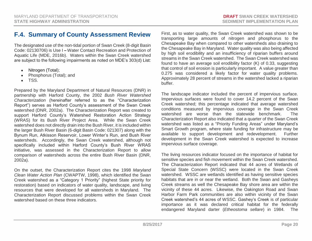
F.4. Summary of County Assessment Review
The designated use of the non-tidal portion of Swan Creek (8-digit Basin Code: 02130706) is Use I – Water Contact Recreation and Protection of Aquatic Life (MDE, 2016b). Waters within the Swan Creek watershed are subject to the following impairments as noted on MDE’s 303(d) List:
Nitrogen (Total);
Phosphorus (Total); and
TSS.
Prepared by the Maryland Department of Natural Resources (DNR) in partnership with Harford County, the 2002 Bush River Watershed Characterization (hereinafter referred to as the “Characterization Report”) serves as Harford County’s assessment of the Swan Creek watershed (DNR, 2002a). The Characterization Report was created to support Harford County’s Watershed Restoration Action Strategy (WRAS) for its Bush River Project Area. While the Swan Creek watershed does not directly drain into the Bush River, it is included within the larger Bush River Basin (6-digit Basin Code: 021307) along with the Bynum Run, Atkisson Reservoir, Lower Winter’s Run, and Bush River watersheds. Accordingly, the Swan Creek watershed, although not specifically included within Harford County’s Bush River WRAS initiative, was assessed in the Characterization Report to allow comparison of watersheds across the entire Bush River Basin (DNR, 2002a). On the outset, the Characterization Report cites the 1998 Maryland Clean Water Action Plan (CWAPTW, 1998), which identified the Swan Creek watershed as a “Category 1 Priority” (highest State priority for restoration) based on indicators of water quality, landscape, and living resources that were developed for all watersheds in Maryland. The Characterization Report discussed problems within the Swan Creek watershed based on these three indicators.
First, as to water quality, the Swan Creek watershed was shown to be transporting large amounts of nitrogen and phosphorus to the Chesapeake Bay when compared to other watersheds also draining to the Chesapeake Bay in Maryland. Water quality was also being affected by high soil erodibility and an insufficiency of riparian buffers around streams in the Swan Creek watershed. The Swan Creek watershed was found to have an average soil erodibility factor (K) of 0.33, suggesting that control of soil erosion is particularly important. A value greater than 0.275 was considered a likely factor for water quality problems. Approximately 28 percent of streams in the watershed lacked a riparian buffer.
The landscape indicator included the percent of impervious surface. Impervious surfaces were found to cover 14.2 percent of the Swan Creek watershed; this percentage indicated that average watershed conditions measured by impervious coverage in the Swan Creek watershed are worse than the statewide benchmark. The Characterization Report also indicated that a quarter of the Swan Creek watershed was listed as a “Priority Funding Areas” under Maryland’s Smart Growth program, where state funding for infrastructure may be available to support development and redevelopment. Further development in the Swan Creek watershed is expected to increase impervious surface coverage.
The living resources indicator focused on the importance of habitat for sensitive species and fish movement within the Swan Creek watershed. The Characterization Report indicated that 44 acres of Wetlands of Special State Concern (WSSC) were located in the Swan Creek watershed. WSSC are wetlands identified as having sensitive species habitats that are in or near the wetland. Both the Swan and Gasheys Creek streams as well the Chesapeake Bay shore area are within the vicinity of these 44 acres. Likewise, the Oakington Road and Swan Harbor Farm Park communities are also within vicinity of the Swan Creek watershed’s 44 acres of WSSC. Gashey’s Creek is of particular importance as it was declared critical habitat for the federally endangered Maryland darter (Etheostoma sellare) in 1984. The

MARYLAND DEPARTMENT OF TRANSPORTATION DRAFT SWAN CREEK WATERSHED STATE HIGHWAY ADMINISTRATION SEDIMENT IMPLEMENTATION PLAN
8/25/2017 Page 21
Characterization Report also discusses how blockages in the watershed’s streams can inhibit or prevent some fish species from moving up stream to otherwise viable habitat. The structural components of lakes, farm ponds, or drainage ditches are often a cause of these blockages (DNR, 2002a). The DNR Fish Passage Program identified fish blockages at seven sampling stations in the Swan Creek watershed (See Table 5). Mitigation or removal of blockages to fish movement is recommended as many fish species need the ability to move between stream segments to maintain healthy, resilient populations (DNR, 2002a).
Overall, Harford County and DNR suggested several BMPs for the Bush River Basin in the Characterization Report; however, no recommendations specific to the Swan Creek watershed were made except for the aforementioned fish blockage removal opportunities listed in Table 5. General recommendations included incorporating “Green
Infrastructure” (areas of natural vegetation and habitat that have statewide or regional importance as defined by criteria developed by
DNR) and the habitat needs of sensitive forest interior dwelling species into local land use planning and management; encouraging the use of agricultural BMPs and conservation programs; and conducting stream buffer and wetland restorations (DNR, 2002a).
F.5. MDOT SHA Pollutant Reduction Strategies Proposed practices to meet the sediment reduction in the Swan Creek watershed are shown in Table 6. Projected sediment reductions using these practices are described in Section E and shown in Table 2. Three
timeframes are included in the table below:
BMPs built before the TMDL baseline. In this case, the baseline is 2010;
BMPs built after the baseline through fiscal year 2017; and
BMPs built after fiscal year 2017 through 2030, the projected target date. MDOT SHA will accomplish the projected reduction to be achieved as a percent of the baseline load presented in Table 2. The reduction is not expected to meet MDE’s 13 percent load reduction requirement.
Estimated Capital Budget costs to design and construct practices within the Swan Creek watershed total $ 5,910,000. These projected costs are based on an average cost per impervious acre treated that is derived from cost history for a group of completed projects for each BMP category. Figure 6 shows a map of MDOT SHA’s restoration practices in the watershed and includes those that are under design or construction. Inlet cleaning is not reflected on this map.
Table 5: County Identified Fish Blockages / Removal Opportunities in the Swan Creek Watershed
Station Stream Name / Location
CW010 Gasheys Creek 0.2 mile below Chapel Road
CW011 Gasheys Creek Chapel Road
CW030 Swan Creek 0.1 mile above Rt. 40
CW031 Swan Creek 100 ft. above Oak Street
CW032 Swan Creek 130 yards above Oak Street
CW063 Unnamed Tributary to
Gasheys Creek
0.33 mile below Chapel Road
CW064 Unnamed Tributary to
Gasheys Creek
Chapel Road
Source: DNR (2002a)

MARYLAND DEPARTMENT OF TRANSPORTATION DRAFT SWAN CREEK WATERSHED STATE HIGHWAY ADMINISTRATION SEDIMENT IMPLEMENTATION PLAN
8/25/2017 Page 22
Table 6: Swan Creek Sediment BMP Implementation
BMP Unit Baseline
(Before 2010)
Restoration BMPs
Cost Progress
(2010 – FY17)
Future
(After FY17)
New Stormwater drainage area acres 12.4 30.5 $5,542,000
Tree Planting acres of tree planting 1.3 8.1 $339,500
Inlet Cleaning1 tons 5.0 $28,500
1 Inlet cleaning is an annual practice.

MARYLAND DEPARTMENT OF TRANSPORTATION DRAFT SWAN CREEK WATERSHED STATE HIGHWAY ADMINISTRATION SEDIMENT IMPLEMENTATION PLAN
8/25/2017 Page 23
Figure 6: MDOT SHA Restoration Strategies within the Swan Creek Watershed

MARYLAND DEPARTMENT OF TRANSPORTATION DRAFT SWAN CREEK WATERSHED STATE HIGHWAY ADMINISTRATION SEDIMENT IMPLEMENTATION PLAN
8/25/2017 Page 24
PAGE INTENTIONALLY LEFT BLANK

MARYLAND DEPARTMENT OF TRANSPORTATION DRAFT SWAN CREEK WATERSHED STATE HIGHWAY ADMINISTRATION SEDIMENT IMPLEMENTATION PLAN
8/25/2017 Page A-1
ABBREVIATIONS AA Anne Arundel (County)
AA-DPW Anne Arundel County, Department of Public Works
AAH Adopt-A-Highway
AASHTO American Association of State Highway and Transportation Officials
ac Acre
AFB Air Force Base
Alt Alternative
AMT Automated Modeling Tool
AMT, Inc. A. Morton Thomas and Associates, Inc.
ATV All-terrain vehicle
BA Baltimore (County)
BARC Beltsville Agriculture Research Center
Bay Chesapeake Bay
BBO Beaverdam Run, Baisman Run, and Oregon Branch Subwatersheds of the Loch Raven Reservoir Watershed
BC-DEPRM Baltimore County, Department of Environmental Protection and Resource Management
BC-DEPS Baltimore County, Department of Environmental Protection and Sustainability
BIBI Benthic Index of Biotic Integrity
BMP Best Management Practice
BOD Biochemical Oxygen Demand
BSID Biological Stressor Identification
BST Bacterial Source Tracking
CAFO Concentrated Animal Feeding Operation
CBP Chesapeake Bay Program
CBWM Chesapeake Bay Watershed Model
CC Charles (County)
CC-BRM Carroll County, Bureau of Resource Management
CC-DPGM Charles County, Department of Planning & Growth
CCMS Customer Care Management System
CFR Code of Federal Regulations
CIP Capital Improvement Project
CL Carroll (County)
CRP Community Reforestation Program
CSN Chesapeake Stormwater Network
CSO Combined Sewer Overflow
CTP Consolidated Transportation Program
CWA Clean Water Act
CWAPTW Clean Water Action Plan Technical Workgroup
CWP Center for Watershed Protection
DC District of Columbia
DO Dissolved Oxygen
DEL Delivered Loads
DMCF Dredged Material Containment Facilities
DNR Maryland Department of Natural Resources
DRMO Defense Reutilization and Marketing Office
ECD Environmental Compliance Division (MDOT SHA)
E. coli Escherichia coli
ED Extended Detention
EMC Event Mean Concentration
EMS Environmental Management System
EOS Edge of Stream

MARYLAND DEPARTMENT OF TRANSPORTATION DRAFT SWAN CREEK WATERSHED STATE HIGHWAY ADMINISTRATION SEDIMENT IMPLEMENTATION PLAN
8/25/2017 Page A-2
EPA United States Environmental Protection Agency
EPD Environmental Programs Division
ESC Erosion and Sediment Control
ESD Environmental Site Design
FC Fecal Coliform
FC-DPW Frederick County, Division of Public Works
FEMA Federal Emergency Management Administration
FIB Fecal Indicator Bacteria
FIBI Fish Index of Biotic Integrity
FMD Facility Maintenance Division (MDOT SHA)
FR Frederick (County)
FY Fiscal Year
GIS Geographic Information System
HA Harford (County)
HC-DPW Harford County, Department of Public Works
HO Howard (County)
HUC Hydrologic Unit Code
HWG Horsley Witten Group, Inc.
ICPRB Interstate Commission on the Potomac River Basin
IDDE Illicit Discharge Detection and Elimination
ISWBMPDB International Stormwater BMP Database
LA Load Allocations
lbs Pounds (weight)
LF Linear Feet
LN Lower North
LNB Lower North Branch
LRE Loch Raven East subwatershed
LJF Lower Jones Falls (Watershed)
LU Land Use
MAA Maryland Aviation Administration
MAST Maryland Assessment Scenario Tool
MC-DEP Montgomery County, Department of Environmental Protection
MD Maryland
MDA Maryland Department of Agriculture
MDE Maryland Department of the Environment
MDOT Maryland Department of Transportation
MDP Maryland Department of Planning
MEP Maximum Extent Practicable
MEPA Maryland Environmental Policy Act
MGF Middle Gwynns Falls (Watershed)
MO Montgomery (County)
MOS Margin of Safety
MPR Maximum Practicable Reduction
MS4 Municipal Separate Storm Sewer System
NBOD Nitrogenous Biochemical Oxygen Demand
NEPA National Environmental Policy Act
NFHL National Flood Hazard Layer
NJF Northeastern Jones Falls (Watershed)
NPDES National Pollutant Discharge Elimination System
NSQD National Stormwater Quality Database
OCRI Office of Customer Relations and Information (MDOT SHA)
OED Office of Environmental Design
OOM Office of Maintenance (MDOT SHA)
OP Orthophosphate

MARYLAND DEPARTMENT OF TRANSPORTATION DRAFT SWAN CREEK WATERSHED STATE HIGHWAY ADMINISTRATION SEDIMENT IMPLEMENTATION PLAN
8/25/2017 Page A-3
OPPE Office of Preliminary Planning and Engineering
PACD Pennsylvania Association of Conservation Districts
PB Parsons Brinckerhoff
PCB Polychlorinated Biphenyl
PE Rainfall Target Used To Size ESD Practices
PERC Perchloroethylene
PG Prince George’s (County)
PGC-DoE Prince George’s County, Department of the Environment
RBP Rapid Bioassessment Protocol
RGP Regional General Permit
ROW Rights-Of-Way
Reqd Required
RR Runoff Reduction
RSPSC Regenerative Step Pool System Conveyance
SAH Sponsor-A-Highway
SB Spring Branch subwatershed
SCA Stream Corridor Assessment
SFEI San Francisco Estuary Institute
SGW Submerged Gravel Wetlands
SHA State Highway Administration
SPR State Planning and Research
SSO Sanitary Sewer Overflow
ST Stormwater Treatment
SW Stormwater
SWAP Small Watershed Action Plan
SWM Stormwater Management
SWS Subwatershed
SW-WLA Stormwater Wasteload Allocation
TBD To Be Determined
TBR Tidal Back River (Watershed)
TBS To Be Specified
TCWG Toxic Contaminants Work Group
TMDL Total Maximum Daily Load
TN Total Nitrogen
TP Total Phosphorus
tPCB Total Polychlorinated Biphenyl
TSS Total Suspended Solids
TWGCB Toxics Work Group Chesapeake Bay Partnership
UBR Upper Back River (Watershed)
UGF Upper Gwynns Falls (Watershed)
UJF Upper Jones Falls (Watershed)
US United States
USACE United States Army Corps of Engineers
USDA-NRCS
U United States Department of Agriculture,
Natural Resources Conservation Service
USGS U United States Geological Survey
USWG Urban Stormwater Work Group
WA Washington (County)
WC-DPW Washington County, Division of Public Works
WCSCD Washington County Soil Conservation District
WIP Watershed Implementation Plan
WLA Wasteload Allocation
WPD Water Programs Division
WQLS Water Quality Limited Segment
WQSs Water Quality Standards

MARYLAND DEPARTMENT OF TRANSPORTATION DRAFT SWAN CREEK WATERSHED STATE HIGHWAY ADMINISTRATION SEDIMENT IMPLEMENTATION PLAN
8/25/2017 Page A-4
WQv Water Quality Volume
WQGIT Water Quality Goal Implementation Team
WRAS Watershed Restoration Action Strategy
WTM Watershed Treatment Model
WTWG Watershed Technical Work Group
WWTP Waste Water Treatment Plant
yr Year
12-SW Maryland General Permit for Discharges from Stormwater Associated with Industrial Activities

MARYLAND DEPARTMENT OF TRANSPORTATION DRAFT SWAN CREEK WATERSHED STATE HIGHWAY ADMINISTRATION SEDIMENT IMPLEMENTATION PLAN
8/25/2017 Page R-1
REFERENCES AMT, Inc. (A. Morton Thomas and Associates, Inc.). 2011. Upper Gwynns Falls Small Watershed Action Plan prepared for Baltimore County, Department of Environmental Protection and Sustainability. Retrieved from http://www.baltimorecountymd.gov/Agencies/environment/watersheds/gwynnsmain.html AMT, Inc. and Biohabitats. 2003. Watts Branch Watershed Restoration Study, Task 1 Report, March 2003 prepared for Montgomery County Department of Environmental Protection. Retrieved from https://www.montgomerycountymd.gov/DEP/Resources/Files/ReportsandPublications/Water/Watershed%20studies/Lower%20Potomac%20Direct/Watts-Branch-stream-restoration-study-03.pdf BC-DEPRM (Baltimore County, Department of Environmental Protection and Resource Management). 2008a. Upper Back River Small Watershed Action Plan. Retrieved from http://resources.baltimorecountymd.gov/Documents/Environment/Watersheds/swapupperbackrivervol1.pdf
BC-DEPRM. 2008b. Spring Branch Subwatershed - Small Watershed Action
Plan (Addendum to the Water Quality Management Plan for Loch Raven Watershed). Retrieved from http://resources.baltimorecountymd.gov/Documents/Environment/Watersheds/swapspringbranchvol%201.pdf BC-DEPS (Baltimore County, Department of Environmental Protection and Sustainability). 2012. Northeastern Jones Falls Small Watershed Action Plan (SWAP). Retrieved from http://resources.baltimorecountymd.gov/Documents/Environment/Watersheds/swapnejonesfallsvol1130605.pdf BC-DEPS. 2015. Liberty Reservoir Small Watershed Action Plan. Vol. 1. Retrieved from http://resources.baltimorecountymd.gov/Documents/Environment/Watersheds/2016/libertyreservoir/libertyswapvol1complete.pdf
Biohabitats. 2012. Rock Creek Implementation Plan prepared for Montgomery
County, Department of Environmental Protection. Retrieved from
https://www.montgomerycountymd.gov/DEP/Resources/Files/ReportsandPublications/Water/Watershed%20studies/Rock-creek-watershed-implementation-plan-11.pdf Caraco, D. 2013. Watershed Treatment Model (WTM) 2013 User’s Guide. Center for Watershed Protection, Ellicott City, MD. CBP (Chesapeake Bay Program). 2015. Toxic Contaminants Policy and Prevention Outcome: Management Strategy. 2015-2025. Vol 1. Retrieved from http://www.chesapeakebay.net/documents/22048/3e_toxics_policyprevention_6-25-15_ff_formatted.pdf CC-BRM (Carroll County, Bureau of Resource Management). 2012. Liberty Reservoir Watershed Stream Corridor Assessment. Retrieved from http://ccgovernment.carr.org/ccg/resmgmt/doc/Liberty/Liberty%20SCA.pdf?x=1466803710079 Clary, J., Jones, J., Urbonas, B., Quigley, M., Strecker, E., & Wagner, T. 2008. Can Stormwater BMPs Remove Bacteria? New Findings from the International Stormwater BMP Database. Stormwater Magazine, May/June 2008. Retrieved from http://www.uwtrshd.com/assets/can-stormwater-bmps-remove-bacteria.pdf Clemson Cooperative Extension. 2015. Managing Waterfowl in Stormwater Ponds. Retrieved from http://www.clemson.edu/extension/natural_resources/water/stormwater_ponds/problem_solving/nuisance_wildlife/waterfowl/ CWAPTW (Clean Water Action Plan Technical Workgroup). 1998. Maryland Clean Water Action Plan: Final 1998 Report on Unified Watershed Assessment, Watershed Prioritization and Plans for Restoration Action Strategies. Retrieved from http://msa.maryland.gov/megafile/msa/speccol/sc5300/sc5339/000113/000000/000385/unrestricted/20040775e.pdf
CWP (Center for Watershed Protection). 2003. Bush River Watershed Management Plan prepared for Harford County, Department of Public Works.

MARYLAND DEPARTMENT OF TRANSPORTATION DRAFT SWAN CREEK WATERSHED STATE HIGHWAY ADMINISTRATION SEDIMENT IMPLEMENTATION PLAN
8/25/2017 Page R-2
Retrieved from http://dnr.maryland.gov/waters/Documents/WRAS/br_strategy.pdf CWP. 2008a. Deriving Reliable Pollutant Removal Rates for Municipal Street Sweeping and Storm Drain Cleanout Programs in the Chesapeake Bay Basin, CWP, Ellicott City, MD. Retrieved from https://www.epa.gov/sites/production/files/2015-11/documents/cbstreetsweeping.pdf CWP. 2008b. Lower Jones Falls Watershed Small Watershed Action Plan
(SWAP) prepared for Baltimore County, Department of Environment and Sustainability and the U.S. Environmental Protection Agency, Region III. Retrieved from http://resources.baltimorecountymd.gov/Documents/Environment/Watersheds/swaplowerjonesfalls.pdf CWP. 2011. Beaverdam Run, Baisman Run, and Oregon Branch SWAP prepared for Baltimore County, Department of Environmental Protection and Sustainability. Retrieved from http://resources.baltimorecountymd.gov/Documents/Environment/Watersheds/swapareaivolume1.pdf CWP. 2014. Loch Raven East Small Watershed Action Plan: Final Report prepared for Baltimore County, Department of Environmental Protection and Sustainability. Retrieved from http://resources.baltimorecountymd.gov/Documents/Environment/Watersheds/2014/lochraveneastswapvol1.pdf CWP. 2015. Upper Jones Falls SWAP prepared for Baltimore County Department of Environmental Protection and Sustainability. Retrieved from http://resources.baltimorecountymd.gov/Documents/Environment/Watersheds/2015/AreaG/areagswapfulldoc1.pdf DNR (Maryland Department of Natural Resources). 2002a. Bush River Watershed Characterization. Annapolis, MD. Retrieved from http://dnr.maryland.gov/waters/Documents/WRAS/br_char.pdf DNR. 2002b. Liberty Reservoir Watershed Characterization. Retrieved from http://msa.maryland.gov/megafile/msa/speccol/sc5300/sc5339/000113/002000/002374/unrestricted/20063378e.pdf
DNR. 2004. Upper Monocacy Stream Corridor Assessment. Baltimore, MD: DNR, Watershed Assessment and Targeting Division, Watershed Services. EPA (United States Environmental Protection Agency). 2010a. Getting in Step: A Guide for Conducting Watershed Outreach Campaigns (3rd ed.). (Publication No. EPA 841-B-10-002). Retrieved from https://cfpub.epa.gov/npstbx/files/getnstepguide.pdf EPA. 2010b. Chesapeake Bay Total Maximum Daily Load for Nitrogen, Phosphorus and Sediment. US EPA, Chesapeake Bay Program Office, Annapolis, MD. December 29, 2010. Retrieved from https://www.epa.gov/chesapeake-bay-tmdl/chesapeake-bay-tmdl-document EPA. 2016. Watershed Academy Web. Watershed Change Modules: Growth and Water Resources. Retrieved from https://cfpub.epa.gov/watertrain/
FC-DPW (Frederick County, Division of Public Works). 2004. Lower Monocacy River Watershed Restoration Action Strategy. Final Report. Retrieved from FC-DPW. 2005. Upper Monocacy River Watershed Restoration Action Strategy. Retrieved from http://msa.maryland.gov/megafile/msa/speccol/sc5300/sc5339/000113/002000/002377/unrestricted/20063545e.pdf Gilbreath, A., Yee, D., & McKee, L. 2012. Concentrations and Loads of Trace Contaminants in a Small Urban Tributary, San Francisco Bay, California. A Technical Report of the Sources Pathways and Loading Work Group of the Regional Monitoring Program for Water Quality: Contribution No. 650. San Francisco Estuary Institute, Richmond, California. Hoos, A. B., Robinson, J. A., Aycock, R. A., Knight, R. R., & Woodside, M. D. 2000. Sources, Instream Transport, and Trends of Nitrogen, Phosphorus, and Sediment in the Lower Tennessee River Basin, 1980-96. U.S. Geological Survey, Water-Resources Investigations Report 99-4139. Nashville, Tennessee. HWG (Horsley Witten Group, Inc). 2012a. Muddy Branch and Watts Branch Subwatersheds Implementation Plan prepared for the Montgomery County Department of Environmental Protection. Retrieved from

MARYLAND DEPARTMENT OF TRANSPORTATION DRAFT SWAN CREEK WATERSHED STATE HIGHWAY ADMINISTRATION SEDIMENT IMPLEMENTATION PLAN
8/25/2017 Page R-3
https://www.montgomerycountymd.gov/DEP/Resources/Files/ReportsandPublications/Water/Watershed%20studies/Muddy-Branch-Watts-Branch-Subwatersheds-Implementation-Plan-12.pdf HWG. 2012b. Great Seneca Subwatershed Implementation Plan prepared for the Montgomery County Department of Environmental Protection. Retrieved from https://www.montgomerycountymd.gov/DEP/Resources/Files/ReportsandPublications/Water/Watershed%20studies/Great-Seneca-subwatershed-implementation-plan-12.pdf KCI/CH2M Hill. 2011. Patapsco Non-Tidal Watershed Assessment Comprehensive Summary Report prepared for Anne Arundel County. August 2011 Final Report. Retrieved from http://dev.aacounty.org/departments/public-works/wprp/forms-and-publications/PNT_Report.pdf Lazarick, L. 2013. ‘Scoop the Poop Day in Maryland,’ O’Malley declares, MarylandReporter.com, 27 August 2013. Retrieved from http://marylandreporter.com/2013/08/27/scoop-the-poop-day-in-maryland-omalley-declares/# Leisenring, M., Clary, J., & Hobson, P. 2014. International Stormwater Best Management Practices (BMP) Database Pollutant Category Statistical Summary Report: Solids, Bacteria, Nutrients, and Metals. Retrieved from http://www.bmpdatabase.org/Docs/2014%20Water%20Quality%20Analysis%20Addendum/BMP%20Database%20Categorical_StatisticalSummaryReport_December2014.pdf LimnoTech & Versar. 2012. Patapsco Tidal and Bodkin Creek Watershed Assessment Comprehensive Summary Report prepared for Anne Arundel County, Department of Public Works. Retrieved from http://dev.aacounty.org/departments/public-works/wprp/forms-and-publications/PTB_Summary_Report_Final_Main.pdf LimnoTech & Versar. 2016. Little Patuxent Watershed Assessment Comprehensive Summary Report prepared for Anne Arundel County, Department of Public Works. Retrieved from http://www.aacounty.org/AACoOIT/WPRP/DRAFT%20Little_Patuxent_Summary_Report_20160219_with_Appendices-small.pdf
MAST (Maryland Assessment Scenario Tool). 2016. MASTSource_Data_3_31_2016.xlsx. http://www.mastonline.org/Documentation.aspx. Retrieved March 31, 2016. MC-DEP (Montgomery County, Department of Environmental Protection). 1999. Great Seneca Watershed Study. Retrieved from https://www.montgomerycountymd.gov/DEP/Resources/Files/ReportsandPublications/Water/Watershed%20studies/Seneca%20Creek/Great-Seneca-Creek-watershed-study-99.pdf MC-DEP. 2012. Anacostia Watershed Implementation Plan. Retrieved from www.montgomerycountymd.gov/DEP/Resources/Files/ReportsandPublications/Water/Watershed%20studies/Anacostia/AnacostiaRiverWIP_FINAL.pdf MDE (Maryland Department of the Environment). 2006. Prioritizing Sites for Wetland Restoration, Mitigation, and Preservation in Maryland. Version: May 2006. Baltimore, MD: Maryland Department of the Environment, Wetlands and Waterways Program. Retrieved from http://www.mde.state.md.us/programs/Water/WetlandsandWaterways/AboutWetlands/Pages/Programs/WaterPrograms/Wetlands_Waterways/about_wetlands/priordownloads.aspx MDE. 2008a. Revised Final Total Maximum Daily Load of Sediment in the Antietam Creek Watershed, Washington County, Maryland. Retrieved from http://mde.maryland.gov/programs/Water/TMDL/ApprovedFinalTMDLs/Pages/Programs/WaterPrograms/TMDL/approvedfinaltmdl/tmdl_final_antietam_creek_sediment.aspx
MDE. 2008b. Final Total Maximum Daily Load of Sediment in the Conococheague Creek Watershed, Washington County, Maryland. Retrieved from http://www.mde.state.md.us/programs/Water/TMDL/ApprovedFinalTMDLs/Pages/Programs/WaterPrograms/TMDL/approvedfinaltmdl/tmdl_final_conococheague_creek_sediment.aspx
MDE. 2008c. Final Total Maximum Daily Loads of Phosphorus and Sediments for Triadelphia Reservoir (Brighton Dam) and Total Maximum Daily Loads of Phosphorus for the Rocky Gorge Reservoir, Howard, Montgomery, and Prince George’s Counties, Maryland. Retrieved from http://www.mde.state.md.us/programs/Water/TMDL/ApprovedFinalTMDLs/Pa

MARYLAND DEPARTMENT OF TRANSPORTATION DRAFT SWAN CREEK WATERSHED STATE HIGHWAY ADMINISTRATION SEDIMENT IMPLEMENTATION PLAN
8/25/2017 Page R-4
ges/Programs/WaterPrograms/TMDL/approvedfinaltmdl/tmdl_pax_res_p_sed.aspx MDE. 2009a. 2000 Maryland Stormwater Design Manual Volumes I & II (Effective October 2000, Revised May 2009). Retrieved from http://www.mde.state.md.us/programs/Water/StormwaterManagementProgram/MarylandStormwaterDesignManual/Pages/Programs/WaterPrograms/SedimentandStormwater/stormwater_design/index.aspx MDE. 2009b. Final Total Maximum Daily Loads of Fecal Bacteria for Loch Raven Reservoir Watershed in Baltimore, Carroll and Harford Counties, Maryland. Retrieved from http://www.mde.state.md.us/programs/Water/TMDL/ApprovedFinalTMDLs/Pages/Programs/WaterPrograms/TMDL/approvedfinaltmdl/tmdl_final_loch_raven_reservoir_bacteria.aspx MDE. 2009c. Final Total Maximum Daily Loads of Fecal Bacteria for the Patapsco River Lower North Branch Basin in Anne Arundel, Baltimore, Carroll, and Howard Counties, and Baltimore City Maryland. Retrieved from http://www.mde.state.md.us/programs/Water/TMDL/ApprovedFinalTMDLs/Pages/Programs/WaterPrograms/TMDL/approvedfinaltmdl/tmdl_final_patapsco_lnb_bacteria.aspx MDE. 2009d. Revised Final Total Maximum Daily Load of Sediment in the Catoctin Watershed, Frederick County, Maryland. Retrieved from http://www.mde.state.md.us/programs/Water/TMDL/ApprovedFinalTMDLs/Pages/Programs/WaterPrograms/TMDL/approvedfinaltmdl/tmdl_final_catoctin_creek_sediment.aspx MDE. 2009e. Final Total Maximum Daily Load of Sediment in the Double Pipe Creek Watershed, Frederick and Carroll Counties, Maryland. Retrieved from http://www.mde.state.md.us/programs/Water/TMDL/ApprovedFinalTMDLs/Pages/Programs/WaterPrograms/TMDL/approvedfinaltmdl/tmdl_final_doublepipecreek_sediment.aspx MDE. 2009f. Final Total Maximum Daily Load of Sediment in the Lower Monocacy River Watershed, Frederick, Carroll, and Montgomery Counties, Maryland. Retrieved from http://www.mde.state.md.us/programs/Water/TMDL/ApprovedFinalTMDLs/Pa
ges/Programs/WaterPrograms/TMDL/approvedfinaltmdl/tmdl_final_lower_monocacy_sediment.aspx MDE. 2009g. Final Total Maximum Daily Load of Sediment in the Upper Monocacy River Watershed, Frederick and Carroll Counties, Maryland. Retrieved from http://www.mde.state.md.us/programs/Water/TMDL/ApprovedFinalTMDLs/Pages/Programs/WaterPrograms/TMDL/approvedfinaltmdl/tmdl_final_uppermonocacy_sediment.aspx
MDE. 2010a. Total Maximum Daily Loads of Trash for the Anacostia River Watershed, Montgomery and Prince George’s Counties, Maryland and the District of Columbia Retrieved from: http://www.mde.state.md.us/programs/Water/TMDL/ApprovedFinalTMDLs/Documents/www.mde.state.md.us/assets/document/Anacostia_Trash_TMDL_081010_final.pdf MDE. 2010b. Final Total Maximum Daily Load of Sediment in the Gwynns Falls Watershed, Baltimore City and Baltimore County, Maryland. Retrieved from http://www.mde.state.md.us/programs/Water/TMDL/ApprovedFinalTMDLs/Pages/Programs/WaterPrograms/TMDL/approvedfinaltmdl/tmdl_final_gwynns_falls_sediment.aspx MDE. 2011a. Final Total Maximum Daily Load of Polychlorinated Biphenyls in the Northeast and Northwest Branches of the Nontidal Anacostia River, Montgomery and Prince George's County, Maryland. Retrieved from http://www.mde.state.md.us/programs/Water/TMDL/ApprovedFinalTMDLs/Pages/TMDL_Final_Nontidal_Anacostia_PCBs.aspx MDE. 2011b. Final Total Maximum Daily Loads of Bacteria for Impaired Recreational Areas in Marley Creek and Furnace Creek of Baltimore Harbor Basin in Anne Arundel County, Maryland. Retrieved from http://www.mde.state.md.us/programs/Water/TMDL/ApprovedFinalTMDLs/Pages/TMDL_final_Marley.aspx MDE. 2011c. Final Total Maximum Daily Load of Sediment in the Bynum Run Watershed, Harford County, Maryland. Retrieved from http://www.mde.state.md.us/programs/Water/TMDL/ApprovedFinalTMDLs/Pages/TMDL_Final_BynumRun_Sediment.aspx

MARYLAND DEPARTMENT OF TRANSPORTATION DRAFT SWAN CREEK WATERSHED STATE HIGHWAY ADMINISTRATION SEDIMENT IMPLEMENTATION PLAN
8/25/2017 Page R-5
MDE. 2011d. Final Total Maximum Daily Load of Sediment in the Cabin John Creek Watershed, Montgomery County, Maryland. Retrieved from http://www.mde.state.md.us/programs/Water/TMDL/ApprovedFinalTMDLs/Pages/TMDL_Final_CabinJohnCreek_Sediment.aspx MDE. 2011e. Final Total Maximum Daily Load of Sediment in the Jones Falls Watershed, Baltimore City and Baltimore County, Maryland. Retrieved from http://www.mde.state.md.us/programs/Water/TMDL/ApprovedFinalTMDLs/Pages/TMDL_Final_Jones_Falls_Sediment.aspx MDE. 2011f. Final Total Maximum Daily Load of Sediment in the Little Patuxent River Watershed, Howard and Anne Arundel Counties, Maryland. Retrieved from http://www.mde.state.md.us/programs/Water/TMDL/ApprovedFinalTMDLs/Pages/TMDL_Final_LittlePAX_Sediment.aspx MDE. 2011g. Final Total Maximum Daily Load of Sediment in the Patapsco River Lower North Branch Watershed, Baltimore City and Baltimore, Howard,
Carroll and Anne Arundel Counties, Maryland. Retrieved from
http://www.mde.state.md.us/programs/Water/TMDL/ApprovedFinalTMDLs/Pages/TMDL_Final_PatapscoLNB_Sediment.aspx MDE. 2011h. Final Total Maximum Daily Loads of Fecal Bacteria for the Patuxent River Upper Basin in Anne Arundel and Prince George’s Counties, Maryland. Retrieved from http://www.mde.state.md.us/programs/Water/TMDL/ApprovedFinalTMDLs/Pages/TMDL_final_Patuxent_River_Upper_bacteria.aspx
MDE. 2011i. Final Total Maximum Daily Load of Sediment in the Patuxent River Upper Watershed, Anne Arundel, Howard and Prince George’s Counties, Maryland. Retrieved from http://www.mde.state.md.us/programs/Water/TMDL/ApprovedFinalTMDLs/Pages/TMDL_Final_PaxUpper_Sediment.aspx MDE. 2011j. Final Total Maximum Daily Load of Sediment in the Rock Creek Watershed, Montgomery County, Maryland. Retrieved from http://www.mde.state.md.us/programs/Water/TMDL/ApprovedFinalTMDLs/Pages/TMDL_final_Rock_Creek_sed.aspx
MDE. 2011k. Final Total Maximum Daily Load of Sediment in the Seneca Creek Watershed, Montgomery County, Maryland. Retrieved from http://www.mde.state.md.us/programs/Water/TMDL/ApprovedFinalTMDLs/Pages/TMDL_Final_Seneca_Creek_sed.aspx MDE. 2012a. Final Total Maximum Daily Load of Polychlorinated Biphenyls in Back River Oligohaline Tidal Chesapeake Bay Segment, Maryland. Retrieved from http://www.mde.state.md.us/programs/Water/TMDL/ApprovedFinalTMDLs/Pages/TMDL_Final_BackRiver_PCBs.aspx MDE. 2012b. Final Total Maximum Daily Load of Polychlorinated Biphenyls in Baltimore Harbor, Curtis Creek/Bay, and Bear Creek Portions of Patapsco River Mesohaline Tidal Chesapeake Bay Segment, Maryland. Retrieved from http://www.mde.state.md.us/programs/Water/TMDL/ApprovedFinalTMDLs/Pages/TMDL_Final_BaltHarbor_PCBs.aspx
MDE. 2012c. Final Watershed Report for Biological Impairment of the Catoctin Creek Watershed in Frederick County, Maryland Biological Stressor Identification Analysis Results and Interpretation. Retrieved from http://www.mde.state.md.us/programs/Water/TMDL/Documents/BSID_Reports/Catoctin_Creek_BSID_Report_final.pdf MDE. 2012d. Final Watershed Report for Biological Impairment of the Liberty Reservoir Watershed in Baltimore and Carroll Counties, Maryland, Biological Stressor Identification Analysis Results and Interpretation. Retrieved from http://www.mde.state.md.us/programs/Water/TMDL/Documents/BSID_Reports/LibertyRes_BSID_25Jan2012_final.pdf MDE. 2012e. Final Total Maximum Daily Load of Sediment in the Potomac River Montgomery County Watershed, Montgomery and Frederick Counties, Maryland. Retrieved from http://www.mde.state.md.us/programs/Water/TMDL/ApprovedFinalTMDLs/Pages/TMDL_Final_PotomacMOCnty_Sediment.aspx
MDE. 2013a. Final Total Maximum Daily Load of Phosphorus in the Antietam Creek Watershed, Washington County, Maryland. Retrieved from http://www.mde.state.md.us/programs/Water/TMDL/ApprovedFinalTMDLs/Pages/TMDL_final_Antietam_Creek_Nutrient.aspx

MARYLAND DEPARTMENT OF TRANSPORTATION DRAFT SWAN CREEK WATERSHED STATE HIGHWAY ADMINISTRATION SEDIMENT IMPLEMENTATION PLAN
8/25/2017 Page R-6
MDE. 2013b. Final Total Maximum Daily Load of Phosphorus in the Catoctin Creek Watershed, Frederick County, Maryland. Retrieved from http://www.mde.state.md.us/programs/Water/TMDL/ApprovedFinalTMDLs/Pages/TMDL_final_Catoctin_Creek_nutrient.aspx MDE. 2013c. Final Total Maximum Daily Load of Phosphorus in the Double Pipe Creek Watershed, Frederick and Carroll Counties, Maryland. Retrieved from http://www.mde.state.md.us/programs/Water/TMDL/ApprovedFinalTMDLs/Pages/tmdl_final_double_pipe_creek_phosphorus.aspx MDE. 2013d. Final Total Maximum Daily Load of Phosphorus in the Lower Monocacy River Watershed, Frederick, Carroll, and Montgomery Counties, Maryland. http://www.mde.state.md.us/programs/Water/TMDL/ApprovedFinalTMDLs/Pages/tmdl_final_lower_monocacy_river_phosphorus.aspx MDE. 2013e. Final Total Maximum Daily Load of Phosphorus in the Rock Creek Watershed, Montgomery County, Maryland. Retrieved from http://www.mde.state.md.us/programs/Water/TMDL/ApprovedFinalTMDLs/Pages/TMDL_final_Rock_Creek_Nutrient.aspx MDE. 2013f. Final Total Maximum Daily Load of Phosphorus in the Upper Monocacy River Watershed, Frederick and Carroll Counties, Maryland. Retrieved from http://www.mde.state.md.us/programs/Water/TMDL/ApprovedFinalTMDLs/Pages/tmdl_final_upper_monocacy_river_phosphorus.aspx MDE. 2014a. Accounting for Stormwater Wasteload Allocations and Impervious Acres Treated: Guidance for National Pollutant Discharge Elimination System Stormwater Permits. Retrieved from http://www.mde.state.md.us/programs/Water/StormwaterManagementProgram/Documents/NPDES%20MS4%20Guidance%20August%2018%202014.pdf MDE. 2014b. Guidance for Developing Stormwater Wasteload Allocation Implementation Plans for Nutrient, and Sediment Total Maximum Daily Loads. Retrieved from http://www.mde.state.md.us/programs/Water/TMDL/DataCenter/Documents/Nutrient%20Sediment%20Implementation%20Plan%20Guidance_final_111814.pdf
MDE. 2014c. Guidance for Developing a Stormwater Wasteload Allocation Implementation Plan for Bacteria Total Maximum Daily Loads. Retrieved from http://www.mde.state.md.us/programs/Water/TMDL/DataCenter/Documents/Bacteria%20Implementation%20Plan%20Guidance_051414_clean.pdf MDE. 2014d. General Guidance for Developing a Stormwater Wasteload Allocation (SW-WLA) Implementation Plan. Retrieved from http://www.mde.state.md.us/programs/Water/TMDL/DataCenter/Documents/General_Implementation_Plan_Guidance_clean.pdf MDE. 2014e. Comment Response Document regarding the Final Total Maximum Daily Load of Polychlorinated Biphenyls in Lake Roland of Jones Falls Watershed in Baltimore County and Baltimore City, Maryland. Retrieved from http://mde.maryland.gov/programs/Water/TMDL/ApprovedFinalTMDLs/Pages/tmdl_final_lake_roland_pcb.aspx MDE. 2014f. Guidance for Developing Stormwater Wasteload Allocation Implementation Plans for Trash/Debris Total Maximum Daily Loads. Retrieved from http://www.mde.state.md.us/programs/Water/TMDL/DataCenter/Documents/Trash%20Implementation%20Plan%20Guidance_052014.pdf MDE. 2015a. Maryland’s Final 2014 Integrated Report of Surface Water Quality. Retrieved from http://mde.maryland.gov/programs/Water/TMDL/Integrated303dReports/Pages/2014IR.aspx MDE. 2015b. Final Total Maximum Daily Load of Polychlorinated Biphenyls in the Magothy River Mesohaline Chesapeake Bay Tidal Segment, Anne Arundel County, Maryland. Retrieved from http://www.mde.state.md.us/programs/Water/TMDL/ApprovedFinalTMDLs/Pages/tmdl_final_magothy_river_pcb.aspx
MDE. 2015c. Final Total Maximum Daily Loads of Trash and Debris for Middle Branch and Northwest Branch Portions of Patapsco River Mesohaline Tidal Chesapeake Bay Segment, Baltimore City and County, Maryland. Retrieved from http://www.mde.state.md.us/programs/Water/TMDL/ApprovedFinalTMDLs/Pages/TMDL_final_BaltimoreHarbor_trash.aspx

MARYLAND DEPARTMENT OF TRANSPORTATION DRAFT SWAN CREEK WATERSHED STATE HIGHWAY ADMINISTRATION SEDIMENT IMPLEMENTATION PLAN
8/25/2017 Page R-7
MDE. 2016a. Final Total Maximum Daily Load of Polychlorinated Biphenyls in the Bush River Oligohaline Segment, Harford County, Maryland. Retrieved from http://mde.maryland.gov/programs/water/TMDL/ApprovedFinalTMDLs/Pages/tmdl_final_bush_river_pcb.aspx MDE. 2016b. Final Total Maximum Daily Load of Sediment in the Swan Creek Watershed, Harford County, Maryland. Retrieved from http://mde.maryland.gov/programs/water/TMDL/ApprovedFinalTMDLs/Pages/TMDL_Final_SwanCreek_sediment.aspx MDE. 2016c. Final Total Maximum Daily Load of Polychlorinated Biphenyls in the Gunpowder River and Bird River Subsegments of the Gunpowder River Oligohaline Segment, Baltimore County and Harford County, Maryland. Retrieved from http://mde.maryland.gov/programs/water/TMDL/ApprovedFinalTMDLs/Pages/tmdl_final_gunpowder_bird_pcb.aspx MDE. 2016d. Draft Maryland Trading and Offset Policy and Guidance Manual Chesapeake Bay Watershed. Retrieved from http://www.mde.state.md.us/programs/water/pages/wqtac.aspx MDP (Maryland Department of Planning). 2010. Land Use/Land Cover. Retrieved from http://www.mdp.state.md.us/OurWork/landuse.shtml PACD (Pennsylvania Association of Conservation Districts). 2009. Stream Bank Fencing and Stream Crossings: We All Live Downstream. Retrieved from http://pacd.org/webfresh/wp-content/uploads/2009/09/StreambankFencing1.pdf PB (Parsons Brinckerhoff). 2010. Tidal Back River Small Watershed Action Plan (SWAP) prepared for Baltimore County, Department of Environmental Protection and Resource Management. Retrieved from http://resources.baltimorecountymd.gov/Documents/Environment/Watersheds/tbrswapvol1.pdf PB. 2013. Middle Gwynns Falls SWAP prepared for Baltimore County, Department of Environmental Protection and Sustainability. Retrieved from http://resources.baltimorecountymd.gov/Documents/Environment/Watersheds/2013/swapmgfareacvol131113.pdf
PB. 2015. Loch Raven North SWAP prepared for Baltimore County, Department of Environmental Protection and Sustainability. Retrieved from http://resources.baltimorecountymd.gov/Documents/Environment/Watersheds/2016/lochravennorth/lrnswapvol1complete.pdf PGC-DoE (Prince George’s County, Department of the Environment). 2014. Draft Implementation Plan for the Anacostia River Watershed Trash Total Maximum Daily Load in Prince George’s County, PGC-DoE, Largo, MD. PGC-DoE. 2015. Restoration Plan for PCB-Impacted Water Bodies in Prince George’s County. Retrieved from http://pgcdoe.net/pgcountyfactsheet/Areas/Factsheet/Documents/Plans/PCB%20Restoration%20Plan%2020151228-combined.pdf Pitt, R., Maestre, A., & Morquecho, R. 2004. The National Stormwater Quality Database (NSQD, version 1.1) Retrieved from http://rpitt.eng.ua.edu/Research/ms4/Paper/Mainms4paper.html S&S Planning and Design. 2012. Tiber-Hudson and Plumtree Branch Stream Corridor Assessment prepared for the Howard County Department of Public Works - Bureau of Environmental Services - Stormwater Management Division by S&S Planning and Design, LLC. Cumberland, MD. Retrieved from http://dnncquh0w.azurewebsites.net/LinkClick.aspx?fileticket=yHQ87JE3FGk%3d&portalid=0 SFEI (San Francisco Estuary Institute). 2010. A BMP Tool Box for Reducing Polychlorinated Biphenyls (PCBs) and Mercury (Hg) in Municipal Stormwater. Retrieved from http://www.nemallc.com/Resources/Documents/BMP%20Performance/pcb%20and%20hg%20bmp%20toolbox%202010.pdf Schueler, T. 2000. Microbes in Urban Watersheds: Concentrations, Sources, & Pathways. Watershed Protection Techniques, 3(1), 554-565. Schueler, T. 2011. Nutrient Accounting Methods to Document Local Stormwater Reduction in the Chesapeake Bay Watershed. CSN Technical Bulletin No. 9. Chesapeake Stormwater Network, Ellicott City, MD. Schueler, T., & Youngk, A. 2015. Potential Benefits of Nutrient and Sediment Practices to Reduce Toxic Contaminants in the Chesapeake Bay Watershed.
MARYLAND DEPARTMENT OF TRANSPORTATION DRAFT SWAN CREEK WATERSHED STATE HIGHWAY ADMINISTRATION SEDIMENT IMPLEMENTATION PLAN
8/25/2017 Page R-8
Part 1: Removal of Urban Toxic Contaminants. Final Report. Chesapeake Stormwater Network, Ellicott City, MD. Schueler, T. R. 1987. Controlling Urban Runoff: A Practical Manual for Planning and Designing Urban BMPs. Washington, DC: Metropolitan Washington Council of Governments. Tetra-Tech. 2009. An Assessment of Stormwater Management Retrofit and Stream Restoration Opportunities in Bennett Creek Watershed, Frederick County, Maryland Tetra-Tech. 2014. Watershed Existing Condition Report for the Upper Patuxent River, Western Branch, and Rocky Gorge Reservoir Watershed prepared for the Prince George’s County Department of the Environment. Retrieved from http://pgcdoe.net/pgcountyfactsheet/Areas/Factsheet/Documents/Reports/WECR_Patuxent_20141231.pdf Tetra-Tech. 2015. Restoration Plan for the Upper Patuxent River and Rocky Gorge Reservoir Watersheds in Prince George’s County prepared for the Prince George’s County Department of Environment. Retrieved from http://pgcdoe.net/pgcountyfactsheet/Areas/Factsheet/Documents/Plans/Restoration%20Plan%20Upper%20Patuxent%2020151228-combined.pdf WC-DPW (Washington County, Division of Public Works). 2014. 2013 NPDES MS4 Annual Report. Retrieved from https://www.washco-md.net/DEM/swm/pdfs/swm_2013_NPDES_AnnualReport.pdf WCSCD (Washington County Soil Conservation District), Board of County Commissioners of Washington County, Antietam Creek Watershed Alliance, Canaan Valley Institute, & MDE. 2012. Antietam Creek Watershed Restoration Plan. Retrieved from http://www.mde.state.md.us/programs/Water/319NonPointSource/Pages/AntietamCreekWRP.aspx USGS (United States Geological Survey). 2016. The USGS Water Science School: What is a watershed? Retrieved from http://water.usgs.gov/edu/watershed.html
URS. 2013. Middle Great Seneca Creek Watershed Study prepared for City of Gaithersburg. Retrieved from http://www.gaithersburgmd.gov/services/environmental-services URS. 2014a. Small Watershed Action Plan for Declaration Run and Riverside Watersheds prepared for Harford County Department of Public Works. Retrieved from http://www.harfordcountymd.gov/ArchiveCenter/ViewFile/Item/332 URS. 2014b. Muddy Branch Watershed Study prepared for the City of Gaithersburg. Retrieved from http://www.gaithersburgmd.gov/services/environmental-services URS. 2014c. Lower Great Seneca Watershed Study prepared for City of Gaithersburg. Retrieved from http://www.gaithersburgmd.gov/services/environmental-services Vaughn, C. 2012. The Scoop on Poop: Pet Waste a Major Polluter of MD Waterways, Capital News Service, 25 October 2012. Retrieved from http://cnsmaryland.org/2012/10/25/the-scoop-on-poop-pet-waste-a-major-polluter-of-md-waterways/ Versar. 2011a. Upper Potomac Direct Pre-Assessment Report prepared for Montgomery County, Department of Environmental Protection. Retrieved from https://www.montgomerycountymd.gov/DEP/Resources/Files/ReportsandPublications/Water/Watershed%20studies/Upper-Potomac-Direct-Pre-Assessment-Report-11.pdf Versar. 2011b. Lower Potomac Direct Pre-Assessment Report prepared for Montgomery County, Department of Environmental Protection. Retrieved from https://www.montgomerycountymd.gov/DEP/Resources/Files/ReportsandPublications/Water/Watershed%20studies/Lower-Potomac-Direct-Pre-Assessment-Report-11.pdf Versar. 2011c. Dry Seneca & Little Seneca Creek Pre-Assessment Report prepared for Montgomery County Department of Environmental Protection. Retrieved from https://www.montgomerycountymd.gov/DEP/Resources/Files/ReportsandPublications/Water/Watershed%20studies/Seneca%20Creek/Dry-Seneca-Creek-and-Little-Seneca-Creek-watershed-pre-assessment-report-11.pdf

MARYLAND DEPARTMENT OF TRANSPORTATION DRAFT SWAN CREEK WATERSHED STATE HIGHWAY ADMINISTRATION SEDIMENT IMPLEMENTATION PLAN
8/25/2017 Page R-9
Versar. 2012a. Cabin John Creek Implementation Plan prepared for Montgomery County, Department of Environmental Protection. Retrieved from https://www.montgomerycountymd.gov/DEP/Resources/Files/ReportsandPublications/Water/Watershed%20studies/Cabin-John-Creek-implementation-Plan-12.pdf Versar. 2012b. Lower Patapsco River Small Watershed Action Plan. Final Report. Vols. 1 and 2 prepared for the Baltimore County, Department of Environmental Protection and Sustainability. Retrieved from http://resources.baltimorecountymd.gov/Documents/Environment/Watersheds/lowerpatapscoswapvol1opt.pdf Versar. 2014. Bird River Small Watershed Action Plan. Vols. 1 and 2 prepared for the Baltimore County, Department of Environmental Protection and Sustainability. Retrieved from http://www.baltimorecountymd.gov/Agencies/environment/watersheds/birdmain.html Versar. 2015a. Frederick County Stream Survey: 2014 Countywide Results prepared for Frederick County, Office of Sustainability and Environmental Resources. Versar. 2015b. Little Patuxent River Watershed Assessment prepared for the Howard County Department of Public Works.