Sustainable drainage systems - The RSPB
64
Maximising the potential for people and wildlife A guide for local authorities and developers Sustainable drainage systems Andy Graham, John Day, Bob Bray and Sally Mackenzie
Transcript of Sustainable drainage systems - The RSPB
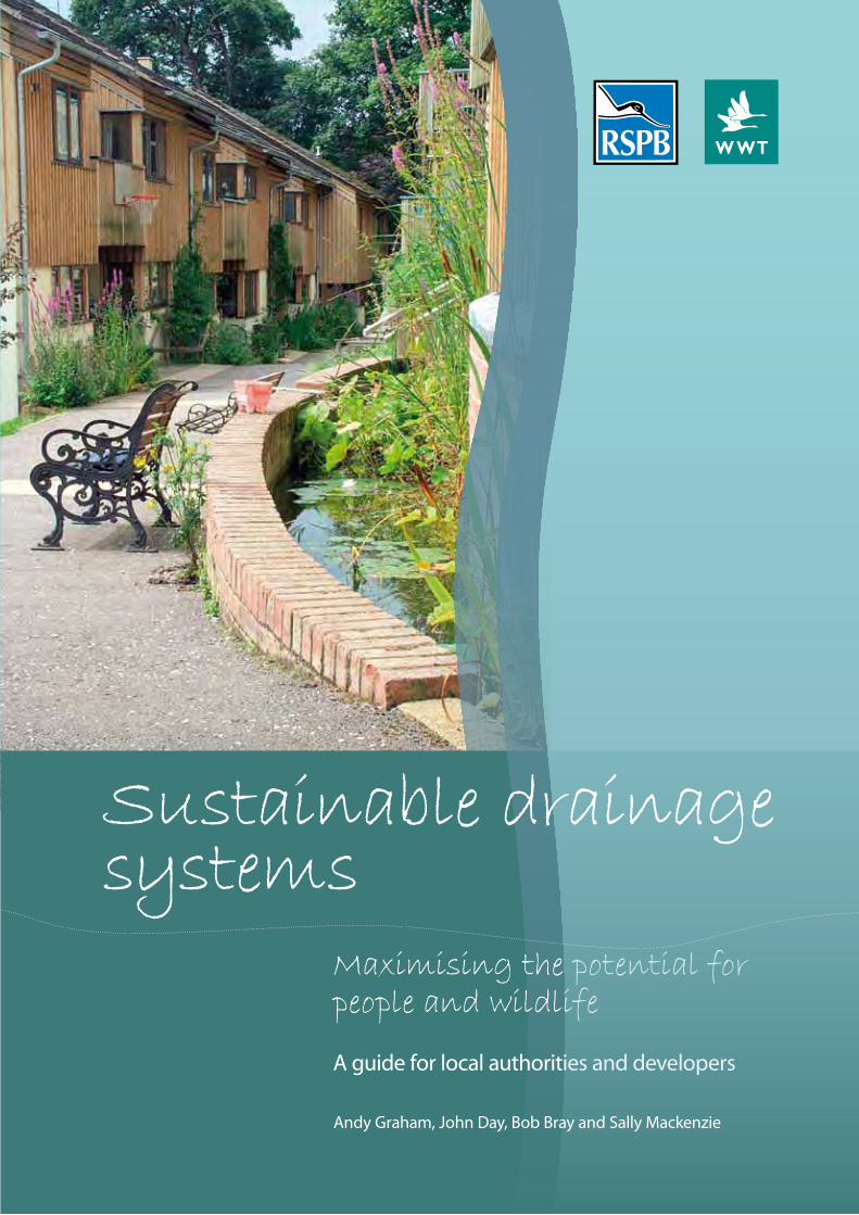
Maximising the potential for people and wildlife
A guide for local authorities and developers
Sustainable drainage systems
Andy Graham, John Day, Bob Bray and Sally Mackenzie
Supported by:
978-1-905601-41-7
The RSPB is the UK charity working to secure a healthy environment for birds and wildlife, helping to create a better world for us all. Our Conservation Management Advice team works to improve the conservation status of priority habitats and species by promoting best-practice advice to land managers.
www.rspb.org.uk
The Wildfowl & Wetlands Trust (WWT) is one of the world’s largest and most respected wetland conservation organisations working globally to safeguard and improve wetlands for wildlife and people.
Founded in 1946 by the late Sir Peter Scott, WWT also operates a unique UK-wide network of specialist wetland centres that protect over 2,600 hectares of important wetland habitat and inspire people to connect with and value wetlands and their wildlife. All of our work is supported by a much valued membership base of over 200,000 people.
WWT’s mission is to save wetlands for wildlife and for people and we will achieve this through:• Inspiring people to connect with and value wetlands and their wildlife.• Demonstrating and promoting the importance and benefits
of wetlands.• Countering threats to wetlands.• Creating and restoring wetlands and protecting key wetland sites.• Saving threatened wetland species.
www.wwt.org.uk
The Royal Society for the Protection of Birds (RSPB) is a registered charity: England & Wales no. 207076, Scotland no. SC037654
The Wildfowl & Wetlands Trust Limited is a charity (1030884 England and Wales, SC039410 Scotland) and a company limited by guarantee (2882729 England). VAT number 618368028.

1
Contents
Foreword.................................................................................................................................................................. iii
Acknowledgements............................................................................................................................................... iv
Introduction............................................................................................................................................................. 1
Part.1..Background.to.sustainable.drainage.systems.(SuDS)What.are.SuDS.and.why.do.we.need.them?....................................................................................................... 2
Legislation................................................................................................................................................................ 5
Delivering.multiple.benefits.through.SuDS....................................................................................................... 6
Sustainabledevelopmentandliveability.......................................................................................................6
. Biodiversity–NationalbiodiversitystrategiesandLocalBAPs....................................................................6
GreenInfrastructureandbluecorridors..........................................................................................................7
Adaptingtoachangingclimate–howSuDScanhelp...................................................................................7
Communityinvolvementandparticipation....................................................................................................8
Leadingthewayinmulti-valueSuDS...............................................................................................................8
SuDS.in.the.built.environment.............................................................................................................................. 9
Part.2..Designing.SuDS.for.people.and.wildlifeKey.design.principles............................................................................................................................................ 11
Hard.landscaping.................................................................................................................................................. 11
Soft.landscaping.................................................................................................................................................... 11
Considerations.for.wildlife................................................................................................................................... 12
The.SuDS.management.train.............................................................................................................................. 13
Source.control........................................................................................................................................................ 15
. Greenroofs........................................................................................................................................................15
Livingwalls......................................................................................................................................................... 17
Raingardens.....................................................................................................................................................18
Permeablesurfaces..........................................................................................................................................19
Filterstrips.........................................................................................................................................................20
Bioretentionareas............................................................................................................................................21
Site.control.............................................................................................................................................................. 22
Detentionbasins...............................................................................................................................................23
Regional.control..................................................................................................................................................... 24
Retentionbasinsandassociatedwetlands...................................................................................................24
Conveyance.features............................................................................................................................................. 27
Swales................................................................................................................................................................28
Cover: Springhill Cohousing, Stroud, Gloucestershire. Photo: Bob Bray
ii
. .
Part.3..Creating,.enhancing.and.managing.SuDS.for.wildlifeManaging.SuDS.for.wildlife................................................................................................................................. 29
Management.principles....................................................................................................................................... 30
Grassland................................................................................................................................................................ 30.. Benefitsforwildlife...........................................................................................................................................30 Generalmanagementrecommendations.....................................................................................................31 Creatingandmanagingflower-richgrassland.............................................................................................31 Creatingandmanagingwetgrasslandandrushmanagement.................................................................32 Creatingandmanagingreedbeds..................................................................................................................32 Grazing..............................................................................................................................................................33
Trees.and.shrubs.................................................................................................................................................... 33.. Benefitstowildlife............................................................................................................................................33 Planting............................................................................................................................................................ 34 Managingtreesandshrubs............................................................................................................................ 34 Deadanddecayingwood................................................................................................................................35
Specific.planting.recommendations.for.SuDS................................................................................................. 35.. Aims....................................................................................................................................................................35 Generalrequirements......................................................................................................................................35. Designguidance...............................................................................................................................................35 PlantingofareasadjacenttoSuDS................................................................................................................35 Do’sandDon’ts.................................................................................................................................................36 Grasssurfacesforfilterstrips,swales,basins,dryorwetbenchesinwetlandsandponds.....................36. Wetlandsandpondedges(detentionandretentionbasins)......................................................................36
Part.4..Case.studies..Case.study.1..Abbey.Hive,.London..................................................................................................................... 38
Case.study.2..Springhill.Cohousing,.Stroud,.Gloucestershire....................................................................... 39
Case.study.3..Red.Hill.Primary.School,.Worcester...........................................................................................40
Case.study.4..Lamb.Drove,.Cambourne,.Cambridgeshire............................................................................. 42
Case.study.5..Robinswood.Hill.Primary.School,.Gloucester.......................................................................... 43
Case.study.6..Hopwood.motorway.service.station.area................................................................................ 45
Part.5..Appendices1..Glossary.............................................................................................................................................................. 47
2..Additional.advice.on.planting.SuDS.............................................................................................................. 49
3..Miscellaneous.habitat.features...................................................................................................................... 51
4..Staying.legal.during.creation.and.management........................................................................................ 53
5..Health.and.Safety.–.designing-out.risk.........................................................................................................54
6..Further.resources.............................................................................................................................................. 55
7.. Useful.contacts.................................................................................................................................................. 56
iii
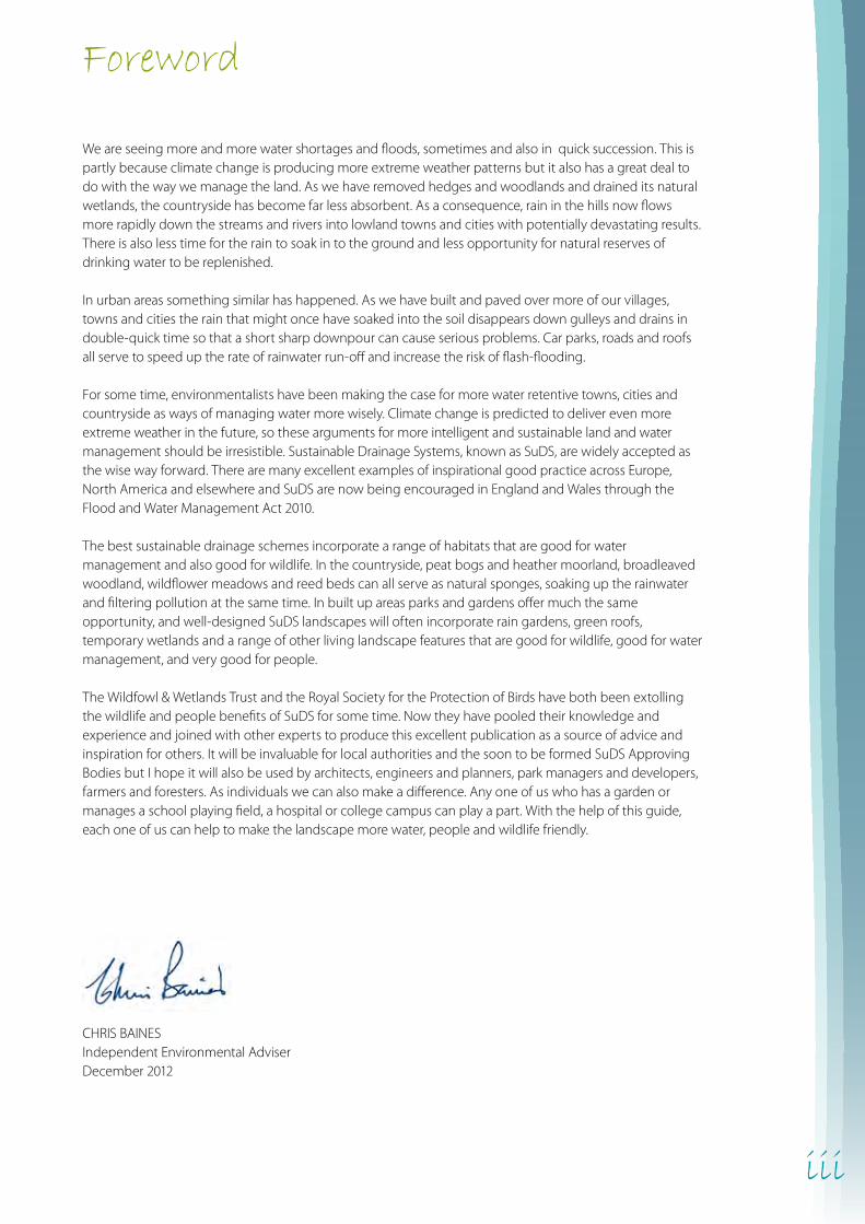
Foreword
We are seeing more and more water shortages and floods, sometimes and also in quick succession. This is partly because climate change is producing more extreme weather patterns but it also has a great deal to do with the way we manage the land. As we have removed hedges and woodlands and drained its natural wetlands, the countryside has become far less absorbent. As a consequence, rain in the hills now flows more rapidly down the streams and rivers into lowland towns and cities with potentially devastating results. There is also less time for the rain to soak in to the ground and less opportunity for natural reserves of drinking water to be replenished.
In urban areas something similar has happened. As we have built and paved over more of our villages, towns and cities the rain that might once have soaked into the soil disappears down gulleys and drains in double-quick time so that a short sharp downpour can cause serious problems. Car parks, roads and roofs all serve to speed up the rate of rainwater run-off and increase the risk of flash-flooding.
For some time, environmentalists have been making the case for more water retentive towns, cities and countryside as ways of managing water more wisely. Climate change is predicted to deliver even more extreme weather in the future, so these arguments for more intelligent and sustainable land and water management should be irresistible. Sustainable Drainage Systems, known as SuDS, are widely accepted as the wise way forward. There are many excellent examples of inspirational good practice across Europe, North America and elsewhere and SuDS are now being encouraged in England and Wales through the Flood and Water Management Act 2010.
The best sustainable drainage schemes incorporate a range of habitats that are good for water management and also good for wildlife. In the countryside, peat bogs and heather moorland, broadleaved woodland, wildflower meadows and reed beds can all serve as natural sponges, soaking up the rainwater and filtering pollution at the same time. In built up areas parks and gardens offer much the same opportunity, and well-designed SuDS landscapes will often incorporate rain gardens, green roofs, temporary wetlands and a range of other living landscape features that are good for wildlife, good for water management, and very good for people.
The Wildfowl & Wetlands Trust and the Royal Society for the Protection of Birds have both been extolling the wildlife and people benefits of SuDS for some time. Now they have pooled their knowledge and experience and joined with other experts to produce this excellent publication as a source of advice and inspiration for others. It will be invaluable for local authorities and the soon to be formed SuDS Approving Bodies but I hope it will also be used by architects, engineers and planners, park managers and developers, farmers and foresters. As individuals we can also make a difference. Any one of us who has a garden or manages a school playing field, a hospital or college campus can play a part. With the help of this guide, each one of us can help to make the landscape more water, people and wildlife friendly.
CHRIS BAINESIndependent Environmental AdviserDecember 2012

iv
Acknowledgements
We would particularly like to thank Bob Bray of Robert Bray Associates, who worked with us throughout the project and contributed expert advice, text, many of the photographs and also commented on drafts. We would also like to acknowledge Sally Mackenzie’s early work on the texts when the original concept was devised and also thanks to Dougal Giles.
We are also indebted to many others including Ann Skinner, Phil Chatfield, Dusty Gedge, Gary Grant, Paul Shaffer, Carrie Hume, Steve Bloomfield, Simon Rose, Rob Shore, Nick Droy, Rob Cunningham, Andrew Whitehouse, Vicky Kindemba, Brian D’Arcy, Brian Shutes, Mark Parsons, Martin Warren, Pascale Nicolet and Mike Oxford, all of whom provided helpful comment and advice on the guidance.
1
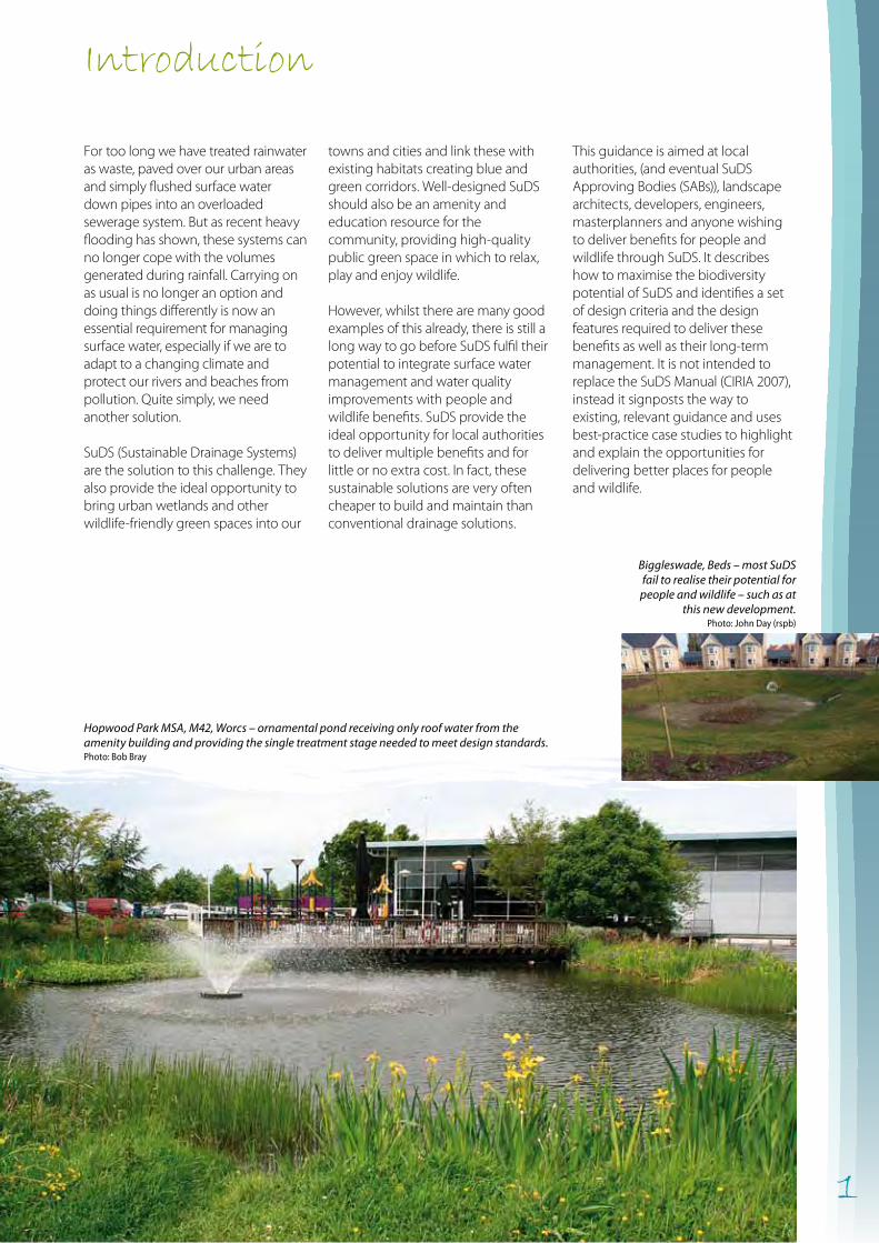
Introduction
towns and cities and link these with existing habitats creating blue and green corridors. Well-designed SuDS should also be an amenity and education resource for the community, providing high-quality public green space in which to relax, play and enjoy wildlife.
However, whilst there are many good examples of this already, there is still a long way to go before SuDS fulfil their potential to integrate surface water management and water quality improvements with people and wildlife benefits. SuDS provide the ideal opportunity for local authorities to deliver multiple benefits and for little or no extra cost. In fact, these sustainable solutions are very often cheaper to build and maintain than conventional drainage solutions.
For too long we have treated rainwater as waste, paved over our urban areas and simply flushed surface water down pipes into an overloaded sewerage system. But as recent heavy flooding has shown, these systems can no longer cope with the volumes generated during rainfall. Carrying on as usual is no longer an option and doing things differently is now an essential requirement for managing surface water, especially if we are to adapt to a changing climate and protect our rivers and beaches from pollution. Quite simply, we need another solution.
SuDS (Sustainable Drainage Systems) are the solution to this challenge. They also provide the ideal opportunity to bring urban wetlands and other wildlife-friendly green spaces into our
This guidance is aimed at local authorities, (and eventual SuDS Approving Bodies (SABs)), landscape architects, developers, engineers, masterplanners and anyone wishing to deliver benefits for people and wildlife through SuDS. It describes how to maximise the biodiversity potential of SuDS and identifies a set of design criteria and the design features required to deliver these benefits as well as their long-term management. It is not intended to replace the SuDS Manual (CIRIA 2007), instead it signposts the way to existing, relevant guidance and uses best-practice case studies to highlight and explain the opportunities for delivering better places for people and wildlife.
Hopwood Park MSA, M42, Worcs – ornamental pond receiving only roof water from the amenity building and providing the single treatment stage needed to meet design standards. Photo: Bob Bray
Biggleswade, Beds – most SuDS fail to realise their potential for
people and wildlife – such as at this new development.
Photo: John Day (rspb)
2
Flooding – Traditional piped drainage networks convey water far more quickly than natural processes. Rivers respond quickly and violently to rainfall, exacerbating downstream flooding. Flooding also occurs where housing and other urban development such as the paving of gardens and the building of extensions (often referred to as ‘urban creep’) increases the volume and speed of run-off.
Surface water on road flowing into a drain on the side of Burnley Road, Crawshawbooth, Lancashire.
Pollution – Surface water run-off is often polluted with silt, oil and other contaminants which, when discharged to rivers, can harm wildlife and contaminate drinking water sources. Combined sewer overflows also discharge during periods of heavy rainfall where sewers are surcharged.
Pollution in Anglian region.
Low flows in streams and rivers – Piped drainage prevents natural percolation of rainfall into groundwater resources that support summer river flows. It can lead to the concentration of nitrates and phosphates in rivers and wetlands, causing an increase in algal blooms, harming wildlife and reducing amenity value.
Partially dried up bed of the River Ash as it flows through woodland riverbank near Much Hadham, Herts.
Wet woodland
Wet grassland
Reed beds
Rainfall
Oxbow lakes & pools
Evapotranspiration fromplants and water bodies
Slow run-off
Groundwater recharge
Groundwater recharge
Ephemeral pools andwet flashes
Groundwater recharge
Part 1. Background to SuDsWhat are SuDS and why do we need them?
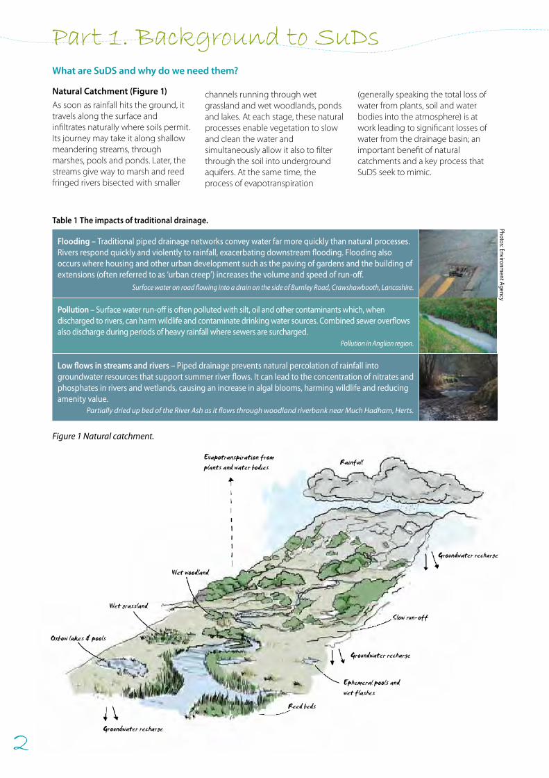
Figure 1 Natural catchment.
Natural Catchment (Figure 1)
As soon as rainfall hits the ground, it travels along the surface and infiltrates naturally where soils permit. Its journey may take it along shallow meandering streams, through marshes, pools and ponds. Later, the streams give way to marsh and reed fringed rivers bisected with smaller
channels running through wet grassland and wet woodlands, ponds and lakes. At each stage, these natural processes enable vegetation to slow and clean the water and simultaneously allow it also to filter through the soil into underground aquifers. At the same time, the process of evapotranspiration
(generally speaking the total loss of water from plants, soil and water bodies into the atmosphere) is at work leading to significant losses of water from the drainage basin; an important benefit of natural catchments and a key process that SuDS seek to mimic.
Table 1 The impacts of traditional drainage.
Photos: Environment Agency
3
Waterways have been canalised,and piped underground
Rainfall
Flooding
Piped drainage
Hard urban surfaces restrictinfiltration of rainfall andpromote rapid run-off ofsurface water
Groundwater recharge
Polluted river
Hard surfaces (roofs, walls, pavements, car parks and roads)increase urban temperatures and the heat island effect
Little or nowildlife habitat
Evapotranspirationfrom natural habitats
Limited evaptranspiration
Limited groundwater recharge,rapid run-off and increased flooding
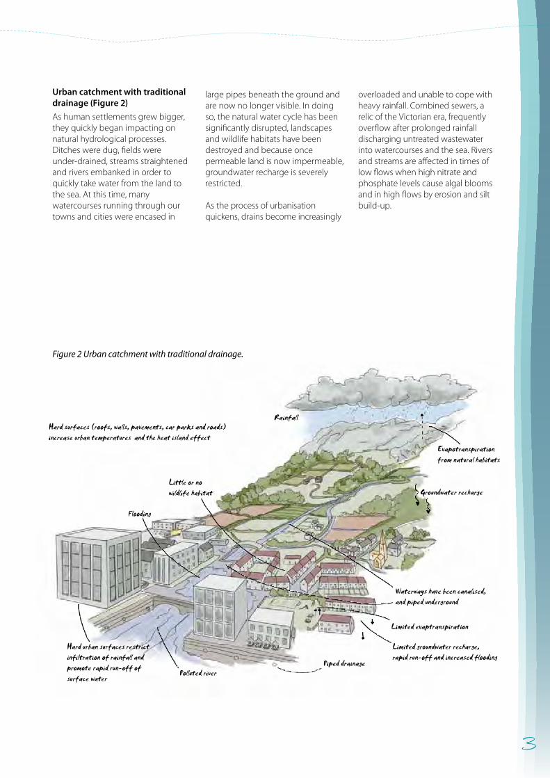
Figure 2 Urban catchment with traditional drainage.
Urban catchment with traditional drainage (Figure 2)
As human settlements grew bigger, they quickly began impacting on natural hydrological processes. Ditches were dug, fields were under-drained, streams straightened and rivers embanked in order to quickly take water from the land to the sea. At this time, many watercourses running through our towns and cities were encased in
large pipes beneath the ground and are now no longer visible. In doing so, the natural water cycle has been significantly disrupted, landscapes and wildlife habitats have been destroyed and because once permeable land is now impermeable, groundwater recharge is severely restricted.
As the process of urbanisation quickens, drains become increasingly
overloaded and unable to cope with heavy rainfall. Combined sewers, a relic of the Victorian era, frequently overflow after prolonged rainfall discharging untreated wastewater into watercourses and the sea. Rivers and streams are affected in times of low flows when high nitrate and phosphate levels cause algal blooms and in high flows by erosion and silt build-up.
4
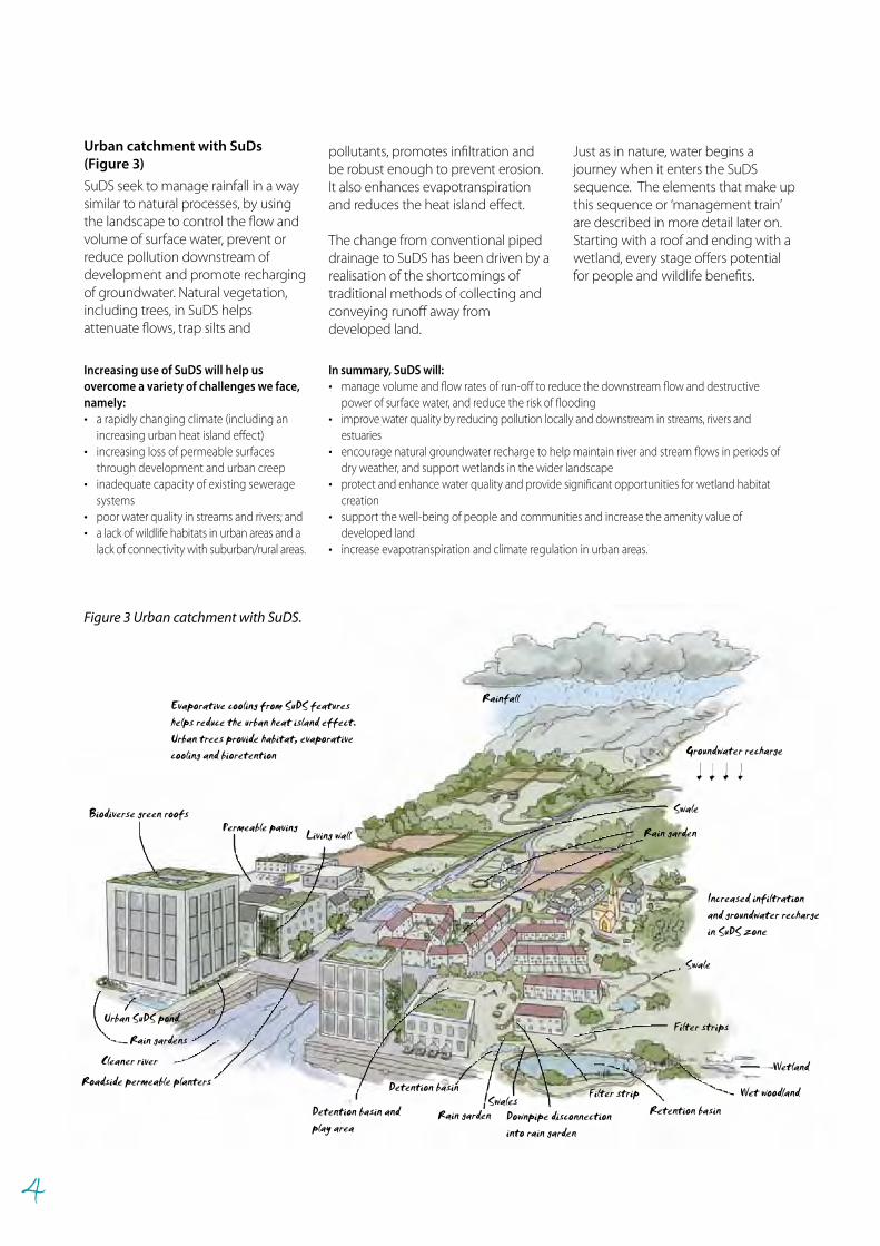
Just as in nature, water begins a journey when it enters the SuDS sequence. The elements that make up this sequence or ‘management train’ are described in more detail later on. Starting with a roof and ending with a wetland, every stage offers potential for people and wildlife benefits.
Cleaner river
Evaporative cooling from SuDS featureshelps reduce the urban heat island effect.Urban trees provide habitat, evaporativecooling and bioretention
Rain gardens
Urban SuDS pond
Rain garden
Biodiverse green roofs
Rainfall
Permeable paving
Swale
Increased infiltrationand groundwater rechargein SuDS zone
SwalesFilter strip
Swale
Retention basin
Detention basin
Rain garden
Living wall
Roadside permeable planters
Filter strips
Detention basin andplay area
Wetland
Wet woodland
Downpipe disconnectioninto rain garden
Groundwater recharge
Increasing use of SuDS will help us overcome a variety of challenges we face, namely: • a rapidly changing climate (including an
increasing urban heat island effect)• increasing loss of permeable surfaces
through development and urban creep • inadequate capacity of existing sewerage
systems• poor water quality in streams and rivers; and • a lack of wildlife habitats in urban areas and a
lack of connectivity with suburban/rural areas.
In summary, SuDS will: • manage volume and flow rates of run-off to reduce the downstream flow and destructive
power of surface water, and reduce the risk of flooding• improve water quality by reducing pollution locally and downstream in streams, rivers and
estuaries • encourage natural groundwater recharge to help maintain river and stream flows in periods of
dry weather, and support wetlands in the wider landscape• protect and enhance water quality and provide significant opportunities for wetland habitat
creation • support the well-being of people and communities and increase the amenity value of
developed land• increase evapotranspiration and climate regulation in urban areas.
Figure 3 Urban catchment with SuDS.
Urban catchment with SuDs (Figure 3)
SuDS seek to manage rainfall in a way similar to natural processes, by using the landscape to control the flow and volume of surface water, prevent or reduce pollution downstream of development and promote recharging of groundwater. Natural vegetation, including trees, in SuDS helps attenuate flows, trap silts and
pollutants, promotes infiltration and be robust enough to prevent erosion. It also enhances evapotranspirationand reduces the heat island effect.
The change from conventional piped drainage to SuDS has been driven by a realisation of the shortcomings of traditional methods of collecting and conveying runoff away from developed land.
5
Legislation
The European Water Framework Directive (WFD) was adopted in 2000 and passed into UK law in 2003. It aims to improve the chemical and ecological status of rivers, lakes, estuaries, coastal waters and groundwater and their dependant ecosystems. SuDS have a key role in delivering those objectives.
After the 2007 summer floods and the subsequent Pitt Review, came the Flood and Water Management Act 2010 (http://www.legislation.gov.uk/ukpga/2010/). This is set to become the key legislation relating to SuDS in England and Wales. In seeking to effectively manage floods, it will make the installation of SuDS compulsory for nearly all new developments. It will also remove the right of automatic connection to sewers unless the drainage scheme is approved by the soon to be created SuDS Approving Bodies (SABs).
Local Authorities have a duty to ensure high quality, fit for purpose SuDS are delivered as a result of this legislation. The SABs will be created within local authorities and they will be tasked with approving all SuDS in new developments (and also redevelopments). The SAB will also be responsible for their adoption and management.
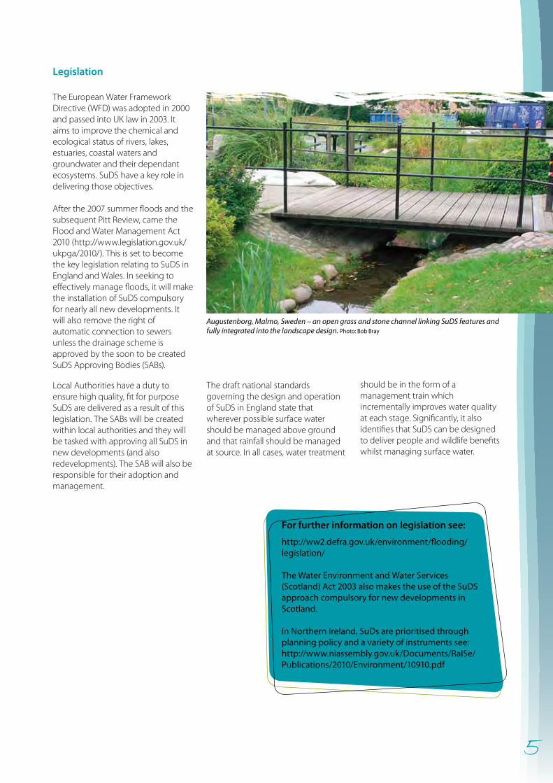
Augustenborg, Malmo, Sweden – an open grass and stone channel linking SuDS features and fully integrated into the landscape design. Photo: Bob Bray
For further information on legislation see:
http://ww2.defra.gov.uk/environment/flooding/legislation/
The Water Environment and Water Services (Scotland) Act 2003 also makes the use of the SuDS approach compulsory for new developments in Scotland.
In Northern Ireland, SuDs are prioritised through planning policy and a variety of instruments see: http://www.niassembly.gov.uk/Documents/RaISe/Publications/2010/Environment/10910.pdf
The draft national standards governing the design and operation of SuDS in England state that wherever possible surface water should be managed above ground and that rainfall should be managed at source. In all cases, water treatment
should be in the form of a management train which incrementally improves water quality at each stage. Significantly, it also identifies that SuDS can be designed to deliver people and wildlife benefits whilst managing surface water.
6
For more details on how green space, including SuDS, can bring health benefits see:
http://www.naturalengland.org.uk/ourwork/enjoying/linkingpeople/health/default.aspxfor information about England, and:
http://www.snh.gov.uk/docs/A265734.pdf for information about the experience in Scotland.
Delivering multiple benefits through SuDS Designing SuDS to deliver more than just surface water management is not difficult or costly but it does depend on early consideration at the master planning stage, creativity, consultation and partnership. Done properly, they can deliver benefits for the whole community in terms of biodiversity, climate regulation, regeneration, learning, health, recreation and play. Those local authorities leading the way in linking the requirement for SuDS to meet the objectives of wider social and environmental policy (see later) have understood this to be a cost-effective way of delivering sustainable, resilient communities in urban areas. The National Planning Policy Framework (2012) (NPPF) makes it clear that local authority plans should seek to protect and enhance the natural environment and that policies recognise the wider benefits of ecosystem services and should capture multiple benefits from land use including wildlife, recreation, mitigation of flood risk and carbon storage; clearly SuDS have a central role to play in delivering these multiple benefits.
Sustainable development and liveability – supporting quality of life and well-being through well-designed SuDS
The contribution of biodiversity to sustainable development and ‘liveability’ agendas is fully recognised in national strategies, regional and local policies and programmes dealing with urban areas and development. This includes the Natural Environment White Paper, ‘The natural choice: securing the value of nature’ (NEWP), the NPPF and the localism agenda. NEWP clearly identifies that the natural environment and the associated green economy are fundamental to economic growth and human well-being. Its key themes of “no net loss”, ecological networks, integrated land management and health are all readily addressed in well-designed SuDS.
Complementing NEWP is the UK National Ecosystem Assessment (2011) which stresses the importance of
managing ecosystems in an integrated fashion to deliver a wider range of services and benefits to create better places for people and wildlife. SuDS will maximise wildlife, water and landscape benefits for people and support wider ecosystem function at the same time.
The Localism Act (2011) introduced Neighbourhood Development Plans, a new and voluntary planning process as well as a Local Green Space designation. These new tools can help encourage the use of SuDS to create wildlife-rich developments.
However, many locally accessible spaces including some SuDS, do not offer much in the way of biodiversity or public amenity value because of poor design and management. SuDS designed with people and wildlife in mind from the very beginning can result in wildlife-rich green space and therefore offer many other amenity benefits. Retrofitting SuDS features can also improve the amenity and wildlife interest of an area. Natural England’s ‘Nature Nearby’ Accessible Natural Greenspace Guidance (2010) specifically identifies SuDS as an opportunity for creating new green space in urban areas and states that when incorporated into site master plans alongside new footpaths, greenways and woodlands, they deliver a range of benefits to people. Benefits include provision of places for recreation and relaxation, areas for children to play, regeneration, education and improved health.
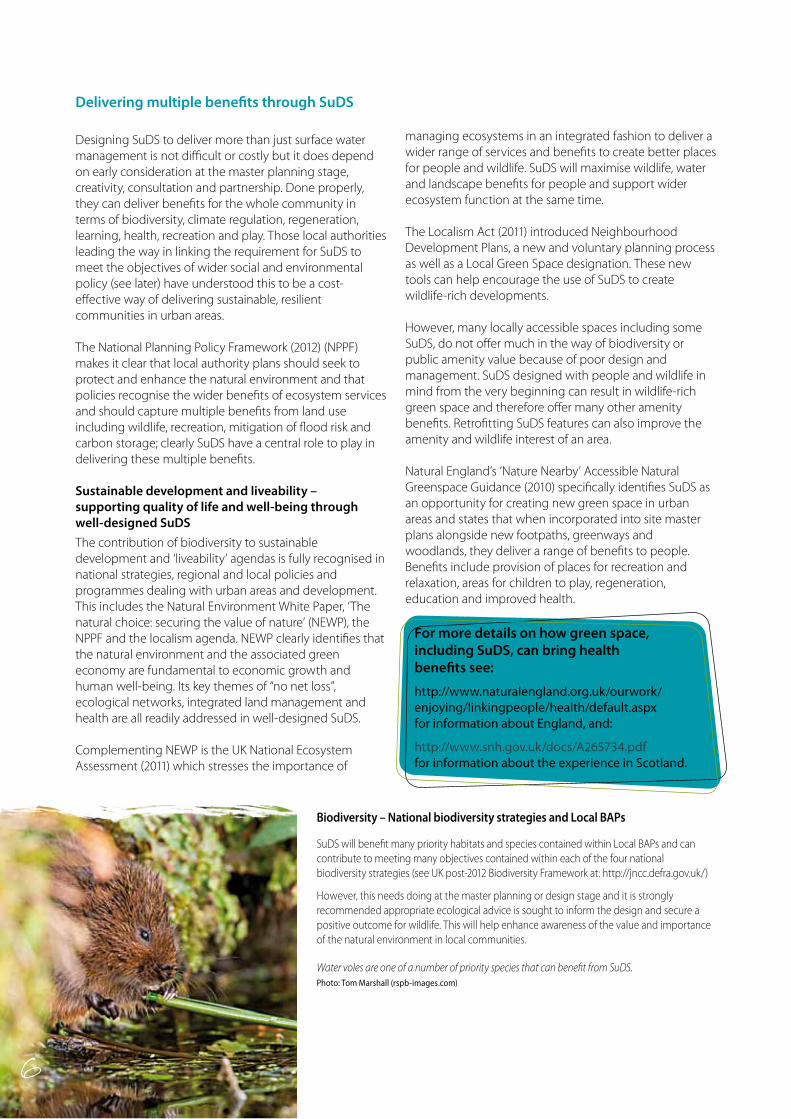
Biodiversity – National biodiversity strategies and Local BAPs
SuDS will benefit many priority habitats and species contained within Local BAPs and can contribute to meeting many objectives contained within each of the four national biodiversity strategies (see UK post-2012 Biodiversity Framework at: http://jncc.defra.gov.uk/)
However, this needs doing at the master planning or design stage and it is strongly recommended appropriate ecological advice is sought to inform the design and secure a positive outcome for wildlife. This will help enhance awareness of the value and importance of the natural environment in local communities.
Water voles are one of a number of priority species that can benefit from SuDS. Photo: Tom Marshall (rspb-images.com)
6
7
Green infrastructure (GI) and blue corridors
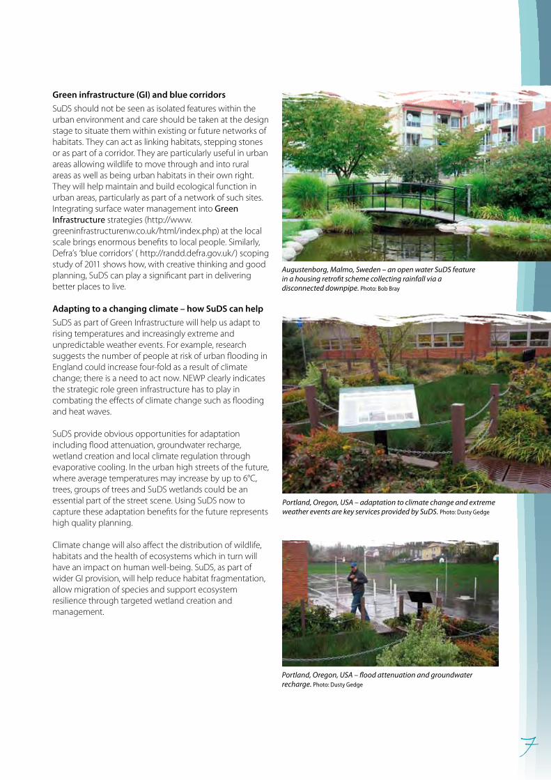
SuDS should not be seen as isolated features within the urban environment and care should be taken at the design stage to situate them within existing or future networks of habitats. They can act as linking habitats, stepping stones or as part of a corridor. They are particularly useful in urban areas allowing wildlife to move through and into rural areas as well as being urban habitats in their own right. They will help maintain and build ecological function in urban areas, particularly as part of a network of such sites. Integrating surface water management into Green Infrastructure strategies (http://www.greeninfrastructurenw.co.uk/html/index.php) at the local scale brings enormous benefits to local people. Similarly, Defra’s ‘blue corridors’ ( http://randd.defra.gov.uk/) scoping study of 2011 shows how, with creative thinking and good planning, SuDS can play a significant part in delivering better places to live.
Adapting to a changing climate – how SuDS can help
SuDS as part of Green Infrastructure will help us adapt to rising temperatures and increasingly extreme and unpredictable weather events. For example, research suggests the number of people at risk of urban flooding in England could increase four-fold as a result of climate change; there is a need to act now. NEWP clearly indicates the strategic role green infrastructure has to play in combating the effects of climate change such as flooding and heat waves.
SuDS provide obvious opportunities for adaptation including flood attenuation, groundwater recharge, wetland creation and local climate regulation through evaporative cooling. In the urban high streets of the future, where average temperatures may increase by up to 6°C, trees, groups of trees and SuDS wetlands could be an essential part of the street scene. Using SuDS now to capture these adaptation benefits for the future represents high quality planning.
Climate change will also affect the distribution of wildlife, habitats and the health of ecosystems which in turn will have an impact on human well-being. SuDS, as part of wider GI provision, will help reduce habitat fragmentation, allow migration of species and support ecosystem resilience through targeted wetland creation and management.
Portland, Oregon, USA – flood attenuation and groundwater recharge. Photo: Dusty Gedge
Augustenborg, Malmo, Sweden – an open water SuDS feature in a housing retrofit scheme collecting rainfall via a disconnected downpipe. Photo: Bob Bray
Portland, Oregon, USA – adaptation to climate change and extreme weather events are key services provided by SuDS. Photo: Dusty Gedge
8
The key principles are:• Involve local communities in ‘master planning’
their SuDS environment at the earliest stage.• Involve them in the detailed design and
management of SuDS.• Establish amenity and biodiversity as high
priorities in all SuDS, both new and retro-fit schemes.
• Allocate adequate resources for design and long-term management.
• Seek advice and input from ecologists and landscape architects.
Community involvement and participation
There are many ways in which those responsible for developing and managing SuDS can involve local communities. In fact, community SuDS management is likely to be one of the most straightforward ways of getting people involved in their local environment. With good design and an effective participation strategy as well as expert ecological guidance, SuDS can readily become a focus of community life, where people are willing to get involved with local activities. For example, this can include retrofitting and creation of rain gardens (www.raingardens.info), seeding of community meadows or planting of wetlands.
The appropriate management of SuDS can provide many opportunities for learning, informal recreation, supported play and other community programmes. This has many social and health benefits and gives people a sense of pride, responsibility and ownership of their environment. Active interpretation, volunteering opportunities, guided walks and other forms of engagement provide ways in which people can become involved in decision-making and management of SuDS. This in turn can engender public support for SuDS, leading to increased awareness of wetlands and the natural environment and community cohesion. For example the ‘Stormwater cycling tour’ in Portland, Oregon is a 21-stop cycling tour that visits an array of SuDS implementation sites promoting the concept of sustainable surface water management to the community. This inventive approach which raises understanding and awareness and also encourages healthy activity at the same time is a great example of how to use SuDS to deliver multiple benefits.
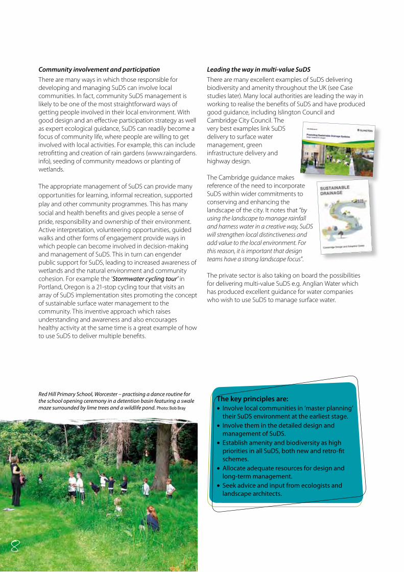
Leading the way in multi-value SuDS
There are many excellent examples of SuDS delivering biodiversity and amenity throughout the UK (see Case studies later). Many local authorities are leading the way in working to realise the benefits of SuDS and have produced good guidance, including Islington Council and Cambridge City Council. The very best examples link SuDS delivery to surface water management, green infrastructure delivery and highway design. The Cambridge guidance makes reference of the need to incorporate SuDS within wider commitments to conserving and enhancing the landscape of the city. It notes that “by using the landscape to manage rainfall and harness water in a creative way, SuDS will strengthen local distinctiveness and add value to the local environment. For this reason, it is important that design teams have a strong landscape focus”.
The private sector is also taking on board the possibilities for delivering multi-value SuDS e.g. Anglian Water which has produced excellent guidance for water companies who wish to use SuDS to manage surface water.
8
Red Hill Primary School, Worcester – practising a dance routine for the school opening ceremony in a detention basin featuring a swale maze surrounded by lime trees and a wildlife pond. Photo: Bob Bray
9
SuDS in the built environment
Retrofitting
Disconnecting down pipes and diverting surface water away from drains through water butts and from impermeable surfaces along grassy swales, through basins, rain gardens and planters can turn uninspiring open spaces into vibrant, aesthetically pleasing areas full of wildlife (see also Retrofitting to manage surface water – C713, CIRIA 2012).
New developments
In urban areas, green space is often at a premium. Careful planning and design in new developments can reduce and slow run-off, provide clean water and create valuable new wildlife habitat too. In fact, the requirement for green space and SuDs can be combined to provide multiple benefits in a very cost-effective manner.
Green roofs and permeable surfaces clean and allow water to drain naturally into soils beneath or provide a source of clean water for wetland wildlife. Any runoff can be channelled into features such as rain gardens, planters, ponds and wetlands linked by carefully designed hard and soft conveyance features such as concrete rills and grass swales.
Parks and green spaces
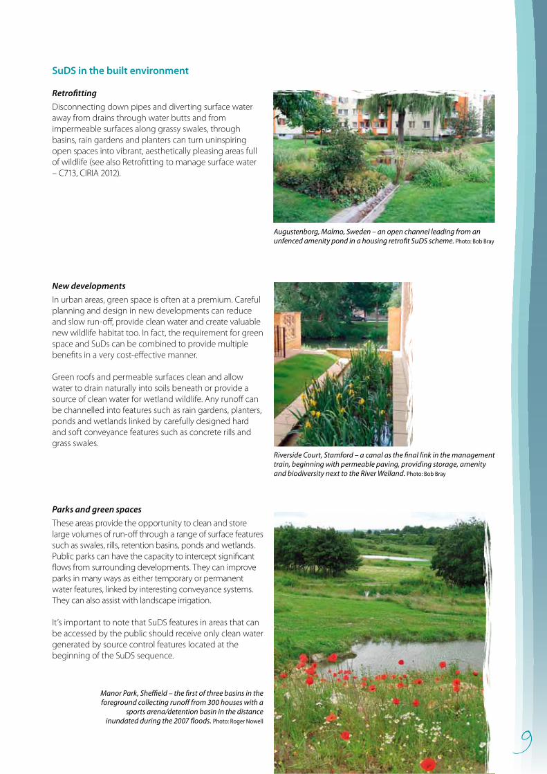
These areas provide the opportunity to clean and store large volumes of run-off through a range of surface features such as swales, rills, retention basins, ponds and wetlands. Public parks can have the capacity to intercept significant flows from surrounding developments. They can improve parks in many ways as either temporary or permanent water features, linked by interesting conveyance systems. They can also assist with landscape irrigation.
It’s important to note that SuDS features in areas that can be accessed by the public should receive only clean water generated by source control features located at the beginning of the SuDS sequence.
Augustenborg, Malmo, Sweden – an open channel leading from an unfenced amenity pond in a housing retrofit SuDS scheme. Photo: Bob Bray
Riverside Court, Stamford – a canal as the final link in the management train, beginning with permeable paving, providing storage, amenity and biodiversity next to the River Welland. Photo: Bob Bray
Manor Park, Sheffield – the first of three basins in the foreground collecting runoff from 300 houses with a
sports arena/detention basin in the distance inundated during the 2007 floods. Photo: Roger Nowell
10
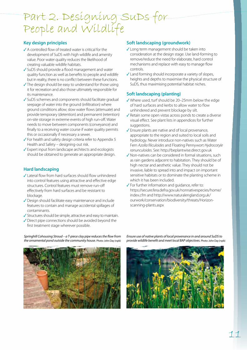
Schools
SuDS are an opportunity to enhance the school environment as well as providing for outdoor learning and play. Roofs and all hard surfaces provide an opportunity to slow, clean and collect water run-off. These may be linked by creative use of surface channels, rills and linear wetlands to move water around the school. Incorporating features such as cascades, spouts and water chutes adds visual interest.
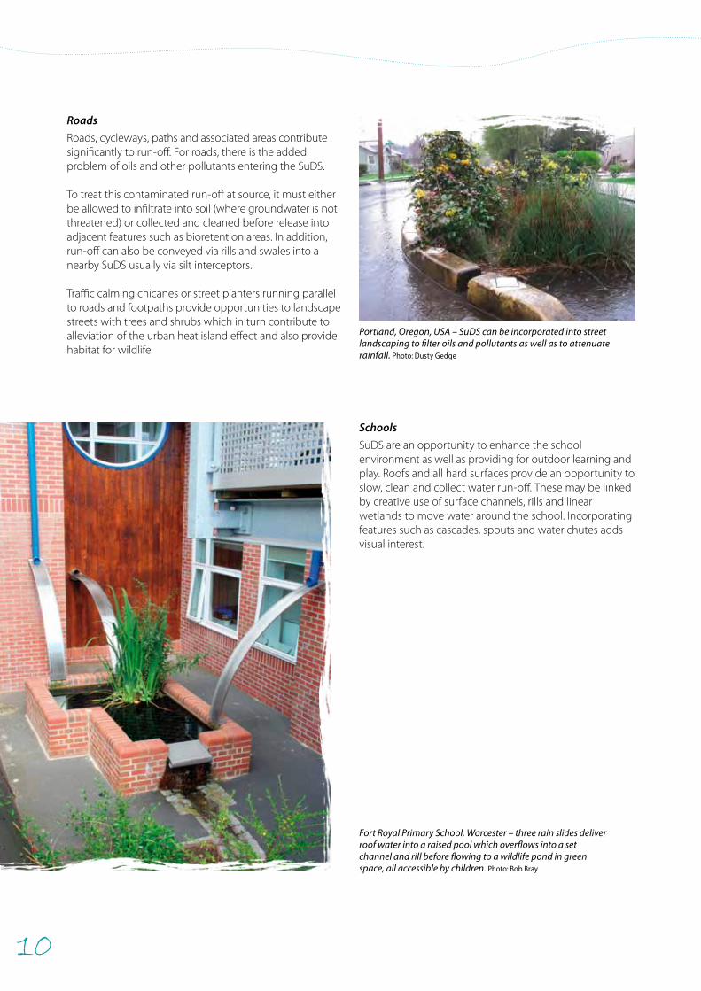
Roads
Roads, cycleways, paths and associated areas contribute significantly to run-off. For roads, there is the added problem of oils and other pollutants entering the SuDS.
To treat this contaminated run-off at source, it must either be allowed to infiltrate into soil (where groundwater is not threatened) or collected and cleaned before release into adjacent features such as bioretention areas. In addition, run-off can also be conveyed via rills and swales into a nearby SuDS usually via silt interceptors.
Traffic calming chicanes or street planters running parallel to roads and footpaths provide opportunities to landscape streets with trees and shrubs which in turn contribute to alleviation of the urban heat island effect and also provide habitat for wildlife.
Fort Royal Primary School, Worcester – three rain slides deliver roof water into a raised pool which overflows into a set channel and rill before flowing to a wildlife pond in green space, all accessible by children. Photo: Bob Bray
Portland, Oregon, USA – SuDS can be incorporated into street landscaping to filter oils and pollutants as well as to attenuate rainfall. Photo: Dusty Gedge
11
Key design principles✓ A controlled flow of treated water is critical for the
development of SuDS with high wildlife and amenity value. Poor water quality reduces the likelihood of creating valuable wildlife habitats.
✓ SuDS should provide a flood management and water quality function as well as benefits to people and wildlife but in reality, there is no conflict between these functions.
✓The design should be easy to understand for those using it for recreation and also those ultimately responsible for its maintenance.
✓ SuDS schemes and components should facilitate gradual seepage of water into the ground (infiltration) where ground conditions allow; slow water flows (attenuate) and provide temporary (detention) and permanent (retention) on-site storage in extreme events of high run-off. Water needs to move between components (conveyance) and finally to a receiving water course if water quality permits this or occasionally if necessary a sewer.
✓ For health and safety design criteria refer to Appendix 5 Health and Safety – designing-out risk.
✓ Expert input from landscape architects and ecologists should be obtained to generate an appropriate design.
Hard landscaping ✓Lateral flow from hard surfaces should flow unhindered
into control features using attractive and effective edge structures. Control features must remove run-off effectively from hard surfaces and be resistant to blockage.
✓Design should facilitate easy maintenance and include features to contain and manage accidental spillages of contaminants.
✓Structures should be simple, attractive and easy to maintain. ✓Direct pipe connections should be avoided beyond the
first treatment stage wherever possible.
Soft landscaping (groundwork)✓Long term management should be taken into
consideration at the design stage. Use land-forming to remove/reduce the need for elaborate, hard control mechanisms and replace with easy to manage flow controls.
✓Land forming should incorporate a variety of slopes, heights and depths to maximise the physical structure of SuDS, thus maximising potential habitat niches.
Soft landscaping (planting)✓Where used, turf should be 20–25mm below the edge
of hard surfaces and kerbs to allow water to flow unhindered and prevent blockage by silt.
✓Retain some open vistas across ponds to create a diverse visual effect. See plant lists in appendices for further suggestions.
✓Ensure plants are native and of local provenance, appropriate to the region and suited to local soils and hydrology. Never introduce non-natives such as Water Fern Azolla filiculoides and Floating Pennywort Hydrocotyle ranunculoides. See: http://beplantwise.direct.gov.uk
✓Non-natives can be considered in formal situations, such as rain gardens adjacent to habitation. They should be of high nectar and aesthetic value. They should not be invasive, liable to spread into and impact on important sensitive habitats or to dominate the planting scheme in which it has been included.
✓For further information and guidance, refer to: https://secure.fera.defra.gov.uk/nonnativespecies/home/
index.cfm and http://www.naturalengland.org.uk/ourwork/conservation/biodiversity/threats/Horizon-scanning-plants.aspx
Part 2. Designing SuDs for People and Wildlife
Springhill Cohousing Stroud – a T-piece clay pipe reduces the flow from the ornamental pond outside the community house. Photo: John Day (rspb)
Ensure use of native plants of local provenance in and around SuDS to provide wildlife benefit and meet local BAP objectives. Photo: John Day (rspb)
12
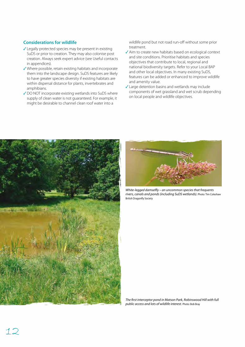
Considerations for wildlife ✓Legally protected species may be present in existing
SuDS or prior to creation. They may also colonise post creation. Always seek expert advice (see Useful contacts in appendices).
✓Where possible, retain existing habitats and incorporate them into the landscape design. SuDS features are likely to have greater species diversity if existing habitats are within dispersal distance for plants, invertebrates and amphibians.
✓DO NOT incorporate existing wetlands into SuDS where supply of clean water is not guaranteed. For example, it might be desirable to channel clean roof water into a
wildlife pond but not road run-off without some prior treatment.
✓Aim to create new habitats based on ecological context and site conditions. Prioritise habitats and species objectives that contribute to local, regional and national biodiversity targets. Refer to your Local BAP and other local objectives. In many existing SuDS, features can be added or enhanced to improve wildlife and amenity value.
✓Large detention basins and wetlands may include components of wet grassland and wet scrub depending on local people and wildlife objectives.
The first interceptor pond in Matson Park, Robinswood Hill with full public access and lots of wildlife interest. Photo: Bob Bray
White-legged damselfly – an uncommon species that frequents rivers, canals and ponds (including SuDS wetlands). Photo: Tim Coleshaw
British Dragonfly Society
13
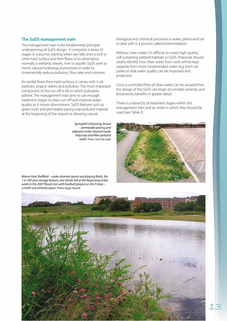
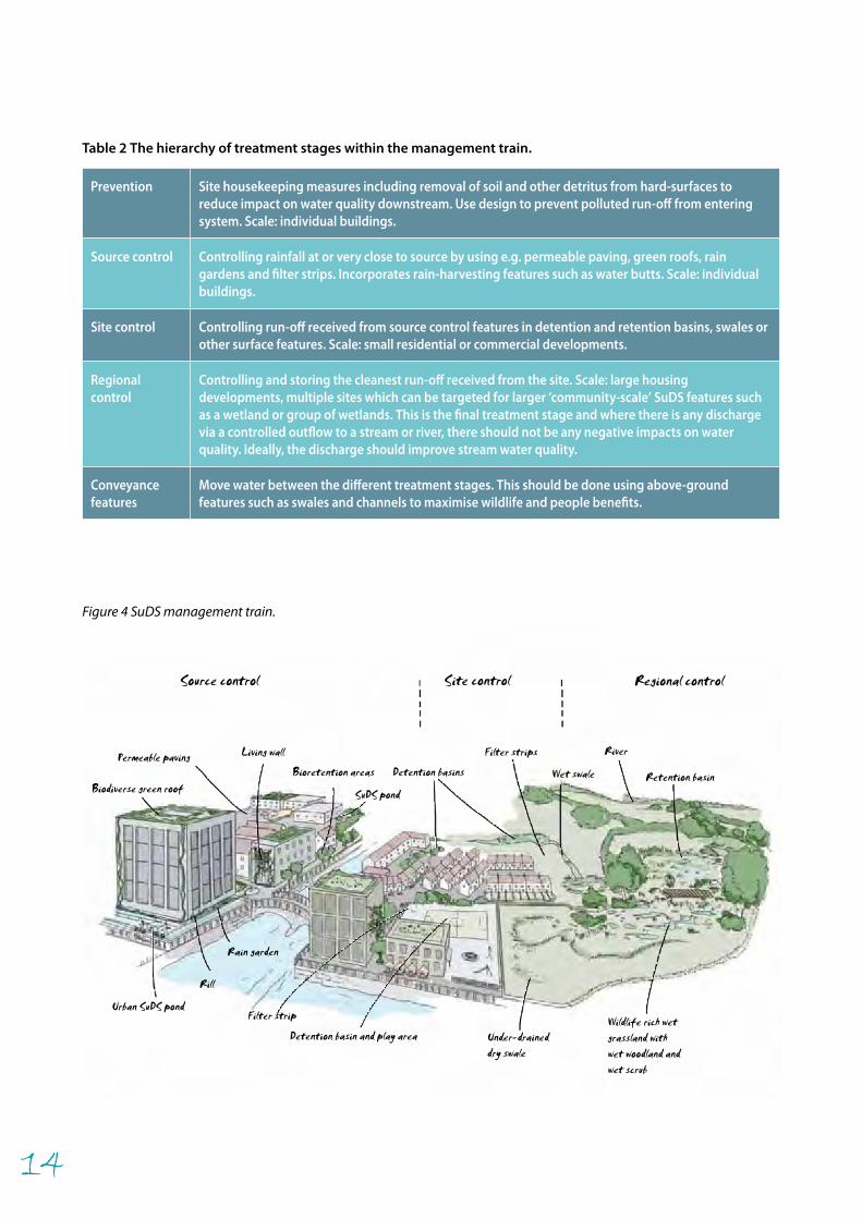
The SuDS management trainThe management train is the fundamental principle underpinning all SuDS design. It comprises a series of stages in a journey starting when rain falls onto a roof or other hard surface and then flows to its destination, normally a wetland, stream, river or aquifer. SuDS seek to mimic natural hydrological processes in order to incrementally reduce pollution, flow rates and volumes.
As rainfall flows from hard surfaces, it carries with it silt particles, organic debris and pollution. The most important component of this run-off is silt to which pollutants adhere. The management train aims to use enough treatment stages to clean run-off and improve water quality as it moves downstream. SuDS features such as green roofs and permeable paving trap polluted material at the beginning of the sequence allowing natural
biological and chemical processes in water, plants and soil to deal with it, a process called bioremediation.
Without clean water, it’s difficult to create high-quality, self-sustaining wetland habitats in SuDS. Proposals should clearly identify how clean water from roofs will be kept separate from more contaminated water (e.g. from car parks) so that water quality can be improved and protected.
Once a controlled flow of clean water can be assured then the design of the SuDS can begin to consider amenity and biodiversity benefits in greater detail.
There is a hierarchy of treatment stages within the management train and an order in which they should be used (see Table 2).
Springhill Cohousing Stroud – permeable paving and
adjacent under-drained swale help trap and filter polluted
water. Photo: John Day (rspb)
Manor Park Sheffield – under-drained sports and playing fields, the 1 in 100 year storage feature, two-thirds full at the beginning of the week in the 2007 floods but with football played on the Friday – a multi-use amenity space. Photo: Roger Nowell
14
Prevention Site housekeeping measures including removal of soil and other detritus from hard-surfaces to reduce impact on water quality downstream. Use design to prevent polluted run-off from entering system. Scale: individual buildings.
Source control Controlling rainfall at or very close to source by using e.g. permeable paving, green roofs, rain gardens and filter strips. Incorporates rain-harvesting features such as water butts. Scale: individual buildings.
Site control Controlling run-off received from source control features in detention and retention basins, swales or other surface features. Scale: small residential or commercial developments.
Regional control
Controlling and storing the cleanest run-off received from the site. Scale: large housing developments, multiple sites which can be targeted for larger ‘community-scale’ SuDS features such as a wetland or group of wetlands. This is the final treatment stage and where there is any discharge via a controlled outflow to a stream or river, there should not be any negative impacts on water quality. Ideally, the discharge should improve stream water quality.
Conveyance features
Move water between the different treatment stages. This should be done using above-ground features such as swales and channels to maximise wildlife and people benefits.
Table 2 The hierarchy of treatment stages within the management train.
Filter strip
Under-draineddry swale
Permeable paving Living wall
Bioretention areasBiodiverse green roof SuDS pond
Filter strips
Rain garden
Rill
Urban SuDS pond
Detention basin and play areaWildlife rich wetgrassland withwet woodland andwet scrub
Retention basin
River
Wet swaleDetention basins
Source control Site control Regional control
Figure 4 SuDS management train.
15
SOURCE CONTROL
The volume of run-off generated by a storm is a function of storm severity and landscape capacity to hold water. This capacity is reduced where hard, impermeable surfaces, principally roofs, paved areas and roads occur. Creative use of SuDS features can counter these impacts and help treat water where it falls and allow infiltration and evapotranspiration to occur thus reducing flood risk and improving water quality.
Managing rainfall at source is the fundamental SuDS concept in providing the first treatment stage. It ensures silt and pollution does not enter the management train and controls the flow and quality of water for use further downstream. It is a critical requirement for amenity and biodiversity in providing clean water in surface SuDS features.
These features should be well designed to give an attractive appearance to a development and provide opportunities for wildlife. At this stage rainwater harvesting (e.g. water butts) for use in buildings and gardens can be considered.
Rainwater harvesting can reduce the flow and volume of run-off and demands on mains water supply. The most common is the small garden water butt which is easy to install and maintain. Larger systems are also available for commercial use but are complex and costly to install and if above ground can look unsightly. Additional cost can be incurred if pumping is required for example for use in buildings for water cisterns.
Source control: Green roofs
Description• formal – intensive green roofs • informal – extensive green roofs• both work in SuDS as a source control mechanism• can have a variety of planting regimes depending on the
approach• depending on the system, may contain wildflowers,
grasses and sedums on extensive roofs and ‘garden-like’ vegetation on intensive roofs.
Locations• urban, suburban, rural• important in high density urban areas with limited space.
BenefitsEnvironmental• slows and reduces run-off particularly during intense
storms• extensive roofs may not provide as much attenuation as
that intensive green roofs. • generates supply of filtered water suitable for wildlife• reduction in the urban heat island effect through
evaporative cooling• traps air borne pollutants• noise reduction.
Amenity• increased visual and physical access to green spaces• can provide a community resource (e.g. as an informal
recreation and meeting space)• educational opportunities especially in schools or public
spaces.
Springhill Housing, Stroud – the upper car court sub-catchment uses permeable pavement to collect, clean and store runoff for downstream amenity and wildlife features. Photo: Bob Bray
Museum of London – the SuDS management train begins with green roofs which attenuate and filter rainfall. They are also a valuable habitat for insects. Photo: John Day (rspb)
16
Rain garden
Water butt
Gutter
Overflow intodrains
Downpipe
Use boulders, logs and soil moundsto vary topography and increasehabitat diversity for invertebrates
Overflow intorain garden
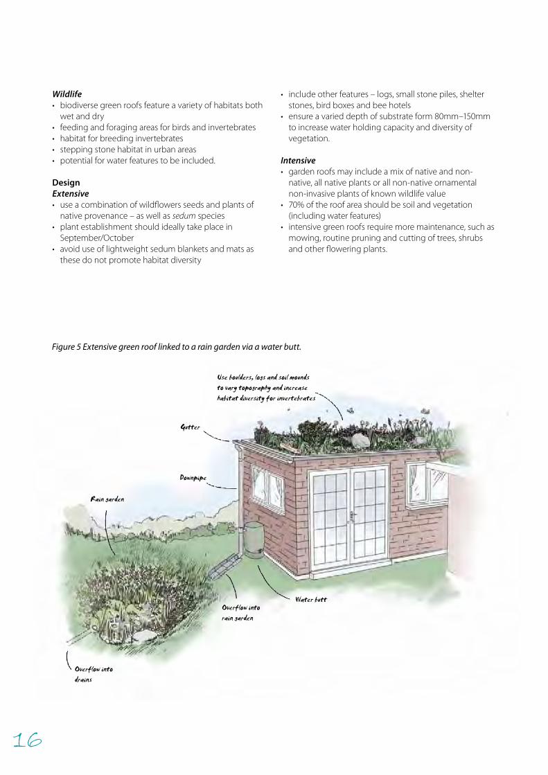
Wildlife• biodiverse green roofs feature a variety of habitats both
wet and dry• feeding and foraging areas for birds and invertebrates• habitat for breeding invertebrates• stepping stone habitat in urban areas • potential for water features to be included.
DesignExtensive • use a combination of wildflowers seeds and plants of
native provenance – as well as sedum species• plant establishment should ideally take place in
September/October• avoid use of lightweight sedum blankets and mats as
these do not promote habitat diversity
• include other features – logs, small stone piles, shelter stones, bird boxes and bee hotels
• ensure a varied depth of substrate form 80mm–150mm to increase water holding capacity and diversity of vegetation.
Intensive • garden roofs may include a mix of native and non-
native, all native plants or all non-native ornamental non-invasive plants of known wildlife value
• 70% of the roof area should be soil and vegetation (including water features)
• intensive green roofs require more maintenance, such as mowing, routine pruning and cutting of trees, shrubs and other flowering plants.
Figure 5 Extensive green roof linked to a rain garden via a water butt.
17
Cover for nesting birds
Foraging for bats and birds
Invertebrates can breedand shelter. Flowers canattract nectar-feeders
Open front nest boxe.g. for robins or wagtails
Conventional nest boxe.g. for sparrows or starlings
Bat box
Bug box
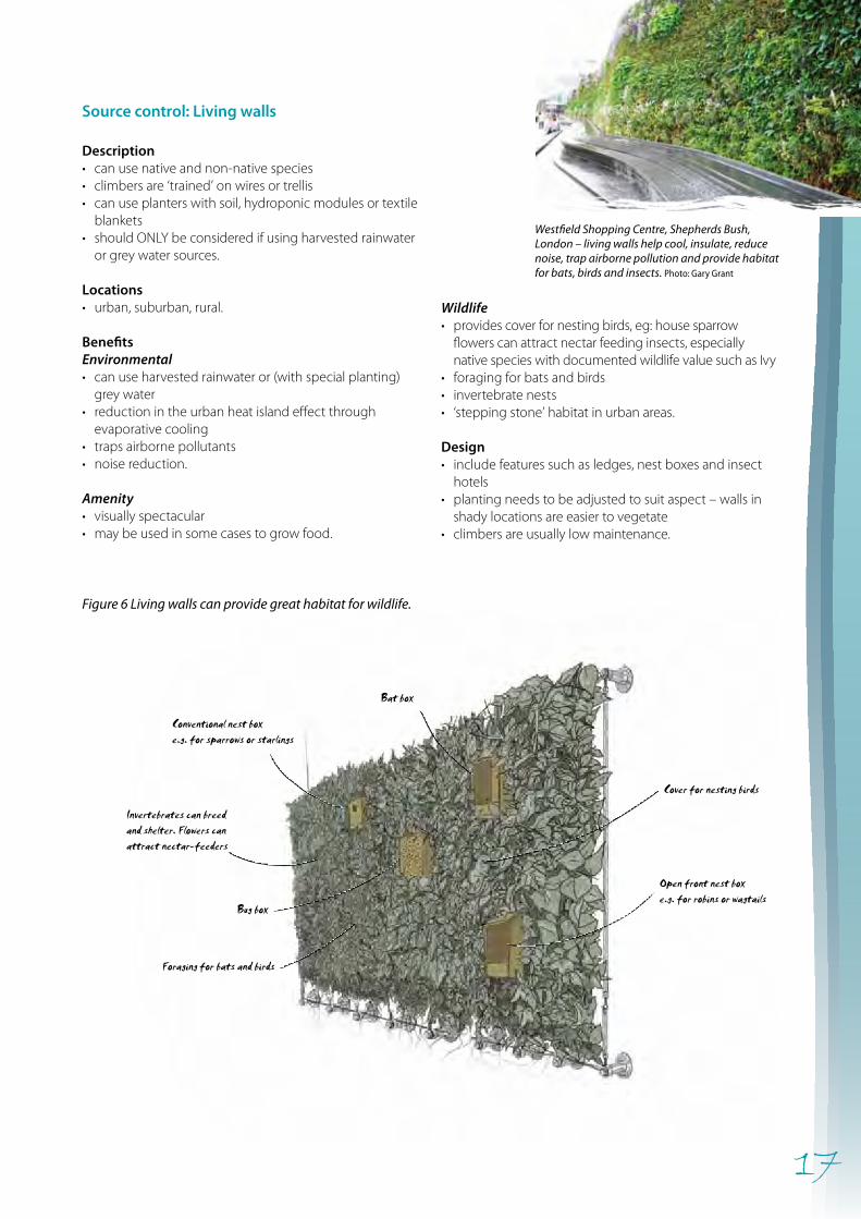
Wildlife • provides cover for nesting birds, eg: house sparrow
flowers can attract nectar feeding insects, especially native species with documented wildlife value such as Ivy
• foraging for bats and birds• invertebrate nests• ‘stepping stone’ habitat in urban areas.
Design• include features such as ledges, nest boxes and insect
hotels• planting needs to be adjusted to suit aspect – walls in
shady locations are easier to vegetate• climbers are usually low maintenance.
Figure 6 Living walls can provide great habitat for wildlife.
Source control: Living walls
Description• can use native and non-native species• climbers are ‘trained’ on wires or trellis • can use planters with soil, hydroponic modules or textile
blankets• should ONLY be considered if using harvested rainwater
or grey water sources.
Locations• urban, suburban, rural.
BenefitsEnvironmental • can use harvested rainwater or (with special planting)
grey water• reduction in the urban heat island effect through
evaporative cooling• traps airborne pollutants• noise reduction.
Amenity • visually spectacular• may be used in some cases to grow food.
Westfield Shopping Centre, Shepherds Bush, London – living walls help cool, insulate, reduce noise, trap airborne pollution and provide habitat for bats, birds and insects. Photo: Gary Grant
18
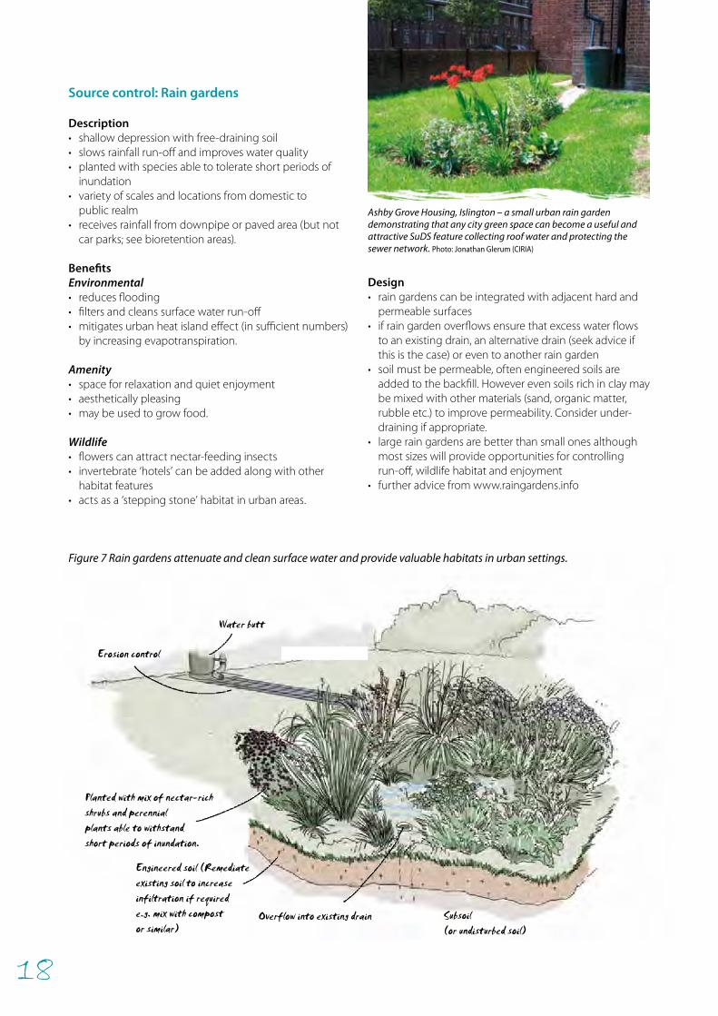
Erosion control
Engineered soil (Remediateexisting soil to increaseinfiltration if requirede.g. mix with compostor similar)
Subsoil (or undisturbed soil)
Planted with mix of nectar-rich shrubs and perennialplants able to withstandshort periods of inundation.
Water butt
Overflow into existing drain
Source control: Rain gardens
Description• shallow depression with free-draining soil• slows rainfall run-off and improves water quality • planted with species able to tolerate short periods of
inundation • variety of scales and locations from domestic to
public realm• receives rainfall from downpipe or paved area (but not
car parks; see bioretention areas).
Benefits Environmental• reduces flooding• filters and cleans surface water run-off• mitigates urban heat island effect (in sufficient numbers)
by increasing evapotranspiration.
Amenity• space for relaxation and quiet enjoyment• aesthetically pleasing• may be used to grow food.
Wildlife• flowers can attract nectar-feeding insects• invertebrate ‘hotels’ can be added along with other
habitat features• acts as a ‘stepping stone’ habitat in urban areas.
Design• rain gardens can be integrated with adjacent hard and
permeable surfaces• if rain garden overflows ensure that excess water flows
to an existing drain, an alternative drain (seek advice if this is the case) or even to another rain garden
• soil must be permeable, often engineered soils are added to the backfill. However even soils rich in clay may be mixed with other materials (sand, organic matter, rubble etc.) to improve permeability. Consider under-draining if appropriate.
• large rain gardens are better than small ones although most sizes will provide opportunities for controlling run-off, wildlife habitat and enjoyment
• further advice from www.raingardens.info
Figure 7 Rain gardens attenuate and clean surface water and provide valuable habitats in urban settings.
Ashby Grove Housing, Islington – a small urban rain garden demonstrating that any city green space can become a useful and attractive SuDS feature collecting roof water and protecting the sewer network. Photo: Jonathan Glerum (CIRIA)
19
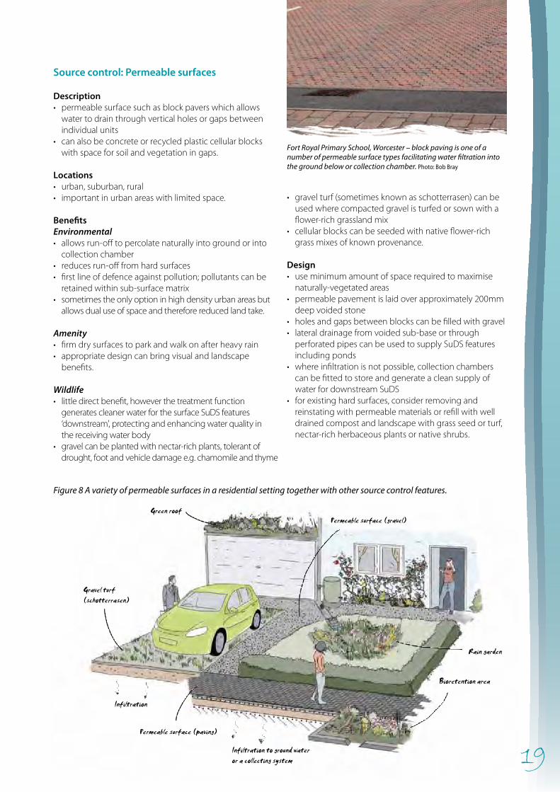
Permeable surface (gravel)Green roof
Rain garden
Gravel turf(schotterrasen)
Infiltration
Permeable surface (paving)
Infiltration to ground wateror a collecting system
Bioretention area
Source control: Permeable surfaces
Description• permeable surface such as block pavers which allows
water to drain through vertical holes or gaps between individual units
• can also be concrete or recycled plastic cellular blocks with space for soil and vegetation in gaps.
Locations• urban, suburban, rural• important in urban areas with limited space.
BenefitsEnvironmental • allows run-off to percolate naturally into ground or into
collection chamber• reduces run-off from hard surfaces• first line of defence against pollution; pollutants can be
retained within sub-surface matrix• sometimes the only option in high density urban areas but
allows dual use of space and therefore reduced land take.
Amenity • firm dry surfaces to park and walk on after heavy rain• appropriate design can bring visual and landscape
benefits.
Wildlife • little direct benefit, however the treatment function
generates cleaner water for the surface SuDS features ‘downstream’, protecting and enhancing water quality in the receiving water body
• gravel can be planted with nectar-rich plants, tolerant of drought, foot and vehicle damage e.g. chamomile and thyme
• gravel turf (sometimes known as schotterrasen) can be used where compacted gravel is turfed or sown with a flower-rich grassland mix
• cellular blocks can be seeded with native flower-rich grass mixes of known provenance.
Design• use minimum amount of space required to maximise
naturally-vegetated areas• permeable pavement is laid over approximately 200mm
deep voided stone• holes and gaps between blocks can be filled with gravel• lateral drainage from voided sub-base or through
perforated pipes can be used to supply SuDS features including ponds
• where infiltration is not possible, collection chambers can be fitted to store and generate a clean supply of water for downstream SuDS
• for existing hard surfaces, consider removing and reinstating with permeable materials or refill with well drained compost and landscape with grass seed or turf, nectar-rich herbaceous plants or native shrubs.
Fort Royal Primary School, Worcester – block paving is one of a number of permeable surface types facilitating water filtration into the ground below or collection chamber. Photo: Bob Bray
Figure 8 A variety of permeable surfaces in a residential setting together with other source control features.
20
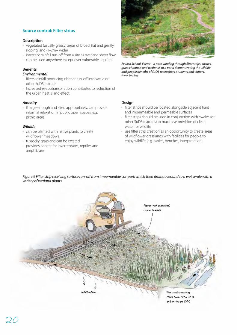
Infiltration
Flower-rich grassland,regularly mown
Wet swale receivingflows from filter stripand upstream SuDS
Source control: Filter strips
Description• vegetated (usually grassy) areas of broad, flat and gently
sloping land (1–2m+ wide)• intercept rainfall run-off from a site as overland sheet flow• can be used anywhere except over vulnerable aquifers.
BenefitsEnvironmental • filters rainfall producing cleaner run-off into swale or
other SuDS feature• Increased evapotranspiration contributes to reduction of
the urban heat island effect.
Amenity• if large enough and sited appropriately, can provide
informal relaxation in public open spaces, e.g. picnic areas.
Wildlife• can be planted with native plants to create
wildflower meadows• tussocky grassland can be created• provides habitat for invertebrates, reptiles and
amphibians.
Design• filter strips should be located alongside adjacent hard
and impermeable and permeable surfaces• filter strips should be used in conjunction with swales (or
other SuDS features) to maximise provision of clean water for wildlife
• use filter strip creation as an opportunity to create areas of wildflower grasslands with facilities for people to enjoy wildlife (e.g. tables, benches, interpretation).
Exwick School, Exeter – a path winding through filter strips, swales, grass channels and wetlands to a pond demonstrating the wildlife and people benefits of SuDS to teachers, students and visitors. Photo: Bob Bray
Figure 9 Filter strip receiving surface run-off from impermeable car-park which then drains overland to a wet swale with a variety of wetland plants.
21
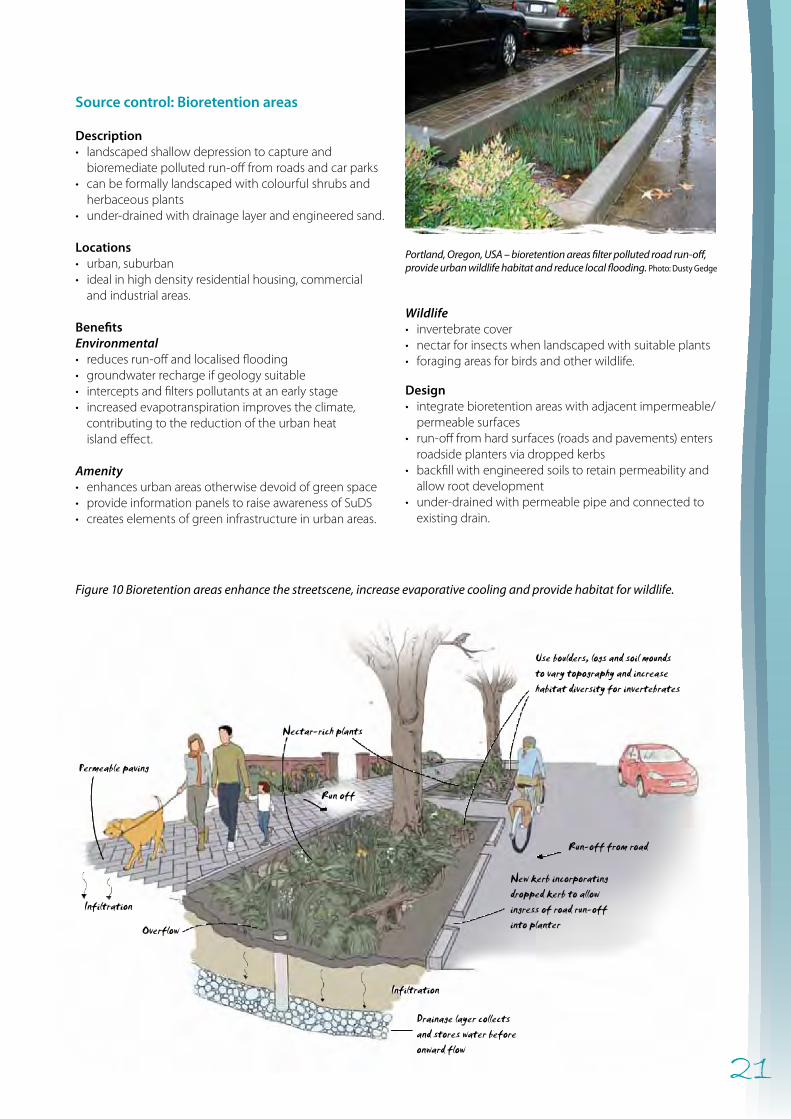
Permeable paving
Infiltration
Infiltration
Use boulders, logs and soil moundsto vary topography and increasehabitat diversity for invertebrates
Drainage layer collectsand stores water beforeonward flow
Run off
Run-off from road
New kerb incorporatingdropped kerb to allowingress of road run-offinto planter
Nectar-rich plants
Overflow
Source control: Bioretention areas
Description• landscaped shallow depression to capture and
bioremediate polluted run-off from roads and car parks• can be formally landscaped with colourful shrubs and
herbaceous plants• under-drained with drainage layer and engineered sand.
Locations• urban, suburban• ideal in high density residential housing, commercial
and industrial areas.
BenefitsEnvironmental • reduces run-off and localised flooding• groundwater recharge if geology suitable• intercepts and filters pollutants at an early stage• increased evapotranspiration improves the climate,
contributing to the reduction of the urban heat island effect.
Amenity • enhances urban areas otherwise devoid of green space• provide information panels to raise awareness of SuDS• creates elements of green infrastructure in urban areas.
Figure 10 Bioretention areas enhance the streetscene, increase evaporative cooling and provide habitat for wildlife.
Wildlife • invertebrate cover• nectar for insects when landscaped with suitable plants• foraging areas for birds and other wildlife.
Design• integrate bioretention areas with adjacent impermeable/
permeable surfaces• run-off from hard surfaces (roads and pavements) enters
roadside planters via dropped kerbs• backfill with engineered soils to retain permeability and
allow root development• under-drained with permeable pipe and connected to
existing drain.
Portland, Oregon, USA – bioretention areas filter polluted road run-off, provide urban wildlife habitat and reduce local flooding. Photo: Dusty Gedge
22
Permeablepaving
Infiltration
Partially buriedhabitat pile
ConcreteSoil
Waterproof render
Liner
Separatingblock wall
Wall
Permanent water
Ensure use of native marginal andsubmergent aquatic vegetation.DO NOT use non-native plants
Maximum storage volume Grass
Figure 11 Urban ponds integrated into hard landscaping of SuDS can provide somewhere pleasant to sit, and when planted appropriately can also be attractive to wildlife.
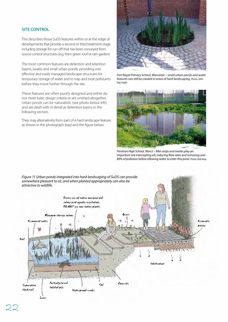
SITE CONTROL
This describes those SuDS features within or at the edge of developments that provide a second or third treatment stage including storage for run-off that has been conveyed from source control structures (e.g. from green roof or rain garden). The most common features are detention and retention basins, swales and small urban ponds, providing cost effective and easily managed landscape structures for temporary storage of water and to trap and treat pollutants before they move further through the site.
These features are often poorly designed and either do not meet basic design criteria or are omitted altogether. Urban ponds can be naturalistic (see photo below left) and are dealt with in detail as detention basins in the following section.
They may alternatively form part of a hard landscape feature, as shown in the photograph (top) and the figure below.
Fort Royal Primary School, Worcester – small urban ponds and water features can still be created in areas of hard landscaping. Photo: John Day (rspb)
Pershore High School, Worcs – filter strips and swales play an important role intercepting silt, reducing flow rates and removing over 80% of pollution before allowing water to enter this pond. Photo: Bob Bray
23
Outlet with erosion control feature,requires regular inspection
Linked to downstream SuDS orreceiving watercourse
Wetland plants can beintroduced and/or allowedto colonise naturally
Damp zone - used for formal and informalrecreation when not inundated
Inlet with erosion control feature,requires regular inspection
High water level(after rainfall)
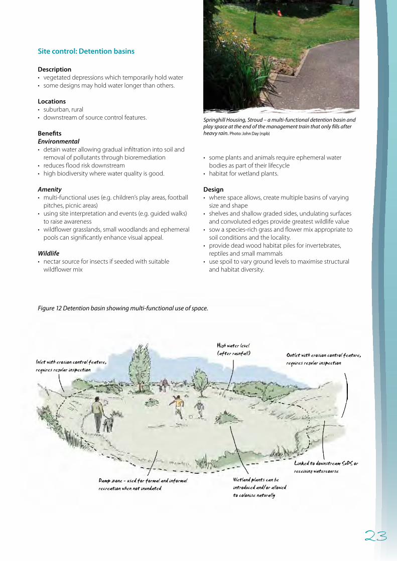
Site control: Detention basins
Description• vegetated depressions which temporarily hold water• some designs may hold water longer than others.
Locations• suburban, rural• downstream of source control features.
BenefitsEnvironmental• detain water allowing gradual infiltration into soil and
removal of pollutants through bioremediation• reduces flood risk downstream• high biodiversity where water quality is good.
Amenity• multi-functional uses (e.g. children’s play areas, football
pitches, picnic areas) • using site interpretation and events (e.g. guided walks)
to raise awareness • wildflower grasslands, small woodlands and ephemeral
pools can significantly enhance visual appeal.
Wildlife• nectar source for insects if seeded with suitable
wildflower mix
• some plants and animals require ephemeral water bodies as part of their lifecycle
• habitat for wetland plants.
Design• where space allows, create multiple basins of varying
size and shape• shelves and shallow graded sides, undulating surfaces
and convoluted edges provide greatest wildlife value• sow a species-rich grass and flower mix appropriate to
soil conditions and the locality. • provide dead wood habitat piles for invertebrates,
reptiles and small mammals • use spoil to vary ground levels to maximise structural
and habitat diversity.
Figure 12 Detention basin showing multi-functional use of space.
Springhill Housing, Stroud – a multi-functional detention basin and play space at the end of the management train that only fills after heavy rain. Photo: John Day (rspb)
24
Gently sloping marshy area(max 1:3 slope)
Permanent water - max 500mm deep
Outflow to downstream SuDSor receiving water course
Swale with inflowfrom upstream SuDS
Dry bench(gently slopinggrassy area justabove marsh)
REGIONAL CONTROL
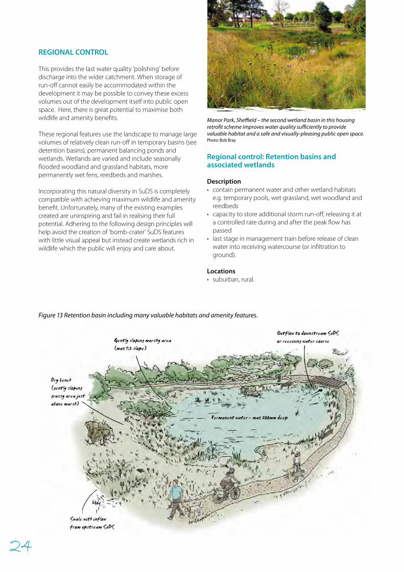
This provides the last water quality ‘polishing’ before discharge into the wider catchment. When storage of run-off cannot easily be accommodated within the development it may be possible to convey these excess volumes out of the development itself into public open space. Here, there is great potential to maximise both wildlife and amenity benefits.
These regional features use the landscape to manage large volumes of relatively clean run-off in temporary basins (see detention basins), permanent balancing ponds and wetlands. Wetlands are varied and include seasonally flooded woodland and grassland habitats, more permanently wet fens, reedbeds and marshes.
Incorporating this natural diversity in SuDS is completely compatible with achieving maximum wildlife and amenity benefit. Unfortunately, many of the existing examples created are uninspiring and fail in realising their full potential. Adhering to the following design principles will help avoid the creation of ‘bomb-crater’ SuDS features with little visual appeal but instead create wetlands rich in wildlife which the public will enjoy and care about.
Regional control: Retention basins and associated wetlands
Description• contain permanent water and other wetland habitats
e.g. temporary pools, wet grassland, wet woodland and reedbeds
• capacity to store additional storm run-off, releasing it at a controlled rate during and after the peak flow has passed
• last stage in management train before release of clean water into receiving watercourse (or infiltration to ground).
Locations• suburban, rural.
Figure 13 Retention basin including many valuable habitats and amenity features.
Manor Park, Sheffield – the second wetland basin in this housing retrofit scheme improves water quality sufficiently to provide valuable habitat and a safe and visually-pleasing public open space. Photo: Bob Bray
25
Outflow to local stream
Wet grassland with ephemeralpools and channels rich inwetland wildlife. Semi-natural area wherenatural colonisation andprocesses are encouraged.
Inflow
Interpretation panel
Uneven topographycreates a variety ofwetland micro-habitatsgood for wildlife
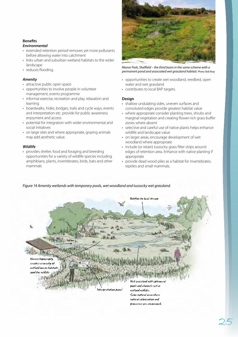
BenefitsEnvironmental• extended retention period removes yet more pollutants
before allowing water into catchment • links urban and suburban wetland habitats to the wider
landscape• reduces flooding.
Amenity • attractive public open space• opportunities to involve people in volunteer
management, events programme• informal exercise, recreation and play, relaxation and
learning • boardwalks, hides, bridges, trails and cycle ways, events
and interpretation etc. provide for public awareness enjoyment and access
• potential for integration with wider environmental and social initiatives
• on large sites and where appropriate, grazing animals may add aesthetic value.
Wildlife• provides shelter, food and foraging and breeding
opportunities for a variety of wildlife species including amphibians, plants, invertebrates, birds, bats and other mammals
• opportunities to create wet woodland, reedbed, open water and wet grassland
• contributes to local BAP targets.
Design• shallow undulating sides, uneven surfaces and
convoluted edges provide greatest habitat value• where appropriate consider planting trees, shrubs and
marginal vegetation and creating flower-rich grass buffer zones where absent
• selective and careful use of native plants helps enhance wildlife and landscape value
• on larger areas, encourage development of wet woodland where appropriate
• include (or retain) tussocky grass filter strips around edges of retention area. Enhance with native planting if appropriate
• provide dead wood piles as a habitat for invertebrates, reptiles and small mammals.
Manor Park, Sheffield – the third basin in the same scheme with a permanent pond and associated wet grassland habitat. Photo: Bob Bray
Figure 14 Amenity wetlands with temporary pools, wet woodland and tussocky wet grassland.
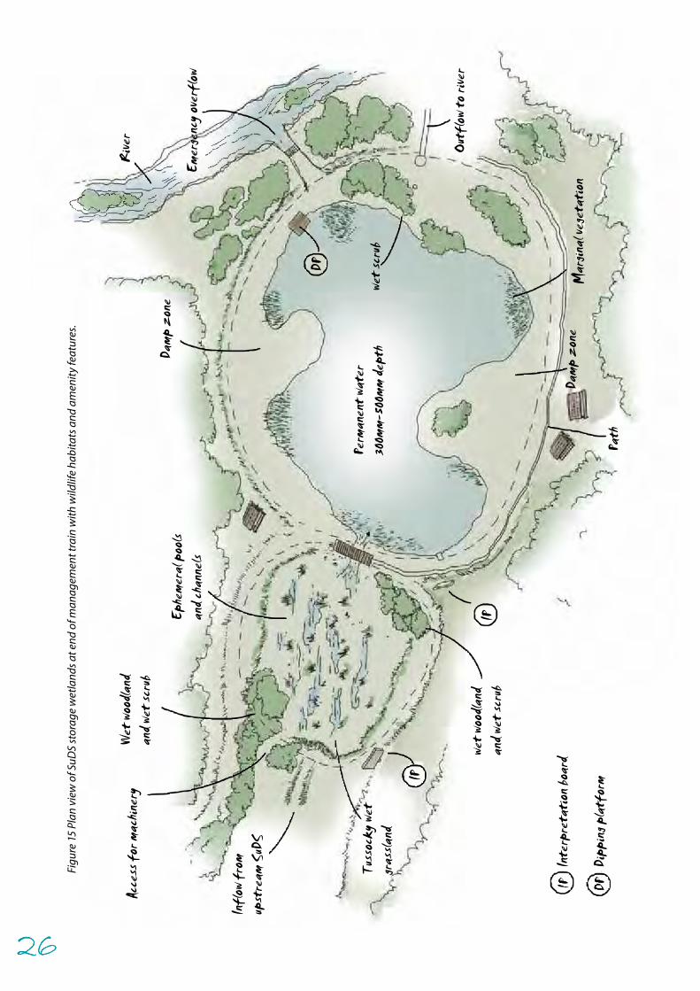
26
Acce
ss f
or m
achin
ery
Wet
woo
dland
and w
et sc
rub
Ephe
mera
l poo
lsan
d cha
nnels
Damp
zon
e
Rive
r
Emer
genc
y ove
rflow
Outf
low to
rive
r
Damp
zon
e
Path
Mar
ginal
vege
tati
on
wet s
crub
IP
IP
wet w
oodla
ndan
d wet
scru
b
Tuss
ocky
wet
gras
sland
Infl
ow f
rom
upst
ream
SuD
S
Perm
anen
t wat
er30
0mm-
500m
m de
pth
DP
Inte
rpre
tati
on bo
ard
Dipp
ing p
latf
orm
Figu
re 1
5 Pl
an v
iew
of S
uDS
stor
age
wet
land
s at e
nd o
f man
agem
ent t
rain
with
wild
life
habi
tats
and
am
enity
feat
ures
.
26
27
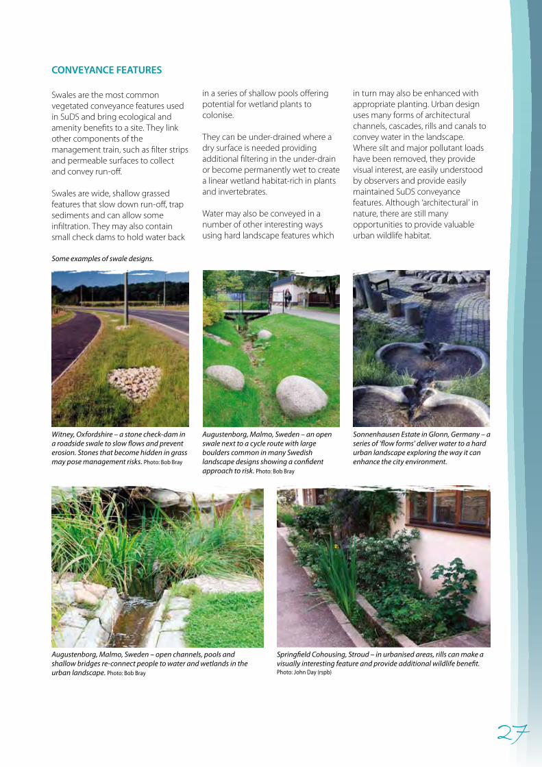
CONVEYANCE FEATURES
Swales are the most common vegetated conveyance features used in SuDS and bring ecological and amenity benefits to a site. They link other components of the management train, such as filter strips and permeable surfaces to collect and convey run-off.
Swales are wide, shallow grassed features that slow down run-off, trap sediments and can allow some infiltration. They may also contain small check dams to hold water back
in a series of shallow pools offering potential for wetland plants to colonise.
They can be under-drained where a dry surface is needed providing additional filtering in the under-drain or become permanently wet to create a linear wetland habitat-rich in plants and invertebrates.
Water may also be conveyed in a number of other interesting ways using hard landscape features which
Springfield Cohousing, Stroud – in urbanised areas, rills can make a visually interesting feature and provide additional wildlife benefit. Photo: John Day (rspb)
Augustenborg, Malmo, Sweden – open channels, pools and shallow bridges re-connect people to water and wetlands in the urban landscape. Photo: Bob Bray
Sonnenhausen Estate in Glonn, Germany – a series of ‘flow forms’ deliver water to a hard urban landscape exploring the way it can enhance the city environment.
Augustenborg, Malmo, Sweden – an open swale next to a cycle route with large boulders common in many Swedish landscape designs showing a confident approach to risk. Photo: Bob Bray
Witney, Oxfordshire – a stone check-dam in a roadside swale to slow flows and prevent erosion. Stones that become hidden in grass may pose management risks. Photo: Bob Bray
in turn may also be enhanced with appropriate planting. Urban design uses many forms of architectural channels, cascades, rills and canals to convey water in the landscape. Where silt and major pollutant loads have been removed, they provide visual interest, are easily understood by observers and provide easily maintained SuDS conveyance features. Although ‘architectural’ in nature, there are still many opportunities to provide valuable urban wildlife habitat.
Some examples of swale designs.
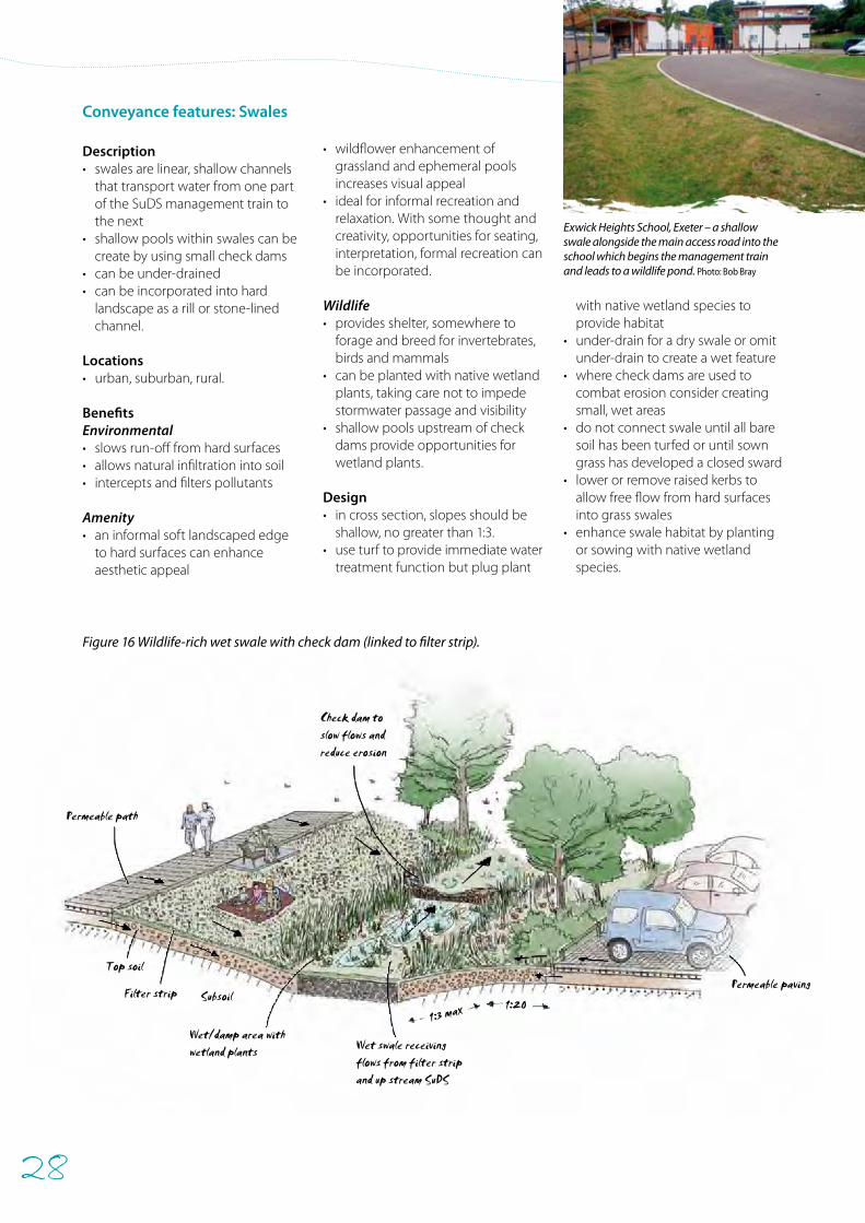
28
Wet swale receivingflows from filter stripand up stream SuDS
Wet/damp area withwetland plants
Subsoil
Permeable path
Permeable pavingTop soil
Filter strip
Check dam toslow flows andreduce erosion
1:3 max 1:20
Conveyance features: Swales
Description• swales are linear, shallow channels
that transport water from one part of the SuDS management train to the next
• shallow pools within swales can be create by using small check dams
• can be under-drained• can be incorporated into hard
landscape as a rill or stone-lined channel.
Locations• urban, suburban, rural.
BenefitsEnvironmental• slows run-off from hard surfaces• allows natural infiltration into soil• intercepts and filters pollutants
Amenity• an informal soft landscaped edge
to hard surfaces can enhance aesthetic appeal
• wildflower enhancement of grassland and ephemeral pools increases visual appeal
• ideal for informal recreation and relaxation. With some thought and creativity, opportunities for seating, interpretation, formal recreation can be incorporated.
Wildlife• provides shelter, somewhere to
forage and breed for invertebrates, birds and mammals
• can be planted with native wetland plants, taking care not to impede stormwater passage and visibility
• shallow pools upstream of check dams provide opportunities for wetland plants.
Design • in cross section, slopes should be
shallow, no greater than 1:3. • use turf to provide immediate water
treatment function but plug plant
with native wetland species to provide habitat
• under-drain for a dry swale or omit under-drain to create a wet feature
• where check dams are used to combat erosion consider creating small, wet areas
• do not connect swale until all bare soil has been turfed or until sown grass has developed a closed sward
• lower or remove raised kerbs to allow free flow from hard surfaces into grass swales
• enhance swale habitat by planting or sowing with native wetland species.
Figure 16 Wildlife-rich wet swale with check dam (linked to filter strip).
Exwick Heights School, Exeter – a shallow swale alongside the main access road into the school which begins the management train and leads to a wildlife pond. Photo: Bob Bray
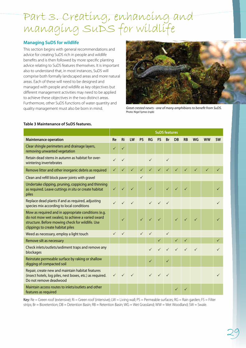
29
Managing SuDS for wildlifeThis section begins with general recommendations and advice for creating SuDS rich in people and wildlife benefits and is then followed by more specific planting advice relating to SuDS features themselves. It is important also to understand that, in most instances, SuDS will comprise both formally landscaped areas and more natural areas. Each of these will need to be designed and managed with people and wildlife as key objectives but different management activities may need to be applied to achieve these objectives in the two distinct areas. Furthermore, other SuDS functions of water quantity and quality management must also be born in mind.
Table 3 Maintenance of SuDS features.
SuDS features
Maintenance operation Re Ri LW PS RG FS Br DB RB WG WW SW
Clear shingle perimeters and drainage layers, removing unwanted vegetation
P P
Retain dead stems in autumn as habitat for over- wintering invertebrates
P P P P
Remove litter and other inorganic debris as required P P P P P P P P P P P P
Clean and refill block paver joints with gravel P
Undertake clipping, pruning, coppicing and thinning as required. Leave cuttings in situ or create habitat piles
P P P P P P P P
Replace dead plants if and as required, adjusting species mix according to local conditions
P P P P P P P
Mow as required and in appropriate conditions (e.g. do not mow wet swales), to achieve a varied sward structure. Before mowing check for wildlife. Use clippings to create habitat piles
P P P P P P P P
Weed as necessary, employ a light touch P P P P P
Remove silt as necessary P P P P
Check inlets/outlets/sediment traps and remove any blockages
P P P P P P P
Reinstate permeable surface by raking or shallow digging of compacted soil
P P
Repair, create new and maintain habitat features (insect hotels, log piles, nest boxes, etc.) as required. Do not remove deadwood
P P P P P P P
Maintain access routes to inlets/outlets and other features as required
P P
Key: Re = Green roof (extensive); Ri = Green roof (intensive); LW = Living wall; PS = Permeable surfaces; RG = Rain garden; FS = Filter strips; Br = Bioretention; DB = Detention Basin; RB = Retention Basin; WG = Wet Grassland; WW = Wet Woodland; SW = Swale.
Great crested newts - one of many amphibians to benefit from SuDS. Photo: Nigel Symes (rspb)
Part 3. Creating, enhancing and managing SuDS for wildlife
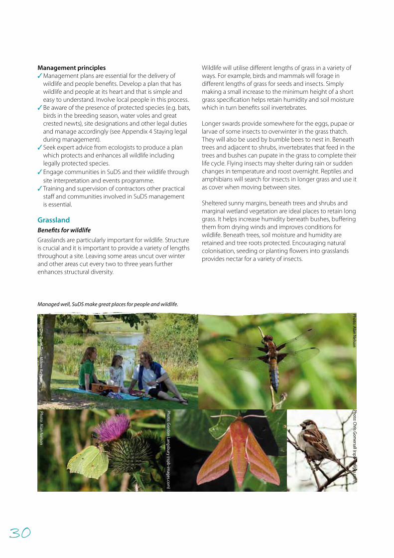
30
Management principles✓Management plans are essential for the delivery of
wildlife and people benefits. Develop a plan that has wildlife and people at its heart and that is simple and easy to understand. Involve local people in this process.
✓Be aware of the presence of protected species (e.g. bats, birds in the breeding season, water voles and great crested newts), site designations and other legal duties and manage accordingly (see Appendix 4 Staying legal during management).
✓Seek expert advice from ecologists to produce a plan which protects and enhances all wildlife including legally protected species.
✓Engage communities in SuDS and their wildlife through site interpretation and events programme.
✓Training and supervision of contractors other practical staff and communities involved in SuDS management is essential.
Grassland Benefits for wildlife
Grasslands are particularly important for wildlife. Structure is crucial and it is important to provide a variety of lengths throughout a site. Leaving some areas uncut over winter and other areas cut every two to three years further enhances structural diversity.
Wildlife will utilise different lengths of grass in a variety of ways. For example, birds and mammals will forage in different lengths of grass for seeds and insects. Simply making a small increase to the minimum height of a short grass specification helps retain humidity and soil moisture which in turn benefits soil invertebrates.
Longer swards provide somewhere for the eggs, pupae or larvae of some insects to overwinter in the grass thatch. They will also be used by bumble bees to nest in. Beneath trees and adjacent to shrubs, invertebrates that feed in the trees and bushes can pupate in the grass to complete their life cycle. Flying insects may shelter during rain or sudden changes in temperature and roost overnight. Reptiles and amphibians will search for insects in longer grass and use it as cover when moving between sites.
Sheltered sunny margins, beneath trees and shrubs and marginal wetland vegetation are ideal places to retain long grass. It helps increase humidity beneath bushes, buffering them from drying winds and improves conditions for wildlife. Beneath trees, soil moisture and humidity are retained and tree roots protected. Encouraging natural colonisation, seeding or planting flowers into grasslands provides nectar for a variety of insects.
Photo: Alan Nelson
Photo: Gordon Langsbury (rspb-im
ages.com)
Photo: The Parks Trust Milton Keynes
Managed well, SuDS make great places for people and wildlife.
Photo: Alan Nelson
Photo: Chris Gom
ersall (rspb-images.com
)
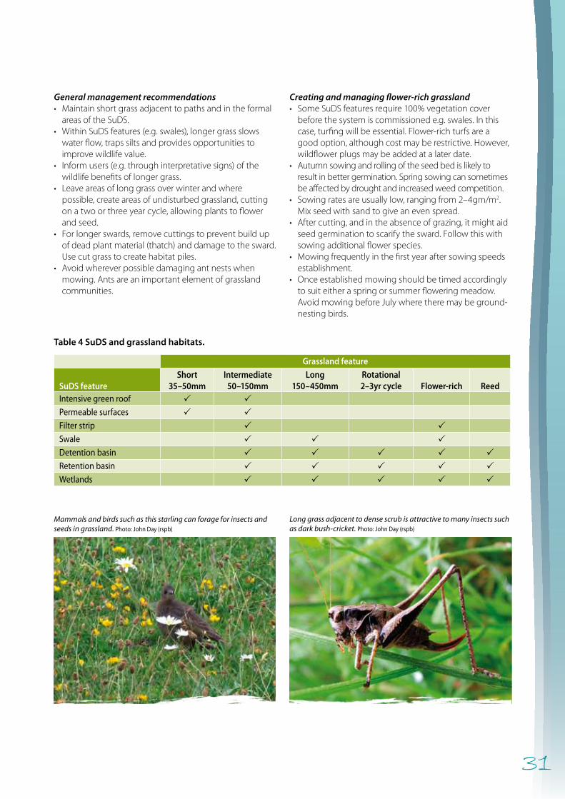
31
General management recommendations• Maintainshortgrassadjacenttopathsandintheformal
areasoftheSuDS.• WithinSuDSfeatures(e.g.swales),longergrassslows
waterflow,trapssiltsandprovidesopportunitiestoimprovewildlifevalue.
• Informusers(e.g.throughinterpretativesigns)ofthewildlifebenefitsoflongergrass.
• Leaveareasoflonggrassoverwinterandwherepossible,createareasofundisturbedgrassland,cuttingonatwoorthreeyearcycle,allowingplantstoflowerandseed.
• Forlongerswards,removecuttingstopreventbuildupofdeadplantmaterial(thatch)anddamagetothesward.Usecutgrasstocreatehabitatpiles.
• Avoidwhereverpossibledamagingantnestswhenmowing.Antsareanimportantelementofgrasslandcommunities.
Creating and managing flower-rich grassland• SomeSuDSfeaturesrequire100%vegetationcover
beforethesystemiscommissionede.g.swales.Inthiscase,turfingwillbeessential.Flower-richturfsareagoodoption,althoughcostmayberestrictive.However,wildflowerplugsmaybeaddedatalaterdate.
• Autumnsowingandrollingoftheseedbedislikelytoresultinbettergermination.Springsowingcansometimesbeaffectedbydroughtandincreasedweedcompetition.
• Sowingratesareusuallylow,rangingfrom2–4gm/m2.Mixseedwithsandtogiveanevenspread.
• Aftercutting,andintheabsenceofgrazing,itmightaidseedgerminationtoscarifythesward.Followthiswithsowingadditionalflowerspecies.
• Mowingfrequentlyinthefirstyearaftersowingspeedsestablishment.
• Onceestablishedmowingshouldbetimedaccordinglytosuiteitheraspringorsummerfloweringmeadow.AvoidmowingbeforeJulywheretheremaybeground-nestingbirds.
Long grass adjacent to dense scrub is attractive to many insects such as dark bush-cricket. Photo: John Day (rspb)
Mammals and birds such as this starling can forage for insects and seeds in grassland. Photo: John Day (rspb)
Table 4 SuDS and grassland habitats.
Grassland feature
SuDS featureShort
35–50mmIntermediate
50–150mmLong
150–450mmRotational2–3yr cycle Flower-rich Reed
Intensive green roof P PPermeable surfaces P PFilter strip P PSwale P P PDetention basin P P P P PRetention basin P P P P PWetlands P P P P P
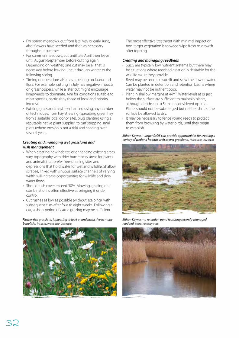
32
• Forspringmeadows,cutfromlateMayorearlyJune,afterflowershaveseededandthenasnecessarythroughoutsummer.
• Forsummermeadows,cutuntillateAprilthenleaveuntilAugust–Septemberbeforecuttingagain.Dependingonweather,onecutmaybeallthatisnecessarybeforeleavinguncutthroughwintertothefollowingspring.
• Timingofoperationsalsohasabearingonfaunaandflora.Forexample,cuttinginJulyhasnegativeimpactsongrasshoppers,whilealatercutmightencourageknapweedstodominate.Aimforconditionssuitabletomostspecies,particularlythoseoflocalandpriorityinterest.
• Existinggrasslandmaybeenhancedusinganynumberoftechniques,fromhaystrewing(spreadinggreenhayfromasuitablelocaldonorsite),plugplantingusingareputablenativeplantsupplier,toturfstrippingsmallplots(whereerosionisnotarisk)andseedingoverseveralyears.
Creating and managing wet grassland and rush management• Whencreatingnewhabitat,orenhancingexistingareas,
varytopographywithdrierhummockyareasforplantsandanimalsthatpreferfree-drainingsitesanddepressionsthatholdwaterforwetlandwildlife.Shallowscrapes,linkedwithsinuoussurfacechannelsofvaryingwidthwillincreaseopportunitiesforwildlifeandslowwaterflows.
• Shouldrushcoverexceed30%.Mowing,grazingoracombinationisofteneffectiveatbringingitundercontrol.
• Cutrushesaslowaspossible(withoutscalping),withsubsequentcutsafterfourtoeightweeks.Followingacut,ashortperiodofcattlegrazingmaybesufficient.
Themosteffectivetreatmentwithminimalimpactonnon-targetvegetationistoweedwipefreshre-growthaftertopping.
Creating and managing reedbeds • SuDSaretypicallylownutrientsystemsbuttheremay
besituationswherereedbedcreationisdesirableforthewildlifevaluetheyprovide
• Reedmaybeusedtotrapsiltandslowtheflowofwater.Canbeplantedindetentionandretentionbasinswherewatermaynotbenutrientpoor.
• Plantinshallowmarginsat4/m2.Waterlevelsatorjustbelowthesurfacearesufficienttomaintainplants,althoughdepthsupto5cmareconsideredoptimal.Plantsshouldnotbesubmergedbutneithershouldthesurfacebeallowedtodry.
• Itmaybenecessarytofenceyoungreedstoprotectthemfrombrowsingbywaterbirds,untiltheybegintoestablish.
Milton Keynes – larger SuDS can provide opportunities for creating a variety of wetland habitat such as wet grassland. Photo: John Day (rspb)
Flower-rich grassland is pleasing to look at and attractive to many beneficial insects. Photo: John Day (rspb)
Milton Keynes – a retention pond featuring recently-managed reedbed. Photo: John Day (rspb)
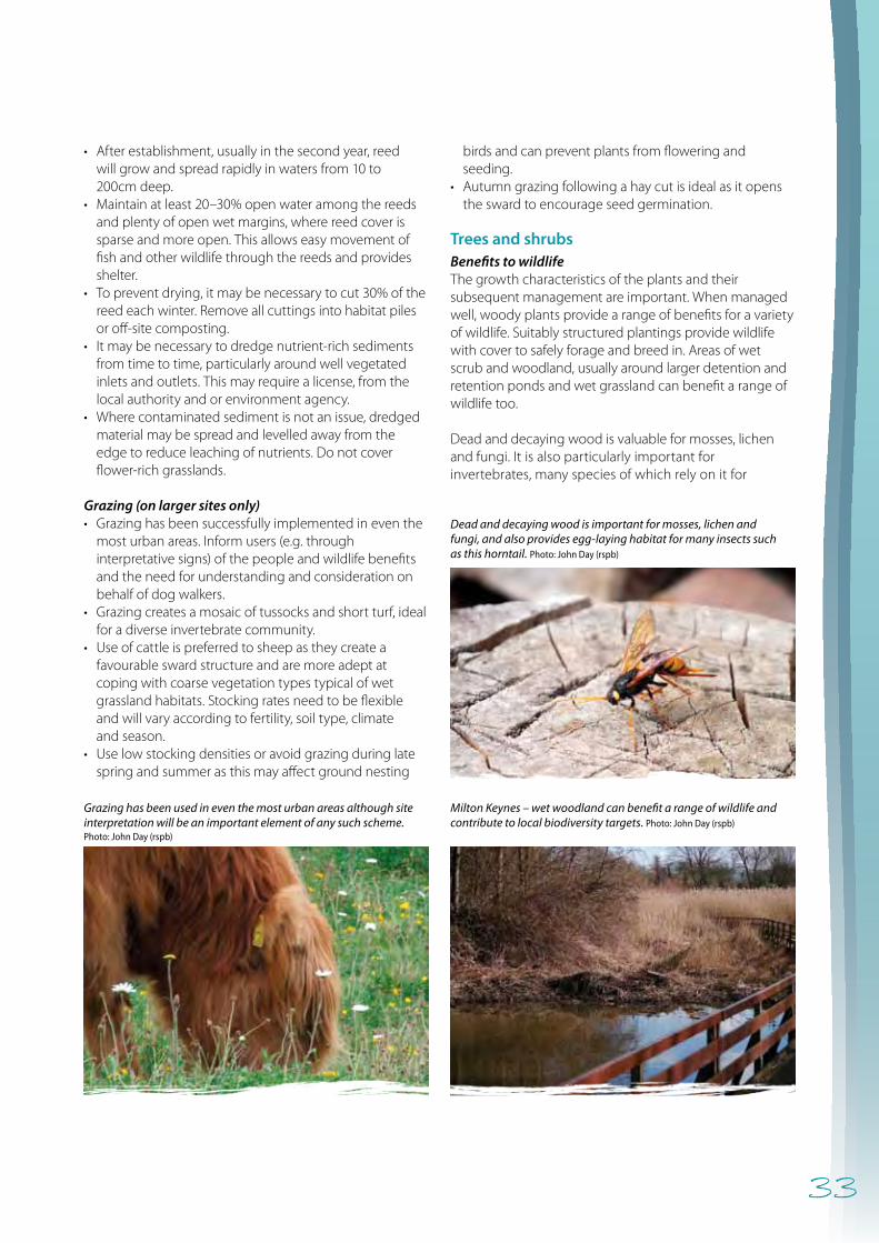
33
• After establishment, usually in the second year, reed will grow and spread rapidly in waters from 10 to 200cm deep.
• Maintain at least 20–30% open water among the reeds and plenty of open wet margins, where reed cover is sparse and more open. This allows easy movement of fish and other wildlife through the reeds and provides shelter.
• To prevent drying, it may be necessary to cut 30% of the reed each winter. Remove all cuttings into habitat piles or off-site composting.
• It may be necessary to dredge nutrient-rich sediments from time to time, particularly around well vegetated inlets and outlets. This may require a license, from the local authority and or environment agency.
• Where contaminated sediment is not an issue, dredged material may be spread and levelled away from the edge to reduce leaching of nutrients. Do not cover flower-rich grasslands.
Grazing (on larger sites only)• Grazing has been successfully implemented in even the
most urban areas. Inform users (e.g. through interpretative signs) of the people and wildlife benefits and the need for understanding and consideration on behalf of dog walkers.
• Grazing creates a mosaic of tussocks and short turf, ideal for a diverse invertebrate community.
• Use of cattle is preferred to sheep as they create a favourable sward structure and are more adept at coping with coarse vegetation types typical of wet grassland habitats. Stocking rates need to be flexible and will vary according to fertility, soil type, climate and season.
• Use low stocking densities or avoid grazing during late spring and summer as this may affect ground nesting
birds and can prevent plants from flowering and seeding.
• Autumn grazing following a hay cut is ideal as it opens the sward to encourage seed germination.
Trees and shrubs Benefits to wildlifeThe growth characteristics of the plants and their subsequent management are important. When managed well, woody plants provide a range of benefits for a variety of wildlife. Suitably structured plantings provide wildlife with cover to safely forage and breed in. Areas of wet scrub and woodland, usually around larger detention and retention ponds and wet grassland can benefit a range of wildlife too.
Dead and decaying wood is valuable for mosses, lichen and fungi. It is also particularly important for invertebrates, many species of which rely on it for
Grazing has been used in even the most urban areas although site interpretation will be an important element of any such scheme. Photo: John Day (rspb)
Dead and decaying wood is important for mosses, lichen and fungi, and also provides egg-laying habitat for many insects such as this horntail. Photo: John Day (rspb)
Milton Keynes – wet woodland can benefit a range of wildlife and contribute to local biodiversity targets. Photo: John Day (rspb)
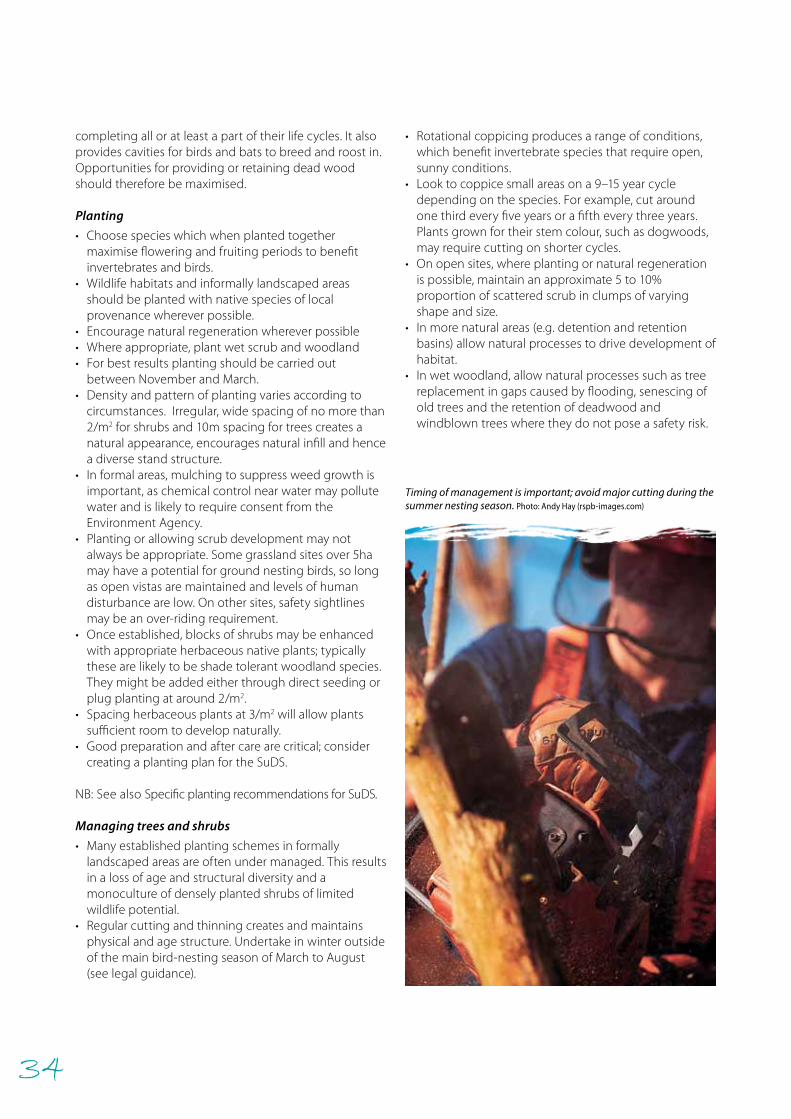
34
• Rotational coppicing produces a range of conditions, which benefit invertebrate species that require open, sunny conditions.
• Look to coppice small areas on a 9–15 year cycle depending on the species. For example, cut around one third every five years or a fifth every three years. Plants grown for their stem colour, such as dogwoods, may require cutting on shorter cycles.
• On open sites, where planting or natural regeneration is possible, maintain an approximate 5 to 10% proportion of scattered scrub in clumps of varying shape and size.
• In more natural areas (e.g. detention and retention basins) allow natural processes to drive development of habitat.
• In wet woodland, allow natural processes such as tree replacement in gaps caused by flooding, senescing of old trees and the retention of deadwood and windblown trees where they do not pose a safety risk.
completing all or at least a part of their life cycles. It also provides cavities for birds and bats to breed and roost in. Opportunities for providing or retaining dead wood should therefore be maximised. Planting
• Choose species which when planted together maximise flowering and fruiting periods to benefit invertebrates and birds.
• Wildlife habitats and informally landscaped areas should be planted with native species of local provenance wherever possible.
• Encourage natural regeneration wherever possible• Where appropriate, plant wet scrub and woodland • For best results planting should be carried out
between November and March. • Density and pattern of planting varies according to
circumstances. Irregular, wide spacing of no more than 2/m2 for shrubs and 10m spacing for trees creates a natural appearance, encourages natural infill and hence a diverse stand structure.
• In formal areas, mulching to suppress weed growth is important, as chemical control near water may pollute water and is likely to require consent from the Environment Agency.
• Planting or allowing scrub development may not always be appropriate. Some grassland sites over 5ha may have a potential for ground nesting birds, so long as open vistas are maintained and levels of human disturbance are low. On other sites, safety sightlines may be an over-riding requirement.
• Once established, blocks of shrubs may be enhanced with appropriate herbaceous native plants; typically these are likely to be shade tolerant woodland species. They might be added either through direct seeding or plug planting at around 2/m2.
• Spacing herbaceous plants at 3/m2 will allow plants sufficient room to develop naturally.
• Good preparation and after care are critical; consider creating a planting plan for the SuDS.
NB: See also Specific planting recommendations for SuDS.
Managing trees and shrubs
• Many established planting schemes in formally landscaped areas are often under managed. This results in a loss of age and structural diversity and a monoculture of densely planted shrubs of limited wildlife potential.
• Regular cutting and thinning creates and maintains physical and age structure. Undertake in winter outside of the main bird-nesting season of March to August (see legal guidance).
Timing of management is important; avoid major cutting during the summer nesting season. Photo: Andy Hay (rspb-images.com)
35
• To maintain perpetuity and age diversity, select and retain saplings during thinning. Alternatively, gap up with native ‘whips’ or ‘feathers’.
• After thinning, a temporary flush of annual and perennial plants is likely. This provides valuable nectar for invertebrates. Look to retain this, particularly in less formal areas. Shrubs will soon re-grow to shade them out.
• In formal locations, consider under-planting thinned shrub stands with nectar-rich annuals and perennials. For longer-term benefit, choose shade or partial shade tolerant, herbaceous plants. Native woodland species would be preferable but in formal areas this is not necessarily essential.
• Inform the local community and users of pending thinning work, explaining the long-term environmental benefits.
Dead and decaying wood
• Retain and increase the amount of cut woody material on site, laying or stacking at or near to where it has been cut.
• Where safe to do so, retain standing dead and dying trees and shrubs. Also, retain any stumps of trees that have had to be removed.
• For mature or veteran trees, always seek specialist advice particularly with reference to the likelihood of bats being present within the tree (see Appendix 4 Staying legal during management).
• Create habitat piles with cuttings and pruned material (see Appendix 3 Miscellaneous features for ideas).
Specific planting recommendations for SuDS
Aims
Planting plans should ensure that plant choice and location:• prevent erosion of soil surfaces• trap silt and prevent re-suspension• filter and treat pollution• provide wildlife habitat • provide visual and landscape benefits.
General requirements
• Filter strips and swales normally require turf to be laid over 100–150mm of topsoil, sometimes (but not always and especially not if the objective is to create a wildlife-rich wetland swale) with a gravel under-drain to ensure water soaks quickly into the ground or flows to a convenient detention area.
• Detention and retention basins are simple depressions in the ground with a grass surface but can feature extensive wet areas that can be planted with native wetland plants or where natural recolonisation can be encouraged.
• Ponds are basins designed to fill naturally with water in clay soils or can be lined to ensure water stays in the pond most of the year.
Design guidance
• All bare soil surfaces should be protected as soon as possible following construction to prevent erosion.
• All other surfaces that will receive direct flows e.g. filter strips, swales, inlets and outlets etc. should be stabilised immediately using turf or similar (e.g. a fully biodegradable coir blanket seeded with native flowers and grasses) prior to commissioning.
• All surfaces adjacent to infiltration structures e.g. filter drains, permeable surfaces or infiltration basins should be turfed.
• All planting must be accessible in order to be easily maintained.
• Wherever possible, all seed and plants to be supplied from an accredited source which specialises in British native plants and can guarantee provenance. However, it may be desirable in some cases to use non-native plants (see Appendix 2 for further advice).
Planting of areas adjacent to SuDS features
• All planting that link SuDS features with existing, natural wetlands should use native species from an accredited source to prevent the spread of alien species and protect native habitat.
• Use normal amenity grade turf wherever possible to provide an immediate protected surface for drainage
• Alternatively, use wildflower-rich turf to perform the same function. This may be more expensive so to reduce costs, consider using a smaller amount but intersperse this with the amenity turf so that over time, wildflowers can colonise other areas.
• All planting should aim to create permanent ground cover with no bare soil or use of surface mulches.
• Plant with native plant plugs after permanent ground cover has been established in order to bring added plant and wildlife diversity (if using normal amenity turf).
• Maintenance should consist of grass cutting and shrub pruning with no weed treatment or bare soil management but keeping inlets and outlets clear at all times.
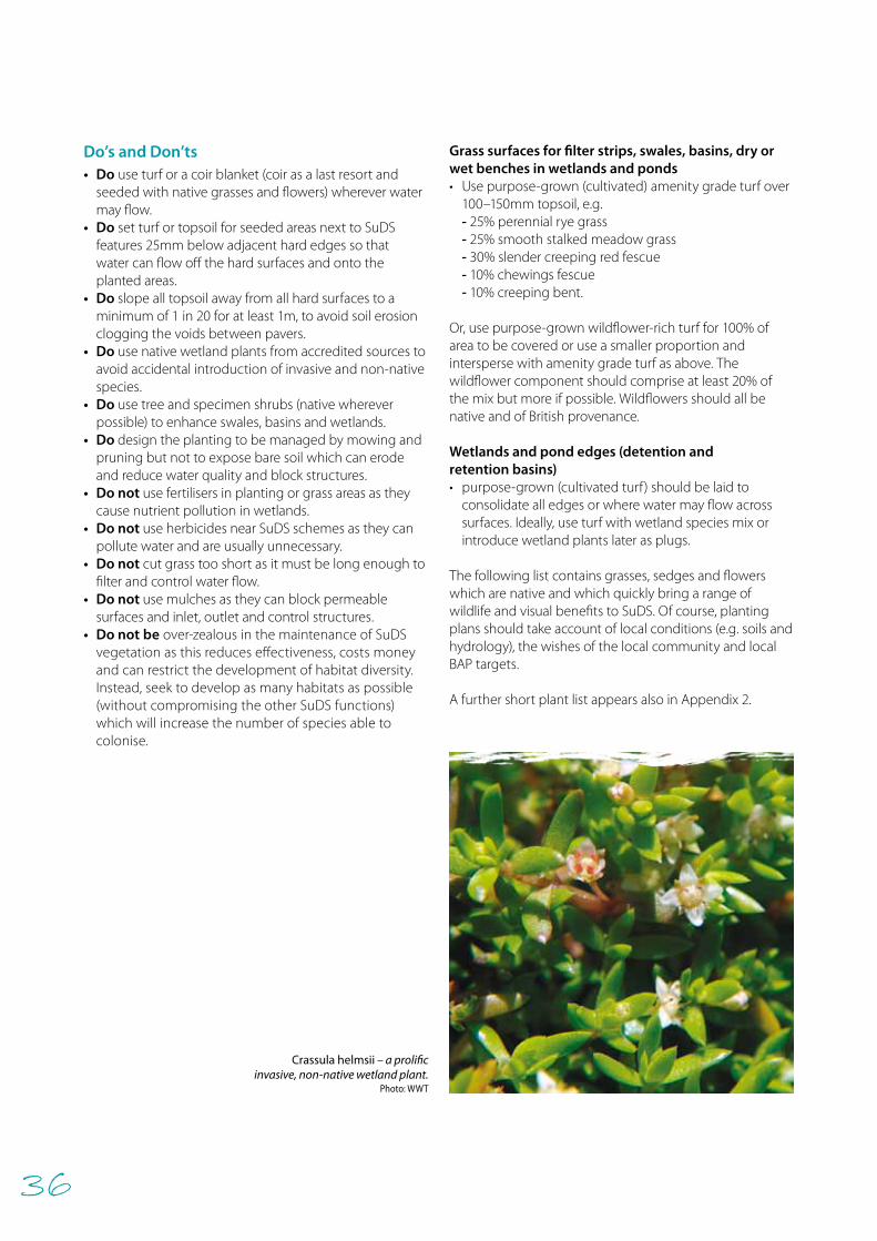
36
Do’s and Don’ts• Do use turf or a coir blanket (coir as a last resort and
seeded with native grasses and flowers) wherever water may flow.
• Do set turf or topsoil for seeded areas next to SuDS features 25mm below adjacent hard edges so that water can flow off the hard surfaces and onto the planted areas.
• Do slope all topsoil away from all hard surfaces to a minimum of 1 in 20 for at least 1m, to avoid soil erosion clogging the voids between pavers.
• Do use native wetland plants from accredited sources to avoid accidental introduction of invasive and non-native species.
• Do use tree and specimen shrubs (native wherever possible) to enhance swales, basins and wetlands.
• Do design the planting to be managed by mowing and pruning but not to expose bare soil which can erode and reduce water quality and block structures.
• Do not use fertilisers in planting or grass areas as they cause nutrient pollution in wetlands.
• Do not use herbicides near SuDS schemes as they can pollute water and are usually unnecessary.
• Do not cut grass too short as it must be long enough to filter and control water flow.
• Do not use mulches as they can block permeable surfaces and inlet, outlet and control structures.
• Do not be over-zealous in the maintenance of SuDS vegetation as this reduces effectiveness, costs money and can restrict the development of habitat diversity. Instead, seek to develop as many habitats as possible (without compromising the other SuDS functions) which will increase the number of species able to colonise.
Grass surfaces for filter strips, swales, basins, dry or wet benches in wetlands and ponds • Use purpose-grown (cultivated) amenity grade turf over
100–150mm topsoil, e.g. - 25% perennial rye grass- 25% smooth stalked meadow grass- 30% slender creeping red fescue- 10% chewings fescue- 10% creeping bent.
Or, use purpose-grown wildflower-rich turf for 100% of area to be covered or use a smaller proportion and intersperse with amenity grade turf as above. The wildflower component should comprise at least 20% of the mix but more if possible. Wildflowers should all be native and of British provenance.
Wetlands and pond edges (detention and retention basins)• purpose-grown (cultivated turf) should be laid to
consolidate all edges or where water may flow across surfaces. Ideally, use turf with wetland species mix or introduce wetland plants later as plugs.
The following list contains grasses, sedges and flowers which are native and which quickly bring a range of wildlife and visual benefits to SuDS. Of course, planting plans should take account of local conditions (e.g. soils and hydrology), the wishes of the local community and local BAP targets.
A further short plant list appears also in Appendix 2.
Crassula helmsii – a prolific invasive, non-native wetland plant.
Photo: WWT
37
Table 5 A selection of marginal plants to consider.
Erect marginal plants to consider Low-growing marginal/aquatic plants to consider
Flowering-rush (Butomus umbellatus) Amphibious bistort (Persicaria amphibia)
Gipsywort (Lycopus europaeus) Brooklime (Veronica beccabunga)
Great water-dock (Rumex hydrolapathum) Fleabane (Pulicaria dysenterica)
Hemp agrimony (Eupatorium cannabinum) Floating sweet-grasses (Glyceria spp.)
Lesser reedmace/lesser bulrush (Typha angustifolia) Marsh foxtail (Alopecurus geniculatus)
Marsh woundwort (Stachys palustris) Marsh marigold (Caltha palustris)
Pendulous sedge (Carex pendula) Meadowsweet (Filipendula vulgaris)
Purple loosestrife (Lythrum salicaria) Water forget-me-not (Myosotis scorpioides)
Rush (Juncus spp.) Water mint (Mentha aquatica)
Yellow iris (Iris pseudacorus) Watercress (Nasturtium officinale)
Table 6 Plants to avoid.
Avoid aggressive plants, such as: DO NOT PLANT any of the following invasive non-native plants
Branched bur-reed (Sparganium erectum) Canadian pondweed (Elodea canadensis)
Bulrush (Typha latifolia) Curly waterweed (Lagarosiphon major)
Greater pond sedge (Carex riparia) Floating pennywort (Hydrocotyle ranunculoides) often supplied as Marsh pennywort (Hydrocotyle vulgaris)
Reed canary-grass (Phalaris arundinacea) New Zealand swamp-stonecrop (Crassula helmsii)
Reed sweet-grass (Glyceria maxima) Nuttall’s pondweed (Elodea nuttallii)
Greater spearwort (Ranunculus lingua) – never introduce into small ponds
Parrot’s-feather (Myriophyllum aquaticum)
Water fern (Azolla filiculoides)
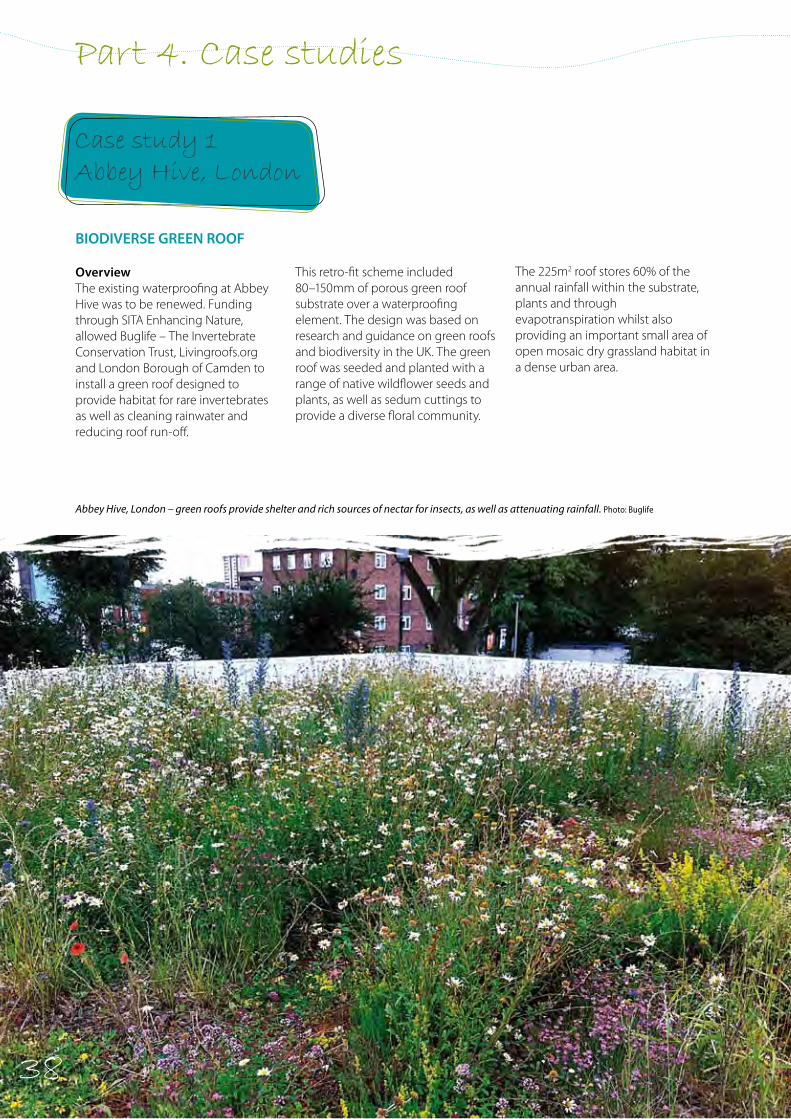
38
Part 4. Case studies
BIODIVERSE GREEN ROOF
OverviewThe existing waterproofing at Abbey Hive was to be renewed. Funding through SITA Enhancing Nature, allowed Buglife – The Invertebrate Conservation Trust, Livingroofs.org and London Borough of Camden to install a green roof designed to provide habitat for rare invertebrates as well as cleaning rainwater and reducing roof run-off.
Abbey Hive, London – green roofs provide shelter and rich sources of nectar for insects, as well as attenuating rainfall. Photo: Buglife
Case study 1 Abbey Hive, London
This retro-fit scheme included 80–150mm of porous green roof substrate over a waterproofing element. The design was based on research and guidance on green roofs and biodiversity in the UK. The green roof was seeded and planted with a range of native wildflower seeds and plants, as well as sedum cuttings to provide a diverse floral community.
The 225m2 roof stores 60% of the annual rainfall within the substrate, plants and through evapotranspiration whilst also providing an important small area of open mosaic dry grassland habitat in a dense urban area.
38
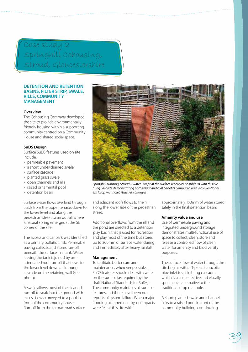
39
Case study 2 Springhill Cohousing, Stroud, Gloucestershire
Springhill Housing, Stroud – water is kept at the surface wherever possible as with this tile hung cascade demonstrating both visual and cost benefits compared with a conventional 4m ‘drop manhole’. Photo: John Day (rspb)
DETENTION AND RETENTION BASINS, FILTER STRIP, SWALE, RILLS, COMMUNITY MANAGEMENT
OverviewThe Cohousing Company developed the site to provide environmentally friendly housing within a supporting community centred on a Community House and shared social space.
SuDS DesignSurface SuDS features used on site include:• permeable pavement• a short under-drained swale• surface cascade• planted grass swale• open channels and rills• raised ornamental pool• detention basin
Surface water flows overland through SuDS from the upper terrace, down to the lower level and along the pedestrian street to an outfall where a natural spring emerges at the SE corner of the site.
The access and car park was identified as a primary pollution risk. Permeable paving collects and stores run-off beneath the surface in a tank. Water leaving the tank is joined by un-attenuated roof run-off that flows to the lower level down a tile-hung cascade on the retaining wall (see photo).
A swale allows most of the cleaned run-off to soak into the ground with excess flows conveyed to a pool in front of the community house. Run-off from the tarmac road surface
and adjacent roofs flows to the rill along the lower side of the pedestrian street.
Additional overflows from the rill and the pond are directed to a detention ‘play basin’ that is used for recreation and play most of the time but stores up to 300mm of surface water during and immediately after heavy rainfall. ManagementTo facilitate better care and maintenance, wherever possible, SuDS features should deal with water on the surface (as required by the draft National Standards for SuDS). The community maintains all surface features and there have been no reports of system failure. When major flooding occurred nearby, no impacts were felt at this site with
approximately 150mm of water stored safely in the final detention basin.
Amenity value and use Use of permeable paving and integrated underground storage demonstrates multi-functional use of space to collect, clean, store and release a controlled flow of clean water for amenity and biodiversity purposes.
The surface flow of water through the site begins with a T-piece terracotta pipe inlet to a tile hung cascade which is a cost effective and visually spectacular alternative to the traditional drop manhole.
A short, planted swale and channel links to a raised pool in front of the community building, contributing
40
Case study 3 Red Hill Primary School, Worcester
visually to the social space. The rill system provides both a collection and flow route for water and separates private and public space. Each householder understands how it works and takes responsibility for managing their section. The community is well aware that occasionally the detention basin will hold water after heavy rainfall but will quickly be available as a public play area within a short period.
Biodiversity valueClean water is the essential ingredient for aquatic biodiversity and this is assured at Springhill by source control treatment of the main risk areas through the use of permeable pavement in the upper car court and a well-designed management train. The vegetated swales, rill and
channels provide connectivity of habitats for wildlife and the pond is of significant value, as well as being a great feature of interest. The community is careful to enhance biodiversity and maintain the SuDS in a relaxed way to allow maximum opportunities for wildlife in this relatively dense urban development.Species found within the SuDS include frogs, newts, dragonflies, damselflies, other aquatic invertebrates and a range of native wetland plants and birds (which use the features for hunting insects and as bird baths).
Assessment – lesson learntThe recommendation that SuDS should be at or near the surface is reinforced by the experience at Springhill Cohousing. The people
and wildlife benefits of SuDS are possible only with clean water and when features are both visible and accessible.
New designs and features on site that replicate conventional engineering solutions include:• cascades replace drop manholes• rills and swales replace pipes• open storage features using
multi-functional space replace underground tanks
• soft landscape features allow infiltration even on clays when natural shrinkage occurs (especially in the summer)
• downpipes direct water into attractive surface features without the need for sub-surface pipes (which are harder to maintain).
DETENTION AND RETENTION BASINS, SWALE, FILTER STRIP
OverviewThe school site is two hectares in size and is bounded by a road, a railway line and domestic gardens. An avenue of lime trees finish in a small, open woodland at the lowest part of the site on the northern boundary.
SuDS Design Run-off flows to a new storm sewer running along the eastern boundary with no acceptable overland exceedance route available in the event of blockage or exceptional rainfall.
The school and associated hard surfaces are near the bottom of the
site where there is limited space for surface water storage.
In order to create sufficient storage capacity, use of the woodland as a detention basin was negotiated with Worcestershire County Council. A shallow swale maze was carefully excavated between the trees to provide an amenity feature and to deliver water to each tree, particularly during short summer storms.
Excavated soil was used to form a low bund around the trees enclosing the new basin and providing a 1-in-10 year return period storage feature.A conventional pipe collects run-off from the playground which then passes through a retaining wall and an ornamental spout. Surface granite sets channel direct run-off from the
west of the school to a short pipe-run entering a swale before passing under the access road to the maze. All road run-off flows across a 4m wide grass filter strip before entering the swale maze.
The highest risk area for water quality was considered to be the car park so permeable pavement provided both good treatment and storage for this water. The remaining run-off follows an extended management train that include swales, filter strips, basins and a small amenity and wildlife pond before release to the storm sewer.
Management The school grounds management is carried out by a landscape contractor, with additional maintenance undertaken by the site manager.
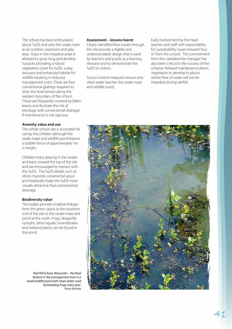
41
Assessment – lessons learntClearly identified flow routes through the site provide a legible and understandable design that is used by teachers and pupils as a learning resource and to demonstrate the SuDS to visitors.
Source control measures ensure only clean water reaches the swale maze and wildlife pond.
Early involvement by the head teacher and staff with responsibility for sustainability issues ensured ‘buy in’ from the school. The commitment from the caretaker/site manager has also been critical in the success of the scheme. Relaxed maintenance allows vegetation to develop in places where flow of water will not be impeded during rainfall.
Red Hill School, Worcester – the final feature in the management train is a
small wildlife pond with clean water used by breeding frogs every year.
Photo: Bob Bray
The school has been enthusiastic about SuDS and uses the swale maze as an outdoor classroom and play area. Grass in the meadow areas is allowed to grow long and develop tussocks providing a robust vegetation cover for SuDS, a play resource and enhanced habitat for wildlife resulting in reduced management costs. There are four conventional gratings required to drain the level terrace along the western boundary of the school. These are frequently covered by fallen leaves and illustrate the risk of blockage with conventional drainage if maintenance is not rigorous.
Amenity value and useThe whole school site is accessible for use by the children although the swale maze and wildlife pond feature a toddler fence of approximately 1m in height.
Children enjoy playing in the swales and basin toward the top of the site and are encouraged to interact with the SuDS. The SuDS details such as stone channels, ornamental spout and headwalls make the SuDS more visually attractive than conventional drainage.
Biodiversity valueThe swales provide a habitat linkage from the green space at the southern end of the site to the swale maze and pond at the north. Frogs, dragonfly nymphs, other aquatic invertebrates and wetland plants can be found in the pond.

42
Lamb Drove, Cambourne – an open basin for occasional storage linked to a wet swale which is cut annually to enhance habitat whilst maintaining conveyance function. Photo: Bob Bray
DETENTION AND RETENTION BASINS, FILTER STRIP, SWALES
Overview The Lamb Drove development comprises 35 houses on a 2.5 hectare site within the new settlement of Cambourne in Cambridgeshire.
SuDS design This is a retrofit scheme chosen to demonstrate how SuDS can be used in an area subject to the risk of flooding. It was part of the FLOWS project (Living with Flood Risk in a Changing Climate) with EU funding and was designed to show:• a variety of SuDS techniques• effective flood protection to
dwellings• cost effective design• easily managed SuDS• biodiversity and amenity benefits.
Two overland flow routes and two sub-catchments were identified. The first route flows from the top of the site, passing between housing and around public open space to a ditch in the south-west corner.
The second route begins where the run-off first enters a detention basin. It continues eastwards through a courtyard and housing terrace into a public open space swale sequence and the ditch outfall.
Roof water is collected conventionally and runs to basins or swales. The SuDS features provide treatment and storage for this relatively clean roof water.
Permeable block paving was used for the two access roads which also
Case study 4.Lamb Drove, Cambourne, Cambridgeshire
receives surface water flows from surrounding parking and hard surfaces. Run-off from remaining hard surfaces flow to a small basin or to under-drained swales before being conveyed out of the housing court area.
Cambridgeshire County Council provided a boundary strip of public open space for conveyance and storage in a series of basins which lead to the outfall. This arrangement removed the need for additional underground storage and financed a visually interesting biodiversity corridor within public open space.
Management Lamb Drove requires similar maintenance to any other medium
density housing development. Grassed amenity space is cut short but reduced cutting is undertaken on swales, flow channels, wetland basins and around the final pond. The housing association considers the cost of maintenance to be less than the costs of a conventional system.
Amenity value and use The visual quality of the site has been enhanced leading to a more stimulating and interesting public space. Residents appreciate the natural character of the development and value the contribution made to their immediate environment.
Biodiversity value Source control including permeable paving and under-drained swales
43
Case study 5. Robinswood Hill Primary School, Gloucester
within the development envelope ensure a flow of clean water to surface SuDS features.
Wildflower seeding and plug planting kick-started the development of species-rich vegetation and this has established slowly over time. Structural diversity within the grassed areas is encouraging colonisation by local, native plants and invertebrate populations and this has also developed into useful amphibian habitat.
Assessment – lessons learnt There was some limited amenity provision including a play area and some wildflower planting. However, the scheme would have benefited from a clearer amenity and biodiversity strategy being developed alongside the SuDS design.
Construction quality highlighted how vulnerable SuDS details can be to poor workmanship and suggests a robust approach must be taken to detail and supervising their installation. Hard SuDS features deteriorate quickly if poorly designed or badly constructed. In contrast, ‘green’ SuDS elements (swales, ponds etc.) develop interest with the passage of time.
Following completion of the work, a monitoring programme was undertaken to assess and compare the Lamb drove site with a nearby site using conventional drainage. See: http://www.cambridgeshire.gov.uk/environment/planning/drainagesystems/monitoring.htm
Key lessons include:• The study site significantly reduces
peak flows compared to the control site.
• Attenuation and reduction of flow and volume occurs at each stage of the management train.
• Improved quality of water discharged from the study site compared to the control site.
• Greater biodiversity is present in the study site than the control site.
• Capital and maintenance costs are much lower than costs for conventional pipe drainage.
• Open space around homes was valued more highly where SuDS features were present.
DETENTION AND RETENTION BASINS, FILTER STRIP, SWALE
OverviewRobinswood Hill Primary School lies on the northern boundary of the hill. After prolonged rain or storms, the permeable soils become saturated. Surface water flows across the adjacent Matson Park onto the school grounds and in the past even through the school.
SuDS design• a sloping site with an unprotected
southern boundary open to the public
• a springline within the park creating a permanent flow of water along a public footpath and across the school
• occasional sheet flow after heavy rain following an old ditch line which has caused catastrophic flooding to the school in the past
• a council park next to a school • variable infiltration into soils across
the site• easily saturated soils quickly giving
rise to surface flows.
The approach was unusual in that SuDS features were used to manage an unknown volume of water.
Springs in the park were intercepted to form a watercourse to flow round the school, through new SuDS features and eventually to highway drains. This allowed water to be retained in more convenient locations.
A low bund along the park boundary retains a large volume of water. A low-flow control deals with most volumes but a grass weir allows excess water to flow into the school grounds. A second bund in the school and at a slightly lower level contains within it a large area of the playing fields and is used as a ‘forest school’. This was created using spoil from a second wildlife pond.
The two resulting large, but shallow, storage areas have contained and managed surface water on a number of occasions. The final outfall from the second basin allows a controlled outflow of water to pass around the playing fields in a shallow swale back into the original highway drain.
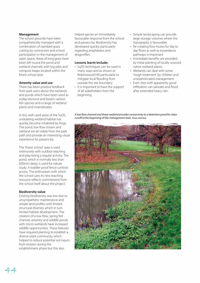
44
ManagementThe school grounds have been sympathetically managed with a combination of standard grass cutting by contractors and school participation in the management of open space. Areas of long grass have been left round the pond and wetland channels with log piles and compost heaps located within the forest school area.
Amenity value and useThere has been positive feedback from park users about the wetlands and ponds which have been used as a play resource and boasts various fish species and a range of wetland plants and invertebrates.
In less well-used areas of the SuDS, undulating wetland habitat has quickly become inhabited by frogs. The pond, low flow stream and wetland are all visible from the park path and provide an interesting visual experience for passers-by.
The ‘forest school’ area is used extensively with outdoor teaching and play being a regular activity. The pond, which is normally less than 600mm deep, is used for nature study. A toddler proof fence controls access. The enthusiasm with which the school uses its new teaching resource reflects commitment from the school itself about the project.
Biodiversity value Existing biodiversity was low due to unsympathetic maintenance and simple land profiles with limited structural diversity which in turn limited habitat development. The creation of a low flow, spring fed channel, amenity and wildlife ponds with micro-wetlands have increased wildlife opportunities. These features have required planting to establish a diverse plant community which helped to reduce potential soil inputs from erosion during the establishment phase but this also
helped garner an immediately favourable response from the school and passers-by. Biodiversity has developed quickly particularly regarding amphibians and dragonflies.
Lessons learnt include:• SuDS techniques can be used in
many ways and as shown at Robinswood Hill particularly to mitigate local flooding from outside the site boundary.
• It is important to have the support of all stakeholders from the beginning.
• Simple landscaping can provide large storage volumes where the topography is favourable
• Re-creating flow routes for day to day flows as well as exceedance pathways is important
• Immediate benefits are provided by initial planting of locally-sourced native wetland plants.
• Wetlands can deal with some ‘rough treatment’ by children and unsophisticated management.
• Even sites with apparently good infiltration can saturate and flood after extended heavy rain.
A low flow channel and linear wetland provides connectivity to a detention pond for clean runoff at the beginning of this management train. Photo: Bob Bray
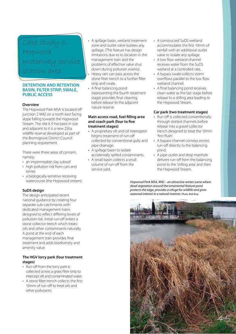
45
Case study 6. Hopwood motorway service station area
Hopwood Park MSA, M42 – an attractive winter scene where dead vegetation around the ornamental feature pond protects the edge, provides a refuge for wildlife and gives seasonal interest in a natural manner. Photo: Bob Bray
DETENTION AND RETENTION BASIN, FILTER STRIP, SWALE, PUBLIC ACCESS
OverviewThe Hopwood Park MSA is located off junction 2 M42 on a north east facing slope falling towards the Hopwood Stream. The site is 9 hectares in size and adjacent to it is a new 25ha wildlife reserve developed as part of the Bromsgrove District Council planning requirement.
There were three areas of concern, namely:• an impermeable clay subsoil • high pollution risk from cars and
lorries• a biologically-sensitive receiving
watercourse (the Hopwood stream).
SuDS designThe design anticipated recent national guidance by creating four separate sub-catchments with dedicated management trains designed to reflect differing levels of pollution risk. Initial run-off enters a stone collector trench which treats oils and other contaminants naturally. A pond at the end of each management train provides final treatment and adds biodiversity and amenity value.
The HGV lorry park (four treatment stages)• Run-off from the lorry park is
collected across a grass filter strip to intercept silt and contaminated water.
• A stone filter trench collects the first 10mm of run-off to treat oils and other pollutants.
• A spillage basin, wetland treatment zone and outlet valve isolates any spillage. (This feature has design limitations due to its location in the management train and the problems of effective valve shut down during pollution events).
• Heavy rain can pass across the stone filter trench to a further filter strip and swale.
• A final balancing pond (representing the fourth treatment stage) provides final cleaning before release to the adjacent nature reserve.
Main access road, fuel filling area and coach park (four to five treatment stages)• A proprietary silt and oil interceptor
begins treatment of run-off collected by conventional gully and pipe drainage.
• A spillage basin to isolate accidentally spilled contaminants.
• A small basin collects a small volume of run-off from the service yard.
• A constructed SuDS wetland accommodates the first 10mm of rainfall with an additional outlet valve to isolate any spillage.
• A low flow wetland channel receives water from the SuDS wetland at a controlled rate.
• A bypass swale collects storm overflows parallel to the low flow wetland channel.
• A final balancing pond receives clean water as the last stage before release to a stilling area leading to the Hopwood Stream.
Car park (two treatment stages)• Run-off is collected conventionally
through slotted channels before release into a gravel collector trench designed to treat the 10mm ‘first flush’.
• A bypass channel conveys excess run-off directly to the balancing pond.
• A pipe outlet and drop manhole delivers run-off from the balancing pond to the ‘stilling area’ and then the Hopwood Stream.
45
46
Amenity building (one treatment stage)• Clean water is piped directly from
the roof by siphonic drainage across a floating wooden pontoon to the centre of the feature pond to prevent erosion of the pond edge
• A cascade controlled by a slot weir falls to the stilling area before flowing to the Hopwood Stream.
ManagementSource control features like the filter strip, basins and trench collectors intercept silt early in the management train preventing contamination of the wetland features. Site operators have been pleased at the effectiveness with which it has reduced maintenance requirements.
An academic study found that inorganic silt was trapped at the beginning of the management train and that organic silt did not accumulate.
Short pipe connectors, usually less then 3m, located near the surface are easily cleaned. Grass overflow channels ensure there have been no serious failures to date. The working of the SuDS features are robust and have withstood damage as well as a lack of maintenance without failure.
An annual landscape maintenance budget of £15,000 at 2003 prices allocated £2,500 for the SuDS sub-catchments compared to £4,000 for maintaining equivalent conventional drainage structures. The annual budget for SuDS maintenance is now approximately £300.
Hopwood Park MSA, M42 Worcs – a recently de-silted low flow channel with
a flush of wetland plants. Photo: Bob Bray
Amenity value and useThe SuDS are visible from both the coffee lounge and the outdoor eating area by the ‘feature pond’.Interpretation panels demonstrate and explain the benefits of sustainable drainage and are much-used by visitors to the site.
Biodiversity valueThe variety of wetland features within the system provide extensive and linked habitat for a variety of plants, invertebrates, amphibian and mammals.
Assessment – lessons learnt• Source control prevents silt and
pollution reaching sensitive habitats in the management train.
• Organic sediments do not build up easily in basins, wetlands and ponds where oxygenated flows pass through shallow SuDS features.
• Management is straightforward, simple and cost effective.
• Maintenance costs can be further reduced where mosaic habitats are created by phased and infrequent management.
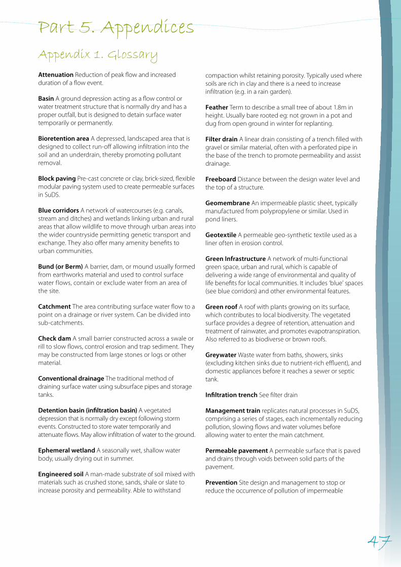
47
Part 5. AppendicesAppendix 1. Glossary
Attenuation Reduction of peak flow and increased duration of a flow event.
Basin A ground depression acting as a flow control or water treatment structure that is normally dry and has a proper outfall, but is designed to detain surface water temporarily or permanently.
Bioretention area A depressed, landscaped area that is designed to collect run-off allowing infiltration into the soil and an underdrain, thereby promoting pollutant removal.
Block paving Pre-cast concrete or clay, brick-sized, flexible modular paving system used to create permeable surfaces in SuDS.
Blue corridors A network of watercourses (e.g. canals, stream and ditches) and wetlands linking urban and rural areas that allow wildlife to move through urban areas into the wider countryside permitting genetic transport and exchange. They also offer many amenity benefits to urban communities.
Bund (or Berm) A barrier, dam, or mound usually formed from earthworks material and used to control surface water flows, contain or exclude water from an area of the site.
Catchment The area contributing surface water flow to a point on a drainage or river system. Can be divided into sub-catchments.
Check dam A small barrier constructed across a swale or rill to slow flows, control erosion and trap sediment. They may be constructed from large stones or logs or other material.
Conventional drainage The traditional method of draining surface water using subsurface pipes and storage tanks.
Detention basin (infiltration basin) A vegetated depression that is normally dry except following storm events. Constructed to store water temporarily and attenuate flows. May allow infiltration of water to the ground.
Ephemeral wetland A seasonally wet, shallow water body, usually drying out in summer.
Engineered soil A man-made substrate of soil mixed with materials such as crushed stone, sands, shale or slate to increase porosity and permeability. Able to withstand
compaction whilst retaining porosity. Typically used where soils are rich in clay and there is a need to increase infiltration (e.g. in a rain garden).
Feather Term to describe a small tree of about 1.8m in height. Usually bare rooted eg: not grown in a pot and dug from open ground in winter for replanting.
Filter drain A linear drain consisting of a trench filled with gravel or similar material, often with a perforated pipe in the base of the trench to promote permeability and assist drainage.
Freeboard Distance between the design water level and the top of a structure.
Geomembrane An impermeable plastic sheet, typicallymanufactured from polypropylene or similar. Used in pond liners.
Geotextile A permeable geo-synthetic textile used as a liner often in erosion control.
Green Infrastructure A network of multi-functional green space, urban and rural, which is capable of delivering a wide range of environmental and quality of life benefits for local communities. It includes ‘blue’ spaces (see blue corridors) and other environmental features.
Green roof A roof with plants growing on its surface, which contributes to local biodiversity. The vegetated surface provides a degree of retention, attenuation and treatment of rainwater, and promotes evapotranspiration. Also referred to as biodiverse or brown roofs.
Greywater Waste water from baths, showers, sinks (excluding kitchen sinks due to nutrient-rich effluent), and domestic appliances before it reaches a sewer or septic tank.
Infiltration trench See filter drain
Management train replicates natural processes in SuDS, comprising a series of stages, each incrementally reducing pollution, slowing flows and water volumes before allowing water to enter the main catchment.
Permeable pavement A permeable surface that is paved and drains through voids between solid parts of the pavement.
Prevention Site design and management to stop or reduce the occurrence of pollution of impermeable
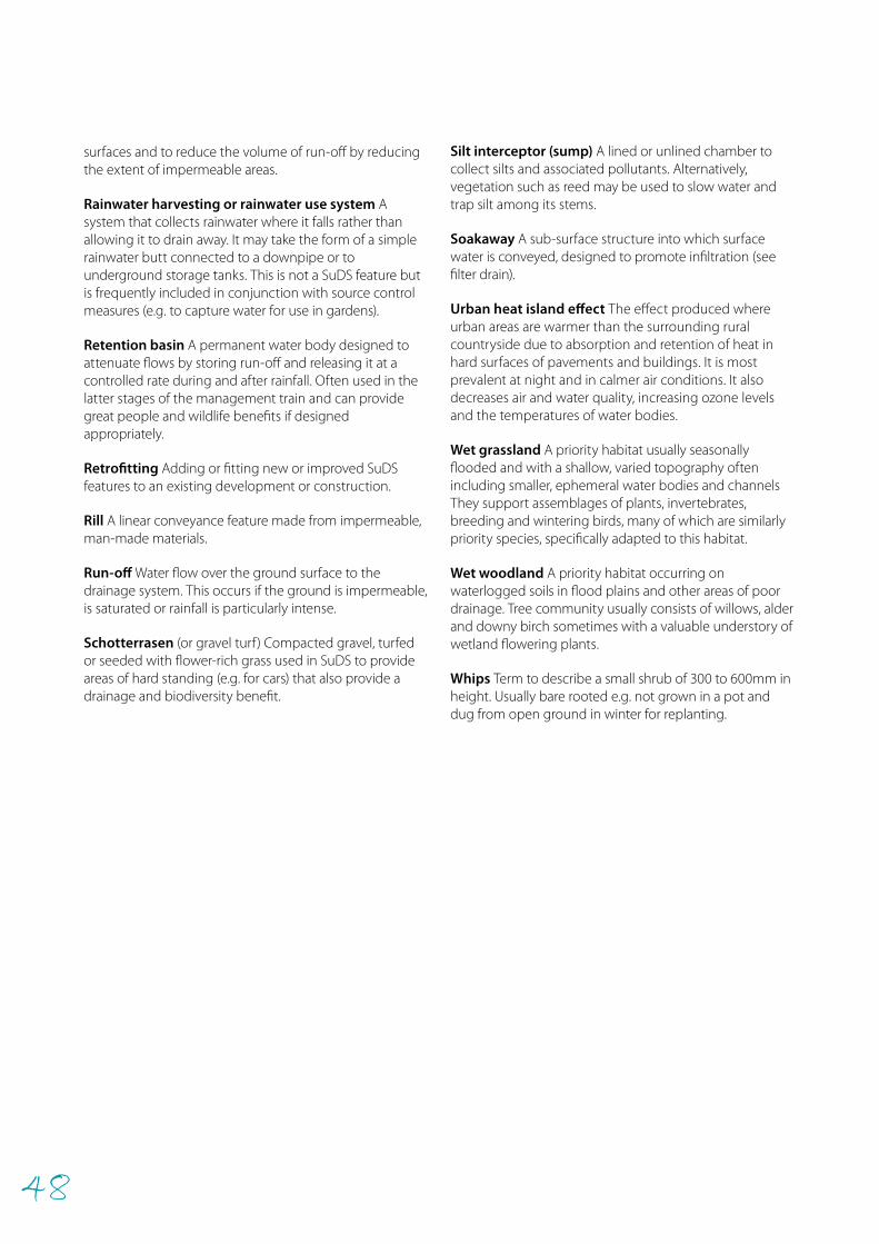
48
surfaces and to reduce the volume of run-off by reducing the extent of impermeable areas.
Rainwater harvesting or rainwater use system A system that collects rainwater where it falls rather than allowing it to drain away. It may take the form of a simple rainwater butt connected to a downpipe or to underground storage tanks. This is not a SuDS feature but is frequently included in conjunction with source control measures (e.g. to capture water for use in gardens).
Retention basin A permanent water body designed to attenuate flows by storing run-off and releasing it at a controlled rate during and after rainfall. Often used in the latter stages of the management train and can provide great people and wildlife benefits if designed appropriately.
Retrofitting Adding or fitting new or improved SuDS features to an existing development or construction.
Rill A linear conveyance feature made from impermeable, man-made materials.
Run-off Water flow over the ground surface to the drainage system. This occurs if the ground is impermeable, is saturated or rainfall is particularly intense.
Schotterrasen (or gravel turf) Compacted gravel, turfed or seeded with flower-rich grass used in SuDS to provide areas of hard standing (e.g. for cars) that also provide a drainage and biodiversity benefit.
Silt interceptor (sump) A lined or unlined chamber to collect silts and associated pollutants. Alternatively, vegetation such as reed may be used to slow water and trap silt among its stems.
Soakaway A sub-surface structure into which surface water is conveyed, designed to promote infiltration (see filter drain).
Urban heat island effect The effect produced where urban areas are warmer than the surrounding rural countryside due to absorption and retention of heat in hard surfaces of pavements and buildings. It is most prevalent at night and in calmer air conditions. It also decreases air and water quality, increasing ozone levels and the temperatures of water bodies.
Wet grassland A priority habitat usually seasonally flooded and with a shallow, varied topography often including smaller, ephemeral water bodies and channels They support assemblages of plants, invertebrates, breeding and wintering birds, many of which are similarly priority species, specifically adapted to this habitat.
Wet woodland A priority habitat occurring on waterlogged soils in flood plains and other areas of poor drainage. Tree community usually consists of willows, alder and downy birch sometimes with a valuable understory of wetland flowering plants.
Whips Term to describe a small shrub of 300 to 600mm in height. Usually bare rooted e.g. not grown in a pot and dug from open ground in winter for replanting.
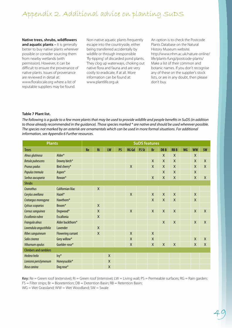
49
Appendix 2. Additional advice on planting SuDS
Native trees, shrubs, wildflowers and aquatic plants – It is generally better to buy native plants wherever possible or consider sourcing them from nearby wetlands (with permission). However, it can be difficult to ensure the provenance of native plants. Issues of provenance are reviewed in detail at: www.floralocale.org where a list of reputable suppliers may be found.
Non-native aquatic plants frequently escape into the countryside, either being transferred accidentally by wildlife or through irresponsible ‘fly-tipping’ of discarded pond plants. They clog up waterways, choking out native flora and fauna and are very costly to eradicate, if at all. More information can be found at: www.plantlife.org.uk
An option is to check the Postcode Plants Database on the Natural History Museum website. http://www.nhm.ac.uk/nature-online/life/plants-fungi/postcode-plants/ Make a list of their common and botanic names. If you don’t recognise any of these on the supplier’s stock lists, or are in any doubt, then please don’t buy.
Table 7 Plant list.
The following is a guide to a few more plants that may be used to provide wildlife and people benefits in SuDS (in addition to those already recommended in the guidance). Those species marked * are native and should be used wherever possible. The species not marked by an asterisk are ornamentals which can be used in more formal situations. For additional information, see Appendix 6 Further resources.
Plants SuDS features
Trees Re Ri LW PS RG Gd FS St Br DB B RB B WG WW SWAlnus glutinosa Alder* X X X
Betula pubescens Downy birch* X X X X X
Prunus padus Bird cherry* X X X X X X
Populus tremula Aspen* X X X
Sorbus aucuparia Rowan* X X X X X
ShrubsCeanothus Californian lilac X
Corylus avellana Hazel* X X X X X
Crataegus monogyna Hawthorn* X X X X
Cytisus scoparius Broom* X
Cornus sanguinea Dogwood* X X X X X X X
Escallonia rubra Escallonia X
Frangula alnus Alder buckthorn* X X X X
Lavendula angustifolia Lavender X
Ribes sanguineum Flowering currant X X X
Salix cinerea Grey willow* X X X X
Viburnum opulus Guelder-rose* X X X X X X
Climbers and ramblersHedera helix Ivy* X
Lonicera periclymenum Honeysuckle* X
Rosa canina Dog rose* X
Key: Re = Green roof (extensive); Ri = Green roof (intensive); LW = Living wall; PS = Permeable surfaces; RG = Rain garden; FS = Filter strips; Br = Bioretention; DB = Detention Basin; RB = Retention Basin; WG = Wet Grassland; WW = Wet Woodland; SW = Swale
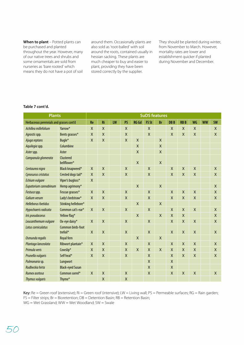
50
Herbaceous perennials and grassesAchillea millefolium Yarrow* X X X X X X X X
Agrostis spp. Bents grasses* X X X X X X X X
Ajuga reptans Bugle* X X X X X
Aquilegia spp. Columbine X X
Aster spp. Aster X X
Campanula glomerata Clustered bellflower* X X
Centaurea nigra Black knapweed* X X X X X X X X
Cynosurus cristatus Crested dogs tail* X X X X X X X X
Echium vulgare Viper’s bugloss* X
Eupatorium cannabinum Hemp agrimony* X X X
Festuca spp. Fescue grasses* X X X X X X X X
Galium verum Lady’s bedstraw* X X X X X X X X
Helleborus foetidus Stinking hellebore* X X
Hypochaeris radicata Common cat’s-ear* X X X X X X X X
Iris pseudacorus Yellow flag* X X X X X
Leucanthemum vulgare Ox-eye daisy* X X X X X X X X
Lotus corniculatus Common birds-foot trefoil* X X X X X X X X
Osmunda regalis Royal fern X X
Plantago lanceolata Ribwort plantain* X X X X X X X X
Primula veris Cowslip* X X X X X X X X X X
Prunella vulgaris Self heal* X X X X X X X X
Pulmonaria sp. Lungwort X X
Rudbeckia hirta Black-eyed Susan X X
Rumex acetosa Common sorrel* X X X X X X X X
Thymus vulgaris Thyme* X X
Plants SuDS features
Herbaceous perennials and grasses cont’d Re Ri LW PS RG Gd FS St Br DB B RB B WG WW SW
When to plant – Potted plants can be purchased and planted throughout the year. However, many of our native trees and shrubs and some ornamentals are sold from nurseries as ‘bare rooted’ which means they do not have a pot of soil
around them. Occasionally plants are also sold as ‘root-balled’ with soil around the roots, contained usually in hessian sacking. These plants are much cheaper to buy and easier to plant, providing they have been stored correctly by the supplier.
They should be planted during winter, from November to March. However, mortality rates are lower and establishment quicker if planted during November and December.
Key: Re = Green roof (extensive); Ri = Green roof (intensive); LW = Living wall; PS = Permeable surfaces; RG = Rain garden; FS = Filter strips; Br = Bioretention; DB = Detention Basin; RB = Retention Basin; WG = Wet Grassland; WW = Wet Woodland; SW = Swale
Table 7 cont’d.

51
Grass cuttings, aquaticvegetation and soft waste
Cover logs with grass clippingsto provide hibernation site andegg-laying area for grass snakes
Wood prunings
Cross logs at right angles
Both features can be located ingrass or nectar-rich flower border
Leave logs uncovered toprovide invertebrate habitat
Both designs are great for smallmammals like shrews and mice
In-fill gaps with prunings
Appendix 3. Miscellaneous habitat features
Bird and bat boxesBoxes for birds and bats can be purchased or alternatively made and installed as part of a volunteer task with local people and schools. Appropriate designs, correct placement and targeting of species in most need of help will maximise wildlife value. Box networks can also provide great opportunities for engaging with people as part of site survey and monitoring programmes.
For information on purchasing or making your own bird and bat boxes and their location, see Useful contacts.
Wildlife or habitat piles Wildlife piles are a sustainable way of managing cuttings, providing a natural and cost effective wildlife and education resource and are most effective if accompanied with appropriate interpretation. They are easy for children and adults to construct with opportunities for subsequent monitoring of their use.
There are four kinds of habitat pile that can be constructed. They are laying logs which may or may not be covered with grass cuttings and, or vertical standing logs. They may be located informally in grassland or given a more formal setting in a border planted with nectar-rich plants. Finally, there is the rubble-based hibernaculum for reptiles and amphibians.
Laying log piles
• Select a sheltered space in partial shade; this will meet a variety of wildlife needs. Locations which receive sunlight for at least part of the day will provide basking opportunities for reptiles and invertebrates.
• Stack the logs in a criss-cross pattern up to about 1m high.
• Fill the gaps between each layer of logs with brash and other woody material.
When positioned in sunnier locations, log piles can be great places for reptiles and if smothered in grass cuttings provide them with somewhere to both hibernate and or lay their eggs in.
• Stack the logs as above, but only to 0.5m high, filling the gaps as before with brash and other woody material.
• This can now be topped off with a mix of prunings, grass and other soft vegetation to between 1 and 1.5m high.
• The pile will heat up during summer and attract many animals including slow worms and grass snakes (if present in the locality) that require heat to incubate their young and eggs.
• They create different ‘micro-habitats’ for wildlife and should not be disturbed. They should be left as a permanent feature with new material added each year as required. New piles can be created close to existing ones as they decompose to provide new refuges.
Figure 17 Two laying log pile designs – one for hibernation/egg-laying and one for invertebrate habitat.
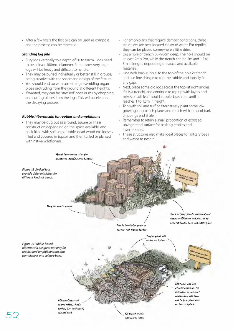
52
Can be located in grass ornectar-rich flower border
Great larva laying sites forcreatures including stag beetles
Seed or ‘plug’ plants with local andnative wildflowers and grasses tobenefit bumble bees and butterflies
Bury 60cm into ground
Add mixed layers ofcoarse rubble, shingle,timber, logs, leaf mould,soil and sand Fill trench or hole
with coarse rubble
Add timber and logsat right angles, in-fillwith mixes of soil, leafmould, cover with loamand turf, or plant withnectar-rich plants
Turf or plant withnectar-rich plants
• After a few years the first pile can be used as compost and the process can be repeated.
Standing log pile
• Bury logs vertically to a depth of 50 to 60cm. Logs need to be at least 100mm diameter. Remember, very large logs will be heavy and difficult to handle.
• They may be buried individually or better still in groups, being creative with the shape and design of the feature.
• You should end up with something resembling organ pipes protruding from the ground at different heights.
• If wanted, they can be ‘stressed’ once in situ by chopping and cutting pieces from the logs. This will accelerates the decaying process.
Rubble hibernacula for reptiles and amphibians
• They may be dug out as a round, square or linear construction depending on the space available, and back-filled with split logs, rubble, dead wood etc. loosely filled and covered in topsoil and then turfed or planted with native wildflowers.
Figure 19 Rubble-based hibernacula are great not only for reptiles and amphibians but also bumblebees and solitary bees.
Figure 18 Vertical logs provide different niches for different kinds of insect.
• For amphibians that require damper conditions, these structures are best located closer to water. For reptiles they can be placed somewhere a little drier.
• Dig a hole or trench 60–90cm deep. The hole should be at least 2m x 2m, while the trench can be 2m and 1.5 to 3m in length, depending on space and available materials.
• Line with brick rubble, to the top of the hole or trench and use fine shingle to top the rubble and loosely fill any gaps.
• Next, place some old logs across the top (at right angles if it is a trench), and continue to top up with layers and mixes of soil, leaf mould, rubble, brash etc. until it reaches 1 to 1.5m in height.
• Top with soil and turf or alternatively plant some low growing, nectar-rich plants and mulch with a mix of bark chippings and shale.
• Remember to retain a small proportion of exposed, unvegetated surface for basking reptiles and invertebrates.
• These structures also make ideal places for solitary bees and wasps to nest in.
53
Appendix 4. Staying legal during creation and management
Follow the key points below to ensure that appropriate management is undertaken and seek advice from the specialist organisations listed in the appendices as required.
Consents and permitsEnsure all necessary permissions are obtained prior to works beginning on site. These may include consents from the Environment Agency and local authorities or other bodies.
Vegetation management• Avoid undertaking vegetation management between
mid March and mid August to avoid disturbing wildlife • For amphibians, avoid management between March
and October. Seek specialist advice. • Water voles can be affected by vegetation management
at all times of year. If they are known or thought to be present seek specialist advice before undertaking management.
• Work required on mature or veteran trees, including pollarded trees, should take into consideration the possible presence of bats. Birds may also nest in holes and cavities.
• Where maintenance for safety reasons is required between mid March and mid August, it is essential to consider nesting birds and the likely presence of other protected species.
• Be aware that birds may breed outside of these times and it is essential that preliminary inspections are undertaken before proceeding with work which may disturb protected species.
Birds• The nests of all wild birds are legally protected under
the Wildlife and Countryside Act 1981.• It is also an offence to intentionally or recklessly disturb
any wild bird listed on Schedule 1 of the Act, while it is nest building, or at a nest containing eggs or young, or disturb the dependent young of such a bird.
Amphibians• Amphibians and their spawn are protected under the
Wildlife and Countryside Act 1981 from sale or trade. • The Great Crested Newt is specially protected under
Schedule 2 of the Wildlife and Countryside Act 1981 and under European law Annexes 2 and 4 of the EU Habitats and Species Directive, the Bern Convention and the Conservation (Natural Habitats, etc.) Regulations 1994.
Mammals• The Water vole is fully protected under Schedule 5
(Section 9) of the Wildlife & Countryside Act 1981.• Otters receive protection under both the Wildlife and
Countryside Act 1981 (as amended) and the Conservation (Natural Habitats, etc.) Regulations 1994.
• All Bat species are protected under schedule 5 of the Wildlife & Countryside Act 1981 and under European law Annexes 2 and 4 of the EU Habitats and Species Directive, the Bern Convention and the Conservation (Natural Habitats, etc.) Regulations 1994.
• Badgers and their setts are protected under the Protection of Badgers Act 1992.
Phot
o: D
avid
Kja
er
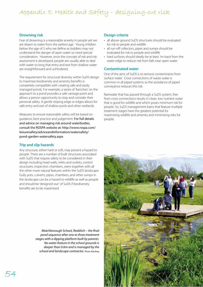
54
Appendix 5. Health and Safety – designing-out risk
Matchborough School, Redditch – the final pond sequence after one to three treatment
stages with a dipping platform built by parents. No water feature in the school grounds is deeper than 0.6m and is managed by the
school and landscape contractor. Photo: Bob Bray
Drowning risk Fear of drowning is a reasonable anxiety in people yet we are drawn to water from the earliest age. Young children below the age of 5 who we define as toddlers may not understand the danger of open water so need special consideration. However, once the concept of risk and risk assessment is developed, people are usually able to deal with water so long that entry and exit from shallow water are straightforward and unhindered.
The requirement for structural diversity within SuDS design to maximise biodiversity and amenity benefits is completely compatible with creating safe and easily managed ponds. For example, a series of ‘benches’ on the approach to a pond provides a safe vantage point and allows a person opportunity to stop and consider their personal safety. A gentle sloping edge or edges allows for safe entry and exit of shallow pools and other wetlands.
Measures to ensure reasonable safety will be based on guidance, best practice and judgement. For full details and advice on managing risk around waterbodies, consult the ROSPA website at: http://www.rospa.com/leisuresafety/adviceandinformation/watersafety/pond-garden-watersafety.aspx
Trip and slip hazards Any structure, either hard or soft, may present a hazard to people. There are a number of built structures associated with SuDS that require safety to be considered in their design including head walls, inlets and outlets, control structures, inspection chambers, weirs together with all the other more natural features within the SuDS landscape.Gully pots, culverts, pipes, chambers, and other sumps in the landscape can be a hazard to wildlife as well as people and should be ‘designed-out’ of SuDS if biodiversity benefits are to be maximised.
Design criteria• all above-ground SuDS structures should be evaluated
for risk to people and wildlife• all run-off collectors, pipes and sumps should be
evaluated for risk to people and wildlife• hard surfaces should ideally be at least 1m back from the
water edge to reduce risk from falls near open water. Contaminated water One of the aims of SuDS is to remove contaminants from surface water. Cross connections of waste water is common in all piped systems so the avoidance of piped conveyance reduces this risk.
Rainwater that has passed through a SuDS system, free from cross-connections results in clean, low nutrient water that is good for wildlife and which poses minimum risk for people. So, SuDS management trains that feature multiple treatment stages have the greatest potential for maximising wildlife and amenity and minimising risks for people.
55
Appendix 6. Further resources
LiteratureR. Bray, D. Gedge, G. Grant and L. Leuthvilay, Rain Garden Guide. RESET Development, 2012
N. Dunnett, A. Clayden. Rain Gardens: Managing Water Sustainably in the Garden and Designed Landscape: Sustainable Rainwater Management for the Garden and Designed Landscape. Timber Press, 2007.
N. Dunnett and N. Kingsbury. Planting Green Roofs and Living Walls. Timber Press, 2008.
N. Dunnett, D. Gedge, J. Little and E.C. Snodgrass, Planting Green Roofs and Living Walls. Timber Press, 2011.
Pond Conservation, Maximising the ecological benefits of SuDS schemes. Oxford, UK, 2003.
SEPA, Ponds, Pools & Lochans: Guidance on good practice for small waterbodies in Scotland, SEPA Habitat Enhancement Initiative, 2000.
SEPA, Watercourses in the Community: A Guide to sustainable watercourse management in the urban environment. SEPA Habitat Enhancement Initiative, 2000.
Town and Country Planning Association and The Wildlife Trusts, Planning for a Healthy Environment – Good Practice Guidance for Green Infrastructure and Biodiversity, 2012.
B. Woods-Ballard, R. Kellagher, P. Martin, C. Jefferies, R. Bray and P. Shaffer, The SuDS Manual, CIRIA, 2007.
Websiteshttps://secure.fera.defra.gov.uk/nonnativespecies/home/index.cfm and
from the Horizon scanning plant list at: http://www.naturalengland.org.uk/ourwork/conservation/biodiversity/threats/Horizon-scanning-plants.aspx
www.blackredstarts.org.uk
www.buglife.org.uk
www.cambridge.gov.uk/ccm/content/planning-and-building-control/urban-design/sustainable-drainage-systems.en
www.ciria.org.uk/SuDS/
www.floodplainmeadows.org.uk
www.floralocale.org
www.greenroofconsultancy.com/
www.islington.gov.uk/environment/sustainability/sus_water/SUDS.asp
www.livingroofs.org/
www.puddleplants.co.uk
www.raingardens.info
www.rhs.org.uk/Gardening/Sustainable-gardening/pdfs/FrontGardens
www.susdrain.org
www.wildseed.co.uk
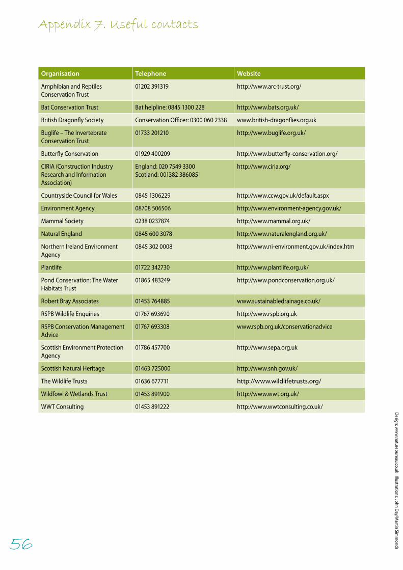
56
Appendix 7. Useful contacts
Organisation Telephone Website
Amphibian and Reptiles Conservation Trust
01202 391319 http://www.arc-trust.org/
Bat Conservation Trust Bat helpline: 0845 1300 228 http://www.bats.org.uk/
British Dragonfly Society Conservation Officer: 0300 060 2338 www.british-dragonflies.org.uk
Buglife – The Invertebrate Conservation Trust
01733 201210 http://www.buglife.org.uk/
Butterfly Conservation 01929 400209 http://www.butterfly-conservation.org/
CIRIA (Construction Industry Research and Information Association)
England: 020 7549 3300 Scotland: 001382 386085
http://www.ciria.org/
Countryside Council for Wales 0845 1306229 http://www.ccw.gov.uk/default.aspx
Environment Agency 08708 506506 http://www.environment-agency.gov.uk/
Mammal Society 0238 0237874 http://www.mammal.org.uk/
Natural England 0845 600 3078 http://www.naturalengland.org.uk/
Northern Ireland Environment Agency
0845 302 0008 http://www.ni-environment.gov.uk/index.htm
Plantlife 01722 342730 http://www.plantlife.org.uk/
Pond Conservation: The Water Habitats Trust
01865 483249 http://www.pondconservation.org.uk/
Robert Bray Associates 01453 764885 www.sustainabledrainage.co.uk/
RSPB Wildlife Enquiries 01767 693690 http://www.rspb.org.uk
RSPB Conservation Management Advice
01767 693308 www.rspb.org.uk/conservationadvice
Scottish Environment Protection Agency
01786 457700 http://www.sepa.org.uk
Scottish Natural Heritage 01463 725000 http://www.snh.gov.uk/
The Wildlife Trusts 01636 677711 http://www.wildlifetrusts.org/
Wildfowl & Wetlands Trust 01453 891900 http://www.wwt.org.uk/
WWT Consulting 01453 891222 http://www.wwtconsulting.co.uk/
Design: w
ww
.naturebureau.co.uk Illustrations: John Day/M
artin Simm
onds

Maximising the potential for people and wildlife
A guide for local authorities and developers
Sustainable drainage systems
Andy Graham, John Day, Bob Bray and Sally Mackenzie
Supported by:
978-1-905601-41-7
The RSPB is the UK charity working to secure a healthy environment for birds and wildlife, helping to create a better world for us all. Our Conservation Management Advice team works to improve the conservation status of priority habitats and species by promoting best-practice advice to land managers.
www.rspb.org.uk
The Wildfowl & Wetlands Trust (WWT) is one of the world’s largest and most respected wetland conservation organisations working globally to safeguard and improve wetlands for wildlife and people.
Founded in 1946 by the late Sir Peter Scott, WWT also operates a unique UK-wide network of specialist wetland centres that protect over 2,600 hectares of important wetland habitat and inspire people to connect with and value wetlands and their wildlife.
www.wwt.org.uk
The Royal Society for the Protection of Birds (RSPB) is a registered charity: England & Wales no. 207076, Scotland no. SC037654Wildfowl & Wetlands Trust (WWT) is a registered charity in England & Wales, no. 1030884 and Scotland, no. SC039410