Sustainable Communities: Assessment of Priority ......DNH), and Virginia Commonwealth University –...
92
1 Sustainable Communities: Assessment of Priority Conservation Areas and their Vulnerability to Development 16 November 2009 Final Project Report Virginia Coastal Zone Management Program NOAA Grant # NA 08NOS4190466 FY08 Task#11.02 Virginia Department of Game and Inland Fisheries In partnership with Virginia Department of Conservation and Recreation – Division of Natural Heritage and Virginia Commonwealth University – Center for Environmental Studies
Transcript of Sustainable Communities: Assessment of Priority ......DNH), and Virginia Commonwealth University –...

1
Sustainable Communities: Assessment of Priority Conservation Areas and their Vulnerability to Development 16 November 2009 Final Project Report Virginia Coastal Zone Management Program NOAA Grant # NA 08NOS4190466 FY08 Task#11.02
Virginia Department of Game and Inland Fisheries
In partnership with Virginia Department of Conservation and Recreation – Division of Natural Heritage and
Virginia Commonwealth University – Center for Environmental Studies

2
Table of Contents Executive Summary …………………………………………….……….. 3 Acknowledgements …………………………………………………….. 4 Introduction and Background ………………………………………….. 4 Priority Conservation Areas – Vision ………………………………….. 5 DCR-Natural Heritage Plan PCA Components …..…………………….. 6 DGIF – Priority Wildlife Diversity Conservation Areas ………………. 11 VCU – Aquatic Resource Integrity Layer ……………………………… 18 Priority Conservation Areas – Combining Components ………………. 20 Vulnerability Model …………………………………………………… 22 Vulnerability Analysis ….………………………………………………. 23 Pilot Project – Northampton County – Community Viz Development .…. 24 PDC Workshop ………………………………………………………… 27 Conclusions and Next Steps ……………………………………………. 28 Literature Cited ………………………………………………………… 28 Appendix I – Northampton County Community Viz Application ……..... 30 Appendix II – PCA User Survey ……………………………………...... 45 Appendix III – Metadata ………………………………………………... 46 Priority Conservation Areas ……………………………………... 46 Priority Wildlife Diversity Conservation Areas ………………… 57 Natural Landscape Network ……………………………………... 66 Conservation Sites ………………………………………………. 72 Aquatic Resource Integrity Layer ………………………….…… 80 Vulnerability Model ….………………………………………… 84

3
Executive Summary Habitat loss, fragmentation, and degradation represent the most significant threats to the effective conservation of wildlife species and natural communities. These repercussions must be managed proactively via a comprehensive planning tool, recognizing that most land conservation occurs locally and that priorities need to be established to guide allocation of limited resources. A collaboration between the Virginia Department of Game and Inland Fisheries (DGIF), Virginia Department of Conservation and Recreation – Division of Natural Heritage (DCR-DNH), and Virginia Commonwealth University – Center for Environmental Studies (VCU-CES) synthesized conservation information and priorities into a unified dataset of Priority Conservation Areas (PCA). Because DGIF did not have an existing conservation planning dataset, the Priority Wildlife Diversity Conservation Areas (PWDCA) dataset was created using existing geospatial wildlife data, guidance from the Wildlife Action Plan, and input from biologists. The PWDCA was then combined with DCR-DNH’s Conservation Sites and Natural Land Network, and VCU-CES’s Aquatic Resource Integrity Layer to produce the PCA. The PCA is a geospatial representation of conservation opportunities using a 1 to 5 ranking from Moderate Opportunities to Imperative Opportunities. Combining information and priorities from state conservation agencies and a major research institute, the PCA provides a unified tool to guide green infrastructure planning at the regional and local level. The PWDCA and PCA are available for download at: http://www.dgif.virginia.gov/gis/gis-data.asp To assess the PCA for vulnerability to development, DCR-DNH’s Virginia Conservation Lands Needs Assessment – Vulnerability Model was updated. The revised Composite Vulnerability Model was used to attribute the PCA polygons with average relative vulnerability. All areas in the PCA have both a conservation opportunities rank and a vulnerability rank. To test the applicability of the PCA at a local level, a partnership was established with Northampton County. Using Community Viz software, an extension to ESRI’s ArcGIS software for visualizing and analyzing planning scenarios, VCU-CES developed an application to evaluate the current and proposed zoning regulations in Northampton relative to impact on Priority Conservation Areas. This application was created using input from Northampton County planning staff and the final product delivered to them for their own use and continued development. A workshop was held at VCU to transfer the results of this project to regional planners. Planning District Commissions from the Coastal Zone of Virginia were invited to attend. There were 22 participants. The first half of the workshop provided information on the development, background, and potential use of the PCA dataset. A hands-on session, providing experience using Community Viz software, constituted the second half of the workshop. In conclusion, this project produced a synthesized dataset to guide conservation planning, assessed these areas for risk to development, demonstrated use of this tool within planning and visualization software, and transferred the knowledge to regional planning groups. It is anticipated that Planning District Commissions will use the PCA and other results of this project within their development of green infrastructure initiatives and to assist counties with comprehensive planning.
4
Acknowledgements This project was funded in part by the Virginia Coastal Zone Management Program at the Department of Environmental Quality through Grant #FY08 NAO8NOS4190466, Task 11.02 of the U.S. Department of Commerce, National Oceanic and Atmospheric Administration, under the Coastal Zone Management Act of 1972, as amended. This project was a partnership between the Virginia Department of Game and Inland Fisheries (DGIF), Virginia Department of Conservation and Recreation – Division of Natural Heritage (DCR-DNH), and Virginia Commonwealth University’s Center for Environmental Studies (VCU-CES) with input and oversight from Virginia Department of Environmental Quality – Coastal Zone Management Program (VCZM). It also involved collaboration and cooperation with the Planning and Zoning Department of Northampton County, Virginia. The following staff contributed to this effort: DGIF: Dave Morton, Kendell Ryan, and Jim Husband. Wildlife Diversity biologists: Ruth Boettcher, Rick Reynolds, Jeff Cooper, JD Kleopfer, Sergio Harding, Mike Pinder, Brian Watson, Justin Laughlin, Louise Finger, Brian Roosa, Susan Watson, Amy Ewing, and Ernie Aschenbach. Chris Burkett provided input and feedback. Becky Gwynn provided grant management. DCR-NH: Jason Bulluck and Joe Weber VCU-CES: Jennifer Ciminelli, Dr. Greg Garman, and Will Shuart VCZM: Laura McKay, Nick Meade, and Beth Polak. Northampton County: Peter Stith and Sandra Benson Introduction and Background
Habitat loss, fragmentation, and degradation represent the most significant threats to the effective conservation of wildlife species and natural, communities. At the same time, however, the capacity to purchase, conserve, and manage lands has diminished significantly due to declining budgets and rising land costs. This problem is compounded by the rapid conversion of lands from traditional rural and agricultural uses, which may support a broad diversity of wildlife, to industrial or residential uses, which create landscapes inhospitable to many species. This condition is especially clear in Virginia where—by one estimate—current land conversion rates will develop more land over the next 40 years than has been developed in the past 400 years (Benedict et al. 2004). Undoubtedly, habitat loss and fragmentation cannot be stopped. Rather, their repercussions must be managed proactively via well-informed, comprehensive planning that recognizes the critical importance of conserving and managing terrestrial and aquatic species habitats and the ecosystem functions they help constitute. This function is the foundation for a healthy Green Infrastructure.
Two major ideas have become clearer alongside our understanding of the impacts of habitat loss and fragmentation. First, most land conservation happens locally. This is due in part to the fact that specific decisions about how parcels of land will be used are made locally, and at this level, public input and funding possibilities are most closely linked with the conservation of a specific place. Second, all lands/resources are not equal in their contribution to a healthy functioning ecological network. Each conservation opportunity displays a unique set of conservation values that can be used to weigh the benefits of conserving one parcel over another. Considering the reality that funding for conservation is typically very limited at the local level,

5
having tools to identify conservation opportunities that maximize our ability to conserve and manage the most important areas in the most financially sound ways is key.
Virginia natural resources agencies have independently quantified important conservation opportunities. Specific conservation tools used for this purpose include the Virginia Conservation Lands Need Assessment (VCLNA) which was developed by the Virginia Department of Conservation and Recreation – Division of Natural Heritage (DCR-DNH) and the Virginia Wildlife Action Plan, developed by the Virginia Department of Game and Inland Fisheries (DGIF). Both the Ecological Model (aka the Virginia Natural Landscape Assessment or VaNLA) of the VCLNA and the mapped tiered-species habitats from the Wildlife Action Plan identified conservation priorities spatially. However, each of these efforts were formed with different perspectives and assumptions and therefore, presented very different results. Concurrently, Virginia Commonwealth University’s Center for Environmental Studies (VCU-CES) has developed methods to rate aquatic resource integrity based on fish and macro-invertebrate community sampling. This provided another way to identify conservation priorities. With several tools for mapping conservation priorities, local planners needed to fully evaluate all available options at the risk of under representing a specific conservation perspective. Synthesis was needed to present a unified method of prioritizing conservation opportunities.
This project is the result of a partnership between VCU-CES, DCR-DNH, and DGIF to fulfill the need to provide a single collaborative approach to mapping conservation opportunities. The specific objectives were to:
1. Cooperatively indentify and prioritize conservation areas, specifically for use by regional and local planners for green infrastructure initiatives;
2. Assess priority conservation areas for vulnerability to development, highlighting areas most
at risk;
3. Collaborate with an individual county to explore implementation of data and tools at the local scale; and
4. Conduct a workshop to transfer information to all Planning District Commissions (PDCs),
which are regional planning organizations. The remainder of this report presents how the project team worked toward the above objectives. Priority Conservation Areas - Vision The principal objective was to cooperatively identify and map priority wildlife conservation areas. The project team defined priority conservation areas as…. lands and surface waters indentified as important for conservation of Virginia’s wildlife, plants, and natural communities. The identified lands/waters can be used to prioritize areas for preservation, protection or specific management action. The Priority Conservation Areas (PCA) represents locations that should be managed for conservation. They contain features of conservation importance (e.g., a rare community or species
6
habitat) along with a protective area around them to insure their continued existence and ecosystem function. The PCAs may contain areas that are presently developed or otherwise degraded, but if restored and/or managed properly would produce conservation benefits. An example is a stream riparian buffer that may be currently an asphalt parking lot, but if reverted to natural vegetation would provide a critical buffer protecting downstream habitat. The PCAs were defined based on each partners’ priorities. Methods used by DCR-DNH, DGIF, and VCU-CES to define their priorities are covered in the following sections. DCR- Natural Heritage Plan PCA Components
Virginia DCR-DNH prepared two data layers from data in the Natural Heritage Plan to contribute to the PCA compilation. These layers were selected because together they provide a fine filter and a coarse filter conservation panning tool. In short, coarse filter tools are designed to conserve high percentages of species by conserving adequate diversity, distribution, and abundance of ecological communities, ecological land units (e.g., alliances of ecological communities, physical environments and landscape-level ecological phenomena). Coarse filter tools are complimented by fine filter approaches, which focus on specific habitats of individual rare species, or species that specialize on a small and/or unique habitat type. For the PCA, DCR-DNH prepared data layers derived from DCR-DNH Conservation Sites (Conservation Sites ranked by B-rank; fine filter) and the Virginia Natural Landscape Assessment (VaNLA) (Virginia Natural Land Network; coarse filter). The following text briefly describes these two PCA inputs. Virginia Natural Land Network – Coarse Filter
The Virginia Natural Land Network is a focused subset of lands identified in the VaNLA, a landscape-scale GIS analysis for identifying, prioritizing, and linking natural habitats in Virginia, which was developed by the DCR-DNH with funding from the Virginia Coastal Zone Management Program (NOAA Grant # NA05NOS4191180, Task 92.05 and NOAA Grant # NA03NO54190104, Task 95.01). Using land cover data derived from satellite imagery, the VaNLA identifies un-fragmented natural habitats called Ecological Cores, or large patches of natural land cover with at least 100 acres of interior conditions. Cores consist mainly of upland forests and forested wetlands statewide, but also marshes, beaches, and dunes in the coastal plain. Large, medium, and small Ecological Cores are identified, along with smaller Habitat Fragments that may be important in more urban localities. Ecological Cores provide habitat for a wide range of species, from those dependent upon interior forests to habitat generalists, as well as species that utilize marsh, dune, and beach habitats. Cores also provide benefits in terms of open space, recreation, water quality (including drinking water protection), and carbon sequestration, along with the associated economic benefits of these functions.
All VaNLA cores are given an ecological integrity score. This score is derived from a ranking method resulting from the calculation of several attributes from all cores that assess a core’s relative contribution to ecosystem functions (e.g. rare terrestrial and aquatic species locations from the SWAP and Natural Heritage Plan, locations of rare community types, total core area, length of core interior streams, variety of unmodified wetlands, etc.). Via this process, each ecological core was assigned an ecological integrity score of C1 – Outstanding to C5 – General.
In the interest of identifying an entire ecological network upon which to base conservation decisions, landscape corridors were also identified using GIS to identify the most suitable linkages

7
between the two highest ranks of cores (C1 andC2). Suitable corridors that link cores allow animal movement between cores and help to facilitate seed and pollen transfer between cores. In addition to indentifying links between C1 and C2 cores, corridors also integrated all landscape cores that they intersected (C3, C4 and C5 cores) as habitat nodes. These nodes provide stepping stones for plant and animal populations over time and help to assure that lands identified as important to core linkages also contribute to the available habitats for some species within the ecological network. More detailed methods and background for the VaNLA can be found on the DCR-DNH website at http://www.dcr.virginia.gov/natural_heritage/vclnavnla.shtml
Portions of the VaNLA were selected to provide the coarse filter contribution to the greater PCA. Referred to as the Virginia Natural Land Network (NLN), this subset of lands consists of a GIS layer of:
• all the highest ranked cores (C1 and C2) in the Coastal Zone, each ranked by ecological integrity,
• all landscape corridors providing linkages between these cores, and • all cores (ranks C3 – C5) that intersect landscape corridors.
The NLN was provided with rankings of ecological integrity from low (1) to high (5) for
incorporation into the PCA. All included cores maintained their VaNLA Ecological Integrity scores, and all corridors were given a rank of 1 where they did not intersect a VaNLA core. The NLN is shown in Figure 1.
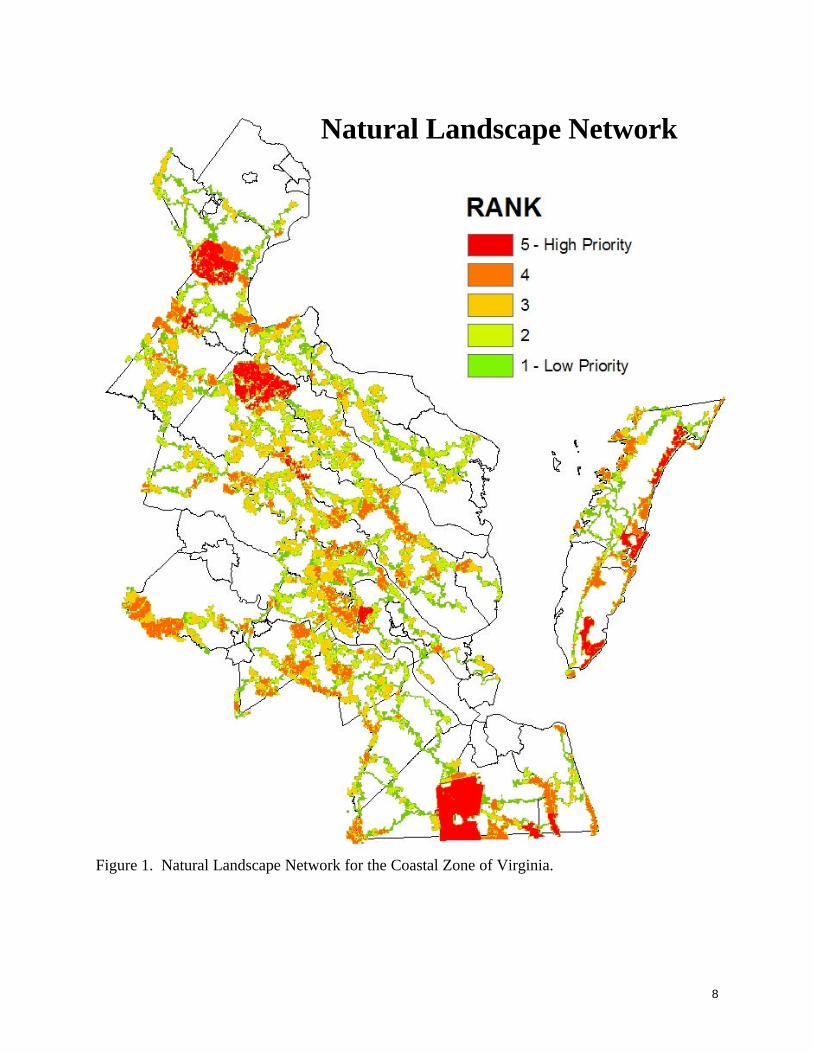
8
Figure 1. Natural Landscape Network for the Coastal Zone of Virginia.
Natural Landscape Network

9
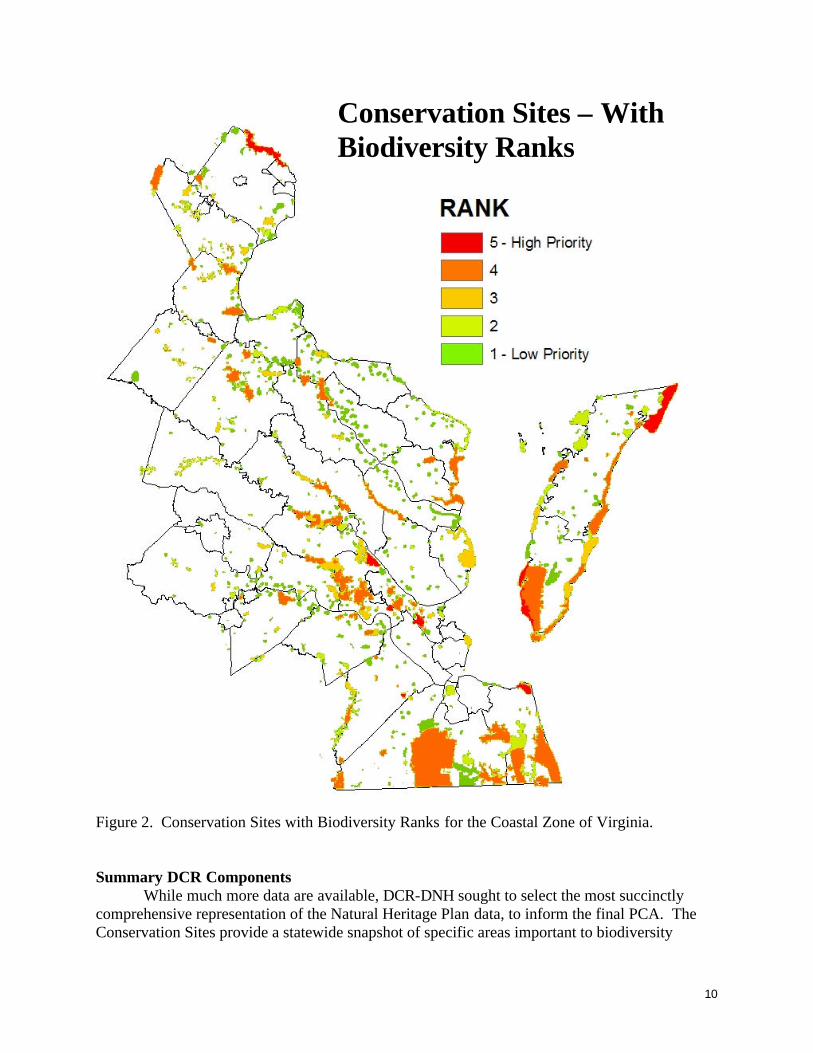
Virginia Conservation Sites – Fine Filter The DCR-DNH maintains a GIS layer and database of Virginia’s Conservation Sites, a
central component of the Natural Heritage Plan. A conservation site is a planning boundary delineating the Virginia Natural Heritage Program’s best determination of the land and water area occupied by one or more natural heritage resources (exemplary natural communities and rare species) and required to support their long-term survival. The size and dimensions of a conservation site are based on the habitat requirements of the natural heritage resources present and the physical features of the surrounding landscape. Features taken into consideration include underground and surface hydrology, slope, aspect, vegetation structure, current land uses, and potential threats from invasive species. Conservation sites do not necessarily preclude human activities. but the site’s viability may be greatly influenced by human activities. Conservation sites may require ecological management, such as invasive species control or water management, in order to maintain or enhance their viability. Each conservation site is given a biodiversity significance ranking (B-rank) based on rarity, quality, and number of natural heritage resources it contains.
All conservation planning tools developed using DCR-DNH data rely in part on the locations of, and data tied to, DCR-DNH Conservation Sites. The Conservation Sties layer was selected as a DCR-DNH input to the PCA analysis to provide a fine filter conservation planning dataset to inform the greater PCA.
For the PCA, Biodiversity Ranks were calculated for all DCR-DNH Conservation Sites in the Virginia Coastal Zone based on most recent data as of January 2009. Conservation Sites were then ranked by their Biodiversity Rank scores, from 1 (low) to 5 (high). A revised GIS layer was developed based on this ranking and contributed to the greater PCA analysis. The ranked Conservation Sites are shown in Figure 2.
10
Figure 2. Conservation Sites with Biodiversity Ranks for the Coastal Zone of Virginia. Summary DCR Components
While much more data are available, DCR-DNH sought to select the most succinctly comprehensive representation of the Natural Heritage Plan data, to inform the final PCA. The Conservation Sites provide a statewide snapshot of specific areas important to biodiversity
Conservation Sites – With Biodiversity Ranks

11
conservation, and the NLN provides a coarser tool for planning to conserve and minimize negative impacts on lands that contribute to a landscape-level ecological network. DGIF – Priority Wildlife Diversity Conservation Areas The DGIF maintains several GIS datasets showing the location of important wildlife features. However, DGIF has never produced a map showing how these features should be prioritized and conserved. While, as part of the Wildlife Action Plan, the DGIF mapped habitats of over 250 species of greatest conservation need (Tiered Habitat), these do not include any protective buffer around habitats. Furthermore, there are general conservation actions included in the Wildlife Action Plan that benefit multiple species that had not been mapped. Therefore, it was necessary to create a new GIS dataset to compile wildlife conservation areas. This dataset was called Priority Wildlife Diversity Conservation Areas or PWDCA. The term diversity was included to reinforce the wildlife diversity or nongame wildlife conservation focus. The first step was to determine appropriate existing GIS datasets that represent conservation opportunities. These datasets included: Anadromous Fish Use Waters, Colonial Waterbird Database, and Audubon Important Bird Areas. The DGIF’s Coldwater Stream Survey dataset was also considered, but is primarily outside of the Coastal Zone.
The next step was to gather “mappable” conservation actions outlined in the Wildlife Action Plan. There were four explicit conservation actions that could be mapped:
1. Acquire or protect needed habitats. The DGIF mapped the habitats of over 250
species of greatest conservation need within the top two tiers of imperilment plus any state or federally listed species in a lower tier. These are called DGIF’s Tiered Species Habitat. While this doesn’t include the habitats needed to conserve all species of greatest conservation need, it does include a major portion of the most critically imperiled species.
2. Protect large blocks of contiguous habitat. The DCR-DNH identified cores of natural land cover within the Ecological Model of their VCLNA. These cores and related features represent contiguous or unfragmented habitat. These are also referred to as the VaNLA cores.
3. Create forest or upland buffers around marshes and protect wooded wetlands. Wetlands are identified in the U.S. Fish and Wildlife Service’s (USFWS) National Wetlands Inventory. Buffers can be created in GIS to identify buffers around these features.
4. Protect and establish riparian buffers. GIS data on streams can be buffered to delineate appropriate stream buffers. The best available stream data are the National Hydrography Dataset from U.S. Geological Survey (USGS).
Details on the existing GIS datasets, as well as datasets used to map conservation actions, are
listed below: Anadromous Fish Use Waters: This dataset maintained by DGIF and updated in 2006 identifies reaches that are confirmed or potential migration pathways, spawning grounds, or nursery areas for

12
anadromous fish. The base layer hydrography for this dataset is the USGS National Hydrography Dataset, High (1:24,000) and Medium (1:100,000) resolution. Colonial Waterbird Database: This dataset contains known occurrences of colony nesting waterbirds in Virginia. It includes data from the 2003 Colonial Waterbird survey conducted by the College of William and Mary’s Center for Conservation Biology (CCB), data from the DGIF’s Species Observations database and data from Cornell University. Audubon Important Bird Areas (IBA): This dataset is maintained by the Audubon Society as part of a global effort to conserve bird biodiversity. There are 20 IBA’s that fall within the Coastal Zone. They are created to encompass habitat important one or more species and are based on nominations from experts in the avian community. DGIF’s Tiered Species Habitat: Aquatic and terrestrial tiered confirmed and potential habitat layers were created as part of the Virginia Wildlife Action Plan. There are four tiers, representing levels of imperilment with I being the highest. All maps and information were reviewed by biologists. For more information, visit: http://bewild.virginia.org.
• Terrestrial confirmed habitat: This layer includes confirmed locations from DGIF’s Species Observations database as well as data from DCR-DNH's Biotics Data System.
• Terrestrial Potential habitat: This layer represents areas with potential for supporting species. It is based on species distribution, species habitat requirements, existing spatial data and biologists’ knowledge.
• Aquatic habitat: The aquatic layers are based on a Stream Reach Classification System using the 1:100,000 National Hydrography Dataset (NHD). Reaches in this dataset were assigned additional attributes useful for habitat evaluation such as size, gradient and elevation.
o Confirmed habitat: Confirmed reaches have documented species occurrences. o Potential habitat: Potential reaches are assigned based on species distribution and the
characteristics of confirmed reaches. Note that the DGIF’s Threatened and Endangered Species Waters dataset is essentially a subset of the aquatic habitat portion of the Tiered Species Habitat, for those individual listed species. Therefore this dataset was not included on its own. National Wetlands Inventory: This dataset is maintained and downloaded from the USFWS. It was digitized from 1:24,000 topographic quads and attributed using the Cowardin Wetland Classification System. National Hydrography Dataset: This dataset is maintained and downloaded from the U.S. Geologic Survey. The layer used to extract riparian areas was at the 1:100,000 scale. VaNLA Cores: Layer created and distributed by the DCR-DNH for the Virginia Conservation Lands Needs Assessment, as part of the Virginia Natural Lands Network. It was published in 2006 and represents areas of un-fragmented natural habitat ranging in size and corresponding conservation value. Once the initial GIS input layers were gathered, it was necessary to determine how they should be processed and prioritized. The list of relevant layers and habitat features was sent to 13

13
DGIF Wildlife Diversity biologists with broad questions in-mind including: What areas in Virginia should be preserved?; What are the priority that should be managed in a specific way?; What areas should localities protect through local zoning or planning?; How should the Wildlife Diversity section prioritize land for acquisition? The biologists reviewed the list of mapped wildlife features, suggesting priorities for features, buffer distances and buffer priorities where appropriate. Priorities were on a scale of 1 to 10, with 10 being the highest. In addition, biologists identified any other features that should be included in the model. Specific areas were identified as having additional value as being unique terrestrial or aquatic features.
Input was received from all 13 biologists. The results of this survey were averaged. However, input from those biologists with specific taxonomic expertise was considered more appropriate than similar input from non-experts for individual taxa features. For example, avian biologists determined the priority rankings of Important Bird Areas and tiered bird species habitats while aquatic biologists had more input on riparian buffers rankings. Initial input was compiled and draft buffer distances and priorities were determined. A second round of input on these draft results followed. After feedback on the draft values was received and incorporated, final values were determined (see table below). The final priorities used in the model are shown below:
Aquatic Tiered Habitat1 Tier I spp reach Priority 10 Buffer 300 Buffer priority 10 Tier II spp reach Priority 9 Buffer 300 Buffer priority 9 Tier III spp reach Priority 7 Buffer 300 Buffer priority 7 Tier IV spp reach Priority 5 Buffer 300 Buffer priority 5
Confirmed DGIF
Tier I spp reach Priority 7 Buffer 150 Buffer priority 7 Tier II spp reach Priority 6 Buffer 150 Buffer priority 6 Tier III spp reach Priority 4 Buffer 150 Buffer priority 4
Potential DGIF
Tier IV spp reach Priority 3
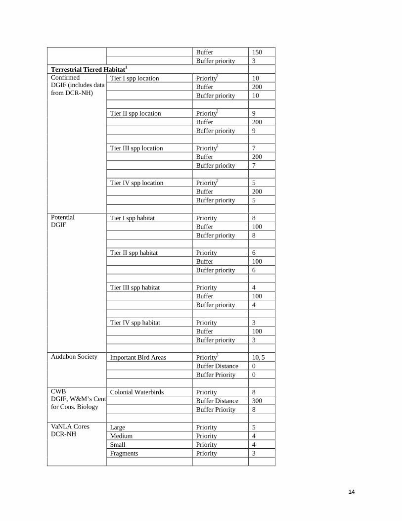
14
Buffer 150 Buffer priority 3
Terrestrial Tiered Habitat1 Tier I spp location Priority2 10 Buffer 200 Buffer priority 10 Tier II spp location Priority2 9 Buffer 200 Buffer priority 9 Tier III spp location Priority2 7 Buffer 200 Buffer priority 7 Tier IV spp location Priority2 5 Buffer 200 Buffer priority 5
Confirmed DGIF (includes data from DCR-NH)
Tier I spp habitat Priority 8 Buffer 100 Buffer priority 8 Tier II spp habitat Priority 6 Buffer 100 Buffer priority 6 Tier III spp habitat Priority 4 Buffer 100 Buffer priority 4 Tier IV spp habitat Priority 3 Buffer 100 Buffer priority 3
Potential DGIF
Important Bird Areas Priority3 10, 5 Buffer Distance 0 Buffer Priority 0
Audubon Society
Colonial Waterbirds Priority 8 Buffer Distance 300 Buffer Priority 8
CWB DGIF, W&M’s Center for Cons. Biology
Large Priority 5 Medium Priority 4 Small Priority 4 Fragments Priority 3
VaNLA Cores DCR-NH
15
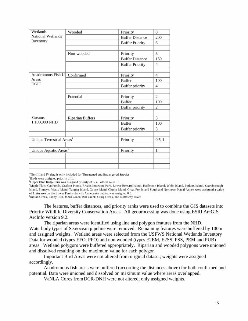
Wooded Priority 8 Buffer Distance 200 Buffer Priority 6 Non-wooded Priority 5 Buffer Distance 150 Buffer Priority 4
Wetlands National Wetlands Inventory
Confirmed Priority 4 Buffer 100 Buffer priority 4 Potential Priority 2 Buffer 100 Buffer priority 2
Anadromous Fish Use Areas DGIF
Riparian Buffers Priority 3 Buffer 100
Streams 1:100,000 NHD
Buffer priority 3 Unique Terrestrial Areas4 Priority 0.5, 1 Unique Aquatic Areas5 Priority 1
1Tier III and IV data is only included for Threatened and Endangered Species 2Birds were assigned priority of 1. 3Upper Blue Ridge IBA was assigned priority of 5, all others were 10. 4Maple Flats, Cat Ponds, Grafton Ponds, Breaks Interstate Park, Lower Bernard Island, Halfmoon Island, Webb Island, Parkers Island, Scarsborough Island, Finney's, Watts Island, Tangier Island, Goose Island, Clump Island, Great Fox Island South and Northeast Naval Annex were assigned a value of 1. An area on the Lower Peninsula with Canebrake habitat was assigned 0.5. 5Indian Creek, Paddy Run, Johns Creek/Mill Creek, Craig Creek, and Nottoway River
The features, buffer distances, and priority ranks were used to combine the GIS datasets into Priority Wildlife Diversity Conservation Areas. All geoprocessing was done using ESRI ArcGIS ArcInfo version 9.2.
The riparian areas were identified using line and polygon features from the NHD. Waterbody types of Sea/ocean pipeline were removed. Remaining features were buffered by 100m and assigned weights. Wetland areas were selected from the USFWS National Wetlands Inventory Data for wooded (types EFO, PFO) and non-wooded (types E2EM, E2SS, PSS, PEM and PUB) areas. Wetland polygons were buffered appropriately. Riparian and wooded polygons were unioned and dissolved resulting on the maximum value for each polygon
Important Bird Areas were not altered from original dataset; weights were assigned accordingly.
Anadromous fish areas were buffered (according the distances above) for both confirmed and potential. Data were unioned and dissolved on maximum value where areas overlapped.
VaNLA Cores from DCR-DNH were not altered, only assigned weights.

16
Unique terrestrial areas were selected from DCR-DNH’s Conservation Lands layer, and from DCR’s Jurisdictions layer. DGIF Biologists drew the peninsula area representing canebrake rattlesnake habitat. Unique aquatic layers were selected from the NHD.
For terrestrial and aquatic tiered data, confirmed and potential locations were buffered and assigned weights according to tier. Layers were unioned to identify areas of overlap. Data were imported into MS Access where duplicate species were removed and final weights were calculated for each polygon. Final weight was calculated as the highest weight, plus half the total of the additional weights in each polygon. Because Tiered Species Habitats had such a high priority, there was a danger of these data overshadowing other wildlife features. The use of highest species weight plus half the weights of additional species occurring at the same location reduced the overall influence of sites where several tiered species co-occur.
All layers were compiled and converted from vector polygons to a raster dataset according to final weight. The raster layers were summed to get a total score for all locations. Using the Standard Deviations classification method, the combined raster was broken into 5 categories, with 1 being lower priority and 5 being the highest conservation priority.
The input layers and draft PWDCA with the 1-5 categories were posted in an intranet map site, providing an opportunity for final review by DGIF biologists. The final PWDCA is shown in Figure 3.

17
Figure 3. Priority Wildlife Diversity Conservation Areas for the Coastal Zone of Virginia.

18
VCU – Aquatic Resource Integrity Layer
This layer was created by Virginia Commonwealth University Center for Environmental Studies (VCU-CES) to aid in the characterization of stream health in the Commonwealth. This layer is a combination of both a local scale assessment and a watershed based approach to stream health. The assessment was aided by the Interactive Stream Assessment Resource (INSTAR). Stream Reach Assessment:
Within each geo-referenced stream reach (150-200 m, depending on stream width), fishes, macroinvertebrates, and stream habitat data are collected. Data are compiled into databases and application macros calculate over 50 separate ecological metrics, including those typically generated for Index of Biotic Integrity (IBI) and Rapid Bioassessment Protocol (RBP) assessments. INSTAR evaluates the ecological health of stream reaches based on percent comparability of empirical data to the appropriate (e.g., basin, stream order) reference model. Stream health is calculated and placed in four categories: Exceptional, Healthy, Restoration Potential, and Compromised.
In addition to extensive stream community data collected by VCU biologists for INSTAR, appropriate data from other sources (e.g., agencies, universities) are screened for inclusion in the database, based on stringent QA criteria. Watershed Assessment:
Watershed assessments include a broader range of validated qualitative (e.g., species lists) biotic data from various sources, including state and federal agencies. These data are used to generate watershed health using six metrics or variables for the Commonwealth’s 1275 6th-order watersheds. Watershed health is calculated and placed in four categories: Exceptional, Healthy, Restoration Potential, and Compromised. Layer creation:
All 1:24,000 hydrology lines in the Commonwealth were rasterized to 30m pixels and the watershed health score was attributed on each pixel that was inside a watershed. The stream reaches were buffered and rasterized by stream order:
1st: 30m cell buffer 2nd: 60m cell buffer 3rd and above: 90m cell buffer
The Aquatic Resource Integrity Layer was then created by merging the stream reach
assessment layer with the watershed assessment layer. A Mosaic operation using the last option, setting the reach raster to last and taking those values and imposing them on the raster for the watershed values so the end result was a rasterized hydrology layer that had watershed health and stream health scores combined. The Aquatic Resource Integrity Layer with health categories is shown in Figure 4.

19
Aquatic Resource Integrity Layer
Figure 4. Aquatic Resource Integrity Layer. The raster values and health scores are as follows of 5= Exceptional, 4=Healthy, 3=Restoration Potential, and 2=Compromised.
20
Priority Conservation Areas – Combining Components
Data from DCR-DNH (Natural Lands Network and Conservation Sites), DGIF (Priority Wildlife Diversity Conservation Areas), and VCU-CES (Aquatic Resource Integrity Layer) form the component pieces of the Priority Conservation Areas (PCA) dataset. All input layers were scaled to a 100 meter cell size using a resample with the nearest neighbor resampling technique. Data were ranked on a scale of 5 to 1, where 5 was the highest value using the reclassify function of Spatial Analyst. The final priority conservation area was developed using the Spatial Analyst cell statistics to pull out the maximum cell value of all input datasets to create the final grid. The final grid was filtered to smooth the data. The Spatial Analyst Majority Filter was used with the options set to four neighbors, majority replacement threshold.
One concern when combining components was not to introduce redundancy. Several partners used the same or similar inputs, but with different methods and with different priorities. Furthermore, it was the desire of the project team to retain areas identified as the highest priorities by any single partner. For these reasons, it was decided to use the majority filter method of combining datasets rather than an additive or averaging approach. The final PCA values are as follows: 1 – Moderate Conservation Opportunity 2 – Moderately High Conservation Opportunity 3 – High Conservation Opportunity 4 – Very High Conservation Opportunity 5 – Imperative Conservation Opportunity The final PCA is shown in Figure 5.

21
Figure 5. Priority Conservation Areas for the Coastal Zone of Virginia.

22
Vulnerability Model
The original VCLNA Vulnerability model was developed to provide a statewide growth prediction for the Virginia Conservation Lands Needs Assessment (VCLNA), a statewide Green Infrastructure assessment completed by DCR-DNH in late 2007. The VCLNA as a whole was developed via funding from the Virginia Coastal Zone Management Program under NOAA Grant # NA05NOS4191180, Task 92.05, and NOAA Grant # NA03NO54190104, Task 95.01, where the latter grant specifically funded the Vulnerability Model. This growth prediction was developed to indicate potential land use change from the current use to an urban or suburban use. Four models were developed to account for different urban, suburban and rural growth pressures and rates:
• the Virginia Urban Vulnerability Model shows predicted urban growth, • the Virginia Urban Fringe Vulnerability Model shows the predicted urban fringe, or
metropolitan fringe growth, • the Virginia Vulnerability beyond the Urban Fringe Model shows the predicted growth
beyond the urban fringe (ex-urban growth), and • the composite Virginia Vulnerability Model shows all vulnerability models integrated into
one model, representing growth pressures across the urban, suburban and rural landscape (E. H. Wilson et al. 2003, R. E. Heimlich and W. D. Anderson, 2001).
Background and methodology for the Vulnerability Model will not be provided in this report but
are available via the links provided later in this brief report. For the Priority Conservation Areas analysis (NOAA Grant # NAO8NOS4190466, Task 11.02), the original Vulnerability Model (2006) methods were revised and the model re-run resulting in an enhanced model for use with the PCA outputs.
One improvement was the inclusion of more parcel data for estimating a locality’s mean lot size. Parcel data are not available in GIS format for all localities in Virginia. Thus, in the original and revisions of the Vulnerability Model, a linear regression was used to correlate road density with mean lot size in localities where parcel data were available and to use output from this analysis to predict mean lot size for localities statewide. In the original Vulnerability Model, the regression was run using parcel data for 9 localities. In the revision for the PCA analysis, the mean lot size regression was run using parcel data for 35 localities, allowing a stronger prediction of mean lot size for all localities.
Tighter fit of the data in the regression model removed “noise” in the data which had resulted from hotspots being identified as statistically significant due to the regression model mean lot size prediction (over-representation of hotspots). In the previous version, hotspots could be seen dispersed throughout the state. The revised model resulted in a stronger statistical identification of hotspots in Virginia and removed much of that noise. As a result, in the model revision used in the PCA, fewer tighter clusters of hotspots are clear. This can be generally summarized in a comparison of numbers of hotspots between Versions 1 and 2 of the Vulnerability model, in all development types: Layer Version 1 Count Version 2 Count Urban hotspots 6135 2797
Suburban hotspots 11681 8916
Rural hotspots 12798 9673

23
The revised Vulnerability Model allows users of the PCA dataset and GIS layers to assess
areas of potential growth and subsequent threat of development to high-ranked PCAs in their areas of concern, to help prioritize their conservation efforts. Altogether, the PCA and Vulnerability Model can be used together with Community Viz planning software or other planning tools to prioritize conservation efforts based on recent data and current predicted growth patterns.
The composite Vulnerability Model is shown in Figure 6. Rural, suburban, urban and composite Vulnerability Models can be viewed on the DCR-DNH Virginia Land Conservation Data Explorer, an ArcIMS website, at www.vaconservedlands.org. More thorough background on the Vulnerability Model(s) can be found on the DCR-DNH website at the following URL: http://www.dcr.virginia.gov/natural_heritage/vclnavulnerable.shtml. A full report on this assessment can be obtained by contacting the DCR-DNH.
Figure 6. Revised Vulnerability Model for Virginia. Vulnerability Analysis
The revised Composite Vulnerability Model was used to attribute the PCA with a threat value. The threat value was averaged for each polygon within the PCA to create a threat attribute in the PCA. This is because the PCA polygons encompass more than one cell of the Vulnerability layer, so the average threat value of all cells within each PCA polygon was calculated and an
24
attribute created. Therefore, for each polygon within the PCA there is a value for PCA rank and a value for threat level from 1- 8, with 8 being the highest threat from development. Pilot Project - Northampton County – Community Viz Development To test how the Priority Conservation Areas (PCA) can be applied at a local level, a partnership was established with Northampton County. Northampton was chosen because of a similar conservation planning initiative being conducted in Accomack County to the north and also because Northampton County was in the middle of revising its zoning. The County Planning staff were also interested in evaluating the PCA data for use in the next revision of the comprehensive plan. Community Viz software, developed by Placeways, LLC, is a visualization and planning extension for ESRI’s ArcGIS. This software is becoming increasingly used by local planners and so was chosen as a platform this pilot project. Many of the planners in the Coastal Zone were interested in gaining experience in using this package. For more information on Community Viz, see http://placeways.com/communityviz/index.php
The Community Viz application was developed by VCU-CES using the PCA and local County input datasets to evaluate Current and Proposed Zoning code impacts on Priority Conservation Areas within the County. The application includes the capability to interactively change zoning types and to see the resulting impacts to PCA area depending on the type of zoning code. The application uses the Current Zoning and Proposed Zoning layers provided by Northampton County and the PCA layer developed within this project. For the purposes of this application, the PCA layer was clipped to Northampton County and broken into 5 respective layers representing the 5 ranks.
Because this particular analysis in Northampton focuses on protecting lands, it was first necessary to exclude those lands currently protected. DCR-DNH’s Conservation Lands were removed from the PCA layers as these lands are already under some type of conservation status, and therefore, were not necessary to be included in the analysis. (See http://www.dcr.virginia.gov/natural_heritage/clinfo.shtml).

25
Figure 7. Northampton County - PCA analysis using Community Viz software. Community Viz Overview
To calculate the impacts of zoning type on the PCA, dynamic attributes, indicators and a land use design model were created. The overall process involved the following steps:
• Assessing if a parcel polygon in the Current or Proposed Zoning layer is a compatible or incompatible zone type based on the zone code (see chart below) (dynamic attribute created to store this information);
• Calculating the spatial overlap of the PCA and Current Zoning, and PCA and Proposed Zoning (dynamic attribute, this attribute is not set to dynamically update); and
• Summarizing the area of overlap of the PCA and zoning, if a parcel zone code is incompatible (indicator set to sum the area of spatial overlap of the PCA and zoning).
A land use model was created for the proposed zoning layer to allow the end user to use
sketch tools to change zoning type. The land use model was created for just proposed zoning because the proposed zoning layer is considered the active “working” zoning layer. Changing a polygons zoning code will result in formula updates and subsequent updates to any indicators and charts. Dynamic attributes were created to summarize the amount of PCA area that may be impacted due to zoning type. Zoning types considered high density may negatively impact the sustainability of a PCA to support wildlife and terrestrial species communities and/or aquatic integrity. Zoning types considered high density were chosen by the project team, not by Northampton County. These

26
zoning types can be changed to be more representative of high density zone types by the County. An attribute was created to identify a parcel as being compatible or incompatible based on the following zone codes: Current Zoning High Density Zone Types Code Description CD_CN Community Development Commercial
Neighborhood CD_R1 Community Development Family Residential EB_CG Existing Business Commercial General EB_CN Existing Business Commercial Neighborhood EB_IG Existing Business Industrial General MHP Mobile Home Park PUD_PVR Planned Urban Dev Planned Rural Village RV_R Rural Village Residential Proposed Zoning High Density Zone Types Code Description EB Existing Business District ESD-CDR1 Community Development – Commercial
Neighborhood ESD-RVR Rural Village – Residential H Hamlet MHP Mobile Home Park District PUD_RVR Planned Rural Village District V2 Village-2 VNB Village Neighborhood Business WH Waterfront Hamlet WV2 Waterfront Village-2 WVNB Waterfront Village Neighborhood Business
To calculate the amount of area that would be incompatible with PCA sustainability, a formula was created to calculate the area of overlap of PCA and parcel polygons determined to be of a non-compatible zone type. The area was then summarized in indicators and the results are displayed in the charts.
It should be noted that the current and proposed zoning codes are not an exact match. There are a total of 6,121 currently zoned parcels that are classed as incompatible zone types for a total area of 6,872 acres. There are a total of 4,620 proposed zoned parcels that are classed as incompatible zone types for a total area of 6,379 acres.
Based on the analysis, there are 5,892 acres of the priority conservation area that fall within a non-compatible current zoning type. There are 4,705 acres of the priority conservation area that fall within a non-compatible proposed zoning type.

27
Figure 8. Results of Zoning impact on PCA This analysis revealed that incompatible zoning types under the proposed zoning regulations would have less impact on priority conservation areas than the current zoning regulations (Figure 8). The results could be used to show the benefits of the new zoning to Northampton County. Community Viz – Interactive Northampton Project While Community Viz effectively showed the impact of zoning regulations in the analysis above, the real power of the software is the ability to quickly assess changes in assumptions and scenarios interactively. The Community Viz project or application used for the zoning analysis was built and distributed to planners at Northampton County. Full documentation and instructions on using this project can be found in Appendix I. When undertaking similar analyses, it is recommended that end users fully evaluate the project objectives. This will allow for the development or procurement of necessary input datasets as well as optimize Community Viz’s capability to interactively work with data and visualize relevant scenarios. End users are encouraged to explore training opportunities and use Placeways’ website and knowledge base for help. PDC Workshop In order to transfer the results of this project to regional planners, a workshop was held on 18 August 2009 at Virginia Commonwealth University. Six of the 8 coastal Planning District Commissions (PDCs) were represented. Other attendees were from Northampton County and partner state agencies. Overall, there were 22 participants. The first portion of the workshop focused on the development and background of the PCA. The second half involved a hands-on activities using Community Viz software. The material used in this portion is available in Appendix I. Overall, the regional planners were given information on the PCA as well as some experience using software to assist in the planning process.

28
Conclusions and Next Steps The Priority Conservation Areas dataset represents a historic partnership between DGIF, DCR-DNH, and VCU-CES to synthesize conservation planning priorities for use by regional and local planners. The PCA is a generalized subjective geospatial dataset intended to guide initial conservation planning or green infrastructure efforts. It does not replace the need for on-the-ground surveys or consultations with biologists, land managers, and planners. These data do not constitute official legal or technical advice. The PCA highlights areas due to the presence of unfragmented habitat and potential links between contiguous patches, exemplary aquatic communities, wetlands, identified habitat for rare species, and/or special wildlife features. The PCA has values from 1-5, with 5 being the highest priority. Again, all areas within the PCA are important. The 1-5 values are subjective rankings based on expert opinions and the best available informa tion. It is recommended that priority be given to sites with the highest PCA value in consultation with a biologist using contact information below. Users should also consider protection and management of entire watersheds, as impacts to headwaters areas have cumulative affects on downstream priority features such as rivers and wetlands.
The PCA contains all lands regardless of their current protection status. Depending on the intended use of the PCA, lands that are already in a conservation status may need to be removed from the analysis. The conservation lands data (see the DCR-DNH Conservation Lands Database website at http://www.dcr.virginia.gov/natural_heritage/clinfo.shtml) can be used to evaluate conservation “protectedness” for all conserved parcels in the Coastal Zone.
The PCA is available for download from http://www.dgif.virginia.gov/gis/gis-data.asp. It is expected that several coastal Planning District Commissions (PDCs) will use the PCA to assist with green infrastructure planning initiatives. The Hampton Roads PDC has started using these data for its green infrastructure project. The Southern Tip Partnership, a coalition of non-governmental organizations and state and federal agencies, has expressed interest in using the PCA to help with land acquisition decisions. To get feedback on the PCA, as well as other results of this project, a follow-up phone survey is planned for first quarter of 2010. Draft survey questions are found in Appendix II.
Placeways’ Community Viz provides an easy-to-use interactive application that allows the end user to analyze a variety of scenarios and to visualize the resulting impacts. This project demonstrated the power of this software to evaluate planning decisions using the PCA as an input. The workshop was a successful method to transfer information about the PCA as well as provided experience using Community Viz to Planning District Commissions in Virginia’s Coastal Zone.
It is hoped that the tools and information developed through this project will be instrumental in guiding green infrastructure planning in the Commonwealth now and in the future. Literature Cited Benedict M. A., W. Allen, E. McMahon. 2004. Advancing Strategic Conservation
in the Commonwealth of Virginia. Using a Green Infrastructure Approach to Conserving and Managing the Commonwealth's Natural Areas, Working Landscapes, Open Space, and Other Critical Resources, The Conservation Fund, Center for Conservation and Development, Arlington.

29
Heimlich, R.E. and W.D. Anderson. 2001. Development at the urban fringe and beyond: impacts on
agriculture and rural land. U.. Department of Agriculture, Agricultural Economics Report 803, Washington, D.C., USA.
Wilson, E. H. et al. 2003. Development of a geospatial model to quantify, describe and map urban
growth. Remote Sensing of Environment 82: 275-285.

30
Appendix I - Northampton County Community Viz Application The following section continues on the description and documentation of the Northampton Community Viz application described in Pilot Project section of the report (pg 24). This section includes instructions on using Community Viz software with the Northampton data, as well as providing a strong background on the functionality of the software itself. This material was used in the PCA and Community Viz workshop on August 18, 2009. Dynamic Attributes
A dynamic attribute is “an attribute that is automatically updated as changes are made in the analysis. A formula is associated with a dynamic attribute. The formula specifies how the attribute is calculated” (Community Viz Help 2009). The formulas used in this application are accessible through the Community Viz application and can be changed or edited to reflect the needs of the County.
To access a dynamic attribute, go to the 360 Setup Tab and click on Dynamic Attributes:

31
The Dynamic Attributes list will pop up:
The end user can double click on an attribute in the list to bring up the properties, or highlight and
click the properties button . To change the formula, click the Edit Formula or use the Formula Wizard:

32
The Dynamic Attributes created for the Northampton CV application include: DYNAMIC ATTRIBUTE DESCRIPTION LAYER TYPE UNITS NonCompatible_CZ Determines if the parcel is of a
compatible or non-compatible zone type for PCA sustainability.
CurrentZoning YES / NO
NonCompatible_PZ Determines if the parcel is of a compatible or non-compatible zone type for PCA sustainability.
ProposedZoningYES / NO
OverlapPCA1_CurrentZoningCalculate the spatial overlap of Current Zoning and PCA 1.
CurrentZoning Number acres
OverlapPCA2_CurrentZoningCalculate the spatial overlap of Current Zoning and PCA 2.
CurrentZoning Number acres
OverlapPCA3_CurrentZoningCalculate the spatial overlap of Current Zoning and PCA 3.
CurrentZoning Number acres
OverlapPCA4_CurrentZoningCalculate the spatial overlap of Current Zoning and PCA 4.
CurrentZoning Number acres
OverlapPCA5_CurrentZoningCalculate the spatial overlap of Current Zoning and PCA 5.
CurrentZoning Number acres
OverlapPCA1_ProposedZoningCalculate the spatial overlap of Proposed Zoning and PCA 1.
ProposedZoningNumber acres
OverlapPCA2_ProposedZoningCalculate the spatial overlap of Proposed Zoning and PCA 2.
ProposedZoningNumber acres
OverlapPCA3_ProposedZoningCalculate the spatial overlap of Proposed Zoning and PCA 3.
ProposedZoningNumber acres
OverlapPCA4_ProposedZoningCalculate the spatial overlap of Proposed Zoning and PCA 4.
ProposedZoningNumber acres
OverlapPCA5_ProposedZoningCalculate the spatial overlap of Proposed Zoning and PCA 5.
ProposedZoningNumber acres

33
Indicators To create an Indicator, in the 360 Setup Tab, click on the Indicators button:
A list of indicators will appear:
34
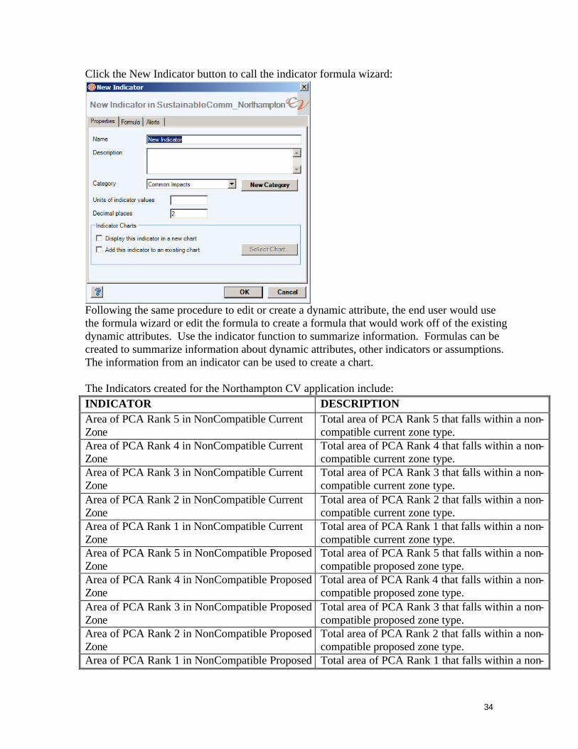
Click the New Indicator button to call the indicator formula wizard:
Following the same procedure to edit or create a dynamic attribute, the end user would use the formula wizard or edit the formula to create a formula that would work off of the existing dynamic attributes. Use the indicator function to summarize information. Formulas can be created to summarize information about dynamic attributes, other indicators or assumptions. The information from an indicator can be used to create a chart. The Indicators created for the Northampton CV application include: INDICATOR DESCRIPTION Area of PCA Rank 5 in NonCompatible Current Zone
Total area of PCA Rank 5 that falls within a non-compatible current zone type.
Area of PCA Rank 4 in NonCompatible Current Zone
Total area of PCA Rank 4 that falls within a non-compatible current zone type.
Area of PCA Rank 3 in NonCompatible Current Zone
Total area of PCA Rank 3 that falls within a non-compatible current zone type.
Area of PCA Rank 2 in NonCompatible Current Zone
Total area of PCA Rank 2 that falls within a non-compatible current zone type.
Area of PCA Rank 1 in NonCompatible Current Zone
Total area of PCA Rank 1 that falls within a non-compatible current zone type.
Area of PCA Rank 5 in NonCompatible Proposed Zone
Total area of PCA Rank 5 that falls within a non-compatible proposed zone type.
Area of PCA Rank 4 in NonCompatible Proposed Zone
Total area of PCA Rank 4 that falls within a non-compatible proposed zone type.
Area of PCA Rank 3 in NonCompatible Proposed Zone
Total area of PCA Rank 3 that falls within a non-compatible proposed zone type.
Area of PCA Rank 2 in NonCompatible Proposed Zone
Total area of PCA Rank 2 that falls within a non-compatible proposed zone type.
Area of PCA Rank 1 in NonCompatible Proposed Total area of PCA Rank 1 that falls within a non-

35
Zone compatible proposed zone type. Area of PCA in NonCompatible Current Zone Total area of PCA that falls within a non-compatible
current zone type. Area of PCA in NonCompatible Proposed Zone Total area of PCA that falls within a non-compatible
proposed zone type. Charts To create a chart, in the 360 Setup Tab, click on the Charts button:

36
A list of charts will appear:
Click the New Chart icon to call the Chart wizard:
Navigate through the tabs to label the Chart, to add the indicators that will be used as the input data to create the chart and to set the chart options.
37
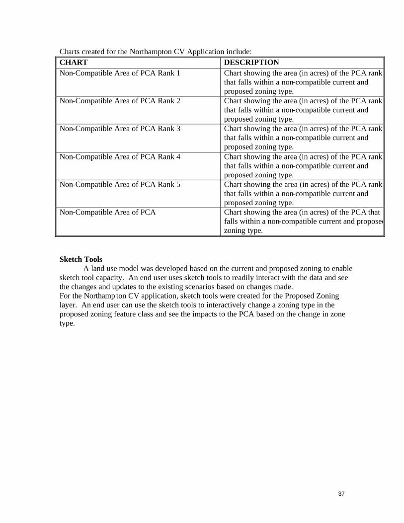
Charts created for the Northampton CV Application include: CHART DESCRIPTION Non-Compatible Area of PCA Rank 1 Chart showing the area (in acres) of the PCA rank 1
that falls within a non-compatible current and proposed zoning type.
Non-Compatible Area of PCA Rank 2 Chart showing the area (in acres) of the PCA rank 2 that falls within a non-compatible current and proposed zoning type.
Non-Compatible Area of PCA Rank 3 Chart showing the area (in acres) of the PCA rank 3 that falls within a non-compatible current and proposed zoning type.
Non-Compatible Area of PCA Rank 4 Chart showing the area (in acres) of the PCA rank 4 that falls within a non-compatible current and proposed zoning type.
Non-Compatible Area of PCA Rank 5 Chart showing the area (in acres) of the PCA rank 5 that falls within a non-compatible current and proposed zoning type.
Non-Compatible Area of PCA Chart showing the area (in acres) of the PCA that falls within a non-compatible current and proposed zoning type.
Sketch Tools
A land use model was developed based on the current and proposed zoning to enable sketch tool capacity. An end user uses sketch tools to readily interact with the data and see the changes and updates to the existing scenarios based on changes made. For the Northamp ton CV application, sketch tools were created for the Proposed Zoning layer. An end user can use the sketch tools to interactively change a zoning type in the proposed zoning feature class and see the impacts to the PCA based on the change in zone type.

38
To activate the sketch tool, turn the sketch tool toolbar on by going to Scenario 360 à View à Sketch Toolbar:
The sketch toolbar will turn on:

39
To activate the sketch tools, the data view must be in an active Edit Session. To start an editing session, turn on the Editor Toolbar in ArcMap by going to View à Toolbars à Editor:
The Editor Toolbar will be turned on:
40
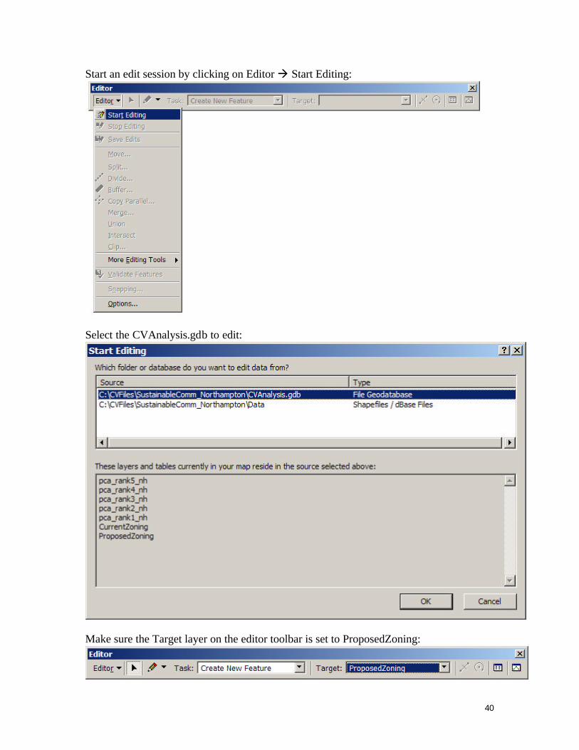
Start an edit session by clicking on Editor à Start Editing:
Select the CVAnalysis.gdb to edit:
Make sure the Target layer on the editor toolbar is set to ProposedZoning:

41
Sketch Tools can now be used to interactively change the zoning type of the proposed zoning layer polygons. To activate the tools on the sketch toolbar, click on the Painter Tool:

42
A style palette will appear listing the zoning types in the proposed zoning layer. Select a zoning type in the style palette that a parcel will be changed TO. The zoning type should be highlighted:

43
Use the Painter Tool and select a polygon to change the zone type of the polygon TO the highlighted zone type in the Style Palette. Notice in the above picture, the polygon in the middle is shaded with a red hatch. As you move the Painter Tool in the data view, parcels will highlight with the hatch color to show which parcel will be selected if the end user clicks the painter tool while the hatch is active. Click on a polygon to change the zoning type. The application will update the information:

44
The polygon zone code will be changed and the change displayed with the appropriate symbology. Charts will be updated and changes will be displayed; previous values will be indicated on the charts with hatching:
To save edits, click Editor à Save Edits. To stop editing, click Editor à Stop Editing. ArcMap will prompt the end user to save edits before the edit session is stopped. To save the application, click the SAVE button, or select File à Save.

45
Appendix II - PCA User Survey To get feedback on the influence of this project on regional and local planners, a phone survey is planned. This will be conducted by DGIF in the 1st quarter of 2010. The draft questions, reviewed by the project team, are included below. 1. Are you using the PCA? Yes or No 2. Please provide examples of how the PCA have been used. 3. How do you plan on using it in the future? 4. Is your organization engaged in green infrastructure or conservation planning?
If so are you using the PCA as a primary green infrastructure data source? If so what are the characteristics of the PCA that made you decide to use it? If not, why not?
5. How could the PCA be improved? 6. Was the data format ideal? If it was less than ideal, what other format would you recommend? 7. Was the PCA documentation adequate? 8. Do you use or plan to use Community Viz? 9. Have you used or do you plan on using the Priority Wildlife Diversity Conservation Areas dataset aside from the PCA?
10. Have you used or do you plan on using the Natural Landscape Network and/or Conservation Sites datasets aside from the PCA? 11. Have you used or do you plan on using the Aquatic Resource Integrity Layer dataset aside from the PCA?
12. How can DGIF, DCR-NH, and/or VCU-CES assist with conservation planning efforts in the future?

46
Appendix III – Spatial Data - Metadata Priority Conservation Areas Identification_Information: Citation: Citation_Information: Originator: VA Department of Game and Inland Fisheries Originator: VA Department of Conservation and Recreation Division of Natural Heritage Originator: Virginia Commonwealth University Center for Environmental Studies Publication_Date: 2009 Title: Priority Conservation Areas Geospatial_Data_Presentation_Form: vector digital data Online_Linkage: http://www.dgif.virginia.gov/gis/gis-data.asp Description: Abstract: The Priority Conservation Area (PCA) dataset delineates priorty conservation areas ranked by level of importance based on VA DGIF Priority Wildlife Diversity Conservation Areas, VA Dept of Conservation and Recreation Division of Natural Heritage Conservation Sites Layer (CSL) and Natural Lands Network (NLN), and VCU Center for Environmental Studies aquatic resource integrity layer. Priority Conservation Areas are defined as lands and surface waters indentified as important for conservation of Virginia's wildlife, plants, and natural communities. The identified lands/waters can be used to prioritize areas for preservation, protection or specific management action. Purpose: This dataset was developed to synthesize important natural resource information in one geospatial layer for natural resource management, land use management and awareness. Supplemental_Information: This dataset is intended to guide conservation planning and efforts. This dataset is not intended to replace on the ground surveys or consultations with biologists as appropriate. Time_Period_of_Content: Time_Period_Information: Multiple_Dates/Times: Single_Date/Time: Calendar_Date: 2001 Single_Date/Time: Calendar_Date: 2008 Single_Date/Time: Calendar_Date: 2009 Currentness_Reference: ground condition Status: Progress: Complete Maintenance_and_Update_Frequency: None planned Spatial_Domain: Bounding_Coordinates: West_Bounding_Coordinate: -78.009543 East_Bounding_Coordinate: -75.179381 North_Bounding_Coordinate: 39.073899

47
South_Bounding_Coordinate: 36.487584 Keywords: Theme: Theme_Keyword_Thesaurus: REQUIRED: Reference to a formally registered thesaurus or a similar authoritative source of theme keywords. Theme_Keyword: Conservation Theme_Keyword: Geographic Information Systems (GIS) Theme_Keyword: Blue-infrastructure Theme_Keyword: Green-infrastructure Place: Place_Keyword: Virginia Place_Keyword: USA Access_Constraints: NA Use_Constraints: None of the contributors of data to the PCA shall be held liable for any improper or incorrect use or application of the data provided, and assume no responsibility for the use or application of the data or information derived from interpretation of the data. In no event shall the collaborators be liable for any direct, indirect, or incidental damages arising from the use or application of these data. This disclaimer of liability applies to any damages or injury, including but not limited to those caused by any failure of performance, error, omission, defect, delay in operation or transmission, computer virus, alteration, use, application, analysis, or interpretation of data. Point_of_Contact: Contact_Information: Contact_Organization_Primary: Contact_Organization: VA Department of Game and Inland Fisheries Contact_Person: Dave Morton Contact_Position: GIS Coordinator Contact_Address: Address_Type: mailing and physical address Address: 4010 West Broad Street City: Richmond State_or_Province: VA Postal_Code: 23230 Country: US Contact_Voice_Telephone: (804) 367-6772 Contact_Facsimile_Telephone: (804) 367-2427 Contact_Electronic_Mail_Address: [email protected] Hours_of_Service: M-F 8-5 EST Data_Set_Credit: Virginia Commonwealth University Center for Environmental Studies, Virginia Department of Game and Inland Fisheries, Virginia Department of Conservation and Recreation Division of Natural Heritage. This project was funded in part, by the Virginia Coastal Zone Management Program at the Department of Environmental Quality through Grant #FY08 NAO8NOS4190466, Task 11.02 of the U.S. Department of Commerce, National Oceanic and Atmospheric Administration, under the Coastal Zone Management Act of 1972, as amended. Security_Information:

48
Security_Classification: Unclassified Native_Data_Set_Environment: Microsoft Windows XP Version 5.1 (Build 2600) Service Pack 3; ESRI ArcCatalog 9.3.1.1850 Cross_Reference: Citation_Information: Originator: Virginia Department of Game and Inland Fisheries Title: Virginia Priority Wildlife Diversity Conservation Area Online_Linkage: http://bewildvirginia.org/wildlifeplan/ Cross_Reference: Citation_Information: Originator: Virginia Department of Conservation and Recreation Division of Natural Heritage Title: Virginia Biodiversity Assessment Online_Linkage: http://www.dcr.virginia.gov/natural_heritage/vclna.shtml Cross_Reference: Citation_Information: Originator: Virginia Commonwealth University Center for Environmental Studies Title: INSTAR Online_Linkage: http://instar.vcu.edu/ Cross_Reference: Citation_Information: Originator: Virginia Commonwealth University Center for Environmental Studies Title: Modified Index of Biotic Diversity Online_Linkage: http://instar.vcu.edu/ Cross_Reference: Citation_Information: Originator: Virginia Department of Conservation and Recreation Division of Natural Heritage Originator: Virginia Commonwealth University Center for Environmental Studies Title: Virginia Vulnerability Model Online_Linkage: http://www.dcr.virginia.gov/natural_heritage/vclnavulnerable.shtml Data_Quality_Information: Attribute_Accuracy: Attribute_Accuracy_Report: Data are as accurate as input datasets at the time of creation. Data were reviewed by biologists internally at respective agencies. Logical_Consistency_Report: These data are as consistent as the input datasets. Completeness_Report: No warranty, expressed or implied, is made regarding the accuracy, adequacy, completeness, reliability, or usefulness of any data provided. These data are provided on an "as is" basis. All warranties of any kind, express or implied, including but not limited to fitness for a particular use, freedom from computer viruses, and non-infringement of proprietary rights, are disclaimed. Data are added and changed periodically, and data may become out-of-date quickly. It is recommended that the user not let a significant period of time elapse between obtaining and using the data. Data was comprised using the most current listings of public lakes from http://www.dgif.virginia.gov/fishing/waterbodies/ . These listings are subject to frequent and unanounced changes, which may affect lake status. Lineage:

49
Process_Step: Process_Description: Priority Wildlife Diversity Conservation Areas were developed by the VA Department of Game and Inland Fisheries. Data from habitat maps, Colonial Waterbird surveys, DCR's VCLNA, USGS National Hydrography Dataset, USFWS National Wetlands Inventory, Audubon's Important Bird Areas, and other datsets were compiled using input from DGIF biologists and guidance from the Wildlfie Action Plan. Data was created in GRID format and ranks were associated with the data from a scale of 1 (low priority) to 5 (high priority). Process_Date: 20090805 Process_Time: 14081900 Process_Contact: Contact_Information: Contact_Person_Primary: Contact_Person: Dave Morton Contact_Organization: Virignia Department of Game and Inland Fisheries Contact_Position: GIS Coordinator Contact_Address: Address_Type: mailing and physical address Address: 4010 West Broad St. City: Richmond State_or_Province: VA Postal_Code: 23230 Country: USA Contact_Voice_Telephone: (804) 367 - 6772 Contact_Facsimile_Telephone: (804) 367 - 2427 Contact_Electronic_Mail_Address: [email protected] Hours_of_Service: M - F 8 - 5 EST Process_Step: Process_Description: The CSL delineates known habitats of rare plants and animals, and exemplary natural communities, as well as surrounding habitat necessary to maintain these resources. In the CSL source dataset, each Virginia Natural Heritage Conservation Site is assigned a biodiversity significance rank (b-rank) based upon the rarity, viability, and diversity of the resources it contains, ranging from a high of 1 to a low of 5. For the PCA analysis, b-ranks were transposed so that highest b-rank Virginia Natural Heritage Conservation Sites (rank 1, Outstanding Biodiversity Significance) maintained a high priority PCA analysis ranking of 5. The NLN is a spatial subset of lands ranked and summarized in the Virginia Natural Landscape Assessment (VaNLA), consisting of all ecological cores in the two highest categories of the VaNLA, outstanding and very high ecological integrity rankings. In addition to the top two rank classes of cores, the NLN includes landscape corridors and nodes that connect highest ranking cores. For the PCA analysis, NLN Ecological Integrity Scores were transposed so that highest ranked lands (rank 1, Outstanding Ecological Integrity) maintained a high priority PCA analysis ranking of 5. Process_Contact: Contact_Information: Contact_Person_Primary: Contact_Person: Joseph Weber

50
Contact_Organization: VA Department of Conservation and Recreation Division of Natural Heritage Contact_Position: Conservation Biologist Contact_Address: Address_Type: mailing and physical address Address: 217 Governor Street City: Richmond State_or_Province: VA Postal_Code: 23219 Country: USA Contact_Voice_Telephone: (804) 371-2545 Contact_Electronic_Mail_Address: [email protected] Hours_of_Service: M - F 8 -5 EST Process_Step: Process_Description: The aquatic resource integruty layer was developed by VCU Center for Environmental Studies using INSTAR stream reaches and a modified index of biotic integrity. The National Hydrography Dataset (high resolution) was assigned a watershed integrity value based on the mIBI. INSTAR reaches were buffered based on stream order and assigned a rank based on the INSTAR VSS score. The datasets were mosaiced together to create a blue infrastructure layer with ranks of 2(low integrity) - 5 (high integrity). Process_Contact: Contact_Information: Contact_Person_Primary: Contact_Person: William Shuart Contact_Organization: Virginia Commonwealth University Center for Environmental Studies Contact_Position: Instructor Contact_Address: Address_Type: mailing and physical address Address: 1000 W. Cary St. Address: P.O. Box 843050 City: Richmond State_or_Province: VA Postal_Code: 23284 Country: USA Contact_Voice_Telephone: (804) 828 - 7202 Contact_Facsimile_Telephone: (804) 828-1622 Contact_Electronic_Mail_Address: [email protected] Hours_of_Service: M - F 8 - 5 EST Process_Step: Process_Description: Input datasets were combined using the majority tool. A majority filter was run on the final dataset to smooth the data. A final dataset called pca was generated. Process_Contact: Contact_Information: Contact_Person_Primary:

51
Contact_Person: Jennifer Ciminelli Contact_Organization: VCU Center for Environmental Studies Contact_Position: Environmental Specialist Contact_Address: Address_Type: mailing and physical address Address: 1000 W. Cary St. Address: P.O. Box 843050 City: Richmond State_or_Province: VA Postal_Code: 23284 Country: USA Contact_Voice_Telephone: (804) 827-0110 Contact_Facsimile_Telephone: (804) 828-1622 Contact_Electronic_Mail_Address: [email protected] Hours_of_Service: M - F 8 - 5 EST Process_Step: Process_Description: The PCA was overlaid with the VCLNA Composite Vulnerability Model. Zonal statistics was used to calculate a mean threat value which was assigned to the pca attribute table, called threat. Process_Contact: Contact_Information: Contact_Person_Primary: Contact_Person: Jennifer Ciminelli Contact_Organization: Virginia Commonwealth University Center for Environmental Studies Contact_Position: Environmental Specialist Contact_Address: Address_Type: mailing and physical address Address: 1000 W. Cary St. Address: P.O. Box 843050 City: Richmond State_or_Province: VA Postal_Code: 23284 Country: USA Contact_Voice_Telephone: (804) 827-0110 Contact_Facsimile_Telephone: (804) 828-1622 Contact_Electronic_Mail_Address: [email protected] Hours_of_Service: M-F 8 - 5 EST Process_Step: Process_Description: Metadata imported. Process_Date: 20090821 Process_Time: 10385000 Process_Step: Process_Description: Metadata imported. Process_Date: 20090828 Process_Time: 15582600

52
Spatial_Data_Organization_Information: Direct_Spatial_Reference_Method: Vector Point_and_Vector_Object_Information: SDTS_Terms_Description: SDTS_Point_and_Vector_Object_Type: G-polygon Point_and_Vector_Object_Count: 74518 Spatial_Reference_Information: Horizontal_Coordinate_System_Definition: Planar: Map_Projection: Map_Projection_Name: Lambert Conformal Conic Lambert_Conformal_Conic: Standard_Parallel: 37.000000 Standard_Parallel: 39.500000 Longitude_of_Central_Meridian: -79.500000 Latitude_of_Projection_Origin: 36.000000 False_Easting: 0.000000 False_Northing: 0.000000 Planar_Coordinate_Information: Planar_Coordinate_Encoding_Method: coordinate pair Coordinate_Representation: Abscissa_Resolution: 0.000000 Ordinate_Resolution: 0.000000 Planar_Distance_Units: meters Geodetic_Model: Horizontal_Datum_Name: North American Datum of 1983 Ellipsoid_Name: Geodetic Reference System 80 Semi-major_Axis: 6378137.000000 Denominator_of_Flattening_Ratio: 298.257222 Entity_and_Attribute_Information: Detailed_Description: Entity_Type: Entity_Type_Label: pca Attribute: Attribute_Label: FID Attribute_Definition: Internal feature number. Attribute_Definition_Source: ESRI Attribute_Domain_Values: Unrepresentable_Domain: Sequential unique whole numbers that are automatically generated. Attribute: Attribute_Label: Shape Attribute_Definition: Feature geometry. Attribute_Definition_Source: ESRI Attribute_Domain_Values: Unrepresentable_Domain: Coordinates defining the features.

53
Attribute: Attribute_Label: PCA_Rank Attribute_Definition: PCA rank Attribute_Domain_Values: Range_Domain: Range_Domain_Minimum: 1 Range_Domain_Maximum: 5 Attribute: Attribute_Label: PolyID Attribute: Attribute_Label: Threat Attribute_Definition: Predicted growth threat based on the Vulnerability Model. Attribute_Domain_Values: Range_Domain: Range_Domain_Minimum: 1 Range_Domain_Maximum: 8 Distribution_Information: Distributor: Contact_Information: Contact_Organization_Primary: Contact_Organization: VA Department of Game and Inland Fisheries Contact_Person: Dave Morton Contact_Position: GIS Coordinator Contact_Address: Address_Type: mailing and physical address Address: 4010 West Broad Street City: Richmond State_or_Province: VA Postal_Code: 23230 Country: USA Contact_Voice_Telephone: (804) 367-6772 Contact_Facsimile_Telephone: (804)367-2427 Contact_Electronic_Mail_Address: [email protected] Hours_of_Service: M-F 8-5 EST Resource_Description: Priority Conservation Area Distribution_Liability: No warranty, expressed or implied, is made regarding the accuracy, adequacy, completeness, reliability, or usefulness of any data provided. These data are provided on an "as is" basis. All warranties of any kind, express or implied, including but not limited to fitness for a particular use, freedom from computer viruses, and non-infringement of proprietary rights, are disclaimed. Data are added and changed periodically, and data may become out-of-date quickly. It is required that the user request an update every 6 months. Standard_Order_Process: Digital_Form: Digital_Transfer_Information: Transfer_Size: 22.910 Fees: NA

54
Distribution_Information: Distributor: Contact_Information: Contact_Organization_Primary: Contact_Organization: VA Department of Game and Inland Fisheries Contact_Person: Dave Morton Contact_Position: GIS Coordinator Contact_Address: Address_Type: mailing and physical address Address: 4010 West Broad Street City: Richmond State_or_Province: VA Postal_Code: 23230 Country: USA Contact_Voice_Telephone: (804) 367-6772 Contact_Facsimile_Telephone: (804) 367-2427 Contact_Electronic_Mail_Address: [email protected] Hours_of_Service: M-F 8-5 EST Resource_Description: Priority Wildlife Diversity Conservation Area Standard_Order_Process: Digital_Form: Digital_Transfer_Information: Distribution_Information: Distributor: Contact_Information: Contact_Organization_Primary: Contact_Organization: VA Department of Conservation and Recreation Division of Natural Heritage Contact_Person: Jason Bulluck Contact_Position: Information Manager Contact_Address: Address_Type: mailing and physical address Address: 217 Governor Street City: Richmond State_or_Province: VA Postal_Code: 23219 Country: USA Contact_Voice_Telephone: (804) 786-8377 Contact_Facsimile_Telephone: (804) 371-2674 Contact_Electronic_Mail_Address: [email protected] Hours_of_Service: M - F 8 - 5 EST Resource_Description: Virginia Natural Heritage Conservation Sites and Natural Lands Network Standard_Order_Process: Digital_Form: Digital_Transfer_Information:
55
Distribution_Information: Distributor: Contact_Information: Contact_Organization_Primary: Contact_Organization: Virginia Commonwealth University Center for Environmental Studies Contact_Person: Will Shuart Contact_Position: Environmental Technology Coordinator Contact_Address: Address_Type: mailing and physical address Address: 1000 W. Cary St Address: P.O. 843050 City: Richmond State_or_Province: VA Postal_Code: 23284 Country: USA Contact_Voice_Telephone: (804) 827-0150 Contact_Facsimile_Telephone: (804) 828-1622 Contact_Electronic_Mail_Address: [email protected] Hours_of_Service: M - F 8 - 5 EST Resource_Description: Aquatic Resource Integrity Layer Standard_Order_Process: Digital_Form: Digital_Transfer_Information: Metadata_Reference_Information: Metadata_Date: 20091005 Metadata_Contact: Contact_Information: Contact_Organization_Primary: Contact_Organization: Virginia Commonwealth University Center for Environmental Studies Contact_Person: Jennifer Ciminelli Contact_Position: Environmental Specialist Contact_Address: Address_Type: mailing and physical address Address: 1000 W. Cary St. Address: P.O. Box 843050 City: Richmond State_or_Province: VA Postal_Code: 23284 Country: USA Contact_Voice_Telephone: (804) 827-0110 Contact_Facsimile_Telephone: (804) 828-1622 Contact_Electronic_Mail_Address: [email protected] Hours_of_Service: M - F 8 - 5 EST Metadata_Standard_Name: FGDC Content Standards for Digital Geospatial Metadata
56
Metadata_Standard_Version: FGDC-STD-001-1998 Metadata_Time_Convention: local time Metadata_Extensions: Online_Linkage: http://www.esri.com/metadata/esriprof80.html Profile_Name: ESRI Metadata Profile Metadata_Extensions: Online_Linkage: http://www.esri.com/metadata/esriprof80.html Profile_Name: ESRI Metadata Profile Metadata_Extensions: Online_Linkage: http://www.esri.com/metadata/esriprof80.html Profile_Name: ESRI Metadata Profile Metadata_Extensions: Online_Linkage: http://www.esri.com/metadata/esriprof80.html Profile_Name: ESRI Metadata Profile

57
Priority Wildlife Diversity Conservation Areas Identification_Information: Citation: Citation_Information: Originator: DGIF Publication_Date: July 2009 Title: Priority Wildlife Diversity Conservation Areas Geospatial_Data_Presentation_Form: raster digital data Other_Citation_Details: This dataset was funded funded, in part, by the Virginia Coastal Zone Management Program at the Department of Environmental Quality through Grant #FY08 NAO8NOS4190466, Task 11.02 of the U.S. Department of Commerce, National Oceanic and Atmospheric Administration, under the Coastal Zone Management Act of 1972, as amended. Online_Linkage: n/a Description: Abstract: The Priority Wildlife Diversity Conservation Areas (PWDCA) dataset was created by the Virginia Department of Game and Inland Fisheries (DGIF) to identify areas important to conservation of nongame wildlife, based on recommendations from DGIF biologists, Virginia's Wildlife Action Plan, and other sources. This is part of a larger effort to map Priority Conservation Areas in the coastal zone of Virginia through a partnership between DGIF, Department of Conservation and Recreation - Natural Heritage, and Virginia Commonwealth University's Center for Environmental Studies. The PWDCA highlights areas due to the presence of unfragmented habitat, wetlands, identified habitat for rare species, and/or special wildlife features such as waterbird colonies, designated important bird areas, or anadromous fish use areas. Areas are also included in the PWDCA if they border these features, providing a minimum protective buffer. The PWDCA has values from 1-5, with 5 being the highest priority. The 1-5 values are subjective rankings based on expert opinions. Purpose: The PWDCA is a generalized subjective map intended to guide initial conservation planning or green infrastructure efforts. It does not replace the need for on-the-ground surveys or consultations with biologists, land managers, and planners. This map does not constitute official legal or technical advice. It is recommended that conservation priority be given to sites with the highest PWDCA value in consultation with a wildlife biologist using contact information below. Please also consider protection and management of entire watersheds, as impacts to headwaters areas have cumulative affects on downstream priority features such as rivers and wetlands. Supplemental_Information: Information on specific weights included in the model, and the process for determining weights will be included in the final report. Contact DGIF for further information. Time_Period_of_Content: Time_Period_Information: Range_of_Dates/Times: Beginning_Date: 2005 Ending_Date: 2009 Currentness_Reference: 2009 Status:

58
Progress: Complete Maintenance_and_Update_Frequency: Irregular Spatial_Domain: Bounding_Coordinates: West_Bounding_Coordinate: -77.984936 East_Bounding_Coordinate: -75.183566 North_Bounding_Coordinate: 39.066903 South_Bounding_Coordinate: 36.505357 Keywords: Theme: Theme_Keyword_Thesaurus: ESRI ArcIMS Topic Categories Theme_Keyword: biota Theme_Keyword: Wildlife Theme_Keyword: Conservation Theme_Keyword: Wildlife Action Plan Theme_Keyword: Habitat Theme_Keyword: Aquatic Theme_Keyword: Terrestrial Theme_Keyword: Anadromous Theme_Keyword: Wetland Access_Constraints: These data are available to public or private entities with permission of the Virginia Department of Game and Inland Fisheries (VDGIF). Use_Constraints: Neither the VDGIF nor the contributors of data to VDGIF shall be held liable for any improper or incorrect use or application of the data provided, and assume no responsibility for the use or application of the data or information derived from interpretation of the data. In no event shall the VDGIF or its collaborators be liable for any direct, indirect, or incidental damages arising from the use or application of these data. This disclaimer of liability applies to any damages or injury, including but not limited to those caused by any failure of performance, error, omission, defect, delay in operation or transmission, computer virus, alteration, use, application, analysis, or interpretation of data. Because these source datasets, as well as our knowledge about wildlife resources are dynamic, we strongly recommend you contact DGIF for specific recommendations on your area of interest. It is also recommended that you request updates of the PWDCA dataset at least once every 6 months. Point_of_Contact: Contact_Information: Contact_Person_Primary: Contact_Person: Dave Morton Contact_Organization: Dept. of Game and Inland Fisheries Contact_Position: GIS Manager Contact_Address: Address_Type: mailing and physical address Address: 4010 West Broad St City: Richmond State_or_Province: VA Postal_Code: 23230
59
Country: USA Contact_Voice_Telephone: 804-367-6772 Contact_Facsimile_Telephone: 804-367-2427 Contact_Electronic_Mail_Address: [email protected] Data_Set_Credit: Use of data in publications, either digital or hardcopy, must be cited as follows: Priority Wildlife Diversity Conservation Areas. 2009. Virginia Department of Game and Inland Fisheries. Native_Data_Set_Environment: Microsoft Windows XP Version 5.1 (Build 2600) Service Pack 2; ESRI ArcCatalog 9.2.6.1500 Data_Quality_Information: Completeness_Report: These data are complete to the best of our knowledge. No warranty, expressed or implied, is made regarding the accuracy, adequacy, completeness, reliabiligy, or usefulness of any data provided. The PWDCA is a compilation of existing datasets ranked by agency biologists. Because these source datasets, as well as our knowledge about wildlife resources are dynamic, we strongly recommend you contact DGIF for specific recommendations on your area of interest. It is also recommended that you request updates of the PWDCA dataset at least once every 6 months. Lineage: Source_Information: Source_Citation: Citation_Information: Originator: DGIF Publication_Date: 2006 Title: Anadromous Fish Use Waters Geospatial_Data_Presentation_Form: vector digital data Online_Linkage: http://www.dgif.virginia.gov/gis/gis_data.html Source_Scale_Denominator: 1:24,000 and 1:100,000 Source_Citation_Abbreviation: Anadromous Fish 2006 Source_Information: Source_Citation: Citation_Information: Originator: Center for Conservation Biology, College of William and Mary Publication_Date: 2003 Title: Colonial Waterbird Data Geospatial_Data_Presentation_Form: vector digital data Online_Linkage: http://ccb.wm.edu/ Source_Citation_Abbreviation: CWB 2003 Source_Information: Source_Citation: Citation_Information: Originator: DGIF Publication_Date: 2005 Title: Tier I and II Essential Habitat Geospatial_Data_Presentation_Form: raster digital data Online_Linkage: http://bewildvirginia.org/ Source_Citation_Abbreviation: Essential Habitat 2005

60
Source_Information: Source_Citation: Citation_Information: Originator: Virginia Audubon Society Publication_Date: 2007 Title: Virginia Important Bird Areas Geospatial_Data_Presentation_Form: vector digital data Online_Linkage: http://www.audubon.org/bird/iba/virginia/ Source_Citation_Abbreviation: IBA Source_Information: Source_Citation: Citation_Information: Originator: U.S. Fish & Wildlife Service Publication_Date: 2005 Title: National Wetlands Inventory Geospatial_Data_Presentation_Form: video Online_Linkage: http://www.nwi.fws.gov Source_Scale_Denominator: 1:24,000 Source_Citation_Abbreviation: NWI Source_Information: Source_Citation: Citation_Information: Originator: U.S. Geological Survey and the Environmental Protection Agency Publication_Date: 1999 Title: National Hydrography dataset Geospatial_Data_Presentation_Form: vector digital data Online_Linkage: http://nhd.usgs.gov Source_Scale_Denominator: 1:100,000 Source_Citation_Abbreviation: NHD Source_Information: Source_Citation: Citation_Information: Originator: DGIF Publication_Date: Unpublished Material Title: Aquatic Habitat Classification Geospatial_Data_Presentation_Form: vector digital data Online_Linkage: http://bewildvirginia.org Source_Scale_Denominator: 1:100,000 Source_Citation_Abbreviation: DGIF's Aquatic Habitat Classification Source_Information: Source_Citation: Citation_Information: Originator: DGIF Publication_Date: Unpublished Material Title: Species Observations Database Geospatial_Data_Presentation_Form: vector digital data

61
Online_Linkage: ttp://www.vafwis.org/fwis/ Source_Scale_Denominator: Various Source_Citation_Abbreviation: DGIF's Spp Obs Source_Information: Source_Citation: Citation_Information: Originator: DGIF Publication_Date: 2005 Title: Wildlife Action Plan Online_Linkage: http://bewildvirginia.org Source_Scale_Denominator: n/a Type_of_Source_Media: online Source_Citation_Abbreviation: WAP Source_Information: Source_Citation: Citation_Information: Originator: Dept. of Conservation and Recreation, Division of Natural Heritage Publication_Date: March 2009 Title: Virginia Natural Heritage Program's Biotics Data System Other_Citation_Details: Data provided through cooperative agreement with DCR. For more information about these data please contact the DCR data manager Online_Linkage: http://www.dcr.virginia.gov/dnh Source_Citation_Abbreviation: DCR-NH, 2009 Source_Information: Source_Citation: Citation_Information: Originator: Dept. of Conservation and Recreation, Division of Natural Heritage Publication_Date: June 2008 Title: Conservation Lands Online_Linkage: http://www.dcr.virginia.gov/natural_heritage/cldownload.shtml Source_Scale_Denominator: 1:24,000 Source_Citation_Abbreviation: DCR-NH, 2008 Source_Information: Source_Citation: Citation_Information: Originator: Va. Dept. of Conservation and Recreation, Division of Natural Heritage Publication_Date: April 2006 Title: National Landscape Assessment (NLA) Online_Linkage: http://www.dcr.virginia.gov/natural_heritage/vclnavnla.shtml Source_Citation_Abbreviation: DCR-NH, 2006 Source_Information: Source_Citation: Citation_Information: Publication_Date: May 2007 Title: Virginia National Waterbody Boundary Dataset Online_Linkage: http://www.dcr.virginia.gov/soil_and_water/hu.shtml
62
Source_Citation_Abbreviation: NWBD Process_Step: Process_Description: Compiled riparian areas - Removed sea/ocean and pipelines from waterbody types in NHD. Unioned reaches represented by waterbodies with line features. Buffered all features by 100m. Assigned appropriate weights. Source_Used_Citation_Abbreviation: NHD Source_Used_Citation_Abbreviation: NWBD Process_Date: May, 2009 Process_Step: Process_Description: Wetland areas: For Wooded wetlands selected EFO, PFO from NWI. Buffered wooded wetlands by 200m. For Non-wooded selected E2EM, E2SS, PSS, PEM and PUB (no extracted areas). Buffered non-wooded wetlands by 150m. Assigned appropriate weights. Unioned layers and dissolved on max value to remove duplication and overlap. Source_Used_Citation_Abbreviation: NWI Process_Date: May 2009 Process_Step: Process_Description: IBA's: selected IBA's in Coastal zone and assigned appropriate weights. Source_Used_Citation_Abbreviation: IBA Process_Date: May 2009 Process_Step: Process_Description: Anadromous fish use areas: Buffered all (confirmed and potential) anadromous fish use reaches by 100m. Assigned appropriate weights. Used union and dissolve function to remove areas of overlap. Source_Used_Citation_Abbreviation: Anadromous Fish 2006 Process_Date: May 2009 Process_Step: Process_Description: For DCR-NH's Cores layer, assigned appropriate weights. Source_Used_Citation_Abbreviation: DCR-NH, 2006 Process_Date: May 2009 Process_Step: Process_Description: Unique terrestrial areas: Selected unique terrestrial areas as identified by DGIF biologists and weighted accordingly. For boundaries of areas, used DCR-NH Conservation Sites boundaries, DCR Conservation lands boundaries and county boundaries for bay islands. For canebreak peninusula area, used area drawn by biologist. Source_Used_Citation_Abbreviation: DCR-NH, 2008 Source_Used_Citation_Abbreviation: DCR-NH, 2009 Process_Date: May 2009 Process_Step: Process_Description: Unique aquatic areas: For unique aquatic areas identified by biologists, selected reachesf from NHD and weighted accordingly. Source_Used_Citation_Abbreviation: NHD Process_Date: May 2009 Process_Step:

63
Process_Description: Terrestrial tiered data: For confirmed habitat, excluded birds, buffered locations by 200m. Assigned weights according to tier. Confirmed habitat included DCR Conservation Sites and DGIF Species Observations. Buffered potential habitat created during the Wildlife Action Plan and weighted appropriately. Worked in MS Access and to remove duplicate species and calculate final weights Source_Used_Citation_Abbreviation: DGIF's Spp Obs Source_Used_Citation_Abbreviation: WAP Source_Used_Citation_Abbreviation: DCR-NH, 2009 Process_Date: July 2009 Process_Step: Process_Description: Aquatic tiered data: Used potential and confirmed reaches created during the Wildlife Action Plan and (based on DGIF Aquatic Habitat Classification), and waterbody areas from NHD. Assigned appropriate weights according to tier and confirmed or potential values. Used National Waterbody Boundary Dataset to intersect waterbodies before relating centerlines back to waterbodies. Worked on Access to remove duplicate species information and calculate final weights for each reach. Confirmed reaches were buffered by 300m, potential reaches by 150m. Source_Used_Citation_Abbreviation: NHD Source_Used_Citation_Abbreviation: DGIF's Aquatic Habitat Classification Source_Used_Citation_Abbreviation: WAP Process_Date: June 2009 Process_Step: Process_Description: Dataset copied. Source_Used_Citation_Abbreviation: K:\projects\PWCA\GIS\Compile\Final_indiv_rasters_czone\metadata Spatial_Data_Organization_Information: Direct_Spatial_Reference_Method: Raster Raster_Object_Information: Raster_Object_Type: Grid Cell Row_Count: 2770 Column_Count: 2381 Vertical_Count: 1 Spatial_Reference_Information: Horizontal_Coordinate_System_Definition: Planar: Map_Projection: Map_Projection_Name: Lambert Conformal Conic Lambert_Conformal_Conic: Standard_Parallel: 37.000000 Standard_Parallel: 39.500000 Longitude_of_Central_Meridian: -79.500000 Latitude_of_Projection_Origin: 36.000000 False_Easting: 0.000000 False_Northing: 0.000000 Planar_Coordinate_Information: Planar_Coordinate_Encoding_Method: row and column

64
Coordinate_Representation: Abscissa_Resolution: 100.000000 Ordinate_Resolution: 100.000000 Planar_Distance_Units: meters Geodetic_Model: Horizontal_Datum_Name: North American Datum of 1983 Ellipsoid_Name: Geodetic Reference System 80 Semi-major_Axis: 6378137.000000 Denominator_of_Flattening_Ratio: 298.257222 Distribution_Information: Resource_Description: Data provided as requested Distribution_Liability: The VDGIF provides these data on an as is basis. All warranties of any kind, express or implied, including but not limited to fitness for a particular use, freedom from computer viruses, and non-infringement of proprietary rights are disclaimed. Neither the VDGIF nor the contributors to this dataset shall be held liable for any improper or incorrect use of the information contained herein and assume no responsibility for the use of the information. In no event shall the VDGIF or the contributors to this dataset be liable for any direct, indirect, or incidental damages arising in any way out of the use of this service. This disclaimer of liability applies to any damages or injury, including but not limited to those caused by any failure of performance, error, omission, defect, delay in operation or transmission, computer virus, alteration or use of record. Standard_Order_Process: Digital_Form: Digital_Transfer_Information: Transfer_Size: 27.130 Metadata_Reference_Information: Metadata_Date: 20090908 Metadata_Contact: Contact_Information: Contact_Organization_Primary: Contact_Organization: Va. Dept. of Game & Inland Fisheries Contact_Person: Kendell Ryan Contact_Position: GIS Specialist Contact_Address: Address_Type: 4010 W. Broad St. City: Richmond State_or_Province: VA Postal_Code: 23230 Country: USA Contact_Voice_Telephone: 804-367-0068 Contact_Facsimile_Telephone: 804-367-2427 Contact_Electronic_Mail_Address: [email protected] Metadata_Standard_Name: FGDC Content Standards for Digital Geospatial Metadata Metadata_Standard_Version: FGDC-STD-001-1998 Metadata_Time_Convention: local time

65
Metadata_Extensions: Online_Linkage: http://www.esri.com/ metadata/esriprof80.html Profile_Name: ESRI Metadata Profile

66
Natural Land Network Identification_Information:
Citation: Citation_Information: Originator: Virginia Department of Conservation and Recreation Publication_Date: 20070627 Title: VaNLA Natural Land Network Geospatial_Data_Presentation_Form: vector digital data Publication_Information: Publication_Place: Richmond, Virginia, USA Publisher: Virginia Department of Conservation and Recreation Online_Linkage: <http://www.dcr.virginia.gov/natural_heritage/vclna.shtml> Larger_Work_Citation: Citation_Information: Originator: Virginia Department of Conservation and Recreation Title: Virginia Conservation Lands Needs Assessment Description: Abstract: Natural land networks are integral parts of green infrastructure. They provide benefits in terms of wildlife and plant habitat, biodiversity conservation, open space, recreation, water resources protection, erosion control, sediment retention, protection from storm and flood damage, crop pollination, and carbon sequestration. The Virginia Natural Landscape Assessment (VaNLA) was a landscape-scale GIS analysis that identified, prioritized, and linked important lands to form natural land networks throughout Virginia. Using land cover data derived from satellite imagery, the VaNLA identified large, unfragmented cores, patches of natural land with at least 100 acres of interior cover. Cores provide habitat for a wide range of species, from interior-dependent forest species to habitat generalists, as well as for species that utilize marsh and maritime habitats. The most ecologically significant cores were linked by landscape corridors. Lower-ranked cores and fragments of natural land that intersected landscape corridors were added as corridor nodes to complete the natural land networks. Collectively, these networks can be viewed as a minimal coarse filter, to which additional cores and rare or sensitive species habitats should be added for more comprehensive biodiversity conservation in Virginia. Purpose: The VaNLA generates fundamental ecological data layers for conservation of land and natural resources in Virginia. Time_Period_of_Content: Time_Period_Information: Single_Date/Time: Calendar_Date: circa 2000 Currentness_Reference: RESAC 2000 Land Cover Status: Progress: Complete Maintenance_and_Update_Frequency: As needed

67
Spatial_Domain: Bounding_Coordinates: West_Bounding_Coordinate: -84.193821 East_Bounding_Coordinate: -75.149927 North_Bounding_Coordinate: 39.623272 South_Bounding_Coordinate: 36.355136 Keywords: Theme: Theme_Keyword_Thesaurus: none Theme_Keyword: Virginia Natural Landscape Assessment Theme_Keyword: VaNLA Theme_Keyword: Natural Land Network Theme_Keyword: Green Infrastructure Place: Place_Keyword_Thesaurus: none Place_Keyword: Virginia Place_Keyword: Mid-Atlantic Access_Constraints: none Use_Constraints: none Point_of_Contact: Contact_Information: Contact_Person_Primary: Contact_Person: Joseph T. Weber Contact_Organization: Virginia Department of Conservation and Recreation Contact_Position: Natural Heritage GIS Projects Manager/Conservation Biologist Contact_Address: Address_Type: mailing and physical address Address: 217 Governor St. City: Richmond State_or_Province: Virginia Postal_Code: 23219 Country: USA Contact_Voice_Telephone: (804) 371-2545 Contact_Facsimile_Telephone: (804) 371-2674 Contact_Electronic_Mail_Address: [email protected] Hours_of_Service: 7:30 AM - 4:15 PM Native_Data_Set_Environment: Microsoft Windows XP Version 5.1 (Build 2600) Service Pack 2; ESRI ArcCatalog 9.2.6.1500
Data_Quality_Information:
Lineage: Process_Step: Process_Date: 20070509 Process_Step: Process_Description: Metadata imported.

68
Source_Used_Citation_Abbreviation: C:\WorkSpace\1_VANLA_Products2\VaNLA_Cores_Lite.shp.xml
Spatial_Data_Organization_Information:
Direct_Spatial_Reference_Method: Vector Point_and_Vector_Object_Information: SDTS_Terms_Description: SDTS_Point_and_Vector_Object_Type: G-polygon Point_and_Vector_Object_Count: 8551
Spatial_Reference_Information:
Horizontal_Coordinate_System_Definition: Planar: Map_Projection: Map_Projection_Name: Lambert Conformal Conic Lambert_Conformal_Conic: Standard_Parallel: 37.000000 Standard_Parallel: 39.500000 Longitude_of_Central_Meridian: -79.500000 Latitude_of_Projection_Origin: 36.000000 False_Easting: 0.000000 False_Northing: 0.000000 Planar_Coordinate_Information: Planar_Coordinate_Encoding_Method: coordinate pair Coordinate_Representation: Abscissa_Resolution: 0.000000 Ordinate_Resolution: 0.000000 Planar_Distance_Units: meters Geodetic_Model: Horizontal_Datum_Name: North American Datum of 1983 Ellipsoid_Name: Geodetic Reference System 80 Semi-major_Axis: 6378137.000000 Denominator_of_Flattening_Ratio: 298.257222
Entity_and_Attribute_Information:
Detailed_Description: Entity_Type: Entity_Type_Label: VaNLA_NaturalLandNetwork Attribute: Attribute_Label: FID Attribute_Definition: This field contains the Internal Feature Number, a unique sequential number that is automatically generated by ArcGIS 9.1 software. Attribute_Definition_Source: ESRI Attribute_Domain_Values: Unrepresentable_Domain:
69
Sequential unique whole numbers that are automatically generated. Attribute: Attribute_Label: Shape Attribute_Definition: This field contains the feature geometry, the coordinates defining the features. Attribute_Definition_Source: ESRI Attribute_Domain_Values: Unrepresentable_Domain: Coordinates defining the features. Attribute: Attribute_Label: EI_Class Attribute_Definition: This field represents the ecological integrity scores from the ECM summarized in 5 classes. Attribute_Definition_Source: JTW Attribute_Domain_Values: Enumerated_Domain: Enumerated_Domain_Value: 1 Enumerated_Domain_Value_Definition: Outstanding Enumerated_Domain: Enumerated_Domain_Value: 2 Enumerated_Domain_Value_Definition: Very High Enumerated_Domain: Enumerated_Domain_Value: 3 Enumerated_Domain_Value_Definition: High Enumerated_Domain: Enumerated_Domain_Value: 4 Enumerated_Domain_Value_Definition: Moderate Enumerated_Domain: Enumerated_Domain_Value: 5 Enumerated_Domain_Value_Definition: General
Distribution_Information:
Distributor: Contact_Information: Contact_Person_Primary: Contact_Person: Joseph T. Weber Contact_Organization: Virginia Department of Conservation and Recreation Contact_Position: Natural Heritage GIS Projects Manager/Conservation Biologist Contact_Address: Address_Type: mailing and physical address Address: 217 Governor St. City: Richmond State_or_Province: Virginia Postal_Code: 23219 Country: USA Contact_Voice_Telephone: (804) 371-2545

70
Contact_Facsimile_Telephone: (804) 371-2674 Contact_Electronic_Mail_Address: [email protected] Hours_of_Service: 7:30 AM - 4:15 PM Resource_Description: Downloadable Data Distribution_Liability: Although all data referred to in this documentation have been used by VADCR, no warranty, expressed or implied, is made by VADCR or the original data sources as to the accuracy of the data. The act of distribution shall not constitute any such warranty, and no responsibility is assumed by VADCR in the use of these data. Users must assume responsibility to determine appropriate use of these data. VaNLA feature boundaries are not to be used for legal definitions of these areas. Please contact the proper agency or organization with questions concerning ancillary data sets used in, but not created by, the VaNLA. The re-distribution of this dataset for profit is prohibited. Standard_Order_Process: Digital_Form: Digital_Transfer_Information: Format_Name: ESRI Shapefile Transfer_Size: 55.721 Digital_Transfer_Option: Online_Option: Computer_Contact_Information: Network_Address: Technical_Prerequisites: End user must have GIS software capable of importing and displaying ESRI shapefiles.
Metadata_Reference_Information:
Metadata_Date: 20090522 Metadata_Contact: Contact_Information: Contact_Organization_Primary: Contact_Organization: Department of Conservation and Recreation Contact_Person: Joseph T. Weber Contact_Position: Natural Heritage GIS Projects Manager/Conservation Biologist Contact_Address: Address_Type: mailing and physical address Address: 217 Governor St. City: Richmond State_or_Province: Virginia Postal_Code: 23219 Country: USA Contact_Voice_Telephone: (804) 371-2545 Contact_Facsimile_Telephone: (804) 371-2674 Contact_Electronic_Mail_Address: [email protected] Hours_of_Service: 7:30 AM - 4:15 PM

71
Metadata_Standard_Name: FGDC Content Standards for Digital Geospatial Metadata Metadata_Standard_Version: FGDC-STD-001-1998 Metadata_Time_Convention: local time Metadata_Extensions: Online_Linkage: <http://www.esri.com/metadata/esriprof80.html> Profile_Name: ESRI Metadata Profile

72
Conservation Sites Identification_Information:
Citation: Citation_Information: Originator: Division of Natural Heritage, VA DCR Publication_Date: 20080324 Title: Natural Heritage Screening Coverage Geospatial_Data_Presentation_Form: vector digital data Series_Information: Series_Name: Natural Heritage Screening Coverage Publication_Information: Publication_Place: Richmond, VA Publisher: VA-DCR Online_Linkage: <http://www.dcr.virginia.gov/natural_heritage/nhdeinfo.shtml> Description: Abstract: There are three separate components to the NH Screening Coverage...
1) Conservation Sites represent key areas of the landscape of protection and stewardship action because of the natural heritage resources and habitat they support. Conservation sites are polygons built around one or more rare plant or animal, or significant natural community or geological feature. Sites are designed to include the element and, where possible, its associated habitat, and buffer or other adjacent land thought necessary for the element's conservation. For rare aquatic species we define Stream Conservation Units (SCUs), which identify stream reaches that contain aquatic natural heritage resources, including upstream and downstream buffer and tributaries associated with this reach. There are almost 2000 terrestrial and SCU site records in the Conservation Sites coverage; these sites encompass all viable, recently-verified element occurrences documented in our databases. Conservation Sites and SCUs are given a biodiversity significance ranking based on the rarity, quality, and number of natural heritage resources they contain. Conservation Sites can be used to identify land management needs and protection priorities. They can also be used as a screening tool, to identify potential conflicts with development activities, and they can be used for proactive planning to ensure that development projects successfully avoid or enhance natural heritage resources.
2) General Location Areas for Natural Heritage Resources represent the approximate locations of documented natural heritage resource occurrences that were not incorporated into Conservation Sites, either because they are poor quality, their location was not precisely identified, or they have not been reverified in over 20 years. These approximate locations are included in the Screening Coverage because they indicate areas with relatively high potential for natural heritage resource occurrences to be redocumented. Depending on the apparent suitability of local habitat, DCR-NH may recommend biological surveys when reviewing projects that intersect these locations. Some general location
73
areas are represented by circular polygons of 0.5 mi. radius. Some are regular polygons. For these records, a review of recent aerial photography in conjunction with known habitat needs for the element identified potential habitat that might exist within the limits documented in the original occurrence.
Purpose: The NH Screening Coverage is a valuable tool for conservation planning, land stewardship, and for screening projects that have potential for impacting natural heritage resources. The layer can facilitate project permitting by identifying biologically sensitive areas before projects are submitted to permitting authorities. For example, potential impacts to endangered species can be identified early in the planning process, while there is still an opportunity to modify a project to avoid the impacts. Early coordination is key to ensuring protection of an area's natural heritage resources and accelerating the permit review process. Supplemental_Information: Any absence of data may indicate that an area has not been surveyed, rather than confirm that the area lacks natural heritage resources. NH Screening Coverage boundaries should not considered legal boundaries. Time_Period_of_Content: Time_Period_Information: Single_Date/Time: Calendar_Date: 20080324 Currentness_Reference: publication date Status: Progress: always in progress Maintenance_and_Update_Frequency: Quarterly Spatial_Domain: Bounding_Coordinates: West_Bounding_Coordinate: -83.675328 East_Bounding_Coordinate: -75.238535 North_Bounding_Coordinate: 39.447302 South_Bounding_Coordinate: 36.531812 Keywords: Theme: Theme_Keyword: biodiversity Theme_Keyword: endangered Theme_Keyword: rare Theme_Keyword: biology Theme_Keyword: environment Theme_Keyword: habitat Theme_Keyword: conservation Theme_Keyword: sites Theme_Keyword: planning Place: Place_Keyword: Virignia Access_Constraints: License agreement required

74
Use_Constraints: The NH Screening Coverage boundaries are not for legal use. These boundaries are a work in progress and are updated and added to daily. A license agreement is necessary to use these data and typically a data subscription agreement entitles a user to updates in 6 month intervals. Point_of_Contact: Contact_Information: Contact_Person_Primary: Contact_Person: David Boyd Contact_Organization: Division of Natural Heritage, VA DCR Contact_Position: Conservation Lands GIS Planner Contact_Voice_Telephone: 804) 371-4801 Contact_Facsimile_Telephone: (804) 371-2674 Contact_Electronic_Mail_Address: [email protected] Hours_of_Service: 8-5 m-f Security_Information: Security_Classification: Sensitive Security_Handling_Description: SENSITIVE DATA - Not to be redistributed by user to anyone Native_Data_Set_Environment: Microsoft Windows XP Version 5.1 (Build 2600) Service Pack 2; ESRI ArcCatalog 9.2.4.1420 Cross_Reference: Citation_Information: Title: Natural Heritage Screening Coverage
Data_Quality_Information:
Logical_Consistency_Report: Data is believed to be logically consistent. Completeness_Report: Data is a continual work in progress. Positional_Accuracy: Horizontal_Positional_Accuracy: Horizontal_Positional_Accuracy_Report: Data is believed to be consistent with National Map Accuracy Standards of 1:24,000. Thus, mapped features should be within 12.2 meters of the true locations for about 90% of the features tested. Lineage: Process_Step: Process_Description: Metadata imported. Source_Used_Citation_Abbreviation: C:\DOCUME~1\dboyd\LOCALS~1\Temp\xml11C.tmp
Spatial_Data_Organization_Information:
Direct_Spatial_Reference_Method: Vector Point_and_Vector_Object_Information: SDTS_Terms_Description: SDTS_Point_and_Vector_Object_Type: G-polygon

75
Point_and_Vector_Object_Count: 4386
Spatial_Reference_Information: Horizontal_Coordinate_System_Definition: Geographic: Latitude_Resolution: 0.000000 Longitude_Resolution: 0.000000 Geographic_Coordinate_Units: Decimal degrees Geodetic_Model: Horizontal_Datum_Name: North American Datum of 1983 Ellipsoid_Name: Geodetic Reference System 80 Semi-major_Axis: 6378137.000000 Denominator_of_Flattening_Ratio: 298.257222
Entity_and_Attribute_Information:
Detailed_Description: Entity_Type: Entity_Type_Label: nhr_screen Attribute: Attribute_Label: FID Attribute_Definition: Internal feature number. Attribute_Definition_Source: ESRI Attribute_Domain_Values: Unrepresentable_Domain: Sequential unique whole numbers that are automatically generated. Attribute: Attribute_Label: Shape Attribute_Definition: Feature geometry. Attribute_Definition_Source: ESRI Attribute_Domain_Values: Unrepresentable_Domain: Coordinates defining the features. Attribute: Attribute_Label: NHR_ID Attribute_Definition: Natural Heritage Program index for Conservation Sites and SCU's Attribute_Definition_Source: VA-DCR Attribute: Attribute_Label: SITENAME Attribute_Definition: Unique name assigned to a NH Screening feature. Attribute_Definition_Source: VA-DCR Attribute: Attribute_Label: BRANK Attribute_Definition: Biodiversity Rank is a rating of the significance of the site based on presence and number of natural heritage resources; on a scale of 1-5, 1 being most significant. Attribute_Definition_Source: VA-DCR
76
Attribute_Domain_Values: Enumerated_Domain: Enumerated_Domain_Value: B1 Enumerated_Domain_Value_Definition: Outstanding significance Enumerated_Domain: Enumerated_Domain_Value: B2 Enumerated_Domain_Value_Definition: Very high significance Enumerated_Domain: Enumerated_Domain_Value: B3 Enumerated_Domain_Value_Definition: High significance Enumerated_Domain: Enumerated_Domain_Value: B4 Enumerated_Domain_Value_Definition: Moderate significance Enumerated_Domain: Enumerated_Domain_Value: B5 Enumerated_Domain_Value_Definition: General Biodiversity significance Attribute: Attribute_Label: BR_SIGNIF Attribute_Definition: Biodiversity Rank and value definition combined for convenience of visual display Attribute_Definition_Source: VA-DCR Attribute: Attribute_Label: LEGSTATUS Attribute_Definition: Legal Status is the value for the highest ranking legal protection status for the natural heritage resources at a site. Federal ranks score higher in priority than state ranks. Attribute_Definition_Source: VA-DCR Attribute_Domain_Values: Enumerated_Domain: Enumerated_Domain_Value: NL Enumerated_Domain_Value_Definition: No state/federally listed species present Enumerated_Domain_Value_Definition_Source: VA-DCR Enumerated_Domain: Enumerated_Domain_Value: SL Enumerated_Domain_Value_Definition: State Listed species present Enumerated_Domain_Value_Definition_Source: VA-DCR Enumerated_Domain: Enumerated_Domain_Value: FL Enumerated_Domain_Value_Definition: Federally Listed species present Enumerated_Domain_Value_Definition_Source: VA-DCR Attribute: Attribute_Label: SITE_DESC Attribute_Definition: Conservation Site and SCU descriptions, **under development**
77
Attribute_Definition_Source: VA-DCR Attribute: Attribute_Label: TYPE Attribute_Definition: type of conservation site Attribute_Definition_Source: VA-DCR Attribute_Domain_Values: Enumerated_Domain: Enumerated_Domain_Value: Conservation Site Enumerated_Domain_Value_Definition: Conservation Site feature Enumerated_Domain_Value_Definition_Source: VA Natural Heritage Program Enumerated_Domain: Enumerated_Domain_Value: SCU Enumerated_Domain_Value_Definition: Stream Conservation Unit feature Enumerated_Domain_Value_Definition_Source: VA Natural Heritage Program Enumerated_Domain: Enumerated_Domain_Value: Karst Screen feature Enumerated_Domain_Value_Definition: Karst Screen feature Enumerated_Domain_Value_Definition_Source: VA Natural Heritage Program Enumerated_Domain: Enumerated_Domain_Value: General Location Enumerated_Domain_Value_Definition: General Location NHR feature Enumerated_Domain_Value_Definition_Source: VA Natural Heritage Program Attribute: Attribute_Label: FWS_SOC Attribute_Definition: US Fish and Wildlife Service Species of Concern Attribute_Definition_Source: VA-DCR Attribute_Domain_Values: Enumerated_Domain: Enumerated_Domain_Value: SOC Enumerated_Domain_Value_Definition: Site associated with US Fish and Wildlife Service Species of Concern Attribute: Attribute_Label: ACRES Attribute_Definition: Size of feature in acres Attribute_Definition_Source: VA-DCR Attribute_Domain_Values: Unrepresentable_Domain: Coordinates defining the features.
Distribution_Information:
Distributor: Contact_Information: Contact_Person_Primary: Contact_Person: Rene Hypes Contact_Organization: VA-DCR Contact_Position: Project Review Coordinator Contact_Voice_Telephone: (804) 371-2708

78
Contact_Facsimile_Telephone: (804) 371-2674 Contact_Electronic_Mail_Address: [email protected] Hours_of_Service: 8-5 m-f Resource_Description: Available by request and approval of subscription Distribution_Liability: A license agreement is required to use these data. These data are not for legal use. Although all data referred to in this documentation have been used by the VADCR, no warranty, expressed or implied, is made by the VADCR as to the accuracy of the data. The act of distribution shall not constitute any such warranty, and no responsibility is assumed by the VADCR in the use of these data. Users must assume responsibility to determine the appropriate use of these data. Standard_Order_Process: Digital_Form: Digital_Transfer_Information: Transfer_Size: 28.377 Fees: varies depending on project and user Ordering_Instructions: Please email Rene Hypes with contact information and a project description: [email protected] Available_Time_Period: Time_Period_Information: Single_Date/Time: Calendar_Date: 20080324
Metadata_Reference_Information:
Metadata_Date: 20080325 Metadata_Review_Date: 20080324 Metadata_Future_Review_Date: 20090324 Metadata_Contact: Contact_Information: Contact_Organization_Primary: Contact_Organization: VA-DCR Natural Heritage Contact_Person: David Boyd Contact_Position: Conservation Lands GIS Planner Contact_Address: Address_Type: mailing address Address: 217 Governor Street City: Richmond State_or_Province: VA Postal_Code: 23219 Contact_Voice_Telephone: 804-371-4801 Contact_Facsimile_Telephone: 804-371-2674 Contact_Electronic_Mail_Address: [email protected] Hours_of_Service: M-F 8-5

79
Metadata_Standard_Name: FGDC Content Standards for Digital Geospatial Metadata Metadata_Standard_Version: FGDC-STD-001-1998 Metadata_Time_Convention: local time Metadata_Access_Constraints: none Metadata_Use_Constraints: none Metadata_Security_Information: Metadata_Security_Classification: Unclassified Metadata_Extensions: Online_Linkage: <http://www.esri.com/metadata/esriprof80.html> Profile_Name: ESRI Metadata Profile

80
Aquatic Resource Integrity Layer dentification_Information: Citation: Citation_Information: Originator: Center for Environmental Studies at VCU Publication_Date: July 2009 Title: Aquatic Resource Integrity Layer Geospatial_Data_Presentation_Form: raster digital data Description: Abstract: Stream Reach Assessment: Within each geo-referenced stream reach (150-200 m, depending on stream width), fishes, macroinvertebrates, and stream habitat is collected. Data are compiled into databases and application macros calculate over 50 separate ecological metrics, including those typically generated for Index of Biotic Integrity (IBI) and Rapid Bioassessment Protocol (RBP) assessments. INSTAR evaluates the ecological health of stream reaches based on percent comparability of empirical data to the appropriate (e.g. basin, stream order) reference model. Stream health is calculated and placed in four categories: Exceptional, Healthy, Restoration Potential, and Compromised. In addition to extensive stream community data collected by VCU biologists for INSTAR, appropriate data from other sources (e.g. agencies, universities) are screened for inclusion in the database, based on stringent QA criteria. Watershed Assessment: Watershed assessments include a broader range of validated qualitative (e.g. species lists) biotic data from various sources, including state and federal agencies. These data are used to generate watershed health using six metrics or variables for the Commonwealths 1275 6th order watersheds. Watershed health is calculated and placed in four categories: Exceptional, Healthy, Restoration Potential, and Compromised. For more information on the this assessment, see VCU-CES's mIBI application and data. Layer creation: All 1:24,000 hydrology lines in the Commonwealth were rasterized to 30m pixels and the watershed health score was attributed on each pixel that was inside a watershed. The stream reaches were buffered and rasterized by stream order: 1st: 30m cell buffer 2nd: 60m cell buffer 3rd and above: 90m cell buffer The Aquatic Resource Integrity Layer was then created by merging the stream reach assessment layer with the watershed assessment layer. A Mosaic operation using the last option, setting the reach raster to last and taking those values and imposing them on the raster for the watershed values so the end result was a rasterized hydrology layer that had watershed health and stream health scores combined. Purpose: This layer was created by VCU - CES to aid in the characterization of stream health in the Commonwealth. This layer is a combination of both a local scale assessment

81
and a watershed based approach to stream health. The assessment was aided by the Interactive Stream Assessment Resource (INSTAR). Supplemental_Information: http://instar.vcu.edu Time_Period_of_Content: Time_Period_Information: Single_Date/Time: Calendar_Date: July 2009 Currentness_Reference: publication date Status: Progress: Complete Maintenance_and_Update_Frequency: Continually Spatial_Domain: Bounding_Coordinates: West_Bounding_Coordinate: -83.837848 East_Bounding_Coordinate: -75.080513 North_Bounding_Coordinate: 39.471570 South_Bounding_Coordinate: 36.462180 Keywords: Theme: Theme_Keyword: Aquatic resources Theme_Keyword: INSTAR Theme_Keyword: Prioritization Place: Place_Keyword: Virginia Access_Constraints: Data are not to be redistributed as these data are updated frequently. Use_Constraints: Contact the Center for Environmental Studies for additional information. Point_of_Contact: Contact_Information: Contact_Person_Primary: Contact_Person: William Shuart Contact_Organization: Center for Environmental Studies at VCU Contact_Address: Address_Type: mailing and physical address Address: 1000 West Cary Street City: Richmond State_or_Province: VA Postal_Code: 23284 Contact_Voice_Telephone: 804-827-0150 Contact_Facsimile_Telephone: 804-828-1622 Contact_Electronic_Mail_Address: [email protected] Data_Set_Credit: Data provided by VDGIF, VCU, and other sources. Please see the INSTAR website for data and funding partners. Native_Data_Set_Environment: Microsoft Windows XP Version 5.1 (Build 2600) Service Pack 3; ESRI ArcCatalog 9.3.1.3000

82
Spatial_Data_Organization_Information: Direct_Spatial_Reference_Method: Raster Raster_Object_Information: Raster_Object_Type: Grid Cell Row_Count: 10842 Column_Count: 25137 Vertical_Count: 1 Spatial_Reference_Information: Horizontal_Coordinate_System_Definition: Planar: Map_Projection: Map_Projection_Name: Lambert Conformal Conic Lambert_Conformal_Conic: Standard_Parallel: 37.000000 Standard_Parallel: 39.500000 Longitude_of_Central_Meridian: -79.500000 Latitude_of_Projection_Origin: 36.000000 False_Easting: 0.000000 False_Northing: 0.000000 Planar_Coordinate_Information: Planar_Coordinate_Encoding_Method: row and column Coordinate_Representation: Abscissa_Resolution: 30.000000 Ordinate_Resolution: 30.000000 Planar_Distance_Units: meters Geodetic_Model: Horizontal_Datum_Name: North American Datum of 1983 Ellipsoid_Name: Geodetic Reference System 80 Semi-major_Axis: 6378137.000000 Denominator_of_Flattening_Ratio: 298.257222 Entity_and_Attribute_Information: Detailed_Description: Entity_Type: Entity_Type_Label: mibistreamrch.vat Attribute: Attribute_Label: Rowid Attribute_Definition: Internal feature number. Attribute_Definition_Source: ESRI Attribute_Domain_Values: Unrepresentable_Domain: Sequential unique whole numbers that are automatically generated. Attribute: Attribute_Label: VALUE Attribute_Definition: Integrity Rank Attribute_Definition_Source: The coded range is 1 to 4 with a 1 indicating exceptional health, 2 indicating healthy, 3 indicating a restoration potential, and 4 indicating a

83
compromised rank. For more information, pleas see the INSTAR website for additional clarification and descriptions. Attribute: Attribute_Label: COUNT Distribution_Information: Resource_Description: Contact for access to data. Standard_Order_Process: Digital_Form: Digital_Transfer_Information: Transfer_Size: 16.639 Metadata_Reference_Information: Metadata_Date: 20091116 Metadata_Contact: Contact_Information: Contact_Organization_Primary: Contact_Organization: Center for Environmental Studies Contact_Person: William Shuart Contact_Address: Address_Type: mailing and physical address Address: 1000 West Cary Street City: Richmond State_or_Province: VA Postal_Code: 23284 Contact_Voice_Telephone: 804-827-0150 Contact_Facsimile_Telephone: 804-828-1622 Contact_Electronic_Mail_Address: [email protected] Contact_Instructions: Please use email first for contact. Metadata_Standard_Name: FGDC Content Standards for Digital Geospatial Metadata Metadata_Standard_Version: FGDC-STD-001-1998 Metadata_Time_Convention: local time Metadata_Extensions: Online_Linkage: http://instar.vcu.edu Profile_Name: ESRI Metadata Profile Metadata_Extensions: Online_Linkage: http://www.esri.com/metadata/esriprof80.html Profile_Name: ESRI Metadata Profile

84
Vulnerability Model Identification_Information:
Citation: Citation_Information: Originator: Virginia Department of Conservation and Recreation Division of Natural Heritage Publication_Date: October 2008 Title: compositevulnerabilitymodel Edition: version 2 Geospatial_Data_Presentation_Form: vector digital data Online_Linkage: http://www.dcr.virginia.gov/natural_heritage/vclnavulnerable.shtml Description: Abstract: The Virginia Vulnerability Model represents a landscape scale growth prediction model for Virginia. The polygon values represent predicted growth based on a scale of 1 to 8. A value of 8 indicates a hotspot of growth and a value of 1 represents a low prediction of growth into the landscape. This dataset is one component of the Virginia Conservation Lands Needs Assessment (VCLNA) project, which is being undertaken in an effort to map green infrastructure for the state of Virginia. Purpose: The purpose of the Virginia Vulnerability Model is to provide an overview of the predicted growth patterns in Virginia. The model puts the predicted urban, suburban and rural growth patterns into context in relation to the entire Virginia landscape, presenting an overview of where growth is occuring in the state. The end user will use the dataset as a stand alone GIS layer or integrated with additional data for conservation or green infrastructure planning decision making. Time_Period_of_Content: Time_Period_Information: Range_of_Dates/Times: Beginning_Date: 2000 Ending_Date: 2010+ Currentness_Reference: ground condition Status: Progress: Complete Maintenance_and_Update_Frequency: Unknown Spatial_Domain: Bounding_Coordinates: West_Bounding_Coordinate: -83.838203 East_Bounding_Coordinate: -75.160483 North_Bounding_Coordinate: 39.471959 South_Bounding_Coordinate: 36.464584 Keywords:

85
Theme: Theme_Keyword: Vulnerability Theme_Keyword: Growth Patterns Theme_Keyword: Urban Growth Theme_Keyword: Suburban Growth Theme_Keyword: Rural Growth Theme_Keyword: VCLNA Place: Place_Keyword: Virginia Place_Keyword: USA Access_Constraints: There are no restrictions and/or legal prerequisites for accessing the data set. Use_Constraints: There are no restrictions and/or legal prerequisites for using the data set after access is granted. Point_of_Contact: Contact_Information: Contact_Organization_Primary: Contact_Organization: Virginia Department of Conservation and Recreation Division of Natural Heritage Contact_Person: Jennifer Ciminelli Contact_Position: Environmental Specialist Contact_Address: Address_Type: mailing and physical address Address: 217 Governor Street City: Richmond State_or_Province: Virginia Postal_Code: 23219 Country: USA Contact_Voice_Telephone: 804-786-3375 Contact_Facsimile_Telephone: 804-371-2674 Contact_Electronic_Mail_Address: [email protected] Hours_of_Service: 8:30 AM - 5:30 AM EST Security_Information: Security_Classification: Unclassified Native_Data_Set_Environment: Microsoft Windows XP Version 5.1 (Build 2600) Service Pack 2; ESRI ArcCatalog 9.2.6.1500
Back to Top
Data_Quality_Information: Attribute_Accuracy: Attribute_Accuracy_Report: Data was generated based on several input layers, including 2000 RESAC data, locality parcel information and U.S. Census information. Data are believed to be

86
as accurated as the input layers. Version 1 of the vulnerability model was reviewed by PDC staff and planners representing areas in Virginia. Comments were received back and applied to the final version. The final version was validated in house at the Division of Natural Heritage by GIS staff. Version 2 was updated to reflect additional data for the regression development. The regression was validated with statisticians from VCU. Logical_Consistency_Report: These data are logically consistent and topologically correct. Completeness_Report: All data are believed to be as complete as possible based on information obtained at the time of data creation. Positional_Accuracy: Horizontal_Positional_Accuracy: Horizontal_Positional_Accuracy_Report: NA Vertical_Positional_Accuracy: Vertical_Positional_Accuracy_Report: NA Lineage: Source_Information: Source_Citation: Citation_Information: Originator: College Park Originator: Maryland State Highway Administration Originator: Mid-Atlantic RESAC Originator: University of Maryland Publication_Date: 20030319 Title: RESAC 2000 CBW Impervious Surface Product - Version 1.3 Source_Citation_Abbreviation: 2000 RESAC Impervious Surface Classification Source_Contribution: Used to calculate change in impervious surfaces. Source_Information: Source_Citation: Citation_Information: Originator: College Park Originator: Mid-Atlantic RESAC Originator: University of Maryland Publication_Date: 20030319 Title: RESAC 1990 CBW Impervious Surface Product - Version 1.3 Source_Information: Source_Citation: Citation_Information: Originator: Regional Earth Science Applications Center (RESAC)
87
Originator: University of Maryland Publication_Date: Unpublished Material Title: RESAC Chesapeake Bay Watershed Land Cover - 2000 - Version 1.05 Online_Linkage: http://www.geog.umd.edu/resac/outgoing/ Source_Information: Source_Citation: Citation_Information: Originator: U.S. Census Bureau Publication_Date: 1990 Title: 1990 U.S. Census Block Group Tiger Line Files Geospatial_Data_Presentation_Form: vector digital data Online_Linkage: http://www.esri.com/data/download/census2000_tigerline/index.html Source_Information: Source_Citation: Citation_Information: Originator: U.S. Census Bureau Title: 2000 U.S. Census Block Group Tiger Line Files Geospatial_Data_Presentation_Form: vector digital data Online_Linkage: http://www.esri.com/data/download/census2000_tigerline/index.html Source_Information: Source_Citation: Citation_Information: Originator: U.S. Census Bureau Title: 1990 U.S. Census Summary Files Geospatial_Data_Presentation_Form: tabular digital data Online_Linkage: http://factfinder.census.gov/home/saff/main.html?_lang=en Source_Information: Source_Citation: Citation_Information: Originator: U.S. Census Bureau Title: 2000 U.S. Census Summary File Geospatial_Data_Presentation_Form: tabular digital data Online_Linkage: http://factfinder.census.gov/home/saff/main.html?_lang=en Source_Information: Source_Citation: Citation_Information: Originator: See Vulnerability Methodology Title: Virginia Locality Parcel Information

88
Process_Step: Process_Description: See the Virginia Conservation Lands Needs Assessment Vulnerability Report for detailed methodology. Process_Contact: Contact_Information: Contact_Person_Primary: Contact_Person: Jennifer Ciminelli Contact_Organization: Virginia Department of Conservation and Recreation Division of Natural Heritage Contact_Position: VCLNA GIS Planner Contact_Address: Address_Type: mailing and physical address Address: 217 Governor Street City: Richmond State_or_Province: Virginia Postal_Code: 23219 Country: USA Contact_Voice_Telephone: 804-786-3375 Contact_Facsimile_Telephone: 804-371-2674 Contact_Electronic_Mail_Address: [email protected] Hours_of_Service: 8:30 AM to 5:30 PM EST Process_Step: Process_Description: Metadata imported. Source_Used_Citation_Abbreviation: C:\Projects\VCLNA\Vulnerability\rerun\finaldeliverables\data\grids\thrtall_va\metadata.xml Process_Step: Process_Description: Metadata imported. Source_Used_Citation_Abbreviation: C:\Projects\VCLNA\Vulnerability\rerun\finaldeliverables\data\grids\thrt_rank\metadata.xml
Back to Top
Spatial_Data_Organization_Information: Direct_Spatial_Reference_Method: Vector Point_and_Vector_Object_Information: SDTS_Terms_Description: SDTS_Point_and_Vector_Object_Type: G-polygon Point_and_Vector_Object_Count: 9138
Back to Top
Spatial_Reference_Information:
89
Horizontal_Coordinate_System_Definition: Planar: Map_Projection: Map_Projection_Name: Lambert Conformal Conic Lambert_Conformal_Conic: Standard_Parallel: 37.000000 Standard_Parallel: 39.500000 Longitude_of_Central_Meridian: -79.500000 Latitude_of_Projection_Origin: 36.000000 False_Easting: 0.000000 False_Northing: 0.000000 Planar_Coordinate_Information: Planar_Coordinate_Encoding_Method: coordinate pair Coordinate_Representation: Abscissa_Resolution: 0.000000 Ordinate_Resolution: 0.000000 Planar_Distance_Units: meters Geodetic_Model: Horizontal_Datum_Name: North American Datum of 1983 Ellipsoid_Name: Geodetic Reference System 80 Semi-major_Axis: 6378137.000000 Denominator_of_Flattening_Ratio: 298.257222 Vertical_Coordinate_System_Definition: Altitude_System_Definition: Altitude_Resolution: 0.000010 Altitude_Encoding_Method: Explicit elevation coordinate included with horizontal coordinates
Back to Top
Entity_and_Attribute_Information: Detailed_Description: Entity_Type: Entity_Type_Label: compositevulnerabilitymodel Attribute: Attribute_Label: FID Attribute_Definition: Internal feature number. Attribute_Definition_Source: ESRI Attribute_Domain_Values: Unrepresentable_Domain: Sequential unique whole numbers that are automatically generated. Attribute: Attribute_Label: Shape Attribute_Definition: Feature geometry.
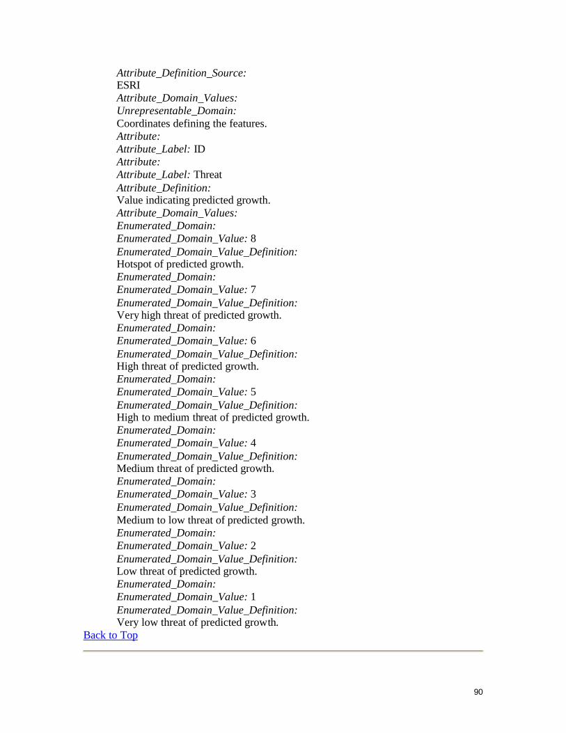
90
Attribute_Definition_Source: ESRI Attribute_Domain_Values: Unrepresentable_Domain: Coordinates defining the features. Attribute: Attribute_Label: ID Attribute: Attribute_Label: Threat Attribute_Definition: Value indicating predicted growth. Attribute_Domain_Values: Enumerated_Domain: Enumerated_Domain_Value: 8 Enumerated_Domain_Value_Definition: Hotspot of predicted growth. Enumerated_Domain: Enumerated_Domain_Value: 7 Enumerated_Domain_Value_Definition: Very high threat of predicted growth. Enumerated_Domain: Enumerated_Domain_Value: 6 Enumerated_Domain_Value_Definition: High threat of predicted growth. Enumerated_Domain: Enumerated_Domain_Value: 5 Enumerated_Domain_Value_Definition: High to medium threat of predicted growth. Enumerated_Domain: Enumerated_Domain_Value: 4 Enumerated_Domain_Value_Definition: Medium threat of predicted growth. Enumerated_Domain: Enumerated_Domain_Value: 3 Enumerated_Domain_Value_Definition: Medium to low threat of predicted growth. Enumerated_Domain: Enumerated_Domain_Value: 2 Enumerated_Domain_Value_Definition: Low threat of predicted growth. Enumerated_Domain: Enumerated_Domain_Value: 1 Enumerated_Domain_Value_Definition: Very low threat of predicted growth.
Back to Top

91
Distribution_Information: Distributor: Contact_Information: Contact_Organization_Primary: Contact_Organization: Virginia Department of Conservation and Recreation Division of Natural Heritage Contact_Person: Jennifer Ciminelli Contact_Position: Environmental Specialist Contact_Address: Address_Type: mailing and physical address Address: 217 Governor Street City: Richmond State_or_Province: Virginia Postal_Code: 23219 Country: USA Contact_Voice_Telephone: 804-786-3375 Contact_Facsimile_Telephone: 804-371-2674 Contact_Electronic_Mail_Address: [email protected] Hours_of_Service: 8:30 AM to 5:30 AM EST Resource_Description: Downloadable Data Distribution_Liability: NA Standard_Order_Process: Digital_Form: Digital_Transfer_Information: Format_Name: ESRI Format_Version_Number: shapefile Transfer_Size: 42.278 Fees: NA Custom_Order_Process: NA Technical_Prerequisites: ArcGIS or ArcView knowledge. Available_Time_Period: Time_Period_Information: Single_Date/Time: Calendar_Date: unknown
Back to Top
Metadata_Reference_Information: Metadata_Date: 20081218 Metadata_Contact: Contact_Information: Contact_Organization_Primary:

92
Contact_Organization: Virginia Department of Conservation and Recreation Division of Natural Heritage Contact_Person: Jennifer Ciminelli Contact_Position: Environmental Specialist Contact_Address: Address_Type: mailing and physical address Address: 217 Governor Street City: Richmond State_or_Province: Virginia Postal_Code: 23219 Country: USA Contact_Voice_Telephone: 804-786-3375 Contact_Facsimile_Telephone: 804-371-2674 Contact_Electronic_Mail_Address: [email protected] Hours_of_Service: 8:30 AM to 5:30 AM EST Metadata_Standard_Name: FGDC Content Standards for Digital Geospatial Metadata Metadata_Standard_Version: FGDC-STD-001-1998 Metadata_Time_Convention: local time Metadata_Extensions: