Susitna-Watana Hydroelectric Project (FERC No. 14241 ... · Susitna-Watana Hydroelectric Project...
46
Susitna-Watana Hydroelectric Project (FERC No. 14241) Recreation Resources Study Prepared for Alaska Energy Authority Prepared by URS and McDowell Group Inc. January 2013
Transcript of Susitna-Watana Hydroelectric Project (FERC No. 14241 ... · Susitna-Watana Hydroelectric Project...
Susitna-Watana Hydroelectric Project
(FERC No. 14241)
Recreation Resources Study
Prepared for
Alaska Energy Authority
Prepared by
URS and McDowell Group Inc.
January 2013

FINAL REPORT RECREATION RESOURCES STUDY
Susitna-Watana Hydroelectric Project Alaska Energy Authority FERC Project No. 14241 Page i January 2013
TABLE OF CONTENTS
1. Introduction ..........................................................................................................................1
2. Study Objectives ..................................................................................................................1
2.1. Recreation Objectives ............................................................................................. 1
2.2. River Recreation Objectives ................................................................................... 2
3. Study Area ...........................................................................................................................2
3.1. Recreation Study Area ............................................................................................ 2
3.2. River Study Area..................................................................................................... 3
4. Methods................................................................................................................................3
4.1. Recreation Methods ................................................................................................ 3
4.1.1. Inventory of Existing Information .............................................................. 4
4.1.2. Agency/Stakeholder Coordination and Consultation.................................. 5
4.1.3. Executive Interviews ................................................................................... 5
4.1.4. Site Visit...................................................................................................... 6
4.1.5. Survey Sampling and Instrument Designs .................................................. 6
4.1.6. Deviations from Study Plan ........................................................................ 6
4.2. River Recreation Methods ...................................................................................... 7
4.2.1. Deviations from Study Plan ........................................................................ 7
4.2.2. Study Methodology ..................................................................................... 7
5. Results ..................................................................................................................................8
5.1. Recreation Results .................................................................................................. 8
5.1.1. Inventory of Existing Information .............................................................. 8
5.1.2. Agency/Stakeholder Coordination and Consultation................................ 16
5.1.3. Executive Interviews ................................................................................. 16
5.1.4. Site Visit.................................................................................................... 16
5.1.5. Survey Sampling Plans and Instrument Design ........................................ 17
5.2. River Recreation Results....................................................................................... 17
5.2.1. Reach 1 – Upper River .............................................................................. 17
5.2.2. Reach 2 – Canyon Section ........................................................................ 18
5.2.3. Reach 3 – Lower River ............................................................................. 18
5.2.4. Tributaries ................................................................................................. 19
6. Discussion and Conclusion ................................................................................................19
6.1. Recreation ............................................................................................................. 19
6.2. River Recreation ................................................................................................... 20
FINAL REPORT RECREATION RESOURCES STUDY
Susitna-Watana Hydroelectric Project Alaska Energy Authority FERC Project No. 14241 Page ii January 2013
6.2.1. Summer Recreation ................................................................................... 20
6.2.2. Ice-Dependent Winter Recreation on Susitna River Corridor .................. 21
7. References ..........................................................................................................................22
8. Tables .................................................................................................................................25
9. Figures................................................................................................................................26
LIST OF TABLES
Table 6-1. River Recreation Activities in Susitna River Recreation Reaches ............................. 25
Table 6-2. Ice-Dependent Winter Recreation Activities in Susitna River Recreation Reaches .. 25
LIST OF FIGURES
Figure 3-1. Recreation Resources study area ............................................................................... 27
Figure 3-2. River Recreation Study Reaches ............................................................................... 28
Figure 5-1. Recreation Opportunity Spectrum............................................................................. 29
Figure 5-2. Facilities .................................................................................................................... 30
Figure 5-3. Fog Creek Trail SW (NOTE: trail identified by white arrow) .................................. 31
Figure 5-4. The Jay Creek Trail in the lower portion of the drainage (NOTE: trail identified by
white arrow) .......................................................................................................................... 31
Figure 5-5. Well-established trail traveling up a broad drainage located north of the Susitna
River ...................................................................................................................................... 32
Figure 5-6. Well-defined upland trail connecting two drainages (NOTE: trail identified by white
arrow) .................................................................................................................................... 32
Figure 5-7. The Susitna South Trail ............................................................................................. 33
Figure 5-8. Parking along Denali Highway by crossing of the Susitna River, hunting season
September 2012 .................................................................................................................... 34
Figure 5-9. Vehicles parked on AK Road Commission Air Strip #1 (Mile 81 Denali Hwy),
hunting season September 2012 ............................................................................................ 34
Figure 5-10. Aerial view of Devils Creek Rapid (July 27, 2012; flow approximately 22,000 cfs)
............................................................................................................................................... 35
Figure 5-11. Typical island campsite in Reach 3 .......................................................................... 36
Figure 5-12. Commercial jetboat trip downstream of Devils Canyon .......................................... 36
Figure 5-13. Commercial rafting trip on Susitna Reach 3 accessed via the train ......................... 37
Figure 5-14. Aerial view of Susitna-Chulitna confluence, July 2012........................................... 37
Figure 5-15. Portage Creek confluence with Susitna .................................................................... 38
FINAL REPORT RECREATION RESOURCES STUDY
Susitna-Watana Hydroelectric Project Alaska Energy Authority FERC Project No. 14241 Page iii January 2013
LIST OF APPENDICES
Appendix A: Map Book of Trails
FINAL REPORT RECREATION RESOURCES STUDY
Susitna-Watana Hydroelectric Project Alaska Energy Authority FERC Project No. 14241 Page iv January 2013
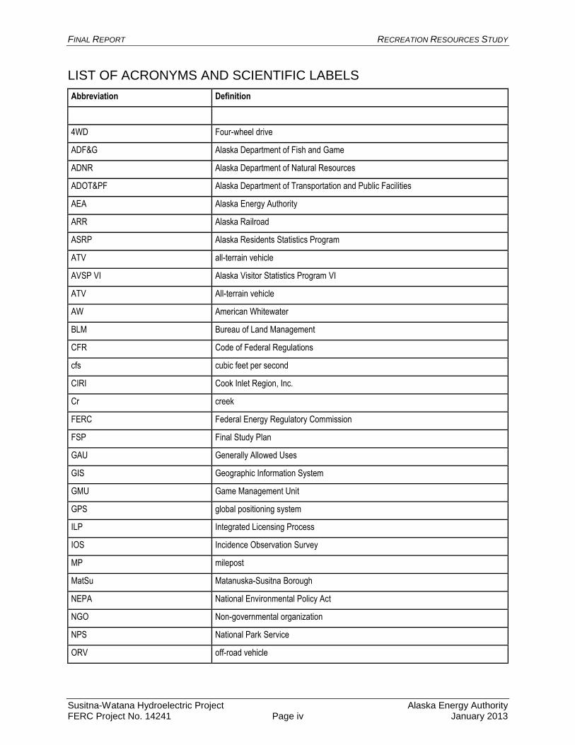
LIST OF ACRONYMS AND SCIENTIFIC LABELS
Abbreviation Definition
4WD Four-wheel drive
ADF&G Alaska Department of Fish and Game
ADNR Alaska Department of Natural Resources
ADOT&PF Alaska Department of Transportation and Public Facilities
AEA Alaska Energy Authority
ARR Alaska Railroad
ASRP Alaska Residents Statistics Program
ATV all-terrain vehicle
AVSP VI Alaska Visitor Statistics Program VI
ATV All-terrain vehicle
AW American Whitewater
BLM Bureau of Land Management
CFR Code of Federal Regulations
cfs cubic feet per second
CIRI Cook Inlet Region, Inc.
Cr creek
FERC Federal Energy Regulatory Commission
FSP Final Study Plan
GAU Generally Allowed Uses
GIS Geographic Information System
GMU Game Management Unit
GPS global positioning system
ILP Integrated Licensing Process
IOS Incidence Observation Survey
MP milepost
MatSu Matanuska-Susitna Borough
NEPA National Environmental Policy Act
NGO Non-governmental organization
NPS National Park Service
ORV off-road vehicle
FINAL REPORT RECREATION RESOURCES STUDY
Susitna-Watana Hydroelectric Project Alaska Energy Authority FERC Project No. 14241 Page v January 2013
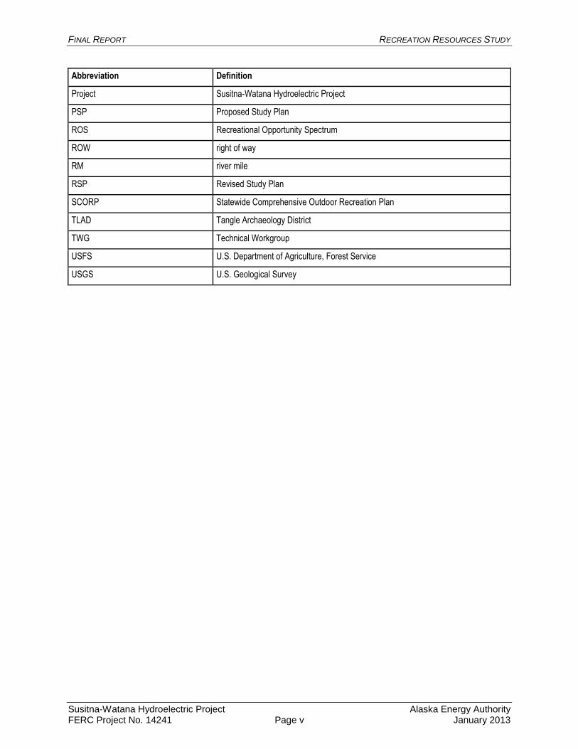
Abbreviation Definition
Project Susitna-Watana Hydroelectric Project
PSP Proposed Study Plan
ROS Recreational Opportunity Spectrum
ROW right of way
RM river mile
RSP Revised Study Plan
SCORP Statewide Comprehensive Outdoor Recreation Plan
TLAD Tangle Archaeology District
TWG Technical Workgroup
USFS U.S. Department of Agriculture, Forest Service
USGS U.S. Geological Survey
FINAL REPORT RECREATION RESOURCES STUDY
Susitna-Watana Hydroelectric Project Alaska Energy Authority FERC Project No. 14241 Page 1 January 2013
1. INTRODUCTION
This report provides the results of the 2012 Recreation Resources Study, based on work outlined
in the 2012 Recreation Resources Study plan (AEA 2012).
The Alaska Energy Authority (AEA) is preparing a License Application that will be submitted to
the Federal Energy Regulatory Commission (FERC) for the Susitna-Watana Hydroelectric
Project (Project) using the Integrated Licensing Process (ILP). The Project is located on the
Susitna River, an approximately 300-mile-long river in Southcentral Alaska. The Project’s dam
site would be located at river mile (RM) 184.
This study provided data to inform the 2013–2014 licensing study program, Exhibit E of the
License Application, and FERC’s National Environmental Policy Act (NEPA) analysis for the
Project license.
2. STUDY OBJECTIVES
2.1. Recreation Objectives
The objectives for the 2012 Recreation Resources Study were to define the recreation study area,
identify recreation opportunities and experiences, map facilities and access, identify user groups
and activities (by both visitors to Alaska and Alaska residents), and develop field methods for
documenting current recreation activities under baseline conditions and for predicting future
trends in the recreation study area.
The specific goals of the 2012 study were as follows:
Identify and document recreation resources and facilities that support commercial and
non-commercial recreation in the Project area;
Identify common access routes to the Project area such as trails, waterways, rail, and/or
air travel;
Develop a clear understanding of the type and levels of current recreational uses; and
Complete a preliminary assessment of the analysis area related to potential effects of
Project construction and operation on recreation resources to inform the development of
the 2013–2014 Recreation Resources Revised Study Plan (RSP).
To meet these goals, the following objectives of the 2012 study plan included:
Secondary data collection to assess past and current recreation use, activity and demand;
Review of existing land use management regimes within the study area;
Conduct interviews with user groups, vendors, and incidental Project area contacts to
preliminarily determine use patterns and inform the development of the Revised Study
Plan (RSP) for 2013-2014;
Initiate a recreation inventory and capacity of the study area;
Initiate a study of the project area access, including trails and rights-of-way (ROW);
Conduct geo-referenced mapping to document trails and access points;
FINAL REPORT RECREATION RESOURCES STUDY
Susitna-Watana Hydroelectric Project Alaska Energy Authority FERC Project No. 14241 Page 2 January 2013
Conduct field reconnaissance to help identify the study areas for recreation analysis;
Preliminarily assess current recreation uses, activity, and demand;
Evaluate data collection methods to assist the planning of the formal study program,
including preliminary survey design and sample planning; and
Preliminarily identify literature or data that may inform the assessment of future
recreation trends and issues
2.2. River Recreation Objectives
The primary objectives for the River Recreation Flow and Access Study in 2012 were to define
the river recreation study area, identify river recreation opportunities, , identify user groups, and
determine appropriate field methods for documenting river recreation activities under baseline
conditions and for predicting future trends in river recreation on the Susitna River.
The study included the following tasks:
Review existing river recreation information sources
Explore river recreation study area and delineate reach breaks
Document river recreation users
Map known river access locations for each reach
Map key river features
Undertake initial interviews with user groups, vendors, and incidental Project area
contacts
Develop a river recreation survey instrument to identify future recreation trends and
issues
3. STUDY AREA
3.1. Recreation Study Area
An important part of the 2012 study effort was defining the areas of study for the Recreation
Resources Study. Defining the geographic extent of these areas required consultation with
agencies and analysis of existing recreation use data and patterns gathered through executive
interviews and secondary review, as well as mapping. As a result of this analysis, three
geographic areas were defined and used in the Recreation Resources Study (Figure 3-1). The
study areas are summarized below.
Recreation Effects Analysis Area: The area encompasses the areas that would be directly
affected by Project facilities, including the proposed access road and transmission line corridors,
and other Project facility locations. This area includes the Susitna River, upstream from the
proposed dam to the Denali Highway bridge and downstream to Sunshine, the proposed Project
reservoir, and some nearby shore lands and trails surrounding the reservoir location.
Recreation Use Study Area / Recreation Supply and Demand Analysis Area: This area is
encompassed by the following features:

FINAL REPORT RECREATION RESOURCES STUDY
Susitna-Watana Hydroelectric Project Alaska Energy Authority FERC Project No. 14241 Page 3 January 2013
The Parks Highway corridor and areas east, from the Y at the Talkeetna Spur Road
intersection to Cantwell (including Denali State Park);
The Denali Highway corridor (including Brushkana and Tangle Lakes campgrounds) and
areas south, from Cantwell east to Paxson;
West from Paxson along a 2-mile buffer south of the Denali Highway to the Matanuska-
Susitna Borough boundary;
Areas west of the Matanuska-Susitna Borough boundary between the Denali and Glenn
Highways (including Lake Louise area); and
North from the Matanuska-Susitna Borough boundary (located south of Lake Louise),
joining the Susitna River basin boundary, and then continuing from a line running north
from Chickaloon, following the Chickaloon River to its headwaters at the Chickaloon
Glacier, and from there, turning west from the Chickaloon Glacier to connect at the Y
Junction on the Parks Highway.
Recreation Facilities Study Area: This area is defined by the western and northern boundaries
of the Parks Highway and the Denali Highway, and the following eastern and southern
boundaries:
The Richardson Highway corridor and areas west, from Paxson to the Glenn Highway
intersection;
The Glenn Highway corridor and areas north, from Glennallen west to Chickaloon; and
Joining the recreation use study area along the line running north from Chickaloon,
following the Chickaloon River to its headwaters at the Chickaloon Glacier. From there,
turning west from the Chickaloon Glacier to connect at the Y Junction on the Parks
Highway.
3.2. River Study Area
For the reconnaissance effort and study planning purposes, the Susitna River was divided into
three reaches based on field observations, desktop analysis of the physical setting, guidebook
descriptions, and trip reports (Figure 3-2). The three study reaches are described as follows:
Reach 1—Upper River (Denali Highway Bridge to Fog Creek); Reach 2—Devils Canyon Reach
(Fog Creek to Portage Creek); and Reach 3—Lower River (Portage Creek to Parks Highway
Bridge). These reach breaks occur at physical changes in the river gradient and corresponding
changes in river run difficulty. These breaks, in turn, are suitable for different types of
watercraft and attract different user groups, although some overlap is expected between reaches
and user groups.
4. METHODS
4.1. Recreation Methods
The methodology for the 2012 Recreation Resources Study comprised:
FINAL REPORT RECREATION RESOURCES STUDY
Susitna-Watana Hydroelectric Project Alaska Energy Authority FERC Project No. 14241 Page 4 January 2013
Regional Recreation Analysis – conducting a preliminary analysis of existing data on
water and land-based recreation uses, access considerations, seasonality, and
management framework in the study area.
Recreation Supply, Demand, and Use – developing a preliminary baseline of developed
and dispersed recreation uses, including types, levels, and access from existing data and
relevant studies and recreation use survey results, as well as a executive interview
candidate list and interview protocols.
Recreation Facilities and Carrying Capacity – gathering of preliminary data and
inventory of recreation facilities, applying carrying capacity guidelines and standards.
Recreation Survey Data Collection Planning – developing survey methodologies, content,
and implementation planning to gather data on recreation use within the study area.
4.1.1. Inventory of Existing Information
4.1.1.1. Review of Management Plans
Relevant resource management plans from agencies with jurisdiction over recreation trails and
facilities within the recreation facilities study area were compiled and reviewed. These plans
provided information about resource management goals and objectives, and helped identify
existing data sources needed to conduct future recreational analyses of the Project. A
preliminary inventory of existing recreation use data, access, and capacity data was completed
for the Railbelt planning area, as defined in the Statewide Comprehensive Outdoor Recreation
Plan (SCORP) 2009–2014 (Alaska Department of Natural Resources [ADNR] 2009). Secondary
data from agencies, businesses, and other sources were also collected, including recreation
survey studies. The primary purpose of this preliminary assessment was to identify what data
were available, to identify contacts for data requests, and to make preliminary requests for data.
The following federal, state, and local regulatory and planning documents were identified and
reviewed for relevant information relating to recreation use, access, and experience data, or areas
identified for recreation activities:
Federal Regulations and Plans
Bureau of Land Management – East Alaska Resource Management Plan. 2006.
Denali National Park and Preserve Final South Denali Implementation Plan and
Environmental Impact Statement. April 2006.
State Plans
George Parks Highway Scenic Byway Master Interpretive Plan Draft. April 30,
2012.Susitna Watana Hydroelectric Project Pre-Application Document (FERC Project
No. 14241) (AEA 2011)
Alaska Recreational Trails Plan. October 2000.
Alaska’s Outdoor Legacy. Statewide Comprehensive Recreation Plan (SCORP) 2009–
2014. September 2009.
Recreation and Tourism in South-Central Alaska: Patterns and Prospects. 2002.
FINAL REPORT RECREATION RESOURCES STUDY
Susitna-Watana Hydroelectric Project Alaska Energy Authority FERC Project No. 14241 Page 5 January 2013
Cultural Resource Management Plan for the Denali Highway Lands, Central Alaska
Draft. September 2005.
Denali State Park Management Plan. 2006.
Division of Parks & Outdoor Recreation. Ten-Year Strategic Plan 2007–2012. November
2006.
George Parks Highway Scenic Byway Corridor Partnership Plan. November 2008.
Feasibility Study for the South Denali Visitor Center. March 21, 2011.
Local Plans
Chase Comprehensive Plan. 1993.
Matanuska-Susitna Borough Tourism Infrastructure Needs Study. June 2008.
Matanuska-Susitna Borough, Alaska Economic Development Strategic Plan. April 22,
2010.
Matanuska-Susitna Borough, Recreational Trails Plan. August 2008.
Susitna Area Plan. June 1985.
Susitna Matanuska Area Plan Public Review Draft. February 2010.
Susitna Basin Recreation Rivers Management Plan. August 1991.
Talkeetna Comprehensive Plan. Adopted January 1998.
4.1.1.2. GIS-based Trails Inventory
A field map book was created using ArcGIS 10 (Appendix A) to show known trails, cabins, and
recreation facilities along both the Denali Highway and the Susitna River. Trail data included
ADNR state trails, RS 2477 trails, Cook Inlet Region, Inc. (CIRI) 17(b) easements, and trails
identified and digitized by URS during desktop surveys. Digitized trails were identified using
aerial photographs (5-meter resolution or better), which were provided by AEA. These images
were visually searched for linear features and distinct changes in coloration that indicated a
potential trail. Trails found often originated from the Parks or Denali highways, Alaska Railroad,
Susitna River, or from remote structures such as lodges and cabins. Once identified, a potential
trail was followed and digitized until no longer visible using the aerial imagery. Given the
imagery’s resolution and the area’s vegetation/canopy cover, trails identified are likely large all-
terrain vehicle (ATV) trails rather than narrow-width foot trails. Locations of remote structures
were also digitized during this exercise.
4.1.2. Agency/Stakeholder Coordination and Consultation
Meetings were held with agency representatives from the National Park Service (NPS) and
Bureau of Land Management (BLM) prior to the site visit to gather preliminary information on
trails access and facilities within the recreation facilities study area.
4.1.3. Executive Interviews
During the reconnaissance site visit in July 2012, in-person, semi-structured interviews were
conducted with lodge owners, tour guide operators, and organization leads who may be affected
by the Project. The purpose of these interviews was to inform interviewees of the Recreation
Resources Study, acquire feedback on concepts for the intercept survey’s sampling approach,
FINAL REPORT RECREATION RESOURCES STUDY
Susitna-Watana Hydroelectric Project Alaska Energy Authority FERC Project No. 14241 Page 6 January 2013
and gather preliminary information about how businesses, organizations, and individuals use the
recreation use study area.
4.1.4. Site Visit
The recreational resources field reconnaissance was undertaken July 25–28, 2012, and focused
on the following objectives:
Reconnaissance and familiarization of Susitna River corridor and trail network by
boat and air;
Ground reconnaissance of recreation facilities, use areas, and trails along portions of
the Parks and Denali highways;
Identification of downstream recreation opportunities and access points; and
Identification of intercept survey locales for the recreational demand assessment.
Results of this site visit were used to refine the 2013–2014 RSP methodologies. A detailed trip
report was submitted to AEA in August 2012.
4.1.5. Survey Sampling and Instrument Designs
Much of the 2012 effort was designed to collect practical information that will help design and
implement a survey program for the formal study plans. Several survey methods have been
considered during 2012 based on the initial recreation reconnaissance , including an Incident
Observation Survey (IOS), recreation use intercept survey and observational tallies, and a
regional residents household mail survey.
4.1.6. Deviations from Study Plan
4.1.6.1. Executive Interview Research
An executive interview protocol and an interview candidates list were developed in 2012;
however, of the anticipated 30 to 40 telephone executive interviews expected to be held in 2012,
only a few were conducted. Reasons to postpone executive interview research to 2013 included
the following:
Need for additional time for coordination with other study disciplines (such as
socioeconomics, river recreation, aesthetics) to avoid duplication of research effort;
As part of the formal study planning process, agencies requested an opportunity to
comment on the interview protocol and candidates list; and,
Study efforts shifted from implementation of this research to ongoing development of the
Proposed Study Plan (PSP) and RSP.
Executive Interviews will be conducted in 2013 when the RSP is implemented upon FERC
approval.
FINAL REPORT RECREATION RESOURCES STUDY
Susitna-Watana Hydroelectric Project Alaska Energy Authority FERC Project No. 14241 Page 7 January 2013
4.1.6.2. Field-based Trails Inventory
Proposed methodology for trail inventory and classification consisted of ground-truthing a range
of data sources to determine the location and type of trail within the recreation use study area
(Appendix A). The goal of this analysis was to characterize both developed and undeveloped
trails within the recreation use study area, and use this information to estimate the level of detail
and effort required for complete mapping and inventory in 2013–2014. This effort was originally
intended to focus primarily on trails stemming from the Denali Highway, with data collection
occurring on-site using a matrix to gather detailed trail information.
Due to the size of the recreation use study area, and the amount of time budgeted for field
investigations in 2012, it was not practical to collect information on more than a few trails during
the site reconnaissance using the proposed classification methodology. Similar time constraints
kept the reconnaissance team from visiting the Denali Highway from Alpine Creek Lodge to
Paxson, also within the Recreation Use Study Area. As a result, a detailed trails inventory and
classification were not conducted for the full lengths of the Parks and Denali highways.
4.2. River Recreation Methods
4.2.1. Deviations from Study Plan
The 2012 field reconnaissance was not able to investigate half of Reach 1 (Denali Highway
Bridge to Jay Creek) due to helicopter mechanical issues and conflicts with helicopter
availability. As a result, the recreation flow and access team was not able to observe the
character of the river in this section or map potential river access points
4.2.2. Study Methodology
The preliminary assessment of river recreation opportunities that potentially exist in the Project
study area was completed through a desktop review of published guidebooks (Embick 1994;
Jettmar 2008), river descriptions on national and Alaska paddling club websites, and trip reports
from river users. The desktop exercise provided insights on river reaches within the overall
study area, river access locations, the river run difficulty for respective reaches based on
International Scale of Whitewater Difficulty (AW 2005), and the appropriate motorized and non-
motorized watercraft types for respective river sections. Other plans reviewed for this analysis
included the Matanuska-Susitna Borough Talkeetna Riverfront Park Land Use Plan and
Economic Development Strategy (MSB 2004).
A field reconnaissance was undertaken July 25–28, 2012. The reconnaissance effort investigated
the river corridor from the Parks Highway Bridge upstream to the Denali Highway Bridge
crossing. The reconnaissance was conducted using a combination of jetboat (Talkeetna
confluence to bottom of Devils Canyon), helicopter (Talkeetna confluence to Jay Creek
confluence), and vehicle (river access points on Denali Highway and Parks Highway). The
section of the Susitna River from Jay Creek to the Denali Highway crossing was not included in
the 2012 reconnaissance effort due to helicopter mechanical issues. The following tributaries
were included in the aerial reconnaissance to determine potential for these corridors to serve as
access routes to the Susitna River (land and water) as well as serving as river recreation
opportunities in their own right: Fog Creek, Deadman Creek (bottom mile only), and Jay Creek.
FINAL REPORT RECREATION RESOURCES STUDY
Susitna-Watana Hydroelectric Project Alaska Energy Authority FERC Project No. 14241 Page 8 January 2013
Staff experienced in motorized and non-motorized river recreation documented existing
conditions, suitability for various watercraft types, and access points throughout each reach of
the river corridor and tributaries.
Informal interviews were conducted with local area commercial providers (Steve Mahay,
Mahay’s Riverboat Service; Ben Stephenson, hunting guide operating out of Stephan Lake
Lodge; Woody Stephens, Stephan Lake Lodge owner; John Madson, Stephan Lake Lodge
owner) and non-commercial users to get a better understanding of user groups, watercraft,
seasonality, instream flows, and access. Local recreationists were interviewed informally to
assess use patterns and interest in river recreation opportunities. In preparation for the planned
2013 executive interviews, contact information for commercial river rafting operators, jetboat
operators, and flight services providing access to the Susitna was obtained. Names of boaters
who have paddled Devils Canyon were obtained from local sources. The names of individuals
involved in organizing and/or participating in adventure races crossing the study area were
obtained.
Site investigations using jetboat and helicopter provided a first-hand view of river difficulty,
flow-dependent recreation activities under existing instream flows, watercraft types on the
Susitna River, safety, access, and river camps. Potential river camps from the bottom of Devils
Canyon to Talkeetna were documented with digital photos with built-in global positioning
system (GPS). The river difficulty using the International Scale of Whitewater Difficulty was
classified for sections of the river visited. Access points for ingress and egress were observed for
portions of the river.
5. RESULTS
5.1. Recreation Results
5.1.1. Inventory of Existing Information
5.1.1.1. Land Management Within the Recreation Use Study Area
The BLM Recreational Opportunity Spectrum (ROS) is a framework for classifying and defining
different classes or types of outdoor recreation environments, activities, and experience
opportunities (United States Department of Agriculture, Forest Service [USFS] 1979). The ROS
inventory system includes eight land classifications: primitive, semi-primitive non-motorized,
semi-primitive motorized, roaded natural, rural, and urban (BLM 2006). Each class is described
by a “typical” setting based on factors such as size, naturalness, and the presence or absence of
motorized vehicles and other sights and sounds of humans. Spatial data demonstrating the ROS
classification were obtained. As shown in Figure 5-1, much of the BLM-managed lands within
the recreation use study area are managed as primitive; however, semi-primitive non-motorized,
semi-primitive motorized, remote developed lakeside, backcountry roaded, and special ROS
classifications also exist (BLM 2006).
A portion of the Delta Wild and Scenic River intersects the recreation use study area, and is
classified as Scenic (Figure 5-1). Recreationists access this portion of the river from the boat
launch at the Delta National Wild and Scenic River Wayside at milepost (MP) 21.5 of the Denali
Highway. From there, they arrive at the Upper Tangle Lakes, which can be explored through a
FINAL REPORT RECREATION RESOURCES STUDY
Susitna-Watana Hydroelectric Project Alaska Energy Authority FERC Project No. 14241 Page 9 January 2013
series of portages (BLM 2012a). This portion of the river provides for day canoe, kayak, and
motorboat trips. All-terrain vehicle/off-road vehicle (ATV/ORV) trails also provide access to the
river corridor (BLM 2006).
The East Alaska Resource Management Plan (BLM 2006) identifies two river segments within
the recreation use study area that were deemed eligible for Wild and Scenic River designation:
(1) the Susitna River from the headwaters to the confluence of Kosina Creek; and (2) Brushkana
Creek, from just south of the Denali Highway to the confluence with the Nenana River. With
regard to the Susitna River segment, this river segment is accessible from the Denali Highway
bridge, and boating occurs from the bridge downriver to the Maclaren River. It is also possible to
continue down the Susitna River, past the Maclaren River, to the Tyone River, upriver on the
Tyone and out through Lake Louise. The eligible portion of the Susitna River was tentatively
classified as Scenic (AEA 2011a). With regard to the Brushkana Creek segment, this river
segment is tentatively classified as Recreational. Grayling fishing is a major activity near the
Denali Highway and within the Brushkana Creek Campground, which the river flows next to for
a short section (BLM 2006).
5.1.1.2. Recreation Facilities and Use Areas
Existing public recreational facilities were identified and mapped within the recreation facilities
study area. Private lodges and cabin facilities located off the road network were also assessed
given their proximity to the Project area (Figure 5-2). Public recreational facilities included
improved access points, trailheads, campgrounds, memorials, and viewpoints. Within the
recreation facilities Project area, several public facilities are found along the George Parks
Highway, which is designated as both a National and Alaska State Scenic Byway between MP
132 and 248 (ADNR 2008). Each year, recreation facilities along this section of highway attract
a variety of visitors, including both tourists and Alaska residents. In addition, the boundary of
Denali State Park intersects with the Parks Highway at MP 132.3. Facilities within Denali State
Park (along the Parks Highway) include a total of 118 campsites, picnic areas, the Alaska
Veteran’s Memorial Visitors Center, public use cabins, scenic pullouts, boat launch at Byers
Lake, four trailheads, and 48 miles of interconnected trails (DPOR 2006).
Between Cantwell and Paxson along the 135-mile Denali Highway, there are two BLM-
administered campgrounds and two waysides (Figure 5-2). Interpretative panels describing the
landscape are also located at prominent overlooks (BLM 2012b). In addition to BLM facilities,
there are four privately owned lodges located along the Denali Highway that offer various guided
and unguided recreation opportunities. The Tangle Lakes Archaeological District (TLAD)
intersecting the Denali Highway between MPs 16.2 and 38 is comprised of approximately
196,000 acres of mostly State-selected land containing important cultural and historical resources
(BLM 2006). Within the TLAD, the use of motorized vehicles is limited to designated trails
(BLM 2012c). BLM is responsible for the management of these trails; however, since the
addition of the TLAD to the National Register of Historic Places in 1972, there has been an
increase in both ATV/ORV use and trail impacts to archaeological sites in the area (BLM
2012b).
Public recreation facilities along the Richardson Highway include the Paxson Campground and
Sourdough Campground (BLM 2006). BLM lands along this portion of the Richardson Highway
are used by recreational users for hunting and fishing resources and ATV recreation
opportunities. The privately owned Paxson Lodge is located at MP 185.5 of the Richardson
FINAL REPORT RECREATION RESOURCES STUDY
Susitna-Watana Hydroelectric Project Alaska Energy Authority FERC Project No. 14241 Page 10 January 2013
Highway. They offer 19 private rooms, RV hook-ups, and an air strip. The lodge hosts various
recreation events including sled dog races that use the facility as a starting/ending point, and the
Arctic Man snow machine race.
A portion of the Glenn Highway National Scenic Byway, from Chickaloon (MP 70.6) to Eureka
Summit (MP 129.5) is included in the recreation facilities study area. Several recreation
facilities exist along the Glenn Highway, including the Lake Louise State Recreation Area and
Bonnie Lake Boat Launch/Day Use Area. Consultation with the BLM suggests that recreational
users who access the recreation use study area from the Glenn Highway are limited to a small
number of hunters and snow machine enthusiasts utilizing facilities in Lake Louise.
Private recreation facilities in the interior portion of the recreation facility study area include
private lodges and cabins, which can be accessed only by float plane (AEA 2011b). Private
cabins also exist on Clarence Lake, Portage Creek, Stephan Lake, High Lake, Big Lake, and
Daneka Lake. While many of these lodges and cabins are known to be in good condition and
operable, the status of others is currently unknown.
5.1.1.3. Recreation Trails
5.1.1.3.1. Review of Existing Trail Information
ANCSA 17(b) Easements
Section 17(b) of the 1971 Alaska Native Claims Settlement Act (ANCSA) authorized the
Secretary of the Interior to reserve public easements on lands conveyed to Alaska Native
regional and village corporations under the Act. These 17(b) easements generally are reserved to
provide public access across these private lands to public lands and waters. The route and uses
allowed on a 17(b) easement are limited and set forth in the conveyance document for the
particular easement. Hunting, fishing, or trapping on or from the easement are prohibited, unless
a permit from the landowner is obtained. Several 17(b) easements are located within the
recreation use study area (AEA 2011):
26a: Existing Stephan Lake west shore campsite, managed by BLM State Office
26: Existing trail, running west from 26a, managed for general public use by ADF&G
27a: Existing Stephan Lake east shore campsite, managed by ADF&G
28: Existing trail running southeast from 27a
46a: Existing Stephan Lake north shore campsite, managed by BLM State Office
46: Existing trail running north from 46a to 14, managed by BLM District Office and State of
Alaska
22d: Existing Fog lakes campsite, managed by ADF&G
22a: Proposed trail, running south from 22d, sponsored by ADF&G
14: Existing Susitna River west (Talkeetna Mountains USGS Quadrangle D-4) campsite,
managed by
BLM District Office and State of Alaska
71: Existing Susitna River east (Talkeetna Mountains USGS Quadrangle D-4) campsite,
managed by BLM District Office and ADF&G
72: Proposed trail running north from 71, sponsored by BLM District Office
48: Existing general public use trail from Gold Creek to lands south of Devil’s Canyon
FINAL REPORT RECREATION RESOURCES STUDY
Susitna-Watana Hydroelectric Project Alaska Energy Authority FERC Project No. 14241 Page 11 January 2013
18: Existing general public use trail from Chulitna to lands north of Devil’s Canyon,
managed by the State of Alaska and ADF&G
RS 2477 Trails
From 1866 until its repeal in 1976, Revised Statute (RS) 2477 granted Alaska and the other
states “the right of way for construction of highways over public lands, not reserved for public
uses.” RS 2477 has been called a “self-executing” grant. Establishment of a RS 2477 trail did
not require government approval, issuance of an identifying record such as a land patent, or
public recording of title; rather, a RS 2477 right-of-way came into existence automatically when
a highway was established across public lands.
The State of Alaska has formally identified six RS 2477 trails in the recreation use study area.
Many of these were and still are used to access mining claims, fishing and hunting areas, or
remote cabins from communities such as Chase, Curry, and Hurricane that exist along the rail
corridor. RS 2477 public right-of-way trails identified by ADNR in the recreation use study area
include (AEA 2011):
Susitna River Trail (also referred to as the Gulkana/Denali Winter Trail, RS Trail 294):
Access to this 125-mile long trail is from the Denali Highway where the highway crosses
the Susitna River. The trail travels southeast, following the river to its junction with the
Maclaren River. The trail continues up the Maclaren River and ultimately connects with
trails originating from the Lake Louise area.
Curry Landing Strip to Lookout Tower Trail (RS Trail 1509): This trail is accessed from
the Curry Station along the Alaska Railroad right-of-way and travels west to the lookout
tower. The trail is used to access views of the Alaska Range and Mt. McKinley.
McWilliams/Gold Creek Trail (RS Trail 469): This trail is accessed from the railroad
station and community of Gold Creek at Mile 263 of the Alaska Railroad. The trail heads
east, following the base of the hills, climbs the plateau south of the Susitna River, and
continues south-southeast toward mining claims on John Creek. The trail is
approximately 36 miles long.
Indian River-Portage Creek Trail (RS Trail 100): This trail is accessed from the Chulitna
Station at Mile 274 of the Alaska Railroad. It heads eastward, crossing the Indian River,
and continues east to cabins on Portage Creek. The trail is approximately eight miles
long.
Murder Lake North to Ridgeline Trail (RS Trail 80): This trail is accessed from Murder
Lake and heads northwest to a ridge. Historically used for berry picking and hunting
access, the trail is two miles long.
Stephan Lake to Murder Lake Trail (RS Trail 61): This trail connects the south shore of
Stephan Lake to Murder Lake. The trail is approximately one-half mile long and has
been used for access between landowners on Stephan Lake and Murder Lake, and as a
recreational trail to access fishing on Murder Lake.
FINAL REPORT RECREATION RESOURCES STUDY
Susitna-Watana Hydroelectric Project Alaska Energy Authority FERC Project No. 14241 Page 12 January 2013
Stephan, Murder, and Daneka Lakes Connector Trail (RS Trail 377): This trail is
accessed from the west end of Stephan Lake, and heads southwest to Murder Lake. It
then continues southward, crossing Prairie Creek and terminating at Daneka Lake. It is
used to access cabins for recreational fishing, hiking, and hunting.
Talkeetna Area – There are approximately 20 miles of multi-use summer and winter trails
around Talkeetna. These trails were constructed by the Talkeetna Chamber of Commerce and
are maintained by the Denali Nordic Ski Club and other volunteer organizations. These trails
have open shelters and foot bridges. In addition, there are numerous trails used for hiking,
snowmachining, dog mushing, and hunting that extend into the Talkeetna Mountains, providing
access to hunting areas and remote sites (MSB 2008).
George Parks Highway and Denali State Park – Denali State Park has a limited, but popular
trail system with highway-accessible hiking opportunities. Hiking on Kesugi Ridge is very
popular and use has been increasing steadily in recent years. Increased use is attributed to
exposure in outdoor/travel magazines and the construction of the trail and trailhead at Ermine
Hill (NPS 2006). Use of motorized vehicles is restricted to maintained roads and parking areas
within Denali State Park; snow machines may be used in the park when snow depth is sufficient.
Park land use designations and trail management also restrict the use of bicycles and pack
animals on most trails within the state park (ADNR 2006).
Denali Highway – Nearly all the trails stemming from the Denali Highway are unmaintained.
The BLM’s East Alaska Resource Management Plan specifically calls for an implementation-
level plan in regard to travel management for BLM lands in the Chistochina-Cantwell area,
which overlaps the recreation use study area (BLM 2006).
Implementation-level planning or a travel management plan would give consideration to
rerouting of trails, maintenance of particular routes, establishment of non-motorized routes, and
vehicle class restrictions. All ATV management considerations in implementation planning
would be consistent with Section 811 of the Alaska National Interest Lands Conservation Act,
which allows for “appropriate use for subsistence purposes of snowmobiles, motorboats, and
other means of surface transportation traditionally employed for such purposes by local
residents, subject to reasonable regulation.”
There are many undeveloped trails and areas associated with the Denali Highway. The BLM
Glennallen Field Office actively manages and maintains five trails that fall within the TLAD as
well as the recreation use study area (BLM 2012d). These designated trails begin at or near the
Denali Highway and ATV use is limited from May 16 to October 16. Winter ATV use is
unrestricted when adequate snowfall is present (BLM 2012c).
For state lands, the area is currently managed to limit off-road travel to existing trails with
provisions allowed for off-trail travel if conditions of the State of Alaska Generally Allowed
Uses (GAU) are met.
Figure 5-8 and 5-9 demonstrate vehicle parking pressure around trail access points on the Denali
Highway.
FINAL REPORT RECREATION RESOURCES STUDY
Susitna-Watana Hydroelectric Project Alaska Energy Authority FERC Project No. 14241 Page 13 January 2013
5.1.1.3.2. GIS-based Trails Inventory
Trail Geographic Information System (GIS) data were compiled from all known and available
data sources including the trail dataset provided in the Project geodatabase, BLM, Matanuska-
Susitna Borough, ADNR, CIRI, and trails digitized from imagery by URS. Matanuska-Susitna
Borough Recreation Trails Plan Maps 10 and 11 for the Talkeetna area could not be obtained in
GIS format. As a result, trail information from these maps was digitized from the plan’s PDF
maps. ADNR datasets included RS 2477s, ADNR State Parks SnowTRAC Grooming Pool, and
trails digitized from U.S. Geological Survey (USGS) 63,360 quadrangle maps. All data were
pulled into a single ArcGIS geodatabase feature class and evaluated trail by trail with imagery as
a backdrop, where available. Where duplicate data existed, the higher quality option was
retained and lower quality feature was removed. A BLM segment attributed as post-processed
global positioning system (GPS) data was selected over digitized features from the ADNR’s
USGS 1:63360 quad map dataset.
5.1.1.3.3. Trails and Facilities Reconnaissance
Although the time and resources available for field reconnaissance and ground-truthing were
limited, observations of existing trails were recorded during the Project flyover. Trail types
ranged from indiscrete two-track trails situated in the interior of the recreation use study area, to
well-defined dirt trails located in closer proximity to the Denali Highway. The range in trails
types is demonstrated in Figures 5-3 to 5-7. Figure 5-3 shows the South Fog Lake SW Trail and
a nearby private cabin, located south of the Susitna River. Figure 5-4 shows the Jay Creek Trail
in the lower portion of the drainage. The tracks are obscured by tall vegetation, and likely
receive limited use. Figure 5-5 shows the Jay Creek Trail in the upland portion of the drainage.
The trail is more apparent due to limited vegetation and exposed creek bed. Figure 5-6 shows a
well-defined trail in the upland portion of the recreation use study area, providing an overland
route between drainages. Figure 5-7 shows the well-established Susitna South Trail, located
south of the Denali Highway.
5.1.1.4. Survey Data
Survey data from the 1985 studies (Harza-Ebasco 1985) and other surveys such as the SCORP
(ADNR 2009); Alaska Residents Statistics Program (ARSP) (Fix 2009); Benefits Based
Management Study for the Dalton, Taylor and Denali Highways (Stegmann and Fix 2008); and
the Alaska Visitor Statistic Program VI (AVSP VI) (McDowell 2012) were reviewed.
SCORP (ADNR 2009) included a statewide telephone (600 households), mail (517
surveys), and online survey (2,338 surveys) to identify what Alaskans currently do for
outdoor recreation and what opportunities are desired for the future.
The ARSP Survey (Fix 2009) was a statewide mail survey that gathered information
regarding Alaska residents’ travel in Alaska, recreation activities in which they
participate, use of facilities, visitation patterns, and factors contributing to the quality of
life.
Benefits Based Management Study for the Dalton, Taylor and Denali Highways
(Stegmann and Fix 2008) was based on 220 surveys conducted on the Denali Highway
during the summer of 2007. Surveys gathered information on visitor characteristics such
FINAL REPORT RECREATION RESOURCES STUDY
Susitna-Watana Hydroelectric Project Alaska Energy Authority FERC Project No. 14241 Page 14 January 2013
as group size, information about areas the visitors intended to visit and in which activities
they intended to participate, primary destination zones and primary activity, and
important reasons or motivations for visitors’ participation in the primary activity in the
primary destination zone.
The AVSP VI Survey (McDowell 2012) was a statewide survey research program
commissioned by the Alaska Department of Commerce, Community and Economic
Development. The year-round survey program included 6,747 visitors to Alaska in the
summer of 2011 and 1,361 visitors in fall/winter/spring of 2011–2012. These data will be
utilized to describe year-round nonresident (non-Alaskan) experiences by visitors in three
major communities in the MSB (Palmer, Wasilla, and Talkeetna), passengers on the
Alaska Railroad, and cruise passengers (visiting McKinley Princess Lodge). A special
data run of visitors to Talkeetna was completed, including data on the following:
- Lodging types
- Activities
- Length of stay
- Purpose of trip
- Previous travel to Alaska
- Modes of transportation used within the state
- Trip spending
- Communities visited (overall and overnight)
- Demographics (origin, age, income, party size)
5.1.1.5. Secondary Recreation Use and Demand Data
For the more prominent recreation uses of and demand for the study area, existing
secondary data and literature regarding recreation use, activity and demand were
compiled and evaluated for applicability to the Project.
5.1.1.5.1. Sportfishing – Guided
Publicly available data on guided sportfishing have been acquired and organized from the
ADF&G Fishery Data Series No. 12-27, Participation, Effort, and Harvest in Sport Fish
Business/Guide Licensing and Logbook Programs, 2004-2011. This publication includes guided
sportfishing information for the number of businesses, number of trips, number of guides, total
angler days, resident/nonresident status, and angler days by species. Data are not stream- or lake-
specific due to the small number of businesses and confidentially. Additional data and cross-tabs
may be available via formal data request. Alaska Department of Fish and Game (ADF&G) data
availability generally lag by a year. Data for 2012 will be available during 2013 and 2013 data
will be available in 2014.
FINAL REPORT RECREATION RESOURCES STUDY
Susitna-Watana Hydroelectric Project Alaska Energy Authority FERC Project No. 14241 Page 15 January 2013
5.1.1.5.2. Sportfishing – Unguided
Unguided sportfishing information for anglers, days fished, and harvest by species has been
acquired and organized from the ADF&G Fishery Data Series No. 11-45, Estimate of
Participation, Catch and Harvest in Alaska Sport Fisheries, 2004-2011. Area “M” data are
reported as a whole and for some subgroups including the Susitna, Talkeetna, and Chulitna rivers
and some area streams and lakes. Additional data and cross-tabs may be available via data
request. Data for 2012 will be available during 2013 and 2013 data will be available in 2014.
5.1.1.5.3. Hunting – Guided and Unguided
ADF&G can provide historic data for hunter effort and harvest at the Game Management Unit
level (GMU13), subunits 13A, 13B, and 13E, and minor code level. This will allow for a high
level of accuracy in identifying hunting demand in the recreation use study area. Data at the
minor code level are confidential and would be reported only in aggregate. Historic effort and
harvest data for those portions of 13A, 13B, and 13E within the recreation use study area for
2011 will be requested. A contact person has been identified at ADF&G, but data have not yet
been requested. Confidentially agreements will need to be coordinated through AEA and signed
with ADF&G.
5.1.1.5.4. Floating Recreation (raft, cataraft, packrafting, canoe, kayak) – Private
The primary transportation source for recreational floaters on the lower Susitna River is via the
Alaska Railroad’s (ARR’s) Hurricane train. The Hurricane Train provides 4 days/week service in
the summer and 1 day/ week service in the winter. The train departs Talkeetna and turns around
at Hurricane Gulch. This train provides whistle stop service and there are multiple locations
between Talkeetna and Indian Creek with access for launching on the Susitna River.
A data request has been sent to the ARR. Preliminary data show that a total of about 1,400
people rode the Hurricane Train during the summers of 2011 and 2012. Hiking and Camping
Trail and campground utilization data from BLM, ADNR, and MSB are publicly available. BLM
provided historical use data for campgrounds, waysides, and estimated use for BLM facilities
within the recreation use study area.
5.1.1.5.5. Recreational Mining
Some utilization and descriptive data are available from BLM and ADNR on recreational mining
activities in the study area.
5.1.1.5.6. Sightseeing and Wildlife Viewing
Given the spectacular vistas, scenic turnouts, and wildlife viewing potential offered along the
Denali Highway, Parks Highway, Alaska Railroad, regional flightseeing tours, and Susitna River
tours, it is assumed that most (and perhaps all) travelers (including visitors and residents) will be
engaged in sightseeing and wildlife viewing. BLM has made some estimates of traffic volumes
on the Denali Highway..
FINAL REPORT RECREATION RESOURCES STUDY
Susitna-Watana Hydroelectric Project Alaska Energy Authority FERC Project No. 14241 Page 16 January 2013
5.1.2. Agency/Stakeholder Coordination and Consultation
5.1.3. Agencies contacted include NPS, BLM, ADNR, USFS, and ADF&G. Topics included important recreation and aesthetic resources, recreation survey development, available data resources, and information gathering for future field activities. Executive Interviews
During the July reconnaissance trip, interviews were conducted with the following private sector
recreation providers:
Claude and Jennifer Bondy, Alpine Creek Lodge
Alan and Susie Echols, Maclaren River Lodge
Trisha Costello, Talkeetna Roadhouse
Steve May, Mahay’s River Boat Service
John Schandelmeier Denali Highway Tours & Cabins/Crazy Dog Kennel
Summaries of these interviews conducted during the July reconnaissance trip were prepared and
submitted as Susitna-Watana Hydroelectric Project meeting records.
Asinterviewee contact list was developed through existing and referred contacts, Internet
searches, and interviews. As the Project proceeds, more contacts may be added. The executive
interview candidates include sportfishing guides, hunting guides, commercial jetboat tour
operators, commercial rafting operators, state and/or facility lessees (including campgrounds and
boat launches), recreation organizations and clubs, Boy Scouts of America Great Alaska
Council, commercial visitor accommodations providers, services and tour providers (such as dog
sledding, biking tours, etc.), Alaska Native organizations and corporations, and governmental
agencies..
5.1.4. Site Visit
A preliminary site investigation of river recreation opportunities downstream of the proposed
dam site was conducted using a commercial jetboat from Talkeetna. The site investigation
included travel up the Susitna River from Talkeetna to the western (lower) end of Devils Canyon
and shore visits at the Curry townsite and Portage Creek, and at a recreated Dena’ina Indian
camp. At multiple locations, photographs and GPS waypoints were taken. Observations of river-
based recreation and access were made, including commercial and private boating, and potential
access from the Alaska Railroad. No additional observations of upland recreation were made
from the boat.
The Parks Highway was driven from Talkeetna to Cantwell as well as to the junction with the
Denali Highway. GPS waypoints and photographs were taken along the route to document most
campgrounds (formal and informal), viewpoints, boat launches, and trailheads between
Talkeetna and Cantwell.
GPS waypoints and photographs were taken along the Denali Highway between MPs 132 and
120 at trailheads and access points. Major access points and facilities along the remainder of the
Denali Highway between MP 120 and the Alpine Creek Lodge (MP 68) were noted. At Alpine
FINAL REPORT RECREATION RESOURCES STUDY
Susitna-Watana Hydroelectric Project Alaska Energy Authority FERC Project No. 14241 Page 17 January 2013
Creek Lodge, members of the team boarded an R44 helicopter for a flyover of the Project
inundation zone, upper Susitna River, Jay Creek, Kosina Creek, Deadman’s Creek, and Watana
Creek drainages. A short layover occurred at Stephan Lake Lodge before the team returned to
Alpine Creek Lodge. While at Stephan Lake Lodge, recreators visiting the lodge for a fishing
trip and remote lodge experience were observed.
One member of the study team continued east on the Denali Highway from Alpine Creek Lodge
to Paxson, south on the Richardson Highway, and west on the Glenn Highway, noting possible
intercept points for the recreation use intercept survey, as well as informal visits with lodge and
tour operators along the way. The rest of the study team traveled west on the Denali Highway to
the Parks Highway and then south to Anchorage.
5.1.5. Survey Sampling Plans and Instrument Design
Meetings were held with agency representatives from NPS and BLM prior to the July site visit to
learn about other survey techniques, examples of survey instruments, and data availability
regarding the recreation use study area. Dr. Peter Fix at the University of Alaska, Fairbanks, was
consulted about the methodology used in the Alaska Residents Statistic Program, and the
Benefits Based Management Study, as well as BLM, ADF&G, Alaska Department of
Transportation and Public Facilities (ADOT&PF), and ADNR representatives. Incidental
Observation Survey
The IOS was e-mailed to all study team leads for staff working in the recreation use study area.
Because members of the biological team staff were stationed within the Study Area for long
periods of time, during the 2012 study season, specific follow-up requests were made to R2
Resource Consultants, LGL Research, and HDR. IOSs were completed and submitted by R2
Resource Consultants and McDowell Group. A copy of the IOS is included in the 2013–2014
Recreation Resource RSP (AEA, 2012).
5.2. River Recreation Results
5.2.1. Reach 1 – Upper River
This study reach extends from the Denali Highway Bridge to Fog Creek. The reach is
approximately 114 miles in length. Suitable watercraft are most likely non-motorized, such as
kayaks, canoes, packrafts, rafts, and catarafts. The broad and shallow nature of this reach
observed at the Denali Highway Bridge presents safety issues for motorized craft. Motorized
watercraft such as jet and airboats in this reach are likely used only by individuals skilled on
shallow glacial rivers with high turbidity.
Road access is limited to the undeveloped put-in directly upstream of the Denali Highway Bridge
on river left (RM 290). This undeveloped put-in is suitable for non-motorized craft that can be
carried to the river and is not designed to accommodate launching of trailered motorized craft.
Other river launch points accessible by vehicle may exist downstream using the four-wheel drive
(4WD) road along Jay Creek as well as potential access points on the Maclaren River. The latter
two locations are word-of-mouth access points that require further investigation. A cabin and
ATV/off-road vehicle (ORV) road was observed at the mouth of Jay Creek but does not appear
to connect with the road observed in the upper portions of Jay Creek. Jay Creek Canyon is too
narrow to accommodate an ATV/ORV trail or road. There is potentially an ATV/ORV trail from
FINAL REPORT RECREATION RESOURCES STUDY
Susitna-Watana Hydroelectric Project Alaska Energy Authority FERC Project No. 14241 Page 18 January 2013
the ridgeline to the confluence of Jay Creek. Alternatively, cabin owners may be accessing this
location using aircraft landing on gravel bars or on the river using floatplanes. Most users likely
access this reach of the river using fixed wing aircraft or helicopter.
Most river users will need to exit the Susitna River before Watana Canyon unless they possess
proper whitewater skills to negotiate Class IV water. Boaters limited to Class I–II skills would
not be capable of safely navigating the rapids in Watana or Devils Canyon farther downstream.
The primary river recreational users of Reach 1 are not yet determined. Hunters, both guided
and private, may use the Susitna River as a corridor to access hunting areas, relying on motorized
watercraft for two-way access to a single point or non-motorized watercraft combined with
aircraft support for egress. Some hunters may use aircraft to access areas on the river corridor
utilizing gravel bars or the river. Anglers likely use this reach in a similar fashion. Day use of
the river by motorized craft for other purposes such as sightseeing, wildlife viewing, and berry
picking is uncertain at this time. Recreation cabins in the area of Reach 1 may be accessed via
the river corridor as well.
The reach offers river runners a Class I–II multi-day wilderness float. The cost of an air taxi to
exit upstream of Devils Canyon may be a factor limiting use in Reach 1. Embick (1994) and
Jettmar (2008) specifically describe this portion of the river and the Denali Highway Bridge as
one of the access points for boaters interested in running the Class V Devils Canyon. Embick
(1994) provides excerpts from early trip reports describing this trip. Both authors also describe
an overland route to the Talkeetna River allowing boaters to bypass Devils Canyon by hiking out
in the vicinity of Fog Creek to Stephan Lake and down Prairie Creek to the Talkeetna River.
5.2.2. Reach 2 – Canyon Section
Reach 2 starts at the confluence with Fog Creek (RM 177) to the confluence with Portage Creek
(RM 149) downstream of Devils Canyon. The reach is approximately 28 miles in length. Devils
Canyon (Figure 5-10) is listed as part of the triple crown of Alaskan whitewater experiences
including the Grand Canyon of the Stikine and Turnback Canyon on the Alsek, all of which are
ranked as Class V whitewater runs.
Access to this reach requires floating down the 114 miles of Reach 1 described above or using
aircraft landing at any number of locations in the river corridor or tributary lakes. Aerial access
points for boaters focusing specifically on Devils Canyon have not yet been determined. Embick
(1994) describes a potential access route from Stephan Lake using a float plane.
Portage Creek is considered the downstream boundary for Devils Canyon where the river
gradient decreases substantially and the river difficulty changes to Class II. Whitewater boaters
can paddle the remaining 66 miles to Talkeetna, coordinate a jetboat pick-up, or catch the train at
Gold Creek. The 56 miles of Class II to Talkeetna presents a lengthy paddle in a whitewater
boat not designed for flatwater conditions prevalent in Reach 3. Commercial jetboat operators
run daily trips in the summer season to the downstream mouth of Devils Canyon.
5.2.3. Reach 3 – Lower River
Reach 3 extends from Portage Creek (RM 149) to the Parks Highway Bridge (RM 83), also
known as Sunshine. This reach is approximately 66 miles in length. This is Class I–II water
accessible via jetboat and airboat. Reach 3 offers the recreating public multiple options to access
FINAL REPORT RECREATION RESOURCES STUDY
Susitna-Watana Hydroelectric Project Alaska Energy Authority FERC Project No. 14241 Page 19 January 2013
a remote Alaska river at a reasonable price. Non-motorized users can access this reach via a
jetboat shuttle, train to Gold Creek, or aircraft, although the latter is less likely as a shuttle due to
overall costs. Motorized watercraft can access Reach 3 from multiple locations on the Parks
Highway and the boat launch in Talkeetna.
Reach 3 is used for single and multi-day trips by both motorized watercraft and non-motorized
watercraft. Camping is available on islands and tributary deltas, particularly on the upper half of
Reach 3 (Figure 5-11). Fishing opportunities exist primarily on tributaries rather than in the
mainstem due to turbidity of the glacially-fed Susitna River. Fish species include sockeye, coho,
pink, Chinook, grayling, Dolly Varden, and rainbow trout. Hunters use watercraft to travel on
this reach to access big game hunting areas. Reach 3 offers hunting opportunities, river camping,
and reduced hunting pressure.
The reach is used commercially for jetboat tours to the mouth of Devils Canyon (Figure 5-12).
Local rafting companies use the reach for day trips using the train to shuttle customers upstream
and float back to Talkeetna (Figure 5-13). The reach offers scenic views of Mt. McKinley and
surrounding mountains.
For non-motorized boaters, Talkeetna lacks a suitable river access point to take-out on the
Susitna from upstream reaches. The current river access is located upstream on the Talkeetna
River making it suitable as a put-in only for non-motorized watercraft traveling downstream to
the Susitna. Motorized watercraft are capable of two-way travel, allowing them to use the river
launch on the Talkeetna River as a combined put-in and take-out.
Talkeetna is located at the confluence of the Chulitna, Susitna, and Talkeetna Rivers. During the
July 2012 reconnaissance, the river channel directed flows away from the town of Talkeetna,
requiring non-motorized craft to negotiate across the current to reach the gravel bar near town
(Figure 5-14). Non-motorized watercraft can continue downstream to the take-out where the
Parks Highway crosses the Susitna at Sunshine. The September 2012 floods altered the current
river channel and may change the access for non-motorized craft to the river in Reach 3.
5.2.4. Tributaries
Multiple tributaries ranging from Class I to V flow into all three study reaches of the Susitna
River. Most of the tributaries are clearwater streams providing anglers with fishing opportunities
for anadromous fish (tributaries downstream of Devils Canyon) and resident salmonids on
tributaries upstream of Devils Canyon (Figure 5-15). Some users may utilize the tributaries for
multi-day whitewater trips; however, access would be limited to aircraft shuttle or overland
travel.
6. DISCUSSION AND CONCLUSION
6.1. Recreation
The 2012 Recreation Resources Study effort included available data review and field
reconnaissance that provided information to adequately plan for the–2014 study, including
technical aspects of the study, identification of appropriate study areas, survey instrument
development, and the logistical aspects of field survey implementation. A key result of the 2012
FINAL REPORT RECREATION RESOURCES STUDY
Susitna-Watana Hydroelectric Project Alaska Energy Authority FERC Project No. 14241 Page 20 January 2013
work was the establishment of interdisciplinary coordination to assist in identifying recreational
activities within the study area. This activity, along with consideration of potential Project
facilities locations and operational characteristics of the proposed Project, helped identify
existing and potential future recreational uses to address potential effects of the proposed Project
on recreation resources.
6.2. River Recreation
6.2.1. Summer Recreation
The river recreational activities documented in 2012 are based on field reconnaissance and
interviews. Recreation activities in Reaches 1 and 3 are typical for Alaska rivers. The 28-mile
section of Reach 2 is essentially a single activity portion of the Susitna River. Reach 2 is unique
due to the limited access and whitewater difficulty. Common to all reaches is the remote
character of the area, which lends a wilderness component to the activities. Table 6-1
summarizes the river recreation activities and qualities documented in 2012 for the three river
reaches.
Floating is an activity common to all reaches. The degree of difficulty varies by reach and, with
the exception of Reach 2, provides access for other personal use and commercial recreational
activities (e.g., hunting, fishing, hiking, sightseeing).
Motorized boating occurs in Reaches 1 and 3, with the majority of the activity in Reach 3. In
Reach 1, motorized boating likely is limited to experienced operators with the skills necessary to
navigate braided, shallow, and turbid channels. Motorized boating is a common commercial
and recreational activity in Reach 3 and provides access for other recreational activities. The
commercial jetboat operators use their larger boats to tour the bottom rapids of Devils Canyon in
Reach 2 entering from downstream. This activity is uncommon for non-commercial operators.
Aviation activities occur in all three reaches within the study area for both access and as a stand-
alone recreational activity. Different aircraft types (floats vs. wheels/skis, helicopters) are
dependent on seasonal flow conditions to utilize primitive airstrips on river gravel bars or pools.
Helicopters are less dependent on flow conditions given their ability to land and take-off in small
landing zones. Aviation opportunities in Reach 2 are limited to discrete gravel bars and sections
of the river in the upper portion of the reach.
Future use may see packrafts using tributaries with more frequency. The current trend is for users
to link cross-country travel between mountain ranges using a combination of mainstem and
tributary river systems.
Susitna tributaries offer river recreation opportunities, enabling individuals to fly-in to headwater
lakes (alternatively overland hike), float down a tributary to the mainstem, use the mainstem to
connect to another tributary or trail, and then hike out to the Parks Highway or vice-versa.
Information obtained via informal interviews indicates that adventure schools in the area, such as
the National Outdoor Leadership School, are currently using this model for some of their trips.
Adventure races occur in the Project study area. Racers participating in these events typically
rely on packrafts to cross the mainstem Susitna or navigate a portion of the river or tributaries.
Additional information is needed to better understand the frequency of adventure races in this
FINAL REPORT RECREATION RESOURCES STUDY
Susitna-Watana Hydroelectric Project Alaska Energy Authority FERC Project No. 14241 Page 21 January 2013
area and typical routes from point to point. A list of adventure racers and event organizers has
been compiled for further information gathering and interviews.
6.2.2. Ice-Dependent Winter Recreation on Susitna River Corridor
The River Ice-Dependent Winter Recreation Study was added to the River Recreation Flow and
Access Study in the fall of 2012. As such, no field reconnaissance work was conducted in 2012.
Information has been collected through desktop review and research by staff with direct
knowledge of winter recreation activities on the Susitna River. Recreational activities during the
winter are dependent on ice conditions, weather, and user skill levels. The study implementation
and analysis will be coordinated with science teams investigating hydrology, ice processes, and
fluvial geomorphology. The study area will use the same three reach breaks used for the River
Recreation Flow and Access Study.
Ice-dependent winter recreational opportunities are limited to Reaches 1 and 3. There are no
documented winter recreation activities in Reach 2. Snow machine use is the most common
winter recreational activity in Reaches 1 and 3, and provides access for other personal use and
some commercial recreational activities (i.e., hunting, trapping, and recreational cabin access)
(Table 6-2). Reach 3 is utilized to access recreational cabins along the river corridor and
associated drainages.
Like snow machine use, aviation is a common winter recreational activity in Reaches 1 and 3,
and provides access for personal use and some commercial recreational activities (i.e., hunting,
trapping, and recreational cabin access). Aircraft are utilized to access recreational cabins along
the river corridor and associated drainages.
Nordic skiing is a popular activity in Reach 3, and the Talkeetna Nordic Ski Club sponsors the
Oosik Classic each spring, which utilizes the river for portions of the race trail. The river also
provides training opportunities for a variety of skiing organizations. Spring skiing “on the crust”
is also popular during March and April.
FINAL REPORT RECREATION RESOURCES STUDY
Susitna-Watana Hydroelectric Project Alaska Energy Authority FERC Project No. 14241 Page 22 January 2013
7. REFERENCES
ADF&G (Alaska Department of Fish & Game) . 2004-2011. Fishery Data Series No. 12-27,
Participation, Effort, and Harvest in Sport Fish Business/Guide Licensing and Logbook
Programs.
—. 2004-2011b. Fishery Data Series No. 11-45, Estimate of Participation, Catch and Harvest
in Alaska Sport Fisheries.
ADNR (Alaska Department of Natural Resources). 1985. Susitna Area Plan. June 1985.
—. 2000. Alaska Recreational Trails Plan. October 2000.
—. 2006. Denali State Park Management Plan. Alaska Department of Natural Resources
Division of Parks and Outdoor Recreation, Anchorage, AK.
—. 2006. Ten-Year Strategic Plan 2007-2012. Alaska Department of Natural Resources
Division of Parks and Outdoor Recreation, Anchorage, AK. November 2006.
—. 2009. Alaska’s Outdoor Legacy. Statewide Comprehensive Recreation Plan (SCORP)
2009-2014. Alaska Department of Natural Resources, Division of Parks and Outdoor
Recreation. Anchorage, AK. September 2009.
—. 2010. Susitna Matanuska Area Plan Public Review Draft. Alaska Department of Natural
Resources, Division of Mining, Land and Water Resource Assessment & Development.
Anchorage, AK. February 2010.
AEA (Alaska Energy Authority). 2011a. Susitna-Watana Hydroelectric Project, Socioeconomic,
Recreation, Air Quality and Transportation Data Gap Analysis. Prepared by HDR, Inc.,
Anchorage.
—. 2011b. Pre-application Document: Susitna-Watana Hydroelectric Project FERC Project
No. 14241. Prepared for the Federal Energy Regulatory Commission, Washington, DC.
—. 2012. Revised Study Plan: Susitna-Watana Hydroelectric Project FERC Project No.
14241. Prepared for the Federal Energy Regulatory Commission, Washington, DC.
AW (American Whitewater). 2005. Safety Code of American Whitewater; Chapter VI,
International Scale of River Difficulty.
http://www.americanwhitewater.org/content/Wiki/safety:start#vi._international_scale_of
_river_difficultyBLM (Bureau of Land Management). 2006. East Alaska Resource
Management Plan. U.S. Department of the Interior, Bureau of Land Management.
Glennallen Field Office.
—. 2012a. Delta National Wild and Scenic River. Published online at
http://www.blm.gov/pgdata/etc/medialib/blm/ak/aktest/brochures.Par.14667.File.dat/delta
river_brochure06.pdf
—. 2012b. Denali Highway Points of Interest. Published online at
http://www.blm.gov/ak/st/en/fo/gdo/denali_highway_points.html
—. 2012c. Tangle Lakes Archaeological District Information Guide and Trails Map. Published
online at
FINAL REPORT RECREATION RESOURCES STUDY
Susitna-Watana Hydroelectric Project Alaska Energy Authority FERC Project No. 14241 Page 23 January 2013
http://www.blm.gov/pgdata/etc/medialib/blm/ak/gdo/pdf_files.Par.12713.File.dat/05TLA
D_trails_brochure.pdf
—. 2012d. Denali Highway Trails. Published online at
http://www.blm.gov/ak/st/en/fo/gdo/trails/denali_trails.html
Chase Citizen’s Planning Advisory Committee. 1993. Chase Comprehensive Plan.
Embick. A. 1994. Fast and cold, a guide to Alaska whitewater. Valdez Alpine Books, Valdez,
Alaska.
DPOR (Alaska Division of Parks and Outdoor Recreation). 2006. Denali State Park Management
Plan. Alaska Department of Natural Resources, Juneau.
Fix, Peter J. 2009. Alaska Residents Statistics Program Final Report. School of Natural
Resources and Agricultural Sciences, Department of Resources Management, University
of Alaska Fairbanks.
Harza-Ebasco (Harza-Ebasco Susitna Joint Venture). 1985. Pre-Application Document Appendix
4.9-3, Aesthetic Value and Visual Absorption Capability Ratings.
Jettmar, K. 2008. The Alaska river guide: canoeing, kayaking, and rafting in the last frontier.
Menasha Ridge Press. 3rd edition.
MSB (Matanuska-Susitna Borough). 2004. Matanuska-Susitna Borough Talkeetna Riverfront
Park Land Use Plan and Economic Development Strategy.
MSB (Matanuska-Susitna Borough). Matanuska-Susitna Borough Recreational Trails Plan.
Adopted March 2000, Updated August 2008. Matanuska-Susitna Borough Planning and
Land Use Department, Palmer.
McDowell Group. 2012. Alaska Visitor Statistics Program. Alaska Department of Commerce,
Community, and Economic Development.
NPS (National Park Service). 2006. Final South Denali Implementation Plan and
Environmental Impact Statement. U.S. Department of the Interior, Denali National Park
and Preserve, Denali Park, Alaska.
Stegmann, Jennifer A. and Peter J. Fix. 2008. Benefits-Based Management Study for the Dalton,
Taylor and Denali Highways. Department of Resource Management, University of
Alaska Fairbanks, August 2008
USFS (USDA Forest Service). 1979. The Recreation Opportunity Spectrum: A Framework for
Planning, Management, and Research. U.S. Department of Agriculture, Forest Service.
7.1. Map References
BLM. REC_BLM_EligableRiverSeg.shp, River segments eligible for wild and scenic
designation, East Alaska Resource Management Plan
BLM, REC_BLM_wsrp.shp, BLM SDMS
BLM, REC_BLM_ROS.shp: Resource Oppourtinty Spectrum, East Alaska Resource
Management Plan
FINAL REPORT RECREATION RESOURCES STUDY
Susitna-Watana Hydroelectric Project Alaska Energy Authority FERC Project No. 14241 Page 24 January 2013
ERM, Inc. 2012. REC_Reaches: Generated from NHD data, split at pre-determined SuWa River
miles.
ERM, Inc. 2012. REC_Points_of_Interest: Conglomorate of select town locations, state
highway/NHD river intersection, Dam site.
URS Alaska, 2012. REC_FACILITIES_2012_12_05
URS Alaska, 2012. REC_StudyArea_EffectsAnalysis: Five mile buffer around the Susitna River
from Sunshine to the Denali Highway, all trails accessing project area, and the proposed
project facilities.
URS Alaska, 2012. URS_Intercept_PTS: Location of in-person intcepts to gather recreation use
data.
URS Portland, 2012. REC_StudyArea_Facilities: Study area for exhisting public recreation
facilities and carrying capacity.
URS Portland. 2012. REC_StudyArea_Use: Study area for both Recreation Use Studys and the
Recreation Supply and Demand Studies.
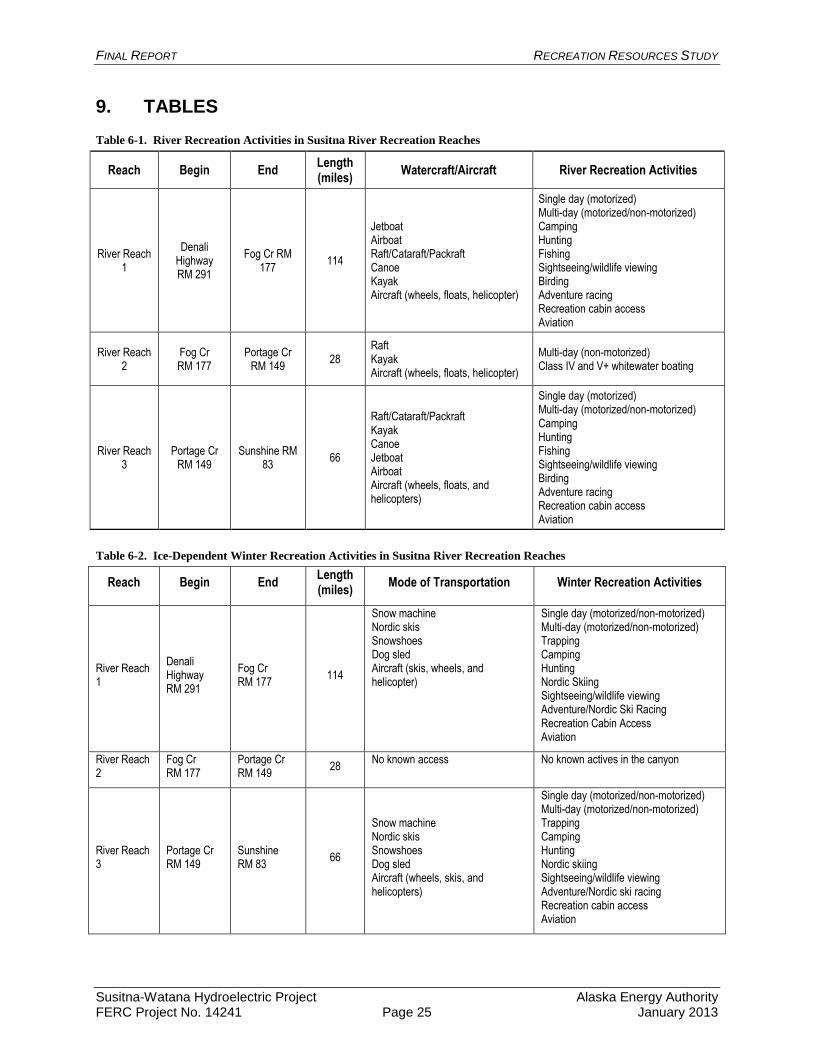
FINAL REPORT RECREATION RESOURCES STUDY
Susitna-Watana Hydroelectric Project Alaska Energy Authority FERC Project No. 14241 Page 25 January 2013
9. TABLES
Table 6-1. River Recreation Activities in Susitna River Recreation Reaches
Reach Begin End Length (miles)
Watercraft/Aircraft River Recreation Activities
River Reach 1
Denali Highway RM 291
Fog Cr RM 177
114
Jetboat Airboat Raft/Cataraft/Packraft Canoe Kayak Aircraft (wheels, floats, helicopter)
Single day (motorized) Multi-day (motorized/non-motorized) Camping Hunting Fishing Sightseeing/wildlife viewing Birding Adventure racing Recreation cabin access Aviation
River Reach 2
Fog Cr RM 177
Portage Cr RM 149
28 Raft Kayak Aircraft (wheels, floats, helicopter)
Multi-day (non-motorized) Class IV and V+ whitewater boating
River Reach 3
Portage Cr RM 149
Sunshine RM 83
66
Raft/Cataraft/Packraft Kayak Canoe Jetboat Airboat Aircraft (wheels, floats, and helicopters)
Single day (motorized) Multi-day (motorized/non-motorized) Camping Hunting Fishing Sightseeing/wildlife viewing Birding Adventure racing Recreation cabin access Aviation
Table 6-2. Ice-Dependent Winter Recreation Activities in Susitna River Recreation Reaches
Reach Begin End Length (miles)
Mode of Transportation Winter Recreation Activities
River Reach 1
Denali Highway RM 291
Fog Cr RM 177 114
Snow machine Nordic skis Snowshoes Dog sled Aircraft (skis, wheels, and helicopter)
Single day (motorized/non-motorized) Multi-day (motorized/non-motorized) Trapping Camping Hunting Nordic Skiing Sightseeing/wildlife viewing Adventure/Nordic Ski Racing Recreation Cabin Access Aviation
River Reach 2
Fog Cr RM 177
Portage Cr RM 149 28 No known access No known actives in the canyon
River Reach 3
Portage Cr RM 149
Sunshine RM 83 66
Snow machine Nordic skis Snowshoes Dog sled Aircraft (wheels, skis, and helicopters)
Single day (motorized/non-motorized) Multi-day (motorized/non-motorized) Trapping Camping Hunting Nordic skiing Sightseeing/wildlife viewing Adventure/Nordic ski racing Recreation cabin access Aviation
FINAL REPORT RECREATION RESOURCES STUDY
Susitna-Watana Hydroelectric Project Alaska Energy Authority FERC Project No. 14241 Page 26 January 2013
10. FIGURES
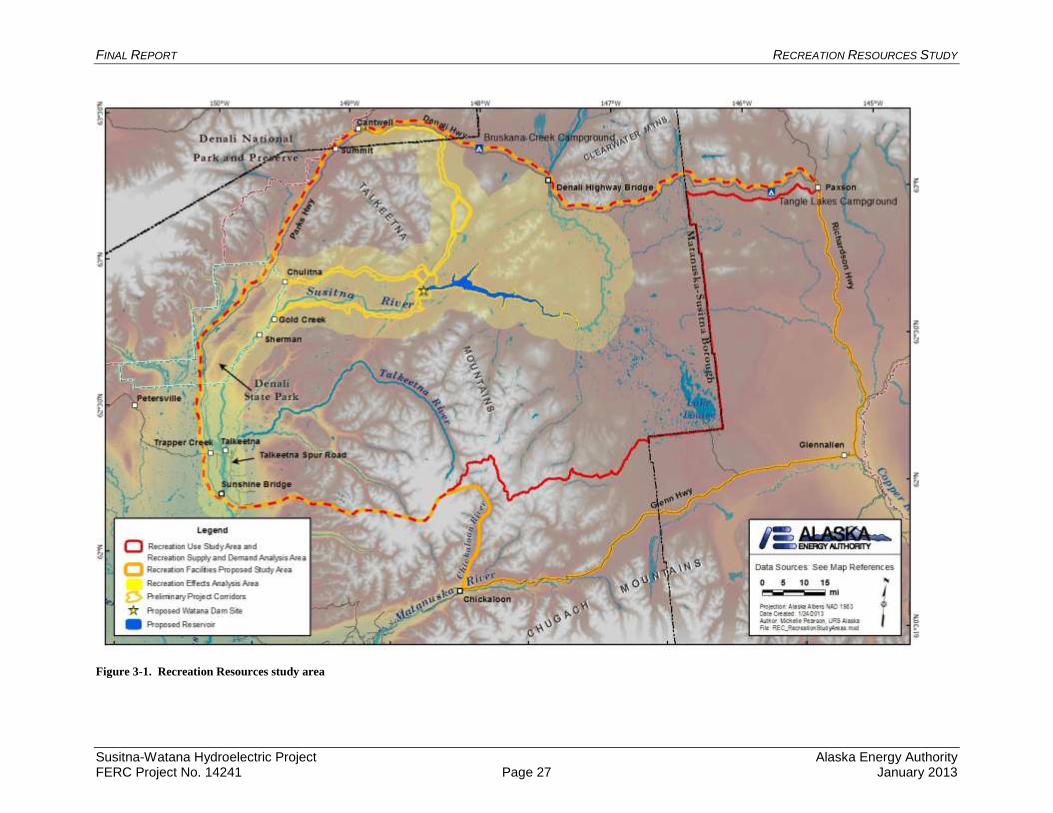
FINAL REPORT RECREATION RESOURCES STUDY
Susitna-Watana Hydroelectric Project Alaska Energy Authority FERC Project No. 14241 Page 27 January 2013
Figure 3-1. Recreation Resources study area
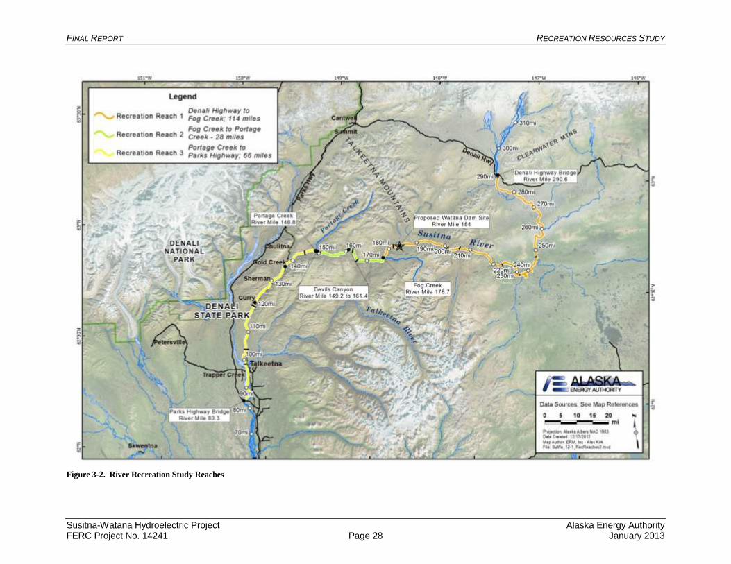
FINAL REPORT RECREATION RESOURCES STUDY
Susitna-Watana Hydroelectric Project Alaska Energy Authority FERC Project No. 14241 Page 28 January 2013
Figure 3-2. River Recreation Study Reaches
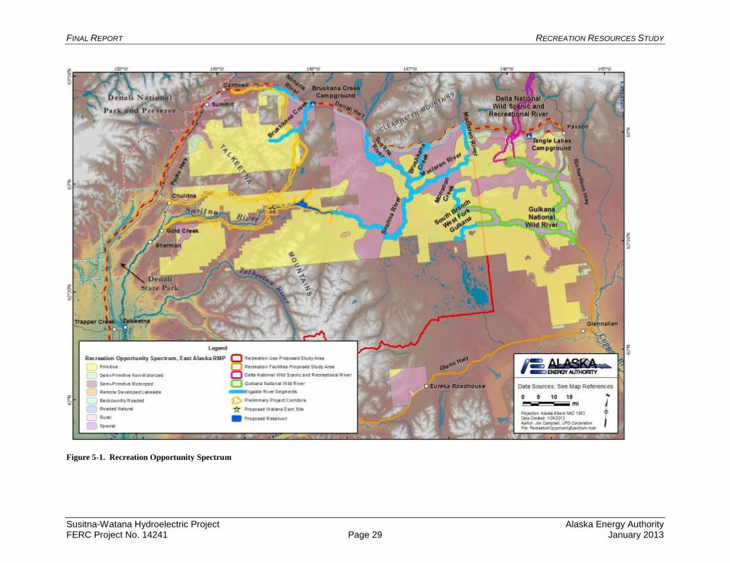
FINAL REPORT RECREATION RESOURCES STUDY
Susitna-Watana Hydroelectric Project Alaska Energy Authority FERC Project No. 14241 Page 29 January 2013
Figure 5-1. Recreation Opportunity Spectrum
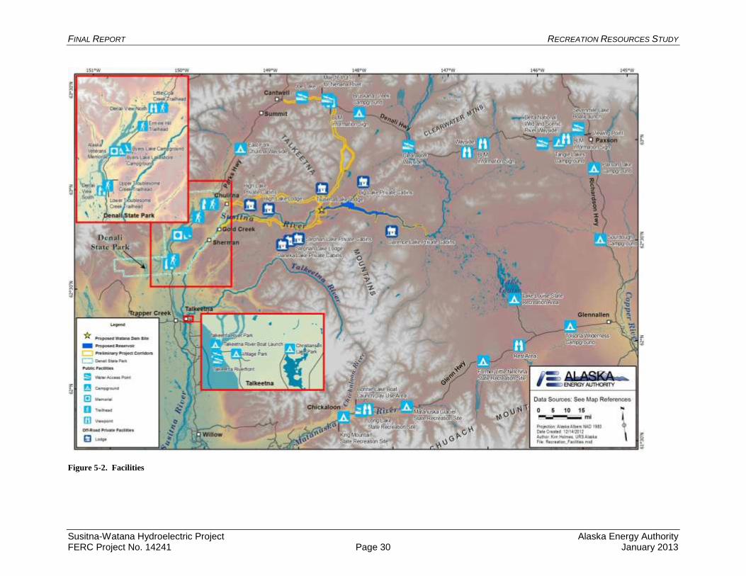
FINAL REPORT RECREATION RESOURCES STUDY
Susitna-Watana Hydroelectric Project Alaska Energy Authority FERC Project No. 14241 Page 30 January 2013
Figure 5-2. Facilities
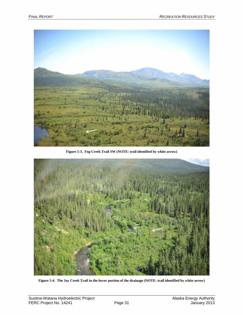
FINAL REPORT RECREATION RESOURCES STUDY
Susitna-Watana Hydroelectric Project Alaska Energy Authority FERC Project No. 14241 Page 31 January 2013
Figure 5-3. Fog Creek Trail SW (NOTE: trail identified by white arrow)
Figure 5-4. The Jay Creek Trail in the lower portion of the drainage (NOTE: trail identified by white arrow)
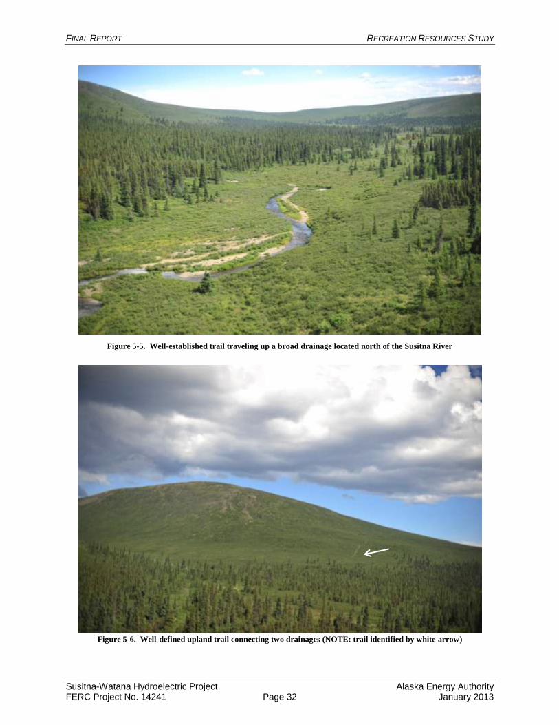
FINAL REPORT RECREATION RESOURCES STUDY
Susitna-Watana Hydroelectric Project Alaska Energy Authority FERC Project No. 14241 Page 32 January 2013
Figure 5-5. Well-established trail traveling up a broad drainage located north of the Susitna River
Figure 5-6. Well-defined upland trail connecting two drainages (NOTE: trail identified by white arrow)
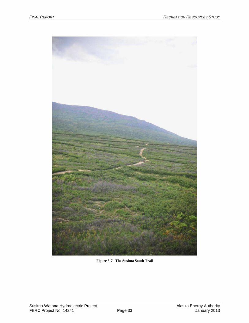
FINAL REPORT RECREATION RESOURCES STUDY
Susitna-Watana Hydroelectric Project Alaska Energy Authority FERC Project No. 14241 Page 33 January 2013
Figure 5-7. The Susitna South Trail
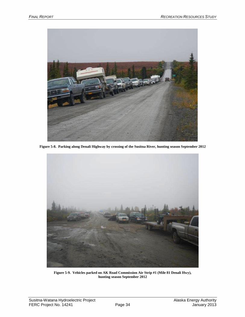
FINAL REPORT RECREATION RESOURCES STUDY
Susitna-Watana Hydroelectric Project Alaska Energy Authority FERC Project No. 14241 Page 34 January 2013
Figure 5-8. Parking along Denali Highway by crossing of the Susitna River, hunting season September 2012
Figure 5-9. Vehicles parked on AK Road Commission Air Strip #1 (Mile 81 Denali Hwy),
hunting season September 2012
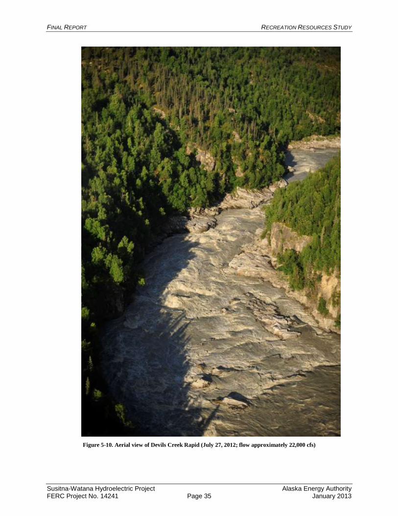
FINAL REPORT RECREATION RESOURCES STUDY
Susitna-Watana Hydroelectric Project Alaska Energy Authority FERC Project No. 14241 Page 35 January 2013
Figure 5-10. Aerial view of Devils Creek Rapid (July 27, 2012; flow approximately 22,000 cfs)
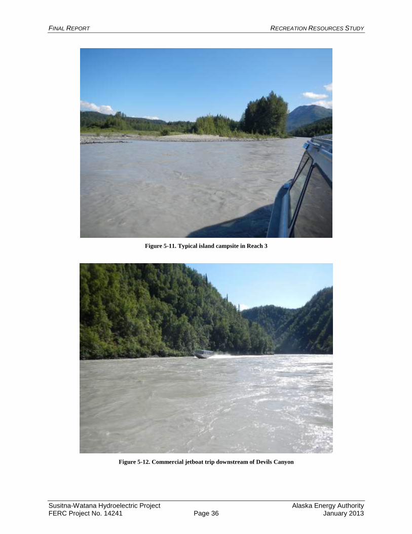
FINAL REPORT RECREATION RESOURCES STUDY
Susitna-Watana Hydroelectric Project Alaska Energy Authority FERC Project No. 14241 Page 36 January 2013
Figure 5-11. Typical island campsite in Reach 3
Figure 5-12. Commercial jetboat trip downstream of Devils Canyon
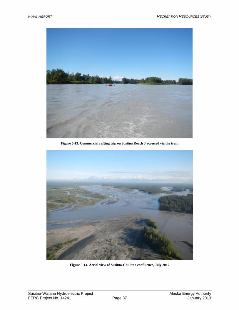
FINAL REPORT RECREATION RESOURCES STUDY
Susitna-Watana Hydroelectric Project Alaska Energy Authority FERC Project No. 14241 Page 37 January 2013
Figure 5-13. Commercial rafting trip on Susitna Reach 3 accessed via the train
Figure 5-14. Aerial view of Susitna-Chulitna confluence, July 2012
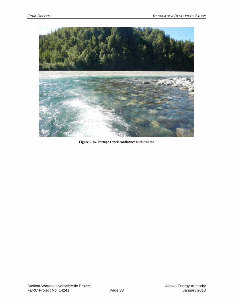
FINAL REPORT RECREATION RESOURCES STUDY
Susitna-Watana Hydroelectric Project Alaska Energy Authority FERC Project No. 14241 Page 38 January 2013
Figure 5-15. Portage Creek confluence with Susitna
FINAL REPORT RECREATION RESOURCES STUDY
Susitna-Watana Hydroelectric Project Alaska Energy Authority FERC Project No. 14241 Page 39 January 2013
Appendices
Appendix A: Map Book of Trails