Susitna Hydroelectric Project.|pFinal report, big game ... · SUSITNA HYDROELECTRIC PROJECT VOL....
115
SUSITNA HYDROELECTRIC PROJECT VOL. III MOOSE FORAGE BIOMASS IN-THE MIDDLE SUSITNA RIVER BASIN 1 ALASY.A ' . Earl. F. Becker Alaska Department of Fish and Game and William D- Steiqers, Jr. LGL Alaska Research Associates, Inc. ALASKA DEPARTMENT OF FISH AND GAME 333 RASPBERRY·ROAD ALASKA 99518-1599 APlUL:tS87 URCESUBAA
Transcript of Susitna Hydroelectric Project.|pFinal report, big game ... · SUSITNA HYDROELECTRIC PROJECT VOL....

SUSITNA HYDROELECTRIC PROJECT
VOL. III
MOOSE FORAGE BIOMASS IN-THE MIDDLE SUSITNA
RIVER BASIN 1 ALASY.A ' .
Earl. F. Becker Alaska Department of Fish and Game
and
William D- Steiqers, Jr. LGL Alaska Research Associates, Inc.
ALASKA DEPARTMENT OF FISH AND GAME
333 RASPBERRY·ROAD
.~CHORAGE, ALASKA 99518-1599
APlUL:tS87
URCESUBAA ~

PREFACE
Between January 1980 and June 1986, the Alaska Power Authority (APA) ~D-
contracted with the Game Division of the Alaska Department of Fish and Game (ADF&G) to provide field data and recommendations to be used for assessing potential impacts and developing options for mitigating impacts of the proposed Susitna Hydroelectric Project on moose, caribou, brown bear, black bear, Dall sheep, wolf, wolverine, and belukha whales. ADF&G was only one of many participants in this program. Information on birds, small mammals, furbearers, and vegetation was collected by the University of Alaska and private consulting firms.
Formally, ADF&G' s role was to collect data which could be used to describe the baseline, pre-project conditions. This information was supplemented with data from other ADF&G studies. Baseline conditions were defined to include processes which might be sufficiently sensitive to either direct or indirect project induced impacts to alter the dynamics of the wildlife populations. The responsibility of impact assessment and mitigation planning was assigned by APA to several private consulting firms. ADF&G staff worked closely with these firms, but only in an advisory capacity.
The project was cancelled before the impact assessment and mitigation planning processes were complete. In an effort to preserve the judgements and ideas of the authors at the termination of the project, the scope of this report has been expanded to include material relating to impact assessment and mitigation planning. Statements do not necessarily represent the views of the APA or its contractors. Conjectural statements sometimes are included in the hope that they may serve as hypotheses to guide future work, should the project be reactivated.
The following list of reports completely cover all of the Game Division's contributions to the project. It should not be necessary for the reader to consult the many progress reports.
Moose
Modafferi, R. D. 1987. Susitna Hydroelectric Project, Big Game Studies, Final Report Vol. I - Moose - Downstream. Alaska Dept. of Fish and Game.
Ballard, W. B. and J. S. Whitman. 1987. Susitna Hydroelectric Project, Upstream.
Big Game Studies, Final Report, Vol. II Moose Alaska Dept. of Fish and Game.
Becker, E. F. and W. D. Steigers. 1987. Susitna Hydroelectric Project, Big Game Studies. Firial Report, Vol. III - Moose forage biomass in the middle Susitna River basin, Alaska. Alaska Dept. of Fish and Game.
Becker , E . F. Studies. Estimate.
1987. Susitna Hydroelectric Project. Big Game Final Report. Vol. VI Moose Carrying Capacity Alaska Dept. of Fish and Game.
Alaska Resources Information
Caribou
Pitcher, K. W. 1987. Susitna Hydroelectric Project, Big Game Studies. Final Report. Vol. IV - Caribou. Alaska Dept. of Fish and Game. 5 9pp.
Black Bear and Brown Bear
Miller, S. D. 1987. Susitna Hydroelectric Project, Big Game Studies, Final Report. Vol. V - Black Bear and Brown Bear. Alaska Dept. of Fish and Game.
Wolf
Ballard, W. B., J. S. Whitman, L. D. Aumiller, and P. Hessing. 1984. Susitna Hydroelectric Project, Big Game Studies. 1983 Annual Report. Vol. V - Wolf. Alaska Dept. of Fish and Game. 44pp.
Ballard, W. B., J. S. Whitman, and C. L. Gardner. 1987. Ecology of an exploited wolf population in southcentral Alaska. Wildlife Monographs No. __ (In press).
Wolverine
Whitman, J. S. and W. B .. Ballard. 1984. Susitna Project, Big Game Studies. 1983 Annual Report. Wolverine. Alaska Dept. of Fish and Game. 25pp.
Dall $heeQ
Hydroelectric Vol. VII -
Tankersley, N. G. 1984. Susitna Hydroelectric Project, Big Game Studies. Final Report. Vol. VIII - Dall Sheep. Alaska Dept. of Fish and Game. 91pp.
Belukha Whale
Calkins, D. 1984. Final Report. Game. 16pp.
Susitna Hydroelectric Project, Big Game Studies. Vol. IX - Belukha Whale. Alaska Dept. of Fish and

TABLE OF CONTENTS
LIST OF TABLES
LIST OF FIGURES
. . . . . . . . . . . . . . . . . . . . . . . . . . . . . . . . . . . . . . . . . . . . . . . . . . . . . . . . . . . . . . . . . . . . . . . . .
INTRODUCTION . . . . . . . . . . . . . . . . . . . . . . . . . . . . . . . . . . . . . . . ACKNOWLEDGEMENTS . . . . . . . . . . . . . . . . . . . . . . . . . . . . . . . . . . . STUDY AREA . . . . . . . . . . . . . . . . . . . . . . . . . . . . . . . . . . . . . . . . . METHODS
RESULTS
. . . . . . . . . . . . . . . . . . . . . . . . . . . . . . . . . . . . . . . . . . . .
. . . . . . . . . . . . . . . . . . . . . . . . . . . . . . . . . . . . . . . . . DISCUSSION
SUMMARY . . . . . . . . . . . . . . . . . . . . . . . . . . . . . . . . . . . . . . . . . . . . LITERATURE CITED . . . . . . . . . . . . . . . . . . . . . . . . . . . . . . . . . . . APPENDIX A
APPENDIX B
APPENDIX C
. . . . . . . . . . . . . . . . . . . . . . . . . . . . . . . . . . . . . . . . .
. . . . . . . . . . . . . . . . . . . . . . . . . . . . . . . . . . . . . . . . .
Page
3
8
9
10
11
12
17
22
27
88
91
95
108
2

LIST OF TABLES
Table
1. Percent area, broken down by population, of willow biomass strata ••••••••••••••••••••••••• 29
2. Differences in willow biomass between 1984 and 1985 for the high, medium-forest, and medium-shrub strata of population A ~················· 30
3. Mean paper birch biomass and standard error, pooled over height categories, by population and strata . . . . . . . . . . . . . . . . . . . . . . . . . . . . . . . . . . . . . . . . 31
4. Mean paper birch biomass and standard error, below 50 em in height, by population and strata 32
5. Mean paper birch biomass and standard error, above 50 em in height, by population and strata 33
6. Mean willow biomass and standard error, pooled over height categories, by population and strata 34
7. Mean willow biomass and standard error below 50 em in height, by population and strata ••..• 35
a. Mean willow biomass and standard error above 50 em in height, by population and strata •.••• 36
9. Mean mountain cranberry biomass and 80% confidence interval by population ••••••••••••• 37
10. Average biomass and standard errors of willow, paper birch, and mountain cranberry in populations A, B, and D ••••••••••••••••••••..• 38
11. Average biomass and standard errors of willow and paper birch below 50 em in height for populations A, B, and D ••••••••••••••••••••••• 39
12. Average biomass and standard errors of willow and paper birch above 50 em in height for populations A, B, and D ••••••••••••••••••••••. 40
13. Acres of forage biomass stratum to be permanently or temporarily lost by facility, for Stage I . . . . . . . . . . . . . . . . . . . . . . . . . . . . . . . . . . . . . . . 41
3

14. Acres of forage biomass stratum to be permanently or temporarily lost by facility, for Stage II . . . . . . . . . . . . . . . . . . . . . . . . . . . . . . . . . . . . . . 42
15. Acres of forage biomass stratum to be permanently or temporarily lost by facility, for Stage III . . . . . . . . . . . . . . . . . . . . . . . . . . . . . . . . . . . . . 4 3
16. Kg of willow biomass, pooled over height categories, to be permanently or temporarily lost by facility and stratum, for Stage I ....• 44
17. Kg of willow biomass, pooled over height categories, to be permanently or temporarily lost by facility and stratum, for Stage II 45
18. Kg of willow biomass, pooled over height categories, to be permanently or temporarily lost by facility and stratum, for Stage III 46
19. Upper 80% confidence limit of kg of willow biomass pooled over height categories, to be permanently or temporarily lost by facility and stratum, for Stage I .. • • • • . • • • • • • • • . . . • . • . • . . . . 47
20. Upper· 80% confidence limit of kg of willow biomass pooled over height categories, to be permanently or temporarily lost by facility and stratum, for Stage II • • • • • • • • • • • . . • • . . • • • . . . . . 48
21. Upper 80% confidence limit of kg of willow biomass pooled over height categories, to be permanently or temporarily lost by facility and stratum, for Stage III ••••••••••••....•....... 49
22. Kg of willow biomass over 50 em in height, to be permanently or temporarily lost by facility and stratum, for stage I • • • • • • • • • • • • • • • • • • • • . . . . . • 50
23. Kg of willow biomass over 50 em in height, to be permanently or temporarily lost by facility and stratum, for Stage II • • • • • • • • • • . . • . • • . • • . . . . • • . 51
24. Kg of willow biomass over 50 em in height, to be permanently or temporarily lost by facility and stratum, for Stage III •••••••••••••.••••••...•• 52
25. Upper 80% confidence limit of kg of willow biomass over 50 em in height, to be permanently or temporarily lost by facility and stratum, for Stage I . . . . . . . . . . . . . . . . . . . . . . . . . . . . . . . . . . . . . . . . 53
4

26. Upper 80% confidence limit of kg of willow biomass over 50 em in height, to be permanently or temporarily lost by facility and stratum, for Stage II . . . . . . . . . . . . . . . • . . . . . . . . . . . . . . . . . . . . . . . 54
27. Upper 80% confidence limit of kg of willow biomass over 50 em in height, to be permanently or temporarily lost by facility and stratum, for Stage III . . . . . . . . . . . . . . . . . . . . . . . . . . . . . . . . . . . . . . 55
28. Kg of paper birch biomass, pooled over height categories, to be permanently or temporarily lost by facility and stratum, for Stage I . . . . . . . . . . . . . . . . . . . . . . . . . . . . . . . . . . . . . . . . 56
29. Kg of paper birch biomass, pooled over height categories, to be permanently or temporarily lost by facility and stratum, for Stage II . . . . . . . . . . . . . . . . . • . . . . . . • • . . . . . . . . . . . . . 57
30. Kg of paper birch biomass, pooled over height categories, to be permanently or temporarily lost by facility and stratum, for Stage III . . . . . . . . . . . . . . . . . . . . . . . . . . . . . . . . . . . . . . 58
31 .. Upper 80% confidence limit on kg of paper birch biomass pooled over height categories, to be permanently or temporarily lost by facility and stratum, for Stage I • • • • • • • • • • • • • • • • • . . • • • • • • . . 59
32. Upper 80% confidence limit on kg of paper birch biomass pooled over height categories, to be . permanently or temporarily lost by facility and stratum, for Stage II • • • • • • • • • • • • • • • • • • • • • • • • • . 60
33. Upper 80% confidence limit on kg of paper birch biomass pooled over height categories, to be permanently or temporarily lost by facility and stratum, for Stage III ••••••••••••••••.••••••.. 61
34. Kg of paper birch biomass over 50 em in height, to be permanently or temporarily lost by facility and stratum, for Stage I •••••••••••••••••••••.. 62
35. Kg of paper birch biomass over 50 em in height, to be permanently or temporarily lost by facility and stratum, for Stage II •••••••••••••••••.•... 63
36. Kg of paper birch biomass over 50 em in height, to be permanently or temporarily lost by facility and stratum, for Stage III • • • • . • • • • • • • • • • • • • • . . 64
5

37. Upper 80% confidence limit of kg of paper birch biomass over 50 em in height, to be permanently or temporarily lost by facility and stratum, for Stage I . . . . . . . . . . . . . . . . . . . . . . . . . . . . . . . . . . . . . . . . 65
38. Upper 80% confidence limit of kg of paper birch biomass over 50 em in height, to be permanently or temporarily lost by facility and stratum, for Stage II ••••••••••••••••••••••••••••••••••••• o • 6 6
39. Upper 80% confidence limit of kg of paper birch biomass over 50 em in height, to be permanently or temporarily lost by facility and stratum, for Stage III • • • • • • • • • • • • • • • • • • • • • • • • • • • • • • • • • . • • • • 6 7
40. Kg of mountain cranberry to be permanently or temporarily lost by facility for Stage I •...... 68
41. Kg of mountain cranberry to be permanently or temporarily lost by facility for Stage II ...... 69
42. Kg of mountain cranberry to be permanently or temporarily lost by facility for Stage III 70
43. The mean and upper 80% confidence limit on the amount of biomass lost, by stage and species 71
44. The mean and upper 80% confidence limit on the amount of biomass (above 50 em in height) lost, by stage and species • • • • • • • • . • • • • . . . . . . . • . . . . . . 72
45. The estimated probability, and standard error, of a plot containing diamondleaf willow, by population and strata ••••••..••••.............. 73
46. The estimated probability, and standard error, of a plot containing grayleaf willow, by population and strata ••••••••••.•..•....•...... 74
47. The estimated probability, and standard error, of a plot containing Richardson willow, by population and strata • • • • • • • . • • • • • . . . . . • . . . . . . . 7 5
48. The estimated probability, and standard error, of a plot containing feltleaf willow, by population and strata •••••••••••••............. 76
49. The estimated probability, and standard error, of a plot containing unknown willows, by population and strata ••••..••••..••............ 77
50. The estimated probability, and standard error, of a plot containing reachable paper birch, by population and strata •••••.••••••.•...•.......• 78
6

51. The estimated probability, and standard error, of a plot containing reachable paper birch, diamondleaf, grayleaf, Richardson, feltleaf, and unknown willows by population •••••.••••.... 79
7

LIST OF FIGURES
Figure
1. Watana, Devil canyon, and surrounding area sampling populations for the browse inventory study . . . . . . . . . . . . . . . . . . . . . . . . . . . . . . . . . . . . . . . . . ao
2. Browsing pressure on willows by impoundment and plant density . . . . . . . . . . . . . . . . . . . . . . . . . . . . . . . . . 81
3. Browsing pressure on willows in the Watana impoundment by elevation •••••••••••••••....... 82
4. Browsing pressure on willows in the non-impoundment by elevation ••••••••••••...... 83
5. Stratification map of the non-impoundment population (A) •..••••••••••••.••..•••.•....... 84
6. Stratification map of the Watana impoundment population (B) . . . . . . . . . . . . . . . . . . . . . . . . . . . . . . . . 85
7. Stratification map of the Devil canyon impoundment population (D) •.•••••.•••••....... 86
8. Map of project features 87
8

INTRODUCTION
The proposed Susitna Hydroelectric Project consists of 3 major developments on the susitna River, approximately 180 miles north and east of Anchorage, Alaska. The first phase would be the Watana Stage I earth-fill dam and associated power and camp facilities. The Watana Dam site would be located at river mile 184 above the mouth of the Susitna River, in a broad u-shaped valley approximately 2.5 miles upriver from the Tsusena Creek confluence. The dam would create a reservoir approximately 39 miles long with a maximum width of about 3 miles (excluding tributaries), and have a surface area of 14,900 acres at the normal maximum operating level of 2,025 feet mean sea level, (MSL). The second stage would be the Devil Canyon Stage II concrete arch dam and associated facilities. The Devil Canyon Dam site would be located in the Devil Canyon gorge at river mile 152 of the Susitna River, approximately 32 miles down river from the Watana Dam site. It would form a reservoir approximately 26 miles long with a surface area of 7,800 acres at the normal operating level of 1,455 feet MSL. Stage III would consist of raising the Watana dam to create a reservoir 48 miles long and having a surface area of 38,000 acres. Maximum width of the Stage III reservoir would be approximately 5 miles._
Cons~ruction and operation of the Watana and Devil Canyon hydroelectric dams in the middle Susitna River Basin (Fig. 1) would result in both permanent and temporary losses of habitat for moose (Alces alces gigas) . Approximately 72 square miles of land area would be permanently inundated, and another 24 square miles temporarily disturbed as a result of the project. Loss of the vegetation growing there to reservoir inundation, camp facilities, borrow sites, and other sources represents a loss of capacity to support moose populations. Loss of habitat carrying capacity would be the primary impact on moose of hydroelectric development in the susitna basin.
Impacts of the susitna Hydroelectric Project on the loss of moose habitat will be based on an assessment of the loss of carrying capacity of the affected area. Nutritional carrying capacity is defined as the number of healthy individuals that can be maintained in a designated area for a specified time period. Mathematical models of range food supply and animal food habits have been used to estimate habitat carrying capacity for roe deer (Capreolus capreolus) (Bobeck 1977), mule deer (Odocoileus hemionus hemionus) (Wallmo et al. 1977), white~tailed deer(~ virginianus) (Potvin and Huot 1983), and elk (Cervus elaphus nelsoni) (Hobbs et al. 1982, Hobbs and swift 1985).
In Alaska, research has been underway to modify the generalized ruminant submodel developed by Swift (1983) to make it specific to moose (Regelin et al. 1985, 1986, Schwartz et al. 1984, 1986a, 1986b). The model has been
9

developed, tested, and verified on the Kenai Peninsula (Hubbert l987).
In 1983 it was decided to adapt the moose carrying capacity model to assess impacts of the proposed Susitna Hydroelectric Project on moose. This model, coupled with area-specific information on moose, provided the means for the impact assessment and mitigation planning in conjunction with hydroelectric development in Alaska. This approach for impact assessment has not previously been used for moose. Development of the model represents a major advancement in assessment of the impacts of man's activities on a freeranging population of animals.
The objective of this study was to provide an estimate of the amount of browse that is available to moose in the middle Susitna Basin. This estimate was an essential element of the moose carrying capacity model.
During the spring and summer of l982 and l983 preliminary browse inventory studies were conducted to make first determinations of the vegetation types and browse species most heavily utilized by moose in the areas to be affected by the project, and to determine the most costeffective method of sampling biomass of browse species. Vegetation mapping, utilizing new aerial photography techniques, was initiated in l984 to provide detailed maps upon which browse biomass could ·be stratified. The stratified vegetation map formed the sample frame, and was essential for obtaining an estimate of browse biomass.
ACKNOWLEDGMENTS
This project was a joint effort between the Alaska Department of Fish and Game and LGL Alaska Research Associates. The list of people who have contributed to the completion of the browse inventory study during 1984 and l985 is extensive. We would like to especially thank Dr. Wayne Regelin (ADF&G) for his guidance in the initial planning stages and for his assistance in implementing the ADF&G intern program. SuzAnne Miller (ADF&G) has been of invaluable assistance in computer programming, program guidance, statistical consulting, and trouble-shooting. Randy Fairbanks (Harza-Ebasco susitna Joint Venture), Dr. Robin Sener (LGL Alaska Research Associates) , and Karl Schneider (ADF&G) have been responsible for funding and overall program guidance. We would like to thank the following people for technical assistance: ADF&G interns D. Ashby, B. Barkuloo, c. Bird, s. Brainerd, G. Chaney, J. Chumbley, R. Gonzalez, M. Hertzic, D. Hoffman, J. Keller, J. Kidd, T. LeFlamme, N. Larter, J. McCarthy, T. McKinley, I. Murto, K. Omura, c. Petersen, L. Restad, A. swan, D. Weisel, J. Wiegers, L. Wold, and E. Wood; ADF&G employees N. Tankersley and T. Otto; and volunteers c. Burns and P. Wood. D. Anctil, P. Mieczynski, L. Aumiller, and B. Strauch of ADF&G and B. Bennett of System Integrators Inc. provided
lO

computer programming and digitizing support. D. Heebner and R. Koleser of R.A. Kreig and Associates assisted with training of field personnel and transferring transect lines to aerial photographs. G. Couey and v. Volpe of HarzaEbasco susitna Joint Venture, R. Goodman of KNIK-ATNU, Inc., the operators of High Lake Lodge, and the helicopter pilots of Air Logistics of Alaska are thanked for their logistical support during the field seasons.
STUDY AREA
The 1,021-square-mile study area is located in the middle susitna River basin, upstream of the mouth of Devil canyon (Fig. 1). study area boundaries were defined by Ballard et al. (1983), as the "primary zone of impact" for moose. Elevations range from about 900 feet (274 m) on the river at the mouth of Devil Canyon to 6,255 feet (1,907 m) at the top of Mt. Watana. The river elevation rises to approximately 2,500 feet (746 m) where the Denali Highway crosses the Susitna River. Topography of the study area has been strongly influenced by past glacial action and associated stream and river erosion, resulting in a broad ushaped valley.occupied by the Susitna River. The river channel slopes are very steep near Devil. Canyon and become less steep and wider at the eastern end of the study·area, north of the confluence of the.Tyone River. Terraces above the river channel are approximately 2,000-2,500 feet (610-762 m) in elevation and make up the majority of the study area.
McKendrick et al. (1982) mapped 16 vegetation types in the middle and upper susitna River basin at levels III or IV of the classification system developed by Viereck and Dyrness (1980). The plant communities are strongly influenced by site topography, soils, and moisture regimes. The steep, well-drained river channel slopes are dominated by forest communities such as mixed paper birch (Betula papyrifera) and white-spruce (Picea glauca) forests and open coniferous forests on both sides of the river. Benches above the river primarily contain shrub communities dominated by resin birch (~ glandulosa) on the drier sites, white-spruce forests on the well-drained slopes, and black spruce (Picea mariana) forests on the wetter sites. Willows (Salix), primarily diamondleaf willow(~ pulchra), grayleaf willow(~ glauca), Richardson willow(~ lanata), and feltleaf willow(~ alaxensis), dominate the shrub communities in the wetter sites on upland slopes and in the coniferous forests. Alpine vegetation types occur at the highest elevations.
11

METHODS
The primary objective of this report was to estimate the amount of browse that is available to moose during the winter. These estimates will then be used to generate carrying capacity estimates of moose in the Susitna Basin. In the initial phase of this project, it was decided to stratify willow biomass on the basis of a vegetation map. Due to 1) our inability to produce accurate stratification maps for each willow species and 2) the inherent sampling problems involved with using a stratification scheme for each species, it was decided to stratify on Salix biomass. The combining of the various willow species caused us to make assumptions about the availability of the various willow species.
Willow biomass strata were developed and analyzed using combined biomass of all willows, based on the assumption that all willow species available to wintering moose in the study area were equally preferred (and subsequently consumed), or at least not specifically avoided by the end of winter. A second assumption was that different willow species were equally available to wintering moose. In reality, not all species were equally available because each species had a distinct regional distribution and thus a different degree of accessibility.
Resin birch is an important understory component of many vegetation types in the Susitna Study area (Steigers et al. 1983). However, it was not sampled during this study because: 1) it is very time consuming to remove the small twigs of this species (Steigers and Helm 1984); and 2) it composed only 11% of the average moose diet in this region (Steigers and Becker 1986). Resin birch, for the purposes of this study, was considered to be non-limiting either in distribution or abundance. Resin birch biomass was assumed to be available to the extent that moose voluntarily limit their intake.
A vegetation map of the study area was prepared by R.A. Kreig and Associates, Inc. The study area was mapped to level IV of the Viereck et al. (1982) vegetation classification system, using 40 acres (16.19 hectares) as the minimum polygon size. The understory cover of willow, resin birch, and alder (Alnus) was classified into the following categories: 0-4%, 5-25%, 26-50%, 51-75%, and 76-100% cover (see Appendix A) • The mapping was done by photointerpretation of color infrared (CIR) photographs. Groundtruthing was done by the mappers and from information collected during the 1984 sampling season.
Vegetation sampling was conducted from July 9 through August 22, 1984 and from July 11 through August 25, 1985. During the first phase of the 1984 sampling effort, 5 1:60,000 scale CIR photos were subjectively chosen to cover the east-west gradient of the middle susitna River basin. Using a two-stage sample design (Cochran 1977), the first stage being 1-mile line transects and the second stage
12

consisting of square-meter plots, these areas were sampled and the amount of current annual growth biomass (CAG) of willow and paper birch present was estimated. Whole mountain cranberr1 (Vaccinium vitis-idaea) plants were clipped at ground level. To maximize the number of different vegetation polygons for which browse biomass data were obtained, the transects were given a north-south orientation which corresponded to the major elevation-aspect gradient. A total of 36 transects was sampled and provided data used to stratify the study area into willow CAG strata.
After these 36 transects were sampled, the study area was divided into 3 populations: the Watana population (population B), the Devil Canyon population (population D), and the outside population (population A), to facilitate sampling during the second phase of the sampling effort. Population B was created to facilitate intensive sampling of browse within the proposed Watana impoundment. The upper elevational boundary of population B was the 2,200 foot contour; when necessary the boundaries were extended above 2,200 feet to maintain a minimum width of 0.5 mile. Population D was created to facilitate intensive browse sampling within the proposed Devil Canyon impoundment. The upper elevation boundary of population D was the 1,500 foot contour; when necessary the boundary was extended above 1,500 feet to maintain a minimum width of 0.5 mile. Population A consisted of the remaining area within the study area and below the 3,400 foot contour; the area above the· 3,400 foot contour was deleted since 97% of all winter · observations of moose in the study area occurred at or below this elevation (Ballard et al. 1983).
During the second phase of the 1984 season, 72 transects were sampled in the 3 populations. The number of transects sampled per population was weighted by the proportion of area, within each population, that was scheduled to be inundated by the dams, and the perceived variation in willow biomass per population; of the 72 transects, 49 were conducted in population A, 15 in population B, and 8 in population o. One-mile transects were used to sample population A, while 0.5-mile transects were used to sample the other 2 populations due to their narrow shape. In total, 108 transects were completed during the summer of 1984. ·
Four groups of transects were randomly selected from a 1:63,360 scale USGS topography map of· the study area •. Transects were then transferred to both 1:60,000 scale CIR and 1:24,000 scale true-color photographs (when available) for use by the field crews. Accurate transfer of the transects to the aerial photographs was facilitated through use of a Map-a-graph. Crews used the 1:60,000 scale CIR and the 1:24,000 scale photography, when available, for locating transect starting points. Helicopters were used to transport the crews, each consisting of 2 people, to the landing zone closest to the transect starting point. When a
13

crew could not be dropped off at the starting point, orienteering methods were used to reach this point.
Plots were randomly selected, without replacement, along the transect, and sampled if they fell within the population of interest. The number of plots sampled per transect varied from 20 to 30 as we attempted to maximize the average number of plots a 2-man crew could complete in a day. The number of plots sampled was changed upon the completion of a randomly selected group of transects. Twenty-two plots per transect were used after the first few weeks.
Once at the transect starting point, the crew would orient themselves to a prescribed compass heading and go the specified number of meters to the first plot. All distances were measured along a transect using a 100-meter tape. A straight-line course was maintained using a hand-held compass. If the average straight-line slope between successive plots exceeded 15 degrees, the distance traveled between successive plots was corrected, for slope, to the nearest meter. This was done to adjust ground distances to match the planar distance on the two-dimensional aerial photographs. Discrepancies between field transect locations and map locations were documented, when known, to assure accurate post-stratification.
At each plot the following information was recorded: transect number; plot number; date; crew code; distance measured from last plot; elevation (feet); aspect (degree azimuth); slope (degrees); local topography within a 100-foot radius of the plot (convex, simple slope, concave, or complex); surface drainage within a 100-foot radius of the plot (fa~t, intermediate, or ponded); site moisture within a 100-foot radius of the plot (very dry, dry, moist, or wet); landscape setting within a 0.5-mile radius of the plot (flat, undulating flats, hills-mountains [if hillsmountains, then whether the landscape setting was on the valley floor, lower one-third of the slope, or the ridge crest]); Viereck et al. (1982) level IV vegetation classification (see Appendix A for the classifications and codes used); percent canopy, by genus, for willow, resin birch, and alder (0=0%, 1=1-4%, 2=5-25%, 3=26-50%, 4=51-75%, 5=76-100% cover).
A 1 x 1-meter-square plot was positioned parallel to the line of travel, and at the end point of the distance measurement. The plot frame was elevated 50 em above the ground by metal stakes and clamps, and oriented parallel to the ground surface. The current-annual-growth twigs were clipped and placed in paper bags by height categories and species for diamondleaf willow, grayleaf willow, Richardson willow, feltleaf willow, one shrub genera (other willow species), and paper birch. Height strata were to be used to adjust the amount of forage that is available during the winter at various snow depths. The 2 height strata used were o-50 em, and 50-250 em. The 250-cm maximum height was not observed if the diameter-at-breast-height (dbh) of the
14

shrub stem was less than 2.5 em. All current-annual-growth twigs that were within the vertical boundaries of the plot were clipped. A 20 x 50-cm subplot was positioned at ground level within the larger 1-m-square plot, parallel to the line of travel and starting at the end point of the distance measurement. All mountain cranberry leaves and twigs occurring within the vertical borders of the subplot were clipped and bagged.
All field data were recorded on Epson HX-20 notebook computers which were programmed to prompt crew members for data input at each plot. Data were transferred directly from the Epson to an IBM PC-XT computer, located at base camp, at the end of each day. Once in the IBM PC-XT the field data were run through format, error check, and sort programs to ensure high quality and. organization of data. Field work ended on August 22, 1984.
Collected plant material was brought to the field laboratory each evening. Bags of samples brought into the laboratory were checked against a list of the bags that should have been present, as determined by data entered into the field computers. Bags were placed in drying ovens and dried at 60 C for at least 72 hours prior to processing. Leaves and foreign material were separated from the twigs, and the twigs were then redried and weighed to the nearest one-hundredth gram on a Mettler.PC4400 electronic balance. The weights, transect number, plot number, crew code, species, and height strata were recorded on an Epson HX-20 computer. Laboratory data were transferred directly from the Epson to the IBM PC-XT computer, where they were run through format, error check, and sort programs to ensure data quality and organization. The lab data were then merged with the field data, and another error checking program reported mismatches between the field data and the weight data. When errors were discovered, all effort was made to immediately determine the source and rectify them.
After returning from the field, the transect lines were transferred from the aerial photos to vegetation map overlays that corresponded to the photos. The distance between vegetation polygon intersections with the transect line was digitized. From this information every plot in the transect could be classified into a vegetation polygon by comparing the digitized distances associated with polygon intersections with the distance of the plot from the transect starting point. Plots occurring at the border of polygon intersections (within 50 meters} were checked against vegetation calls made by the crew to prevent improper classification due to sources of error introduced in the transect transfer and digitizing process. It was felt that plot locations were accurate to within 50 meters.
The 36 phase-one strati£ication transects and portions of 21 phase-two 1984 transects, which fell in vegetation types not covered by the 36 phase-one stratification transects, were analyzed to provide the data base from which the stratification map was developed. For each plot, willow
15

biomass information, pooled over height strata and willow species, was combined with the vegetation call. Mean willow biomass per square meter, by vegetation call and population, was then calculated. A k-means cluster program was run on a CDC Cyber 700 computer, using BMDP (Dixon 1981). A centroid linkage algorithm that utilized Euclidean distances was used on the willow biomass averages to determine ranges of willow biomass in each strata. Based on this information and comparisons between average biomass and average willow cover classifications, a willow biomass stratification scheme was developed for the vegetation polygons for which data were available. Relationships between willow biomass and other recorded site factors such as elevation, slope, and aspect were also investigated to determine if strata should be further subdivided. This preliminary stratification scheme was expanded, based on the assumption that major vegetation types with similar willow cover calls should be classified into like strata, to include every vegetation polygon that occurred within the study area. Representative vegetation polygon types with insufficient data were surveyed in the early summer of 1985 and subsequently classified into strata. The finished stratification scheme is listed in Appendix B.
During the 1985 field season, sampling effort was optimized by calculating strata means, variances, and 80% confidence intervals for each population on a bi-monthly basis and allocating transects to meet the set precision goals of 80% confidence intervals with ranges equal to twice the point estimate. A two-stage ratio-to-size estimator (Cochran 1977) was used to perform these calculations. The length of the transect segment ~n the strata was used to weight the ratio. Transects were allocated by randomly locating their midpoint within the strata of interest using a Prime computer and Arc-Info software. Transects were generated by the computer on a USGS quadrangle base map, over-laid with the matching USGS map, and hand-transferred to aerial photographs as described for 1984. To increase the sample size, all transects in 1985 were 0.5 mile in length and had 11 plots per transect, allowing each crew to complete 2 transects per day. Three hundred thirty three one-mile transects were sampled in 1985, with 164 in population A, 126 in population B, and 43 in population D.
The field methods used during 1985 were the same as those employed during the 1984 field season with the exception of: 1) mountain cranberry biomass was not clipped; 2) local topography, site moisture, and landscape were not recorded; 3) canopy cover and berry information of dwarf shrubs and forbs were recorded for a concurrent bear study; and 4) the proportion of the closest 8 willow plants within 5 m of the plot location stake that had been browsed in their recent (e.g., 5-year) history was recorded. During the 1985 field season, slope adjustments were made when the slope was greater than 10 degrees versus 15 degrees used in 1984. Eleven calibration transects were sampled to
16

determine if there was a difference in the production of willow CAG between 1984 and 1985. Calibration transects consisted of reconducting all 1984 transect segments located in high, medium shrub, or medium forest strata of population A. Plot spacing was offset by 1 m between years to pair the observations without overlapping previously clipped plots. Differences in willow biomass between years for each stratum were calculated, and the average difference per stratum, along with standard errors, was computed using two-stage ratio-to-size formulae. This data set formed the basis for testing whether there was a year effect in willow biomass during the 2-year course of the study. Significance level for all statistical tests was set at alpha = 0.05.
RESULTS
Distribution of Browse The completed vegetation map of the study area contains
9014 vegetation polygons, consisting of Viereck et al. (1982) level IV vegetation calls. The k-means classification identified 7 strata classifications which were used in the construction of a stratification map of willow biomass. These 7 classifications were designated as high, medium-forest, medium-shrub, low, very-low, scarce, and zero willow biomass strata. The stratification map consisted of 7, 6, and 4 strata classifications in populations A (Figure 3), B (Figure 4), and D (Figure 5), respectively. The reader is cautioned that the 3 maps mentioned above are drawn at different scales. In population B, the medium-shrub and medium-forest strata were combined to form a medium stratum, since the acreage of the medium-shrub stratum was minute. In population D, the medium-shrub and medium-forest strata classifications were lumped with the low stratum, again due to minute acreages in the medium strata.
The scarce (35.1%), very-low (24.6%), and low (22.6%) strata composed the majority of population A (Table 1). The scarce (41.6%), very-low (33.9%), and low (16.7%) strata also composed the majority of population B (Table 1). The scarce (41.2%) and very-low (49.5%) strata composed the majority of population D (Table 1).
Paired sample t-tests of differences in the biomass of willow for the high, medium-shrub, and medium-forest strata of population A between 1984 and 1985 were inconclusive (Table 2). Based on these results, it was decided to pool the willow biomass data over years, even though the power to detect a difference between years was low. Pooling of the data resulted in the biomass estimates being more heavily weighted by 1985 data than by the 1984 data.
Using a two-stage ratio-to-size estimator (Appendix C), the estimated probability of a square meter containing diamondleaf willow (Table 45), grayleaf willow (Table 46), Richardson willow (Table 47), feltleaf willow (Table 48),
17

unclassified willow (Table 49), and reachable paper birch (Table 50) was calculated for every stratum-population combination. These probabilities provide a crude estimate of browse species distribution. The probability of encountering a particular species in a square-meter plot was calculated for each population (Table 51). Due to small sample sizes, average plant height for each species was not calculated.
Using a two-stage ratio-to-size estimator (Appendix C) , average biomass of paper birch (Table 3) along with standard errors of the mean, were calculated for the various stratapopulation combinations. Means and their standard errors were also calculated for paper birch biomass, by population and strata, for below and above 50 em height categories (Tables 4 and 5 respectively). Average biomass of willow, and standard errors of the mean were calculated by population and strata for combined height, below 50 em, and above 50 em height categories (Tables 6, 7, and 8 respectively). The two-stage ratio-to-size estimator produces slightly biased estimates of the mean; almost all of the estimates had a bias of less than 1% (Appendix C) . The largest bias was 4.4% of the mean willow biomass found below 50 em in the very low strata of population D (Devil Canyon). A two-stage, simple random sample estimator (Appendix C) was used to estimate the average biomass of mountain cranberry, by population, and an 80% confidence interval about that average (Table 9).
Mean willow, paper birch, and mountain cranberry biomass along with their standard errors was calculated for each population using strata covariances and weighted means (Table 10, Appendix C). Mean willow biomass was significantly different and appeared to be greater in population A (outside the impoundments) than in either population B (P=0.0036), or population D (P<O.OOOl). Willow biomass was not significantly different between population B and population D (P=0.1528). Biomass of paper birch was significantly different and appeared to be greater in population B than in population A (P=0.0020). Biomass of paper birch in population D (Devils Canyon) was not significantly different from either population A (P=0.0588) or population B (P=0.4412). Mean mountain cranberry biomass was significantly different and appeared to be greater in population B than in population A (P<O.OOOl) but population D was not significantly different from either population A (P=0.2502) or population B (P=O.l902).
Mean willow and paper birch biomass below 50 em in height, and their standard errors, were calculated for each population (Table 11). Mean willow biomass below 50 em in height was significantly different and appeared to be lower for population D than for either population A (P<O.OOOl) or population B (P=0.0088); populations A and B were not significantly different (P=0.7642). Paper birch biomass below 50 em was significantly different and appeared to be lower for population A than population B (P=0.0244).
18

Population D was not significantly different from either population A (P=0.0950) or population B (P=0.0750).
Mean willow and paper birch biomass above 50 em in height, and their standard errors, were calculated for each population (Table 12). Mean willow biomass above 50 em was significantly different and appeared to be greater for population A than either populations B (P<0.0001) or D (P<0.0001). Populations B and D were not significantly different (P=0.6672). Paper birch biomass above 50 em was significantly different and appeared to be lower in population A than in population B (P=0.0182). Population D was not significantly different from either population A (P=0.0750) or population B (P=0.7188).
The precision goal of obtaining 80% confidence intervals for mean willow biomass with a range of less than twice the mean was met for all height, strata, and population combinations. This precision goal for pooled height categories of paper birch was met in all strata and population combinations except the low and scarce strata of population A, the medium strata of population B, and the zero strata of population D. This goal for paper birch below 50 em in height was met in all strata and population combinations except the zero strata of population D, while in the above 50 em height category this goal was met in all strata and population combinations except the low strata of population A, the medium and low strata of population B, and the zero strata of population D.
The majority of population B (98.4%), all of population D, and 63.6% of population A were in strata with a mean willow biomass of 2.00 gm;m2 or less, in both the pooled and greater than 50 em height categories. For willow biomass pooled over height categories the majority of the area in population A (96.1%) and popul2tion B (97.0%) was in strata with willow means of 1.00 gmjm or greater versus 0% of population D. For willow biomass greater than 50 em in height the majority of the area in popul2tion A (70.0%) was in strata with willow means of 1.00 gmjm or greater versus 4.8% of population B and 0% of population D.
The amount of acreage that could be lost, by stratum, was calculated for each stage of the Susitna Dam Project (Tables 13, 14, and 15) .· In terms of the amount of nonwater acreage lost due to construction, stage I will result in the largest loss (17,287 acres), followed closely by Stage III (17,123 acres), Stage II would cause the least acreage (6,893 acres) to be lost.
Biomass Loss by Project Feature The amount of willow biomass, broken down by project
feature and strata, that would be lost due to the construction of Stages I through III, is recorded in Tables 16-18 respectively. The upper 80% confidence limit on the amount of willow biomass that would be lost due to the construction Stages I through III, is recorded in Tables 19-21 respectively. The amount of willow biomass above 50 em
19

in height, broken down by project feature and strata, that would be lost due to the construction of the Stages I through III is given in Tables 22-24 respectively, with the upper 80% confidence limits recorded in Tables 25-27.
The amount of paper birch biomass, broken down by project feature and strata, that would be lost due to the construction of Stages I through III, is given in Tables 28-30 respectively, with upper 80% confidence limits recorded in Tables 31-33 respectively. The amount of paper birch biomass above 50 em in height, broken down by project feature and strata, that would be lost due to Stages I through III is given in Tables 34-36 respectively, with the upper 80% confidence limits given in Tables 37-39 respectively.
The estimated amount and the 80% upper confidence estimate of the amount of mountain cranberry biomass that would be lost due to stage I is given in Table 40, in Table 41 for Stage II, and in Table 42 for Stage III.
20
The construction of the Stage I impoundment will result in an estimated loss of 74,430 kg of willow biomass, 6,788 kg of paper birch biomass, and 1,928,182 kg of mountain cranberry biomass (Table 43). The upper 80% confidence limit on this forage loss would be 98,396 kg of willow biomass, 11,101 kg of paper birch biomass, and 2,247,670 kg of mountain cranberry biomass (Table 43). Furthermore, it is estimated that 32,886 kg of the willow biomass and 5,000 kg of the paper birch biomass (Table 44) will be lost from the above 50 em height category. The upper 80% confidence limits on the amount of biomass lost from the above 50 em in height category would be 46,097 kg of willow and 8,397 kg of paper birch biomass (Table 44).
The construction of the Stage II impoundment will result in an estimated loss of 10,513 kg of willow biomass, 3,731 kg of paper birch biomass, and 538,514 kg of mountain cranberry biomass (Table 43). The upper 80% confidence limits on these estimated losses would be 15,938 kg of willow biomass, 7,431 kg of paper birch biomass, and 736,493 kg of mountain cranberry biomass (Table 43). Of the biomass lost in the construction of Stage II impoundment, approximately 7,709 kg of willow biomass and 2,968 kg of paper birch biomass (Table 44) will be lost from the above 50 em height category. The upper 80% confidence estimates of these losses are 12,303 kg of willow biomass and 5,876 kg of paper birch biomass (Table 44).
The construction of the Stage III impoundment will result in an estimated loss of 156,160 kg of willow biomass and 16,650 kg of paper birch biomass. In the above 50 em height category, approximately 68,723 kg of willow biomass and 11,894 kg of paper birch biomass will be lost due the construction of the Stage III impoundment.
Availability of Browse Although an accurate estimate of the amount of willow
browse present in the 3 populations was obtained, the amount

of that browse available to moose during the winter was the real parameter of interest. In order to get an indirect handle on this parameter, data on the proportion of willow plants which were browsed were collected. The response variable was dichotomous (proportion of plants browsed versus not browsed); thus, an ordinal legit model (Agresti, 1984) could be used to determine how well population an~ plant density explain the proportion of plants browsed. An ordinal legit model was fit to the ratio of browsed to unbrowsed willow plants within 5 m of the plot location stake. The data for population D (Devil Canyon) was not well behaved, primarily due to extremely small sample sizes at some plant densities, and as a result these data were excluded from the analysis. The observed odds of a willow plant being browsed versus not browsed, is given by population in Figure 2A. The best model (P)0.728) explaining differences in browsing pressure on willow plants between population A and B was:
ln(m2jkfmljk) = 0.28264 + sjp + 0.06976(dk - d) ;
where . sl p
= -0.32230 for Population A, . s2
p = 0.32230 for Population B, and
dk = -3.5 + (k-1) *l. 0 . k=l,2, ••• ,8 (Figure 2B) . ,
The dk values were used to indicate the various levels of plant density (k) • The results can be expressed in terms of the expected odds that a willow plant is browsed for a given plant density and given population. The expected odds of a willow plant being browsed versus not browsed increased at the same rate (1.07236) for both populations, as plant density increases by one plant. However, after the data were adjusted for plant densities, a significantly (P<0.05) higher proportion of browsed plants was found in population B (Watana population) than in population A (outside impoundments) •
Ordinal legit models explaining browsing pressure on willows were fit for each population, with possible explanatory variables including plant density and elevation. The best model (0.25<P<0.50) predicting the browsing pressure on willows in population B (Watana impoundment) was:
ln(m2jk/mljk) = 0.699748 (Figure 3).
The best model (0.50<P<0.75) predicting browsing pressure on willows in population A (non-impoundment) was :
ln(m2jkfmljk) = 0.170664 - 0.3027lO(ej - e) (Figure 4).
Elevation categories were indexed by j, j= 1,2, ••• ,6, and weighted by ej, ej = -2.5 + (j-1)*1.0, where j=l denoted the
21

elevation band from 2200-2400 feet. The expected odds that a willow plant was browsed versus unbrowsed increased at the same rate (1.3535) as elevation increased 1 category.
DISCUSSION
Willow Utilization Information from the literature and from the data that
has been collected on utilization of willows in the middle basin study area, supports our assumption that willow plants of different species are equally available, in terms of regional availability and levels of utilization. Thus, when willow biomass data are combined over species, it will not affect the carrying capacity estimates. Steigers et al. (1983: 192) found similar utilization levels of twigs among diamondleaf, grayleaf, and Richardson willows within the 5 different vegetation types sampled in which 2 or more of those species occurred together. Murie (1961) indicated that of the more than 20 species of willows in Denali Park, feltleaf, diamondleaf, and Richardson willows were particularly well liked by moose. Milke's findings agree closely with those of Murie (1969: 17), in which feltleaf, diamondleaf, and Richardson willow were all ranked high on lists of apparent preferences of moose for certain willow species at 7 interior Alaska study areas (Milke 1969: 19-21). Machida (1979) also ranked feltleaf and diamondleaf willows at the top of a preference list for moose in interior Alaska.
In contrast, Milke (1969: 19-21) ranked grayleaf willow near the bottom of his species preference list. Steigers et al. (1983: 59-61) took exception to this low ranking, for the middle Susitna basin. Furthermore, they hypothesized that relatively low densities and interspersion of grayleaf willow among other, more highly preferred, willow species in the susitna basin had resulted in higher utilization levels, for this species, than those observed by Milke (1969). It seems probable that this type of phenomenon is also occurring with other lower-utilization species, such as alder and resin birch.
This study has documented that diamondleaf willow makes up a large proportion of the total willow biomass in the middle basin, particularly in higher-elevation "willow fields." our observations did not suggest widely divergent levels of utilization among willow species in the absence of highly preferred feltleaf willow. The distribution of feltleaf willow is generally confined to active drainage flood plains ranging in size from riparian zones of small tributary streams to the banks of the Susitna River. Reasons that this species seems to be preferred might include its palatability, and its availability in deep snow when other willow species are buried (Mould 1977, Milke 1969, Machida 1979). In spite of their decided preference for feltleaf willow, moose do not concentrate their foraging
22

activities on the twigs of this species until mid-to-late winter. In the middle basin, moose appeared to browse all available willows and did not concentrate on feltleaf willow at the lowest elevations until later in the winter when moose tended to move to the lower elevations; this movement tended to coincide with increasing snow depths at the higher elevations. For example, moose had browsed very little of the concentrated feltleaf willow stand near the mouth of Watana creek and along Devil Creek by early December 1984, but had removed nearly all of the current annual growth by early March 1985.
From the standpoint of palatability and plant height, feltleaf willow is different from all other dominant willow species in the basin. For that reason alone it might be argued that feltleaf willow should have been separated from the other species in the analysis. However, field observations suggest that where feltleaf willow has been heavily browsed (70-90%), all other willows intermixed with it (predominantly diamondleaf willow) were also heavily browsed (40-90%). Throughout the study area, it can be generalized that all willow species growing at a particular site receive comparable levels of browsing.
Feltleaf willow is also distinct, due to its taller plant height, from the other willow species that were sampled. Plant.height is probably not a·serious factor affecting availability until January when snow depths begin to approach levels that can severely restrict foraging movements. The taller species, such as feltleaf willow, become more important as the winter progresses and greater snow depths make shorter plants harder for moose to obtain. This phenomenon usually occurs from January to April. Even though plant height effects the local availability of forage biomass, it probably does not invalidate our conclusion that regional availability of forage is more important to foraging moose than plant height (i.e., forage availability) on a site-specific basis.
Annual Variation in CAG Biomass Based on the information collected from the calibration
transects, it was decided to pool the 1984 and 1985 data, even though the power to detect a difference between the data of these 2 years was low. This pooling resulted in the biomass estimates being more heavily weighted toward the 1985 data set, since most of the transects were sampled during that field season. Field observations during late spring, on the phenological development of willow and paper birch plants, suggested that spring came later in 1985 than 1984. If this were true, then biomass production, if different between these 2 years, would be lower in 1985. This lower production would result in conservative biomass estimates, if 1984 is assumed to be an average year with regard to phenological development. Because there is an absence of more precise data for determining which of these 2 years is most representative, and due to the fact that a
23

difference between these 2 years has not been quantitatively demonstrated, it is felt that the pooled data give biomass estimates that are precise enough for mitigation purposes.
Species Distribution Population B, which contains the Watana impoundment,
can be generalized as having the highest paper birch and mountain cranberry biomass concentrations of the 3 populations. This population has a fairly low relative concentration of willow biomass, though the amount of total browse biomass above 50 em in height consists mainly of willow. Population A has the highest concentration of willow, of which the highest densities tend to be found above the tree line in either riparian habitat or on wet slopes. This population had the lowest concentrations of paper birch and mountain cranberry biomass. Population D can be characterized as a very steep canyon with very low relative amounts of willow biomass and moderate amounts of mountain cranberry and paper birch biomass. Based on the browse inventory results, which were fairly precise considering the vastness of the study area, it could be concluded that population A produces more moose browse above 50 em in height than either of the other 2 populations, which contain the impoundments.
24
Distribution of Browsing Pressure The proportion of browsed willow plants found in the
Watana impoundment was significantly greater than that found outside the impoundment. Browsing pressure on willows outside of the impoundments increased with decreasing elevation at a constant rate; starting at 3400 feet the expected odds a willow plant is browsed versus not browsed increases by 35.4% as elevation decreases by 200 feet. The odds that a willow plant is browsed versus not browsed appeared to be constant, over elevation, in the Watana impoundment. Ballard and Whitman (1986) hypothesized that moose were more likely to use the Watana impoundment in severe winters than in mild ones. Their data suggest that the highest use of the Watana impoundment occurs during the winter period (February 1 through April 30) and, in general, the moose population exhibits movements toward lower elevations during this period. Their analysis of habitat use by moose shows that strata in the Watana impoundment are selected for while almost all strata in the area outside this impoundment are avoided.
The estimate of the amount of browse biomass that is available to moose in the middle Susitna basin is one of the most crucial parameters in the carrying capacity model (Hubbert 1987) . To estimate the amount of browse biomass present in the study area was difficult, but to determine the proportion of that browse available to moose during the winter period is even more difficult to quantify.
The data on proportion of willow plants browsed, the results from analyzing observations of moose locations, and

the fact that the higher elevation areas, outside the impoundment, have higher willow productivity than the lower elevation areas inside the Watana impoundment is consistent with the hypotheses that a large amount of the biomass found at higher elevations is not available to moose during winter. If the hypothesis were false, then one would not expect moose to move toward lower elevations, away from the very productive "willow fields" found above tree line, especially during times of stress such as the winter period. If availability of browse were equal between the Watana impoundment and the area outside the impoundment, then it would be expected that the proportion of willow plants browsed would not be greater in the impoundment where productivity of willow biomass is lower. However, there does exist a difference in proportion of willow plants browsed between the 2 spatially distinct populations. This evidence along with decreasing browsing pressure as elevation increases in the non-impoundment areas, suggests that a discrepancy in availability of willow forage biomass exists in at least some of the higher-elevation areas outside of the Watana impoundment.
The causes of willow biomass being less available at higher elevations are not fully understood, though certain parameters are known to influence browse availability during winter. In general, as elevation increases snow depth also increases (Steigers et al. 1986). Moen and Severinghaus (1981) reported that white-tailed deer (Odocoileus virginianus) in New York have a better chance of over-winter survival by yarding and conserving energy in areas of dense conifer cover and suitable topography versus more exposed areas. The reason conifer areas at the lower elevations are being selected for more frequently by wintering moose might also be explained by the benefits of increased cover and energy conservation. Use of the lower elevations might result in a better energy balance for moose than they could obtain by over-wintering in the more exposed area of population A, even though more browse is found there. There are probably several other factors causing browse in the exposed areas of population A to be less available, and it is highly likely that there are interactions among the various factors.
Browse Utilization Rate The extent to which a plant continues to be a source of
moose browse, over time, is a function of the amount of browsing pressure that plant has received. Thus, the amount of utilization a plant can withstand over time is of interest, since the browse inventory data was primarily intended to be used in modeling moose carrying capacity over time, through use of a carrying capacity model.
The data we collected on the proportion of willow plants that were browsed does not provide insights into the browsing intensity being sustained by individual plants. steigers et al. (1983) reported twig utilization levels
25

ranging from 4-30% for 3 willow species (diamondleaf, grayleaf, and feltleaf willow) collected in 10 different vegetation types occurring within the middle Susitna River basin. These estimates were biased low, because new-growth twigs from the current summer were counted as unbrowsed twigs. In heavily browsed areas, sampled for snow depth during late March 1985, ocular estimates of twigs removed from individual plants ranged from 60% to over 95% (Steigers et al. 1986). Information from these studies is the best currently available.for levels of willow twig utilization by wintering moose in the study area.
Recommended levels of twig utilization in other studies have varied because of differences in species sampled, climate, and methods used to identify and count twigs. However, several "rules of thumb" have become established for hardwood browse: 1) twig utilization levels of up to 30% can increase production (Krefting et al. 1966); 2) annual removal of 50% of the twigs can occur without a reduction in total production (Aldous 1952, Krefting et al. 1966, Wolff 1976, Wolff 1978); and 3) shrubs can withstand up to 100% utilization without permanent damage, but this high level cannot be sustained for more than 3 consecutive years without decreases in vigor and production (Wolff 1978, Wolff et al. 1983).
Willows appear to be capable of withstanding relatively high utilization levels while still maintaining productivity, particularly on riparian flood plains where nutrient concentrations are also high. Riparian feltleaf willows in the susitna Study area regularly experience winter utilization levels exceeding 90% of their current annual growth while reproducing new twigs up to 1.3 m long the following summer. In the case of feltleaf willow, high cropping rates and the resultant stem breakage hinders the plants from rapidly growing out of reach of moose.
Local utilization of shrubs in the Susitna study area varies by distribution and density of wintering moose, timing of utilization, and both the quantity and availability of forage biomass over a specified time period. However, to precisely estimate a recommended utilization rate for forage shrubs across the entire study area, one would need to place the greatest emphasis on those local areas receiving the burden of the mid-to-late winter (January-April) browsing, when moose populations are concentrated on a limited range. Average annual utilization rates, for this period, of 60% of the current-annual-growth twigs, is recommended for all forage species except feltleaf willow, for which 70% is recommended. For all species, 100% of the twigs could be removed for 3 consecutive winters without detrimental loss of habitat value.
Based on the above discussion, it seems evident that flooding the Watana impoundment would have a greater impact on moose winter browse than suggested by average biomass per unit area alone. It is very difficult to estimate the amount of moose browse, above 50 em in height, that is not
26

available to moose during the winter. The amount not available in population A probably increases with winter severity, since ·the majority of this population is above the tree line and thus exposed to the full brunt of winter · storms. The Devil Canyon impoundment is sheltered from winter storms but has a very low production of both willow and paper birch browse per unit area, not all of which is available due to the extreme steepness of some sections of the canyon. This, plus the small 'size of the Devil Canyon impoundment compared with the size of the Watana impoundment, suggests that the construction of the Watana impoundment would have a much greater impact on moose winter habitat than the construction of just a Devil Canyon dam.
SUMMARY
The primary impact on moose of the proposed Susitna Hydroelectric Project would be the loss of moose habitat. Therefore, it was decided that an assessment of the loss of moose carrying capacity, based on a moose carrying capacity model, would be a meaningful way to measure the impacts of the proposed project on moose. Nutritional carrying capacity is defined as the number of healthy individuals that can be maintained in a designated area for a specified period of time. One of the major inputs to the carrying capacity model is the amount of browse that is available to moose during the winter. The estimation of this parameter was the primary objective of this study.
A stratified two-stage sampling design was used to estimate the amount of willow, paper birch, and mountain cranberry browse that is contained in the primary impact zone, which was delineated on the basis of movements of radio-collared moose. The study area was broken up into 3 sub-study areas, the Devil Canyon Population (population D), the Watana Impoundment Population (population B), and the remaining area (population A). Resin birch was assumed to be a non-limiting browse item, due to its ubiquitous distribution. The impact of snow depth on browse availability was crudely adjusted for by calculating the amount of browse biomass above 50 em in height.
Willo! browse greater than 50 em in height was higher (1.72 gmjm ) outside the impoundmen~s (population A) than inside eit~er the Watana (0.47 gmjm ) or the Devil canyon ( o. 3 5 gmjm ) Impoundments. _Pap~r birch biomass abov-a 5o em in height was lower (0.007 gmjm ) outside of the impoundments than in eit~er the Watana (0.063 gm;m2 ) or Devil Canyon (0.051 gmjm ) Impoundments. Mountain cranberry browse appe2red to be greater in the Watana Impoundment (28.01 gm;m
2) than in either the Devil Canyon Impoundment
(19.74 gmjm) or the areas outside of the impoundments (13.31 gm;m2). Based on upper 80% confidence limits, the construction of either stage I or III (Watana Impoundments) will result in a loss of about 4 times more willow biomass
27

(over 50 em in height) than the construction of the Stage II impoundment (Devil Canyon). Based on upper 80% confidence limits, the construction of either Stage I or III will result in a loss of about 1.4 times more willow biomass (over 50 em in height) than the construction of the Stage II impoundment. Based on the above figures, it would appear that the construction of the Watana Dam, either Stage I or both stages I and III, will have a far larger impact than the construction of the Devil canyon Dam. In general, willow biomass over 50 em in height was about 2.5 times greater than paper birch biomass over 50 em in height in Stage II, and 5 times greater in Stages I or III.
The majority of the browse was found outside of the impoundment areas. This outside area also had higher willow productivity than any of the proposed impoundments. However, a logit regression model on the proportion of willow plants that were browsed, showed heavier browsing pressure occurring in the Watana impoundment than in areas outside of the impoundments, and browsing pressure decreasing with increasing elevation in the non-impoundment areas. This difference would indicate that not all of the willow browse found outside of the proposed impoundments is available to moose in the winter. Increasing snow depths with increasing elevation is one mechanism that would explain the different levels of browsing pressure. The extent to which browse outside of the proposed impoundments is not available to moose·is not fully known at this time, nor is it likely to ever be fully.known.
28

Table 1. Percent area, broken down by population, of willow biomass strata.
Population
A (NonImpoundment)
B (Watana Impoundment)
0 (Devil Canyon Impoundment)
Strata
High Medium-Forest Medium-Shrub Low Very-Low Scarce Zero TOTAL
High Medium Low Very-Low Scarce Zero TOTAL
Low Very-Low Scarce Zero TOTAL
Area (ha)
14,425.7 4,488.2
12,649.0 52,086.3 56,669.3 80,706.4 9,073.7
230,098.6
129.0 820.0
3,287.1 6,682.1 8,190.2
598.0 19,706.4
255.9 3,952.3 3,293.6
484.1 7,985.9
Proportion of population (%)
6.27 l. 95 5.50
22.64 24.63 35.07
3.94 100.00
0.65 4.16
16.68 33.91 41.56
3.03 99.99
3.20 49.49 41.24
6.06 99.99
29

Table 2. Differences in willow biomass between 1984 and 1985 for the high, medium-forest, and medium-shrub strata of population A.
x1984-x1985 Power of test
(gm/m2) (2-tailed test)
Strata S.E. P value alpha=.05 (.10)
High -1.38 5.37 P>0.25 0.038 (0.075)
Medium-Forest 1. 73 4.17 P>0.25 0.025 (0.06)
Medium-Shrub 1. 67 3.62 P>0.25 0.045 (0.08)
All Mediums 1. 72 3.43 P>0.25 0.05 (0.10)
30

Table 3. Mean paper birch biomass and standard error, pooled over height categories, by population and strata.
Population
A (NonImpoundment)
B (Watana Impoundment)
D (Devil Canyon Impoundment)
Strata
High Medium-Forest Medium-Shrub Low Very-Low Scarce Zero
High Medium Low Very-Low Scarce Zero
Low Very-Low Scarce Zero
0.000 o.ooo o.ooo 0.030 0.000 0.004 0.000
0.000 0.013 0.030 0.108 0.106 0.129
0.002 o.ooo 0.114 0.270
o.ooo o.ooo o.ooo# 0.030 o.ooo# 0.004 0.000
0.000# 0.011 0.023 0.053 0.051 0.058
o.ooo* 0.000 0.049# 0.196
* denotes zero value due to rounding
# denotes 80% C.I. with a range > 2X
df
70 28 52 72 73 93 27
20 41 56 59 68 15
10 13 34 17
31

Table 4. Mean paper birch biomass and standard error, below 50 em in height, by population and strata.
Population
A {NonImpoundment)
B (Watana Impoundment)
D (Devil Canyon Impoundment)
Strata
High Medium-Forest Medium-Shrub Low Very-Low Scarce Zero
High Medium Low Very-Low Scarce Zero
Low Very-Low Scarce Zero
Mean (gm/m2)
0.000 o.ooo 0.000 o.ooo 0.000 o.ooo* o.ooo
0.000 0.003 0.007 0.046 0.021 0.034
0.000 0.000 0.003 0.056
0.000 0.000 0.000 0.000 0.000 o.ooo* o.ooo
o.ooo 0.003 0.006 0.032 0.011 0.017
0.000 0.000 0.002# 0.053
* denotes zero value due to rounding
# denotes 80% C.I. with a range > 2X
df
70 28 52 72 73 93 27
20 41 56 59 68 15
10 13 34 17
32

Table 5. Mean paper birch biomass and standard error, above 50 em in height, by population and strata.
Population
A (NonImpoundment)
B (Watana Impoundment)
D (Devil Canyon Impoundment)
strata
High Medium-Forest Medium-Shrub Low Very-Low Scarce Zero
High Medium Low Very-Low Scarce Zero
Low Very-Low Scarce Zero
o.ooo 0.000 0.000 0.025 0.000 0.003 0.000
0.000 0.010 0.023 0.062 0.085 0.095
0.002 o.ooo 0. 091 . 0.214
SE (gm/m2)
0.000 0.000 0.000# 0.024 0.000 0.002 0.000
0.000# 0.010# 0.017 0.028 0.044 0.047
o.ooo* 0.000 0.049# 0.196
·* denotes zero value due to rounding
# denotes 80% C.I. with a range > 2X
df
70 28 52 72 73 93 27
20 41 56 59 68 15
10 13 34 17
33

Table 6. Mean willow biomass and standard error, pooled over height categories, by population and strata.
Population
A (NonImpoundment)
B (Watana Impoundment)
D (Devil Canyon Impoundment)
strata
High Medium-Forest· Medium-Shrub Low Very-Low Scarce Zero
High Medium Low Very-Low Scarce Zero
Low Very-Low Scarce Zero
6.20 5.09 3.27 3.09 1.99 1.14 0.70
6.86 1. 74 1.16 1.05 1.01 0.20
0.17 0.77 0.20 0.05
0.89 1.43 0.54 0.70 0.33 0.20 0.40
2.44 0.58 0.25 0.29 0.22 0.11
0.08 0.46 0.11 0.04
* denotes zero value due to rounding
# denotes 80% C.I. with a range > 2X
df
70 28 52 72 73 93 27
20 41 56 59 68 15
10 13 34 17
34

Table 7. Mean willow biomass and standard error below 50 em in height, by population and strata.
Population
A (NonImpoundment)
B (Watana Impoundment)
D (Devil Canyon Impoundment)
Strata
High Medium-Forest Medium-Shrub Low Very-Low Scarce Zero
High Medium Low Very-Low Scarce Zero
Low Very-Low Scarce Zero
Mean (gm/m2)
1.04 1.68 0.84 0.73 0.50 0.34 0.12
2.18 0.49 0.62 0.59 0.67 0.09
0.15 0.19 0.05 0.03
0.17 0.62 0.16 0.10 0.16 0.06 0.06
0.87 0.11 0.13 0.16 0.17 0.04
0.07 0.10 0.03 0.02
df
70 28 52 72 73 93 27
20 41 56 59 68 15
10 13 34 17
* denotes zero value due to rounding
# denotes 80% C.I. with a range > 2X
35
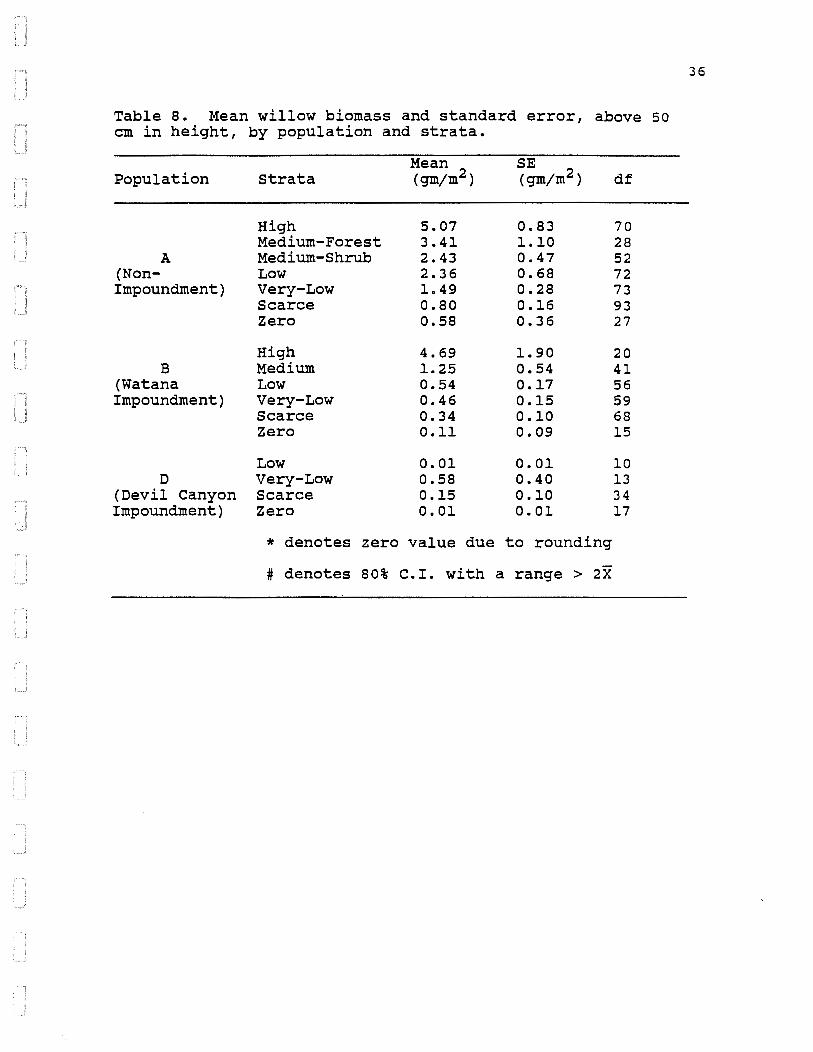
Table a. Mean willow biomass and standard error, above 50 em in height, by population and strata.
Population
A (NonImpoundment)
B (Watana Impoundment)
D (Devil Canyon Impoundment)
Strata
High Medium-Forest Medium-Shrub Low Very-Low Scarce Zero
High Medium Low Very-Low Scarce Zero
Low Very-Low Scarce Zero
Mean (gmjm2)
5.07 3.41 2.43 2.36 1.49 0.80 0.58
4.69 1.25 0.54 0.46 0.34 0.11
0.01 0.58 0.15 0.01
SE (gmjm2)
0.83 1.10 0.47 0.68 0.28 0.16 0.36
1.90 0.54 0.17 0.15 0.10 0.09
0.01 0.40 0.10 0.01
* denotes zero value due to rounding
# denotes 80% C.I. with a range > 2X
df
70 28 52 72 73 93 27
20 41 56 59 68 15
10 13 34 17
36

Table 9. Mean mountain cranberry biomass and 80% confidence interval by population.
Population
A (NonImpoundment)
B (Watana Impoundment)
D (Devil Canyon Impoundment)
80% Confidenc~ Interval (gmjm ) ·
13.31 (11.05, 15.55)
28.01 (23.35, 32.65)
19.74 (12.21, 27.19)
37

Table 10. Average biomass and standard errors of willow, paper birch, and mountain cranberry in populations A, B, and D.
Mean Std. Error Forage-Group Population (gm;m2 ) (gm;m2 )
A 2.28 0.16 Willow B 1. 09 0.37
D 0.47 0.22
A 0.007 0.006 Paper Birch B 0.092 0.028
D 0.062 0.028
A 13.31 1.73 Cranberry B 28.01 3.46
D 19.74 5.29
38

Table 11. Average biomass and standard errors of willow and paper birch below 50 em in height for populations A, B, and D.
Forage-Group Population
A Willow B
D
A Paper Birch B
D
Mean (gm/m2)
0.56 0.62 0.12
0.000 0.027 0.005
Std. Er~or (gm/m )
0.09 0.18 0.06
0.000 0.012 0.003
39

Table 12. Average biomass and standard errors of willow and paper birch above 50 em in height for populations A, B, and D.
Forage-Group Population
A Willow B
D
A Paper Birch B
D
Mean (gm/m2)
1.72 0.47 0.35
0.007 0.063
.0.051
Std. Er~or (gm/m )
0.22 0.20 0.19
0.006 0.023 0.024
40

Table 13. Acres of forage biomass stratum to be permanently or temporarily lost by facility, for Stage I. Unless otherwise denoted with a footnote, all potential for forage biomass production is considered permanently lost.
Project Very Feature High Medium Low Low Scarce Zero Total
Impoundment 183 169 1490 3268 8190 2001 15301
Access Road1A 96 76B 104 88 136 28 528
Camps2 0 0 26 88 174 o 288
Borrow Pits3 0 o 77 275 641 25 1018
Other4 1 7 0 50 94 0 152
Total 280 251 1697 3769 9235
A - Located primarily within Population A.
B - Indicates medium shrub acreages.
2054 17287
1 - Includes only the Denali Highway-Watana access road. Assumed an average clearing width of 100 feet for this 43.6-mile road. Approximately 40 feet of this width will be revegetated after the access road is constructed.
2 - Includes the Watana construction camp and villages. Approximately 200 acres will be rehabilitated following the completion of Stage III.
3 - Includes proportionally 1/3 of the area of quarry site A, 2/3 of the area of borrow pit D, and 2/3 of the area of borrow pit E that is above the Devil Canyon impoundment. All quarry and borrow pit areas will be rehabilitated.
. 4- Includes the airport (44 acres), Watana construction
roads (80 acres), and the transmission line switchyards at Watana (12 acres) and for Gold Creek (16 acres). Approximately 30 acres u·sed in building construction roads will be rehabilitated.
5 - Figure 6 shows the location of the various features.
41

Table 14. Acres of forage biomass stratum to be permanently or temporarily lost by facility, for Stage II. Unless otherwise denoted with a footnote, all potential for forage biomass production is considered permanently lost. ·
Project Very Feature High Medium Low Low Scarce Zero Total
Impoundment 0 49A 48 323 3502 1684 5606
Access Road1B 75 6c 106 157 100 23 467
Camps2 0 0 23 0 141 36 200
Borrow Pits3 0 97A 1 252 95 0 445
Other4 0 0 14 8 90 63 175
Total 75 152 192 740 3928 1806 6893
A - Treated as low strata of population D.
B - Located primarily within population A.
c - Indicates medium shrub acreages.
1 - Includes only the Watana-Devil Canyon access road. Assumed an average clearing width of 100 feet for this 38.6-mile road. Approximately 40 feet of this width will be revegetated after the access road is constructed.
2 - Includes the Devil Canyon construction camp and villages, which will be rehabilitated following the completion of Stage III.
3 - Includes quarry site K. All quarry and borrow pit areas will be rehabilitated.
4- Includes the railroad (73 acres), railhead facility (40 acres), Devil Canyon construction roads (50 acres), and the Devil Canyon transmission line switchyards (12 acres). Approximately 22 acres cleared for the railroad and 19 acres cleared for construction roads will be rehabilitated after construction.
5 - Figure 6 shows the location of the various features.
42

Table 15. Acres of forage biomass stratum to be permanently or temporarily lost by facility, for Stage III. Unless otherwise denoted with a footnote, all potential for forage biomass production is considered permanently lost.
Project Very Feature High Medium Low Low Scarce Zero Total
Impoundmentl 86 543 2893 6531 849 5474 16376
Borrow Pits2 0 o 40 164 531 12 747
Total 86 543 2933 6695 1380 5486 17123
1 - Includes only the area inundated by Stage III.
2 - Includes proportionally 2/3 of the area of borrow pit A, 1/3 of the area of borrow pit D, and 1/3 of the area of borrow pit E that is above the Devil Canyon impoundment.
3 - Figure· 6 shows the location of the various features.
All borrow pit areas will be rehabilitated.
43

Table 16. Kg of willow biomass, pooled over height categories, to be permanently or temporarily lost by facility and stratum, for Stage I. Unless otherwise denoted with a footnote, all potential for forage biomass production is considered permanently lost.
Project Very Feature High Medium Low Low Scarce Zero Total
I~poundment 5081 1190 6995 13887 33476 1620 62248
Access Rd1A 2409 1006B 1301 709 627 79 6130
Camps2 0 0 122 374 711 0 1207
Borrow Pits3 o o 362 1169 2620 20 4170
Other4 28 49 0 213 384 o 674
Total 7517 2245 8779 16351 37819 1919 74430
A - Located primarily within Population A.
B - Indicates medium shrub acreages.
1 - Includes only the Denali Highway-Watana access road. Assumed an average clearing width of 100 feet for this 43.6-mile road. Approximately 40 feet of this width will be revegetated after the access road is constructed.
2 - Includes the Watana construction camp and villages. Approximately 200 acres will be rehabilitated following the completion of Stage III.
3 - Includes proportionally 1/3 of the area of quarry site A, 2/3 of the area of borrow pit D, and 2/3 of the area of borrow pit E that is above the Devil Canyon impoundment. All quarry and borrow pit areas will be rehabilitated.
4- Includes the airport (44 acres), Watana construction roads (80 acres), and the transmission line switchyards at Watana (12 acres) and for Gold Creek (16 acres). Approximately 30 acres used in building construction roads will be rehabilitated.
44

Table 17. Kg of willow biomass, pooled over height categories, to be permanently or temporarily lost by stratum and facility, for Stage II. Unless otherwise denoted with a footnote, all potential for forage biomass production is considered permanently lost.
Project Very Feature High Medium Low Low Scarce Zero Total
Impoundment o 34A 33 1007 2835 341 4249
Access Rd1B 1882 79c 1326 1264 461 65 5078
Camps2 o o 16 0 114 7 137
Borrow Pits3 0 67A 1 785 77 0 930
Other4 0 o 10 25 73 13 120
Total 1882 180 1385 3081 3560 426 10513
A - Treated as low strata of population D.
B - Located primarily within population A.
C - Indicates medium shrub acreages.
1 - Includes only the Watana-Devil Canyon access road. Assumed an average clearing width of 100 feet for this 38.6-mile road. Approximately 40 feet of this width will be revegetated after the access road is constructed.
2 - Includes the Devil Canyon construction camp and villages, which will be rehabilitated following the completion of Stage III.
3 - Includes quarry site K. All quarry and borrow pit areas will be rehabilitated.
4- Includes the railroad (73 acres), railhead facility (40 acres), Devil Canyon construction roads (50 acres), and the Devil Canyon transmission line switchyards (12 acres) . Approximately 22 acres cleared for the railroad and 19 acres cleared for construction roads will be rehabilitated after construction.
45

Table 18. Kg of willow biomass, pooled over height categories, to be permanently or temporarily lost by facility and stratum, for Stage III. Unless otherwise denoted with a footnote, all potential for forage biomass production is considered permanently lost.
Project Very Feature High Medium Low Low Scarce Zero Total
Impoundment1 2388 3824 13581 27753 3470 4431 55446
Borrow Pits2 0 0 188 697 2170 10 3065 -----
Total 2388 3824 13769 28449 5641 4440 58511
1 - Includes only the area inundated by Stage III.
2 - Includes proportionally 2/3 of the area of borrow pit A, 1/3 of the area of borrow pit D, and 1/3 of the area of borrow pit E that is above the Devil Canyon impoundment.
All borrow pit areas will be rehabilitated.
46

Table 19. Upper 80% confidence limit of kg of willow biomass, pooled over height categories, to be permanently or temporarily lost by facility and stratum, for Stage I.
Project Very Feature High Medium Low Low Scarce
Impoundment 7473 1703 8924 18913 43088
Access Rd1A 2856 1221B 1679 858 771
camps2 0 0 156 509 915
Borrow Pits3 0 0 461 1592 3372
Other4 41 71 0 289 495
Total 10369 2995 11221 22161 48641
A - Located primarily within Population A.
B- Indicates medium.shrub acreages.
Zero
2834
139
0
35
0
3009
Total
82935
7524
1580
5461
895 -----98396
1 - Includes only the Denali Highway-Watana access road. Assumed an average clearing width of 100 feet for this 43. 6-mile road. · Approximately 40 feet of this width will be revegetated after the access road is constructed.
2 - Includes the Watana construction camp and villages. Approximately 200 acres will be rehabilitated following the completion of Stage III. ·
3 - Includes proportionally 1/3 of the area of quarry site A, 2/3 of the area of borrow pit D, and 2/3 of the area of borrow pit E that is above the Devil Canyon impoundment. All quarry and borrow pit areas will be rehabilitated.
4- Includes the airport (44 acres), Watana construction roads (80 acres), and the transmission line switchyards at Watana (12 acres) and for Gold creek (16 acres). Approximately 30 acres ~sed in building construction roads will be rehabilitated •
. -.
47
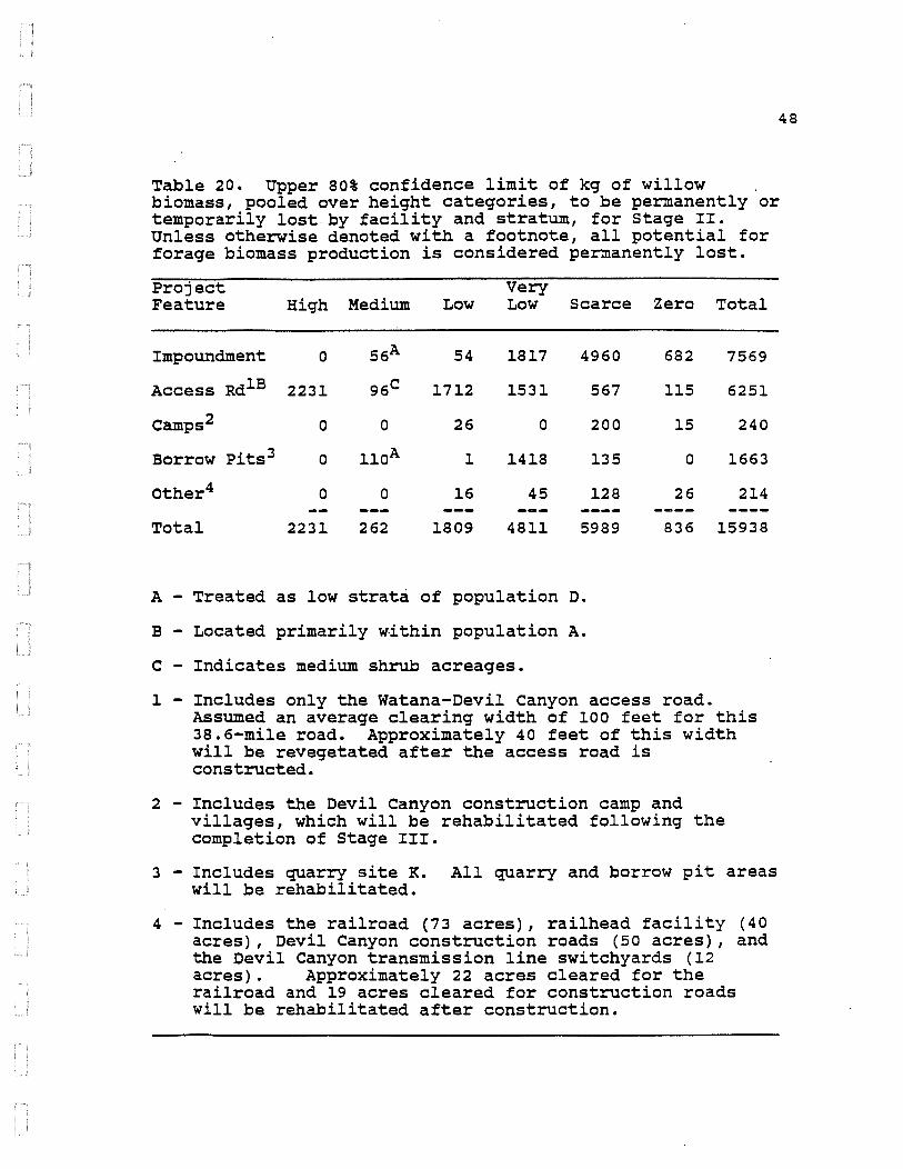
48
Table 20. Upper 80% confidence limit of kg of willow biomass, pooled over height categories, to be permanently or temporarily lost-by facility and stratum, for stage II. Unless otherwise denoted with a footnote, all potential for forage biomass production is considered permanently lost.
Project Very Feature High Medium Low Low Scarce Zero Total
Impoundment 0 56A 54 1817 4960 682 7569
Access Rd1B 2231 96c 1712 1531 567 115 6251
Camps2 0 o 26 0 200 15 240
Borrow Pits3 0 110A 1 1418 135 0 1663
Other4 0 0 16 45 128 26 214
Total 2231 262 1809 4811 5989 836 15938
A - Treated as low strata of population D.
B - Located primarily within population A.
C - Indicates medium shrub acreages.
l - Includes only the Watana-Devil canyon access road. Assumed an average clearing width of 100 feet for this 38.6-mile road. Approximately 40 feet of this width will be revegetated after the access road is constructed.
2 - Includes the Devil Canyon construction camp and villages, which will be rehabilitated following the completion of Stage III.
3 - Includes quarry site K. All quarry and borrow pit areas will be rehabilitated.
4- Includes the railroad (73 acres), railhead facility (40 acres), Devil Canyon construction roads (50 acres), and the Devil Canyon transmission line switchyards (12 acres) • Approximately 22 acres cleared for the railroad and 19 acres cleared for construction roads will be rehabilitated after construction.

Table 21. Upper 80% confidence limit of kg of willow biomass, pooled over height categories, to be permanently or temporarily lost by facility and stratum, for Stage III. Unless otherwise denoted with a footnote, all potential for forage biomass production is considered permanently lost.
Project Very Feature High Medium Low Low Scarce Zero Total
Impoundment1 3512 5472 17328 37796 4467 7754 76328
Borrow Pits2 0 0 240 949 2794 17 3999 -----Total 3512 5472 17567 38745 7260 7771 80327
1 - Includes only the area inundated by Stage III.
2 - Includes proportionally 2/3 of the area of borrow pit A, 1/3 of the area of borrow pit D, and 1/3 of the area of borrow pit E that is above the Devil canyon impoundment.
All borrow pit areas will be rehabilitated.
49

Table 22. Kg of willow biomass over 50 em in height, to be permanently or temporarily lost by facility and stratum, for Stage I. Unless otherwise denoted with a footnote, all potential for forage biomass production is considered permanently lost.
Project Very Feature High Medium Low Low Scarce
Impoundment 3473 855 3256 6084 11269
Access RdlA 1970 747B 993 531 440
Camps2 0 0 57 164 239
Borrow Pits3 0 0 168 512 882
Other4 19 35 0 93 129
Total 5462 1638 4475 7383 12960
A - Located primarily within Po·pulation A.
B - Indicates medium shrub acreages.
Zero
891
66
0
11
0
968
Total
25828
4747
460
1573
277 -----32886
1 - Includes only the Denali Highway-Watana access road. Assumed an average clearing width of 100 feet for this 43.6-mile road. Approximately 40 feet of this width will be revegetated after the access road is constructed.
2 - Includes the Watana construction camp and villages. Approximately 200 acres will be rehabilitated following the completion of Stage III.
3 - Includes proportionally 1/3· of the area of quarry site A, 2/3 of the area of borrow pit D, and 2/3 of the area of borrow pit E that is above the Devil Canyon impoundment. All quarry and borrow pit areas will be rehabilitated.
4- Includes the airport (44 acres), Watana construction roads (80 acres), and the transmission line switchyards at Watana (12 acres) and for Gold Creek (16 acres). Approximately 30 acres used in building construction roads will be rehabilitated.
50
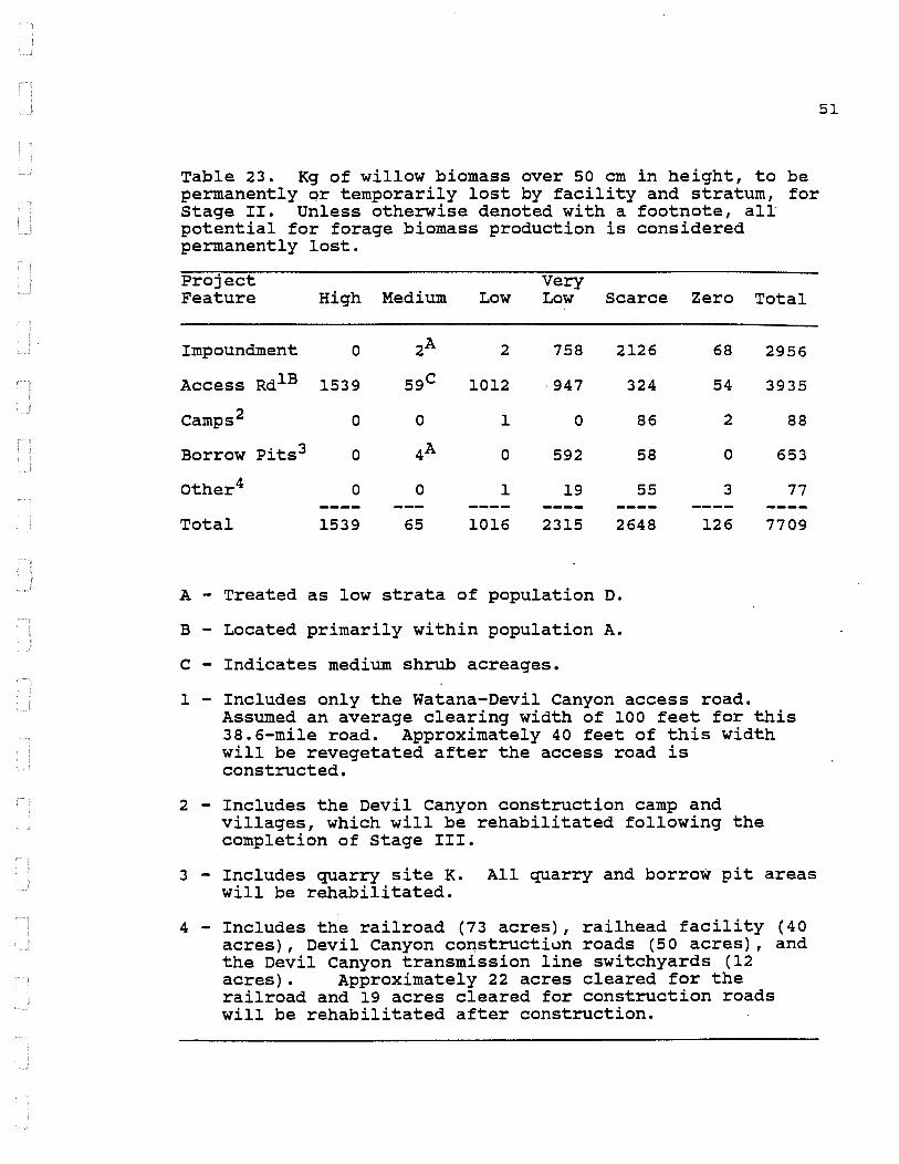
Table 23. Kg of willow biomass over 50 em in height, to be permanently ~r temporarily lost by facility and stratum, for Stage II. Unless otherwise denoted with a footnote, all potential for forage biomass production is considered permanently lost.
Project Very Feature High Medium Low Low Scarce Zero Total
Impoundment 0 2A 2 758 2126
Access RdlB 1539 59c 1012 947 324
Camps2 0 0 1 0 86
Borrow Pits3 0 4A 0 592 58
Other4 0 0 1 19 55
Total 1539 65 1016 2315 2648
A - Treated as low strata of population D.
B - Located primarily within population A.
c - Indicates medium shrub acreages.
68
54
2
0
3
126
1 - Includes only the Watana-Devil Canyon access road.
2956
3935
88
653
77
7709
Assumed an average clearing width of 100 feet for this 38.6-mile road. Approximately 40 feet of this width will be revegetated after the access road is constructed.
2 - Includes the Devil Canyon construction camp and villages, which will be rehabilitated following the completion of Stage III.
3 - Includes quarry site K. All quarry and borrow pit areas will be rehabilitated.
4- Includes the railroad (73 acres), railhead facility (40 acres), Devil canyon co~structiun roads (50 acres), and the Devil Canyon transmission line switchyards (12 acres). Approximately 22 acres cleared for the railroad and 19 acres cleared for construction roads will be rehabilitated after construction.
51

Table 24. Kg of willow biomass over 50 em in height, to be permanently or temporarily lost by facility and stratum, for Stage III. Unless otherwise denoted with a footnote, all potential for forage biomass production is considered permanently lost.
Project Very Feature High Medium Low Low Scarce Zero Total
Impoundment1 1632 2747 6322 12158 1168 2437 26465
Borrow Pits2 0 0 87 305 731 5 1129 -----
Total 1632 2747 6410 12464 1899 2442 27593
1 - Includes only the area inundated by Stage III.
2 - Includes proportionally 2/3 of the area of borrow pit A, 1/3 of the area of borrow pit D, and 1/3 of the area of borrow pit E that is above the Devil Canyon impoundment.
All borrow pit areas will be rehabilitated.
52

Table 25. Upper 80% confidence limit of the kg of willow biomass over 50 em in height, to be permanently or temporarily lost by facility and stratum, for stage I. Unless otherwise denoted with a footnote, all potential for forage biomass production is considered permanently lost.
Project Feature High Medium Low
Impoundment 5340 1334 4583
Access Rd1A 2386 935B 1360
Camps2 0 o 80
Borrow Pits3 0 0 237
Other4 29 55 0
Very Low Scarce Zero Total
8597 15247 1782 36881
659 556 119 6014
232 324 0 635
723 1193 22 2176
132 175 0 391
Total 7754 2324 6259 10342 17495 1923 46097
A - Located primarily within Population A.
B - Indicates medium shrub acreages.
1 - Includes only the Denali Highway-Watana access road. Assumed an average clearing width of 100 feet for this 43.6-mile road. Approximately 40 feet of this width will be revegetated after the access road is constructed.
2 - Includes the Watana construction camp and villages. Approximately 200 acres will be rehabilitated following the completion of stage III.
3 - Includes proportionally 1/3 of the area of quarry site A, 2/3 of the area of borrow pit D, and 2/3 of the area of borrow pit E that is above the Devil Canyon impoundment. All quarry and borrow pit areas will be rehabilitated.
4- Includes the airport (44 acres), Watana construction roads (80 acres), and the transmission line switchyards at Watana (12 acres) and for Gold Creek (16 acres). Approximately 30 acres used in building construction roads will be rehabilitated.
53

Table 26. Upper 80% confidence limit on the kg of willow biomass over 50 em in height, to be permanently or temporarily lost by facility and stratum, for Stage II. Unless otherwise denoted with a footnote, all potential for forage biomass production is considered permanently lost.
Project Very Feature High Medium Low Low Scarce Zero Total
Impoundment 0 4A 4 1464 4110 136 5718
Access Rd1B 1864 74c 1386 1176 409 98 5005
Camps2 0 0 2 0 166 3 170
Borrow Pits3 0 aA 0 1142 112 0 1262
Other4 0 0 1 36 106 5 148
Total 1864 86 1393 3818 4901 242 12303
A - Treated as low strata of population D.
B - Located primarily within population A.
c - Indicates medium shrub acreages.
1 - Includes only the Watana-Devil Canyon access road. Assumed an average clearing width of 100 feet for this 38.6-mile road. Approximately 40 feet of this width will be revegetated after the access road is constructed.
2 - Includes the Devil ·canyon construction camp and villages, which will be rehabilitated following the completion of stage III.
3 - Includes quarry site K. All quarry and borrow pit areas will be rehabilitated.
4- Includes the railroad (73 acres), railhead facility (40 acres), Devil Canyon construction roads (50 acres), and the Devil Canyon transmission line switchyards (12 acres) . Approximately ·22 acres cleared for the railroad and 19 acres cleared for construction roads will be rehabilitated after construction.
54
Table 27. Upper 80% confidence limit on the kg of willow biomass over 50 em in height, to be permanently or temporarily lost by stratum and facility, for Stage III. Unless otherwise denoted with a footnote, all potential for forage biomass production is considered permanently lost.
Project Very Feature High Medium Low Low Scarce Zero Total
Impoundment1 2509 4285 8898 17180 1581 4874 39327
Borrow Pits2 0 0 123 431 989 11 1554 -----Total 2509 4285 9021 17612 2569 4884 40881
1 - Includes only the area inundated by Stage III.
2 - Includes proportionally 2/3 of the area of borrow pit A, 1/3 of the area of borrow pit D, and 1/3 of the area of borrow pit E that is above the Devil Canyon impoundment.
All borrow pit areas will be rehabilitated.
55

Table 28. Kg of paper birch biomass pooled over height categories, to be permanently or temporarily lost by facility and stratum for Stage I. Unless otherwise denoted with a footnote, all potential for forage biomass production is considered permanently lost.
ProJect Very Feature High Medium Low Low Scarce
Impoundment 0 9 181 1428 3513
Access RdlA 0 oB 13 0 2
Camps2 0 0 3 39 75
Borrow Pits3 0 0 9 120 275
Other4 0 0 0 22 40
Total 0 9 206 1609 3906
A - Located primarily within Population A.
B - Indicates medium shrub acreages.
Zero Total
1045 6176
0 15
0 116
13 418
0 63 -----1058 6788
l - Includes only the Denali Highway-Watana access road. Assumed an average clearing width of 100 feet for this 43.6-mile road. Approximately 40 feet of this width will be revegetated after the access road is constructed.
2 - Includes the Watana construction camp and villages. Approximately 200 acres will be rehabilitated following the completion of Stage III.
3 - Includes proportionally l/3 of the area of quarry site A, 2/3 of the area of borrow pit D, and 2/3 of the area of borrow pit E that is above the Devil canyon impoundment. All quarry and borrow pit areas will be rehabilitated.
4- Includes the airport (44 acres), Watana construction roads (80 acres), and the transmission line switchyards at Watana (12 acres) and for Gold Creek (16 acres). Approximately 30 acres used in building construction roads will be rehabilitated.
56

Table 29. Kg of paper birch biomass pooled over height categories, to be permanently or temporarily lost by facility and stratum, for Stage II. Unless otherwise denoted with a footnote, all potential for forage biomass production is considered permanently lost.
Project Very Feature High Medium Low Low Scarce Zero Total
Impoundment 0 oA 0 0 1616 1840 3457
Access RdlB 0 oC 13 0 2 0 15
Camps2 o o 0 0 65 39 105
Borrow Pits3 o 1A 0 0 44 0 45
Other4 o 0 0 0 42 69 110
Total o 1 14 0 1768 1948 3731
A - Treated as low strata of· population D.
B - Located primarily within population A.
c - Indicates medium shrub acreages.
1 - Includes only the Watana-Devil Canyon access road. Assumed an average clearing width of 100 feet for this 38.6-mile road. Approximately 40 feet of this width will be revegetated after the access road is constructed.
2 - Includes the Devil Canyon construction camp and villages, which will be rehabilitated following the completion of Stage III.
3 - Includes quarry site K. All quarry and borrow pit areas will be rehabilitated.
4- Includes the railroad (73 acres), railhead facility (40 acres), Devil canyon construction roads (50 acres), and the Devil Canyon transmission line switchyards (12 acres) • Approximately 22 acres cleared for the railroad and 19 acres cleared for construction roads will be rehabilitated after construction.
57
Table 30. Kg of paper birch biomass pooled over height categories, to be permanently or temporarily lost by facility and stratum, for Stage III. Unless otherwise· denoted with a footnote, all potential for forage biomass production is considered permanently lost.
Project Very Feature High Medium Low Low Scarce Zero Total
Impoundment1 0 29 351 2855 364 2858 6456
Borrow Pits2 0 0 5 72 228 6 311 -----Total 0 29 356 2926 592 2864 6767
1 - Includes only the area inundated by Stage III.
2 - Includes proportionally 2/3 of the area of borrow pit A, 1/3 of the area of borrow pit D, and 1/3 of the area of borrow pit E that is above the Devil Canyon impoundment.
All borrow pit areas will be rehabilitated.
58

Table 31. Upper 80% confidence limit on kg of paper birch biomass pooled over height categories, to be permanently or temporarily lost by facility and stratum for Stage I. Unless otherwise denoted with a footnote, all potential for forage biomass production is considered permanently lost.
Project Very Feature High Medium Low Low Scarce Zero Total
Impoundment 0 19 356 2341 -5701 1676 10092
Access RdlA 0 oB 29 0 5 0 34
Camps2 0 0 6 63 ~21 0 190
Borrow Pits3 o o 18 197 446 21 683
Other4 0 1 0 36 65 0 102
Total 0 19 409 2637 6339 1697 11101
A - Located primarily within Population A. . .
B - Indicates medium shrub acreages.
1 - Includes only the.Denali Highway-Watana access road. Assumed an average clearing width of 100 feet for this 43.6-mile road. Approximately 40 feet of this width will be revegetated after the access road is constructed.
2 - Includes the Watana construction camp and villages. Approximately 200 acres will be rehabilitated following the completion of Stage III.
3 - Includes proportionally 1/3 of the area of quarry site A, 2/3 of the area of borrow pit D, and 2/3 of the area of borrow pit E that is above the Devil Canyon impoundment. All quarry and borrow pit areas will be rehabilitated.
4- Includes the airport (44 acres), Watana construction roads (80 acres), and the transmission line switchyards at Watana (12 acres) and for Gold creek (16 acres). Approximately 30 acres used in building construction roads will be rehabilitated.
59

Table 32. Upper 80% confidence limit on kg of paper birch biomass pooled over height categories, to be permanently or temporarily lost by facility and stratum, for Stage II. Unless otherwise denoted with a footnote, all potential for forage biomass production is considered permanently lost.
Project Very Feature High Medium Low Low Scarce Zero Total
Impoundment 0 oA 0 0 2792 4103 6896
Access RdlB 0 oC 30 0 4 0 33
Camps2 o 0 0 0 112 88 200
Borrow Pits3 0 1A 0 0 76 0 77
Other4 o 0 0 0 72 154 225
Total o 1 30 0 3056 4344 7431
A - Treated as low strata of population D.
B - Located primarily within population A.
c - Indicates medium shrub acreages.
1 - Includes only the Watana-Devil canyon access road. Assumed an average clearing width of 100 feet for this 38.6-mile road. Approximately 40 feet of this width will be revegetated after the access road is constructed.
2 - Includes the Devil Canyon construction camp and villages, which will be rehabilitated following the completion of Stage III.
3 - Includes quarry site K. All quarry and borrow pit areas will be rehabilitated.
4- Includes the railroad (73 acres), railhead facility (40 acres), Devil Canyon construction roads (50 acres), and the Devil Canyon transmission line switchyards (12 acres). Approximately 22 acres cleared for the railroad and 19 acres cleared for construction roads will be rehabilitated after construction.
60

Table 33. Upper 80% confidence limit on kg of paper birch biomass pooled over height categories, to be permanently or temporarily lost by facility and stratum, for stage III. Unless otherwise denoted with a footnote, all potential for forage biomass production is considered permanently lost.
Project Very Feature High Medium Low Low Scarce Zero Total
Impoundment1 0 59 691 4678 591 4586 10605
Borrow Pits2 0 0 10 118 370 10 507 -----
Total 0 59 700 4796 961 4596 11112
l - Includes only the area inundated by stage III.
2 - Includes proportionally 2/3 of the area of borrow pit A, l/3 of the area of borrow pit D, and l/3 of the area of borrow pit E that is above the Devil canyon impoundment.
All borrow pit areas will be rehabilitated.
61

Table 34. Kg of paper birch biomass over 50 em in height, to be permanently or temporarily lost by facility and stratum for stage I. Unless otherwise denoted with a footnote, all potential for forage biomass production is considered permanently lost.
Project Very Feature High Medium Low Low Scarce
Impoundment 0 7 139 820 2817
Access RdlA 0 oB ll 0 2
Camps2 0 0 2 22 60
Borrow Pits3 0 0 7 69 221
Other4 0 0 0 13 32
Total 0 7 159 924 3132
A - Located primarily within Population A.
B - Indicates medium shrub acreages.
Zero Total
769 4552
0 12
0 84
10 306
0 45 -----779 5000
l - Includes only the Denali Highway-Watana access road. Assumed an average clearing width of 100 feet for this 43.6-mile road. Approximately 40 feet of this width will be revegetated after the access road is constructed.
2 - Includes the Watana construction camp and villages. Approximately 200 acres will be rehabilitated following the completion of Stage III.
3 - Includes proportionally 1/3 of the area of quarry site A, 2/3 of the area of borrow pit D, and 2/3 of the area of borrow pit E that is above the Devil canyon impoundment. All quarry and borrow pit areas will be rehabilitated.
4- Includes the airport (44 acres), Watana construction roads (80 acres), and the transmission line switchyards at Watana (12 acres) and for Gold Creek (16 acres). Approximately 30 acres used in building construction roads will be rehabilitated.
62

Table 35. Kg of paper birch biomass over 50 em in height, to be permanently or temporarily lost by facility and stratum, for Stage II. Unless otherwise denoted with a footnote, all potential for forage biomass production is considered permanently lost.
Project Very Feature High Medium Low Low Scarce Zero Total
Impoundment 0 oA 0 0 1290 1458 2749
Access Rd1B 0 oC 11 0 1 0 12
Camps2 0 0 0 0 52 31 83
Borrow Pits3 o 1A 0 0 35 0 36
Other4 0 0 0 0 33 55 88
Total o 1 11 0 1411 1544 2968
A - Treated as low strata of population D.
B - Located primarily within population A.
c - Indicates medium shrub acreages.
1 - Includes only the Watana-Devil Canyon access road. Assumed an average clearing width of 100 feet for this 38.6-mile road. Approximately 40 feet of this width will be revegetated after the access road is constructed.
2 - Includes the Devil canyon construction camp and villages, which will be rehabilitated following the completion of Stage III.
3 - Includes quarry site K. All quarry and borrow pit areas will be rehabilitated.
4- Includes the railroad (73 acres), railhead facility (40 acres), Devil canyon construction roads (50 acres), and the Devil Canyon transmission line switchyards (12 acres). Approximately 22 acres cleared for the railroad and 19 acres cleared for construction roads will be rehabilitated after construction.
63

Table 36. Kg of paper birch biomass over 50 em in height, to be permanently or temporarily lost by facility and stratum, for Stage III. Unless otherwise denoted with a footnote, all potential for forage biomass production is considered permanently lost.
Project Very Feature High Mediwn Low Low Scarce Zero Total
Impoundment1 0 22 269 1639 292 2105 4327
Borrow Pits2 0 0 4 41 183 5 232 -----Total 0 22 273 1680 475 2109 4559
1 - Includes only the area inundated by Stage III.
2 - Includes proportionally 2/3 of the area of borrow pit A, 1/3 of the area of borrow pit D, and 1/3 of the area of borrow pit E that is above the Devil Canyon impoundment.
All borrow pit areas will be rehabilitated.
64

Table 37. Upper 80% confidence limit of kg of paper birch biomass over 50 em in height, to be permanently or temporarily lost by facility and stratum for Stage I. Unless otherwise denoted with a footnote, all potential for forage biomass production is considered permanently lost.
Project Very Feature High Medium Low Low Scarce Zero Total
Impoundment 0 16 308 1296 4740 1280 7639
Access Rd1A 0 oB 27 0 3 0 31
Camps2 o 0 5 35 101 0 141
Borrow Pits3 o 0 16 109 371 16 512
Other4 0 1 0 20 54 0 75
Total 0 16 356 1460 5269 1296 8397
A - Located primarily within Population A.
B - Indicates medium shrub acreages.
1 - Includes only the Denali Highway-Watana access road. Assumed an average clearing width of 100 feet for this 43.6-mile road. Approximately 40 feet of this width will be revegetated after the access road is constructed.
2 - Includes the Watana construction camp and villages. Approximately 200 acres will be rehabilitated following the completion of Stage III.
3 - Includes proportionally 1/3 of the area of quarry site A, 2/3 of the area of borrow pit D, and 2/3 of the area of borrow pit E that is above the Devil Canyon impoundment. All quarry and borrow pit areas will be rehabilitated.
4- Includes the airport (44 acres), Watana construction roads (80 acres), and the transmission line switchyards at Watana (12 acres) and for Gold Creek (16 acres). Approximately 30 acres used in building construction roads will be rehabilitated.
65
Table 38. Upper 80% confidence limit of kg of paper birch biomass over 50 em in height, to be permanently or temporarily lost by facility and stratum, for Stage II. Unless otherwise denoted with a footnote, all potential for forage biomass production is considered permanently lost.
Project Very Feature High Medium Low Low Scarce Zero Total
Impoundment 0 oA 0 0 2211 3237 5449
Access RdlB 0 oC 28 0 2 0 30
Camps2 o 0 0 0 89 69 158
Borrow Pits3 0 1A 0 0 60 0 61
Other4 0 0 0 0 57 121 178
Total o 1 29 0 2419 3428 5876
A - Treated as low strata of population D.
B - Located primarily within population A.
C - Indicates medium shrub acreages.
1 - Includes only the Watana-Devil canyon access road. Assumed an average clearing width of 100 feet for this 38.6-mile road. Approximately 40 feet of this width will be revegetated after the access road is constructed.
2 - Includes the Devil canyon construction camp and villages, which will be rehabilitated following the completion of Stage III.
3 - Includes quarry site K. All quarry and borrow pit areas will be rehabilitated.
4- Includes the railroad (73 acres), railhead facility (40 acres), Devil Canyon construction roads (50 acres), and the Devil Canyon transmission line switchyards (12 acres) . Approximately 22 acres cleared for the railroad and 19 acres cleared for construction roads will be rehabilitated after construction.
66

Table 39. Upper 80% confidence limit on kg of paper birch biomass over 50 em in height, to be permanently or temporarily lost by facility and stratum, for Stage III. Unless otherwise denoted with a footnote, all potential for forage biomass production is considered permanently lost.
Project Very Feature High Medium Low Low Scarce Zero Total
Impoundment1 0 51 597 2590 491 3500 7229
Borrow Pits2 0 0 8 65 307 8 388 -----Total 0 51 605 2655 799 3508 7618
1 - Includes only the area inundated by Stage III.
2 - Includes proportionally 2/3 of the area of borrow pit A, 1/3 of the area of borrow pit D, and 1/3 of the area of borrow pit E that is above the Devil Canyon impoundment.
All borrow pit areas will be rehabilitated.
67

Table 40. Kg of mountain cranberry to be permanently or temporarily lost by facility for Stage I. Unless otherwise denoted with a footnote, all potential for forage biomass production is considered permanently lost.
Project Mean Upper SO% C.L. Feature Mt. cranberry Mt. Cranberry
Impoundment 1,734,467 2,021,791
Access Rd1A 28,441 32,228
Camps2 32,647 38,055
Borrow Pits3 115,397 134,513
Other4 17,230 20,084
--------- --------Total 1,928,182 2,247,670
A - Located primarily within Population A.
1 - Includes only the Denali Highway-Watana access road. Assumed an average clearing width of 100 feet for this 43.6-mile road. Approximately 40 feet of this width will be revegetated after the access road is constructed.
2 - Includes the Watana construction camp and villages. Approximately 200 acres will be rehabilitated following the completion of Stage III.
3 - Includes proportionally 1/3 of the area of quarry site A, 2/3 of the area of borrow pit D, and 2/3 of the area of borrow pit E that is above the Devil Canyon impoundment. All quarry and borrow pit areas will be rehabilitated.
4- Includes the airport (44 acres), Watana construction roads (SO acres), and the transmission line switchyards at Watana (12 acres) and for Gold Creek (16 acres). Approximately 30 acres used in building construction roads will be rehabilitated.
68

.Table 41. Kg of mountain cranberry to be permanently or. temporarily lost by facility for Stage II. Unless otherwise denoted with a footnote, all potential for forage biomass production is considered permanently lost.
Project Mean Upper 80% C.L. F~ature Mt. cranberry Mt. Cranberry
Impoundment 447,851 616,873
Access Rd1A 25,155 29,389
camps2 15,978 22,008
Borrow Pits3 35,550 48,967
Other4 13,980 19,257 --------- --------Total 538,514 736,493
A - Located primarily within Population A.
1 - Includes only the Denali Highway-watana access road. Assumed an average clearing width of 100 feet for this 43.6-mile road. Approximately 40 feet of this width will be revegetated after the access road is constructed.
2 - Includes the Watana construction camp and villages. Approximately 200 acres will be rehabilitated following the completion of Stage III.
3 - Includes proportionally 1/3 of the area of quarry site A, 2/3 of the area of borrow pit D, and 2/3 of the area of borrow pit E that is above the Devil Canyon impoundment. All quarry and borrow pit areas will be rehabilitated.
4- Includes the airport (44 acres), Watana construction roads (80 acres), and the transmission line switchyards at Watana (12 acres) and for Gold Creek (16 acres). Approximately 30 acres used in building construction roads will be rehabilitated.
69

Table 42. Kg of mountain cranberry to be permanently or temporarily lost by facility for Stage III. Unless otherwise denoted with a footnote, all potential for forage biomass production is considered permanently lost.
Project Mean Upper 80% C.L. Feature Mt. Cranberry Mt. Cranberry
Impoundment 1,856,326 2,163,835
Borrow Pits1 84,677 98,705
--------- ---------Total 1,941,003 2,262,540
1 - Includes proportionally 1/3 of the area of quarry site A, 2/3 of the area of borrow pit D, and 2/3 of the area of borrow pit E that is above the Devil Canyon impoundment. All quarry and borrow pit areas will be rehabilitated.
70
Table 43. The mean and upper 80% confidence limit on the amount of biomass lost, by stage and species.
Project Stage
I
II
III
Forage-Group
Willow Paper Birch Mt. Cranberry
Willow Paper Birch Mt. Cranberry
Willow Paper Birch Mt. Cranberry
Biomass 80% Upper Limit (Kg) (Kg)
74,430 98,396 6,788 11,101
1,928,182 2,247,670
10,513 15,938 3,731 7,431
538,514 736,493
58,511 80,327 6,767 11,112
1,941,003 2,262,540
71

Table 44. The mean and upper 80% confidence limit on the amount of biomass (above 50 em in height) lost, by stage and species.
Project Forage- Biomass 80% Upper Limit Stage Group (Kg) (Kg)
I Willow 32,886 46,097 Paper Birch 5,000 8,397
II Willow 7,709 12,303 Paper Birch 2,968 5,876
III Willow 27,593 40,881 Paper Birch 4,559 7,618
72
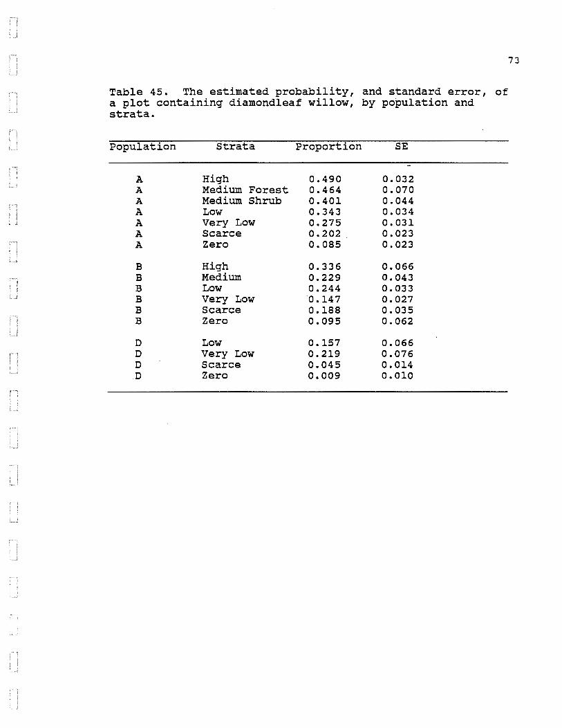
Table 45. The estimated probability, and standard error, of a plot containing diamondleaf willow, by population and strata.
Population Strata Proportion SE
A High 0.490 0.032 A Medium Forest 0.464 0.070 A Medium Shrub 0.401 0.044 A Low 0.343 0.034 A Very Low 0.275 0. 031 A Scarce 0.202 0.023 A Zero 0.085 0.023
B High 0.336 0.066 B Medium 0.229 0.043 B Low 0.244 0.033 B Very Low 0.147 0.027 B Scarce 0.188 0.035 B Zero 0.095 0.062
D Low 0.157 0.066 D Very Low 0.219 0.076 D Scarce 0.045 0.014 D Zero 0.009 0.010
73

Table 46. The estimated probability, and standard error, of a plot containing grayleaf willow, by population and strata.
Population Strata Proportion SE
A High 0.020 0.009 A Medium Forest 0.000 o.ooo A Medium Shrub 0.016 0.008 A Low 0.010 0.007 A Very Low 0.008 0.004 A Scarce 0.006 0.004 A Zero o.ooo 0.000
B High 0.022 0.023 B Medium 0.050 0.018 B Low 0.039 0.017 B Very Low 0.057 0.017 B Scarce 0.009 0.005 B Zero 0.010 0.009
D Low o.ooo 0.000 D Very Low 0.016 0.015 D Scarce 0.000 0.000 D Zero 0.000 0.000
74
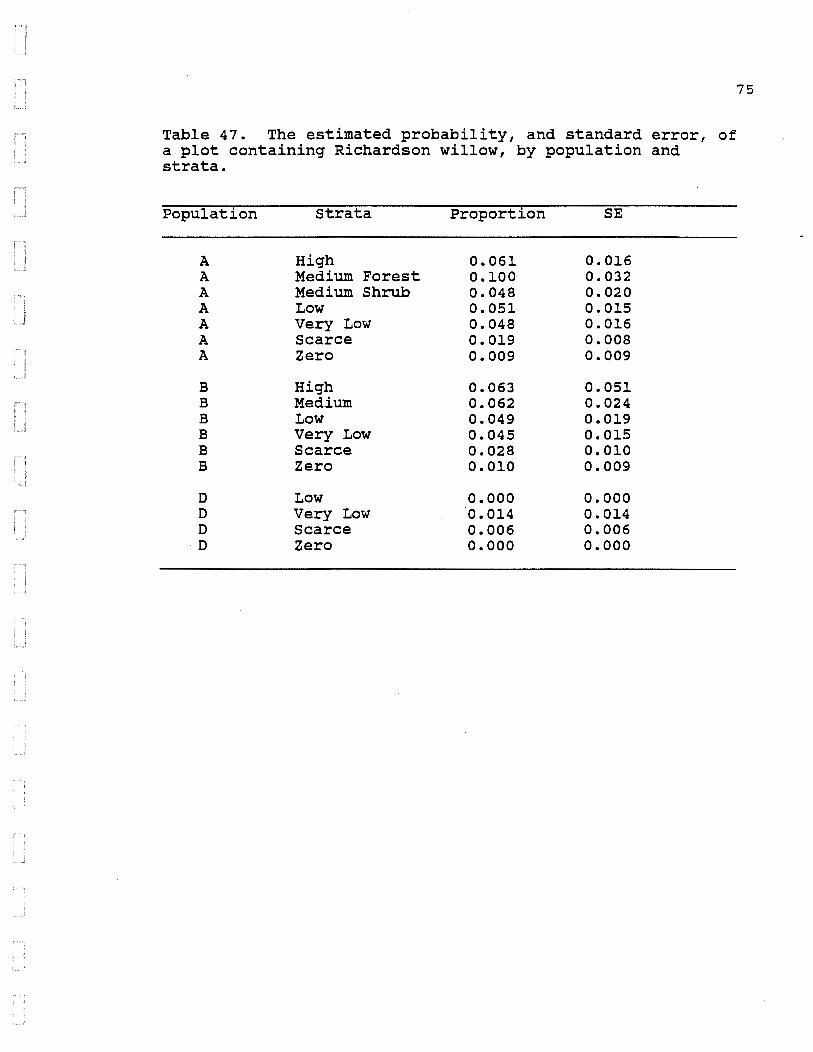
Table 47. The estimated probability, and standard error, of a plot containing Richardson willow, by population and strata.
Population Strata Proportion SE
A High 0.061 0.016 A Medium Forest 0.100 0.032 A Medium Shrub 0.048 0.020 A Low 0.051 0.015 A Very Low 0.048 0.016 A Scarce 0.019 0.008 A Zero 0.009 0.009
B High 0.063 0.051 B Medium 0.062 0.024 B Low 0.049 0.019 B Very Low 0.045 0.015 B Scarce 0.028 0.010 B Zero 0.010 0.009
D Low o.ooo 0.000 D Very Low 0.014 0.014 D Scarce 0.006 0.006
·D Zero o.ooo 0.000
75

Table 48. The estimated probability, and standard error, of a plot containing feltleaf willow, by population and strata.
Population Strata Proportion SE
A High 0.015 0.006 A Medium Forest 0.007 0.007 A Medium Shrub 0.003 0.003 A Low 0.008 0.004 A Very Low 0.000 0.000 A Scarce 0.002 0.002 A Zero 0.006 0.005
B High 0.134 0.071 B Medium 0.026 0.011 B Low 0.016 0.009 B Very Low 0.013 0.006 B Scarce 0.022 0.009 B Zero 0.011 0.011
D Low o.ooo 0.000 D Very Low o.ooo 0.000 D Scarce 0.000 0.000 D Zero 0.000 0.000
76

Table 49. The estimated probability, and standard error, of a plot containing unknown willows, by population and strata.
Population Strata Proportion SE
A High 0.072 0.017 A Medium Forest 0.115 0.034 A Medium Shrub 0.053 0.016 A Low 0.073 0.024 A Very Low 0.049 0.013 A Scarce 0.023 0.008 A Zero 0.031 0.017
B High 0.247 0.098 B Medium 0.072 0.028 B Low 0.109 0.021 B Very Low 0.070 0.024 B Scarce 0.083 0.022 B Zero 0.051 0.029
D Low 0.012 0.012 D Very Low 0.028 0.018 D Scarce 0.006 0.006 D Zero 0.018 0.019
77
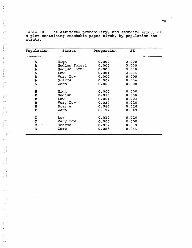
Table 50. The estimated probability, and standard error, of a plot containing reachable paper birch, by population and strata.
Population Strata Proportion SE
A High o.ooo 0.000 A Medium Forest 0.000 0.000 A Medium Shrub 0.000 0.000 A Low 0.004 0.004 A Very Low 0.000 0.000 A Scarce 0.007 0.004 A Zero 0.000 0.000
B High 0.000 0.000 B Medium 0.010 0.008 B Low 0.004 0.003 B Very Low 0.032 0.010 B Scarce 0.044 0.016 B Zero 0.137 0.049
D Low 0.010 0.010 D Very Low 0.000 0.000 D Scarce 0.057 0.019 D Zero 0.085 0.044
78

Table 51. The estimated probability, and standard error, of a plot containing reachable paper birch, diamondleaf, grayleaf, Richardson, feltleaf, and unknown willows, by population.
Population Species Proportion SE
A Diamondleaf 0.281 0.0137 B willow 0.183 0.0188 D 0.133 0.0396
A Gray leaf 0.008 0.0033 B willow 0.032 0.0070 D 0.008 0.0075
A Richardson 0.039 0.0067 B willow 0.038 0.0083 D 0.009 0.0070
A Feltleaf 0.004 0.0012 B willow 0.019 0.0048 D 0.000 0.0000
A Unknown 0.048 0.0073 ·B willow 0.083 0.0131 D 0.018 0.0093
A Reachable 0.003 0.0017 B Paper 0.034 0.0080 D Birch 0.029 0.0082
79

0
0
Mllee 10
10 20 Kllometere
20
30
.... •q
figure 1. Watana. OevU Canyon. and aurroundlng area aample populetlon boundarlea for the browll Inventory atudy.
···#lttla •
00 0

Figure 2A.
(/) 0 0 0 ~ :;::)
~
Figure 2B.
(/) 0 0 0 0
t ~
0.. X ~
81
BROWSING PRESSURE ON WILLOWS BY IMPOUNDMENT AND PLANT DENSITY
2.8
2.6
2.4
2.2
2
1.8
1.6
1.4
1.2
o.a
0.6
2 3 4 5 6 7 a PLANT DENSITY (within 5 m. of plot)
Cl NON-IMPOUNDMENT + WATANA-IMPOUNDMENT
BROWSING PRESSURE ON WILLOWS BY IMPOUNDMENT AND PLANT DENSITY
2.8
2.6
2.4
2.2
2
1.8
1.6
1.4
1.2
2 3 4 5 6 7
PLANT DENSITY (within 5 m. of plot) Cl NON-IMPOUNDMENT + WATANA-IMPOUNOMENT

Figure 3.
...-.... 0 w (/) ;: 0 0:: (I)
z :J (/)
> 0 w (/) ;: 0 0:: (I)
(/)
;: 0 _j _j
;: ..__, (/) 0 0 0
BROWSING PRESSURE ON WILLOWS IN THE WATANA-IMPOUNDMENT BY ELEVATION
2.6 ~--~------------------------------------------------------~ + +
2.4 +
2.2
2
1.8 +
1.6 +
1.4
1.2
1
0.8
0.6
0.4 --r------,-- ~ ----T------r--~-------r-----r---
15 17 19 21 23 25 27
ELEVATION (hundreds of feet) EXPECTED ODDS + OBSERVED ODDS
CXl N

BROWSING PRESSURE ON WILLOWS Figure 4. IN THE NON-IMPOUNDMENT BY ELEVATION
2.6
2.4 ,--.. 0 + w (f) 2.2 ~ 0 0:: 2 Ill z :J (/)
> 1.8
+ 0 w 1.6 (f)
~ 0 0:: 1.4 Ill
(f)
~ 1.2
0 _J _J
1 ~ '-"
(/) 0.8 + 0
0 0
0.6
0.4 ---r 21 23 25 27 29 31 33 35
ELEVATION (hundreds of feet) co EXPECTED ODDS + OBSERVED ODDS
w

S M R P F I G U R f . ~ R 1 I 0 N s·. T A R T I F I f N T P 0 p U
I M p 0 U N 0 M 0 F 1 H f 1'1 0 I·J -
{ R 1 L R l l 0 N
D • • II
~ s 0 R J "I BIOMRPU L Rll' z f A 0 l 0 f p 0 0 u 1 s
S C R R C E 6 1 0 M R 5 5 c R G N I L L 0 t~
V E R I L 0 N B I 0 M q S 5 C R G N I L L 0 N
L 0 N B l 0 M q s s C R G W I L L 0 N
M E .0 l U M 8 ! 0 M q 3 c; C R G w I L L 0 w
H I G H B l 0 M R 5 s c R G w l L L 0 W
I'! R l E R
::: ;: 4 0 J Cl

F GUAE 6
STAP. llFI CRliON I M P 0 U N 0 M E N 1
I LJ I
• • • • ~ ' •
MP.r .;=- .... ;: . ' - 1'. r ! 0..:
PLJrULRl I t'\
z t tl u B [ 0 M q s ~ ., n 0 u l s 0 t r 0 r G L ~ I
5 C R R C E o r o !" q 5 c; C A G w I L L 0 I..J
v E R r L (j w G c ,., ,:l ~ ; c ~ G w I L L 0 ~')
- 0 w 8 0 M q s -C A G w L L u f~
M E 0 L f' 8 I 0 11 p :- s C R G w j L L 0 w
H I G H fl I 0 M q s s C A G w I L L 0 w
v; R l E R
:::1 C R L E
., ~
' ~
u '!

F I G U R F 7 ·vrL CRN ;
S T R R ·1 I F I C R T I 0 N M A P 0 F 1 !-l E '"' i'J I M 0 () U ' 0 M F N T P u P U L R 1 I 0 r ( n
, ---• I I I I ,
l_ __ _ J Z E R C B J 0 M q S S C R G W I L L 0 W
~-:~ S C R A C E .- B f 0 11 f-1 S S t:::_______ C R G W I L L 0 h §-::~
~mmn V E R Y L 0 · B ! 0 M R C R G W r L L 0 ~~
jl il l I: • J.1.1J
L (J W C A G
N A ·r E R
.
~C!; I E = t. 7 5 8C C
NCRT!i
/\ I •
/ \ _1
c
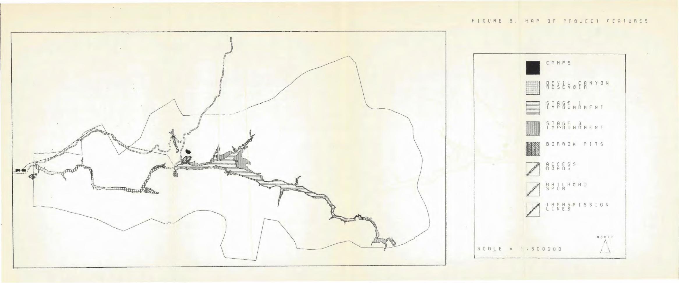
F J G U R f 8 . M R P D F P A Q J E C T F E R 1 U R E S
S C R L E =
C R M r S
0 f V I L C R N Y D N A E S E V :J I R
STRGf 1 I M P 0 U N 0 M E N T
5 T R G E 3 l M P· O U 0 ME N T
B 0 R A D W P I T 5
R C C E S S R C R 0 S
RRILRDRD S P U R
T R R N 5 M I S S I 0 N L I N E S
t~CF\T"i
. 3 0 U G 0 0 ' L~

LITERATURE CITED
Agresti, A. 1984. Analysis of ordinal categorical data. John Wiley and Sons. New York. 287 pp.
Aldous, S.D. 1952. States Region.
Deer browse clipping in the Lake J. Wildl. Manage. 16:401-409.
Ballard, W.B.~ J.S. Whitman, N.G. Tankersley, L.D. Aumiller, and P. Hessing. 1983. Moose - Upstream. Vol. III Susitna Hydroelectric Project big game studies, Phase II Prog. Rep. by Alaska Dept. Fish and Game to Alaska Power Authority. 141 pp.
Ballard, W. B., and J.S. Whitman. 1987. Susitna Hydroelectric Project, Final Report Vol. I - Moose -Downstream. Alaska Dept. of Fish and Game.
Bobeck, B. 1977. Summer food as a factor limiting roe deer population size. Nature 268:47-49.
Cochran, W.G. 1977. Sampling techniques, 3rd edition. John Wiley and Sons. New York. 428 pp.
Dixon, w.J. editor. pp.
1981. BMDP statistical software. Chief University of California Press, Berkeley.
Hobbs, N.T., D.L. Baker, E.J. Ellis, D.M. Swift, and R.A.
725
Green. 1982. Energy and nitrogen-based estimates of elk winter range carrting capacity. J. Wildl. Manage. 46:12-21.
Hobbs, N.T., and D.M. Swift. 1985. Estimates of habitat carrying capacity incorporating explicit nutritional constraints. J. Wildl. Manage. 49:814-822.
Hubbert, M. 1987. The effects of dietary quality and quantity on energy partitioning in moose. Ph.D. Thesis. Univ. of Alaska, Fairbanks. 158 pp.
Krefting, L.W., M.H. stenlund, and R.K. Seemel. 1966. Effects of simulated and natural deer browsing on mountain maple. J. Wildl. Manage. 30:481-488.
Machida, s. 1979. Differential use of willow species by moose in Alaska. M.S. Thesis. Univ. of Alaska, Fairbanks. 97 pp.
88

McKendrick, J., w. Collins, D. Helm, J. McMullen, and J. Koranda. 1982. Plant ecology studies phase I final report. Environmental Studies. Susitna Hydroelectric Project. Prepared for the Alaska Power Authority. 124 pp.
Milke, G.C. 1969. Some moose-willow relationships in the interior of Alaska. M.S. Thesis. Univ. of Alaska, Fairbanks. 79 pp.
Moen, A.N, and c.w. Severinghaus. 1981. The annual weight cycle and survival of white-tailed deer in New York. N.Y. Fish and Game J. 28:162-177.
Mould, E.D. 1977. Movement patterns of moose in the Colville River area of Alaska. M.S. Thesis, Univ. of Alaska, Fairbanks. 82 pp.
Murie, A. 1961. A naturalist in Alaska. The Devin-Adair Co. New York. 320 pp.
Potvin, F., and J. Huot. 1983. Estimating carrying capacity of white-tailed deer wintering area in Quebec. J. Wildl. Manage. 47:463-475.
Reg·elin, W.L., c. c. Schwartz, and A.W. Franzmann. 1985. Seasonal ene~gy metabolism of adult moose. J. Wildl. Manage. 49:388-393.
Regelin, W.L., c.c. Schwartz, and A.W. Franzmann. 1986. Effects of forest succession on nutritional dynamics of moose forage. Viltrevy. In press.
Schwartz, c.c., W.L. Regelin, and A.W. Franzmann. 1984. Seasonal dynamics of food intake in moose. Alces 20:223-244.
Schwartz, c.c., W.L. Regelin, and A.W. Franzmann. 1986a. Annual weight cycle of moose. Viltrevy. In press.
Schwartz, c.c., W.L. Regelin, and A.W. Franzmann. l986b. Food passage rates in moose. J. Wildl. Manage. In press.
Steigers, W.O., Jr., W.B. Ballard, E.F. Becker. 1986. March 1985 snow depth survey in the middle Susitna River basin, Alaska. LGL ALaska Research Assoc., Inc. for Alaska Power Authority Susitna Hydroelectric Project. 73 pp.
89

Steigers, W.D., Jr., and E.F. Becker. 1986. Moose food habits and nutritional quality of forage in the middle susitna River.basin, Alaska. LGL Al~ska Research Assoc., Inc. for Alaska Power Authority susitna Hydroelectric Project.
Steigers, W.D., Jr., and D. Helm. 1984. Terrestrial program 1983 browse pilot study. University of Alaska, Fairbanks for Alaska Power Authority Susitna Hydroelectric Project. 341 pp.
Steigers, W.D., Jr., D. Helm, J.G. Maccracken, J.D. McKendrick and P.V. Mayer. 1983. 1982 plant ecology studies. Univ. of Alaska, Agric. and For. Exp. Sta. for Alaska Power Authority Susitna Hydroelectric Project. 288 pp.
Swift, D.M. 1983. A simulation model of energy and nitrogen balance for free-ranging moose. J. Wildl. Manage. 47:620-645.
Viereck, L.A., and C.T. Dyrness, 1980. A preliminary classification for vegetation in Alaska. Pacific Northwest For. and Range Exp. Sta., Gen. Tech. Rep. PNW-106. 38 pp.
Viereck, L.A., C.T. Dyrness, and R.A. Batten. 1982. 1982 revision of preliminary classification for vegetation of Alaska. Anchorage Workshop on Classification of Alaskan Vegetation. USDA Pac. N.W. Res. Sta., Institute of N. For., Fairbanks, Alaska. 72 pp.
Wallmo, o.c., L.C. Carpenter, W.L. Regelin, R.B. Gill, and D.L. Baker. 1977. Evaluation of deer habitat on a nutritional basis. J. Range Manage. 30:122-127.
Wolff, J.O. 1976. Utilization of hardwood browse on the Tanna flood plain of Interior Alaska. Serv. Pac. N.W. For. and Range Exp. Sta. Res. 267. 7 pp.
by moose u.s. For. Note PNW-
Wolff, J.O. 1978. Burning and browsing effects on willow growth in Interior Alaska. J. Wildl. Manage. 42:135-140.
Wolfe, M.L., W.H. Babcock, and R.M. Welch. 1983. Effects of simulated moose browsing on Drummond's Willow. Alces 19:14-35.
90

APPENDIX A
Susitna Hydroelectric Project Vegetation Mapping Source: R.A. Kreig & Associates, Inc.
Mapping Legend (Revision 2) June 15, 1984
9]
Mapping legend is based primarily on the 1982 Revision of Preliminary
Classification for Vegetation of Alaska (Viereck et al. 1982). Modifications to the
classification made as a result of the Alaska Vegetation Classification Workshop
(Anchorage - February 21, 1984) are also incorporated. Level 4 categories recognized
in this study area, but not listed in Viereck et al. ( 1982) , are indicated by an
asterisk(*).
The following symbology design is used on the maps:
Viereck Level I, II, III call JL r- Viereck
Community Classification Do:b
Level IV call
002
Shrub Cover Classes ~~
Willow---- · Birch (Shrub & Dwarf only)
Alder -------...s
Complexes are shown as: Do:b + 002 .
Major component ----------~' Minor component (not less than 25%
5 point scale-0 • 0-4% cover 1 • 5-25% cover 2 • 26-50% cover 3 • 51-75% cover 4 • 76-100% cover
SLo:bw 240
of unit area) -------------------------~

92
APPEnDIX A
Susitna Ve~etation
Alaska Vegetation Classification Unit Name (Viereck et al. 1982) Mapping lin it Symbol
1. Forest A. Conifer 1. Closed K) White Spruce Cc:w (60-100%) L) Black Spruce Cc:m
M) Black & White Spruce Cc:mw
2. Open F) White Spruce Co:w (25-60%) G) Black Spruce Co:m
H) Black & White Spruce Co:mw
3. Woodland C) White Spruce Cw:w ( 10-25%) D) Black Spruce Cw:m
E) Black & White Spruce Cw:mw
B. Broad leaf 1. Closed B) Black Cottonwood Dc:o (60-100%) C) Balsam Poplar Dc:p
D) Paper Birch Dc:b E) Aspen Dc:a F) Birch - Aspen Dc:ba
2. Open A) Paper Birch Do:b (25-60%) B) Aspen Do:a
C) Balsam Poplar Do:p
3. Woodland A) Paper Birch Dw:b (10-25%) B) Poplar Dw:p
C) Paper Birch - Poplar Dw:bp
C. Mixed 1. Closed A) Spruce - Birch Mc:sb (60-100%) B) Spruce - Birch - Poplar Mc:sbp
C) Spruce - Birch - Aspen Me: sba D) Aspen - Spruce Mc:as E) Poplar - Spruce Mc:ps
2. Open A) Spruce - Birch Mo:sb (25-60%) B) Aspen - Spruce Mo:as
C) Spruce - Birch - Poplar Mo:sbp D) Spruce - Poplar Mo:sp
3. Woodland A) Spruce - Birch Mw: sb (10-25%) B) Spruce - Poplar Mw: sp
C) Spruce - Birch - Poplar Mw: sbp
2. Scrub A. Dwarf Tree Conifer
1. Closed FCc (60-100%)
2. Open FCo (25-60%)
3. Woodland FCw (10-25%)

93
APPE1WIX A
Broadleaf 1. Closed FDc
(60-100%)
2. Open FDo (25-60%)
3. Woodland FDw (10-25%)
Mixed 1. Closed FMc
(60-100%)
2. Open FMo (25-60%)
3. Woodland FMw (10-25%)
B. Tall Shrub 1. Closed A) Willow STc:w (75-100%) B) Alder STc:l
C) Shrub Birch STc:b D) Alder - Willow STc:lw E) Shrub Birch - Willow STc:bw *) Alder - Shrub Birch -
Willow STc:lbw
2. Open A) Willow STo:w (25-75%) B) Alder STo:l
C) Shrub Birch STo:b D) Alder - Willow STo:lw E) Shrub Birch - Willow STo:bw *) Alder - Shrub Birch STo:lb
C. Low Shrub 1. Closed A) Dwarf Birch SLc:b (75-100%) B) Low Willow SLc:w
C) Dwarf Birch - Low Willow SLc :bw D) Ericaceous Shrub Tundra SLc:e
2. Open A) Dwarf Birch SLo:b (25-75%) B) Low Willow SLo:w
C) Dwarf Birch - Willow SLo:bw D) Low Alder SLo:l J) Ericaceous Shrub -
Sphagnum Bog SLo:eu S) Willow Grass Tundra SLo:wg T) Birch & Ericaceous Shrub SLo:be *) Ericaceous Shrub SLo:e

94
APPEirDL"\ A
D. Dwarf Shrub 1. Closed SMc (75-100%)
A) Mat & Cushion - Sedge SMc:s B) Mat & Cushion - Grass SMc: g· D) Cassiope SMc:j G) Low Ericaceous Shrub SMc:e
2. Open SMo (25-75%) E) Low Willow SMo:w
*) Ericaceous Shrub SMo:e
3. Herbaceous A. Graminoid 1. Dry HGd 2. Mesic HGm 3. Wet HGw
A) Wet Sedge Meadow HGw: s C) Wet Sedge - Herb HGw: sh M) Sedge - Moss Bog HGw:sm
B. Forb 1. Dry HFd C) Alpine Herbs HFd:h
2. Mesic HFm 3. Wet HFw
c. Bryoid 1. Mosses HBm 2. Lichens HBl
D. Aquatic 1. Fresh water HAf
4. Sparse A. Forest Pf Vegetation B. Scrub Ps
c. Herbaceous Ph
5. Barren 0 A. Bedrock Ob

APPENDIX B WILLOW STRATIFICATION SCHEME
MAJOR VEGETATION COMPLEX
** STRATA HIGH CO:MW3-CO:MW301 CO:MW4-MO:SB212 MO:SB212 MO:SB310 SLC:B3-SLC:BW2-SLC:BW3-SLC:BW3-SLC:BW4-SLC:LW3-SLC:W3-SLC:W3-SLC:W3-SLC:W3-SLC:W3-SLC:W3-SLC:W4 SLC:W4~
SLC:W4-SLO:B320 SLO:BW310 SLO:BW320 SLO:W3-SLO:W3-SLO:W3-SLO:W3-SLO:W3-SLO:W4-SLO:WG3-SLO:WG3-SLO:WG3-SLO:WG300 SLO:WG310 STC:W3-STC:W311 STC:W4-STO:L4-STO:W3--
+3-SLO:W300 +4-SLC:BW320 SLC:BW320
+4--
SLO:BEG010
+0-+1-+2-+3-SMO +1--
+4-CW:W210
+1-HGW SLO:L003 STO:L003
1--HGW CO:MW210
ELEVATION WILLOW-STRATA
GE2000 L2000
GE2000
HIGH HIGH HIGH HIGH HIGH HIGH HIGH HIGH HIGH HIGH HIGH HIGH HIGH HIGH HIGH HIGH HIGH HIGH HIGH HIGH HIGH HIGH HIGH HIGH HIGH HIGH HIGH HIGH HIGH HIGH HIGH HIGH HIGH HIGH HIGH HIGH HIGH HIGH HIGH HIGH
95

APPENDIX B WILLOW STRATIFICATION SCHEME
MAJOR VEGETATION COMPLEX
** STRATA MEDIUM-FOREST CO:M3-- SLO:WG310 CO:M300 SLO:WG3--CO:MW2-- +3--CO:MW2-- +4--CO:MW2-- SLO:BW3--CO:MW2-- SLO:W3--CO:MW3--CO:MW300 HGW CW:MW2-- +3--CW:MWJ--CW:MW320 CW:W201 SLC:BW320 CW:W3--CW:W310 FC03-FC03-FCW210 FCW2ll FCW3--MO:SB2--MO:SB2--MO:SP3--
HGW SLO:BW320 SLO:BW320
ELEVATION WILLOW-STRATA
L2000 GE2000 GE2000
MEDIUM-FOREST MEDIUM-FOREST MEDIUM-FOREST MEDIUM-FOREST MEDIUM-FOREST MEDIUM-FOREST MEDIUM-FOREST MEDIUM-FOREST MEDIUM-FOREST MEDIUM-FOREST MEDIUM-FOREST MEDIUM-FOREST MEDIUM-FOREST MEDIUM-FOREST MEDIUM-FOREST MEDIUM-FOREST MEDIUM-FOREST MEDIUM-FOREST MEDIUM-FOREST MEDIUM-FOREST MEDIUM-FOREST MEDIUM-FOREST
96

APPENDIX B WILLOW STRATIFICATION SCHEME
MAJOR VEGETATION COMPLEX
** STRATA MEDIUM-SHRUB SLC:B2--SLC:BW2--SLC:W2--SLC:W2-- HGW SLC:WG2--SLC:WG3--SLO:BW2-- +3--SLO:BWG3--SLO:WG3-- SMO STC:LW3-- l--·sTC:LW3--STC:W2--STO:BW2--STO:L3--STO:L3-- SLC:Bl40 STO:LW3--STO:W2--
ELEVATION WILLOW-STRATA
MEDIUM-SHRUB MEDIUM-SHRUB MEDIUM-SHRUB MEDIUM-SHRUB MEDIUM-SHRUB MEDIUM-SHRUB
. MEDIUM-SHRUB MEDIUM-SHRUB MEDIUM-SHRUB MEDIUM-SHRUB MEDIUM-SHRUB MEDIUM-SHRUB MEDIUM-SHRUB MEDIUM-SHRUB MEDIUM-SHRUB MEDIUM-SHRUB MEDIUM-SHRUB
97

98
APPENDIX B WILLOW STRATIFICATION SCHEME
MAJOR VEGETATION COMPLEX ELEVATION WILLOW-STRATA
* * STRATA LOW CC:MW3-- LOW cc:MW3-- CW:MW220 LOW cc:MW3-- HGW LOW cc:w3-- LOW CO:M3-- LOW co:MW120 SLC:W310 LOW co:MW120 SLC:W410 LOW CO:MW120 SLC:WG301 LOW CO:MW2-- LOW CO:MW2-- FCOllO LOW CO:MW2-- HGW LOW CO:MW2-- SLC:Bl-- LOW CO:MW2-- SLC:BEl-- LOW co:MW2-- SLO:Bl-- LOW CO:MW2-- SLO:BW2-- LOW co:w1-- +3-- LOW CO:W3-- LOW CO:W3-- HGW LOW CW:MW2-- LOW CW:MW211 SLO:WG210 LOW CW:W2-- LOW CW:W210 SLO:Bl30 LOW FCCl-- SLO:W3-- LOW FCC2-- LOW FCC2-- SLO:BW2-- LOW FC02-- LOW FC0210 HGW LOW FC0210 SLO:BW220 LOW FCW2-- LOW FCW210 LOW FMW:211 SLC:B230 LOW HGM LOW HGW LOW HGW SLO:BWllO LOW HGW SLO:W200 LOW MC:SB2-- GE2000 LOW MC:SP2-- GE2000 LOW MO:SP2-- GE2000 LOW SLC:BO-- +3-- LOW SLC:BO-- +4-- LOW SLC:B040 SLC:W311 LOW SLC:Bl-- SLC:W3-- LOW SLC:Bl-- SLC:W4-- LOW SLC:Bl-- SLO:W2-- LOW SLC:Bl-- SLO:W3-- LOW SLC:Bl-- STC:W4-- LOW SLC:BE2-- LOW SLC:BEG2-- LOW SLC:WlOO LOW SLO:B2-- LOW

99
APPENDIX B WILLOW STRATIFICATION SCHEME
MAJOR VEGETATION COMPLEX ELEVATION WILLOW-STRATA
SLO:BE230 LOW SLO:BEGl-- +3-- LOW SLO:BEGl-- +4-- LOW SLO:BEG2-- LOW SLO:BG2-- LOW SLO:BW2-- LOW SLO:BW2-- HGM LOW SLO:BW210 SLO:BE020 LOW SLO:BW220 SLO:Bl30 LOW SLO:BW220 SLO:BE120 LOW SLO:BW220 STO:Ll03 LOW SLO:BWG2-- LOW SLO:W2-- +3-- LOW SLO:W2-- +4-- LOW SLO:W2-- HGW LOW SLO:WG2-- LOW SLO:WG2-- HGW LOW SLO:WG2-- SLO:BE020 LOW SLO:WG2-- SLO:BW120 LOW STC:LW2-- LOW STO:L2-~ PH LOW STO:L2-- LOW STO:L2-- SLO:BW130 LOW STO:LW2-- LOW

lOO
APPENDIX B WILLOW STRATIFICATION SCHEME
MAJOR VEGETATION COMPLEX ELEVATION WILLOW-STRATA
** STRATA VERY-LOW CC:M3-- VERY-LOW CC:MW1-- VERY-LOW CC:MW1-- +1-- VERY-LOW CC:MW110- FC0110 VERY-LOW CC:MW120 FC0110 VERY-LOW CC:MW2-- VERY-LOW CO:M1-- SLC:W3-- VERY-LOW CO:M1-- SLO:WG3-- VERY-LOW CO:M220 SLO:WGJOO VERY-LOW CO:MWO-- CW:W310 VERY-LOW CO:MW110 SLC:W400 VERY-LOW CO:MW112 VERY-LOW CO:MW1l2 SLC:WJOO VERY-LOW CO:MW120 VERY-LOW CO:MW12l VERY-LOW CO:MWl2l STO:Lll3 VERY-LOW CO:MW122 VERY-LOW CO:MW130 SLC:WJ-- VERY-LOW CO:W1-- VERY-LOW CO:W10l VERY-LOW CO:W102 VERY-LOW CO:W110 VERY-LOW CO:Wl1l VERY-LOW CO:W112 SLO:Bl20 · VERY-LOW CO:W120 VERY-LOW CO:Wl21 VERY-LOW CO:Wl22 VERY-LOW CO:W130 VERY-LOW CO:W2-- VERY-LOW CW:MW1-- VERY-LOW CW:MWl-- SLO:Bl20 VERY-LOW CW:Wl03- VERY-LOW CW:W104 VERY-LOW CW:WllO VERY-LOW CW:Wlll VERY-LOW CW:Wll2 VERY-LOW CW:Wll3 · VERY-LOW CW:Wl2l VERY-LOW
. CW:Wl22 VERY-LOW CW:Wl23 VERY-LOW CW:Wl30 VERY-LOW CW:Wl30 co:MW220 VERY-LOW CW:Wl31 VERY-LOW CW:W132 VERY-LOW CW:Wl40 VERY-LOW FCCl-- VERY-LOW FCCl-- +1-- VERY-LOW MC:SBl-- GE2000 VERY-LOW MC:SBl-- +1-- GE2000 VERY-LOW MC:SB102 co:w202 GE2000 VERY-LOW

lOl
APPENDIX B WILLOW STRATIFICATION SCHEME
MAJOR VEGETATION COMPLEX ELEVATION WILLOW-STRATA
MC:SBA2-- VERY-LOW MC:SBPlOl GE2000 VERY-LOW MC:SPl-- GE2000 VERY-LOW MO:SBO-- GE2000 VERY-LOW MO:SBl-- GE2000 VERY-LOW MO:SB310 L2000 VERY-LOW MO:SBPl-- GE2000 VERY-LOW MO:SPl-- GE2000 .VERY-LOW MW:SB2-- GE2000 VERY-LOW MW:SBA212 GE2000 VERY-LOW MW:SP2-- GE2000 VERY-LOW SLC:Bl-- VERY-LOW SLC:BWl-- VERY-LOW SLC:EG2-- VERY-LOW SLC:Ll-- VERY-LOW SLO:BO-- +2-- VERY-LOW SLO:BO-- +3-- VERY-LOW SLO:Bl-- +3-- VERY-LOW SLO:BEO-- +3-- VERY-LOW SLO:BEl-- +3-- VERY-LOW SLO:BEGl-- VERY-LOW SLO:BEG120 SLO:B030 VERY-LOW SLO:LWl-- VERY-LOW SLO:Wl-- VERY-LOW SLO:Wl-- HGW VERY-LOW SLO:Wl-- SMO VERY-LOW SLO:WlOO VERY-LOW SLO:WlOO PH VERY-LOW SLO:W2-- VERY-LOW SLO:W2-- +1-- VERY-LOW SLO:W2-- SMO VERY-LOW SLO:WGl-- VERY-LOW SLO:WGlOO VERY-LOW SMC:E +3-- VERY-LOW SMO +3-- VERY-LOW SMO +4-- VERY-LOW SMO SLC:W410 VERY-LOW SMO SLO:W3l0 VERY-LOW STC:Ll-- +2-- VERY-LOW STC:L2-- SLC:BW22l VERY-LOW STC:L2-- SLO:BW220 VERY-LOW STC:L22l SMO VERY-LOW STC:LW202 SLC:B040 VERY-LOW STC:LW202 SMC VERY-LOW STO:Ll-- +2-- VERY-LOW STO:Ll.-- SLO:BW220 VERY-LOW STO:LWl-- +2-- VERY-LOW STO:Wl.OO SMO VERY-LOW

APPENDIX B WILLOW STRATIFICATION SCHEME
MAJOR VEGETATION COMPLEX ELEVATION WILLOW-STRATA
** STRATA SCARCE CC:Ml--CC:Ml--cc:Ml--cc:M2--cc:wl--cc:wl--cc:w2--cc:w2--CC:W200 CC:W2l2 CO:Ml--CO:Ml--co:MllO CO:M2--CO:M211 CO:M220 CO:MWO-CO:MWO-CO:MWlOO co:MWl02 CO:MW103 CO:MWllO CO:MWllO CO:MWllO CO:MWlll CO:MW113 CO:MW123 CO:MW130 CO:MW131 CO:MW140 co:wo--co:W020 CO:W022 CO:W030 CW:Ml--CW:M210 CW:MWO-CW:WO--CW:Wl20 DC:Bl-DC:BAl-DC:BP2-DC:Pl--DC:P2--DO:Bl--DO:Pl--DO:P2--DW:Bl--DW:Pl--FCOl--
HGM HGW
+0--
SLO:Bl
+1-HGM
+0--
FCOOlO FCWlOO
SLO:BE120
SCARCE SCARCE SCARCE SCARCE SCARCE SCARCE SCARCE SCARCE SCARCE SCARCE SCARCE SCARCE SCARCE SCARCE SCARCE SCARCE SCARCE SCARCE SCARCE SCARCE SCARCE SCARCE SCARCE SCARCE SCARCE SCARCE SCARCE SCARCE SCARCE SCARCE SCARCE SCARCE SCARCE SCARCE SCARCE SCARCE SCARCE SCARCE SCARCE SCARCE SCARCE SCARCE SCARCE SCARCE SCARCE SCARCE SCARCE SCARCE SCARCE SCARCE
102

103
APPENDIX B WILLOW STRATIFICATION SCHEME
MAJOR VEGETATION COMPLEX ELEVATION WILLOW-STRATA
FC01-- +0-- SCARCE FC0110 STO:L103 SCARCE FCWO-- SCARCE FCWO-- HGW SCARCE FCW1-- SCARCE HGD SCARCE MC:SBO-- GE2000 SCARCE MC:SB1-- L2000 .SCARCE MC:SB1-- +1-- L2000 SCARCE MC:SB102 CO:W202 L2000 SCARCE MC:SB2-- L2000 SCARCE MC:SBAO-- SCARCE MC:SBA1-- SCARCE MC:SBP101 L2000 SCARCE MC:SPO-- GE2000 SCARCE MC:SP1-- L2000 SCARCE MC:SP2-- L2000 SCARCE MO:SBO-- L2000 SCARCE MO:SB1-- .L2000 SCARCE MO:SBPO-- L2000 SCARCE· MO:SBPO'!"- GE2000 SCARCE MO:SBP1-- L2000 SCARCE MO:SPO-- GE2000 SCARCE MO:SP1-- L2000 SCARCE MO:SP2-- L2000 SCARCE MO:SP3-- L2000 SCARCE MW:SBO-- GE2000 SCARCE MW:SB1-- GE2000 SCARCE MW:SB2-- L2000 SCARCE MW:SBA212 L2000 SCARCE MW:SP1-- GE2000 SCARCE MW:SP2-- L2000 SCARCE 0 w SCARCE PF SCARCE SLC-B +2 SCARCE SLC:B +1 SCARCE SLC:BO-- SLC:BW2-- SCARCE SLC:BO-- SLO:BW2-- SCARCE SLC:BO-- SLO:W2-- SCARCE SLC:BO-- SLO:WG2-- SCARCE SLC:B040 SLO:W200 SCARCE SLC:BEO-- SCARCE SLC:BEO-- SLO:W2-- SCARCE SLC:BE030 SLO:W200 SCARCE SLC:BE1-- SCARCE SLC:BEGO-- SCARCE SLC:BEG1-- SCARCE SLC:E1-- SCARCE SLC:EG1-- SCARCE SLO:BO-- SCARCE SLO:B1-- SCARCE

MAJOR VEGETATION
SLO:Bl-SLO:Bl-SLO:Bl-SLO:BEO-SLO:BEO-SLO:BEO-SLO:BEO-SLO:BEl-SLO:BEl-SLO:BEl-SLO:BEl-SLO:BEl-SLO:BEGO-SLO:BGO-SLO:BWl-SLO:BWl-SLO:BWl-SLO:BWl-SLO:BWGl-SLO:EO-SLO:EOlO SLO:El-SLO:EllO SLO:EGOlO SLO:EGl-SLO:EGl-SLO:EGllO SLO:Ll-SMC SMC SMC SMC SMC:E SMO SMO SMO SMO SMO SMO SMO SMO SMO SMO SMO SMO SMO SMO SMO SMO SMO:E SMO:E
APPENDIX B WILLOW STRATIFICATION SCHEME
COMPLEX
+0--+l-SMO
+0-+l-+2--
+0-+l-+2-SMO
+0-+l-SMO
SMC
+l--+2--PH +1--+l--+2-SLO:BWllO SLO:BW2l0 SLO:Bl30 SLC:BW2l0 SLO:BW220 SLO:BWGllO SLO:EllO SLO:WlOO SLO:W200 SLO:W2ll SLO:WGlOO STO:Llll SLO:W2l0 STO:WlOl SMO:W SLO:W200
ELEVATION WILLOW-STRATA
SCARCE SCARCE SCARCE SCARCE SCARCE SCARCE SCARCE SCARCE SCARCE SCARCE SCARCE SCARCE SCARCE SCARCE SCARCE SCARCE SCARCE SCARCE SCARCE SCARCE SCARCE SCARCE SCARCE SCARCE SCARCE SCARCE SCARCE. SCARCE SCARCE SCARCE SCARCE SCARCE SCARCE SCARCE SCARCE SCARCE SCARCE SCARCE SCARCE SCARCE SCARCE SCARCE SCARCE SCARCE SCARCE SCARCE SCARCE SCARCE SCARCE SCARCE SCARCE
104

MAJOR VEGETATION
SMO:E111 SMO:W STC:LO-STC:LO-STC:LO-STC:L1-STC:L1-STC:L1-STC:L2-STC:L2-STC:L2-STC:LW1-STC:LW103 STO:B121 STO:B130 STO:LO-STO:LO-STO:L003 STO:L012 STO:L1-STO:L1-STO:L1-STO:L1-STO:LW1--
APPENDIX B WILLOW STRATIFICATION SCHEME
COMPLEX
SMO:E SLO:BW110 0
+0-+1--
SLO:B020
0
SLO:BEG020
1--
SMO SMO +0--
ELEVATION WILLOW-STRATA
SCARCE SCARCE SCARCE SCARCE SCARCE SCARCE SCARCE
.SCARCE SCARCE SCARCE SCARCE SCARCE SCARCE SCARCE SCARCE SCARCE SCARCE SCARCE. SCARCE SCARCE SCARCE SCARCE SCARCE SCARCE
105

106
APPENDIX B WILLOW STRATIFICATION SCHEME
MAJOR VEGETATION COMPLEX ELEVATION WILLOW-STRATA
** STRATA ZERO CC:MO-- ZERO CC:Ml-- MO:SBO-- ZERO CC:Ml-- MC:SPO-- ZERO CC:Ml-- MC:SPl-- ZERO CC:Ml-- MO:SBl-- ZERO CC:MWO-- ZERO CC:MWl-- MO:SBO-- ZERO CC:MWl-- MO:SBl-- ZERO cc:wo-- ZERO CO:MOOl ZERO CO:MOlO ZERO DC:AO-- ZERO DC:BO-- ZERO DC:BAO-- ZERO DO:BO-- ZERO DW:BO-- ZERO DW:BPO-- ZERO FCOO-- ZERO MC:SBO-- L2000 ZERO MC:SPO-- L2000 ZERO MO:SBAO-- ZERO MO:SPO-- L2000 ZERO MW:SBO-- L2000 ZERO MW:SBl-- L2000 ZERO MW:SPl-- L2000 ZERO 0 ZERO 0 PH ZERO 0 SMO ZERO 0 STO:L002 ZERO PH ZERO PH 0 ZERO PH SMO ZERO SLC:BO-- ZERO SLC:EO-- ZERO SMC:E ZERO SMO ZERO SMO HBL ZERO SMO PH ZERO SMO 0 ZERO SMO SMC ZERO

APPENDIX B - WILLOW STRATIFICATION SCHEME
Explanation of the coding key :
1) When the 'complex' column is blank and the major vegetation call includes dashes '--',this indicates that any combination of alder and dwarf birch forage calls that could occur with the level IV Viereck call is covered under this strata code unless this major vegetation call is listed under another strata code with a specific alder and dwarf birch forage call. When this occurs all calls that are not covered specifically are covered by the major vegetation call that uses dashes.
2) When the 'complex' column is not blank, then the conditions of both the major vegetation call and the complex call have to be met in order for the strata code to be valid.
3) Some of the listings in the complex column do not contain complete complex codes but rather a number preceded by a '+' sign, for example '+3', this number represents any vegetation polygon occurring in the complex which has a '3' in the willow forage component.
4) The strata code is only valid for polygons or the portions of polygons at or above the 2000 foot contour which me~t the conditions of the major vegetation and complex call when 'GE2000' appears in the elevation column.
5) The strata code is only valid for polygons or portions of polygons below the 2000 foot contour which meet the conditions of the major vegetation and complex call when 'L2000' appears in the elevation column.
107

APPENDIX C
STATISTICAL RESULTS USED TO ESTIMATE MOOSE FORAGE BIOMASS
I) Two stage ratio to size estimators
A) Biomass per m2 per population-strata category
n n ~-'jkl = 2: M· 'ky"kl I 2: M· 'k
i=l ~J ~J i=l ~J (1)
where i - indexes transects j - indexes strata k - indexes the population (A,B,D) 1 - indexes species (willow, paper birch, mt. cranb.) M - denotes transect length
Yijkl - denotes mean biomass per m2 for the i th transect, j th strata, k th population, and 1 th species
/\
~-'jkl - denotes mean biomass per m2 for the j th strata, k th population, and 1 th species
"' n 2 -V(J.'jkl) = i:lM ijk(Yijkl
-2 n 2 + { (liNnM ) 2: M ijk[ (M· 'k-m· 'k)IM· 'k] . 1 ~J ~J ~J
~=
2 S ijkllmijk} (2)
<-------------------~~-----------------------) 2 nd TERM
Since the transects were sampled with replacement, N = oo .... 2 nd TERM = 0 •
Where
So . . /\
2 s ijk
= number of plots in the i th transect, j th strata and k th population
g - indexes the plots in the i th transect, j strata, and k th population
( 3)
th
V(J.'jkl) = n 2 -
i:lM ijk(Yijkl /\ 2 ~-'jkl) I n(n-l)M 2 (4)
108

APPENDIX C
B) Biomass per m2 per population
"' h "' h ~kl = i: A·k ~'kl I. i: Ajk
j=l J J J=l (5)
where A - denotes area of the j th strata in the k th pop.
(6)
"' "' where Cov(~jkl'~j'kl) = (7)
* n -denotes the number of.~ransects with plots in both the jth and j' th strata, for a given population (k)
C) Bias of biomass per.m2 per population strata category
= (8)
(9)
2 2 - - 2 3 =(~Yljkl/~Mjk)-(1/~ Mjkn )Cov(YljklMjk)+(~Yljkla Mjkfn~ Mjk)
Based on a 2 nd order Taylor Series Approximation.
Note ~jkl = (Tyljkl/TMjk) = (N ~Yljkl/ N ~Mjk)
= (~Yljkl/~Mjk) •
"' Bias = ~jkl - E(~jkl)
( 10)
(ll)
109

APPENDIX C
(12)
So
" Where b - denotes the estimated bias of ~jkl•
n Yljkl = i:
1Yijk1Mijkln (13)
.n MJ'k = i: M· 'kin (14) . 1 ~J
~=
n Cov(Yljkl,Mjk) =i:lyijklMijk- n Yljkl Mjk (15)
A2 n 2 a MJ'k = i: (M· 'k - M-J'k) I (n-1) (16) . 1 ~J
~=
D) Probability of species occurrence per m2 per population-strata ·category.
n A n = i: M· 'kP. 'kl I i: M· 'k . 1 ~J ~J . ~J
~= ~=1
where i - indexes transects j - indexes strata k - indexes the population (A,B,D)
(17)
1 -indexes species (willow, paper birch, mt. cranb.) M - denotes transect length A
Pijkl - denotes the proportion of plots in the i th transect, j th strata, k th population, that contain plantR of the 1 th species
A
Pjkl - denotes the estimated probability of a plot in the j th strata, and k th population, containing a plant of the 1 th species
110
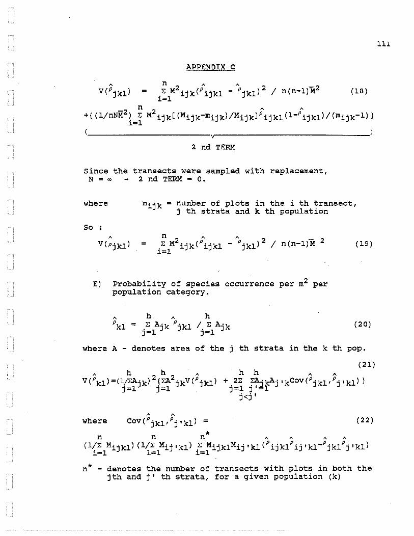
APPENDIX C
(18)
2 nd TERM
Since the transects were sampled with replacement, N = co -+ 2 nd TERM = 0 •
where = number of plots in the i th transect, j th strata and k th population
So
=
E) Probability of species occurrence per m2 per population category.
(19)
(20)
where A - denotes area of the j th strata in the k th pop.
(21)
1\ 1\
where Cov(Pjkl,Pj'kl) = (22)
* n n n ,... ,... ,... ,... (1~~ Mijk1) (1/~ Mij'kl) .~ Mijk1Mij'kl(Pijklpij'k1-Pjklpj'kl) ~=l 1=1 ~=1
n* - denotes the number of transects with plots in both the jth and j' th strata, for a given population (k)
lll

APPENDIX C
F) Bias of probability of species occurrence per m2 per population category
~ n ~ n E(PJ'kl) = E{ :EM· 'kP. 'kl /:EM· 'k}
i=l ~J ~J i=1 ~J (23)
(24)
2 2 - - 2 3 z(~Wjkl/~Mjk)-(1/~ Mjkn )Cov(Wjk1Mjk)+(~Wjkl0 Mjkfn~ Mjk)
Based on a 2 nd order Taylor Series Approximation.
N N N N Note PJ. kl = (:EM' 'kp ' 'k, /:EM' 'k)
i=l ~J ~J "'i=1 ~J = ( (:EM' 'kp ' 'kl/N) I (:EM' 'k/N) )
i=1 ~J ~J i=f-J
~
Bias = pjkl - E(Pjkl)
So b
~
Where b - denotes the estimated bias of Pjkl•
n ~
WJ'kl = :E M· 'kp' 'kl/n i=l ~J ~J
n cov(Wjkl,Mjk) =i:1wijk1Mijk- n wjkl Mjk
~2 n 2 a M'k = :E (M· 'k - MJ·.k) /(n-1)
J i=1 ~J
( 25)
(26)
(27)
(28)
(29)
( 3 0)
(31)
112

APPENDIX C
II) Ordinal logit model for proportion of willow plants browsed.
A) Full Models
l) Regular model
ln(m2jk/mljk) = a + rj + rk + rjk (32)
2) Linear Model
ln(m2jk/mljk) =a+ rj + p(wk-W) + Aj(wk-w) (33)
3) Quadratic Model
ln(m2jk/mljk) =a+ rj + p(wk-W) 2 + Aj(wk-w) 2 (34)
B) Model with Best Fit
-· Reduced Linear Model with no interactions
(35)
where j - indexes population (A, or B) k- indexes plant density (1,2, ••• ,8) mljk - denotes the number of plots in the j th
population and at the k th plant density level that were not browsed
m2J'k - denotes the number of plots in the j th population and at the k th plant density level that were browsed
a - denotes the mean of the 2X8 logits rj - denotes the deviation of the cell count from the
mean due to the j th population rk - denotes the deviation of the cell count from the
mean due to the k th level of plant density p - denotes the linear change in the logit due to
plant density wk - denotes the value of the k th level of plant
density (1,2, ••• ,8) w - denotes the mean level of plant density (4.5) Aj - denotes the additional change in the logit due to
the interaction of the j th population with the k th plant density
113