Survey Project Proposal Report - National Oceanic and ...
14
Survey Project Proposal Report ________________________________________ Attn: Philippe Hensel, PhD PAB Branch Chief NOAA National Geodetic Survey N/NGS4 SSMC3 #8533 1315 East-West Hwy Silver Springs, MD 20910 Project Number: ZHTV100117 Replacement of Taxiway C WPAFB, Ohio ________________________________________ Location: Dayton, Ohio Work Type: Geodetic Leveling – 1 st Order, Class II Project Begin Date: May 16, 2016 Project End Date: September 1, 2016 Brumbaugh Engineering & Surveying, LLC. 1105 South Miami Street West Milton, Ohio 45383 Phone: 937.609.933 Fax: 937.698.3928 Project Manager: John Brumbaugh – [email protected] Project Contacts: Bill Ezerski – [email protected] Matt Newsome – [email protected]
Transcript of Survey Project Proposal Report - National Oceanic and ...

Survey Project Proposal Report ________________________________________
Attn: Philippe Hensel, PhD PAB Branch Chief
NOAA National Geodetic Survey N/NGS4 SSMC3 #8533 1315 East-West Hwy
Silver Springs, MD 20910
Project Number: ZHTV100117 Replacement of Taxiway C
WPAFB, Ohio ________________________________________
Location: Dayton, Ohio
Work Type: Geodetic Leveling – 1st Order, Class II Project Begin Date: May 16, 2016
Project End Date: September 1, 2016
Brumbaugh Engineering & Surveying, LLC. 1105 South Miami Street West Milton, Ohio 45383
Phone: 937.609.933 Fax: 937.698.3928
Project Manager: John Brumbaugh – [email protected]
Project Contacts: Bill Ezerski – [email protected]
Matt Newsome – [email protected]

Dr. Philippe Hensel,
We have reviewed your notes from my first submission and after some field reconnaissance and research we are
moving the level line north of state route 4. This will level out the terrain to be covered and allow access to
some local county benchmarks which appear to be suitable for this leveling procedure. Any marks not currently
in the NGS database will be written up and submitted for approval into the database. This will also allow the
benchmark spacing requirements to be met as several of the benchmarks along the south side of state route 4
(south of the mad river) were unable to be recovered or were located in the side of an elevated railroad
structure limiting safe access to the marks. In addition, the proposed control line can be better accessed with
the new route. Below is a list of the field verified benchmarks to be used in this project as well as some
additional marks for back-up, if required.
PROJECT BENCHMARKS
SSN PID DESIGNATION RECONISSANCE NOTES
0010 JZ3668 K346 FIELD VERIFIED
0020 JZ3667 E346 FIELD VERIFIED
0030 JZ3666 D346 FIELD VERIFIED
0040 JZ0056 Z3XRESET FIELD VERIFIED
0050 JZ0057 J138 FIELD VERIFIED MONUMENT BROKEN MAY STILL HOLD ELEVATION
0060 JZ3665 C346 FIELD VERIFIED
0070 JZ3664 B346 FIELD VERIFIED
0080 N-A COD BM STANLEY-RT 4 FIELD VERIFIED MONTGOMERY COUNTY BENCHMARK – APPENDIX II
0090 AE3348 D12 FIELD VERIFIED
0100 AE3346 MAD4 FIELD VERIFIED
0110 DG7194 HOAG FIELD VERIFIED
0120 N-A COD BM 1037 FIELD VERIFIED MONTGOMERY COUNTY BENCHMARK – APPENDIX III
0130 JZ2904 WRIGHTFIELD FIELD VERIFIED USE ONLY IF ACCESS IS GRANTED – ACCESS GRANTED
0140 N-A HUFFMAN-1 FIELD VERIFIED MONTGOMERY COUNTY BENCHMARK – APPENDIX IV
0150 JZ0127 N140 FIELD VERIFIED
0160 JZ0128 PAT AZ MK FIELD VERIFIED MARKED “PAT 1945”
0170 JZ3507 M140 RESET FIELD VERIFIED
0180 N-A WPAFB 1502 NEW MARK CONTRACT BENCHMARK TO BE SET
0190 BBBZ87 KITTYHAWK NE AZ MK FIELD VERIFIED
0200 BBBZ86 KITTYHAWK NE FIELD VERIFIED
0210 N-A NEW BM NEW MARK ADDITIONAL BENCHMARK TO BE SET
0220 N-A WPAFB1501 NEW MARK CONTRACT BENCHMARK TO BE SET
OTHER MARKS OF NOTE
0230 JZ3669 L346 FIELD VERIFIED TO BE USED AS CHECK TIES IF REQUIRED
0240 JZ3670 J346 FIELD VERIFIED TO BE USED AS CHECK TIES IF REQUIRED
0250 JZ3671 H346 NOT VERIFIED TO BE USED AS CHECK TIES IF REQUIRED
0260 JZ3663 A346 FIELD VERIFIED TO BE USED AS CHECK TIES IF REQUIRED
0270 JZ3662 G346 FIELD VERIFIED TO BE USED AS CHECK TIES IF REQUIRED
0280 JZ2907 PAT NEW AAF NOT VERIFED TO BE USED IF JZ0128 IS DESTROYED
0290 JZ2918 PAT NOT VERIFIED USE LAST RESORT – APPEARS LOCATION IS ON GUN RANGE
0300 N-A NEW BM NOT VERIFIED TO BE SET IF JZ3507 IS DESTROYED
0310 JZ2709 L140 RESET NOT FOUND (GOLF COURSE RECENTLY REGRADED)

As stated above the new route meets benchmark spacing requirements with the use of some county
benchmarks. I have provided Montgomery County’s (OH) Data Sheets for these benchmarks and propose they
be used to fill in gaps between NGS documented benchmarks. The proposed route’s statistics are provided
below:
PROPOSED LEVEL ROUTE
SECTION
BEGIN MARK
SSN
END MARK
SSN APPROX DISTANCE NOTES
CHECK-TIE_ 1 0070 0060 0.67 MI (1.07KM) CHECK TIE FOR ❶JZ3664 AND ❷JZ3665
CHECK-TIE_2 0060 0050 0.91 MI (1.46KM) CHECK TIE BETWEEN JZ3665 AND ❸JZ0057
SECTION_1 0050 0080 1.1 MI (1.77KM)
SECTION_2 0080 0090 1.1 MI (1.77KM)
SECTION_3 0090 0100 0.58 MI (0.93KM)
SECTION_4 0100 0110 1.23 MI (1.98KM)
SECTION_5 0110 0120 1.33 MI (2.14KM)
SECTION_6 0120 0140 0.98 MI (1.58KM)
SECTION_6A 0120 0130 0.83 MI (1.33KM) SUBSTITUTE 6 FOR 6A & 6B IF ACCESS PROVIDED TO JZ2904
SECTION_6B 0130 0140 0.58 MI (0.93KM) SUBSTITUTE 6 FOR 6A & 6B IF ACCESS PROVIDED TO JZ2904
SECTION_7 0140 0150 0.62 MI (1.0KM)
SECTION_8 0150 0160 1.0 MI (1.6KM)
SECTION_9 0160 0170 0.37 MI (.59KM)
SECTION_10 0170 0180 1.72 MI (2.76KM) LONGEST RUN
SECTION_11 0180 0190 0.96 MI (1.54KM)
SECTION_12 0190 0200 0.11 MI (0.18KM)
SECTION_13 0200 0210 1.16 MI (1.86KM)
SECTION_14 0210 0220 1.65 MI (2.65KM)
SECTION_15 0220 0210 1.65 MI (2.65KM)
SECTION_16 0210 0200 1.16 MI (1.86KM)
SECTION_17 0200 0190 .011 MI (0.18KM)
SECTION_18 0190 0180 0.96 MI (1.54KM)
SECTION_19 0180 0170 1.72 MI (2.76KM) LONGEST RUN
SECTION_20 0170 0160 0.37 MI (.59KM)
SECTION_21 0160 0150 1.0 MI (1.6KM)
SECTION_22 0150 0140 0.62 MI (1.0KM)
SECTION_23 0140 0120 0.98 MI (1.58KM)
SECTION_23A 0140 0130 0.58 MI (0.93KM) SUBSTITUTE 23 FOR 23A & 23B IF ACCESS PROVIDED TO JZ2904
SECTION_23B 0130 0120 0.83 MI (1.33KM) SUBSTITUTE 23 FOR 23A & 23B IF ACCESS PROVIDED TO JZ2904
SECTION_24 0120 0110 1.33 MI (2.14KM)
SECTION_25 0110 0100 1.23 MI (1.98KM)
SECTION_26 0100 0090 0.58 MI (0.93KM)
SECTION_27 0090 0080 1.1 MI (1.77KM)
SECTION_28 0080 0050 1.1 MI (1.77KM)
CHECK-TIE_3 0050 0040 1.0 MI (1.6KM) CHECK TIE BETWEEN JZ0057 AND ❹JZ0056
CHECK-TIE_4 0040 0030 0.89 MI (1.43KM) CHECK TIE BETWEEN JZ0056 AND ❺JZ3666
CHECK-TIE_5 0030 0020 0.88 MI (1.41KM) CHECK TIE BETWEEN JZ3666 AND ❻JZ3667
TOTAL DISTANCE = 32.01 MI (51.52KM) DOES DOT INCLUDE SECTION 6A,6B,23A,AND23B
AVERAGE SECTION= 0.97 MI (1.56KM) DOES DOT INCLUDE SECTION 6A,6B,23A,AND23B

APPENDIX I – Google Route Map

mileskm
710

APPENDIX II – City of Dayton Benchmark – Stanley Rt 4

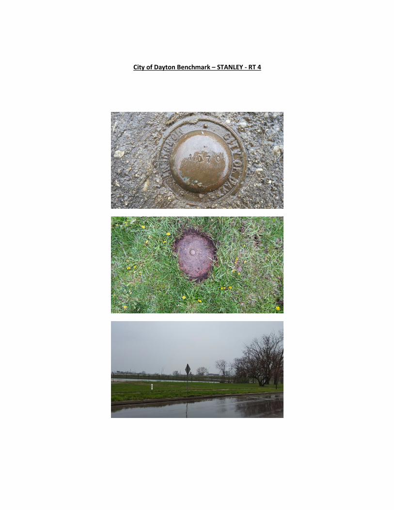
City of Dayton Benchmark – STANLEY - RT 4

APPENDIX III – City of Dayton Benchmark 1037


City of Dayton Benchmark - 1037

APPENDIX IV – Montgomery County Benchmark Huffman-1


Montgomery County Benchmark Huffman-1