Survey of Assemblages of the wetlands with organic mound ... · permanently moist and supports a...
24
Survey of Assemblages of the wetlands with organic mound springs on the tidal mudflats of the Victoria-Bonaparte bioregion Priority 1 ecological community A report to the Kimberley Region - August 2017 survey of Victoria-Bonaparte wetlands. Funded by Kimberley Science Conservation Strategy (KSCS) Jill Pryde, Species & Communities Branch, Science & Conservation Division October 2017
Transcript of Survey of Assemblages of the wetlands with organic mound ... · permanently moist and supports a...
Survey of Assemblages of the wetlands with organic mound springs on the tidal
mudflats of the Victoria-Bonaparte bioregion Priority 1 ecological community
A report to the Kimberley Region - August 2017 survey of
Victoria-Bonaparte wetlands.
Funded by Kimberley Science Conservation Strategy (KSCS)
Jill Pryde, Species & Communities Branch, Science & Conservation Division
October 2017

Department of Biodiversity, Conservation and Attractions 1
Current description:
Assemblages of the wetlands associated with the organic mound springs on the tidal
mudflats of the Victoria-Bonaparte Bioregion East Kimberley on Carlton Hill Station.
Large wetlands with Melaleuca forest with small patches of rainforest on central
mounds. Rainforest and paperbark forest associated with mound springs and
seepage areas of the Victoria Bonaparte coastal lands. The rainforest canopy height
at Long Swamp is 30m, and the dominant tree species include Nauclea orientalis,
Terminalia microcarpa and Melicope elleryana; the periphery of the patch is
permanently moist and supports a Melaleuca leucadendra forest (McKenzie et al.
1991). Species richness at Long Swamp is 52 and perennial plant species richness
is 20. Silty clay soil type at this swamp. Plants with very restricted distributions within
the State include Mucuna gigantea (vine) and Sterculia holtzei P1 (tree). The
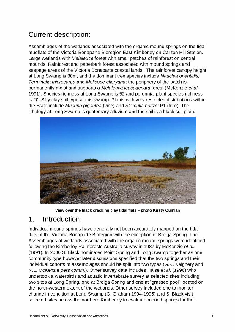
lithology at Long Swamp is quaternary alluvium and the soil is a black soil plain.
View over the black cracking clay tidal flats – photo Kirsty Quinlan
1. Introduction:
Individual mound springs have generally not been accurately mapped on the tidal
flats of the Victoria-Bonaparte Bioregion with the exception of Brolga Spring. The
Assemblages of wetlands associated with the organic mound springs were identified
following the Kimberley Rainforests Australia survey in 1987 by McKenzie et al.
(1991). In 2000 S. Black nominated Point Spring and Long Swamp together as one
community type however later discussions specified that the two springs and their
individual cohorts of assemblages should be split into two types (G.K. Keighery and
N.L. McKenzie pers comm.). Other survey data includes Halse et al. (1996) who
undertook a waterbirds and aquatic invertebrate survey at selected sites including
two sites at Long Spring, one at Brolga Spring and one at “grassed pool” located on
the north-western extent of the wetlands. Other survey included one to monitor
change in condition at Long Swamp (G. Graham 1994-1995) and S. Black visit
selected sites across the northern Kimberley to evaluate mound springs for their
conservation value and proposed listing as threatened ecological communities
(TECs).
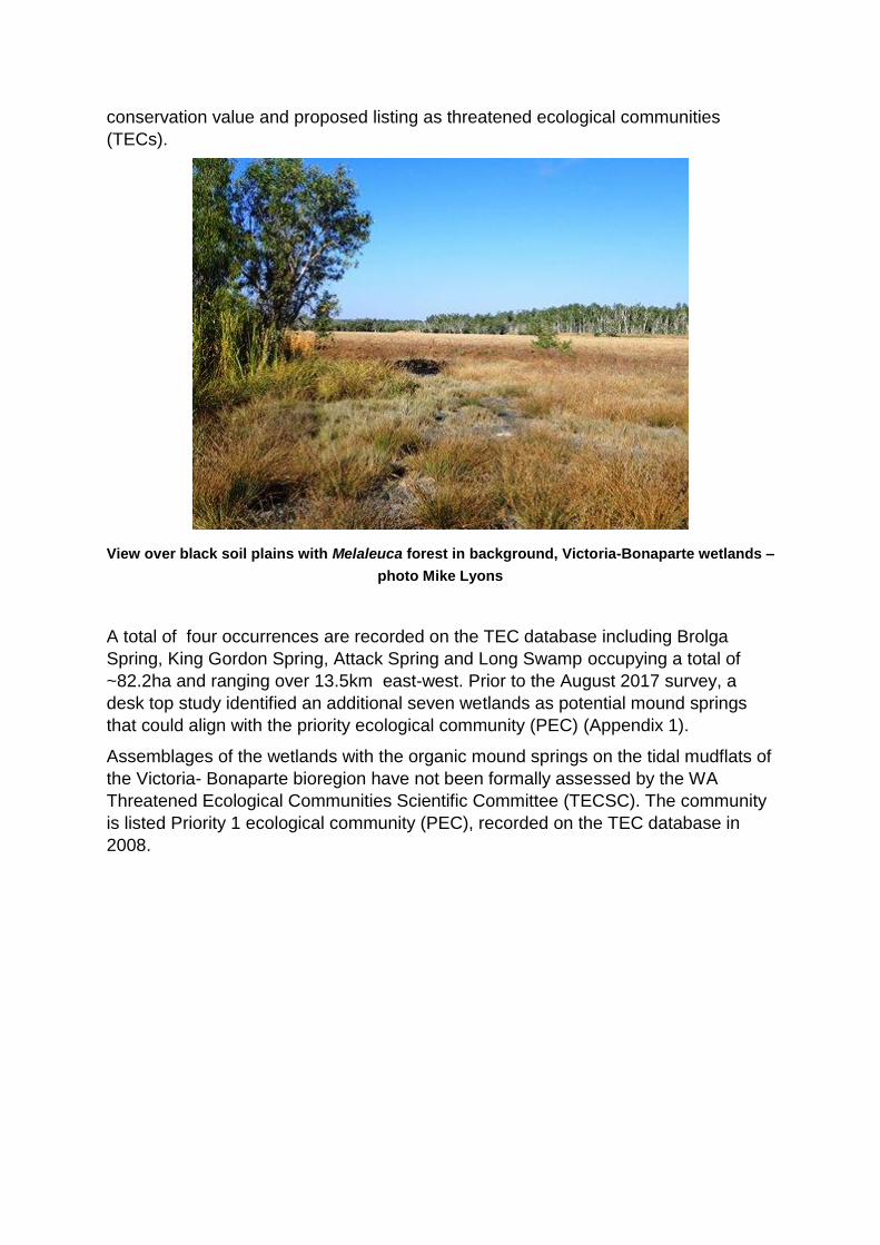
View over black soil plains with Melaleuca forest in background, Victoria-Bonaparte wetlands –
photo Mike Lyons
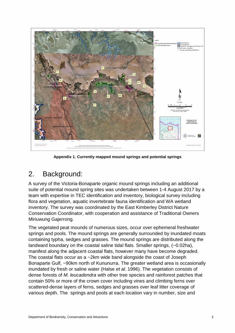
A total of four occurrences are recorded on the TEC database including Brolga
Spring, King Gordon Spring, Attack Spring and Long Swamp occupying a total of
~82.2ha and ranging over 13.5km east-west. Prior to the August 2017 survey, a
desk top study identified an additional seven wetlands as potential mound springs
that could align with the priority ecological community (PEC) (Appendix 1).
Assemblages of the wetlands with the organic mound springs on the tidal mudflats of
the Victoria- Bonaparte bioregion have not been formally assessed by the WA
Threatened Ecological Communities Scientific Committee (TECSC). The community
is listed Priority 1 ecological community (PEC), recorded on the TEC database in
2008.
Department of Biodiversity, Conservation and Attractions 3
Appendix 1. Currently mapped mound springs and potential springs
2. Background:
A survey of the Victoria-Bonaparte organic mound springs including an additional
suite of potential mound spring sites was undertaken between 1-4 August 2017 by a
team with expertise in TEC identification and inventory, biological survey including
flora and vegetation, aquatic invertebrate fauna identification and WA wetland
inventory. The survey was coordinated by the East Kimberley District Nature
Conservation Coordinator, with cooperation and assistance of Traditional Owners
Miriuwung Gajerrong.
The vegetated peat mounds of numerous sizes, occur over ephemeral freshwater
springs and pools. The mound springs are generally surrounded by inundated moats
containing typha, sedges and grasses. The mound springs are distributed along the
landward boundary on the coastal saline tidal flats. Smaller springs, (~0.02ha),
manifest along the adjacent coastal flats, however many have become degraded.
The coastal flats occur as a ~2km wide band alongside the coast of Joseph
Bonaparte Gulf, ~90km north of Kununurra. The greater wetland area is occasionally
inundated by fresh or saline water (Halse et al. 1996). The vegetation consists of
dense forests of M. leucadendra with other tree species and rainforest patches that
contain 50% or more of the crown cover including vines and climbing ferns over
scattered-dense layers of ferns, sedges and grasses over leaf litter coverage of
various depth. The springs and pools at each location vary in number, size and

depth. The majority contained a thick cover of aquatic ferns and herbs, typha,
rushes and sedges with fallen logs and leaf litter.
The key threats identified for the mound springs are pastoralism (impacts of cattle)
including trampling of vegetation, soils and spring pools, and nutrient enrichment;
altered fire regimes - too high intensity, and potential hydrological change. The
springs are on aquifers that have operating bores on them and are potentially
threatened by water abstraction (DEC 2008).
The springs are located on unallocated Crown land (UCL), within the ex-Carlton Hill
Pastoral Lease, which is awaiting outcome of S16 negotiations. Access to the
springs is recommended during low tide.
3. Objective:
The Kimberley Region is seeking to address knowledge gaps utilising funding from
the Kimberley Science Conservation Strategy (KSCS). The aim of the survey is to
update PEC baseline information, including description, condition and threats to the
PEC, to establish permanent quadrats to record flora and vegetation, inventory
aquatic invertebrates, soils and water chemistry, and to identify new occurrences
and update boundaries of the wetland community as required. Over time it will be
valuable to build up a uniform dataset for springs for a broader regional analysis.
This report covers the ecological community aspect of the survey and will assist with
the development of a formal nomination of the community to the TECSC, with
recommendations for management and future research.
4. Methods
A total of eleven sites were surveyed, including all recorded occurrences and five
additional sites, and the following recorded:
general vegetation description, condition and structure across the mapped
community;
Flora list (Appendix 2) for vegetation within the quadrat and at random
locations throughout the mound spring community;
threatening processes; and
management recommendations compiled.
In conjunction with the above six sites were selected in tall dense rainforest
community and in a woodland community. Permanent 50x502m quadrat were
installed. Each quadrat was marked with one 1.6m star picket at NE corner site. This
will enable future scoring and analysis of change, for monitoring purposes. Quadrat
data (held by M. Lyons) for site include:
GPS location;
vegetation description, stratum and structure;
soil and landform;
Department of Biodiversity, Conservation and Attractions 5
flora specimens were collected from the mound springs seepage areas
and damplands surrounding the springs. The flora specimens will be
provided for lodging where suitable to the WA Herbarium. Mike Lyons and
Jill Pryde (DRF Permit no. 22-1718); Additional flora collected by M. Coote
and A. Turnbull.
Aquatic invertebrate survey, peat core and water chemistry in an area of
standing water by A. Pinder and K. Quinlan.
Assessment and mapping by the wetlands group (M. Coote and A.
Turnbull) using a handheld GPS in conjunction with aerial photography.
Photographs of occurrences and surrounding landscape.
These data will be added to the corporate TEC/PEC database when available
5. Limitations:
Four days were allocated to survey the Victoria-Bonaparte wetlands and this limited
the capacity to conduct a full assessment on status and condition across the suite of
wetlands.
6. Results:
Survey of the Victoria-Bonaparte wetlands PEC was undertaken between 1-4 August
2016 to coincide with low tide. The PEC comprise four mapped occurrences that
occur over a range of 14 km bordering the edge of the saline coastal flats. All
recorded occurrences and the majority of potential sites sampled are located on a
raised central mound that contained a mix of peaty organic black soils and/or
decayed organic material. Internal moats and pools occur at various depth and
contained aquatic ferns and submerged herbs at various densities. The canopy
vegetation comprised tall Melaleuca forest with other trees, including rainforest
species of various stratum and density including thickets of vines, including climbing
ferns over Pandanus spiralis, typha, creepers, rushes, sedges, grasses and ferns.
The surrounding alluvial flats and black soil plains support dense to scattered stands
of Melaleuca spp., Acacia spp. and other shrubs and trees over Cyperus spp.,
Sporobolus ?virginicus grasslands and patches of Adansonia gregorii (boab) and
Pandanus thickets with scattered samphires over the outer saline areas. No
Declared rare flora (DRF) were identified, however two priority flora species were
recoded including Sterculia holtzei (P1) and Utricularia ?aurea (P2). This information
may change once all flora taxa has been processed

Brolga Spring (Occurrence 01)
(M1 Appendix 1)
Brolga Spring occupies 23.3ha. A Melaleuca woodland surrounded by Typha
domingensis with emergent Ficus spp. is a small permanent freshwater spring which
lies on the margin of open coastal grassland plain towards the west and the red soils
plains of open eucalypt woodlands to the east and south. The spring occurs at the
extreme northern end of the Ningbing Range on the sandy margin flanked by tidal
limit 3km east and 4km west. Brolga Spring lies directly adjacent Mijing Conservation
Park (Crown reserve 49691).
Brolga Spring – photo Adam Turnbull
No comprehensive survey of Brolga Springs was undertaken in August 2017,
however boundary reconnaissance and a brief edge survey to observe status and
condition was conducted. Vegetation comprised a Melaleuca sp. forest within the
central mound and open water with patches of duckweed Lemna aequinoctialis.
Species co-occurring included Cyperus javanicus, sedges and T. domingensis. The
outer perimeter of the larger seepage area in the surrounding moat contained T.
domingensis forming a dense barrier. The south and western peripheries were more
open and comprised M. viridiflora, Sesbania cannabina, and occasional Ficus spp.
with vines and creepers, including Thespia sp. Based on records of previous survey
and current survey, the degraded stands of M. ?leucadendra found on the southern
side of the wetland, are in poor condition and the vegetation surrounding the trees
has become degraded, transitioning into a grassland. Along the western periphery,
upland of the moat, soils are red-brown sandy-loam covered with deep litter of P.
spiralis, dense M. viridiflora shrubs, S. cannabina and A. gregorii over Cyperus spp.
and grasses. Although the brief survey limited the flora inventory, the flora taxa
present in this occurrence appeared to be diverse.
Previous observations by S. Black et al. (2000) noted the destructive impacts caused
by cattle, particularly at the south east corner, which appears to be a major entry
point into the wetland. McKenzie (pers comm. 2013) noted that a fence installed prior
to visitation in 2013, appeared to have assisted in improving vegetation condition of
the community. However in August 2017 the fence was breached and cattle were
again causing significant damage to the community and resulted in trampling of
vegetation, damaging soil structure and adding to the accumulation of nutrients.
Some weeds in this area have potential of becoming a serious threat, including
*Mesosphaerum suaveolens located on the southern side. The community was
Department of Biodiversity, Conservation and Attractions 7
partially burnt in the previous 12 months. Vegetation condition Good-Very Good
(Bush Forever scales).
The key threats identified for the mound springs are trampling of vegetation, soils
and springs by cattle, nutrient enrichment, high intensity fires and potential
hydrological change.
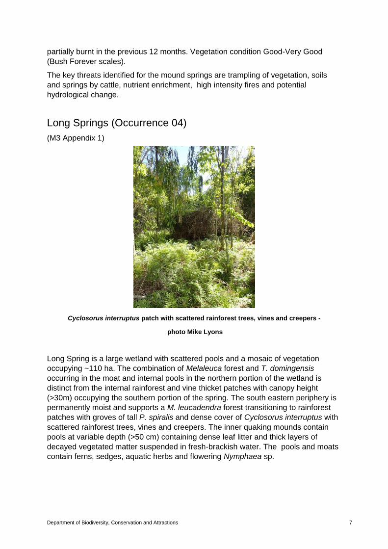
Long Springs (Occurrence 04)
(M3 Appendix 1)
Cyclosorus interruptus patch with scattered rainforest trees, vines and creepers -
photo Mike Lyons
Long Spring is a large wetland with scattered pools and a mosaic of vegetation
occupying ~110 ha. The combination of Melaleuca forest and T. domingensis
occurring in the moat and internal pools in the northern portion of the wetland is
distinct from the internal rainforest and vine thicket patches with canopy height
(>30m) occupying the southern portion of the spring. The south eastern periphery is
permanently moist and supports a M. leucadendra forest transitioning to rainforest
patches with groves of tall P. spiralis and dense cover of Cyclosorus interruptus with
scattered rainforest trees, vines and creepers. The inner quaking mounds contain
pools at variable depth (>50 cm) containing dense leaf litter and thick layers of
decayed vegetated matter suspended in fresh-brackish water. The pools and moats
contain ferns, sedges, aquatic herbs and flowering Nymphaea sp.
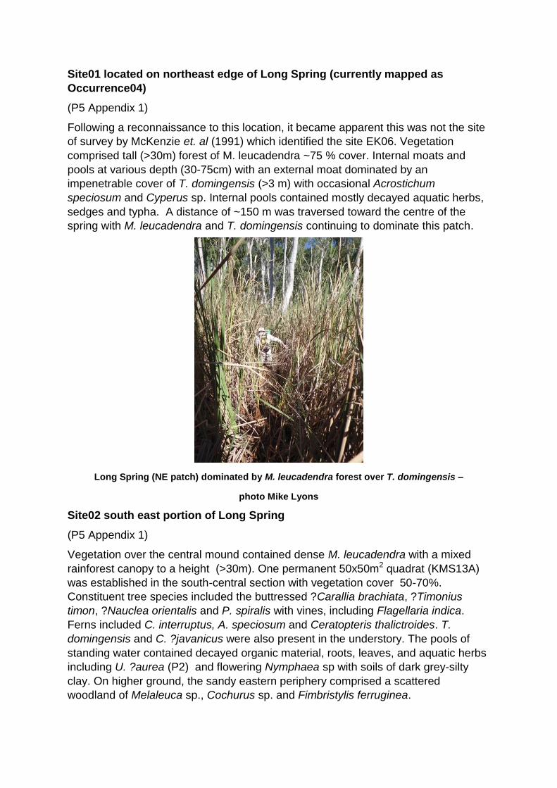
Site01 located on northeast edge of Long Spring (currently mapped as
Occurrence04)
(P5 Appendix 1)
Following a reconnaissance to this location, it became apparent this was not the site
of survey by McKenzie et. al (1991) which identified the site EK06. Vegetation
comprised tall (>30m) forest of M. leucadendra ~75 % cover. Internal moats and
pools at various depth (30-75cm) with an external moat dominated by an
impenetrable cover of T. domingensis (>3 m) with occasional Acrostichum
speciosum and Cyperus sp. Internal pools contained mostly decayed aquatic herbs,
sedges and typha. A distance of ~150 m was traversed toward the centre of the
spring with M. leucadendra and T. domingensis continuing to dominate this patch.
Long Spring (NE patch) dominated by M. leucadendra forest over T. domingensis –
photo Mike Lyons
Site02 south east portion of Long Spring
(P5 Appendix 1)
Vegetation over the central mound contained dense M. leucadendra with a mixed
rainforest canopy to a height (>30m). One permanent 50x50m2 quadrat (KMS13A)
was established in the south-central section with vegetation cover 50-70%.
Constituent tree species included the buttressed ?Carallia brachiata, ?Timonius
timon, ?Nauclea orientalis and P. spiralis with vines, including Flagellaria indica.
Ferns included C. interruptus, A. speciosum and Ceratopteris thalictroides. T.
domingensis and C. ?javanicus were also present in the understory. The pools of
standing water contained decayed organic material, roots, leaves, and aquatic herbs
including U. ?aurea (P2) and flowering Nymphaea sp with soils of dark grey-silty
clay. On higher ground, the sandy eastern periphery comprised a scattered
woodland of Melaleuca sp., Cochurus sp. and Fimbristylis ferruginea.
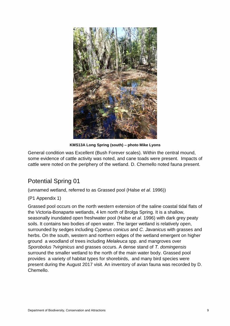
Department of Biodiversity, Conservation and Attractions 9
KMS13A Long Spring (south) – photo Mike Lyons
General condition was Excellent (Bush Forever scales). Within the central mound,
some evidence of cattle activity was noted, and cane toads were present. Impacts of
cattle were noted on the periphery of the wetland. D. Chemello noted fauna present.
Potential Spring 01
(unnamed wetland, referred to as Grassed pool (Halse et al. 1996))
(P1 Appendix 1)
Grassed pool occurs on the north western extension of the saline coastal tidal flats of
the Victoria-Bonaparte wetlands, 4 km north of Brolga Spring. It is a shallow,
seasonally inundated open freshwater pool (Halse et al. 1996) with dark grey peaty
soils. It contains two bodies of open water. The larger wetland is relatively open,
surrounded by sedges including Cyperus conicus and C. Javanicus with grasses and
herbs. On the south, western and northern edges of the wetland emergent on higher
ground a woodland of trees including Melaleuca spp. and mangroves over
Sporobolus ?virginicus and grasses occurs. A dense stand of T. domingensis
surround the smaller wetland to the north of the main water body. Grassed pool
provides a variety of habitat types for shorebirds, and many bird species were
present during the August 2017 visit. An inventory of avian fauna was recorded by D.
Chemello.
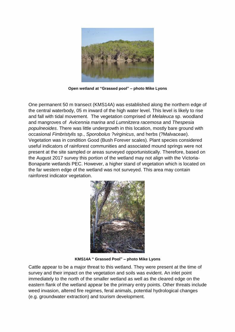
Open wetland at “Grassed pool” – photo Mike Lyons
One permanent 50 m transect (KMS14A) was established along the northern edge of
the central waterbody, 05 m inward of the high water level. This level is likely to rise
and fall with tidal movement. The vegetation comprised of Melaleuca sp. woodland
and mangroves of Avicennia marina and Lumnitzera racemosa and Thespesia
populneoides. There was little undergrowth in this location, mostly bare ground with
occasional Fimbristylis sp., Sporobolus ?virginicus, and herbs (?Malvaceae).
Vegetation was in condition Good (Bush Forever scales). Plant species considered
useful indicators of rainforest communities and associated mound springs were not
present at the site sampled or areas surveyed opportunistically. Therefore, based on
the August 2017 survey this portion of the wetland may not align with the Victoria-
Bonaparte wetlands PEC. However, a higher stand of vegetation which is located on
the far western edge of the wetland was not surveyed. This area may contain
rainforest indicator vegetation.
KMS14A “ Grassed Pool” – photo Mike Lyons
Cattle appear to be a major threat to this wetland. They were present at the time of
survey and their impact on the vegetation and soils was evident. An inlet point
immediately to the north of the smaller wetland as well as the cleared edge on the
eastern flank of the wetland appear be the primary entry points. Other threats include
weed invasion, altered fire regimes, feral animals, potential hydrological changes
(e.g. groundwater extraction) and tourism development.
Department of Biodiversity, Conservation and Attractions 11
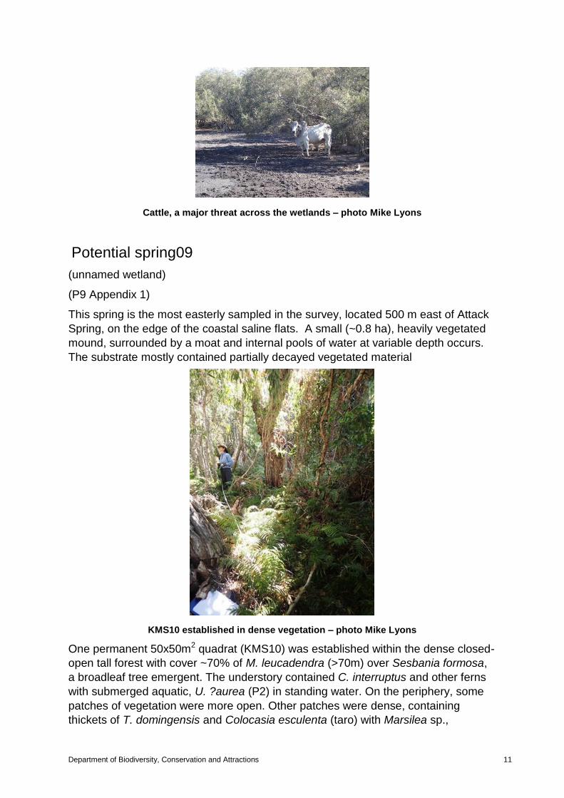
Cattle, a major threat across the wetlands – photo Mike Lyons
Potential spring09
(unnamed wetland)
(P9 Appendix 1)
This spring is the most easterly sampled in the survey, located 500 m east of Attack
Spring, on the edge of the coastal saline flats. A small (~0.8 ha), heavily vegetated
mound, surrounded by a moat and internal pools of water at variable depth occurs.
The substrate mostly contained partially decayed vegetated material
KMS10 established in dense vegetation – photo Mike Lyons
One permanent 50x50m2 quadrat (KMS10) was established within the dense closed-
open tall forest with cover ~70% of M. leucadendra (>70m) over Sesbania formosa,
a broadleaf tree emergent. The understory contained C. interruptus and other ferns
with submerged aquatic, U. ?aurea (P2) in standing water. On the periphery, some
patches of vegetation were more open. Other patches were dense, containing
thickets of T. domingensis and Colocasia esculenta (taro) with Marsilea sp.,
Corchorus sp., Cyperus sp and Sporobolus ?virginicus. No DRF was located
however one Priority flora species was recorded. Plant species considered useful
indicators of rainforest communities and associated mound springs were present .
The total number of weeds species was low. Vegetation condition was Excellent
(Bush Forever scales).
There was evidence of cattle activity. The key threats identified for the wetland
include grazing, weed invasion, altered fire regimes, feral animals, potential
hydrological changes (e.g. groundwater extraction) and possibly tourism
development.
It is considered that this mound spring is likely to align with Victoria-Bonaparte
wetlands Priority 1 ecological community.
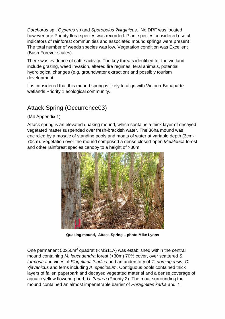
Attack Spring (Occurrence03)
(M4 Appendix 1)
Attack spring is an elevated quaking mound, which contains a thick layer of decayed
vegetated matter suspended over fresh-brackish water. The 36ha mound was
encircled by a mosaic of standing pools and moats of water at variable depth (3cm-
70cm). Vegetation over the mound comprised a dense closed-open Melaleuca forest
and other rainforest species canopy to a height of >30m.
Quaking mound, Attack Spring – photo Mike Lyons
One permanent 50x50m2 quadrat (KMS11A) was established within the central
mound containing M. leucadendra forest (>30m) 70% cover, over scattered S.
formosa and vines of Flagellaria ?indica and an understory of T. domingensis, C.
?javanicus and ferns including A. speciosum. Contiguous pools contained thick
layers of fallen paperbark and decayed vegetated material and a dense coverage of
aquatic yellow flowering herb U. ?aurea (Priority 2). The moat surrounding the
mound contained an almost impenetrable barrier of Phragmites karka and T.
Department of Biodiversity, Conservation and Attractions 13
domingensis. On higher ground, the periphery of the wetland contained occasional
S. formosa and dense Melaleuca spp. woodland. Vegetation condition was Excellent
(Bush Forever scales). Within the central mound there was little evidence of cattle
activity, however cattle impacts were noted on the outer surrounding Melaleuca
woodland.
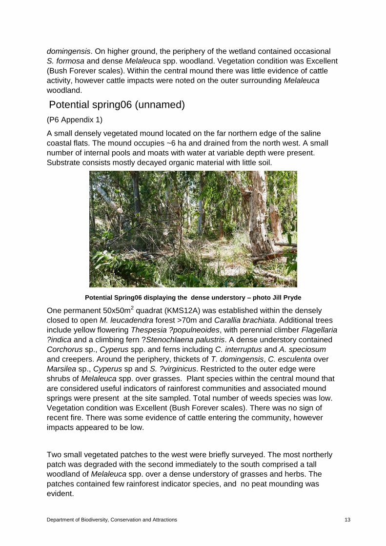
Potential spring06 (unnamed)
(P6 Appendix 1)
A small densely vegetated mound located on the far northern edge of the saline
coastal flats. The mound occupies ~6 ha and drained from the north west. A small
number of internal pools and moats with water at variable depth were present.
Substrate consists mostly decayed organic material with little soil.
Potential Spring06 displaying the dense understory – photo Jill Pryde
One permanent 50x50m2 quadrat (KMS12A) was established within the densely
closed to open M. leucadendra forest >70m and Carallia brachiata. Additional trees
include yellow flowering Thespesia ?populneoides, with perennial climber Flagellaria
?indica and a climbing fern ?Stenochlaena palustris. A dense understory contained
Corchorus sp., Cyperus spp. and ferns including C. interruptus and A. speciosum
and creepers. Around the periphery, thickets of T. domingensis, C. esculenta over
Marsilea sp., Cyperus sp and S. ?virginicus. Restricted to the outer edge were
shrubs of Melaleuca spp. over grasses. Plant species within the central mound that
are considered useful indicators of rainforest communities and associated mound
springs were present at the site sampled. Total number of weeds species was low.
Vegetation condition was Excellent (Bush Forever scales). There was no sign of
recent fire. There was some evidence of cattle entering the community, however
impacts appeared to be low.
Two small vegetated patches to the west were briefly surveyed. The most northerly
patch was degraded with the second immediately to the south comprised a tall
woodland of Melaleuca spp. over a dense understory of grasses and herbs. The
patches contained few rainforest indicator species, and no peat mounding was
evident.

Looking west to small vegetated patches and potential mound springs – photo Jill Pryde
Potential spring07 (Hayley’s Spring)
(P7 Appendix 1)
Hayley’s spring is located south of Potential Spring06 and 1 km northwest of Attack
Spring. No comprehensive survey was undertaken, however a brief edge survey and
boundary reconnaissance was undertaken to assess status and condition.
Internal pools covered with L. aequinoctialis – photo Jill Pryde
The thickly vegetated mound occupied ~8.6 ha and rises (~2m) above black cracking
clays and surrounding saline coastal flats. Soils are peaty grey-black containing
mostly organic material. Water appears fresh-brackish. Vegetation on the central
mound comprised a tall-medium dense M. leucadendra forest with vines including F.
indica and emergent ?N. orientalis and lacking mid-story. A suite of internal moats to
various depth (~30-70cm), contain a dense cover of L. aequinoctialis, U. ?aurea and
Stenochlaena palustris. A. speciosum typically occurred from the surrounding pools
of water to the base of Melaleuca trees. Many fallen Melaleuca trees lay over the
mound. Surrounding the central mound, occasional ?Cochorus sp. and dense stands
of Schoenoplectus subulatus, P. karka, T. domingensis over Marsilea sp. and ferns
including C. interruptus occurred. The outer perimeter contained a woodland of
Department of Biodiversity, Conservation and Attractions 15
Melaleuca spp. and Acacia spp. shrubs and mistletoe with T. domingensis and
swathes of mixed sedges, including C. ?javanicus sp. Fimbristylis sp. and grasses.
Vegetation condition was Excellent (Bush Forever scales).
Based on observations from this partial survey, the mound appears to align with the
PEC.
The key threats identified to the mound springs are, grazing, weed invasion, altered
fire regimes, feral animals and potential hydrological changes (e.g. groundwater
extraction) and tourism development.
Potential spring08 (unnamed)
(P8 Appendix 1)
A small vegetated mound which occupies ~5.4ha is located immediately west of
Attack Spring. This site was not surveyed.
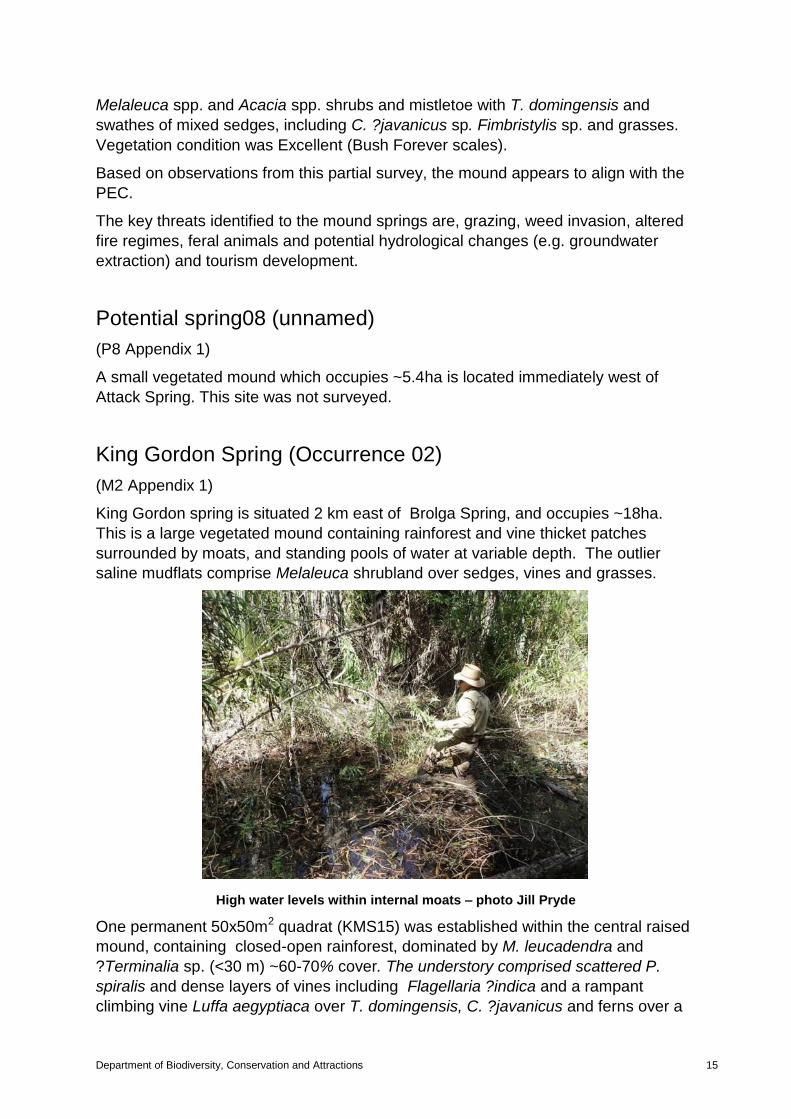
King Gordon Spring (Occurrence 02)
(M2 Appendix 1)
King Gordon spring is situated 2 km east of Brolga Spring, and occupies ~18ha.
This is a large vegetated mound containing rainforest and vine thicket patches
surrounded by moats, and standing pools of water at variable depth. The outlier
saline mudflats comprise Melaleuca shrubland over sedges, vines and grasses.
High water levels within internal moats – photo Jill Pryde
One permanent 50x50m2 quadrat (KMS15) was established within the central raised
mound, containing closed-open rainforest, dominated by M. leucadendra and
?Terminalia sp. (<30 m) ~60-70% cover. The understory comprised scattered P.
spiralis and dense layers of vines including Flagellaria ?indica and a rampant
climbing vine Luffa aegyptiaca over T. domingensis, C. ?javanicus and ferns over a
dense layer of fallen Pandanus branches and litter. Scattered internal pools of water
(<75cm deep) contained a thick layer of decayed vegetated material in combination
with aquatic herbs U. ?aurea, L. aequinoctialis and Nymphaea sp., aquatic ferns
and vines and creepers. Soils were dark grey clay below a dense leaf layer. General
condition was Excellent (Bush Forever scales). Average flora species richness was
10-25 and the number of weeds species was low. Melaleuca leucadendra trees
showed signs of recent fire. No obvious sign of threats were noted however cattle
are likely to utilise the springs.
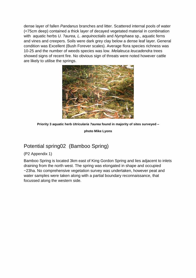
Priority 3 aquatic herb Utricularia ?aurea found in majority of sites surveyed –
photo Mike Lyons
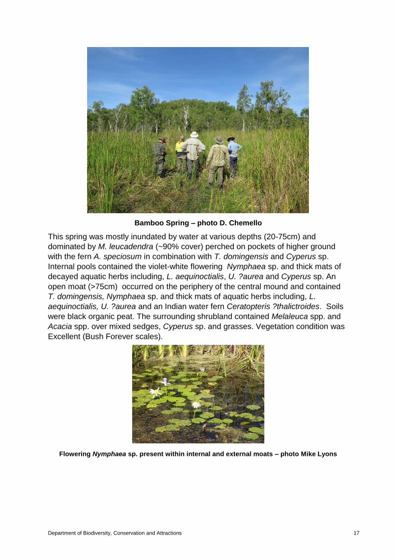
Potential spring02 (Bamboo Spring)
(P2 Appendix 1)
Bamboo Spring is located 3km east of King Gordon Spring and lies adjacent to inlets
draining from the north west. The spring was elongated in shape and occupied
~23ha. No comprehensive vegetation survey was undertaken, however peat and
water samples were taken along with a partial boundary reconnaissance, that
focussed along the western side.
Department of Biodiversity, Conservation and Attractions 17
Bamboo Spring – photo D. Chemello
This spring was mostly inundated by water at various depths (20-75cm) and
dominated by M. leucadendra (~90% cover) perched on pockets of higher ground
with the fern A. speciosum in combination with T. domingensis and Cyperus sp.
Internal pools contained the violet-white flowering Nymphaea sp. and thick mats of
decayed aquatic herbs including, L. aequinoctialis, U. ?aurea and Cyperus sp. An
open moat (>75cm) occurred on the periphery of the central mound and contained
T. domingensis, Nymphaea sp. and thick mats of aquatic herbs including, L.
aequinoctialis, U. ?aurea and an Indian water fern Ceratopteris ?thalictroides. Soils
were black organic peat. The surrounding shrubland contained Melaleuca spp. and
Acacia spp. over mixed sedges, Cyperus sp. and grasses. Vegetation condition was
Excellent (Bush Forever scales).
Flowering Nymphaea sp. present within internal and external moats – photo Mike Lyons
8. Recommendations Determine whether additional springs surveyed align with the Victoria-
Bonaparte Wetlands priority 1 ecological community. This would
require further hydrological investigation and additional vegetation
survey;
Design and implement a project to determine the hydrological drivers of
the mound spring ecosystem;
Design and implement a monitoring program that utilises quadrats
established during the current survey. This will probably require
establishment of a more comprehensive network of quadrats, and
should be designed to provide information about the success of land
management in the sensitive environment of the mound spring
ecosystem;
Seek funds for fencing of the mound springs to restrict cattle access;
and
Determine whether weeds are likely to become a major threat and
seek ways to management them.
9. Conclusions:
Based on observations from this partial survey, the majority of mound springs
surveyed are likely to align with the Victoria-Bonaparte Wetlands priority 1 ecological
community. Once all results of the August 2017 survey are reconciled, it is likely that
additional occurrences will be added to the TEC database and boundaries will be
delineated. Over time it will be valuable to build up a uniform dataset for springs for a
broader regional analysis.
It is recommended that a full nomination be prepared and presented to the W.A.
Threatened Species Ecological Communities Scientific Committee for formal
assessment.
10. References:
Black, S.J. (2004) Mound spring ecosystems in the Western Australian rangelands.
In Living in the outback, Australian Rangelands Society 13th Biennial
Conference 5-8 July 2004, eds G. N. Bastin, D. Walsh, and S. Nicolson.
Australian Rangelands Society, Alice Springs.
Black S. (2001). Wetlands conservation project 2000 Final Report. Conserving
organic mound springs of the Kimberley Region. Internal document.

Department of Biodiversity, Conservation and Attractions 19
Graham, G. (1994) Rainforest monitoring notes. Internal document.
Department of Environment and Conservation (2008). A report on the application of
draft criteria for identification of High Conservation Value Aquatic Ecosystem
(HCVAE) on mound springs in Western Australia. Produced for the Aquatic
Ecosystem Task Group, Department of Environment, Water and Heritage and
the Arts.
Halse, S.A., Shiel, R.J., Pearson, G.B. (1996). Waterbirds and aquatic invertebrates
of swamps on the Victoria-Bonaparte mudflat, northern Western Australia.
Kimberley Rainforests Australia (1991). McKenzie, N.L., R.B. Johnston and P.G.
Kendrick (Eds). Published by Surrey Beatty & Sons in associate with
Department of Conservation & Land Management and Department Arts,
Heritage and Environment, Canberra.

Project title
Department of Biodiversity, Conservation and Attractions 21
Appendix 2. Flora of Victoria Bonaparte mound springs and surrounds, compiled from
August 2017^ survey and historical survey data (not a comprehensive list)
Flora taxa Conservation status
Acrostichum speciosum
Adansonia gregorii
Amyema sp.
Antidesma ghaesembilla
Avicennia marina
Bauhinia cunninghamii
Carallia brachiata
Ceratophyllum demersum
Ceratopteris thalictroides
Cochurus sp.
Colocasia esculenta
Cyclosorus interruptus
Cyperus conicus
Cyperus javanicus
Diospyros maritima
Eleocharis ?geniculata
Ficus racemosa
Ficus virens
Ficus sp.
Flagellaria indica
Fimbristylis caespitosa
Fimbristylis ferruginea
Juncus sp.
Lemna aequinoctialis
Luffa aegyptiaca
Lumnitzera racemosa
Marsilea sp.
Melaleuca alsophila
Melaleuca leucadendra
Melaleuca viridiflora
Melicope elleryana
Mesosphaerum suaveolens
Mucuna gigantea
Nauclea orientalis
Nymphaea sp.
Pandanus spiralis
Phragmites karka
Schoenoplectus subulatus

Sterculia holtzei Priority 1
Sesbania formosa
Sesbania cannabina
Sporobolus ?virginicus
Stenochlaena palustris
Timonius timon
Terminalia microcarpa
Thespia populneoides
Typha domingensis
Utricularia aurea Priority 2
^The list of flora will be verified following formal flora identifications.