Survey Commissioned by The National Trust Wales … Commissioned by The National Trust Wales...
40
Survey Commissioned by The National Trust Wales Surveyed by I.P. Brooks Engineering Archaeological Services Ltd Registered in England N o 2869678 Plas Newydd Marine Heat Source Pump, Archaeological Watching Brief June 2014 EAS Client Report 2014/05
-
Upload
nguyentram -
Category
Documents
-
view
213 -
download
1
Transcript of Survey Commissioned by The National Trust Wales … Commissioned by The National Trust Wales...
Survey Commissioned
by
The National Trust Wales
Surveyed
by
I.P. Brooks
Engineering Archaeological Services Ltd
Registered in England
No 2869678
Plas Newydd Marine Heat Source Pump, Archaeological
Watching Brief
June 2014
EAS Client Report 2014/05

CONTENTS
IntroductionNGRLocation and TopographyArchaeological BackgroundSUMMARY
Methodology
Survey Results
Conclusions
Potential for Further Research
Acknowledgements
References
Appendix 1: Context Summary
List of Illustrations
Figure 1: LocationFigure 2: Extent of the ProjectFigure 3: Location of the archaeologyFigure 4: Elevation of the Marine Walk,
before constructionFigure 5: SectionsFigure 6: SectionsFigure 7: 1916 Ordnance Survey mapFigure 8: 1790 image of Plas NewyddFigure 9: 1840 image of the Marine Walk
Plate 1: General view of the area for the pump house before construction
Plate 2: Detail of the elevation of the marine walk
Plate 3: Possible slipway to the north of the pump house
Plate 4: Blocking for one of the cavesPlate 5: Pillar of indurated sedimentsPlate 6: Possible flowstone floor running
beneath the cliffPlate 7: Removing the tufa from the cliff
facePlate 8: Stalactites forming behind the
tufaPlate 9: Patch of exposed rock face.Plate 10: Section through the face of the
marine walkPlate 11: The make-up for the marine
walkPlate 12: Organic deposits (Context 5)
below the make-up for the Marine Walk
Plate 13: Deposits below the path to the rhododendron walk
Plate 14: Wall (Context 14)Plate 15: Wall (Context 16)Plate 16: Glass bottle from Context 18Plate 17: Gutter support from Context 18Plate 18: Wall, (Context 19)Plate 19: Tip of crushed mortar within
Context 20Plate 20: Tips of stone within Context 20Plate 21: Brick from Context 20Plate 22: Burnt patches (Context 21)
below Context 20Plate 23: Feature (Context 33)Plate 24: Feature (Context 30)

Plate 25: Probable path (Context 27)Plate 26: Chert flakePlate 27: Pitched stones below the
tarmacPlate 28: Concrete pad (Context 22)Plate 29: Step in the underlying
limestone (Context 24)

1
Introduction
NGR
Centred on: SH 5213 6970
Location and Topography (Figure 1)
Plas Newydd is located on the west side of the Menai Straits at SH 52080 69580 4 km south west of Menai Bridge. The development consists of the construction of a marine heat source pump system with its collector system on the bed of the Menai Straits, a pump house on the marine walk and then a pipeline which runs up the cliff, across the gardens to the stable building. A second pipeline then links the stables to the main house.
Archaeological Background
Originating in the sixteenth century the main phases of activity at Plas Newydd date to the turn of the eighteenth and nineteenth centuries with an outstanding landscape park influenced by Humphrey Repton. Plas Newydd is a Grade 1 Registered Historic Park and Garden (PG W (Gd) 48 (ANG)). Whilst no formal archaeological conditions were placed on the development, the National Trust commissioned a limited watching brief on the ground-works in order to record any significant archaeological deposits disturbed.
SUMMARY
The pipeline associated with the marine heat pump system at Plas Newydd recorded a number of post-medieval features and layers within the gardens which suggested a number of phases of modifications to the landscape. On the foreshore and Marine Walk, however,at least two caves were located and below the Marine Walk an organic rich deposit was recorded with the potential for indicating the pre-Marine Walk environment.

2
Methodology
Prior to the start of the ground-works the site was visited and the near vertical face of the marine walk was recorded both with a measured drawing and with a series of photographs. Once the ground-works commenced all of the trenches were inspected and recorded, indeed much of the ground-works were monitored during the excavation of the deposits.
Any archaeologically significant deposits or features encountered were located, either by direct measurement from fixed landscape features or by the use of a Garmin S62 Map hand held GPS using the WAAS correction giving a potential accuracy of ± 2m. Photographs were taken with a D80 Digital SLR Camera at a resolution of 10.2 MP. The photographs were taken in “RAW” format and then converted to JPEGs for illustration and the report.
Survey Results
The results of the watching brief can be conveniently divided into four main areaswhich reflected the way in which the pipeline was constructed and the nature of remains recorded.
Marine walk and the foreshore
Before the construction of the pump house and associated works the marine walk was recorded. The walk consists of a level platform at the foot of the cliff with a revetted face to the sea which was generally, approximately, 1.75 m high (Figure 4, Plates 1 and 2).
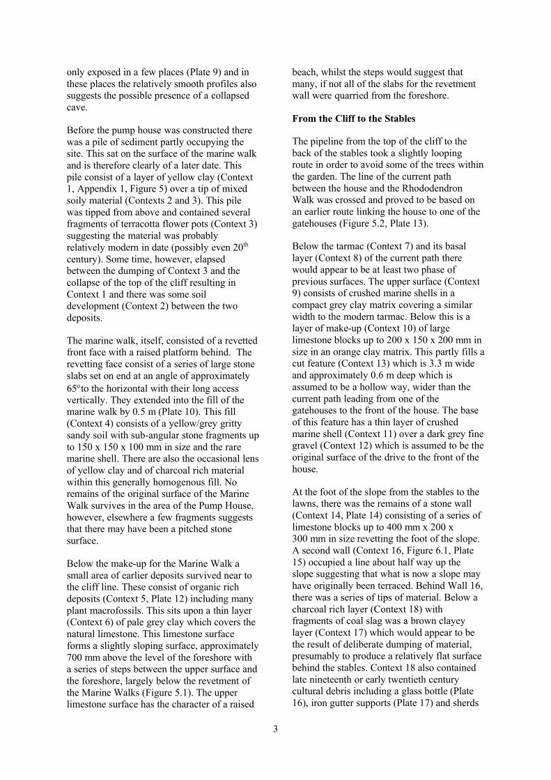
To the north of the outlet site the level of the marine walk reduced to almost nothing (Plate 3), whilst it is not clear, it is probable that there was a slipway onto the foreshore at this point. This point was used to allow the machine used to dig the foundations of the pump house to access the marine walk after having been tracked across the foreshore.
The pump house occupies a section of the marine walk where the cliff follows a slight concaved plan. The origins of this form is uncertain, however the presence of a series of caves to the north (Plate 4) and the presence of what appears to be a flowstone floor (Plate 6)running under the line of the cliff to the south suggests the possibility that the slight embayment is the result of a collapsed cave. There are at least two caves immediately to the north of the pump house (Plate 4) and a surviving pillar of indurated sediment which has the appearance of having been cave sediment (Plate 5). The caves have been partly blocked with rough stone walling, however there is sufficient evidence to suggest that the caves extend behind the walling, although their full extent is unknown.
The cliff was covered by a thick layer of tufa which was clearly still active as it was incorporating the moss growth in places. An area of this tufa was removed proving to be up to 600 mm thick (Plate 7). Behind the drape of tufa there are a series of stalactite like formations, these however would appear to be relatively recent in their formation as they tend to form around a series of tree roots hanging over the cliff edge (Plate 8). The true cliff is
3
only exposed in a few places (Plate 9) and in these places the relatively smooth profiles also suggests the possible presence of a collapsed cave.
Before the pump house was constructed there was a pile of sediment partly occupying the site. This sat on the surface of the marine walk and is therefore clearly of a later date. This pile consist of a layer of yellow clay (Context 1, Appendix 1, Figure 5) over a tip of mixed soily material (Contexts 2 and 3). This pile was tipped from above and contained several fragments of terracotta flower pots (Context 3) suggesting the material was probably relatively modern in date (possibly even 20th
century). Some time, however, elapsed between the dumping of Context 3 and the collapse of the top of the cliff resulting in Context 1 and there was some soil development (Context 2) between the two deposits.
The marine walk, itself, consisted of a revetted front face with a raised platform behind. The revetting face consist of a series of large stone slabs set on end at an angle of approximately 65to the horizontal with their long access vertically. They extended into the fill of the marine walk by 0.5 m (Plate 10). This fill (Context 4) consists of a yellow/grey gritty sandy soil with sub-angular stone fragments up to 150 x 150 x 100 mm in size and the rare marine shell. There are also the occasional lens of yellow clay and of charcoal rich material within this generally homogenous fill. No remains of the original surface of the Marine Walk survives in the area of the Pump House, however, elsewhere a few fragments suggests that there may have been a pitched stone surface.
Below the make-up for the Marine Walk a small area of earlier deposits survived near to the cliff line. These consist of organic rich deposits (Context 5, Plate 12) including many plant macrofossils. This sits upon a thin layer (Context 6) of pale grey clay which covers the natural limestone. This limestone surface forms a slightly sloping surface, approximately 700 mm above the level of the foreshore with a series of steps between the upper surface and the foreshore, largely below the revetment of the Marine Walks (Figure 5.1). The upper limestone surface has the character of a raised
beach, whilst the steps would suggest that many, if not all of the slabs for the revetment wall were quarried from the foreshore.
From the Cliff to the Stables
The pipeline from the top of the cliff to the back of the stables took a slightly looping route in order to avoid some of the trees within the garden. The line of the current path between the house and the Rhododendron Walk was crossed and proved to be based on an earlier route linking the house to one of the gatehouses (Figure 5.2, Plate 13).
Below the tarmac (Context 7) and its basal layer (Context 8) of the current path there would appear to be at least two phase of previous surfaces. The upper surface (Context 9) consists of crushed marine shells in a compact grey clay matrix covering a similar width to the modern tarmac. Below this is a layer of make-up (Context 10) of large limestone blocks up to 200 x 150 x 200 mm in size in an orange clay matrix. This partly fills a cut feature (Context 13) which is 3.3 m wide and approximately 0.6 m deep which is assumed to be a hollow way, wider than the current path leading from one of the gatehouses to the front of the house. The base of this feature has a thin layer of crushed marine shell (Context 11) over a dark grey fine gravel (Context 12) which is assumed to be the original surface of the drive to the front of the house.
At the foot of the slope from the stables to the lawns, there was the remains of a stone wall (Context 14, Plate 14) consisting of a series of limestone blocks up to 400 mm x 200 x 300 mm in size revetting the foot of the slope. A second wall (Context 16, Figure 6.1, Plate 15) occupied a line about half way up the slope suggesting that what is now a slope may have originally been terraced. Behind Wall 16, there was a series of tips of material. Below a charcoal rich layer (Context 18) with fragments of coal slag was a brown clayey layer (Context 17) which would appear to be the result of deliberate dumping of material, presumably to produce a relatively flat surface behind the stables. Context 18 also contained late nineteenth or early twentieth century cultural debris including a glass bottle (Plate 16), iron gutter supports (Plate 17) and sherds

4
of ceramics. It is likely to be the result of the dumping, out of sight, behind the stables including the waste from coal fires.
The glass bottle (Plate 16) was stamped
W. Rowlands & CoWine merchant
Bangor&
Llangefni
W. Rowlands were based at 288 High Street, Bangor with a warehouse and bottling store in James Street and a second shop in Llangefni (Caernarvonshire Directory 1886). They probably developed from a company called Evans and Rowlands who were also based in High Street, Bangor and who appeared in the Slater’s Trade Directories for 1856 and 1858-59. The first mention of W Rowlands is in the Slater’s Directory of 1868 and they appear in a series of directories until the Wales North and South Directory of 1948-9. Whilst they are described as “wine merchants” the 1874 Worrall’s Directory also mentioned they were “Ales & Porter Merchants & Bottlers” and it is likely that the bottle was in this context.
Area of the stables
Context 18 continues round the rear of the stables where it sealed the remains of rough stone wall (Context 19) which appears to run parallel with the rear wall of the stables. It was constructed of large limestone block up to 1.6 x 0.3 x 0.5 m in size, but more typically 0.5 x 0.5 x 0.5 m in size with the remains of some lime mortar (Plate 18). The function of this wall is unknown, however, it is likely to have been in position before the stables was extended to the rear.
Where the trench turns the corner and runs along the southern side of the stables the wall (Context 19) marks the edge of the construction debris for the stables (Context 20). This layer includes tips of soily material, crushed lime mortar (Plate 19) and rough limestone blocks (Plate 20). It also contained a complete, handmade brick (Plate 21) stamped:
TrademarkFW
The size of this brick would suggest a nineteenth century date and the stamp has been associated with the Buckley brickworks (http://www.penmorfa.com/bricks/buckley1.html) from Buckley Brick and Tile Company which operated between 1865 and 1963. The “FW” refers to the “Flintshire White” trade mark.
Sealed below Context 20, in the bottom of the trench were two small patches of burnt clay (Context 21, Plate 22) which presumably relate to activity taking place before the stables were constructed. Given the lack of exposure the extent and function of these patches is unknown.
From the Stables to the House
The spread of construction debris (Context 20) extends for at least 18 m from the southern wall of the stables. In places it is sealed by a clayey layer (Context 26) which is assumed to be the result of construction the spur road from the stables to the rear of the house. There are two feature which contain lenses of burnt material. The larger of these (Context 33, Plate 23, Figure 6.4) cuts this layer and is therefore later whilst the smaller feature (Context 30, Plate 24, Figure 6.3) is sealed by Context 26 whilst cutting Context 20. The full extent and function of these features are unknown.
At SH 52070 69707 a layer of pinkish gravel (Context 27, Plate 25, Figure 6.2), 1.35 m wide and 1.3 m thick appeared in both sections of the trench. This was sealed below Context 26 and therefore pre-dates the construction of the road between the stables and the house. It also aligns on a linear hollow in the lawn between the road to the mansion and the road leading to the volunteer’s car park suggesting that this feature and Context 27 represent the line of a disused footpath. Curiously this line is preserved in the Ordnance Survey Landline mapping even though there are no topographic features to the east of the road from the stables to the house. The footpath also does not appear on the 1916 Ordnance Survey mapping, nor the earlier maps suggesting that the footpath dates from after 1916, but before the construction of the road from the stables to the rear of the house.

5
Although it was unstratified, the only prehistoric artefact found during the project was found in this section. This is a tertiary flake of local chert (Plate 26). Although this artefact is essentially undatable it does suggest a level of prehistoric activity in the area.
The southern section of the trench was cut through the tarmac of the road and parking places adjacent to the northern end of the house complex. In places this tarmac sealed areas of pitched stones (Context 23, Plate 27) which are assumed to be an earlier road surface.
This section of the pipeline is highly disturbed with multiple service pipes, including an electricity cable which runs along the line of much of the route. This disturbance is up to 1.3 m deep where at the southern end of the pipeline, near to the house, the natural rock was exposed. This exposure was only for a short length as the trench angled up the slope. It does however suggest that the house may be built on a larger platform cut into the slope of the hillside.
Further to the north at SH 52067 69665 a large slab of concrete (Context 22) was discovered in the base of the trench. This was at least 8.4 m long and was lined on the western side with a stone wall (Plate 28). The function of this slab is unknown, however it demonstrates a level of relatively modern disturbance in this area.
At SH 52071 69675, a marked step in the underlying limestone (Context 24, Plate 29)was noted. This is at least 0.5 m high and is probably much deeper. The position of this step would suggest that it marks the original edge of the road to the back of the house which did not follow the current route, but curved to the west to link in with the drive to the front of the house. This re-organisation must have taken place after 1916 as is shown on the Ordnance Survey map published at that date (Figure 7)
Conclusions
Whilst the majority of the features and deposits recorded during the watching brief at Plas Newydd are relatively modern there is thepotential for the raised beach and caves discovered on the foreshore to be from an early period in the development of the Menai Straights. The raised beach is probably Pleistocene in date, however, the organic deposits along the cliff line are probably Holocene in date.
The extent of the caves is uncertain and beyond the scope of this study. It would seem likely that the position of the pump house is within a collapsed cave, whilst there are a series of other caves along the cliff line. No direct evidence for human occupation was seen in the cave deposits recorded, however, no detailed examination was made. The potential for these caves is considerable. Their position on the edge of the Menai Straights would be ideal as a hunting stand. The initial breaching of the Menai Straits took place about 8,400 BP, however it was not until between 5,600 and 4,800 BP that the final submergence of the straits took place (Roberts et al 2011). Thus in the Late Palaeolithic and Mesolithic periods The Menai would have been prime hunting grounds with the relative confined topography potentially concentrating the game, making hunting easier. Even if no human activity is recorded within the cave deposits they have the potential to contain a detailed environmental record with a mixture of faunal and flora remains together with the potential for dating from the speliotherms(flowstones, stalactites and stalactites) deposits which could extend beyond the range of radiocarbon.
The only clear evidence of prehistoric activity recovered from the pipeline was the unstratified chert flake found between the stables and the house. Whilst it is undatable the proximity of the chamber tomb is suggestive.
Whilst no evidence for the date of the construction of the Marine Walk from the watching brief an images in the National Library from 1790 (Figure 8) would suggest that it was already constructed by that date. The form of at least part of the Marine Walk is

6
also shown on a later image from 1840 (Figure 9). This would suggest that at least in part the Marine Walk had a low parapet together with gaps which would give access to the foreshore itself.
The only clear feature which probably relates to the eighteenth century house is the drive (Context 13) this would appear to have been within a slight hollow way and had a surface which was a mixture of fine gravel and crushed marine shells.
There is considerable evidence for major landscaping between the stables and the house in relatively modern periods, probably in the nineteenth century. Some of this was incidental with the dumping of ashy waste behind the stables, however, the dumps of building materials around the stables, the re-alignment of the road between the stables and the house and the infilling of the area adjacent to the house are all deliberate. The building debris around the stables was assumed to relate to the construction of the building in 1797 (Rutherford 2009, 27), however the recovery of a brick (Plate 21) stamped “Trademark, FW” would suggest a later date. The brick is of the Flintshire White type made by the Buckley Brickworks which operated between 1865 and 1963 (http://www.penmorfa.com/bricks/buckley1.html). This would suggest that at least part of these deposits are part of a later landscaping of this area, possibly related to the extensions to the rear of the stable block.
The second major phase of landscaping took place with the construction of the road from the stables to the rear of the house. Previously there was a curving drive which linked into the drive to the front of the house, however at some point after 1916 the new link was constructed. This included the spreading of the spoil from the construction to the east thereby blocking the footpath (Context 27) which had crossed the area. At the southern end, near to the house this new road was probably covered with a pitched stone surface. The depth of the deposits below the tarmac near to the house is curious and may suggest that the house is built on a larger platform, cut into the hillside, which has since been in-filled.
Potential for Further Research
The majority of the features and deposits recorded during the project leave little potential for further study being related to relatively late developments within the gardens. The organic rich layer (Context 5) however, has the potential to indicate the environment on the edge of the Menai at some point before the construction of the Marine Walk. This would require the commissioning of a specialist palaeoenvironmental report from a suitable specialist on the sample retained from this deposit and at least one radio-carbon date to give an age to these deposits.
The caves along the foreshore could be the subject of further study as their form and the nature of the deposits is little understood. This work however is highly specialised as cave deposits are difficult to work and potentially contain a very high quality record of past environments. Specialist would potentially be required for such items as micro-fauna (bones of rodents, birds, fish, amphibian etc.) macro fauna (larger bones), pollen and other palynomorphs, sediments and speliotherms (including the potential for uranium series dating) even if no human activity is recorded within the deposits. As such this work is not suitable for amateur volunteers unless they have considerable professional backup available in advance, and the funding for such work should also be available before any study is undertaken.
Acknowledgements
The work was commissioned by Paul Southallfor the National Trust and was based on a brief prepared by Kathy Laws, the National Trust Archaeologist for North Wales. Thanks are due to the groundwork contractors (G.H. Jones Civil Engineering) for their support during the project.
References
Laws, K. 2013. Proposed Plas Newydd Heat Source Pump. Archaeological and Historic Landscape Assessment. Unpublished Report for the National Trust.

7
Roberts, M., Scourse, J., Bennell, J., Huws, D., Jago, C. and Long, B. 2011 Late Devensian and Holocene relative sea-level change in North Wales, UK. Journal of Quaternary Science 26.2, 141–155
Rutherford, S. 2009. Plas Newydd, Anglesey. Historic Landscape Analysis.Unpublished Report for the National Trust.
http://www.bangorcivicsociety.org.uk/pages/hisso/#directories
http://www.penmorfa.com/bricks/wales1.html

Plate 1 : General view of the area for the pump house before constmction
Plate 2: Detail of the elevation of the mruine walk
8
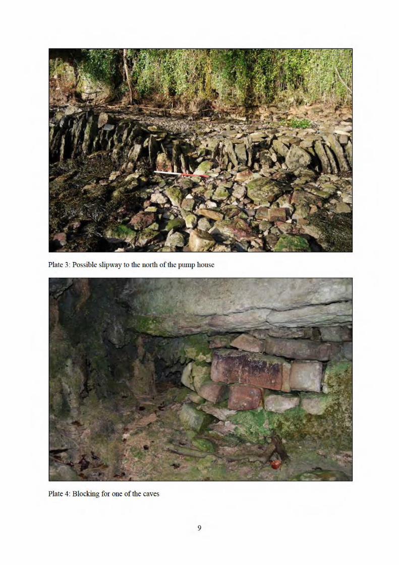
Plate 3: Possible slipway to the north of the pump house
Plate 4: Blocking for one of the caves
9

Plate 5: Pillar of indurated sediments
Plate 6: Possible flowstone floor running beneath the cliff
10

Plate 7: Removing the tufa from the cliff face
Plate 8: Stalactites fonning behind the tufa
11

Plate 9: Patch of exposed rock face.
Plate 10: Section through the face of the marine walk
12

Plate 11 : The make-up for the mruine walk
Plate 12: Organic deposits (Context 5) below the make-up for the Marine Walk
13

Plate 13: Deposits below the path to the rhododendron walk
Plate 14: Wall (Context 14)
14
Plate 15: Wall (Context 16)
Plate 16: Glass bottle fi:om Context 18
15

Plate 17: Gutter supp01t :fi:om Context 18
Plate 18: Wall, (Context 19)
16

Plate 19: Tip of cmshed mo1tar within Context 20
Plate 20: Tips of stone within Context 20
17
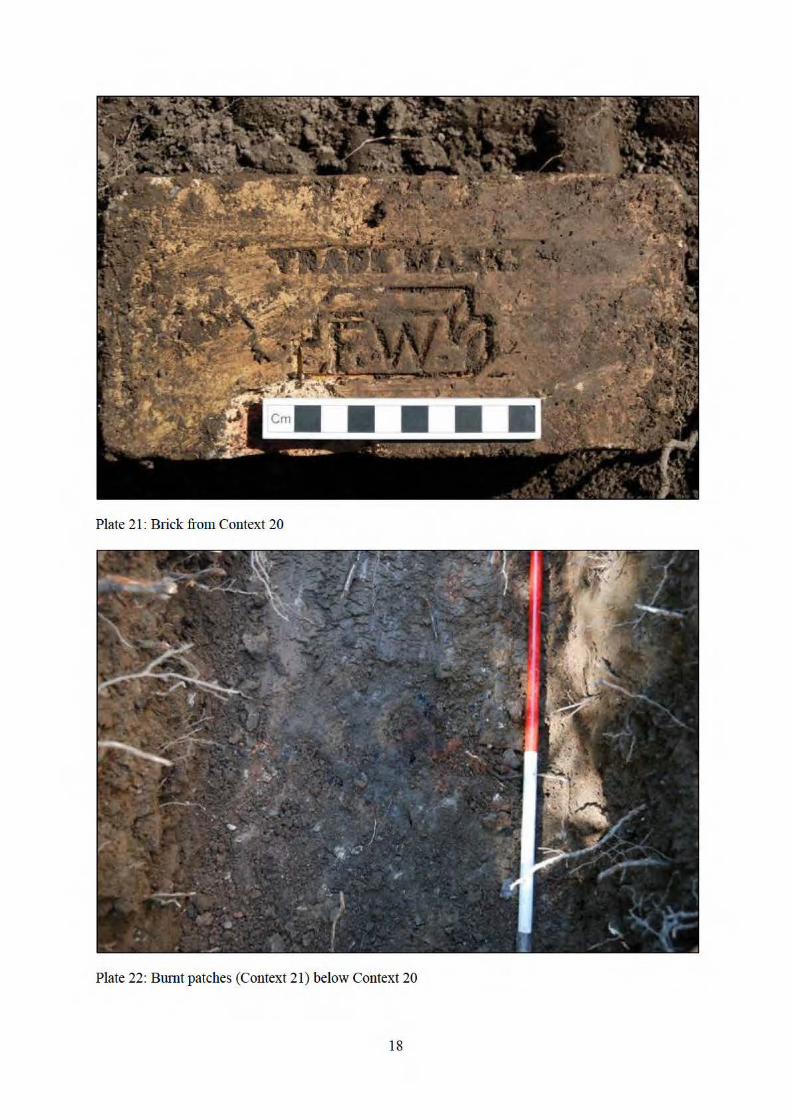
Plate 21 : Brick from Context 20
Plate 22: Bumt patches (Context 21) below Context 20
18

Plate 23: Feamre (Context 33)
Plate 24: Feature (Context 30)
19

Plate 25: Probable path (Context 27)
Plate 26: Che1t flake
20
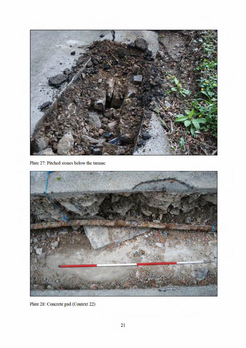
Plate 27: Pitched stones below the tatmac
Plate 28: Concrete pad (Context 22)
21

Plate 29: Step in the underlying limestone (Context 24)
22

Reproduced from the Explorer OL17, 1:25,000 scale mapby permission of the Ordnance Survey ® on behalf of
The Controller of Her Majesty's Stationary Office© Crown Copyright 2002
All Rights Reserved Licence Number AL 100014722
Figure 1: LocationScale 1:25,000

.i: ;t t. ~
~ ~ :j..
.... :t;
..... J:.
* * ~
·* :j..
r:u o;
* £:;
-c (/)
* 4: \:::1 c::
:Jt.. .,
\:::1 ;:,
_.) ~
... -*-
Playing Field
r ial Chamber SJ
0 50m

\~ ~
'I ~ (2
t
;~ * ~~
*-
t--
Patn ( IJ{/))
igure 3: Location of the Scale 1:500
~'
0
:f,
)
:t
'"'~ I I l.y.J
0 50 m
--~~---====---~==~----

NS
0 1.0 m
Figure 4: Elevation of the Marine WalkScale 1:20

0 1.0 m
WE
NW SE7
89
10
1112
##
# ##
# #
##
# #
#
#
##
#
#
# #
#
##
#
# # # #
##
#
##
##
#
#
2
3
4
1
5
6
13
Figure 5: SectionsScale 1:30
5.1
5.2

# ##
# # # #
## #
#
#
# #
# #
# # #
###
#
##
##
# #
#
0 1.0 m
W E
N S
S N
S N
16
25
26
28
27
26
29
30
31
32
33
ElectricCables
15
17
Figure 6: SectionsScale 1:20
6.1
6.2
6.3
6.4
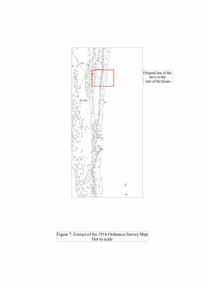
Figure 7: Extract of the 1916 Ordnance Survey MapNot to scale
Original line of thedrive to the
rear of the house

Figure 8: 1790 Image of Plas NewyddSource: National Library of Wales

Figure 9: 1840 Image of the Marine WalkSource: National Library of Wales

Appendix 1: Context SummaryC
onte
xt
Loca
tion
Rel
atio
nshi
ps
Des
crip
tion
Dra
win
gs
Phot
ogra
phs
1 SH 52169 69742 Above 2 Pale yellow/brown clay with the occasional large limestone block up to 500 x 700 x 300 mm in size. This layer would appear to be the result of collapse from the top of the cliff above.
Figure 5.1 Plas Newydd_043, 044, 059, 060, 061, 070, 075, 076, 075, 076, 077
2 SH 52169 69742 Below 1Above 3
Topsoil. Mid brown slightly clayey soil Figure 5.1 Plas Newydd_070, 072. 073, 074, 075, 076, 077, 079, 082, 083
3 SH 52169 69742 Below 2Above 4
Mid brown slightly clayey soil with many root and flecks of charcoal. The layer also contained a moderate number of angular and sub-angular limestone blocks up to 180 x 80 mm in size. Cultural material includes many fragments of flower pots and the occasional handmade brick. Probably the deliberate dumping of material over the cliff in the twentieth century
Figure 5.1 Plas Newydd_070, 072. 073, 074, 075, 076, 077, 079, 082, 083

Con
text
Loca
tion
Rel
atio
nshi
ps
Des
crip
tion
Dra
win
gs
Phot
ogra
phs
4 SH 52169 69742 Below 3Above 6Abuts 5 and structure of marine walk
Yellow/grey gritty sandy soil with sub-angular stone fragments up to 150 x 150 x 100 mm in size and the rare marine shell. There are the occasional lens of yellow clay and of charcoal rich material within a generally homogenous fill. Cultural material within the layer includes the rare fragments of handmade bricks. This layer is clearly deliberately dumped behind the stone walling face of the marine wall to produce a level surface for the marine walk.
Figure 5.1 Plas Newydd_070, 071, 075, 076, 077, 078, 086, 087, 088
5 SH 52169 69742 Below 3Abuts 4Above 6
An area of organic rich soil with many plant fragment in the form of twigs. The layer is black in colour with a clayey texture. Probably the remnant of an organic rich soil at the base of the cliff prior to the construction of the Marine Walk.
Figure 5.1 Plas Newydd_064, 065, 068, 069
6 SH 52169 69742 Below 5 Pale grey clay Figure 5.1 Plas Newydd_071, 072, 073, 074, 075, 076, 077, 079, 080, 081, 082, 083, 084
7 SH 252135 252135 Above 8Within 13
A thin layer of Tarmac, approximately 60 mm thick. Modern path.
Figure 5.2 Plas Newydd_141, 142
8 SH 252135 252135 Below 7Above 9Within 13
Orange/brown clayey gravel disturbed by many tree roots. This layer would appear to be the basal layer for the Tarmac layer above
Figure 5.2 Plas Newydd_141, 142
Con
text
Loca
tion
Rel
atio
nshi
ps
Des
crip
tion
Dra
win
gs
Phot
ogra
phs
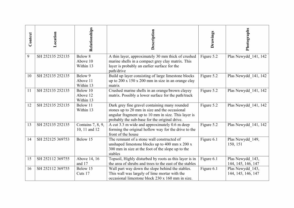
9 SH 252135 252135 Below 8Above 10Within 13
A thin layer, approximately 30 mm thick of crushed marine shells in a compact grey clay matrix. This layer is probably an earlier surface for the path/drive
Figure 5.2 Plas Newydd_141, 142
10 SH 252135 252135 Below 9Above 11Within 13
Build up layer consisting of large limestone blocks up to 200 x 150 x 200 mm in size in an orange clay matrix
Figure 5.2 Plas Newydd_141, 142
11 SH 252135 252135 Below 10Above 12Within 13
Crushed marine shells in an orange/brown clayey matrix. Possibly a lower surface for the path/track
Figure 5.2 Plas Newydd_141, 142
12 SH 252135 252135 Below 11Within 13
Dark grey fine gravel containing many rounded stones up to 20 mm in size and the occasional angular fragment up to 10 mm in size. This layer is probably the sub-base for the original drive.
Figure 5.2 Plas Newydd_141, 142
13 SH 252135 252135 Contains 7, 8, 9,10, 11 and 12
A cut 3.3 m wide and approximately 0.6 m deep forming the original hollow way for the drive to the front of the house
Figure 5.2 Plas Newydd_141, 142
14 SH 252125 369753 Below 15 The remnant of a stone wall constructed of unshaped limestone blocks up to 400 mm x 200 x 300 mm in size at the foot of the slope up to the stables
Figure 6.1 Plas Newydd_149, 150, 151
15 SH 252112 369755 Above 14, 16 and 17
Topsoil, Highly disturbed by roots as this layer is in the area of shrubs and trees to the east of the stables
Figure 6.1 Plas Newydd_143, 144, 145, 146, 147
16 SH 252112 369755 Below 15Cuts 17
Wall part way down the slope behind the stables. This wall was largely of lime mortar with the occasional limestone block 230 x 160 mm in size.
Figure 6.1 Plas Newydd_143, 144, 145, 146, 147

Con
text
Loca
tion
Rel
atio
nshi
ps
Des
crip
tion
Dra
win
gs
Phot
ogra
phs
17 SH 252112 369755 Below 15, 18Cut by 16Probably equivalent to 20
Mid brown clayey soil. This layer would appear to be a deliberate dump of material in order to produce a level surface behind the stables
Figure 6.1 Plas Newydd_143, 144, 145, 146, 147
18 SH 5210 6975 Below 15Above 17, 19
Tips of ash and coal slag behind the stables. The layer includes several fragment of nineteenth or early twentieth century ceramic, a glass bottle and the iron supports for a gutter. This layer appears the have been tipped from the south eastern corner of the stables
Plas Newydd_152, 153, 154, 155
19 SH 5210 6975 Below 18Above 17, 20
Stone wall running parallel with the rear wall of the stables. A row of large limestone blocks up to 1.6 x 0.3 x 0.5 m in size, but more typically 0.5 x 0.5 x 0.5 m in size with the remains of some lime mortar. The line of the wall along the line of the trench means that there were limited opportunities to record this feature
Plas Newydd_152, 153, 156, 157
20 SH 5208 6974 Below 19Probably equivalent to 17Above 21
Made ground around the stables. Dumps of soil, and limestone block. The limited evidence available suggests that this deposit extends up to 18 m from the southern wall of the stables.
Plas Newydd_162, 163, 164
21 SH 52089 69740 Below 20 Small patches of burnt clay and charcoal in the base of the trench, at a depth of 0.7 m below the ground level. Approximately 200 mm in diameter
Plas Newydd_160, 161

Con
text
Loca
tion
Rel
atio
nshi
ps
Des
crip
tion
Dra
win
gs
Phot
ogra
phs
22 SH 52067 69665 Below modern disturbance
Large area of concrete, at least 8.4 m long, edged on one side by the remains of a stone wall consisting of limestone blocks up to 0.55 x 0.25 m in size. Part of this wall has been removed (probably during the excavation of the trench) however there are a few machine made brick suggesting a relatively modern structure
Figure 8: Plas Newydd_124, 125, 126, 127, 128, 129, 139, 183
23 SH 5207 6968 Below TarmacAbove 24
An area of pitched stones below the tarmac of the road to the house, probably reflecting an earlier surface to the road
Plas Newydd_179, 180, 182
24 SH 52071 69675 Below 23 A marked step in the underlying limestone reflecting a deliberate cut, at least 0.5 m deep. Possibly the edge of the original line of the drive to the rear of the house before it was straightened
Plas Newydd_181
25 SH 52070 69707 Above 26 Topsoil Figure 6.2 Plas Newydd_206, 207, 208
26 SH 52070 69707 Below 25Above 22, 27, 29
Mid grey/brown silty clay with the rare small (up to 20 mm) stone and fleck of charcoal. Probably the result of the dumping of material from the construction of the road to the house.
Figure 6.2 Plas Newydd_206, 207, 208
27 SH 52070 69707 Below 26Above 28Cut by 30
Pink/grey gravel of small (less than 20 mm) sub-angular gravel in a pink sandy matrix. This layer aligns with a linear hollow to the west of the road to the house and is therefore probably the remains of a gravel path.
Figure 6.2 Plas Newydd_206, 207, 208

Con
text
Loca
tion
Rel
atio
nshi
ps
Des
crip
tion
Dra
win
gs
Phot
ogra
phs
28 SH 52070 69707 Below 27 Yellow/brown very clayey silt with the occasional limestone block up to 250 mm in size. Possibly the disturbed top of the underlying natural
Figure 6.2 Plas Newydd_206, 207, 208
29 SH 52072 69711 Below 26Within 30
Possible dump of burnt clay with large fragments of charcoal in a yellow/brown clayey matrix
Figure 6.3 Plas Newydd_209, 210, 211
30 SH 52072 69711 Below 26Contains 29
A shallow feature, approximately 750 mm wide and up to 150 mm deep exposed only on the western side of the trench
Figure 6.3 Plas Newydd_209, 210, 211
31 Within 33Above 32
Pale grey/brown clayey soil with the rare stone up to 20 mm in size and several tree roots
Figure 6.4 Plas Newydd_212, 213
32 Below 31Within 33
Dump of burnt material including clumps of burnt clay and may flecks and small pieces of charcoal. The layer also contains the occasional fragment of coal
Figure 6.4 Plas Newydd_212, 213
33 Cuts 26 A large feature, approximately 2.4 m wide and up to 0.9 m deep which appear on both sides of the trench. It is uncertain whether this feature is a ditch or a large pit
Figure 6.4 Plas Newydd_212, 213