SURFICIAL GEOLOGY OF THE MANLY 7.5’ QUADRANGLE, …closed depressions. May overlie Noah Creek...
23
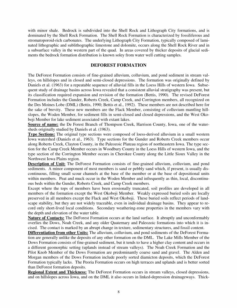
SURFICIAL GEOLOGY OF THE MANLY 7.5’ QUADRANGLE, WORTH AND CERRO GORDO COUNTIES, IOWA Iowa Geological and Water Survey Open File Map OFM-10-04 September, 2010 prepared by Deborah Quade, Stephanie Tassier-Surine, Huaibao Liu, Robert McKay, and James Giglierano Iowa Geological and Water Survey, Iowa City, Iowa Iowa Department of Natural Resources, Patricia Boddy, Interim Director Iowa Geological and Water Survey, Robert D. Libra, State Geologist Supported in part by the U.S. Geological Survey Cooperative Agreement Number G09AC00190 National Cooperative Geologic Mapping Program (STATEMAP)
Transcript of SURFICIAL GEOLOGY OF THE MANLY 7.5’ QUADRANGLE, …closed depressions. May overlie Noah Creek...

SURFICIAL GEOLOGY OF
THE MANLY 7.5’ QUADRANGLE, WORTH AND CERRO
GORDO COUNTIES, IOWA
Iowa Geological and Water Survey
Open File Map OFM-10-04
September, 2010
prepared by
Deborah Quade, Stephanie Tassier-Surine, Huaibao Liu, Robert McKay, and James Giglierano
Iowa Geological and Water Survey, Iowa City, Iowa
Iowa Department of Natural Resources, Patricia Boddy, Interim Director
Iowa Geological and Water Survey, Robert D. Libra, State Geologist
Supported in part by the U.S. Geological Survey
Cooperative Agreement Number G09AC00190
National Cooperative Geologic Mapping Program (STATEMAP)

2
PURPOSE
Detailed geologic mapping of Manly 7.5’ Quadrangle was completed as part of the Iowa Geological and
Water Survey’s (IGWS) ongoing participation in the STATEMAP Mapping Program. In particular, map-
ping of Worth County is part of the Cooperative Mapping with the Natural Resources Conservation Ser-
vice (NRCS) throughout the State of Iowa. This initial mapping provides basic surficial geologic infor-
mation which is the basis to further develop derivative datasets and map products for use by local, county
and state decision-makers. The STATEMAP component of the National Cooperative Geologic Mapping
Program has enhanced the IGWS ability to produce geologic maps. Iowa’s mapping program addresses
priority state-wide issues with longer term goals in mind. Input from the advisory panel has recom-
mended mapping in areas with environmental concerns, related to groundwater quality and land-use plan-
ning issues. IGWS and the advisory panel recognize the need for maps of varying scales to address the
complex environmental issues facing urban and rural Iowans. Issues in developing urban areas center
around residential and commercial development along major transportation corridors, rapid subdivison
expansion on the fringes of urban areas and related problems with septic system siting, aggregate poten-
tial (identification and protection of resources), sensitive areas identification, and water quality and quan-
tity issues. In rural areas, issues are focused on the proper siting of animal confinement facilities, water
quality, watershed management, nutrient management, wetland delineation and protection and aggregate
potential mapping.
INTRODUCTION
The quadrangle-scale map represents the first phase of surficial mapping in conjunction with NRCS and
the Iowa Cooperative Soil Survey county updates in Worth County. The Manly 7.5’Quadrangle map
covers an area from 43° 15’ to 43° 22’ 30” N latitude and 93° 15’ to 93° 07’ 30” W longitude. The map-
ping area is wholly concentrated on the Iowan Erosion Surface (IES) Landform Region. The region has
been subjected to periods of multiple Quaternary glaciations and subaerial erosion. Episodic erosion dur-
ing the last 500,000 years has led to the destruction of pre-existing glacial landforms associated with Pre-
Illinoian glaciations. Generally speaking, the map area consists of unnamed loamy sediments (Iowan Sur-
face materials) of variable thickness overlying Wisconsin-age Sheldon Creek Fm. glacial sediments
and/or Pre-Illinoian-age glacial sediments or shallow rock. These deposits are regionally extensive. Sig-
nificant areas of bedrock outcrop or areas with less than 15 feet of loamy material over rock are present,
especially in the eastern portion of the map area along the Shell Rock River and portions of Beaver Creek,
and pose a significant threat to local groundwater protection. There is no previous surficial geologic
mapping completed as part of the STATEMAP program in this map area. The only other regional surfi-
cial map of the area consists of the Des Moines 4 o x 6
o Quadrangle at a scale of 1:1,000,000 (Hallberg et
al., 1991).
Williams (1899) described and mapped the Quaternary and Paleozoic bedrock geology of the county and
discussed the stratigraphy of Devonian strata that were exposed at the land surface. He also noted the
extreme thinness of the “drift” along the the Winnebago River and nearby Shell Rock River and the re-
markable difference in surface features between the eastern and western portions of Worth County.
Statewide bedrock geologic maps by Hershey (1969), and most recently, by Witzke, Anderson, and Pope
(2010), depict the increased understanding of the complex distribution of geologic units at the bedrock
surface across this region, including Worth County.
REGIONAL SETTING
Early researchers believed there were only two episodes of Pre-Illinoian glaciation in Iowa: Kansan and
Nebraskan. Later regional studies determined that at least seven episodes of Pre-Illinoian glaciation oc-

3
curred in this region between approximately 2.2 million to 500,000 years ago (Boellstorff, 1978a,b; Hall-
berg, 1980a; 1986). Hallberg (1980a,b; 1986) undertook a regional scale project that involved detailed
outcrop and subsurface investigations including extensive laboratory work and synthesis of previous stud-
ies. This study led to the abandonment of the classic glacial and interglacial terminology: Kansan, Afto-
nian and Nebraskan. Hallberg’s study marked a shift from use of time-stratigraphic terms to lithostratiga-
phic classification. The result of Hallberg's study was the development of a lithostratigraphic framework
for Pre-Illinoian till. In east-central Iowa, Hallberg formally classified the units into two formations on
the basis of differences in clay mineralogy: the Alburnett Formation (several undifferentiated members)
and the younger Wolf Creek Formation (including the Winthrop, Aurora and Hickory Hills members).
Both formations are composed predominantly of till deposits, but other materials are present. Paleosols
are formed in the upper part of these till units. Regionally extensive upland units were not deposited in
the map area between 500,000 to 300,000 years ago. During this period several episodes of landscape
development resulted in the formation of an integrated drainage network, slope evolution and soil devel-
opment on stable landsurfaces (Bettis, 1989). Hallberg (1980b) noted that Illinoian-age glacial ice did not
advance as far west as the present map area.
In north-central Iowa, the highly eroded and dissected pre-Illinoian upland is overlain by much younger
Wisconsin-age glacial sediments. During earlier and mid Wisconsin-age, ice advances dating from ap-
proximately 40,000 to 26,000 years before present were deposited throughout the map area. In Iowa, this
glacial deposit is formally recognized as the Sheldon Creek Formation (Bettis et al., 1996; Bettis, 1997)
and in earlier literature is referred to as the “Tazewell till” (Ruhe, 1950). These sediments are typically
buried by loamy erosional sediments associated with the IES. A period of intense cold occurred during
the Wisconsin full glacial episode from 21,000 to 16,500 years ago (Bettis, 1989). This cold episode and
ensuing upland erosion led to the development of the distinctive landform recognized as the Iowan Ero-
sion Surface (Prior, 1976). A periglacial environment prevailed during this period with intensive freeze-
thaw action, solifluction, strong winds and a host of other periglacial processes (Walters, 1996). The re-
sult was that surface soils were removed from the Iowan Erosion Surface and the Pre-Illinoian till surface
was significantly eroded; resulting in the development of a region-wide colluvial lag deposit referred to as
a “stone line”. Another common feature are ice-wedge casts which developed in the colluvial sediments
and stone lines. The ice wedges are remnants of ice-wedge polygons that formed in frozen sediments
(permafrost) during this period of intense cold. Thick packages of stratified loamy and sandy sediments
located low in the upland landscape and adjacent to streams are remnants of solifluction lobes dating to
this period. Associated with the formation of the IES, thick wedges of sediment were transported
downslope. In the map area, along the course of the Shell Rock River, bedrock exposures are common
along the valley and alluvial deposits are relatively thin. On slopes near this area, the colluvial cover is
the only protection for local groundwater resources.
The depositional history of the IES was under great debate for an extended period of time. Early re-
searchers believed the IES was a separate glaciation occurring sometime between the Illinois and the Wis-
consin episodes. Later work disproved this idea and determined that erosional processes controlled the
landscape development (Ruhe et al., 1968). Hallberg et al., (1978) revisited the “Iowan Erosion Surface”
to further research studies into the mechanisms behind the formation of the erosion surface and to reiter-
ate Ruhe’s classic work on stepped erosion surfaces and to illustrate the need for continued research in the
area. Beyond the IES, the Peoria Loess continued to accumulate until 13,000 B.P; and in some parts of
the IES a thin increment of loess accumulated as the climate ameliorated approximately 14,000 to 12,000
years ago.
DESCRIPTION OF LANDFORM SEDIMENT ASSEMBLAGE MAP UNITS
Recent studies and mapping indicate that the map area encompasses a complex suite of depositional land-
forms and sediment sequences related to glaciations, alluviation, subaerial erosion, and wind-blown

4
transport. To map diverse landscapes at 1:24,000 scale we have selected the most comprehensive map-
ping strategy- a landform sediment assemblage (LSA) approach. Various landforms are the result of spe-
cific processes at work in the geologic system. Landforms typically have similar relief, stratigraphic and
sedimentologic characteristics. Recognition of the genetic relationship among landforms and their under-
lying sediment sequences allows one to generalize and map complex glacial terrains over areas of large
extent (Sugden and John, 1976, Eyles and Menzies, 1983). Bettis and others (1999) found LSA mapping
concepts were extremely useful in overcoming the difficulties of mapping in large valleys and noted
LSA's provided a unique opportunity to associate landforms with their underlying sediment packages.
Sixteen landform sediment assemblage units were identified in the map area utilizing orthophotos, topog-
raphic expression, digitized soil and existing and new subsurface boring information. Fourteen borings
were collected representing 288 feet of new subsurface information obtained as part of this mapping pro-
ject. The following is a description of each landform sediment assemblage listed in order of episode:
HUDSON EPISODE
Qo - Depressions (DeForest Formation-Woden Mbr.) - Generally 2.5 to 6 m (8-20 ft) of black to very
dark gray, calcareous, muck, peat and silty clay loam colluvium and organic sediments in drained and
undrained closed and semi-closed depressions. Overlies Noah Creek Fm. sand and gravel, Sheldon Creek
Fm. loam diamicton or Devonian carbonate bedrock. Associated with low relief features that occupy de-
pressions and low sags on the landscape. Supports wetland vegetation and can be permanently covered by
water. High water table.
Qal - Alluvium (DeForest Formation-Undifferentiated) - Variable thickness of less than 1 to 5 m (3-16
ft) of very dark gray to brown, noncalcareous to calcareous, massive to stratified silty clay loam, clay
loam, loam to sandy loam alluvium and colluvium in stream valleys, on hillslopes and in closed depres-
sions. May overlie Noah Creek Formation, Sheldon Creek Formation, Wolf Creek or Alburnett forma-
tions or fractured Devonian carbonate bedrock. Associated with low-relief modern floodplain, closed de-
pressions, modern drainageways or toeslope positions on the landscape. Seasonal high water table and
potential for frequent flooding.
Qalb - Alluvium Shallow to Bedrock (DeForest Formation-Undifferentiated) - Variable thickness of
less than 1 to 5 m (3-16 ft) of very dark gray to brown, noncalcareous to calcareous, stratified silty clay
loam, clay loam, loam to sandy loam alluvium and colluvium in stream valleys, on hillslopes and in
closed depressions. May overlie Noah Creek Formation or Devonian carbonate bedrock. Bedrock surface
is within 5 m (16 ft) of the land surface. Associated with low-relief modern floodplain, closed depres-
sions, modern drainageways or toeslope positions on the landscape. Seasonal high water table and poten-
tial for frequent flooding.
HUDSON and WISCONSIN EPISODE
Qe - Sand Dunes and Sand Sheets (Peoria Formation-sand facies) - Generally less than 3 m (10 ft) of
yellowish brown, massive, calcareous loamy sand to fine sand. May overlie yellowish-brown coarse-
grained sand and gravel (Noah Creek Fm.), or yellowish to grayish brown, usually calcareous, stratified
loam to silt loam to sandy loam diamicton (Sheldon Creek Fm.). Usually restricted to a narrow belt along
major river valley bottoms or adjacent uplands on the Des Moines Lobe. Off the Des Moines Lobe this
unit is not restricted to dunes along valley areas and may occur as sand stringers overlying unnamed ero-
sion surface loamy sediments.
Qdsr - Loamy Sediments Shallow to Limestone, Dolomite, and Shale (DeForest-Noah Creek-Shell
Rock Formation) - 1 to 2 m (3-7 ft) of yellowish brown to gray, massive to weakly stratified, well to

5
poorly sorted loamy, sandy and silty alluvial sediment that overlies the Upper Devonian bedrock surface.
This formation is the major top bedrock unit in the quad, usually with a thickness of 12 to 18 m (40-60 ft).
It is characterized by fossiliferous carbonates with some shale. Layers with abundant subspherical and
tabular stromatoporoids, which may be replaced by calcite crystal masses, commonly occur in the lower
part of the formation. Around southwest part of the quad, this formation is dominated by argillaceous
dolomite and dolomitic limestone, and the thickness can be up to 30 m (100 ft).
Qdlgc - Loamy Sediments Shallow to Dolomite, Limestone, and Shale (DeForest-Noah Creek-
Lithographic City Formation) - 1 to 2 m (3-7 ft) of yellowish brown to gray, massive to weakly stratified,
well to poorly sorted loamy, sandy and silty alluvial sediment that overlies the Middle to Upper Devonian
bedrock surface. Maximum thickness of this map unit is up to 30 m (100 ft), consisting of dolomite and
dolomitic limestone, partially characterized by interbeds of unfossiliferous to sparsely fossiliferous lami-
nated lithographic and sublithographic limestone and dolomitic limestone, in part argillaceous or with
slight shale. “Birdseye” carbonate fabric is common in some layers.
WISCONSIN EPISODE
Qnw - Sand and Gravel (Noah Creek Formation) - 3 m (10 ft) to more than 23 m (75 ft) of yellowish
brown to gray, poorly to well sorted, massive to well stratified, coarse to fine feldspathic quartz sand,
pebbly sand and gravel. In places mantled with 1 to 3 m (3-10 ft) of fine to medium, well sorted sand
derived from wind reworking of the alluvium. This unit encompasses deposits that accumulated in stream
valleys during the Wisconsin Episode.
Qnw_T3 - Sand and Gravel, Terrace 3 (Noah Creek Formation) - 3 m (10 ft) to more than 23 m (75 ft)
of yellowish brown to gray, poorly to well sorted, massive to well stratified, coarse to fine feldspathic
quartz sand, pebbly sand and gravel. In places mantled with 1 to 3 m (3-10 ft) of fine to medium, well
sorted sand derived from wind reworking of the alluvium. This unit encompasses deposits that accumu-
lated in stream valleys during the Wisconsin Episode. Terrace 3 occupies the lowest terrace position and
is located adjacent to Elk Creek and the Shell Rock River.
Qnw_T2 - Sand and Gravel, Terrace 2 (Noah Creek Formation) - 3 m (10 ft) to more than 23 m (75 ft)
of yellowish brown to gray, poorly to well sorted, massive to well stratified, coarse to fine feldspathic
quartz sand, pebbly sand and gravel. In places mantled with 1 to 3 m (3-10 ft) of fine to medium, well
sorted sand derived from wind reworking of the alluvium. This unit encompasses deposits that accumu-
lated in stream valleys during the Wisconsin Episode. Terrace 2 is at an elevation approximately 3 m (10
ft) above Terrace 3. This terrace has limited eolian deposits.
Qnw_T1 - Sand and Gravel Terrace 1 (Noah Creek Formation) - 3 m (10 ft) to more than 23 m (75 ft)
of yellowish brown to gray, poorly to well sorted, massive to well stratified, coarse to fine feldspathic
quartz sand, pebbly sand and gravel. In places mantled with 1 to 3 m (3-10 ft) of fine to medium, well
sorted sand derived from wind reworking of the alluvium. This unit encompasses deposits that accumu-
lated in stream valleys during the Wisconsin Episode. Terrace 1 represents the oldest and highest eleva-
tion of the Noah Creek Formation terraces. Terrace 1 is commonly mantled by Peoria Formation eolian
deposits.
Qnw2 - Sand and Gravel (Noah Creek Formation) - 2 to 12 m (7-40 ft) of yellowish brown to gray,
poorly to well sorted, massive to well stratified, coarse to fine feldspathic quartz sand, pebbly sand and
gravel with few intervening layers of silty clay. Along many valleys a thin mantle of loess, reworked
loess, or fine-grained alluvium (Qal) may be present. This unit includes silty colluvial deposits derived
from the adjacent map units. In places this unit is mantled with 1 to 3 m (3-10 ft) of fine to medium, well
sorted medium to fine sand derived from wind reworking of the alluvium. This unit encompasses depos-

6
its that accumulated in low-relief stream valleys during the Wisconsin Episode and Hudson Episode. Sea-
sonal high water table and some potential for flooding.
Qnw3 - Sand and Gravel Shallow to Bedrock (Noah Creek Formation) - 1 to 3 m (3-10 ft) of yellowish
brown to gray, poorly to well sorted, massive to well stratified, coarse to fine feldspathic quartz sand,
pebbly sand and gravel. May be overlain by up to 2 m (7 ft) of silty alluvial material. In places mantled
with fine to medium well-sorted feldspathic quartz sand derived from wind reworking of the alluvium.
Fractured carbonate bedrock is less than 5 m (16 ft) below the land surface. The unit encompasses depos-
its that accumulated in river and stream valleys during the late Wisconsin as well as exhumed Pre-Illinois
Episode deposits of the Wolf Creek and Alburnett formations.
Qof - Outwash fan (Noah Creek Formation) - Thickness can be quite variable from 3 to 12 m (10-39 ft)
of yellowish-brown coarse-grained sand and gravel. May overlie yellowish to grayish brown usually cal-
careous, stratified loam to silt loam to sandy loam diamicton or gray, calcareous, massive, dense loam
diamicton (Sheldon Creek Fm.); textures can be quite variable. Narrow low-relief apron that gently
slopes away from the moraine front. Seasonal high water table.
Qsc2 - Loamy Sediments Shallow to Glacial Till (Unnamed erosion surface sediment ) - 1 to 3 m (3-10
ft) of yellowish brown to gray, massive to weakly stratified, well to poorly sorted loamy, sandy and silty
erosion surface sediment. Map unit includes some areas mantled with less than 1 m (3 ft) of Peoria For-
mation (silt or sand facies). Overlies massive, fractured, slightly firm glacial till of the Sheldon Creek
Formation.
Qsc - Glacial Till (Sheldon Creek Formation-undiff.) - Generally 3 to 15 m (10-50 ft) of a yellowish
brown to gray, calcareous fractured to massive clay loam; at depth this unit can be variably textured and
contain significant sand and gravel bodies. Pierre Shale clasts may be present in core samples. This unit
may not be present on relatively steep sideslopes near valleys. This unit overlies Pre-Illinois diamicton
and is only shown on the cross-section.
PRE-ILLINOIS EPISODE
Qwa3 - Till (Wolf Creek or Alburnett Formations) - Generally 3 to 23 m (10-75 ft) of very dense, mas-
sive, fractured, loamy glacial till of the Wolf Creek or Alburnett formations. This mapping unit can be
buried by glacial sediments (Sheldon Creek Fm.), unnamed erosion surface sediments, loess or alluvium
and is shown only in the cross-section.
PALEOZOIC
DEVONIAN SYSTEM
Dsr - Limestone, Dolomite, and Shale (Shell Rock Formation) Upper Devonian. This formation is the
major top bedrock unit in the quad, usually with a thickness of 12 to 18 m (40-60 ft). It is characterized by
fossiliferous carbonates with some shale. Layers with abundant subspherical and tabular stromatoporoids,
which may be replaced by calcite crystal masses, commonly occur in the lower part of the formation.
Around southwest part of the quad, this formation is dominated by argillaceous dolomite and dolomitic
limestone, and the thickness can be up to 30 m (100 ft).
Dlgc - Dolomite, Limestone, and Shale (Lithograph City Formation) Middle to Upper Devonian. Maxi-
mum thickness of this map unit is up to 30 m (100 ft), consisting of dolomite and dolomitic limestone,
partially characterized by interbeds of unfossiliferous to sparsely fossiliferous laminated lithographic and

7
sublithographic limestone and dolomitic limestone, in part argillaceous or with slight shale. “Birdseye”
carbonate fabric is common in some layers.
Dcv - Limestone and Dolomite (Coralville Formation) Middle Devonian. Thickness of this formation
varies between 10 and 18 m (35-60 ft), and is dominated by limestone, dolomitic limestone, and dolomite,
in part laminated and argillaceous. Brachiopods and corals usually occur in the limestone facies. This unit
is shown only on cross-section, not on map.
Dlc - Dolomite and Limestone (Little Cedar Formation) Middle Devonian. Thickness of this formation
ranges from 27 to 36 m (90-120 ft) in this area. It is dominated by slightly argillaceous to argillaceous
dolomite and dolomitic limestone, usually vuggy and partially laminated and/or cherty. This unit is com-
monly fossiliferous and brachiopods are especially abundant in lower portion. This unit is shown only on
cross-section, not on map.
DESCRIPTION OF NORTH-CENTRAL-EASTERN IOWA STRATIGRAPHY
An important aspect of surficial geologic mapping on the IES is the development of map units that utilize
previously established lithostratigraphic frameworks for the Hudson, Wisconsin and Pre-Illinoian deposits
in Iowa. A stratigraphic framework allows us to better understand the surficial materials of north-eastern
Iowa. Hudson, Wisconsin and Pre-Illinois Episode deposits (Johnson et al., 1997) of the north-eastern
Iowa area included in six formations: DeForest Formation (Hudson), Noah Creek Formation (Hudson and
Wisconsin), Peoria (Wisconsin), Sheldon Creek Formations (Wisconsin), and Wolf Creek and Alburnett
Formations (Pre-Illinois). The following section provides a description of formations and members of
north-east Iowa deposits.
STRATIGRAPHIC FRAMEWORK FOR NORTH-EASTERN IOWA
Surficial deposits of the map area are composed of six formations: DeForest, Noah Creek, Peoria, Shel-
don Creek, Wolf Creek, and Alburnett formations as well as unnamed erosion surface sediments. Hudson
age deposits associated with fine-grained alluvial, organic and colluvial sediments include the DeForest
Formation which is subdivided into the Camp Creek, Roberts Creek, Gunder, Corrington, Flack and
Woden members. The Noah Creek Formation includes coarse sand and gravel associated with outwash
from the Des Moines Lobe. The Noah Creek Formation 2 includes coarse to finer grained fluvial deposits
associated with local stream and river valleys. Unnamed erosion surface sediments consist of reworked
till and slopewash deposits associated with periglacial activity during the Wisconsin ice advance. Areas
of Peoria Formation eolian materials are present west of the Shell Rock river valley as well as stringers on
the IES surface. Eolian materials may also be intermittently present mantling most other mapping units,
and are more abundant near stream valleys. Sheldon Creek Formation glacial deposits are undifferenti-
ated and occur in northwest and north-central Iowa. The full extent of these deposits is still not fully un-
derstood. Pre-Illinoian glacial deposits in Iowa consist of two formations: the younger Wolf Creek For-
mation and the Alburnett Formation. The Wolf Creek is divided into the Winthrop, Aurora and Hickory
Hills members (oldest to youngest). The Alburnett Formation consists of several “undifferentiated”
members.
Two bedrock mapping units (Devonian Shell Rock and Lithograph City formations) are exposed as out-
crop in the map area. Bedrock outcrops occur along the Shell Rock River, with some exposures along
Beaver Creek in the southeast part of the quadrangle. Middle and lower Upper Devonian carbonate rocks
of shallow-marine origin comprise the bedrock strata in the mapping area. The strata form the upper part
of a thick Devonian carbonate succession within the northern portion of the Iowa Basin. The bedrock
strata in the map area are carbonates of Cedar Valley Group; they vary between limestone and dolomite
8
with minor shale. Bedrock is subdivided into the Shell Rock and Lithograph City formations, and is
dominated by the Shell Rock Formation. The Shell Rock Formation is characterized by fossiliferous and
stromatoporoid-rich carbonates. The underlying Lithograph City Formation, typically composed of lami-
nated lithographic and sublithographic limestone and dolomite, occurs along the Shell Rock River and in
a subsurface valley in the western part of the quad. In areas covered by thicker deposits of glacial sedi-
ments the bedrock formation distribution is known soley from water well cutting samples.
DEFOREST FORMATION
The DeForest Formation consists of fine-grained alluvium, colluvium, and pond sediment in stream val-
leys, on hillslopes and in closed and semi-closed depressions. The formation was originally defined by
Daniels et al. (1963) for a repeatable sequence of alluvial fills in the Loess Hills of western Iowa. Subse-
quent study of drainage basins across Iowa revealed that a consistent alluvial stratigraphy was present, but
its classification required expansion and revision of the formation (Bettis, 1990). The revised DeForest
Formation includes the Gunder, Roberts Creek, Camp Creek, and Corrington members, all recognized on
the Des Moines Lobe (DML) (Bettis, 1990; Bettis et al., 1992). These members are not described here for
the sake of brevity. These new members are the Flack Member, consisting of colluvium mantling hill-
slopes, the Woden Member, for sediment fills in semi-closed and closed depressions, and the West Oko-
boji Member for lake sediment associated with extant lakes.
Source of name: the De Forest Branch of Thompson Creek, Harrison County, Iowa, one of the water-
sheds originally studied by Daniels et al. (1963).
Type Sections: The original type sections were composed of loess-derived alluvium in a small western
Iowa watershed (Daniels et al., 1963). Type sections for the Gunder and Roberts Creek members occur
along Roberts Creek, Clayton County, in the Paleozoic Plateau region of northeastern Iowa. The type sec-
tion for the Camp Creek Member occurs in Woodbury County in the Loess Hills of western Iowa, and the
type section of the Corrington Member occurs in Cherokee County along the Little Sioux Valley in the
Northwest Iowa Plains region.
Description of Unit: The DeForest Formation consists of fine-grained alluvium, colluvium, and pond
sediments. A minor component of most members is sand or pebbly sand which, if present, is usually dis-
continuous, filling small scour channels at the base of the member or at the base of depositional units
within members. Peat and muck occur in the Woden Member and infrequently as thin, local, discontinu-
ous beds within the Gunder, Roberts Creek, and Camp Creek members.
Except where the tops of members have been erosionally truncated, soil profiles are developed in all
members of the formation except the West Okoboji Member. Weakly expressed buried soils are locally
preserved in all members except the Flack and West Okoboji. These buried soils reflect periods of land-
scape stability, but they are not widely traceable, even in individual drainage basins. They appear to re-
cord only short-lived local conditions. Secondary weathering-zone properties in the members vary with
the depth and elevation of the water table.
Nature of Contacts: The DeForest Formation occurs at the land surface. It abruptly and unconformably
overlies the Dows, Noah Creek, and any older Quaternary and Paleozoic formations into which it is in-
cised. The contact is marked by an abrupt change in texture, sedimentary structures, and fossil content.
Differentiation from other Units: The alluvium, colluvium, and pond sediments of the DeForest Forma-
tion are generally unlike the deposits of any other formation on the DML. The Lake Mills Member of the
Dows Formation consists of fine-grained sediment, but it tends to have a higher clay content and occurs in
a different geomorphic setting (uplands instead of stream valleys). The Noah Creek Formation and the
Pilot Knob Member of the Dows Formation are predominantly coarse sand and gravel. The Alden and
Morgan members of the Dows Formation include poorly sorted diamicton deposits, which the DeForest
Formation typically lacks. The Peoria Formation occurs on high terraces and uplands and is better sorted
than DeForest formation deposits.
Regional Extent and Thickness: The DeForest Formation occurs in stream valleys, closed depressions,
and on hillslopes across Iowa, and on the DML it also occurs in linked-depression drainageways. Thick-
9
ness varies with geomorphic position and local relief. Where present, the formation varies in thickness
from a few centimeters (inches) to several meters (greater than 20 feet) thick.
Origin: The DeForest Formation consists of post-glacial alluvium, colluvium, pond deposits, and organic
sediment (peat and muck) that were deposited by or in water.
Age: The base of the DeForest Formation is time-transgressive. On the DML it is younger than 11,000
RCYBP in most areas, but is locally as old as 14,000 to 11,000 RCYBP. Deposition of the DeForest
Formation continues to the present. The age of individual members is also time-transgressive, dependent
on position in the drainage system and on geomorphic position.
Camp Creek Member
Source of Name: Camp Creek a tributary of Garretson Drainage Ditch, Woodbury County, Iowa.
Type Section: Camp Creek cutbank exposure, Woodbury County, Iowa, NW 1/4, SW1/4 of section 1 T.
87 N., R. 45 W. (Bettis, 1990).
Description of Unit: Usually a calcareous to noncalerous, very dark gray to brown, stratified (planar-
bedded) silt loam to clay loam. Surface soils developed into the Camp Creek Member are Entisols (Typic
Udifluvents). These soils consist of an organically enriched surface horizon (A horizon) grading to unal-
tered parent material. Where this unit is rapidly aggrading, surface soils are absent.
Nature of Contacts: This member is inset into or unconformably overlies the Gunder, Corrington and
Roberts Creek members, depending on the local geomorphic setting and history of landuse. This unit of-
ten buries the pre-settlement soil surface. May grade to sand and gravel in and adjacent to the modern
channel belt.
Differentiation From Other Members: The Camp Creek Member differs from other members of the
formation, in geomorphic position and nature of the stratigraphic sequence.
Regional Extent and Thickness: Thickness of the Camp Creek member is quite variable ranging from a
few centimeters to over five meters (16.4 ft.).
Origin: The Camp Creek Member consists of late-Holocene to post-settlement alluvium in and adjacent
to modern channel belt, and at the base of steep slopes.
Age: Age is time-transgressive, dependent on drainage system and geomorphic position. In large valleys
the Camp Creek Member started aggrading as early as 400 B.P. and in small valleys as early as 150 B.P.
It is still accumulating at present in both small and large valleys.
Roberts Creek Member
Source of Name: Roberts Creek, Clayton County, Iowa
Type Area: Along Roberts Creek, Clayton County, Iowa, sections 6 and 7, T. 94 N., R. 5 W. (Baker, et
al., 1996).
Description of Unit: The Roberts Creek Member consists of dark, clayey, silty and loamy alluvium grad-
ing downward to sand and gravel; usually noneffervescent; thick sections are stratified at depth; detrital
organic matter in lower part; relatively thick Mollisol (A-C or A-Bw-C profile) developed in the upper
part (Bettis et al., 1992). Weakly expressed buried soils have been observed within the Roberts Creek
Member, but these are not traceable from one valley to another. This unit includes the Mullenix and Tur-
ton members of Daniels, et al. (1963), which have been redesignated as beds within the Roberts Creek
Member in the thick and moderately thick loess areas of western Iowa and adjacent states.
Nature of Contacts: Roberts Creek Member deposits overlie a wide variety of deposits including the
Gunder and Corrington members, older alluvium, loess and glacial till.
Differentiation From Other Members: The Roberts Creek Member differs from other members of the
formation, in geomorphic position and nature of the stratigraphic sequence. Soils are morphologically
less well expressed and have darker B and C horizons than soils developed in the Gunder and Corrington
members. The Roberts Creek Member is separated from younger DeForest Formation deposits (Camp
10
Creek Member) by either a fluvial erosion surface or an unconformity marked by a buried soil (Bettis,
1995).
Regional Extent and Thickness: Roberts Creek deposits are found beneath flood plains of small and
large valleys and often overlap Gunder Member deposits in 2nd
and 3rd
-order valleys. Unit thickness will
vary dependent on size of valley. Usually unit thickness will vary from 1.5 to 5 m thick.
Origin: The Roberts Creek Member consists of late-Holocene alluvium found in the modern floodplain,
parallels the modern channel, and is also found in fan trenches.
Age: Unit age ranges from 4,000 to 500 B.P.
Gunder Member
Source of Name: Roberts Creek, Clayton County, Iowa
Type Area: Along Roberts Creek, Clayton County, Iowa, sections 6 and 7, T. 94 N., R. 5 W. (Baker, et
al., 1996).
Description of Unit: Gunder Member consists of oxidized brown to yellowish brown to grayish brown
silt loam, silty clay loam, or loam grading to sand and gravel at depth. Usually noneffervescent, lower
part may be stratified and reduced, detrital organic matter often present in lower coarse-grained part of
unit; moderately well to somewhat poorly drained Mollisols and Alfisols developed in upper part. This
member includes the Watkins and Hatcher members of Daniels et al. (1963) which have now been redes-
ignated as beds within the Gunder Member. Buried soils are sometimes present within the Gunder Mem-
ber, but are not traceable on a regional scale.
Nature of Contacts: Gunder Member deposits unconformably overlie loess, glacial till, bedrock, coarse
alluvium, or organic-rich fine-grained alluvium. Overlying younger members of the formation are sepa-
rated from the Gunder Member by a fluvial erosion surface or an unconformity marked by a buried soil.
Differentiation From Other Members: The Gunder Member differs from other members of the forma-
tion, in geomorphic position and nature of the stratigraphic sequence. Soils are morphologically better
expressed and have lighter B and C horizons than soils developed in the Roberts Creek member.
Regional Extent and Thickness: Gunder deposits usually comprise low terrace that merges with side-
slopes in a smooth concave upward profile. Usually unit thickness will vary from 0.5 to 4 m thick, with
thickest deposits associated with Watkins Member deposits.
Origin: The Gunder Member consists of mid-early Holocene alluvium found on low terrace positions
merging with sideslopes.
Age: Unit ranges in age from 10,500 to 3,000 B.P.
Corrington Member
Source of Name: Corrington alluvial fan, Cherokee, County, Iowa
Type Section: Along the Little Sioux River Valley wall, Cherokee, County, Iowa, W 1/2, SW 1/4, SE
1/4 of section 4, T. 91 N., R. 40 W. (Hallberg, et al., 1974; Hoyer, 1980a, 1980b).
Description of Unit: The Corrington Member is the most internally variable unit of the formation and
consists of very dark brown to yellowish brown oxidized loam to clay loam with interbedded lenses of
sand and gravel; noneffervescent to effervescent at depth. The unit is stratified and usually contains sev-
eral buried soils. Surface soils developed into this unit are thick Mollisols (Cumlic Hapludolls) or Al-
fisols (Hapludalfs) that have argillic (Bt) horizons (Bettis, 1995).
Nature of Contacts: The Corrington Member buries coarse-grained older alluvium, glacial till, loess, or
bedrock, and can grade laterally into Gunder Member deposits.
Differentiation from Other Members: The Camp Creek Member differs from other members of the
formation, in geomorphic position and nature of the stratigraphic sequence. The presence of numerous
buried soils (paleosols) and several fining-upward sequences often characterize unit.
Regional Extent and Thickness: Corrington Member deposits compose alluvial fans located where
small and moderate-size valleys (2nd
-and 3rd
-order) enter larger valleys. Fans will vary in thickness, typi-
11
cally thicker sections have been measured in western Iowa. At the type section in Cherokee County, sec-
tion thickness was measured at 11 m (36 ft.).
Origin: The Corrington Member is found in alluvial fans and colluvial slopes along the margins of large
to moderate-size valleys. Deposits are variably textured and accumulated by channeled flow, sheetwash,
and debris flow (Hoyer, 1980b).
Age: Unit ranges in age from 9,000 to about 2,500 B.P
NOAH CREEK FORMATION
The Noah Creek Formation is composed predominantly of coarse-grained sand and gravel deposited in
present and abandoned stream valleys and on outwash plains.
Source of name: Noah Creek, a tributary to the Des Moines River near the formation's type section,
Boone County.
Type Section: the 8 Hallett-1 Section located on a benched terrace along the west side of the Des Moines
Valley in the NW 1/4, NW 1/4, section 36, T. 84 N., R. 27 W., Boone County, Iowa (Bettis et al., 1988).
Description of the Unit: The Noah Creek Formation consists of a thin upper increment of fine-grained
sediment usually ranging between 0.3 and 1.5 m (1 to 5 ft) thick overlying thick sand and gravel that typi-
cally exceeds 5 m (15 ft) in thickness. Bedding structures in the thick lower sequence of sand and gravel
include all of the flow-regime bedforms described by Simons et al. (1965) and the various channel-fill
types recognized by Ramos and Sopena (1983). In settings proximal to ice advances, the formation’s de-
posits may exhibit collapse structures related to melt out of ice blocks buried in the outwash sequence.
Also, in proximal settings a silt facies is recognized. This unit is best described as a slackwater deposit
that consists of a thin, very discontinuous mantle on the oldest Late Wisconsin terraces associated with
the Des Moines River Valley. Secondary alteration includes soil formation throughout the upper fine-
grained sediment, with other pedogenic alterations (such as beta horizons) sometimes extending down
into the upper part of the underlying sand-and-gravel sequence. The sands and gravels are oxidized above
the water table and unoxidized below.
Off the Des Moines Lobe, the Noah Creek Formation 2 consists of 2 to 18 m ( 6 to 58 ft) of massive to
well stratified coarse to fine feldspathic quartz sand, pebbly sand and gravel with few intervening layers
of silty clay or clay.
Nature of Contacts: On outwash plains, the Noah Creek Formation can conformably or unconformably
overlie the Dows Formation. Where the Noah Creek Formation is inset below the uplands in a valley
geomorphic position, it unconformably overlies the Dows Formation, older Quaternary sediments, or Pa-
leozoic bedrock into which the stream has incised. It occurs at the land surface of higher stream terraces
on the Des Moines Lobe and is unconformably buried by the DeForest Formation beneath alluvial fans,
low stream terraces, and the modern flood plain.
Off the Des Moines Lobe, where Noah Creek Formation 2 is inset below the uplands in a valley geomor-
phic position, it can unconformably overlie undifferentiated Illinoian or Pre-Illinoian till, older Quater-
nary alluvial sediments, or Paleozoic bedrock into which the stream has incised.
Differentiation from other Units: The thick, coarse, sand-and-gravel sequences comprising the Noah
Creek Formation are unlike any of the other formations on the Des Moines Lobe (DML). The Dows
Formation occurs in a different geomorphic position, and the Alden and Morgan members are predomi-
nantly diamictons rather than sand and gravel. The Lake Mills Member is dominantly fine-grained sedi-
ment, and, if present, the basal sand-and-gravel is very thin and generally finer grained than the Noah
Creek Formation. The Pilot Knob Member is lithologically similar to the Noah Creek Formation, but dif-
fers in geomorphic position (upland hummocks and ridges rather than stream valleys) and tends to have
greater variability over short distances. The sand facies of the Peoria Formation (see below) is pebble-
free, exhibits better sorting, and has different bedforms than the Noah Creek Formation.
The DeForest Formation differs, being composed primarily of fine-grained alluvium. Sand and gravel in
any of the DeForest Formation members is thinner, finer textured, and less laterally extensive than that
comprising the Noah Creek Formation.
12
Off the Des Moines Lobe, the Noah Creek Formation 2 is coarser grained than the DeForest Formation
and is more massive and coarser grained than the stratified loam and sand sediment package (unnamed
loamy sediments) associated with solifluction lobes on the toeslopes of adjacent uplands.
Extent and Thickness: The Noah Creek Formation occurs on outwash plains and in stream channels that
drained the DML, including river valleys and abandoned outwash channels. In river valleys, the Noah
Creek Formation underlies terraces and flood plains. Three different terrace morphologies are recognized
in the field: cut-off, longitudinal, and point types. Some differences in bedding structures are found in the
different terrace types because of stream-flow variations between the terrace types, and there are down-
valley differences in both valley morphology and sedimentary sequence as well (Kemmis et al., 1987,
1988; Kemmis, 1991). Most of the terraces are 'benches' cut into the upland with only a veneer of sand
and gravel covering them. Thickness of the veneer varies, but commonly is on the order of 6 m (20 ft).
The Noah Creek Formation also occurs in abandoned outwash channels at the margin of former ice ad-
vances and in associated outwash plains
Off the Des Moines Lobe, the Noah Creek Formation 2 occurs as fill in intermediate size valleys and in
larger valleys that did not head on the Des Moines Lobe. Thickness of the fill can vary dramatically de-
pending on the size of the valley.
Origin: The Noah Creek Formation was deposited as outwash or redeposited outwash along stream val-
leys, outwash channels, and in outwash plains. All major rivers on the DML have their source at the mar-
gin of former ice advances (end moraines), and the morphology of their valleys reflects their origins as
glacial sluiceways.
Glacial drainage is characterized by extreme variation in streamflow both on annual scales, as conditions
change from winter freeze-up to early summer floods when the glacier's snow pack rapidly melts off, and
on longer term scales when unusually large flood flows, jokulhlaups, occur (Church and Gilbert, 1975;
Smith, 1985). This variability in streamflow is reflected in the wide range of bedding structures and sand-
and-gravel textures comprising the Noah Creek Formation. Terraces in the distal part of major rivers on
the DML consist of three distinctive increments: a thick, highly variable lower increment that is inter-
preted to record normal fluctuations in outwash systems on annual scales; a 1 to 2 m (3 to 5 ft) thick mid-
dle increment consisting of poorly sorted, planar-bedded cobble gravels extending across the terrace that
appears to result from major floods; and a thin veneer of fine-grained sediment capping the terrace that
results from waning flow and overbank sedimentation (Kemmis et al., 1987; 1988).
Off the Des Moines Lobe, the Noah Creek Formation 2 occurs as coarse to fine grained alluvial deposits
in stream and river valleys.
Age: On the DML, the Noah Creek Formation dates from about 14,000 to 11,000 RCYBP. The oldest
advance of the DML is dated at about 14,000 RCYBP (Ruhe, 1969; Kemmis et al., 1981) when deposi-
tion of the Noah Creek Formation was initiated. Deposition of the Noah Creek Formation ceased by
11,000 RCYBP. Wood from the oldest DeForest Formation alluvium in the Des Moines River Valley,
which is inset into and therefore younger than the Noah Creek Formation, dates at 11,000 + 290 RCYBP
(Beta-10882; Bettis and Hoyer, 1986).
Off the Des Moines Lobe, the Noah Creek Formation 2 dates from as young as 11,000 RCYBP (Szabo,
1975) to at least as old as 21,000 years before present which was the beginning of the coldest part of the
Wisconsin Episode (Baker et al., 1986, 1989, 1991).
PEORIA FORMATION
The Peoria Formation consists of wind-transported sediments and occurs throughout Iowa.
Source of name: the city of Peoria, Peoria County, Illinois.
Type Section: the Tindall School Section, a borrow pit in the west bluff of the Illinois Valley south of
Peoria, Peoria County, Illinois, in the SW 1/4, SW 1/4, NE 1/4 of section 31, T. 7 N., R. 6 E. (Willman
and Frye, 1970).
Description of Unit: The Peoria Formation includes wind-transported sediments. Two facies are recog-
nized in Iowa, a silt facies (loess) and a sand facies (eolian sand). The sediments are well sorted and the

13
two facies may be interbedded. Textures range from silt loam to medium-to-fine sand. Macroscopic
bedding structures are rare and are found primarily in locations proximal to a valley source where the
formation’s sediments are thick. Where present, bedding structures include planar beds with inverse
grading in the silt facies, and planar beds to steep foresets in the sand facies. Where eolian sand overlies
sand-and-gravel deposits of the Noah Creek Formation it is included in that formation. On the DML,
secondary pedogenic alteration has modified most Peoria Formation deposits.
Nature of Contacts: The Peoria Formation usually occurs at the land surface. It abruptly and uncon-
formably overlies older Quaternary formations and paleosols developed in them. Beneath the DML the
silt facies of the formation is buried by Dows Formation glacial diamicton, while the sand facies occurs at
the land surface and abruptly and unconformably overlies the Dows Formation. The contact with other
units is marked by an abrupt change in texture, sedimentary structures, fossil content, or secondary
weathering characteristics.
Differentiation From Other Units: The wind-sorted sediments of the Peoria Formation are generally
unlike the deposits of any other formation on the DML. The Lake Mills Member of the Dows Formation
consists of fine-grained sediment, but it has greater variability, a higher clay content, and occurs in a dif-
ferent geomorphic setting. The Noah Creek Formation and Pilot Knob Member of the Dows Formation
are more poorly sorted and contain coarse sand and gravel. The DeForest Formation contains some sandy
sediment, but the bedding structures and sorting of these are distinct from those associated with the Peoria
Formation.
Regional Extent and Thickness: The Peoria Formation occurs on uplands and high terraces throughout
Iowa. In north-central Iowa, the silt facies of the formation is buried by glacial diamicton of the Dows
Formation, except in very restricted, small areas adjacent to major river valleys in the southern part of the
DML. On the DML, the formation is usually restricted to a narrow belt on the upland along major stream
valleys.
Thickness varies with respect to distance from the valley source. Proximal to the Missouri Valley in
western Iowa, the formation usually is more than thirty meters (90 ft) thick. On the DML the formation
ranges from a few centimeters to about three meters (9 ft) in thickness.
Origin: The Peoria Formation consists of wind-deposited sediment. The formation’s sediments were de-
rived from wind reworking of valley-train outwash. The sand facies also includes sediments reworked
from older eolian sand deposits.
Age: The Peoria Formation is time transgressive. The silt facies was deposited between about 22,000
and 12,500 RCYBP, while the sand facies includes deposits that accumulated contemporaneous with the
silt facies, as well as others that accumulated during the Holocene to the present. Most Peoria Formation
deposits on the DML accumulated between about 14,000 and 11,000 RCYBP and have undergone vari-
ous degrees of wind reworking during the Holocene.
SHELDON CREEK FORMATION
The Sheldon Creek Formation in its type area includes glacial deposits that are overlain by Dows Forma-
tion glacial deposits. In northwestern Iowa it outcrops adjacent to the DML and may be overlain by thin
mantle of Peoria Formation (silt or sand facies) on uplands. The formation includes glacial deposits, for-
merly referenced as the “tazewell till”. It is recognized as an undifferentiated unit at this time.
Source of name: Sheldon Creek, Franklin County, Iowa.
Type Section: the Martin-Marietta quarry (formerly Weaver Construction Company Quarry) located in
the NE 1/4, NW 1/4, NW 1/4 of section 20, T. 89 N., R. 21 W., Franklin County, Iowa (Kemmis et al.,
1981). The type section is located on a moderate relief till plain with aligned ridge forms (formerly clas-
sified as “minor moraines”).
Description of Unit: The Sheldon Creek Formation includes glacigenic deposits at or near the land sur-
face in northwest Iowa and beneath Dows Formation and the Peoria Formation (silt facies) deposits on the
Des Moines Lobe. The Sheldon Creek does not appear to be present south of the Altamont I Moraine of
the Des Moines Lobe. The Sheldon Creek consists predominantly of massive, dense, clay loam to loam

14
diamicton. At the type section, the Sheldon Creek is overlain by Peoria loess which in turn is overlain by
Dows Formation Alden Member diamicton (Kemmis et al., 1981).
Nature of Contacts: The Sheldon Creek Formation unconformably overlies various older stratigraphic
units including, diamictons of the Pre-Illinoian Wolf Creek and Alburnett formations, buried soils devel-
oped in diamictons of the Pre-Illinoian Wolf Creek and Alburnett formations or undifferentiated alluvial
and colluvial deposits overlying these formations, Cretaceous shale, various Pennsylvanian sedimentary
rocks, and Mississippian and Devonian carbonate rocks. The formation usually overlies Quaternary
sediments. The formation is only at the surface in a several county area in northwest Iowa, and otherwise
is overlain by Dows Formation on the DML.
Differentiation from other Units: The Sheldon Creek Formation shares a distinctive clay mineralogy
with the Dows Formation. Compared to other formations, the massive diamicton is higher in expandable
clay minerals (smectite group) and, unlike other northern-source glacial formations (Wolf Creek, and Al-
burnett formations), the illite percentages are higher than the kaolinite-plus-chlorite percentages. The clay
mineralogy of the Sheldon Creek Formation is similar to the clay mineralogy of the Dows Formation and
the Cretaceous Pierre Shale, a distinctive bedrock lithology that was glacially eroded and incorporated
into both the Sheldon Creek and Dows Formations. The clay-mineral composition of fifteen Pierre Shale
fragments taken from the Dows Formation is 67+3% expandables, 27+3% illite, and 6+2% kaolinite plus
chlorite (Kemmis et al., 1981). This compares with the clay mineralogy of the fine-grained matrix of
massive Sheldon Creek Formation diamictons of 65+3.5% expandables, 18+1.8% illite, and 18+1.8%
kaolinite plus chlorite (Lucas, 1977). Distinctive textural and lithologic signatures aid in deciphering
Sheldon Creek Formation from Dows Formation. Dows Formation Alden Member basal till averages
47% sand, 37% silt and 16% clay; a loam diamicton (Lucas, 1977, Kemmis, 1981). The Sheldon Creek
Formation diamicton is 32% sand, 37% silt and 32% clay; a clay loam diamicton (Lucas, 1977). Also,
Lucas, 1977 reported a noticeably higher percentage of carbonate pebbles in the Sheldon Creek Forma-
tion than in Dows Formation diamicton. Other distinguishing characteristics are the possible presence of
a weathering zone developed in the former surface sediments of the Sheldon Creek Formation, subaerial
erosion of the former surface sediments; and/or the presence of proglacial outwash sediments associated
with DML ice advance overlying the Sheldon Creek Formation.
Regional Extent and Thickness: The Sheldon Creek Formation is continuous across uplands in portions
of several counties in northwest Iowa (Buena Vista, Cherokee, Clay, Dickinson, Ida, O’Brien and Osce-
ola,; these counties are adjacent to the DML. In these areas the Sheldon Creek may be mantled with a
thin mantle (<2 meters) of Peoria loess. At this time we have limited information on thickness. However,
the formation is typically 15 to 55 m (45 to 185 ft) thick across its extent.
Origin: The Sheldon Creek Formation includes all upland glacial deposits west of the Bemis Moraine
and east of Mill Creek in northwest Iowa.
Age and Correlation: The Sheldon Creek Formation was deposited by advances of the Wisconsin ice
dating from approximately 40,000 to 26,000 radiocarbon years before present (Bettis et al., 1996, Bettis,
1997).
WOLF CREEK FORMATION
The Wolf Creek Formation is subdivided into three members (oldest to youngest): the Winthrop, Aurora
and Hickory Hills members. Information on the formation as a whole is presented first, followed by more
specific descriptions for individual members.
Source of name: Wolf Creek, northern Tama County, Iowa.
Type Section: The type area for the Wolf Creek Formation is defined from several reference localities in
the region around Wolf Creek in Geneseo, Clark, Buckingham, and Grant Townships, in northern Tama
County.
Description of Unit: The Wolf Creek Formation is predominantly a massive, uniform, basal till, but may
also include fluvial silts, sands and gravels and local fine-textured swale fill deposits and peat. On aver-
age the texture is loam, but subtle differences may be used to help distinguish members. The Wolf Creek
15
Formation averages 50-60% expandable clays (slightly lower in the southeastern portion of the state), 16-
19% illite, and 22-24% kaolinite plus chlorite (Hallberg, 1980a).
Nature of Contacts: In areas of southeast Iowa that were glaciated during the Illinoian, the upper bound-
ary of the Wolf Creek Formation is marked by the unconformable contact with deposits of the Glasford
Formation. Where Illinoian age deposits are present, the Yarmouth Paleosol is formed in the top of the
Wolf Creek Formation. Beyond the reaches of the Illinoian deposits, the Yarmouth-Sangamon Paleosol is
developed in the Wolf Creek Formation. The individual till members may be directly overlain by each
other or be separated by undifferentiated sediments, glaciofluvial deposits, or paleosols. The Wolf Creek
Formation is underlain by either the Alburnett Formation or Paleozoic bedrock.
Differentiation from other Units: The Wolf Creek Formation is distinguished from the Kellerville
Member of the Glasford Formation (Illinoian age till) by the relatively low illite and dolomite contents.
Additionally, the Kellerville Member exhibits an abundance of Pennsylvanian lithologies in the very
coarse sand through cobble size particles (Hallberg, 1980b). The Wolf Creek Formation also has a much
higher limestone to dolomite ratio (greater than 0.40) than the Kellerville Formation deposits.
Differentiation of the Wolf Creek and Alburnett formation tills is difficult in the field without the assis-
tance of stratigraphic boundaries, but mineralogical characteristics can be used to distinguish them. The
most useful characteristic to differentiate between the Wolf Creek and Alburnett formations is the clay
mineralogy. The Wolf Creek Formation has a higher expandable clay percentage, averaging around 62%;
whereas the Alburnett Formation has lower expandable clay percentages, near 43% (Hallberg, 1980a).
Origin: The Wolf Creek Formation consists of three till members associated with several Pre-Illinoian
ice advances. Based on the physical properties of the majority of the Wolf Creek Formation deposits
(massive structure, high density, uniform texture) they likely represent a basal, or subglacial, till facies.
Age and Correlation: The Wolf Creek Formation represents the youngest of the Pre-Illinoian glaci-
ations. Pre-Illinoian deposits in Iowa range from older than 2.2 million years to approximately 500,000
years ago based on volcanic ash dates in western Iowa (Easterbrook and Boellstorff, 1984; Hallberg,
1986). Paleomagnetic studies of the Wolf Creek Formation in east-central Iowa indicate that these depos-
its have normal polarity and are therefore younger than 790,000 years (Baker and Stewart, 1984).
Winthrop Member
Source of name: the town of Winthrop, Buchanan County, Iowa.
Type Section: The type area of the Winthrop Till Member consists of a railroad cut and drill-core section
approximately 1¼ miles (2 km) west of Winthrop in Buchanan County, Iowa, in the NW1/4 of Section 3,
Township 88N, Range 8W. The exposure is about 5 ½ miles (8.8 km) east of Independence and 2 ¼ miles
(3.6 km) east of Doris Station.
Description of Unit: The Winthrop Till Member is the oldest and least well-known of the Wolf Creek
Formation tills due to poor preservation. The color varies within the weathering profile from a light-
yellowish brown to dark gray. Texturally, the Winthrop Till Member is a loam to light clay loam with
averages of 25% clay, 41% silt and 34% sand. Generally, it contains more silt than sand. Clay mineral
percentages in the Winthrop Till Member average 60% ±4.3 (range 51-68) expandables, 17% ±2.2 (range
10-20) illite, and 24% ±3.8 (range 16-31) kaolinite plus chlorite (Hallberg, 1980a). The Winthrop Till
Member tends to have slightly higher values of kaolinite than the other tills of the Wolf Creek Formation.
The Winthrop Till Member exhibits a high limestone to dolomite ratio (median and mode >15) and dolo-
mite is commonly absent.
Nature of Contacts: The Winthrop Till Member is overlain by either leached unnamed sediments sepa-
rating it from the Aurora Till Member, the Aurora Till Member, younger Wolf Creek Formation deposits,
or may be exhumed as the surface till where erosion was severe enough to remove the younger deposits.
The lower boundary of the Winthrop Till Member is equally complex, with the contact being marked by
the underlying bedrock, sediments of the Alburnett Formation, or in the most complete sections by the top
of the Westburg Paleosol. Where present, the Westburg Paleosol occurs below the Winthrop Till Member
of the Wolf Creek Formation and is developed in deposits of the Alburnett Formation or older rock units.
16
Differentiation from other Units: The Winthrop Member is distinguished from the Kellerville Member
of the Glasford Formation (Illinoian age till) by the relatively low illite and dolomite contents. The Kel-
lerville Member also exhibits an abundance of Pennsylvanian lithologies in the very coarse sand through
cobble size particles and a much lower limestone to dolomite ratio (less than 0.40) (Hallberg, 1980b). All
members of the Wolf Creek Formation have average limestone to dolomite ratios greater than 0.40.
Differentiation of the Wolf Creek Formation members and Alburnett Formation materials is difficult in
the field without the assistance of stratigraphic boundaries, but mineralogical characteristics can be used
to distinguish them. The most useful characteristic to distinguish between the Wolf Creek members and
the Alburnett Formation is the clay mineralogy (Hallberg, 1980a). The Wolf Creek Formation has higher
expandable clay percentages, averaging around 62%; whereas the Alburnett Formation has lower expand-
able clay percentages, near 43%.
Clay mineral variation cannot be utilized to differentiate members of the Wolf Creek Formation, and the
sand-fraction lithology generally overlaps. However, the limestone to dolomite ratio and grain-size distri-
bution has been useful for discriminating between members (Hallberg, 1980a). Differentiation can be dif-
ficult in areas of isolated exposures where only one till is exposed (or the till varies to an end member
within its range). Typically, the Hickory Hills Member almost always has more sand than silt and has
higher values for total carbonate and sedimentary grains than the Aurora or Winthrop members. The
Hickory Hills Member also has a low limestone to dolomite ratio. Both the Aurora and Winthrop mem-
bers have more silt than sand, a high limestone to dolomite ratio, and often do not have dolomite. Overall,
these similarities between the Aurora and Winthrop members make it difficult to distinguish the two if
only one is present. The Winthrop generally has lower values for total carbonates and sedimentary grains.
Regional Extent and Thickness: Due to the limited number of positive identifications, the thickness of
the Winthrop Till Member is poorly known and difficult to determine. In the composite Winthrop locality
it varies from 0.6 to about 4.6 meters (2 to 15 ft.) and has a thickness of 14.6 meters (48 ft.) in the 4-Mile
Creek area.
Origin: The Winthrop Member of the Wolf Creek Formation consists of deposits associated with an ad-
vance of Pre-Illinoian ice. Based on the physical properties of these deposits (massive structure, high
density, uniform texture) they likely represent a basal, or subglacial, till facies.
Age and Correlation: The Wolf Creek Formation members represent the youngest of the Pre-Illinoian
glaciations. Pre-Illinoian deposits in Iowa range from older than 2.2 million years to approximately
500,000 years ago based on volcanic ash dates in western Iowa (Easterbrook and Boellstorff, 1984; Hall-
berg, 1986). Paleomagnetic studies of the Wolf Creek Formation in east-central Iowa indicate that these
deposits have normal polarity and are therefore younger than 790,000 years (Baker and Stewart, 1984).
Aurora Member
Source of name: the town of Aurora, Buchanan County, Iowa.
Type Section: The type area for the Aurora Till Member is the Aurora Transect located approximately 2
miles (3.2 km) southwest of the town of Aurora in northeast Buchanan County, Iowa. The transect con-
sists of core-holes drilled along the axis of the stepped erosion surfaces in the area of the regional divide
between the Wapsipinicon and Maquoketa rivers in the NE1/4 of Section 23, T 90N, R 8W.
Description of Unit: The Aurora Till Member is a basal till with relatively uniform characteristics. The
texture of the Aurora Till Member is loam, averaging 22% clay, 40% silt, and 38% sand. The Aurora has
a high limestone to dolomite ratio (median and mode >15), and often no dolomite is present. Color varies
vertically within the weathering profile from light yellowish-brown to dark gray or dark greenish gray.
Clay mineralogy averages 62 % ±3.6 (range 55-70) expandables, 18% ±2.5 (range 13-24) illite, and 21%
±2.3 (range 17-24) kaolinite plus chlorite (Hallberg, 1980a).
Nature of Contacts: The upper boundary of the Aurora Till Member varies in relation to the amount of
erosion. In complete sections, this boundary is marked by the contact with the unnamed weathered
(leached) sediments, which generally contain the Dysart Paleosol (which is overlain by the Hickory Hills
Till Member). Where the Dysart Paleosol has been eroded, the contact may be directly with the Hickory

17
Hills Till Member or a sharp diffuse contact zone including glaciofluvial sediments of the Hickory Hills
Till Member. In some places erosion is severe enough that the Aurora Till Member is the surficial till unit
and may be overlain by a thin veneer of Wisconsin to Holocene surficial sediments or eolian sand, Wis-
consinan loess, or Pre-Wisconsinan sediments.
In complete sections, the lower boundary of the Aurora Till Member may be marked by the contact with
leached sediments and weak paleosols separating it from the Winthrop Till Member. In areas where ero-
sion has occurred, the Aurora Member may be in direct contact with the Winthrop Till Member, various
sediments of the Alburnett Formation, or bedrock. If either of the last two settings is the case, the Aurora
Till Member also marks the base of the Wolf Creek Formation.
Differentiation from other Units: The Wolf Creek Formation tills are distinguished from the Kellerville
Member of the Glasford Formation (Illinoian age till) by the relatively low illite and dolomite contents.
The Kellerville also exhibits an abundance of Pennsylvanian lithologies in the very coarse sand through
cobble size particles (Hallberg, 1980b). The Kellerville has a much lower limestone to dolomite ratio (less
than 0.40) than the Wolf Creek Formation deposits (95% of which all have limestone to dolomite ratios
greater than 0.40).
Differentiation of the Wolf Creek Formation members and Alburnett Formation materials is difficult in
the field without the assistance of stratigraphic boundaries, but mineralogical characteristics can be used
to distinguish them. The most useful characteristic to distinguish between the Wolf Creek and Alburnett
Formations are the clay mineral percentages. The Wolf Creek Formation has higher expandable clay val-
ues, averaging around 62%; whereas the Alburnett Formation has lower expandable clay percentages,
near 43% (Hallberg, 1980a).
Clay mineral variation cannot be utilized to differentiate members of the Wolf Creek, and the sand-
fraction lithology generally overlaps. However, the limestone to dolomite ratio and grain-size distribution
has been useful for discriminating between members (Hallberg, 1980a). Differentiation can be difficult in
areas of isolated exposures where only one till is exposed (or the till varies to an end member within its
range). Typically, the Hickory Hills Member almost always has more sand than silt and has higher values
for total carbonate and sedimentary grains than the Aurora or Winthrop members. The Hickory Hills
Member also has a low limestone to dolomite ratio. Both the Aurora and Winthrop members have more
silt than sand, a high limestone to dolomite ratio, and often do not have dolomite. Overall, these similari-
ties between the Aurora and Winthrop members make it difficult to distinguish the two if only one is pre-
sent. The Winthrop Member generally has lower values for total carbonates and sedimentary grains.
Regional Extent and Thickness: The thickness of the Aurora Member is highly variable. In some areas
it has been entirely removed by erosion, and at the 4-Mile Creek locality it may reach 100 feet (31m) in
thickness. In most areas it ranges from 20 to 35 feet (6 to 11 m) in thickness.
Origin: The Aurora Member of the Wolf Creek Formation consists of deposits associated with an ad-
vance of Pre-Illinoian ice. Based on the physical properties of these deposits (massive structure, high
density, uniform texture) they likely represent a basal, or subglacial, till facies.
Age and Correlation: The Wolf Creek Formation members represent the youngest of the Pre-Illinoian
glaciations. Pre-Illinoian deposits in Iowa range from older than 2.2 million years to approximately
500,000 years ago based on volcanic ash dates in western Iowa (Easterbrook and Boellstorff, 1984; Hall-
berg, 1986). Paleomagnetic studies of the Wolf Creek Formation in east-central Iowa indicate that these
deposits have normal polarity and are therefore younger than 790,000 years (Baker and Stewart, 1984).
Hickory Hills Member
Source of name: Hickory Hills Park, NW1/4 of the SE1/4 of section 10, T 86N, R 13W (Geneseo
Township), Tama County, Iowa.
Type Section: The type area of the Hickory Hills Till Member is within the vicinity of Hickory Hills
Park. Two principal reference localities are described within the type area. The 402 Road cut Section is
designated the type locality and section. Casey's Paha East is the principal reference locality. Several
18
other reference localities (the Hayward's Paha Transect and Buckingham Section) are needed to fully de-
scribe the upper and lower boundaries.
Description of Unit: Due to weathering, the Hickory Hills Till Member varies vertically in color from
light-yellowish brown (10YR 5/6-8) in the oxidized zone to dark greenish gray (5GY 4/1) in the unoxi-
dized zone. Texturally, the Hickory Hills Till Member is a loam, averaging about 22% clay, 34% silt, and
44% sand (Hallberg, 1980a). In thick sections, the till tends to be quite uniform texturally, but where it is
thin it tends toward a mixed composition incorporating underlying material. The Hickory Hills Member
almost always has more sand than silt. The average clay mineral percentages are 63% ±4.5 (range 52-73)
expandables, 17% ±3.3 (range 11-23) illite, and 20% ±2.2 (range 14-25) kaolinite plus chlorite (Hallberg,
1980a). The Hickory Hills till has a lower limestone to dolomite ratio than the other Wolf Creek Forma-
tion members.
Nature of Contacts: The lower boundary is commonly marked by the contact with the Dysart Paleosol
and related unnamed sediments, or where absent it rests directly on the Aurora Till Member. When rest-
ing directly on the Aurora, the boundary is often a complex zone of contorted glaciofluvial sediments re-
lated to the Hickory Hills Till Member. If pre-Hickory Hills Till erosion was extensive, the Hickory Hills
Till Member may lie directly on any older unit from the Winthrop Till Member to Paleozoic bedrock. In
some sections the contact with the Dysart Paleosol is not clear due to block inclusions of the Dysart Pa-
leosol that were sheared into the lower portion of the Hickory Hills Till Member. The upper boundary is
also complex due to erosion, and it may be overlain by the Yarmouth-Sangamon or Late Sangamon sur-
face, Wisconsinan age sediments or other surficial materials.
Differentiation from other Units: The Wolf Creek Formation tills are distinguished from the Kellerville
Member of the Glasford Formation (Illinoian age till) by the relatively low illite and dolomite contents.
The Kellerville also exhibits an abundance of Pennsylvanian lithologies in the very coarse sand through
cobble size particles (Hallberg 1980b). The Kellerville has a much lower limestone to dolomite ratio (less
than 0.40) than the Wolf Creek Formation tills (95% of which all have limestone to dolomite ratios
greater than 0.40).
Differentiation of the Wolf Creek and Alburnett formation tills is difficult in the field without the assis-
tance of stratigraphic boundaries, but mineralogical characteristics can be used to distinguish them. The
most useful characteristic to distinguish between the Wolf Creek and Alburnett formations is the clay
mineralogy (Hallberg, 1980a). The Wolf Creek Formation has higher expandable clay percentages, aver-
aging around 62%; whereas the Alburnett Formation has lower expandable clay percentages, near 43%.
Clay mineral variation cannot be utilized to differentiate members of the Wolf Creek Formation, and the
sand-fraction lithology generally overlaps. However, the limestone to dolomite ratio and grain-size distri-
bution has been useful for discriminating between members (Hallberg, 1980a). Differentiation can be dif-
ficult in areas of isolated exposures where only one till is exposed (or the till varies to an end member
within its range). Typically, the Hickory Hills Member almost always has more sand than silt and has
higher values for total carbonate and sedimentary grains than the Aurora or Winthrop members. The
Hickory Hills Member also has a low limestone to dolomite ratio. Both the Aurora and Winthrop mem-
bers have more silt than sand, a high limestone to dolomite ratio, and often do not have dolomite. Overall,
these similarities between the Aurora and Winthrop members make it difficult to distinguish the two if
only one is present. The Winthrop generally has lower values for total carbonates and sedimentary grains.
Regional Extent and Thickness: The thickness of the Hickory Hills Till Member is extremely variable.
Due to erosion it is absent in some areas, however, in more complete sections the member ranges from 10
to over 50 feet (3-15m).
Origin: The Hickory Hills Member of the Wolf Creek Formation consists of deposits associated with an
advance of Pre-Illinoian ice. Based on the physical properties of these deposits (massive structure, high
density, uniform texture) they likely represent a basal, or subglacial, till facies.
Age and Correlation: The Wolf Creek Formation members represent the youngest of the Pre-Illinoian
glaciations. Pre-Illinoian deposits in Iowa range from older than 2.2 million years to approximately
500,000 years ago based on volcanic ash dates in western Iowa (Easterbrook and Boellstorff, 1984; Hall-

19
berg, 1986). Paleomagnetic studies of the Wolf Creek Formation in east-central Iowa indicate that these
deposits have normal polarity and are therefore younger than 790,000 years (Baker and Stewart, 1984).
ALBURNETT FORMATION
The Alburnett Formation is separated into several “undifferentiated” members. No consistent discrimi-
nating characteristics are available for these members, and the only differentiation comes where strati-
graphic position allows. Therefore, the following description will be used for all the members.
Source of name: the town of Alburnett, Linn County, Iowa.
Type Section: The region around the town of Alburnett, Otter Creek Township (T 85N, R 7W), Linn
County, Iowa.
Description of Unit: The Alburnett Formation is composed of multiple till units, which are "undifferenti-
ated", and a variety of fluvial deposits. Minor paleosols may also be identified within the deposits.
Throughout eastern Iowa, these deposits fill and bury the deep bedrock channels. The till is typically a
uniform, massive, basal till. The Alburnett Formation ranges in color from light-yellowish brown in the
oxidized zone, to dark gray or dark-greenish gray in the unoxidized zone.
The Alburnett Formation is defined by its stratigraphic position and distinctive clay mineralogy. The tills
are generally loam textured, but range to light clay loam. On average, the Alburnett Formation consists of
18.7% clay, 36.8% silt, and 44.4% sand. The Alburnett Formation contains 44% expandables, 24% illite,
and 32% kaolinte plus chlorite. In comparison with the Wolf Creek Formation, the Alburnett tills have
significantly lower percentages of expandable clay minerals and higher kaolinite plus chlorite (Hallberg et
al., 1980).
Nature of Contacts: The upper boundary of the Alburnett Formation is an unconformity of variable
magnitude. Where the section is complete, the top of the Westburg Paleosol marks the upper boundary
and is overlain by the Winthrop Till Member of the Wolf Creek Formation. Where the paleosol is eroded,
any member of the Wolf Creek Formation, Wisconsin loess or other surficial sediments may overlie the
Alburnett Formation. The lower boundary of the Alburnett Formation is marked by an unconformable
contact with the bedrock. Glaciofluvial deposits may also be located at the base of the Alburnett Forma-
tion.
Differentiation from other Units: Pre-Illinoian tills are distinguished from the Kellerville Member of
the Glasford Formation (Illinoian age till) by the relatively low illite and dolomite contents. The Keller-
ville Member also exhibits an abundance of Pennsylvanian lithologies in the very coarse sand through
cobble size particles (Hallberg, 1980b). The Alburnett Formation has a much higher limestone to dolo-
mite ratio (almost always greater than 0.40) than the Kellerville Member.
The differentiation between the Wolf Creek and Alburnett Formation tills is difficult in the field without
the assistance of stratigraphic boundaries, but mineralogical characteristics can be used. The most useful
characteristic to distinguish between the Wolf Creek and Alburnett formations is the clay mineralogy. The
Wolf Creek Formation has higher expandable clay percentages, averaging around 62%; whereas the Al-
burnett Formation has lower expandable clay percentages, near 43% (Hallberg, 1980a).
Regional Extent and Thickness: The Alburnett Formation has a wide range of thickness. In some areas
it is completely absent and in others may reach a substantial thickness where its deposits fill in and bury
deep bedrock channels. In these areas it has been identified to reach thicknesses of 220 to 250 feet (67 to
76 m).
Origin: The Alburnett Formation consists of multiple undifferentiated members associated with several
Pre-Illinoian ice advances. Based on the physical properties of the Alburnett Formation deposits (massive
structure, high density, uniform texture) it is likely a basal, or subglacial, till facies.
Age: The Alburnett Formation represents the oldest of the Pre-Illinoian glaciations. Pre-Illinoian depos-
its in Iowa range from older than 2.2 million years to approximately 500,000 years ago based on volcanic
ash dates in western Iowa (Easterbrook and Boellstorff, 1984; Hallberg, 1986). Paleomagnetic studies of
the Alburnett Formation in east-central Iowa indicate that these deposits have reversed polarity and are
therefore older than 790,000 years (Baker and Stewart, 1984).

20
ACKNOWLEDGMENTS
Recognized for contributions to map’s production: Andrew Asell, Chris Kahle, Brian Witzke, Ray
Anderson, Bill Bunker, Mary Pat Heitman, and Lois Bair. New subsurface geologic data was generated
by the University of Iowa student Kyle Bracken who produced descriptive logs of water well drill sam-
ples. Jason Vogelgesang prepared well samples for stratigraphic logging. Drilling was provided under
contract with Aquadrill of Swisher, Iowa and Cahoy Well and Pump Service of Fredericksburg, Iowa.
Special thanks to drillers Dennis Auld and Mark Claassen. Assistance with field work during drilling was
provided by Bob Rowden and Jason Vogelgesang. Special thanks to all landowners who graciously al-
lowed access to their land for drilling: Leon Benjegerdes, Van Butler, Palmer Dahl, James Dobel, Don
and Karen Gordon, Tim and Melinda Holden, and Gary Marken. Robin Wisner, Kathy Woida, Leland
Camp, Neil Sass, and Elizabeth Swanberg assisted with field work and describing cores as part of the
mapping update for the Iowa Cooperative Soil Survey Update for Worth County. Dean Mueller of the
Worth County Conservation Board assisted with finding drilling locations on public lands. Shane Buen-
zow, Worth County Sanitarian, assisted with acquiring well drillers records.
21
REFERENCES
Baker, J.L., and Stewart, R.A., 1984, Paleomagnetic study of glacial deposits at Conklin Quarry and other
locations in southeast Iowa, in Bunker, B.J., and Hallberg, G.R., eds., Underburden-Overburden, an
examination of Paleozoic and Quaternary strata at the Conklin Quarry near Iowa City: Geological So-
ciety of Iowa Guidebook 41, p. 63-69.
Baker, R.G., Rhodes, R.S., II, Schwert, D.P., Ashworth, A.C., Frest, T.J., Hallberg, G.R., and Janssens,
J.A., 1986, A full-glacial biota from southeastern Iowa, USA: Journal of Quaternary Science. v. 1, p.
91-107.
Baker, R.G., Sullivan, A.E., Hallberg, G.R., and Horton, D.G., 1989, Vegetational changes in western
Illinois during the onset of Late Wisconsinan Glaciation: Ecology. v. 70, p. 1363-1376.
Baker, R.G., Schwert, D.P., Bettis, E.A. III, Kemmis, T.J., Horton, D.G., and Semken, H.A., 1991, Mid-
Wisconsinan stratigraphy and paleoenvironments at the St. Charles site in south-central Iowa: Geo-
logical Society of America Bulletin, v. 103, p. 210-230.
Baker, R.G., Bettis, E.A. III, Schwert, D.P., Horton, D.G., Chumbley, C.A., Gonzalez, L.A., and Reagan,
M.K., Holocene Paleoenvironments of Northeast Iowa: Ecological Monographs, Vol. 66, No. 2 May
1996: Ecological Society of America, p. 203-234.
Bettis, E.A., III, 1989, Late Quaternary history of the Iowa River Valley in the Coralville Lake area in
Plocher, O.W., Geologic Reconnaissance of the Coralville Lake area: Geological Society of Iowa
Guidebook 51, p. 93-100.
Bettis, E.A., III, 1990, Holocene alluvial stratigraphy of western Iowa, in Bettis, E.A., III, ed., Holocene
alluvial stratigraphy and selected aspects of the Quaternary history of western Iowa: Midwest Friends
of the Pleistocene Field Trip Guidebook, p. 1-72.
Bettis, E.A., III, 1995, The Holocene Stratigraphic Record of Entrenched Stream Systems in Thick Loess
Regions of the Mississippi River Basin: University of Iowa Department of Geology, Iowa City, un-
published Ph.D. thesis, 149 p.
Bettis, E.A. III, 1997, Late-Middle and Early-Late Wisconsin Glaciation in North Central Iowa. Geologi-
cal Society of America North-Central Section Meeting Abstracts with Programs 29 (4):5.
Bettis, E.A. III, Quade, D.J., and Kemmis, T.J., 1996, in Hogs, Bogs, and Logs: Quaternary Deposits and
Environmental Geology of the Des Moines Lobe. Edited by: E.A. Bettis, III, D.J Quade, and T.J Kem-
mis. Iowa Department of Natural Resources-Geological Survey Bureau, Guidebook Series No. 18, 170
p.
Bettis, E.A., III, and Hoyer, B.E., 1986, Late Wisconsinan and Holocene landscape evolution and alluvial
stratigraphy in the Saylorvile Lake area, central Des Moines River Valley, Iowa: Iowa Geological
Survey Open File Report 86-1, 71 p.
Bettis, E.A., III, Pearson, J., Edwards, M., Gradwohl, D., Osborn, N., Kemmis, T., and Quade, D., 1988,
Natural history of Ledges State Park and the Des Moines Valley in Boone County: Geological Society
of Iowa Gudiebook 48, 71 p.
Bettis, E.A., III, Baker, R.G., Green, W., Whelan, M.K., and Benn, D.W., 1992, Late Wisconsinan and
Holocene alluvial stratigraphy, paleoecology, and archeological geology of east-central Iowa: Iowa
Department of Natural Resources-Geological Survey Bureau Guidebook Series No. 12, 82 p.
Bettis, E.A. III, Hajic, E.R., and Quade, D.J., 1999, Geologic mapping of large valleys in glaciated re-
gions: The use of landform and landscape sediment assemblages for multi-use maps: Geological So-
ciety of America Abstracts with Programs, 33rd
Annual Meeting North-Central Section April 1999,
Champaign, Illinois, vol. 31 no. 5, abstract no. 04164.
Boellstorff, J., 1978a, North American Pleistocene Stages reconsidered in light of probable Pliocene-
Pleistocene continental glaciation: Science, v. 202, p. 305-307.
Boellstorff, J., 1978b, Chronology of some late Cenozoic deposits from the central United States and the
ice ages: Transactions of the Nebraska Academy of Science, v. 6, p. 35-49.

22
Church, M. and Gilbert, R., 1975, Proglacial fluvial and lacustrine environments, in Jopling, A.V., and
MacDonald, B.C., eds., Glaciofluvial and Glaciolacustrine Sedimentation: Society of Economic Pale-
ontologists and Mineralogists Special Publication No. 23, p. 22-100.
Daniels, R.B, Rubin, M., and Simonson, G.H., 1963, Alluvial chronology of the Thompson Creek Water-
shed, Harrison County, Iowa: American Journal of Science, v. 261, p. 473-484.
Easterbrook, D.J., and Boellstorff, J., 1984, Paleomagnetism and chronology of Early Pleistocene tills in
the central United States in Mahaney, W.C., ed., Correlation of Quaternary Chronologies, p. 73-90.
Eyles, N. and Menzies, J., 1983, The subglacial landsystem, in Eyles, N. ed., Glacial geology-An intro-
duction for engineers and earth scientists: Oxford, Pergamon, p. 19-70.
Hallberg, G.R., 1980a, Pleistocene stratigraphy in east-central Iowa: Iowa Geological Survey Technical
Information Series 10, 168p.
Hallberg, G.R., 1980b, Illinoian and Pre-Illinoian stratigraphy of southeast Iowa and adjacent Illinois:
Iowa Geological Survey Technical Information Series 11, 206 p.
Hallberg, G.R., 1986, Pre-Wisconsin glacial stratigraphy of the central plains region in Iowa, Nebraska,
Kansas, and Missouri: Quaternary Science Reviews, Quaternary Glaciations in the Northern Hemi-
sphere, v. 5, p. 11-15.
Hallberg, G.R., Hoyer, B.E., and Miller, G.A., 1974, The geology and paleopedology of the Cherokee
Sewer site in The Cherokee Sewer site (13CK405): a preliminary report of a stratified Paleo-
Indian/Archaic site in northwestern Iowa: Journal of the Iowa Archaeological Society, v. 21, p. 17-49.
Hallberg, G.R., Fenton, T.C., Miller, G.A., and Lutenegger, A.J., 1978, The Iowan Erosion Surface: an
old story, an important lesson, and some new wrinkles in Anderson, R., ed., 42nd
Annual Tri-State
Geological Field Conference Guidebook, p. 2-1 to 2-94.
Hallberg, G.R., Lineback, J.A., Mickelson, D.M., Knox, J.C., Goebel, J.E., Hobbs, H.C., Whitfield, J.W.,
Ward, R.A., Boellstorf, J.D., and Swinehart, J.B., 1991, Quaternary geologic map of the Des Moines
4° x 6° quadrangle, United States: U.S. Geological Survey, Miscellaneous Investigations Series, Map
I-1420, 1:1,000,000 scale map sheet.
Hershey, H. G., 1969, Geologic map of Iowa, Iowa Geological Survey, scale 1:500,000 (out of print).
Hoyer, B.E., 1980a, The geology of the Cherokee Sewer site, in Anderson, D.C., and Semken, H.A., Jr.
eds. The Cherokee Excavations: Holocene Ecology and Human Adaptions in Northwestern Iowa:
Academic Press, New York, p. 21-66.
Hoyer, B.E., 1980b, Geomorphic history of the Little Sioux River Valley: Geological Society of Iowa
Guidebook 34, 94 p.
Johnson, W.H., Hansel, A.K., Bettis, E.A., Karrow, P.F., Larson, G.J., Lowell, T.V., and Schneider, A.F.,
1997, Late Quaternary temporal and event classifications, Great Lakes region, North America: Qua-
ternary Research, v. 47, p. 1-12.
Kemmis, T.J., 1991, Glacial landforms, sedimentology and depositional environments of the Des Moines
Lobe, northern Iowa: University of Iowa Department of Geology, Iowa City, unpublished Ph.D. the-
sis, 393 p.
Kemmis, T.J. Hallberg, G.R. and Lutengger, A.J., 1981, Depositional environments of glacial sediments
and landforms on the Des Moines Lobe, Iowa: Iowa Geological Survey Guidebook No. 6, Iowa City,
132 p.
Kemmis, T.J., Bettis, E.A., III, and Quade, D.J., 1987, Sedimentary sequences of Wisconsinan-age out-
wash streams on the Des Moines Lobe in north-central Iowa: Iowa Academy of Science Program Ab-
stracts, 99th Annual Meeting, abstract no. 153.
Kemmis, T.J., Quade, D.J., and Bettis, E.A. III, 1988, Part II, Hallet Gravel Pits, in Bettis, E.A. III, et al.,
Natural history of Ledges State Park and the Des Moines River Valley in Boone County: Geological
Society of Iowa Guidebook 48, p. 37-71.
Lucas, J.R., 1977, Till Lithology, Landsat Data and Geomorphic Surfaces in Northwestern Iowa: Univer-
sity of Iowa Department of Geology, Iowa City, unpublished Ph.D. thesis, 182 p.
Prior, J.C., 1976, Landforms of Iowa: Iowa City, University of Iowa Press, 154 p.

23
Ramos, A., and Sopena, A., 1983, Gravel bars in low-sinuosity streams (Permian and Triassic, central
Spain): International Association of Sedimentologists Special Publication No. 6, p. 301-312.
Ruhe, R.V., 1950, Reclassification and correlation of the glacial drifts of northwestern Iowa and adjacent
areas: University of Iowa Department of Geology, Iowa City, unpublished Ph.D. thesis, 124 p.
Ruhe, R.V., 1969, Quaternary Landscapes in Iowa: Ames, Iowa State University Press, 255 p.
Ruhe, R.V., Dietz, W.P., Fenton, T.E., and Hall, G.F., 1968, Iowan drift problem, northeastern Iowa:
Iowa Geological Survey Report of Investigations 7, 10 p.
Simons, D.B., Richardson, E.V., and Nordin, C.F., Jr., 1965, Sedimentary structures generated by flow in
alluvial channels, in Middleton, G.V., ed., Primary Sedimentary Structures and Their Hydrodynamic
Interpretation: Society of Economic Paleontologists and Mineralogists Special Publication No. 12, p.
34-52.
Smith, N.D., 1985, Chapter 3, Proglacial fluvial environment, in Ashley, G.M., Shaw, J., and Smith,
N.D., eds., Glacial Sedimentary Environments: Society of Economic Paleontologists and Mineralo-
gists Short Course No. 16, p. 85-134.
Sugden, D.E., and John, B.S., 1976, Glaciers and Landscape: New York, John Wiley & Sons, 376 p.
Szabo, J.P., 1975, The Quaternary history of the lower part of Pioneer Creek basin, Cedar and Jones
counties, Iowa: University of Iowa Department of Geology, Iowa City, unpublished PhD dissertation,
173 p.
Walters, J.C., 1996, General and Environmental Geology of the Cedar Falls/Waterloo Area, The Iowan
Surface, in General and Environmental Geology of Cedar Falls/Waterloo and Surrounding Area,
Northeast Iowa, Iowa Geological Survey Guidebook Series No. 22, p.7-9.
Williams, I. A., 1899, Geology of Worth County: Iowa Geological Survey, Annual Report, v. 10, p. 315-
378.
Willman, H.B. and Frye, J.C., 1970, Pleistocene stratigraphy of Illinois: Illinois State Geological Survey
Bulletin 94, 204 p.
Witzke, B.J., Anderson, R.R. and Pope, J.P., 2010, Bedrock Geologic Map of Iowa, scale: 1:500,000,
Iowa Geological and Water Survey, Open File Digital Map OFM-10-1.