
SURFERS - Big History Project · The gale’s force bowed the rope ... we’re all surfing on top...
9
WHY WE’RE ALL SURFERS LA A First-Hand Plate Tectonics BY PETER STARK, ADAPTED BY NEWSELA 1030L
Transcript of SURFERS - Big History Project · The gale’s force bowed the rope ... we’re all surfing on top...
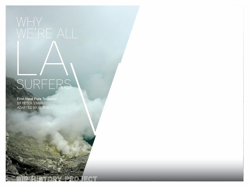
WHY WE’RE ALL
SURFERSLA A
First-Hand Plate TectonicsBY PETER STARK,ADAPTED BY NEWSELA
1030L
COVER: The Kawah Ljen crater lake in Java, Indonesia
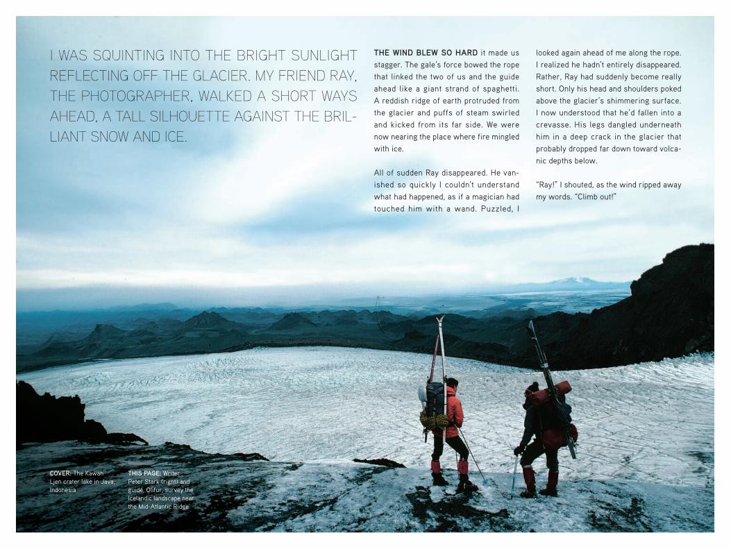
THIS PAGE: Writer Peter Stark (right) and guide, Olifur, survey the Icelandic landscape near the Mid-Atlantic Ridge
I WAS SQUINTING INTO THE BRIGHT SUNLIGHT REFLECTING OFF THE GLACIER. MY FRIEND RAY, THE PHOTOGRAPHER, WALKED A SHORT WAYS AHEAD, A TALL SILHOUETTE AGAINST THE BRIL-LIANT SNOW AND ICE.
THE WIND BLEW SO HARD it made us stagger. The gale’s force bowed the rope that linked the two of us and the guide ahead like a giant strand of spaghetti. A reddish ridge of earth protruded from the glacier and puffs of steam swirled and kicked from its far side. We were now nearing the place where fire mingled with ice.
All of sudden Ray disappeared. He van-ished so quickly I couldn’t understand what had happened, as if a magician had touched him with a wand. Puzzled, I
looked again ahead of me along the rope. I realized he hadn’t entirely disappeared. Rather, Ray had suddenly become really short. Only his head and shoulders poked above the glacier’s shimmering surface. I now understood that he’d fallen into a crevasse. His legs dangled underneath him in a deep crack in the glacier that probably dropped far down toward volca-nic depths below.
“Ray!” I shouted, as the wind ripped away my words. “Climb out!”
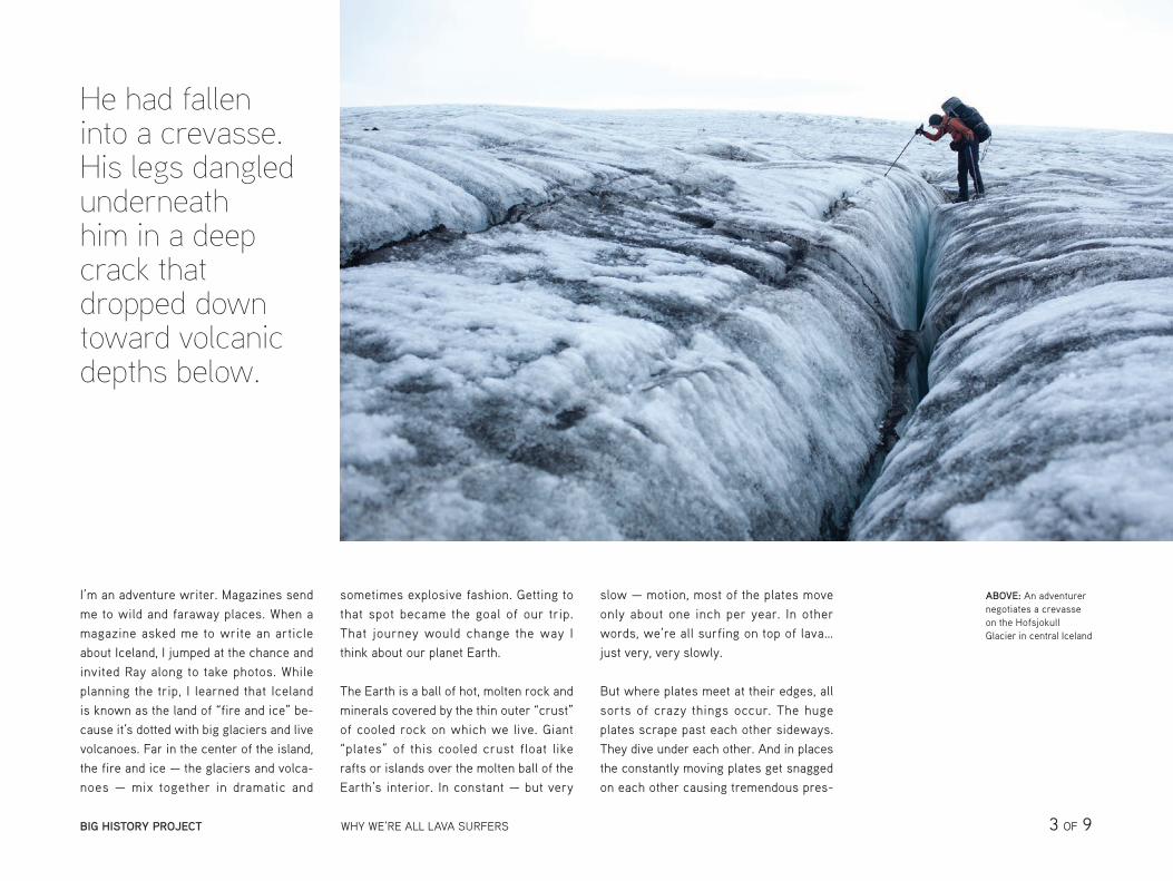
He had fallen into a crevasse. His legs dangled underneath him in a deep crack that dropped down toward volcanic depths below.
ABOVE: An adventurer negotiates a crevasse on the Hofsjokull Glacier in central Iceland
I’m an adventure writer. Magazines send me to wild and faraway places. When a magazine asked me to write an article about Iceland, I jumped at the chance and invited Ray along to take photos. While planning the trip, I learned that Iceland is known as the land of “fire and ice” be-cause it’s dotted with big glaciers and live volcanoes. Far in the center of the island, the fire and ice — the glaciers and volca-noes — mix together in dramatic and
sometimes explosive fashion. Getting to that spot became the goal of our trip. That journey would change the way I think about our planet Earth.
The Earth is a ball of hot, molten rock and minerals covered by the thin outer “crust” of cooled rock on which we live. Giant “plates” of this cooled crust float like rafts or islands over the molten ball of the Earth’s interior. In constant — but very
slow — motion, most of the plates move only about one inch per year. In other words, we’re all surfing on top of lava… just very, very slowly.
But where plates meet at their edges, all sorts of crazy things occur. The huge plates scrape past each other sideways. They dive under each other. And in places the constantly moving plates get snagged on each other causing tremendous pres-
BIG HISTORY PROJECT WHY WE’RE ALL LAVA SURFERS 3 OF 9
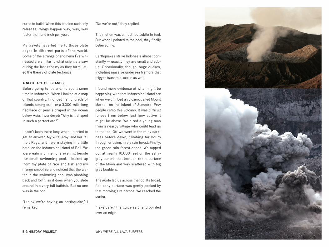
TOP: Mount Bromo erupts in East Java, Indonesia, part of the Pacific’s geologically-active “Ring of Fire”
BOTTOM: The Ibu volcano erupts in Halmahera, Indonesia
sures to build. When this tension suddenly releases, things happen way, way, way faster than one inch per year.
My travels have led me to those plate edges in different parts of the world. Some of the strange phenomena I’ve wit-nessed are similar to what scientists saw during the last century as they formulat-ed the theory of plate tectonics.
A NECKLACE OF ISLANDS
Before going to Iceland, I’d spent some time in Indonesia. When I looked at a map of that country, I noticed its hundreds of islands strung out like a 3,000-mile-long necklace of pearls draped in the ocean below Asia. I wondered: “Why is it shaped in such a perfect arc?”
I hadn’t been there long when I started to get an answer. My wife, Amy, and her fa-ther, Rags, and I were staying in a little hotel on the Indonesian island of Bali. We were eating dinner one evening beside the small swimming pool. I looked up from my plate of rice and fish and my mango smoothie and noticed that the wa-ter in the swimming pool was sloshing back and forth, as it does when you slide around in a very full bathtub. But no one was in the pool!
“I think we’re having an earthquake,” I remarked.
“No we’re not,” they replied.
The motion was almost too subtle to feel. But when I pointed to the pool, they finally believed me.
Earthquakes strike Indonesia almost con-stantly — usually they are small and sub-tle. Occasionally, though, huge quakes, including massive undersea tremors that trigger tsunamis, occur as well.
I found more evidence of what might be happening with that Indonesian island arc when we climbed a volcano, called Mount Marapi, on the island of Sumatra. Few people climb this volcano. It was difficult to see from below just how active it might be above. We hired a young man from a nearby village who could lead us to the top. Off we went in the rainy dark-ness before dawn, climbing for hours through dripping, misty rain forest. Finally, the green rain forest ended. We topped out at nearly 10,000 feet on the ashy-gray summit that looked like the surface of the Moon and was scattered with big gray boulders.
The guide led us across the top. Its broad, flat, ashy surface was gently pocked by that morning’s raindrops. We reached the center.
“Take care,” the guide said, and pointed over an edge.
BIG HISTORY PROJECT WHY WE’RE ALL LAVA SURFERS
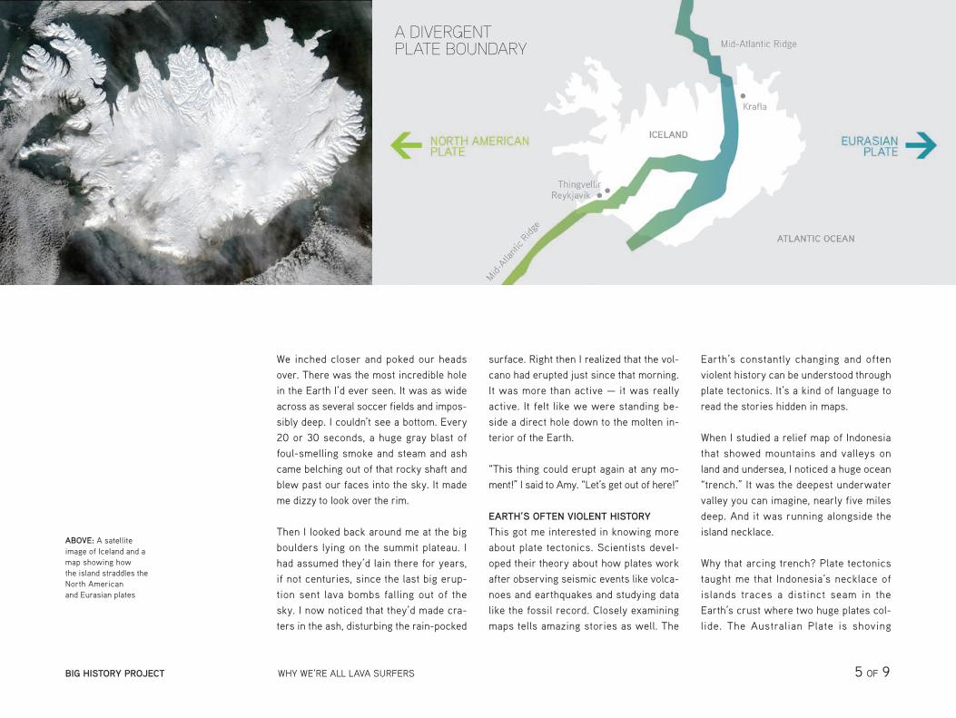
Plate tectonics is a kind of language used to read the stories hidden in the maps.
We inched closer and poked our heads over. There was the most incredible hole in the Earth I’d ever seen. It was as wide across as several soccer fields and impos-sibly deep. I couldn’t see a bottom. Every 20 or 30 seconds, a huge gray blast of foul-smelling smoke and steam and ash came belching out of that rocky shaft and blew past our faces into the sky. It made me dizzy to look over the rim.
Then I looked back around me at the big boulders lying on the summit plateau. I had assumed they’d lain there for years, if not centuries, since the last big erup-tion sent lava bombs falling out of the sky. I now noticed that they’d made cra-ters in the ash, disturbing the rain-pocked
surface. Right then I realized that the vol-cano had erupted just since that morning. It was more than active — it was really active. It felt like we were standing be-side a direct hole down to the molten in-terior of the Earth.
“This thing could erupt again at any mo-ment!” I said to Amy. “Let’s get out of here!”
EARTH’S OFTEN VIOLENT HISTORY
This got me interested in knowing more about plate tectonics. Scientists devel-oped their theory about how plates work after observing seismic events like volca-noes and earthquakes and studying data like the fossil record. Closely examining maps tells amazing stories as well. The
Earth’s constantly changing and often violent history can be understood through plate tectonics. It’s a kind of language to read the stories hidden in maps.
When I studied a relief map of Indonesia that showed mountains and valleys on land and undersea, I noticed a huge ocean “trench.” It was the deepest underwater valley you can imagine, nearly five miles deep. And it was running alongside the island necklace.
Why that arcing trench? Plate tectonics taught me that Indonesia’s necklace of islands traces a distinct seam in the Earth’s crust where two huge plates col-lide. The Australian Plate is shoving
ABOVE: A satellite image of Iceland and a map showing how the island straddles the North American and Eurasian plates
A DIVERGENT PLATE BOUNDARY
BIG HISTORY PROJECT WHY WE’RE ALL LAVA SURFERS 5 OF 9
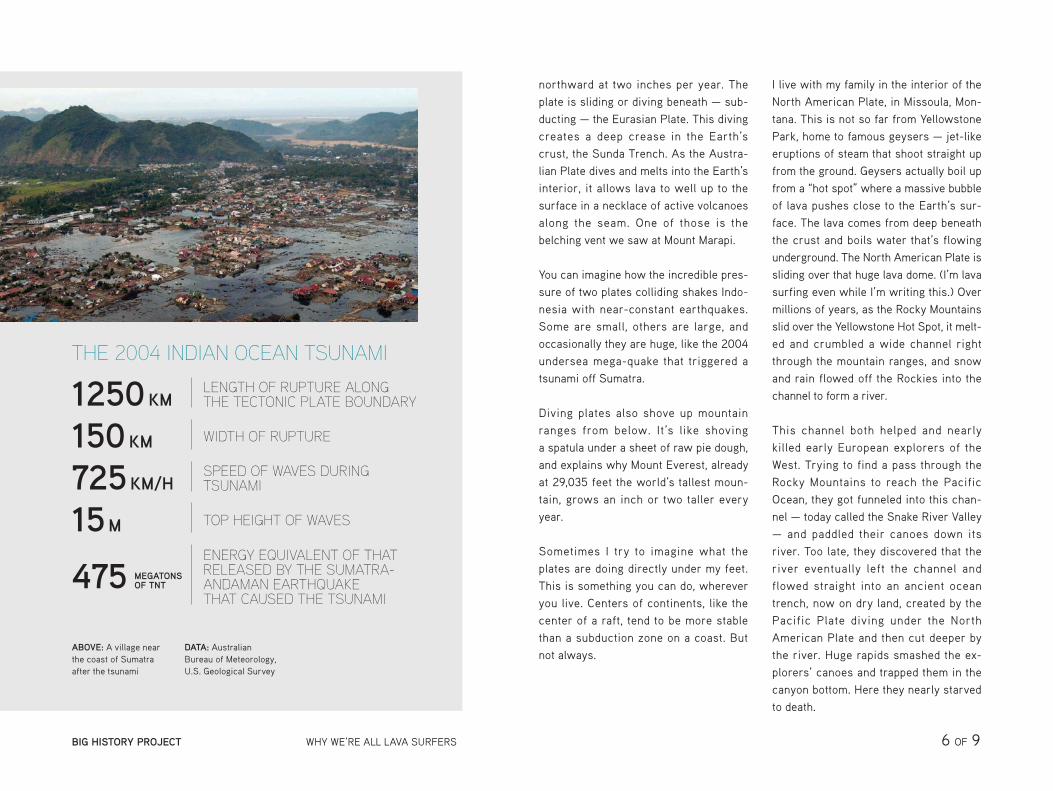
ABOVE: A village near the coast of Sumatra after the tsunami
DATA: Australian Bureau of Meteorology, U.S. Geological Survey
northward at two inches per year. The plate is sliding or diving beneath — sub-ducting — the Eurasian Plate. This diving creates a deep crease in the Earth’s crust, the Sunda Trench. As the Austra-lian Plate dives and melts into the Earth’s interior, it allows lava to well up to the surface in a necklace of active volcanoes along the seam. One of those is the belching vent we saw at Mount Marapi.
You can imagine how the incredible pres-sure of two plates colliding shakes Indo-nesia with near-constant earthquakes. Some are small, others are large, and occasionally they are huge, like the 2004 undersea mega-quake that triggered a tsunami off Sumatra.
Diving plates also shove up mountain ranges from below. It’s like shoving a spatula under a sheet of raw pie dough, and explains why Mount Everest, already at 29,035 feet the world’s tallest moun-tain, grows an inch or two taller every year.
Sometimes I try to imagine what the plates are doing directly under my feet. This is something you can do, wherever you live. Centers of continents, like the center of a raft, tend to be more stable than a subduction zone on a coast. But not always.
I live with my family in the interior of the North American Plate, in Missoula, Mon-tana. This is not so far from Yellowstone Park, home to famous geysers — jet-like eruptions of steam that shoot straight up from the ground. Geysers actually boil up from a “hot spot” where a massive bubble of lava pushes close to the Earth’s sur-face. The lava comes from deep beneath the crust and boils water that’s flowing underground. The North American Plate is sliding over that huge lava dome. (I’m lava surfing even while I’m writing this.) Over millions of years, as the Rocky Mountains slid over the Yellowstone Hot Spot, it melt-ed and crumbled a wide channel right through the mountain ranges, and snow and rain flowed off the Rockies into the channel to form a river.
This channel both helped and nearly killed early European explorers of the West. Trying to find a pass through the Rocky Mountains to reach the Pacific Ocean, they got funneled into this chan-nel — today called the Snake River Valley — and paddled their canoes down its river. Too late, they discovered that the river eventually left the channel and flowed straight into an ancient ocean trench, now on dry land, created by the Pacific Plate diving under the North American Plate and then cut deeper by the river. Huge rapids smashed the ex-plorers’ canoes and trapped them in the canyon bottom. Here they nearly starved to death.
THE 2004 INDIAN OCEAN TSUNAMI
1250KMLENGTH OF RUPTURE ALONG THE TECTONIC PLATE BOUNDARY
150KM WIDTH OF RUPTURE
725KM/HSPEED OF WAVES DURING TSUNAMI
15M TOP HEIGHT OF WAVES
475 MEGATONS OF TNT
ENERGY EQUIVALENT OF THAT RELEASED BY THE SUMATRA- ANDAMAN EARTHQUAKE THAT CAUSED THE TSUNAMI
BIG HISTORY PROJECT WHY WE’RE ALL LAVA SURFERS 6 OF 9
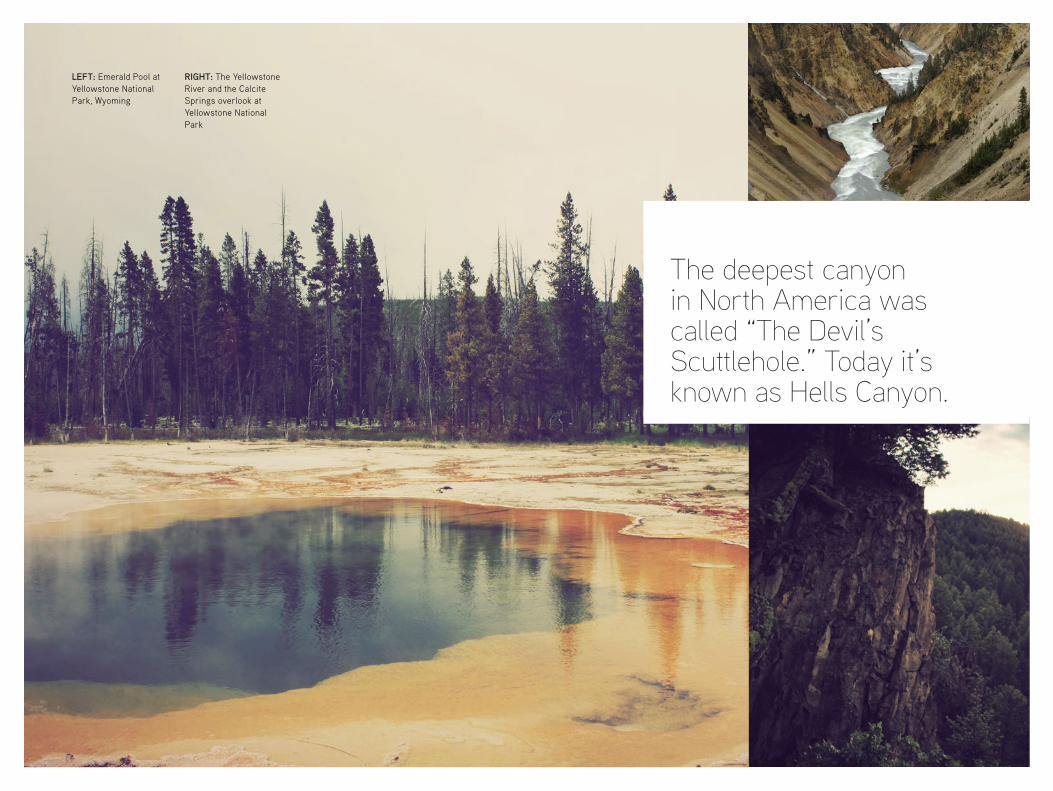
The deepest canyon in North America was called “The Devil’s Scuttlehole.” Today it’s known as Hells Canyon.
LEFT: Emerald Pool at Yellowstone National Park, Wyoming
RIGHT: The Yellowstone River and the Calcite Springs overlook at Yellowstone National Park
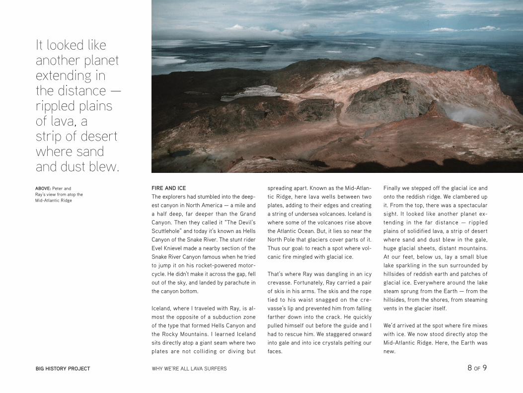
FIRE AND ICE
The explorers had stumbled into the deep-est canyon in North America — a mile and a half deep, far deeper than the Grand Canyon. Then they called it “The Devil’s Scuttlehole” and today it’s known as Hells Canyon of the Snake River. The stunt rider Evel Knievel made a nearby section of the Snake River Canyon famous when he tried to jump it on his rocket-powered motor-cycle. He didn’t make it across the gap, fell out of the sky, and landed by parachute in the canyon bottom.
Iceland, where I traveled with Ray, is al-most the opposite of a subduction zone of the type that formed Hells Canyon and the Rocky Mountains. I learned Iceland sits directly atop a giant seam where two plates are not colliding or diving but
spreading apart. Known as the Mid-Atlan-tic Ridge, here lava wells between two plates, adding to their edges and creating a string of undersea volcanoes. Iceland is where some of the volcanoes rise above the Atlantic Ocean. But, it lies so near the North Pole that glaciers cover parts of it. Thus our goal: to reach a spot where vol-canic fire mingled with glacial ice.
That’s where Ray was dangling in an icy crevasse. Fortunately, Ray carried a pair of skis in his arms. The skis and the rope tied to his waist snagged on the cre-vasse’s lip and prevented him from falling farther down into the crack. He quickly pulled himself out before the guide and I had to rescue him. We staggered onward into gale and into ice crystals pelting our faces.
Finally we stepped off the glacial ice and onto the reddish ridge. We clambered up it. From the top, there was a spectacular sight. It looked like another planet ex-tending in the far distance — rippled plains of solidified lava, a strip of desert where sand and dust blew in the gale, huge glacial sheets, distant mountains. At our feet, below us, lay a small blue lake sparkling in the sun surrounded by hillsides of reddish earth and patches of glacial ice. Everywhere around the lake steam sprung from the Earth — from the hillsides, from the shores, from steaming vents in the glacier itself.
We’d arrived at the spot where fire mixes with ice. We now stood directly atop the Mid-Atlantic Ridge. Here, the Earth was new.
It looked like another planet extending in the distance — rippled plains of lava, a strip of desert where sand and dust blew.ABOVE: Peter and Ray’s view from atop the Mid-Atlantic Ridge
BIG HISTORY PROJECT WHY WE’RE ALL LAVA SURFERS 8 OF 9
IMAGE CREDITS
Articles leveled by Newsela have been adjusted along several dimensions of text complexity including sentence structure, vocabulary and organization. The number followed by L indicates the Lexile measure of the article. For more information on Lexile measures and how they correspond to grade levels: http://www.lexile.com/about-lexile/lexile-overview/
To learn more about Newsela, visit www.newsela.com/about.
The Lexile® Framework for ReadingThe Lexile® Framework for Reading evaluates reading ability and text complexity on the same developmental scale. Unlike other measurement systems, the Lexile Framework determines reading ability based on actual assessments, rather than generalized age or grade levels. Recognized as the standard for matching readers with texts, tens of millions of students worldwide receive a Lexile measure that helps them find targeted readings from the more than 100 million articles, books and websites that have been measured. Lexile measures connect learners of all ages with resources at the right level of challenge and monitors their progress toward state and national proficiency standards. More information about the Lexile® Framework can be found at www.Lexile.com.
Kawah Ljen crater lake, Java, Indonesia © Philippe Crochet/Photononstop/Corbis
Peter Stark and guide, Olifur, near the Mid-Atlantic Ridge in Iceland © Raymond Geyman
Hofsjokull Glacier in central Iceland © Christopher Herwig/Aurora Photos/Corbis
Early morning at the Mount Bromo volcano, East Java, Indonesia © DARREN WHITESIDE/Reuters/Corbis
Eruption of the Ibu volcano, Halmahera, Indonesia © Martin Rietze/Westend61/Corbis
A true-color satellite image of Iceland captured, January 2004, courtesy of Jeff Schmaltz, MODIS Land Rapid Response Team at NASA GSFC
The Mid-Atlantic Ridge in Iceland, U.S. Geological Survey
A village in Sumatra photographed from a relief helicopter, U.S. Navy photographer Philip A. McDaniel
Emerald Pool at Yellowstone National Park, Wyoming © Rachael Schumacher
The Yellowstone River at Yellowstone National Park, Wyoming © Don Johnston/All Canada Photos/ Corbis
Calcite Springs overlook at Yellowstone National Park, Wyoming © Rachael Schumacher
Peter Stark’s expedition looks out from atop the Mid-Atlantic Ridge © Raymond Geyman
BIG HISTORY PROJECT WHY WE’RE ALL LAVA SURFERS 9 OF 9