Surf Snowdonia, Dolgarrog - IEMA · Surf Snowdonia will enhance the economic success of Dolgarrog,...
23
Surf Snowdonia, Dolgarrog Environmental Statement ‐ Non Technical Summary February 2014 in association with
-
Upload
trinhnguyet -
Category
Documents
-
view
214 -
download
0
Transcript of Surf Snowdonia, Dolgarrog - IEMA · Surf Snowdonia will enhance the economic success of Dolgarrog,...

Surf Snowdonia, Dolgarrog
Environmental Statement ‐ Non Technical Summary
February 2014
in association with

1. Introduction
Conwy Adventure Leisure Ltd. (CAL) is applying to Conwy County Borough
Council (CCBC) for an amendment to the consented planning permission of
the redevelopment of the former Dolgarrog Aluminium Works site, Dolgarrog,
Conwy. The Outline and Full planning applications seek consent for the
redevelopment of the site to deliver a leisure-led mixed use scheme,
comprising:
A new watersports facility;
A multi-functional ‘hub’ area to include restaurant/café, retail,
children's play and changing facilities; and
Associated infrastructure, landscaping and open space.
The site is 18.5ha in area and is located in Dolgarrog, Conwy. The site location
is shown in Figure 1.1 and the planning application boundaries are shown in
Figure 1.2. Further detail on the proposed development is provided in Section
3.
The potentially significant environmental impacts of the proposed
development have been assessed through a process called Environmental
Impact Assessment (EIA). EIA is a procedure required under the terms of the
European Union Directive 2011/92/EU on the assessment of the effects on
certain public and private projects on the environment.
The EIA Directive is currently enacted into Welsh legislation through The
Town and Country Planning (Environmental Impact Assessment) (England and
Wales) Regulations 1999 (the EIA Regulations) as amended.
CCBC determined that the proposals constitute EIA Development under
Schedule 2 12(c) and 12(d) of the 1999 EIA Regulations (as amended) and
therefore, an EIA was required to be undertaken.
The potentially significant environmental impacts of the proposed
development have subsequently been documented in an Environmental
Statement (ES) which is submitted as part of the planning applications.
This document provides a Non-Technical Summary (NTS) of the ES. It provides
detail of the site and its surroundings, the proposed development, the likely
environmental impacts of the proposed development and what measures are
proposed to reduce, avoid or compensate for potentially adverse impacts and
maximise beneficial impacts (mitigation measures).
Public Involvement
A public exhibition was held on 27th March 2013, with 250-300 people in
attendance. A number of key issues were raised by local residents which have
taken into account by the project team, and have been considered in further
detail within the Statement of Community Involvement, which has been
submitted as part of the applications.
Benefits of the proposed development
The Environmental Statement has been prepared to consider the
environmental, social and economic impacts of the proposals. The
outcome of the statement demonstrated that the scheme would not have
a detrimental impact on these three dimensions; which give rise to
sustainable development.
The Wavegarden technology will be the first of its kind within the UK, and
the exclusivity deal that CAL have in place with the suppliers will ensure
that North Wales secures its place as the primary destination for tourists,
bringing visitors from all over the UK and abroad.
The proposed development will create over 90 temporary construction
jobs over an anticipated 18 month period, and over 100 permanent direct
and indirect jobs when Surf Snowdonia is fully operational.
Surf Snowdonia will enhance the economic success of Dolgarrog, Conwy
and North Wales, creating an additional 75,000 trips into the area, and an
estimated £5 million annual expenditure on tourism activities. This will
positively impact on other businesses within the area who will directly
benefit from the additional visitors.

Figure 1.1 Site Location Plan
Note: The buildings shown on the image have now been cleared

Figure 1.2 Full and Outline Application Redline boundaries (not for official use)
Plan 1 – Redline showing the boundary of the Outline application that seeks
Consent for the building elements of the scheme.
Plan 2 – Redline showing the boundary of the Full application that seeks consent for the infrastructure works

2. Environmental Impact Assessment
Scoping
Scoping is not a mandatory requirement of the EIA Regulations, but is seen as
good practice. The purpose of scoping is to ensure that the environmental
studies undertaken during the preparation of the ES provide all the relevant
information on the likely significant environmental effects of the project. An
EIA Scoping Opinion was received from CCBC in March 2013 and is included in
Appendix B of the ES.
The technical scope of the EIA has been informed by the following:
Schedule 4 of the EIA Regulations;
Previous technical assessments of the site;
Pre-application meeting between NJL and CCBC Development
Management Officers in February 2013;
CCBC Scoping Opinion; and
Further consultation undertaken as part of the EIA.
Through this scoping process, the environmental topics identified as having
the potential for significant environmental effects are:
Soils and Groundwater;
Flooding and Drainage;
Ecology;
Landscape and Visual;
Traffic and Transport;
Noise and Vibration;
Air Quality and Dust;
Socio-economics; and
Archaeology.
Liaison with CCBC did not establish a requirement for cumulative impact
assessment with other proposed developments, as no relevant developments
were identified in the study area. This position was kept under review during the
EIA process, but no further relevant developments have been identified.
Impact Prediction
Each technical assessment within the EIA firstly establishes the existing conditions
known as the ‘environmental baseline’, which identifies potentially sensitive
receptors to environmental impact e.g. ecological sites, watercourses etc. The
environmental baseline is then the basis against which the potential impacts are
assessed.
Environmental impacts can be positive (known as ‘beneficial’) or negative (known
as ‘adverse’), temporary or permanent and vary in their duration and spatial
scale. The significance of an environmental impact is assessed based on a
combination of its magnitude (i.e. intensity) and the sensitivity of the receiving
receptor.
There is no statutory definition of significance.
In this ES the following descriptive terms are used:
Substantial;
Moderate;
Minor; and
Negligible.
Mitigation
Mitigation measures can be put in place to avoid, reduce or compensate for
potential adverse impacts, or to enhance beneficial impacts.
The EIA has identified appropriate mitigation measures based on the assessment
of potential significant impacts.

These mitigation measures are divided into:
Inherent mitigation measures – those ‘designed in’ to the scheme and
certain to be delivered;
Standard mitigation – e.g. construction mitigation with a high degree of
certainty over delivery; and
Actionable mitigation measures - those that require a controlling mechanism
or legal undertaking to be implemented, but are under the control of the
applicant, CCBC or Statutory Bodies and therefore, have a good certainty over
delivery, e.g. Planning Conditions and legal planning agreements with CCBC.
The purpose of defining mitigation in this way is to make it clear how the
mitigation is to be delivered.
Describing Potential Impacts
The determination of impact significance in each of the technical chapters is
presented under the following scenarios:
Impact Assessment - with inherent and standard mitigation measures
implemented; and
Residual Impact Assessment – with inherent, standard and actionable
mitigation measures implemented.

3. The Site and Surrounding
The site is approximately 18.5 hectares in area, is located within the village of
Dolgarrog and is bounded by:
West: The B5106 that links Conwy with Betws-y-Coed and an existing
residential dwelling;
North West and North: A Hydro-Electric Power Station, an area of
woodland and the Afon Porth-llwyd. A small part of the Morfa Uchaf
Dyffryn Conwy Site of Special Scientific Interest (SSSI) bounds the
northern boundary of the site;
North East and East: An area of semi-improved grassland that is
outside of the SSSI. Beyond the grassland is the Afon Conwy, which is
located approximately 230m east of the site boundary at its closest
point;
South and South East: An area of marshy grassland and an area of
broadleaved woodland; and
South West: A small industrial unit used by an engineering company.
The site was purchased by Ainscough Strategic Land in 2008 following the
closure of the aluminium works and sold to Conwy Adventure Leisure Ltd. in
2012.
The buildings have now been demolished and the site cleared for
redevelopment.
The site now comprises:
6ha of former aluminium works infrastructure, mainly in the centre of
the site which is now cleared.
Over 6ha of improved and amenity grassland, mainly at the north
east, east and south east of the site.
Over 4ha of woodland, some at the north of the site and the rest at
the south and south east.
A former landfill at the north of the site (wooded area).
An old bunker that contains a bat roost and a small night shelter
constructed as bat mitigation for the demolition of the aluminium
works buildings.
A children’s playground at the south west of the site.
A grass football pitch and an all-weather five-a-side football pitch at
the south east of the site.
The topography of the site includes a relatively steep slope along the western
boundary and is then gently sloping from west to east, with the cleared building
bases in the centre of the site forming a plateau.

Figure 3.1 Site and Surroundings

4. The Proposed Development
The planning application seeks Full and Outline consent for a tourism led
surfing and water sports adventure attraction to be known as ‘Surf
Snowdonia’.
The built elements (buildings) application is in outline, details of individual
elements of the scheme will be worked up at the reserved matters stage, with
this application setting minimum and maximum parameters for the future
development including building heights and widths.
The infrastructure works are being applied for in Full.
Entrance and Parking Area
This new arrival space from Conwy Road will announce the new development
and create a safe entry and exit point for vehicles, cyclists and pedestrians.
The main parking area will be designed with materials that reflect the
character of the woodland edge planting such as permeable parking bays,
reinforced gravels and permeable macadam roadways.
Hub Building and Viewing Terrace
The Hub building will offer areas for gathering and formally organised events
will also be provided.
This area will contain the Viewing Plaza from which access to the Restaurant,
Indoor Play and Reception and Changing block is provided. The Reception will
provide the managed access required to control use of the facilities whilst the
viewing plaza and restaurant spill out space provide viewing areas for
members of the public not wishing to access the parks water activities.
Wavegarden Lake
The Wavegarden will include the following main areas:
• The Hub viewing area and Boardwalk
• Beginners Area
• Main ‘Wave Zone’
• Viewing Lawn
Activity Pool
This area will focus on providing a range of high energy, water based activities.
Access from the Hub building will be created by pedestrian routes and viewing
terraces in the spaces between the main lake and the activity pool.
Lower Fields
The lower area of the site will be earmarked for management of the existing open
grassland to become a floral rich meadow, with a new pedestrian footpath area.
Control points will be utilised along the footpath network to safely manage access
to the meadow.
Woodland Edge
The southern woodland will be maintained and the car park will abut to the edge
of the woodland.
The northern woodland will be fenced off with no public access.
Both woodlands will be managed as a biodiversity resource.

Figure 4.1 Illustrative Land Use

Figure 4.2 Illustrative Masterplan

Figure 4.3 Artists Impression of the scheme

5. Alternatives
The EIA Regulations require that the EIA considers ‘alternatives’ to the
proposed development and indicate the reasons for progressing the chosen
alternative, taking into account the environmental effects.
Site Location
The location of the proposed development is paramount to its success. A
potential site has to be accessible and also in the ‘heart’ of the Welsh tourism
mecca of Conwy.
No alternative sites were identified, or currently on the market that offered
the benefits of the proposed site. The requirements were constrained by the
necessary size and the preferred location.
Finding a site that had been previously used and identified as Brownfield land,
presented a beneficial opportunity that would have the potential to limit the
negative environmental effects that using a Greenfield site presents.
As such, no alternative locations were identified for the proposed
development.
Site Layout
The layout of the proposed development as shown in the Illustrative
Masterplan has been informed by:
The space requirements for the various elements of the proposed
development;
Flood risk;
Existing ground conditions, habitats and protected species;
Existing utilities and land ownership constraints;
Access and vehicle parking; and
Landscape character and views within the site, as well as into and out
of the site.
The site layout has been revised during the preparation of the application, based
on the above factors and the findings of the technical assessments.

6. Summary of Potential Environmental Impacts
Soils and Groundwater
The former aluminium works operated under a pollution and prevention
control permit granted by the Environment Agency Wales on 19th December
2003 (original permit no. BS8354).
A number of Site Investigation reports have been undertaken over the past
few years to comply with the requirements of the permits.
A Closure Plan was designed and executed for the decommissioning and
demolition of the Dolgarrog site in conjunction with the Environment Agency
Wales. A decontamination plan was agreed with and signed off by the
Environment Agency Wales. The report confirms that the decommissioning
log proves that the Closure Plan was executed effectively.
Mitigation Measures
The former use of the site as an aluminium works gives rise to the potential
for contamination to be present in soils and groundwater.
A number of mitigation measures have been identified at different stages of
the construction such as:
During the construction phase standard best practice mitigation
measures for each identified receptor will be implemented.
Surface water management plan and appropriate remediation where
identified to be necessary.
Install gas protection measures where required.
Appropriate remediation of site/ protective cover/ trenches.
Appropriate remediation design.
Following the implementation of the proposed mitigation measures, the
residual impacts on the ground conditions and contamination during the
construction phases of the proposed development are anticipated to be
Negligible.
Following implementation of the proposed mitigation measures, the residual
impacts during the operational phase of the proposed development are
anticipated to be Negligible.
Flooding and Drainage
The site is subject to fluvial and tidal flooding. The site falls partially within Zone
C of the NRW Flood Plan mapping.
The worst case fluvial and tidal flood scenarios were found to be (a) 1 in 1000-
year fluvial flood (0.1% AEP); and (b) 200 year tidal flood (0.5% AEP) with climate
change taken into account.
A number of mitigation actions will be implemented to ensure the proposed
development does not increase the risk of flooding on or off site.
Mitigation measures will include:
Raising of site levels in areas to be used for accommodation and commercial activities (Figure 6.1);
Safe, dry access and egress; and
Development of Flood Action Plan related to the low lying areas of the site e.g. Car Parking.
Ecology
There are a number of statutory and non-statutory nature conservation
designations within the 5km of the site boundary, these include:
Morta Uchaf, Dyffryn Conwy SSSI (Adjacent to the northern site
boundary);
Coed Dolgarrog SSSI and National Nature Reserve (NNR) (136m);
Ceunant Dylyn SSSI(1.3km);
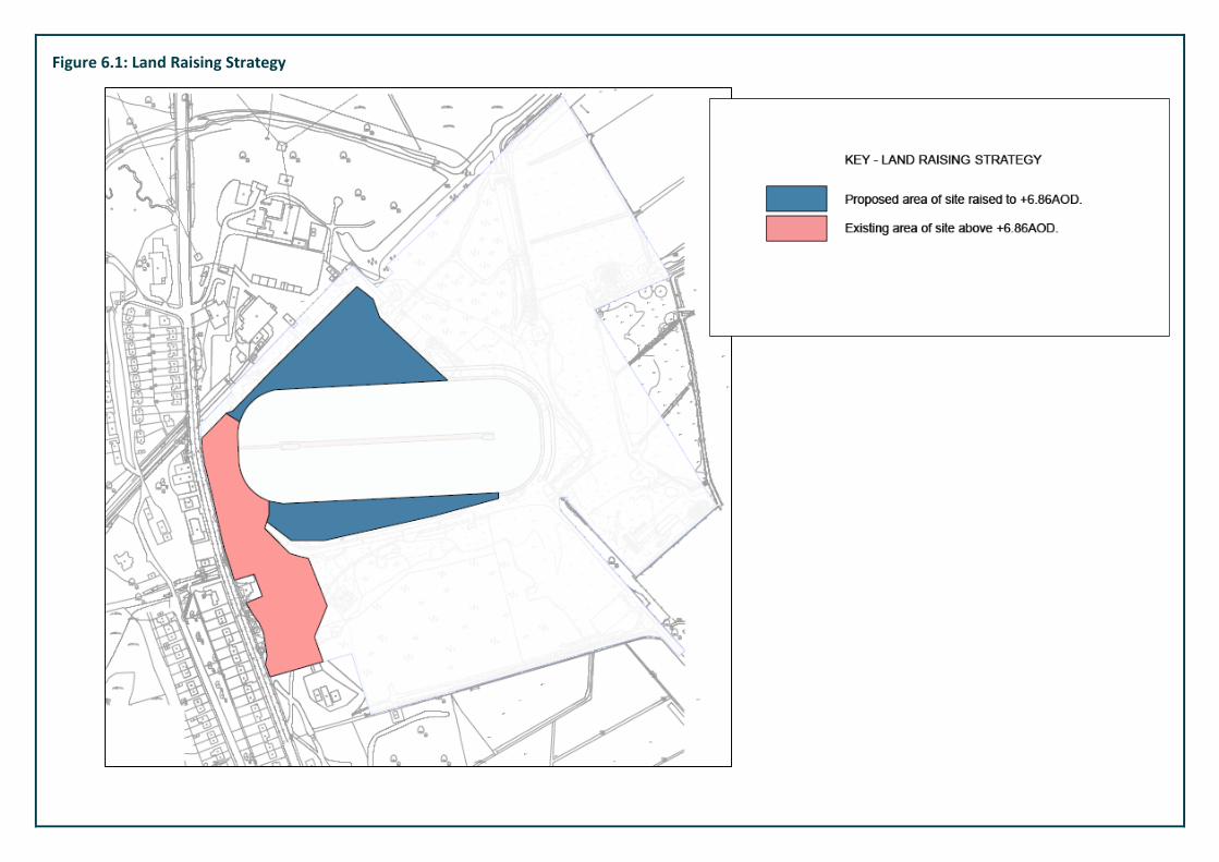
Figure 6.1: Land Raising Strategy

Eyri/Snowdonia Special Area of Conservation (SAC) and SSSI (1.3km);
Plas Maenan SSSI (1.3km);
Pont Dolgarrog March (260m);
Ceunant Porth Llwyd (260m); and
Coed Tal-y-Bont (450m).
An ‘extended’ Phase 1 Habitat Survey (Figure 6.2) of the site and its
immediate environs was undertaken on the 24th July 2012 by an experience
Ecologist. Surveys for protected species were undertaken between July 2012
and February 2013 and in line with published methodologies to inform an
assessment of the site.
The comprehensive surveys identified a number of habitats on site, and the
following species were found to be present within the site.
1. Surveys for reptiles found that the site supports three reptile species
which includes an exceptional population of slow worms and low
populations of grass snakes and common lizards.
2. Several bird species were recorded during the Phase I Survey, these
include robin, jay, long-tailed tit, carrion crow, blue tit, mistle thrush
and pied wagtail. These are all common, widespread species and are
typical of the habitats present on-site.
3. Kingfisher (a WCA schedule 1 and amber listed species) were
observed feeding along the Power Station race adjacent to the site.
4. Several reed bunting were observed in a feeding flock during a winter
site visit.
5. It has been confirmed that bunker TN1 is still being used as a
hibernation site for the lesser horseshoe bat.
The development of the site will inevitably lead to some habitat loss within
the site. However, where possible, the development design has sought to
avoid valuable ecological resources within and adjacent to the site.
No adverse residual impacts to any statutory or non-statutory nature
conservation designations are predicted to arise from the proposed
development.
It is considered that the overall ecological impact of development proposals will
be negligible.
Landscape and Visual
The Landscape and Visual Impact Assessment examined the landscape and visual
impacts in relation to the current development proposals for the site, in
accordance with the Guidelines for Landscape & Visual Impact Assessment, 3rd
Edition, 2013.
The Landscape and Visual Impact Assessment has identified the following
landscape impacts:
Designated landscapes
A moderate beneficial impact on the Historic Landscape.
A negligible impact on Ancient Woodland.
A negligible impact on Snowdonia National Park.
A negligible impact on Sites of Special Scientific Interest.
A negligible impact on Special Areas of Conservation.
A negligible impact on National Nature Reserves
A moderate beneficial impact on the Landscape Value Area
Landscape Character
• A minor beneficial impact on landscape character at the national level.
• A major beneficial impact on landscape character at the local level.

Figure 6.2: On-site Ecological Habitats

Woodland
• A moderate beneficial impact on woodland.
Topography
• A neutral impact on topography.
Footpaths & Cycleways
• A minor beneficial impact on footpaths and cycleways.
Other Site Features of Value
• A moderate beneficial impact on play & sports Facilities.
• A minor beneficial impact on ditches.
• A negligible impact on the canal.
• A minor beneficial impact on former hedgerows.
A minor beneficial impact on trees.
A number of mitigation measures are planned for the site, including an
extensive planting programme that will introduce a new woodland, the
retention of long, open views and vistas with sensitive positioning of planting
and buildings, and a management plan that will ensure habitats and
recreational areas are incorporated together.
The proposed development is likely to result in significant improvements in
terms of the landscape and visual qualities of the site. This is largely due to
the degraded character of the site at present, due to previous development
on the site, and also due to the high quality approach to the proposed built
development and associated landscape proposals, which will ensure that the
proposed development as a whole will be a positive addition to the
landscape, entirely in keeping with the surrounding landscape character.
Traffic and Transport
Vehicular access into the site is via the existing priority controlled junction
off the B5106 Conway Road.
The B5106 Conway Road runs generally in a north-south alignment along the
western side of the Conwy Valley between Conwy and Betws-y-Coed.
When the site was previously used as the Dolgarrog Aluminium Works it used to
employ up to 180 employees and on average the site used to generate between
20 and 30 HGV movements each week which would equate to between 40 and 60
two-way HGV movements per week. These HGV movements would be in addition
to the vehicle movements generated by the employees of the works.
When the site was fully operational it generated a substantial level of vehicle
movements. Surf Snowdonia is expected to generate similar levels of vehicle
movements and as such there is not expected to be traffic issues.
To ensure traffic movements are managed, a number of mitigation measures will
be implemented. These are as follows (but will evolve with the scheme):
A total of 290 car parking spaces on the site, the car parking layout will be
designed to incorporate both coach and car parking. The parking area has
been designed this way to enable a flexible operation.
The proposed development will include secure and conveniently located
cycle parking provision, the level of cycle parking will be agreed with
Conwy County Borough Council at a more advanced stage of the planning
process.
The layout of the development site has been designed to link with
the existing pedestrian infrastructure located within the vicinity of
the site.
The existing Clark Street carriageway will be retained.
A number of standard mitigation measures will be implemented through the
construction phased, such as wheel wash facilities, construction traffic
specific routes and parking for construction workers on-site.
In summary, the proposed development is forecast to result in minimal
increases in vehicle movements on the local highway network.
It is therefore concluded that the proposed development will not result in any
residual traffic or transport impacts when it is fully operational.

Noise
A noise impact assessment for the proposed site has been undertaken and
considered the site’s suitability for a noise generating development. The
assessment looked at the potential impacts that the development may have
on the existing noise climate during the construction phase and upon
completion through its operational stage.
Assessment of impacts has been based on a long-term noise survey,
consultation with the local authority and national planning policy and
guidance documents.
The following noise and vibration impacts have been assessed:
Construction noise and vibration on the existing noise sensitive
receptors; and
Operational noise associated with plant and equipment, car parking
and visitors on-site.
The following conclusions have been reached:
Short-term negligible adverse impacts are expected as a result of construction noise;
Short-term minor to negligible adverse impacts are expected as a result of construction vibration;
Short-term negligible impacts are expected as a result of construction related traffic;
With regard to operational noise, long-term negligible impacts are expected as a result of plant/equipment operation, car park noise and visitors using the facility.
Air Quality
The air quality and dust effects associated with the site preparation and
construction works at the proposed development has been considered.
The following effects were considered:
Potential dust effects arising from the breakout and excavation of the
existing areas of hard standing on the site;
Potential dust effects arising from the movement and storage of materials
on the site, including during the creation of the earth bund and raising of
the building platforms; and
Potential air quality effects associated with the vehicles accessing the site
during this phase of works.
The potential dust and air quality effects upon existing sensitive receptors during
the site preparation and construction phase of works will be negligible once the
mitigation measures have been implemented.
The mitigation measures will include the following:
All dust and air quality complaints will be recorded and appropriate
measures will be taken to identify causes and reduce emissions in a
timely manner.
Ensure effective water suppression is used during demolition operations.
Minimisation of vehicle movements and limitation of vehicle speeds – the
slower the vehicle speeds, the lower the dust generation.
Ensuring that all vehicles will be sheeted when loaded.
Dampening down of exposed stored materials, which will be stored as far
from sensitive receptors as possible.
Avoidance of activities that generate large amounts of dust during windy
conditions.
Socio-economics
Socio-economic impacts were addressed to show the effects on the local
economy in terms of visitor numbers, input into the local economy and any
detrimental impacts on the welsh language.
The following benefits of the proposed scheme for the Conwy area were
identified:
It will generate +75,000 additional tourism trips and +£5.0 million
annual on and off site tourism expenditure. The generation of new
tourism trips is a direct, permanent impact which meets a recognised

need to bring higher spending residents into Conwy and North Wales
more generally and to grow the activity tourism sector. The
significance of the tourism effect is therefore considered to be
Substantial Beneficial.
It will generate +90 temporary construction jobs over the two year
construction programme, +100 permanent direct and indirect jobs
when operational. There is a recognised need for job creation in
Conwy and in the Conwy Valley in particular. The Conwy Valley has a
very narrow economic base with high levels on under-employment.
The significance of the employment effect is therefore considered to
be Substantial Beneficial.
It will create opportunities for an estimated 7,500 Conwy residents to
participate in sport activities per annum. The significance of the
health and active lifestyle impacts is assessed as Moderate Beneficial.
There are not considered to be any detrimental impacts on Welsh language as
a result of the scheme – where the effect is assessed as being Negligible.
Archaeology
A cultural heritage assessment of the site at the Former Aluminium Works,
was carried out to addresses the potential impacts of the proposed
development on potential buried archaeological remains, historic buildings,
and historic landscape.
The findings of the assessment showed the following:
The potential for harm upon any surviving below ground
archaeological remains is limited, because of the previous
development and make up across the site.
The construction of the factory, and the make-up for the remaining
areas, will have reduced remains across the majority of the site.
The design of the scheme has included consideration of the historic
environment, and as a result the area of undeveloped greenfield land
in the north-eastern area of the proposed development site,
considered to be the area with the greatest potential for currently
unrecorded remains, will be set aside, and will not be impacted by
construction.
The only heritage asset identified within the site is the remains of the
former tramway in the western area of the site but this area does not
form part of the proposals.
A watching brief (somebody checking the ground through
construction works) during the excavation of the lake is deemed
sufficient to recover possible exposed archaeological remains.
7. Further Information
Copies of the ES, together with the planning application documents, will be
made available for inspection at the following location:
Conwy County Borough Council Development Control Civic Offices Colwyn Bay Conwy LL29 8AR Comments on the ES should be addressed to Ceri Thomas at the above address. Copies of this Non-Technical Summary (NTS) are available free of charge. Hard copies of the ES can be purchased for a cost of £75 and electronic versions on CD are £5. The ES is also available at: http://www.conwyadventureleisure.co.uk/ For a copy of either the NTS or ES please contact NJL Consulting: NJL Consulting Unit 8 – Ashbrook Office Park Longstone Road Heald Green M22 5LB Tel: 0845 362 8202 Email: [email protected]