SUPPLEMENTAL ENVIRONMENTAL ASSESSMENT
54
AUGUST 2017 SUPPLEMENTAL ENVIRONMENTAL ASSESSMENT OPERATIONS AND MAINTENANCE DREDGING AND DREDGED MATERIAL PLACEMENT HORSESHOE COVE FEDERAL NAVIGATION CHANNEL DIXIE COUNTY, FLORIDA US Army Corps of Engineers Jacksonville District
Transcript of SUPPLEMENTAL ENVIRONMENTAL ASSESSMENT

AUGUST 2017
SUPPLEMENTAL ENVIRONMENTAL ASSESSMENT OPERATIONS AND MAINTENANCE DREDGING AND DREDGED MATERIAL PLACEMENT HORSESHOE COVE FEDERAL NAVIGATION CHANNEL DIXIE COUNTY, FLORIDA
US Army Corps of Engineers Jacksonville District
1
TABLE OF CONTENTS
1 PROJECT PURPOSE AND NEED ...................................................................................................................... 6
1.1 PROJECT DESCRIPTION .................................................................................................................................... 6
1.2 PROJECT PURPOSE AND NEED ......................................................................................................................... 8
1.3 PROJECT AUTHORITY ....................................................................................................................................... 8
1.4 RELATED ENVIRONMENTAL DOCUMENTS ...................................................................................................... 8
1.5 DECISION TO BE MADE .................................................................................................................................... 9
1.6 SCOPING AND RELEVANT ISSUES..................................................................................................................... 9 1.6.1 SCOPING. ............................................................................................................................................... 9 1.6.2 RELEVANT ISSUES. .................................................................................................................................. 9 1.6.3 ISSUES ELIMINATED FROM FURTHER ANALYSIS. ................................................................................. 10
1.7 PERMITS, LICENSES, AND ENTITLEMENTS ..................................................................................................... 10 1.7.1 PERMIT HISTORY .................................................................................................................................. 10 1.7.2 CZMA HISTORY ..................................................................................................................................... 10
2 ALTERNATIVES ............................................................................................................................................ 15
2.1 DESCRIPTION OF ALTERNATIVES .................................................................................................................... 15 2.1.1 NO ACTION ALTERNATIVE .................................................................................................................... 15 2.1.2 DREDGING AND OPEN WATER PLACEMENT ADJACENT TO THE CHANNEL ......................................... 15 2.1.3 PREFERRED ALTERNATIVE: Dredging and upland placement of dredged material ............................. 15
2.2 COMPARISON OF ALTERNATIVES ................................................................................................................... 15
3 AFFECTED ENVIRONMENT .......................................................................................................................... 18
3.1 SEDIMENT CHARACTERISTICS ........................................................................................................................ 18
3.2 WETLANDS..................................................................................................................................................... 19
3.3 FISH AND WILDLIFE ........................................................................................................................................ 20 3.3.1 MIGRATORY BIRDS ............................................................................................................................... 20 3.3.2 MARINE MAMMALS ............................................................................................................................. 20 3.3.3 CHANNEL BENTHOS AND WALLS ......................................................................................................... 21
3.4 THREATENED AND ENDANGERED SPECIES ..................................................................................................... 21 3.4.1 SEA TURTLES ........................................................................................................................................ 22 3.4.2 SMALLTOOTH SAWFISH ....................................................................................................................... 23 3.4.3 GULF STURGEON .................................................................................................................................. 24 3.4.4 FLORIDA MANATEE .............................................................................................................................. 25 3.4.5 EASTERN INDIGO SNAKE ...................................................................................................................... 27 3.4.6 WOOD STORK ...................................................................................................................................... 27
3.5 WILDLIFE REFUGES AND STATE PARKS .......................................................................................................... 28
3.6 ESSENTIAL FISH HABITAT ................................................................................................................................ 28
3.7 AIR QUALITY .................................................................................................................................................. 29
3.8 WATER QUALITY ............................................................................................................................................ 29
3.9 NOISE ............................................................................................................................................................. 30

2
3.10 AESTHETIC RESOURCES ............................................................................................................................. 30
3.11 RECREATIONAL RESOURCES ...................................................................................................................... 30
3.12 NATIVE AMERICANS.................................................................................................................................. 30
3.13 CULTURAL RESOURCES .............................................................................................................................. 30
4 ENVIRONMENTAL EFFECTS ......................................................................................................................... 34
4.1 SEDIMENT CHARACTERISTICS ........................................................................................................................ 34
4.2 WETLANDS ..................................................................................................................................................... 34
4.3 FISH AND WILDLIFE ........................................................................................................................................ 34 4.3.1 MIGRATORY BIRDS ............................................................................................................................... 34 4.3.2 MARINE MAMMALS ............................................................................................................................. 35 4.3.3 CHANNEL BENTHOS AND WALLS ......................................................................................................... 35
4.4 THREATENED AND ENDANGERED SPECIES .................................................................................................... 35 4.4.1 SEA TURTLES ........................................................................................................................................ 36 4.4.2 SMALLTOOTH SAWFISH ....................................................................................................................... 36 4.4.3 GULF STURGEON .................................................................................................................................. 37 4.4.4 FLORIDA MANATEE .............................................................................................................................. 38 4.4.5 EASTERN INDIGO SNAKE ...................................................................................................................... 38 4.4.6 WOOD STORKS ..................................................................................................................................... 38
4.5 WILDLIFE REFUGES AND STATE PARKS .......................................................................................................... 38
4.6 ESSENTIAL FISH HABITAT ................................................................................................................................ 39
4.7 AIR QUALITY .................................................................................................................................................. 39
4.8 WATER QUALITY ............................................................................................................................................ 39
4.9 NOISE ............................................................................................................................................................. 40
4.10 AESTHETIC RESOURCES ............................................................................................................................. 40
4.11 RECREATIONAL RESOURCES ...................................................................................................................... 40
4.12 NATIVE AMERCANS................................................................................................................................... 41
4.13 CULTURAL RESOURCES .............................................................................................................................. 41
4.14 CUMULATIVE EFFECTS ............................................................................................................................... 41
4.15 UNAVOIDABLE ADVERSE ENVIRONMENTAL EFFECTS ................................................................................ 42
5 ENVIRONMENTAL COMMITMENTS ............................................................................................................. 43
5.1 PROTECTION OF FISH AND WILDLIFE RESOURCES .......................................................................................... 43
5.2 ENDANGERED SPECIES PROTECTION .............................................................................................................. 43
5.3 WATER QUALITY ............................................................................................................................................ 43
5.4 CULTURAL RESOURCES .................................................................................................................................. 43
5.5 PROTECTION OF MIGRATORY BIRDS ............................................................................................................. 43
6 COMPLIANCE WITH ENVIRONMENTAL REQUIREMENTS ............................................................................. 44
6.1 NATIONAL ENVIRONMENTAL POLICY ACT OF 1969 (42 U.S.C. §4321 et. seq.) ............................................... 44

3
6.2 ENDANGERED SPECIES ACT OF 1973 (16 U.S.C. §1531 et. seq.) ..................................................................... 44
6.3 FISH AND WILDLIFE COORDINATION ACT OF 1958 (16 U.S.C. §§661-665; 665a; 666; 666a-666c) ................. 44
6.4 NATIONAL HISTORIC PRESERVATION ACT OF 1966 (INTER ALIA) ............................................................... 44
6.5 CLEAN WATER ACT OF 1972 (33 U.S.C. §1251 et. seq.) .................................................................................. 45
6.6 CLEAN AIR ACT OF 1972 (42 U.S.C. §7401 et. seq.) ........................................................................................ 45
6.7 COASTAL ZONE MANAGEMENT ACT OF 1972 (16 U.S.C. §1451 et. seq.) ....................................................... 45
6.8 FARMLAND PROTECTION POLICY ACT OF 1981 (7 U.S.C. §4201 et. seq.) ....................................................... 45
6.9 WILD AND SCENIC RIVER ACT OF 1968 (28 U.S.C. §1271 et. seq.) .................................................................. 45
6.10 MARINE MAMMAL PROTECTION ACT OF 1972 (16 U.S.C. §1361 et. seq.) ................................................. 45
6.11 ESTUARY PROTECTION ACT OF 1968 (16 U.S.C. §§1221-26) ...................................................................... 45
6.12 FEDERAL WATER PROJECT RECREATION ACT ............................................................................................. 45
6.13 MAGNUSON-STEVENS FISHERY CONSERVATION AND MANAGEMENT ACT OF 1976, AS AMENDED (16 U.S.C. §801 et. seq.) ................................................................................................................................................ 46
6.14 SUBMERGED LANDS ACT OF 1953 (43 U.S.C. § 1312 Et. seq.) .................................................................. 46
6.15 COASTAL BARRIER RESOURCES ACT AND COASTAL BARRIER IMPROVEMENT ACT OF 1990 (16 U.S.C. §3501 et. seq.) 46
6.16 RIVERS AND HARBORS ACT OF 1899 (33 USC §401 et. seq.) ...................................................................... 46
6.17 ANADROMOUS FISH CONSERVATION ACT (16 U.S.C. §§757A-757G) ........................................................ 46
6.18 MIGRATORY BIRD TREATY ACT (16 U.S.C. §§703-712) AND MIGRATORY BIRD CONSERVATION ACT (16 U.S.C. §§715-715d, 715e, 715f-715r) ...................................................................................................................... 46
6.19 MARINE PROTECTION, RESEARCH, AND SANCTUARIES ACT (33 U.S.C. §1401 et. seq.) ................................ 46
6.20 UNIFORM RELOCATION ASSISTANCE AND REAL PROPERTY ACQUISITION POLICIES ACT OF 1970 (42 U.S.C. §4601 et. seq.) .............................................................................................................................................. 46
6.21 E.O. 11990, PROTECTION OF WETLANDS .................................................................................................. 46
6.22 E.O. 11988, FLOOD PLAIN MANAGEMENT ................................................................................................ 47
6.23 E.O. 12898, ENVIRONMENTAL JUSTICE ..................................................................................................... 47
6.24 E.O. 13045, DISPARATE RISKS INVOLVING CHILDREN .............................................................................. 47
6.25 E.O. 13089, CORAL REEF PROTECTION ...................................................................................................... 47
6.26 E.O. 13112, INVASIVE SPECIES ................................................................................................................... 47
6.27 E.O. 13186, MIGRATORY BIRDS ................................................................................................................. 47
7 PUBLIC/AGENCY COORDINATION ............................................................................................................... 49
7.1 SCOPING AND DRAFT EA ............................................................................................................................... 49
7.2 AGENCY COORDINATION ............................................................................................................................... 49
8 LIST OF PREPARERS ..................................................................................................................................... 50
9 LITERATURE CITED ...................................................................................................................................... 51

4
This page deliberately left blank.
5
LIST OF FIGURES FIGURE 1 – PROJECT VICINITY........................................................................................................................................ 6 FIGURE 2 – HORSESHOE COVE CHANNEL LOCATION .................................................................................................... 7 FIGURE 3 – HORSESHOE COVE CHANNEL UPLAND PLACEMENT SITE LOCATION.......................................................... 8 FIGURE 4 – LOCATION OF HISTORIC CORE BORINGS FOR THE PROJECT ..................................................................... 19 FIGURE 5 – WETLANDS ADJACENT TO THE HORSESHOE COVE UPLAND DREDGED MATERIAL PLACEMENT SITE ...... 20 FIGURE 6 – SUMMARY MAP OF DCH FOR LOGGERHEAD SEA TURTLES ...................................................................... 23 FIGURE 7 – GULF STURGEON DCH SOUTH OF THE PROJECT AREA ............................................................................. 24 FIGURE 8 – USFWS FLORIDA MANATEE CRITICAL HABITAT ........................................................................................ 25 FIGURE 9 – FLORIDA COUNTIES WITH FWC MANATEE PROTECTION ZONES .............................................................. 26 FIGURE 10 – MANATEE MORTALITY IN THE VICINITY OF HORSESHOE COVE FEDERAL NAVIGATION CHANNEL ........ 27 FIGURE 11 – BOUNDARIES OF THE BIG BEND SEAGRASS AQUATIC PRESERVE. .......................................................... 28 FIGURE 12 – 1944 AERIAL PHOTOGRAPH SHOWING THE HORSESHOE COVE PRIOR TO THE CHANNEL’S CONSTRUCTION (IMAGE COURTESY OF UNIVERSITY OF FLORIDA DIGITAL COLLECTIONS) ........................................ 33 LIST OF TABLES TABLE 1 - SUMMARY OF ENVIRONMENTAL FACTORS EVALUATED IN NEPA DOCUMENTS PREPARED IN 1995 AND 2017 ............................................................................................................................................................................. 12 TABLE 2 - COMPARISON OF ALTERNATIVES IN 2017 SUPPLEMENTAL EA ................................................................... 16 TABLE 3 - THE HABITAT AND CONSERVATION STATUS OF MARINE MAMMALS INHABITING THE PROPOSED PROJECT AREA ............................................................................................................................................................................ 21 TABLE 4 - THREATENED AND ENDANGERED SPECIES IN THE PROJECT AREA .............................................................. 21 LIST OF APPENDICES APPENDIX A – AGENCY COORDINATION APPENDIX B – NEPA COMMENTS AND RESPONSES* APPENDIX C – 1995 ENVIRONMENTAL ASSESSMENT, MAINTENANCE DREDGING AND DREDGED MATERIAL PLACEMENT, HORSESHOE COVE NAVIGATION CHANNEL, DIXIE COUNTY, FLORIDA *This appendix will be updated after the public and agency review and comment period has closed.
6
ENVIRONMENTAL ASSESSMENT HORSESHOE COVE FEDERAL NAVIGATION CHANNEL
OPERATIONS AND MAINTENANCE DREDGING
1 PROJECT PURPOSE AND NEED
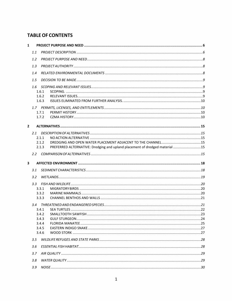
1.1 PROJECT DESCRIPTION The US Army Corps of Engineers (USACE), Jacksonville District proposes to continue periodic dredging of the Horseshoe Cove Federal navigation channel and turning basin, any time of the year and on an “as-needed” basis, in order to maintain safe navigation in the channel. The Horseshoe Cove channel connects the town of Horseshoe Beach in Dixie County, Florida with the Gulf of Mexico (Figure 1).
Figure 1 – Project vicinity

7
Photo courtesy of https://en.wikipedia.org/wiki/File:Dixie_county_florida_incorporated_and_unincorporated_areas_ horseshoe_beach_highlighted.svg
The channel is approximately 1.75-miles long and 75 feet wide with 3:1 side slopes on each side of the channel and a turning basin located at the northern end of the project adjacent to the shoreline (Figure 2).
Figure 2 – Horseshoe Cove channel location
The proposed work consists of routine operations and maintenance (O&M) dredging of an estimated 120,000 cubic yards of silt and silty sand from the Federal channel and turning basin to obtain a project depth of 6-foot with 1 foot of allowable overdepth. Dredged material will be placed in the previously used upland site, which is provided by the project stakeholder, Dixie County. The upland site is approximately 30 acres and is located approximately 4,000 feet northeast of the dredging area (Figure 3). Maintenance dredging most recently occurred in 2008.

8
Figure 3 – Horseshoe Cove channel upland placement site location.
1.2 PROJECT PURPOSE AND NEED The purpose of the project is to maintain safe and efficient vessel navigation through the channel. The need of the project is driven by the accumulation of sediment, commonly referred to as shoaling. The shoaling has restricted the width of the project channel and reduced its depths hindering safe and efficient vessel navigation. Periodic dredging is required to remove accumulated sediments and thus maintain the channel at its federally authorized depth. This Supplemental Environmental Assessment (EA) will evaluate the continued periodic O&M dredging of the Horseshoe Cove channel with upland placement of dredged material. The Supplemental EA will provide an update to previous analyses conducted under the National Environmental Policy Act (NEPA).
1.3 PROJECT AUTHORITY The project was authorized by P.L. 81-516, the River and Harbors Act of May 17, 1950, Section 101.
1.4 RELATED ENVIRONMENTAL DOCUMENTS Related NEPA, design, and planning reports for the Horseshoe Cove channel in Dixie County,

9
Florida includes the following documents:
• Chief’s Report for Horseshoe Cove, Florida. USACE, September 27, 1948. • General and Detail Design Memorandum – Horseshoe Cove. USACE, November 21, 1957. • Maintenance Dredging and Dredged Material Placement, Horseshoe Cove Navigation
Channel, Dixie County, Florida, Environmental Assessment. USACE, May 1995. • Resource Inventory for Horseshoe Cove Channel. Dial Cordy and Associates, Inc., May 31,
2000. • Letter, Florida Department of Environmental Protection (FDEP) Re: Exemption from
permit requirements for project: Horseshoe Cove maintenance dredging. FDEP, December 6, 2000.
• Letter, FDEP Regulatory authorization – Exemption verification for project: Horseshoe Cove maintenance dredging. FDEP File No. 15-163891-002-EE, May 29, 2008.
This Supplemental EA updates the analysis completed under NEPA in May 1995, Maintenance Dredging and Dredged Material Placement, Horseshoe Cove Navigation Channel, Dixie County, Florida, Environmental Assessment.
1.5 DECISION TO BE MADE The decision to be made upon completion of this EA is whether the proposed maintenance dredging and using the upland disposal area for Horseshoe Cover would result in significant environmental effects on the natural and human environment at the project location. The need for mitigation measures or best management practices (BMPs) to reduce any potentially adverse effects, particularly in regards to associated activities, is also a decision to be made. If no significant impacts are identified during the NEPA process, USACE will make the decision to sign the Finding of No Significant Impact and move forward with the Preferred Alternative. If significant impacts are identified, USACE will decide to implement mitigation measures to reduce the impacts to a lower-than-significant threshold, proceed with the Notice of Intent to prepare an Environmental Impact Statement, or not implement the Preferred Alternative.
1.6 SCOPING AND RELEVANT ISSUES
1.6.1 SCOPING. Under the 1995 EA review process, a public notice (PN-HC-178), dated July 14, 1993, was issued for the project and circulated to applicable Federal, state and local agencies and interested non-governmental organizations. Comments were accepted for 30-days after the notice. Comments received during the public notice were incorporated into the EA prior to the signature of the FONSI, signed on January 9, 1995. There is limited information available in the record about the project prior to the 1995 EA. The USACE did not conduct any additional scoping for the preparation of this Supplemental EA.
1.6.2 RELEVANT ISSUES. The USACE identified the following issues as relevant to the preferred alternative and appropriate for further evaluation: sediment characteristics, wetlands, fish and wildlife resources, threatened
10
and endangered species, wildlife refuges and state parks, essential fish habitat, air quality, water quality, noise, aesthetics, recreation, socioeconomics, navigation and public safety; cultural resources; energy requirements and conservation, natural or depletable resources, and cumulative effects. The USACE analyzed many of these issues in the 1985 EA. A summary of these reviews are included in Table 1.
1.6.3 ISSUES ELIMINATED FROM FURTHER ANALYSIS. No issues were specifically identified for elimination.
1.7 PERMITS, LICENSES, AND ENTITLEMENTS The preferred alternative is subject to Section 401 of the Clean Water Act (CWA) (33 U.S.C. §1341) for certification of water quality by the state; however, USACE previously obtained an exemption from permit requirements from FDEP. USACE has held this exemption for this particular project since at least 2000, and expects to maintain this exemption for the foreseeable future. Additionally, the proposed O&M dredging is subject to the Coastal Zone Management Act (CZMA) (16 U.S.C. §1451 et. seq.). By the issuance of the permit in 1993, and with the subsequent exemptions, the State concurred with the USACE’s CZMA consistency determination that the preferred alternative is consistent with the enforceable policies of the Florida Coastal Management Program. Consultation with the State Historic Preservation Office (SHPO) is also required under Section 106 of the National Historic Preservation Act (NHPA) (54 U.S.C. §306108).
1.7.1 PERMIT HISTORY • The State of Florida originally permitted the project in 1993 under the Wetland Resource
Management Permit (File No. 152332769) and USACE was required to comply with State of Florida water quality standards. That permit expired in 1998.
• In a letter dated December 6, 2000, FDEP granted an exemption from permit requirements due to the project meeting specific exemption criteria under s. 403.813(2)(f), Florida Administrative Code (FAC), regarding the upland placement of dredged material. Additionally, FDEP acknowledged in the letter that the project has been previously completed without incident, is routine in nature, and minimal or insignificant individual or cumulative adverse effects are expected.
• FDEP determined this activity was exempt per an exemption verification letter dated May 29, 2008 (FDEP File No. 15-163891-002-EE). The exemption verification letter was valid for only one year. USACE will request another exemption verification from FDEP prior to the next dredging event and in advance of future O&M dredging events as required.
1.7.2 CZMA HISTORY The proposed O&M dredging is subject to the CZMA. The Federal Consistency Determination (FCD) that the preferred alternative is consistent with the enforceable policies of the Florida Coastal Management Program was recoordinated with the state of Florida under the 1995 EA and is incorporated herein by reference. No specific documentation on a final decision is

11
available; however, through the issuance of the Wetland Resource Management Permit in 1993, and with the subsequent exemptions, the State concurred with the FCD. Section 5.0 provides a detailed list of environmental compliance regulations, policies, and permits applicable to this project.

12
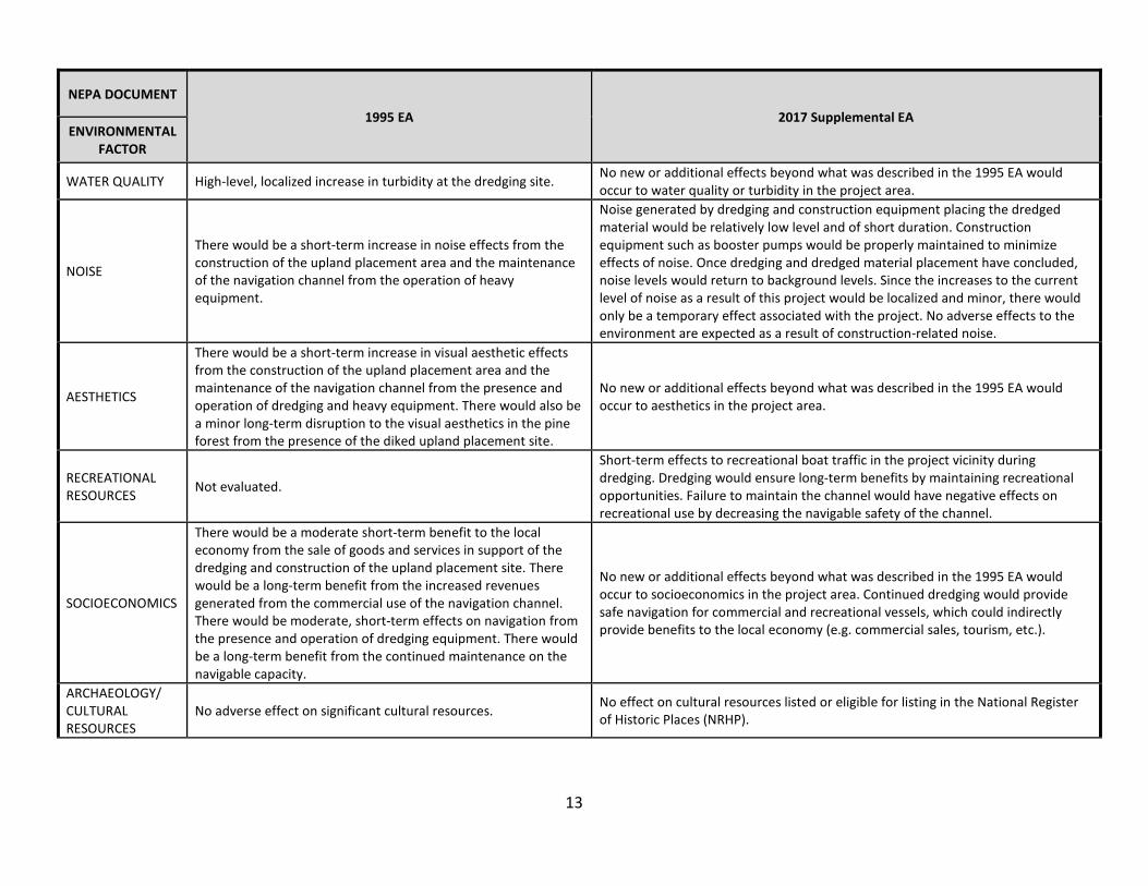
Table 1 - Summary of Environmental Factors Evaluated in NEPA Documents Prepared in 1995 and 2017
NEPA DOCUMENT 1995 EA 2017 Supplemental EA
ENVIRONMENTALFACTOR
SEDIMENT CHARACTERISTICS Not evaluated.
Historical information from previous core borings and past dredging events was used to characterize the material. No new core borings were drilled. The material to be excavated is shoal material that has deposited since the area was last dredged.
WETLANDS A minor loss of less than 1 acre of non-significant wetlands would occur as a result of the construction of the upland placement site. No wetlands are in the project area; therefore, no effects would occur to wetlands.
FISH AND WILDLIFE RESOURCES: migratory birds, seagrasses, forest habitat
There would be a permanent loss of approximately 40 acres of pine forest/oak scrub habitat as a result of the upland placement site construction.
No effects would occur to forest habitat in the project area. Migratory birds may experience temporary interruption of foraging and resting habitat. This effect would be short-term and limited to the immediate area of construction activities. Seagrasses adjacent to the dredge site may experience temporary effects from turbidity. Infaunal resources that live inside the boundaries of the channel will be lethally effected but will recolonize shortly after dredging operations have ceased.
THREATENED AND ENDANGERED SPECIES: manatees, eastern indigo snake, sea turtles, smalltooth sawfish, gulf sturgeon, wood stork
No effect on manatees. Gopher tortoises previously inhabited the disposal area, however, a presence/absence survey was conducted and no individuals were located. Sea turtles, sawfish, and birds were not evaluated. No evaluation of least terns and smalltooth sawfish (smalltooth sawfish were not yet listed).
Dredging activities may affect but are not likely to adversely affect manatees and sea turtles. There is no designated critical habitat located in the project area; therefore, no effects are associated with this effort. No effects are expected to smalltooth sawfish. Construction activities at the upland placement site may affect but are not likely to adversely affect wood storks and the eastern indigo snake. Standard protection measures for the eastern indigo snake and manatees will be implemented for this project.
WILDLIFE REFUGES & STATE PARKS: Big Bend Aquatic Preserve
Not evaluated. No direct effects anticipated.
ESSENTIAL FISH HABITAT (EFH) Not evaluated (pre-dates consultation on EFH).
Dredging would result in minor, temporary adverse effects to water column and benthic species due to displacement during dredging. No long-term adverse effects are anticipated.
AIR QUALITY Not evaluated.
Direct adverse effects would be small, localized, temporary increases in concentrations of nitrogen dioxide (NO2), sulfur dioxide (SO2), carbon monoxide (CO), volatile organic compounds (VOCs), and particulate matter (PM) mostly associated with the dredge plant and heavy equipment used at the placement site.
13
NEPA DOCUMENT
1995 EA 2017 Supplemental EA ENVIRONMENTAL
FACTOR
WATER QUALITY High-level, localized increase in turbidity at the dredging site. No new or additional effects beyond what was described in the 1995 EA would occur to water quality or turbidity in the project area.
NOISE
There would be a short-term increase in noise effects from the construction of the upland placement area and the maintenance of the navigation channel from the operation of heavy equipment.
Noise generated by dredging and construction equipment placing the dredged material would be relatively low level and of short duration. Construction equipment such as booster pumps would be properly maintained to minimize effects of noise. Once dredging and dredged material placement have concluded, noise levels would return to background levels. Since the increases to the current level of noise as a result of this project would be localized and minor, there would only be a temporary effect associated with the project. No adverse effects to the environment are expected as a result of construction-related noise.
AESTHETICS
There would be a short-term increase in visual aesthetic effects from the construction of the upland placement area and the maintenance of the navigation channel from the presence and operation of dredging and heavy equipment. There would also be a minor long-term disruption to the visual aesthetics in the pine forest from the presence of the diked upland placement site.
No new or additional effects beyond what was described in the 1995 EA would occur to aesthetics in the project area.
RECREATIONAL RESOURCES Not evaluated.
Short-term effects to recreational boat traffic in the project vicinity during dredging. Dredging would ensure long-term benefits by maintaining recreational opportunities. Failure to maintain the channel would have negative effects on recreational use by decreasing the navigable safety of the channel.
SOCIOECONOMICS
There would be a moderate short-term benefit to the local economy from the sale of goods and services in support of the dredging and construction of the upland placement site. There would be a long-term benefit from the increased revenues generated from the commercial use of the navigation channel. There would be moderate, short-term effects on navigation from the presence and operation of dredging equipment. There would be a long-term benefit from the continued maintenance on the navigable capacity.
No new or additional effects beyond what was described in the 1995 EA would occur to socioeconomics in the project area. Continued dredging would provide safe navigation for commercial and recreational vessels, which could indirectly provide benefits to the local economy (e.g. commercial sales, tourism, etc.).
ARCHAEOLOGY/ CULTURAL RESOURCES
No adverse effect on significant cultural resources. No effect on cultural resources listed or eligible for listing in the National Register of Historic Places (NRHP).

14
NEPA DOCUMENT
1995 EA 2017 Supplemental EA ENVIRONMENTAL
FACTOR
CUMULATIVE EFFECTS There would be no cumulative effects from this project.
The preferred alternative would result in long-term benefits, which should outweigh any short-term environmental losses. Cumulative effects to EFH for this project would be minimal. Adverse effects associated with dredging and placement activities will be temporary and minor. No long-term adverse effects are expected.
UNAVOIDABLE ADVERSE ENVIRONMENTAL EFFECTS
There would be increased turbidity levels from the dredging, loss of minor wetlands of less than one acre, construction effects on aesthetics, and increased benefits to navigation and the local economy.
Marine animals (including fishes and marine mammals) may experience increased noise and turbidity associated with the channel dredging. Infaunal resources that live inside the boundaries of the channel will be lethally effected but will recolonize shortly after dredging operations have ceased. Migratory birds may also be effected by the construction activities through avoidance of nesting or foraging areas which may include upland placement site. Effects are expected to be short-term and minor.

15
2 ALTERNATIVES
The alternatives section is perhaps the most important component of this Supplemental EA. It describes the No Action Alternative, the Preferred Alternative, and other reasonable alternatives that were evaluated. A preferred alternative was selected based on the information and analysis presented in the sections on the Affected Environment and Environmental Effects.
2.1 DESCRIPTION OF ALTERNATIVES
2.1.1 NO ACTION ALTERNATIVE The No Action Alternative consists of a cessation in the continued, periodic O&M dredging of the Horseshoe Cove channel with placement of dredged material at the previously used upland placement site. This alternative was previously evaluated in the Maintenance Dredging, and Dredged Material Placement, Horseshoe Cove Navigation Channel, Dixie County, Florida, Environmental Assessment, USACE, August 1995 (1995 EA) and will not be discussed in this Supplemental EA, unless a new evaluation is required due to a change in legal status (e.g. listing of a new species or designation of critical habitat).
2.1.2 DREDGING AND OPEN WATER PLACEMENT ADJACENT TO THE CHANNEL This alternative was previously considered in the 1995 EA. This alternative was eliminated because the dredged material is too silty to be contained in open water placement.
2.1.3 PREFERRED ALTERNATIVE: DREDGING AND UPLAND PLACEMENT OF DREDGED MATERIAL The preferred alternative is to continue periodic maintenance dredging of the Horseshoe Cove channel with upland placement as previously described in the 1995 EA and concluded to not have an adverse impact to the environment as noted in the FONSI, dated June 9, 1995. USACE does not dictate contractor methods to perform the work, however, dredging methods for the project may include via hydraulic or mechanical dredging. If hydraulic dredging is used for the project, the dredged material would be piped via hydraulic pipeline for placement at the upland placement site. If mechanical dredging is used on this project, dredged material would be removed from the channel and placed onto a small barge for dewatering and truck haul to the upland placement site. Transport from the barge to the upland site could also occur via hydraulic pipeline. Use of a barge could result in the double handling of dredged material. The past two dredge cycles, in 2001 and 2008, used hydraulic dredging with placement in the upland site via hydraulic pipeline.
2.2 COMPARISON OF ALTERNATIVES Table 2 summarizes the major features and consequences of the preferred alternative and the No Action Alternative. Refer to Section 4, Environmental Effects for a more detailed discussion of effects of alternatives.

16
Table 2 - Comparison of Alternatives in 2017 Supplemental EA
Environmental Factor No Action Alternative No O&M Dredging Occurs
Dredging and Placement at the Upland Site
Sediment Characteristics No effect to project sediment characteristics. The channel will continue to fill with sediments brought in on the flood tide each day and in association with weather events.
Material being removed from the channel is shoal material that has deposited since the area was last dredged. There is no effect to native sediment characteristics within the navigation channel and turning basin. Minor changes to sediment characteristics at the upland placement site are anticipated with the placement of dredged material from the channel.
Wetlands Minimum loss of non-significant wetlands (<1 acre). No effect anticipated.
Fish and Wildlife (migratory birds, seagrasses, benthic habitats)
As the channel fills with sand, any organisms that have colonized would be buried and this burial would be lethal to these organisms. The sand fill of the channel may also result in the colonization of the channel by seagrasses from adjacent beds as the channel shallows and more light reaches the bottom of the channel.
Minor and temporary effects to marine life that may be in the channel at the time of the dredging. Infaunal resources that live inside the boundaries of the channel will be lethally effected but will recolonize shortly after dredging operations have ceased. Effects are expected to be short-term and localized in nature, with recolonization occurring quickly from adjacent habitats.
Threatened and Endangered Species
Shoaling in the channel may result in the colonization of the channel by seagrasses, which may create foraging habitat, particularly for green sea turtles that forage on seagrasses.
Hydraulic dredging may affect, but is not likely to adversely affect sea turtles, manatees, smalltooth sawfish, and gulf sturgeon. Construction activities at the upland placement site may affect but are not likely to adversely affect the eastern indigo snake and wood storks. All terms and conditions of applicable United States Fish and Wildlife Service (USFWS) and National Marine Fisheries Service (NMFS) biological opinions will be implemented.
Wildlife Refuges and State Parks
The Horseshoe Cove channel is within the Big Bend Seagrass Aquatic Preserve (BBSAP). As the channel fills in and seagrass begins to colonize the channel, the grass may be impacted or destroyed if vessels attempt to navigate the channel.
There will be a temporary increase in turbidity levels at the dredge areas during construction. Dredging will meet aquatic preserve turbidity requirements. No significant effects to the BBSAP are expected to occur.
Essential Fish Habitat (EFH)
As the channel fills with sand, any organisms that have colonized the walls of the channel would be buried in sand and this burial would be lethal to these organisms. The sand fill of the channel may also result in the colonization of the channel by seagrasses as the channel shallows and more light reaches the bottom of the channel. This would be a negative effect to these colonizing resources and a beneficial effect to seagrasses.
Effects to EFH include temporary effects to the water column through turbidity. Seagrasses are not located within the channel but may be near the project vicinity. No significant effects to seagrasses that are in the project vicinity are expected to occur.
Air Quality No effect. Minor, temporary reduction of air quality due to emissions from dredging and upland placement operations.

17
Environmental Factor No Action Alternative No O&M Dredging Occurs
Dredging and Placement at the Upland Site
Water Quality No effect.
There will be a temporary increase in turbidity levels at the dredge areas during construction. This elevated turbidity level will be temporary and is not expected to be significant. Dredging will meet aquatic preserve turbidity requirements. No long-term adverse effects to water quality.
Noise No effect. A temporary increase in the noise level during construction in the vicinity of the project would occur.
Aesthetic Resources No effect. During construction, equipment used for dredging and upland placement would be visible, resulting in a temporary reduction in the aesthetic value in the construction area.
Recreational Resources
Without O&M dredging, the channel and turning basin will cease to provide safe navigation for commercial and recreational vessels, which would decrease public safety for vessels transiting the area.
Dredging and placement operations may cause minor, temporary restrictions in recreation during operations. Boat traffic will be temporarily interrupted due to dredging. No direct effects are anticipated at the upland placement site.
Socioeconomics
Without O&M dredging, the channel and turning basin will cease to provide safe navigation for commercial and recreational vessels, which would decrease public safety for vessels transiting the area and may indirectly impact the local economy.
Social and economic benefits that are based on navigation associated with the Federal project would continue. The extent of dredging may be limited by the appropriation of funds, approvals by Federal and state agencies and appropriate access to dredging and placement areas.
Cultural Resources No effect on cultural resources listed or eligible for listing in the NRHP.
No effect on cultural resources listed or eligible for listing in the NRHP.
Cumulative Effects No effect.
The preferred alternative would result in long-term benefits, which should outweigh any short-term environmental losses. Cumulative effects to EFH for this project would be minimal. Adverse effects associated with dredging and placement activities
Unavoidable Adverse Environmental Effects No effect.
Marine animals (including fishes and marine mammals) may experience increased noise and turbidity associated with the channel dredging. Infaunal resources that live inside the boundaries of the channel will be lethally effected but will recolonize shortly after dredging operations have ceased. Migratory birds may also be effected by the construction activities through avoidance of nesting or foraging areas. Effects are expected to be short-term and minor.
18
3 AFFECTED ENVIRONMENT
The Affected Environment section describes the existing environmental resources of the areas that would be affected if either alternative were implemented. This section describes only those environmental resources that are relevant to the decision to be made. It does not describe the entire existing environment, but only those environmental resources that would affect or that would be affected by the alternatives if they were implemented. This section, in conjunction with the description of the “ No Action Alternative,” forms the baseline conditions for determining the environmental effects of the reasonable alternatives.
3.1 SEDIMENT CHARACTERISTICS Horseshoe Cove is a shallow, relatively protected area adjacent to the town of Horseshoe Beach, in Dixie County, Florida, in the embayed northwest portion of the Florida peninsula. The coastline of Dixie County is a part of a low energy coast formed on a partly drowned limestone plateau peninsula. The limestones of Dixie County are permeable and porous, bioclastic, Upper Eocene rocks of the Inglis Formation, Williston Formation, and the Crystal River Formation (the Ocala Group), and older sediments. Soluble limestones are present at the surface or are overlain by an even thinner cover of loose Pleistocene sand. There is an appreciable amount of dolomitic limestone, of Upper Eocene age, along the coastal and western margins of Dixie County. Clay or other impervious sediments are practically nonexistent above the Ocala bedrock. Historical information from previous core borings and past dredging events was used to characterize the material. The material to be excavated is shoal material that has deposited since the area was last dredged in 2008. No new core borings were drilled to characterize the materials for the current maintenance dredging. Earlier shoaling was predominately sand, silt, and clay. The material also contains variable amounts of shell and shell fragments. Some residual loose rock and gravel deposits, left from initial construction dredging, may be encountered in thin layers. Rock occurs at or near grade in many parts of the project. In situ rock, if encountered, is not required to be dredged. The previous maintenance dredging event encountered debris, including trash, rope, chain, cable, tires, and miscellaneous scrap metal that may also be encountered in this dredging event. Historic vibracore borings CB-HCM95-1 through CB-HCM95-2 are located in the Horseshoe Cove turning basin and borings CB-HCM95-3 through CB-HCM95-6 are located in the Horseshoe Cove channel (Figure 4). Most of the materials within the project template presented on the boring logs have been removed by previous dredging events with subsequent shoaling of similar materials.

19
Figure 4 – Location of historic core borings for the project
3.2 WETLANDS The USFWS National Wetland Inventory has identified wetlands near, but not within, the upland placement site (Figure 5).

20
Figure 5 – Wetlands adjacent to the Horseshoe Cove upland dredged material placement site
3.3 FISH AND WILDLIFE
3.3.1 MIGRATORY BIRDS A number of seabirds and shorebirds may occur in and around the project area, including a number of species considered birds of conservation concern by the Migratory Bird Treaty Act (MBTA) (16 U.S.C. §§703-712). Species reported to the Florida Shorebird Database since 2011 within Dixie County include the American oystercatcher, Wilson’s plover, and willet. These species all use sandy beaches for foraging and/or nesting and, therefore, could occur along the project area.
3.3.2 MARINE MAMMALS The Marine Mammal Protection Act (MMPA) (16 U.S.C. §1361 et. seq.) protects all marine mammals from harvesting within the borders of the United States (U.S.), regardless of status. The West Indian (Florida) manatee (Trichechus manatus latirostris) and bottlenose dolphins (Tursiops truncatus) may be in the vicinity of the project area. Table 3 contains more details on the habitat and conservation status of these species. Stock assessments for the bottlenose dolphins of the

21
Northern Gulf of Mexico Bay, Sound, and Estuary Stock and the Gulf of Mexico Eastern Coastal Stock are located at https://www.nefsc.noaa.gov/publications/tm/tm241/154_F2016_bottlenosedolphinGmexBSE.pdf and http://www.nmfs.noaa.gov/pr/sars/pdf/stocks/atlantic/2015/f2015_bodoecoastgmex.pdf and are incorporated by reference. Specific information on the life history is available in NMFS’ “Annual Reports to Congress under the MMPA”, which is located at. The Florida manatee in U.S. waters is managed under thttp://www.nmfs.noaa.gov/pr/sars/region.htm. The jurisdiction of the USFWS and is discussed in more detail in Section 3.3.4. Table 3 - The Habitat and Conservation Status of Marine Mammals Inhabiting the Proposed Project Area
Species Habitat ESA1
Bottlenose dolphin (Tursiops truncatus) Offshore, inshore, coastal, and estuaries NL
West Indian (Florida) manatee (Trichechus manatus latirostris) Coastal, rivers, and estuaries TH
EN – Endangered; TH – Threatened; NL – Not Listed; D – Depleted; NC – No Concern; S – Strategic;
3.3.3 CHANNEL BENTHOS AND WALLS Sedimentary habitats, such as sand shoals, support a variety of invertebrates and demersal fishes. Invertebrate species using the shoals include infaunal and epifaunal species represented primarily by annelid worms, gastropods, bivalves, crustaceans, and echinoderms. Demersal feeding fishes prey on most of these species. The populations are removed each time that the shoals are dredged and recolonize over time from other sand sounds in the vicinity as the shoals rebuild within the channel.
3.4 THREATENED AND ENDANGERED SPECIES The lists of endangered and threatened species developed for this EA (Table 4) were compiled from the Gulf Region Biological Opinion (GRBO), the Florida Natural Areas Inventory, as well as project specific biological assessments and biological opinions (BOs) prepared for previous projects which have taken place in the vicinity of the proposed project. Table 4 - Threatened and Endangered Species in the Project Area
Common Name Scientific Name Listing Status Green sea turtle Chelonia mydas Threatened Hawksbill sea turtle Eretmochelys imbricata Endangered Kemp’s ridley sea turtle Lepidochelys kempii Endangered Loggerhead sea turtle Caretta caretta Threatened Smalltooth sawfish Pristis pectinata Endangered Gulf sturgeon Acipenser oxyrinchus desotoi Threatened/Critical habitat Florida manatee Trichechus manatus Threatened Eastern indigo snake Drymarchon couperi Threatened Wood stork Mycteria Americana Endangered
22
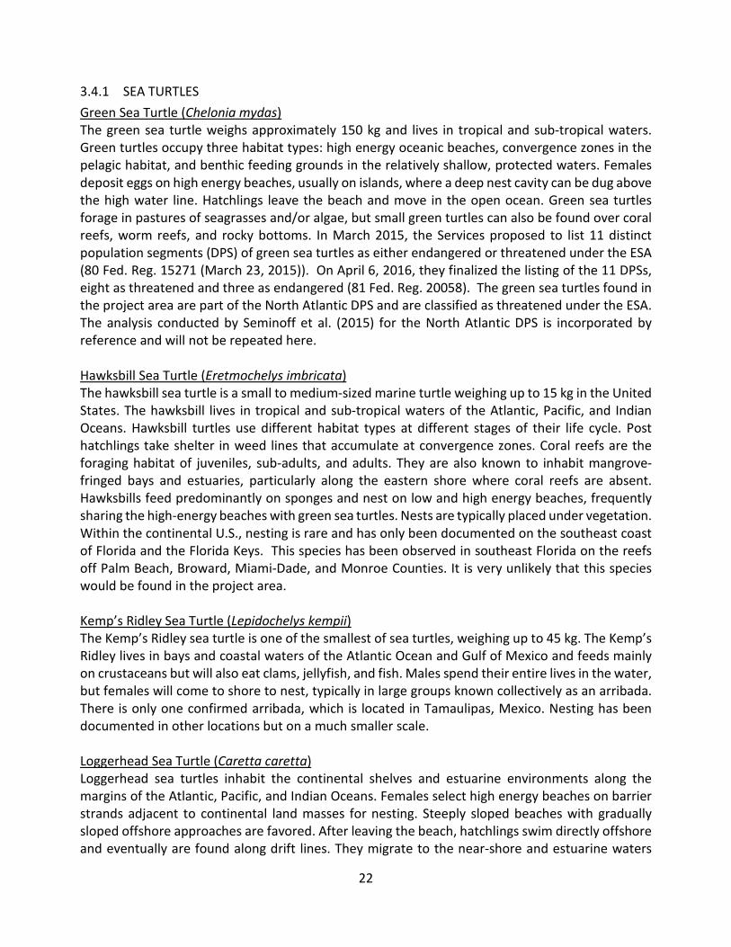
3.4.1 SEA TURTLES Green Sea Turtle (Chelonia mydas) The green sea turtle weighs approximately 150 kg and lives in tropical and sub-tropical waters. Green turtles occupy three habitat types: high energy oceanic beaches, convergence zones in the pelagic habitat, and benthic feeding grounds in the relatively shallow, protected waters. Females deposit eggs on high energy beaches, usually on islands, where a deep nest cavity can be dug above the high water line. Hatchlings leave the beach and move in the open ocean. Green sea turtles forage in pastures of seagrasses and/or algae, but small green turtles can also be found over coral reefs, worm reefs, and rocky bottoms. In March 2015, the Services proposed to list 11 distinct population segments (DPS) of green sea turtles as either endangered or threatened under the ESA (80 Fed. Reg. 15271 (March 23, 2015)). On April 6, 2016, they finalized the listing of the 11 DPSs, eight as threatened and three as endangered (81 Fed. Reg. 20058). The green sea turtles found in the project area are part of the North Atlantic DPS and are classified as threatened under the ESA. The analysis conducted by Seminoff et al. (2015) for the North Atlantic DPS is incorporated by reference and will not be repeated here. Hawksbill Sea Turtle (Eretmochelys imbricata) The hawksbill sea turtle is a small to medium-sized marine turtle weighing up to 15 kg in the United States. The hawksbill lives in tropical and sub-tropical waters of the Atlantic, Pacific, and Indian Oceans. Hawksbill turtles use different habitat types at different stages of their life cycle. Post hatchlings take shelter in weed lines that accumulate at convergence zones. Coral reefs are the foraging habitat of juveniles, sub-adults, and adults. They are also known to inhabit mangrove-fringed bays and estuaries, particularly along the eastern shore where coral reefs are absent. Hawksbills feed predominantly on sponges and nest on low and high energy beaches, frequently sharing the high-energy beaches with green sea turtles. Nests are typically placed under vegetation. Within the continental U.S., nesting is rare and has only been documented on the southeast coast of Florida and the Florida Keys. This species has been observed in southeast Florida on the reefs off Palm Beach, Broward, Miami-Dade, and Monroe Counties. It is very unlikely that this species would be found in the project area. Kemp’s Ridley Sea Turtle (Lepidochelys kempii) The Kemp’s Ridley sea turtle is one of the smallest of sea turtles, weighing up to 45 kg. The Kemp’s Ridley lives in bays and coastal waters of the Atlantic Ocean and Gulf of Mexico and feeds mainly on crustaceans but will also eat clams, jellyfish, and fish. Males spend their entire lives in the water, but females will come to shore to nest, typically in large groups known collectively as an arribada. There is only one confirmed arribada, which is located in Tamaulipas, Mexico. Nesting has been documented in other locations but on a much smaller scale. Loggerhead Sea Turtle (Caretta caretta) Loggerhead sea turtles inhabit the continental shelves and estuarine environments along the margins of the Atlantic, Pacific, and Indian Oceans. Females select high energy beaches on barrier strands adjacent to continental land masses for nesting. Steeply sloped beaches with gradually sloped offshore approaches are favored. After leaving the beach, hatchlings swim directly offshore and eventually are found along drift lines. They migrate to the near-shore and estuarine waters

23
along the continental margins and utilize those areas as the developmental habitat for the sub-adult stage. Loggerheads are predators of benthic invertebrates. NMFS designated critical habitat (DCH) for the loggerhead sea turtle in 2014, and the project area is not located within DCH (Figure 6).
Figure 6 – Summary map of DCH for loggerhead sea turtles
3.4.2 SMALLTOOTH SAWFISH The smalltooth sawfish (Pristis pectinata) is currently listed as endangered by NMFS and has become rare along the southeastern Atlantic and northern Gulf of Mexico coasts of the United States during the past 30 years. Its known primary range is now reduced to the coastal waters of Everglades National Park in extreme southern Florida. Fishing and habitat degradation have extirpated the smalltooth sawfish from much of this former range. The smalltooth sawfish is distributed in tropical and subtropical waters worldwide. It normally inhabits shallow waters (33 feet/ 10 meters or less), often near river mouths or in estuarine lagoons over sandy or muddy substrates, but may also occur in deeper waters (66 feet/20 meters) of the continental shelf. Shallow water less than 3.3 feet (1 meter) deep is an important nursery area for young smalltooth sawfish and maintenance and protection of these habitat is an important component of the “Recovery Plan for Smalltooth Sawfish (Pristis pectinata)” (NMFS 2009). Recent studies indicate that key habitat features (particularly for immature individuals) nominally consist of shallow water, proximity to mangroves, and estuarine conditions. Smalltooth sawfish grow slowly and mature at about 10 years of age. Females bear live young, and the litters reportedly

24
range from 15 to 20 embryos requiring a year of gestation. Their diet consists of macroinvertebrates and fishes such as herrings and mullets. The saw is reportedly used to rake surficial sediments in search of crustaceans and benthic fishes or to slash through schools of herrings and mullets (NMFS 2009). Although DCH has been identified in South Florida, there is no DCH for this species in Northwest Florida.
3.4.3 GULF STURGEON The Gulf Sturgeon (Acipenser oxyrinchus desotoi) is an anadromous fish that inhabits coastal rivers from Louisiana to Florida during the warmer months and overwinters in bays, estuaries, and the Gulf of Mexico. Adults range from 4-8 feet in length and can live over 40 years. Feeding habitat varies depending on the fish’s life stage. Migratory behavior is influenced by sex, reproductive status, water temperature, and possibly river flow. DCH has been identified south of the project area in the Suwannee River (50 CFR Part 226). No DCH is present in the project area (Figure 7).
Figure 7 – Gulf Sturgeon DCH south of the project area

25
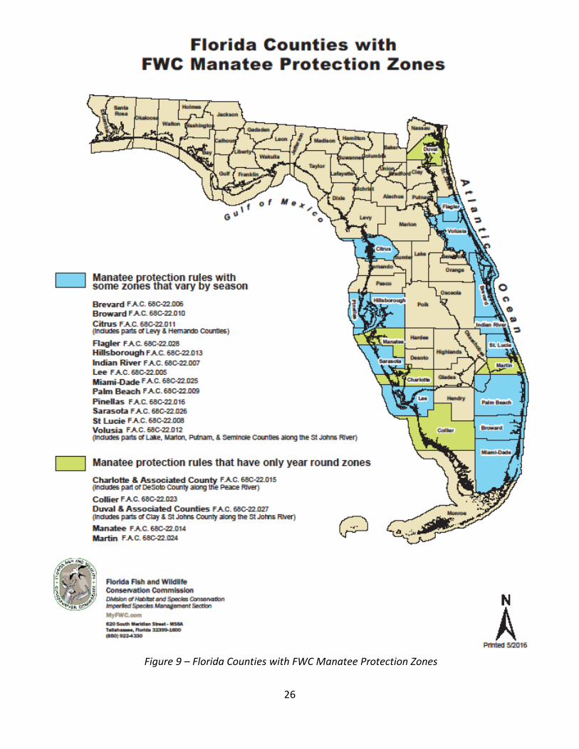
3.4.4 FLORIDA MANATEE The Florida manatee is a subspecies of the West Indian manatee (Trichechus manatus) and can be found throughout the southeastern United States. The manatee is a large, plant-eating aquatic mammal that move between freshwater and saltwater environments. They can be found in shallow coastal waters, rivers, and springs. Adult manatees are approximately 10 feet long, weighing between 800 – 1200 pounds, and consume approximately 4-9% of their body weight each day. Although manatees feed underwater, they frequently rest just below the water surface with only the snout above water. Manatees were listed as endangered throughout its range for both the Florida and Antillean subspecies (Trichechus manatus latirostris and Trichechus manatus manatus) in 1967 (32 FR 4001). In May 2017, the USFWS reclassified the manatee from endangered to threatened. Dixie County is not within a USFWS designated critical habitat for this species (Figure 8) or a Florida Fish and Wildlife Conservation Commission (FWC) Manatee Protection Zone (Figure 9).
Figure 8 – USFWS Florida manatee critical habitat
https://www.fws.gov/northflorida/manatee/2009_CH_Petition/20100112_frn_Manatee_CH_12-mo_notice.htm
26
Figure 9 – Florida Counties with FWC Manatee Protection Zones
27
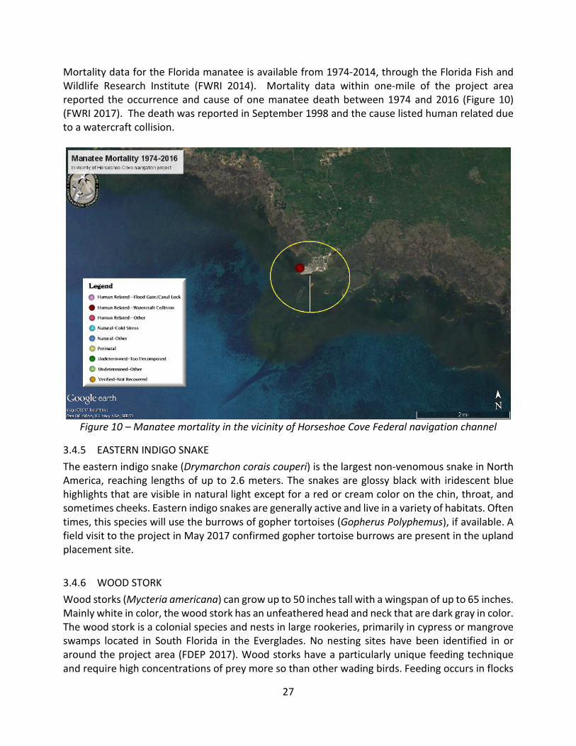
Mortality data for the Florida manatee is available from 1974-2014, through the Florida Fish and Wildlife Research Institute (FWRI 2014). Mortality data within one-mile of the project area reported the occurrence and cause of one manatee death between 1974 and 2016 (Figure 10) (FWRI 2017). The death was reported in September 1998 and the cause listed human related due to a watercraft collision.
Figure 10 – Manatee mortality in the vicinity of Horseshoe Cove Federal navigation channel
3.4.5 EASTERN INDIGO SNAKE The eastern indigo snake (Drymarchon corais couperi) is the largest non-venomous snake in North America, reaching lengths of up to 2.6 meters. The snakes are glossy black with iridescent blue highlights that are visible in natural light except for a red or cream color on the chin, throat, and sometimes cheeks. Eastern indigo snakes are generally active and live in a variety of habitats. Often times, this species will use the burrows of gopher tortoises (Gopherus Polyphemus), if available. A field visit to the project in May 2017 confirmed gopher tortoise burrows are present in the upland placement site.
3.4.6 WOOD STORK Wood storks (Mycteria americana) can grow up to 50 inches tall with a wingspan of up to 65 inches. Mainly white in color, the wood stork has an unfeathered head and neck that are dark gray in color. The wood stork is a colonial species and nests in large rookeries, primarily in cypress or mangrove swamps located in South Florida in the Everglades. No nesting sites have been identified in or around the project area (FDEP 2017). Wood storks have a particularly unique feeding technique and require high concentrations of prey more so than other wading birds. Feeding occurs in flocks
28
in freshwater marshes, narrow tidal creeks, or flooded tidal pools with the diet consisting mainly of small fish from 1-6 inches long and in water that is 6-10 inches deep. Depressions in marshes or swamps where fish become concentrated are particularly preferred feeding sites. The USFWS proposed to reclassify the wood stork status from endangered to threatened in December 2013; however, no official rule has been finalized.
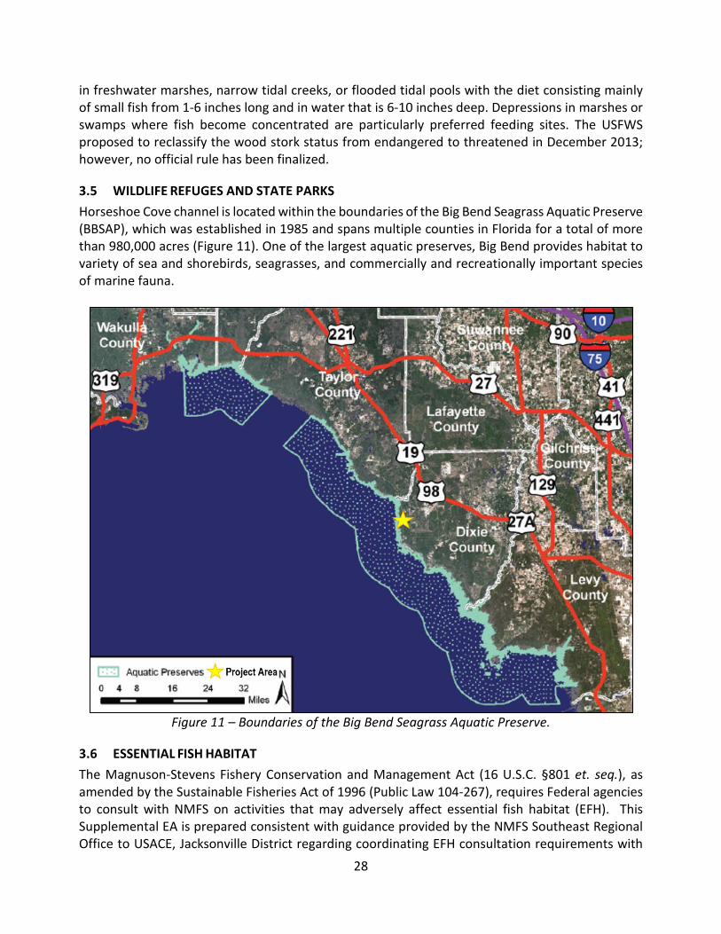
3.5 WILDLIFE REFUGES AND STATE PARKS Horseshoe Cove channel is located within the boundaries of the Big Bend Seagrass Aquatic Preserve (BBSAP), which was established in 1985 and spans multiple counties in Florida for a total of more than 980,000 acres (Figure 11). One of the largest aquatic preserves, Big Bend provides habitat to variety of sea and shorebirds, seagrasses, and commercially and recreationally important species of marine fauna.
Figure 11 – Boundaries of the Big Bend Seagrass Aquatic Preserve.
3.6 ESSENTIAL FISH HABITAT The Magnuson-Stevens Fishery Conservation and Management Act (16 U.S.C. §801 et. seq.), as amended by the Sustainable Fisheries Act of 1996 (Public Law 104-267), requires Federal agencies to consult with NMFS on activities that may adversely affect essential fish habitat (EFH). This Supplemental EA is prepared consistent with guidance provided by the NMFS Southeast Regional Office to USACE, Jacksonville District regarding coordinating EFH consultation requirements with

29
NEPA (NMFS 1999a). EFH is defined as “those waters and substrate necessary to fish for spawning, breeding, or growth to maturity” (SAFMC 1998). The rules promulgated by the NMFS in 2002 further clarify EFH with the following definitions:
• Waters – aquatic areas and their associated physical, chemical, and biological properties that are used by fish and may include aquatic areas historically used by fish where appropriate;
• Substrate – sediment, hard bottom, structures underlying the waters, and associated biological communities;
• Necessary – the habitat required to support a sustainable fishery and the managed species’ contribution to a healthy ecosystem; and
• Spawning, breeding, feeding, or growth to maturity – stages representing a species’ full life cycles (50 CFR Part 600; NMFS, 2002).
Habitat Areas of Particular Concern (HAPC) are subsets of EFH that is either rare, particularly susceptible to human-induced degradation, especially important ecologically, or located in an environmentally stressed area. In light of their designation as EFH-HAPC’s, NMFS applies greater scrutiny to projects that may affect seagrasses, to ensure practicable measures to avoid and minimize adverse effects to these habitats are fully explored. Components of waters, substrate, and necessity, as defined above, exist in the project area for various stages of fish species life cycles. The entire watered portion of the project area is considered as EFH under the above definition. No hardbottom resources (including corals) have been identified within the project area. A benthic inspection of the areas proposed for maintenance dredging was performed by staff from the NMFS Habitat Conservation Division on May 10, 2017. A brief field report and summary was provided via email on May 12, 2017 documenting that no attached/rooted SAV was observed within the areas proposed for maintenance dredging.
3.7 AIR QUALITY Section 176 of the Clean Air Act (CAA) (42 U.S.C. §7506) requires Federal actions to conform to an approved state implementation plan designed to achieve or maintain an attainment designation for air pollutants as defined by the National Ambient Air Quality Standards (NAAQS). The NAAQS are designed to protect public health and welfare. The criteria pollutants include ozone, nitrogen dioxide, carbon monoxide, total suspended particulates, and sulfur dioxide. The project area is located in the Jacksonville-Brunswick Interstate Air Quality Control Region, as established by 40 CFR §81.49. The U.S. Environmental Protection Agency (USEPA) designates air quality compliance on a county level and Dixie County is considered as being in attainment with the NAAQS.
3.8 WATER QUALITY The State of Florida classifies surface waters from “I” (drinking water quality) to “V” (industrial water discharge quality). The predominant issue that affects water quality in Florida is turbidity, which is considered a good measure of water quality. Turbidity is measured in Nephelometric Turbidity Units (NTU), which is a measure of light-scatter by particulates within the water. This measurement does not address the characteristics of the suspended material that creates turbid conditions. Florida state guidelines set to minimize turbidity effects from beach restoration activities confine

30
turbidity values to under 29 NTU above ambient levels outside the turbidity mixing zone for the beach placement areas. For dredging inside the BBSAP, state water quality permits require that turbidity remains at 0 NTU above background.
3.9 NOISE Noise is defined as unwanted sound and, in the context of protecting public health and welfare, implies potential effects on the human and natural environment. Noise is a significant concern associated with construction, dredging, and transportation activities and projects. Ambient noise levels within a given region may fluctuate over time because of variations in intensity and abundance of noise sources. Ambient sources of noise within the project area are recreational activities (boating and fishing), commercial vessels transiting up and down the coast, and natural sounds from the physical and biological environment.
3.10 AESTHETIC RESOURCES The project area vicinity is a small town with a channel that leads through a large, open seagrass area into the Gulf of Mexico, and as previously discussed, is used by recreational and commercial vessels. The channel is sub-tidal and the upland placement site has been previously used and is maintained to ensure future dredged material placement. There are no features that are prominent or architecturally distinguished in the Horseshoe Cove channel or upland placement site.
3.11 RECREATIONAL RESOURCES The town of Horseshoe Beach sits adjacent and north of the channel and turning basin. Recreational activities are mainly limited to swimming, boating, and fishing. Businesses in the town with a focus on recreation and tourism are limited to charter fishing, restaurants, and hotels.
3.12 NATIVE AMERICANS The Horseshoe Cove Federal navigation channel, turning basin, and dredged material upland placement site are not located within or adjacent to known Native American-owned lands, reservation lands, or Traditional Cultural Properties. However, Native American groups have lived throughout this region in the past, and their decedents continue to live within the State of Florida and throughout the U.S. Pursuant to Section 106 of the NHPA (54 U.S.C. § 306108), obligations regarding USACE’s Trust Responsibilities to federally-recognized Native American tribes, and in consideration of the Burial Resources Agreement between USACE and the Seminole Tribe of Florida, the USACE consulted with the appropriate federally-recognized Native American tribes with ancestral ties to this region, including the Seminole Tribe of Florida, the Seminole Nation of Oklahoma, and the Miccosukee Tribe of Indians of Florida.
3.13 CULTURAL RESOURCES There are no previously identified cultural resources within the Horseshoe Cove Federal navigation channel, turning basin, or dredged material upland placement site; however, prehistoric and historic sites have been identified within the vicinity of Horseshoe Cove. A total of 11 prehistoric archaeological sites are located within an approximate 1.5 mile radius of the area of potential effects (APE) (Figure 12). The closest sites (8DI0071 and 8DI0129) are mapped on Horseshoe Point and consist of donated collections. An additional two sites (8DI0131 and 8DI0132) are located north
31
of Horseshoe Beach and also consist of donated collections; however, the recorded locations and archaeological period of these four sites cannot be properly evaluated due to the lack of available information. Nearby Butler Island contains two Woodland period (8DI0050 and 8DI0097) sites and one Early Archaic period (8DI0267) site. Bird Island contains a Late Archaic cemetery (8DI0052), and is one of the oldest archaeological deposits in the region. Both Butler Island and Bird Island are comprised of relict paleodunes that were formed when sea levels were six to two meters below today’s sea level. These sites are subject to shoreline erosion, and the prehistoric shell midden (8DI0051) that was located on Cotton Island has already been destroyed by erosion. The remaining two sites located within the vicinity of Horseshoe Cove (8DI0004 and 8DI0079) are situated northeast of the upland placement area. Site 8DI0004 is an extensive complex of Woodland period mounds and middens that was listed in the NRHP in 1991. Site 8DI0079 is an unspecified prehistoric site, likely associated with the larger, nearby 8DI0004. The first European exploration of the Florida Peninsula began in 1513; however, there was very little European settlement in the Big Bend region of Florida prior to the nineteenth century. By 1778, the Seminole Tribe occupied the village Old Town in the Lower Suwannee. Old Town was the principal village of the region and was destroyed during the Second Seminole War. Although still sparsely populated during the Civil War, early settlers of the region utilized the marsh and tidal creeks that surround the project area for salt manufacturing. Settlers in the latter half of the nineteenth century were generally farmers that relied on the inland rivers and the Gulf to transport timber and cattle (James et al. 2017). No known historic period shipwrecks are documented within the APE; however, a review of the National Oceanic and Atmospheric Administration’s (NOAA) Electronic Navigation Chart (ENC) documents a shipwreck that first appeared on a 1969 chart. This chart records the submerged vessel as immediately adjacent to the eastern edge of channel. A review of NOAA’s Automated Wreck and Obstruction Information System and other historic maps and references did not indicate any further potential cultural resources within the project area. Construction of the Horseshoe Cove Federal navigation channel and turning basin occurred circa 1959 based on aerial imagery of the APE. The upland disposal area was constructed between 1994 and 1995 and utilized during the last maintenance dredging of the channel and turning basin in 2008. The Suwanee River Water Management District hired a consultant to a conduct a cultural resources survey of the disposal area subsequent to the 1994 clearing, grubbing, and construction of the containment dikes of the disposal area. No significant archeological resources were identified in the upland disposal area. A copy of the April 8, 1994 report which resulted from the investigation was coordinated with the Florida SHPO. The SHPO concurred with USACE’s determination of no effect in a letter dated May 2, 1995. The Horseshoe Cove Federal navigation channel and turning basin has not been subject to a submerged cultural resources survey. Due to the location of the APE near a number of offshore prehistoric archaeological sites (i.e., 8DI0051 and 8DI0052), the project area was determined to have a moderate potential for containing intact cultural resources. As such, USACE contracted Panamerican Consultants, Inc. (Panamerican) to identify historic properties that may be located
32
within the APE. This survey is documented in the 2017 report entitled Submerged Cultural Resources Remote Sensing Survey for the Horseshoe Cove Navigation Channel, Dixie County, Florida. The Panamerican submerged cultural resources survey of the APE utilized a magnetometer, sidescan sonar, and a subbottom profiler. A total of 61 magnetic anomalies, two sidescan sonar targets, and no subbottom paleofeatures were recorded during the survey. Analysis of the magnetic data indicates that of the 61 magnetic anomalies, 27 anomalies are classified as single-point sources, 20 anomalies are associated with channel markers, nine represent dock infrastructure, three are comprised of nonsignificant debris, and two represent unknown features. Both of the sidescan sonar contacts, one with associated anomalies and one without, are nonsignificant. All the anomalies and sonar contacts are considered nonsignificant with the exception of two anomalies that form a cluster close to the shore; however, these two anomalies are located over 100 feet outside and to the west of the APE.

33
Figure 12 – 1944 aerial photograph showing the Horseshoe Cove prior to the channel’s
construction (image courtesy of University of Florida Digital Collections)

34
4 ENVIRONMENTAL EFFECTS
This section is the analytic basis for the comparisons of the alternatives. See Table 2 in section 2.0 Alternatives for summary of effects. The following includes anticipated changes to the existing environment including direct, indirect, and cumulative effects. Previous EAs have assessed the effects of placing dredged material in the upland site as identified in Section 1.1. All of these previous EA/FONSIs are incorporated by reference (Section 1.4, Related Environmental Studies).
4.1 SEDIMENT CHARACTERISTICS No Action Alternative. The No Action Alternative will not have an effect on native sediment characteristics within the navigation channels. The channel will continue to fill with sediments brought in on the flood tide each day and in association with weather events. Preferred Alternative, Dredging and Upland Placement of Horseshoe Cove channel. Sediments in the channel are considered previously disturbed, maintenance material. Long-term impacts to bathymetry, typical of dredging project, are expected due to the continued O&M dredging. The previous maintenance dredging event encountered debris, including trash, rope, chain, cable, tires, and miscellaneous scrap metal that may also be encountered in this dredging event. If similar items are discovered during this dredging event, the materials will be properly disposed of as required by the contract specifications and in accordance with Section 307 of the CWA (33 U.S.C. §1317).
4.2 WETLANDS No Action Alternative. The No Action Alternative is not expected to affect wetlands. Preferred Alternative, Dredging and Upland Placement of Horseshoe Cove channel. No wetlands are in the project area; therefore, no effects will occur to wetlands.
4.3 FISH AND WILDLIFE
4.3.1 MIGRATORY BIRDS No Action Alternative. The No Action Alternative is not expected to affect migratory birds in the project area. Preferred Alternative, Dredging and Upland Placement of Horseshoe Cove channel. Migratory birds may pass through and use areas in or adjacent to the project area. There may be some interruption of foraging and resting activities for birds. This effect would be short-term and limited to the immediate area of construction activities. There would be sufficient habitat that can be used by displaced birds during construction. Dredging also results in temporary increases in turbidity and sedimentation, removal and burial of benthic species, and displacement of fishes that could adversely impact local foraging opportunities; however, those effects are minimal given the short-duration of activities and widespread availability of equivalent habitat (Wenger et al. 2016). Smaller fishes located in the channel during dredging operations may also be entrained into the cutterhead dredge pipe, if a hydraulic cutterhead dredge is used, resulting in their demise when the water is pumped to the

35
upland site, where birds have been documented to forage on dredged material discharge. Temporary displacement and noise related to use of heavy construction equipment could disturb nesting and foraging birds at the upland discharge site. USACE, in conjunction with the USFWS and FWC, has developed guidelines to avoid and monitor potential effects to shorebirds. USACE has developed a suite of contractual specifications for dredge contractors to implement during construction where migratory birds may be present. The contractor will keep all dredging and construction activities under surveillance, management, and control to prevent effects to migratory birds. The contractor may be held responsible for harming or harassing the birds, their eggs, or their nests present in the site as a result of the construction activities.
4.3.2 MARINE MAMMALS No Action Alternative. The No Action Alternative is not expected to affect marine mammals in the project area. Preferred Alternative, Dredging and Upland Placement of Horseshoe Cove channel. Marine mammals in the action area may be temporarily displaced from the area by dredging activities, although the operation of the dredge is not expected to affect marine mammals any more than recreational and commercial vessels operating within the channel.
4.3.3 CHANNEL BENTHOS AND WALLS No Action Alternative. As the channel fills in with sediment, the area available to benthos already in the sediment will increase and the number of benthic invertebrates may increase in proportion to the available substrate. Preferred Alternative, Dredging and Upland Placement of Horseshoe Cove channel. Benthos that inhabit the dredging area would be removed by the dredging activity. This effect is likely to be temporary and localized and would likely recover within 12 to 18 months. No long-term adverse effects are anticipated to the intertidal macroinfaunal community due to dredging activities. The undisturbed areas adjacent to the channel will serve as the primary source of colonizing fauna for the recovery of those species into the excavation site (Van Dolah et al. 1984; Jutte et al. 2002)
4.4 THREATENED AND ENDANGERED SPECIES No Action Alternative. Ceasing O&M dredging of the channel may result in the expansion of seagrass into the previously dredged areas. This would be a benefit to the seagrass species found adjacent to the channel. The increase in seagrass may also attract manatees and green sea turtles into the channel area to forage on the grasses, increasing the potential for vessel strikes to these species. As the channel shallows, there may be an increase in vessel strikes of sea turtles and manatees that are unable to avoid vessels continuing to transit the channel, due to decrease in available area for the animals use of the channel footprint. Preferred Alternative, Dredging and Upland Placement of Horseshoe Cove channel. Potential adverse effects of dredging have been reviewed in the NMFS’ GRBO of 2003, as amended in 2005

36
and 2007. The GRBO includes Terms and Conditions (T&Cs) to minimize adverse effects to listed species and provides incidental take authorizations where adverse effects cannot be avoided. USACE is incorporating those T&Cs into the project plans and specifications. As a result of the BO, the effects of the continued dredging of the channel with placement of dredged material in the upland site may adversely affect, but is not likely to jeopardize, the continued existence of any listed species. Additional analysis, by species group or species is provided below:
4.4.1 SEA TURTLES Placement of dredged material will be in an upland site; therefore, no effects to nesting sea turtles are anticipated. Dredging could be performed hydraulically or mechanically and could potentially directly and indirectly affect sea turtles. The 2003 GRBO references the 1991 South Atlantic Region Biological Opinion (SARBO) ( amended in 1995 and 1997) analysis of hydraulic and mechanical dredging effects on sea turtles, which states:
Clamshell dredges are the least likely to adversely affect sea turtles because they are stationary and impact very small areas at a given time. Any sea turtle injured or killed by a clamshell dredge would have to be directly beneath the bucket. The chances of such an occurrence are extremely low, although the take of a live turtle by a clamshell dredge has been documented at Canaveral. On the basis of the best available information, NMFS has determined that dredging with a clamshell dredge is unlikely to result in the take of sea turtles. . . . Pipeline dredges are relatively stationary and only influence small areas at a given time. For a turtle to be taken with a pipeline dredge, it would have to approach the cutterhead and be caught in the suction. This type of behavior would appear unlikely, but may be possible. Presently, NMFS has determined that pipeline dredges are unlikely to adversely affect sea turtles. . . . the special purpose split-hull hopper dredge and sidecast dredges are used in a limited basis in the southeast. These dredges are not believed harmful to sea turtles because of the small size of dragheads (roughly 2’ by 2’). For the present consultation, NMFS has determined that these dredges are unlikely to adversely affect sea turtles.
USACE agrees with this determination and hereby incorporates it into this effects determination.
4.4.2 SMALLTOOTH SAWFISH The logic set forth in the GRBO regarding hopper dredge effects to smalltooth sawfish in the Gulf of Mexico is also applicable to the Horseshoe Cove channel where sawfish occurrences are rare. As stated in the GRBO (page 21):
Smalltooth sawfish (Pristis pectinata) are tropical marine and estuarine fish that have the northwestern terminus of their Atlantic range in the waters of the eastern US. Currently, their distribution has contracted to peninsular Florida and, within that area, they can only be found with any regularity off the extreme southern portion of the state. The current distribution is centered in the Everglades National Park, including Florida Bay. They have

37
been historically caught as bycatch in commercial and recreational fisheries throughout their historic range; however, such bycatch is now rare due to population declines, population extirpations and a ban on fishing with floating nets. Between 1990 and 1999, only four documented takes of smalltooth sawfish occurred in shrimp trawls in Florida (Simpendorfer 2000). After consultation with individuals with many years in the business of providing qualified observers to the hopper dredge industry to monitor incoming dredged material for endangered species remains (C. Slay, Coastwise Consulting, pers. comm. August 18, 2003) and a review of the available scientific literature, NOAA Fisheries has determined that there has never been a reported take of a smalltooth sawfish by a hopper dredge, and such take is unlikely to occur because of smalltooth sawfishes' affinity for shallow, estuarine systems. Only hopper dredging of Key West channels would have the potential to impact smalltooth sawfish but those channels are not within the area of influence of this project. Therefore, NOAA Fisheries believes that smalltooth sawfish are rare in the action area, the likelihood of their entrainment is very low, and that the chances of the preferred alternative affecting them are discountable.
USACE agrees with this determination and hereby incorporates it into this effects determination.
4.4.3 GULF STURGEON The logic set forth about hydraulic and mechanical dredges in the 1991, 1995, and 1997 SARBOs for sea turtles holds true for Gulf sturgeon as well. The 1991 SARBO (which is referenced by the GRBO) states:
Clamshell dredges are the least likely to adversely affect sea turtles because they are stationary and impact very small areas at a given time. Any sea turtle injured or killed by a clamshell dredge would have to be directly beneath the bucket. The chances of such an occurrence are extremely low, although the take of a live turtle by a clamshell dredge has been documented at Canaveral. On the basis of the best available information, NMFS has determined that dredging with a clamshell dredge is unlikely to result in the take of sea turtles. . . . Pipeline dredges are relatively stationary and only influence small areas at a given time. For a turtle to be taken with a pipeline dredge, it would have to approach the cutterhead and be caught in the suction. This type of behavior would appear unlikely, but may be possible. Presently, NMFS has determined that pipeline dredges are unlikely to adversely affect sea turtles. . . . the special purpose split-hull hopper dredge and sidecast dredges are used in a limited basis in the southeast. These dredges are not believed harmful to sea turtles because of the small size of dragheads (roughly 2’ by 2’). For the present consultation, NMFS has determined that these dredges are unlikely to adversely affect sea turtles.
USACE believes that if this statement holds true for a species that is relatively abundant in Florida like sea turtles, it should also hold true for Gulf sturgeon. The probability of a Gulf sturgeon being taken by a clamshell is so unlikely as to be discountable, although a shortnose sturgeon was taken by a mechanical clamshell bucket in the Northeast. There have been documented cases where the shortnose sturgeon have been lethally taken by hydraulic dredging in the Delaware River (NMFS

38
2003); however, the 2003 GRBO also states that the species is more sensitive to vibrations transmitted along the bottom that other species, such as turtles and fish, due to their physostomus swim bladder; are not known for burying and hibernating in soft bottom mud of channels; and are mobile and are not likely to be entrained. USACE agrees with the NMFS analysis and determination that the proposed dredged work may affect but is not likely to adversely affect Gulf sturgeon and hereby incorporates it into this effects determination.
4.4.4 FLORIDA MANATEE In accordance with Section 7 of the ESA (16 U.S.C. §1536), the USACE initiated consultation with the USFWS in August 2017. USACE has determined that the proposed dredge work may affect, but is not likely to adversely affect, manatees. This determination was based on the implementation of species specific protective measures and the type of dredging equipment typically used to dredge the channel. The USACE will follow the 2011 USFWS Standard Manatee Conditions for In-Water Work to ensure protection of the manatees.
4.4.5 EASTERN INDIGO SNAKE In accordance with Section 7 of the ESA, the USACE initiated consultation with the USFWS in August 2017. USACE has determined that the proposed dredged material placement at the upland site may affect, but is not likely to adversely affect, the eastern indigo snake. This determination was based on the implementation of species specific protective measures. The USACE will follow the 2013 USFWS Standard Protection Measures for the Eastern Indigo Snake to ensure protection of the snake. In addition, the absence/presence of gopher tortoise burrows will be confirmed prior to the start of construction. If the burrow presence is confirmed, USACE will obtain an approved/permitted contractor to relocate gopher tortoises prior to the start of construction.
4.4.6 WOOD STORKS In accordance with Section 7 of the ESA, the USACE initiated consultation with the USFWS in August 2017. USACE has determined that the proposed dredged material placement at the upland site may affect, but is not likely to adversely affect, wood storks. Only one sighting of a wood stork was reported in August 2010 in Horseshoe Cove beach (eBird 2017). The likelihood of encountering a wood stork is so unlikely as to be discountable.
4.5 WILDLIFE REFUGES AND STATE PARKS No Action Alternative. As the channel fills in and seagrass begins to colonize the channel, the grass may be impacted or destroyed if vessels attempt to navigate the channel as the channel shallows due to shoaling. Preferred Alternative, Dredging and Upland Placement of Horseshoe Cove channel. There will be a temporary increase in turbidity levels at the dredge areas during construction. Dredging will meet aquatic preserve turbidity requirements. No significant or long-term effects to the BBSAP would occur as a result of the continuation of O&M dredging of the channel.

39
4.6 ESSENTIAL FISH HABITAT No Action Alternative. The natural shoaling of sediment may result in the colonization of the channel by seagrasses as the channel shallows and more light reaches the bottom of the channel. This would be a beneficial effect to seagrasses, which are designated as EFH. Preferred Alternative, Dredging and Upland Placement of Horseshoe Cove channel. Potential effects to EFH include temporary effects to the estuarine water column through turbidity. After dredging, water quality will quickly return to pre-dredging conditions. No adverse effects on EFH are expected.
4.7 AIR QUALITY No Action Alternative. The No Action Alternative would not affect air quality in the project area. Preferred Alternative, Dredging and Upland Placement of Horseshoe Cove channel. Minor, temporary reduction of air quality will occur due to emissions from dredging and upland placement operations.
4.8 WATER QUALITY No Action Alternative. The No Action Alternative would not affect water quality in the project area. Preferred Alternative, Dredging and Upland Placement of Horseshoe Cove channel. Dredging can be performed hydraulically or mechanically. Hydraulic dredging allows for sediment resuspension at the point of material removal only (at the cutterhead) since sediments are suctioned from the bottom and are not directly in contact with the middle or upper part of the water column. The concentration of resuspended sediments the dredging activity will create is a function of dredge type and sediment properties (Collins 1995). Compared to other dredges, cutterhead dredges remove sediment with only limited amounts of resuspension extending beyond the immediate vicinity of the dredge (USACE 1986). Mechanical dredging could also be used for this project. This method allows for sediment resuspension at vertical points in the water column from the bottom to above the water surface. Resuspension of the material into the water column can happen as the bucket impacts the bottom, closes, and is pulled off the bottom through the water column and breaks the water surface. Generally, resuspension of sediment is higher using mechanical clamshell (bucket) dredges than hydraulic dredges but can be minimized through operational controls. Clamshell dredges can be used in smaller navigation channels due to increased maneuverability. No long-term adverse effect on water quality is expected to occur as a result of the continued O&M of the channel. Dredging operations will create minor, temporary reduction of water quality in the vicinity of the construction by increased turbidity levels. Elevated turbidity levels would occur within the mixing zone in dredging areas. Turbidity directly due to dredging are expected to return to ambient levels within a short time period.
40
The State of Florida originally permitted the project in 1993 under the Wetland Resource Management Permit No. 152332769 and required the USACE to comply with State of Florida water quality standards. By the issuance of the permit in 1993, and with the subsequent exemptions, the State concurred with the USACE’s CZMA consistency determination that the preferred alternative is consistent with the enforceable policies of the Florida Coastal Management Program. The USACE coordinated on a FCD and Section 404(b)(1) analysis under the CWA (33 U.S.C. §1344(b)(1)) for the 1995 EA for compliance with the CZMA. USACE received a maintenance dredge exemption verification in 2000, and, in 2008, the FDEP again determined this activity was exempt per an exemption verification letter dated May 29, 2008 (FDEP File NO. 15-163891-002-EE). The exemption verification letter was valid for only one year. USACE will request another exemption verification from FDEP prior to the next dredging event as well as for future dredging events as required.
4.9 NOISE No Action Alternative. The No Action Alternative would not affect noise in the project area. Preferred Alternative, Dredging and Upland Placement of Horseshoe Cove channel. Temporary minor increases in noise would occur during the dredging and dredged material placement in the vicinity of the construction. Waterways where dredging will occur currently experience elevated background noise associated with navigation activities from recreational and commercial vessels. Dredging and disposal operations near populated or other noise-sensitive locations may result in increased levels of noise. Following dredging and placement operations, noise levels would revert to background levels.
4.10 AESTHETIC RESOURCES No Action Alternative. The No Action Alternative would not affect aesthetics in the project area. Preferred Alternative, Dredging and Upland Placement of Horseshoe Cove channel. The channel is regularly used for recreation and commercial purposes, however, the presence of dredges, pipelines, and heavy equipment that would be used during dredging is likely uncommon and members of the public may consider such equipment and vessels to be “unsightly”. The upland placement site is maintained specifically for dredged material placement whereas the shoreline and turning basin have more waterfront aesthetic value. Temporary air emissions, turbid water, and increased noise during construction can also temporarily impact aesthetics. Members of the public may consider aesthetic values to be more affected along the shoreline rather than the upland placement site. Effects to aesthetics would be temporary and last for the duration of mobilization, construction, and demobilization.
4.11 RECREATIONAL RESOURCES No Action Alternative. No direct effect is anticipated. However, failure to maintain the channel would have negative effects on long-term recreational use of the area. Preferred Alternative, Dredging and Upland Placement of Horseshoe Cove channel. Dredging operations may temporarily impede or restrict recreational boat traffic within the project vicinity

41
due to the presence of the dredge, support vessels, and pipelines.
4.12 NATIVE AMERCANS As discussed in Chapter 3, no portion of the preferred alternative is located within or adjacent to known Native American-owned lands, reservation lands, or Traditional Cultural Properties. Pursuant to NHPA, Section 106, obligations regarding the USACE’s Trust Responsibilities to federally-recognized Native American tribes, and in consideration of the Burial Resources Agreement between USACE and the Seminole Tribe of Florida, the USACE initiated consultation with the appropriate federally-recognized tribes on the preferred alternative by letter on July 17, 2017 (Appendix A “Agency Coordination”). The Seminole Tribe of Florida posed “no objection to the project” in an email dated September 19, 2017; however, no formal comments have been received from any other Native American tribes (Appendix A). No Action Alternative. There would be no effect to Native Americans with the No Action Alternative. Preferred Alternative, Dredging and Upland Placement of Horseshoe Cove channel. The continued O&M dredging and placement of material in the upland disposal area would have no effect on Native Americans tribes.
4.13 CULTURAL RESOURCES As discussed in the Section 3: Affected Environment portion of this document, all portions of the Horseshoe Cove Federal navigation channel, turning basin, and upland placement area have been subject to cultural resources surveys. No cultural resources have been identified in the APE as a result of these surveys. In accordance with NHPA, Section 106 and its implementing regulations (36 CFR Part 800), the USACE initiated consultation on the preferred alternative with the SHPO and the appropriate federally-recognized tribes by letter on July 17, 2017 (Appendix A “Agency Coordination”). The Florida SHPO concurred with the USACE’s determination of no historic properties affected by letter dated August 16, 2017 (Appendix A). The Seminole Tribe of Florida concurred with the USACE’s determination of no historic properties affected in an email dated September 19, 2017; however, no formal comments have been received from any other Native American tribes (Appendix A) No Action Alternative. The No Action Alternative would have no effect to cultural resources listed or eligible for listing in the NRHP. Preferred Alternative, Dredging and Upland Placement of Horseshoe Cove channel. The preferred alternative will have no effect on historic properties listed or eligible for listing in the NRHP.
4.14 CUMULATIVE EFFECTS Cumulative effects are defined in 40 CFR §1508.7 as those effects that result from “...the incremental effect of the action when added to other past, present, and reasonably foreseeable future actions regardless of what agency (Federal or non-federal) or person undertakes such other actions. Cumulative effects can result from individually minor but collectively significant

42
actions taking place over a period of time.” The USACE assessed cumulative environmental effects for the proposed project in accordance with guidance provided by the President’s Council on Environmental Quality. Cumulative environmental effects were also evaluated in the NEPA documents listed in Section 1.4 and those analysis are incorporated by reference. The Gulf Intracoastal Waterway (GIWW) is to the west of the Horseshoe Cove channel. The entire length of the GIWW is permitted for O&M activities. In addition, the general public and state and local governments could have permitted activities in or around the project area. Federal activities have been evaluated under NEPA directly for each project. Other projects that take place in-water or would impact wetlands would be evaluated under a permit issued by USACE Regulatory Division. These activities are not expected to have significant effects on the environment individually or cumulatively.
4.15 UNAVOIDABLE ADVERSE ENVIRONMENTAL EFFECTS No Action Alternative. Cessation of O&M dredging of the Horseshoe Cove Federal navigation channel may result in adverse effects to the environment if vessels that run aground are damaged and spill oil or other fluids. Preferred Alternative, Dredging and Upland Placement of Horseshoe Cove channel. Continued O&M dredging of the Horseshoe Cove channel with upland placement of dredged material may have some unavoidable effects to marine animals (including benthic organisms in the channel and fishes near and in the channel during dredging operations) that may experience increased noise and turbidity associated with the channel dredging. Infaunal resources that live inside the boundaries of the channel will be lethally impacted but will recolonize shortly after dredging operations have ceased. Migratory birds may also be effected by the construction activities through avoidance of nesting or foraging areas, particularly those located in the upland disposal site. All of these effects are expected to be short-term and minor in nature.

43
5 ENVIRONMENTAL COMMITMENTS
USACE will comply with all terms and conditions of the GRBO, the 2011 Standard Manatee Conditions for In-Water Work, and the 2013 Standard Protection Measures for the Eastern Indigo Snake. The USACE also commits to avoiding, minimizing, or mitigating for adverse effects during construction activities by including the following commitments in the contract specifications.
5.1 PROTECTION OF FISH AND WILDLIFE RESOURCES The Contractor will keep construction activities under surveillance, management, and control to minimize interference with, disturbance to, and damage of fish and wildlife. Species that require specific attention along with measures for their protection will be listed in the Contractor’s Environmental Protection Plan (EPP) prior to the beginning of construction operation.
5.2 ENDANGERED SPECIES PROTECTION USACE and contractors commit to avoiding, minimizing or mitigating for adverse effects to sea turtles, manatees, and sawfish during construction activities. USACE has included the T&Cs of the GRBO for dredging in the project specifications. The Contractor will also include protection criteria for Endangered and Threatened species protections in their EPP.
5.3 WATER QUALITY The USACE contractor will prevent oil, fuel, or other hazardous substances from entering the air or water. This will be accomplished by design and procedural controls. All wastes and refuse generated by project construction would be removed and properly disposed. The USACE contractor will implement a spill contingency plan for hazardous, toxic, or petroleum material.
5.4 CULTURAL RESOURCES An unexpected cultural resources finds clause has been included in the project specifications. In the event that the dredge operators discover any archaeological resource while conducting dredging operations, dredge operations will be halted immediately within the area. Once reported, USACE staff will initiate coordination with the appropriate Federal, tribal and state agencies to determine if archaeological investigation is required. Additional work in the area of the discovery will be suspended at the site until all Federal and state regulations have been successfully completed and USACE staff members provide further directive.
5.5 PROTECTION OF MIGRATORY BIRDS USACE will incorporate the standard migratory bird protection protocols into the project plans and specifications and will require the contractor to abide by those requirements.

44
6 COMPLIANCE WITH ENVIRONMENTAL REQUIREMENTS
6.1 NATIONAL ENVIRONMENTAL POLICY ACT OF 1969 (42 U.S.C. §4321 ET. SEQ.) Environmental information on the project has been compiled and this Supplemental EA has been prepared. The Draft EA and FONSI shall be released for a 21-day public review period. Comments submitted on the draft shall be responded to and the final EA and signed FONSI will be made available to the public and a notice of availability of the signed FONSI will be sent to interested parties. The project has also undergone one previous review under NEPA as detailed in Section 1.4. This EA summarizes and incorporates those findings by reference. The project is in compliance with NEPA.
6.2 ENDANGERED SPECIES ACT OF 1973 (16 U.S.C. §1531 ET. SEQ.) USACE coordinated this project with NMFS through the GRBO dated November 19, 2003, as amended in 2005 and 2007. For species under the jurisdiction of the USFWS, USACE initiated informal coordination in accordance with section 7 of the ESA in August 2017. A final response from USFWS is pending. This project will be fully coordinated under the ESA and will be in full compliance with the Act. Copies of relevant correspondence are located in Appendix A “Agency Coordination.”
6.3 FISH AND WILDLIFE COORDINATION ACT OF 1958 (16 U.S.C. §§661-665; 665A; 666; 666A-666C)
USACE coordinated each activity constructed pursuant to this NEPA document with the USFWS in accordance with the Fish and Wildlife Coordination Act prior to construction. This project is in full compliance with this Act.
6.4 NATIONAL HISTORIC PRESERVATION ACT OF 1966 (INTER ALIA) The preferred alternative is in compliance with NHPA Section 106 (54 U.S.C. § 306108). As part of the requirements and consultation process contained within the NHPA implementing regulations of 36 CFR Part 800, this project is also in compliance through ongoing consultation with the Archaeological and Historic Preservation Act (16 U.S.C. §§469-469c) (PL93-29), Archeological Resources Protection Act (16 U.S.C. §§470aa-470mm) (PL96-95), American Indian Religious Freedom Act (42 U.S.C. §§1996 and 1996a) (PL 95-341), Native American Graves Protection and Repatriation Act (25 U.S.C. §3001 et. seq.), Executive Orders 11593, 13007, and 13175, the Presidential Memo of 1994 on Government to Government Relations and appropriate Florida Statutes. USACE initiated consultation with the Florida SHPO, the Miccosukee Tribe of Indians of Florida, the Seminole Tribe of Florida, and the Seminole Nation of Oklahoma by letter on July 17, 2017 (Appendix A “Agency Coordination.”). The Corps has determined that preferred alternatives will have no effect on historic properties. The Florida SHPO concurred with the USACE’s determination by letter dated August 16, 2017 and the Seminole Tribe of Florida concurred with the USACE’s determination of no historic properties affected in an email dated September 19, 2017 (Appendix A). No formal comments have been received by the Miccosukee Tribe of Indians of Florida or the Seminole Nation of Oklahoma. Consultation is complete and the project is in compliance with the goals of this Act.

45
6.5 CLEAN WATER ACT OF 1972 (33 U.S.C. §1251 ET. SEQ.) Maintenance dredging of the Horseshoe Cove Federal navigation channel with upland placement is covered by CWA Section 401(33 U.S.C. §1341). In a letter dated December 6, 2000, FDEP approved an exemption from permit requirements due to the project meeting specific exemption criteria under s. 403.813(2)(f), FAC, regarding the upland placement of dredged material. The reissuance of the permit exemption to USACE meets compliance requirements with Section 401 of the CWA. The project will be in full compliance with this Act.
6.6 CLEAN AIR ACT OF 1972 (42 U.S.C. §7401 ET. SEQ.) The short-term effects from construction equipment associated with the project will not significantly effect air quality. Air quality permits are not required for this project. Dixie County is designated as an attainment area for Federal air quality standards under the CAA. Because the project is located within an attainment area, USEPA’s General Conformity Rule to implement Section 176(c) of the CAA (42 U.S.C. §7506(c)) does not apply and a conformity determination is not required.
6.7 COASTAL ZONE MANAGEMENT ACT OF 1972 (16 U.S.C. §1451 ET. SEQ.) USACE coordinated on this project for compliance with the CZMA requirements in the 1995 EA and the State of Florida has continued to find the project to be consistent with its Coastal Management Program through the issuance of exemptions in 2000 and 2008. It is anticipated that future exemptions will be issued, continuing this concurrence.
6.8 FARMLAND PROTECTION POLICY ACT OF 1981 (7 U.S.C. §4201 ET. SEQ.) This project will not affect any prime or unique farmland. This Act is not applicable.
6.9 WILD AND SCENIC RIVER ACT OF 1968 (28 U.S.C. §1271 ET. SEQ.) This project will not affect any designated wild and scenic river reaches. This Act is not applicable.
6.10 MARINE MAMMAL PROTECTION ACT OF 1972 (16 U.S.C. §1361 ET. SEQ.) USACE will incorporate the safeguards used to protect any manatees or dolphins present in the project area. These safeguards are included in the project plans and specifications and will be implemented by the contractor during dredging and placement operations. In addition, if dredging is conducted with a clamshell dredge, a dedicated manatee monitor will be assigned to watch for manatee conflicts. Therefore, this project is in compliance with the Act.
6.11 ESTUARY PROTECTION ACT OF 1968 (16 U.S.C. §§1221-26) This project will not affect any designated Estuary of National Significance. This Act is not applicable.
6.12 FEDERAL WATER PROJECT RECREATION ACT The principles of the Federal Water Project Recreation Act (16 U.S.C. §460l-12 et seq.)(P.L. 89-72) do not apply to this project.

46
6.13 MAGNUSON-STEVENS FISHERY CONSERVATION AND MANAGEMENT ACT OF 1976, AS AMENDED (16 U.S.C. §801 ET. SEQ.)
This EA includes an EFH assessment which will be coordinated with NMFS. USACE has determined that the proposed maintenance dredging will have no adverse effects on EFH.
6.14 SUBMERGED LANDS ACT OF 1953 (43 U.S.C. § 1312 ET. SEQ.) The project will occur on submerged lands of the State of Florida. USACE coordinated the project with the State via the issuance of their 1993 permit and subsequent exemptions, as well as through the review process for the 1995 and current EA. This project is in compliance with the Act.
6.15 COASTAL BARRIER RESOURCES ACT AND COASTAL BARRIER IMPROVEMENT ACT OF 1990 (16 U.S.C. §3501 ET. SEQ.)
There are no designated coastal barrier resources in the project area that would be affected by this project. These Acts are not applicable.
6.16 RIVERS AND HARBORS ACT OF 1899 (33 USC §401 ET. SEQ.) The proposed work will not obstruct navigable waters of the U.S. USACE does not permit itself for civil works projects. As such, the activity discussed in this Supplemental EA is in compliance with the intent of the Act.
6.17 ANADROMOUS FISH CONSERVATION ACT (16 U.S.C. §§757A-757G) This project is not anticipated to affect anadromous fish species. U S A C E c o o r d i n a t e d the project with both NMFS and the USFWS and is in compliance with this Act.
6.18 MIGRATORY BIRD TREATY ACT (16 U.S.C. §§703-712) AND MIGRATORY BIRD CONSERVATION ACT (16 U.S.C. §§715-715D, 715E, 715F-715R)
The project plans and specifications will include migratory bird protection measures for construction activities at the upland placement areas. If nesting activities occur within the construction area, appropriate buffers will be placed around nests to ensure their protection. The project is in compliance with these Acts.
6.19 MARINE PROTECTION, RESEARCH, AND SANCTUARIES ACT (33 U.S.C. §1401 ET. SEQ.) Ocean disposal is not a component of this project; therefore, this Act is not applicable.
6.20 UNIFORM RELOCATION ASSISTANCE AND REAL PROPERTY ACQUISITION POLICIES ACT OF 1970 (42 U.S.C. §4601 ET. SEQ.)
The purpose of this Act is to ensure that owners of real property to be acquired for Federal and federally assisted projects are treated fairly and consistently and that persons displaced as a direct result of such acquisition will not suffer disproportionate injuries as a result of projects designed for the benefit of the public as a whole. This project will not acquire property. Therefore, this Act is not applicable.
6.21 E.O. 11990, PROTECTION OF WETLANDS This project will not affect any wetlands. This project is in compliance with the goals of this Order.
47
6.22 E.O. 11988, FLOOD PLAIN MANAGEMENT To comply with E.O. 11988, the policy of USACE is to formulate projects that, to the extent possible, avoid or minimize adverse effects associated with the use of the floodplain and avoid inducing development in the floodplain unless there is no practicable alternative. No activities associated with this project are located within a floodplain, which is defined by E.O. 11988 as an “area which has a one percent or greater chance of flooding in any given year.” The project is in compliance with the Order.
6.23 E.O. 12898, ENVIRONMENTAL JUSTICE This E.O. mandates that each Federal agency make environmental justice part of the agency mission and to address, as appropriate, disproportionately high and adverse human health or environmental effects of the programs and policies on minority and low-income populations. This project will not cause any disproportionate adverse effects to minority or low income populations. The project is in compliance with the Order.
6.24 E.O. 13045, DISPARATE RISKS INVOLVING CHILDREN The E.O. mandates that each Federal agency make it a high priority to identify and assess environmental health risks and safety risks that may disproportionately affect children and ensure that its policies, programs, activities, and standards address disproportionate risks to children that result from environmental health risks or safety risks. As the preferred alternative does not affect children disproportionately from other members of the population, the preferred alternative would not increase any environmental health or safety risks to children. The project is in compliance with the Order.
6.25 E.O. 13089, CORAL REEF PROTECTION This E.O. may apply to coastal projects, especially those which might directly or indirectly impact coral reefs. There are no coral reefs or hardbottoms within the project footprint or project vicinity; therefore, this E.O. is not applicable.
6.26 E.O. 13112, INVASIVE SPECIES The preferred alternative will require the mobilization of dredge equipment from other geographical regions. Dredge equipment has the potential to transport species from one region to another, introducing them to new habitats where they are able to out-compete native species. The benefits of the proposed project outweigh the risks associated with the very slight potential for introducing non-native species to this region. The project is in compliance with the Order.
6.27 E.O. 13186, MIGRATORY BIRDS This E.O. requires, among other things, a Memorandum of Understanding (MOU) between the Federal Agency and the USFWS concerning migratory birds. Neither the Department of Defense MOU nor the USACE’s Draft MOU clearly address migratory birds on lands not owned or controlled by USACE. For many USACE civil works projects, the real estate interests are provided by the non-Federal sponsor. Control and ownership of the project lands remain with a non-Federal interest. Measures to avoid the destruction of migratory birds and their eggs or hatchlings are described in a section above on the MBTA. USACE will include standard migratory bird protection

48
requirements in the project plans and specifications and will require the contractor to abide by those requirements.

49
7 PUBLIC/AGENCY COORDINATION
7.1 SCOPING AND DRAFT EA USACE coordinated this project, as proposed, under a previously completed EA from 1995. In a letter dated December 6, 2000, FDEP granted an exemption from permit requirements due to the project meeting specific exemption criteria under s. 403.813(2)(f), FAC, regarding the upland placement of dredged material. Additionally, FDEP acknowledged in the letter that the project has been previously completed without incident, is routine in nature, and minimal or insignificant individual or cumulative adverse impacts are expected. USACE will provide a Notice of Availability of the draft Supplemental EA and FONSI for 21 days. USACE will incorporate comments received on the draft into the final EA and a Notice of Availability will be provided to the public and agencies.
7.2 AGENCY COORDINATION The draft Supplemental EA, FONSI, and associated appendices will be provided to the following agencies and interested parties for a 21-day comment period. Recipients include: Federal Agencies NMFS – Protected Resources Division, Habitat Conservation Division USEPA – Region 4 Water Protection Division USFWS – Ecological Services U.S. Coast Guard – 7th District Tribal Nations Miccosukee Tribe of Indians of Florida Seminole Nation of Oklahoma Seminole Tribe of Florida Tribe Historic Preservation Office State Agencies FWC – North Central Region, Habitat and Species Conservation, Marine Fisheries Management FDEP – Florida Coastal Office, Coastal Management Program, Big Bend Seagrass Aquatic Preserve SHPO Local Agencies Town of Horseshoe Beach – City Officials Dixie County – Board of County Commissioners, Environmental Services Non-Governmental Organizations Florida Shore and Beach Preservation Association Alachua Audubon Society Sea Turtle Conservancy Sierra Club, Florida Chapter Surfrider, University of Florida Save the Manatee Club

50
8 LIST OF PREPARERS
Name Organization Expertise Role in Preparation
Kristen Scheler, Biologist USACE NEPA/Biologist – 8 years Primary Author
Terri Jordan-Sellers, Senior Biologist USACE NEPA/Senior Biologist – 23 years Document Reviewer
Jason Spinning, Coastal Section Chief USACE Supervisory Biologist Document Reviewer
Dr. Gina Paduano-Ralph, Environmental Branch Chief
USACE Supervisory Biologist Document Reviewer
Marla Gillman, Assistant District Counsel
USACE Civil Works Legal Reviewer
Rebecca Onchaga USACE Technical Writer/Editor Document Reviewer and Format

51
9 LITERATURE CITED
eBird.org, 2017. Horseshoe Beach. Retrieved from https://ebird.org/ebird/hotspot/L574414/media?yr=all&m=. Website accessed August 3, 2017.
Environmental Conservation Online System (ECOS), 2017. Wood stork (Mycteria americana). Retrieved from https://ecos.fws.gov/ecp0/profile/speciesProfile?sId=8477. Website accessed August 2, 2017.
Federal Register, 2017. Vol. 82, No. 64. Endangered and Threatened Wildlife and Plants; Reclassification of the West Indian Manatee From Endangered to Threatened.
Federal Register, 2012. Vol. 77, No. 247. Endangered and Threatened Wildlife and Plants; Reclassification of the Continental U.S. Breeding Population of the Wood Stork From Endangered to Threatened.
Federal Register, 2003. Vol. 68, No. 53. Endangered and Threatened Wildlife and Plants; Designation of Critical Habitat for the Gulf Sturgeon; Final Rule.
Florida Department of Environmental Protection (FDEP), 2017. Map Direct. Retrieved from https://ca.dep.state.fl.us/mapdirect/?focus=standard. Website accessed August 3, 2017.
Florida Shorebird Database, 2017. Data Export – Dixie County, Florida. Retrieved from https://publictemp.myfwc.com/CrossDOI/Shorebirds/ExploreData.aspx. Website accessed August 3, 2017.
Fish and Wildlife Research Institute (FWRI), 2014. Manatee Mortality Statistics. Retrieved from http://myfwc.com/research/manatee/rescue-mortality-response/mortality-statistics/yearly/. Website Accessed June 13, 2017.
FWRI, 2017. FWC’s Quick Maps. Retrieved from http://atoll.floridamarine.org/Quickmaps/KMZ_download.htm Website accessed June 13, 2017.
James, S.R., W. Wilson, and E. Gifford, 2017. Submerged Cultural Resources Remote Sensing Survey for the Horseshoe Cove Navigation Channel, Dixie County, Florida. Prepared by Panamerican Consultants, Inc., Memphis, Tennessee.
Jutte, P.C., R.F. Van Dolah, and P.T. Gayes, 2002. Recovery of benthic communities following offshore dredging, Myrtle Beach, South Carolina. Shore & Beach, 70(3): 25-30.
Kaufman, K. 1996. Lives of North American Birds. Boston/New York: Houghton Mifflin Co. pp. 176-228
NMFS, 2017. Kemp’s Ridley Turtle (Lepidochelys kempii). Retrieved from http://www.nmfs.noaa.gov/pr/species/turtles/kempsridley.html. Website accessed August 1, 2017.
NMFS, 2014. Endangered and Threatened Species: Critical Habitat for the Northwest Atlantic Ocean Loggerhead Sea Turtle Distinct Population Segment (DPS) and Determination Regarding Critical Habitat for the North Pacific Ocean Loggerhead DPS; Final Rule. 79 FR

52
39856. July 10, 2014.
NMFS, 2009. Recovery Plan for Smalltooth Sawfish (Pristis pectinata). Prepared by the Smalltooth Sawfish Recovery Team for the National Marine Fisheries Service, Silver Spring, Maryland.
NMFS, 2003, as amended (2005 and 2007). Endangered Species Act Section 7 Consultation with the US Army Corps of Engineers for Dredging of Gulf of Mexico Navigation channels and San Mining "borrow" areas using hopper dredges by COE Galveston, New Orleans, Mobile and Jacksonville Districts. Consultation Number F/SER/2000/01287. Signed November 19, 2003 and revised 2005 and 2007.
NMFS, 1999. Memorandum from Andreas Mager to Colonel Joe Miller concerning the use of existing mechanisms to meet EFH consultation requirements. Dated May 3, 1999.
NMFS, 1997. Biological Opinion – The continued hopper dredging of channels and borrow areas in the southeastern United States. Signed September 25, 1997.
NMFS, 1995. Biological Opinion. Hopper dredging of channels and beach nourishment activities in the Southeastern United States from North Carolina through Florida East Coast. Signed August 25, 1995.
NMFS, 1991. Biological Opinion – Dredge of channels in the southeastern United States from North Carolina through Cape Canaveral, Florida. Signed November 25, 1991.
Peterson, C.H., W. Laney, and T. Rice. 2001. Biological impacts of beach nourishment. Workshop on the Science of Beach Renourishment, May 7-8, 2001. Pine Knoll Shores. North Carolina.
South Atlantic Fishery Management Council (SAFMC), 1983.Fishery management plan, regulatory impact review and final environmental impact statement for the snapper grouper fishery of the South Atlantic region. South Atlantic Fishery Management Council, Charleston, SC. 237.
SAFMC, 1998. Final Essential Habitat Plan. Retrieved from http://www.safmc.net/ecosystem/EcosystemManagement/HabitatProtection/SAFMCHabitatPlan/tabid/80/Default.aspx
Seminoff et al., 2015. Status Review of the Green Turtle (Chelonia mydas) under the Endangered Species Act. Retrieved from http://www.nmfs.noaa.gov/pr/species/Status%20Reviews/green_turtle_sr_2015.pdf
Sramek, M., 2017. RE: Horseshoe Cove Channel Dredging EFH/field observations. Personal communication; received via email May 12, 2017.
USACE, 2017. Geotechnical Data Report for Maintenance Dredging 6-Foot Project Entrance Channel and Turning Basin, Horseshoe Cove, Florida. Dated June 2, 2017.
U.S. Fish and Wildlife Service (USFWS), 2016. Wood stork. Retrieved from https://www.fws.gov/northflorida/Species-Accounts/Wood-stork-2005.htm. Website accessed August 2, 2017.
USFWS, 2013. Standard protection measures for the eastern indigo snake. Accessed March 1, 2017. https://www.fws.gov/northflorida/indigosnakes/20130812_EIS%20 Standard%20Protection%20Measures_final.pdf

53
USFWS, 2011. Standard manatee conditions for in-water work. Retrieved from https://www.fws.gov/northflorida/manatee/Manate_Key_Programmatic/20130425_gd_Appendix%20B_2011_Standard%20Manatee%20Construction%20Conditions.pdf. Website accessed February 4, 2017.
Van Dolah, R.F., D.R. Calder, and D.M. Knott, 1984. Effects of dredging and open-water disposal on benthic macroinvertebrates in a South Carolina estuary, Estuaries, 7: 28-37.
Wenger et al., 2017. A critical analysis of the direct effects of dredging on fish. Fish and Fisheries, 2017; 1-19.