Supervising Scientist - Assessment Report: Ranger Mine ...
110
i Assessment Report: Ranger Mine Closure Plan Rev #: 0.18.0 May 2018 September 2018 Release status — Unrestricted internal report
Transcript of Supervising Scientist - Assessment Report: Ranger Mine ...
i
Assessment Report: Ranger Mine Closure Plan
Rev #: 0.18.0
May 2018
September 2018
Release status — Unrestricted
internal report

i
The Department acknowledges the traditional owners of country throughout Australia and their continuing connection to land, sea and community. We pay our respects to them
and their cultures and to their elders both past and present.
ii
Assessment Report:
Ranger Mine Closure Plan
Rev #: 0.18.0
May 2018
Supervising Scientist
GPO Box 461, Darwin NT 0801
September 2018
(Release status –Unrestricted)
iii
How to cite this report:
Supervising Scientist 2018. Assessment Report: Ranger Mine Closure Plan Rev #: 0.18.0 May 2018.
Internal Report 658, September 2018, Supervising Scientist, Darwin.
Supervising Scientist Branch is part of the Australian Government Department of
the Environment and Energy.
Supervising Scientist
Department of the Environment and Energy
GPO Box 461, Darwin NT 0801 Australia
environment.gov.au/science/supervising-scientist/publications
© Commonwealth of Australia 2018
IR658 is licensed by the Commonwealth of Australia for use under a Creative Commons
By Attribution 3.0 Australia licence with the exception of the Coat of Arms of the
Commonwealth of Australia, the logo of the agency responsible for publishing the report,
content supplied by third parties, and any images depicting people. For licence conditions
see: http://creativecommons.org/licenses/by/3.0/au/
Disclaimer
The views and opinions expressed in this publication are those of the authors and do not
necessarily reflect those of the Australian Government or the minister for the
Environment and Energy. .
While reasonable efforts have been made to ensure that the contents of this publication
are factually correct, the Commonwealth does not accept responsibility for the accuracy or
completeness of the contents, and shall not be liable for any loss or damage that may be
occasioned directly or indirectly through the use of, or reliance on, the contents of this
publication.
iv
Contents
Executive Summary viii
1. Introduction 1
1.1. Requirement 1
1.2. Statutory Framework 1
1.2.1. Atomic Energy Act 1953 1
1.2.2. Commonwealth Environmental Requirements 1
1.2.3. Environment Protection (Alligator Rivers Region) Act 1978
(Cwlth) 6
1.2.4. Mining Management Act (NT) and Authorisation 6
1.2.5. Rehabilitation Approval Responsibilities 6
1.2.6. Rehabilitation and Closure Planning Documents 7
1.2.7. Closure Criteria 7
1.3. Supervising Scientist’s Rehabilitation Standards 7
1.4. Supervising Scientist’s Key Knowledge Needs 8
1.5. Assessment Report Purpose and Structure 10
2. General Observations 11
2.1. RMCP Structure 11
2.2. Information Gaps 11
2.3. Contingency Planning 11
2.4. Summary of Recommendations for the General Observations 12
3. Risk Assessment 13
3.1. Summary of Recommendations and Additional Comments for the
Risk Assessment 15
4. Best Practicable Technology 16
4.1. Relevant Environmental Requirements 16
4.2. Application of BPT 17
4.3. Summary of Recommendations for Best Practicable Technology 17
5. Closure Theme: Landform 18
5.1. Relevant Environmental Requirements 18
5.2. Activity Summary 19
5.3. Detailed Activity Description 19
5.3.1. Landform Design 19
5.3.2. Construction Materials 20
5.4. Landform Physical Properties (ER 2.1, 2.2c) 20
5.5. Landform Stability (ER 2.1, 2.2, 11.3) 21
5.5.1. Tailings Consolidation 21

v
5.5.2. Erosion 22
5.5.3. Landform Stability Risks Not Considered 22
5.6. Tailings Isolation (ER 11.2, 11.3) 22
5.6.1. Tailings Isolation Risks Not Considered 23
5.7. Infrastructure and Contaminated Material Disposal (ER 2.3) 23
5.7.1. Pit 3 23
5.7.2. Exploration Decline 23
5.8. Closure Criteria 24
5.8.1. Criteria Terminology 27
5.8.2. Suspended Sediments 27
5.9. Rehabilitation Monitoring 27
5.10. Summary of Recommendations and Additional Comments for
the Landform 28
6. Closure Theme: Water and Sediment 32
6.1. Relevant Environmental Requirements 32
6.2. Activity Summary 34
6.3. Detailed Works Description 34
6.4. Water and Sediment Quality (ER 3.1–3.4) 35
6.4.1. Water Storage, Management and Treatment 35
6.4.2. Site Conceptual Models 36
6.4.3. Contaminant Source Terms 37
6.4.4. Contaminant Transport Modelling 39
6.4.5. Water and Sediment Quality Risks Not Considered 40
6.5. Protection of Ecosystems (ER 1.1, 1.2, 7.1, 11.3) and Protection
of Human Health (ER 1.1c, 1.2c) 41
6.5.1. Baseline Aquatic Biodiversity 41
6.5.2. Suspended Sediments 41
6.5.3. Onsite Water Bodies 41
6.5.4. Eutrophication 41
6.5.5. Protection of Ecosystems and Human Health Risks Not
Considered 42
6.6. Closure Criteria 42
6.6.1. Assessment Approach 46
6.6.2. Locations Where Closure Criteria Apply 46
6.6.3. Ranger Project Area Human Consumption 47
6.6.4. Water Quality for Ecosystem Protection 47
6.6.5. Effects of Contaminant Mixtures 48
6.6.6. Contaminant Accumulation in Sediments 48
6.6.7. Nutrients 48
6.6.8. Sedimentation in Billabongs 48
6.6.9. Groundwater 49

vi
6.7. Rehabilitation Monitoring 49
6.7.1. Surface Water 49
6.7.2. Groundwater 49
6.7.3. Monitoring Program Review 49
6.8. Summary of Recommendations and Additional Comments for
Water and Sediment 50
7. Closure Theme: Radiation 56
7.1. Relevant Environmental Requirements 56
7.2. Activity Summary 57
7.3. Detailed Activity Description 57
7.3.1. Tailings Disposal 57
7.3.2. Landform Surface 58
7.4. Protection of Human Health (ER 1.1, 1.2, 2.2, 5.1–5.3.) 58
7.5. Protection of Ecosystem Health (ER 1.1, 5.1) 59
7.6. Closure Criteria 59
7.7. Rehabilitation Monitoring 61
7.8. Summary of Recommendations and Additional Comments for
Radiation 61
8. Closure Theme: Soils 63
8.1. Relevant Environmental Requirements 63
8.2. Activity Summary 63
8.3. Detailed Activity Description 63
8.4. Delineation of Contaminated Soils 63
8.5. Closure Criteria 64
8.6. Summary of Recommendations and Additional Comments for
Soils 65
9. Closure Theme: Ecosystem Restoration 66
9.1. Relevant Environmental Requirements 66
9.2. Activity Summary 66
9.3. Detailed Activity Description 67
9.3.1. Revegetation Strategy 67
9.4. Ecosystem Restoration (ER 2.1, 2.2) 68
9.4.1. Revegetation Trials 68
9.4.2. Reference Sites 68
9.4.3. Seed Availability and Viability 69
9.4.4. Soil Development 69
9.4.5. Plant Available Water 69
9.4.6. Fire 70
9.4.7. Importance of Understorey 71
vii
9.4.8. Fauna 71
9.4.9. Contingencies for Revegetation Mortality 71
9.4.10. Ecosystem Restoration Risks Not Considered 72
9.5. Closure Criteria 73
9.5.1. Criteria Terminology 78
9.5.2. Revegetation Establishment Trajectories 78
9.5.3. Vegetation Composition and Structure 78
9.5.4. Fauna 79
9.5.5. Sustainability 79
9.6. Rehabilitation Monitoring 80
9.7. Summary of Recommendations and Additional Comments for
Ecosystem Restoration 81
10. Monitoring 87
10.1. Relevant Environmental Requirements 87
10.2. Activity Summary 87
10.3. Detailed Works Description 87
10.4. Monitoring for Environment Protection (ER 13.1–13.3) 88
10.5. Summary of Recommendations and Additional Comments for
Monitoring 89
11. References 90
Appendixes
Appendix 1: List of Acronyms
Appendix 2: Supervising Scientist’s Key Knowledge Needs
viii
Executive Summary
In May 2018, Energy Resources of Australia Ltd (ERA) submitted its Ranger Mine Closure Plan
(RMCP) to the Commonwealth and Northern Territory (NT) resources ministers for approval
pursuant to Environmental Requirement 9 of the Environmental Requirements of the Commonwealth of
Australia for the Operation of Ranger Uranium Mine (the ERs) attached to ERA’s Authority to operate the
Ranger uranium mine. The Supervising Scientist is required to advise the ministers as to whether the
implementation of the plan will result in achievement of the major rehabilitation objectives as set out in
ER 2. This assessment report constitutes this advice.
The ERs stipulate a high level of environmental protection throughout the mining and
rehabilitation of the Ranger Project Area, and the long-term protection of people and the
environment post-rehabilitation. The ultimate objective of rehabilitation is to restore the site to a
standard that allows its eventual incorporation into Kakadu National Park.
The rehabilitation planning process builds on a significant amount of scientific and technical
information drawn from research and monitoring work undertaken by ERA and the Supervising
Scientist over the past 40 years. The RMCP should present key information on the major
rehabilitation activities, including the scientific evidence that justifies the approach and
demonstrates that the ERs can be achieved. The RMCP will be updated and submitted for approval
annually. In this way, the RMCP provides a mechanism for ERA to describe and seek approval for
high level rehabilitation activities at Ranger, identify key research and rehabilitation activities in
train, and demonstrate the progressive rehabilitation of the Ranger Project Area over time.
Approval of the less-complex rehabilitation activities can be undertaken through the RMCP.
Approval of the more technically complex activities will occur independently of the RMCP, by
submission of detailed standalone applications for each activity. These standalone applications will
be assessed, and once approved, key information and the assessment outcomes will be documented
in the RMCP.
The Supervising Scientist accepts the broad approach to the rehabilitation of Ranger mine
presented in the RMCP, however a significant amount of additional evidence is required to
demonstrate all the ERs can be achieved. In some cases the RMCP acknowledges existing
knowledge gaps and describes the work that will be undertaken to generate the required
information. However, uncertainty exists where knowledge gaps are not identified.
This assessment report includes recommendations which provide a framework for ERA to address
these knowledge gaps. These recommendations necessarily align with the Key Knowledge Needs
(KKNs) for the rehabilitation of Ranger mine. The KKNs detail the additional information
required to ensure successful rehabilitation, and to prevent environmental impacts throughout and
after rehabilitation. By addressing the recommendations in this report, ERA will obtain sufficient
information and knowledge to fulfil the KKNs and demonstrate that the rehabilitation plan will
achieve the objectives in the ERs. It is acknowledged that ERA is close to completing feasibility-
level planning for the rehabilitation of the site. The feasibility study will provide additional
information that will need to be included in future versions of the RMCP, and in the standalone
assessments.
The RMCP describes the rehabilitation plan at a point in time. It is anticipated that the next version
of the RMCP will be updated to include the most recently available information, including more
detailed plans and schedules from ERA’s feasibility study which is due to be completed in 2018.
Overall, the RMCP does not yet provide sufficient evidence to demonstrate that the current plan
for rehabilitation of the Ranger minesite will achieve the required ERs. A significant amount of
ix
work needs to be undertaken by ERA to demonstrate that the ERs can be achieved. If sufficient
resources are allocated to this work it can be completed in time to inform the rehabilitation process.
While some of this work is planned, or currently underway, this assessment report provides many
recommendations on which this forward work program can be based.
Some key conclusions of the Supervising Scientist’s review:
Detailed contingency plans should be provided for all key activities outlined within the
RMCP.
Further work is required to provide reliable predictions of surface water contaminant
concentrations post-rehabilitation; including (i) the characterisation of contaminant source
terms, (ii) verifying the conceptualisation of key groundwater contaminant pathways, (iii)
additional information on the interactions between surface water and groundwater, and (iv)
more detailed ground and surface water modelling.
The Revegetation Strategy presented should be expanded to an ecosystem restoration
strategy, based upon a suitable ecosystem trajectory model which addresses the
interdependencies between flora and fauna.
Additional information is required to give confidence in the ability of the final landform to
support vegetation in the long term, particularly concerning plant available water, soil
formation and the establishment of understory species.
Tailings consolidation modelling should be reviewed to provide greater certainty on
consolidation time frames, the volume of contaminants which will express into the
groundwater and the ability to capture and treat 99% of the expressed pore water. This
should consider the heterogeneous nature of the tailings mass and the direction of solute
expression.
Further information is required on the rehabilitation of the Tailings Storage Facility,
including on the extent of contamination within the walls of the dam and the long-term
movement of contaminated groundwater from beneath the dam.
An assessment of radiation dose to humans and biota from the rehabilitated minesite is
required to demonstrate that radiation closure criteria can be met. Additional information
on the radiological properties of the rock to be used on the surface of the landform is
required to inform the dose assessment.
While there is agreement with many of the proposed closure criteria presented in the
RMCP, some criteria need further clarification. All closure criteria should be quantified and
accompanied by a suitable monitoring program. In the absence of agreement on an
acceptable level of environmental effect outside of the Ranger Project Area, closure criteria
should aim to prevent any mine-derived change to biodiversity and be applied at the
boundary of the Ranger Project Area.
As acknowledged within the RMCP, all rehabilitation activities will need to be supported
by best practicable technology (BTP) analyses.
1
1. Introduction
1.1. Requirement
Clause 9.1 of the Environmental Requirements of the Commonwealth of Australia for the Operation of Ranger
Uranium Mine (ERs) states:
9.1 The company must prepare a rehabilitation plan which is approved by the Supervising Authority and the minister
with the advice of the Supervising Scientist, the implementation of which will achieve the major objectives of
rehabilitation as set out in subclause 2.2, and provide for progressive rehabilitation.
The RMCP was submitted for assessment by ERA in May 2018 in accordance with ER 9.1. This
assessment report contains the outcomes of a detailed assessment of the RMCP by the Supervising
Scientist. It constitutes the advice of the Supervising Scientist to the Supervising Authority, being
the Northern Territory minister for Primary Industry and Resources, and the Australian
Government minister for Resources and Northern Australia.
The RMCP is required to be updated and submitted for assessment annually.
1.2. Statutory Framework
Ranger is subject to both Commonwealth and Northern Territory legislation. This is because the
Australian Government retains ownership of uranium resources in the NT and because Ranger,
like all mining operations in the NT, must satisfy stringent obligations imposed by NT law. The
following sections provide an overview of statutory requirements pertaining to the rehabilitation
of the Ranger mine.
For the purpose of this report the Australian Government minister for Resources and Northern
Australia will be referred to as the ‘Commonwealth minister’, and the Northern Territory minister
for Primary Industry and Resources will be referred to as the ‘NT minister’. Collectively they will
be referred to as the regulatory authorities.
1.2.1. Atomic Energy Act 1953
The Atomic Energy Act 1953 (AEA) reserves ownership of prescribed substances, including
uranium, with the Commonwealth in all Commonwealth Territories.
Ranger mine operates under an s41 Authority issued under the AEA. The Environmental Requirements
of the Commonwealth of Australia for the Operation of Ranger Uranium Mine are attached to the s41
Authority.
The initial s41 Authority was entered into on 9 January 1979 and subsequently extended for a
further 26 years from 9 January 2000.
Under the current s41 Authority, mining and milling activities on the Ranger Project Area must
cease on (or by) 8 January 2021, and rehabilitation works must be completed on (or by) 8 January
2026.
The s41 Authority cannot be further extended without amendment to the AEA.
1.2.2. Commonwealth Environmental Requirements
The Environmental Requirements of the Commonwealth of Australia for the Operation of Ranger Uranium Mine
(ERs), attached to the Ranger Authority issued under s41 of the Atomic Energy Act 1953, set out the
environmental protection conditions with which the operator must comply. The ERs are also given
2
effect through the Ranger Authorisation issued under the Northern Territory Mining Management
Act and are attached to and referenced in a number of other agreements.
The Ranger ERs specify the primary and secondary environmental objectives to be achieved during
the life of the mine and after closure. The primary environmental objectives focus on maintaining
the World Heritage attributes of Kakadu National Park and the ecosystem health of the wetlands
for which Kakadu is listed as a Ramsar site, for protecting the health of people living in the region
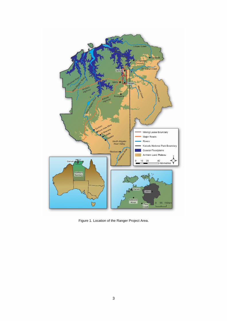
and preventing change to the biological diversity and ecological processes in the region. Impacts
within the Ranger Project Area (Figure 1) are to be as low as reasonably achievable.
The primary environmental objectives specifically relating to rehabilitation are, in summary, to
establish an environment with habitats and erosion characteristics similar to the adjacent areas of
Kakadu National Park and stable radiological conditions with doses that comply with national
requirements and are as low as reasonably achievable. Tailings must be placed into the mined-out
pits in a way that ensures physical isolation from the environment and prevents any detrimental
environmental impacts from contaminants arising from tailings for at least 10,000 years. Moreover,
surface or ground waters discharging from the Ranger Project Area during and after rehabilitation
must not compromise the achievement of the above primary environmental objectives.
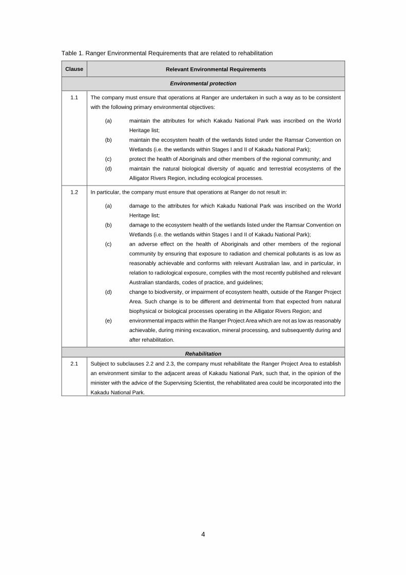
The primary environmental objectives pertaining to the rehabilitation of Ranger mine are detailed
in Table 1.
3
Figure 1. Location of the Ranger Project Area.
4
Table 1. Ranger Environmental Requirements that are related to rehabilitation
Clause Relevant Environmental Requirements
Environmental protection
1.1 The company must ensure that operations at Ranger are undertaken in such a way as to be consistent
with the following primary environmental objectives:
(a) maintain the attributes for which Kakadu National Park was inscribed on the World
Heritage list;
(b) maintain the ecosystem health of the wetlands listed under the Ramsar Convention on
Wetlands (i.e. the wetlands within Stages I and II of Kakadu National Park);
(c) protect the health of Aboriginals and other members of the regional community; and
(d) maintain the natural biological diversity of aquatic and terrestrial ecosystems of the
Alligator Rivers Region, including ecological processes.
1.2 In particular, the company must ensure that operations at Ranger do not result in:
(a) damage to the attributes for which Kakadu National Park was inscribed on the World
Heritage list;
(b) damage to the ecosystem health of the wetlands listed under the Ramsar Convention on
Wetlands (i.e. the wetlands within Stages I and II of Kakadu National Park);
(c) an adverse effect on the health of Aboriginals and other members of the regional
community by ensuring that exposure to radiation and chemical pollutants is as low as
reasonably achievable and conforms with relevant Australian law, and in particular, in
relation to radiological exposure, complies with the most recently published and relevant
Australian standards, codes of practice, and guidelines;
(d) change to biodiversity, or impairment of ecosystem health, outside of the Ranger Project
Area. Such change is to be different and detrimental from that expected from natural
biophysical or biological processes operating in the Alligator Rivers Region; and
(e) environmental impacts within the Ranger Project Area which are not as low as reasonably
achievable, during mining excavation, mineral processing, and subsequently during and
after rehabilitation.
Rehabilitation
2.1 Subject to subclauses 2.2 and 2.3, the company must rehabilitate the Ranger Project Area to establish
an environment similar to the adjacent areas of Kakadu National Park, such that, in the opinion of the
minister with the advice of the Supervising Scientist, the rehabilitated area could be incorporated into the
Kakadu National Park.
5
Clause Relevant Environmental Requirements
2.2 The major objectives of rehabilitation are:
(a) revegetation of the disturbed sites of the Ranger Project Area using local native plant
species similar in density and abundance to those existing in adjacent areas of Kakadu
National Park, to form an ecosystem the long-term viability of which would not require a
maintenance regime significantly different from that appropriate to adjacent areas of the
park;
(b) stable radiological conditions on areas impacted by mining so that, the health risk to
members of the public, including traditional owners, is as low as reasonably achievable;
members of the public do not receive a radiation dose which exceeds applicable limits
recommended by the most recently published and relevant Australian standards, codes
of practice, and guidelines; and there is a minimum of restriction on the use of the area;
(c) erosion characteristics which, as far as can reasonably be achieved, do not vary
significantly from those of comparable landforms in surrounding undisturbed areas.
2.3 Where all major stakeholders agree, a facility connected with Ranger may remain in the Ranger Project
Area following termination of the Authority, provided that adequate provision is made for eventual
rehabilitation of the affected area consistent with principles for rehabilitation set out in subclauses 2.1,
2.2 and 3.1.
3.1 The company must not allow either surface or ground waters arising or discharged from the Ranger
Project Area during its operation, or during or following rehabilitation, to compromise the achievement of
the primary environmental objectives.
9.1 The company must prepare a rehabilitation plan which is approved by the Supervising Authority and the
minister with the advice of the Supervising Scientist, the implementation of which will achieve the major
objectives of rehabilitation as set out in subclause 2.2, and provide for progressive rehabilitation.
9.2 All progressive rehabilitation must be approved by the Supervising Authority or the minister with the
advice of the Supervising Scientist and subject to the Northern Land Council agreeing that the aim and
objectives for rehabilitation as described in clause 2 are met.
9.3 The company’s obligations under clause 9 will cease in respect of any part of the Ranger Project Area
over which a close-out certificate is issued by the Supervising Authority subject to the Supervising
Scientist and the Northern Land Council agreeing that the specific part of the Ranger Project Area has
met the requirements of clause 2.
9.4 Where agreements under subclause 9.2 or 9.3 cannot be reached the minister will make a determination
with the advice of the Supervising Scientist.
11.1 During mining operations and prior to final placement, covering and rehabilitation of the tailings, tailings
must be securely contained in a manner approved by the Supervising Authority or the minister with the
advice of the Supervising Scientist which prevents detrimental environmental impact.
11.2 By the end of operations all tailings must be placed in mined-out pits.
11.3 Final tailings disposal of tailings must be undertaken, to the satisfaction of the minister with the advice of
the Supervising Scientist on the basis of the best-available modelling, in such a way to ensure that:
(i) the tailings are physically isolated from the environment for at least 10,000 years
(ii) any contaminants arising from the tailings will not result in any detrimental environmental
impacts for at least 10,000 years
(iii) radiation doses to members of the public will comply with relevant Australian law and be
less than limits recommended by the most recently published and relevant Australian
standards, codes of practice, and guidelines effective at the time of the final tailings
disposal.

6
1.2.3. Environment Protection (Alligator Rivers Region) Act 1978 (Cwlth)
The Environment Protection (Alligator Rivers Region) Act 1978 (EPARR Act) establishes the position
and duties of the Supervising Scientist for protection of the environment of the Alligator Rivers
Region from the effects of uranium mining.
The Supervising Scientist conducts research programs into the environmental effects of uranium
mining in the Alligator Rivers Region, develops standards and practices for environmental
protection, undertakes environmental monitoring, participates in and oversees the regulatory
process and provides advice to regulatory authorities and mine operators. The Supervising Scientist
plays a fundamental role in communicating research and monitoring results to assure
Governments, and the public, that the environment of the Alligator Rivers Region remains
protected from the effects of mining.
The Supervising Scientist Branch sits within the Department of the Environment and Energy,
supporting the minister for the Environment. The Supervising Scientist is required to provide
technical advice to the Commonwealth minister and NT minister on rehabilitation and closure-
related activities at Ranger mine.
The Act also establishes the Alligator Rivers Region Technical Committee (ARRTC) to advise the
minister for the Environment on the quality and relevance of the research conducted by the
Supervising Scientist and ERA. The committee comprises a panel of independent scientists
recognised for their expertise in relevant fields, currently focused on the various areas of minesite
rehabilitation.
1.2.4. Mining Management Act (NT) and Authorisation
The Mining Management Act (MMA) regulates mining in the Northern Territory and ERA undertakes
operations and activities at Ranger in accordance with the terms of an Authorisation granted under
s35 of the MMA by the NT Minister.
The NT Government is the day-today regulator of Ranger but is required to consult with the
Australian Government on key matters. The Northern Territory Department of Primary Industry
and Resources chairs the Ranger MTC, which also includes the Supervising Scientist, the Northern
Land Council, the Gundjeihmi Aboriginal Corporation and ERA. The MTC has no decision-
making authority or approval powers. Rather, the role of the MTC is to provide a forum where all
key stakeholders can remain abreast of current activities and have informed discussions before the
regulatory authorities make a determination.
1.2.5. Rehabilitation Approval Responsibilities
Responsibility for the approval of rehabilitation and closure activities at Ranger is generally shared
by the Commonwealth and NT ministers. Both ministers must approve the RMCP, the final
disposal of tailings, and the issue of a close out certificate(s) for the Ranger Project Area (all or
part). The regulatory framework also provides for consultation with key stakeholders. In addition,
the ERs require ministers to seek the advice and, where necessary, the agreement of the Supervising
Scientist and the Northern Land Council when making these decisions.
Less complex matters are generally decided by the NT Minister alone. For example, the NT
Minister generally approves progressive rehabilitation of the Ranger Project Area with the advice
of the Supervising Scientist and agreement by the Northern Land Council that the aim and
objectives for rehabilitation as described in ER 2 are met (ER 9.2). The NT Minister may also
approve the secure containment of tailings, during operations and prior to final disposal, with the
advice of the Supervising Scientist (ER 11.1).

7
The Commonwealth Minister can make a final determination on specific rehabilitation and closure
matters where there is disagreement between the NT Government, Supervising Scientist and
Northern Land Council.
The rehabilitation of Ranger mine is not subject to assessment under the Environment Protection and
Biodiversity Conservation Act 1999 (EPBC Act). Actions that started before the EPBC Act coming
into force on 16 July 2000 are exempt from assessment and approval under the EPBC Act,
including mining and rehabilitation at Ranger mine which commenced in 1980. The ERs were
revised in 1999 and include rehabilitation requirements.
1.2.6. Rehabilitation and Closure Planning Documents
A draft RMCP was submitted by ERA to stakeholders for review in December 2016. ERA was not
seeking approval of the RMCP at that time. The Supervising Scientist reviewed the draft RMCP
and provided advice to the MTC members, including ERA.
The regulatory authorities and stakeholders agreed that some aspects of rehabilitation works would
be approved within the plan, while other more complex aspects that require substantial supporting
technical information would be subject to a separate assessment and approval process. A summary
of the information included in these standalone applications and the outcomes of their assessment
would then be included in subsequent updates of the RMCP.
In parallel with the RMCP, ERA submits an Annual Plan of Rehabilitation (APR), prepared in
accordance with the requirements of the Ranger Uranium Project Government Agreement
between ERA and the Commonwealth Government. The APR is intended to provide the
conceptual specifications for rehabilitation works and methodology for an unplanned premature
cessation of operations at Ranger mine, along with a supporting cost estimate. Accordingly, cost
estimates for closure have not been included in the RMCP and are therefore not included in this
review.
1.2.7. Closure Criteria
ERA’s obligation to submit a RMCP will cease where the Commonwealth and NT ministers issue
a close-out certificate in respect of any part of the Ranger Project Area (ER 9.3). Prior to taking
that decision, ministers must seek the advice of the Supervising Scientist and the Northern Land
Council must agree that that specific part of the Ranger Project Area meets the rehabilitation
objectives described in ER 2.
ERA have proposed closure criteria to quantify the rehabilitation objectives within the ERs and
provide a clear and objective basis for the Supervising Scientist and the Northern Land Council to
determine when the rehabilitation objectives have been met.
Closure criteria require approval by both the NT minister and the Commonwealth minister. An
assessment of the closure criteria proposed in the RMCP has been included in this assessment
report. A commentary is provided in cases where closure criteria require further information.
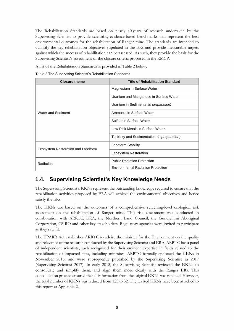
1.3. Supervising Scientist’s Rehabilitation Standards
In accordance with s5c of the Environment Protection (Alligator Rivers Region) Act 1978, the Supervising
Scientist has developed a series of Rehabilitation Standards for Ranger mine against which the
success of rehabilitation can be measured. These standards are advisory only and are available on
the Supervising Scientist’s website (environment.gov.au/science/supervising-scientist).
8
The Rehabilitation Standards are based on nearly 40 years of research undertaken by the
Supervising Scientist to provide scientific, evidence-based benchmarks that represent the best
environmental outcomes for the rehabilitation of Ranger mine. The standards are intended to
quantify the key rehabilitation objectives stipulated in the ERs and provide measurable targets
against which the success of rehabilitation can be assessed. As such, they provide the basis for the
Supervising Scientist’s assessment of the closure criteria proposed in the RMCP.
A list of the Rehabilitation Standards is provided in Table 2 below.
Table 2 The Supervising Scientist’s Rehabilitation Standards
Closure theme Title of Rehabilitation Standard
Water and Sediment
Magnesium in Surface Water
Uranium and Manganese in Surface Water
Uranium in Sediments (In preparation)
Ammonia in Surface Water
Sulfate in Surface Water
Low-Risk Metals in Surface Water
Turbidity and Sedimentation (In preparation)
Ecosystem Restoration and Landform Landform Stability
Ecosystem Restoration
Radiation Public Radiation Protection
Environmental Radiation Protection
1.4. Supervising Scientist’s Key Knowledge Needs
The Supervising Scientist’s KKNs represent the outstanding knowledge required to ensure that the
rehabilitation activities proposed by ERA will achieve the environmental objectives and hence
satisfy the ERs.
The KKNs are based on the outcomes of a comprehensive screening-level ecological risk
assessment on the rehabilitation of Ranger mine. This risk assessment was conducted in
collaboration with ARRTC, ERA, the Northern Land Council, the Gundjeihmi Aboriginal
Corporation, CSIRO and other key stakeholders. Regulatory agencies were invited to participate
as they saw fit.
The EPARR Act establishes ARRTC to advise the minister for the Environment on the quality
and relevance of the research conducted by the Supervising Scientist and ERA. ARRTC has a panel
of independent scientists, each recognised for their eminent expertise in fields related to the
rehabilitation of impacted sites, including minesites. ARRTC formally endorsed the KKNs in
November 2016, and were subsequently published by the Supervising Scientist in 2017
(Supervising Scientist 2017). In early 2018, the Supervising Scientist reviewed the KKNs to
consolidate and simplify them, and align them more clearly with the Ranger ERs. This
consolidation process ensured that all information from the original KKNs was retained. However,
the total number of KKNs was reduced from 125 to 32. The revised KKNs have been attached to
this report at Appendix 2.

9
Figure 2 provides an overview of the research planning process undertaken by the Supervising
Scientist, based on the KKNs, and resulting in a 10-year research plan to inform the rehabilitation
of Ranger mine.
Figure 2. Process for development and review of Supervising Scientist’s research program for Ranger
mine.
While ultimate responsibility for rehabilitation outcomes at Ranger mine rests with ERA, both
ERA and the Supervising Scientist maintain active research programs. The Supervising Scientist’s
research program is strategically targeted on achieving the KKNs for which it currently has the
lead. Research projects to be conducted over the next 8 years have been established and are
scheduled against the mine rehabilitation schedule. The KKNs should also form the basis of the
research program undertaken by ERA to ensure the adequacy of the proposed rehabilitation
activities. To address the KKNs in the time frame required, it will be important for ERA and the
Supervising Scientist to continue to maintain a coordinated and collaborative research program.
An evidence-based process has been developed to formally modify, close out or add KKNs. Close
out of KKNs can occur when (i) the knowledge required by the KKN has been acquired, or (ii)
the KKN is no longer relevant or necessary. Addition of new KKNs may be required where new
10
issues emerge or additional knowledge is required to inform existing issues. The views of both the
MTC and ARRTC will be sought before modifying, closing out and adding new KKNs.
The recommendations within this assessment report have been cross-referenced with the KKNs.
Where sufficient information has been provided in the RMCP to fully address a KKN, its close
out should be proposed. Alternatively, where additional knowledge needs have been identified
through this review, a new KKN may be required. As such, the KKNs represent the additional
research information required to underpin the RMCP and demonstrate the ERs can be achieved.
1.5. Assessment Report Purpose and Structure
This assessment report documents the outcomes of the Supervising Scientist’s technical review
and assessment of the RMCP. It also includes recommendations for further work required to
provide additional information to support the rehabilitation activities included in the RMCP.
This report will be provided to the Ranger MTC and the regulatory authorities as the advice of the
Supervising Scientist in accordance with ER 9.
This report assesses whether sufficient information was provided in the RMCP to:
describe the proposed rehabilitation activities and detail how and when these activities
will be conducted, including any environmental protection measures to be implemented
while works are underway
demonstrate that these activities will result in the achievement of the environmental
objectives in the ERs
demonstrate that proposed closure criteria appropriately represent the environmental
objectives in the ERs, and are sufficiently clear and measurable to allow for the future
determination of their achievement
demonstrate that appropriate provisions have been made to enable the implementation
of effective contingency measures in the event that the rehabilitation works do not occur
as planned (e.g. long-term water treatment to manage contamination issues should they
occur).
Chapters 3 and 4 considers whether:
environmental risks associated with rehabilitation process, and the rehabilitated site, have
been identified and adequately assessed and mitigated
proposed rehabilitation strategies are based on the best available science, including
reference to relevant international experience and the principles of the BPT.
Chapters 5 to 9 divides the Supervising Scientist’s advice on the RMCP according to these closure
‘themes’:
Landform
Water and Sediment
Radiation
Soils
Ecosystem Restoration.

11
The ERs relevant to each theme have been listed in each chapter, along with an indication on
whether sufficient information has been presented in the RMCP to demonstrate that each ER will
be achieved.
Chapter 10 details the Supervising Scientist’s advice on the proposed post-closure monitoring
programs.
The Cultural Criteria presented in the RMCP were not considered by the Supervising Scientist, and
hence are not discussed in this report. Both the Northern Land Council and the Gundjeihmi
Aboriginal Corporation will provide advice on the suitability of the Cultural Criteria.
2. General Observations
The RMCP is a substantial document that provides a good overview of the planned rehabilitation
approach for the Ranger mine, and a sound base for future versions. Some inconsistency
throughout the document was noted, both in the description of key rehabilitation activities and in
some of values and figures quoted. Additionally, while it is accepted the RMCP describes the
rehabilitation plan at a point in time, some of the information presented within the plan has now
been superseded. The majority of the information presented in the RMCP is from 2016. As such
much of the work undertaken over the last 2 years is not presented. It is anticipated that the next
version of the RMCP will be updated to include the most recently available information.
2.1. RMCP Structure
The RMCP is a generally well-presented document and structured following the Western Australian
guidelines for mining rehabilitation plans. Consideration should be given to modifying the structure
to strengthen the link between each of the rehabilitation activities and the research and information
that underpins them, and the closure criteria against which they will be assessed. A thematic
structure is recommended, and may include:
a description of the proposed activity
a schedule for undertaking the proposed activity, including clear milestones
supporting evidence to demonstrate that the activity will result in achievement of the
relevant ERs
associated closure criteria that will be used to assess the success of the activity
associated monitoring program(s).
2.2. Information Gaps
ERA made a significant attempt to identify knowledge gaps in the RMCP. It would be useful to
include a standardised table to identify why the knowledge is needed and detail the work that is
planned to obtain the knowledge. References to the stand-alone applications for certain
rehabilitation activities are useful for identifying when future information will be provided. It is
also important to ensure all rehabilitation activities have specific timeframes allocated to key
milestones, and that these timeframes and milestones are consistent throughout the different plans
and reports. Once complete, ERA’s Feasibility Study is expected to provide a greater level of detail
in this regard.
12
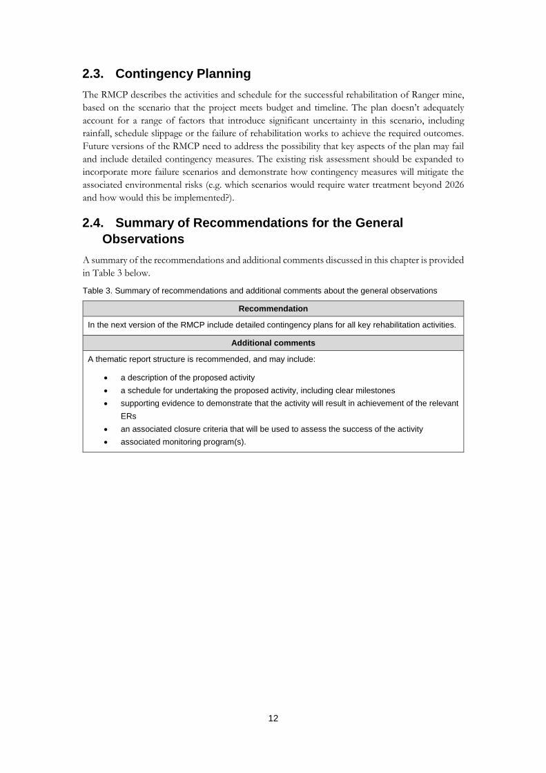
2.3. Contingency Planning
The RMCP describes the activities and schedule for the successful rehabilitation of Ranger mine,
based on the scenario that the project meets budget and timeline. The plan doesn’t adequately
account for a range of factors that introduce significant uncertainty in this scenario, including
rainfall, schedule slippage or the failure of rehabilitation works to achieve the required outcomes.
Future versions of the RMCP need to address the possibility that key aspects of the plan may fail
and include detailed contingency measures. The existing risk assessment should be expanded to
incorporate more failure scenarios and demonstrate how contingency measures will mitigate the
associated environmental risks (e.g. which scenarios would require water treatment beyond 2026
and how would this be implemented?).
2.4. Summary of Recommendations for the General
Observations
A summary of the recommendations and additional comments discussed in this chapter is provided
in Table 3 below.
Table 3. Summary of recommendations and additional comments about the general observations
Recommendation
In the next version of the RMCP include detailed contingency plans for all key rehabilitation activities.
Additional comments
A thematic report structure is recommended, and may include:
a description of the proposed activity
a schedule for undertaking the proposed activity, including clear milestones
supporting evidence to demonstrate that the activity will result in achievement of the relevant
ERs
an associated closure criteria that will be used to assess the success of the activity
associated monitoring program(s).

13
3. Risk Assessment
The risk assessment detailed in the RMCP has been conducted following generally accepted
methods of risk assessment and includes risks to human health, safety and the natural environment.
This section of the plan could be improved by simplifying and standardising the risk-related terms
and definitions.
In general, more detail is required to demonstrate that the identified risks have been adequately
assessed and that the existing and proposed controls are appropriate. The level of detail provided
in the RMCP is insufficient to justify the assignment and ranking of risk classes and control
effectiveness. To address this issue, the risk assessment should include:
evidence to substantiate the likelihood and consequence rankings, including key
assumptions and any uncertainty associated with the information used in this evaluation
a clear distinction between existing and proposed controls, and evidence to support control
effectiveness rankings, including consideration of control applicability or availability during
the three closure phases (i.e. decommissioning, stabilisation and monitoring and post-
closure)
a plan to obtain additional information to inform the risk assessment, as required.
Given the long time frame for the life of the project, it might be necessary to reconsider the
likelihood classifications, particularly for risks that span the full 10,000-year period such as
exposure of tailings through erosion (TB1-01 and TB1-02). If this event is predicted to occur once
in every 100 years over a 10,000-year period, the risk would be more appropriately be classified as
being highly likely rather than rare.
Where possible, the common risks across different locations on the minesite should be
standardised. Where a different risk class has been assigned to similar risks, this should be clearly
discussed and justified. For example, further explanation is required to demonstrate why the risk
of poor-quality water entering offsite water bodies from Pit 1 (TA2-01) is considered to be lower
compared to the same risk for Pit 3 (TA2-02), particularly given that the existing/proposed controls
for both locations are similar.
Table 9-6 in the RMCP shows a summary of class III risks across the risk subcategories. This table
should include:
reference to the existing controls and the phase of closure for which the risk is being
assessed (e.g. risk TA3-01: Uncontrolled release of contaminated material into the onsite
environment during tailings transfer to Pit 3 will only be a risk during the decommissioning
phase, whereas risk TA3-05: Potential migration of contaminants from tailings dam plumes
will be a risk that may require management throughout all three phases of closure)
risk TC4-03: Delays to rehabilitation and/or closure activities extending beyond 2026 in
the Aquatic Ecosystem risk category (TA), as well as the People risk category (TC).
All listed controls should be clearly defined as existing or proposed, and of the existing controls
those that may be removed during decommissioning should be flagged and discussed. The risk
assessment has been based upon the assumption all existing ERA controls will continue to be applied
where applicable. This assumption may lead to an underestimation of the level of risk during some or
all three phases of closure. For example, the groundwater interception trenches installed to the
west of the Tailings Storage Facility and around the Western Stockpile currently play a significant
role in reducing the risk to the offsite environment from contaminants transported away from the
site in the shallow aquifer system. These interception trenches are planned to be decommissioned

14
during rehabilitation works, and as such may not available to mitigate risk to the offsite
environment from contaminants during the stabilisation and monitoring and post-closure phases.
The effectiveness ranking for controls should also account for controls that are ineffective at the
time of reporting, such as the operation of an underbed pump to keep the underdrain at atmospheric pressure,
maximising the downwards consolidation flow as a control to manage risk TB1-03: Consolidation settlement is
significantly greater than predicted in Pit 3. This pump is currently not working. However, the control
effectiveness ranking for this particular risk is C1 (considered to be operating effectively on almost all
occasions). Risk TB1-03 should also consider the possibility that the time taken for tailings to
consolidate could be significantly greater than predicted.
While the outcomes from the screening-level ecological risk assessment conducted by Supervising
Scientist Branch (SSB) and ERA during 2014–15 (as recommended and overseen by ARRTC) have
been considered in the risk assessment, examining risks individually is no longer considered to be
best practice as it does not account for the potential interactions between risks. ERA and SSB are
undertaking a cumulative risk assessment to address a KKN (CT1), which will examine the effects
of combined and integrated risks. It is indicated in the RMCP that the outcomes of this work will
be used to update the risk assessment.

15
3.1. Summary of Recommendations and Additional
Comments for the Risk Assessment
A summary of the recommendations and additional comments discussed in this chapter is provided
in Table 4 below.
Table 4. Summary of recommendations and additional comments pertaining to the risk assessment
Recommendation
In the next version of the RMCP provide further information to justify the assignment and ranking of risks, risk classes, controls and control effectiveness, and including the outcomes of an assessment of cumulative risks to the success of rehabilitation and to the protection of the offsite environment (CT1).
Key Knowledge Needs to be addressed:
CT1. Assessing the cumulative risks to the success of rehabilitation and the protection of the offsite
environment.
Additional comments
To justify the assignment and ranking of risks, risk classes, controls and control effectiveness, the risk
assessment should include:
evidence to justify the likelihood and consequence rankings, including key assumptions and the
level of certainty associated with the information informing this evaluation
a clear distinction between existing and proposed controls, and evidence to support control
effectiveness rankings including consideration of control applicability or availability during the three
closure phases (i.e. decommissioning, stabilisation and monitoring and post-closure)
a clear plan to obtain additional information to inform the assessment of each risk, to improve the
control effectiveness, or to identify new risks as further information is obtained, where required.
Terms and definitions should be simplified and standardised.
The likelihood classifications may need to be reconsidered given the long time frame for the life of the
project (10,000 years).
Additional discussion around control effectiveness and contingencies should be provided for existing
controls that:
might be removed during decommissioning
are known to be ineffective at the time of reporting.
Table 9-6 should include:
reference to the existing controls
the phase of closure for which the risk is being assessed
risk TC4-03: Delays to rehabilitation and/or closure activities extending beyond 2026 in the Aquatic
Ecosystem risk category (TA), as well as the People risk category (TC).
Risks that are present at more than one location across the site should be standardised.
16
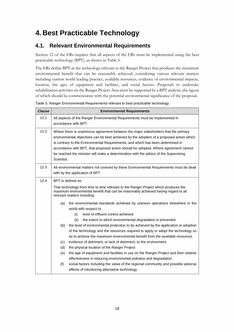
4. Best Practicable Technology
4.1. Relevant Environmental Requirements
Section 12 of the ERs requires that all aspects of the ERs must be implemented using the best
practicable technology (BPT), as shown in Table 5.
The ERs define BPT as the technology relevant to the Ranger Project that produces the maximum
environmental benefit that can be reasonably achieved, considering various relevant matters
including current world leading practice, available resources, evidence of environmental impacts,
location, the ages of equipment and facilities, and social factors. Proposals to undertake
rehabilitation activities on the Ranger Project Area must be supported by a BPT analysis, the rigour
of which should be commensurate with the potential environmental significance of the proposal.
Table 5. Ranger Environmental Requirements relevant to best practicable technology
Clause Environmental Requirements
12.1 All aspects of the Ranger Environmental Requirements must be implemented in
accordance with BPT.
12.2 Where there is unanimous agreement between the major stakeholders that the primary
environmental objectives can be best achieved by the adoption of a proposed action which
is contrary to the Environmental Requirements, and which has been determined in
accordance with BPT, that proposed action should be adopted. Where agreement cannot
be reached the minister will make a determination with the advice of the Supervising
Scientist.
12.3 All environmental matters not covered by these Environmental Requirements must be dealt
with by the application of BPT.
12.4 BPT is defined as:
That technology from time to time relevant to the Ranger Project which produces the maximum environmental benefit that can be reasonably achieved having regard to all relevant matters including:
(a) the environmental standards achieved by uranium operations elsewhere in the
world with respect to
(i) level of effluent control achieved
(ii) the extent to which environmental degradation is prevented
(b) the level of environmental protection to be achieved by the application or adoption
of the technology and the resources required to apply or adopt the technology so
as to achieve the maximum environmental benefit from the available resources
(c) evidence of detriment, or lack of detriment, to the environment
(d) the physical location of the Ranger Project
(e) the age of equipment and facilities in use on the Ranger Project and their relative
effectiveness in reducing environmental pollution and degradation
(f) social factors including the views of the regional community and possible adverse
effects of introducing alternative technology.

17
Clause Environmental Requirements
12.5 Proposals to amend or introduce operational approaches, procedures or mechanisms must
be supported by a BPT analysis. The rigour of the BPT analysis must be commensurate
with the potential environmental significance of the proposal. The BPT analysis must
involve consultation with and having regard to the views of the major stakeholders and
copies of the BPT analysis must be provided to each of the major stakeholders.
12.6 A precautionary approach is to be exercised in the application of BPT in order to achieve
outcomes consistent with the primary environmental objectives.
4.2. Application of BPT
ERA has a rigorous BPT assessment process that has been reviewed previously and endorsed by
the Ranger MTC.
Chapter 8 of the RMCP includes the BPT analysis undertaken in relation to tailings/brine disposal
and final landform construction. Additional BPT assessments will be undertaken for other
proposed rehabilitation activities and submitted for approval as part of the standalone applications.
All BPT assessments should include a wide range of options, particularly considering relevant
national and international experience and precedents where they exist.
4.3. Summary of Recommendations for Best Practicable
Technology
A summary of the recommendations discussed in this chapter is provided in Table 6.
Table 6. Summary of recommendations about best practicable technology (BPT)
Recommendation
In the next version of the RMCP identify the full range of planned (or potentially required) BPT assessments.
18
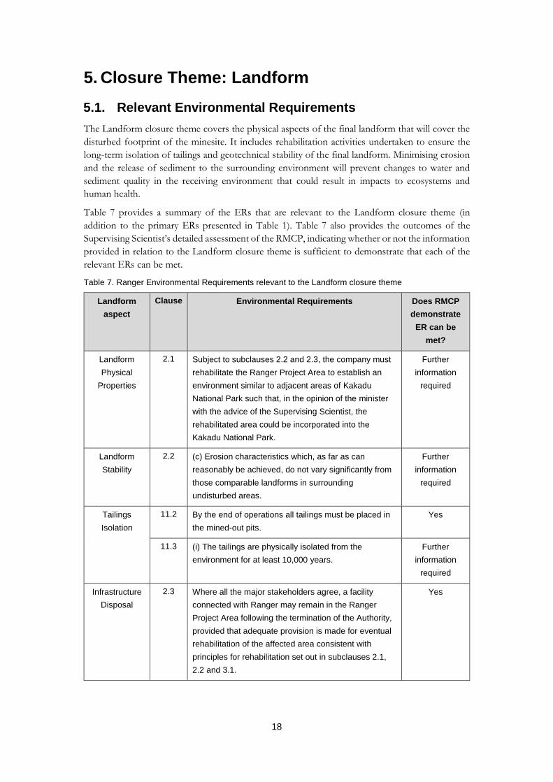
5. Closure Theme: Landform
5.1. Relevant Environmental Requirements
The Landform closure theme covers the physical aspects of the final landform that will cover the
disturbed footprint of the minesite. It includes rehabilitation activities undertaken to ensure the
long-term isolation of tailings and geotechnical stability of the final landform. Minimising erosion
and the release of sediment to the surrounding environment will prevent changes to water and
sediment quality in the receiving environment that could result in impacts to ecosystems and
human health.
Table 7 provides a summary of the ERs that are relevant to the Landform closure theme (in
addition to the primary ERs presented in Table 1). Table 7 also provides the outcomes of the
Supervising Scientist’s detailed assessment of the RMCP, indicating whether or not the information
provided in relation to the Landform closure theme is sufficient to demonstrate that each of the
relevant ERs can be met.
Table 7. Ranger Environmental Requirements relevant to the Landform closure theme
Landform
aspect
Clause Environmental Requirements Does RMCP
demonstrate
ER can be
met?
Landform
Physical
Properties
2.1 Subject to subclauses 2.2 and 2.3, the company must
rehabilitate the Ranger Project Area to establish an
environment similar to adjacent areas of Kakadu
National Park such that, in the opinion of the minister
with the advice of the Supervising Scientist, the
rehabilitated area could be incorporated into the
Kakadu National Park.
Further
information
required
Landform
Stability
2.2 (c) Erosion characteristics which, as far as can
reasonably be achieved, do not vary significantly from
those comparable landforms in surrounding
undisturbed areas.
Further
information
required
Tailings
Isolation
11.2 By the end of operations all tailings must be placed in
the mined-out pits.
Yes
11.3 (i) The tailings are physically isolated from the
environment for at least 10,000 years.
Further
information
required
Infrastructure
Disposal
2.3 Where all the major stakeholders agree, a facility
connected with Ranger may remain in the Ranger
Project Area following the termination of the Authority,
provided that adequate provision is made for eventual
rehabilitation of the affected area consistent with
principles for rehabilitation set out in subclauses 2.1,
2.2 and 3.1.
Yes

19
5.2. Activity Summary
The RMCP proposes that all tailings will be placed in the mine pits, which will then be backfilled
with waste rock. The remaining waste rock, including the waste rock used to construct the Tailings
Storage Facility walls, will then be progressively distributed across the site to form a final landform,
which will be progressively revegetated with local native plant species.
These proposed activities comply with the relevant ERs.
5.3. Detailed Activity Description
5.3.1. Landform Design
Approval of the final landform design will be the subject of a standalone assessment. The final
design will be assessed for its long-term stability (over 10,000 years) using the CAESAR–Lisflood
erosion model. This information requirement has been identified as a KKN (LAN3). Before
approval ERA will also need to demonstrate that the landform will be able to sustain a vegetation
community, which will include providing evidence to show that sufficient soil, plant available water
and nutrients will be available in the waste rock substrate. These issues and related
recommendations are discussed in more detail in Chapter 9 (Closure Theme – Ecosystem
Restoration) and have been identified as KKNs (EE6, EE7).
The RMCP presents and discusses information on the proposed landform design, providing
detailed descriptions of the backfill methodology that will be used to fill the mine pits and construct
the final landform. The landform design must be optimised to minimise erosion, and outcomes of
iterative erosion modelling undertaken by the Supervising Scientist have been used to assist with
this.
Additional information to be provided for assessment should include:
detailed construction plans and timelines
engineering designs, construction tolerances and a digital elevation model
mass or material balances
assumed availability rates or capacities of key equipment.
The description of the Pit 3 tailings deposition method in section 10.3.2 of the RMCP is based on
the original plan which was unable to be implemented due to larger than expected process water
volumes. This section should be updated to reflect that tailings deposition has generally been onto
either a small beach or down the pit wall and directly into the water.
Section 10.6.2 of the RMCP states that infrastructure will be demolished to set distances below the
finished surface level. Clarification is required if this level is the surface of the waste rock landform,
and therefore much of the infrastructure would remain in situ and simply be buried.
Section 10.6.2.2 of the RMCP does not discuss the placement of contaminated material from RP2
and RP3 in the Exploration Decline as indicated in Figure 10-14.
Section 10.7.4 of the RMCP states that 4.6 million tonnes of mineralised material from the northern
wall of the Tailing Storage Facility will be placed in Pit 3 in 2025. However, Table 10-1 indicates
that backfilling of Pit 3 will be completed in 2024. ERA has committed in other sections of the
RMCP that all mineralised material will be placed in the lower sections of the pits. It should be
clarified how this material will be placed below the low-grade 2 rock cap referred to in section 10.7.6.
20
Component 2 of section 10.7.8 (pp. 10–72) refers to planting weeds in drainage lines for stabilisation.
The section refers to natural ecological succession processes that will replace the initial fast-growing weed
species, but there is a high likelihood this will be ineffective. Further detail is required before the
deliberate introduction of weeds would be supported.
5.3.2. Construction Materials
The general strategy for final landform construction presented in the RMCP involves the
placement of the more mineralised grade 2 waste rock below the less mineralised grade 1 waste
rock. While this strategy is supported, more detailed information should be provided to
demonstrate adequate planning and monitoring of material movements, including a basis upon
which the progress of landform construction can be assessed over time. Further information
should include:
mapped locations of material grades
quality control procedures to be employed during construction
a schedule showing material movements as the landform is constructed.
It is noted that the material movement areas shown in Figure 10-31 do not include the area to the
north-west of the Tailings Storage Facility surrounding the trial landform and RP1 as shown in
Figure 10-36. This should be clarified.
5.4. Landform Physical Properties (ER 2.1, 2.2c)
The elevation and slope of the final landform is intended to be as similar to the surrounding terrain
as possible. It is stated in the RMCP that the maximum slope on the final landform will be 4.6%,
but it is unclear how this figure was calculated. The Supervising Scientist estimates that slopes as
high as 8% may occur in some areas of the landform. Details should be provided on how predicted
maximum final landform slopes were calculated.
The RMCP suggests the use of the trial landform as a reference site that can be used to inform the
design and indicate the potential long-term success of revegetation on the final landform. While
the trial landform is currently supporting a vegetation community, it has not yet achieved the ERs
in terms of ecosystem similarity (nor sustainability). The Supervising Scientist has concerns about
how representative the trial landform is likely to be of the final landform but acknowledges that
data from the trial landform are useful to inform the design and construction of the final landform.
Other concerns related to the establishment of an environment similar to adjacent areas of Kakadu
National Park include:
there is no assessment on the effect of variable landform thickness on ecosystem
establishment, function and sustainability.
there is no assessment of the thickness of waste rock required to isolate plants from
underlying contamination (e.g. soils and/or shallow groundwater) which may impact on
plant health.
there is a lack of evidence to demonstrate that the final landform would support the
establishment of, and sustain, a vegetation community similar to the surrounding
environment (e.g. substrate properties, weathering rate, water-holding capacity, plant
available water, internal water transport and contaminant availability).
there is no assessment of the risks and benefits associated with the proposed 4 m
compaction layers.
21
Much of the information outlined here is required to assess the adequacy of the final landform to
support a sustainable ecosystem that is similar to the surrounding environment ER 2.2, which is
discussed in more detail in Chapter 9 (Closure Theme — Ecosystem Restoration).
The adequacy of existing monitoring data from historical revegetation trials and analogue sites to
address the above concerns should be assessed. If existing data are insufficient or inappropriate,
further data should be collected from the trial landform or relevant reference sites.
5.5. Landform Stability (ER 2.1, 2.2, 11.3)
5.5.1. Tailings Consolidation
The areas of the final landform located over the mine pits will be susceptible to differential surface
settlement as the tailings below the waste rock mass compress through consolidation. Therefore,
a detailed understanding of the tailings characteristics and likely consolidation behaviour is required
to effectively address risks related to landform stability.
The validation of the Pit 1 consolidation model against recovered pore water volumes and the
three-dimensional surface shape of the tailings (as opposed to a bulk consolidation volume) would
provide additional confidence in the Pit 1 consolidation model. A pit water balance is necessary to
support the statement in section 7.1.2 that > 99% of the process water expressed by consolidation
will be recovered for treatment by January 2026.
The tailings in Pit 3 are known to be segregated, with finer tailings in the western section of the pit
and coarser tailings in the eastern section. This segregation will affect the rate and extent of tailings
consolidation, possibly extending the consolidation time frame reported in the RMCP which was
predicted based on assumed homogenous tailings. The finer tailings in the western section of the
pit are likely to consolidate more slowly than the coarser tailings in the eastern section. This may
lead to differential settlement of the landform above Pit 3 which can have implications for stability
in this area. ERA has indicated that differential settlement of the landform will be managed by re-
contouring the landform surface after construction is completed.
To decrease the degree of segregation of tailings during deposition, ERA is planning to implement
a new deposition process. This will be assessed in a standalone application and information from
the application should be included in future versions of the RMCP. There is a high degree of
uncertainty associated with the tailings consolidation modelling for Pit 3, as the tailings
characteristics used in the modelling are not representative of the tailings in the pit. ERA
commenced a significant program of work in August 2018 to characterise the Pit 3 tailings and
update the consolidation model accordingly. Section 7.1.3 incorrectly states that up-to-date parameters
have been used in the Pit 3 consolidation model. However, these data are only being obtained at
the time of writing this report.
Until the updated modelling results have been assessed, the Supervising Scientist does not support
the claim that consolidation could be achieved by 2026.
Reliable tailings consolidation modelling is required for both pits to predict consolidation
behaviour. This modelling will provide an estimate of the time frame for consolidation, and may
also indicate the area and rate of differential settlement of the landform over the pits. This
information is required to assess the long-term stability of the landform, and may also be used to
plan material movements accordingly. This information requirement has been identified as a KKN
(LAN3).

22
5.5.2. Erosion
5.5.2.1. Denudation
Erosion modelling and field observations undertaken by the Supervising Scientist indicate that
denudation rates on the landform are likely to reduce substantially within the first 100 years, but
are unlikely to reach background denudation rates for at least 1000 years (Lowry 2016a,b; Lowry
et al. 2017). The RMCP acknowledges this, but it also needs to recognise that the quoted rates are
derived from a single modelled scenario. This information requirement has been identified as a
KKN (LAN3). Under worst-case scenarios, it may take significantly longer for the denudation rate
on the landform to reflect background rates.
5.5.2.2. Gully Formation
To assess the significance of predicted erosion gullies on the final landform, baseline information
on gully formation rates in areas surrounding the Ranger Project Area should be presented in the
RMCP. This information requirement has been identified as a KKN (LAN1). It should also be
acknowledged in the RMCP that landform erosion modelling results are only indicative and should
not be used or referenced as providing precise locations or depths of potential gully formation on
the final landform.
5.5.2.3. Bedload Movement
The risk of bedload sediment transport offsite is considered to be low because of its ability to be
managed through appropriate mitigation measures. The following information is required for the
assessment of proposed flow and sediment control structures:
design
program of maintenance
volume of bedload requiring disposal
potential impacts and planned mitigation measures if the controls are ineffective.
To assess the potential impacts associated with bedload transport to Magela and Gulungul creeks,
information on background bedload yields is required. The requirement for this information has
been identified as a KKN (LAN1).
5.5.3. Landform Stability Risks Not Considered
5.5.3.1. Extreme Events and Landscape-scale Processes
The potential impact of extreme events and landscape-scale processes (e.g. flood events in Magela
Creek) on the stability of the final landform (e.g. mass failure, subsidence), particularly in the Pit 3
area, is not considered in the RMCP. The information required to assess this risk should be
included in the RMCP and has been identified as a KKN (LAN2).
A landform flood study is presented in section 7.5.2 of the RMCP, although this does not include
consideration of major flood events on landform stability or the use of synthetic rainfall datasets
that have been supplied to ERA by the Supervising Scientist.
5.6. Tailings Isolation (ER 11.2, 11.3)
The ERs require tailings are not exposed for 10,000 years. Gully erosion is the key mechanism that
can lead to tailings exposure. The erosion modelling presented in Figure 9-9 shows the formation

23
of a gully over the southern portion of Pit 1. The gully is predicted to extend to a depth of 5 metres
above the surface of the tailings. The digital elevation model used to represent the landform surface
in this modelling had a vertical resolution of approximately 10 metres. Hence the error associated
with the predicted depth of the modelled gully is likely to be ± 10 metres, indicating that the gully
could potentially expose tailings in the long term.
The final landform design should be revised to avoid gully formation over tailings for both Pit 1
and Pit 3. As stated above, erosion modelling results are indicative only and should not be
referenced as providing precise locations or depths of potential gully formation on the final
landform. Approval of the final landform design will not be supported by the Supervising Scientist
if the modelling indicates there is the potential for gully formation on top of the buried tailings.
5.6.1. Tailings Isolation Risks Not Considered
5.6.1.1. Tailings Deposition in Pit 3
The current status of tailings in Pit 3, as discussed above, and the intention to revise the deposition
strategy (moving from subaerial to subaqueous) should be discussed in the RMCP. The control
effectiveness rating of C1 for the tailings consolidation risk should be reconsidered.
5.7. Infrastructure and Contaminated Material Disposal (ER
2.3)
5.7.1. Pit 3
More information is required on the disposal of site infrastructure and contaminated materials
(including contaminated soil) and how this may affect tailings consolidation and landform
settlement. Currently, there is insufficient detail to enable assessment of the planned waste disposal.
Additional information should include:
types and volumes of contaminated material that will require disposal (e.g. hydrocarbons,
soil, waste from high density sludge plant)
plans for material segregation (if required)
disposal methods to be used (e.g. mixing with waste rock, layering, cells, etc.)
schedule for plant demolition and disposal.
Section 7.5.1 states that all material with the potential for environmental impact will be placed at the bottom
of the mined-out pits. It is suggested this statement is removed from the plan as it is not readily
achievable given grade 1 waste rock has the potential for environmental impact.
As these processes will not commence for some years this information should be provided in future
versions of the RMCP.
5.7.2. Exploration Decline
A standalone application for the rehabilitation of the Ranger 3 Deeps exploration decline was
submitted for assessment in July 2018 and is currently under review. This application does not
propose the complete backfill of the decline. The information contained within the application
should be incorporated into (or appended to) future versions of the RMCP.
The exploration decline should be included in Table 10-1: Current schedule of closure tasks.
24
Figure 10-14: 2025 closure summary shows contaminated material being placed in the exploration
decline. This is not currently reflected in the standalone application or other sections of the RMCP.
This needs to be clarified.
5.8. Closure Criteria
Closure criteria proposed in the RMCP pertaining to the final landform have been assessed and
the outcome is described as being either a) Accepted or b) Further Information (Table 8). For
criteria that require further information (or clarification), comments are provided in the following
sections.
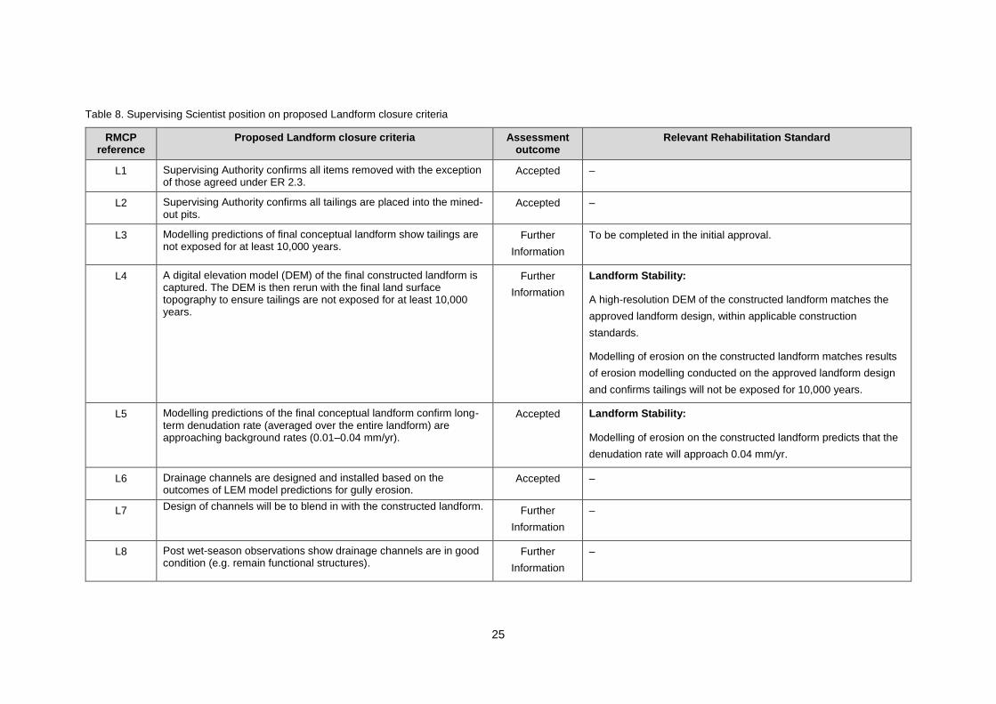
25
Table 8. Supervising Scientist position on proposed Landform closure criteria
RMCP reference
Proposed Landform closure criteria Assessment outcome
Relevant Rehabilitation Standard
L1 Supervising Authority confirms all items removed with the exception of those agreed under ER 2.3.
Accepted –
L2 Supervising Authority confirms all tailings are placed into the mined-out pits.
Accepted –
L3 Modelling predictions of final conceptual landform show tailings are not exposed for at least 10,000 years.
Further
Information
To be completed in the initial approval.
L4 A digital elevation model (DEM) of the final constructed landform is captured. The DEM is then rerun with the final land surface topography to ensure tailings are not exposed for at least 10,000 years.
Further
Information
Landform Stability:
A high-resolution DEM of the constructed landform matches the
approved landform design, within applicable construction
standards.
Modelling of erosion on the constructed landform matches results
of erosion modelling conducted on the approved landform design
and confirms tailings will not be exposed for 10,000 years.
L5 Modelling predictions of the final conceptual landform confirm long-term denudation rate (averaged over the entire landform) are approaching background rates (0.01–0.04 mm/yr).
Accepted Landform Stability:
Modelling of erosion on the constructed landform predicts that the
denudation rate will approach 0.04 mm/yr.
L6 Drainage channels are designed and installed based on the outcomes of LEM model predictions for gully erosion.
Accepted –
L7 Design of channels will be to blend in with the constructed landform. Further
Information
–
L8 Post wet-season observations show drainage channels are in good condition (e.g. remain functional structures).
Further
Information
–
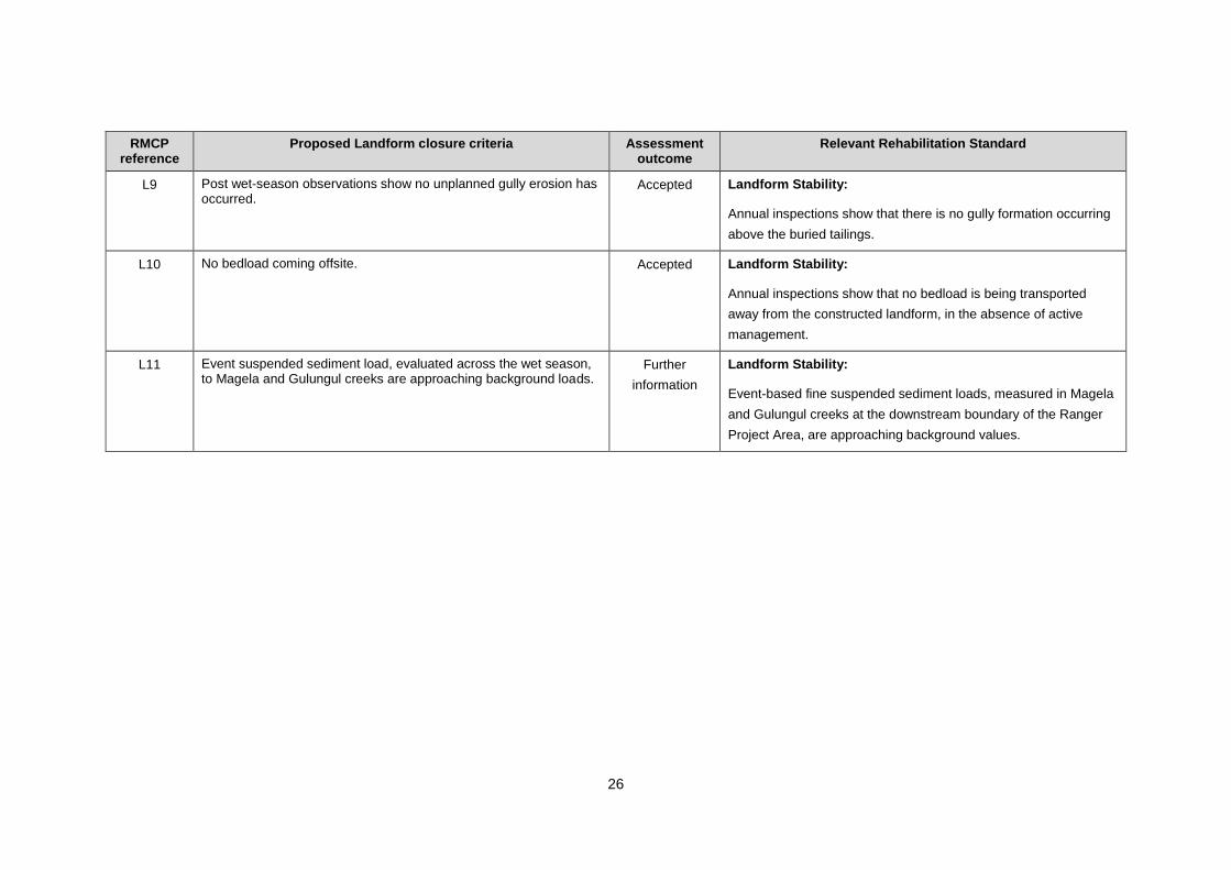
26
RMCP reference
Proposed Landform closure criteria Assessment outcome
Relevant Rehabilitation Standard
L9 Post wet-season observations show no unplanned gully erosion has occurred.
Accepted Landform Stability:
Annual inspections show that there is no gully formation occurring
above the buried tailings.
L10 No bedload coming offsite. Accepted Landform Stability:
Annual inspections show that no bedload is being transported
away from the constructed landform, in the absence of active
management.
L11 Event suspended sediment load, evaluated across the wet season, to Magela and Gulungul creeks are approaching background loads.
Further
information
Landform Stability:
Event-based fine suspended sediment loads, measured in Magela
and Gulungul creeks at the downstream boundary of the Ranger
Project Area, are approaching background values.

27
5.8.1. Criteria Terminology
Both closure criteria related to the physical isolation of tailings for 10,000 years (L3 and L4), should
be assessed against a probable worst-case scenario, as described in the Landform Rehabilitation
Standard.
Clarification is required on the terminology used in closure criterion L7, for drainage channel
design. It is not clear how it will be determined that drainage channels blend in with the constructed
landform, or how comparable they would be to surrounding natural areas.
Further clarification is required on the terminology used in closure criterion L8, for drainage
channel condition. It is not clear how it will be determined that drainage channels are in good condition
and the example provided (i.e. remain functional structures) is subjective.
5.8.2. Suspended Sediments
The use of site-specific relationships to convert continuous turbidity data to suspended sediment
concentration data is supported. However, there are inconsistencies within the RMCP in describing
the preferred method for assessing suspended sediment loads in the surface waters receiving runoff
from the final landform. It is recommended that the Moliere and Evans (2010) before-after-
control-impact paired (BACIP) method is adopted as described in the Landform Rehabilitation
Standard. This method employs event-based regression analyses of stream discharge and
suspended sediment concentrations to assess the difference between upstream and downstream
sites.
5.9. Rehabilitation Monitoring
The RMCP needs to include further details on monitoring methods to demonstrate how
information will be collected to assess landform performance over time, including:
how gully formation will be measured on the revegetated landform
details of monitoring data required for ongoing validation of erosion modelling
water quality monitoring methods to be used for assessing landform erosion (e.g. turbidity
as a surrogate for suspended sediment in surface water).
It is stated in the RMCP that the final landform topography will be documented after completion
using ground-based LiDAR survey techniques, and that specific details are yet to be determined.
The Supervising Scientist is currently developing airborne LiDAR platforms which may be more
suited to this task. Methods of monitoring and assessing erosion and landform evolution should
be reviewed regularly to ensure that they are optimised and in accordance with current best practice.
These requirements have been identified as KKNs (LAN4 and LAN5).
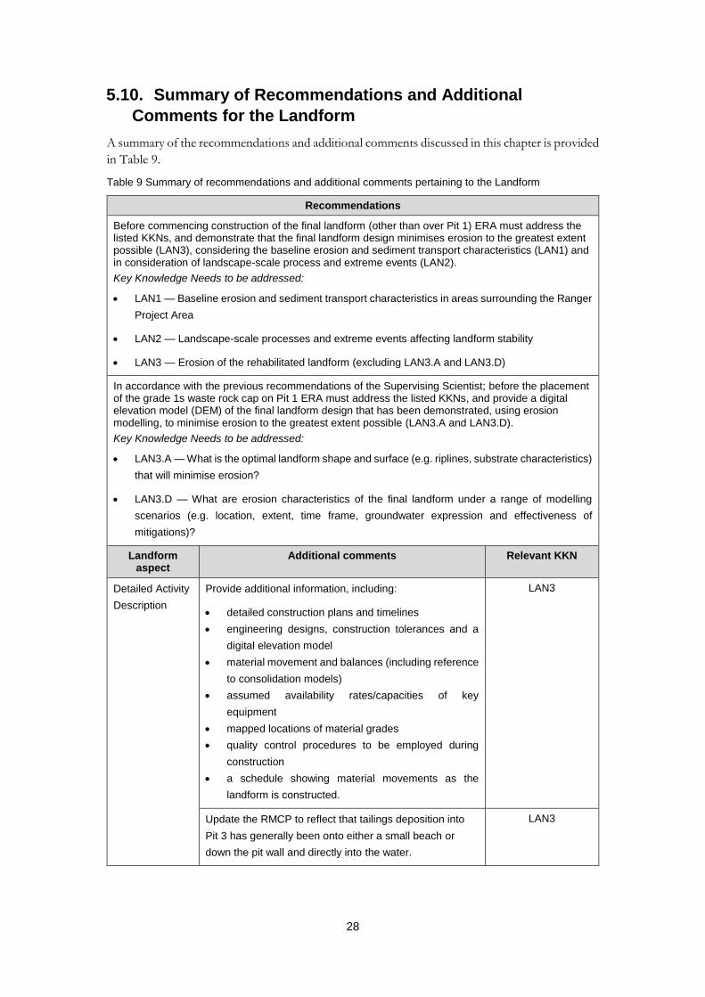
28
5.10. Summary of Recommendations and Additional
Comments for the Landform
A summary of the recommendations and additional comments discussed in this chapter is provided
in Table 9.
Table 9 Summary of recommendations and additional comments pertaining to the Landform
Recommendations
Before commencing construction of the final landform (other than over Pit 1) ERA must address the listed KKNs, and demonstrate that the final landform design minimises erosion to the greatest extent possible (LAN3), considering the baseline erosion and sediment transport characteristics (LAN1) and in consideration of landscape-scale process and extreme events (LAN2).
Key Knowledge Needs to be addressed:
LAN1 — Baseline erosion and sediment transport characteristics in areas surrounding the Ranger
Project Area
LAN2 — Landscape-scale processes and extreme events affecting landform stability
LAN3 — Erosion of the rehabilitated landform (excluding LAN3.A and LAN3.D)
In accordance with the previous recommendations of the Supervising Scientist; before the placement of the grade 1s waste rock cap on Pit 1 ERA must address the listed KKNs, and provide a digital elevation model (DEM) of the final landform design that has been demonstrated, using erosion modelling, to minimise erosion to the greatest extent possible (LAN3.A and LAN3.D).
Key Knowledge Needs to be addressed:
LAN3.A — What is the optimal landform shape and surface (e.g. riplines, substrate characteristics)
that will minimise erosion?
LAN3.D — What are erosion characteristics of the final landform under a range of modelling
scenarios (e.g. location, extent, time frame, groundwater expression and effectiveness of
mitigations)?
Landform aspect
Additional comments Relevant KKN
Detailed Activity
Description
Provide additional information, including:
detailed construction plans and timelines
engineering designs, construction tolerances and a
digital elevation model
material movement and balances (including reference
to consolidation models)
assumed availability rates/capacities of key
equipment
mapped locations of material grades
quality control procedures to be employed during
construction
a schedule showing material movements as the
landform is constructed.
LAN3
Update the RMCP to reflect that tailings deposition into
Pit 3 has generally been onto either a small beach or
down the pit wall and directly into the water.
LAN3

29
Recommendations
Clarify if finished surface level is the surface of the waste
rock landform, and therefore much of the infrastructure
would remain in situ and simply be buried.
LAN3
Include discussion on the placement of contaminated
material from RP2 and RP3 in the Exploration Decline, as
indicated in Figure 10-14.
LAN3
Improve the scheduling for disposal of contaminated
material into the pits, including the 4.6 million tonnes of
mineralised material from the northern wall of the Tailing
Storage Facility that will be placed in Pit 3 in 2025, and
the other mineralised material that will be placed in the
lower sections of the pits. It should be clarified how this
material will be placed below the low-grade 2 rock cap.
LAN3
Further detail is required to support the deliberate
introduction of weeds on the final landform.
LAN3
Landform
Physical
Properties
Provide details on how predicted maximum final landform
slopes were calculated.
LAN3
Assess the adequacy of existing monitoring data from
historical revegetation trials and analogue sites to inform
recommendation and future work. If existing data are
insufficient or inappropriate, further data should be
collected from the trial landform or relevant reference
sites.
LAN1, LAN3
Landform
Stability
Develop a water balance for Pit 1 to support the statement
that > 99% of the process water expressed by
consolidation will be recovered for treatment by January
2026.
LAN3
Information on the new tailings deposition strategy in Pit 3
should be included in future versions of the RMCP,
including the consolidation time frames, and any
differential settlement predicted using the updated Pit 3
consolidation model.
LAN3
It should be acknowledged that landform erosion
modelling results are dependent on the specific scenario
modelled, and are indicative only (e.g. not to be
referenced as providing precise locations or depths of
potential gully formation on the final landform).
LAN3

30
Recommendations
Provide the following information on the proposed flow and
sediment control structures, including:
the design
a program of maintenance
the volume of bedload requiring disposal
potential impacts and planned mitigation measures
that the structures are ineffective.
LAN3
Provide information on the background bedload yields, to
assess the potential impacts associated with bedload
transport to Magela and Gulungul creeks (should this
occur).
LAN1
Assess the potential risks of extreme events and
landscape-scale processes on landform stability.
LAN2
Use synthetic rainfall datasets in flood modelling. LAN2
Tailings
Isolation
The final landform design should be revised to avoid gully
formation over tailings for both Pit 1 and Pit 3.
LAN4
Given the tailings deposition method is currently under
review the control effectiveness rating of C1 for the tailings
consolidation risk should be reconsidered.
LAN3
Infrastructure
Disposal
Provide a detailed backfill plan for Pit 3 including:
types and volumes of contaminated material that will
require disposal (e.g. hydrocarbons, soil, waste from
HDS plant)
plans for material segregation (if required)
disposal methods to be used (e.g. mixing with waste
rock, layering, cells, etc.)
schedule for plant demolition and disposal.
LAN3
Incorporate a summary of the standalone application for
rehabilitation of the Ranger 3 Deeps exploration decline
into future versions of the RMCP.
LAN3
Closure Criteria The probable worst-case scenario should be retained in
the closure criteria and clearly defined, in consultation
with the Supervising Scientist.
LAN3
Quantify closure criteria L7 and L8. LAN3
Use the BACIP method described by Moliere and Evans
(2010) to assess suspended sediment loads in closure
criteria L11.
LAN3
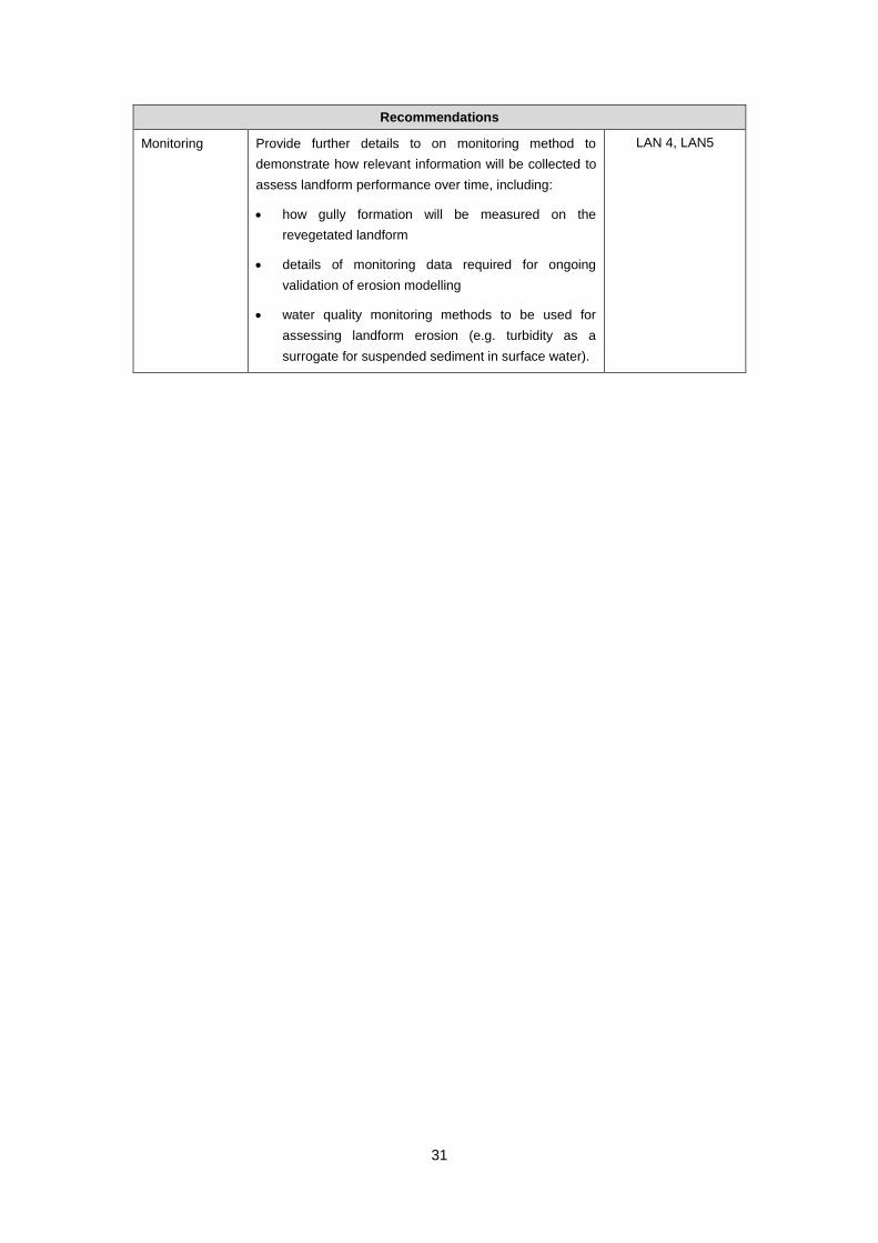
31
Recommendations
Monitoring Provide further details to on monitoring method to
demonstrate how relevant information will be collected to
assess landform performance over time, including:
how gully formation will be measured on the
revegetated landform
details of monitoring data required for ongoing
validation of erosion modelling
water quality monitoring methods to be used for
assessing landform erosion (e.g. turbidity as a
surrogate for suspended sediment in surface water).
LAN 4, LAN5
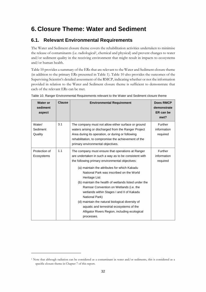
32
6. Closure Theme: Water and Sediment
6.1. Relevant Environmental Requirements
The Water and Sediment closure theme covers the rehabilitation activities undertaken to minimise
the release of contaminants (i.e. radiological1, chemical and physical) and prevent changes to water
and/or sediment quality in the receiving environment that might result in impacts to ecosystems
and/or human health.
Table 10 provides a summary of the ERs that are relevant to the Water and Sediment closure theme
(in addition to the primary ERs presented in Table 1). Table 10 also provides the outcomes of the
Supervising Scientist’s detailed assessment of the RMCP, indicating whether or not the information
provided in relation to the Water and Sediment closure theme is sufficient to demonstrate that
each of the relevant ERs can be met.
Table 10. Ranger Environmental Requirements relevant to the Water and Sediment closure theme
Water or
sediment
aspect
Clause Environmental Requirement Does RMCP
demonstrate
ER can be
met?
Water/
Sediment
Quality
3.1 The company must not allow either surface or ground
waters arising or discharged from the Ranger Project
Area during its operation, or during or following
rehabilitation, to compromise the achievement of the
primary environmental objectives.
Further
information
required
Protection of
Ecosystems
1.1 The company must ensure that operations at Ranger
are undertaken in such a way as to be consistent with
the following primary environmental objectives:
(a) maintain the attributes for which Kakadu
National Park was inscribed on the World
Heritage List
(b) maintain the health of wetlands listed under the
Ramsar Convention on Wetlands (i.e. the
wetlands within Stages I and II of Kakadu
National Park)
(d) maintain the natural biological diversity of
aquatic and terrestrial ecosystems of the
Alligator Rivers Region, including ecological
processes.
Further
information
required
1 Note that although radiation can be considered as a contaminant in water and/or sediments, this is considered as a
specific closure theme in Chapter 7 of this report.
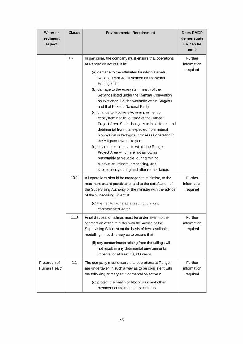
33
Water or
sediment
aspect
Clause Environmental Requirement Does RMCP
demonstrate
ER can be
met?
1.2 In particular, the company must ensure that operations
at Ranger do not result in:
(a) damage to the attributes for which Kakadu
National Park was inscribed on the World
Heritage List
(b) damage to the ecosystem health of the
wetlands listed under the Ramsar Convention
on Wetlands (i.e. the wetlands within Stages I
and II of Kakadu National Park)
(d) change to biodiversity, or impairment of
ecosystem health, outside of the Ranger
Project Area. Such change is to be different and
detrimental from that expected from natural
biophysical or biological processes operating in
the Alligator Rivers Region
(e) environmental impacts within the Ranger
Project Area which are not as low as
reasonably achievable, during mining
excavation, mineral processing, and
subsequently during and after rehabilitation.
Further
information
required
10.1 All operations should be managed to minimise, to the
maximum extent practicable, and to the satisfaction of
the Supervising Authority or the minister with the advice
of the Supervising Scientist:
(c) the risk to fauna as a result of drinking
contaminated water.
Further
information
required
11.3 Final disposal of tailings must be undertaken, to the
satisfaction of the minister with the advice of the
Supervising Scientist on the basis of best-available
modelling, in such a way as to ensure that:
(ii) any contaminants arising from the tailings will
not result in any detrimental environmental
impacts for at least 10,000 years.
Further
information
required
Protection of
Human Health
1.1 The company must ensure that operations at Ranger
are undertaken in such a way as to be consistent with
the following primary environmental objectives:
(c) protect the health of Aboriginals and other
members of the regional community.
Further
information
required
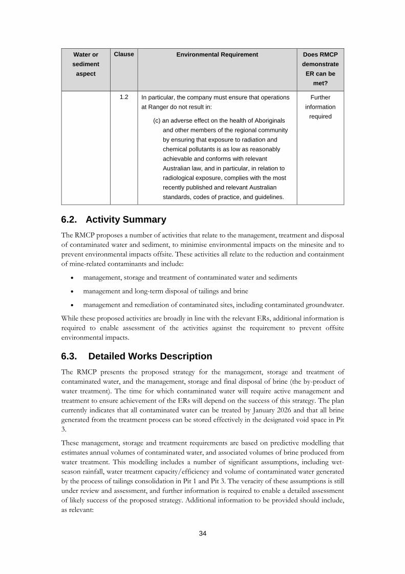
34
Water or
sediment
aspect
Clause Environmental Requirement Does RMCP
demonstrate
ER can be
met?
1.2 In particular, the company must ensure that operations
at Ranger do not result in:
(c) an adverse effect on the health of Aboriginals
and other members of the regional community
by ensuring that exposure to radiation and
chemical pollutants is as low as reasonably
achievable and conforms with relevant
Australian law, and in particular, in relation to
radiological exposure, complies with the most
recently published and relevant Australian
standards, codes of practice, and guidelines.
Further
information
required
6.2. Activity Summary
The RMCP proposes a number of activities that relate to the management, treatment and disposal
of contaminated water and sediment, to minimise environmental impacts on the minesite and to
prevent environmental impacts offsite. These activities all relate to the reduction and containment
of mine-related contaminants and include:
management, storage and treatment of contaminated water and sediments
management and long-term disposal of tailings and brine
management and remediation of contaminated sites, including contaminated groundwater.
While these proposed activities are broadly in line with the relevant ERs, additional information is
required to enable assessment of the activities against the requirement to prevent offsite
environmental impacts.
6.3. Detailed Works Description
The RMCP presents the proposed strategy for the management, storage and treatment of
contaminated water, and the management, storage and final disposal of brine (the by-product of
water treatment). The time for which contaminated water will require active management and
treatment to ensure achievement of the ERs will depend on the success of this strategy. The plan
currently indicates that all contaminated water can be treated by January 2026 and that all brine
generated from the treatment process can be stored effectively in the designated void space in Pit
3.
These management, storage and treatment requirements are based on predictive modelling that
estimates annual volumes of contaminated water, and associated volumes of brine produced from
water treatment. This modelling includes a number of significant assumptions, including wet-
season rainfall, water treatment capacity/efficiency and volume of contaminated water generated
by the process of tailings consolidation in Pit 1 and Pit 3. The veracity of these assumptions is still
under review and assessment, and further information is required to enable a detailed assessment
of likely success of the proposed strategy. Additional information to be provided should include,
as relevant:
35
detailed plans and timelines for all activities related to water management, storage,
treatment and brine disposal
availability, rates, capacities of key plant and equipment (e.g. water treatment plants, brine
injection bores, etc.)
updated modelling assumptions and modelling uncertainty analyses.
It is expected that a large majority of this information will become available as ERA completes its
feasibility-level planning, and it should be detailed in a future version of the RMCP.
The RMCP also presents results of contaminant transport modelling that predicts concentrations
of mine-derived contaminants in the offsite environment over 10,000 years. This modelling
requires reliable assessment/predictions of contaminant concentrations in key source terms,
transport and behaviour of contaminants in groundwater and contaminant concentrations in
receiving surface waters. There is still a high degree of uncertainty associated with each of these,
and ERA is currently refining the various models to reduce this uncertainty.
Until confidence in the modelling is improved, predicted contaminant concentrations in surface
waters surrounding the minesite remain uncertain. As such, assessment of the rehabilitation plan
against the requirement to protect the surrounding environment for 10,000 years cannot be
undertaken. The section below discusses the additional information that is required to improve the
confidence in the modelling.
6.4. Water and Sediment Quality (ER 3.1–3.4)
6.4.1. Water Storage, Management and Treatment
6.4.1.1. Process Water and Brine
To demonstrate that ERA will be able to effectively manage all process water throughout the
rehabilitation process, the RMCP should include a detailed schedule that outlines the predicted
process water volume and intended storage locations over time. It is understood that the key
process water storage locations will be the Tailings Storage Facility, Pit 3 and RP6 (if required).
Further assessment is required to determine if the Tailings Storage Facility can be used as a process
water storage post-2020, and relevant contingency options should be considered in the event the
Tailings Storage Facility is determined to be unsuitable for water storage.
A schedule should also be included for water treatment, indicating all planned options for process
water treatment and demonstrating that these options will be sufficient to treat the predicted
process water volumes. It is understood that brine concentration will remain the preferred option
for process water treatment during rehabilitation. However, the existing plant will require
operational improvements to increase its treatment capacity. Other options for process water
treatment are currently being considered and scoped, including a high-density sludge treatment
plant. The requirement to dispose of the treated water, such as through land application, should
also be considered in any assessment of water treatment capacity.
Information is presented in the RMCP on differences in tailings consolidation modelling results
between work that was conducted in 2014 and 2016. While most of the results are essentially the
same, it is unclear why tailings pore water expression during deposition has increased from
14.7 Mm3 to 21.9 Mm3.
Given the uncertainty associated with the predicted process water volumes up to 2025, it is critical
that ERA fulfil its commitment to continue water treatment for as long as necessary to treat and

36
dispose of all process water (including expressed tailings pore water) onsite (section 10.2, pp. 10–
36). This commitment is supported by the Supervising Scientist, along with the intention to
increase the capacity of process water treatment over time, which will be necessary to achieve
treatment of all process water by 2025. This commitment should be included as a contingency in
section 10.9.1.
Further details of the Pit 3 brine injection system should be provided in the RMCP, including:
the expected lifespan of brine injection bores and factors that may affect this
time frames and potential issues associated with the construction of additional brine
injection bores, should they be required
any other brine disposal methods that might be used in the case that the brine injection
system fails (i.e. failure of all bores, or the underbed drain extraction system).
It is noted that the brine injection system has been offline since late 2016 due to issues with the
underdrain water recovery system, and is not likely to recommence operations until later in 2019.
6.4.1.2. Pond Water
It is stated in the RMCP that pond water treatment will continue throughout the rehabilitation
process, with treated water discharged to available wetland filters and land application areas (LAAs)
until 2025. However, as irrigation areas are progressively rehabilitated, only the Corridor Creek
wetland filter/irrigation area and Georgetown Creek median bund level-line (GCMBL) will be
available after 2021. This could result in potential risks associated with concentrating the disposal
over a smaller area (e.g. soil waterlogging, unseasonal surface runoff, raised groundwater levels).
Further information needs to be provided to demonstrate that there are sufficient disposal options
for treated pond water as irrigation areas are decommissioned, as well as the disposal of the pond
water treatment waste stream later in the rehabilitation process.
6.4.1.3. Sediment Control Infrastructure
A concept design for erosion and sediment controls is provided in the RMCP (i.e. surface
treatment, drainage channel treatment and sediment basins), which are intended to manage runoff
during the early years of landform establishment. While these may be effective in reducing loads
of suspended sediments leaving the site, the time frames for which these structures are expected
to remain in place should be included (i.e. criteria for removal) along with a schedule for ongoing
maintenance (e.g. sediment removal and disposal locations). It is expected that more specific
designs and management plans for erosion and sediment controls will be presented in the RMCP
before the commencement of major rehabilitation works onsite.
The RMCP proposes the use of engineering controls to minimise the transportation of waste rock solutes to the
offsite environment. Magnesium, the key contaminant of concern, is highly soluble so it is unclear how
passive systems can be used to manage magnesium. It is not clear why this control is rated as the
highest level of effectiveness in the closure risk assessment.
6.4.2. Site Conceptual Models
The baseline hydrogeological and groundwater quality information presented in the RMCP is
largely based on the current Ranger Conceptual Model (INTERA 2016) and assessments of
background concentrations of contaminants in groundwater (Esslemont 2015, 2017). Work on
defining background concentrations of contaminants in groundwater in the vicinity of Ranger
mine, and regionally, is ongoing and should be included in future versions of the RMCP.
37
The Ranger Conceptual Model (INTERA 2016) was reviewed by SSB and discussed at a
groundwater workshop in September 2016. The conceptual model presents a significant amount
of information at a range of scales but requires ongoing updates and refinement as further
information becomes available. General feedback on the review of the conceptual model included
the need for:
the use of observed data to underpin the conceptualisation rather than using
modelling outputs
further refinement and characterisation of key hydrolithilogical units, aquifers and
groundwater flows, particularly in regions in the vicinity of Pit 1, Pit 3 and the Tailing
Storage Facility that are high-risk areas for contaminant transport (e.g. the Magela
Creek bed, the Djalkmarra sands, and the MBL zone)
greater detail on surface water and groundwater interactions
improved characterisation of existing contaminated groundwater (e.g. under the
Tailings Storage Facility) and contaminated sites (e.g. LAAs).
The conceptual model must retain sufficient complexity at a relevant scale as it provides the
foundation for analytical and numerical models that need to adequately simulate the actual
groundwater flow system to the degree necessary to satisfy the objectives of the contaminant
transport modelling. The conceptual model must describe key features of hydrogeological and
hydrogeochemical regimes during pre-mining, mining and post-closure periods to ensure
understanding of the changing nature of the groundwater system during and after
decommissioning and post-rehabilitation.
ERA will update the Ranger Conceptual Model with new hydrogeological data and information as
required. This is important to ensure confidence in the conceptualisation of the site. The RMCP
should detail future hydrogeological work that will be undertaken to refine the Ranger Conceptual
Model and explain how this will feed into the contaminant transport modelling and rehabilitation
planning.
These information requirements have been identified as a KKN (WS2).
6.4.3. Contaminant Source Terms
Further work is required to quantify contaminant source terms (including radionuclides) and
factors that influence their mobilisation on a whole-of-site basis. This includes quantifying existing
groundwater contamination and contaminants that are predicted to arise from the waste rock
landform, the buried tailings and contaminated soils and sediments disturbed during rehabilitation,
including:
more detailed information on waste rock infiltration rates and vadose zone behaviour,
including estimates of pyrite content and oxidation potential
quantification of the degree and extent of contaminated groundwater under the
Tailings Storage Facility, along with its potential for movement through the aquifer
into the offsite environment
tailings consolidation modelling needs to be validated and/or updated in Pit 1 and Pit
3 to improve estimates of the volume and timing of contaminated water expression
during tailings consolidation.
For each of these sources, possible remediation options and contingency measures should also be
included in the RMCP.

38
These information requirements have been identified as a KKN (WS1)
6.4.3.1. Waste Rock
The RMCP presents monitoring data from the trial landform (section 7.3.2.3) that show
concentrations of contaminants in surface runoff from waste rock are generally low. However,
there are few data or little information presented on the contaminant concentrations present in
seepage water from the trial landform, which are likely to be higher than those in surface runoff.
The rate of rainfall infiltration will drive the seepage process and associated geochemical reactions
that lead to the dissolution of contaminants from the waste rock.
Table 7-22 of the RMCP states that infiltration rates will be between 1 and 10 mm per hour, and
based on this it has been assumed that 10% of total rainfall will infiltrate the final landform. This
value has been used in modelling to predict concentrations of contaminants that could enter
shallow groundwater from seepage through the waste rock landform. ERA has recently
acknowledged that this rate is too low, and the actual rate is likely to be substantially higher. Work
undertaken by the Supervising Scientist also indicates that the actual infiltration rate is likely to be
higher than indicated in the plan. ERA plans to investigate infiltration rates in waste rock across
the site to ensure that the appropriate rate is used in contaminant transport modelling. Modelling
will need to be updated accordingly.
Given the order of magnitude difference in the mean and median values for waste rock sulfur
content provided in section 3.2.8 there must have been some significantly higher values detected.
Consideration should be given to an improved quantification of sulfide minerals present in the
waste rock landform, and assessment of solute release subsequent to the consumption of all the
sulfide minerals. The ongoing release from the waste rock could be considered in terms of the acid
content of water that will pass through the waste rock as well as from appropriate mineralogical
controls if the latter is deemed necessary.
6.4.3.2. Tailings and Pore Water
Current tailings consolidation modelling indicates that by 2026, nearly all tailings pore water
(process water) will be removed from the buried tailings in Pit 1 and Pit 3 and treated. This is a key
assumption in the current groundwater and contaminant transport modelling. However, it is
possible that tailings consolidation may take longer than predicted, and that some tailings pore
water may move laterally or downwards into the rock around the edges of the pits, and may not be
removed and treated. This could increase the contaminant source associated with pit tailings and
require the contaminant transport modelling to be updated accordingly. Additional data are
required to update the tailings consolidation modelling and water balance accounting for both pits,
considering the heterogeneous nature of the tailings in the pits, and the effect this may have on the
quantity of contaminants mobilised from tailings and the timing, direction and rate of solute
expression.
ERA’s commitment to continue to capture and treat expressed tailings pore water until
consolidation is effectively complete is noted and supported.
6.4.3.3. Groundwater
Although it is acknowledged in the RMCP that contaminated groundwater beneath some
contaminated sites will require active management during the rehabilitation process, further work
is required to characterise existing groundwater contamination onsite. This includes beneath the
Tailings Storage Facility, the waste rock stockpiles and the processing plant. Once the nature and
extent of groundwater contamination across the site are understood, the Ranger Conceptual Model
and contaminant transport models should be updated accordingly to better reflect this important
39
source term. Where required, specific groundwater management and remediation strategies should
be developed and included in the RMCP. This is particularly important for the area beneath the
Tailings Storage Facility given the large volume of contaminated groundwater likely to be present.
To support conclusions made in the RMCP that there is negligible groundwater contamination
beneath the LAAs, data should be presented from bores representing all aquifers and areas of the
Ranger Project Area that could be impacted (i.e. Aquifer 1 and Aquifer 2).
These information requirements have been identified as a KKN (WS1).
6.4.4. Contaminant Transport Modelling
The RMCP provides a modelling plan that illustrates the various models that will be used to predict
the transport and fate of contaminants, including groundwater and surface water flow and
contaminant transport models. When completed and integrated, these models will provide post-
rehabilitation surface water contaminant concentrations in the creeks surrounding Ranger mine.
These concentrations will then be assessed against the approved water quality closure criteria to
demonstrate whether or not mine-derived contaminants are likely to result in impacts to the offsite
environment.
All numerical modelling should be based on:
the data-driven Ranger Conceptual Model, which needs to include sufficient detail and
confidence for high-risk areas, particularly the Magela Creek bed, the ‘Djalkmarra sands’
and the ‘MBL zone’
detailed and reliable quantification of all potential contaminant source terms onsite,
including existing groundwater contamination on the minesite
a calibration period that is sufficient to stress the model to the extent that its behaviour
during pre-mining, operational and post-mining conditions can be assessed, including
mine-impacted and baseline variability in groundwater levels, stream flow and associated
processes
all available data, including pre-mine data if available, with clear justification for the
exclusion of data not used
surface water and groundwater interactions at an appropriate temporal scale.
The modelling undertaken to date is considered suitable for the intended purpose of estimating
the average and peak annual contaminant loads delivered from Pits 1 and 3 to downstream surface
waters (i.e. Corridor and Magela creeks) over 10,000 years. However, as indicated above, additional
work is required to predict contaminant concentrations in the receiving surface waters to
demonstrate that there will not be detrimental impacts to the surrounding environment associated
with mine-derived contaminants. This includes:
undertaking contaminant transport modelling at increased temporal and spatial resolution
(particularly around the period of peak solute delivery to the surface water system)
developing a better understanding of groundwater and surface water interactions that will
control the location and timing of delivery of contaminated groundwater to the surface
water system
implications of groundwater recovery as groundwater levels return to a stable state after
rehabilitation
improved understanding of the role of groundwater and surface water interactions in solute
migration
40
assessment of confidence in modelled outputs using statistical, sensitivity and uncertainty
analyses for each model, as well as analysis of cumulative uncertainty where multiple models
are interconnected.
The contaminant concentrations presented in the RMCP are not supported by the Supervising
Scientist. The concentrations presented are based on modelling that assumes a constant rate of
solute delivery from groundwater to surface water throughout the entire period of surface flow. In
contrast, water quality data collected throughout mine operations indicate that the expression of
groundwater to surface water, and the associated delivery of groundwater contaminants, increases
during recessional flow periods, either during intermonsoonal periods or towards the end of the
annual wet season. During these periods surface flow is reduced which limits dilution and results
in higher contaminant concentrations. Additional work is currently underway by ERA to refine the
contaminant transport modelling and provide more realistic predictions of contaminant
concentrations in surface waters. A key component of this work is to develop an understanding of
the spatial and temporal (seasonal) interactions between groundwater and surface water. This work
is required as a priority, particularly in light of the significant concerns related to water quality in
Magela Creek raised in Appendix 8.1 of the RMCP (2011–12 ITWC PFS BPT Assessment).
Reactive transport modelling has not been undertaken and all contaminants have been assumed to
behave conservatively in groundwater. This assumption is acceptable for all contaminants except
calcium, for which reactive transport modelling is required due to its ameliorative effect on
magnesium toxicity.
In addition to this, there is no uncertainty associated with the concentrations presented in the
RMCP. To ensure that the assessment of potential future environmental impacts is possible,
uncertainty in the estimated concentrations must be quantified and understood. This will require a
robust analysis of model uncertainty.
Until this work is completed the Supervising Scientist does not accept the statement in section
9.3.2 of the RMCP that contaminants from the landform do not pose a risk to the surrounding
environment.
These information requirements have been identified as KKNs (WS2, WS3).
6.4.5. Water and Sediment Quality Risks Not Considered
6.4.5.1. Acid Sulfate Sediments
The potential risks associated with the generation of acid sulfate sediments due to mine-derived
sulfate needs to be assessed, particularly in Coonjimba, Georgetown and Gulungul billabongs. This
assessment should also consider the potential associated impacts on water quality in Magela Creek.
It is stated in the RMCP that there is a low environmental risk to the billabong system, or to downstream water
quality and ecosystems, and that acid water does not flow into Magela Creek because there are no natural drains
from Coonjimba Billabong in the dry season. These statements are not considered to be accurate and are
not supported by sufficient evidence. Acidic pools have been observed by the Supervising Scientist
in Magela Creek downstream of Coonjimba Billabong during the dry season, which indicates there
is a subsurface connection between these waterbodies. While it is likely that the predominant
source of sulfate in Coonjimba Billabong is from operational releases of mine water, potential
inputs of sulfate from groundwater should also be investigated.
These information requirements have been identified as KKNs (WS5, WS7).
41
6.5. Protection of Ecosystems (ER 1.1, 1.2, 7.1, 11.3) and
Protection of Human Health (ER 1.1c, 1.2c)
6.5.1. Baseline Aquatic Biodiversity
There is limited information presented in the RMCP on aquatic biodiversity. There are a large
amount of aquatic biodiversity data that have been collected by the Supervising Scientist that
should be referenced and included in baseline descriptions in the RMCP. Organism assemblages
for all stages of creek flow should be characterised and assessed for their sensitivity to
contaminants.
The potential contribution of subterranean fauna in Magela Creek sand beds to ecological
processes and the biodiversity of the Alligator Rivers Region (ARR) also needs to be determined
and if significant, the potential impact of contaminants on these communities should be
determined.
These information requirements have been identified as a KKN (WS4)
6.5.2. Suspended Sediments
While significant consideration is given to contaminants in surface water, more information needs
to be provided on concentrations of suspended sediments and the contaminants (including
nutrients) bound to suspended sediments, including:
effects of sediment mobilisation on surface water quality
physical effects of suspended sediment on aquatic biodiversity
where, when and to what extent contaminants may accumulate in downstream
sediments
monitoring methods.
These information requirements have been identified as KKNs (WS3, WS8).
6.5.3. Onsite Water Bodies
The potential requirement for remediation of onsite water bodies (i.e. RP1, Coonjimba Billabong,
Georgetown Billabong) is not discussed in the RMCP. It is stated that RP1 will be retained
temporarily post-closure to manage water quality runoff from the final landform but specific details
should be provided for all onsite water bodies on any remediation required and associated timing.
6.5.4. Eutrophication
The potential risk of eutrophication as a result of nutrients emanating from the rehabilitated
minesite is acknowledged in the RMCP, and will be assessed when water quality modelling data
predicting nutrient concentrations become available.
Further discussion on nutrients in the context of eutrophication risks and closure criteria is
provided below.
These information requirements have been identified as a KKN (WS6 — refer Chapter 12).

42
6.5.5. Protection of Ecosystems and Human Health Risks Not
Considered
6.5.5.1. Effects of Contaminants on Riparian and Aquatic Vegetation
While the potential risk to riparian vegetation from contaminants is acknowledged in the RMCP,
no investigations to inform the assessment of this risk have been proposed. It is also unclear what
concentrations of contaminants aquatic vegetation will be exposed to after rehabilitation and the
potential risk of impacts to aquatic vegetation is not discussed in the RMCP. Updated contaminant
transport modelling being undertaken by ERA will inform the assessment of this risk.
These information requirements have been identified as KKNs (EE6, WS7).
6.5.5.2. Emerging Contaminants
While not highly likely, it is possible that additional contaminants that have not been previously
identified as a risk may need to be considered in future. For example, contaminated site studies
that are currently underway could identify ‘new’ contaminants. Provision should also be made for
a periodic review of the contaminants measured in the post-rehabilitation monitoring program
outlined in the RMCP, and if required closure criteria developed accordingly.
This information requirement has been identified as a KKN (WS7).
6.5.5.3. Inhibition of Aquatic Organism Movement
The potential risk that a contaminant plume in creek channels could form a barrier that inhibits
organism migration and connectivity (e.g. fish migration, invertebrate drift, gene flow) is not
considered in the RMCP.
This information requirement has been identified as a KKN (WS7).
6.5.5.4. Additional Key Aquatic Organisms
While current water quality guideline values (and closure criteria) are based on a range of aquatic
organism types, it is possible that there may be key groups (e.g. flow-dependent insects, hyporheic
biota and stygofauna) that have not been represented in laboratory and field toxicity assessments.
This could result in the risk that current guideline values are not sufficiently protective of aquatic
ecosystems.
This information requirement has been identified as a KKN (WS7).
6.6. Closure Criteria
Closure criteria proposed in the RMCP pertaining to water and sediment have been assessed and
the outcome is described as being either a) Accepted or b) Require Further Information (Table 11).
For criteria that require further information (or clarification), comments are provided in the
following sections.

43
Table 11. Supervising Scientist position on proposed Water and Sediment closure criteria
RMCP reference
Water and Sediment criteria Assessment outcome
Relevant Rehabilitation Standard
W1 A risk assessment of water quality in Magela Creek outside of the RPA demonstrates mine-derived analytes do/will not cause intake levels of those contaminants to become intolerable.
First-tier screening criteria – drinking water:
Drinking water quality in Magela Creek outside the RPA meets the national drinking water health guidelines
SO42– 500 mg/L, Mn 500 μg/L, NO3 50 mg/L, NO2 3 mg/L, U 17 μg/L (NHMRC & NRMMC,
2011; v3.4).
First-tier screening criteria – diet:
Local diet model demonstrates that ingestion of mine-derived contaminants via aquatic bush foods and drinking water does not cause annual intakes to exceed national/international tolerable intake levels.
Refer to Figure 6-3 for higher tier assessment approaches.
Further
information
W2 Water quality in Magela and Gulungul creeks at secondary contact sites is safe for secondary contact.
First-tier screening criteria:
Water quality at MG009 and GCH meets these recreational guidelines:
NO3 500 mg/L, NO2 30 mg/L, U 170 μg/L (i.e. drinking water contaminant x 10: NHRMC 2008)
SO42– 400 mg/L, Mn 100 μg/L (ANZECC & ARMCANZ 2000 irritants, no guidelines for
irritants/toxicants in NHMRC 2008).
Refer to Figure 6-4 for higher tier assessment approaches.
No mine-related change to water quality in Magela and Gulungul creeks causes turbidity to be significantly increased over natural background values. Oil and petrochemicals not to be noticeable as a visible film on the water or be detectable by odour.
Further
information
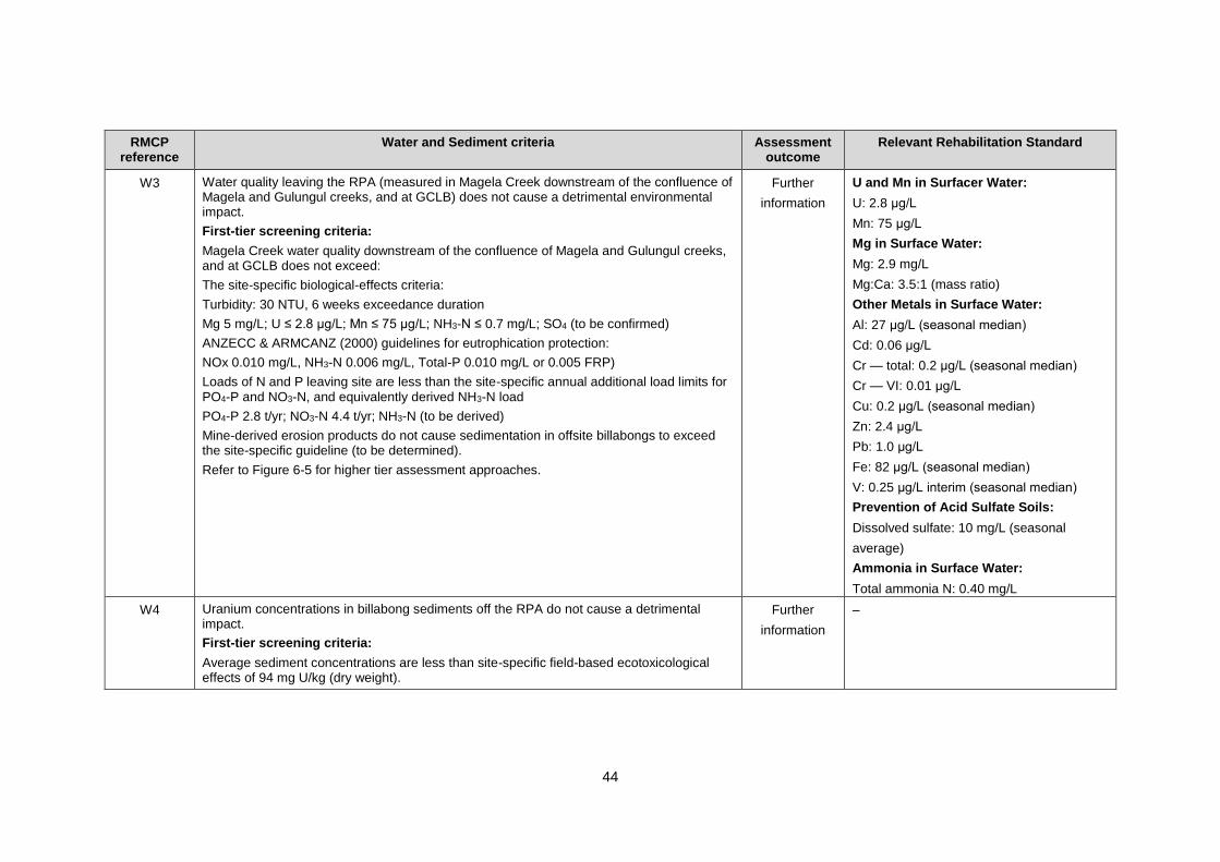
44
RMCP reference
Water and Sediment criteria Assessment outcome
Relevant Rehabilitation Standard
W3 Water quality leaving the RPA (measured in Magela Creek downstream of the confluence of Magela and Gulungul creeks, and at GCLB) does not cause a detrimental environmental impact.
First-tier screening criteria:
Magela Creek water quality downstream of the confluence of Magela and Gulungul creeks, and at GCLB does not exceed:
The site-specific biological-effects criteria:
Turbidity: 30 NTU, 6 weeks exceedance duration
Mg 5 mg/L; U ≤ 2.8 μg/L; Mn ≤ 75 μg/L; NH3-N ≤ 0.7 mg/L; SO4 (to be confirmed)
ANZECC & ARMCANZ (2000) guidelines for eutrophication protection:
NOx 0.010 mg/L, NH3-N 0.006 mg/L, Total-P 0.010 mg/L or 0.005 FRP)
Loads of N and P leaving site are less than the site-specific annual additional load limits for PO4-P and NO3-N, and equivalently derived NH3-N load
PO4-P 2.8 t/yr; NO3-N 4.4 t/yr; NH3-N (to be derived)
Mine-derived erosion products do not cause sedimentation in offsite billabongs to exceed the site-specific guideline (to be determined).
Refer to Figure 6-5 for higher tier assessment approaches.
Further
information
U and Mn in Surfacer Water:
U: 2.8 μg/L
Mn: 75 μg/L
Mg in Surface Water:
Mg: 2.9 mg/L
Mg:Ca: 3.5:1 (mass ratio)
Other Metals in Surface Water:
Al: 27 μg/L (seasonal median)
Cd: 0.06 μg/L
Cr — total: 0.2 μg/L (seasonal median)
Cr — VI: 0.01 μg/L
Cu: 0.2 μg/L (seasonal median)
Zn: 2.4 μg/L
Pb: 1.0 μg/L
Fe: 82 μg/L (seasonal median)
V: 0.25 μg/L interim (seasonal median)
Prevention of Acid Sulfate Soils:
Dissolved sulfate: 10 mg/L (seasonal
average)
Ammonia in Surface Water:
Total ammonia N: 0.40 mg/L
W4 Uranium concentrations in billabong sediments off the RPA do not cause a detrimental impact.
First-tier screening criteria:
Average sediment concentrations are less than site-specific field-based ecotoxicological effects of 94 mg U/kg (dry weight).
Further
information
–

45
RMCP reference
Water and Sediment criteria Assessment outcome
Relevant Rehabilitation Standard
W5 On the RPA water quality in Magela and Gulungul creeks and sedimentation in the billabongs will be as low as reasonably achievable (ALARA).
Further
information
–
46
6.6.1. Assessment Approach
The use of ALARA terminology within final criteria statements results in closure criteria that are
not quantifiable or measurable. It is recommended that ERA update these criteria with quantitative
values that reflect ALARA.
There are statements made in the RMCP that misinterpret the Supervising Scientist’s view in
relation to the proposed tiered approach for Water and Sediment closure criteria. In general, a
tiered screening-level approach is undertaken to ensure that the amount of effort placed on
environmental protection and impact assessment is commensurate with the level of risk posed by
any given contaminant. In this way, a tiered screening-level approach is useful to prevent the
requirement to conduct site-specific assessments of biological effects where there is a low risk of
effects occurring.
For low-risk contaminants, for which there are no local biological-effects data (aluminium, iron,
copper, cadmium, zinc, lead, vanadium and chromium), it is appropriate to base the closure criteria
on the first-tier screening level, against which predicted future surface water concentrations could
be compared. If the predicted concentrations exceed the first-tier screening level, then further
studies will need to be conducted to determine a biological-effect based criteria for that
contaminant (e.g. ecotoxicological investigations).
For high-risk contaminants, where site-specific biological-effects based values are already available
(magnesium, uranium, ammonia and manganese), there is no need to use a tiered screening-level
approach for assessing impact. The closure criteria should be based on the biological-effects values
that have been derived by the Supervising Scientist, providing a single numerical value against
which predicted future surface water concentrations can be compared. If the predicted
concentrations exceed these values there is likely to be some degree of impact on the environment.
In this case, the final step of the tiered risk-assessment framework presented in Figure 6-5 may be
used to assess if predicted changes to biodiversity are considered detrimental. This process may be
useful for quantifying and communicating the potential impacts and assessing the appropriate level
of mitigation required to minimise these impacts.
It is noted that there has been no agreement reached on an acceptable level of biological effects
outside of the Ranger Project Area. The Mirrar Traditional Owners have been clear in stating that
they consider any mine-derived change to biodiversity outside of the Ranger Project Area to be
detrimental.
Additionally, it is incorrectly asserted in the second outcome of the Water and Sediment
Objectives 2 that the ERs require an effect to be regional in nature to be considered detrimental.
ER 1.2(d) states that to be considered detrimental a change must be in excess of that observed
naturally in the region (i.e. outside the range of natural variability), not that changes must be
regional in nature.
Any assessment of water quality criteria must consider uncertainty, both in predicted surface water
contaminant concentrations and in the guideline value being applied.
Methods used to derive sediment criteria should be provided in the RMCP.
6.6.2. Locations Where Closure Criteria Apply
The proposal to apply closure criteria in Magela Creek downstream of the Gulungul confluence,
within Kakadu National Park, is not supported. In the absence of agreement on an acceptable level
of impact outside of the Ranger Project Area, water quality closure criteria should be applied at the
Ranger Project Area boundary.
47
A further rationale should be provided for the locations where the proposed closure criteria apply
as this is variable. For example:
drinking water criteria apply to Magela Creek outside the Ranger Project Area
recreational contact criteria apply at the sites MG009 and GCH.
6.6.3. Ranger Project Area Human Consumption
The parameters and concentrations proposed in the criterion for drinking water and diet (Criteria
W1) are supported. Closure criteria for drinking water are provided for areas outside the Ranger
Project Area only. To demonstrate concentrations are ALARA within the Ranger Project Area will
require the following information:
potential levels of exposure of humans associated with drinking water (i.e. consumption
rates, locations, concentrations)
an assessment of the risk to humans.
Depending on the level of risk to humans, drinking water closure criteria may need to be applied
to the Ranger Project Area.
This information requirement has been identified as a KKN (WS10).
6.6.4. Water Quality for Ecosystem Protection
The parameters proposed in the closure criterion for protection of ecosystem health (Criterion
W3) are generally supported.
Note that for specific concentrations of the parameters:
turbidity — supported
magnesium — generally supported, but the Supervising Scientist’s magnesium
Rehabilitation Standard is 2.9 mg/L, and also specifies a Mg:Ca (mass) ratio of 3.5:1 that
should not be exceeded
uranium — supported
manganese — supported
ammonia — generally supported, but the Supervising Scientist’s total ammonia nitrogen
(TAN) Rehabilitation Standard is 0.4 mg/L
nutrients — (NOx, NH3-N, Total-P N) not supported (see section 6.7.8)
sulfate — the Supervising Scientist has developed a Rehabilitation Standard for sulfate of
10 mg/L (seasonal average) in surface water, for prevention of acid sulfate soil formation
in sediments
metals (other than uranium) — the Supervising Scientist has developed a Rehabilitation
Standard for aluminium, cadmium, chromium, copper, zinc, lead and vanadium.
It is noted in the RMCP that several metals originating from mill tailings/process water have been
excluded from the closure criteria list based on a risk analysis comparing previous modelling results
to guidelines or limits. This may need to be reconsidered in future, depending on the results of
updated modelling that is yet to be completed, as well as any emerging contaminants that are
identified during rehabilitation studies.
These information requirements have been identified as KKNs (WS5–WS10).
48
6.6.5. Effects of Contaminant Mixtures
The RMCP presents a range of closure criteria for individual contaminants, which are based on the
effects of those contaminants alone. The contaminants will co-occur in mine waters and receiving
surface waters, and synergistic interactions and other modifying factors (e.g. increased pH is known
to increase ammonia toxicity) may increase toxicity. It should be demonstrated that the proposed
criteria are applicable in all water quality situations.
This information requirement has been identified as a KKN (WS7).
6.6.6. Contaminant Accumulation in Sediments
The second outcome under Water and Sediment Objective 2 refers only to uranium in sediment.
This should be expanded to ‘contaminants’ in sediment.
The sediment monitoring program proposed in the RMCP includes the sampling of uranium in
Georgetown Billabong at the end of decommissioning to demonstrate achievement of closure
criteria. Work currently underway by the Supervising Scientist indicates that uranium accumulation
in sediments will be limited provided the closure criteria for uranium in surface water is met.
However, estimates of potential uranium accumulation in sediments post-rehabilitation should be
based on the results of surface water contaminant modelling to demonstrate that sediment closure
criteria are likely to be met over the long term.
The potential for impacts associated with mobilisation and accumulation of uranium and other
contaminants in suspended sediments transported offsite is not detailed in the RMCP, although it
is acknowledged that the Supervising Scientist has scheduled research to be undertaken to address
this information requirement.
These information requirements have been identified as KKNs (WS3 and WS5)
6.6.7. Nutrients
The closure criteria for nutrients have been derived using default values from ANZECC &
ARMCANZ (2000). However, these values are unlikely to be achieved because they are less than
the background concentrations for nitrate/nitrite (NOx) and ammonia (NH3-N) observed in the
surface water systems surrounding the Ranger Project Area. Further work is required to derive
closure criteria that are protective of the environment from eutrophication and toxicity, and are
also achievable. The risk of eutrophication should be reassessed and placed in the context of both
baseline conditions and predicted post-rehabilitation surface water concentrations.
This information requirement has been identified as a KKN (WS6).
6.6.8. Sedimentation in Billabongs
Turbidity closure criteria proposed within the landform theme are considered sufficient to ensure
the protection of aquatic ecosystems in the creeks but do not consider the environmental effects
of sedimentation in billabongs closer to the mine. It is acknowledged in the RMCP that a closure
criterion is to be developed for sedimentation in offsite billabongs in relation to aquatic ecosystem
protection.
This information requirement has been identified as a KKN (WS8).
49
6.6.9. Groundwater
Closure criteria for groundwater are not included in the RMCP. Work underway by the Supervising
Scientist to investigate subterranean fauna will assist in determining whether or not groundwater
criteria are required.
This information requirement has been identified as a KKN (WS4).
6.7. Rehabilitation Monitoring
6.7.1. Surface Water
The proposal to establish the overall surface water compliance site downstream of the Magela –
Gulungul confluence is not supported in the absence of agreement on an acceptable level of effect
to the offsite environment (i.e. in the sections of Magela and Gulungul creeks between the lease
boundary and the proposed compliance site).
The monitoring section of the RMCP (Chapter 11) includes sulfate as a water quality parameter at
the Magela–Gulungul confluence and at GCLB for 'Diet and Recreation' values. Given the risk of
acid sulfate soil development on the Ranger Project Area and the Supervising Scientist’s
rehabilitation standard for this parameter, it should also be monitored at RP1 (and other onsite
waterbodies, while they are present) and Georgetown and Gulungul Billabongs.
Grab sampling may need to be conducted more frequently than monthly in the initial period after
completion of rehabilitation works. Section 11.3.1 states that only continuous monitoring will be
conducted at the upstream sites. It is assumed this includes event-based sampling as shown in
Table 11-2.
Ra-226 should be included in the surface water monitoring program.
6.7.2. Groundwater
The groundwater monitoring program presented in the RMCP should be revised to clearly
demonstrate that monitoring will be undertaken at an appropriate spatial and temporal scale to:
observe trends in groundwater level recovery and contaminant transport post-rehabilitation
that can be used to validate groundwater models, and recalibrate if necessary
detect significant increases in contaminant concentrations in aquifers surrounding Pit 1,
Pit 3 and the Tailing Storage Facility, to enable downstream mitigation of impacts if
required (i.e. groundwater interception or abstraction).
The RMCP incorrectly states that a groundwater monitoring program for Pit 1 was approved in
the application of the final tailings level. This is not the case, rather a key recommendation made
as part of the approval of the final tailings level in Pit 1 was that the monitoring program approved
in the 2005 application to deposit tailings in Pit 1 must be continued until a new, more appropriate
monitoring program was developed and approved. This has not yet been done.
6.7.3. Monitoring Program Review
Future reductions in the approved monitoring program should consider the need for ongoing
model validation and the predicted time frame for solute migration, as well as observed trends in
water quality.
Methods of monitoring and assessing water quality and ecosystem health should be reviewed
regularly to ensure that they are optimised and in accordance with current best practice.
50
This information requirement has been identified as a KKN (WS11).
6.8. Summary of Recommendations and Additional
Comments for Water and Sediment
A summary of the recommendations and additional comments discussed in this chapter is provided
in Table 12.
Table 12. Summary of recommendations pertaining to Water and Sediment
Recommendation
Before commencing backfill of Pit 3 or construction of the final landform ERA must address the listed
KKNs, and demonstrate that the environment surrounding the minesite (WS4) will not be impacted
(WS5, WS6, WS7, WS8, WS9 and WS10) by contaminants arising from the rehabilitated minesite
(WS1, WS2 and WS3).
Key Knowledge Needs to be addressed:
WS1 — Characterising contaminant sources on the Ranger Project Area
WS2 — Predicting transport of contaminants in groundwater
WS3 — Predicting transport of contaminants in surface water
WS4 — Characterising baseline aquatic biodiversity and ecosystem health
WS5 — Determining the impact of contaminated sediments on aquatic biodiversity and
ecosystem health
WS6 — Determining the impact of nutrients on aquatic biodiversity and ecosystem health
WS7 — Determining the impact of chemical contaminants on aquatic biodiversity and ecosystem
health
WS8 — Determining the impact of suspended sediment on aquatic biodiversity and ecosystem
health
WS9 — Determining the impact of chemical contaminants in drinking water on terrestrial wildlife
WS10 — Determining the impact of chemical contaminants on human health
Water and Sediment
aspect
Additional comments Relevant KKN
Detailed
Works
Description
Additional information should be provided to support the site wide water
balance model, including:
detailed plans and timelines for all activities related to water
management, storage and treatment and brine disposal
availability, rates, capacities of key plant and equipment (e.g. water
treatment plants, brine injection bores, etc.)
updated modelling assumptions and modelling uncertainty
analyses.
WS1
Water
Management
Include a detailed schedule that outlines the predicted process water
volume and intended storage locations over time.
WS1
Demonstrate that the Tailings Storage Facility is able to be used as a
process water storage post-2020, and provide relevant contingencies
options for the event the Tailings Storage Facility is determined to be
unsuitable for water storage.
WS1
A schedule should also be included for water treatment, indicating the
planned options for process water treatment and demonstrating that
these options will be sufficient to treat the predicted process water
volumes.
WS1

51
Recommendation
Clarify why tailings pore water expression during deposition has
increased by more than 30% in consolidation modelling results between
2014 and 2016.
WS1
It is critical that ERA fulfil its commitment continue water treatment for
as long as necessary to treat and dispose of all process water (including
expressed tailings pore water) onsite. This commitment is fully
supported by the Supervising Scientist, along with the intention to
increase the capacity of process water treatment over time, which will
be necessary to achieve treatment of all process water by 2025. This
commitment should be included as a contingency in section 10.9.1.
WS1
Further details the Pit 3 brine injection system should be provided in the
RMCP, including:
the expected lifespan of brine injection bores and factors that may
affect this
time frames and potential issues associated with the construction of
additional brine injection bores, should they be required
any other brine disposal methods that might be used in the case
that the brine injection system fails (i.e. failure of all bores, or the
underbed drain extraction system).
WS1
Provide further information to demonstrate that there are sufficient
appropriate disposal options for treated water throughout the
rehabilitation process, as irrigation areas are decommissioned.
WS1
Provide further detail on time frames that sediment control infrastructure
is expected to remain in place (i.e. criteria for removal) and any ongoing
maintenance requirements (e.g. sediment removal and disposal
locations).
WS1
Site
Conceptual
Modes
The RMCP should detail future hydrogeological work that will be
undertaken to refine the Ranger Conceptual Model, and explain how
this will further inform rehabilitation planning, particularly with regard to:
further refinement and characterisation of key hydrolithilogical units,
aquifers and groundwater flows in high-risk areas for contaminant
transport (around Pit1, Pit 3 and the Tailings Storage Facility)
further information on surface water/groundwater interactions
improved characterisation of existing contaminated groundwater
(e.g. under the Tailings Storage Facility) and contaminated sites
(e.g. LAAs).
WS2
Contaminant
Source Terms
Further work is required to quantify contaminant source terms and
factors that influence their mobilisation on a whole-of-site basis,
including existing groundwater contamination and contaminants
predicted to arise from the waste rock landform, the buried tailings and
contaminated soils and sediments disturbed during rehabilitation.
WS1

52
Recommendation
For the waste rock source term:
ensure that an appropriate infiltration rate is used to understand
vadose zone behaviour and to determine the concentrations of
contaminants in waste rock seepage, and update contaminant
transport modelling accordingly
improve the estimate of sulfide minerals and associated oxidation
potential in the waste rock landform
improved assessment of solute release subsequent to the
consumption of all of the sulfide minerals.
WS1
For the tailings and pore water source term:
additional data are required to update the tailings consolidation
modelling and water balance accounting for both pits, taking into
account the heterogenous nature of the tailings in the pits, and the
effect this may have on the amount of contaminants mobilised from
tailings and the direction and rate of solute expression
WS1
For the groundwater source term:
characterisation the existing groundwater contamination onsite,
including beneath the Tailings Storage Facility, and update the
Ranger Conceptual Model and contaminant transport models
accordingly
proposed remediation and active management options for
groundwater during and after the rehabilitation of contaminated sites
(e.g. the processing area, stockpiles and the Tailings Storage
Facility)
to demonstrate that LAAs will not result in a significant groundwater
contamination source, include data from bores representing all
aquifers and areas of the Ranger Project Area that could be impacted
(i.e. Aquifer 1 and Aquifer 2).
WS1,
WS2
The potential risks associated with the generation of acid sulfate
sediments due to mine-derived sulfate needs to be assessed,
particularly in Coonjimba, Georgetown and Gulungul billabongs.
WS5,
WS7
53
Recommendation
Contaminant
Transport
Modelling
All numerical modelling should be based on:
the data-driven Ranger Conceptual Model, which needs to include
sufficient detail and confidence for high-risk areas (e.g. the Magela
Creek bed, the Djalkmarra sands and the MBL zone)
detailed and reliable quantification of all potential contaminant
source terms onsite, including existing groundwater contamination
on the minesite
a calibration period that is sufficient to stress the model to the extent
that its behaviour during pre-mining, operational and post-mining
conditions can be assessed, including mine-impacted and baseline
variability in groundwater levels, stream flow and associated
processes
all available data, including pre-mine data if available, with clear
justification for the exclusion of data not used
surface water and groundwater interactions at a temporal scale
appropriate for the baseline variation in groundwater levels and
surface water flow.
WS2,
WS3
To enable more reliable predictions of contaminant concentrations in
surface water, the contaminant transport modelling, particularly the
surface water model, needs to be refined using more relevant and
appropriate data and assumptions, including:
undertaking contaminant transport modelling at increased temporal
and spatial resolution (particularly around the period of peak solute
delivery to the surface water system)
developing better understanding of groundwater/surface water
interactions that will control the location and timing of delivery of
contaminated groundwater to the surface water system
implications of groundwater recovery as groundwater levels return
to a stable state after rehabilitation
improved understanding of the role of groundwater/surface water
interactions in solute migration
assessment of confidence in modelled outputs using statistical,
sensitivity and uncertainty analyses for each model, as well as
analysis of cumulative uncertainty where multiple models are
interconnected.
WS2,
WS3
Develop an understanding of the spatial and temporal (seasonal)
interactions between groundwater and surface water. This work is
required as a priority, particularly in light of the significant concerns
related to water quality in Magela Creek raised in Appendix 8.1 of the
RMCP (2011–12 ITWC PFS BPT Assessment).
WS2,
WS3
Reactive transport modelling is required for calcium so that its effect on
magnesium toxicity in the receiving surface waters can be understood
(calcium has been shown to ameliorate magnesium toxicity).
WS2
A robust analysis of model uncertainty will need to be undertaken to
quantify and understand the level of uncertainty associated with the
modelled outputs.
WS2,
WS3
54
Recommendation
Protection of
Ecosystems
Organism assemblages for all stages of creek flow should be
characterised and assessed for their sensitivity to contaminants
WS7
Assess the potential contribution of subterranean fauna in Magela
Creek sand beds to ecological processes and the biodiversity of the
ARR and if significant, then determine the potential impact of
contaminants on these communities.
WS4,
WS7
Provide information on concentrations of suspended sediments and
contaminants (including nutrients) bound to sediments, including:
effects of sediment mobilisation on surface water quality
physical effects of suspended sediment on aquatic biodiversity
where, when and to what extent contaminants may accumulate in
downstream sediments
monitoring methods.
WS5,
WS8,
WS11
Provide additional details on remediation of onsite waterbodies. —
Assess the risk of eutrophication to on and offsite waterbodies when
surface water model results predicting nutrient concentrations become
available.
WS6
Provision should be made for a periodic review of contaminants
measured in the post-rehabilitation monitoring program outlined in the
RMCP, and closure criteria developed where required in the future.
WS1
Assess the risk of contaminated groundwater on riparian and aquatic
vegetation.
WS7,
EE6
Assess the potential risk of contaminant plumes in creek channels
forming a barrier that inhibits organism migration and connectivity.
WS7
Assess whether there are additional key aquatic organisms for with
water quality guidelines need to be developed (e.g. flow-dependent
insects, hyporheic biota and stygofauna).
WS7
Closure
Criteria
Define the process for ALARA in the context of closure criteria and
provide examples of water and sediment criteria that are ALARA.
–
To enable assessment of the ecological implications of an exceedance
of a water quality closure criterion, the closure criteria need to be
numerical values and should be applied at the boundary of the Ranger
Project Area until such time as there is agreement on an acceptable
level of detriment for areas outside of the Ranger Project Area.
–
Determine potential levels of exposure of humans to contaminants from
drinking water from onsite waterbodies (i.e. consumption rates,
locations, concentrations) and assess the risk to human health.
WS10
Propose closure criteria for sulfate, specifically in relation to the risk of
acid sulfate sediment generation for billabongs.
WS5,
WS7
Acknowledge that there may be a requirement in future to consider the
reintroduction of a closure criterion for pH, depending on the outcome of
acid sulfate soil investigations.
WS1
Provide evidence that the proposed closure criteria are applicable to
contaminant mixtures.
WS7
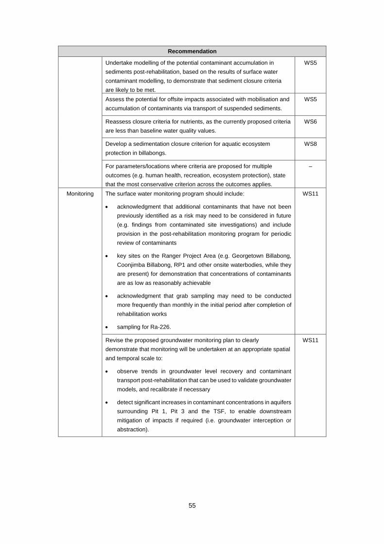
55
Recommendation
Undertake modelling of the potential contaminant accumulation in
sediments post-rehabilitation, based on the results of surface water
contaminant modelling, to demonstrate that sediment closure criteria
are likely to be met.
WS5
Assess the potential for offsite impacts associated with mobilisation and
accumulation of contaminants via transport of suspended sediments.
WS5
Reassess closure criteria for nutrients, as the currently proposed criteria
are less than baseline water quality values.
WS6
Develop a sedimentation closure criterion for aquatic ecosystem
protection in billabongs.
WS8
For parameters/locations where criteria are proposed for multiple
outcomes (e.g. human health, recreation, ecosystem protection), state
that the most conservative criterion across the outcomes applies.
–
Monitoring The surface water monitoring program should include:
acknowledgment that additional contaminants that have not been
previously identified as a risk may need to be considered in future
(e.g. findings from contaminated site investigations) and include
provision in the post-rehabilitation monitoring program for periodic
review of contaminants
key sites on the Ranger Project Area (e.g. Georgetown Billabong,
Coonjimba Billabong, RP1 and other onsite waterbodies, while they
are present) for demonstration that concentrations of contaminants
are as low as reasonably achievable
acknowledgment that grab sampling may need to be conducted
more frequently than monthly in the initial period after completion of
rehabilitation works
sampling for Ra-226.
WS11
Revise the proposed groundwater monitoring plan to clearly
demonstrate that monitoring will be undertaken at an appropriate spatial
and temporal scale to:
observe trends in groundwater level recovery and contaminant
transport post-rehabilitation that can be used to validate groundwater
models, and recalibrate if necessary
detect significant increases in contaminant concentrations in aquifers
surrounding Pit 1, Pit 3 and the TSF, to enable downstream
mitigation of impacts if required (i.e. groundwater interception or
abstraction).
WS11
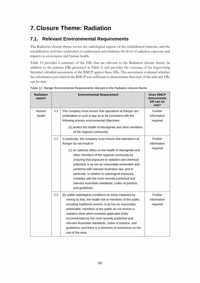
56
7. Closure Theme: Radiation
7.1. Relevant Environmental Requirements
The Radiation closure theme covers the radiological aspects of the rehabilitated minesite, and the
rehabilitation activities undertaken to understand and minimise the level of radiation exposure and
impacts to ecosystems and human health.
Table 12 provides a summary of the ERs that are relevant to the Radiation closure theme (in
addition to the primary ERs presented in Table 1) and provides the outcome of the Supervising
Scientist’s detailed assessment of the RMCP against these ERs. The assessment evaluated whether
the information provided in the RMCP was sufficient to demonstrate that each of the relevant ERs
can be met.
Table 12. Ranger Environmental Requirements relevant to the Radiation closure theme
Radiation aspect
Environmental Requirement Does RMCP demonstrate
ER can be met?
Human
health
1.1 The company must ensure that operations at Ranger are
undertaken in such a way as to be consistent with the
following primary environmental objectives:
(c) protect the health of Aboriginals and other members
of the regional community.
Further
information
required
1.2 In particular, the company must ensure that operations at
Ranger do not result in:
(c) An adverse effect on the health of Aboriginals and
other members of the regional community by
ensuring that exposure to radiation and chemical
pollutants is as low as reasonably achievable and
conforms with relevant Australian law, and in
particular, in relation to radiological exposure,
complies with the most recently published and
relevant Australian standards, codes of practice,
and guidelines.
Further
information
required
2.2 (b) stable radiological conditions on areas impacted by
mining so that, the health risk to members of the public,
including traditional owners, is as low as reasonably
achievable; members of the public do not receive a
radiation dose which exceeds applicable limits
recommended by the most recently published and
relevant Australian standards, codes of practice, and
guidelines; and there is a minimum of restrictions on the
use of the area.
Further
information
required
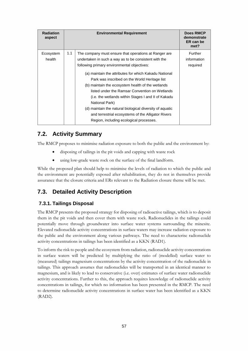
57
Radiation aspect
Environmental Requirement Does RMCP demonstrate
ER can be met?
Ecosystem
health
1.1 The company must ensure that operations at Ranger are
undertaken in such a way as to be consistent with the
following primary environmental objectives:
(a) maintain the attributes for which Kakadu National
Park was inscribed on the World Heritage list
(b) maintain the ecosystem health of the wetlands
listed under the Ramsar Convention on Wetlands
(i.e. the wetlands within Stages I and II of Kakadu
National Park)
(d) maintain the natural biological diversity of aquatic
and terrestrial ecosystems of the Alligator Rivers
Region, including ecological processes.
Further
information
required
7.2. Activity Summary
The RMCP proposes to minimise radiation exposure to both the public and the environment by:
disposing of tailings in the pit voids and capping with waste rock
using low-grade waste rock on the surface of the final landform.
While the proposed plan should help to minimise the levels of radiation to which the public and
the environment are potentially exposed after rehabilitation, they do not in themselves provide
assurance that the closure criteria and ERs relevant to the Radiation closure theme will be met.
7.3. Detailed Activity Description
7.3.1. Tailings Disposal
The RMCP presents the proposed strategy for disposing of radioactive tailings, which is to deposit
them in the pit voids and then cover them with waste rock. Radionuclides in the tailings could
potentially move through groundwater into surface water systems surrounding the minesite.
Elevated radionuclide activity concentrations in surface waters may increase radiation exposure to
the public and the environment along various pathways. The need to characterise radionuclide
activity concentrations in tailings has been identified as a KKN (RAD1).
To inform the risk to people and the ecosystem from radiation, radionuclide activity concentrations
in surface waters will be predicted by multiplying the ratio of (modelled) surface water to
(measured) tailings magnesium concentrations by the activity concentration of the radionuclide in
tailings. This approach assumes that radionuclides will be transported in an identical manner to
magnesium, and is likely to lead to conservative (i.e. over) estimates of surface water radionuclide
activity concentrations. Further to this, the approach requires knowledge of radionuclide activity
concentrations in tailings, for which no information has been presented in the RMCP. The need
to determine radionuclide activity concentrations in surface water has been identified as a KKN
(RAD2).

58
7.3.2. Landform Surface
The RMCP presents the proposed design of the final landform, which indicates that the surface of
the final landform will comprise low-grade waste rock. After construction is complete, the waste
rock on the surface of the final landform will be the primary source of radiation. The magnitude
of exposure along each of the potential exposure pathways will depend on the uranium activity
concentration of the waste rock. The plan indicates that the waste rock surface will have an average
uranium activity concentration of approximately 0.8 Becquerels per gram. However, the data and
analyses through which this value was derived have not been presented.
The RMCP states that the anticipated uranium activity concentration of waste rock (of 0.8
Becquerels per gram) is below that currently considered to be radioactive according to the Australian Radiation
Protection and Nuclear Safety Agency. While the Australian Radiation Protection and Nuclear Safety
Agency’s National Directory for Radiation Protection (ARPANSA 2017) provides a regulatory
exemption level for small amounts of materials containing uranium of 1 Bq/g, this does not
strictly apply to the large amount of waste rock on the surface of the final landform. Furthermore,
the National Directory for Radiation Protection defines radioactive material as being any material
that emits ionising radiation spontaneously. Therefore, the Supervising Scientist does not support the
view that the waste rock is not radioactive.
7.4. Protection of Human Health (ER 1.1, 1.2, 2.2, 5.1–5.3.)
The RMCP outlines the process for assessing radiation doses to the public from the final landform.
This includes:
establishing a baseline (i.e. pre-mining) radiological conditions of the site
identifying the representative person (i.e. the real or hypothetical individual most at
risk of radiation exposure)
identifying exposure pathways and probable habitation scenarios
compiling data to parameterise the radiation exposure pathways and habitation
scenarios
developing a radiation dose model to estimate doses.
The RMCP presents information on the baseline radiological conditions of the minesite as
determined by Bollhöfer et al. (2014). This includes:
gamma dose rates
soil radium-226 activity concentrations
radon-222 exhalation flux densities.
The RMCP presents information on baseline water radium-226 activity concentrations in Magela
Creek, determined from routine water quality monitoring at the Magela Creek upstream location
between 2010 and 2013. However, water quality monitoring at this location has occurred over an
extended period, and it is unclear why the baseline conditions were derived from a small subset of
the monitoring data, rather than from all available data.
The RMCP presents baseline activity concentrations of uranium-238, radium-226 and lead-210 in
bush foods, with the information compiled from several studies conducted by the SSB. However,
the RMCP does not present baseline activity concentrations for polonium-210, which is the
radionuclide with the highest ingestion dose coefficient. Furthermore, a complete compilation of

59
all SSB bush food radionuclide data were published in 2016 (Doering & Bollhöfer 2016), which
has not been used within the RMCP to determine baseline values.
The RMCP identifies the representative person as an Indigenous person using the final landform
and surrounding environment for traditional activities including transient camping and the
gathering of traditional bush foods for consumption. The probable habitation scenarios have been
identified as those documented in Garde (2015) after consultation with the Mirarr traditional
owners.
The RMCP identifies the potential radiation exposure pathways to the public from the final
landform as:
external gamma radiation
ingestion of radionuclides in bush foods
ingestion of radionuclides in water
inhalation of radionuclides in dust
inhalation of radon progeny.
The RMCP does not present a dose assessment which compiles data to parameterise the radiation
exposure pathways so that radiation doses received from each pathway can be estimated. The
absence of a radiation dose assessment within the RMCP means that there is currently insufficient
information to demonstrate that the ERs relevant to radiation protection of the public can be met.
The plan indicates that a dose assessment will be undertaken in the future. The need to compile
data for parameterising the various radiation exposure pathways has been identified within several
KKNs (RAD3, RAD4, RAD5). The need to assess radiation doses to the public and to undertake
a sensitivity analysis of radiation dose modelling has also been identified as a KKN (RAD7).
7.5. Protection of Ecosystem Health (ER 1.1, 5.1)
The RMCP acknowledges the need to assess radiation risks to the environment in line with world’s
best practice standards for radiation protection and commits to undertake such an assessment using
the ERICA Tool. The RMCP should present information on the representative organisms or
parameter values (e.g. tissue conversion factors and whole-organism concentration ratios) that will
be used in this assessment. The need for this information has been identified as a KKN (RAD6).
The lack of a radiation dose assessment for wildlife within the RMCP means that there is currently
insufficient information to demonstrate that the ERs relevant to radiation protection of the
environment can be met.
7.6. Closure Criteria
Closure criteria proposed in the RMCP pertaining to radiation have been assessed and all proposed
criteria have been accepted (Table 14).

60
Table 14. Supervising Scientist position on proposed Radiation closure criteria
RMCP reference
Radiation criteria Assessment outcome
Relevant Rehabilitation Standard
R1 Using the agreed restrictions on land use the total above-baseline radiation dose from external gamma exposure, inhalation of radon decay products (RDP), inhalation of dust and ingestion of bush food (including water), (shall not exceed) 0.3 mSv per year.
Accepted Public Radiation Projection:
Dose constraint: 0.3 mSv in a year — effective dose to members of the
public is ALARA below the dose constraint for conditions of agreed future
land use.
R2 Should land use restrictions fail the total above-baseline radiation dose from external gamma exposure, inhalation of RDP, inhalation of dust and ingestion of bush food (including water), (shall not exceed) 1 mSv per year.
Accepted Public Radiation Projection:
Dose limit 1.0 mSv in a year — effective dose to members of the public is
ALARA below the dose limit for conditions of future land use different to
those agreed.
R3 Total above-baseline radiation dose rate to terrestrial plants and animals from internal and external exposures (shall not exceed) 100 μGy h–1 to the most highly exposed terrestrial species.
Accepted Environmental Radiation Projection:
Environmental reference level of 100 μGy h–1 for terrestrial organisms —
absorbed dose rates to the most highly exposed individuals are ALARA
below the environmental reference level
R4 Total above-baseline radiation dose rate to aquatic plants and animals from internal and external exposures (shall not exceed) 400 μGy h–1 to the most highly exposed aquatic species.
Accepted Environmental Radiation Projection:
Environmental reference level of 400 μGy h–1 for aquatic organisms —
absorbed dose rates to the most highly exposed individuals are ALARA
below the environmental reference level
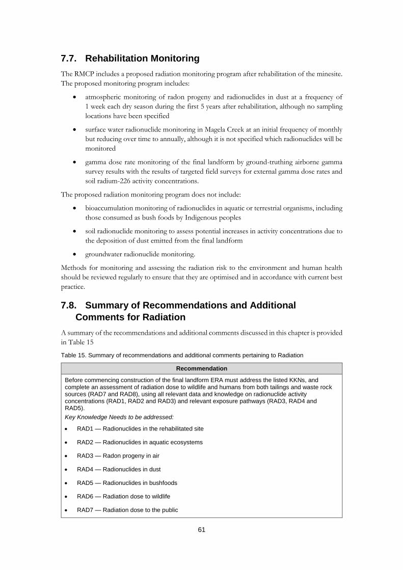
61
7.7. Rehabilitation Monitoring
The RMCP includes a proposed radiation monitoring program after rehabilitation of the minesite.
The proposed monitoring program includes:
atmospheric monitoring of radon progeny and radionuclides in dust at a frequency of
1 week each dry season during the first 5 years after rehabilitation, although no sampling
locations have been specified
surface water radionuclide monitoring in Magela Creek at an initial frequency of monthly
but reducing over time to annually, although it is not specified which radionuclides will be
monitored
gamma dose rate monitoring of the final landform by ground-truthing airborne gamma
survey results with the results of targeted field surveys for external gamma dose rates and
soil radium-226 activity concentrations.
The proposed radiation monitoring program does not include:
bioaccumulation monitoring of radionuclides in aquatic or terrestrial organisms, including
those consumed as bush foods by Indigenous peoples
soil radionuclide monitoring to assess potential increases in activity concentrations due to
the deposition of dust emitted from the final landform
groundwater radionuclide monitoring.
Methods for monitoring and assessing the radiation risk to the environment and human health
should be reviewed regularly to ensure that they are optimised and in accordance with current best
practice.
7.8. Summary of Recommendations and Additional
Comments for Radiation
A summary of the recommendations and additional comments discussed in this chapter is provided
in Table 15
Table 15. Summary of recommendations and additional comments pertaining to Radiation
Recommendation
Before commencing construction of the final landform ERA must address the listed KKNs, and complete an assessment of radiation dose to wildlife and humans from both tailings and waste rock sources (RAD7 and RAD8), using all relevant data and knowledge on radionuclide activity concentrations (RAD1, RAD2 and RAD3) and relevant exposure pathways (RAD3, RAD4 and RAD5).
Key Knowledge Needs to be addressed:
RAD1 — Radionuclides in the rehabilitated site
RAD2 — Radionuclides in aquatic ecosystems
RAD3 — Radon progeny in air
RAD4 — Radionuclides in dust
RAD5 — Radionuclides in bushfoods
RAD6 — Radiation dose to wildlife
RAD7 — Radiation dose to the public

62
Recommendation
Radiation aspect
Additional comments Relevant KKN(s)
Baseline
conditions
Use monitoring data collected over all years to derive statistical
results for baseline water radionuclide concentrations at Magela
Creek upstream or otherwise explain why only the data from 2010 to
2013 have been used.
RAD1
Radiation
Sources
Reconsider the view that the waste rock on the surface of the
landform (with estimated uranium activity concentration of 0.8 Bq/g)
is not radioactive.
RAD1
Include data and analyses to demonstrate what the average uranium
activity concentration across the landform surface will be.
RAD1
Include data and analyses to demonstrate what the radionuclide
activity concentration of the tailings will be.
RAD1
Human
health
Provide estimates of radionuclide activity concentrations in surface
water surrounding the minesite.
RAD2
Provide information on radon and radon progeny concentrations in
the air due to the final landform.
RAD3
Provide information on the activity concentration of radionuclides in
dust due to the final landform.
RAD4
Provide information on gamma dose rates on the final landform. RAD1
Provide information on concentration ratios for uranium and actinium
decay series radionuclides in bush foods.
RAD5
Provide an estimate of radiation doses to the public from the final
landform.
RAD7
Ecosystem
health
Identify the representative organisms upon which the radiation dose
assessment for wildlife will be based.
RAD6
Provide whole-organism concentration ratios for the representative
organisms.
RAD6
Provide tissue to whole-organism conversion factors for converting
tissue-specific activity concentrations to whole-organism activity
concentrations.
RAD6
Provide an estimate of radiation dose rates to wildlife from the final
landform.
RAD6
Rehabilitation
monitoring
Include bioaccumulation monitoring of radionuclides in bush foods
within the radiation monitoring program.
RAD8
Include soil radionuclide monitoring within the radiation monitoring
program.
RAD8
Include groundwater radionuclide monitoring within the radiation
monitoring program.
RAD8
63
8. Closure Theme: Soils
8.1. Relevant Environmental Requirements
The Soils closure theme covers the rehabilitation activities undertaken to minimise the release of
contaminated soils, and contaminants from these soils, to prevent changes to water and/or
sediment quality in the receiving environment and related impacts to ecosystems and/or human
health.
In the RMCP, the only ER listed as being relevant to soils is 1.2 (e), which pertains to environmental
impacts within the Ranger Project Area being ALARA. ER 1.2(c) requires that the company
prevent an adverse effect on the health of Aboriginals and other members of the regional community by ensuring
that exposure to radiation and chemical pollutants is as low as reasonably achievable and conforms with relevant
Australian law…. All of the primary ERs should be included in the RMCP as they are all relevant
to soils unless it can be demonstrated that contaminated soils within the Ranger Project Area do
not pose a risk to the environment outside the Ranger Project Area.
8.2. Activity Summary
Contaminated site assessments will be used to define the extent of soil contamination within the
Ranger Project Area. Where remediation is required, the contaminated soil will be recovered and
disposed of in Pit 3. This is in line with the relevant ERs.
8.3. Detailed Activity Description
The RMCP identifies the LAAs and processing plant area as the main areas with known or potential
soil contamination. For the LAAs, some existing information on soil contamination is presented
in the RMCP and it is stated that additional studies are currently underway to confirm whether
remediation is required.
It is stated in the RMCP that if soil contaminant concentrations are shown to be below either local
background concentrations or the published investigation levels (i.e. health investigation level (HIL)
and/or ecological investigation level (EIL)), then no further assessment or remediation will be
required. Health and/or ecological investigation levels for contaminants that are not currently listed
in the published investigation levels, including uranium, need to be developed. Consideration
should also be given to guidance provided by the Environmental Health Standing Committee
(EnHealth) in assessing the risk of contaminants to human health.
8.4. Delineation of Contaminated Soils
It is stated in the RMCP that the LAAs pose a low risk because contaminated runoff from these
areas will be heavily diluted, but it is also acknowledged that there are currently soil assessments
being undertaken that will further inform this risk. Additional information is required to assess the
potential for mobilisation of contaminants arising from LAAs if soils are disturbed during
rehabilitation activities.
Although the RMCP acknowledges that soils in the processing plant area will require remediation,
no data indicating the extent (e.g. depth and surface area/volume) of contaminated soil in this area
are presented, or referenced. The RMCP needs to indicate the volume of contaminated soil, as well
as the proposed method for recovery and placement of this soil into the Pit.
The RMCP indicates that the Tailings Storage Facility is likely to be a source of contamination after
rehabilitation. However, there are no details provided on the nature or extent of contamination
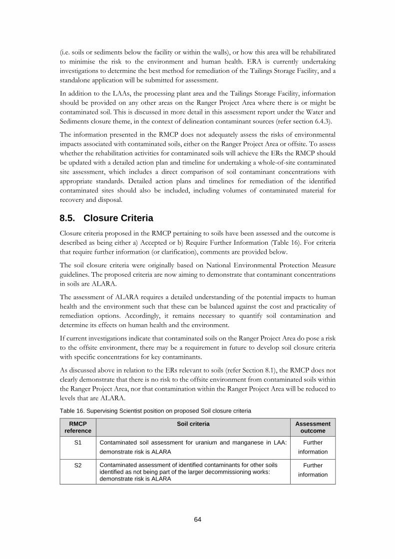
64
(i.e. soils or sediments below the facility or within the walls), or how this area will be rehabilitated
to minimise the risk to the environment and human health. ERA is currently undertaking
investigations to determine the best method for remediation of the Tailings Storage Facility, and a
standalone application will be submitted for assessment.
In addition to the LAAs, the processing plant area and the Tailings Storage Facility, information
should be provided on any other areas on the Ranger Project Area where there is or might be
contaminated soil. This is discussed in more detail in this assessment report under the Water and
Sediments closure theme, in the context of delineation contaminant sources (refer section 6.4.3).
The information presented in the RMCP does not adequately assess the risks of environmental
impacts associated with contaminated soils, either on the Ranger Project Area or offsite. To assess
whether the rehabilitation activities for contaminated soils will achieve the ERs the RMCP should
be updated with a detailed action plan and timeline for undertaking a whole-of-site contaminated
site assessment, which includes a direct comparison of soil contaminant concentrations with
appropriate standards. Detailed action plans and timelines for remediation of the identified
contaminated sites should also be included, including volumes of contaminated material for
recovery and disposal.
8.5. Closure Criteria
Closure criteria proposed in the RMCP pertaining to soils have been assessed and the outcome is
described as being either a) Accepted or b) Require Further Information (Table 16). For criteria
that require further information (or clarification), comments are provided below.
The soil closure criteria were originally based on National Environmental Protection Measure
guidelines. The proposed criteria are now aiming to demonstrate that contaminant concentrations
in soils are ALARA.
The assessment of ALARA requires a detailed understanding of the potential impacts to human
health and the environment such that these can be balanced against the cost and practicality of
remediation options. Accordingly, it remains necessary to quantify soil contamination and
determine its effects on human health and the environment.
If current investigations indicate that contaminated soils on the Ranger Project Area do pose a risk
to the offsite environment, there may be a requirement in future to develop soil closure criteria
with specific concentrations for key contaminants.
As discussed above in relation to the ERs relevant to soils (refer Section 8.1), the RMCP does not
clearly demonstrate that there is no risk to the offsite environment from contaminated soils within
the Ranger Project Area, nor that contamination within the Ranger Project Area will be reduced to
levels that are ALARA.
Table 16. Supervising Scientist position on proposed Soil closure criteria
RMCP reference
Soil criteria Assessment outcome
S1 Contaminated soil assessment for uranium and manganese in LAA:
demonstrate risk is ALARA
Further
information
S2 Contaminated assessment of identified contaminants for other soils identified as not being part of the larger decommissioning works: demonstrate risk is ALARA
Further
information
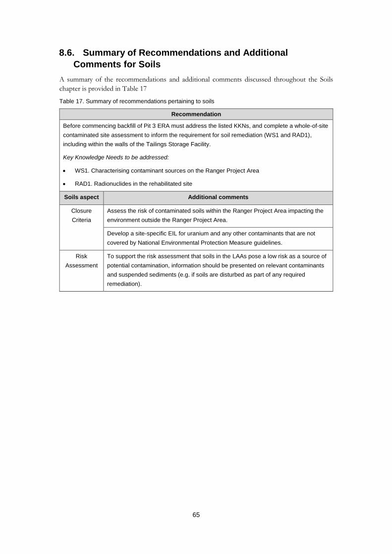
65
8.6. Summary of Recommendations and Additional
Comments for Soils
A summary of the recommendations and additional comments discussed throughout the Soils
chapter is provided in Table 17
Table 17. Summary of recommendations pertaining to soils
Recommendation
Before commencing backfill of Pit 3 ERA must address the listed KKNs, and complete a whole-of-site
contaminated site assessment to inform the requirement for soil remediation (WS1 and RAD1),
including within the walls of the Tailings Storage Facility.
Key Knowledge Needs to be addressed:
WS1. Characterising contaminant sources on the Ranger Project Area
RAD1. Radionuclides in the rehabilitated site
Soils aspect Additional comments
Closure
Criteria
Assess the risk of contaminated soils within the Ranger Project Area impacting the
environment outside the Ranger Project Area.
Develop a site-specific EIL for uranium and any other contaminants that are not
covered by National Environmental Protection Measure guidelines.
Risk
Assessment
To support the risk assessment that soils in the LAAs pose a low risk as a source of
potential contamination, information should be presented on relevant contaminants
and suspended sediments (e.g. if soils are disturbed as part of any required
remediation).
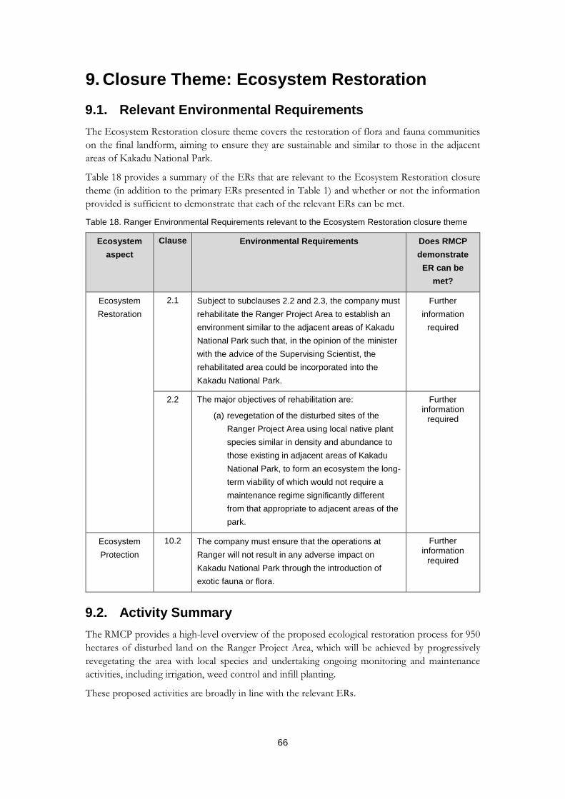
66
9. Closure Theme: Ecosystem Restoration
9.1. Relevant Environmental Requirements
The Ecosystem Restoration closure theme covers the restoration of flora and fauna communities
on the final landform, aiming to ensure they are sustainable and similar to those in the adjacent
areas of Kakadu National Park.
Table 18 provides a summary of the ERs that are relevant to the Ecosystem Restoration closure
theme (in addition to the primary ERs presented in Table 1) and whether or not the information
provided is sufficient to demonstrate that each of the relevant ERs can be met.
Table 18. Ranger Environmental Requirements relevant to the Ecosystem Restoration closure theme
Ecosystem
aspect
Clause Environmental Requirements Does RMCP
demonstrate
ER can be
met?
Ecosystem
Restoration
2.1 Subject to subclauses 2.2 and 2.3, the company must
rehabilitate the Ranger Project Area to establish an
environment similar to the adjacent areas of Kakadu
National Park such that, in the opinion of the minister
with the advice of the Supervising Scientist, the
rehabilitated area could be incorporated into the
Kakadu National Park.
Further
information
required
2.2 The major objectives of rehabilitation are:
(a) revegetation of the disturbed sites of the
Ranger Project Area using local native plant
species similar in density and abundance to
those existing in adjacent areas of Kakadu
National Park, to form an ecosystem the long-
term viability of which would not require a
maintenance regime significantly different
from that appropriate to adjacent areas of the
park.
Further information
required
Ecosystem
Protection
10.2 The company must ensure that the operations at
Ranger will not result in any adverse impact on
Kakadu National Park through the introduction of
exotic fauna or flora.
Further information
required
9.2. Activity Summary
The RMCP provides a high-level overview of the proposed ecological restoration process for 950
hectares of disturbed land on the Ranger Project Area, which will be achieved by progressively
revegetating the area with local species and undertaking ongoing monitoring and maintenance
activities, including irrigation, weed control and infill planting.
These proposed activities are broadly in line with the relevant ERs.
67
9.3. Detailed Activity Description
The RMCP provides a high-level plan to revegetate the final landform with local species to establish
a vegetation community similar to that in surrounding areas of Kakadu National Park. The RMCP
assumes that once vegetation has successfully established, the area will be naturally colonised by
fauna.
Further information is required to demonstrate the relevant ERs can be achieved. The RMCP states
that this will be provided in a standalone application, which should include a detailed description
of the works to be undertaken. Additional information to be provided within the application should
include:
detailed action plans and timelines, including methods (i.e. planting, irrigation)
seed availability and collection plan
nursery details and propagation studies
target and planned planting densities and methods (e.g. final target density for each
species)
habitat to be installed (e.g. nesting boxes, rock piles)
ongoing management activities, including weed control and infill planting
any other project specific assumptions or information which would be required to
conduct a detailed assessment of the activity.
These information requirements have been identified as KKNs (EE2, EE3 and EE4).
9.3.1. Revegetation Strategy
A Revegetation Strategy is presented in Appendix 10.2 of the RMCP but it requires significant
revision. It is suggested the Revegetation Strategy be expanded to an ‘Ecosystem Restoration
Strategy’ in recognition of the intention of the ERs, and key linkages between flora and fauna and
broader ecosystem processes. These information requirements have been identified as KKNs
(EE1, EE2, EE3, EE4).
It is stated in the current strategy that revegetation will be broadly similar to adjacent areas of Kakadu.
However, this will not satisfy the ERs. Should ERA identify that certain aspects of the ERs cannot
be met, a substantial body of evidence must be provided to demonstrate that what is being
proposed constitutes BPT.
The Ecosystem Restoration Strategy should be clearly underpinned by data to substantiate the
proposed approach. However, it is supported by only three references, one of which is related to
the establishment of vegetation. ERA needs to synthesise key findings and knowledge gaps from
all revegetation trials. Monitoring on the trial landform to address these gaps and inform the
Ecosystem Restoration Strategy should be recommenced as soon as possible.
The following sections provide a detailed assessment of the various factors with the potential to
influence the success of ecosystem restoration, and as such should be clearly addressed in the
Ecosystem Restoration Strategy.
68
9.4. Ecosystem Restoration (ER 2.1, 2.2)
9.4.1. Revegetation Trials
In listing various revegetation trials from 1982 to 1999, the RMCP indicates that there has been a
substantial body of work conducted in relation to revegetation at Ranger mine over many years.
While this is the case, there is no detail or summary provided on the findings or recommendations
from each of these studies, or details of how they contribute to the proposed Revegetation Strategy.
In the absence of these details, it is difficult to assess the scientific veracity of the studies and
whether they are sufficient to demonstrate that revegetation will be successful. Most of the trials
have generally been conducted over relatively short time frames and at smaller spatial scales.
Therefore, there is limited evidence to support the potential for long-term sustainability of
revegetation at Ranger mine.
The RMCP only includes reference to monitoring of the revegetation on the trial landform up until
2015 and states that since 2016 the focus of revegetation monitoring has been on the growth and
performance of individual plants. However, much of this work has not been compiled into reports.
Any reference to revegetation work on the trial landform is notably absent from section 7.6.1 which
lists revegetation trials from 1982 to 1999, but nothing from the past nearly 20 years. The potential
success or failure of rehabilitation on the trial landform presented in the RMCP is therefore based
on only 6 years of data. Monitoring of revegetation should also include grasses and groundcover
species. Section 7.3.3 gives the impression that biannual monitoring has been conducted since
2009. However, it should also state that this monitoring was discontinued around 2014. It is
recommended that ERA collate and publish all relevant information from the trial landform,
incorporating information from other studies as required, to inform the Ecosystem Restoration
Strategy.
It is possible that some species present in the surrounding environment may not be able to establish
or persist on the waste rock landform. Information should be presented in the RMCP that
demonstrates whether waste rock can maintain long-term species diversity through recruitment
and regeneration and whether there are factors that could be manipulated to facilitate this. There
is some information presented on natural recruitment on the trial landform, although this is limited
to numbers and does not provide an indication of species composition. This information
requirement has been identified as a KKN (EE7).
9.4.2. Reference Sites
The SSB is developing techniques to undertake large-scale aerial vegetation surveys, including an
extensive ground-truthing program. The information from this program will be provided to ERA
as it comes to hand to update measures of vegetation structure and species composition which has
historically been obtained from smaller scale ground-based surveys.
It is noted that ERA has commenced a regional vegetation survey program as shown in Figure 7-
46. Further information on the survey methods should be provided. While the sites were surveyed
in 2016 no data from the survey have been presented in the RMCP. Section 2.3.2.1 of the RMCP
states there have been over 90 flora species recorded on the Ranger Project Area. However, a
literature survey by SSB showed that 541 flora species have been recorded on the Ranger Project
Area.
A KKN related to the scale and temporal variability of terrestrial ecosystems in areas surrounding
the Ranger Project Area has been identified (EE1).
69
9.4.3. Seed Availability and Viability
Further information is required to demonstrate that sufficient seed can be sourced to complete
revegetation in the time frame required. Seed availability/collection issues are classified in the
RMCP as a Class II risk. This is a key risk given the very large volume of seed required, so it may
be more appropriate to be considered a class III risk (as plant propagation success is), or further
detail provided on control measures. The amount of seed and resulting tube stock for each species
required to reach the desired end state should be documented in the RMCP.
Information should also be provided on which species are currently able to be grown from seed,
and which are not able to be successfully propagated. These information requirements have been
identified as a KKN (EE3).
9.4.4. Soil Development
Additional information is required to demonstrate that the waste rock substrate will develop into
a soil suitable to support a vegetation community similar to the surrounding area.
It has been assumed that rock material will weather rapidly to form rudimentary soil materials but
the cited studies were conducted on waste rock from Pit 1, which has different properties to waste
rock from Pit 3. Given that the majority of the final landform will comprise waste rock from Pit 3,
the information referenced is not applicable across the site. Field observations undertaken by the
Supervising Scientist on the trial landform do not support the assumption that rapid weathering
will occur.
The soil texture information presented in the RMCP appears to be based on a subset of the
substrate (i.e. minus the > 2 mm gravel fraction) rather than the entire substrate. This may have
resulted in an incorrect classification of soil properties that could have implications on substrate
suitability for plant establishment and survival, such as water-holding capacity.
The RMCP should provide information on soil formation properties for each type of waste rock
to be used in landform construction, including:
weathering rates
soil texture information for the entire waste rock substrate (i.e. not just < 2 mm
fraction).
The trial landform provides the opportunity to assess soil formation over a 9-year period to address
some of the above. These information requirements have been identified as a KKN (EE7).
9.4.5. Plant Available Water
The SSB is currently undertaking a detailed review of ERA’s work to quantify water usage
requirements by the surrounding undisturbed vegetation communities, and to estimate the plant
available water within the final landform. Significant additional work is required to demonstrate
that the waste rock landform will provide sufficient plant available water to support a mature
vegetation community.
The modelling undertaken to predict plant available water in the final landform is unclear and
requires more explanation. The modelled plant available water needs to include uncertainty
analysis, particularly because the current model simulations predict there may be insufficient plant
available water during some years.
The RMCP states that increasing the thickness of the waste rock to 7 m would ensure sufficient
plant available water. This requires that plant roots are able to access water down to those depths.
70
Information should be provided on likely rooting depths in waste rock, including for understory
species, to confirm plants will be able to access water at those depths. This should also account for
the presence of macropores, which are currently excluded from the textural classification system
used to characterise the substrate.
In the RMCP, plant evapotranspiration is used as an indicator to demonstrate that there is sufficient
plant available water in the rehabilitated landform, with the assumption that overstorey species are
the main component of evapotranspiration during the dry season. However, this assumption is not
supported by any data or published studies, with understorey evapotranspiration rates being
simulated. A review of available literature on local understorey species should be undertaken, or
empirical data provided, to support the assumption that understorey is a minor component of
evapotranspiration.
It is proposed in the RMCP that placement of waste rock in the landform will be undertaken via a
‘paddock dumping’ technique that will create additional compaction layers at 4 m intervals. It is
claimed that this may improve the water-holding capacity of the waste rock. However, no evidence
is presented to demonstrate this is the case. Nor is there evidence to demonstrate that compaction
layers (both within the constructed landform and underlying the original ground surface) won’t
lead to other issues affecting plant growth such as physically restricting root penetration, the
formation of perched water tables or accumulation of metals and salts (Shirtliff 2007).
Further information on the internal properties in each area of the final landform (e.g. nature, depth
and extent of compacted layers) should be provided, in conjunction with a conceptual model and
water balance (under a range of rainfall scenarios) demonstrating that there will be sufficient water
available for revegetation (including understorey).
Radon is soluble and soil moisture levels are a significant driver of seasonal fluctuations in radon
exhalation rates. It is noted in section 7.3.3 of the RMCP that there was no seasonal trend in radon
exhalation rates on the waste rock-only section of the trial landform. This observation should be
investigated in the context of the ability of the waste rock substrate to retain water.
The need to gain a better understanding of plant available water in the rehabilitated landform has
been identified as a KKN (EE7).
9.4.6. Fire
Although identified as a risk to revegetation success, there is very limited contemporary
information presented in the RMCP to demonstrate the resilience of revegetation to fire (i.e. there
is a reference from 25 years ago in relation to the impact of fire frequency on tree/grass ratios).
Within this limited information, there is no reference to the fire severity and intensity, plant
response nor species (other than Eucalypts). It is stated that fire will be introduced to revegetated
areas after 5 to 7 years but there is no rationale provided for this, or data presented to support it.
There are numerous relevant published studies on fire and plant survivability in the region
(e.g. Setterfield 1997; Williams et al. 1999; Setterfield 2002; Russell-Smith et al. 2003; Werner 2005;
Werner & Prior 2013) that could be used to strengthen the information presented in the RMCP
and provide stronger criteria for vegetation success.
Based on experience in other areas in the region, fire can present a significant risk to revegetation.
Further information should be provided to explain why fire was not classified as a class III risk.
The RMCP makes only a brief reference to the effect of fire regimes on fauna (from a protection
of wildlife perspective), therefore it is unclear what the most appropriate fire regime may be to
allow faunal colonisation and persistence on the rehabilitated minesite.
71
The requirement to determine the most appropriate fire management regime to ensure a fire
resilient ecosystem on the rehabilitated site has been identified as a KKN (EE8).
9.4.7. Importance of Understorey
Grasses and understorey are critical to savanna structure and function, including creating the
conditions required for the colonisation and survival of soil biota (e.g. Scholes & Archer 1997;
Hutley et al. 2001; Ludwig et al. 2004; Hutley & Setterfield 2008).
Trials for introducing understory for a limited number of species have recently commenced on the
trial landform. The ability for the landform to support understory is critical to the establishment
of ecosystem processes and the creation of habitat but remains a key unknown.
There has been very little demonstration of success in establishing understorey species on Ranger
mine waste rock. The RMCP states that the revegetation will include understorey, which will be
introduced via direct seeding once upper storeys are established. However, only a draft list is
provided for species that would be included in the understorey, and does not provide evidence to
support that direct seeding will be effective in the establishment of such species. Further detail is
also required on how species identified in the reference sites have been selected to be planted on
the rehabilitated landform. Faunal requirements, including habitat use and diet, should be a key
consideration in the development of the understory species list.
Information requirements pertaining to understorey propagation and establishment on waste rock
have been identified as a KKN (EE3).
9.4.8. Fauna
In summarising findings from studies of the trial landform, it is stated in the RMCP that there is
evidence of fauna colonisation across the trial landform and other revegetated sites. While there
was a study completed nearly 20 years ago (i.e. a single reference is cited), there have not been any
recent or ongoing studies to demonstrate that this is the case. Further information is needed to
determine what habitats should be provided on the rehabilitated site to ensure the recolonisation
of fauna (particularly including threatened species). The creation of this habitat should be a key
focus of the Ecosystem Restoration Strategy, both through the plant species introduced and the
installation of constructed habitat such as nesting boxes or rock piles.
It is acknowledged in the RMCP that information pertaining to the abundance of feral animals in
areas adjacent to the Ranger Project Area is not currently available and it is assumed that this
information would be provided in future by Parks Australia North. This assumption may not be
appropriate and a commitment should be provided in the RMCP for ERA to obtain the appropriate
data if required. Information should be quantitative (i.e. animals per unit area) to allow comparison
of densities between the Ranger Project Area and adjacent areas of Kakadu National Park. There
should also be an assessment of the risk of feral animals impacting on faunal colonisation of the
rehabilitated site.
These information requirements have been identified as KKNs (EE2, EE4 – refer to Chapter 12).
9.4.9. Contingencies for Revegetation Mortality
It is stated in the RMCP that infill planting will be required if greater than 65% mortality occurs in
revegetation in the first 6 months after planting. However, the rationale for this level of mortality
is unclear and it seems simplistic. It does not consider species distribution and does not consider
the potential for mortality later in the rehabilitation process. A longer-term strategy is required
which is linked to the monitoring program and an ecosystem trajectory model.

72
9.4.10. Ecosystem Restoration Risks Not Considered
9.4.10.1. Contaminant Impacts on Vegetation
While it has been acknowledged in the RMCP that waste rock in the rehabilitated landform will
leach contaminants of potential concern, the risk of potential impacts of contaminants on
revegetation and fauna is not assessed. Nor are details provided on how this could be
avoided/mitigated if required. For example, areas of the landform overlying contaminated
materials may pose a risk of contaminant uptake by plants. These information requirements have
been identified as KKNs (EE6, WS9).
Note that radiation is considered as a specific closure theme in Chapter 7 of this report.
9.4.10.2. Landform Stability
As discussed in Chapter 5 of this report there remains the potential for instability in the landform
from the differential consolidation of tailings. The Ecosystem Restoration Strategy should include
consideration of landform stability, including remedial actions in the event that vegetation is
affected during the process of re-contouring the landform surface.
9.4.10.3. Nutrients
There are likely to be substantial differences between waste rock and natural soils in terms of
nutrients (e.g. P, N, Mg, exchangeable K and S) and rhizobia/mycorrhizal fungi available to plants.
The potential for nitrogen and other nutrients to be a limiting factor for nutrient cycling on waste
rock is not discussed in the RMCP, other than being mentioned in the risk assessment. The need
to gain an understanding of nutrient cycling in the rehabilitated landform has been identified as a
KKN (EE7).
The Revegetation Strategy should identify the requirements necessary for the commencement of
nutrient cycling on the landform, in particular, the colonisation and survival of key soil biota and
invertebrates.
9.4.10.4. Weeds
It is stated in the RMCP that ERA has undertaken annual weed surveys and mapping across the
Ranger Project Area since 2003. It is understood that initially these annual weed surveys were very
detailed and included a large proportion of the Ranger Project Area (i.e. 48 ‘Weed Management
Areas’) but the extent of areas surveyed annually has decreased over time. Since 2015 the focus has
predominately been on areas of the site with known significant weed infestations (ELA 2015).
While annual surveys of the entire Ranger Project Area are unlikely to be required for operational
weed management programs, it should be acknowledged in the RMCP that comprehensive weed
surveys are required on both the Ranger Project Area and in surrounding areas before and during
the rehabilitation process. This has been identified as a KKN (EE4).
SSB supports the proposal to establish a weed buffer zone around the rehabilitated site which is
listed as a control against risk TB4-01. The rationale for the nominated 200 m buffer should be
outlined in the RMCP.
9.4.10.5. Spatial and Temporal Scale of Landscape Factors
Information on spatial and temporal considerations for assessing the influence of landscape-scale
factors on revegetation success are only partially addressed in the RMCP (i.e. feral animal
monitoring). Mitigations to address integrated landscape risks, such as extreme weather events

73
(e.g. cyclones, extreme rainfall, prolonged dry season), should be addressed in the Ecosystem
Restoration Strategy.
9.5. Closure Criteria
Closure criteria proposed in the RMCP pertaining to ecosystem restoration have been assessed and
the outcome is described as being either a) Accepted or b) Require Further Information (Table 19).
For criteria that require further information (or clarification), comments are provided in the
following sections.
It should be noted that the Supervising Scientist has recently completed a Rehabilitation Standard
for ecosystem restoration, which includes recommended indicators of the similarity to surrounding
areas of Kakadu National Park and demonstration of long-term ecosystem sustainability.
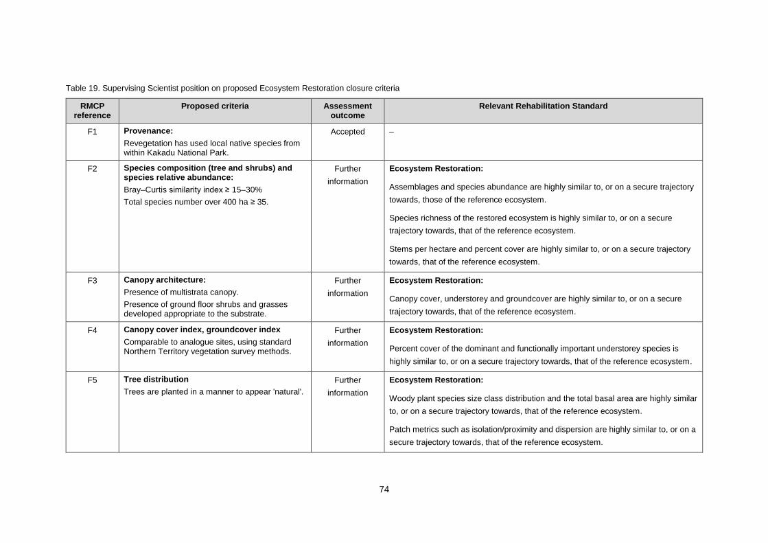
74
Table 19. Supervising Scientist position on proposed Ecosystem Restoration closure criteria
RMCP reference
Proposed criteria Assessment outcome
Relevant Rehabilitation Standard
F1 Provenance:
Revegetation has used local native species from within Kakadu National Park.
Accepted –
F2 Species composition (tree and shrubs) and species relative abundance:
Bray–Curtis similarity index ≥ 15–30%
Total species number over 400 ha ≥ 35.
Further
information
Ecosystem Restoration:
Assemblages and species abundance are highly similar to, or on a secure trajectory
towards, those of the reference ecosystem.
Species richness of the restored ecosystem is highly similar to, or on a secure
trajectory towards, that of the reference ecosystem.
Stems per hectare and percent cover are highly similar to, or on a secure trajectory
towards, that of the reference ecosystem.
F3 Canopy architecture:
Presence of multistrata canopy.
Presence of ground floor shrubs and grasses developed appropriate to the substrate.
Further
information
Ecosystem Restoration:
Canopy cover, understorey and groundcover are highly similar to, or on a secure
trajectory towards, that of the reference ecosystem.
F4 Canopy cover index, groundcover index
Comparable to analogue sites, using standard Northern Territory vegetation survey methods.
Further
information
Ecosystem Restoration:
Percent cover of the dominant and functionally important understorey species is
highly similar to, or on a secure trajectory towards, that of the reference ecosystem.
F5 Tree distribution
Trees are planted in a manner to appear 'natural'.
Further
information
Ecosystem Restoration:
Woody plant species size class distribution and the total basal area are highly similar
to, or on a secure trajectory towards, that of the reference ecosystem.
Patch metrics such as isolation/proximity and dispersion are highly similar to, or on a
secure trajectory towards, that of the reference ecosystem.
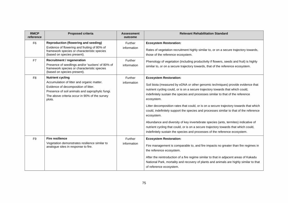
75
RMCP reference
Proposed criteria Assessment outcome
Relevant Rehabilitation Standard
F6 Reproduction (flowering and seeding)
Evidence of flowering and fruiting of 80% of framework species or characteristic species (based on species present).
Further
information
Ecosystem Restoration:
Rates of vegetation recruitment highly similar to, or on a secure trajectory towards,
those of the reference ecosystem.
Phenology of vegetation (including productivity if flowers, seeds and fruit) is highly
similar to, or on a secure trajectory towards, that of the reference ecosystem.
F7 Recruitment / regeneration
Presence of seedlings and/or 'suckers' of 80% of framework species or characteristic species (based on species present).
Further
information
F8 Nutrient cycling
Accumulation of litter and organic matter.
Evidence of decomposition of litter.
Presence of soil animals and saprophytic fungi.
The above criteria occur in 90% of the survey plots.
Further
information
Ecosystem Restoration:
Soil biota (measured by eDNA or other genomic techniques) provide evidence that
nutrient cycling could, or is on a secure trajectory towards that which could,
indefinitely sustain the species and processes similar to that of the reference
ecosystem.
Litter decomposition rates that could, or is on a secure trajectory towards that which
could, indefinitely support the species and processes similar to that of the reference
ecosystem.
Abundance and diversity of key invertebrate species (ants, termites) indicative of
nutrient cycling that could, or is on a secure trajectory towards that which could,
indefinitely sustain the species and processes of the reference ecosystem.
F9 Fire resilience
Vegetation demonstrates resilience similar to analogue sites in response to fire.
Further
information
Ecosystem Restoration:
Fire management is comparable to, and fire impacts no greater than fire regimes in
the reference ecosystem.
After the reintroduction of a fire regime similar to that in adjacent areas of Kakadu
National Park, mortality and recovery of plants and animals are highly similar to that
of reference ecosystem.

76
RMCP reference
Proposed criteria Assessment outcome
Relevant Rehabilitation Standard
F10 Resilient to wind and drought
Woodland ecosystem demonstrates survival under natural condition, similar to analogue.
Further
information
Ecosystem Restoration:
Ecosystem resilience to disturbances such as high wind and disease is highly similar
to that of reference ecosystem.
F11 Plant available water
Modelling predicts the store-release waste rock cover layer will provide sufficient plant available water for long-term vegetation growth.
Further
information
Ecosystem Restoration:
Plant available water is sufficient to sustain the species and processes similar to that
of the reference ecosystem.
The growth medium is capable of sustaining the species and processes similar to
that of the reference ecosystem.
Plant available nutrients (especially nitrogen and phosphorus) can sustain, or are on
a secure trajectory towards that which can sustain, vegetation similar to that of the
reference ecosystem.
Organic matter content can indefinitely sustain, or is on a secure trajectory towards
that which can sustain, the species and processes similar to that of the reference
ecosystem.
F12 Weed composition and abundance
No Class A weeds.
Class B weeds similar to surrounding KNP.
Presence of other introduced species would not require a maintenance regime significantly different from that appropriate to adjacent areas of KNP.
Accepted Ecosystem Restoration:
Weed composition, abundance and density no greater than that of the reference
ecosystem.
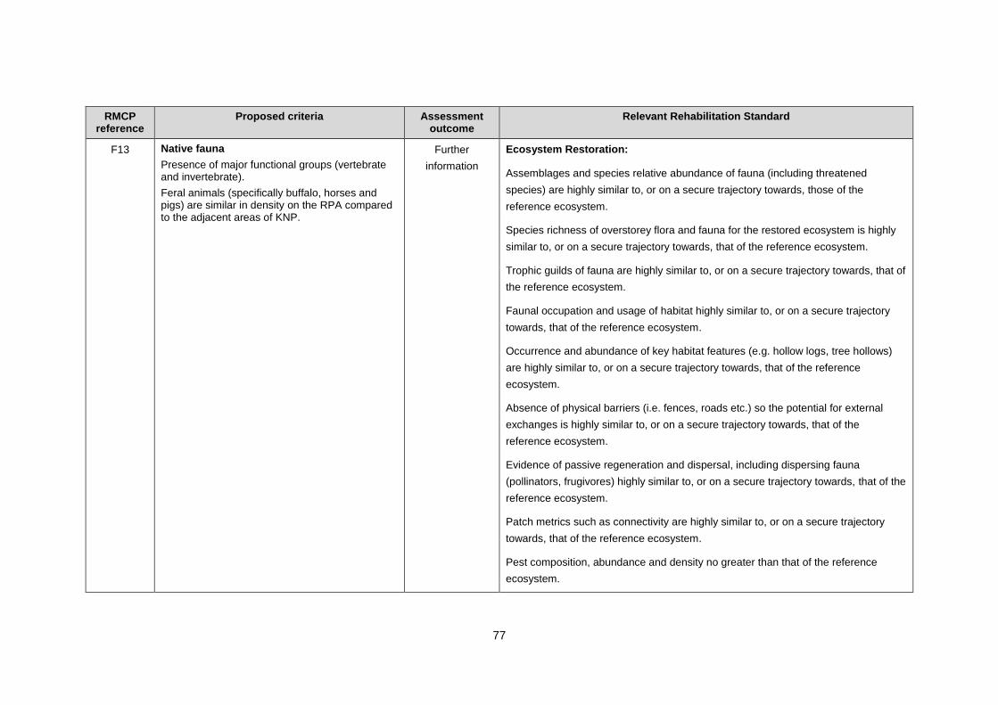
77
RMCP reference
Proposed criteria Assessment outcome
Relevant Rehabilitation Standard
F13 Native fauna
Presence of major functional groups (vertebrate and invertebrate).
Feral animals (specifically buffalo, horses and pigs) are similar in density on the RPA compared to the adjacent areas of KNP.
Further
information
Ecosystem Restoration:
Assemblages and species relative abundance of fauna (including threatened
species) are highly similar to, or on a secure trajectory towards, those of the
reference ecosystem.
Species richness of overstorey flora and fauna for the restored ecosystem is highly
similar to, or on a secure trajectory towards, that of the reference ecosystem.
Trophic guilds of fauna are highly similar to, or on a secure trajectory towards, that of
the reference ecosystem.
Faunal occupation and usage of habitat highly similar to, or on a secure trajectory
towards, that of the reference ecosystem.
Occurrence and abundance of key habitat features (e.g. hollow logs, tree hollows)
are highly similar to, or on a secure trajectory towards, that of the reference
ecosystem.
Absence of physical barriers (i.e. fences, roads etc.) so the potential for external
exchanges is highly similar to, or on a secure trajectory towards, that of the
reference ecosystem.
Evidence of passive regeneration and dispersal, including dispersing fauna
(pollinators, frugivores) highly similar to, or on a secure trajectory towards, that of the
reference ecosystem.
Patch metrics such as connectivity are highly similar to, or on a secure trajectory
towards, that of the reference ecosystem.
Pest composition, abundance and density no greater than that of the reference
ecosystem.

78
9.5.1. Criteria Terminology
In the Ecosystem Restoration (flora and fauna) closure criteria explanatory text presented in the
RMCP, there is a distinction made between critical standalone criteria and others that may be assessed
collectively, or within the context of meeting the overall closure criteria as a whole. It is not clear why some
criteria would be seen as more critical than others, as all relate to meeting the ERs and if criteria
were assessed collectively, the important detail would likely be lost. Clear justification should be
provided as to why some criteria would be more important than others.
To ensure that closure criteria for ecosystem restoration are specific and measurable, terminology
should be consistent and clearly defined, such as:
comparable to
similar to
to appear
under natural condition
adjacent areas of KNP and surrounding KNP.
There is mention of framework species in Chapter 7 of the RMCP but the composition of these species
does not appear to be reflected in the information presented in the document, or in the closure
criteria.
9.5.2. Revegetation Establishment Trajectories
Trajectories are applicable to any closure criteria that are expected to be reached after a period of
time from the initial establishment, which is the case for revegetation establishment. The trajectory
approach is based on modelling of a desired and/or expected trajectory pathway, distinguishing
the desired pathway from possible undesired states, and selecting points within the desired
trajectory that represent milestones for closure criteria.
The information drawn from previous revegetation studies should be used in the development of
a revegetation trajectory model. The model should consider scenarios that capture the key aspects
of, and influences on, revegetation establishment, and be used to identify and plan for management
of risks, and provide the basis for a targeted monitoring program. There is a need to monitor the
revegetation against closure criteria until the closure objective has been met, or until milestones
within an appropriately modelled trajectory (or trajectories) have been achieved and sufficient
confidence is gained that the desired end state will be achieved.
In the Revegetation Strategy presented in the RMCP, it is acknowledged that active management
will be required to keep revegetation on a developmental trajectory that has a predictable long-term result.
However, trajectories of possible change are not documented or presented and management
strategies to reach desired end states are not clearly articulated. The trajectory model needs to
include the uncertainty associated with the possible end states and management interventions.
The requirement for information in relation to key sustainability indicators and establishment
trajectories to measure revegetation success have been identified a KKN (EE5).
9.5.3. Vegetation Composition and Structure
For overstorey species, the RMCP proposes a Bray–Curtis similarity of ≥ 15–30 % as a closure
criterion for revegetation (Criterion F2) together with a proposed total species number criterion of
79
≥ 35. SSB does not support the numbers as currently presented noting that both metrics depend
upon the spatial scale of measurement. No understorey metrics are provided.
Species number criteria should also incorporate the structural components of vegetation
communities (i.e. understorey and overstorey), to ensure that none of these is over or under-
represented. Total species number of combined overstorey and understorey for a 4 km2 area is
estimated to be 224 from preliminary data in the surrounding environment.
For the closure criterion proposed for canopy architecture (Criterion F3), presence alone is not
sufficient to demonstrate that revegetation communities are representative of adjacent areas of
Kakadu. Criteria should be presented as ranges relative to reference sites and broken down into an
appropriate classification of strata. Also, the establishment of understorey species that are
appropriate to substrate is not consistent with the ERs that state that vegetation should be comparable
to surrounding areas.
For the closure criterion proposed for canopy and groundcover (Criterion F4), clarification is
required on what is meant by canopy/groundcover index. Foliage projective cover would generally be
considered as an appropriate measure to assess vegetation cover.
It is suggested in the RMCP that rock is considered as an understorey cover. Although rocks may
assist in erosion control, they should not be included in the assessment of whether understorey
cover on the rehabilitated site is similar to reference/analogue ecosystems.
A proposed revegetation species list (including both over- and understorey species) should be
provided.
The information requirement concerning the development of appropriate structural indicators to
measure revegetation success has been identified as a KKN (EE1).
9.5.4. Fauna
Fauna closure criteria presented in the RMCP are qualitative and based largely on one unpublished
report/study relating to revegetation, which does not incorporate major advances in fauna
sampling technology (e.g. remote cameras) in the last 20 years (Gillespie et al. 2015), and the now
well-established application of more systematic fauna sampling in KNP and elsewhere
(e.g. Woinarski et al. 2010).
The criteria refer only to major functional groups but should also include standard quantitative
biodiversity indices (e.g. species richness and abundance) that allow assessment of whether
terrestrial fauna communities on the rehabilitated site are comparable (or on a trajectory to be
comparable) with those in adjacent areas of Kakadu National Park. There is also a lack of evidence
to support the assumption that fauna will colonise the rehabilitated site once suitable habitat has
established. The requirement for information to assess the suitability of habitats on the
rehabilitated site (and inform its design) for fauna colonisation has been identified as a KKN (EE2)
and should be a key aspect of the Revegetation Strategy.
Criterion F13 should be reworded to; feral animal densities ‘not greater than’ those in surrounding
areas, as opposed to similar to those in surrounding areas.
9.5.5. Sustainability
The exclusion of 20% of plant species from the plant reproduction closure criterion (Criterion F6)
should be justified. To demonstrate that the revegetated site is comparable to adjacent areas, there
should be some consideration of the amount and periodicity of flower, fruit and seed resources
80
provided in the revegetated site, rather than simply whether there is any evidence of any flowering
or fruiting.
The closure criterion for recruitment and regeneration (Criterion F7) does not adequately capture
the process of vegetation recruitment. A seedling may be present but not survive the dry season
and hence is not recruited into the population (i.e. recruitment has not occurred). This criterion
should capture seedling germination/sucker emergence, survivorship and growth. While
understood as a general term, framework species should be clearly defined to avoid confusion.
Issues identified with the closure criterion for nutrient cycling (Criterion F8):
Relatively broad assessments are proposed for measuring nutrient cycling that only
require evidence of build-up of organic matter and decomposition, which are
essentially opposite processes.
There are no measures of uptake of nutrients and there is no assessment of what
nutrients are being cycled, which would demonstrate a functioning ecosystem.
Closure criteria should include measures of actual nutrients that are being cycled and
identify preferable organisms for nutrient cycling.
For soil biota, presence alone is not appropriate and should be relative to the
abundance of functional groups and similar to adjacent areas of Kakadu.
The requirement for the proposed criteria to be met in 90% of the survey plots is
subject to the number and location of plots and may not represent the spatial scale of
the entire minesite.
Infill planting is identified as a contingency for an absence of nutrient cycling but it is
unclear how this would address such an issue.
In relation to the closure criterion proposed for fire resilience (Criterion F9), it is not clear how
resilience would be assessed, or what an acceptable value for resilience is. It is also important to
assess how the restored vegetation community responds to fire regimes that are characteristic of
the surrounding area, rather than how it may respond to a single fire.
In addition to long-term vegetation growth, the proposed criterion for plant available water (Criterion
F11) should incorporate sustainability of a mature plant community, which would need to be
confirmed by monitoring.
9.6. Rehabilitation Monitoring
It is stated in the RMCP that a long-term vegetation and fauna monitoring program has
commenced at 17 sites, to document the condition and seasonal variation of reference sites in
adjacent areas of Kakadu and undisturbed areas of the Ranger Project Area. It is intended that
information collected from these reference site will be used to assess future rehabilitation success.
The RMCP should provide detailed information about:
justification for site selection
survey methods (including plot size) and quantitative metrics being used to assess
condition and natural variability
how the data from these surveys are being used to derive or update closure criteria.
Monitoring techniques described in the RMCP are unlikely to be sufficient to provide
comprehensive surveillance of weeds, fire and revegetation establishment on the Ranger Project
Area. Further research is required to investigate efficient and cost-effective methods that can be
81
used to measure and monitor these aspects at a landscape scale. SSB does not support the
monitoring frequency proposed in section 11.5, which suggests that after the first 5 years of annual
monitoring, the monitoring frequency should be reduced to 5-yearly intervals and weed monitoring
ceased altogether. Five-yearly monitoring will be too infrequent to detect and correct deviations
from the desired restoration trajectory in a timely manner. The monitoring program should be
developed based upon the risks and mitigations identified through a trajectory model, and include
monitoring of the progressive rehabilitation activities which have already commenced. Weed
monitoring and weed control, at some frequency, will need to continue until closure.
The overall monitoring time frame of 25 years proposed in the RMCP is reasonable but should be
extended if required. Methods for monitoring the success of ecosystem restoration should be
reviewed regularly to ensure that they are optimised and in accordance with current best practice.
The above information requirements have been identified as a KKN (EE9).
9.7. Summary of Recommendations and Additional
Comments for Ecosystem Restoration
A summary of the recommendations and additional comments discussed in this chapter is provided
in Table 20.
Table 20 Summary of recommendations and additional comments pertaining to Ecosystem Restoration
Recommendation
Before commencement of revegetation activities on the final landform ERA must address the listed
KKNs, and develop an ecosystem restoration strategy which includes consideration of both flora and
fauna (EE1, EE2, EE3 and EE4), and is based upon an appropriate trajectory model (EE5) that
accounts for key influences on revegetation establishment (EE6, EE7 and EE8).
Key Knowledge Needs to be addressed:
EE1 — Determining the characteristics of ecosystems in the areas surrounding the Ranger Project
Area.
EE2 — Determining the requirements to support a faunal community similar to areas surrounding
the Ranger Project Area.
EE3 — Understanding how to establish native vegetation, including understory species.
EE4 — Determine the density of introduced species in areas surrounding the Ranger Project Area.
EE5. Develop a revegetation trajectory for Ranger mine.
EE6 — Understanding the impact of contaminants on vegetation establishment and sustainability.
EE7 — Understanding the effect of physical and geochemical properties of waste rock on
vegetation establishment and sustainability (excluding EE7.B).
EE8 — Understanding fire resilience and management in revegetation.
In accordance with the previous recommendations of the Supervising Scientist; before the placement of the grade 1s waste rock cap on Pit 1 ERA must address the listed KKNs, and demonstrate that the waste rock landform will provide sufficient plant available water to support a mature vegetation community (EE7.B).
Key Knowledge Needs to be addressed:
EE7.B — Will sufficient plant available water be available in the final landform to support a mature
vegetation community?

82
Ecosystem Restoration
aspect
Additional comments Relevant KKN
Detailed Activity
Description
Additional information on the works proposed in the revegetation
application should include:
detailed action plans and timelines, including methods
(i.e. planting, irrigation)
seed availability and collection plan
nursery details and propagation studies
target and planned planting densities and methods (e.g. final
target density for each species)
habitat to be installed (e.g. nesting boxes, rock piles)
ongoing management activities, including weed control and infill
planting
any other project specific assumptions or information which
would be required to conduct a detailed assessment of the
activity.
EE2,
EE3, EE4
Expand the Revegetation Strategy to an ecosystem restoration
strategy.
EE1,
EE2,
EE3, EE4
Key findings and knowledge gaps should by synthesised from all
previous work, and based on this a monitoring program should
commence on the trial landform to inform the Ecosystem
Restoration Strategy.
EE2, EE3
Revegetation
Trials
Information and data from previous revegetation studies need to be
collated and incorporated into the Ecosystem Restoration Strategy,
including:
up-to-date monitoring results for the trial landform, including
monitoring of grasses and groundcover species
findings and recommendations from revegetation studies
conducted at Ranger that pre-date the trial landform
a synthesis of key findings and knowledge gaps.
EE2,
EE3, EE4
Provide information demonstrating that waste rock can maintain
long-term species diversity through recruitment and regeneration
and whether there are factors that could be manipulated to facilitate
this.
EE7
Reference Sites Provide the survey methods used for the regional vegetation survey
program.
EE1
83
Ecosystem
Restoration
Provide further information to demonstrate that sufficient seed can
be sourced to complete revegetation in the time frame required and
reach the desired end state (including the amount of seed and
resulting tube stock for each species), and consider classifying seed
availability as a Class 3 risk.
EE3
Provide information on which species are currently able to be grown
from seed, and which are not able to be successfully propagated.
EE3
Provide information on soil formation properties for each type of
waste rock to be used in landform construction, including:
weathering rates
soil texture information for the entire waste rock substrate
(i.e. not just < 2mm fraction).
EE7
Provide uncertainty analysis for all modelling undertaken in relation
to demonstrating that there will be sufficient plant available water in
the final landform.
EE7
Provide information to demonstrate that plant roots will be able to
penetrate a waste rock substrate to a sufficient depth to address
plant available water requirements, including understory species
and accounting for macropores.
EE7
Provide further evidence to support the assumption that
understorey is a minor component of evapotranspiration.
EE7
Provide evidence to demonstrate that compaction layers:
will improve the water-holding capacity of the waste rock
will not lead to other issues affecting plant growth
(e.g. physical restriction of roots, formation of perched water
tables)
EE7
Provide further information on the internal properties of the final
landform (e.g. nature, depth and extent of compacted layers), in
conjunction with a conceptual model and water balance (under a
range of rainfall scenarios) to demonstrate that there will be
sufficient water available for revegetation.
EE7
The lack of a seasonal trend in radon exhalation rates on the waste
rock-only section of the trial landform should be investigated in the
context of the ability of the waste rock substrate to retain water.
EE7
Include more relevant information on fire and plant survivability in
the region, including reference to fire severity and intensity, and
survivability of specific species.
EE8
Determine the most appropriate fire management regime to ensure
a fire resilient ecosystem on the rehabilitated site, including
reference to faunal colonisation.
EE8
Further information should be provided to explain why fire was not
classified as a class III risk.
EE8
84
Provide details on which species would be included in the
understorey (in consideration of requirements for faunal
colonisation), and evidence to support the assumption that direct
seeding is the best option for the establishment of such species.
EE3
Provide evidence to demonstrate that appropriate measures will be
taken to ensure fauna colonisation of the rehabilitated site.
EE2
Quantify the magnitude of potential sources of feral animals
(i.e. no. of animals per unit area), to allow comparison of densities
between areas inside the Ranger Project Area and adjacent areas
of Kakadu National Park.
EE2
Assess the risk of feral animals impacting on faunal colonisation of
the rehabilitated site.
EE2
Refine the vegetation mortality contingencies to consider mortality
beyond the first 6 months and the potential for mortality to vary
between species and locations.
EE3
Ecosystem
Restoration Risks
Not Assessed
Assess the risk of potential impacts of contaminants leached from
waste rock on revegetation and fauna, including details on how this
would be avoided or mitigated.
EE6,
WS9
Provide information to assess how vegetation community
development may be affected by landform stability, including re-
contouring the landform surface.
EE7
Provide information on nitrogen dynamics in the rehabilitated
landform, including an assessment of the potential for nitrogen to
be a limiting factor for nutrient cycling, and nutrient availability and
presence of soil biota to assist in plant growth.
EE7
Acknowledge that comprehensive surveys to inform the status of
weeds and feral animals will be required before and during the
rehabilitation process, including the entire Ranger Project Area and
surrounding areas.
EE4
Provide the rationale for the nominated 200 m weed buffer zone. EE4
Mitigations to address integrated landscape risks, such as weather,
should be addressed in the Ecosystem Restoration Strategy.
EE3
Closure Criteria Clearly justify why some closure criteria would be more important
than others, in relation to the Environmental Requirements.
–
Ensure that the closure criteria for ecosystem restoration use
consistent and clearly defined terminology.
–
Include a defined trajectory (or trajectories) in relation to vegetation
community establishment, using site-specific indicators relating to
ecosystem composition, structure and function.
EE5
Provide information to justify the ≥ 15–30 % similarity as the
closure criterion for species composition and relative abundance.
EE1
85
Provide information to justify the proposed total species number
closure criterion of ≥ 35.
EE1
The canopy architecture criterion (F3) should not be expressed as
presence/absence, rather should be presented as ranges and
broken down into an appropriate classification of strata.
EE1
Clarify what is meant by canopy/groundcover index in relation to
criterion F4 and do not include rocks in the assessment of
understorey cover.
EE1
A proposed revegetation species list (including both over- and
understorey species) should be provided.
EE1
Update terrestrial fauna closure criteria using data gathered with
contemporary fauna sampling methodologies.
EE2
Include standard quantitative biodiversity indices (e.g. species
richness and abundance) for fauna that allow assessment of
whether terrestrial fauna communities on the rehabilitated site are
comparable (or on a trajectory to be comparable) with those in
adjacent areas of Kakadu National Park.
EE2
Provide evidence to support the assumption that fauna will
colonise the rehabilitated site, once suitable habitat has
established.
EE2
Provide information to justify the proposed plant reproduction
closure criterion of evidence of flowering and fruiting in 80% of
species, including consideration of the amount and periodicity of
flower, fruit and seed resources provided in the revegetated site.
EE1
Criterion F7 should capture seedling germination/sucker
emergence, survivorship and growth, and the term framework
species should be clearly defined.
EE1
Criterion F13 should be reworded to; feral animal densities ‘not
greater than’ those in surrounding areas, as opposed to similar to
those in surrounding areas.
EE1
Criteria for recruitment/regeneration should capture seedling
germination/sucker emergence, survivorship and growth.
EE5
Criteria for nutrient cycling (F8) should be expanded to include a
more detailed assessment of nutrient cycling, including:
quantification of nutrients present
relative abundance for soil biota
appropriate spatial scales.
EE7

86
The criterion proposed for fire resilience should clearly detail how
resilience would be assessed and what an acceptable value for
resilience is. Consideration should also be given to how the
restored vegetation community responds to fire regimes that are
characteristic of the surrounding area, rather than how it may
respond to a single fire.
EE8
Criterion F11 (plant available water) should incorporate
sustainability of a mature plant community.
EE7
Rehabilitation
Monitoring
The vegetation and fauna monitoring program should include
detailed information about:
justification for site selection
survey methods and quantitative metrics being to assess
condition and natural variability
how the data from these surveys are being used to derive or
update closure criteria.
EE9
Revise the proposed monitoring methods and frequency based
upon the risks and mitigations identified through a trajectory model.
EE9
Weed monitoring and weed control, at some frequency, will need to
continue until closure.
EE9
87
10. Monitoring
10.1. Relevant Environmental Requirements
Under the ERs monitoring is required until site closure (Table 21). Monitoring programs must be
implemented
while undertaking rehabilitation activities to ensure continued protection of the offsite
environment and to inform the progressive rehabilitation process
after the completion of rehabilitation activities to assess and demonstrate achievement of
the rehabilitation objectives.
Monitoring related to specific themes has been discussed in more detail in the relevant
rehabilitation theme chapters.
Table 21. Ranger Environmental Requirements relevant to Monitoring
Monitoring
aspect Clause Environmental Requirement
Does RMCP
demonstrate
ER can be met?
Monitoring for
Environment
Protection
13.3
The company must carry out a monitoring program
approved by the Supervising Authority or the minister
with the advice of the Supervising Scientist following
cessation of operations until such time as a relevant
close-out certificate is issued under clause 9.3.
Further
information
required
10.2. Activity Summary
The RMCP provides a chapter on closure monitoring and maintenance which covers the period
post-2026 after the completion of rehabilitation, defined as the stabilisation and monitoring phase.
During this phase, monitoring will be used for ongoing assessment of the success of the
rehabilitation activities and enable effective implementation of an adaptive management approach
to ensure the successful transition of the site from its rehabilitation through to final closure.
These proposed activities are broadly in line with the relevant ERs. However, there is very little
discussion on monitoring to be carried out to assess potential environmental impacts of
rehabilitation activities undertaken from now until 2026, nor to monitor the success of progressive
rehabilitation works currently underway.
10.3. Detailed Works Description
The RMCP summarises the proposed post-rehabilitation monitoring programs at a high level.
Further information is required to ensure the ongoing protection of the offsite environment during
and immediately after rehabilitation and to determine whether or not the proposed monitoring is
appropriate for assessing the success of the rehabilitation objectives. It is acknowledged that ERA
is close to completing feasibility-level planning for rehabilitation and this additional detail should
be provided once available.
Additional information to be provided should include, as relevant:
detailed monitoring plans that cover and distinguish between all the necessary types and
periods of monitoring, including:
88
‘operational’ monitoring to detect potential impacts during the implementation phase of
rehabilitation
progressive rehabilitation monitoring to confirm that rehabilitated areas are performing as
expected and if necessary, inform future rehabilitation activities
monitoring to verify surface and groundwater modelling predictions
post-2026 stabilisation and maintenance phase monitoring
resources required to fulfil monitoring requirements
any other project specific assumptions or information which would be required to conduct
a detailed assessment of the appropriateness of the monitoring programs.
10.4. Monitoring for Environment Protection (ER 13.1–13.3)
Two different types of monitoring are required as part of the rehabilitation and closure process,
listed here with the applicable criteria:
1. during rehabilitation (including progressive rehabilitation) to demonstrate that site works
do not result in environmental impacts, to inform requirements for maintenance and to
inform future rehabilitation activities — operational criteria
2. after rehabilitation to validate modelling predictions and/or verify that the rehabilitation
objectives have been met — closure criteria.
The intent of the monitoring will dictate the type of monitoring required and it is recommended
that the monitoring programs be presented separately for each. Each monitoring program should
also include additional information on reporting of monitoring results. Agreement on appropriate
reporting frequencies will need to be reached, noting that annual reporting of surface water quality
monitoring results post-rehabilitation is not likely to be frequent enough.
It is accepted that monitoring effort will be reduced over time in line with reducing environmental
risk. However, any future reduction in monitoring effort should be justified with data which
demonstrate a reduction in environmental risk, rather than being based on a predetermined time
frame. The overall monitoring time frame of 25 years proposed in the RMCP is a reasonable
estimation, but in accordance with ER 13.3 it will need to continue until closure should this take
longer than 25 years.
The Supervising Scientist supports the use of the ‘trigger action response plan’ (TARP)
methodology for implementing adaptive management activities. It is noted that this approach will
only be useful in situations where effects are likely to be observed within a relatively short time
frame, as opposed to effects which may appear after hundreds or thousands of years. This approach
could be improved by:
ensuring that triggers are specific, measurable and readily linked to management actions
ensuring that actions are specific and avoid the use of generic responses such as monitor
trends and develop site-specific action plans as required
using a ‘tiered’ risk approach.
Examples of the tiered approach include:
‘first tier’ triggers that identify opportunities for closer monitoring or early intervention that
may mitigate potential impacts before significant impact to rehabilitation success, or the
environment, occurs
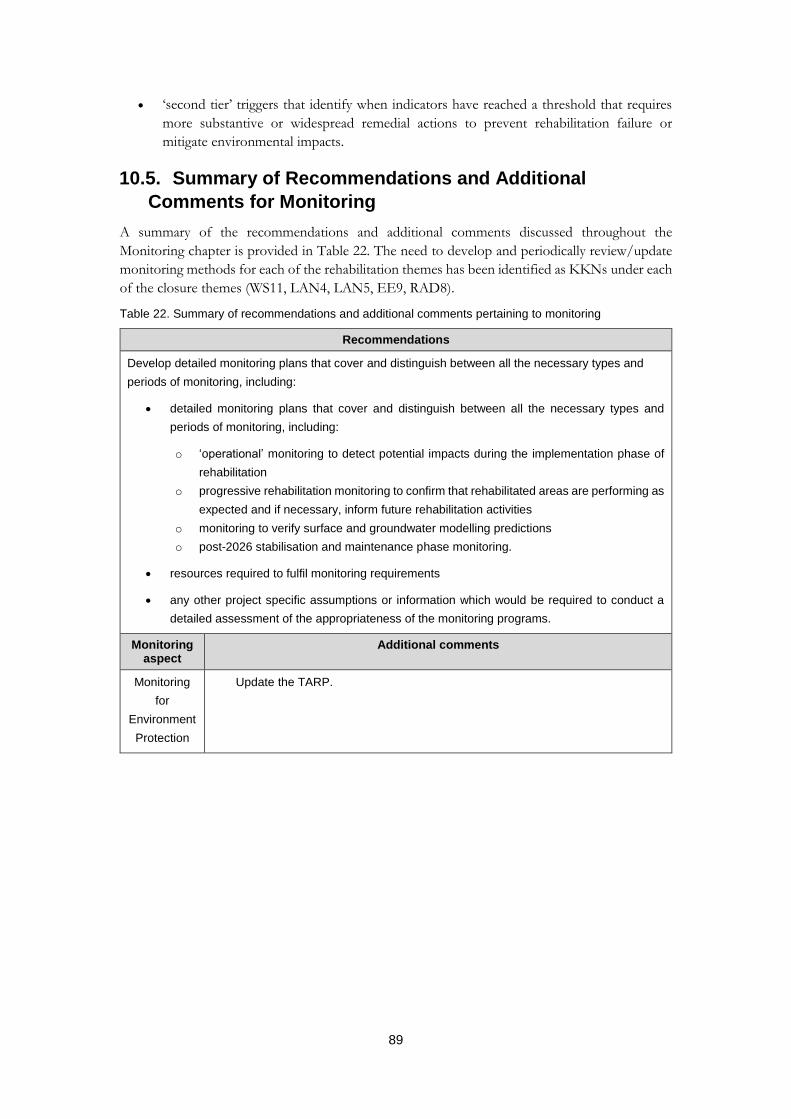
89
‘second tier’ triggers that identify when indicators have reached a threshold that requires
more substantive or widespread remedial actions to prevent rehabilitation failure or
mitigate environmental impacts.
10.5. Summary of Recommendations and Additional
Comments for Monitoring
A summary of the recommendations and additional comments discussed throughout the
Monitoring chapter is provided in Table 22. The need to develop and periodically review/update
monitoring methods for each of the rehabilitation themes has been identified as KKNs under each
of the closure themes (WS11, LAN4, LAN5, EE9, RAD8).
Table 22. Summary of recommendations and additional comments pertaining to monitoring
Recommendations
Develop detailed monitoring plans that cover and distinguish between all the necessary types and
periods of monitoring, including:
detailed monitoring plans that cover and distinguish between all the necessary types and
periods of monitoring, including:
o ‘operational’ monitoring to detect potential impacts during the implementation phase of
rehabilitation
o progressive rehabilitation monitoring to confirm that rehabilitated areas are performing as
expected and if necessary, inform future rehabilitation activities
o monitoring to verify surface and groundwater modelling predictions
o post-2026 stabilisation and maintenance phase monitoring.
resources required to fulfil monitoring requirements
any other project specific assumptions or information which would be required to conduct a
detailed assessment of the appropriateness of the monitoring programs.
Monitoring aspect
Additional comments
Monitoring
for
Environment
Protection
Update the TARP.

90
11. References
ANZECC & ARMCANZ 2000. Australian and New Zealand Guidelines for Fresh and Marine Water Quality. Australian and New Zealand Environment and Conservation Council & Agriculture and Resource Management Council of Australia and New Zealand, Canberra.
ARPANSA 2017. National Directory for Radiation Protection, June 2017. Radiation Protection Series Publication No. 6 (incorporating Amdendment 7). Australian Radiation Protection and Nuclear Saftey Agency, Miranda.
Bollhöfer A, Beraldo A, Pfitzner K, Esparon A & Doering C 2014. Determining a pre-mining radiological baseline from historic airborne gamma surveys: a case study. Science of the Total Environment 468–469, 764–773.
Doering C & Bollhöfer A 2016. A database of radionuclide activity and metal concentrations for the Alligator Rivers Region uranium province. Journal of Environmental Radioactivity 162–163, 154–159.
Eco Logical Australia (ELA). 2015. Ranger and Jabiluka Weed Management Report 2014-2015. Prepared for Energy Resources of Australia Ltd
Esslemont G 2015. Background Constituents of Potential Concern in Groundwater of the Ranger Project Area. Report by Energy Resources of Australia Ltd. Commercial in Confidence. 15 April 2016.
Esslemont G 2017. Background Constituents of Potential Concern in Groundwater of the Ranger Project Area. Report by Energy Resources of Australia Ltd. Commercial in Confidence. 18 January 2018.
Gillespie GR, Brennan K, Gentles T, Hill B, Low Choy J, Mahney T, Stevens A & Stokeld D 2015. A guide for the use of remote cameras for wildlife survey in northern Australia. Northern Australia Hub of the National Environmental Research Program, Darwin.
Garde M 2015. Closure Criteria Development — Cultural. ERA Ranger Integrated Tailings, Water and Closure. Confidential report, Darwin. April 2015.
Hutley LB, O’Grady AP & Eamus D 2001. Monsoonal influences on evapotranspiration of savanna vegetation of northern Australia. Oecologia 126 (3), 434–443.
Hutley LB & Setterfield SA 2008. Savanna. In: Encyclopedia of Ecology Vol. 4: Ecosystems, eds SE Jorgensen & BD Fath, Elsevier, Oxford.
Iles M 2004. Water quality objectives for Magela Creek — revised November 2004. Internal Report 489, Supervising Scientist, Darwin.
INTERA Incorporated. 2016. Final report: Conceptual model for Ranger mine. Report by INTERA Incorporated for Energy Resources of Australia Ltd. Commercial in Confidence. September 2016, p 1121.Lowry J 2016a. Interim ERA FLV5_02 assessment document. Letter to ERA with advice on preliminary results of long-term (10,000 years) modelling of Ranger conceptual landform. 29 January 2016.
Lowry J 2016b. Interim ERA FLV5_02 assessment suplement document. Letter to ERA with advice on preliminary results of long-term (10,000 years) modelling of Ranger conceptual landform. 3 March 2016.
Lowry J, Narayan M, Evans K & Hancock G 2017. Utilising landform evolution models to assess the long-term stability of pre- and post-mining landforms. Internal Report 647, November, Supervising Scientist, Darwin.
Ludwig F, de Kroon H, Berendse F & Prins HHT 2004. The Influence of Savanna Trees on Nutrient, Water and Light Availability and the Understorey Vegetation. Plant Ecology 170 (1), 93–105.
91
NHMRC 2008. Guidelines for Managing Risks in Recreational Water. Australian Government National Health and Medical Research Council, Canberra.
Moliere DR & Evans KG 2010. Development of trigger levels to assess catchment disturbance on stream suspended sediment loads in the Magela Creek, Northern Territory, Australia. Geographical Research, Article first published online 24 Feb 2010, DOI: 10.1111/j.1745-5871.2010.00641.x
Russell-Smith J, Whitehead PJ, Cook GD & Hoare JL 2003. Response of Eucalyptus‐dominated savanna to frequent fires: lessons from Munmarlary, 1973–1996. Ecological Monographs 73 (3), 349–375.
Scholes RJ & Archer SR 1997. Tree-grass interactions in savannas. Annual Review of Ecology & Systematics 28, 517.
Setterfield SA 1997. The impact of experimental fire regimes on seed production in two tropical eucalypt species in northern Australia. Australian Journal of Ecology 22 (3), 279–287.
Setterfield SA 2002. Seedling establishment in an Australian tropical savanna: effects of seed supply, soil disturbance and fire. Journal of Applied Ecology 39 (6), 949–959.
Shirtliff GJ 2007. The waste and low grade ore stockpiles of Ranger uranium mine — A system approach. PhD Thesis, Australian National University, Canberra
Supervising Scientist 2017. Alligator Rivers Region Technical Committee: Key Knowledge Needs: Uranium Mining in the Alligator Rivers Region. Supervising Scientist Report 213, Supervising Scientist, Darwin.
Turner K, Tayler K & Costar A 2017. Assessment Report: Ranger Pit 1 Final Tailings Deposition Level to +7 mRL. Internal Report 651, January, Supervising Scientist, Darwin.
Werner PA 2005. Impact of feral water buffalo and fire on growth and survival of mature savanna trees: an experimental field study in Kakadu National Park, northern Australia. Austral Ecology 30 (6), 625–647.
Werner PA & Prior LD 2013. Demography and growth of subadult savanna trees: interactions of life history, size, fire season, and grassy understory. Ecological Monographs 83 (1), 67–93.
Williams R, Cook G, Gill A & Moore P 1999. Fire regime, fire intensity and tree survival in a tropical savanna in northern Australia. Australian Journal of Ecology 24 (1), 50–59.
Woinarski JCZ, Armstrong M, Brennan K, Fisher A, Griffiths AD, HillB, Milne DJ, Palmer C, Ward S, Watson M, Winderlich S & Young S 2010. Monitoring indicates rapid and severe decline of native small mammals in Kakadu National Park, northern Australia. Wildlife Research 37, 116–126.

Appendix 1 — List of Acronyms
AALL annual additional load limits
Ac actinium
ALARA as low as reasonably achievable
APR Annual Plan of Rehabilitation
ARR Alligator Rivers Region
ARRTC Alligator Rivers Region Technical Committee
BPT best practicable technology
EIL ecological investigation level
ER Environmental Requirements of the Commonwealth of Australia for the Operation of Ranger Uranium Mine, attached to the Ranger Authority issued under s 41 of the Atomic Energy Act 1953
ERA Energy Resources of Australia Ltd
GCH Gulungul Creek at Arnhem Highway
GCMBL Georgetown Creek median bund level-line
GCT2 Gulungul Creek Tributary 2
KKN Key Knowledge Need
LAA land application area
NTU nephelometric turbidity unit
Ramsar The Ramsar Convention on Wetlands, an intergovernmental treaty that provides the framework for national action and international cooperation for the conservation and wise use of wetlands and their resources
RMCP Ranger Mine Closure Plan
RP1/RP2/RP3 Retention Pond 1/Retention Pond 2/Retention Pond 3
RPA Ranger Project Area
SSB Supervising Scientist Branch
TARP trigger action response plan
Tailings Storage Facility Tailings Storage Facility (dam)
U uranium

Appendix 2 – The Supervising Scientist’s Key Knowledge Needs

Landform
KKN No.
ER Link Category Title Questions
LAN1 Erosion Baseline LAN1. Determining baseline erosion and sediment transport characteristics in areas surrounding the Ranger Project Area
LAN1A. What is the baseline rate of gully formation for areas surrounding the Ranger Project Area?
LAN1B. What is the baseline rate of bedload movement and deposition in creeks and billabongs?
LAN2 Erosion Baseline LAN2. Understanding the landscape-scale processes and extreme events affecting landform stability
LAN2A. What major landscape-scale processes could impact the stability of the rehabilitated landform (e.g. fire, extreme events, climate)?
LAN2B. How will these landscape-scale processes impact the stability of the rehabilitated landform (e.g. mass failure, subsidence)?
LAN3 Erosion Predicting LAN3. Predicting erosion of the rehabilitated landform LAN3A. What is the optimal landform shape and surface (e.g. riplines, substrate characteristics) that will minimise erosion?
LAN3B. Where and how much consolidation will occur on the landform?
LAN3C. How can we optimise the landform evolution model to predict the erosion characteristics of the final landform (e.g. refining parameters, validation using bedload, suspended sediment and erosion measurements, quantification of uncertainty and modelling scenarios)?
LAN3D. What are erosion characteristics of the final landform under a range of modelling scenarios (e.g. location, extent, time frame, groundwater expression and effectiveness of mitigations)?
LAN3E. How much suspended sediment will be transported from the rehabilitated site (including LAAs) by surface water?
LAN4 Erosion Monitoring LAN4. Development of remote sensing methods for monitoring erosion
LAN4A. How do we optimise methods to measure gully formation on the rehabilitated landform?
LAN4B. What monitoring data are required for ongoing LEM validation?
LAN5 Erosion Monitoring LAN5. Development of water quality monitoring methods for assessing landform erosion
LAN5A. How can we use suspended sediment in surface water (or turbidity as a surrogate) as an indicator for erosion on the final landform?
Water and Sediment
KKN No.
ER Link Category Title Questions
WS1 Biodiversity and ecosystem
health
Source WS1. Characterising contaminant sources on the Ranger Project Area
WS1A. What contaminants (including nutrients) are present on the rehabilitated site (e.g. LAAs, contaminated soils and groundwater, tailings and waste rock)?
WS1B. What are the factors that influence the mobilisation of contaminants?
WS2 Biodiversity and
ecosystem health
Pathway WS2. Predicting transport of contaminants in groundwater
WS2A. What is the nature and extent of groundwater movement, now and over the long term?
WS2B. What are the factors that influence contaminant (including nutrients) transport and toxicity in groundwater?
WS2C. What are predicted contaminant (including nutrients) concentrations in groundwater over time?
WS3 Biodiversity and ecosystem
health
Pathway WS3. Predicting transport of contaminants in surface water
WS3A. What is the nature and extent of surface water movement, now and over the long term?
WS3B. What are the factors that influence contaminant (including nutrients) transport and toxicity in surface water?
WS3C. Where and when does groundwater discharge to surface water?
WS3D. What influences the movement of contaminants (including nutrients) between groundwater and surface water?
WS3E. What are predicted contaminant (including nutrients and contaminants bound to sediment) and suspended sediment concentrations in surface waters over time?
WS3F. To what extent will the mobilisation of contaminants from sediment influence surface water quality?
WS3G. Where, when and to what extent will contaminants accumulate in downstream sediments?
WS4 Biodiversity and ecosystem
health
Receptor WS4. Characterising baseline aquatic biodiversity and ecosystem health
WS4A. What are the nature and extent of baseline surface water, hyporheic and stygofauna communities, as well as other groundwater dependent ecosystems, and their associated environmental conditions?
WS5 Biodiversity and ecosystem
health
Receptor WS5. Determining the impact of contaminated sediments on aquatic biodiversity and ecosystem health
WS5A. To what extent will contaminants accumulate in sediments over time, including the development of acid sulfate sediments?
WS5B. What are the factors that influence the toxicity of contaminants in sediment?
WS5C. What is the impact of contaminated sediments to aquatic ecosystems?
WS6 Biodiversity and ecosystem
health
Receptor WS6. Determining the impact of nutrients on aquatic biodiversity and ecosystem health
WS6A. What is the toxicity of ammonia to local aquatic species, considering varying local conditions (e.g. pH and temperature)?
WS6B. Can annual additional load limits (AALL) be used to inform ammonia closure criteria?
WS6C. Will the total loads of nutrients (N and P) to surface waters represent a eutrophication risk?
WS7 Biodiversity and ecosystem
health
Receptor WS7. Determining the impact of chemical contaminants on aquatic biodiversity and ecosystem health
WS7A. Are current guideline values appropriate given the potential for variability in toxicity due to mixtures and modifying factors?
WS7B. Are there any emerging contaminants that have not yet been identified as a risk?
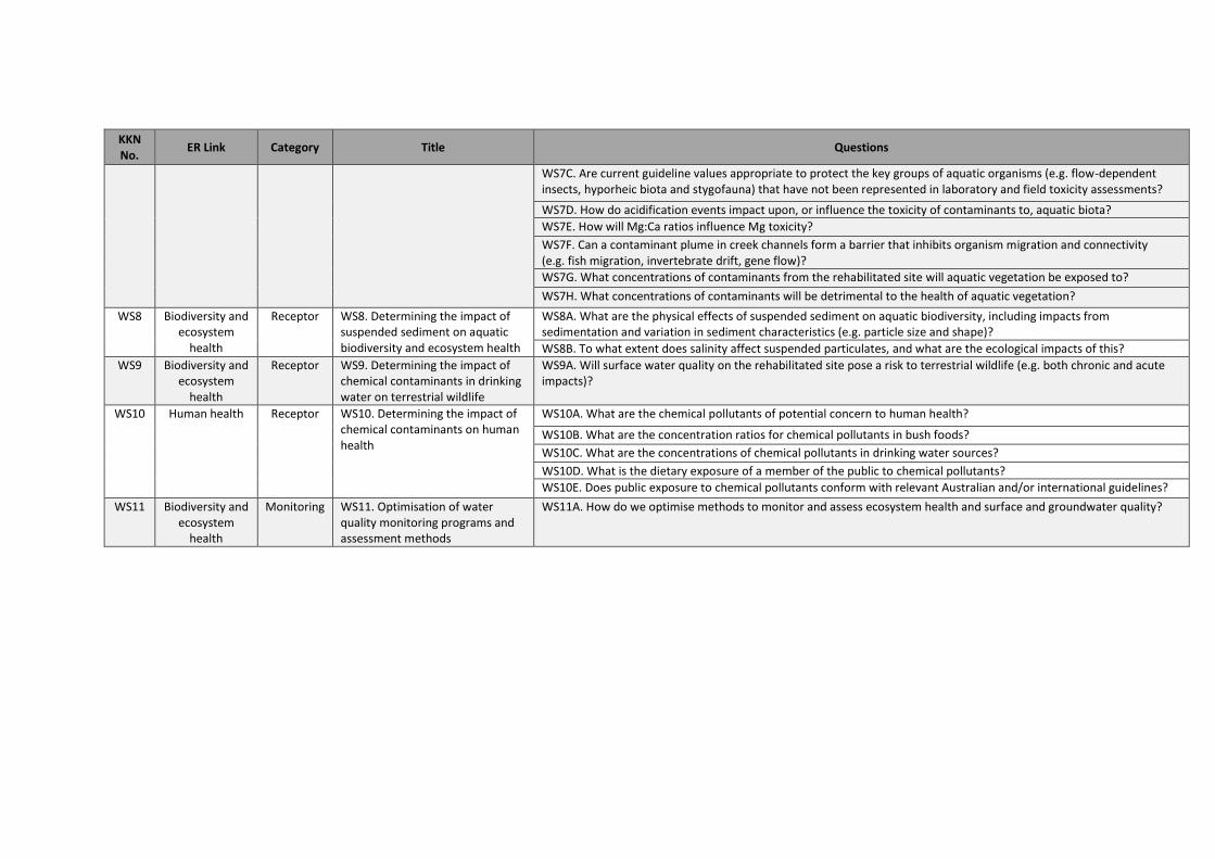
KKN No.
ER Link Category Title Questions
WS7C. Are current guideline values appropriate to protect the key groups of aquatic organisms (e.g. flow-dependent insects, hyporheic biota and stygofauna) that have not been represented in laboratory and field toxicity assessments?
WS7D. How do acidification events impact upon, or influence the toxicity of contaminants to, aquatic biota?
WS7E. How will Mg:Ca ratios influence Mg toxicity?
WS7F. Can a contaminant plume in creek channels form a barrier that inhibits organism migration and connectivity (e.g. fish migration, invertebrate drift, gene flow)?
WS7G. What concentrations of contaminants from the rehabilitated site will aquatic vegetation be exposed to?
WS7H. What concentrations of contaminants will be detrimental to the health of aquatic vegetation?
WS8 Biodiversity and ecosystem
health
Receptor WS8. Determining the impact of suspended sediment on aquatic biodiversity and ecosystem health
WS8A. What are the physical effects of suspended sediment on aquatic biodiversity, including impacts from sedimentation and variation in sediment characteristics (e.g. particle size and shape)?
WS8B. To what extent does salinity affect suspended particulates, and what are the ecological impacts of this?
WS9 Biodiversity and ecosystem
health
Receptor WS9. Determining the impact of chemical contaminants in drinking water on terrestrial wildlife
WS9A. Will surface water quality on the rehabilitated site pose a risk to terrestrial wildlife (e.g. both chronic and acute impacts)?
WS10 Human health Receptor WS10. Determining the impact of chemical contaminants on human health
WS10A. What are the chemical pollutants of potential concern to human health?
WS10B. What are the concentration ratios for chemical pollutants in bush foods?
WS10C. What are the concentrations of chemical pollutants in drinking water sources?
WS10D. What is the dietary exposure of a member of the public to chemical pollutants?
WS10E. Does public exposure to chemical pollutants conform with relevant Australian and/or international guidelines?
WS11 Biodiversity and ecosystem
health
Monitoring WS11. Optimisation of water quality monitoring programs and assessment methods
WS11A. How do we optimise methods to monitor and assess ecosystem health and surface and groundwater quality?
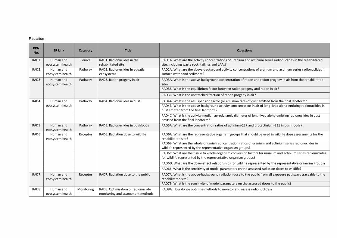
Radiation
KKN No.
ER Link Category Title Questions
RAD1 Human and ecosystem health
Source RAD1. Radionuclides in the rehabilitated site
RAD1A. What are the activity concentrations of uranium and actinium series radionuclides in the rehabilitated site, including waste rock, tailings and LAAs?
RAD2 Human and ecosystem health
Pathway RAD2. Radionuclides in aquatic ecosystems
RAD2A. What are the above-background activity concentrations of uranium and actinium series radionuclides in surface water and sediment?
RAD3 Human and ecosystem health
Pathway RAD3. Radon progeny in air RAD3A. What is the above-background concentration of radon and radon progeny in air from the rehabilitated site?
RAD3B. What is the equilibrium factor between radon progeny and radon in air?
RAD3C. What is the unattached fraction of radon progeny in air?
RAD4 Human and ecosystem health
Pathway RAD4. Radionuclides in dust RAD4A. What is the resuspension factor (or emission rate) of dust emitted from the final landform?
RAD4B. What is the above-background activity concentration in air of long-lived alpha-emitting radionuclides in dust emitted from the final landform?
RAD4C. What is the activity median aerodynamic diameter of long-lived alpha-emitting radionuclides in dust emitted from the final landform?
RAD5 Human and ecosystem health
Pathway RAD5. Radionuclides in bushfoods RAD5A. What are the concentration ratios of actinium-227 and protactinium-231 in bush foods?
RAD6 Human and ecosystem health
Receptor RAD6. Radiation dose to wildlife RAD6A. What are the representative organism groups that should be used in wildlife dose assessments for the rehabilitated site?
RAD6B. What are the whole-organism concentration ratios of uranium and actinium series radionuclides in wildlife represented by the representative organism groups?
RAD6C. What are the tissue to whole-organism conversion factors for uranium and actinium series radionuclides for wildlife represented by the representative organism groups?
RAD6D. What are the dose–effect relationships for wildlife represented by the representative organism groups?
RAD6E. What is the sensitivity of model paramaters on the assessed radiation doses to wildlife?
RAD7 Human and ecosystem health
Receptor RAD7. Radiation dose to the public RAD7A. What is the above-background radiation dose to the public from all exposure pathways traceable to the rehabilitated site?
RAD7B. What is the sensitivity of model paramaters on the assessed doses to the public?
RAD8 Human and ecosystem health
Monitoring RAD8. Optimisation of radionuclide monitoring and assessment methods
RAD8A. How do we optimise methods to monitor and assess radionuclides?
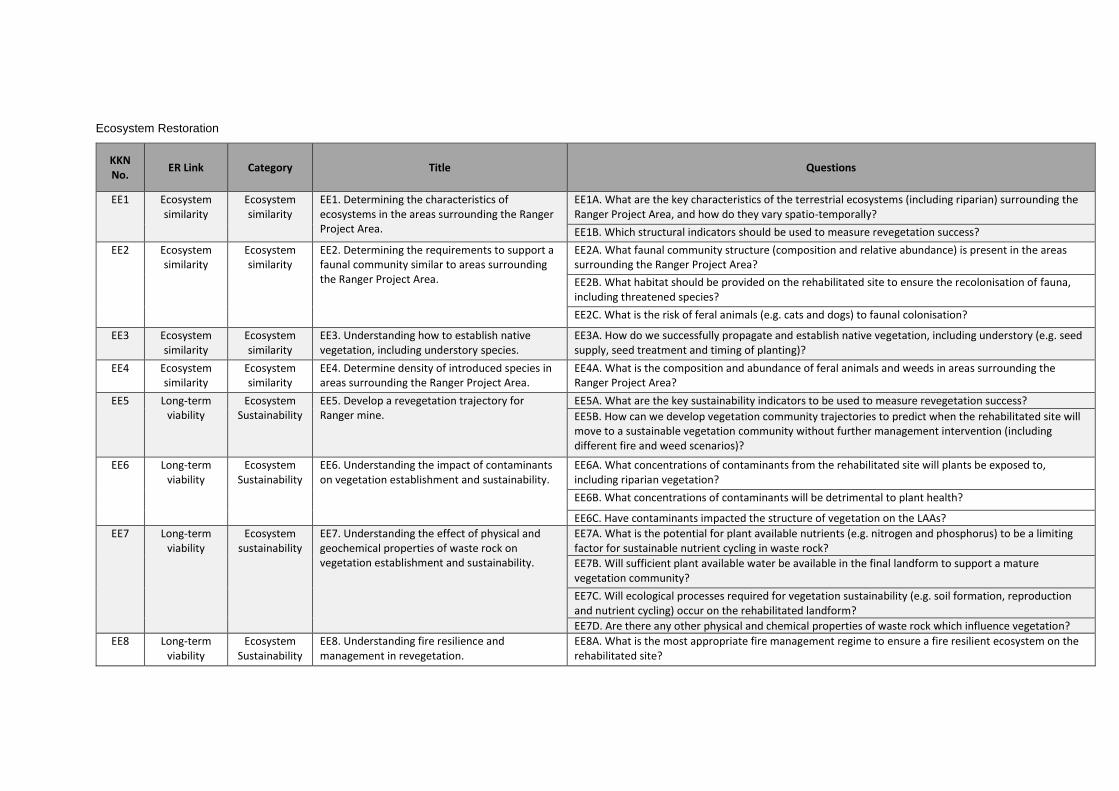
Ecosystem Restoration
KKN No.
ER Link Category Title Questions
EE1 Ecosystem similarity
Ecosystem similarity
EE1. Determining the characteristics of ecosystems in the areas surrounding the Ranger Project Area.
EE1A. What are the key characteristics of the terrestrial ecosystems (including riparian) surrounding the Ranger Project Area, and how do they vary spatio-temporally?
EE1B. Which structural indicators should be used to measure revegetation success?
EE2 Ecosystem similarity
Ecosystem similarity
EE2. Determining the requirements to support a faunal community similar to areas surrounding the Ranger Project Area.
EE2A. What faunal community structure (composition and relative abundance) is present in the areas surrounding the Ranger Project Area?
EE2B. What habitat should be provided on the rehabilitated site to ensure the recolonisation of fauna, including threatened species?
EE2C. What is the risk of feral animals (e.g. cats and dogs) to faunal colonisation?
EE3 Ecosystem similarity
Ecosystem similarity
EE3. Understanding how to establish native vegetation, including understory species.
EE3A. How do we successfully propagate and establish native vegetation, including understory (e.g. seed supply, seed treatment and timing of planting)?
EE4 Ecosystem similarity
Ecosystem similarity
EE4. Determine density of introduced species in areas surrounding the Ranger Project Area.
EE4A. What is the composition and abundance of feral animals and weeds in areas surrounding the Ranger Project Area?
EE5 Long-term viability
Ecosystem Sustainability
EE5. Develop a revegetation trajectory for Ranger mine.
EE5A. What are the key sustainability indicators to be used to measure revegetation success?
EE5B. How can we develop vegetation community trajectories to predict when the rehabilitated site will move to a sustainable vegetation community without further management intervention (including different fire and weed scenarios)?
EE6 Long-term viability
Ecosystem Sustainability
EE6. Understanding the impact of contaminants on vegetation establishment and sustainability.
EE6A. What concentrations of contaminants from the rehabilitated site will plants be exposed to, including riparian vegetation?
EE6B. What concentrations of contaminants will be detrimental to plant health?
EE6C. Have contaminants impacted the structure of vegetation on the LAAs?
EE7 Long-term viability
Ecosystem sustainability
EE7. Understanding the effect of physical and geochemical properties of waste rock on vegetation establishment and sustainability.
EE7A. What is the potential for plant available nutrients (e.g. nitrogen and phosphorus) to be a limiting factor for sustainable nutrient cycling in waste rock?
EE7B. Will sufficient plant available water be available in the final landform to support a mature vegetation community?
EE7C. Will ecological processes required for vegetation sustainability (e.g. soil formation, reproduction and nutrient cycling) occur on the rehabilitated landform?
EE7D. Are there any other physical and chemical properties of waste rock which influence vegetation?
EE8 Long-term viability
Ecosystem Sustainability
EE8. Understanding fire resilience and management in revegetation.
EE8A. What is the most appropriate fire management regime to ensure a fire resilient ecosystem on the rehabilitated site?
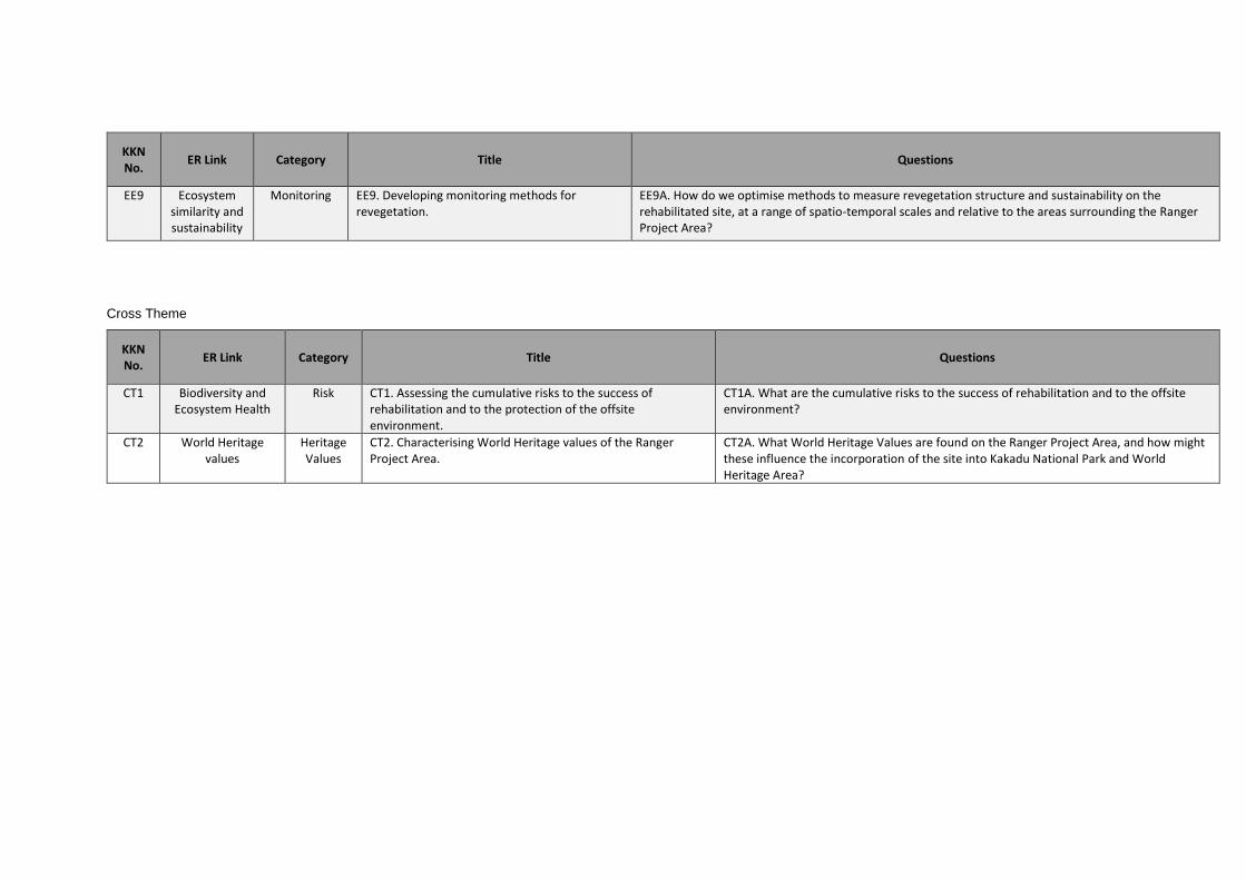
KKN No.
ER Link Category Title Questions
EE9 Ecosystem similarity and sustainability
Monitoring EE9. Developing monitoring methods for revegetation.
EE9A. How do we optimise methods to measure revegetation structure and sustainability on the rehabilitated site, at a range of spatio-temporal scales and relative to the areas surrounding the Ranger Project Area?
Cross Theme
KKN No.
ER Link Category Title Questions
CT1 Biodiversity and Ecosystem Health
Risk CT1. Assessing the cumulative risks to the success of rehabilitation and to the protection of the offsite environment.
CT1A. What are the cumulative risks to the success of rehabilitation and to the offsite environment?
CT2 World Heritage values
Heritage Values
CT2. Characterising World Heritage values of the Ranger Project Area.
CT2A. What World Heritage Values are found on the Ranger Project Area, and how might these influence the incorporation of the site into Kakadu National Park and World Heritage Area?