Summary of Information for Assessing the Status of the Tooth Cave
81
STATUS OF THE TOOTH CAVE GROUND BEETLE TITLE PAGE HNTB CORPORATION JUNE 2005 Summary of Information for Assessing the Status of the Tooth Cave Ground Beetle (Rhadine persephone) 16 June 2005
Transcript of Summary of Information for Assessing the Status of the Tooth Cave

STATUS OF THE TOOTH CAVE GROUND BEETLE TITLE PAGE
HNTB CORPORATION JUNE 2005
Summary of Information for Assessing the Status of the Tooth Cave Ground Beetle
(Rhadine persephone)
16 June 2005

STATUS OF THE TOOTH CAVE GROUND BEETLE EXECUTIVE SUMMARY
HNTB CORPORATION i JUNE 2005
EXECUTIVE SUMMARY This report summarizes data for assessing the status of the Tooth Cave ground beetle (Rhadine persephone), a federally listed endangered species. Only the U.S. Fish and Wildlife Service (USFWS) can determine the recovery and regulatory status of this species, and this report is intended as tool for assessing both. Data reviewed for this report were gleaned from USFWS files; additional information was obtained from the Mike Walsh (Texas Cave Conservancy), James R. Reddell (Texas Memorial Museum, The University of Texas as Austin), Mark Sanders (City of Austin), and Rose Farmer (Travis County). The Tooth Cave ground beetle was listed as a federally endangered species in 1988. Threats facing the species are associated primarily with human activities, especially urban development. In 1994 the USFWS prepared a Recovery Plan for this species and several other endangered karst invertebrate species. At that time the USFWS believed that the prospect for complete recovery and delisting of Tooth Cave ground beetles was uncertain. The Recovery Plan includes recovery criteria that should be met in order for Tooth Cave ground beetles to be considered for downlisting from endangered to threatened. The recovery criteria are intended to serve as recommendations and are not mandatory steps toward achieving downlisting or recovery. The recovery criteria include the recommendation that multiple karst fauna areas (KFAs) should be protected in each karst fauna region (KFR) within the species’ range. Tooth Cave ground beetles were known from only two caves when listed as endangered. The Recovery Plan lists the species as occurring in 23 karst features and tentatively identified from another four. For this report, “confirmed” records of Tooth Cave ground beetle occurrence were defined as those for which documentation apparently attributable to James R. Reddell was found in USFWS files and for which Mr. Reddell provided confirmation specific to this report; “tentative” records of occurrence are those for which either but not both forms of confirmation were obtained. Based on these definitions, Tooth Cave ground beetles have been confirmed from 46 karst features and are tentatively confirmed from another six features. Most of these features are in Williamson County and the Cedar Park KFR; the Jollyville Plateau KFR is the only other KFR from which confirmed or tentative records of occurrence are documented. Five karst features from which Tooth Cave ground beetles have not been collected have been referred to as, or implied to contain, potential habitat for the species. One of these features is in the McNeil/Round Rock KFR and the other four are in the Cedar Park KFR. The occurrence of troglobitic species was most often cited as an indicator for the potential presence of Tooth Cave ground beetles. An un-described Rhadine species, often referred to as “Rhadine new species” or something similar, is reported from 36 karst features mostly located in Williamson County and in the Cedar Park KFR. Nineteen of these features are confirmed or tentatively confirmed Tooth Cave ground beetle collection locations. Some collections

STATUS OF THE TOOTH CAVE GROUND BEETLE EXECUTIVE SUMMARY
HNTB CORPORATION ii JUNE 2005
formerly assigned to “Rhadine ?subterranea” may now be considered Rhadine new species. Of the 57 karst features considered as confirmed or tentatively confirmed Tooth Cave ground beetle collection sites, or considered as containing habitat potentially suitable for the species, three features are destroyed and 48 features are within 27 preserves or tracts managed at least in part to protect Tooth Cave ground beetles. Preserve size varies considerably; the largest preserve discussed in this report occupies about 494 acres and the smallest occupies about 0.05 acres. One tract of land owned by Travis County and containing two of the cave entrances is only about 0.0057 acres and is completely surrounded by privately owned land. Tooth Cave ground beetle preserve and tract owners include public and private entities, and the management of beetle caves and habitats varies. In the Cedar Park KFR, 33 caves considered as confirmed or tentatively confirmed Tooth Cave ground beetle collection sites, or considered as containing habitat potentially suitable for the species, are contained within 17 preserves managed at least in part for the protection of the species. Tooth Cave ground beetles have reportedly been observed as recently as 2003 in eight of the Cedar Park KFR caves. In the Jollyville Plateau KFR, 15 caves considered as confirmed or tentatively confirmed Tooth Cave ground beetle collection sites, or considered as containing habitat potentially suitable for the species, are contained within 10 preserves, setbacks, or parcels managed at least in part for the protection of the species. Tooth Cave ground beetles have reportedly been observed as recently as December 2004 in one of the Jollyville Plateau KFR caves. Documents found in USFWS files suggest that nine KFAs known to contain Tooth Cave ground beetles have been delineated to some extent. Six of these possible KFAs are located in the Cedar Park KFR and three are in the Jollyville Plateau KFR. Documentation and references for these claims are typically not provided, but most of these claims appear to be based solely on hydrogeologic studies. While some of these studies do suggest that specific karst features are not connected and probably occur in separate KFAs, no study describing the delineation of a KFA’s full subsurface and surface extents as described in the Recovery Plan was found in USFWS files. None of the nine possible KFAs appear to have been delineated in a manner consistent with the description of KFAs provided in the Recovery Plan.
ACKNOWLEDGEMENTS The staff of the USFWS Austin, Texas, Ecological Services Field Office provided office space, access to files and information, and extensive guidance necessary to complete this report. Invaluable information was provided by Mike Walsh (Texas Cave Conservancy), James R. Reddell (Texas Memorial Museum, The University of Texas as Austin), Mark Sanders (City of Austin), and Rose Farmer (Travis County). The author (Casey Berkhouse, HNTB Corp.) expresses his sincere appreciation to the people listed here.

STATUS OF THE TOOTH CAVE GROUND BEETLE TABLE OF CONTENTS
HNTB CORPORATION. iii JUNE 2005
Table of Contents Executive Summary ....................................................................................................... i
Acknowledgements ....................................................................................................... ii
Table of Contents ......................................................................................................... iii
List of Tables .................................................................................................................. v
Section 1 Introduction and Purpose ........................................................................... 1
Section 2 Background 2.1 Introduction ................................................................................................. 2 2.2 Life History .................................................................................................. 2 2.3 Habitat Requirements................................................................................. 2 2.4 Listing History ............................................................................................. 3 2.5 Review History ............................................................................................ 3 2.6 Recovery Plan .............................................................................................. 3
2.6.1 Threats .............................................................................................. 4 2.6.2 Recovery Criteria............................................................................. 4
Section 3 Records of Occurrence for Tooth Cave Ground Beetles 3.1 Introduction ................................................................................................. 6 3.2 Methods ........................................................................................................ 8 3.3 Findings ........................................................................................................ 8 3.4 Section 3 Summary ................................................................................... 17
Section 4 Karst Features Noted as Containing Potential Habitat for Tooth Cave Ground Beetles
4.1 Introduction ............................................................................................... 21 4.2 Methods ...................................................................................................... 21 4.3 Findings ...................................................................................................... 22 4.4 Section 4 Summary ................................................................................... 23
Section 5 Records of Occurrence for the Un-described Rhadine new species 5.1 Introduction ............................................................................................... 25 5.2 Methods ...................................................................................................... 25 5.3 Findings ...................................................................................................... 26 5.4 Section 5 Summary ................................................................................... 29
Section 6 Status of Karst Features that are Confirmed or Tentatively Confirmed Tooth Cave Ground Beetle Collection Sites or are Reported as Containing Habitat Potentially Suitable for the Species
6.1 Introduction ............................................................................................... 30 6.2 Methods ...................................................................................................... 30 6.3 Findings ...................................................................................................... 30
6.3.1 Big Oak, Jug, and Raccoon Caves ................................................ 30 6.3.2 Buttercup Creek Habitat Conservation Plan (HCP) Caves....... 33 6.3.3 Crumley’s Cave .............................................................................. 38 6.3.4 Discovery Well Cave Preserve Caves ........................................... 39

STATUS OF THE TOOTH CAVE GROUND BEETLE TABLE OF CONTENTS
HNTB CORPORATION. iv JUNE 2005
(Table of Contents continued)
6.3.5 Fall Creek, Marigold Cave, Primrose Cave, and Wilcox Karst Preserves .............................................................................. 41 6.3.6 Four Points HCP Caves................................................................. 42 6.3.7 Homestead Cave............................................................................. 45 6.3.8 Jollyville Jewel Cave ...................................................................... 45 6.3.9 Lakeline Cave and Lakeline Mall Well Trap No. 6 .................... 45 6.3.10 Lamm and Stovepipe Caves .......................................................... 46 6.3.11 Lime Creek Preserve ..................................................................... 47 6.3.12 Recently Acquired Travis County Caves..................................... 48 6.3.13 Spider Cave on the Park West Preserve Tract ........................... 49 6.3.14 Testudo Tube Cave Preserve ........................................................ 49
6.4 Section 6 Summary ................................................................................... 50 6.4.1 Cedar Park KFR ............................................................................ 50 6.4.2 Jollyville Plateau KFR ................................................................... 53 6.4.3 McNeil/Round Rock KFR ............................................................. 54 6.4.4 Cave Preserves ............................................................................... 55
Section 7 Karst Fauna Areas 7.1 Introduction ............................................................................................... 56 7.2 Methods ...................................................................................................... 58 7.3 Findings ...................................................................................................... 58 7.4 Section 7 Summary ................................................................................... 63
Section 8 Recommendations 8.1 Introduction ............................................................................................... 65 8.2 Procedure for Authenticating Collection Records ................................. 65 8.3 Define the Status of Potential KFAs ........................................................ 66 8.4 Monitor Tooth Cave Ground Beetle Populations .................................. 66 8.5 Assess Tooth Cave Ground Beetle Potential Habitat............................. 66 8.6 Use Cave and Cave Preserve Monitoring to Research Conservation of Tooth Cave Ground Beetles ......................................... 67 8.7 Review Cave and Cave Preserve Management Reports in the Context of the Permit-related Documentation ....................................... 67
Section 9 Literature Cited ......................................................................................... 68

STATUS OF THE TOOTH CAVE GROUND BEETLE LIST OF TABLES
HNTB CORPORATION. v JUNE 2005
List of Tables Table 3.1 – Karst features considered in the Recovery Plan for Endangered Karst Invertebrates in Travis and Williamson Counties, Texas (USFWS 1994a) as containing Tooth Cave ground beetles or from which the species had been tentatively identified. ................................................................................................................. 7
Table 3.2 – Karst features identified in U.S. Fish and Wildlife Service (USFWS) files and/or considered by Texas Cave Conservancy (TCC) as containing or possibly containing Tooth Cave ground beetles. ................................................................... 9
Table 3.3 – Status of records of occurrence for Tooth Cave ground beetles...................... 19
Table 5.1 – Karst features from which an un-described Rhadine species which may by “Rhadine new species” has reportedly been collected. Underlined karst features are those for which confirmed or tentative records of Tooth Cave ground beetle occurrence also exist (see Section 3 of this report). ...................................... 27
Table 6.1 – Karst features for which records of Tooth Cave ground beetle occurrence have been confirmed or tentatively confirmed, or which have been described as containing potential habitat for Tooth Cave ground beetles. ........................ 31
Table 6.2 – Cave preserve areas established as part of the Buttercup Creek Habitat Conservation Plan (HCP); this HCP (USFWS 1999) was created in support of issuance of an Endangered Species Act Section 10(a)(1)(B) incidental take permit (permit number PRT 836384)............................................................................ 35
Table 6.3 – Caves of the Discovery Well Cave Preserve. ..................................................... 39
Table 6.4 – Caves of the Fall Creek, Marigold Cave, Primrose Cave, and Wilcox Karst preserves. ....................................................................................................................... 42
Table 6.5 – High density cave area preserved as part of the Four Points Habitat Conservation Plan (HCP). This HCP was created in support of issuance of an Endangered Species Act Section 10(a)(1)(B) incidental take permit (permit number PRT 808694); see Section 6.3 of this report and USFWS (1995 and 2001b) for additional information.......................................................................................... 43
Table 6.6 – Status of caves within the Cedar Park KFR that are confirmed or tentatively confirmed Tooth Cave ground beetle collection sites, or are believed to contain habitat potentially suitable for the species. ......................................................... 51
Table 6.7 – Status of caves within the Jollyville Plateau KFR that are confirmed or tentatively confirmed Tooth Cave ground beetle collection sites, or are believed to contain habitat potentially suitable for the species. .......................................... 53

STATUS OF THE TOOTH CAVE GROUND BEETLE SECTION 1
HNTB CORPORATION. 1 JUNE 2005
Summary of Information for Assessing the Status of the Tooth Cave Ground Beetle
(Rhadine persephone) Section 1 Introduction and Purpose Seven species of cave-dwelling invertebrates believed to be endemic to Travis and/or Williamson counties, Texas, are listed by the U.S. Fish and Wildlife Service (USFWS) as endangered under the Endangered Species Act of 1973, as amended (ESA). These species are known from only caves and subterranean voids associated with karst terrain of the Edwards Plateau. Specific habitat requirements for these species are not well documented but the species are most often observed in dark zones of caves (occasionally in areas of very subdued lighting) where temperature and high relative humidity (approaching 100 percent) are somewhat constant. The purpose of this report is to summarize data relevant for assessing the status of one of these species – the Tooth Cave ground beetle (Rhadine persephone). It is intended that this report provide the USFWS with a summary of information and data useful to the agency as a tool for assessing the conservation and recovery status of the species. Section 2 of this report includes background information related to Tooth Cave ground beetle life history, listing history, and recovery planning. An analysis of Tooth Cave ground beetle records of occurrence is included in Section 3, information on karst features that have been noted as containing potential habitat for the species is presented in Section 4, and data on the occurrence of an un-described and sympatric Rhadine species are summarized in Section 5. Section 6 includes a summary of the current status of karst features identified in Sections 3 and 4, and Section 7 provides an assessment of karst fauna areas in the context of USFWS-established recovery criteria. Recommendations for data collection and assessing the conservation status of Tooth Cave ground beetles are provided in Section 8. The primary sources of information reviewed for this report were files maintained at the USFWS Ecological Services Field Office in Austin, Texas. Additional information was provided by Mike Walsh (Texas Cave Conservancy, TCC), James R. Reddell (Texas Memorial Museum, The University of Texas as Austin), Mark Sanders (City of Austin), and Rose Farmer (Travis County).

STATUS OF THE TOOTH CAVE GROUND BEETLE SECTION 2
HNTB CORPORATION. 2 JUNE 2005
Section 2 Background 2.1 Introduction It is not the intent of this report to provide detailed summaries of Tooth Cave ground beetle life history, habitat requirements, listing history, and recovery planning. However, brief synopses of each are provided in this chapter as general background information. This information will be useful for providing context for summarizing data on the status of the species. 2.2 Life history The Tooth Cave ground beetle is a small (up to about 8.0 mm long) and somewhat robust member of the Carabidae Family. Very little is known about even the most basic life history of the species. Circumstantial evidence suggests that Tooth Cave ground beetles feed on cave crickets. Feeding has not been observed but Elliott (1994) reports observing a Tooth Cave ground beetle carrying a cricket (presumably Ceuthophilus sp.) nymph in its mandibles, and USFWS (1994a) reports that the congeneric and sympatric troglobite Rhadine subterranea was observed feeding on cave cricket (Ceuthophilus sp.) eggs and dead body parts. Tooth Cave ground beetle reproduction has not been described, nor have other life history characteristics. 2.3 Habitat Requirements USFWS (1994a) provides very general discussions of habitat requirements (humidity, temperature, surface communities, interstitial spaces) for all Travis/Williamson counties endangered karst species1 and summarizes the requirements for these species in stating that
“[a]ll tend to occur in the dark zones of caves, but occasionally in deep twilight. All prefer relative humidities near 100%, but some may be less sensitive to drying than others. Presumably all are predators upon small or immature arthropods, or, as in the case of the ground beetle, possibly cave cricket eggs.”
Nine species of karst invertebrates occurring in Bexar County, Texas, are listed as endangered; critical habitat is designated for seven of these species including two troglobitic Rhadine species. Habitat requirements for the Bexar County endangered karst species are probably very similar to those of the Travis/Williamson counties endangered karst species. When designating critical habitat for the Bexar County species, the USFWS (2003) stated that
“...we have determined that the primary constituent elements required by the karst invertebrates consist of: (1) The physical features of karst-forming rock containing subterranean spaces with stable temperatures, high humidities (near saturation) and suitable substrates (for example, spaces between and underneath
1 “Travis/Williamson counties endangered karst species” is in this report defined as including Bee Creek
harvestman, Bone Cave harvestman, Tooth Cave pseudoscorpion, Tooth Cave spider, Kretschmarr Cave mold beetle, Coffin Cave mold beetle, and Tooth Cave ground beetle.

STATUS OF THE TOOTH CAVE GROUND BEETLE SECTION 2
HNTB CORPORATION. 3 JUNE 2005
rocks suitable for foraging and sheltering); and (2) the biological features of a healthy surface community of native plants (for example, juniper-oak woodland) and animals (for example, cave crickets) living in and near the karst feature that provide nutrient input and buffer the karst ecosystem from adverse effects (from, for example, nonnative species invasions, contaminants, and fluctuations in temperature and humidity).”
These primary constituent elements are not intended to provide a species-specific account of all facets of required habitat, but they provide a very general description of the habitat requirements of the Bexar County endangered karst species and probably for the Travis/Williamson counties endangered karst species as well. Beyond this general information, very little is known about habitat requirements specific to Tooth Cave ground beetles. USFWS (1994a) reports that the species is usually found under rocks and has been observed walking on damp rocks and silt. Elliott (1994) observed Tooth Cave ground beetles in a cave and reports the beetles “patrol the walls and especially are prone to hunt and dig in soft bedrock, called ‘pulverite,’ where cave crickets may lay their eggs.” Reddell (no date f) refers to Tooth Cave ground beetles as “less cave-adapted” and able to “survive greater environmental fluctuations” in comparison to some of other Travis/Williamson counties endangered karst species. No definitive study of Tooth Cave ground beetle habitat requirements has been completed. 2.4 Listing History Tooth Cave ground beetle and four other karst invertebrate species (Tooth Cave pseudoscorpion [Tartarocreagris [Microcreagris] texana], Tooth Cave spider [Neoleptoneta [Leptoneta] myopica], Bee Creek Cave harvestman [Texella reddelli], and Kretschmarr Cave mold beetle [Texamaurops reddelli]) were proposed for listing as endangered in 1988 (USFWS 1988a) and listed as endangered later that year (USFWS 1988b). Subsequent taxonomic revisions of two of these taxa led to the extending of endangered status to Coffin Cave mold beetle (Batrisodes texanus) and Bone Cave harvestman (Texella reyesi) in 1993 (USFWS 1993). Critical habitat is not designated for any of the Travis/Williamson counties endangered karst species. 2.4.1 Listing Factors Section 4(a)(1) of the ESA identifies five factors used to determine if species should be listed as threatened or endangered. USFWS (1988b) presents information relevant to these factors in the original listing of Travis/Williamson counties endangered karst species as endangered. In summary:
a) present or threatened destruction, modification, or curtailment of its habitat or range – the primary threat to the species comes from the potential loss of habitat related to ongoing development activities;
b) overutilization for commercial, recreational, scientific, or educational purposes – not currently a threat;
c) disease or predation – potential for impacts as result of increased human presence;

STATUS OF THE TOOTH CAVE GROUND BEETLE SECTION 2
HNTB CORPORATION. 4 JUNE 2005
d) inadequacy of existing regulatory mechanisms – at the time of listing there were no laws that protected the species or that directly addressed protection of their habitat; and
e) other natural or manmade factors affecting the species’ continued existence – the limited ranges, habitats, and abilities to colonize new habitats increases the species’ vulnerabilities to impacts.
2.5 Review History No definitive status review has been completed for Tooth Cave ground beetle or any of the Travis/Williamson counties endangered karst species. 2.6 Recovery Plan The recovery of Tooth Cave ground beetle is addressed in the Recovery Plan for Endangered Karst Invertebrates in Travis and Williamson Counties, Texas (“Recovery Plan,” USFWS 1994a). The Recovery Plan was created to “delineate reasonable actions that are believed to be required to recover and/or protect” the Travis/Williamson counties endangered karst species. At the time the Recovery Plan was finalized the USFWS believed that the prospect for complete recovery and delisting of Travis/Williamson counties endangered karst species was uncertain. Therefore, the goal of the Recovery Plan is downlisting the species from endangered to threatened. No revisions to the Recovery Plan have been made. The Recovery Plan includes discussions of threats faced by Travis/Williamson counties endangered karst species and presents recovery criteria that should be met in order for these species to be considered for downlisting. The Recovery Plan does not address threats or recovery criteria on species-specific bases. Threats and recovery criteria are summarized in the proceeding paragraphs in order to provide background and context for assessing the status of Tooth Cave ground beetles. 2.6.1 Threats Tooth Cave ground beetles and other Travis/Williamson counties endangered karst invertebrate species are threatened primarily by impacts associated with human activities, especially urban development. Threats facing these species are discussed in detail in the Recovery Plan and outlined only briefly here. Direct loss of subterranean habitat may occur when caves and voids are filled and/or collapsed as a result of construction, development, ranching, and quarry and mine-related activities. These activities can also alter surface and subsurface drainage patterns and result in excessive drying or flooding of subterranean habitats. Excessive clearing and/or alteration of surface habitats can alter the flow of surface-derived nutrients into subterranean habitats. Contaminants may be introduced into subterranean habitats via runoff or directly introduced via dumping. Human recreational activities (such as caving) and vandalism can also destroy subterranean habitats. Finally, non-native fire ants (Solenopsis sp.) that invade

STATUS OF THE TOOTH CAVE GROUND BEETLE SECTION 2
HNTB CORPORATION. 5 JUNE 2005
subterranean habitats may directly prey on endangered invertebrate species and can compete with these species for food. 2.6.2 Recovery Criteria The Recovery Plan lists recovery criteria that “should be met” in order for Tooth Cave ground beetles to be considered for downlisting from endangered to threatened. These criteria are based on the concepts of “karst fauna regions” and “karst fauna areas.” The following information is intended as a brief summary of the recovery criteria; Section 7 of this report provides a more thorough discussion of recovery criteria, karst fauna regions, and karst fauna areas. Karst fauna regions (KFRs) are large geographic areas that are delineated based on geologic continuity, hydrology, and the distribution of 38 rare troglobitic species. The USFWS (1994a) recognizes eight KFRs occupying portions of Travis and Williamson counties. Karst fauna areas (KFAs) are smaller and distinct subdivisions within KFRs. The recovery criteria recommend that multiple (up to three) KFAs in each KFR should be protected for each species. The number of KFAs protected for a single species would depend on that species’ distribution within and among KFRs. The Recovery Plan provides guidance on delineating and protecting KFAs; that information is summarized in more detail in Section 7 of this report. It is important to note that recovery plans are intended as guidance documents and the recovery criteria contained therein are not mandatory steps that must be achieved in order for a species to be considered recovered. The recovery status of a species is determined based on review of the five listing factors identified in Section 4(a)(1) of the ESA. In the case of the Tooth Cave ground beetle these listing factors are summarized in Section 2.4.1 of this report and discussed in detail in USFWS (1998b).

STATUS OF THE TOOTH CAVE GROUND BEETLE SECTION 3
HNTB CORPORATION. 6 JUNE 2005
Section 3 Records of Occurrence for Tooth Cave Ground Beetles 3.1 Introduction Tooth Cave ground beetles were known from only Tooth and Kretschmarr caves when the species was listed as endangered (USFWS 1988b). The Recovery Plan lists Tooth Cave ground beetles as occurring in 23 karst features and tentatively identified from another four (Table 3.1). In order to assess the status of the Tooth Cave ground beetle it is necessary to know from what karst features the species has been collected. Unfortunately, there is no standard procedure for authenticating Tooth Cave ground beetle records of occurrence. The Recovery Plan lists Rhadine subterranea, R. austinica, and R. noctivaga, as species known from central Texas with which Tooth Cave ground species may be confused, and states that “[i]dentification of Rhadine species must be confirmed by microscopic examination of preserved specimens by a qualified systematist.” Records and accounts of Tooth Cave ground beetle occurrence include anecdotal and unreferenced commentary in reports, written accounts of field observations, and records based on positive taxonomic identification made by a generally accepted authority on central Texas troglobitic Rhadine. Of these, the latter are the most reliable for reporting occurrence of Tooth Cave ground beetles, and Mr. James R. Reddell (Texas Memorial Museum, The University of Texas at Austin) is the taxonomist typically cited as providing definitive taxonomic identification. At this time (January 2005) there are no official protocols for conducting Tooth Cave ground beetle presence/absence surveys. The successful collection of a Tooth Cave ground beetle is obviously evidence of presence; however, failure to collect a specimen is not necessarily indicative of absence. The USFWS has developed draft protocols for karst invertebrate presence/absence surveys (USFWS 2004) and these protocols have been made available for public review and comment. The USFWS is now reviewing and addressing comments and will presumably revise the protocols and propose them as a standard methodology for use in the future. According to the draft protocols, a cave or other karst feature should be sampled on at least three separate days (preferably including one spring day and one fall day) during suitable sampling conditions and at an accepted level of thoroughness; guidelines defining “suitable sampling conditions” and “diligence and thoroughness” are included in the draft protocols. Diligent use of the draft protocols would in theory reduce the likelihood of overlooking Tooth Cave ground beetles that are present in a karst feature, but the failure to collect Tooth Cave ground beetles when following the draft survey protocols still can not definitively prove absence. Survey and/or collection methods are not provided for many of the surveys and fauna collections cited in this report. Most of these were completed before presence/absence survey draft protocols had been widely circulated, and it is likely that these surveys would be considered as not complying with the draft protocols. It must be emphasized that records of occurrence discussed in this report should not be considered as describing the actual historic or current distributions of the species. Tooth Cave ground beetles are very likely present in some caves in which the species has not been collected

STATUS OF THE TOOTH CAVE GROUND BEETLE SECTION 3
HNTB CORPORATION. 7 JUNE 2005
Table 3.1 – Karst features considered in the Recovery Plan for Endangered Karst Invertebrates in Travis and Williamson Counties, Texas (USFWS 1994a) as containing Tooth Cave ground beetles or from which the species had been tentatively identified.
Karst Feature Karst Fauna Region1 County Tooth Cave ground
beetle status
Bluewater Cave No.2 CP Williamson present
Boulevard Cave CP Williamson present
Broken Arrow Cave CP Travis present
Buttercup Creek Cave CP Williamson present
Cedar Elm Sink CP Williamson present
Good Friday Cave CP Williamson present
Hideaway Cave CP Williamson present
Kretschmarr Cave JP Travis present
Lakeline Cave CP Williamson present
Lakeline Mall Well Trap No.6 CP Williamson present
Lamm Cave JP Travis present
Marigold Cave CP Williamson present
Nelson Ranch Cave CP Williamson present
North Root Cave JP Travis present
Raccoon Cave CP Williamson present
Rolling Rock Cave CP Travis present
Root Cave JP Travis present
Stovepipe Cave JP Travis present Tardus Hole (Kretschmarr Fluted Sink) JP Travis present
Testudo Tube CP Williamson present
Tooth Cave JP Travis present
Tree House Cave CP Williamson present
T.W.A.S. A Cave CP Williamson present
Gallifer Cave JP Travis tentatively identified
Harvestman Cave CP Williamson tentatively identified
Kretschmarr Double Pit JP Travis tentatively identified
Spider Cave JP Travis tentatively identified
1 CP = Cedar Park Karst Fauna Region; JP = Jollyville Plateau Karst Fauna Region

STATUS OF THE TOOTH CAVE GROUND BEETLE SECTION 3
HNTB CORPORATION. 8 JUNE 2005
in the past. Conversely, the species may now be absent from caves at which it had been collected in the past, and some caves from which the species has been confirmed have since been destroyed. 3.2 Methods Staff at the USFWS Austin, Texas, Ecological Services Field Office (Austin ESFO) has created a draft and as of yet incomplete database of karst features and the potential occurrence of Travis/Williamson counties endangered karst species. This draft database contains information gathered from USFWS project files. The draft database was reviewed to identify features that may contain or potentially contain Tooth Cave ground beetles, and to identify USFWS files that may contain pertinent information. The primary sources of information reviewed for this report were documents obtained from files maintained at the USFWS Austin ESFO. These documents are, in general, non-published and non-peer-reviewed reports created as part of consultations with the USFWS. Typically these consultations were conducted under Sections 7 or 10 of the ESA and involved the potential for proposed projects to impact Tooth Cave ground beetles. In some cases information was obtained from annual reports submitted to the USFWS in support of scientific permits – these documents are also considered non-published and non-peer-reviewed. For this report, documents that appear to confirm the occurrence of Tooth Cave ground beetles were defined as those authored/co-authored by Reddell or those that contain data likely attributable to Reddell. Additional information on the potential occurrence of Tooth Cave ground beetles was obtained from the Texas Cave Conservancy (TCC; Mike Walsh, TCC, personal communication with Casey Berkhouse, HNTB Corp., 13 October 2004). Information from the USFWS and TCC was combined and submitted to Reddell for review. For this report, “confirmed” records of Tooth Cave ground beetle occurrence are those for which documentation apparently attributable to Reddell was found in USFWS files and for which Reddell (personal communication with Mike Walsh, TCC, 7 December 2004)2 provided confirmation specific to this report; “tentative” records of occurrence are those for which either but not both forms of confirmation were obtained. 3.3 Findings The combined USFWS and TCC information list contains the names of 76 karst features considered by at least one of these sources as containing or possibly containing Tooth Cave ground beetles (Table 3.2). The use of karst feature names is not always consistent, and Table 3.2 contains examples of multiple names used to designate single features. Based in part on the review of files for this report and on comments provided by Reddell (personal communication 2004), eight of the karst feature names listed in Table 3.2 are considered to be alternatives or inaccurate representations for more commonly accepted names:
2 Throughout the remainder of this report this communication is cited as “Reddell (personal communication
2004).”

STATUS OF THE TOOTH CAVE GROUND BEETLE SECTION 3
HNTB CORPORATION. 9 JUNE 2005
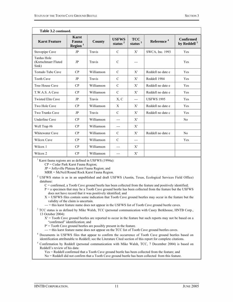
Table 3.2 – Karst features identified in U.S. Fish and Wildlife Service (USFWS) files and/or considered by Texas Cave Conservancy (TCC) as containing or possibly containing Tooth Cave ground beetles.
Karst Feature Karst Fauna
Region 1 County USFWS
status 2 TCC
status 3 Reference 4 Confirmed by Reddell 5
A Cave CP Williamson X --- A.J. and B.L. Wilcox Cave CP Williamson C --- Reddell no date a Yes
Amber Cave JP Travis --- X′ No
Animal Canyon Cave CP Williamson X X′ Reddell no date e Yes
Animal Cave CP Williamson X ---
Beard Ranch Cave JP Travis --- P′ No
Big Oak Cave CP Williamson C X′ Reddell 1997 Yes
Blue Wasp Cave MRR Williamson P --- No
Bluewater Cave No.2 CP Williamson C X′ Reddell no date e Yes
Boulevard Cave CP Williamson C X′ Reddell no date e Yes
Broken Arrow Cave CP Travis C X′ Reddell 1991a Yes Buttercup Blow Hole Cave CP Williamson X X′ Reddell no date e Yes
Buttercup Creek Cave CP Williamson X X′ Reddell no date e Yes
Cedar Elm Sink Cave CP Williamson C X′ Reddell no date e Yes
Clark Cave MRR Williamson --- X′ No
Comanche Trail Cave JP Travis --- X′ No
Connection Cave CP --- X′ No Convoluted Canyon Cave CP Williamson X --- Reddell no date e No
Convoluted Cave CP Williamson --- X′
Crumley’s Cave CP Williamson P P′ No
Disbelievers Cave JP Travis X, C X′ SWCA, Inc. 1995a Yes
Discovery Well Cave CP Williamson C X′ Reddell 2002a Yes
Eluvial Cave JP Travis --- X′ No
Fern Pit JP Travis --- X′ No
Gallifer Cave JP Travis P, C X′ Reddell 1999a Yes
Good Friday Cave CP Williamson C X′ Reddell no date e Yes
Grimace Cave CP Williamson X X′ Reddell no date e Yes
Harvestman Cave CP Williamson C --- Reddell no date e Yes
Hideaway Cave CP Williamson C X′ Reddell no date e Yes

STATUS OF THE TOOTH CAVE GROUND BEETLE SECTION 3
HNTB CORPORATION. 10 JUNE 2005
Table 3.2 continued.
Karst Feature Karst Fauna
Region 1 County USFWS
status 2 TCC
status 3 Reference 4 Confirmed by Reddell 5
Homestead Cave JP Travis X --- Yes
Ilex Cave CP Williamson X X′ No
Japygid Cave JP Travis X, C --- SWCA, Inc. 1995a Yes
Jypigid Cave JP Travis --- X′
Jollyville Jewel Cave MRR Travis P --- No Jollyville Plateau Cave JP Travis X, C X′ SWCA, Inc. 1995a Yes
Jug Cave CP Williamson C X′ Reddell 2000 Yes
Kretschmarr Cave JP Travis C --- Reddell 1984 Yes Kretschmarr Double Pit JP Travis P, C --- Reddell 1999a Yes
Kretschmarr Sink JP Travis X --- No
Lakeline Cave CP Williamson C X′ Reddell 1990 Yes Lakeline Mall Well Trap No.6 CP Williamson X --- Reddell no date d Yes
Lamm Cave JP Travis C X′ SWCA, Inc. 1993 Yes
Marigold Cave CP Williamson C X′ Reddell no date e Yes
May B A Cave CP Williamson X X′ Reddell no date e Yes
McDonald Cave JP Travis --- X′ No
MWA Cave JP Travis X, C X′ SWCA, Inc. 1995a Yes
Nelson Ranch Cave CP Williamson C X′ Reddell no date e Yes
North Root Cave JP Travis C --- Reddell 1999a Yes
Owl Eyes Cave JP Travis --- X′ No
Pat’s Pit Cave CP Williamson X X′ No
Pig Snout Cave CP Williamson X X′ Reddell no date e Yes
Primrose Cave CP Williamson X X′ Reddell no date e Yes
Puzzle Cave JP Travis X ---
Puzzle Pit Cave JP Travis X, C --- SWCA, Inc. 1995a Yes
Raccoon Cave CP Williamson C X′ Reddell no date e Yes
Rolling Rock Cave CP Travis C X′ Reddell 1991a Yes
Root Cave JP Travis C --- Salamander Squeeze Cave CP Williamson X X′ Reddell no date e Yes
Spider Cave JP Travis C X′ Reddell no date b Yes Stone Well Cave No.1 CP Williamson X X′ Reddell no date e Yes
Stone Well Cave No.2 CP Williamson X X′ Reddell no date e Yes
STATUS OF THE TOOTH CAVE GROUND BEETLE SECTION 3
HNTB CORPORATION. 11 JUNE 2005
Table 3.2 continued.
Karst Feature Karst Fauna
Region 1 County USFWS
status 2 TCC
status 3 Reference 4 Confirmed by Reddell 5
Stovepipe Cave JP Travis C X′ SWCA, Inc. 1993 Yes
Tardus Hole (Kretschmarr Fluted Sink)
JP Travis C --- Yes
Testudo Tube Cave CP Williamson C X′ Reddell no date e Yes
Tooth Cave JP Travis C X′ Reddell 1984 Yes
Tree House Cave CP Williamson C X′ Reddell no date e Yes
T.W.A.S. A Cave CP Williamson C X′ Reddell no date e Yes
Twisted Elm Cave JP Travis X, C --- USFWS 1995 Yes
Two Hole Cave CP Williamson X X′ Reddell no date e Yes
Two Trunks Cave JP Travis C X′ Reddell no date c Yes
Underline Cave CP Williamson --- X′ No
Well Trap #6 CP Williamson --- X′
Whitewater Cave CP Williamson C X′ Reddell no date e No
Wilcox Cave CP Williamson C --- Yes
Wilcox 1 CP Williamson --- X′
Wilcox 2 CP Williamson --- X′ 1 Karst fauna regions are as defined in USFWS (1994a):
CP = Cedar Park Karst Fauna Region; JP = Jollyville Plateau Karst Fauna Region; and MRR = McNeil/Round Rock Karst Fauna Region.
2 USFWS status is as in an unpublished and draft USFWS (Austin, Texas, Ecological Services Field Office) database:
C = confirmed, a Tooth Cave ground beetle has been collected from the feature and positively identified; P = a specimen that may be a Tooth Cave ground beetle has been collected from the feature but the USFWS
does not have record that it was positively identified; and X = USFWS files contain some indication that Tooth Cave ground beetles may occur in the feature but the
validity of the claim is uncertain. --- = this karst feature name does not appear in the USFWS list of Tooth Cave ground beetle caves.
3 TCC status is as defined by Mike Walsh, TCC (personal communication with Casey Berkhouse, HNTB Corp., 13 October 2004):
X′ = Tooth Cave ground beetles are reported to occur in the feature but such reports may not be based on a “confirmed” identification; and
P′ = Tooth Cave ground beetles are possibly present in the feature. --- = this karst feature name does not appear on the TCC list of Tooth Cave ground beetles caves.
4 Documents in USFWS files that appear to confirm the occurrence of Tooth Cave ground beetles based on identification attributable to Reddell; see the Literature Cited section of this report for complete citations.
5 Confirmation by Reddell (personal communication with Mike Walsh, TCC, 7 December 2004) is based on Reddell’s review of his data:
Yes = Reddell confirmed that a Tooth Cave ground beetle has been collected from the feature; and No = Reddell did not confirm that a Tooth Cave ground beetle has been collected from this feature.

STATUS OF THE TOOTH CAVE GROUND BEETLE SECTION 3
HNTB CORPORATION. 12 JUNE 2005
• “A Cave” refers to T.W.A.S. A Cave; • “Animal Cave” refers to Animal Canyon Cave; • “Convoluted Cave” refers to Convoluted Canyon Cave; • “Jypigid Cave” refers to Japygid Cave; • “Puzzle Cave” refers to Puzzle Pit Cave; • “Well Trap #6” refers to Lakeline Mall Well Trap No.6; and • “Wilcox 1” and “Wilcox 2” refer to A.J. and B.L Wilcox Cave and to Wilcox
Cave. Root Cave and North Root Cave are listed separately in Table 3.2 but their relationship is not consistently described in literature. These features are in close proximity (about 30 feet) and Reddell (1991d) refers to North Root Cave as “discreet and not physically connected” to Root Cave. Reddell (1999a and b) also describe the caves as not physically connected (1999a) and not connected by humanly passable openings (1999b), but each document adds that the caves are “hydrologically connected.” George Veni & Associates (GVA 2000) cites an unreferenced 1991 survey by Mike Warton & Associates when describing Root and North Root caves as “closely situated and almost certainly related,” and adds that “[u]nless specifically distinguished, they will jointly be referred to in this report as just ‘Root Cave.’” In this report Root Cave and North Root Cave are considered as separate caves. This is not intended to deny that these caves may be connected hydrologically, and it is very likely that other caves discussed in this report also are hydrologically connected. North Root Cave and Root Cave are frequently presented separately when fauna collections are summarized (see Reddell 1991d, USFWS 1994a, Elliott 1997, Reddell 1999a) and they are presented separately in this report. In light of the information provided in the preceding paragraphs, the 76 karst feature names listed in Table 3.2 are considered here to identify 68 unique karst features. “Unique” as used here is not intended to imply that some of the features listed are not connected below ground, and assessing the extent of subterranean connections is beyond the scope of this report. “Unique” is only meant as a convenient way to associate the collection of invertebrates with a specific karst surface expression. The TCC lists 56 karst features as supporting or possibly supporting Tooth Cave ground beetles (Table 3.2). Fifteen karst feature names included in TCC’s list are not included in the USFWS list. Of these 15 names, five (Convoluted Cave, Jypigid Cave, Well Trap #6, Wilcox 1, Wilcox 2) are alternate names for features included elsewhere on the list. Reddell (personal communication 2004) did not confirm the collection of Tooth Cave ground beetles from the remaining 10 features (Amber, Beard Ranch, Clark, Comanche Trail, Connection, Eluvial, Fern Pit, McDonald, Owl Eyes, and Underline caves) and no documents were found in USFWS files that confirmed such collections. The USFWS draft database lists 61 karst features as sites from which Tooth Cave ground beetles have been or may have been collected (Table 3.2). Three feature names listed (A Cave, Animal Cave, and Puzzle Cave) are alternate names for features included elsewhere on the list. Documents from USFWS files appear to confirm the collection of

STATUS OF THE TOOTH CAVE GROUND BEETLE SECTION 3
HNTB CORPORATION. 13 JUNE 2005
Tooth Cave ground beetles from 47 features, and Reddell (personal communication 2004) confirmed the collection of Tooth Cave ground beetles from 49 features. As defined for this report, records of occurrence were confirmed for 46 karst features listed in Table 3.2 – that is, for 46 features there was found in USFWS files documentation authored, co-authored, or likely attributable to Reddell that appeared to confirm the collection of Tooth Cave ground beetles, and for these 46 features Reddell (personal communication 2004) confirmed collection of the species based on his review of his data. Twelve features listed in the USFWS draft database as confirmed or potential Tooth Cave ground beetle sites lacked one or both forms of confirmation. These 12 features are discussed separately below. Blue Wasp Cave. The USFWS draft database lists Blue Wasp Cave as a karst feature for which there is reason to believe that a record of Tooth Cave ground beetle occurrence may exist. Reddell (1991b) provides a summary of fauna collected from Blue Wasp Cave and an assessment of habitat within the cave. In that report Tooth Cave ground beetle is not listed as a taxon collected from this cave, and Reddell speculates
“[i]t is possible, however, that the cave could harbor [troglobites other than Cicurina species]. It is more likely that the shallowness of the cave will preclude the appearance of the more highly cave-adapted species.”
Later in that report Reddell refers to “Rhadine ground beetle” as a “highly cave-adapted species.” Reddell (1991b) is the only reference in USFWS files for the collection of karst invertebrates in Blue Wasp Cave. Based on review of the fauna list and habitat description provided in Reddell (1991b), it appears that Tooth Cave ground beetle was not collected from Blue Wasp Cave and that Reddell thought it unlikely that the species would occur there. Reddell (personal communication 2004) also did not confirm the collection of the species from this cave. In this report Blue Wasp Cave is considered as having neither a confirmed nor a tentative record of Tooth Cave ground beetle occurrence. Convoluted Canyon Cave. This feature is listed in the USFWS draft database as a cave from which Tooth Cave ground beetles may have been collected but the validity of the claim has not yet been researched. Fauna lists in Reddell (no date e) reportedly “include all material taken from caves in the Buttercup Creek karst area,” and that report includes Tooth Cave ground beetle in the fauna list for Convoluted Canyon Cave. However, Reddell (personal communication 2004) did not confirm the collection of the species from this cave. The record of Tooth Cave ground beetle occurrence in Convoluted Canyon Cave is considered tentative in this report. Crumley’s Cave. The USFWS draft database lists Crumley’s Cave as a feature from which a specimen that may be Tooth Cave ground beetle has been collected but the agency does not have record of a positive identification. Reddell (2002b) does not include Tooth Cave ground beetle in a fauna list for Crumley’s Cave but states that “[t]he cave appears to be potential habitat for the [species].” Reddell (personal communication 2004) did not confirm a record of occurrence for this feature. In this report Crumley’s Cave is considered as having neither a confirmed nor a tentative record of Tooth Cave ground beetle occurrence.

STATUS OF THE TOOTH CAVE GROUND BEETLE SECTION 3
HNTB CORPORATION. 14 JUNE 2005
Homestead Cave. Several early lists of caves known to contain endangered species (Elliott and Reddell 1989, Reddell 1991d, USFWS 1994a) do not include Homestead Cave. Reddell and Elliott (no date) includes Homestead Cave as a feature known to contain Tooth Cave ground beetles “as of July 1997” but provides no information on fauna collections. USFWS files reviewed for this report did not contain information on this cave or fauna collected at this cave. Reddell (personal communication 2004) did confirm that Tooth Cave ground beetle has been collected from Homestead Cave. The record of Tooth Cave ground beetle occurrence in Homestead Cave is considered tentative in this report. Ilex Cave. This feature is listed in the USFWS draft database as a cave from which Tooth Cave ground beetles may have been collected but the validity of the claim has not yet been researched. Elliott and Reddell (1989), Reddell (1991d), and Reddell (no date e) do not include Tooth Cave ground beetle in Ilex Cave fauna lists. Mike Warton & Associates (MWA 1997) reports the species is confirmed from Ilex Cave and this information is repeated in USFWS (1999); however, neither of those documents provides a fauna list for the cave or detailed description of collection efforts. Reddell (personal communication 2004) did not confirm the collection of the species from this cave. In this report Ilex Cave is considered as having neither a confirmed nor a tentative record of Tooth Cave ground beetle occurrence. Jollyville Jewel Cave. The USFWS draft database lists Jollyville Jewel Cave as a karst feature for which there is reason to believe that a record of Tooth Cave ground beetle occurrence may exist. Reddell (1991c) does not included the species in a fauna list for the cave, but the author speculates that
“[g]iven the cursory biological study of Jollyville Jewel Cave and the quality of its fauna, I do not believe that we can assume that the cave does not contain one or more of the endangered species. ... The cave ... is only about four miles from LakeLine [sic] Cave and the possibility that it harbors the Tooth Cave ground beetle, Rhadine persephone, cannot be entirely ruled out.”
Hicks & Company (1991) states that an additional attempt to collect invertebrates from Jollyville Jewel Cave would occur during “the winter or early Spring of 1992,” but no documentation of such an effort was found in the USFWS file. Reddell (personal communication 2004) did not confirm the collection of Tooth Cave ground beetle from this cave. In this report Jollyville Jewel Cave is considered as having neither a confirmed nor a tentative record of Tooth Cave ground beetle occurrence. Kretschmarr Sink. This feature is listed in the USFWS draft database as a feature from which Tooth Cave ground beetles may have been collected but the validity of the claim has not yet been researched. Reddell (1991d and 1999a) do not include the species in Kretschmarr Sink fauna lists, and Reddell (personal communication 2004) did not confirm the collection of the Tooth Cave ground beetles from the feature. In this report Kretschmarr Sink is considered as having neither a confirmed nor a tentative record of Tooth Cave ground beetle occurrence.

STATUS OF THE TOOTH CAVE GROUND BEETLE SECTION 3
HNTB CORPORATION. 15 JUNE 2005
Pat’s Pit Cave. This feature is listed in the USFWS draft database as a feature from which Tooth Cave ground beetles may have been collected but the validity of the claim has not yet been researched. Tooth Cave ground beetle is listed in MWA (1997) as occurring in Pat’s Pit Cave; this same list is referenced in USFWS (1999). Neither of those documents provides a fauna list for the cave or detailed description of the collection effort. Reddell (no date e) includes Tooth Cave ground beetle followed by “(?SIGHT RECORD)” in the fauna list for Pat’s Pit Cave; it appears that Reddell had reason to question the validity of the record of occurrence for Tooth Cave ground beetle in Pat’s Pit Cave. This karst feature is not included in the Reddell and Elliott (no date) list of caves known to include Tooth Cave ground beetles as of July 1997. Information in Reddell and Elliott (no date) appears to pre-date the completion of the Warton report (“July 1997” compared to “18 October 1997”), but the Warton report does not cite collection dates or fauna lists. It is possible that information substantiating the occurrence of Tooth Cave ground beetles in Pat’s Pit Cave became available after Reddell and Elliott (no date) and Reddell (no date e) and that this information was included but not cited in MWA (1997). However, Reddell (personal communication 2004) did not confirm the collection of the Tooth Cave ground beetles from the feature. In this report Pat’s Pit Cave is considered as having neither a confirmed nor a tentative record of Tooth Cave ground beetle occurrence. Root Cave. The USFWS draft database lists Root Cave as a karst feature for which there exists a confirmed record of Tooth Cave ground beetle occurrence. A document confirming the occurrence of Tooth Cave ground beetles at Root Cave was not found during review of USFWS files. Elliott and Reddell (1989) includes the species in a fauna list for Root Cave and cites collections made on 12 July 1984 and 1 April 1989. Reddell (1991d) revises the fauna list for Root Cave based in part on the more recently discovered North Root Cave. In that report, Tooth Cave ground beetle is cited as occurring in North Root Cave (based on a 1 April 1989 collection) and is not included in the fauna list for Root Cave (for which “[n]o new collections have been made”). Reddell (1991d) further states that North Root Cave was “previously (Elliott and Reddell, 1989) included under the description of Root Cave” and that the fauna lists for these two features in Reddell (1991d) includes only the taxa collected from the respective caves. The Recovery Plan identifies Root Cave and North Root Cave as caves known to contain Tooth Cave ground beetles. The list of endangered species caves provided in the Recovery Plan is cited as “compiled” by Elliott and Reddell on 12 July 1993. Elliott (1997) includes Tooth Cave ground beetle in separate fauna lists for both Root and North Root caves but references only the 12 July 1984 and 1 April 1989 collection efforts for Root Cave and only the latter effort for North Root Cave. Reddell and Elliott (no date) list Root Cave, but not North Root Cave, as a cave known to contain Tooth Cave ground beetles – the list is reportedly up-to-date “as of July 1997.” As no new collections (other than those previously cited) are referenced in the Recovery Plan, Elliott (1997), and Reddell and Elliott (no date), it is possible that the inclusion in each of these documents of Root Cave as a cave known to harbor Tooth Cave ground beetles is an error and fails to take into account Reddell’s (1991d) revision of the fauna list for Root and North Root caves. This could also account for the omission of North Root Cave from Reddell and

STATUS OF THE TOOTH CAVE GROUND BEETLE SECTION 3
HNTB CORPORATION. 16 JUNE 2005
Elliott (no date). The most recent fauna lists for Root and North Root caves (Reddell 1999a) found in USFWS files during review for this report (December 2004) include Tooth Cave ground beetles as occurring in North Root Cave but not in Root Cave. Reddell (1999a) includes the statement “North Root Cave contains Rhadine persephone, while Root Cave has Texella reyesi.” Reddell (no date f) states in part that
“[f]our trips have been made to the [Root Cave and North Root Cave ‘system’] since the original visits and on none were troglobites present. Only three troglophiles have been found in the ‘system.’ Fire ants covered the floor of the caves on two visits. The most recent visit was on 24 December 1999 when the caves were cold and dry and not fauna were present.”
If “original visits” refers to the 12 July 1984 and 1 April 1989 collection efforts, it appears that as of 24 December 1999 an additional four collection efforts had occurred and no Tooth Cave ground beetles were collected. It is possible that successful collection of the species has occurred since that last date, but record of such could not be located in USFWS files. For this report Reddell (personal communication 2004) referred to Root and North Root caves are the same cave and confirmed the presence of Tooth Cave ground beetles from the cave. As discussed previously, it is quite possible that Root and North Root caves (and other caves discussed in this report) are connected hydrologically. However, for the convenience of associating collection efforts with specific karst surface expressions, in this report Root Cave and North Root Cave are referred to as separate karst features. Furthermore, it appears possible that Tooth Cave ground beetles have been collected from North Root Cave but not from Root Cave. This is not meant to imply that the species does not occur in Root Cave, or that Root Cave and North Root Cave are not connected hydrologically. The record of Tooth Cave ground beetle occurrence in Root Cave is considered tentative in this report. Tardus Hole. The USFWS draft database lists Tardus Hole as a karst feature for which there exists a confirmed record of Tooth Cave ground beetle occurrence. The collection history for Tardus Hole is clouded by both the inconsistent use of names to identify the feature and the inconsistent reporting of collection data for the feature. Reddell (1984) presents information for both Tardus Hole and Kretschmarr Fluted Sink, and the descriptions provided for each feature are very similar. Reddell (1991d) does not name or provide descriptions for either feature in an appendix containing cave descriptions and fauna lists, but does include both feature names in an appendix containing taxa-based records of occurrence. The Recovery Plan (USFWS 1994a) and Elliott (1997) consider “Kretschmarr Fluted Sink” as synonymous with “Tardus Hole” and gives preference to the latter. Reddell (1999a) also considers the names synonymous but gives preference to “Kretschmarr Fluted Sink.” Reddell (1984), Elliott and Reddell (1989), and Reddell (1991d) do not identify Tooth Cave ground beetle as a species collected from Tardus Hole/Kretschmarr Fluted Sink. The Recovery Plan and Elliott and Reddell (no date) identify Tardus Hole as a cave known to contain Tooth Cave ground beetles. Elliott (1997) does not include Tooth Cave ground beetles in a fauna list for Tardus Hole but does state in the narrative that this

STATUS OF THE TOOTH CAVE GROUND BEETLE SECTION 3
HNTB CORPORATION. 17 JUNE 2005
feature contains the species. Similarly, Reddell (1999a) does not include Tooth Cave ground beetle in a fauna list for Kretschmarr Fluted Sink but does list the feature as known to contain the species. Reddell (personal communication 2004) did confirm the collection of Tooth Cave ground beetles from Tardus Hole. It seems likely that the names “Tardus Hole” and “Kretschmarr Fluted Sink” refer to a single feature; in this report “Tardus Hole” is used as the preferred name. Tooth Cave ground beetle does not occur in any Tardus Hole/Kretschmarr Fluted Sink fauna lists that were reviewed for this report. However, several reports identify Tardus Hole/Kretschmarr Fluted Sink as a feature known to contain Tooth Cave ground beetles. The record of Tooth Cave ground beetle occurrence in Tardus Hole is considered tentative in this report. Whitewater Cave. The USFWS draft database lists Whitewater Cave as a karst feature for which there exists a confirmed record of Tooth Cave ground beetle occurrence. Reddell (no date e) reportedly identifies “all material taken from caves in the Buttercup Creek karst area.” The Whitewater Cave fauna list presented in that document includes Tooth Cave ground beetles, though its inclusion appears to be an amendment added after the report was completed. Furthermore, this amendment is not credited to the original author (Reddell) but is credited to “M.W.A,” presumably referring to Mike Warton & Associates. Fant (2003a) reports observing five Tooth Cave ground beetles in Whitewater Cave in April 2003, but it appears that none were collected for taxonomic verification. Reddell (personal communication 2004) did not confirm the collection of the Tooth Cave ground beetles from the feature. The record of Tooth Cave ground beetle occurrence in Whitewater Cave is considered tentative in this report. Wilcox Cave. The USFWS draft database lists Wilcox Cave as a karst feature for which there exists a confirmed record of Tooth Cave ground beetle occurrence. MWA (1998) and USFWS (1999) report that Tooth Cave ground beetle was collected from Wilcox Cave but neither document provides information on the collection or positive identification of specimens. Reddell (personal communication 2004) did confirm the collection of the Tooth Cave ground beetles from the feature. The record of Tooth Cave ground beetle occurrence in Wilcox Cave is considered tentative in this report. Lakeline Mall Well Trap No.6 deserves separate comment in this discussion. Of the features listed in Table 3.2, Lakeline Mall Well Trap No.6 appears to be the only one that was not a naturally formed feature. The well trap is an approximately 4.75-inch diameter boring drilled to a depth of approximately 25 feet for the sole purpose of attempting to collect karst fauna (HES 1991). Reddell (no date f) describes the well trap as being located within 100 feet of a “significant sinkhole” and concluded that the collection of Tooth Cave ground beetles from the well trap probably indicated that the well intersected a connection to the sinkhole. Lakeline Mall Well Trap No.6 is treated in this report as a confirmed Tooth Cave ground beetle collection site but its status should be considered somewhat different than similarly designated sites that are naturally formed karst features.

STATUS OF THE TOOTH CAVE GROUND BEETLE SECTION 3
HNTB CORPORATION. 18 JUNE 2005
3.4 Section 3 Summary For this report, “confirmed” records of Tooth Cave ground beetle occurrence are defined as those for which documentation apparently attributable to Reddell was found in USFWS files and for which Reddell (personal communication 2004) provided confirmation specific to this report; “tentative” records of occurrence are those for which either but not both forms of confirmation were obtained. Confirmed records of Tooth Cave ground beetle occurrence exist for 46 karst features and tentative records of occurrence exist for another six features (Table 3.3). Most (32 of 52) of these features are located in Williamson County and most (34 of 52) are located in the Cedar Park KFR. Records of occurrence were also confirmed for 18 features in the Jollyville Plateau KFR. As noted previously, records of the occurrence of Tooth Cave ground beetles should not be considered as delineating the historic or current distribution or range of the species. Tooth Cave ground beetles very likely occur in caves from which they have not yet been collected. Some features that appear unique at the surface may actually be joined by subterranean connections (for example, North Root and Root caves [GVA 2000] and Owl Eyes and Twisted Elm caves [SWCA 1995b]) and if suitable habitat is present ground beetles may move between such features. Some of the karst features listed in Table 3.3 have been destroyed or may have been impacted to such an extent that they no longer provide habitat for the species. The current distribution of Tooth Cave ground beetles cannot be defined based on a review of historical records of occurrence. It also is important to note that the focus of this report was karst features suggested to contain or potentially contain Tooth Cave ground beetles. No effort was made to identify and research features that reportedly do not contain the species – that is, features that have been sampled and from which Tooth Cave ground beetles were not among the species collected. No definitive list of “negative” survey results exists. It is outside of the scope of this report to assess collection records from all karst features within the range of the species. It should not be assumed that karst features not discussed in this report do not contain Tooth Cave ground beetles.
STATUS OF THE TOOTH CAVE GROUND BEETLE SECTION 3
HNTB CORPORATION. 19 JUNE 2005
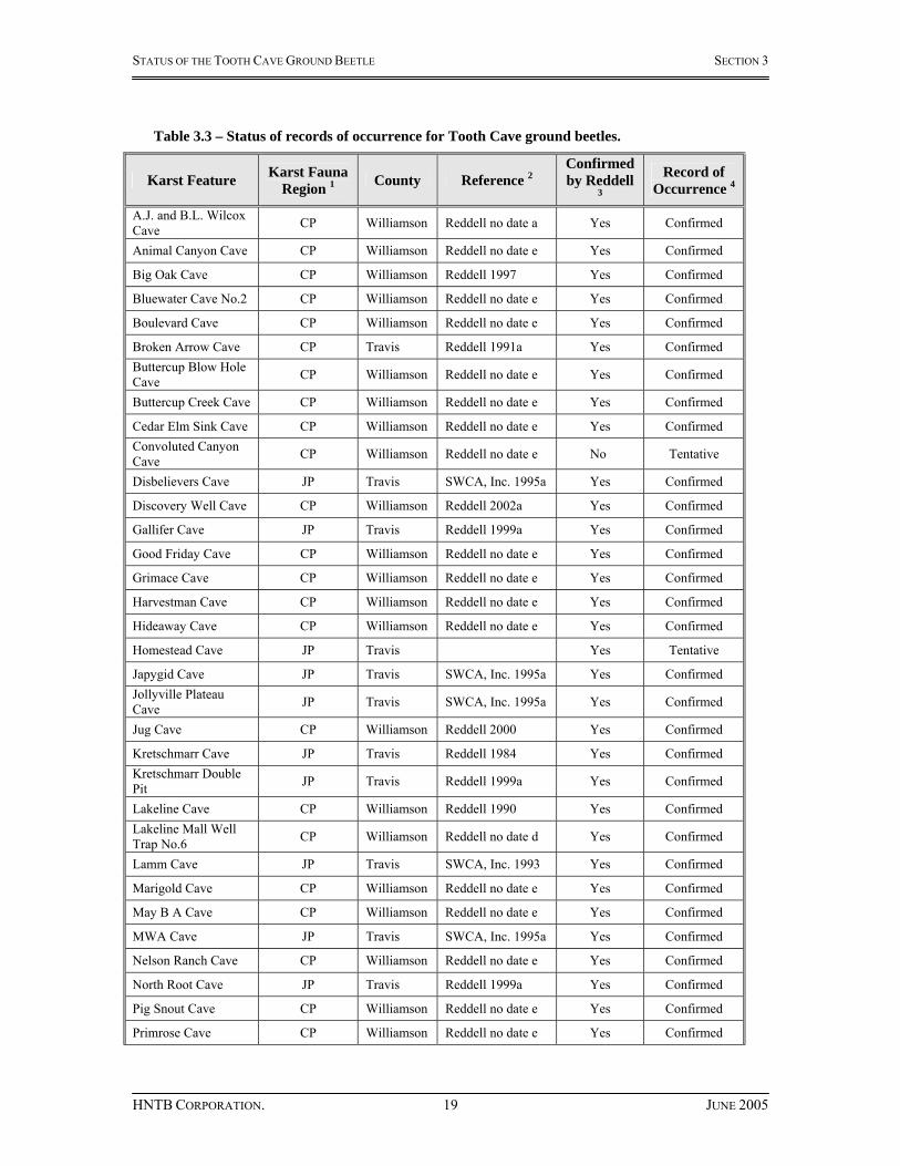
Table 3.3 – Status of records of occurrence for Tooth Cave ground beetles.
Karst Feature Karst Fauna Region 1 County Reference 2
Confirmed by Reddell
3
Record of Occurrence 4
A.J. and B.L. Wilcox Cave CP Williamson Reddell no date a Yes Confirmed
Animal Canyon Cave CP Williamson Reddell no date e Yes Confirmed
Big Oak Cave CP Williamson Reddell 1997 Yes Confirmed
Bluewater Cave No.2 CP Williamson Reddell no date e Yes Confirmed
Boulevard Cave CP Williamson Reddell no date e Yes Confirmed
Broken Arrow Cave CP Travis Reddell 1991a Yes Confirmed Buttercup Blow Hole Cave CP Williamson Reddell no date e Yes Confirmed
Buttercup Creek Cave CP Williamson Reddell no date e Yes Confirmed
Cedar Elm Sink Cave CP Williamson Reddell no date e Yes Confirmed Convoluted Canyon Cave CP Williamson Reddell no date e No Tentative
Disbelievers Cave JP Travis SWCA, Inc. 1995a Yes Confirmed
Discovery Well Cave CP Williamson Reddell 2002a Yes Confirmed
Gallifer Cave JP Travis Reddell 1999a Yes Confirmed
Good Friday Cave CP Williamson Reddell no date e Yes Confirmed
Grimace Cave CP Williamson Reddell no date e Yes Confirmed
Harvestman Cave CP Williamson Reddell no date e Yes Confirmed
Hideaway Cave CP Williamson Reddell no date e Yes Confirmed
Homestead Cave JP Travis Yes Tentative
Japygid Cave JP Travis SWCA, Inc. 1995a Yes Confirmed Jollyville Plateau Cave JP Travis SWCA, Inc. 1995a Yes Confirmed
Jug Cave CP Williamson Reddell 2000 Yes Confirmed
Kretschmarr Cave JP Travis Reddell 1984 Yes Confirmed Kretschmarr Double Pit JP Travis Reddell 1999a Yes Confirmed
Lakeline Cave CP Williamson Reddell 1990 Yes Confirmed Lakeline Mall Well Trap No.6 CP Williamson Reddell no date d Yes Confirmed
Lamm Cave JP Travis SWCA, Inc. 1993 Yes Confirmed
Marigold Cave CP Williamson Reddell no date e Yes Confirmed
May B A Cave CP Williamson Reddell no date e Yes Confirmed
MWA Cave JP Travis SWCA, Inc. 1995a Yes Confirmed
Nelson Ranch Cave CP Williamson Reddell no date e Yes Confirmed
North Root Cave JP Travis Reddell 1999a Yes Confirmed
Pig Snout Cave CP Williamson Reddell no date e Yes Confirmed
Primrose Cave CP Williamson Reddell no date e Yes Confirmed

STATUS OF THE TOOTH CAVE GROUND BEETLE SECTION 3
HNTB CORPORATION. 20 JUNE 2005
Table 3.3 continued
Karst Feature Karst Fauna Region 1 County Reference 2
Confirmed by Reddell
3
Record of Occurrence 4
Puzzle Pit Cave JP Travis SWCA, Inc. 1995a Yes Confirmed
Raccoon Cave CP Williamson Reddell no date e Yes Confirmed
Rolling Rock Cave CP Travis Reddell 1991a Yes Confirmed
Root Cave JP Travis Tentative Salamander Squeeze Cave CP Williamson Reddell no date e Yes Confirmed
Spider Cave JP Travis Reddell no date b Yes Confirmed Stone Well Cave No.1 CP Williamson Reddell no date e Yes Confirmed
Stone Well Cave No.2 CP Williamson Reddell no date e Yes Confirmed
Stovepipe Cave JP Travis SWCA, Inc. 1993 Yes Confirmed
Tardus Hole (Kretschmarr Fluted Sink)
JP Travis Yes Tentative
Testudo Tube Cave CP Williamson Reddell no date e Yes Confirmed
Tooth Cave JP Travis Reddell 1984 Yes Confirmed
Tree House Cave CP Williamson Reddell no date e Yes Confirmed
T.W.A.S. A Cave CP Williamson Reddell no date e Yes Confirmed
Twisted Elm Cave JP Travis USFWS 1995 Yes Confirmed
Two Hole Cave CP Williamson Reddell no date e Yes Confirmed
Two Trunks Cave JP Travis Reddell no date c Yes Confirmed
Whitewater Cave CP Williamson Reddell no date e No Tentative
Wilcox Cave CP Williamson Yes Tentative
1 Karst fauna regions are as defined in USFWS (1994a): CP = Cedar Park Karst Fauna Region; and JP = Jollyville Plateau Karst Fauna Region. 2 Documents in USFWS files that appear to confirm the occurrence of Tooth Cave ground beetles based on
identification attributable to Reddell; see the Literature Cited section of this status report for complete citations.
3 Confirmation by Reddell (personal communication with Mike Walsh, TCC, 7 December 2004) is based on Reddell’s review of his data:
Yes = Reddell confirmed that a Tooth Cave ground beetle has been collected from the feature; and No = Reddell did not confirm that a Tooth Cave ground beetles has been collected from this feature.
4 “Confirmed” records of occurrence are those for which documentation apparently attributable to Reddell was found in USFWS files and for which Reddell (personal communication with Mike Walsh, TCC, 7 December 2004) provided confirmation specific to this report; “tentative” records of occurrence are those for which either but not both forms of confirmation were obtained.

STATUS OF THE TOOTH CAVE GROUND BEETLE SECTION 4
HNTB CORPORATION. 21 JUNE 2005
Section 4 Karst Features Noted as Containing Potential Habitat for Tooth Cave Ground Beetles
4.1 Introduction The absence of Tooth Cave ground beetles in a fauna collection from a karst feature does not necessarily mean that the species does not occur in the feature. It could be that the species was present but not collected. However, in the absence of specimen collection, there is no generally accepted method for assessing habitat quality as an indicator of the potential for the species to occur. Specific habitat requirements for Tooth Cave ground beetles are not known. Also, barriers that may prevent the species from occupying suitable habitat are not always easy to identify. Though habitat that appears suitable may be present in a karst feature, unobserved barriers may prevent beetles from occupying the habitat. Such a feature would be outside of the range of the species. Discussion of the presence or absence of habitat potentially suitable for Tooth Cave ground beetles often include comments on the occurrence of other troglobitic species, the physical dimensions (depth) of a feature, and/or environmental conditions (primarily humidity and/or temperature) of habitats inside a feature. However, lacking accepted criteria for assessing habitat suitability for Tooth Cave ground beetle, the interpretation of habitat quality is likely to vary among observers. Reddell (no date f) provides a useful example. In that document Reddell refers to a method of quantifying habitat based on the biodiversity of troglobites present in a karst feature. Based on such a method, Reddell states that Root and North Root caves considered as a combined “system” would be rated as “marginally good habitat.” Reddell continues, however, by stating that
“I would personally consider the Root Cave ‘system’ poor habitat for several reasons. The caves are extremely small and shallow and subject to severe environmental fluctuations. Four trips have been made to the cave since the original visits and on none were troglobites present. Only three troglophiles have been found in the ‘system.’”
The difference between “marginally good habitat” and “poor habitat” may in fact be subtle, but this example illustrates the lack of criteria for assessing habitat quality. Of interesting note is that Tooth Cave ground beetles were documented from the North Root and Root caves “system” probably as early as 1989 (see Section 3.3 of this report) but it is not clear that the species has been collected there since that time. It is outside of the scope of this report to assess the validity of statements concerning Tooth Cave ground beetle potential habitat in karst features. However, the USFWS may choose to investigate features for which such statements have been made. 4.2 Methods Information on karst features reported to contain Tooth Cave ground beetle potential habitat was gleaned from documents contained in USFWS files. Of specific interest were those features for which confirmed or tentative records of Tooth Cave ground beetle occurrence (see Section 3 of this report) do not exist. These karst features are discussed

STATUS OF THE TOOTH CAVE GROUND BEETLE SECTION 4
HNTB CORPORATION. 22 JUNE 2005
in the proceeding paragraphs and for each the claims in support of potential habitat are presented. No attempt is made to assess the validity of these claims. 4.3 Findings Documents were found in USFWS files that suggested five caves from which Tooth Cave ground beetles have not been collected may contain habitat potentially suitable for the species. These caves are discussed in detail below. Crumley’s Cave. This cave is located in the Cedar Park KFR and in Williamson County. Reddell (2002b) collected fauna from Crumley’s Cave in February 2002. Tooth Cave ground beetles were not collected during that effort but the author states in part that
“[t]he cave appears to be potential habitat for the endangered Tooth Cave ground beetle Rhadine persephone. The presence of three troglobites also indicates that much more suitable habitat exists at a lower level.”
MWA (2002) summarizes study of this cave and suggests that the confirmed presence of an un-described troglobitic Rhadine species is a good indicator that Tooth Cave ground beetles are also present:
“Rhadine New species is endemic to the buttercup creek system, and is more highly cave adapted than the endangered Rhadine Persephone (Tooth Cave Ground Beetle). Thus, there is absolutely No valid reason why Rhadine Persephone would not be present as well. It’s [sic] chances of showing up in additional collection attempts would be much greater than not. ... As we feel that the finding of the presence of the endangered ‘Rhadine Persephone’ (Tooth Cave Ground Beetle) would only be a matter of time before it is found, our professional opinion, and best recommendation would be to consider this cave to be ‘Habitat’ for endangered invertebrate species.”
It is likely that Reddell (2002b) and MWA (2002) summarize a single collection effort. This may be the only documented collection effort at this cave as no additional documents describing other efforts were observed in USFWS files. Hunter’s Lane Cave, Persimmon Well Cave, and Uncorked Cave. These caves are located in the Discovery Well Cave Preserve (see Section 6.3 of this report) and the Cedar Park KFR; Persimmon Well Cave is in Travis County and the other two caves are in Williamson County. Reddell (2002a) summarizes collection efforts these caves and the collection of Tooth Cave ground beetles from Discovery Well Cave:
“The endangered Tooth Cave ground beetle, Rhadine persephone, was found in Discovery Well Cave on the last date, but two other caves appear to contain habitat for this species and should probably be re-studied under different conditions. ... The presence of Rhadine persephone in Discovery Well Cave provides strong evidence that this species will also be found in other caves on the property. Discovery Well, Hunter’s Lane, and Uncorked Caves are clearly structurally connected even if human connections are not possible and all should be considered habitat for the endangered ground beetle.”

STATUS OF THE TOOTH CAVE GROUND BEETLE SECTION 4
HNTB CORPORATION. 23 JUNE 2005
When discussing data for Hunter’s Lane, Persimmon Well, and Uncorked caves individually, Reddell (2002a) reports that each may contain habitat for Tooth Cave ground beetles. In these individual accounts Reddell points out that other troglobitic species were collected from each cave and in the case of Uncorked Cave states that “[t]he presence of two troglobites in the cave indicates that this could be habitat for Rhadine persephone.” USFWS files did not contain documentation of other collection efforts at these features. Jollyville Jewel Cave. Reddell (1991c) describes a collection effort at this cave. Three troglobitic species were collected but Tooth Cave ground beetle was not one of them. Reddell (1991c) states in part that
“[g]iven the cursory biological study of Jollyville Jewel Cave and the quality of its fauna, I do not believe that we can assume that the cave does not contain one or more of the endangered species. This cave probably will be found to contain the Bone Cave harvestman, Texella new species. The cave, however, is only about four miles from LakeLine Cave and the possibility that it harbors the Tooth Cave ground beetle, Rhadine persephone, cannot be entirely ruled out.”
The phrase “the quality of its fauna” is assumed to be a reference to four troglobitic species present in the cave. Though Reddell (1991c) does not specifically state that habitat potentially suitable for Tooth Cave ground beetles was observed in Jollyville Jewel Cave, it is appears that the author believed that the occurrence of the species in the cave was possible. Reddell (1991c) may describe the only collection effort at this cave as no documents describing other efforts were observed in USFWS files. 4.4 Section 4 Summary Documentation was found in USFWS files stating that four caves (Crumley’s, Hunters Lane, Persimmon Well, and Uncorked caves) contained Tooth Cave ground beetle potential habitat. These caves are each located in Cedar Park KFR and three of the caves (Hunters Lane, Persimmon Well, and Uncorked caves) are located in the Discovery Well Preserve. Additional documentation was found that implied that potentially suitable habitat was present in Jollyville Jewel Cave. This cave is located in the McNeil/Round Rock KFR. Specific habitat characteristics (e.g., depth, humidity, temperature, substrate) were not cited as indicating that potential habitat for Tooth Cave ground beetles was present in these caves. However, in each case the presence of troglobitic species other than Tooth Cave ground beetles was cited or implied as a reason supporting the presence of potentially suitable habitat. Direct connection to an occupied feature (Discovery Well Cave) is also cited for both Hunters Lane and Uncorked caves, and proximity within 4 miles of an occupied feature (Lakeline Cave) is cited for Jollyville Jewel Cave. As discussed previously, the habitat requirements for Tooth Cave ground beetles are not well defined, and the extent to which this species shares habitat or habitat requirements with other troglobites is not known. Also, direct connection or near proximity to occupied habitat are not likely to assure the presence of Tooth Cave ground beetles.

STATUS OF THE TOOTH CAVE GROUND BEETLE SECTION 4
HNTB CORPORATION. 24 JUNE 2005
The caves identified in this section should not be considered an exhaustive list of all karst features that have been referred to as containing potential habitat for Tooth Cave ground beetles. Documents related to these caves were found in USFWS files incidental to research for confirmed records of Tooth Cave ground beetle occurrence. Though files and documents were diligently reviewed, it is possible that some references were overlooked.

STATUS OF THE TOOTH CAVE GROUND BEETLE SECTION 5
HNTB CORPORATION 25 JUNE 2005
Section 5 Records of Occurrence for the Un-described Rhadine new species 5.1 Introduction Fifteen species of troglobitic Rhadine beetles have been recorded from Texas caves (Reddell and Cokendolpher 2004). Tooth Cave ground beetle is not the only troglobitic Rhadine species that occurs in Travis and/or Williamson counties – Rhadine austinica, R. noctivaga, R. russelli, and R. subterranea are all cited as troglobitic taxa occurring in these counties (Reddell 1991d). The latter species has been further classified into the subspecies R. s. mitchelli and R. s. subterranea, and it is not uncommon to see reference to “Rhadine ?subterranean” in taxa lists. Some karst features support more than one troglobitic Rhadine species. Tooth Cave ground beetles and Rhadine subterranea (or “?subterranea”) have each been collected at Broken Arrow Cave, Kretschmarr Cave, Lakeline Cave, Testudo Tube Cave, and Tooth Cave (Elliott and Reddell 1989, Elliott 1994, Elliott 1997, Reddell 1999a). In Bexar County the endangered troglobites Rhadine exilis and Rhadine infernalis are reported as co-occurring in 12 caves (GVA 2002). An un-described troglobitic Rhadine taxon has been collected from several caves that also contain Tooth Cave ground beetles. This un-described taxon is often referred to as Rhadine new species (hereafter in this report, Rhadine n.s.), but its taxonomic status is not described in documents contained in USFWS files. Reddell (no date e) refers to Rhadine n.s. when stating “[a] second species of ground beetle belonging to the genus Rhadine is probably an un-described species known only from the Buttercup Creek karst and a few additional peripheral caves in the immediate vicinity.” MWA (1998) states that Rhadine n.s. was “known to be endemic to the caves of the Buttercup Creek area” prior to being collected at Lakeline Cave. MWA (2002) states that Rhadine n.s. is “endemic to the buttercup creek system, and is more highly cave adapted than the endangered Rhadine Persephone.” It is not clear from existing literature that Rhadine n.s. is a single taxon or possibly two or more taxa, and it is not clear that all references to “Rhadine new species” refer to the same ground beetle. It is beyond the scope of this report to define the taxonomy of central Texas troglobitic Rhadine species. However, the co-occurrence of Tooth Cave ground beetles with an un-described and possibly closely related congeneric species could have implications for assessing the status of Tooth Cave ground beetles. 5.2 Methods Information on collection of un-described Rhadine specimens was gleaned from documents contained in USFWS files. A collection was assumed to refer to an un-described Rhadine species if the specimen was not associated with an accepted species or subspecies. For instance, “Rhadine ?subterranea” and “Rhadine sp. probably subterranea” were not considered un-described but instead was considered likely to be a R. subterranea subspecies. On the other hand, “Rhadine sp. subterranea group” was considered to refer to an un-described species that was probably related to R.

STATUS OF THE TOOTH CAVE GROUND BEETLE SECTION 5
HNTB CORPORATION 26 JUNE 2005
subterranea. Reddell (personal communication 2004) provide additional information on the occurrence of Rhadine n.s. based on his review of his data. 5.3 Findings It was often difficult to interpret the intent of an author in identifying a taxon. Ambiguous identifications such as “Rhadine ?subterranea” could mean that an author believed the specimen to be R. subterranea but was not certain, or that it was possibly a subspecies, or that it was likely a new species but was very similar to R. subterranea. It is likely that some of the specimens referred to as “Rhadine ?subterranea” in the literature and not included in this report as a Rhadine n.s. may actually be Rhadine n.s. or some other un-described species or sub-species. Also, it is likely that specimens for which tentative or uncertain identification is provided in a document were subsequently positively identified or determined to be un-described species. For example, Reddell (1991d) and Elliott (1994) list Tooth Cave ground beetles and “Rhadine ?subterranea” as occurring in Lakeline Cave. Reddell (personal communication 2004) confirmed the collection of Rhadine n.s. from this cave. It seems that Lakeline Cave contains either three troglobitic Rhadine species or one of the earlier identifications (most likely “Rhadine ?subterranea”) has now been re-classified as Rhadine n.s. A similar case exists for Testudo Cave. Elliott (1994) includes Tooth Cave ground beetles and “Rhadine ?subterranea” in the fauna list for Testudo Tube Cave and states that the latter taxa “may be a closely related, but un-described species or subspecies.” Reddell (no date e) includes Tooth Cave ground beetles and “Rhadine ?new species” in the taxa list for Testudo Tube Cave. Based on external evidence it is extremely likely that Reddell (no date e) is a more recent document than Elliott (1994) and thus may indicate that Reddell concluded that what had originally listed as “Rhadine ?subterranea” from this cave was most likely a new species. Un-described Rhadine specimens that may be Rhadine n.s. are reported from 36 karst features (Table 5.1). Most (31 of 36) of these features are in Williamson County. Thirty of these features are in the Cedar Park KFR, two are in the McNeil/Round Rock KFR, one is in the Jollyville Plateau KFR, and the locations of three features are not certain. Confirmed or tentative records of Tooth Cave ground beetle occurrence exist for 19 of the features listed in Table 5.1. Because of the uncertainty in interpreting collection records for un-described Rhadine species, no attempt is made in this report to characterize collections of Rhadine n.s. as “confirmed” or “tentative.” Most (34 of 36) of the collections listed in Table 5.1 are reported in fauna lists attributable to Reddell, or by Reddell (personal communication 2004) specific to this report, or both. These collection accounts should probably be considered somewhat more reliable than those which lack these forms of confirmation. The collection of Rhadine n.s. from Hideaway Cave is reported from MWA (1997) and repeated in USFWS (1999). Reddell (personal communication 2004) did not confirm Rhadine n.s. from this feature

STATUS OF THE TOOTH CAVE GROUND BEETLE SECTION 5
HNTB CORPORATION 27 JUNE 2005
Table 5.1 – Karst features from which an un-described Rhadine species which may by “Rhadine new species” has reportedly been collected. Underlined karst features are those for which confirmed or tentative records of Tooth Cave ground beetle occurrence also exist (see Section 3 of this report).
Karst Feature Karst Fauna Region 1 County Reference 2 Confirmed by
Reddell 3
Adobe Spring Cave CP Travis Elliott and Reddell (1989) No
BABE Cave --- Travis Yes
Bad Air Fissure CP Williamson Reddell (no date e) No
Bluewater Cave No.1 CP Williamson Reddell (no date e) No
Bluewater Cave No.2 CP Williamson Reddell (no date e) No
Blue Wasp Cave MRR Williamson Yes
Boulevard Cave CP Williamson Reddell (no date e) No Buttercup Blow Hole Cave CP Williamson Reddell (no date e) No
Buttercup Creek Cave CP Williamson Reddell (no date e) No
Buttercup Drain CP Williamson Yes
Buttercup Wind Cave CP Williamson Reddell (no date e) Yes
Cedar Elm Sink Cave CP Williamson Reddell (no date e) No Convoluted Canyon Cave CP Williamson Reddell (no date e) Yes
Crumley’s Cave CP Williamson Reddell (2002b) Yes
Dead Dauber Cave --- Williamson Yes
Discovery Well Cave CP Williamson Reddell (2002a) Yes
Grimace Cave CP Williamson Yes
Godzilla Cave CP Williamson Reddell (no date e) Yes
Hideaway Cave CP Williamson MWA (1997) No
Ilex Cave CP Williamson Elliott and Reddell (1989), Reddell (no date e) Yes
Jollyville Jewel Cave MRR Travis Yes
Lakeline Cave CP Williamson Yes Lakeline Mall Well Trap No.6 CP Williamson Yes
Link’s Cave CP Williamson Reddell (no date e) Yes
Marigold Cave CP Williamson Elliott and Reddell (1989), Reddell (no date e) Yes
May B A Cave CP Williamson Reddell (no date e) No
Nelson Ranch Cave CP Williamson Reddell (no date e) No
Northside Cave --- Travis Yes

STATUS OF THE TOOTH CAVE GROUND BEETLE SECTION 5
HNTB CORPORATION 28 JUNE 2005
Table 5.1 continued.
Karst Feature Karst Fauna Region 1 County Reference 2 Confirmed by
Reddell 3
Pebblebrook Pit Cave CP Williamson Reddell (no date e) No
Persimmon Well Cave CP Williamson Reddell (2002a) Yes
Testudo Tube Cave CP Williamson Reddell (no date e) No
Tooth Cave JP Travis Yes
Tree House Cave CP Williamson Reddell (no date e) No
T.W.A.S. A Cave CP Williamson Elliott and Reddell (1989), Reddell (no date e) No
Whitestone Pit Cave CP Williamson Reddell (no date e) Yes
Wilcox Cave CP Williamson MWA (1998) No 1 Karst fauna regions are as defined in USFWS (1994a):
CP = Cedar Park Karst Fauna Region; JP = Jollyville Plateau Karst Fauna Region; MRR = McNeil/Round Rock Karst Fauna Region; and --- = the location of these features in not known.
2 Documents in USFWS files that report the collection of an un-described Rhadine sp..; see the Literature Cited section of this report for complete citations.
3 Confirmation by Reddell (personal communication with Mike Walsh, TCC, 7 December 2004) is based on Reddell’s review of his data:
Yes = Reddell confirmed that Rhadine n.s. has been collected from the feature; and No = Reddell did not confirm that Rhadine n.s. has been collected from this feature.
and Rhadine n.s. was not listed in Reddell’s (no date e) fauna list for this feature. The collection of Rhadine n.s. from Wilcox Cave is reported in MWA (1998). A Wilcox Cave fauna list attributable to Reddell was not observed in USFWS files and Reddell (personal communication 2004) did not confirm Rhadine n.s. from this feature. Adobe Spring Cave is the only feature included in Table 5.1 for which the occurrence of Rhadine n.s. is not explicitly stated in a document or confirmed by Reddell (personal communication 2004). Elliott and Reddell (1989) list “Rhadine sp. (subterranea group)” as occurring in Adobe Springs, Ilex, Marigold, and T.W.A.S. A caves. Reddell (no date e) and Reddell (personal communication 2004) confirm that Rhadine n.s. has been collected from Ilex, Marigold, and T.W.A.S. A caves. For these three features it is assumed that what was described as “Rhadine sp. (subterranea group)” has now been reclassified as Rhadine n.s. However, no additional information for the collection from Adobe Springs Cave was found in USFWS files and Reddell (personal communication 2004) did not confirm Rhadine n.s. from this feature. It could be that the “Rhadine sp. (subterranea group)” collected from Adobe Springs Cave is not the same taxa as that collected from the other three features. It is also possible that the specimen from Adobe Springs Cave has not been re-examined in order to determine if it is Rhadine n.s.

STATUS OF THE TOOTH CAVE GROUND BEETLE SECTION 5
HNTB CORPORATION 29 JUNE 2005
Elliott (1994) reports some general and very limited observations from Lakeline Cave and Testudo Tube Cave where “Rhadine ?subterranea” and Tooth Cave ground beetles co-occur. Assuming that “Rhadine ?subterranea” in these caves is Rhadine n.s. (see discussion in Section 5.3), these observations may be the first reported from a cave where Tooth Cave ground beetles and Rhadine n.s. co-occur. Elliott (1994) reports that Tooth Cave ground beetles were more common in Lakeline Cave and “Rhadine ?subterranea” was more common in Testudo Tube Cave. The distributions of the species cannot be characterized or contrasted based on information provided, but the Elliott reports that the “two beetle species do overlap, and one may occasionally see the two species within a short distance of each other, but we have not seen them interact.” 5.4 Section 5 Summary An un-described troglobitic Rhadine taxon has been reported from 36 karst features in Travis and Williamson counties. Most of these features (about 86 percent) are in Williamson County and most (about 83 percent) are in the Cedar Park KFR. The taxonomic status of these specimens is not clear, but recent documents state that the taxon is un-described species (see Reddell no date e, MWA 1998 and 2002) as opposed to a subspecies of a currently recognized species. Some specimens formerly identified as “Rhadine ?subterranea” may now be considered representative of this new taxa (compare fauna lists for Ilex, Marigold, and Testudo Tube caves in Elliott and Reddell 1989 to Reddell no date e). Nineteen of the karst features from which Rhadine n.s. has been collected also are confirmed or tentatively confirmed collection locations for Tooth Cave ground beetles. Elliott (1997) reports limited observations from two caves which contained Tooth Cave ground beetles and “Rhadine ?subterranea” but the information is not sufficient to characterize the interactions of the taxa. The taxa referred to by Elliott (1997) as “Rhadine ?subterranea” may now be considered Rhadine n.s. (compare Elliott 1997 to Reddell no date e and Reddell [personal communication 2004]).

STATUS OF THE TOOTH CAVE GROUND BEETLE SECTION 6
HNTB CORPORATION 30 JUNE 2005
Section 6 Status of Karst Features that are Confirmed or Tentatively Confirmed Tooth Cave Ground Beetle Collection Sites or are Reported as Containing Habitat Potentially Suitable for the Species
6.1 Introduction Tooth Cave ground beetles are confirmed or tentatively confirmed from 52 karst features in Travis and Williamson counties, and another five features are considered by some researchers to contain potential habitat for the species (see Sections 3 and 4 of this report). Some of these features have been impacted to the point that they may no longer contain habitat suitable for Tooth Cave ground beetles, or they should no longer be considered significant to the long-term conservation of the species. Some features are within preserves or “natural areas,” and some of these areas are managed as karst preserves. There currently is no range-wide program for assessing the status of karst features believed to support Tooth Cave ground beetles, and a review of the status of these features has not been conducted. Such a review may provide information useful for assessing the status of the species. 6.2 Methods Information presented in Sections 3 and 4 of this report was used to create a list of caves confirmed or tentatively confirmed as Tooth Cave ground beetle collection sites, or considered as containing habitat potentially suitable to the species (Table 6.1). Information describing consultation histories and consultation-related cave and cave preserve management actions was gathered from USFWS files for those caves that were subjects of USFWS consultations. Additional information on the current status of caves and cave preserves was gathered from USFWS files and discussions with staff from the USFWS, TCC, City of Austin, and Travis County. 6.3 Findings Information presented in this section summarizes the current status of caves confirmed or tentatively confirmed as Tooth Cave ground beetle collection sites, and caves that have been described as containing habitat potentially suitable for the species. When appropriate, caves are discussed below within the context of USFWS consultations and/or preserves established in part to protect caves. The discussions presented in this section are typically structured so as to present background information about a cave or preserve followed by a summary of a cave’s or preserve’s current status. 6.3.1 Big Oak, Jug, and Raccoon Caves The USFWS in 2001 issued a biological opinion assessing the potential for construction of U.S. Highway 183-alternate (US 183A) to impact endangered species (USFWS 2001c). Construction of this highway is currently underway in and in the vicinity of the City of Cedar Park, Williamson County, Texas. In that biological opinion the USFWS concluded that Jug Cave would be destroyed, Big Oak Cave would be severely impacted,

STATUS OF THE TOOTH CAVE GROUND BEETLE SECTION 6
HNTB CORPORATION 31 JUNE 2005
Table 6.1 – Karst features for which records of Tooth Cave ground beetle occurrence have been confirmed or tentatively confirmed, or which have been described as containing potential habitat for Tooth Cave ground beetles.
Karst Feature Karst Fauna Area1 County
Tooth Cave Ground Beetle Status at this
Feature2
A.J. and B.L. Wilcox Cave CP Williamson Confirmed
Animal Canyon Cave CP Williamson Confirmed
Big Oak Cave CP Williamson Confirmed
Bluewater Cave No.2 CP Williamson Confirmed
Boulevard Cave CP Williamson Confirmed
Broken Arrow Cave CP Travis Confirmed
Buttercup Blow Hole Cave CP Williamson Confirmed
Buttercup Creek Cave CP Williamson Confirmed
Cedar Elm Sink Cave CP Williamson Confirmed
Convoluted Canyon Cave CP Williamson Tentative
Crumley’s Cave CP Williamson Potential Habitat
Disbelievers Cave JP Travis Confirmed
Discovery Well Cave CP Williamson Confirmed
Gallifer Cave JP Travis Confirmed
Good Friday Cave CP Williamson Confirmed
Grimace Cave CP Williamson Confirmed
Harvestman Cave CP Williamson Confirmed
Hideaway Cave CP Williamson Confirmed
Homestead Cave JP Travis Tentative
Hunter’s Lane Cave CP Williamson Potential Habitat
Japygid Cave JP Travis Confirmed
Jollyville Jewel Cave MRR Travis Potential Habitat
Jollyville Plateau Cave JP Travis Confirmed
Jug Cave CP Williamson Confirmed
Kretschmarr Cave JP Travis Confirmed
Kretschmarr Double Pit JP Travis Confirmed
Lakeline Cave CP Williamson Confirmed
Lakeline Mall Well Trap No.6 CP Williamson Confirmed
Lamm Cave JP Travis Confirmed
Marigold Cave CP Williamson Confirmed
May B A Cave CP Williamson Confirmed
MWA Cave JP Travis Confirmed
Nelson Ranch Cave CP Williamson Confirmed

STATUS OF THE TOOTH CAVE GROUND BEETLE SECTION 6
HNTB CORPORATION 32 JUNE 2005
Table 6.1 continued
Karst Feature Karst Fauna Area1 County
Tooth Cave Ground Beetle Status at this
Feature2 North Root Cave JP Travis Confirmed
Persimmon Well Cave CP Williamson Potential Habitat
Pig Snout Cave CP Williamson Confirmed
Primrose Cave CP Williamson Confirmed
Puzzle Pit Cave JP Travis Confirmed
Raccoon Cave CP Williamson Confirmed
Rolling Rock Cave CP Travis Confirmed
Root Cave JP Travis Tentative
Salamander Squeeze Cave CP Williamson Confirmed
Spider Cave JP Travis Confirmed
Stone Well Cave No.1 CP Williamson Confirmed
Stone Well Cave No.2 CP Williamson Confirmed
Stovepipe Cave JP Travis Confirmed
Tardus Hole (Kretschmarr Fluted Sink) JP Travis Tentative
Testudo Tube Cave CP Williamson Confirmed
Tooth Cave JP Travis Confirmed
Tree House Cave CP Williamson Confirmed
T.W.A.S. A Cave CP Williamson Confirmed
Twisted Elm Cave JP Travis Confirmed
Two Hole Cave CP Williamson Confirmed
Two Trunks Cave JP Travis Confirmed
Uncorked Cave CP Williamson Potential Habitat
Whitewater Cave CP Williamson Tentative
Wilcox Cave CP Williamson Tentative
1 Karst fauna regions are as defined in USFWS (1994a): CP = Cedar Park Karst Fauna Region; JP = Jollyville Plateau Karst Fauna Region; and MRR = McNeil/Round Rock Karst Fauna Area.
2 Confirmed = a record of Tooth Cave ground beetle occurrence is confirmed for this feature (see Section 3 of this report for a definition of “confirmed”);
Tentative = a record of Tooth Cave ground beetle occurrence is tentatively confirmed for this feature (see Section 3 of this report for a definition of “tentative”); and
Potential Habitat = Tooth Cave ground beetles have not been collected here but this feature has been characterized as containing Tooth Cave ground beetle potential habitat (see Section 4 of this report).

STATUS OF THE TOOTH CAVE GROUND BEETLE SECTION 6
HNTB CORPORATION 33 JUNE 2005
and Raccoon Cave would be impacted to a minor extent. Each of these caves is a confirmed Tooth Cave ground beetle collection location. As of the writing of this report, Jug Cave has been covered by construction-related soils and fill and is considered destroyed. Raccoon Cave is located on private land adjacent to the US 183A construction area and was not inspected for this report. The Raccoon Cave entrance is about 140 feet north of the Lakeline Boulevard right-of-way, about 350 feet east of the US 183A right-of-way, and about 800 feet east of the US 183 right-of-way (USFWS 2001c). As viewed from the public roadway the property containing Raccoon Cave appears to contain a relatively undisturbed open grassland community with scattered Ashe juniper (Juniperus ashei) and oak (Quercus species) trees. GVA (1994) recommended that a preserve area of at least 60-m by 75-m rectangular preserve be established around the entrance of Raccoon Cave in order to prevent contaminated runoff; it appears that an area of relatively undisturbed vegetation in excess of that size currently surrounds the cave entrance. Big Oak Cave is located in a narrow strip of land between the existing US 183 and the proposed and under-construction US 183A (USFWS 2001c). This strip of land would be occupy as much as about 10 acres or more, but would be relatively long (up to 0.5 miles) and narrow (maximum width about 225 feet). The Big Oak Cave entrance is about 82 feet east of the existing US 183 right-of-way and would be about 150 feet west of the US 183A right-of-way. In addition, the Lakeline Boulevard right-of-way is about 485 feet south of the cave entrance. The cave’s footprint and surface drainage are outside of all right-of-way, but about 107 square-feet of the cave’s probable subsurface drainage is within the US 183 right-of-way, and an additional approximately 1,728 square-feet of this drainage area would be “affected” by US 183A (PBS&J 2004). A berm has been constructed around the cave and the area contained within the berm is in a relatively natural state. PBS&J (2004) describes a monitoring plan that will be conducted at Big Oak Cave. Summarizing, monitoring would be conducted annually for the first 4 years and then once every-other year for 6 years. Monitoring would include collecting a variety of environmental data (including fauna, habitat, temperature, and other data) from inside the cave. PBS&J (2004) states that the monitoring plan would begin “following approval of the plan.” Documentation showing approval of the plan was not observed in USFWS files during the preparation of this report. 6.3.2 Buttercup Creek Habitat Conservation Plan (HCP) Caves The USFWS in 1999 issued an ESA Section 10(a)(1)(B) incidental take permit (permit number PRT 836384) to Lumbermens Investment Corporation (LIC) to cover the potential incidental take of Tooth Cave ground beetles associated with development within an approximately 438-acre permit area in southern Williamson County, Texas. The permit area is located within the Cedar Park KFR in an area referred to generally as the “Buttercup Creek karst” (Russell 1993). The permit area is also adjacent to the Discovery Well Preserve, Lime Creek Preserve, and Testudo Tube Preserve – each of

STATUS OF THE TOOTH CAVE GROUND BEETLE SECTION 6
HNTB CORPORATION 34 JUNE 2005
these contains confirmed Tooth Cave ground beetle collection sites and each is discussed under separate headings in this section. The HCP created in support of permit issuance (hereafter, Buttercup Creek HCP) calls for the establishment of a “preserve system” consisting in part of 12 “cave preserve areas” within the permit area (USFWS 1999). Five of these preserve areas are designated in the HCP as “park” preserve areas and the remaining seven preserve areas are designated as “research” preserve areas. The cave preserve areas comprise about 132 acres (range = 3.3 to 49.6 acres, average ≈ 11.0 acres, N = 12) and contain more than 38 caves and karst features – 20 of the caves are confirmed or tentatively confirmed collection sites for Tooth Cave ground beetles, and Rhadine n.s. is reported from 16 caves including 10 from which Tooth Cave ground beetles are confirmed or tentatively confirmed. General information for each cave preserve area is summarized in Table 6.2. Ownership of the cave preserve areas is currently divided between LIC and the City of Cedar Park (COCP), Williamson County, Texas (Table 6.2). The Buttercup Creek HCP (USFWS 1999) includes guidelines for transferring ownership of the preserve areas from LIC to COCP as portions of the permit area are developed. The HCP also contains a description of a cave preserve management and monitoring plan that must be implemented at the preserve areas. This plan includes (but is not limited to):
- all preserves will be deeded to the COCP within 90 days of recordation of the final plat;
- all significant cave entrances will be gated prior to deeding ownership to the COCP;
- each preserve will be inspected monthly; - one cave in each preserve will be inspected monthly; - all preserves will have permanent fencing by the time adjacent permit-related
development is completed; - each preserve will have an official point of entry or access; - only restricted recreational use (e.g., hike and/or bike trails, picnic areas) will
be allowed in the five park-designated preserves, and an overall park plan will be developed by the “Permittee” (LIC) with approval from the USFWS;
- little or no use or public access (other than authorized research) will be allowed in the research-designated preserves, and access to research-designated preserves will be restricted to the preserve manager, the Permittee, the USFWS, and research personnel;
- natural vegetation will be maintained in all preserves; - fire ant control and treatment will be implemented on each preserve; and - the USFWS will review all research projects and must approve those
potentially harming listed species or species of concern.

STATUS OF THE TOOTH CAVE GROUND BEETLE SECTION 6
HNTB CORPORATION 35 JUNE 2005
Table 6.2 – Cave preserve areas established as part of the Buttercup Creek Habitat Conservation Plan (HCP); this HCP (USFWS 1999) was created in support of issuance of an Endangered Species Act Section 10(a)(1)(B) incidental take permit (permit number PRT 836384).
Cave preserve area
Area (acres)
Prominent karst features1
Tooth Cave ground beetle2
Rhadine n.s.3
Preserve designation4
Current preserve owner5
Animal Canyon Cave C
Buttercup Bone Cave Animal Canyon Cave Preserve 8.3
Two Hole Cave C
research COCP
Boulevard Cave Preserve 3.3 Boulevard Cave C research COCP
Buttercup Creek Cave C
Buttercup Drain Cave Convoluted Canyon Cave T
Drainside Sink
Hideaway Cave C
Ilex Cave
Buttercup Creek Cave Preserve 49.6
Nelson Ranch Cave C
research COCP
Buttercup Wind Cave
Next Door Cave Buttercup Wind Cave Preserve 3.6
Shady Shaft Cave
park LIC
Buttercup Blow Hole Cave C
Cedar Elm Sink Cave C
Good Friday Cave C
Pat’s Pit Cave Salamander Squeeze Cave C
Stone Well Cave No.1 C
Cedar Elm Cave Preserve 23.1
Stone Well Cave No.2 C
research COCP
Flesh & Blood Cave
Godzilla Cave Godzilla Cave Preserve 8.3
Link’s Cave
park LIC
Ant Riot Cave
Grimace Cave C Grimace Cave Preserve 4.2
Kamikaze Cave
park LIC
May B A Cave Preserve 4.6 May B A Cave C park COCP
Tree House Cave Preserve
3.3 Tree House Cave C research COCP

STATUS OF THE TOOTH CAVE GROUND BEETLE SECTION 6
HNTB CORPORATION 36 JUNE 2005
Table 6.2 continued
Cave preserve area
Area (acres)
Prominent karst features1
Tooth Cave ground beetle2
Rhadine n.s.3
Preserve designation4
Current preserve owner5
Buttercup Dome Cave
Harvestman Cave C
Pig Snout Cave C T.W.A.S. A Cave Preserve 8.9
T.W.A.S. A Cave C
research LIC
Bad Air Fissure Cave
Honeycomb Cave
Pearl Harbor Pit Cave Whitestone Pit Cave Preserve6 10.9
Whitestone Pit Cave
park LIC
Whitewater Cave Preserve 4.6 Whitewater Cave C research LIC
1 Underlined caves are those that serve as monitoring caves. 2 Record of Tooth Cave ground beetle occurrence is as defined in Section 3 of this report:
C = confirmed; and T = tentative.
3 Rhadine n.s. = Rhadine new species as defined in Section 5 of this report; a “ ” indicates that Rhadine n.s. has been reported from a feature.
4 Preserve designation is as specified in the Buttercup Creek Habitat Conservation Plan (USFWS 1999); see Section 6.3 of this report and USFWS (1999) for additional information.
5 Current preserve owner is believed to be accurate as of January 2005 (Mike Walsh, TCC, personal communication with Casey Berkhouse, HNTB Corp., 19 January 2005):
COCP = City of Cedar Park, Williamson County, Texas; and LIC = Lumbermens Investment Corporation.
6 Whitestone Pit Cave Preserve is referred to as “Honeycomb Cave Preserve” in the Buttercup Creek Habitat Conservation Plan (USFWS 1999); the former is believed to be the more commonly accepted name currently in use.
The following information summarizing the management of the Buttercup Creek HCP cave preserve areas was provided by Mike Walsh (TCC, personal communication with Casey Berkhouse, HNTB Corp., 20 January 2005).3 At the time this report is being written (January 2005), TCC has separate contracts with LIC and with COCP to manage the Buttercup Creek HCP cave preserve areas. The cave preserve areas are managed in general accordance with the management actions identified in the Buttercup Creek HCP. The preserve areas are inspected monthly, fire ant control is conducted routinely, and vegetation is left in a relatively natural state. One cave per preserve area is entered once per three months and environmental conditions (temperature and relative humidity) and general observations (including observations of Rhadine species) are recorded. This latter action differs from the HCP-specified monthly visit within one cave per preserve area. TCC (2004) includes cave monitoring reports (Fant 2003 a and b) that indicate that
3 Throughout the remainder of this status report this communication is cited as “Walsh (personal
communication 2005).”

STATUS OF THE TOOTH CAVE GROUND BEETLE SECTION 6
HNTB CORPORATION 37 JUNE 2005
Tooth Cave ground beetles were observed in Good Friday Cave, Harvestman Cave, and Whitewater Cave on 29 April 2003, and in May B A Cave, Boulevard Cave, T.W.A.S. A Cave, and Tree House Cave on 5 or 6 December 2003. TCC (2004) also reports that Rhadine species (not identified to species) were observed in Animal Canyon, Boulevard, Good Friday, Harvestman, May B A, Tree House, Whitestone Pit, and Whitewater caves in 2003, and in these same caves and T.W.A.S. A Cave in 2004. All caves in the Buttercup Creek HCP preserve areas are gated and no unauthorized human visitation into a cave has been noted. Vandals broke numerous beer bottles into the entrance of Tree House Cave in the fall of 2004, but other cases of overt vandalism within caves have not been observed. Evidence of public access has been observed in all preserve areas – typically the evidence is in the form of occasional human-conveyed litter, but cave gates have been tampered with and tree houses and an archery target area have been observed as well. Maintenance trails occur in all preserve areas and these are likely used on some occasions by unauthorized visitors. The maintenance trails are unobtrusive non-surfaced trails used by TCC during preserve inspections and fire ant control. Some form of public-access trails have been placed in at least three of the research-designated preserve areas (Buttercup Creek, Cedar Elm, and Tree House cave preserve areas) – such trails are typically relatively short earthen trails, portions of which may be covered with wood chips and portions are open. TCC did not create these trails and some of the trails occupy portions maintenance trails. LIC and TCC have co-sponsored “Cave Day” events for the public within the Buttercup Creek HCP preserve areas. These events included presentations of cave and fauna information, above-ground demonstrations of caving gear and techniques, guided tours of some preserve areas, and visits to some cave entrances (no access into caves was allowed). Such events were held on 1 May and 2 October 2004 and possibly other dates as well. The TCC 2004 annual report (TCC 2004) includes information on “New City of Cedar Park Regulations” specific to activities within cave preserves. These regulations identify unlawful activities and potential fines and jail-time for violations. It is not clear from information provided in the annual report whether these regulations have officially been enacted. Complete build-out within the Buttercup Creek HCP permit area has not yet occurred. When that does occur the result will be a patchwork of relatively natural areas totaling about 165 acres (132 acres of cave preserve areas and about 33 acres divided between two greenbelt floodplain areas) and about 275 acres of residential and roadway development. Residential development occupies lands to the northeast, east, and south of the permit area, and a quarry occupies land to the northwest. Several small cave preserve areas (Marigold Cave, Pebblebrook Cave, Primrose Cave, and Bluewater caves preserve areas) are located in developed areas adjacent to the Buttercup Creek HCP permit area. USFWS (1999) describes the preserve areas as delineated based on “field-determined catchment areas, surface karstificaiton, surface topography, and subsurface extent of each cave.” Testudo Cave Preserve and Discovery Well Cave Preserve (combined area ≈ 132 acres) are adjacent to the southwest boundary of the permit area, and a small portion of

STATUS OF THE TOOTH CAVE GROUND BEETLE SECTION 6
HNTB CORPORATION 38 JUNE 2005
the 494-acre Lime Creek is adjacent to the west. It is generally believed that Testudo Tube Cave and several of the caves on the Discovery Well Cave Preserve are connected to caves of the Buttercup Creek preserve areas; it is considered much less likely that caves on the Lime Creek Preserve share significant connections with the Buttercup Creek HCP caves. A system of underground streams has been documented within the HCP permit area – for instance, Whitewater Cave and Hideaway Cave are connected via an underground stream (MWA 1997) and Buttercup Creek Cave contains an underground stream (Russell 1993). Some caves outside of but near by the permit area are also known to be connected to caves within the permit area – for instance, Marigold Cave to the northeast is connected to Hideaway Cave via an underground stream (MWA 1997) and Elliott (1994) states that “there is little doubt that [Testudo Tube Cave] is a major tributary to the Buttercup Creek Karst.” MWA (2002) concluded that the Crumley’s Cave (see Section 6.3.3) “is significant as a recharge feature to the Cedar Park Watershed, and the Buttercup Creek Cave System.” The subsurface drainage area of the Buttercup Creek HCP permit area likely extends beyond the permit area boundary – “contributing areas” are most likely toward the north, northeast, and west – but the full extent of the drainage area has not been delineated. 6.3.3 Crumley’s Cave Crumley’s Cave is located in the Cedar Park KFR in south central Williamson County. MWA (2002) reports that the cave entrance is located in the bed of Cluck Creek about 110 feet north of Ranch to Market (RM) 1431. Tooth Cave ground beetles have not been collected from Crumley’s Cave but Reddell (2002b) described the cave as potential habitat for the species. Reddell also reported collection Rhadine n.s. from Crumley’s Cave. The location of Crumley’s Cave as described by MWA (2002) is about 1 mile northwest of the Buttercup Creek HCP permit area. The cave is located on privately owned land and the exact location of the entrance could not be determined based on observations from the public roadway made during the preparation of this report. A large detention pond and residential development are located adjacent to the general area; MWA (2002) notes that a large detention pond is “adjacent to the property.” A sign near the probable location of the cave advertises a 1.34-acre tract for sell, and an adjacent larger tract contains a sign appearing to advertise a planned development. This larger tract is open grassland with scattered woody vegetation; the 1.34-acre tract is in a similar state but contains a greater density of woody vegetation. The cave entrance was gated in 2002 (MWA 2002) but it is not known if this gate is still in place. MWA (2002) noted that the property containing the cave was moderately to heavily infested with fire ants. Elliott (1993) refers to Crumley’s Cave as an “important groundwater conduit,” and MWA (2002) concluded that the Crumley’s Cave “is significant as a recharge feature to the Cedar Park Watershed, and the Buttercup Creek Cave System.” MWA also repots that the cave entrance is above the incised bed of Cluck Creek so that normal creek flow may not enter the cave but flood flow likely would. If this is the case, the cave’s surface

STATUS OF THE TOOTH CAVE GROUND BEETLE SECTION 6
HNTB CORPORATION 39 JUNE 2005
drainage area may be considered to extend to some undetermined distance upstream. MWA (2002) does not speculate as to the extent of the cave’s subsurface drainage area. 6.3.4 Discovery Well Cave Preserve Caves In 2003 the Texas Department of Transportation (TxDOT) purchased the approximately 106-acre4 Discovery Well Cave Preserve. The preserve is located in the Cedar Park KFR in north central Travis County and south central Williamson County, and is bounded by Anderson Mill Road to the south, Lime Creek Road to the west, the Testudo Tube Cave preserve and the Buttercup Creek HCP permit area to the north, and development to the east. Discovery Well Cave Preserve and the Lime Creek Preserve are separated by Lime Creek Road. Discovery Well Preserve contains 10 caves including one (Discovery Well Cave) confirmed Tooth Cave ground beetle collection site and three caves (Hunter’s Lane, Persimmon Well, and Uncorked caves) that have been described as containing potential habitat for the species (Table 6.3). Persimmon Well Cave is located in Travis County and Discovery Well, Hunter’s Lane, and Uncorked caves are in Williamson County.
Table 6.3 – Caves of the Discovery Well Cave Preserve.
Cave preserve area
Area (acres)
Prominent karst features
Tooth Cave ground beetle1
Rhadine n.s.2
Current preserve owner
Discovery Well Cave C
Grassy Grove Sink
Hole in the Draw Cave
Hunter’s Lane Cave PH
Jumble Rocks Cave
Lime Creek Sink
Persimmon Well Cave PH
Uncorked Cave PH
Under 3 Oaks Cave
Discovery Well Preserve 106
Zig Zag Cave
Texas Department of Transportation
1 Record of Tooth Cave ground beetle occurrence is as defined in Sections 3 and 4 of this report: C = confirmed; and PH = potential habitat.
2 Rhadine n.s. = Rhadine new species as defined in Section 5 of this report; a “ ” indicates that Rhadine n.s. has been reported from a feature.
4 According to PBS&J (2004) the preserve tract was originally about 120 acres but was reduced by about
14 acres (about 11%) to accommodate the construction of Anderson Mill Road; one cave (Yawning Entrance Cave) within the original preserve boundary and from which Tooth Cave ground beetles had not been collected was filled during the construction of this road (see GVA 2004 for additional information ).

STATUS OF THE TOOTH CAVE GROUND BEETLE SECTION 6
HNTB CORPORATION 40 JUNE 2005
PBS&J (2004) includes a description of a Discovery Well Cave Preserve management plan outlining actions to “monitor the status of the endangered species populations and their habitat; to account for and respond to unforeseen, detrimental circumstances; and to maintain the preserve’s integrity.” The management plan includes activities related to surveying caves and terrestrial habitats, managing surface vegetation, managing fire ants, and annual reporting. The PBS&J report containing the description of the management plan is dated March 2004 and at the time this report was written (January 2005) it is not clear to what extent the management plan has been enacted. TCC is currently (January 2005) contracted with TxDOT to provide some management activities at Discovery Well Cave Preserve (Walsh, personal communication, 2004). Activities conducted by TCC include routine inspection of the preserve and fire ant monitoring and control. TCC does not enter caves to perform inspections but such inspections are perhaps conducted by others. Several caves (including Discovery Well Cave) are gated but others are not; additional cave gates may be installed. The Discovery Well Cave Preserve is adjacent to three sides of the smaller (about 26 acres) Testudo Tube Cave Preserve, and these preserves abut the Buttercup Creek HCP permit area to the northeast. Discovery Well Cave Preserve is separated from the Lime Creek Cave Preserve by Lime Creek Road. Land south of Discovery Well Cave Preserve is privately owned and is being developed (Walsh, personal communication 2005). GVA (2004) concluded that the proposed extension of Anderson Mill Road follows the surface water drainage divide between the Buttercup Creek to the north and Cypress Creek to the south. This extension runs adjacent to the southwest boundary of the Discovery Well Cave Preserve; therefore, land southwest of the Anderson Mill Road extension may not provide much surface water runoff to the preserve. MWA (2001) quantified the “recharge value” of features within the Discovery Well Cave Preserve and provided some discussion of subsurface connections among some of the features. The author concluded that Discovery Well, Hunters Lane, and Uncorked caves were part of an interconnected “cave complex” and speculated that other features within the preserve were likely connected to this complex. MWA (2001) also speculated that Hole in the Draw Cave may be structurally related to the Discovery Well Cave “complex” and to caves within the Buttercup Creek HCP permit area, and that Lime Creek Sink may be structurally related to Testudo Tube Cave. In each case, the relationships would be such that features within the Discovery Well Preserve may drain toward the Buttercup Creek HCP permit area. MWA (2001) reported that potential sub-grade conduits were more near the surface on the northwestern portion of Discovery Well Cave Preserve than elsewhere on the property. PBS&J (2004) reports that Lime Creek Sink, Persimmon Well Cave, Zig Zag Cave, and Jumbled Rocks Cave on the Discovery Well Cave Preserve are “considered to be the westernmost entrances to this branch [via Testudo Tube Cave] of Buttercup Creek Cave.”

STATUS OF THE TOOTH CAVE GROUND BEETLE SECTION 6
HNTB CORPORATION 41 JUNE 2005
6.3.5 Fall Creek, Marigold Cave, Primrose Cave, and Wilcox Karst Preserves The Fall Creek, Marigold Cave, Primrose Cave, and Wilcox Karst preserves are located in the Cedar Park KFR in the vicinity of the City of Cedar Park, Williamson County. These preserves are discussed together under this subheading because they share several traits: each is relatively small (up to about 4.5 acres), each contains one confirmed Tooth Cave ground beetle collection site, each is located within areas of residential development in the vicinity of the Buttercup Creek HCP permit area, each is privately owned, and TCC conducts some management actions at each. Walsh (personal communication 2005) provided general information for each preserve and this information is summarized below (see also Table 6.4):
Fall Creek Preserve – approximately 2 to 3 acres in a residential development about 500 feet southeast of the Buttercup Creek HCP permit area; completely bounded by residential development; owned by LIC; contains Bluewater Cave No. 1 and Bluewater Cave No. 2, the former of which is a confirmed Tooth Cave ground beetle collection site; Rhadine n.s. has been reported from both caves; both cave entrances are gated and each cave’s surface drainage basin is fenced; public access into the preserve is allowed and the preserve contains a paved walking path; TCC conducts fire ant control in the preserve. Marigold Cave Preserve – occupies three single-home lots (total area approximately 0.72 acres) in a residential development about 800 feet northeast of the Buttercup Creek HCP permit area; completely bounded by residential development; owned by LIC; contains Marigold Cave which is a confirmed Tooth Cave ground beetle collection site; the cave footprint extends to a point beneath an adjacent residence; Marigold Cave is gated; the preserve is fenced and public access is not allowed; TCC conducts fire ant control and some vegetation management in the preserve; monitoring inside the cave occurs four times a year; Rhadine sp (not identified to species) was observed in 2004. Primrose Cave Preserve – about 1.5 acres in a residential development just northeast of the Buttercup Creek HCP permit area; completely bounded by residential development; owned by LIC; contains Primrose Cave which is a confirmed Tooth Cave ground beetle collection site; Primrose Cave is gated; the preserve is fenced and public access is not allowed; TCC conducts fire ant control in the preserve. Wilcox Karst Preserve – about 4.5 acres approximately 500 feet north of the Buttercup Creek HCP permit area; bounded on all sides by privately owned land some of which is developed, including an active quarry to the west; owned by Fox River Investments; contains A.J. and B.L Wilcox Cave and Wilcox Cave, the former is a confirmed Tooth Cave ground beetle collection site and the latter is a tentatively confirmed collection site; A.J. and B.L. Wilcox Cave is gated and is located in the backyard of the TCC headquarters; the entrance to Wilcox Cave is covered by a large rock; public access to the preserve is not allowed; TCC conducts fire ant control in the preserve.

STATUS OF THE TOOTH CAVE GROUND BEETLE SECTION 6
HNTB CORPORATION 42 JUNE 2005
Table 6.4 – Caves of the Fall Creek, Marigold Cave, Primrose Cave, and Wilcox Karst preserves.
Cave preserve Area (acres)
Prominent karst features
Tooth Cave ground beetle1
Rhadine n.s.2
Current preserve owner
Bluewater Cave No.1 Fall Creek Preserve 2 to 3
Bluewater Cave No.2 C LIC
Marigold Cave Preserve 0.9 Marigold Cave C LIC
Bev’s Grotto Primrose Cave Preserve 1.5
Primrose Cave C LIC
A.J. & B.L Wilcox Cave C Wilcox Karst
Preserve 4.5 Wilcox Cave T
Fox River Investments
1 Record of Tooth Cave ground beetle occurrence is as defined in Sections 3 and 4 of this report: C = confirmed; and T = tentative.
2 Rhadine n.s. = Rhadine new species as defined in Section 5 of this report; a “ ” indicates that Rhadine n.s. has been reported from a feature.
Though the specific tracts containing these preserves are somewhat undisturbed, the areas adjacent to these preserves have been impacted by development. Extensive descriptions of the “pre-development” conditions at the preserves were not reviewed during the preparation of this report; however, such conditions are likely to have differed from current conditions especially in terms of surface drainage areas. Several studies describe connections and potential connections between caves in the general vicinity of the Buttercup Creek HCP permit area (e.g., MWA 1997, 2002; Elliott 1994). Marigold Cave is connected to Hideaway Cave in the Buttercup Creek HCP permit area via an underground stream (MWA 1997). Crumley’s Cave (northwest of the Wilcox caves) may contribute significant runoff to the Buttercup Creek caves (MWA 2002). However, full descriptions of the subsurface drainage for each feature were not observed in USFWS files during the preparation of this report. 6.3.6 Four Points HCP Caves The USFWS in 1996 issued an ESA Section 10(a)(1)(B) incidental take permit (permit number PRT 808694) to P WB Joint Venture in part to cover the potential incidental take of Tooth Cave ground beetles associated with development within an approximately 333-acre property in north-central Travis County, Texas. Ownership of the permit and property have since been transferred to TPG Four Points Land, L.P. (USFWS 2001b). The property is located within the Jollyville Plateau KFR and contains numerous karst features including six caves (Disbelievers Cave, Japygid Cave, Jollyville Plateau Cave, MWA Cave, Puzzle Pit Cave, Twisted Elm Cave) that are confirmed collection sites for Tooth Cave ground beetles. The HCP created in support of permit issuance (hereafter,

STATUS OF THE TOOTH CAVE GROUND BEETLE SECTION 6
HNTB CORPORATION 43 JUNE 2005
Four Points HCP; USFWS 1995) calls for the preservation of a 52-acre “high density cave area” containing six caves or prominent karst features including four of the Tooth Cave ground beetle confirmed collection sites (Table 6.5).
Table 6.5 – High density cave area preserved as part of the Four Points Habitat Conservation Plan (HCP). This HCP was created in support of issuance of an Endangered Species Act Section 10(a)(1)(B) incidental take permit (permit number PRT 808694); see Section 6.3 of this report and USFWS (1995 and 2001b) for additional information.
Cave preserve area Area (acres) Prominent karst
features Tooth Cave
ground beetle1 Current preserve
owner
Disbelievers Cave2 C
Eluvial Cave
Fern Pit
Japygid Cave C
Jollyville Plateau Cave C
MWA Cave C
Four Points HCP 52
Owl Eyes Cave
TPG Four Points Land, L.P.
1 Record of Tooth Cave ground beetle occurrence is as defined in Section 3 of this report: C = confirmed; and T = tentative.
2 The Four Points HCP does not specifically state that Disbelievers Cave is within the preserve area; however, based on review of maps in the HCP it appears likely that it is.
The Four Points HCP is not clear when describing the anticipated final status of the six Tooth Cave ground beetle caves. According to that HCP (USFWS 1995), Puzzle Pit Cave would be “covered over” and would clearly be considered impacted. The surface runoff draining to Twisted Elm Cave would be “altered in quantity and possibly in quality due to construction within its drainage area.” It appears that this assessment of Twisted Elm Cave is intended as a description of an impact, but the magnitude of the potential impact to the cave is not quantified. The biological opinion (USFWS 1996) created in support of permit issuance is even more ambiguous when stating that the surface water runoff into Twisted Elm Cave “may be altered in quantity and in quality” (emphasis added here). Though not specifically stated in the Four Points HCP or biological opinion, based on review of maps in the HCP it appears that Twisted Elm Cave is within an approximately 32-acre portion of the permit area that would be undeveloped and conserved as habitat for golden-cheeked warblers (Dendroica chrysoparia). Ubick and Briggs (2004) cite a personal communication from J.R. Reddell when referring to Puzzle Pit Cave and Twisted Elm Cave as “destroyed.” The scenario described in the Four Points HCP would not necessarily result in the destruction of Twisted Elm Cave, and the basis for Ubick and Briggs’ (2004) reference is not known. Twisted Elm Cave was not visited during the preparation of this report and its current condition is unknown.

STATUS OF THE TOOTH CAVE GROUND BEETLE SECTION 6
HNTB CORPORATION 44 JUNE 2005
Perhaps most unclear in the Four Points HCP is status of Disbelievers Cave. This cave is clearly identified in the Four Points HCP as containing Tooth Cave ground beetles, but beyond that is not discussed in the HCP (USFWS 1995) and is not mentioned at all in the biological opinion (USFWS 1996). Based on review of maps in the HCP it appears that Disbelievers Cave is within the 52-acre “high density cave area.” However, the description of this area in the text of the HCP states that
“[t]his area contains a total of five caves (Owl Eyes, Japygid, Eluvial, Fernpit, M.W.A. and Jollyville) known to be inhabited by Tooth Cave ground beetle (four caves) and/or Bone Cave harvestman (three caves).”
This statement is confusing for several reasons. The parenthetic list includes six caves, not five as stated, and only three of those caves (Japygid, Jollyville Plateau, and MWA caves), not four as stated, were considered Tooth Cave ground beetle caves. Based on review of maps in the Four Points HCP, it appears that four caves (Disbelievers, Japygid, Jollyville Plateau, and MWA caves) confirmed to support Tooth Cave ground beetles are within the 52-acre preserve. The Balcones Canyonlands Preserve karst management 2003 annual report (Travis County and COA 2004a) list these four caves as within a common preserve. The Four Points HCP (USFWS 1995) includes only preserve fencing and fire ant control as required management activities for the 52-acre cave preserve. That portion of the preserve adjacent to River Place Boulevard appeared to be fenced with four or five-strand barbed wire fencing when observed on 13 January 2005 and the vegetation within view appeared to be relatively undisturbed; no other boundary or portions of the preserve were observed at that time. The City of Austin’s Wastewater Treatment Plant 4 tract which is adjacent to a portion of the preserve northeastern boundary is reportedly fenced with 8-ft-tall wildlife fencing (Mark Sanders, COA, personal communication with Casey Berkhouse, HNTB Corp., 25 January 2005).5 The USFWS file for the Four Points project (file number PRT-808694) contains annual reports for 2001, 2002, and 2003 (ACI 2002a, 2002b, 2003). The 2001 report states in part that a fire ant management plan would be initiated during 2002. The 2002 annual report does not include mention of fire ant control, and the 2003 annual report states that fire ant control was conducted once during 2003 and would be conducted a second time during that year. The 2001 and 2002 annual reports suggest that a “karst operations and management plan” is in development and would be submitted for USFWS approval; however, such a plan was not observed in USFWS files during the preparation of this report. The 52-acre preserve was not visited during the preparation of this report and the current condition of the caves located therein is not known. Twisted Elm Cave was also not visited and the status of this feature is not known. 5 Throughout the remainder of this status report this communication is cited as “Sanders (personal
communication 2005).”

STATUS OF THE TOOTH CAVE GROUND BEETLE SECTION 6
HNTB CORPORATION 45 JUNE 2005
6.3.7 Homestead Cave Homestead Cave is within the Jollyville Plateau KFR and is a tentative Tooth Cave ground beetle collection site. The exact location of this cave is not certain – Walsh (personal communication 2005) described the cave as located behind a gas station and near a power-line right-of-way just north of RM 2222 and east of the RM 2222 and RM 620 intersection. An area fitting this general description was located during the preparation of this report but a thorough field survey could not be conducted. The area appeared to be relatively heavily wooded. 6.3.8 Jollyville Jewel Cave Jollyville Jewel Cave is located in the McNeil/Round Rock KFR of Travis County. Though Tooth Cave ground beetles have not been confirmed or tentatively confirmed from this feature, Reddell (1991c) concluded that “...the possibility that [Jollyville Jewel Cave] harbors the Tooth Cave ground beetle...cannot be entirely ruled out.” In this report this cave is considered as potential habitat for the species (see Section 4). Also, Reddell (personal communication 2004) confirmed that Rhadine n.s. has been collected from Jollyville Jewel Cave. The USFWS in 1991 concurred that development of the tract containing Jollyville Jewel Cave would not adversely impact the cave if a suite of protective measures were enacted (USFWS 1991). At that time development of the approximately 29-acre “Jollyville Tract” at 11570 Jollyville Road was proposed as single-family residential (Hicks & Company 1991); no specific development plan was found within the USFWS file pertaining to this project. The protective measures identified in USFWS (1991) include dedicating an approximately 60-m by 80-m (about 1.2 acres) conservation easement around the cave entrance and allowing this area to remain undeveloped and in a relatively natural state. Additional protective measures included creating a berm to divert potentially tainted runoff from entering the cave, limiting potentially harmful activities or facilities up-slope of the cave entrance, and constructing a gate at the cave entrance. Jollyville Jewel Cave was not visited during the preparation of this report. A gated residential apartment complex (La Mirage) is currently located at 11500 Jollyville Road and a private residence is located at 11586 Jollyville Road – property containing the cave is described in USFWS files as located at 11570 Jollyville Road. The apartment complex was reportedly constructed in 1993 and appears to encircle the private residence to the rear. Some as of yet undeveloped land fronts Jollyville Road between the apartment complex and the residence. The location of Jollyville Jewel Cave in relationship to these properties could not be determined based on observations from the public roadway. The general area is highly developed with only limited open space. 6.3.9 Lakeline Cave and Lakeline Mall Well Trap No. 6 The USFWS in 1993 issued an ESA Section 10(a)(1)(B) incidental take permit (permit number PRT 762988) to H. Co. Simon Lakeline Mall Partnership to cover the potential

STATUS OF THE TOOTH CAVE GROUND BEETLE SECTION 6
HNTB CORPORATION 46 JUNE 2005
incidental take of Tooth Cave ground beetles associated with development within an approximately 116-acre permit area in southern Williamson County, Texas. The permit area is located within the Cedar Park KFR and is currently occupied by Lakeline Mall. Lakeline Cave is located within the permit area and is a confirmed collection Tooth Cave ground beetle collection site. Lakeline Mall Well Trap No.6 is also located within the permit area and also is a confirmed Tooth Cave ground beetle collection site. The well trap is an approximately 4.75-inch diameter boring drilled to a depth of approximately 25 feet for the sole purpose of attempting to collect karst fauna (HES 1991). The HCP created in support of permit issuance (hereafter, Lakeline HCP; HCSLMP no date) called for the creation of a 2.3-acre “research preserve” around Lakeline Cave. The Lakeline HCP provided details on the management and monitoring of Lakeline Cave. The HCP also states that “[f]ollowing year five and through year ten the conservation area would be reduced to the area immediately above the underground portion of the cave (approximately 70 by 30 feet) [about 0.5 acres].” The preserve area around Lakeline Cave was so reduced in 2002 (Stallsmith 2002). The Lakeline HCP also concludes that Lakeline Mall Well Trap No.6 would be impacted but does not provide any information about this site beyond that assessment. The Lakeline HCP describes a monitoring plan that would be conducted at Lakeline Cave for 10 years (through 2002). Monitoring within the cave was to include collection of environmental data and observations of fauna. Though the 10-year period for monitoring described in the HCP has expired, monitoring was conducted in Lakeline Cave in 2003 (Sprouse 2004) and reportedly Tooth Cave ground beetles were observed in the cave in that year. The Lakeline Cave research preserve is adjacent to and slightly elevated from adjacent parking areas. Also adjacent to the preserve is a larger area (several acres) of cleared and primarily open grassland with some woody vegetation (Ashe juniper and oak) near the preserve. The preserve is fenced and the area contained within contains a relatively natural vegetation community of grasses and shrubs with infrequent larger woody vegetation. The location of Lakeline Mall Well Trap No.6 appears to be contained within the current footprint of a Dillards department store that is part of the Lakeline Mall. 6.3.10 Lamm and Stovepipe Caves The USFWS in 1994 issued a biological opinion assessing the potential for take of Tooth Cave ground beetles associated with the proposed construction of a wastewater line and a temporary haul road in the Jollyville Plateau KFR of western Travis County, Texas (USFWS 1994b). Lamm Cave and Stovepipe Cave are located within the project area and are confirmed Tooth Cave ground beetle collection sites. Reasonable and prudent measures contained in the biological opinion include the dedication of 55-acre preserve around the entrance to Stovepipe Cave and the dedication of a 150-ft-diameter (about 0.41 acres) setback area around the entrance of Lamm Cave. The USFWS concluded in the biological opinion that incidental “take” of Tooth Cave ground beetles would likely occur at Lamm Cave despite the dedication of the set-back.

STATUS OF THE TOOTH CAVE GROUND BEETLE SECTION 6
HNTB CORPORATION 47 JUNE 2005
The biological opinion does not identify management actions for the Lamm Cave set-back but does identify such actions for the Stovepipe Cave Preserve. Terms and conditions in the biological opinion call for conveying the 55-acre preserve as a permanent conservation easement to the Northwest Austin Municipal Utility District (MUD) #1 and operation and maintenance of the preserve in perpetuity. “Operation and maintenance” is defined in the biological opinion as including by restricting human access by installing and maintaining barricades at access points and perimeter fencing, fire ant control following USFWS-approved methods, periodic (once per 3 to 6 months) preserve inspections, removal of existing and any future unauthorized dump sites, and restoration of habitats that may become damaged. The Lamm Cave setback and the Stovepipe Cave Preserve are currently (March 2005) owned by the Northwest Austin MUD #1 and managed by Canyon Creek Option, Limited. The present conditions of Lamm Cave and Stovepipe Cave and Preserve are not well-documented. Some documents (primarily hardcopies of e-mails dated from 2003) contained in the USFWS file pertaining to these caves include descriptions of the Stovepipe Cave Preserve suggesting that during part of 2003 the preserve fencing was not being maintained as described in the biological opinion. One e-mail dated 28 February 2003 describes the fence as “down and people are driving inside [the preserve]” and states that “a small portion of the preserve was bulldozed” (Sanders 2003a); another e-mail dated 1 October 2003 states that the fence “has not been repaired” (Sanders 2003b). The Balcones Canyonlands Preserve karst management 2003 annual report (Travis County and COA 2004a) describes the Stovepipe Cave Preserve in part by stating “...fence cut, illegal acces [sic]...” and suggests that the preserve may not be adequately protected. Fence repairs were apparently initiated in 2004 (Hartman 2004; Sanders, personal communication, 2005); it is not known when or if these repairs were completed. Sanders (personal communication 2005) visited Lamm Cave in December 2004. At that time a portion of the setback perimeter was fenced, the cave was not gated, and there was evidence of all-terrain vehicle operation within the setback area. Zara (2004) summarizes observations made during the December 2004 visit to Lamm Cave and lists Tooth Cave ground beetle as one of the taxa observed in the cave. USFWS files reviewed for this report did not contain a management plan for the Lamm Cave setback or for Stovepipe Cave Preserve. These files also did not contain documentation of fire ant control activities at the setback and preserve. Sanders (personal communication, 2005) reported that a management plan had been created for the Stovepipe Cave Preserve but this document was not reviewed during the preparation of this report. 6.3.11 Lime Creek Preserve The 494-acre Lime Creek Preserve is located in the Cedar Park KFR in north central Travis County and south central Williamson County. The preserve is bounded by Lime Creek Road to the east. Adjacent properties include the Discovery Well Cave Preserve,

STATUS OF THE TOOTH CAVE GROUND BEETLE SECTION 6
HNTB CORPORATION 48 JUNE 2005
the Buttercup Creek HCP permit area, and an active quarry to the east, the City of Austin (COA) owned Austin Simon property to the west, and the Texas Audubon Society’s Audubon Sanctuary property to the south. Contained within the preserve are Broken Arrow Cave and Rolling Rock Cave, both are confirmed Tooth Cave ground beetle collection sites. Lime Creek Preserve is owned by the City of Austin (COA). Much of the information presented in the proceeding discussion of this preserve was provided by Sanders (personal communication 2005). A portion of the perimeter of the cave preserve is fenced and within the next 1 to 2 years the remainder of the preserve will likely be fenced. The cave entrances are not gated but they are relatively unobtrusive and difficult to find; no evidence of unauthorized access to the caves or preserve has been observed. The preserve supports a relatively natural vegetation community. Vegetation management is not conducted on the preserve but the COA may consider future actions to manage vegetation for black-capped vireos (Vireo atricapillus) on a portion of the preserve. Fire ant control is conducted on the preserve. 6.3.12 Recently Acquired Travis County Caves Travis County recently (December 2004) was granted ownership of eight caves in the Jollyville Plateau KFR southwest of the intersection of RM 620 and RM 2222. Gallifer Cave, Kretschmarr Cave, Kretschmarr Double Pit, North Root Cave, Tooth Cave, and Two Trunks Cave6 are confirmed Tooth Cave ground beetle collection sites; Root Cave and Tardus Hole Cave are tentative Tooth Cave ground beetle collection sites. Each cave is within or very near the approximately 1,900-acre Jollyville Unit, a series of contiguous properties under Travis County ownership or for which the county has conservation easements. The caves are also in relative close proximity to each other and only about 0.8 miles separate the two most distantly spaced entrances. Much of the information presented in the proceeding discussion was provided by Rose Farmer (Travis County, personal communication with Casey Berkhouse, HNTB Corp., 26 January 2005). The entrance to Gallifer Cave is located on an approximately 0.475-acre parcel that is entirely surrounded by the “Cuevas Tracts,” an approximately 120 to 140-acre tract within the Jollyville Unit. The parcel has a perimeter fence and the cave opening is gated. The exact location of Two Trunks Cave is uncertain, but Reddell (no date c) locates the cave as about 600 feet north of Gallifer Cave. At this location, Two Trunks Cave would also be contained within the Cuevas Tract. The entrance to Kretschmarr Cave is located in an approximately 0.207-acres parcel that is adjacent and partially surrounded by the Cuevas Tract. The parcel has a perimeter fence and the cave entrance is gated.
6 The exact location of the entrance to Two Trunks Cave is uncertain and it is possible that this cave was on
the Travis County-owned “Cuevas Tract” prior to the county obtaining ownership of the other seven caves discussed under this subheading.

STATUS OF THE TOOTH CAVE GROUND BEETLE SECTION 6
HNTB CORPORATION 49 JUNE 2005
The entrances to Kretschmarr Double Pit and to Tardus Hole Cave are located within an approximately 5-acre parcel that is contiguous with the Cuevas Tract. This parcel is not fenced and the cave entrances are not gated. The entrances to North Root and Root caves are located within an approximately 0.057-acre parcel that is contained within a privately owned property. The cave entrances are about 200 to 250 feet east of the Cuevas Tract. The parcel is not fenced and the cave entrances are not gated. The entrance to Tooth Cave is located within a 0.63-acre parcel that is contained within a privately owned property. The cave entrance is located about 600 feet east of the Cuevas Tract and about 1,000 feet south of the entrances to North Root and Root caves. The entrance to Tooth Cave is gated and the parcel is not fenced. Travis County intends to conduct fire ant control within these cave preserves. The county also will consider conducting some vegetation management as necessary to maintain the caves. Reddell (1999, no date f) and GVA (2000) provide discussions of the adequacy of various preserve configurations in protecting fauna within the caves discussed under this subheading. Reddell (no date f) describes a 24 December 1999 visit to North Root and Root caves in which no “fauna” were observed; the caves are described as being “cold and dry” at that time and thus is it possible that this effort did not occur in conditions environmentally favorable for observing Tooth Cave ground beetles. Otherwise, during the preparation of this report no records were observed that described recent efforts to monitor fauna in these caves. 6.3.13 Spider Cave on the Park West Preserve Tract The 468-acre Park West Preserve Tract is located in central Travis County. This preserve contains Spider Cave which is a confirmed Tooth Cave ground beetle collection site. The Park West Preserve Tract is owned by the COA. The tract is bounded by RM 2222 to the northeast and shares a common border at the southeast with the COA-owned 450-acre Long Canyon Preserve Tract. The Park West Preserve Tract, Long Canyon Preserve Tract, and the Coldwater I & II tracts form an approximately 1,345-acre contiguous block of lands managed by the COA. Much of the information summarized in the proceeding discussion of Spider Cave was provided by Sanders (personal communication 2005). The preserve perimeter is fenced and a portion of the fence on the western perimeter had to be repaired in 2004 as a result of vandalism (Travis County and COA 2004b). The entrance to Spider Cave is not gated but is relatively unobtrusive and not easy to find. 6.3.14 Testudo Tube Cave Preserve The approximately 26-acre Testudo Tube Cave Preserve is located in the Cedar Park KFR in south central Williamson County and north central Travis County. The northeast preserve boundary abuts the Buttercup HCP permit area, and the remaining preserve

STATUS OF THE TOOTH CAVE GROUND BEETLE SECTION 6
HNTB CORPORATION 50 JUNE 2005
boundary is adjacent to the Discovery Well Cave Preserve. The preserve contains Testudo Tube Cave which is a confirmed Tooth Cave ground beetle collection site. Though not part of the preserve, a single residence is located on the property from which the preserve was established. Testudo Tube Cave Preserve was established in 1992 and is now owned by the COA and managed by the COA and their consultants. Prior to this the preserve was operated by the Texas Parks and Wildlife Foundation. Much of the information presented in the proceeding discussion of this preserve was provided by Sanders (personal communication 2005). The preserve perimeter is fenced but evidence of unauthorized public access onto the preserve has been observed; no obvious signs of such access to Testudo Tube Cave have been observed. The entrance to Testudo Tube Cave was gated in 2004. Vegetation on the preserve is in a relatively natural state. Fire ant control is conducted on the preserve, and quarterly monitoring is conducted in Testudo Tube Cave. Testudo Tube Cave leads to an underground stream passage and the COA has plans to initiate a water quality sampling program at this stream. Quarterly monitoring has been conducted in the Testudo Tube Cave since at least 1993, and Tooth Cave ground beetles were reportedly observed in the cave in 2003 (Sprouse 2004). 6.4 Summary Based on criteria developed for this report, 57 caves or karst features are considered confirmed or tentatively confirmed Tooth Cave ground beetle collection sites, or considered to contain habitat potentially suitable for the species. Three of these features are considered destroyed and most (48) of the remaining features are within preserves managed at least in part for the protection of the Tooth Cave ground beetles. 6.4.1 Cedar Park KFR Thirty-eight caves or karst features in the Cedar Park KFR are considered confirmed or tentatively confirmed Tooth Cave ground beetle collection sites, or considered to contain habitat potentially suitable for the species (Table 6.6). Two of these (Jug Cave and Lakeline Mall Well Trap No.6) are considered destroyed. As noted previously in this report, Lakeline Mall Well Trap No.6 was not a naturally formed karst feature but was instead a bored hole (about 4.75 inches in diameter and about 25 feet deep) that intersected a subsurface void. Thirty-three of the Cedar Park KFR caves are within preserves managed in part for the protection of Tooth Cave ground beetles. If the Buttercup HCP preserve areas are treated as separate preserves, there is a total of 17 cave preserves in the Cedar Park KFR that contain at least one cave confirmed or tentatively confirmed to contain Tooth Cave ground beetles. The City of Cedar Park and Lumbermens Investment Corporation each own 6 preserves; the TCC currently participates in the management of at least 14 preserves. Tooth Cave ground beetles were reportedly observed during 2003 in Good Friday, Harvestman, Lakeline, May B A, Testudo Tube, Tree House, T.W.A.S. A, and Whitewater caves (Fant 2003a and b, Sprouse 2004); Rhadine species (not identified to

STATUS OF THE TOOTH CAVE GROUND BEETLE SECTION 6
HNTB CORPORATION 51 JUNE 2005
species or as “new species”) were observed in Animal Canyon, Boulevard, Good Friday, Harvestman, May B A, Tree House, Whitestone Pit, and Whitewater caves in 2003, and in these same caves and T.W.A.S. A and Marigold caves in 2004 (TCC 2004).
Table 6.6 – Status of caves within the Cedar Park KFR that are confirmed or tentatively confirmed Tooth Cave ground beetle collection sites, or are believed to contain habitat potentially suitable for the species.
Preserve and cave names Tooth Cave ground beetle
Preserve area
(acres)
Preserve owner or permit holder2
Current preserve manager2
Buttercup HCP Cave Preserve Areas
Animal Canyon Cave Confirmed
Two Hole Cave Confirmed 8.3 CoCP
Boulevard Cave Confirmed 3.3 CoCP
Buttercup Creek Cave Confirmed
Convoluted Canyon Cave Tentative
Hideaway Cave Confirmed
Nelson Ranch Cave Confirmed
49.6 CoCP
Buttercup Blow Hole Cave Confirmed
Cedar Elm Sink Cave Confirmed
Good Friday Cave Confirmed
Salamander Squeeze Cave Confirmed
Stone Well Cave No.1 Confirmed
Stone Well Cave No.2 Confirmed
23.1 CoCP
Grimace Cave Confirmed 4.2 LIC
May B A Cave Confirmed 4.6 CoCP
Tree House Cave Confirmed 3.3 CoCP
Harvestman Cave Confirmed
Pig Snout Cave Confirmed
T.W.A.S. A Cave Confirmed
8.9 LIC
Whitewater Cave Tentative 4.6 LIC
TCC
Discovery Well Cave Preserve
Discovery Well Cave Confirmed
Hunter’s Lane Cave Potential Habitat
Persimmon Well Cave Potential Habitat
Uncorked Cave Potential Habitat
106 TxDOT TCC (in part)
Lime Creek Cave Preserve
Broken Arrow Cave Confirmed
Rolling Rock Cave Confirmed 494 COA COA

STATUS OF THE TOOTH CAVE GROUND BEETLE SECTION 6
HNTB CORPORATION 52 JUNE 2005
Table 6.6 continued
Preserve and cave names Tooth Cave ground beetle
Preserve area
(acres)
Preserve owner or permit holder2
Current preserve manager2
Wilcox Karst Preserve
A.J. and B.L. Wilcox Cave Confirmed
Wilcox Cave Tentative 4.5 FRI TCC
Fall Creek Preserve
Bluewater Cave No.2 Confirmed 2 - 3 LIC TCC
Marigold Cave Preserve
Marigold Cave Confirmed 0.72 (est.) LIC TCC
Lakeline Cave Research Preserve
Lakeline Cave Confirmed 0.05 HCSLMP unknown
Primrose Cave Preserve
Primrose Cave Confirmed 1.5 LIC TCC
Testudo Tube Cave Preserve
Testudo Tube Cave Confirmed 26 COA COA
Caves not located in preserves
Big Oak Cave Confirmed ---- TxDOT unknown
Crumley’s Cave Potential Habitat ---- Private unknown
Jug Cave Confirmed, considered destroyed TxDOT ----
Lakeline Mall Well Trap No.6 Confirmed, considered destroyed HCSLMP ----
Raccoon Cave Confirmed ---- Private unknown
1 Confirmed, tentative, and potential habitat are as defined in Sections 3 and 4 of this report. 2 Abbreviations for owner, permit holder, and cave manager are:
COA = City of Austin; COCP = City of Cedar Park; FRI = Fox River Investments; HCSLMP = H. Co. Simon Lakeline Mall Partnership; LIC = Lumbermens Investment Corporation; TCC = Texas Cave Conservancy; and TxDOT = Texas Department of Transportation.
Three of the Cedar Park KFR caves are apparently not destroyed and not in a cave preserve. Big Oak Cave is within TxDOT-owned right-of-way between US 183 and proposed US 183A; the USFWS (2001c) concluded that this cave would be severely impacted as result of the construction of US 183A. Crumley’s Cave and Raccoon Cave are located on privately owned land. USFWS (2001c) concluded that Raccoon Cave may experience minor impacts due to the construction of US 183A, and Crumley’s Cave is located near a retention pond, residential development, and reportedly within 110 feet of a highly traveled public roadway.

STATUS OF THE TOOTH CAVE GROUND BEETLE SECTION 6
HNTB CORPORATION 53 JUNE 2005
6.4.2 Jollyville Plateau KFR Eighteen caves or karst features in the Jollyville Plateau KFR are considered confirmed or tentatively confirmed Tooth Cave ground beetle collection sites (Table 6.7). One of these (Puzzle Pit Cave) is considered destroyed.
Table 6.7 – Status of caves within the Jollyville Plateau KFR that are confirmed or tentatively confirmed Tooth Cave ground beetle collection sites, or are believed to contain habitat potentially suitable for the species.
Preserve and cave names Tooth Cave ground beetle
Preserve area or
parcel size (acres)
Preserve owner or permit holder2
Current preserve manager2
Four Point HCP Caves
Disbelievers Cave Confirmed
Japygid Cave Confirmed
Jollyville Plateau Cave Confirmed
MWA Cave Confirmed
52
Twisted Elm Cave Confirmed ----3
Puzzle Pit Cave Confirmed, considered destroyed
TPG Four Points Land, L.P. unknown
Recently acquired Travis County Caves
Surrounded by the 120-140 acre county-owned “Cuevas Tract”
Gallifer Cave Confirmed 0.4574
Two Trunks Cave Confirmed ----
Adjacent to the 120-140 acre county-owned “Cuevas Tract”
Kretschmarr Cave Confirmed 0.2074
Kretschmarr Double Pit Confirmed
Tardus Hole Cave Tentative 54
Surrounded by privately owned land
North Root Cave Confirmed
Root Cave Tentative 0.00574
Tooth Cave Confirmed 0.634
Travis County Travis County
Lamm and Standpipe Caves
Lamm Cave Confirmed 0.41
Stovepipe Cave Confirmed 55 Northwest Austin MUD #1
Canyon Creek Option, Limited

STATUS OF THE TOOTH CAVE GROUND BEETLE SECTION 6
HNTB CORPORATION 54 JUNE 2005
Table 6.7 continued
Preserve and cave names Tooth Cave ground beetle
Preserve area or
parcel size (acres)
Preserve owner or permit holder2
Current preserve manager2
Park West Preserve Tract
Spider Cave Confirmed 468 COA COA
Caves not located in preserves
Homestead Cave Tentative ---- private ---
1 Confirmed, tentative, and potential habitat are as defined in Sections 3 and 4 of this report. 2 COA = City of Austin. 3 Twisted Elm Cave is within an approximately 32-acre area that was conserved as habitat for golden-cheeked
warblers (Dendroica chrysoparia). The area is not managed as a cave preserve and USFWS (1995) concluded that Tooth Cave ground beetles in Twisted Elm Cave would likely be impacted by development nearby.
4 In the case of the recently acquired Travis County caves, the area reported is the area of the parcel that was recently obtained by the county. Some of these parcels are contained or adjacent to the 120 to 140-acre county-owned “Cuevas Tract” which is in turn part of the approximately 1,900-acrre Jollyville Unit, a contiguous block of properties for which the county has ownership or conservation easements; some of these parcels are near but not adjacent to the Cuevas Tract and are surrounded by privately owned land.
Fifteen of the Jollyville Plateau KFR caves are within preserves, setbacks, or parcels managed in part for the protection of Tooth Cave ground beetles. If each parcel and setback is considered a separate preserve, there is a total of 12 preserves in the Jollyville Plateau KFR that contain at least one cave confirmed or tentatively confirmed to contain Tooth Cave ground beetles. In addition, Twisted Elm Cave is in a parcel that though not managed as a cave preserve was set aside as habitat for golden-cheeked warblers. Travis County owns and manages eight of the Jollyville Plateau KFR caves, and TPG Four Points Land, L.P., owns one cave preserve containing four Tooth Cave ground beetle caves. Tooth Cave Ground beetles were reportedly observed in Lamm Cave in December 2004 (Zara 2004). Two of the Jollyville Plateau caves are apparently not destroyed and not in a cave preserve. Twisted Oak Cave is discussed in the preceding paragraph. Homestead Cave is located on privately owned land. Neither cave was visited during the preparation of this report. 6.4.3 McNeil/Round Rock KFR Tooth Cave ground beetles have not been confirmed or tentatively confirmed from any karst feature in the McNeil/Round Rock KFR. Reddell (1991c) reported that the occurrence of the species in Jollyville Jewel Cave could not be ruled out, and on this basis this cave is considered in this report to contain habitat potentially suitable for Tooth Cave ground beetles. Reddell (personal communication 2004) did report the collection of

STATUS OF THE TOOTH CAVE GROUND BEETLE SECTION 6
HNTB CORPORATION 55 JUNE 2005
Rhadine n.s. from Jollyville Jewel Cave. The cave is located on private land and was not visited during the preparation of this report. The presence or absence of a cave protection area similar to that suggested by the USFWS (1991) could not be confirmed based on observations made from the public roadway. The properties in the general area of the probable location of the cave entrance are developed with only a small area of undeveloped land. 6.4.4 Cave Preserves It is difficult to assess the long-term efficacy of a preserve in terms of conserving Tooth Cave ground beetles. USFWS (2001a) compiled and reviewed data useful for determining the appropriate size and configuration of karst preserves. Among the factors considered important for delineating karst preserves were protection of surface and subsurface drainage basins and protection of surface habitats. USFWS (2001a) indicated that the following should be considered when delineating a karst preserve (this list is not all inclusive):
- protect the entire surface and subsurface drainage basins and maintain these within natural plant communities; - an area of at least 69 to 99 acres needed to support a self-sustaining woodland-grassland mosaic community; and - protect an area within a radius of 492 to 820 feet (area ≈ 17.5 to 48.5 acres) of karst features known to support listed invertebrate species.
Most of the preserves discussed in this report were created prior to the review conducted for USFWS (2001a), and many of them do not meet the area considerations discussed in that report and listed above (see Tables 6.6 and 6.7 above for areas of preserves discussed in this report). Tooth Cave ground beetles are known to persist in at least one relatively small preserve – the species has been reported from Lakeline Cave (preserve area = 2.3 acres from about 1992 through 2002, then reduced to 0.05 acres) as recently as 2003 (TCC 20024). However, data do not exist for comparing the possible change in the Lakeline Cave beetle population over time, and persistence for 10 years or more is not equivalent to long-term survival. Typically, a larger system in a “natural” condition would be considered more able to weather environmental perturbations than would a small system that has been more greatly impacted and altered from a natural state. Preserve-specific conditions (for instance, cave characteristics, local geology and vegetation, adjacent land use, management actions) that are area-independent obviously are factors that would influence the success or failure of a preserve. Some cave preserves of lesser area than described in USFWS (2001a) may provide for the long-term survival of the Tooth Cave ground beetles contained therein, and some cave preserves of greater area may not. It appears that sufficient data do not exist to allow researchers to predict with accuracy the likelihood of a preserve to provide for long-term survival and conservation of Tooth Cave ground beetles. However, the great variation in the condition and management of existing Tooth Cave ground beetle caves and cave preserves could provide biologists with an opportunity for assessing preserve design and management in the conservation of the species and other karst invertebrate species.

STATUS OF THE TOOTH CAVE GROUND BEETLE SECTION 7
HNTB CORPORATION 56 JUNE 2005
Section 7 Karst Fauna Areas 7.1 Introduction The Recovery Plan (USFWS 1994a) is intended as a guidance document and the recovery criteria contained therein are not mandatory steps that must be achieved in order for Tooth Cave ground beetles to be considered recovered. The recovery criteria do, however, identify actions that the USFWS believes may assist toward reaching the goals of downlisting or delisting a species. The recovery criteria for Tooth Cave ground beetles are based on the concepts of “karst fauna regions” and “karst fauna areas.” Karst fauna regions (KFRs) are relatively large geographic areas that are delineated based on geologic continuity, hydrology, and the distribution of 38 rare troglobitic species. The USFWS (1994a) recognizes eight KFRs occupying portions of Travis and Williamson counties. KFRs can be subdivided into karst fauna areas (KFAs). The USFWS (1994a) defines a KFA as “an area known to support one or more locations of a listed [karst invertebrate] species and is distinct in that it acts as a system that is separated from other [KFAs] by geologic and hydrogeologic features and/or processes that create barriers to the movement of water, contaminants, and troglobitic fauna.” It would not be feasible to delineate KFAs for the entire Travis and Williamson counties area – it is more likely that KFAs would be delineated when data for specific caves and cave clusters are collected and analyzed. The Recovery Plan lists two recovery criteria that “should be met” in order for Tooth Cave ground beetles and the other Travis/Williamson counties endangered karst species “to be considered for downlisting to threatened.” The recovery criteria for these species are (USFWS 1994a):
1. Three KFAs within each KFR in each species’ range should be protected in perpetuity. If fewer than three KFAs exist within a given KFR of a given species’ range, then all KFAs within that KFR should be protected. If a species’ entire range contains less than three KFAs, then all KFAs where that species occurs should be protected. At least two KFA should exist and be protected for that species to be considered for downlisting.
2. Recovery Criteria 1 should be maintained for at least 5 consecutive years with assurances that these areas will remain protected in perpetuity before downlisting.
According to the Recovery Plan, KFAs should be spatially separated such that a single catastrophic event (e.g., flooding, contamination of water supply) would not be likely to impact more than one KFA. KFAs should also be of such size (presumably acres of surface area) that each “maintain[s] the integrity of the karst ecosystem.” This is further explained in Recovery Plan:
“...a [KFA] should contain a large enough expanse of contiguous karst and surface area to maintain a high integrity of the karst ecosystem on which each species depends. The size and configuration of each [KFA] should be adequate
STATUS OF THE TOOTH CAVE GROUND BEETLE SECTION 7
HNTB CORPORATION 57 JUNE 2005
to maintain moist, humid conditions, air flow, and stable temperatures in the air-filled voids; maintain an adequate nutrient supply; prevent contamination of surface and groundwater entering the ecosystem; prevent or control the invasion of exotic species, such as fire ants; and allow for movement of the karst fauna and nutrients through the interstitium between karst features.”
The Recovery Plan lists several factors for consideration when defining KFA boundaries: (a) pattern and direction of groundwater movement; (b) direction and area of surface and subsurface drainages; (d) preservation of surface community above and surrounding a karst feature; and (e) the presence of other caves or karst features. As for determining the appropriate area of surface habitat to include within a KFA, the Recovery Plan states only that “[t]he amount of surface area necessary to maintain the ecological processes of the karst ecosystem should also be considered [when determining the size and configuration of a KFA] and may be larger than the surface drainage area of the cave.” Extensive discussion and analyses of roles and extents of surface habitats in the conservation of karst invertebrates are presented in USFWS (2001a and 2003), but neither of these documents specifically addresses the delineation of KFAs. The protection of multiple KFAs is intended in part to reduce the potential impact of threats identified in the Recovery Plan (see Section 2.6.1 of this report). The Recovery Plan contains general guidance for judging the appropriateness of KFA protection measures in terms of meeting the recovery criteria. The Recovery Plan recommends that KFAs must be provided protection from threats such as fire ants, habitat destruction, and contaminants. “Protection” here refers to management activities and conservation measures applied to KFAs. A few of these are identified in the Recovery Plan: short-term and long-term fire ant control; identify and sustain nutrient flow; prevent vandalism, dumping, and unauthorized access; and other actions as deemed necessary. Tooth Cave ground beetles have been confirmed from karst features in the Cedar Park KFR and in the Jollyville Plateau KFR (see Section 3 of this report), and a single karst feature in the McNeil/Round Rock KFR has been suggested to contain potential habitat for the species (see Section 4 of this report). If the recovery criteria are applied to Tooth Cave ground beetles, it would be necessary to delineate and protect KFAs within the Cedar Park and Jollyville Plateau KFRs and perhaps in the McNeil/Round Rock KFR. The number of KFAs protected in a KFR would depend on the distribution of Tooth Cave ground beetles within that KFR, but would not exceed three KFA per KFR. In order to meet the definitions and descriptions provided in the Recovery Plan, these KFAs would probably need to be: (a) distinct, separated from other KFAs by geologic features, hydrogeologic features, and/or processes that create barriers to the movement of water, contaminants, and karst fauna; (b) spatially separate from other KFAs so that a single catastrophic event would be unlikely to destroy multiple KFAs; and (c) of sufficient size to protect the surface and sub-surface elements of the karst ecosystem. Several documents found in USFWS files include claims that KFAs known to contain Tooth Cave ground beetles have been identified. In this section these claims will be assessed within the context of the recovery criteria and other information provided in the Recovery Plan.

STATUS OF THE TOOTH CAVE GROUND BEETLE SECTION 7
HNTB CORPORATION 58 JUNE 2005
7.2 Methods Information on potential KFAs containing Tooth Cave ground beetles was gleaned from documents in USFWS files. Each potential KFA was researched and compared to information provided in the Recovery Plan. 7.3 Findings References to nine KFAs containing Tooth Cave ground beetles were found in USFWS files. Three of these potential KFAs are located in the Jollyville Plateau KFR and the other six are within the Cedar Park KFR. Each potential KFA is discussed in more detail in the proceeding paragraphs. Big Oak Cave KFA. Hicks & Company (2000) and USFWS (2001c) identify Big Oak Cave as a KFA known to support Tooth Cave ground beetles in the Cedar Park KFR. Neither document cites references to further documentation in support of this claim. GVA (1997a) provides a general description of the Big Oak and Reddell (1997) include comments on the collection of cave fauna. GVA (1997b) summarizes a hydrogeologic investigation of Big Oak Cave including delineation of the cave’s surface and subsurface drainage basins. The author recommends that a preserve area at least as large as the cave’s subsurface drainage basin be created around Big Oak Cave in order to prevent contaminated runoff from entering the cave via the cave entrance and nearby karst features. GVA (1998) provides some information on karst features in the vicinity of Big Oak Cave but no additional significant information specific to the cave. None of the documents reviewed here (GVA 1997a, 1997b, 1998; Reddell 1997; Hicks & Company 2000; USFWS 2001c) describes an effort to delineate a KFA nor do they provide references for such an effort. It could be that the results of GVA (1997b) are adequate for describing the surface and subsurface drainage basins for Big Oak Cave, and that this information could be incorporated into the delineation of a KFA. But no documents were found that describe an assessment of the surface habitat necessary to support the Big Oak Cave-related karst ecosystem and KFA. According to the Recovery Plan (USFWS 1994a) this is a key component of a KFA. It could be that the recommended preserve area proposed by GVA (1997b) would contain an adequate amount of surface habitat in the context of a KFA. But the “preserve” design was based only on drainage considerations, and GVA (1997b) states that the preserve “boundary may need expansion for biological considerations which are beyond the scope of this report.” Based on review these documents, and in the absence of additional supporting documentation, it appears that a Big Oak Cave KFA has not been delineated in a manner consistent with information provided in the Recovery Plan. USFWS (2001c) also states that “[s]ubstantial impacts to Big Oak Cave and its associated cave fauna are anticipated from the” proposed construction of U.S. Highway 183 Alternate. Therefore, even if a

STATUS OF THE TOOTH CAVE GROUND BEETLE SECTION 7
HNTB CORPORATION 59 JUNE 2005
Big Oak Cave KFA could be delineated as described in the Recovery Plan, it apparently would not be considered protected. Broken Arrow KFA and Rolling Rock KFA. Hicks & Company (2000) and USFWS (2001c) identify Broken Arrow Cave and Rolling Rock Cave as separate KFAs known to contain Tooth Cave ground beetles. Those documents cite GVA (1999a) in support of this claim. GVA (1999a) summarizes hydrogeologic investigations of Broken Arrow and Rolling Rock caves, and GVA (1999b) concludes that these caves “can be considered separate karst fauna areas.” This conclusion appears to be drawn from the following observations: (1) Rolling Rock Cave and Broken Arrow Cave are hydrologically distinct; (2) Rolling Rock Cave “should in no way be hydrologically linked to caves along Buttercup Creek;” (3) Broken Arrow Cave “is probably hydrologically distinct from Buttercup Creek caves;” and, (4) if groundwater from Broken Arrow Cave does mix with groundwater derived from Buttercup Creek, the connection between these two drainages would be such that a catastrophic spill of toxic chemicals at either Broken Arrow Cave or one of the Buttercup Creek caves would almost certainly not affect the other location. Summarizing these observations, Rolling Rock Cave and Broken Arrow Cave are not hydrologically connected and neither appears to be significantly connected to the Buttercup Creek caves. The intent of GVA (1999a) was to “hydrologically evaluate Broken Arrow Cave and Rolling Rock Cave” and to “morphologically determine if the caves are hydrologically distinct from those along Buttercup Creek.” The results of that study suggest that Broken Arrow and Rolling Rock caves are not significantly connected to Buttercup Creek caves and are not hydrologically connected to each other. Based on these results it appears that Broken Arrow Cave and Rolling Rock Cave are within distinct KFAs and neither of these KFAs is hydrologically connected to the Buttercup Creek caves. But this falls short of delineating the KFAs that contain Broken Arrow Cave and Rolling Rock Cave. It was clearly not the intent of GVA (1999a) to delineate KFAs based on the subsurface and surface components as described in the Recovery Plan (USFWS 1994a). GVA (1999a) does not include delineations of the surface and subsurface drainage basins for either cave, and no documents were found in USFWS files that described assessments of the surface habitat necessary to maintain the karst ecosystems. Based on the review of documents cited in this discussion, and in the absence of additional supporting documentation, it appears that a Broken Arrow Cave KFA and a Rolling Rock Cave KFA have not been delineated in a manner consistent with information provided in the Recovery Plan. It could be that KFAs containing each cave are completely within the boundary of the Lime Creek Preserve, a 494-acre preserve that contains the entrances to both caves; however, the full extent of each KFA has not been delineated. Buttercup Creek cave cluster KFA. Hicks & Company (2000) and USFWS (2001c) refer to the “Buttercup Creek Cave cluster” as a KFA known to support Tooth Cave ground beetles. The Buttercup Creek cave cluster is not clearly defined in either document but is likely to refer to those caves in the vicinity of Buttercup Creek and the Buttercup Creek karst as described by Russell (1993). The “Buttercup Creek property” as defined in USFWS (1999) is considered to contain a portion of the cluster; this property
STATUS OF THE TOOTH CAVE GROUND BEETLE SECTION 7
HNTB CORPORATION 60 JUNE 2005
encompasses about 438 acres and includes at least 37 karst features, 20 of which are confirmed or tentatively confirmed Tooth Cave ground beetle collection sites (USFWS 1999, Sections 3 and 7 of this report). USFWS (2001c) reports that “25 caves [in the Buttercup Creek area] were found to contain the Tooth Cave ground beetle. All of these caves are considered one KFA because of strong hydrological connections.” Hicks & Company (2000) and USFWS (2001c) do not provide references for the delineation of a Buttercup Creek cave cluster KFA (hereafter, Buttercup Creek KFA). Russell (1993) provides a summary of the geology of the Buttercup Creek karst and discussion of the movement of underground water through a portion of the area. Reddell (no date (e)) provides fauna lists for some caves within the Buttercup Creek karst. MWA (1997) provides some geologic and hydrogeologic data related primarily to the Buttercup Creek property and near-by caves. That document also includes a summary of a groundwater tracing study involving Buttercup Creek area caves. In that study groundwater-tracing dyes introduced into Marigold and Whitewater caves were detected at R-Bar-B Springs on Cypress Creek about 3 to 3.5 miles southwest of the caves; dye injected at Whitewater Cave was also detected at Hideaway Cave which is within the Buttercup Creek cave cluster. The extent of subsurface hydrological connection among the Buttercup Creek-area caves is believed to be extensive. Besides the groundwater-tracing study described in MWA (1997), PBS&J (2004) reports that the “Discovery Well cave complex” (Discovery Well, Hunters Lane, and Uncorked caves) is likely connected to the Buttercup Creek cave complex by a common groundwater conduit, and that Grassy Grove Sink and Hole-in-the-Draw Cave may also be similarly connected. PBS&J (2004) also states that Jumbled Rocks Cave, Lime Creek Sink, Persimmon Well Cave, and Zig Zag Cave are likely connected to Testudo Tube Cave and the latter is “directly connected to Buttercup Creek Cave via Buttercup Creek Drain.” USFWS (2001c) also considers Testudo Tube Preserve as within a Buttercup Creek KFA. Elliot (1994) states that “that there is little doubt that [Testudo Tube Cave] is a major tributary to the Buttercup Creek Karst.” Russell (1993) describes some of the subsurface stream flow within some Buttercup Creek-area caves, and Reddell (personal communication 2004) reports that obligate aquatic salamanders (Eurycea species7) have been observed in 12 Buttercup Creek-area caves (Buttercup Creek Cave, Buttercup Drain, Hideaway Cave, Hunter’s Well8, Ilex Cave, Marigold Cave, Salamander Squeeze Cave, Testudo Tube Cave, Tree House Cave, T.W.A.S. A Cave, Two Hole Cave, and Whitewater Cave). The occurrence of Eurycea species in caves is not necessarily evidence that the caves are hydrologically connected, but the observation of the aquatic obligate salamanders in numerous Buttercup Creek-area caves does illustrate the extent to which groundwater is accessible in the area. There appear to be extensive hydrological connections among Buttercup Creek-area caves, but the full extent of such connections and the relationships among the caves have 7 Eurycea species salamanders observed in the Buttercup Creek area have not been definitively described.
These salamanders could be representatives of a described taxon or taxa, or they could represent an un-described taxon or taxa.
8 This is probably Hunter’s Lane Cave as reported by Reddell (2002).

STATUS OF THE TOOTH CAVE GROUND BEETLE SECTION 7
HNTB CORPORATION 61 JUNE 2005
not been completely described. USWFS (2001c) cites “strong hydrological connections” as indicating that a KFA occurs here, but that document also states in part that caves (not named in the document) containing Tooth Cave ground beetles and occurring south of the Buttercup Creek cave cluster “may be part of the Buttercup Creek KFA, but not enough information is available on these caves to make a determination.” This statement indicates that a Buttercup Creek KFA has not been fully delineated. Also, subsurface hydrologic connections are not the sole consideration for the delineation of KFAs, and no documents in USFWS files were found that described efforts to delineate the surface-habitat component of a Buttercup Creek KFA. Based on the review of documents cited in this discussion, and in the absence of additional supporting documentation, it appears that a Buttercup Creek KFA has not been delineated in a manner consistent with information provided in the Recovery Plan. Jug Cave KFA. Hicks & Company (2000) and USFWS (2001c) include Jug Cave in a list of KFAs known to support Tooth Cave ground beetles in the Cedar Park KFR. Those documents do not cite supporting documentation or references for a Jug Cave KFA. GVA (2001) describes the Jug Cave’s surface and subsurface drainage areas and concluded in part that the cave does not have an extensive surface drainage area. The subsurface drainage is more extensive, and GVA (2001) suggests that there are subsurface conduits “near and associated with Jug Cave” that are “almost certainly biologically connected to the cave” and “probably provide habitat for the cave’s listed species.” Such conduits, according to GVA (2001), would probably occur within the subsurface drainage area delineated during that study. The intent of GVA (2001) does not appear to have been to delineate a Jug Cave KFA, and no other documents found in USFWS files provided a delineation of such a KFA. The information in GVA (2001) would be useful for delineating a KFA but may not be sufficient to completely delineate one. USFWS (2001c) also states that Jug Cave would likely be destroyed during the proposed construction of U.S. Highway 183 Alternate. Therefore, even if a Jug Cave KFA could be delineated as described in the Recovery Plan, it apparently would not be considered protected. Lamm Cave KFA and Stovepipe Cave KFA. USFWS (1994b) states that “karst fauna areas have been identified” in each KFR and identifies a Lamm Cave KFA and a Stovepipe Cave KFA as occurring in the Jollyville Plateau KFR. According to that document this claim is based on
“the general direction of groundwater movement toward local spring outlets, which indicates that Lamm Cave and Stovepipe Cave occur in separate recharge areas and thus are not hydrologically connected; the distance between Lamm Cave and the cluster of karst features near Stovepipe Cave, indicating that Lamm Cave is not connected to these features; and the unlikelihood that a catastrophic event (such as a contaminant spill, flood, or fire) would eliminate both karst fauna areas.”
SWCA (1993) provides limited descriptions of Lamm and Stovepipe caves and concludes in part that “Lamm Cave appears to be isolated from other features.” The Recovery Plan (USFWS 1994a) identifies the “Stovepipe Cave karst fauna area” and provides a map

STATUS OF THE TOOTH CAVE GROUND BEETLE SECTION 7
HNTB CORPORATION 62 JUNE 2005
depicting a “suggested karst fauna area for the Stovepipe Cave cluster.” Neither SWCA (1993), USFWS (1994a), nor USFWS (1994b) cite references for detailed hydrogeologic studies of Lamm and Stovepipe caves. It is possible that Lamm and Stovepipe caves are within separate KFAs, though conclusive evidence is not cited in USFWS (1994b). Based on review of SWCA (1993) and USFWS (1994 a and b), and in the absence of other supporting documentation, it seems unlikely that either a Lamm Cave or a Stovepipe Cave KFA have been delineated in such a way that would meet the description of a KFA provided in the Recovery Plan. USFWS (1994b) also concludes that the proposed preserve around Lamm Cave was not adequate to avoid impacts to this cave. If a Lamm Cave KFA does exist, it apparently would not be considered protected. Raccoon Cave KFA. Hicks & Company (2000) and USFWS (2001c) include Raccoon Cave in a list of KFAs known to support Tooth Cave ground beetles. Those documents do not cite supporting documentation or references for a Raccoon Cave KFA. GVA (1994) summarizes a hydrogeologic investigation of Raccoon Cave and includes an illustration of the “approximate outline of primary surface area draining to the cave.” GVA (1994) concludes in part that water enters the cave primarily at two main entrances, and recommends a preserve boundary sufficient to “prevent contaminated surface runoff from entering the cave either via the cave entrance or from other fractures and karst features;” the proposed preserve boundary includes almost all of the “approximate” surface area drainage. No documents were found in USFWS files that described an effort to delineate a Raccoon Cave KFA. Though GVA (1994) does not refer to a KFA, it is possible that the proposed preserve described in that document would include an entire KFA. However, no documents were found that delineated the surface-habitat component of a Raccoon Cave KFA. Based on the review of documents cited in this discussion, and in the absence of additional supporting documentation, it appears that a Raccoon Cave KFA has not been delineated in a manner consistent with information provided in the Recovery Plan. Tooth Cave KFA. The Recovery Plan (USFWS 1994a) identifies a Tooth Cave KFA as a “distinct [KFA]” that “should be targeted for protection.” No references are cited in support of this statement. GVA (1988) identifies a “Tooth Cave area” consisting of Tooth Cave and the connected Russell Cave and as many as 11 additional karst features within a 450-ft radius of Tooth Cave. The connectivity among features in this area is not completely described, but GVA (1988) does identify the “hydrologically critical area of Tooth-Russell Cave” and recommends that this area be preserved in its natural state and bermed up-slope as protection from potentially contaminated run-off. GVA (2000) suggests expanding the proposed preserve around Tooth Cave based in part on the interpretation of data related to the potential for interconnected voids. Reddell (no date (f)) states that the recommended Tooth Cave preserve (presumably referring to the preserve area described in GVA 2000) includes “adequate foraging areas for cave crickets.”

STATUS OF THE TOOTH CAVE GROUND BEETLE SECTION 7
HNTB CORPORATION 63 JUNE 2005
Of the references cited in the preceding paragraph, only the Recovery Plan (USFWS 1994a) refers to a Tooth Cave KFA. It is clear that the intentions of GVA (1988 and 2000) and Reddell (no date (f)) were not to delineate a KFA. However, the preserve area proposed by GVA (2000) may be an approximation of a KFA if it includes all areas hydrologically connected to Tooth Cave and sufficient surface habitat. This proposed preserve area was delineated in part using data not available at the time the Recovery Plan was written; therefore, it is likely that the “Tooth Cave karst fauna area” cited in the Recovery Plan would not be identical the preserve area proposed by GVA (2000). Reddell (no date (f)) indicates that the proposed preserve area includes adequate areas for cave cricket foraging, though he does not reference data in support of this statement. Cricket foraging habitat is not the sole component of surface habitat for a KFA, but it is likely a very important component. It is possible that the proposed preserve area is of such size that it includes some (if not all) contiguous karst significant to Tooth Cave, and includes foraging areas for cave crickets, but it is not clear that the proposed preserve would meet all requirements to be considered a KFA. 7.4 Section 7 Summary The Recovery Plan (USFWS 1994a) lists recovery criteria that “should be met” in order for Tooth Cave ground beetles to be considered for downlisting from endangered to threatened. The recovery criteria recommend that multiple KFAs containing karst features known to harbor Tooth Cave ground beetles should be protected within each KFR within the species known range. KFAs are described in the Recovery Plan as containing sufficient surface and subsurface habitats to insure that acceptable environmental conditions are maintained within karst ecosystems and that these ecosystems are protected from contamination by pollutants and from invasion by fire ants. Tooth Cave ground beetles occur in the Cedar Park KFR and the Jollyville Plateau KFR, and one cave in the McNeil/Round Rock KFR has been referred to as containing potential habitat for the species. Documents in USFWS files contain statements identifying six KFAs in the Cedar Park KFR and three KFAs in the Jollyville Plateau KFR. In most cases references citing documentation for such claims are not provided. Documentation related to the possible KFAs are almost always hydrogeologic studies. These studies tend to focus on descriptions of the surface and subsurface drainage areas of a particular karst feature and/or the potential connectivity between two or more karst features. This is necessary information for defining KFAs but is not the only information needed. No documents were found that described ecological conditions (temperature, humidity, nutrient flow, habitats, presence/absence of fire ants) in a cave and linked the maintenance of those conditions to the delineation of a KFA. According to the Recovery Plan the surface extent (size) of a KFA should be determined based in part on surface and subsurface geology and hydrology, and on an understanding of the ecological relationship between surface habitats and subsurface habitats. The area necessary to preserve and maintain acceptable ecological relationships between surface and subsurface habitats is not easily defined; the Recovery Plan states only that “[t]he amount of surface area

STATUS OF THE TOOTH CAVE GROUND BEETLE SECTION 7
HNTB CORPORATION 64 JUNE 2005
necessary to maintain the ecological processes of the karst ecosystem should also be considered [when determining the size and configuration of a KFA] and may be larger than the surface drainage area of the cave.” No document found in USFWS files or referenced in a document reviewed for this report appeared to describe an effort specifically designed to delineate a KFA. It appears unlikely that a study has been undertaken to characterize both the surface and subsurface components and relationships of a cave or cave cluster and to delineate a KFA in such a way as to meet the size and location recommendations presented in the Recovery Plan. Other than the map of a “suggested Stovepipe Cave karst fauna area” in the Recovery Plan, no other documents were found that included a map depicting the boundary of a KFA. Maps were found that delineated surface and/or subsurface drainage areas, or that described proposed preserve boundaries, but none of these appear to have been created for the intent of delineating a KFA as described in the Recovery Plan. It is possible that reports documenting the delineation of a KFA are in USFWS files but were overlooked during the preparation of this report, or that such reports exist but are not located in USFWS files. Much of the information cited in this section could be helpful to managers attempting to delineate KFAs. For instance,
• it is likely that Broken Arrow Cave and Rolling Rock Cave occur in separate KFAs and that neither is significantly connected to a Buttercup Creek KFA;
• it is likely that some if not all caves within the Discovery Well Preserve and Testudo Tube Preserve are connected to a Buttercup Creek KFA;
• the preserve described by GVA (1994) may contain most of the Raccoon Cave surface drainage area; and
• the preserve area described in GVA (2000) may include much if not all of Tooth Cave’s subsurface and surface drainage area, and may include sufficient cave cricket foraging habitat.
It is possible that each of the KFAs named in this section does exist and could be delineated relying in part on information summarized here. But, additional information would be needed to define KFAs as described in the Recovery Plan. This additional information would include in most cases an analysis of ecological conditions within a cave or cave cluster and an assessment of the KFA size and location necessary to support and protect those conditions.

STATUS OF THE TOOTH CAVE GROUND BEETLE SECTION 8
HNTB CORPORATION 65 JUNE 2005
Section 8 Recommendations 8.1 Introduction At the time this report is being written (January 2005) the Tooth Cave ground beetle will have been federally listed as an endangered species for over 16 years; the recovery plan (USFWS 1994a) covering this species is over a decade old. Many data have been collected since the recovery plan was finalized. These data were not collected as part of a single effort to assess the status of the species, but instead were collected ancillary to a wide variety of projects. The creation of this report has provided the opportunity to review data and information from a broad range of sources and projects and to take a “big picture” view across many projects not related to each other save that they generated information about Tooth Cave ground beetles. From this perspective it is possible to identify recommendations that may be useful to the USFWS but may not be apparent or obvious when viewing projects in isolation. The intent of this section is to briefly summarize a few recommendations that may be useful to the USFWS for assessing the conservation and recovery status of the Tooth Cave ground beetle. 8.2 Procedure for Authenticating Collection Records Troglobitic Rhadine species are not always easily differentiated in the field. Field observations in caves may be made under dim lighting or poorly illuminated conditions, and Rhadine specimens may not be examined sufficiently to render a verified identification. Many caves are known collection sites for more than one species, and some caves from which only one species is now known may in time be found to support more than one species. It is likely that all observers are not equally qualified to differentiate and identify species in the field, and field observations should typically be thought of as un-confirmed pending microscopic examination by an accepted expert. This latter point is highlighted in the Recovery Plan (USFWS 1994a) which states that “[i]dentification of Rhadine species must be confirmed by microscopic examination of preserved specimens by a qualified systematist.” “Confirmed” records of Tooth Cave ground beetle occurrence were in this report defined as those for which both a written confirmation attributable to Reddell exists in USFWS files and for which Reddell’s (personal communication 2004) confirmation was obtained specific to this report. In some cases either one but not both forms of confirmation were obtained – a fauna list or collection account attributable to Reddell is located in USFWS files but Reddell did not provide confirmation specific to this report, or Reddell did confirm a collection but no written account is located in USFWS files. Such cases serve to highlight the uncertainty of the completeness of records describing collection of Tooth Cave ground beetles. A procedure for authenticating Tooth Cave ground beetle collection records should be developed. Such a procedure should incorporate both taxonomic verification by a qualified and accepted specialist, and a written account of the collection and identification of the specimen. The taxonomic verification should include microscopic

STATUS OF THE TOOTH CAVE GROUND BEETLE SECTION 8
HNTB CORPORATION 66 JUNE 2005
examination of a preserved specimen, and preserved specimens should be assigned unique codes so that they can be retrieved for verification and future examination. Written accounts documenting verification of specimens should include the unique code assigned to specimens and a summary of the collection effort (date and time, method and effort, environmental conditions, etc.). The system need not be elaborate and could include template data sheets. 8.3 Define the Status of Potential KFAs Tooth Cave ground beetle recovery criteria focus on the need to delineate and protect KFAs. The Recovery Plan describes KFAs as having both subsurface and surface habitats, and as being of such size and location that the karst ecosystem dependent on these components is protected. USFWS files contain references to nine potential KFAs known to contain Tooth Cave ground beetles (see Section 7 of this report). However, these potential KFAs appear in general to be designated based solely on surface and subsurface geology and drainage; none of these accounts reference consideration of surface habitats believed necessary to maintain self-sustaining karst ecosystems. The nine potential KFAs discussed in this report should be examined in the context of the Recovery Plan’s description of KFAs. The surface habitat necessary for conservation of each should be studied and delineated. It is possible that some of these KFAs are adequately protected by current preserves, but this should be documented and the limits of each KFA should be delineated. 8.4 Monitor Tooth Cave Ground Beetle Populations Tooth Cave ground beetles are confirmed or tentatively confirmed from 52 karst features. The species may have been collected on only a single occasion from some of these features. Many of these features also contain congeneric troglobitic Rhadine species, and it may be difficult to distinguish Tooth Cave ground beetles from these other species based on field observations. Monitoring programs should be implemented at those features from which Tooth Cave ground beetles have been collected and for which legal access has been granted. In order to provide information on the continued presence of Tooth Cave ground beetles, these programs should include the periodic collection of Rhadine specimens so that they can be examined and identified by a qualified professional. 8.5 Assess Tooth Cave Ground Beetle Potential Habitat Five caves identified in Section 4 of this report may contain potential habitat for Tooth Cave ground beetles. The species has not been collected from any of these features and no standard method exists for assessing habitat suitability. An intensive effort should be undertaken to study caves known to support Tooth Cave ground beetles in order to identify cave characteristics and environmental conditions that describe suitable habitat. A possible research scenario could include studying a number of Tooth Cave ground beetle caves to identify potential habitat indicators, and then looking for these indicators

STATUS OF THE TOOTH CAVE GROUND BEETLE SECTION 8
HNTB CORPORATION 67 JUNE 2005
in other caves known to contain the species and caves believed unlikely to contain the species. Additional collecting should be conducted at each of these features for which legal access is granted in order to determine if Tooth Cave ground beetles are present. 8.6 Use Cave and Cave Preserve Monitoring to Research Conservation of Tooth
Cave Ground Beetles The great variation in the condition and management of existing Tooth Cave ground beetle caves and cave preserves could provide biologists with an opportunity for assessing roles of preserve design and management in the conservation of the species and other karst invertebrate species. However, such an effort would require much more coordination and uniformity of cave monitoring than currently exists. Multiple stakeholders, cave/preserve owners, and cave/preserve managers would have to pool resources, agree to similar monitoring requirements, and agree to collect uniform data that may be more extensive than data currently collected. Funding would be necessary, and the participants would need to commit to a long-term effort. 8.7 Review Cave and Cave Preserve Management Reports in the Context of the
Permit-related Documentation Some cave preserves have been established as a result of permit-related consultations involving the USFWS. In such cases the permit-supporting documentation (for instance, a habitat conservation plan; see USFWS 1995 and 1999) often includes specific cave and/or preserve management actions that must be implemented. Typically the permit holder is required to submit to the USFWS an annual report summarizing cave and cave preserve management activities. These reports should be reviewed in the context of the requirements identified in the permit-supporting documents. Such a review would provide the USFWS with opportunities to verify compliance with important conservation-related requirements, to work with permit holders to develop adaptive management actions, and to assess the efficacy of management actions so that cave and cave preserve management practices may evolve based in part on assessments of past successes and failures. The review and any findings, including the opportunity to work with permit holders on adaptive management, should be thoroughly documented and entered into the permit file.

STATUS OF THE TOOTH CAVE GROUND BEETLE SECTION 9 – LITERATURE CITED
HNTB CORPORATION 68 JUNE 2005
Section 9 Literature Cited ACI (ACI Consulting Inc.). 2002a. Year-end annual report 2001 for Four Points Centre.
18 March 2002. USFWS Austin, Texas, Ecological Services Field Office file: PRT 808694.
ACI (ACI Consulting Inc.). 2002b. TPG Four Points Land, L.P. endangered species
incidental take permit (PRT-808694 (amended)) annual compliance report. 1 October 2002. USFWS Austin, Texas, Ecological Services Field Office file: PRT 808694.
ACI (ACI Consulting Inc.). 2003. TPG Four Points Land, L.P. endangered species
incidental take permit (PRT-808694 (amended)) 2003 annual compliance report. 14 November 2003. USFWS Austin, Texas, Ecological Services Field Office file: PRT 808694.
Elliott, W.R. 1994. Community ecology of three caves in Williamson County, Texas: a
three-year summary. 30 August 1994. USFWS Austin, Texas, Ecological Services Field Office file: PRT 762988.
Elliott, W.R. 1997. The caves of the Balcones Canyonlands Conservation Plan, Travis
County, Texas. June 1997. USFWS Austin, Texas, Ecological Services Field Office file: SE – Karst Invertebrates (B/E); Texas; Cave Geology/Hydrology.
Elliott, W.R. and J.R. Reddell. 1989. The status and range of five endangered arthropods
from caves in the Austin, Texas, region. 1 October 1989, revised 1 December 1989. USFWS Austin, Texas, Ecological Services Field Office file: SE – Karst Invertebrates (B/E); Texas; Distribution.
Fant, J. 2003a. Monitoring report prepared for the Texas Cave Conservancy. 29 April
2003. In: Years 2002-2003 annual report of activities, PRT-836384 Buttercup Creek section 4 and phase 5, City of Cedar Park, Williamson County, Texas. October 2003. USFWS Austin, Texas, Ecological Services Field Office file: PRT 836384.
Fant, J. 2003b. Monitoring report prepared for the Texas Cave Conservancy. 5-6
December 2003. In: Years 2002-2003 annual report of activities, PRT-836384 Buttercup Creek section 4 and phase 5, City of Cedar Park, Williamson County, Texas. October 2003. USFWS Austin, Texas, Ecological Services Field Office file: PRT 836384.
GVA (George Veni & Associates). 1988. Hydrogeologic investigation of the Jollyville
Plateau karst, Travis County, Texas. December 1988. GVA (George Veni & Associates). 1994. Hydrogeologic investigation of Raccoon Cave,
Williamson County, Texas. 24 December 1994. USFWS Austin, Texas, Ecological Services Field Office file: log 2-15-97-F-416.

STATUS OF THE TOOTH CAVE GROUND BEETLE SECTION 9 – LITERATURE CITED
HNTB CORPORATION 69 JUNE 2005
GVA (George Veni & Associates). 1997a. Biological investigation of Big Oak Cave & Raccoon Cave, Williamson County, Texas. 11 March 1997. USFWS Austin, Texas, Ecological Services Field Office file: log 2-15-97-F-416.
GVA (George Veni & Associates). 1997b. Hydrogeologic investigations of Big Oak
Cave, Williamson County, Texas. 31 July 1997. USFWS Austin, Texas, Ecological Services Field Office file: log 2-15-97-F-416.
GVA (George Veni & Associates). 1998. Survey and preliminary hydrogeologic
evaluation of karst features along the study corridors, proposed State Highway 183-A, Williamson County, Texas. 6 April 1998. USFWS Austin, Texas, Ecological Services Field Office file: log 2-15-97-F-416.
GVA (George Veni & Associates). 1999a. Letter to Larry Cox, Hicks & Company, Re:
Findings of the hydrogeologic evaluation of Broken Arrow Cave and Rolling Rock Cave. 2 May 1999. USFWS Austin, Texas, Ecological Services Field Office file: log 2-15-97-F-416.
GVA (George Veni & Associates). 1999b. Letter to Larry Cox, Hicks & Company, Re:
Findings of the hydrogeologic evaluation of Broken Arrow Cave and Rolling Rock Cave. 20 October 1999. USFWS Austin, Texas, Ecological Services Field Office file: log 2-15-97-F-416.
GVA (George Veni & Associates). 2000. Hydrogeologic reevaluation of the proposed
endangered karst invertebrate preserves on the former Kretschmarr Ranch, Travis County, Texas. 27 November 1999, amended 1 February 2000, revised 2 March 2000. USFWS Austin, Texas, Ecological Services Field Office file: GDF lawsuit.
GVA (George Veni & Associates). 2001. Letter to Larry Cox, Hicks and Company, Re:
Letter report on findings of Jug Cave study along State Highway 183. 23 February 2001. USFWS Austin, Texas, Ecological Services Field Office file: log 2-15-97-F-416.
GVA (George Veni & Associates). 2002. Delineation of hydrogeologic areas and zones
for the management and recovery of endangered karst invertebrate species in Bexar County, Texas. 23 December 2002, revised 12 April 2003. USFWS Austin, Texas, Ecological Services Field Office file: Karst Invertebrates; Bexar Co. (B/E); Cave geology/hydrology; Veni 2002.
GVA (George Veni & Associates). 2004. Hydrogeologic and biologic evaluation of caves
and karst features along the proposed extension of Anderson Mill Road, Travis County, Texas. 24 February 2004. USFWS Austin, Texas, Ecological Services Field Office file: log 2-15-97-F-416.

STATUS OF THE TOOTH CAVE GROUND BEETLE SECTION 9 – LITERATURE CITED
HNTB CORPORATION 70 JUNE 2005
Hartman, D.G. 2004. Letter to Sybil Vosler, USFWS Ecological Services (Austin) re: continued implementation of terms and conditions of biological opinion issued December 30, 1994 (“Biological Opinion”) in connection with activities by Canyon Creek Option, Ltd. (“Canyon Creek”), in the Canyon Creek residential development located in western Travis County, Texas. USFWS Austin, Texas, Ecological Services Field Office file: log 2-15-93-F-075
HCSLMP (H. Co. Simon Lakeline Mall Partnership). No date. Habitat conservation plan
Lakeline Mall Austin, Texas. USFWS Austin, Texas, Ecological Services Field Office file: PRT-762988.
HES (Horizon Environmental Services). 1991. Report of investigations – karst
invertebrate survey of the Lakeline Mall site, Williamson County, Texas. January 1991. USFWS Austin, Texas, Ecological Services Field Office file: PRT 762988.
Hicks & Company. 1991. Jollyville Tract, Austin, Texas: results of biological and
hydrogeological investigations with development recommendations. 11 September 1991. USFWS Austin, Texas, Ecological Services Field Office file: log 2-15-91-I-0372.
Hicks & Company. 2000. Draft biological assessment, US 183 Alternate, Williamson
County, Texas. November 2000. USFWS Austin, Texas, Ecological Services Field Office file: log 2-15-97-F-416.
MWA (Mike Warton & Associates). 1997. Final report of findings, a study of cave
habitats, point recharge potential, and associated karst lands of the Buttercup Creek development properties, including Buttercup Creek Section 4 and Phase V, Cedar park, Williamson County, Texas. 18 October 1997. USFWS Austin, Texas, Ecological Services Field Office file: PRT 836384.
MWA (Mike Warton & Associates). 1998. Report of findings, completion of karst
feature investigations (phases # 2&3) per endangered species habitat(s) of the “Lakeline” roadway extention [sic] project (City of Cedar Park), Cedar Park area, Williamson County, Texas. 24 June 1998. USFWS Austin, Texas, Ecological Services Field Office file: Fox River, log-02-15-2002-I-0407.
MWA (Mike Warton & Associates). 2001. Completion of karst feature investigations
(phases no. 2 & 3) per potential endangered invertebrate species habitat(s), and associated point recharge values for “tract no. 3” (199.69 acres) of the “Ranch at Deer Creek”/ Standard-Morrison No.2 LLC residential subdivision development prospectus, Cedar Park area south, Williamson & Travis counties, Texas, final report of findings. USFWS Austin, Texas, Ecological Services Field Office file: log 2-15-97-F-416.

STATUS OF THE TOOTH CAVE GROUND BEETLE SECTION 9 – LITERATURE CITED
HNTB CORPORATION 71 JUNE 2005
MWA (Mike Warton & Associates). 2002. Karst feature investigation and documentation (phases 2, & 3) of site study for potential endangered invertebrate species habitat, and associated point recharge value for “Crumley” Cave, located along the northwest side of F.M Hwy. 1431, Cedar Park area south, Williamson County, Texas. 13 March 2002. USFWS Austin, Texas, Ecological Services Field Office file: Fox River, log-2-15-I-01-213.
PBS&J. 2004. Karst conservation summary report, U.S. Highway 183 Alternate from RM
620 to three miles north of the City of Leander, Williamson County. March 2004. USFWS Austin, Texas, Ecological Services Field Office file: log 2-15-97-F-416.
Reddell, J.R. 1984. Report on the caves and cave fauna of the Parke, Travis County,
Texas. October 1984. USFWS Austin, Texas, Ecological Services Field Office file: GDF lawsuit.
Reddell, J.R. 1990. Letter to Alisa Shull, USFWS. 9 February 1990. USFWS Austin,
Texas, Ecological Services Field Office file: PRT 762988. Reddell, J.R. 1991a. Report on the biology of caves near Lime Creek Road, Travis
County, Texas. 17 February 1991. USFWS Austin, Texas, Ecological Services Field Office file: PRT 788841.
Reddell, J.R. 1991b. Preliminary report on endangered species survey of the proposed
Round Rock elementary school site, Fern Bluff, Round Rock, Williamson County, Texas. 4 June 1991. USFWS Austin, Texas, Ecological Services Field Office file: log 2-15-91-I-0374.
Reddell, J.R. 1991c. Report on karst feature survey of the Jollyville Road Tract, Austin,
Travis County, Texas. 19 June 1991. USFWS Austin, Texas, Ecological Services Field Office file: log 2-15-91-I-0372.
Reddell, J.R. 1991d. Further study of the status and range of endangered arthropods from
caves in the Austin, Texas, region. 25 July 1991. USFWS Austin, Texas, Ecological Services Field Office file: SE – Karst Invertebrates (B/E); Texas; Distribution.
Reddell, J.R. 1997. Biological investigation of Big Oak Cave and Raccoon Cave,
Williamson County, Texas. 15 June 1997. USFWS Austin, Texas, Ecological Services Field Office file: log 2-15-97-F-416.
Reddell, J.R. 1999a. Caves and cave biology of the Purcell Tract, Travis County, Texas.
8 December 1999. USFWS Austin, Texas, Ecological Services Field Office file: GDF lawsuit.
Reddell, J.R. 1999b. Evaluation of the karst preserves planned on development west of
F.M. 620, Travis County, Texas. 28 October 1999. USFWS Austin, Texas, Ecological Services Field Office file: GDF lawsuit.

STATUS OF THE TOOTH CAVE GROUND BEETLE SECTION 9 – LITERATURE CITED
HNTB CORPORATION 72 JUNE 2005
Reddell, J.R. 2000. E-mail to Larry Cox, Hicks Environmental. 15 June 2000. USFWS Austin, Texas, Ecological Services Field Office file: log 2-15-97-F-416.
Reddell, J.R. 2002a. Cave biology of Tract #3, Ranch at Deer Creek, Cedar Park,
Williamson County, Texas. 7 February 2002. USFWS Austin, Texas, Ecological Services Field Office file: log 2-15-97-F-416.
Reddell, J.R. 2002b. Biology of Crumley’s Cave, Williamson County, Texas. 24
February 2002. USFWS Austin, Texas, Ecological Services Field Office file: Scientific Permits; Mike Warton & Associates; TE-022329-0.
Reddell, J.R. No date a. Biology of A.J. and B.L. Wilcox Cave, Williamson County,
Texas. USFWS Austin, Texas, Ecological Services Field Office file: Scientific Permits; Mike Warton & Associates TE-022329-0.
Reddell, J.R. No date b. Fauna list for Spider Cave, Travis County. USFWS Austin,
Texas, Ecological Services Field Office file: PRT 788841. Reddell, J.R. No date c. Biological investigation of karst features near Gallifer Cave,
Travis County. USFWS Austin, Texas, Ecological Services Field Office file: GDF lawsuit.
Reddell, J.R. No date d. Preliminary identification of specimens collected from Lakeline
Mall well traps and Underline Cave. Appendix A in: Horizon Environmental Services. 1991. Report of investigations – karst invertebrate survey of the Lakeline Mall site, Williamson County, Texas. January 1991. USFWS Austin, Texas, Ecological Services Field Office file: PRT 762988.
Reddell, J.R. No date e. Cave fauna of the Buttercup Creek karst, Williamson County,
Texas. USFWS Austin, Texas, Ecological Services Field Office file: PRT 836384. Reddell, J.R. No date f. Clarification and elaboration of the December 8, 1999, report:
Caves and cave biology of the Purcell Tract, Travis County, Texas. USFWS Austin, Texas, Ecological Services Field Office file: GDF lawsuit.
Reddell, J.R and J.C. Cokendolpher. 2004. New species and records of cavernicole
Rhadine (Coleoptera: Carabidae) from Camp Bullis, Texas. In: J.C. Cokendolpher and J.R. Reddell (eds.). 2004. Studies on the cave and endogean fauna of North America. IV. Texas Memorial Museum Speleological Monographs 6:153-162. July 2004.
Reddell, J.R. and W.R. Elliott. No date. Endangered species caves in Travis and
Williamson counties, Texas as of July 1997. USFWS Austin, Texas, Ecological Services Field Office file: log 2-15-97-F-416.

STATUS OF THE TOOTH CAVE GROUND BEETLE SECTION 9 – LITERATURE CITED
HNTB CORPORATION 73 JUNE 2005
Russell, W.H. 1993. The Buttercup Creek Karst, Travis and Williamson counties, Texas, geology, biology, and land development. July 1993. USFWS Austin, Texas, Ecological Services Field Office file: SE – Karst Invertebrates (B/E); Texas; Cave Geology/hydrology.
Sanders, M. 2003a. E-mail to several recipients. 28 February 2003. USFWS Austin,
Texas, Ecological Services Field Office file: log 2-15-93-F-075 Sanders, M. 2003b. E-mail to several recipients. 1 October 2003. USFWS Austin, Texas,
Ecological Services Field Office file: log 2-15-93-F-075 Sprouse, P. 2004. Permit holder activities 2003 [USFWS endangered species permit
#TE014168-0). 31 March 2004. USFWS Austin, Texas, Ecological Services Field Office file: scientific permits.
Stallsmith, J. 2002. Letter to Jean Krejca, USFWS Ecological Services Austin, Texas, re:
approval of boundary adjustment, Lakeline Cave research area, Lakeline Mall – Austin, Texas. 31 January2002. USFWS Austin, Texas, Ecological Services Field Office file: PRT-762988.
SWCA, Inc. 1993. Biological evaluation of karst features at Canyon Creek, Austin,
Travis County, Texas. November 1993. USFWS Austin, Texas, Ecological Services Field Office file: SE – Karst Invertebrates (R); Travis/Williamson Co.; Consultation; Canyon Creek.
SWCA, Inc. 1995a. Memorandum from Steve Paulson, SWCA, to Sybil Vosler, USFWS.
5 June 1995. A fauna list attached to this memorandum is circumstantially attributable to J.R. Reddell by reference in: SWCA, Inc. 1995. Letter from Steve Paulson, SWCA, to Joe Johnston, USFWS, re: Four Points Tract, Austin, Texas. 21 July 1995. USFWS Austin, Texas, Ecological Services Field Office file: PRT 808694.
SWCA, Inc. 1995b. Letter from Steven D. Paulson, SWCA, to Joe Johnstone, USFWS,
Re: Four Points Tract, Austin, Texas. 21 July 1995. USFWS Austin, Texas, Ecological Services Field Office file: PRT 808694.
TCC (Texas Cave Conservancy). 2004. Cave management activities at the: Buttercup
Creek Cave Preserve – 2004. October 2004. Travis County and COA (City of Austin). 2004a. Balcones Canyonlands Preserve karst
management 2003 annual report. Travis County Parks and Natural Resources project numbers 0905-0312, 0905-0323, 0905-0324. 27 January 2004.
Travis County and COA (City of Austin). 2004b. Balcones Canyonlands Conservation
Plan annual report FY 2003. January 2004.

STATUS OF THE TOOTH CAVE GROUND BEETLE SECTION 9 – LITERATURE CITED
HNTB CORPORATION 74 JUNE 2005
Ubick, D. and T.S. Briggs. 2004. The harvestman family Phalangodidae. 5. New records and species of Texella Goodnight and Goodnight (Opiliones: Laniatores). In: J.C. Cokendolpher and J.R. Reddell (eds.). 2004. Studies on the cave and endogean fauna of North America. IV. Texas Memorial Museum Speleological Monographs 6:101-141. July 2004.
USFWS (U.S. Fish and Wildlife Service). 1988a. Endangered and threatened wildlife and
plants; proposal to determine five Texas cave invertebrates to be endangered species. 19 April 1988. Federal Register 53(75):12787-12790.
USFWS (U.S. Fish and Wildlife Service). 1988b. Endangered and threatened wildlife and
plants; final rule to determine five Texas cave invertebrates to be endangered species. 16 September 1988. Federal Register 53(180):36029-36033.
USFWS (U.S. Fish and Wildlife Service). 1991. Letter from Sam Hamilton, USFWS
Ecological Services Field Supervisor (Austin, Texas), to Tom Van Zandt, Hicks & Company, re: development on the approximately 28.9-acres Jollyville tract. 5 December 1991. USFWS Austin, Texas, Ecological Services Field Office file: log 2-15-91-I-0372.
USFWS (U.S. Fish and Wildlife Service). 1993. Endangered and threatened wildlife and
plants: Coffin Cave mold beetle (Batrisodes texanus) and the Bone Cave harvestman (Texella reyesi) determined to be endangered. 18 August 1993. Federal Register 58(158):43818-43820.
USFWS (U.S. Fish and Wildlife Service). 1994a. Recovery plan for endangered karst
invertebrates in Travis and Williamson counties, Texas. 25 August 1994. USFWS Region 2 Office, Albuquerque, NM.
USFWS (U.S. Fish and Wildlife Service). 1994b. Biological opinion on the U.S. Army
Corps of Engineers proposed permitting action for consultation no. 2-15-93-F-075 [construction of a wastewater line and temporary haul road in the Canyon Creek development, Travis County, Texas]. 30 December 1994. USFWS Austin, Texas, Ecological Services Field Office file: log 2-15-93-F-075
USFWS (U.S. Fish and Wildlife Service). 1995. Environmental assessment/habitat
conservation plan for issuance of an Endangered Species Act section 10(a)(1)(B) permit for the incidental take of the golden-cheeked warbler (Dendroica chrysoparia), Tooth Cave ground beetle (Rhadine persephone), and Bone Cave harvestman (Texella reyesi) during construction and operation of a mixed use and residential development on portions of the 333-acre Four Points Property, Austin, Texas. 13 November 1995. USFWS Austin, Texas, Ecological Services Field Office file: PRT 808694.
USFWS (U.S. Fish and Wildlife Service). 1996. Biological opinion for P-WB Joint
Venture (Four Points), PRT-080808694. 7 February 2004. USFWS Austin, Texas, Ecological Services Field Office file: PRT 808694.
STATUS OF THE TOOTH CAVE GROUND BEETLE SECTION 9 – LITERATURE CITED
HNTB CORPORATION 75 JUNE 2005
USFWS (U.S. Fish and Wildlife Service). 1999. Environmental assessment/habitat
conservation plan for issuance of an Endangered Species Act section 10(a)(1)(B) permit for the incidental take of Tooth Cave ground beetle (Rhadine persephone) during construction and operation of the Buttercup Creek’s Section 4 and Phase V and extension of Lakeline Boulevard (438 acres), Williamson County, Texas. August 1999. USFWS Austin, Texas, Ecological Services Field Office file: PRT 836384.
USFWS (U.S. Fish and Wildlife Service). 2001a. U.S. Fish and Wildlife Service draft
recommendations for karst preserve design. 6 March 2001. USFWS (U.S. Fish and Wildlife Service). 2001b. Endangered species incidental take
permit PRT-808694 (amended). 7 May 2001. USFWS (U.S. Fish and Wildlife Service). 2001c. Biological opinion for consultation no.
2-15-97-F-416 [U.S. Highway 183 alternate in Williamson County, Texas]. 1 May 2001. USFWS Austin, Texas, Ecological Services Field Office file: log 2-15-97-F-416.
USFWS (U.S. Fish and Wildlife Service). 2001d. Letter from David C. Frederick,
Supervisor, USFWS (Austin, Texas), to Amer J. Hammoud, President, Hammoud Inc. Consultation number 2-15-2001-I-0382. USFWS Austin, Texas, Ecological Services Field Office file: log 2-15-97-F-416.
USFWS (U.S. Fish and Wildlife Service). 2003. Endangered and threatened wildlife and plants; designation of critical habitat for seven Bexar County, TX, invertebrate species. 8 April 2003. Federal Register 68(67):17156-17231
USFWS (U.S. Fish and Wildlife Service). 2004. DRAFT USFWS Section 10(a)(1)(A)
permit requirements for conducting presence/absence surveys for endangered karst invertebrates in central Texas. USFWS Austin, Texas, Ecological Services Field Office. 11 March 2004.
Zara (Zara Environmental LLC). 2004. Report on visit to Lamm Cave. 14 December
2004.