Summary of Brownfield Register (Part 1) Knowsley Council€¦ · Summary of Knowsley Council’s...
13
Summary of Brownfield Register (Part 1) Knowsley Council Updated July 2019 Introduction Knowsley Council is required by government to publish a register of previously-developed (‘brownfield’) sites which it considers appropriate for residential development, and which meet the criteria set out in The Town and Country Planning (Brownfield Land Register) Regulations 2017. The register is intended to help speed up the delivery of new homes by assisting developers to identify suitable housing sites quickly and easily. This summary document provides key details of the sites which Knowsley Council has included in the register; full information in the format required by government can be found in the spreadsheet file linked from the Brownfield Register page of the Council’s website. Sites included are drawn from the 2016 Strategic Housing Land Availability Assessment Update 1 , land with planning permission for 5 or more dwellings (or sites where such a permission has recently expired) 2 where development work has not yet begun, and previously-developed sites (or parts of sites) allocated for residential development in either the 2006 Unitary Development Plan or the 2016 Local Plan Core Strategy (both available on the Local Plan – Adopted Documents page of the Council’s website). Knowsley Council has not included any sites on Part 2 of the brownfield register. Further information and answers to ‘frequently asked questions’ can be found on the Department for Communities and Local Government’s website. The Council will update the register on at least an annual basis; if you have any queries about it or can provide updated information for any of the sites included please contact the Local Plan team: 0151—443 2326 [email protected] 1 Note that many sites assessed by the SHLAA as being suitable for housing development are not included within the Brownfield Register as they fall below the 0.25 hectare size threshold set out in the regulations. 2 Sites with permission for 5 or more dwellings are included even where they fall below the 0.25 hectare size threshold set out in the regulations.
Transcript of Summary of Brownfield Register (Part 1) Knowsley Council€¦ · Summary of Knowsley Council’s...
Summary of Brownfield Register (Part 1) Knowsley Council
Updated July 2019
Introduction
Knowsley Council is required by government to publish a register of previously-developed
(‘brownfield’) sites which it considers appropriate for residential development, and which
meet the criteria set out in The Town and Country Planning (Brownfield Land Register)
Regulations 2017. The register is intended to help speed up the delivery of new homes by
assisting developers to identify suitable housing sites quickly and easily.
This summary document provides key details of the sites which Knowsley Council has
included in the register; full information in the format required by government can be found in
the spreadsheet file linked from the Brownfield Register page of the Council’s website.
Sites included are drawn from the 2016 Strategic Housing Land Availability Assessment
Update1, land with planning permission for 5 or more dwellings (or sites where such a
permission has recently expired)2 where development work has not yet begun, and
previously-developed sites (or parts of sites) allocated for residential development in either
the 2006 Unitary Development Plan or the 2016 Local Plan Core Strategy (both available on
the Local Plan – Adopted Documents page of the Council’s website).
Knowsley Council has not included any sites on Part 2 of the brownfield register.
Further information and answers to ‘frequently asked questions’ can be found on the
Department for Communities and Local Government’s website.
The Council will update the register on at least an annual basis; if you have any queries
about it or can provide updated information for any of the sites included please contact the
Local Plan team:
0151—443 2326
1 Note that many sites assessed by the SHLAA as being suitable for housing development are not
included within the Brownfield Register as they fall below the 0.25 hectare size threshold set out in the regulations. 2 Sites with permission for 5 or more dwellings are included even where they fall below the 0.25
hectare size threshold set out in the regulations.
http://www.knowsley.gov.uk/residents/building-and-planning/local-plan/local-plan-evidence-base#SHLAA


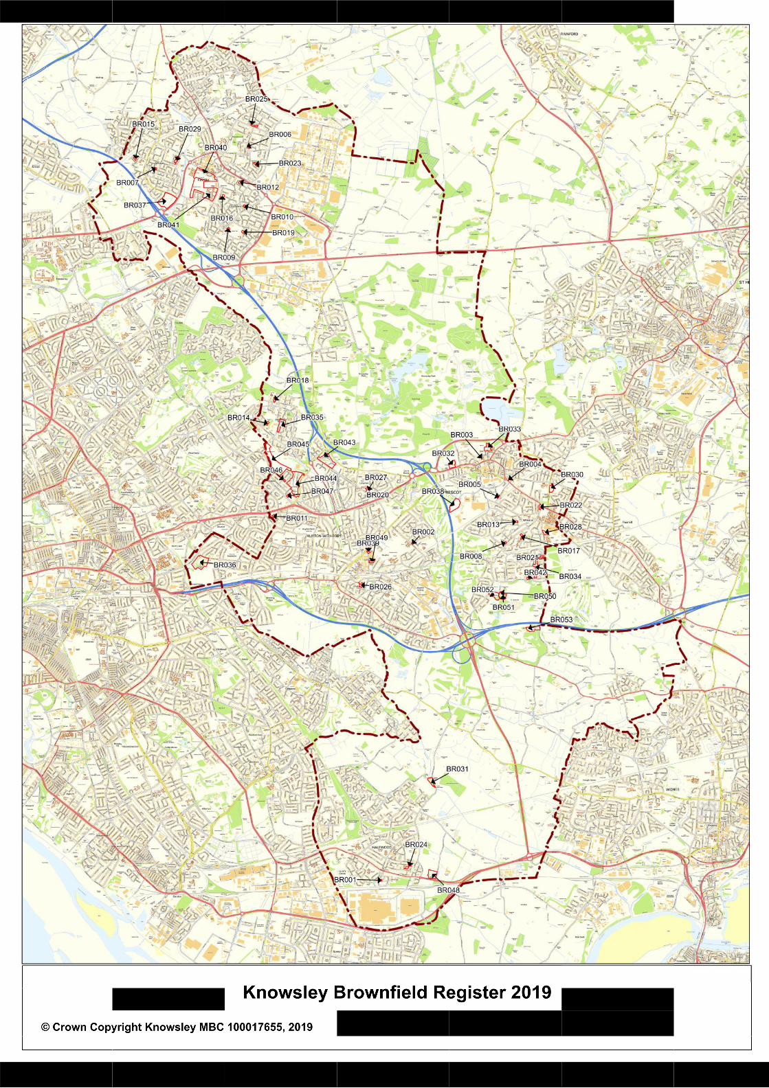
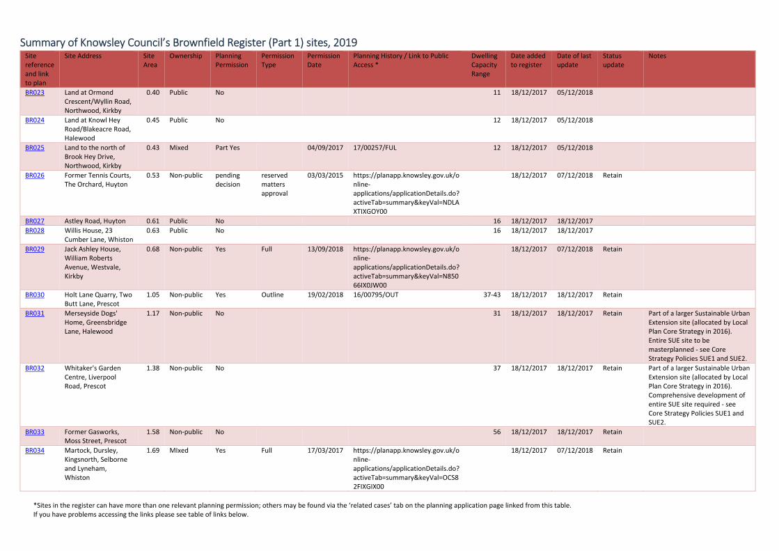
Summary of Knowsley Council’s Brownfield Register (Part 1) sites, 2019
*Sites in the register can have more than one relevant planning permission; others may be found via the ‘related cases’ tab on the planning application page linked from this table. If you have problems accessing the links please see table of links below.
Site reference and link to plan
Site Address Site Area
Ownership Planning Permission
Permission Type
Permission Date
Planning History / Link to Public Access *
Dwelling Capacity Range
Date added to register
Date of last update
Status update
Notes
BR001
Rear of 7 Brent Way, Halewood
0.09 Mixed Yes Full 09/02/2016 https://planapp.knowsley.gov.uk/online‐applications/applicationDetails.do?activeTab=externalDocuments&keyVal=P6LVYWIXKPZ00
4‐5 18/12/2017 05/12/2018 Retain; devt not started
Included in register as site has permission for five dwellings, although it is smaller than 0.25ha.
BR002
Robcliffe Longview Service Station, 91 Longview Drive, Huyton
0.10 Non‐public Yes Outline 07/11/2016 https://planapp.knowsley.gov.uk/online‐applications/applicationDetails.do?activeTab=summary&keyVal=O48ELPIXKGH00
6‐18 18/12/2017 07/12/2018 Retain; devt not started
Included in register as site has permission for 18 dwellings, although it is smaller than 0.25ha.
BR003 Rear 1‐25 Hope Street, Prescot
0.10 Non‐public Yes Full 17/10/2014 https://planapp.knowsley.gov.uk/online‐applications/applicationDetails.do?activeTab=summary&keyVal=N8FYNCIXM4100
5‐6 18/12/2017 07/12/2018 Retain; no permission
Included in register as site has had permission for six dwellings, although it is smaller than 0.25ha.|Permission now lapsed.
BR004 Former Beesley & Fildes Builder's Merchant, Scotchbarn Lane, Prescot
0.12 Non‐public Yes Full 22/02/2016 https://planapp.knowsley.gov.uk/online‐applications/applicationDetails.do?activeTab=summary&keyVal=NWIBHSIXGD100
5‐6 18/12/2017 07/12/2018 Retain; devt not started
Included in register as site has permission for six dwellings, although it is smaller than 0.25ha.
BR005 Imperial Hotel, Bridge Road, Prescot
0.12 Non‐public Yes Full 16/06/2015 https://planapp.knowsley.gov.uk/online‐applications/applicationDetails.do?activeTab=summary&keyVal=NKMMC0IXFX200
7‐22 18/12/2017 18/12/2017 Check Included in register as site has permission for 22 dwellings, although it is smaller than 0.25ha. | Site also has permission for 27 bedroom hotel ‐ planning reference 17/0446/FUL.
BR006 Land adjacent to 12 Bigdale Drive, Northwood, Kirkby
0.14 Non‐public Yes reserved matters approval
25/06/2014 https://planapp.knowsley.gov.uk/online‐applications/applicationDetails.do?activeTab=summary&keyVal=N3VGFXIXJTK00
5‐7 18/12/2017 07/12/2018 Retain Included in register as site has permission for six dwellings, although it is smaller than 0.25ha.|Permission now lapsed.
BR007 Former Westvale Community Centre, 70 Richard Hesketh Drive, Kirkby
0.16 Non‐public Yes Full 24/10/2016 https://planapp.knowsley.gov.uk/online‐applications/applicationDetails.do?keyVal=O6LWHKIXJ9C00&activeTab=summary
18/12/2017 05/12/2018 Retain Included in register as site has permission for six dwellings, although it is smaller than 0.25ha.
BR008 Whiston Methodist Church, Dragon Drive, Whiston
0.19 Non‐public Yes Full 26/10/2016 https://planapp.knowsley.gov.uk/online‐applications/applicationDetails.do?activeTab=summary&keyVal=O74CBMIXMGN00
18/12/2017 07/12/2018 Retain Included in register as site has permission for five dwellings, although it is smaller than 0.25ha.
BR009 Southdene Methodist Church, Broad Lane, Southdene, Kirkby
0.20 Non‐public No
7‐8 18/12/2017 18/12/2017 Included in register as site has previously had permission for seven dwellings, although it is smaller than 0.25ha.

Summary of Knowsley Council’s Brownfield Register (Part 1) sites, 2019
*Sites in the register can have more than one relevant planning permission; others may be found via the ‘related cases’ tab on the planning application page linked from this table. If you have problems accessing the links please see table of links below.
Site reference and link to plan
Site Address Site Area
Ownership Planning Permission
Permission Type
Permission Date
Planning History / Link to Public Access *
Dwelling Capacity Range
Date added to register
Date of last update
Status update
Notes
BR010 Thursby Walk, Southdene, Kirkby
0.22 Non‐public pending decision
reserved matters approval
https://planapp.knowsley.gov.uk/online‐applications/applicationDetails.do?activeTab=summary&keyVal=NY3YI5IXGZR00
18/12/2017 07/12/2018 Retain Included in register as site has permission for nine dwellings, although it is smaller than 0.25ha.
BR011 Former Express Dairies depot, Dinas Lane, Huyton
0.26 Non‐public Yes Full 02/08/2018 18/00237/FUL 7 18/12/2017 18/12/2017
BR012 Land at Overdene Walk/Lyelake Road, Southdene, Kirkby
0.27 Non‐public No 8 18/12/2017 18/12/2017
BR013 Land at Brookside Road/Molyneux Drive, Prescot
0.28 Non‐public No 8 18/12/2017 05/12/2018
BR014 St Judes C Of E Church, Round Hey, Stockbridge Village
0.28 not owned by a public authority
pending decision
https://planapp.knowsley.gov.uk/online‐applications/applicationDetails.do?activeTab=summary&keyVal=OVYV4EIXH0T00
18/12/2017 07/12/2018 Retain
BR015 Land at Copthorne Road/Melverley Road, Westvale, Kirkby
0.29 Public No 8 18/12/2017 05/12/2018
BR016 Land at Pitsmead Road, Southdene, Kirkby
0.29 Public No 8 18/12/2017 05/12/2018
BR017 Land off Milton Avenue/at rear of Dryden Close, Whiston
0.32 Public No 9 18/12/2017 05/12/2018
BR018 Pod 11, Hollow Croft, Stockbridge Village
0.33 Non‐public No 9 18/12/2017 18/12/2017
BR019 St Martins Church and Vicarage, Peatwood Avenue, Southdene, Kirkby
0.34 Non‐public No 10 18/12/2017 18/12/2017
BR020 Longview Social Club, Hazel Road/Lyme Grove, Huyton
0.34 Non‐public No 13 18/12/2017 18/12/2017
BR021 Lyneham, Whiston 0.39 Non‐public Yes Outline 20/06/2017 https://planapp.knowsley.gov.uk/online‐applications/applicationDetails.do?activeTab=summary&keyVal=ODHNU1IXITV00
18/12/2017 07/12/2018 Retain
BR022 Green Dragon Hotel, Dragon Lane, Whiston
0.40 Non‐public No 18/12/2017 18/12/2017
Summary of Knowsley Council’s Brownfield Register (Part 1) sites, 2019
*Sites in the register can have more than one relevant planning permission; others may be found via the ‘related cases’ tab on the planning application page linked from this table. If you have problems accessing the links please see table of links below.
Site reference and link to plan
Site Address Site Area
Ownership Planning Permission
Permission Type
Permission Date
Planning History / Link to Public Access *
Dwelling Capacity Range
Date added to register
Date of last update
Status update
Notes
BR023 Land at Ormond Crescent/Wyllin Road, Northwood, Kirkby
0.40 Public No 11 18/12/2017 05/12/2018
BR024 Land at Knowl Hey Road/Blakeacre Road, Halewood
0.45 Public No 12 18/12/2017 05/12/2018
BR025 Land to the north of Brook Hey Drive, Northwood, Kirkby
0.43 Mixed Part Yes 04/09/2017 17/00257/FUL 12 18/12/2017 05/12/2018
BR026 Former Tennis Courts, The Orchard, Huyton
0.53 Non‐public pending decision
reserved matters approval
03/03/2015 https://planapp.knowsley.gov.uk/online‐applications/applicationDetails.do?activeTab=summary&keyVal=NDLAXTIXGOY00
18/12/2017 07/12/2018 Retain
BR027 Astley Road, Huyton 0.61 Public No 16 18/12/2017 18/12/2017 BR028 Willis House, 23
Cumber Lane, Whiston 0.63 Public No 16 18/12/2017 18/12/2017
BR029 Jack Ashley House, William Roberts Avenue, Westvale, Kirkby
0.68 Non‐public Yes Full 13/09/2018 https://planapp.knowsley.gov.uk/online‐applications/applicationDetails.do?activeTab=summary&keyVal=N85066IX0JW00
18/12/2017 07/12/2018 Retain
BR030 Holt Lane Quarry, Two Butt Lane, Prescot
1.05 Non‐public Yes Outline 19/02/2018 16/00795/OUT 37‐43 18/12/2017 18/12/2017 Retain
BR031 Merseyside Dogs' Home, Greensbridge Lane, Halewood
1.17 Non‐public No 31 18/12/2017 18/12/2017 Retain Part of a larger Sustainable Urban Extension site (allocated by Local Plan Core Strategy in 2016). Entire SUE site to be masterplanned ‐ see Core Strategy Policies SUE1 and SUE2.
BR032 Whitaker's Garden Centre, Liverpool Road, Prescot
1.38 Non‐public No 37 18/12/2017 18/12/2017 Retain Part of a larger Sustainable Urban Extension site (allocated by Local Plan Core Strategy in 2016). Comprehensive development of entire SUE site required ‐ see Core Strategy Policies SUE1 and SUE2.
BR033 Former Gasworks, Moss Street, Prescot
1.58 Non‐public No 56 18/12/2017 18/12/2017 Retain
BR034 Martock, Dursley, Kingsnorth, Selborne and Lyneham, Whiston
1.69 MIxed Yes Full 17/03/2017 https://planapp.knowsley.gov.uk/online‐applications/applicationDetails.do?activeTab=summary&keyVal=OCS82FIXGIX00
18/12/2017 07/12/2018 Retain

Summary of Knowsley Council’s Brownfield Register (Part 1) sites, 2019
*Sites in the register can have more than one relevant planning permission; others may be found via the ‘related cases’ tab on the planning application page linked from this table. If you have problems accessing the links please see table of links below.
Site reference and link to plan
Site Address Site Area
Ownership Planning Permission
Permission Type
Permission Date
Planning History / Link to Public Access *
Dwelling Capacity Range
Date added to register
Date of last update
Status update
Notes
BR035 The Withens, Stockbridge Village
2.06 Non‐public Yes Full 09/05/2016 https://planapp.knowsley.gov.uk/online‐applications/applicationDetails.do?activeTab=summary&keyVal=NYHB4JIXH4I00
18/12/2017 07/12/2018 Retain
BR036 Thingwall Hall Residential Home (Brothers Of Charity), Thingwall Lane, Roby
5.90 Non‐public No 120‐132 18/12/2017 18/12/2017 Retain Site has had outline permission for 120 dwellings (04/00054/OUT, renewed by 10/00302/RPP) now lapsed.
BR037 Former Kirkby Stadium, Valley Road, Westvale, Kirkby
6.86 Public No 154 18/12/2017 18/12/2017 Retain Site allocated in 2006 Unitary Development Plan.
BR038 Carr Lane 3.25 Non‐public No 20/12/2018 20/12/2018 New Site allocated as SUE site in Local Plan Core Strategy 2016.
BR039 Former fire station, Huyton
0.39 Public No 20/12/2018 20/12/2018 New
BR040 Land south of Cherryfield Drive, Kirkby
5.77 MIxed No 20/12/2018 20/12/2018 New
BR041 Former All Saints School, Kirkby
11.32
Public No 20/12/2018 20/12/2018 New
BR042 Former Penny Black pub, Lickers Lane, Whiston
0.21 Non‐public No 20/12/2018 20/12/2018 New
BR043 North Huyton Revive Phase 2B
4.93 Public No 20/12/2018 20/12/2018 New
BR044 North Huyton Revive Phase 4
9.64 Public No 20/12/2018 20/12/2018 New
BR045 North Huyton Revive Phase 5
9.10 Public No 20/12/2018 20/12/2018 New
BR046 Land at Southdean Road, Huyton
0.23 Public No 20/12/2018 20/12/2018 New
BR047 Former Family Centre, Princess Drive, Huyton
0.17 Public No 20/12/2018 20/12/2018 New
BR048 Former RSPCA site, Halewood
2.46 Non‐public No 20/12/2018 20/12/2018 New Part of a larger Sustainable Urban Extension site (allocated by Local Plan Core Strategy in 2016). Entire SUE site to be masterplanned ‐ see Core Strategy Policies SUE1 and SUE2.
BR049 Former Huyton Magistrates Court
0.46 Public No 20/12/2018 20/12/2018 New
BR050 Halsnead ‐ Gateway Site 1
0.08 Non‐public No 20/12/2018 20/12/2018 New Part of a larger Sustainable Urban Extension site (allocated by Local

Summary of Knowsley Council’s Brownfield Register (Part 1) sites, 2019
*Sites in the register can have more than one relevant planning permission; others may be found via the ‘related cases’ tab on the planning application page linked from this table. If you have problems accessing the links please see table of links below.
Site reference and link to plan
Site Address Site Area
Ownership Planning Permission
Permission Type
Permission Date
Planning History / Link to Public Access *
Dwelling Capacity Range
Date added to register
Date of last update
Status update
Notes
Plan Core Strategy in 2016). Entire SUE site to be masterplanned ‐ see Core Strategy Policies SUE1 and SUE2.
BR051 Halsnead ‐ Gateway Site 2
1.35 Non‐public No 20/12/2018 20/12/2018 New Part of a larger Sustainable Urban Extension site (allocated by Local Plan Core Strategy in 2016). Entire SUE site to be masterplanned ‐ see Core Strategy Policies SUE1 and SUE2.
BR052 Former Garden Centre Site
2.09 Non‐public No 20/12/2018 20/12/2018 New Part of a larger Sustainable Urban Extension site (allocated by Local Plan Core Strategy in 2016). Entire SUE site to be masterplanned ‐ see Core Strategy Policies SUE1 and SUE2.
BR053 South Halsnead ‐ Residential Allocation
2.08 Non‐public No 20/12/2018 20/12/2018 New Part of a larger Sustainable Urban Extension site (allocated by Local Plan Core Strategy in 2016). Entire SUE site to be masterplanned ‐ see Core Strategy Policies SUE1 and SUE2.

Summary of Knowsley Council’s Brownfield Register (Part 1) sites, 2019
*Sites in the register can have more than one relevant planning permission; others may be found via the ‘related cases’ tab on the planning application page linked from this table. If you have problems accessing the links please see table of links below.
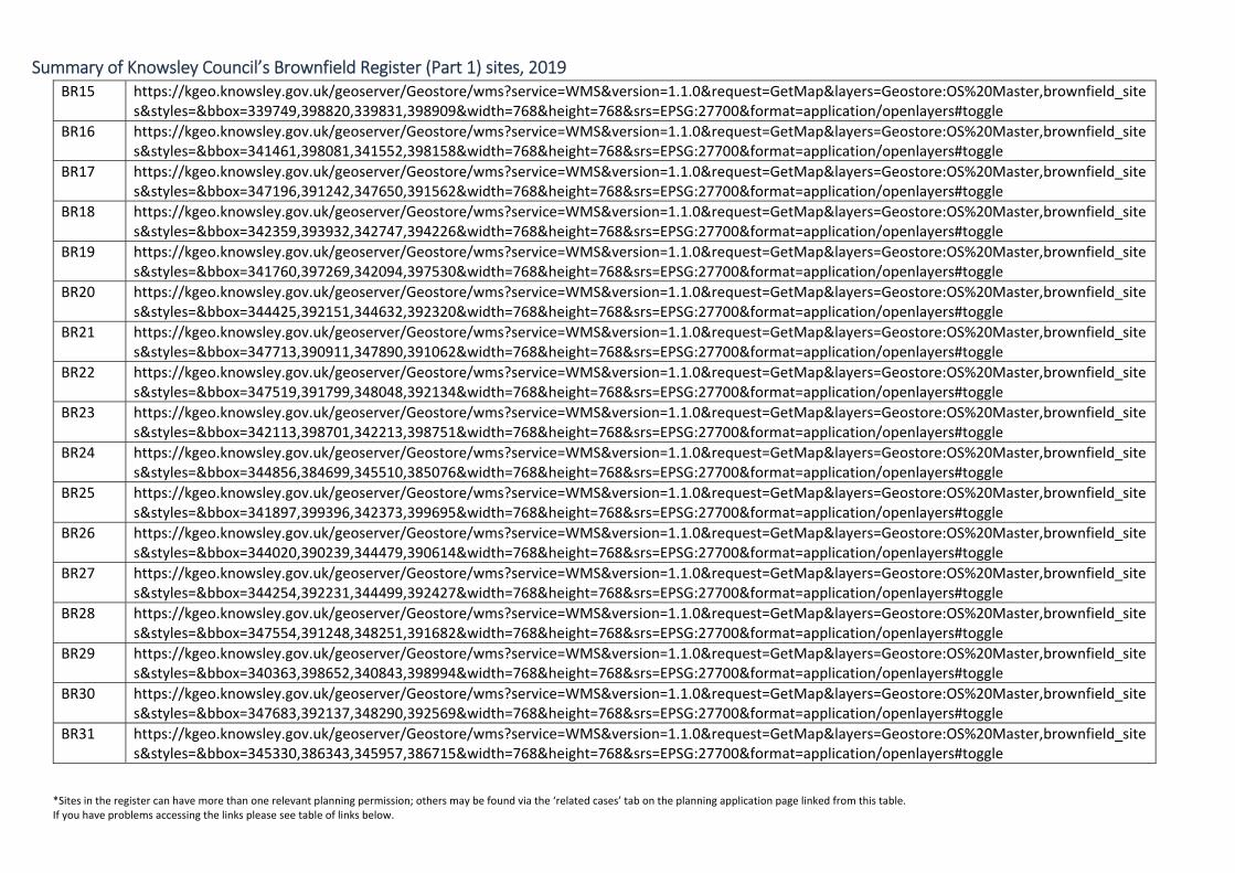
Table of Links
Please copy and paste the link into the web address bar in your browser.
BR01 https://kgeo.knowsley.gov.uk/geoserver/Geostore/wms?service=WMS&version=1.1.0&request=GetMap&layers=Geostore:OS%20Master,brownfield_sites&styles=&bbox=344512,384492,344759,384702&width=768&height=768&srs=EPSG:27700&format=application/openlayers#toggle
BR02 https://kgeo.knowsley.gov.uk/geoserver/Geostore/wms?service=WMS&version=1.1.0&request=GetMap&layers=Geostore:OS%20Master,brownfield_sites&styles=&bbox=345131,391175,345389,391334&width=768&height=768&srs=EPSG:27700&format=application/openlayers#toggle
BR03 https://kgeo.knowsley.gov.uk/geoserver/Geostore/wms?service=WMS&version=1.1.0&request=GetMap&layers=Geostore:OS%20Master,brownfield_sites&styles=&bbox=346436,392835,346800,393052&width=768&height=768&srs=EPSG:27700&format=application/openlayers#toggle
BR04 https://kgeo.knowsley.gov.uk/geoserver/Geostore/wms?service=WMS&version=1.1.0&request=GetMap&layers=Geostore:OS%20Master,brownfield_sites&styles=&bbox=347072,392456,347282,392590&width=768&height=768&srs=EPSG:27700&format=application/openlayers#toggle
BR05 https://kgeo.knowsley.gov.uk/geoserver/Geostore/wms?service=WMS&version=1.1.0&request=GetMap&layers=Geostore:OS%20Master,brownfield_sites&styles=&bbox=346747,392029,347169,392290&width=768&height=768&srs=EPSG:27700&format=application/openlayers#toggle
BR06 https://kgeo.knowsley.gov.uk/geoserver/Geostore/wms?service=WMS&version=1.1.0&request=GetMap&layers=Geostore:OS%20Master,brownfield_sites&styles=&bbox=341814,398941,342222,399241&width=768&height=768&srs=EPSG:27700&format=application/openlayers#toggle
BR07 https://kgeo.knowsley.gov.uk/geoserver/Geostore/wms?service=WMS&version=1.1.0&request=GetMap&layers=Geostore:OS%20Master,brownfield_sites&styles=&bbox=340021,398541,340344,398759&width=768&height=768&srs=EPSG:27700&format=application/openlayers#toggle
BR08 https://kgeo.knowsley.gov.uk/geoserver/Geostore/wms?service=WMS&version=1.1.0&request=GetMap&layers=Geostore:OS%20Master,brownfield_sites&styles=&bbox=346932,391130,347241,391390&width=768&height=768&srs=EPSG:27700&format=application/openlayers#toggle
BR09 https://kgeo.knowsley.gov.uk/geoserver/Geostore/wms?service=WMS&version=1.1.0&request=GetMap&layers=Geostore:OS%20Master,brownfield_sites&styles=&bbox=341458,397317,341789,397590&width=768&height=768&srs=EPSG:27700&format=application/openlayers#toggle
BR10 https://kgeo.knowsley.gov.uk/geoserver/Geostore/wms?service=WMS&version=1.1.0&request=GetMap&layers=Geostore:OS%20Master,brownfield_sites&styles=&bbox=341740,397773,342168,398034&width=768&height=768&srs=EPSG:27700&format=application/openlayers#toggle
BR11 https://kgeo.knowsley.gov.uk/geoserver/Geostore/wms?service=WMS&version=1.1.0&request=GetMap&layers=Geostore:OS%20Master,brownfield_sites&styles=&bbox=342348,391633,342724,391954&width=768&height=768&srs=EPSG:27700&format=application/openlayers#toggle
BR12 https://kgeo.knowsley.gov.uk/geoserver/Geostore/wms?service=WMS&version=1.1.0&request=GetMap&layers=Geostore:OS%20Master,brownfield_sites&styles=&bbox=341624,398232,342086,398559&width=768&height=768&srs=EPSG:27700&format=application/openlayers#toggle
BR13 https://kgeo.knowsley.gov.uk/geoserver/Geostore/wms?service=WMS&version=1.1.0&request=GetMap&layers=Geostore:OS%20Master,brownfield_sites&styles=&bbox=347064,391540,347513,391822&width=768&height=768&srs=EPSG:27700&format=application/openlayers#toggle
BR14 https://kgeo.knowsley.gov.uk/geoserver/Geostore/wms?service=WMS&version=1.1.0&request=GetMap&layers=Geostore:OS%20Master,brownfield_sites&styles=&bbox=342263,393534,342542,393739&width=768&height=768&srs=EPSG:27700&format=application/openlayers#toggle
Summary of Knowsley Council’s Brownfield Register (Part 1) sites, 2019
*Sites in the register can have more than one relevant planning permission; others may be found via the ‘related cases’ tab on the planning application page linked from this table. If you have problems accessing the links please see table of links below.
BR15 https://kgeo.knowsley.gov.uk/geoserver/Geostore/wms?service=WMS&version=1.1.0&request=GetMap&layers=Geostore:OS%20Master,brownfield_sites&styles=&bbox=339749,398820,339831,398909&width=768&height=768&srs=EPSG:27700&format=application/openlayers#toggle
BR16 https://kgeo.knowsley.gov.uk/geoserver/Geostore/wms?service=WMS&version=1.1.0&request=GetMap&layers=Geostore:OS%20Master,brownfield_sites&styles=&bbox=341461,398081,341552,398158&width=768&height=768&srs=EPSG:27700&format=application/openlayers#toggle
BR17 https://kgeo.knowsley.gov.uk/geoserver/Geostore/wms?service=WMS&version=1.1.0&request=GetMap&layers=Geostore:OS%20Master,brownfield_sites&styles=&bbox=347196,391242,347650,391562&width=768&height=768&srs=EPSG:27700&format=application/openlayers#toggle
BR18 https://kgeo.knowsley.gov.uk/geoserver/Geostore/wms?service=WMS&version=1.1.0&request=GetMap&layers=Geostore:OS%20Master,brownfield_sites&styles=&bbox=342359,393932,342747,394226&width=768&height=768&srs=EPSG:27700&format=application/openlayers#toggle
BR19 https://kgeo.knowsley.gov.uk/geoserver/Geostore/wms?service=WMS&version=1.1.0&request=GetMap&layers=Geostore:OS%20Master,brownfield_sites&styles=&bbox=341760,397269,342094,397530&width=768&height=768&srs=EPSG:27700&format=application/openlayers#toggle
BR20 https://kgeo.knowsley.gov.uk/geoserver/Geostore/wms?service=WMS&version=1.1.0&request=GetMap&layers=Geostore:OS%20Master,brownfield_sites&styles=&bbox=344425,392151,344632,392320&width=768&height=768&srs=EPSG:27700&format=application/openlayers#toggle
BR21 https://kgeo.knowsley.gov.uk/geoserver/Geostore/wms?service=WMS&version=1.1.0&request=GetMap&layers=Geostore:OS%20Master,brownfield_sites&styles=&bbox=347713,390911,347890,391062&width=768&height=768&srs=EPSG:27700&format=application/openlayers#toggle
BR22 https://kgeo.knowsley.gov.uk/geoserver/Geostore/wms?service=WMS&version=1.1.0&request=GetMap&layers=Geostore:OS%20Master,brownfield_sites&styles=&bbox=347519,391799,348048,392134&width=768&height=768&srs=EPSG:27700&format=application/openlayers#toggle
BR23 https://kgeo.knowsley.gov.uk/geoserver/Geostore/wms?service=WMS&version=1.1.0&request=GetMap&layers=Geostore:OS%20Master,brownfield_sites&styles=&bbox=342113,398701,342213,398751&width=768&height=768&srs=EPSG:27700&format=application/openlayers#toggle
BR24 https://kgeo.knowsley.gov.uk/geoserver/Geostore/wms?service=WMS&version=1.1.0&request=GetMap&layers=Geostore:OS%20Master,brownfield_sites&styles=&bbox=344856,384699,345510,385076&width=768&height=768&srs=EPSG:27700&format=application/openlayers#toggle
BR25 https://kgeo.knowsley.gov.uk/geoserver/Geostore/wms?service=WMS&version=1.1.0&request=GetMap&layers=Geostore:OS%20Master,brownfield_sites&styles=&bbox=341897,399396,342373,399695&width=768&height=768&srs=EPSG:27700&format=application/openlayers#toggle
BR26 https://kgeo.knowsley.gov.uk/geoserver/Geostore/wms?service=WMS&version=1.1.0&request=GetMap&layers=Geostore:OS%20Master,brownfield_sites&styles=&bbox=344020,390239,344479,390614&width=768&height=768&srs=EPSG:27700&format=application/openlayers#toggle
BR27 https://kgeo.knowsley.gov.uk/geoserver/Geostore/wms?service=WMS&version=1.1.0&request=GetMap&layers=Geostore:OS%20Master,brownfield_sites&styles=&bbox=344254,392231,344499,392427&width=768&height=768&srs=EPSG:27700&format=application/openlayers#toggle
BR28 https://kgeo.knowsley.gov.uk/geoserver/Geostore/wms?service=WMS&version=1.1.0&request=GetMap&layers=Geostore:OS%20Master,brownfield_sites&styles=&bbox=347554,391248,348251,391682&width=768&height=768&srs=EPSG:27700&format=application/openlayers#toggle
BR29 https://kgeo.knowsley.gov.uk/geoserver/Geostore/wms?service=WMS&version=1.1.0&request=GetMap&layers=Geostore:OS%20Master,brownfield_sites&styles=&bbox=340363,398652,340843,398994&width=768&height=768&srs=EPSG:27700&format=application/openlayers#toggle
BR30 https://kgeo.knowsley.gov.uk/geoserver/Geostore/wms?service=WMS&version=1.1.0&request=GetMap&layers=Geostore:OS%20Master,brownfield_sites&styles=&bbox=347683,392137,348290,392569&width=768&height=768&srs=EPSG:27700&format=application/openlayers#toggle
BR31 https://kgeo.knowsley.gov.uk/geoserver/Geostore/wms?service=WMS&version=1.1.0&request=GetMap&layers=Geostore:OS%20Master,brownfield_sites&styles=&bbox=345330,386343,345957,386715&width=768&height=768&srs=EPSG:27700&format=application/openlayers#toggle

Summary of Knowsley Council’s Brownfield Register (Part 1) sites, 2019
*Sites in the register can have more than one relevant planning permission; others may be found via the ‘related cases’ tab on the planning application page linked from this table. If you have problems accessing the links please see table of links below.
BR32 https://kgeo.knowsley.gov.uk/geoserver/Geostore/wms?service=WMS&version=1.1.0&request=GetMap&layers=Geostore:OS%20Master,brownfield_sites&styles=&bbox=345740,392616,346337,393007&width=768&height=768&srs=EPSG:27700&format=application/openlayers#toggle
BR33 https://kgeo.knowsley.gov.uk/geoserver/Geostore/wms?service=WMS&version=1.1.0&request=GetMap&layers=Geostore:OS%20Master,brownfield_sites&styles=&bbox=346493,393016,347016,393310&width=768&height=768&srs=EPSG:27700&format=application/openlayers#toggle
BR34 https://kgeo.knowsley.gov.uk/geoserver/Geostore/wms?service=WMS&version=1.1.0&request=GetMap&layers=Geostore:OS%20Master,brownfield_sites&styles=&bbox=347596,390555,347770,391031&width=768&height=768&srs=EPSG:27700&format=application/openlayers#toggle
BR35 https://kgeo.knowsley.gov.uk/geoserver/Geostore/wms?service=WMS&version=1.1.0&request=GetMap&layers=Geostore:OS%20Master,brownfield_sites&styles=&bbox=342424,393369,342918,393823&width=768&height=768&srs=EPSG:27700&format=application/openlayers#toggle
BR36 https://kgeo.knowsley.gov.uk/geoserver/Geostore/wms?service=WMS&version=1.1.0&request=GetMap&layers=Geostore:OS%20Master,brownfield_sites&styles=&bbox=340793,390639,341373,391107&width=768&height=768&srs=EPSG:27700&format=application/openlayers#toggle
BR37 https://kgeo.knowsley.gov.uk/geoserver/Geostore/wms?service=WMS&version=1.1.0&request=GetMap&layers=Geostore:OS%20Master,brownfield_sites&styles=&bbox=339959,397716,340874,398306&width=768&height=768&srs=EPSG:27700&format=application/openlayers#toggle
BR38 https://kgeo.knowsley.gov.uk/geoserver/Geostore/wms?service=WMS&version=1.1.0&request=GetMap&layers=Geostore:OS%20Master,brownfield_sites&styles=&bbox=345984,391879,346202,392157&width=768&height=768&srs=EPSG:27700&format=application/openlayers#toggle
BR39 https://kgeo.knowsley.gov.uk/geoserver/Geostore/wms?service=WMS&version=1.1.0&request=GetMap&layers=Geostore:OS%20Master,brownfield_sites&styles=&bbox=344353,391065,344420,391145&width=768&height=768&srs=EPSG:27700&format=application/openlayers#toggle
BR40 https://kgeo.knowsley.gov.uk/geoserver/Geostore/wms?service=WMS&version=1.1.0&request=GetMap&layers=Geostore:OS%20Master,brownfield_sites&styles=&bbox=340933,398412,341407,398685&width=768&height=768&srs=EPSG:27700&format=application/openlayers#toggle
BR41 https://kgeo.knowsley.gov.uk/geoserver/Geostore/wms?service=WMS&version=1.1.0&request=GetMap&layers=Geostore:OS%20Master,brownfield_sites&styles=&bbox=341113,398022,341414,398308&width=768&height=768&srs=EPSG:27700&format=application/openlayers#toggle
BR42 https://kgeo.knowsley.gov.uk/geoserver/Geostore/wms?service=WMS&version=1.1.0&request=GetMap&layers=Geostore:OS%20Master,brownfield_sites&styles=&bbox=347514,390561,347574,390599&width=768&height=768&srs=EPSG:27700&format=application/openlayers#toggle
BR43 https://kgeo.knowsley.gov.uk/geoserver/Geostore/wms?service=WMS&version=1.1.0&request=GetMap&layers=Geostore:OS%20Master,brownfield_sites&styles=&bbox=343376,392746,343747,393050&width=768&height=768&srs=EPSG:27700&format=application/openlayers#toggle
BR44 https://kgeo.knowsley.gov.uk/geoserver/Geostore/wms?service=WMS&version=1.1.0&request=GetMap&layers=Geostore:OS%20Master,brownfield_sites&styles=&bbox=342765,392165,343152,392707&width=768&height=768&srs=EPSG:27700&format=application/openlayers#toggle
BR45 https://kgeo.knowsley.gov.uk/geoserver/Geostore/wms?service=WMS&version=1.1.0&request=GetMap&layers=Geostore:OS%20Master,brownfield_sites&styles=&bbox=342338,392579,342861,393257&width=768&height=768&srs=EPSG:27700&format=application/openlayers#toggle
BR46 https://kgeo.knowsley.gov.uk/geoserver/Geostore/wms?service=WMS&version=1.1.0&request=GetMap&layers=Geostore:OS%20Master,brownfield_sites&styles=&bbox=342661,392483,342755,392574&width=768&height=768&srs=EPSG:27700&format=application/openlayers#toggle
BR47 https://kgeo.knowsley.gov.uk/geoserver/Geostore/wms?service=WMS&version=1.1.0&request=GetMap&layers=Geostore:OS%20Master,brownfield_sites&styles=&bbox=342772,392172,342827,392234&width=768&height=768&srs=EPSG:27700&format=application/openlayers#toggle
BR48 https://kgeo.knowsley.gov.uk/geoserver/Geostore/wms?service=WMS&version=1.1.0&request=GetMap&layers=Geostore:OS%20Master,brownfield_sites&styles=&bbox=345558,384649,345742,384832&width=768&height=768&srs=EPSG:27700&format=application/openlayers#toggle

Summary of Knowsley Council’s Brownfield Register (Part 1) sites, 2019
*Sites in the register can have more than one relevant planning permission; others may be found via the ‘related cases’ tab on the planning application page linked from this table. If you have problems accessing the links please see table of links below.
BR49 https://kgeo.knowsley.gov.uk/geoserver/Geostore/wms?service=WMS&version=1.1.0&request=GetMap&layers=Geostore:OS%20Master,brownfield_sites&styles=&bbox=344400,390881,344514,390934&width=768&height=768&srs=EPSG:27700&format=application/openlayers#toggle
BR50 https://kgeo.knowsley.gov.uk/geoserver/Geostore/wms?service=WMS&version=1.1.0&request=GetMap&layers=Geostore:OS%20Master,brownfield_sites&styles=&bbox=346961,390162,347118,390313&width=768&height=768&srs=EPSG:27700&format=application/openlayers#toggle
BR51 https://kgeo.knowsley.gov.uk/geoserver/Geostore/wms?service=WMS&version=1.1.0&request=GetMap&layers=Geostore:OS%20Master,brownfield_sites&styles=&bbox=346961,390162,347118,390313&width=768&height=768&srs=EPSG:27700&format=application/openlayers#toggle
BR52 https://kgeo.knowsley.gov.uk/geoserver/Geostore/wms?service=WMS&version=1.1.0&request=GetMap&layers=Geostore:OS%20Master,brownfield_sites&styles=&bbox=346758,390149,346969,390332&width=768&height=768&srs=EPSG:27700&format=application/openlayers#toggle
BR53 https://kgeo.knowsley.gov.uk/geoserver/Geostore/wms?service=WMS&version=1.1.0&request=GetMap&layers=Geostore:OS%20Master,brownfield_sites&styles=&bbox=347491,389523,347774,389637&width=768&height=768&srs=EPSG:27700&format=application/openlayers#toggle