Sujala III Project Overview - Karnatakawatershed.kar.nic.in/SujalaIII_files/Sectoral Head...Sujala...
21
Project coverage for data : Bidar, Gulbarga, Yadgir, Koppal, Gadag, Davanagere, generation Chamarajnagar, Effectiveness Date : 13-05-2013 Closing Date : 31-12-2018 Total cost of the project : 85.70 million USD (Rs.471.30 cr as per PAD, Rs.514.40 Cr May 7, 2015) Sujala III Project Overview Pattern of cost sharing 30% 70% World Bank GOK
Transcript of Sujala III Project Overview - Karnatakawatershed.kar.nic.in/SujalaIII_files/Sectoral Head...Sujala...

� Project coverage for data : Bidar, Gulbarga, Yadgir, Koppal, Gadag, Davanagere,
generation Chamarajnagar,
� Effectiveness Date : 13-05-2013
� Closing Date : 31-12-2018
� Total cost of the project : 85.70 million USD (Rs.471.30 cr as per PAD,
Rs.514.40 Cr May 7, 2015)
Sujala III Project Overview
Pattern of cost sharing
30%
70%
World Bank GOK

Project (Sujala – III) Overview
DISTRICTS : Bidar, Gulbarga, Yadgir, Gadag,
Koppal, Davanagere, Chamarajanagar (7),
Tumkur, Chikkamagalur, Bijapur & Raichur (4)
NO. OF MICRO WATERSHEDS : 931 (698)
TREATABLE AREA : 3.34 Lakh Ha
PROJECT PERIOD : 2013-14 To 2018-19
TOTAL PROJECT COST : Rs. 522.17
crores
Pattern of cost sharing
30%
70%
World Bank GOK

Project districts
Subsequently, 4 CGIAR districts were proposed to added namely,
• Tumkur,
• Chikkamagalore,
• Raichur and
• Vijayapur by the PEC dt. 31.05.2014.

Improved Program Integration in Rainfed Areas - Rs.120.75 Cr.
Research, Development and Innovation - Rs.239.74 Cr.
Institutional Strengthening - Rs.23.93 Cr.
Horticulture - Rs.105.11Cr.
Project components
Horticulture - Rs.105.11Cr.
Project Management and Coordination - Rs.32.64 Cr.
Project Objectives
To demonstrate more effective
watershed managementthrough
Innovative and Science based
approachesapproaches
Greater integration of programs
related Rain fed Agriculture,
Strengthening institutions and
capacities.

• Sujala III is not a stand alone project
• It is designed to improve the PMKSY effectiveness.
• World Bank funded project (70%).

Project Cost ( INR Crores )
COMPONENTGOK 30%
ShareBANK 70%
ShareTOTAL
Improved Program Integration in Rainfed Areas
36.23 84.52 120.75
Research, Development and Innovation
71.92 167.82 239.74
Institutional Strengthening 7.18 16.75 23.93
Horticulture 31.53 73.58 105.11
Project Management and Coordination
9.79 22.85 32.64
Total Project Costs (including contingencies)
156.65 365.52 522.17

StrategyStrategyStrategyStrategy
• Land Resource Inventory by using state of art RS, GIS and Field MappingTechniques
• Developing Digital Library, by pooling all spatial & non spatial Land Resources
• Establishing LR Portal for effective information dissemination
• Supported by Robust, dynamic and evolving Decision Support System (DSS) forimproved program integration at farm/watershed and higher levels in the State
ImplementedImplementedImplementedImplemented bybybyby :::: ResearchResearchResearchResearch institutions,institutions,institutions,institutions, SAU’s,SAU’s,SAU’s,SAU’s, KSNDMC,KSNDMC,KSNDMC,KSNDMC, KSRSACKSRSACKSRSACKSRSAC
Activities in the projectActivities in the projectActivities in the projectActivities in the project
ImplementedImplementedImplementedImplemented bybybyby :::: ResearchResearchResearchResearch institutions,institutions,institutions,institutions, SAU’s,SAU’s,SAU’s,SAU’s, KSNDMC,KSNDMC,KSNDMC,KSNDMC, KSRSACKSRSACKSRSACKSRSAC
1. Inventory of Land Resources like soil, water, land use , weather etc., at individual farm level
2. Ground and surface water availability, water balance etc.,
3. Establishing Digital Library, Watershed Management Portal for the Decision Support System
4. Strengthening local Watershed Institutions in planning, implementation & monitoring of watershed development activities through participatory approaches
• To provide datasets & inputs needed for planning,
implementation & monitoring of all land based
programmes
• To provide farm-specific crop choices
• To evolve location specific soil & water conservations &
Outcome of SUJALA-III
• To evolve location specific soil & water conservations &
package of practices
Project partners
1. Indian Institute of Science (IISc.), Bangalore
2. International Crops Research Institute for the Semi-Arid Tropics (ICRISAT)
3. National Bureau of Soil Survey and Land Use Planning (NBSSLUP),
4. University of Agricultural Sciences, Bangalore,
5. University of Agricultural Sciences, Dharwad
6. University of Agricultural Sciences, Raichur
7. University of Horticultural Sciences, Bagalkot7. University of Horticultural Sciences, Bagalkot
8. Karnataka State Remote Sensing Applications Centre, Bangalore
9. Karnataka State Natural Disaster Management Center, Bangalore
10. Karnataka Veterinary, Animal and Fishery Sciences University, Bidar
11. Bangalore University
12. University of Agriculture & Horticulture Sciences, Shivamogga.
13. Indian Institute of Soil & Water Conservation, Regional Research Centre, Bellari

A micro watershed with 500 ha area in Aurad taluk, Bidar shows
wide variability in soil depth and soil texture
This requires
• Site specific soil and water conservation measures• Selection of best suited crops and tree species• Farm specific nutrient management

KSRSAC
• Supply of Geo referenced Seamless Cadastral Maps at Taluk level for the State
• Supply of Geo referenced satellite imageries for the Project areas initially and subsequently for the entire state
Roles and Responsibilities of the project partners
and subsequently for the entire state
• Generation of Base Maps for all the MCs
• Generation of Land use / Land cover maps at the Micro-watershed level
• Developing UIDs initially at Cadastral level and later at Land parcel level with inputs from Project partners
• Development of DEM for all the MCs
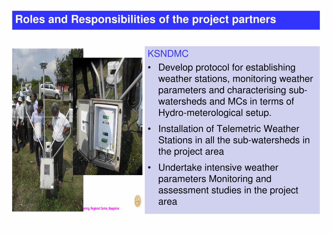
KSNDMC
• Develop protocol for establishing
weather stations, monitoring weather
parameters and characterising sub-
watersheds and MCs in terms of
Hydro-meterological setup.
Roles and Responsibilities of the project partners
Hydro-meterological setup.
• Installation of Telemetric Weather
Stations in all the sub-watersheds in
the project area
• Undertake intensive weather
parameters Monitoring and
assessment studies in the project
areaNational Bureau of Soil Survey & Land Use Planning, Regional Centre, Bangalore
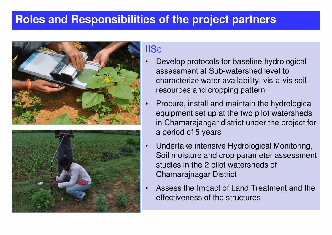
IISc
• Develop protocols for baseline hydrological assessment at Sub-watershed level to characterize water availability, vis-a-vis soil resources and cropping pattern
• Procure, install and maintain the hydrological equipment set up at the two pilot watersheds
Roles and Responsibilities of the project partners
in Chamarajangar district under the project for a period of 5 years
• Undertake intensive Hydrological Monitoring, Soil moisture and crop parameter assessment studies in the 2 pilot watersheds of Chamarajnagar District
• Assess the Impact of Land Treatment and the effectiveness of the structures
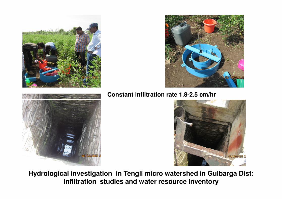
Constant infiltration rate 1.8-2.5 cm/hr
Hydrological investigation in Tengli micro watershed in Gulbarga Dist: infiltration studies and water resource inventory

Bangalore University
Pumping and slug test
• Procure the pumping test equipments and undertake different hydraulic tests viz., slug tests, and pumping tests.
• Estimate hydrogeological parameters of the hard rock aquifer like Hydraulic
Roles and Responsibilities of the project partners
the hard rock aquifer like Hydraulic conductivity (K), Transmissivity (T) and Storativity (S).
Geology and Geophysical studies
• Procure the equipment and execute the 1D and 2D resistivity soundings, well logging at the 14 pilot watersheds in 7 project district
• Undertake geological mapping and aquifer charecterisation assessment studies in the 14 pilot watersheds of 7 project District;

Constant infiltration rate 1.8-2.5 cm/hr
Hydrological investigation in Tengli micro watershed in Gulbarga Dist: infiltration studies and water resource inventory

• Pilot demonstration of water
harvesting and production
technologies
• Pilot demonstration of watershed
New activities planned
• Pilot demonstration of watershed
treatments saturation in selected
micro watersheds

1) M & E by specialised agency - Indian Institute of Soil and Water
Conservation (IISWC)
• Assess and monitor the efficiency and usefulness of the scientific tools
developed under the project for planning, implementation and
• Assess its impact in achieving the development objective of the project.
2) Third party/ agency – Process of hiring experienced agency is in progress
Monitoring & Evaluation
2) Third party/ agency – Process of hiring experienced agency is in progress
(QCBS method)
• Assess the acceptance and use of scientific tools and approaches by the
communities
• Impacts of the project interventions at the field level.
3) Participatory monitoring and evaluation is jointly done by the communities
and implementing agencies.

• Crop cutting experiment in all saturation micro watersheds by Dept. of economics and statistics
• Interns from agriculture engineering college to monitor and learn implementation of watershed treatment
• Revised user group to activity based groups -
• Two for Agriculture,
• One for Forest,
New initiatives
• One for Forest,
• One for Horticulture and
• One for Animal husbandry
• Setting up GIS cell in Head Quarter of Watershed Development Department
• Intensive training of watershed assistant at our training centre followed by exam
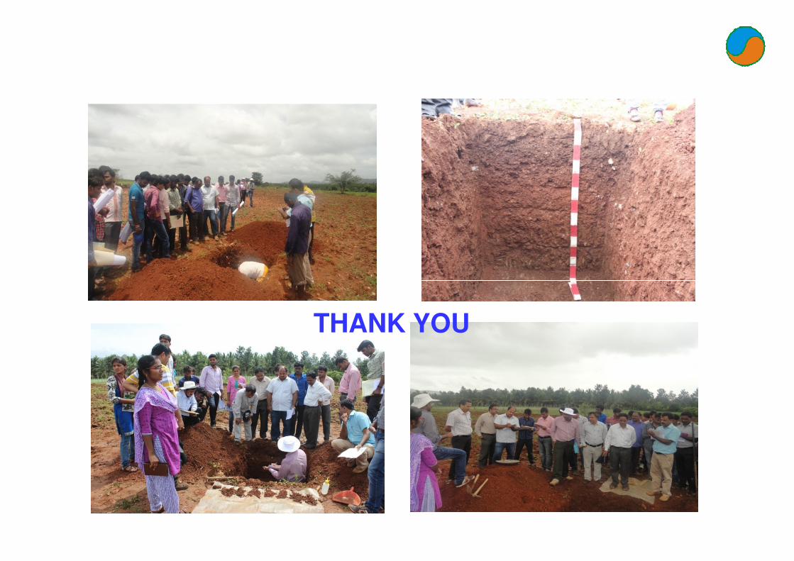
THANK YOU