sugiura(River information management and flood … Centre for Water entre for Water HHaazard and...
36
River information management and flood forecasting River information management and flood forecasting in Japan in Japan Tomonobu Tomonobu SUGIURA SUGIURA Senior Researcher Hydrologic Engineering Research Team International Centre for Water Hazard and Risk Management (ICHARM)
Transcript of sugiura(River information management and flood … Centre for Water entre for Water HHaazard and...

River information management and flood forecasting River information management and flood forecasting in Japanin Japan
TomonobuTomonobu SUGIURASUGIURA
Senior ResearcherHydrologic Engineering Research Team
International Centre for Water Hazard and Risk Management (ICHARM)

IInternational nternational CCentre for Water entre for Water HaHazard and zard and RRisk isk MManagement under the auspices of UNESCOanagement under the auspices of UNESCO
ContentsContents
1. Objectives of river information management1. Objectives of river information management
2. Collection, processing and provision of real2. Collection, processing and provision of real--time datatime data
3. Provision of disaster information3. Provision of disaster information
4. Predicted rainfall4. Predicted rainfall
5. Run5. Run--off analysis and flood forecastingoff analysis and flood forecasting
6. Utilization of satellite6. Utilization of satellite--based rainfall information based rainfall information
IInternational nternational CCentre for Water entre for Water HaHazard and zard and RRisk isk MManagement under the auspices of UNESCOanagement under the auspices of UNESCO
1. Objectives of river information management1. Objectives of river information management

IInternational nternational CCentre for Water entre for Water HaHazard and zard and RRisk isk MManagement under the auspices of UNESCOanagement under the auspices of UNESCO
11--1 Objectives of river information management1 Objectives of river information management
Images
Water quality
Rainfall amounts
Water levels
River informationRiver information
Refinement of planar dataRefinement of image data
ProcessingProcessing
ProvisionProvision
Centralization of dataRefinement of prediction data
Refinement of contentsImprovement of information dissemination tools
Accurate, reliable and quick collection, processing and dissemination of river information(e.g. rainfall amounts and water levels in rivers)
CollectionCollection
UserUser Increasing the efficiency of river-related work
Enhancing river administration services through information dissemination to the public
Regional FM radio station
The Internet
Radio station
Broadcasting station/CATV
MediaNewspapers
Regional FM radio station
Local municipality/public institution

IInternational nternational CCentre for Water entre for Water HaHazard and zard and RRisk isk MManagement under the auspices of UNESCOanagement under the auspices of UNESCO
11--2 Adaptation measures to decreasing loss of life2 Adaptation measures to decreasing loss of life
(1)Adaptation strategies using structures(2)Adaptation strategies in step with local community development(3)Adaptation strategies with emphasis on crisis management
1)Promotion of preparation for responding to large-scale disasters2)Promoting non-structural measures based on new scenarios3)Enhancement of forecasting and warning systems for floods, sediment-
disasters and flood fightingTo conduct such activities as flood fighting, evacuation and emergency restoration in disaster management, it is very important to provide residents and relevant organizations with forecasts and warnings based on the prediction of the precursors, timings and scales of floods, debris flows and storm surges.
(4)Adaptation strategies to avoid drought risk(5)Adaptation strategies to river environment changes(6)Enhancement of observational systems for the impacts of climate change
Since it is difficult to totally protect everything from flood and other disasters, which are likely to be intensified by climate change, adaptation strategies for climate change need to be developed aiming for “zero victims.”Enhancing river information management is one of adaptive measures to decreasing loss of life.
Proposal of specific adaptation strategiesProposal of specific adaptation strategiesClimate Change Adaptation Strategies to Cope withClimate Change Adaptation Strategies to Cope with WaterWater--related related Disasters due to Global WarmingDisasters due to Global Warming (Draft Policy Report)(Draft Policy Report)

IInternational nternational CCentre for Water entre for Water HaHazard and zard and RRisk isk MManagement under the auspices of UNESCOanagement under the auspices of UNESCO
2. Collection, processing and provision of real2. Collection, processing and provision of real--time datatime data

IInternational nternational CCentre for Water entre for Water HaHazard and zard and RRisk isk MManagement under the auspices of UNESCOanagement under the auspices of UNESCO
22--1 Collection of real1 Collection of real--time datatime data
22--11--11.. Collection of point data Collection of point data (e.g. rainfall amounts, water levels and water quality)(e.g. rainfall amounts, water levels and water quality)
Rain observation by ground gaugesRain observation by ground gaugesTelemetry systemTelemetry system
22--11--22.. Collection of area data (rainfall amounts)Collection of area data (rainfall amounts)Radar rain gaugeRadar rain gauge
22--11--33.. Collection of image dataCollection of image dataCCTV networkCCTV networkFiber optic networkFiber optic network

IInternational nternational CCentre for Water entre for Water HaHazard and zard and RRisk isk MManagement under the auspices of UNESCOanagement under the auspices of UNESCO
22--11--1 Rain observation by ground gauges1 Rain observation by ground gauges
Tipping-Bucket Rain Gauge
Observation sites
Raingauge
中継局
中継局
中継局
中継局
事務所
県庁
事務所
事務所
事務所事務所
事務所
事務所
事務所
事務所
事務所
事務所
事務所
Diagram of Telemeter Data Collection in Prefecture A
The data obtained by telemeters are consolidated in one site, such as a regional bureau and a prefecturaloffice, through the linking station. Then, they are sent to each office to update the real-time flood prediction calculations.
IInternational nternational CCentre for Water entre for Water HaHazard and zard and RRisk isk MManagement under the auspices of UNESCOanagement under the auspices of UNESCO
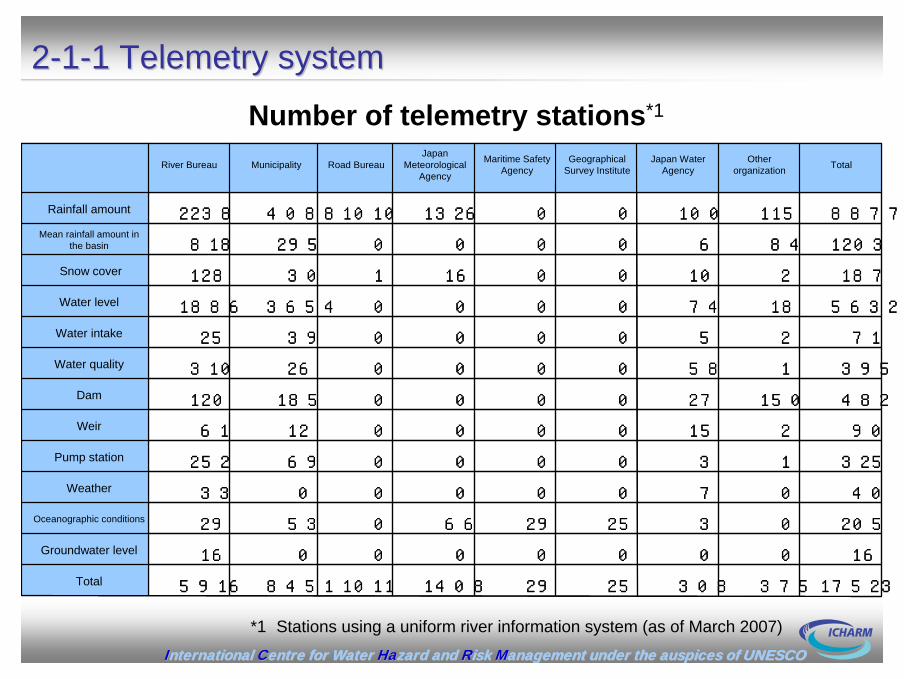
22--11--1 Telemetry system1 Telemetry system
1752337530825291408101184515916合計
16000000016地下水位
2050325296605329海象
40070000033気象
32513000069252排水機場
9021500001261堰
482150270000185120ダム
395158000026310水質
712500003925取水
56321874000036541886水位
1872100016130128積雪
12038460000295818流域平均雨量
8877115100001326101040882238雨量
合計他所管水資源
機構国土地
理院海上保
安庁気象庁道路局都道府県河川局
1752337530825291408101184515916
16000000016
2050325296605329
40070000033
32513000069252
9021500001261
482150270000185120
395158000026310
712500003925
56321874000036541886
1872100016130128
12038460000295818
8877115100001326101040882238Rainfall amount
Mean rainfall amount in the basin
Snow cover
Water level
Water intake
Water quality
Dam
Weir
Pump station
Weather
Oceanographic conditions
Groundwater level
Total
Japan Meteorological
AgencyRiver Bureau Municipality Road Bureau Maritime Safety
AgencyGeographical
Survey InstituteJapan Water
AgencyOther
organization Total
Number of telemetry stations*1
*1 Stations using a uniform river information system (as of March 2007)

IInternational nternational CCentre for Water entre for Water HaHazard and zard and RRisk isk MManagement under the auspices of UNESCOanagement under the auspices of UNESCO
22--11--2 Locations of radar rain gauges2 Locations of radar rain gauges
Radar rain gauges have been installed at 26 locations throughout the country.
The information of 1-km mesh resolution is updated every half an hour and available on the Internet.
The radar data are calibrated using the ground data.

IInternational nternational CCentre for Water entre for Water HaHazard and zard and RRisk isk MManagement under the auspices of UNESCOanagement under the auspices of UNESCO
22--11--3 CCTV network3 CCTV network
15,13215,13250250256656666,,5985987,4667,466TotalTotal
9696----46465050OkinawaOkinawa
1,9481,9485252848411,,070070742742KyushuKyushu
1,0261,02640403030299299657657ShikokuShikoku
1,4951,4959999--685685711711ChugokuChugoku
1,5641,56446465555766766697697KinkiKinki
1,7891,7892277101101662662999999ChubuChubu
1,2591,2596666147147525525521521HokurikuHokuriku
2,5122,5129191585811,,2102101,1531,153KantoKanto
1,5511,55164643636610610841841TohokuTohoku
1,8921,892171755557257251,0951,095HokkaidoHokkaido
TotalTotalOtherOtherSediment Sediment controlcontrol
RiverRiverRoadRoad
Estimate at the end of March, 2007Estimate at the end of March, 2007
Source: Data collected by Electricity and Telecommunication Office in October 2006
Ministry of Land, Infrastructure and Transport, Regional Development Bureaus and River Offices have real-time access to 3,900 CCTV images available on IP (Internet protocol) network.
CCTV images are used for developing disaster control plans.
Sample image(Yodo River in Osaka on August 14, 2007)
Number of CCTV sets installed

IInternational nternational CCentre for Water entre for Water HaHazard and zard and RRisk isk MManagement under the auspices of UNESCOanagement under the auspices of UNESCO
22--11--4 Fiber optics network4 Fiber optics network高瀬川
馬渕川
鳴瀬川
名取川
阿武隈川
赤川最上川
子吉川
雄物川
米代川
岩木川
久慈川
那珂川
利根川
綱走川
常呂川
湧別川
渚滑川
熊野川
紀ノ川
肱川
吉野川
那賀川
四万十川
大野川
番匠川
五ヶ瀬川
小丸川
大淀川川内川
球磨川
大和川
九頭竜川
手取川
留萌川
天塩川
尻別川
後志利別川
梯川
淀川 宮川
相模川富
士川安
倍川大
井川
天竜川
豊川
矢作川
奈半利川
加古川
揖保川
芦田川
太田川小
瀬川
鵡川 沙
流川
十勝川
皆別川
和天別川
釧路川
山国川
遠賀川
江ノ川
日野川
天神川
千代川
石狩川
円山川
由良川
北川
小矢部川
神通川
黒部川
姫川
関川
信濃川
阿賀野川
荒川
北上川
高津川
松浦川
高梁川
仁淀川
筑後川 菊
池川白
川
木曽川
鈴鹿川
江戸川
荒川多
摩川
鶴見川
光ファイバ整備図 平成17年12月1日現在
一般国道(直轄管理)
河川直轄管理区間
①平成17年度末現在整備済み
②平成18年度末予定
③平成19年度末予定
施工延長
ネットワーク構成
3
10
331
329330
58
10
10
196
1122
2
99
228
37
230
5
36
12
40
39
38
44
1
163
25
8
8
18
8
7
112
4
4
7
48
18
19
1
246
16
17
174
6
15
2
53
9
54
28
201
3
57
沖縄総合事務局
国総研
四国地方整備局
近畿地方整備局
中部地方整備局
北陸地方整備局
中国地方整備局
九州地方整備局
関東地方整備局
東北地方整備局
国土交通本省
北海道開発局Hokkaido Development Bureau
Hokuriku Regional Development Bureau Tohoku Regional
Development Bureau
Kanto Regional Development Bureau
National Institute for Land and Infrastructure Management
Chubu Regional Development Bureau
Kinki Regional Development Bureau
Shikoku Regional Development Bureau
Chugoku Regional Development Bureau
Kyushu Regional Development Bureau
Okinawa General Bureau
Lines constructed
National highways (under direct jurisdiction of MLIT)
River sections under direct jurisdiction of MLIT
Constructed at the end of fiscal 2005
To be constructed by the end of fiscal 2006
To be constructed by the end of fiscal 2007
Kyushu
Chugoku Shikoku Kinki
Chubu
Ministry of Land, Infrastructure and Transport
Okinawa
National Institute for Land and Infrastructure Management
Kanto
Hokuriku Tohoku
Hokkaido
WDM (east loop, 4.8 Gbps)WDM (west loop, 4.8 Gbps)Ethernet (1 Gbps)Telecommunications carrier's lines, etc.
Ministry of Land, Infrastructure and Transport (MLIT)
River Bureau and Road Bureau have jointly laid fiber optics network lines.
Total:12,046Km(2006)Total:12,046Km(2006)

IInternational nternational CCentre for Water entre for Water HaHazard and zard and RRisk isk MManagement under the auspices of UNESCOanagement under the auspices of UNESCO
22--2 Uniform river information system2 Uniform river information system
The uniform river information system aims at sharing and standardizing river administration data including river water levels and rainfall amounts.
River information systems developed by individual regional development bureaus have been integrated into a national river information system. Regional development bureaus can customize the system according to their requirements.
Foundation of river and basin integrated communications (FRICS) developed an integrated river information system.

IInternational nternational CCentre for Water entre for Water HaHazard and zard and RRisk isk MManagement under the auspices of UNESCOanagement under the auspices of UNESCO
22--33--1 River disaster prevention information 1 River disaster prevention information Information to be provided
Radar rain gauge data
Telemetry data (water levels, rainfall amounts, etc.)
Flood forecasting and warning
Dam-related parameters (notice of release of water from the reservoir, reservoir water storage, etc.)
http://http://www.river.go.jpwww.river.go.jp//
河川の水位Water level graph
雨量観測グラフHyetographPortal of "river disaster prevention information" website

IInternational nternational CCentre for Water entre for Water HaHazard and zard and RRisk isk MManagement under the auspices of UNESCOanagement under the auspices of UNESCO
22--33--2 Data provision via the Internet and cellular phone2 Data provision via the Internet and cellular phone
Numerous improvements have been made since fiscal 2007 such as additional provision of data of prefectural governments and applicability to all cellular phone service companies.
River disaster prevention data such as water levels, rainfall amounts and dam-related parameters have been disseminated since fiscal 2001 via the Internet and cellular phone.
The Internet since April 2001. Cellular phone (since April 2001)*Applicable to multiple carriers including auand Softbank since April 2007.

IInternational nternational CCentre for Water entre for Water HaHazard and zard and RRisk isk MManagement under the auspices of UNESCOanagement under the auspices of UNESCO
3. Provision of disaster information3. Provision of disaster information

IInternational nternational CCentre for Water entre for Water HaHazard and zard and RRisk isk MManagement under the auspices of UNESCOanagement under the auspices of UNESCO
33--1 1 Hazard map prepared by a municipalityHazard map prepared by a municipality
Image of a hazard mapImage of a hazard map
Hazard map in Kurihashi town
1)General InformationFlood Risk Areas, Types of damage Ways to provide evacuation information (flood forecasts, etc.)Sources of weather information, etc.Evacuation sites, Dangerous areas during evacuation
2)Area-Specific Information (Information for Evacuation) Flood information in other areas than flood risk areas Flood characteristics of rivers, Issues on evacuation ordersEvacuation zone, Tips for evacuationInformation on the facilities for people who are particularly vulnerable to disasters Information on underground malls

IInternational nternational CCentre for Water entre for Water HaHazard and zard and RRisk isk MManagement under the auspices of UNESCOanagement under the auspices of UNESCO
33--2 Water2 Water--level display tower, etc.level display tower, etc.
Tokyo and the Edo, Ara, Sumida Rivers
Alti
tude
(m)
Kei
hin
Toho
ku
Rai
lroad
Lin
e
Sum
ida
Riv
er
Ara
Riv
er
Aya
seR
iver
Nak
a R
iver
Ohb
aR
iver
Edo
Riv
er
Sak
aR
iver
Shi
n S
aka
Riv
erJo
ban
Rai
lroad
Lin
e
Mus
ashi
noR
ailro
ad L
ine
Nat
iona
l Rou
te 6
Kita Ward
Arakawa Ward
Adachi Ward
Katsushika Ward
Misato City Matsudo City
The water-level display tower to indicate the current WL of River B with red lights.
Flood water depth (projected)Sign in town

IInternational nternational CCentre for Water entre for Water HaHazard and zard and RRisk isk MManagement under the auspices of UNESCOanagement under the auspices of UNESCO
33--3 Awareness program3 Awareness programTo enhance a flood awareness of residents
River information (under normal condition)Residents understand a flood risk, and how to act and where to evacuate in flood.
River information (under abnormal condition)Residents can make an accurate judgment to start evacuation.

IInternational nternational CCentre for Water entre for Water HaHazard and zard and RRisk isk MManagement under the auspices of UNESCOanagement under the auspices of UNESCO
4. Predicted rainfall4. Predicted rainfall

IInternational nternational CCentre for Water entre for Water HaHazard and zard and RRisk isk MManagement under the auspices of UNESCOanagement under the auspices of UNESCO
44--1 Short1 Short--period rain predictionperiod rain prediction
1 hour 2 hours 3 hours
4 hours 5 hours 6 hours
Short-Period Rain Prediction is issued every 30 minutes to provide forecasts of one-hour precipitation for the next 6 hours with 1-km spatial resolution. Not only changes in rain
distribution, but also geographical factors and numeric estimates are taken into considerations.
IInternational nternational CCentre for Water entre for Water HaHazard and zard and RRisk isk MManagement under the auspices of UNESCOanagement under the auspices of UNESCO
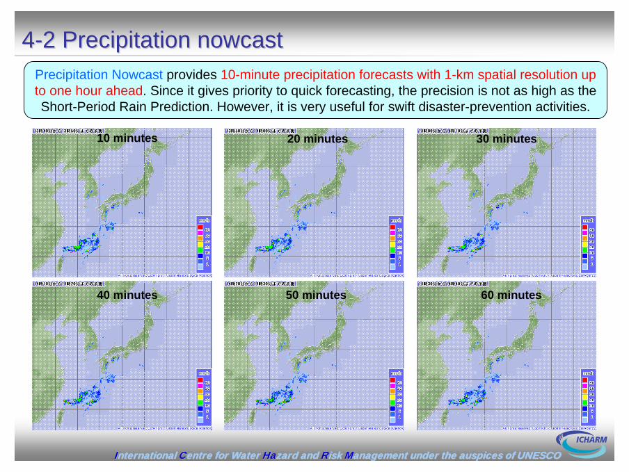
44--2 Precipitation 2 Precipitation nowcastnowcast
10 minutes 20 minutes 30 minutes
40 minutes 50 minutes 60 minutes
Precipitation Nowcast provides 10-minute precipitation forecasts with 1-km spatial resolution up to one hour ahead. Since it gives priority to quick forecasting, the precision is not as high as the Short-Period Rain Prediction. However, it is very useful for swift disaster-prevention activities.

IInternational nternational CCentre for Water entre for Water HaHazard and zard and RRisk isk MManagement under the auspices of UNESCOanagement under the auspices of UNESCO
5. Run5. Run--off analysis and flood forecastingoff analysis and flood forecasting

IInternational nternational CCentre for Water entre for Water HaHazard and zard and RRisk isk MManagement under the auspices of UNESCOanagement under the auspices of UNESCO
55--11--1 Flood prediction by storage function model1 Flood prediction by storage function model
It predicts a runoff volume of the prediction site by a runoff model using the storage function method and a water level by means of the H-Q equation.
Most commonly used in Japan.

IInternational nternational CCentre for Water entre for Water HaHazard and zard and RRisk isk MManagement under the auspices of UNESCOanagement under the auspices of UNESCO
55--11--2 Flood prediction by distributed model2 Flood prediction by distributed model
With this method, rain distribution is modeled more precisely in comparison with the Storage Function Model.
It is a physical model which segments a basin into meshes and calculates a runoff volume assuming that rain falls on each mesh.
Q converted to H by the H-Q equation
Flow of water in the ground
Flow in the river channel
Surface flow of water
Rainfall
Modeling

IInternational nternational CCentre for Water entre for Water HaHazard and zard and RRisk isk MManagement under the auspices of UNESCOanagement under the auspices of UNESCO
55--22--1 Flood forecasts jointly announced by MLIT and JMA 1 Flood forecasts jointly announced by MLIT and JMA
Forecast DepartmentDistrict Meteorological ObservatoryLocal Meteorological Observatory
Weather information
JMA
Rainfall
Regional Bureaus River Offices
River Information
Water Level
MLIT
1.Flood Alert Information 2. Flood Risk Information 3. Flood Information(Flood-Fighting information (MLIT))
Types of flood forecasting
Press and Broadcast Agencies
GovernmentFlood-Fighting Organizations
Local Residents
Joint Announcement
Japan meteorological Agency Ministry of Land, Infrastructure, Transport and Tourism

IInternational nternational CCentre for Water entre for Water HaHazard and zard and RRisk isk MManagement under the auspices of UNESCOanagement under the auspices of UNESCO
55--22--2 Water levels used to issue flood forecasts2 Water levels used to issue flood forecasts
Example of Flood Forecasts
LeveeLevee

IInternational nternational CCentre for Water entre for Water HaHazard and zard and RRisk isk MManagement under the auspices of UNESCOanagement under the auspices of UNESCO
55--22--3 Flood forecasts3 Flood forecasts
Announced to warn of a risk of floodsAnnounced to warn of a risk of floodsFlood warningsFlood warnings
Announced when floods may cause damagesAnnounced when floods may cause damagesFlood advisoriesFlood advisories
Announced to warn of a risk of serious disasters by heavy rain, Announced to warn of a risk of serious disasters by heavy rain, gale, high tide, etc.gale, high tide, etc.Weather warningsWeather warnings
Announced when disasters may occur by heavy rain, gale, high tidAnnounced when disasters may occur by heavy rain, gale, high tide, etc.e, etc.Weather advisories Weather advisories
Flood Forecasts by JMAFlood Forecasts by JMAAnnounced by the local meteorological observatory of JMA in its area of administration.Medium- to small-size rivers other than those designated for flood forecasts
Warnings for Flood Fighting issued by MLITWarnings for Flood Fighting issued by MLITIssued with the purpose for MLIT or the prefectural government to provide flood-fighting organizations with a guideline for their activities.
Warns that floodWarns that flood--fighting organizations need to be mobilized when WL is predictedfighting organizations need to be mobilized when WL is predictedto exceed the Flood Alert WL.to exceed the Flood Alert WL.
Mobilization Mobilization
Warns that floodWarns that flood--fighting organizations need to be prepared for operation, at thefighting organizations need to be prepared for operation, at thesame time, sending information about flood control, providing flsame time, sending information about flood control, providing flood control ood control equipments and materials, securing communication and transportatequipments and materials, securing communication and transportation means.ion means.
PreparationPreparation
Alerts that floodAlerts that flood--fighting organizations need to be ready for operation in case fighting organizations need to be ready for operation in case floods may occur or WL is predicted to increase.floods may occur or WL is predicted to increase.
StandbyStandby

IInternational nternational CCentre for Water entre for Water HaHazard and zard and RRisk isk MManagement under the auspices of UNESCOanagement under the auspices of UNESCO
6. Utilization of satellite6. Utilization of satellite--based rainfall informationbased rainfall informationAdaptation measurement in developing countryAdaptation measurement in developing country

IInternational nternational CCentre for Water entre for Water HaHazard and zard and RRisk isk MManagement under the auspices of UNESCOanagement under the auspices of UNESCO
66--1 Necessity of satellite1 Necessity of satellite--based rainfall databased rainfall dataIn the countries where river improvements are not sufficient, smooth evacuation from flooding is important for decreasing loss of life and properties. Dissemination of risk by hazard maps, etc. and direction of evacuation by issuing flood forecasts and alerts are necessary.However, in reality, development of a flood warning system in these countries has not advanced properly because of financial difficulty, lack of rainfall data, etc.
Technical issues for flood forecasting
Non real time observation
No data of river discharge
IInternational nternational CCentre for Water entre for Water HaHazard and zard and RRisk isk MManagement under the auspices of UNESCOanagement under the auspices of UNESCO
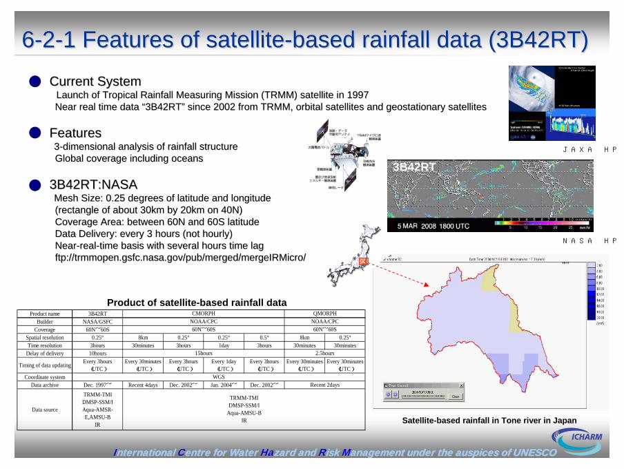
Current SystemCurrent SystemLaunch of Tropical Rainfall Measuring Mission (TRMM) satellite iLaunch of Tropical Rainfall Measuring Mission (TRMM) satellite in 1997n 1997Near real time data Near real time data ““3B42RT3B42RT”” since 2002 from TRMM, orbital satellites andsince 2002 from TRMM, orbital satellites and geostationageostationary ry satellites satellites
FeaturesFeatures33--dimensional analysis of rainfall structuredimensional analysis of rainfall structureGlobal coverage including oceansGlobal coverage including oceans
3B42RT:NASA3B42RT:NASAMesh Size: 0.25 degrees of latitude and longitudeMesh Size: 0.25 degrees of latitude and longitude(rectangle of about 30km by 20km on 40N)(rectangle of about 30km by 20km on 40N)Coverage Area: between 60N and 60S latitudeCoverage Area: between 60N and 60S latitudeData Delivery: every 3 hours (not hourly) Data Delivery: every 3 hours (not hourly) NearNear--realreal--time basis with several hours time lagtime basis with several hours time lagftp://ftp://trmmopen.gsfc.nasa.gov/pub/merged/mergeIRMicrotrmmopen.gsfc.nasa.gov/pub/merged/mergeIRMicro//
66--22--1 Features of satellite1 Features of satellite--based rainfall data (3B42RT)based rainfall data (3B42RT)
JAXA HP
Product name 3B42RTBuilder NASA/GSFC
Coverage 60N~60SSpatial resolution 0.25° 8km 0.25° 0.25° 0.5° 8km 0.25°Time resolution 3hours 30minutes 3hours 1day 3hours 30minutes 30minutes
Delay of delivery 10hours
Timing of data updating Every 3hours(UTC)
Every 30minutes(UTC)
Every 3hours(UTC)
Every 1day(UTC)
Every 3hours(UTC)
Every 30minutes(UTC)
Every 30minutes(UTC)
Coordinate systemData archive Dec. 1997~ Recent 4days Dec. 2002~ Jan. 2004~ Dec. 2002~
Data source
TRMM-TMIDMSP-SSM/IAqua-AMSR-E,AMSU-B
IR
CMORPH QMORPHNOAA/CPC NOAA/CPC
TRMM-TMIDMSP-SSM/I
Aqua-AMSU-BIR
WGSRecent 2days
60N~60S 60N~60S
15hours 2.5hours
Product of satellite-based rainfall data
NASA HP
Satellite-based rainfall in Tone river in Japan
3B42RT

IInternational nternational CCentre for Water entre for Water HaHazard and zard and RRisk isk MManagement under the auspices of UNESCOanagement under the auspices of UNESCO
66--22--2 Accuracy of satellite2 Accuracy of satellite--based rainfall databased rainfall data
R2 = 0.4459
R2 = 0.5263
0
10
20
30
40
50
0 10 20 30 40 50
Ground-based rainfall data(mm/h)
Sat
ellit
e-ba
sed
rain
fall
data
(mm
/h)
.
Upstream area of sameura dam, area=472km2
Upstream area of ikeda dam, area=1,904km2
0
10
20
30
40
50
12:00 0:00 12:00 0:00 12:00 0:00 12:00
hourly
rain
fall
Ground-based rainfall dataSatellite-based rainfall data
2004/7/30 2004/7/31 2004/8/1 (GMT)
(mm/h)
0
10
20
30
40
0:00 12:00 0:00 12:00 0:00 12:00 0:00
hourly
rain
fall
Ground-based rainfall data
Satellite-based rainfall data
2007/7/12 2007/7/13 2007/7/14 (GMT)
(mm/h)
0
10
20
30
40
12:00 0:00 12:00 0:00 12:00 0:00 12:00
hourly
rain
fall
Ground-based rainfall data
Satellite-based rainfall data
2004/8/28 2004/8/29 2004/8/30 (GMT)
(mm/h)
Comparison with satellite-based and ground-based rainfall of Sameura dam basin
Comparison with satellite-based and ground-based rainfall(major ten flood in 2002-2007)
IInternational nternational CCentre for Water entre for Water HaHazard and zard and RRisk isk MManagement under the auspices of UNESCOanagement under the auspices of UNESCO
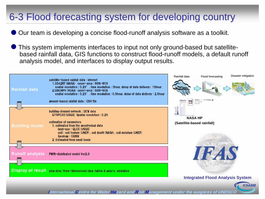
66--3 Flood forecasting system for developing country3 Flood forecasting system for developing countryOur team is developing a concise flood-runoff analysis software as a toolkit.
This system implements interfaces to input not only ground-based but satellite-based rainfall data, GIS functions to construct flood-runoff models, a default runoff analysis model, and interfaces to display output results.
NASA HP(Satellite-based rainfall)
Rainfall dataRainfall data Flood forecastingFlood forecasting Disaster mitigationDisaster mitigation
Integrated Flood Analysis System

IInternational nternational CCentre for Water entre for Water HaHazard and zard and RRisk isk MManagement under the auspices of UNESCOanagement under the auspices of UNESCO
66--4 Modeling function4 Modeling function
L a n d C o v er C la ssifica tio n (G L C C ) IF A S C la ssifica tio nU rb a n a n d B u ilt -U p L a n d U rb a n a rea
D ry la n d C ro p la n d a n d P a stu reIrrig a ted C ro p la n d a n d P a stu re
M ixed D ry la n d /Irrig a ted C ro p la n d a n d P a stu reC ro p la n d /G ra ssla n d M o sa icC ro p la n d /W o o d la n d M o sa ic
G ra ssla n dS h ru b la n d
M ixed S h ru b la n d /G ra ssla n dS a v a n n a
D ec id u o u s B ro a d lea f F o restD ecid u o u s N eed le lea f F o restE v erg reen B ro a d lea f F o restE v erg reen N eed le lea f F o rest
M ixed F o restW a ter B o d ies W a ter B o d ies
H erb a ceo u s W etla n dW o o d ed W etla n d
B a rren o r S p a rse ly V eg eta tedH erb a ceo u s T u n d ra
W o o d ed T u n d raM ixed T u n d ra
B a re G ro u n d T u n d raS n o w o r Ice W a ter B o d ies
G ra ssla n d
W etla n d
W etla n d
F o rest
G ra ssla n d
Intake of digital elevation data Create a basin boundary
Create a river channel network
Set parameter
automatically
automatically
automatically
IFAS creates a basin boundary and a river channel network use of digital elevation data.
IFAS estimates parameter based on the classification that we set up beforehand.
800 634 533 500 382 329 307 290 268 259 290 262
688 580 504 400 352 301 297 290 271 267 253 246
688 547 429 381 340 309 310 294 292 299 300 246
643 510 400 382 358 345 322 314 306 299 300 245
600 471 401 400 376 347 334 320 300 287 273 271
491 452 426 406 385 368 348 318 300 287 291 288
504 495 490 470 447 430 393 355 313 280 268 262
560 569 570 546 512 500 445 384 307 289 265 259
653 672 682 670 623 576 517 500 417 323 291 296
800 806 828 827 731 668 586 597 549 382 297 288
Landuse dataGLCC (USGS HP)
IInternational nternational CCentre for Water entre for Water HaHazard and zard and RRisk isk MManagement under the auspices of UNESCOanagement under the auspices of UNESCO
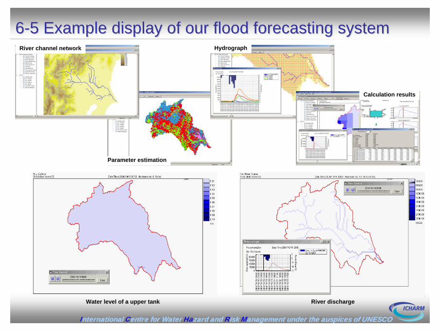
66--5 Example display of our flood forecasting system5 Example display of our flood forecasting systemRiver channel network
Parameter estimation
Hydrograph
Calculation results
Water level of a upper tank River discharge

IInternational nternational CCentre for Water entre for Water HaHazard and zard and RRisk isk MManagement under the auspices of UNESCOanagement under the auspices of UNESCO
66--6 On going6 On going worksworks
We hope this system is useful for immediate and efficient implementation of flood forecasting and warning system in developing countries.
Tonle Sap Lake Flood in 2003
Improvement accuracy and resolution of results: Improvement accuracy and resolution of results: to calibrate a set up parameter with some large basinsto calibrate a set up parameter with some large basinsto implement functions united at the distribution time delay to implement functions united at the distribution time delay and updating time of satelliteand updating time of satellite--based rainfall based rainfall (correcting function of satellite(correcting function of satellite--based rainfall using ground based rainfall)based rainfall using ground based rainfall)
Display an inundation depth:Display an inundation depth:to implement a linkage function with an inundation modelto implement a linkage function with an inundation model