sub>urban. Reinventing the fringe. State of the art
48
sub > urban — Reinventing the fringe State of the art
-
Upload
suburban-reinventing-the-fringe -
Category
Documents
-
view
214 -
download
0
description
sub>urban. Reinventing the fringe is an URBACT III project where 9 European cities work together on the topic of urban development in 20th century urban tissues. The goal is to define and work out strategies, methodologies and propose solutions to make this city areas more attractive and qualitative areas to live, work and celebrate life.
Transcript of sub>urban. Reinventing the fringe. State of the art

sub> urban—
Reinventing the fringe
State of the art


Written by Lead Expert temp.architecture, Maarten van Tuijl
in collaboration with Lead Partner, Urban Planning Department Antwerp, Isabelle Verhaert
sub> urban—
Reinventing the post-war urban fringe to achieve sustainable densification
State of the art
4

5
Content —
1 State of the art 7
1.0 Introduction 91.1 EU context 131.2 Topic perspective 19 1.2.1 Transforming for intensified use 251.2.2 Transforming for social inclusion 291.2.3 Transforming the relationship with the region 331.2.4 Transforming private space 371.2.5 Transforming planning 411.3 Pool of good practices 44
Appendix: Glossary 46 Colophon 47


7 state of the art
State Of The Art —1

9 state of the art | introduction
1.0 INTRODUCTION
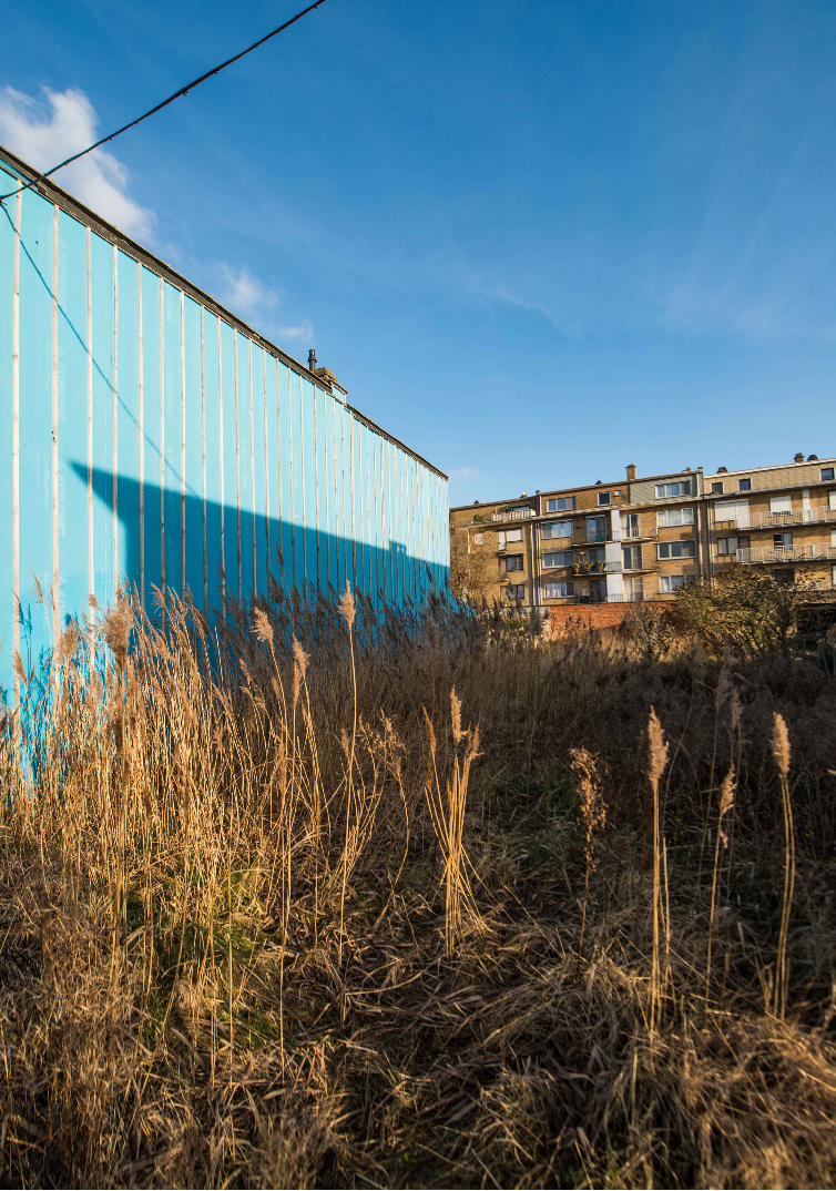
‘Sub>urban. Reinventing the fringe’ is about countering urban sprawl by transforming the complex periphery of cities into a more attractive and high-quality area for existing and future communities. Through a flexible process and an implementation-oriented approach, we seek to reinvent urban planning to achieve this goal.
Cities in our sub>urban (pronounced urban suburban) network are looking at sus-tainable urban regeneration of existing urban areas as opposed to further expansion. This process of urban regeneration is not taking place within the inner cities but in the 20th-century post-war urban fringe. The urban fringe area is the zone between high density urban and low density suburban areas, where development pressure is often intense. These areas are less saturated and much more fragmented and patchwork-like than the historic city centres. The cities in our network want to revive these areas and create a newer, high-quality urban environment. Overall, the objective is to intensify the use of underused and poorly used space, increase the quality and availability of housing and amenities, find effective and transparent ways to deal with private and fragmented ownership, improve the connectivity of these areas and rethink the iden-tity of the urban fringe. Since these fringe areas and their restrictions are very different from the inner city and the suburbs, an entirely new approach toward urban planning as a whole will be required.
Though all partner cities are united by the pressure on urban tissue as a result of rapid growth today or uncontrolled growth in the past, they vary greatly in size and context. Each partner city finds itself at a different stage in the suburbanisation pro-cess. In our network, we identify three types of cities in relation to this issue. Firstly, there are cities that are growing demographically and are looking for sustainable ways to increase the densities in their post-war urban areas. The pressure on these areas is becoming even higher. Secondly, there are cities that are experiencing a demographic decline. People are moving into suburban homes in regional areas. To counter this sprawl, improving conditions in the inner cities and the fringes is a clear solution. Finally, there are cities that have already undergone rapid and often uncontrolled growth in recent years and are now facing the consequences of this process. Although these cities are currently not growing demographically, the challenge for them is two-fold: they have to improve the quality of these areas and make them more sustainable. In many of these areas, densification often had the upper hand to quality.
10 state of the art | introduction
The urban fringe area is the zone in between high-density urban and low-density suburban areas, where development pressure is often intense.

11 state of the art | introduction
These differences allow us to look at the topic from many different angles and promote local innovation through the exchange of experience. However, this demands a solid framework for sharing expertise and best practices – a framework that clearly defines the topic and relevant subthemes and assists with the gathering of data that can then be meaningfully compared.
This State of the Art therefore defines the network topic and relevant subthemes and aims to establish the framework for sharing. It presents current related policies, knowledge, networks and research at EU level on the sustainable regeneration of existing 20th-century peripheral urban areas. Furthermore, it identifies international examples of good practice in this field and describes relevant innovative planning approaches and tools already out there. Many of these examples and approaches are drawn from the book The Flexible City, sustainable solutions for Europe in transition (January 2016, NAi010)¹, which is closely related to the network topic. The synthesis summarises the lessons learnt, as well as critical factors and preconditions for success.
Terms and their useThere are many possible definitions of the urban fringe and related terms such as urban periphery, transitional belt or peri-urban areas. Collins English Dictionary defines ‘the fringe’ as outer edge, margin or periphery. Oxford Dictionary describes ‘the fringe’ as the outer or less important part of an area. In this baseline study the term ‘urban fringe’ is interpreted as the zone between high density urban and low-density subur-ban areas, where development pressure is or has often been intense. Sometimes these fringe areas are (partly) situated in other municipalities. Moreover they can even be in a high-density polycentric setting, as is the case for Barcelona. Sometimes the fringe is still a low-density area within the city borders. For example in Antwerp the sites contains single family detached housing. The two examples have in common that the urban fringe is a transitional belt, an area with mixed, sporadic functions between the dense inner city and the less dense peripheral single family areas of cities. The glossary provides definitions of important and frequently used terms in this baseline study.
1 ht
tp:/
/ww
w.n
ai01
0.co
m/e
n/tu
e/ite
m/t
he-fl
exib
le-c
ity

12 state of the art | e.u. context
http
://w
ww
.dlr.
de/d
lr/en
/des
ktop
defa
ult.a
spx/
tabi
d-10
081/
151_
read
-107
50/#
/gal
lery
/153
12

13 state of the art | e.u. context
1.1 EU CONTEXT
Nearly every European city, town and village expanded considerably after the Second World War. As a result, Europe is among the most urbanised continents in the world. 70% of the EU population reside in cities, towns and suburbs. 80% of these people enjoy living in the city. 70% of the GDP is produced in metropolitan areas. This demographic and economic growth of cities implies also a new task for our cities: existing post-war urban areas now require maintenance and have to undergo alterations to meet changing requirements and future demands. In many cases they also offer opportunities to increase the densities of our cities. Upgrading these existing buildings and urban areas has therefore become an increasingly important task for European towns and cities.
Compact CitiesCities are first and foremost human settlements that should be developed to improve the living conditions and the environment of current and future residents, as stated in the Riga Declaration of Ministers towards the EU Urban Agenda² of 10 June 2015. The sub>urban theme unites cities and regions that want to achieve this enhanced quality of life by carefully increasing the densities of 20th-century post-war urban tissues at the periphery of the historic centres instead of expanding the urban territory. This makes the upgrade of the urban fringe in between the historic city centre and current suburbs an important alternative to both urban sprawl and inner city saturation in the ambition to develop sustainable compact cities. ‘The compact city or city of short dis-tances’³ is an urban planning and urban design concept that promotes relatively high residential density with mixed land uses. It is based on an efficient public transport system and features an urban layout that encourages walking and cycling, low energy consumption and reduced pollution. The need for compact cities and smart growth does not only apply to cities that are growing demographically but also to cities expe-riencing a demographic decline. Though many of those cities are faced with decreasing numbers of residents, land use in the suburbs, congestion and air pollution are still on the rise, even there.
Urban SprawlPutting a stop to urban sprawl and working toward more intensive and better qual-ity use of existing urban areas is a goal underpinned by many European policies and networks. In 2006, the report titled Urban Sprawl in Europe, the ignored challenge⁴ by the European Environment Agency (EEA) already highlighted the danger of local policies being too isolated in overcoming the serious impact of urban sprawl, and the need for action at EU level. In addition, the European Commission report titled Cities of Tomorrow⁵ that was published in 2011 describes many negative outcomes of urban sprawl.
2 ht
tp:/
/urb
anag
enda
.nl/
3 ht
tp:/
/ww
w.o
ecd.
org/
gov/
regi
onal
-pol
icy/
5052
4895
htt
p://
ww
w.e
ea.e
urop
a.eu
/pub
licat
ions
/eea
_rep
ort_
2006
_10
4 ht
tp:/
/ww
w.e
ea.e
urop
a.eu
/pub
licat
ions
/eea
_rep
ort_
2006
_10
5 ht
tp:/
/ec.
euro
pa.e
u/re
gion
al_p
olic
y/so
urce
s/do
cgen
er/s
tudi
es/p
df/c
ities
ofto
mor
row
/citi
esof
tom
orro
w_fi
nal.p
df
14 state of the art | e.u. context
Urbact director Emmanuel Moulin has summed up the conclusions of this report in regards to urban sprawl very well in his introduction to the USEAct network:
“ Urban sprawl makes organising the provision of services to all residents a compli-cated and expensive process. Since urban sprawl frequently happens outside local authorities’ administrative areas, the taxation basis that funds public services can-not be matched with the geographical distribution across the area of those using the services. Given the low density, the resulting use of private cars leads to increased energy consumption, air pollution and congestion. Urban sprawl increases the risk of social exclusion and spatial segregation as different areas become differentiated socially. Furthermore, for these urban areas, this often brings with it a loss of func-tional diversity and commercial functions, while for smaller or more economically fragile cities, it can even lead to the decline of the traditional city centre. Urban sprawl contributes to the loss of agricultural land, increased soil sealing and, conse-quently, a higher risk of flooding in urban areas. It is also one of the main reasons for the loss of biodiversity and overuse of natural resources. Urban sprawl also has a very negative impact on the quality of surrounding landscapes, and on the attractiveness of the city and its hinterland.” ⁶
Although the negative consequences of urban sprawl are clear, the political com-mitment to really do something about it varies greatly in each city and country. In many cities the inner cities are on the rise but so are the suburbs. There are also many cases known, where the population of the city and the whole urban area is shrinking but spatial expansion is still going on. Suburban space in general holds the following pull-factors: work space and living space close to nature, relatively homogeneous social neighbourhoods, lower property prices, less stress, less noise, less emission, more safety, an environment supposedly fit for children, etc. ⁷ These are factors to be taken into account when working on an alternative for suburbia.
Sustainable DevelopmentSimilar to the EU 2020 strategy 8 launched in 2010, the sub>urban network focuses on smart, sustainable and inclusive growth and is aimed at the same objectives. In rec-ognition of the importance of cities in delivering the Europe 2020 strategy (combined with the increasing recognition of the added value brought by an integrated territo-rial approach), the urban dimension within the Cohesion Policy framework has been strengthened significantly for the 2014-2020 period. This is particularly evident in the ERDF, article 7 ⁹, which mandates that Member States earmark at least 5% of their national ERDF allocation (under the Investment for Jobs and Growth programme) in support of integrated sustainable urban development strategies, where urban authori-ties are responsible for tasks related to the selection of operations, among other things. In addition, new tools have been introduced to promote innovation and experimenta-tion in the field of urban development (Urban Innovative Actions, Article 8, ERDF ¹⁰) and to deepen the discussion on the implementation of the urban dimension (Urban Development Network, Article 9, ERDF).
USEActThe sub>urban project is closely related to the previous URBACT project USEAct¹¹. USEAct focused mainly on putting a stop to urban sprawl through urban growth man-agement and reusing urban areas. The project also identified a number of important strategies to counter land consumption and promote reuse through management, part-nership and funding solutions, and formulated essential findings in terms of monitoring 6
http
://u
rbac
t.eu/
usea
ct7
http
://w
ww
.city
may
ors.
com
/dev
elop
men
t/eu
rope
-urb
an-s
ubur
ban.
htm
l8
http
://e
c.eu
ropa
.eu/
euro
pe20
20/i
ndex
_en.
htm
9 ht
tp:/
/ec.
euro
pa.e
u/re
gion
al_p
olic
y/en
/fun
ding
/erd
f/10
ht
tp:/
/ec.
euro
pa.e
u/re
gion
al_p
olic
y/so
urce
s/ac
tivity
/urb
an/u
rban
_inn
ovat
ive_
actio
ns.p
df11
ht
tp:/
/urb
act.e
u/us
eact

15 state of the art | e.u. context
quality, protecting heritage and gathering and analysing data. Similarly to the new pro-ject proposal, USEAct partners focused on the roles of local and regional governments and on the refitting and regenerating of inhabited buildings and areas. The present URBACT project affirms and builds on these findings and strategies. It unites partners who acknowledge the need to stop the consumption of land and who have taken the first steps by making the necessary preparations and/or key decisions. It is not about looking for ways to stop urban sprawl but about putting into practice currently pro-posed and new strategies and ideas to accomplish this goal within a specific area within the built-up tissue of the city. And, most importantly, this project is not merely about protecting rural areas, but about improving the city while doing so. Therefore, the focus is on rethinking the city and, consequently, rethinking urban renewal itself.
REDISREDIS ¹² is the URBACT I network that focused on how municipalities can reshape districts into science quarters. The link with the sub>urban theme is especially visible where the knowledge hotspots are created as mixed and urban areas, such as the crea-tive districts of the lead partner Halle (Saale, Germany). The network focused on the themes to make good knowledge hotspots, from which the following are relevant for our network: the need to create an identity, the connectivity to the city, the manage-ment of the area and the promotion of innovation as a catalyst for urban renewal. The two networks are different from each other in defining the target group. The knowl-edge hotspots often focus on attracting entrepreneurial and creative people, as key drivers for innovation. They are usually highly educated. Sub>urban on the other hand starts specifically from social inclusion and dealing with diversity when rethinking the planning process.
SURFSub>urban is also related to the Interreg programme Sustainable Urban Fringes (SURF ¹³), which recognises urban fringes as valuable assets that can provide a high-quality environment in an urban setting and can create vital areas for the health and well-being of local communities. SURF defines the urban fringe as the landscape that links urban and rural environments and puts emphasis on opportunities for recre-ation within the urban fringe. Sub>urban defines the fringe as the entire area between the high-density inner city and the low-density suburbs. Sub>urban sees this area as a potential high-quality alternative both to the unsustainable suburbs and the often saturated inner cities. Sub>urban is interested in the urban fringe as an area that can combine the best of both worlds, being greener than the city centre and providing more services than the suburbs.
12
http
://u
rbac
t.eu/
redi
s13
ht
tp:/
/ww
w.s
usta
inab
lefr
inge
s.eu
/hom
e/ho
me.
asp

16 state of the art | e.u. context
Sub>urban’s added value Our network topic is a broad but important one that touches upon many existing and past initiatives in relation to sustainable regeneration. The rethinking and regenera-tion of the urban fringe poses an important challenge for European cities in general. What sets this network apart is that it is specifically looking at the urban fringe for sustainable regeneration combined with the focus on the process rather than the design. Our network will put the challenge of sustainable urban fringe regeneration on the map, but also recognises that we are still at the beginning of a task that has been neglected for too long. We want to contribute to the dialogue on how to improve the quality of the urban fringe and what the future may look like, but we do not believe in ready-made solutions. As we are essentially dealing with existing urban areas, it is crucial that we zoom in and understand the local context. Doing so in nine differ-ent contexts in Europe, comparing them, sharing local challenges and solutions, and exchanging methods and ideas, will be an important element of added value within our network.

17 state of the art | e.u. context
The URBACT City Festival, Riga 2015 (www.urbact.eu)

18 state of the art | topic perspective

19 state of the art | topic perspective
1.2 TOPIC PERSPECTIVE
The urban fringe area is the zone between high-density urban and low-density suburban areas, where development pressure is or has been often intense. It appears as a fragmented car based collage landscape made up of modernistic urban areas, old village nuclei, industrial zones and recreational areas, cut by heavy infrastructure. Most of the property is privately owned – and therefore often lacks a collective layer for achieving improvements. For many cities the fringe is a fragmented unsustainable belt of often sub-optimal land usage close to their inner cities. Inefficient land-use and urban highways create high car-dependency and underused space. In some cities that are already further in their development process, like the polycentric conurbation of Barcelona for instance, the fringe area is already very dense but is lacking quality and facing social issues. Socioeconomic segregation in the urban fringe with pockets of social deprivation, often coexist with low-waged jobs. Sub>urban is aimed at developing physical planning approaches and tools, that should guide and stimulate transformation processes in the urban fringe. Transformation that aims to achieve more attractive and efficiently organised areas that can both include and improve the lives of existing communities while also creating sustainable new homes and jobs when necessary.
Inner City RenewalIn the past decades, urban development and planning practices in European cities and regions focused on the renewal of metropolitan cores and historic inner cities. This resulted in numerous success stories. In many European cities, the historic city centre is now in good shape. They are popular places providing mixed functions, a solid struc-ture, high-quality public spaces and a clear identity. A lot of money and attention has been, and is still being, invested in this area. The success of inner city renewal is partly due to the specific urban pattern and tissue, with on the one hand the functional and historical diversity of individual plots, and on the other hand a clear structure based on the division between public space and private building blocks (which the individual plots are part of). Thanks to this tissue, the renewal of most inner cities was able to take place plot by plot, each in its own time, since this clearly defined way of organis-ing land is strong enough to hold everything together. There has rarely been a need for lot-transcending collaboration. Most of the time, municipalities only needed to focus on public space and the strategic insertion of amenities. These efforts were usually combined with social investments, while the economic and physical successes in inner cities are characterised at the same time by gentrification¹⁴ .
Many inner cities have now reached their peak in terms of density, population and mobility. Cities that are still growing demographically and do not want to or cannot sprawl any more, need to look at other areas within the city to accommodate the grow-ing population. Even cities that are experiencing a demographic decline and want to counter the sprawl and migration to their suburbs and neighbouring municipalities, now need to consider other areas in addition to the inner cities as convincing alterna-tives for the sprawl.
14
http
://w
ww
.theg
uard
ian.
com
/citi
es/g
entr
ifica
tion

20 state of the art | topic perspective
Shift to the Urban FringeFor many European cities the pressure, challenges and opportunities of developments are now shifting to the urban fringe, since the fringe is more closely located than the suburbs and densities and prices are still relatively low compared to the inner city. Besides the earlier mentioned cities that have already succeeded in their inner city renewal, there are still many cities which could not complete inner city regeneration. But even they have to consider the fringe areas as an alternative to urban sprawl, whilst continuing to deal with their inner city. Besides offering an alternative to sprawl, there can even be a financial reason for those cities to prioritize interventions in the transitional belt over inner city renewal, since it is often cheaper there. Another exception are cities like Barcelona where the fringe has already been rapidly densified over the past decades, resulting in high dense monofunctional areas lacking quality and a good future perspective.
One can see how it would make sense to a lot of cities to add new housing, jobs and amenities to the urban fringe in a sustainable way. At the same time, most of the exist-ing housing in these areas is in need of renovation or upgrades and social issues need to be addressed. Many areas are underused, cut off by infrastructure, threatened by air pollution or facing soil contamination. All these challenges and opportunities demand that the urban fringe be reread and redefined. To be able to understand the interven-tions that would make sense, we must first take a closer look at what is already there.
The urban fringe is a pragmatic land consumption and car-based space that is often missing a collective layer. It includes many monofunctional areas (lacking a decent mix of housing, amenities, retail and work space), insufficient and inefficient public transport facilities, and underused space. The urban fringe of most European cities falls short of a clear structure, good public space and a clear identity. It has always been the logistical back of the inner city. The place where things that were not desirable in our cities were banned to. The place where workers were economically housed, and goods were produced, stored and transported.
Another characteristic of the urban fringe is the lack of relation between the various elements in this often fragmented landscape. Buildings and even entire neighbourhoods are usually positioned in the area based on pragmatic reasons only. Juxtapositions seem rather random, and buildings often differ greatly in scale. The components of the urban fringe are the result of a serial logic in which different stand-ard solutions per sector are repeatedly positioned alongside each other. In that sense, the urban fringe is not designed as much as it is a consequence of various development logics colliding. The outcome is a poor-quality environment for living and working, and a city that reads and feels like a disorganised patchwork of differences.¹⁵ Unexpected relations and leaps in scale yield just as many strange combinations as unproductive borderline cases. Therefore, the relations between the elements that are already pres-ent in the 20th-century urban fringe need to be considered from a different angle. Also, public space in the urban fringe, which is mainly ‘leftover’ space resulting from car infrastructures cutting through the urban fabric, needs to be reviewed. This public space should become much more than just a functional space. The human scale needs to be better introduced. This leads us to the view that the goals for sustainability and EU2020 will be very hard, if not impossible, to reach for cities, without substantial restructuring and urban transformation of the urban fringe.
Best of Both WorldsThe characteristics of the urban fringe also provide an important opportunity to coun-ter urban sprawl as well as inner city saturation. Having more amenities and being closer to the city centre than the low-density suburbs is one of these characteristics. 15
Fr
eek
Pers
yn, i
nspi
ratio
nal s
peak
er a
t the
Ant
wer
p ki
ck-o
ff

21 state of the art | topic perspective
On the other hand, the urban fringe offers more space and includes more (or is situ-ated more closely to) green space than the city centre. In other words, the urban fringe holds the promise of combining the best of both worlds.¹⁶
To fully benefit the combination of both worlds, there are a few challenges. The first requires to look into innovative housing types and suitable environments for a wide target group. These are different from the typical urban apartments and suburban freestanding houses. Another important challenge is how the interests of the ‘insiders’ (the people who already live and work there) meet with the interests of the ‘outsiders’ (the newcomers). The densification of peripheries can cause conflict situations. In essence this is based on a changing environment: an increase of the density of housing, shrinking green areas, less parking spaces, et cetera. In conclusion this threat for the insiders needs to be taken into consideration as well as the needs of the newcomers. The conflict of interest makes it challenging for the public administration to manage the transition process of urban regeneration.
16
Mic
hiel
Deh
aene
and
Kris
tiaan
Bor
ret ´
Lab
XX
, Opt
ing
for
the
twen
tieth
cen
tury
bel
t´

22 state of the art | topic perspective
Three types of citiesThe rethinking and regeneration of these areas therefore poses an important challenge for European cities in general. In our network, we identify three types of cities in relation to this topic. First, there are cities that are growing demographically and are looking for sustainable ways to increase the densities in their post-war urban areas. In these cities, the pressure on these originally suburban areas to become more dense and urban, is high. Second, there are cities that are experiencing a demographic decline, where people are moving into suburban homes in regional areas. Here, improving con-ditions in the inner cities and the fringes is a way to counter sprawl. And third, there are cities that have already undergone rapid and often uncontrolled growth in recent years and are now facing the consequences of this process. Although these cities are currently not growing demographically, it is equally challenging for them to not only improve the quality of these areas but also make them more sustainable, since in many of these areas, quality was sacrificed for densification.
In any case, the main question remains: how can we improve the appeal and qual-ity of the existing 20th-century urban tissue? How can we add a new urban layer to achieve this, and make our future urban fringe more mixed and resilient? The space where suburbanisation first occurred is ready for a second layer of urbanisation. ¹⁷
Process-Oriented NetworkUrban transformation requires a different approach and a different set of instruments than urban expansion. The aim of this network is to develop useful strategies for rein-venting and transforming the 20th-century urban fringe by uncovering new planning practices, processes, instruments and partnerships. The emphasis of our network therefore lies on the process. How to successfully implement this process is of greater importance than developing ideal spatial planning solutions that will never be real-ised or used in the way they were intended. A successful, sustained transformation process and increased quality of the urban fringe requires an integral vision and a holistic approach touching on many topics. It involves the intensified use of existing structures, good and affordable housing solutions, proper amenities, job opportunities, efficient sustainable mobility, city branding, and dealing with private and fragmented ownership.
This network will therefore look into the following subthemes, which are described in more detail in the following chapters:
• Transforming for intensified use• Transforming for social inclusion• Transforming the relationship with the region• Transforming private space• Transforming planning
17
Mic
hiel
Deh
aene
and
Too
n Va
nobb
erge
n ´L
ab X
X, O
ptin
g fo
r the
twen
tieth
/cen
tury
city
bel
t´

23 state of the art | topic perspective
Land
scap
e of
my
pers
onal
bel
ongi
ngs,
Pau
l Cas
aer


25 state of the art | transforming for intensified use
1.2.1. Transforming for intensified use
Densities in the 20th-century urban fringe are often low compared to inner cities. There is much oversized public space, as well as many single-storey buildings, large parking lots and vacant buildings and land. From this perspective, it is obvious that these urban areas can be used more intensively. Instead of constructing new urban areas on greenfields outside the city, transforming the urban fringe would make better use of and further improve existing urban structures. Intensifying the use of public space, vacant and underused buildings and land, is an important challenge in achieving compact cities. Housing and amenities can be added and improved in the urban fringe instead of being created anew in the suburbs
Public spaceMost public space is used for car and railroad infrastructures that lead to and from the city. These infrastructures cut through the fringe and create huge barriers. This reinforces poor interconnectivity and the segregation of areas. Addressing these prob-lematic edges around the city is an important challenge in improving the use of public space and creating a new future for these areas.
Some 20th-century developments have vast green and undefined open spaces¹8 typ-ical of modernistic post-war CIAM town planning. The generous dimensions of these 20th-century developments now offer new possibilities and more opportunities in com-parison to the historic city centres. They provide room for comprehensive sustainability concepts and technologies, such as wider streets that allow for more green space, and opportunities in terms of heat networks because of their proximity to industrial sites.
Other developments include much less public space due to the effect of rapid and uncontrolled urban growth during the 20th century.¹⁹ The size of private dwellings and land areas was maximized, leaving no room for footpaths and properly integrated park-ing facilities. How can this type of public space be improved?
Vacant and underused areasSince most of the cities in our network are growing and are choosing not to do so through sprawl developments, the number one question remains: where and how can more dwell-ings and amenities be added to existing urban tissues? Within the urban fringe, there are often many vacant or underused buildings and sites. Vacant office buildings ²⁰ can be transformed into housing or for other much-needed purposes. Unused and underused industrial sites can be transformed into mixed-use urban areas. Single-storey supermar-kets can be redeveloped into multipurpose buildings that include housing and under-ground parking facilities. This way, the quality can be improved and the density increased.
To determine how areas can best be intensified, we first need a meticulous analysis of what is already there. Where are these low-quality buildings and sites located? What needs to be improved? Where can new and more intensive programmes be added? Who are the owners? What is the current energy label of these buildings and how can they be improved? Does the structure of the building allow for repurposing? Which regula-tions have to be taken into account? How can this be funded? Using and intensifying what is already there also means discovering unforeseen opportunities in the use of existing structures. Temporary use can play an important role in taking the first step towards the regeneration of unused and underused buildings and sites.18
ht
tp:/
/the
prot
ocity
.com
/pub
lic-s
pace
-and
-urb
an-p
lann
ing/
19
Am
ador
Fer
rer,
insp
iratio
nal s
peak
er a
t the
Bar
celo
na s
ite v
isit
20
http
://m
file.
naro
tam
a.ac
.id/fi
les/
Civ
il%20
Engi
neer
ing/
Smar
t%20
Bui
ldin
g%20
in%
20a%
20C
hang
ing%
20C
limat
e/C
hapt
er%
208%
20%
20Tr
ansf
orm
atio
n%20
of%
20M
onof
unct
iona
l%20
Offi
ce%
20A
reas

26 state of the art | transforming for intensified use
Transforming public space: St. Kjeld Climate District Copenhagen (DK)In recent years, Copenhagen has experienced significantly more rain. Heavy rainfall has placed enormous pressure on the city’s drainage system. The oversized main arter-ies connecting the periphery to the historic city centre provide the opportunity to address this issue by adding more green space that can both function as a recreational area and as a water buffer. Or in other words, retrofitting wider streets to become green cycle lanes that also function as temporary rainwater reservoirs. It has been calculated that roads in the St. Kjeld District can become 20% narrower, thus adding 50 000m² that can be converted into green urban space.
ExamplEs
http
://w
ww
.dac
.dk/
en/d
ac-l
ife/c
open
hage
n-x-
galle
ry/c
ases
/the
-st-
kjel
d-cl
imat
e-di
stric
t/
>
>
27 state of the art | transforming for intensified use
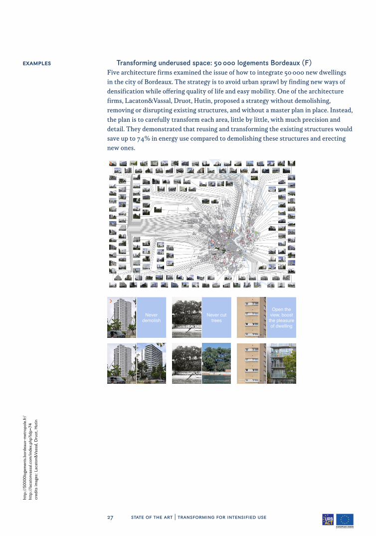
Transforming underused space: 50 000 logements Bordeaux (F)Five architecture firms examined the issue of how to integrate 50 000 new dwellings in the city of Bordeaux. The strategy is to avoid urban sprawl by finding new ways of densification while offering quality of life and easy mobility. One of the architecture firms, Lacaton&Vassal, Druot, Hutin, proposed a strategy without demolishing, removing or disrupting existing structures, and without a master plan in place. Instead, the plan is to carefully transform each area, little by little, with much precision and detail. They demonstrated that reusing and transforming the existing structures would save up to 74% in energy use compared to demolishing these structures and erecting new ones.
http
://5
0000
loge
men
ts.b
orde
aux-
met
ropo
le.fr
/ht
tp:/
/laca
tonv
assa
l.com
/ind
ex.p
hp?i
dp=7
4cr
edits
imag
es: L
acat
on&
Vass
al, D
ruot
, Hut
in
Never demolish
Social Housing: Carrier. Demolition
township: Lormont
Social housing: tour Bois le Prêtre. transformationArchitects: Frédéric Druot, Anne Lacaton, Jean Philippe Vassaltownship: Paris 17ème
>
>
ExamplEs
Never cut trees
GreenfieldWithout constructiontownship: Lège Cap Ferret
Field + VillaConstruction: Anne Lacaton & Jean Philippe Vassal architectstownship: Lège Cap Ferret
Open the view, boost
the pleasure of dwelling
Collective housing Pascal Lafarge, south gable
township: Bordeaux Bacalan
Social housing: tour Bois le Prêtre. transformed, south gableArchitects: Frédéric Druot, Anne Lacaton, Jean Philippe Vassaltownship: 17ème arr Paris


29 state of the art | transforming for social inclusion
1.2.2 Transforming for social inclusion
Unlike with new constructions in urban expansion zones, the transformation of existing buildings or areas always impacts local residents. Often regeneration conflicts with the interests of people living and working there, since their direct environment changes. The area might get more dense, less green and gentrification ²¹ might occur. Regeneration in the urban fringe should therefore also consider the interests of the people currently living there. It should be aimed towards mixed cultural and ethnic backgrounds and people of different incomes, education levels and ages. In other words: reinforcing the city as a platform for diversity and serendipity. Therefore, the challenge also lies in spreading the benefits of growth and regeneration equally and in providing affordable housing, high quality public space, jobs and facilities for all.
Affordable housingPreventing social segregation requires a high-quality, differentiated supply of afforda-ble, attractive, accessible housing, close enough to essential services for the general public, including for more vulnerable citizens.²² Successfully providing innovative housing types for a wide target group, different from the typical urban apartments and suburban freestanding houses, is a major challenge for the cities in this project. Stimulating the production of affordable housing demands innovative social housing provision and financing models, including government funding and market incentives, taking into account what types of tenure forms already exist and what types could be attracted to the area.
Mixed UseMixed-use development means creating a building, complex or area that includes a mixture of land uses.²³ Many areas in the urban fringe are monofunctional and encour-age spatial segregation. They include residential areas, industrial sites, office areas, etc. Mixing jobs and amenities with housing makes any area more self-reliable and decreases the need to commute to other areas. Preventing social exclusion means pro-viding job opportunities and services for all educational backgrounds, and rethinking public spaces and infrastructures to suit various ages and cultures. It also requires schools, retail stores, recreational and cultural facilities, and employment for both cur-rent and future residents.
Housing is an aggressive element in cities. It puts pressure on land in the sense that it often pushes out jobs and productivity. One general observation in this regard is that over the past years, urban development projects often involved converting abandoned industrial sites into new residential areas. Business and especially employment oppor-tunities were often forgotten or pushed out. We want to learn from this observation when reconverting 20th-century urban areas, making the most of the often larger par-cels of land and dimensions to really integrate industry, work, retail and housing. Other themes that will be explored by the partners are the development of a new urban econ-omy, integrating production in the city, and providing more low-skilled jobs in environ-ments with mostly skilled labour demands. It is an important challenge to maintain and improve job and productivity opportunities in these existing areas.
21
http
://w
ww
.theg
uard
ian.
com
/citi
es/2
016/
jan/
16/g
entr
ifica
tion-
inev
itabl
e-ba
d-ur
ban-
chan
ge22
ht
tp:/
/ww
w.h
ousi
ngeu
rope
.eu/
reso
urce
-468
/the
-sta
te-o
f-ho
usin
g-in
-the
-eu-
2015
23
http
://w
ww
.use
ful-
com
mun
ity-d
evel
opm
ent.o
rg/m
ixed
-use
-dev
elop
men
t.htm
l
30 state of the art | transforming for social inclusion
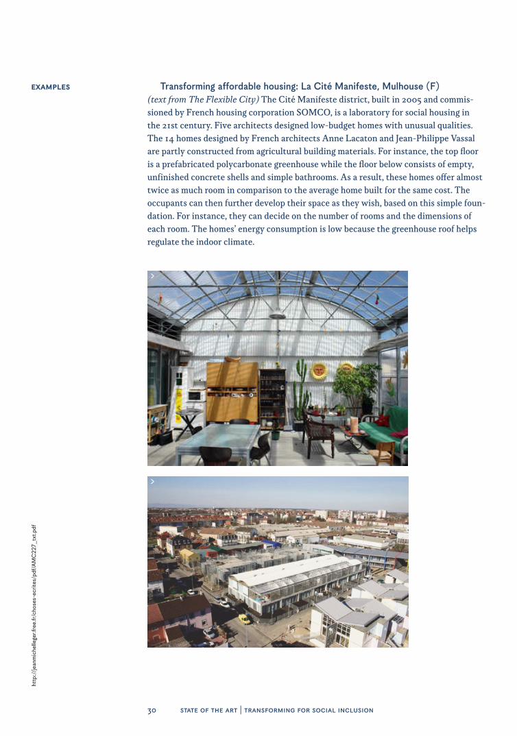
Transforming affordable housing: La Cité Manifeste, Mulhouse (F)(text from The Flexible City) The Cité Manifeste district, built in 2005 and commis-sioned by French housing corporation SOMCO, is a laboratory for social housing in the 21st century. Five architects designed low-budget homes with unusual qualities. The 14 homes designed by French architects Anne Lacaton and Jean-Philippe Vassal are partly constructed from agricultural building materials. For instance, the top floor is a prefabricated polycarbonate greenhouse while the floor below consists of empty, unfinished concrete shells and simple bathrooms. As a result, these homes offer almost twice as much room in comparison to the average home built for the same cost. The occupants can then further develop their space as they wish, based on this simple foun-dation. For instance, they can decide on the number of rooms and the dimensions of each room. The homes’ energy consumption is low because the greenhouse roof helps regulate the indoor climate.
ExamplEs
http
://j
eanm
iche
llege
r.fre
e.fr
/cho
ses-
ecrit
es/p
df/A
MC
227_
txt.p
df
>
>

31 state of the art | transforming for social inclusion
ExamplEs Transforming mixed use: Südstadt, Tübingen (D)(text from The Flexible City) The development of Südstadt in Tübingen is an outstand-ing example of creating a mixed-use city in a 20th-century military base. A deliberate attempt was made to incorporate local businesses to prevent the area from turning into a ghost town throughout the day. A number of conditions applied to new construc-tions. For instance, ground floors had to incorporate commercial uses. As a result, the development resulted in 2 000 extra jobs in addition to 6 500 new dwellings. These jobs were created in small workshops, offices, shops, cafes and other facilities housed in the first two storeys of the buildings, adjoining public spaces. The municipality tackled the redevelopment of the site and the barracks in partnership with private construction cooperatives of future residents. As these group members were involved in the develop-ment process, the buildings were designed with the residents’ needs in mind. Moreover, the entire process led to more programmatic diversity and considerable savings.
http
://w
ww
.nai
010.
com
/en/
tue/
item
/the
-flex
ible
-city
>
>

33 state of the art | transforming the relationship with the region
1.2.3 Transforming the relationship with the region
Traditionally, the urban fringe used to be the edge of the city, subordinate to the historic city centre. A logistics area intersected by major infrastructures linking the city centre to regions outside the city. Providing a mass of oppor-tunities between the low-density suburbs and the high-density city centre, the connectivity and identity of the urban fringe needs to be re-examined on a regional scale. Often, this also means dealing with various public authorities as the fringe crosses political borders and a variety of ownership structures.
ConnectivityThe urban fringe is an area with a relatively large number of infrastructures and bar-riers. The fact that the main infrastructure linking the city centre to the outer regions cuts through the fringe for the most part, has resulted in many isolated and poorly con-nected areas. Other downsides are poor air quality and noise nuisance. How to improve the existing infrastructure and how to overcome barriers in these types of urban areas, are important questions we need to address. Another challenge in the regeneration of these areas is that sustainable mobility choices must be promoted, and that we must support the development of a more efficient public transport network. Sustainable alternatives to car travel, such as public transport and a decent bicycle infrastructure, must be developed and made more widely available. When improving connectivity, the focus should not only be on connecting outer areas to the city centre, but also on their interconnectivity with other peripheral areas.
IdentityIn addition to the physical aspect, there is a mental aspect to the relationship between the urban fringe and the region, and between the fringe and the city centre. With the pressure on urban fringe development arises the opportunity to redefine and improve these former suburbs, no longer as towns or outskirts subordinate to the city centre, but as self-conscious districts. With more amenities and closer proximity to the city centre than the low-density suburbs on the one hand, and offering more green space and more space in general than the city centre on the other hand, the urban fringe holds the promise of combining the best of both worlds. How can identities be formed and enhanced in relation to other peripheral areas and the city centre? How can we intervene in this area? How can we give it a new and appealing image that builds effec-tively on what is already there?
Key opportunities for enhancing sustainability and creating a new future for the urban fringe are to be found at regional level – the level at which economic networks usually operate and landscape features manifest themselves. Yet, administrative bor-ders in Europe are often found either at a lower level (the municipality or district) or at a higher level (the province or nation). This makes it difficult to reach sound agree-ments regarding the development of business parks or housing, for instance, or regard-ing strategies concerning the countryside, the preservation of historical structures, or the establishment or closure of amenities. Decisions on these matters at municipal level could create undue competition while decisions at provincial or national level could overlook regional opportunities or disregard regional sensitivities. Greater sustainability requires a solid regional coordination mechanism. In some cases the periphery of the city is already outside of the administrative area of the city (e.g. the French cities). In such cases the urban association (communauté urbaine) can create

34 state of the art | transforming the relationship with the region
the opportunity to deal with most important joint problems. Regarding the challenges of regional coordination, major cities such as Vienna and Düsseldorf, peripheral munic-ipalities such as Solin and Casoria, and regional authority Metropolitan Area of Barce-lona are assets to our network.
Transforming connectivity: Green Cycle Routes Copenhagen (DK)In promoting alternatives to car travel for the commute between the fringe and the city centre, a reliable public transportation network and a good bicycle infrastructure are crucial. Since about a third of all employees in Copenhagen ride their bikes to and from work, the bicycle paths along the main access roads are under a lot of pressure. Both fast and cautious cyclists compete for space and constantly have to stop at traffic lights and bus stops where passengers get off. Safety and comfort suffer as a result. The vision behind green cycle routes is to promote safe cycling, which will get even more people on their bikes. New ‘highways’ are being laid out for cyclists that allow them to get to their destinations quickly along pleasant green areas away from regular traffic. Green cycle routes are intended to supplement existing bicycle paths, not replace them. And although the network is primarily aimed at providing an alternative to the many people who ride their bikes across the city each day, it is also intended for leisure purposes and excursions. Plans are in the making for 22 green cycle routes, covering over 100 kilo-metres, about one third of which will incorporate existing bicycle paths through parks.
ExamplEs
S S
S
S
S
S
S
S
S
S
SSS
S
SS
S
S
S
S
S
S
S
S
S S
SS
S
S
Vigerslevruten
Vest
vold
rute
n
Frederiksbergruten
Grødalsru
ten
n
Ryvan
g sru ten
Utterslevruten
Hareskovruten
Nørrebroruten
Søru
ten
Valbyruten
CarlsbergrutenHav
nerute
n
Refshaleruten
Universitetsruten
Kastrup Fort ruten
Øre
stad
srut
en
Kal
vebo
drut
en
HvidovrerutenLufthavnsruten
Am
agerruten
Svanemølleruten
Christianshavnruten
Det grønne cykelrutenet 2009 Realiserede og planlagte ruter
realiserede ruter og ruter under anlæg
cykelmulighed langs Søerne
planlagte ruter
alternativ linieføring
ruter udenfor kommunen
cykelforbindelser til Regionen
kommunegrænse
TEKNIK- OG MILJØFORVALTNINGEN D. 20.05.10
0
N
500m 1.000m
http
://w
ww
.nai
010.
com
/en/
tue/
item
/the
-flex
ible
-city
35 state of the art | transforming the relationship with the region
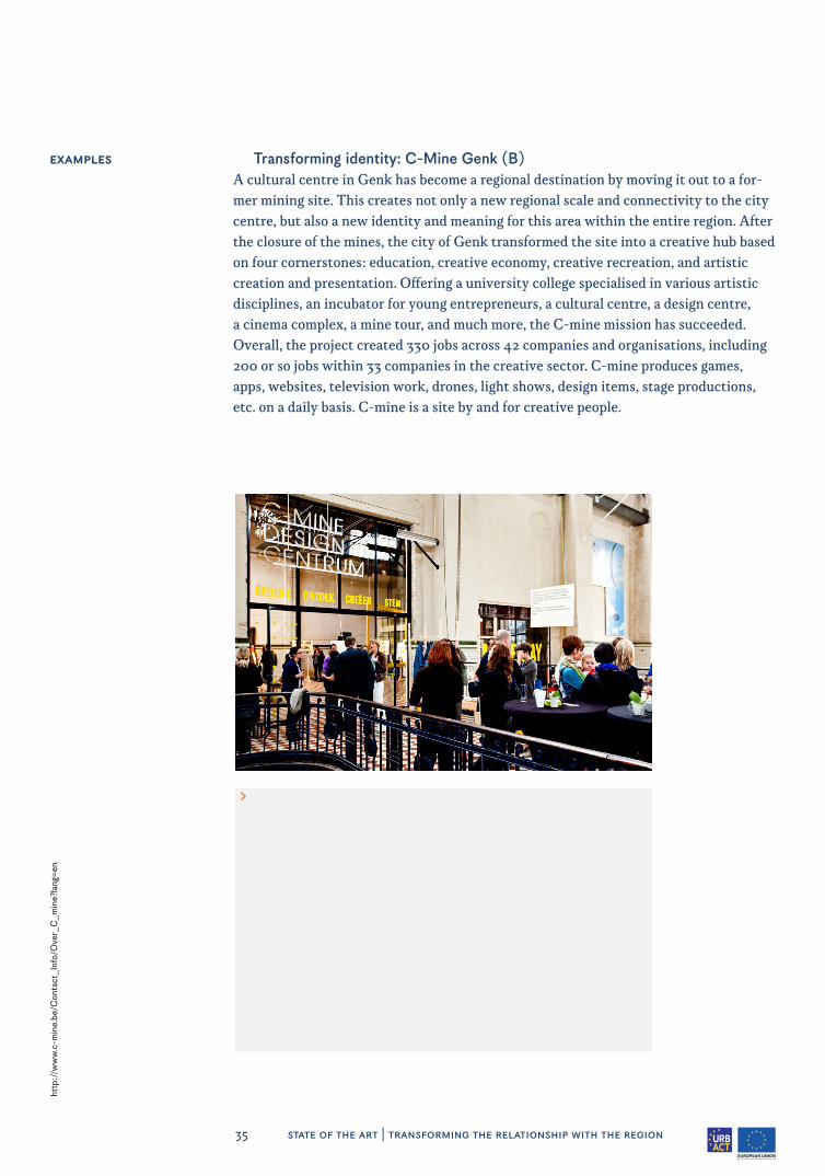
ExamplEs Transforming identity: C-Mine Genk (B)A cultural centre in Genk has become a regional destination by moving it out to a for-mer mining site. This creates not only a new regional scale and connectivity to the city centre, but also a new identity and meaning for this area within the entire region. After the closure of the mines, the city of Genk transformed the site into a creative hub based on four cornerstones: education, creative economy, creative recreation, and artistic creation and presentation. Offering a university college specialised in various artistic disciplines, an incubator for young entrepreneurs, a cultural centre, a design centre, a cinema complex, a mine tour, and much more, the C-mine mission has succeeded. Overall, the project created 330 jobs across 42 companies and organisations, including 200 or so jobs within 33 companies in the creative sector. C-mine produces games, apps, websites, television work, drones, light shows, design items, stage productions, etc. on a daily basis. C-mine is a site by and for creative people.
http
://w
ww
.c-m
ine.
be/C
onta
ct_I
nfo/
Ove
r_C
_min
e?la
ng=e
n
>

37 state of the art | transforming private space
1.2.4 Transforming private space
Urban expansion, when agricultural land is transformed into urban zones, involves a considerable increase in value and large land ownerships. Transforming existing urban areas is more expensive and often means having to deal with fragmented private ownership – from residents owning a single apartment to major global agglomerates that invest in shopping malls or office developments. As most municipalities do not own a lot of land and buildings, it is imperative to make the right decisions and negotiate agreements in the public interest when regenerating existing urban areas. How can collaborations between private and public stakeholders be improved to achieve the best possible quality through a fair process?
Fragmented Ownership and Missing Collective layersCities tend to focus on enhancing public space because of their experience with inner city upgrades, and because owning this land makes it relatively easy to create an impact. However, the poor quality of most existing dwellings and vacant or underused buildings and sites remains unchanged, since private owners are not motivated to make improvements. On the one hand, many buildings were constructed during the post-war building boom, prior to the energy crisis. Most of these are in need of renovation work and are poorly insulated. On the other hand, many areas could be used better and more intensively, such as large single-storey supermarkets, large open-air parking lots, etc., as they eat up a lot of land. There is plenty of potential in 20th-century urban areas, and a lot of dormant capital. However, divided ownership and the fact that most cit-ies do not own much land there (anymore) have turned this into a complex challenge. Dealing with fragmented private ownership to make areas and buildings more sus-tainable often requires municipalities to take on a different role from the one they are used to. How to kick-start this process? Not by developing a master plan, but through dynamics: creating acceptance, putting together a coalition of the willing, offering development potential and opportunities, catering to the needs of residents, all within the context of a broader strategy and ambition. An especially difficult challenge is pre-sented by reclaimed property in former Eastern Block cities.
TransparencyThe role of municipalities in the urban regeneration process is often twofold. On the one hand, its urban planning department defines the strategic plans and zoning plans and therefore determines the development potential of a site. On the other hand, they have to verify that everything is done according to the regulations and these plans. When trying to push and facilitate private partners towards certain developments, this could lead to a grey zone, and it makes their double role of ambitious creator and strict judge increasingly difficult. It may even lead to suspicion of corruption and favouritism. But as a public authority that has to encourage openness of government, it also means that in doing so, the municipalities are not operating in a level playing field when deal-ing with large private companies shielded by corporate secrecy and expensive lawyers. Which models of procurement, public private partnerships and processes are best suited for urban regeneration?

38 state of the art | transforming private space
Transforming fragmented ownership: Office vacancy action plan, Amsterdam (NL)
After the financial crisis, the city of Amsterdam was confronted with high office vacancy rates of around 20%. The city therefore decided to dedicate one department (‘Kantorenloods’) specifically to the challenge of dealing with fragmented ownership in monofunctional office space, in order to stimulate the transformation of these areas into different uses. Specific regulations were established in 2011 to force owners to look for new uses for these buildings. Owners who fail to cooperate can be fined. However, in the end, the initiating process itself turned out to be the most significant. An invitation from the mayor to address these big international investment companies who own a vast amount of vacant office space in Amsterdam, proved to be instrumen-tal in getting the transformation of numerous vacant offices going.
ExamplEs
http
s://
ww
w.a
mst
erda
m.n
l/ond
erne
men
/inv
este
ren/
kant
oren
/kan
tore
nloo
ds/
>
>
39 state of the art | transforming private space
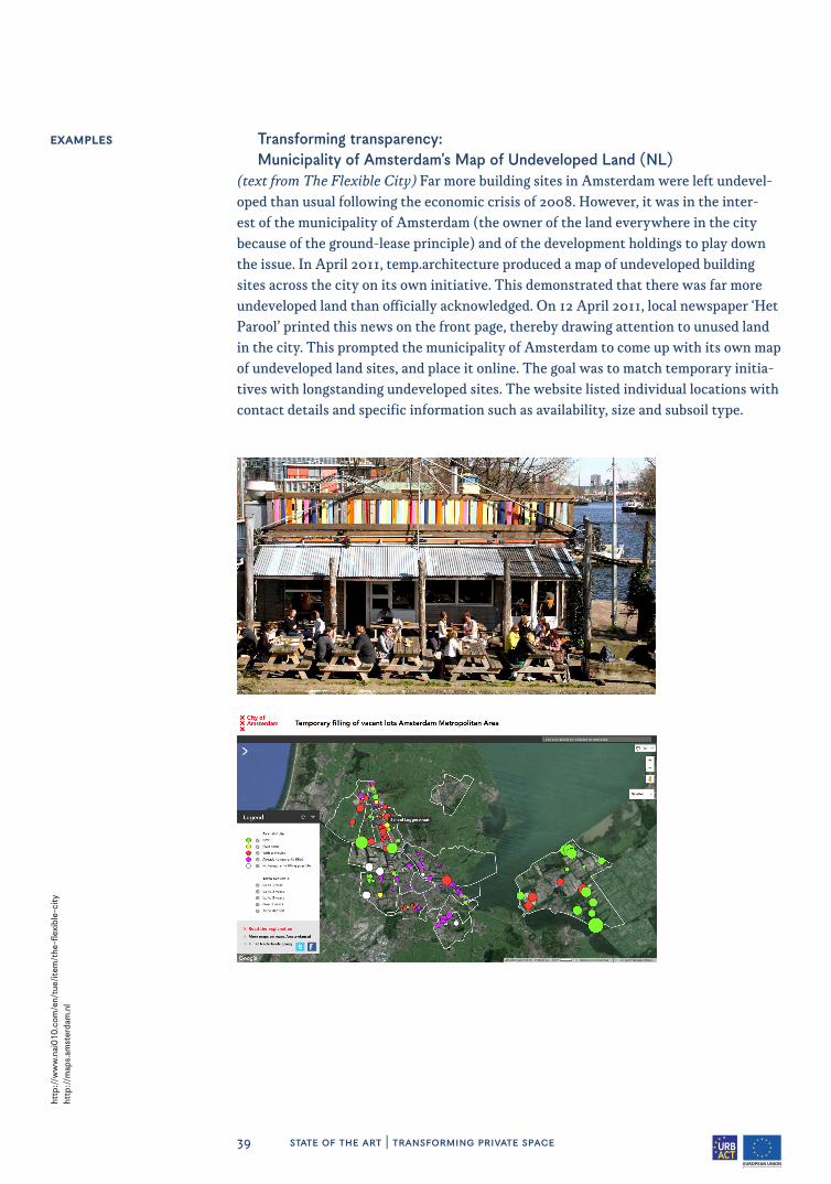
ExamplEs Transforming transparency: Municipality of Amsterdam’s Map of Undeveloped Land (NL)
(text from The Flexible City) Far more building sites in Amsterdam were left undevel-oped than usual following the economic crisis of 2008. However, it was in the inter-est of the municipality of Amsterdam (the owner of the land everywhere in the city because of the ground-lease principle) and of the development holdings to play down the issue. In April 2011, temp.architecture produced a map of undeveloped building sites across the city on its own initiative. This demonstrated that there was far more undeveloped land than officially acknowledged. On 12 April 2011, local newspaper ‘Het Parool’ printed this news on the front page, thereby drawing attention to unused land in the city. This prompted the municipality of Amsterdam to come up with its own map of undeveloped land sites, and place it online. The goal was to match temporary initia-tives with longstanding undeveloped sites. The website listed individual locations with contact details and specific information such as availability, size and subsoil type.
http
://w
ww
.nai
010.
com
/en/
tue/
item
/the
-flex
ible
-city
ht
tp:/
/map
s.am
ster
dam
.nl
>
>


41 state of the art | transforming spatial planning
1.2.5 Transforming spatial planning
Urban transformation requires a different approach and a different set of instruments than urban expansion. The aim of this network is to develop useful strategies for reinventing and transforming the urban fringe by uncovering new planning practices, processes, instruments and partnerships. Instead of working with a fixed blueprint, it involves flexible planning and strategic pilots. This way, a parallel development of experimental settings as well as an action plan for tangible results can be achieved. The objective is to plan, learn and implement at the same time – complementing concrete findings with the ambitions of the strategic plan, and vice versa.
Flexible PlanningLinear blueprint planning, where plans are fixed by a small group of experts, has proven not to be able to deal very well with the complexity, unpredictability and lim-ited funds usually associated with urban regeneration. Instead of determining outcome by design, focusing on the process and its dynamics is much more productive. This does not mean letting go of quality-related goals, but rather adding a broader defi-nition instead of looking at these as the only possible outcome. It also means clearly excluding what is not desired, and setting the scope of ambition. The possibilities for developments or redevelopments are determined by these ambitions, often described in a strategic plan, together with process-related, legal, financial and spatial planning boundaries. If a development is seen as a stepwise incremental process rather than a single undertaking, it can gradually take shape based on existing qualities, allow-ing users and other stakeholders to gain more influence, thereby making it easier to respond to and take advantage of unforeseen and unforeseeable social dynamics. In the field of flexible area development, each individual development explicitly forms part of a continuous process.²⁴ Each step can feed the learning process and can help the master plan grow.
In the quest for planning practices that enable transformation, the sub>urban partners are not only interested in strategies as such. They are also eager to discover the roles of local and regional governments in the ongoing development of their cit-ies. The local governments’ roles in the renewal of inner cities have mostly been to initiate, coordinate and/or direct projects that are generally well-defined. Should we prepare for a substantial shift towards enabling and facilitating roles in mostly organic and informal processes? What are the tools needed to take on these new roles, and are these instruments within reach of local and regional governments today?
Strategic PilotsIn addition to thinking at strategic level on the scale of the city and the region, this project is about the implementation of local action plans as strategic pilots, and on a more zoomed-in scale, it serves as a testing ground with an urban acupuncture approach. Sub>urban aims at renewing the city by rethinking our concept of the city. By doing research through concrete pilot projects, the project partners aim to improve current concepts of urban development and find and test new strategies, partnerships, financial models, procedures, regulations and new building typologies for housing, amenities, school buildings and offices. As it is impossible to finance and initiate everything at the same time, it is important to choose these strategic sites well, so they 24
To
m B
erge
voet
, Maa
rten
van
Tui
jl, T
he F
lexi
ble
City
, htt
p://
ww
w.n
ai01
0.co
m/e
n/tu
e/ite
m/t
he-fl
exib
le-c
ity
42 state of the art | transforming spatial planning
can influence and contribute to further planning on a larger scale. Modest steps, even temporary ones, that are well chosen can ultimately have big consequences.
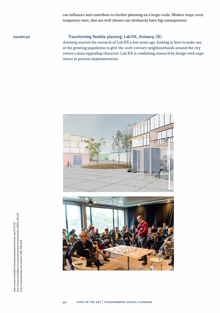
Transforming flexible planning: Lab XX, Antwerp (B)Antwerp started the research of Lab XX a few years ago, looking at how to make use of the growing population to give the 20th-century neighbourhoods around the city centre a more appealing character. Lab XX is combining research by design with expe-rience in process implementation.
ExamplEs
http
://w
ww
.ruim
telij
kstr
uctu
urpl
anan
twer
pen.
be/m
ain.
aspx
?l=0
7.02
http
://w
ww
.ruim
telij
kstr
uctu
urpl
anan
twer
pen.
be/d
ownl
oads
/LA
BXX
_EN
ht
tps:
//w
ww
.you
tube
.com
/wat
ch?v
=SN
i_D
RLj
nZ0
>
>

Transforming experimental pilots: Lageweg, Hoboken, Antwerp (B)Lageweg is a project site with ten different private owners and almost no public prop-erty. Lageweg experiments with a different kind of process, aimed at encouraging cooperation with various private owners across the boundaries of the plots. The pro-cess delays the development of a master plan and focuses instead on building a coali-tion. Lageweg wants to create a new urban fabric in which housing and amenities can coexist with production facilities. The project includes a variety of stakeholders: a pro-ject developer, a school, families who inherited a piece of land, entrepreneurs in indus-tries that are moving away, and entrepreneurs who are staying and plan to expand their business. The coalition process is also a process of collective learning based on different ‘design tables’ and a financial model that is owned by every stakeholder. The lessons that will be learnt by the City of Antwerp from this pilot project will be incorporated on a larger scale into the future vision for the entire 20th-century belt.
ExamplEs
44 state of the art | pool of good practices
1.3 POOL OF GOOD PRACTICES
Transforming for intensified use
• Vienna Dachausbauten: roof extensions to add housing and office space and counter sprawl
• 22@ The Innovation District, Barcelona. transformed two hundred hectares of industrial land in a central location to a mixed use neighbourhood with industry, offices and housing
• Amstel III, Amsterdam: vacant office transformation on the sale of a mono functional area
• Park Hill, Sheffield: sustainable transformation of vacant and outdated housing estate
• Prinzessinengarten, Berlin: nomadic temporary use of vacant sites as community gardens
• Open Lab Ebbinge, Groningen: from a large vacant site to a temporary village
• Cinerolum, London: close reading of vacant petrol station as a cinema
Transforming for social inclusion
• Neighbourhood contract Navez-Portaels, Brussels: joint effort with residents to improve neighbourhood
• Sargfabrik Vienna: user driven housing diversity
• The Klusflat (DIY-flat) in Amsterdam: affordable housing by DIY
• Strijp S, Eindhoven: transformation of factory into a functionally neutral building
• Solid 11, Amsterdam: a flexible structure that deliberately enables different kinds of use at the same time or consecutively
Transforming the relationship with the region
• Fabra i Coats, Barcelona: An old Factory transformed to an important Art Factory giving a new metropolitan centrality to a peripheral neighbourhood
https://www.youtube.com/watch?v=_Mhky-EMiJ8 http://www.nai010.com/en/tue/item/the-flexible-city
http://www.22barcelona.com/content/blogcategory/49/280/lang,en/
http://www.amstel3.amsterdam.nl/main.asp?display_framework=startpagina
http://www.nai010.com/en/tue/item/the-flexible-city
http://prinzessinnengarten.net/
http://www.nai010.com/en/tue/item/the-flexible-city
http://www.nai010.com/en/tue/item/the-flexible-city
http://www.nai010.com/en/tue/item/the-flexible-city
http://www.nai010.com/en/tue/item/the-flexible-city http://www.sargfabrik.at/Home/Die-Sargfabrik/Verein
http://www.klushuisamsterdam.nl/
http://www.nai010.com/en/tue/item/the-flexible-city
http://www.nai010.com/en/tue/item/the-flexible-city
http://fabraicoats.bcn.cat/en/artfactory

45 state of the art | pool of good practices
• Williamsburg, New York: from suburban to urban
• Musikkens Hus, Aalborg Region: municipal amenity co-financed by demographically declining region,
• Made in Marxloh, Duisburg: From vacant shopping street to the most romantic street in Europe,
Transforming private space
• Incentives for improving sustainability existing private houses, Santa Coloma
• Urban Land Reallocations, Germany: redrawing property bound-aries in redevelopment areas
• Financial incentives UK and Japan
• AG Vespa, Antwerp: municipal autonomous company, using its property and building policy in cases where market parties can-not or do not want to invest
• Collective Private Commissioning, Germany/ The Netherlands: collective users develop themselves
Transforming spatial planning
• Park Groot Schijn, Antwerpen: participative plan that started by executing parts of it,
• Darwin Eco-système, Bordeaux: open process inviting entrepreneurs to make area future proof
• Instant Master Planning Vollmose, Odense: using social media to increase participation
• Schieblock, Rotterdam: area transformation that started with temporary use of a vacant building
• ZEMU (Zones d’Entreprise en Milieu Urbain), Brussels: zoning making it possible to combine residential housing with commercial activity
• The neighbourhood Act, a specific instrument to promote integrated regeneration plans for neighbourhoods that need special attention.
>
http://bettercities.net/news-opinion/blogs/feigenbaum/15003/williamsburg-brooklyn-fringe-cutting-edge-and-beyond
http://www.nai010.com/en/tue/item/the-flexible-city
http://www.nai010.com/en/tue/item/the-flexible-city
http://www.nai010.com/en/tue/item/the-flexible-city
http://www.agvespa.be/
http://www.nai010.com/en/tue/item/the-flexible-city
https://www.antwerpen.be/nl/info/55e56b44b0a8a789ac8b458d/participatie-park-groot-schijn
http://www.nai010.com/en/tue/item/the-flexible-city
http://www.nai010.com/en/tue/item/the-flexible-city
http://www.naibooksellers.nl/de-flexibele-stad-oplossingen-voor-leegstand-en-krimp-tom-bergevoet-maarten-van-tuijl.html http://www.zus.cc/work/urban_politics/162_Schieblock.php
http://www.nai010.com/en/tue/item/the-flexible-city
http://territori.gencat.cat/es/01_departament/04_actuacions_i_obres/02_actuacions_dhabitatge_i_millora_urbana/barris/fitxa_generica/index.html

46 appendix | glossary
APPENDIX: GLOSSARYThis glossary is intended to provide a shared vocabulary.
Compact City The compact city or city of short distances is an urban planning and urban design concept, which promotes relatively high residential density with mixed land uses. It is based on an efficient public transport system and has an urban layout which – according to its advocates – encourages walking and cycling, low energy consumption and reduced pollution.Gentrification The process of renewal and rebuilding accompanying the influx of middle-class or affluent people into deteriorating areas that often displaces poorer residents Infrastructure The basic network or foundation of capital facilities or community investments which are necessary to support economic and community activities. (EEA)Local Action Plan is a strategic document that addresses identified needs, analyses problems and opportunities and puts forward sustainable, feasible solutions.Metropolitan Area is a region consisting of a densely populated urban core and its less-populated surrounding territories, sharing industry, infrastructure, and hous-ing.Mono-functionality Functioning with one focus, purpose or goal. Multifunctional Describes a diversity of activities occupying the same or adjoining spaceMixed Use is any urban, suburban or village development, or even a single build-ing, that blends a combination of residential, commercial, cultural, institutional, or industrial uses, where those functions are physically and functionally integrated, and that provides pedestrian connections.NIMBY Term referring to the statement ‘not in my backyard’ where someone or an organisation may support a proposal in principal, but not if they are to sacrifice on their part.Public Private Partnership (PPP) is a government service or private business ven-ture that is funded and operated through a partnership of government and one or more private sector companies.Social inclusion is the provision of certain rights to all individuals and groups in society, such as employment, adequatehousing, health care, education and training, etcStakeholder An institution, organisation, group or individual that has some interest in a particular sector or system. (EEA)Sustainable development Development that meets the needs of the present with-out compromising the ability of future generations to meet their own needs. (World Commission on Environment and Development, 1987)Underused space Buildings and/ or sites that are vacant, partly vacant or given their proximity to the city centre inefficiently used.URBACT Local Support Group The vehicle of local stakeholders by which inte-grated and participative approaches to urban policies are developedUrban Fringe The urban fringe area is the zone in between high density urban and low density suburban areas, where development pressure is or has been often intense.Urban Sprawl The uncontrolled or unplanned extension of urban areas into the countryside. (EEA)
47 colophon
COLOPhON
TextsMaarten van Tuijl Editorial boardCity of Antwerp: Isabelle Verhaert, Isabel Michielsen, Valerie Van de VeldeLocal coordinators of Barcelona Metropolitan Area, Baia Mare, Brno, Casoria, Düsseldorf, Oslo, Solin and Vienna
Special thanks toIván Tosics Translation and editingCom&Co
Graphic designEllen Van Huffel
PhotographyDries Luyten: p 4, 42, 57; URBACT City Festival: p. 17; Fabian Schröder and Jean Bernard Koeman: p. 18; Veva Roesems, Toon Vanobbergen, Mieke Belmans: p. 57, 66, 78, 88, 97, 109,117, 126, 135; La-Citta-Vita (Flickr): p.21; temp.architecture: p. 66, 88, 97, 109, 117, 135
Maps and modelsMaat ontwerpers en Posad p. 42; 51N4E: p. 43; temp.architecture: p. 48, 52 – 53, 54, 64, 74, 84, 94, 104, 114, 122, 132, 152, 154; DLR (Deutsches Zentrum für Luft- und Raumfahrt): cover, p. 12, Gemeente Amsterdam: p. 39 TypefacesKorpus, Korpus Grotesk
URBACT is a European exchange and learning programme promoting sustainable urban development. It enables cities to work together to develop solutions to major urban challenges, reaffirming the key role they play in facing increasingly complex societal challenges. It helps them to develop pragmatic solutions that are new and sus-tainable, and that integrate economic, social and environmental dimensions. It enables cities to share good practices and lessons learned with all professionals involved in urban policy throughout Europe. URBACT is 300 cities, 29 countries, and 5 000 active participants